Tuolumne River Post Construction Habitat Evaluation River Post Construction Habitat Evaluation...
111
Tuolumne River Post Construction Habitat Evaluation prepared by Boucher, Allison M submitted to Ecosystem Restoration Program 2004 Monitoring and Evaluation compiled 2004-11-19 00:37:18 PST Tuolumne River Post Construction Habitat Evaluation 1
Transcript of Tuolumne River Post Construction Habitat Evaluation River Post Construction Habitat Evaluation...
Tuolumne River Post Construction Habitat Evaluationprepared by Boucher, Allison M
submitted to Ecosystem Restoration Program 2004 Monitoring and Evaluation
compiled 2004−11−19 00:37:18 PST
Tuolumne River Post Construction Habitat Evaluation 1
Project InformationThis proposal is for the Ecosystem Restoration Program 2004 Monitoring and Evaluation solicitation as prepared by Boucher, Allison M.
November 18, 2004: Some checkboxes were not displaying correctly in the "printable" views and compilations. This problem has been resolved. Pleasecheck your proposals carefully and notify the help line if what you entered is not displayed correctly.
Proposal Title Tuolumne River Post Construction Habitat Evaluation
Project Duration36 months
Lead Organization NameFriends of the Tuolumne, Inc.Enter the name of the agency or institution to whom funds would be awarded.
Lead Organization Typenon−profit organization
Organization Contact
Please provide information for the primary person responsible foroversight of grant operation, management, and reportingrequirements at the lead institution.
Social TitleMs.
First Name Allison
Last Name Boucher
Street Address7523 Meadow Avenue
City Stockton
State Or ProvinceCA
ZIP Code Or Mailing Code 95207
Telephone(209) 477−9033 Include area code.
E−Mail [email protected]
LeadInvestigator
Is the leadinvestigatorthe same asthe maincontactperson?Yes.If not, providethe leadinvestigator'sinformationbelow.
Social Title
First Name
Last Name
Institution
Institution Type
Street Address
City
State Or Province
ZIP Code Or Mailing Code
Telephone Include area code.
Project Information 2
E−Mail
Provide information about additional investigators below.
Last Name First Name Organization
Hood Dennis KDH Biological Environmental Services
Demko Doug S.P. Cramer and Associates, Inc.
Hart Jeff H.A.R.T. Restoration Team
Hamilton Laurissa Endangered Species Recovery Program
Hammond Jeanne PRBO
Select one topic area that best applies to this proposal.− at−risk species assessmentX river channel restoration− estuary foodweb productivity− ecosystem water and sediment quality− environmental education− environmental water management− fish passage− fish screens− harvestable species assessment− lowland floodplains and bypasses− local watershed stewardship− mine remediation− hydrodynamics, sediment transport, and flow regimes− non−native invasive species− riparian habitat− shallow water and marsh habitat− upland habitatand wildlife friendly agriculture− X2 relationships (freshwater − seawater interface)
Select a minimum of three keywords to describe the project.− adaptive management− aquatic plants− benthic invertebratesX biological indicatorsX birdsX neotropical migratory birds− shorebirdsX upland birds− wading birds− waterfowl− climate− climate change− precipitation− sea level rise− snowmelt− contaminants / toxicants / pollutants− contaminants and toxicity of unknown origin− emerging contaminants− mercury− nutrients and oxygen depleting substances− organic carbon and disinfection byproduct precursors− persistent organic contaminants− pesticides− salinity− sediment and turbidity− selenium− trace metals− database management− economics− engineering− civil
Project Information 3
− environmental− hydraulic− environmental education− environmental impact analysis− environmental laws and regulations− environmental risk assessmentX fish biologyX bass and other centarchids− delta smelt− longfin smelt− other speciesX salmon and steelheadX splittail− striped bass− sturgeon− fish management and facilities− hatcheries− ladders and passage− screens− forestry− genetics− geochemistry− geographic information systems (GIS)− geology− geomorphology− groundwaterX habitat− benthosX channels and sloughs− flooded islandsX floodplains and bypasses− oceanic− reservoirsX riparianX rivers and streamsX shallow water− upland habitat− vernal pools− water columnX wetlands, freshwater− wetlands, seasonal− wetlands, tidal− human health− hydrodynamics− hydrology− insects− invasive species / non−native species / exotic species− land use management, planning, and zoning− limnologyX mammals− largeX small− microbiology / bacteriology− modeling− conceptual− quantitativeX monitoring− natural resource managementX performance measures− phytoplanktonX plants− primary productivity− reptilesX restoration ecologyX riparian ecology
Project Information 4
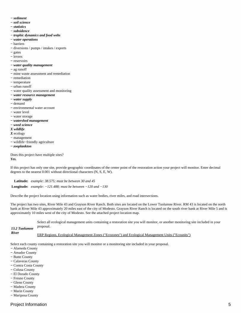
− sediment− soil science− statistics− subsidence− trophic dynamics and food webs− water operations− barriers− diversions / pumps / intakes / exports− gates− levees− reservoirs− water quality management− ag runoff− mine waste assessment and remediation− remediation− temperature− urban runoff− water quality assessment and monitoring− water resource management− water supply− demand− environmental water account− water level− water storage− watershed management− weed scienceX wildlifeX ecology− management− wildlife−friendly agriculture− zooplankton
Does this project have multiple sites?Yes.
If this project has only one site, provide geographic coordinates of the center point of the restoration action your project will monitor. Enter decimaldegrees to the nearest 0.001 without directional characters (N, S, E, W).
Latitude: example: 38.575; must be between 30 and 45
Longitude: example: −121.488; must be between −120 and −130
Describe the project location using information such as water bodies, river miles, and road intersections.
The project has two sites, River Mile 43 and Grayson River Ranch. Both sites are located on the Lower Tuolumne River. RM 43 is located on the northbank at River Mile 43 approximately 20 miles east of the city of Modesto. Grayson River Ranch is located on the south river bank at River Mile 5 and isapproximately 10 miles west of the city of Modesto. See the attached project location map.
13.2 TuolumneRiver
Select all ecological management units containing a restoration site you will monitor, or another monitoring site included in yourproposal.
ERP Regions, Ecological Management Zones ("Ecozones") and Ecological Management Units ("Ecounits")
Select each county containing a restoration site you will monitor or a monitoring site included in your proposal.− Alameda County− Amador County− Butte County− Calaveras County− Contra Costa County− Colusa County− El Dorado County− Fresno County− Glenn County− Madera County− Marin County− Mariposa County
Project Information 5
− Merced County− Napa County− Nevada County− Placer County− Plumas County− Sacramento County− San Joaquin County− Shasta County− Solano CountyX Stanislaus County− Sonoma County− Sutter County− Tehama County− Tuolumne County− Yolo County− Yuba County
Select each Indian reservation or rancheria containing or adjacent to a restoration site you will monitor or a monitoring site included in your proposal. Usethe California tribal lands as a guide.Amador County− Buena Vista Rancheria− Ione Band of Miwok− Jackson RancheriaButte County− Berry Creek Rancheria− Chico Rancheria (Mechoopda)− Enterprise Rancheria− Mooretown RancheriaCalaveras County− California Valley Miwok Tribe (Sheep Ranch)Colusa County− Colusa Rancheria (Cachil Dehe Band of Wintun Indians)− Cortina RancheriaEl Dorado County− Shingle Springs Rancheria− Washoe Tribe Reservations of California and NevadaFresno County− Big Sandy Rancheria− Cold Springs Rancheria− Table Mountain RancheriaGlenn County− Grindstone RancheriaMadera County− North Fork Rancheria− Picayune Rancheria (Chukchansi)Placer County− United Auburn RancheriaPlumas County− Greenville RancheriaShasta County− Big Bend Rancheria (Pit River Tribe)− Montgomery Creek Rancheria (Pit River Tribe)− Pit River Tribe of California− Redding Rancheria− Roaring Creek Rancheria (Pit River Tribe)Sonoma County− Cloverdale Rancheria− Dry Creek Rancheria− Graton Rancheria− Lytton Rancheria− Stewarts Point RancheriaTehama County− Paskenta Band of Nomelaki IndiansTuolumne County− Chicken Ranch Rancheria
Project Information 6
− Tuolumne RancheriaYolo County− Rumsey Rancheria
List each city (one per line) containing a restoration site you will monitor or a monitoring site included in your proposal.
None
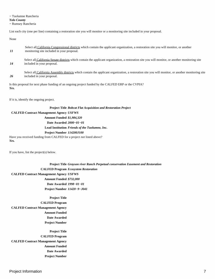
11Select all California Congressional districts which contain the applicant organization, a restoration site you will monitor, or anothermonitoring site included in your proposal.
14Select all California Senate districts which contain the applicant organization, a restoration site you will monitor, or another monitoring siteincluded in your proposal.
26Select all California Assembly districts which contain the applicant organization, a restoration site you will monitor, or another monitoring siteincluded in your proposal.
Is this proposal for next phase funding of an ongoing project funded by the CALFED ERP or the CVPIA?Yes.
If it is, identify the ongoing project.
Project Title Bobcat Flat Acquisition and Restoration Project
CALFED Contract Management AgencyUSFWS
Amount Funded $1,984,320
Date Awarded 2000−01−01
Lead Institution Friends of the Tuolumne, Inc.
Project Number 114200J100Have you received funding from CALFED for a project not listed above?Yes.
If you have, list the project(s) below.
Project Title Grayson river Ranch Perpetual conservation Easement and Restoration
CALFED Program Ecosystem Restoration
CALFED Contract Management AgencyUSFWS
Amount Funded $732,000
Date Awarded 1998−01−01
Project Number 11420−9−J041
Project Title
CALFED Program
CALFED Contract Management Agency
Amount Funded
Date Awarded
Project Number
Project Title
CALFED Program
CALFED Contract Management Agency
Amount Funded
Date Awarded
Project Number
Project Information 7

Project Title
CALFED Program
CALFED Contract Management Agency
Amount Funded
Date Awarded
Project NumberHave you ever submitted a similar proposal to any CALFED PSP?No.
If you have, describe the submission below.
Project Title
CALFED Program
Date Of PSPList people you feel are qualified to act as scientific reviewers for this proposal and are not associated with CALFED.
Full Name Organization Telephone E−Mail Expertise
adaptivemanagement
adaptivemanagement
adaptivemanagement
adaptivemanagement
Give additional comments, information, etc. here.
This proposal is for next phase funding for the completed Grayson river Ranch site as well as RM 43 at Bobcat Flat. Funds from the grants either haveexpired or will expire before planned monitoring activities could be completed.
Project Information 8
Executive SummaryThis proposal is for the Ecosystem Restoration Program 2004 Monitoring and Evaluation solicitation as prepared by Boucher, Allison M.
November 18, 2004: Some checkboxes were not displaying correctly in the "printable" views and compilations. This problem has been resolved. Pleasecheck your proposals carefully and notify the help line if what you entered is not displayed correctly.
Provide a summary of your project including the following:
a brief description of your proposed project, including location• objective• the restoration action(s) it will monitor, and the approach to implement the proposal• expected outcomes• relationship to CBDA ERP or CVPIA goals•
This information will be made public on our website shortly after the closing date of this PSP.
Executive Summary
This proposal is to monitor two separate restoration projects managed by Friends of the Tuolumne: BOBCAT FLAT RIVERMILE 43 AND GRAYSONRIVER RANCH.
We propose post construction monitoring of Bobcat Flat Rivermile 43, a CBDA and DWR/California Fish and Game funded instream and riparianrestoration project on the Tuolumne River approximately 23 miles upstream of Modesto. Construction to be completed in 2005 includes removingaggregate from the floodplain thus lowering sections as much as four feet and placing the proper spawning gravel in the river channel to enhance salmonidhabitat. Portions of the floodplain will be planted with native trees.
The objective of the project is to reestablish spawning and holding habitat for salmon and steelhead in an area that was severely damaged by the golddredger. This is the first instream restoration on the Tuolumne River designed to enhance steelhead habitat. The riparian restoration objective is to lowerthe floodplain so that it will receive spring flood flows allowing some natural regeneration and to establish native plants. A high water scour channel willbe built across the floodplain to enhance floodplain inundation.
We plan to monitor the instream habitat enhancements to evaluate the effectiveness of the designs which aim to provide not only increased salmonspawning but also spawning and holding habitat for steelhead/trout. The gravel is placed in riffles with deep holding water immediately below. The gravelis sized to attract both Chinook and trout spawning. Instream monitoring will complement other monitoring on the Tuolumne River, including monitoringat Bobcat Flat, by the Tuolumne River Technical Advisory Committee (TRTAC) and DFG such as juvenile fish seining, summer snorkeling, and fall runChinook salmon redd surveys. We expect the outcome to be a stronger design “recipe” for riffle construction that will enhance both salmon and steelheadspawning.
Predator fish may be a limiting factor on the Tuolumne River. We propose to monitor the change in their use of the project site by analyzing where andwhen they are present and their feeding and spawning habits compared to pre−project status.
We plan to monitor the riparian restoration to determine if lowering the floodplain in this part of the river will encourage natural regeneration and providefor more successful planting.
Monitoring is designed to add to the base of knowledge for the TRTAC. We propose to use angling, cinema photography, GPS identification of specificsites, mapping, predator fish stomach contents analysis, and comparison with pre−project conditions. These tasks will help fill in the information gaps foradult steelhead/trout and predator fish in the spawning reach of the Tuolumne River.
The deliverables include detailed maps to demonstrate how the fish are using the new spawning and holding habitat, how the predator fish are respondingto the new instream habitat, and reports describing the nature of the habitats and uses of the habitat compared to pre−project status. A report will evaluatethe revegetation results and determine the effects of lowering the floodplain in this reach of the river.
This proposal also seeks funding to continue monitoring at GRAYSON RIVER RANCH RESTORATION at Rivermile 5 of the lower Tuolumne River.The objective at this site was to reestablish a riparian forest that was converted to agriculture many years ago and provide habitat for avian, terrestrial andaquatic species.
The restoration was physically completed in 2002. Active management ended in the fall of 2004. The CBDA contract has expired so we need additionalfunding to continue monitoring to evaluate biological responses to the restoration.
We propose to monitor the trend in abundance and diversity of avian species and mammals as indicators of restoration success, and to evaluate the plantpalette mix of native trees and grass after the cessation of irrigation. Investigation into localized conditions that are predictive of planting success will bedone in the development of a predictive site quality index. Natural regeneration of native plants will be investigated to determine if natural processes arecontributing to the restoration. Restoration also created a new floodplain backwater. We will monitor to determine if salmon, steelhead, and splittail use
Executive Summary 9

this habitat when water levels are appropriate.
Deliverables: Vegetation monitoring will produce GIS mapping of plant inventories, survival, natural regeneration, overlayed with a Site Quality Indexaccompanied by appropriate reports.
Wildlife components will provide data and reports to support biologic response to habitat improvements in terms of population trends and richness.Fishery study will generate data to document use of constructed floodplain backwaters by juvenal Chinook salmon, steelhead, and splittail. Reports will begenerated and included in Tuolumne River reports for the Tuolumne River Technical Advisory Committee.
Bobcat Flat RM 43 and Grayson River Ranch both address several ERP and CVPIA goals – ERP Strategic Goal 1: At−Risk Species, “big R”. Goal 3:Harvestable Species. Goal 4: Riparian Habitats, and CVPIA Priority SJ3: Rearing and spawning habitat for Chinook salmon, steelhead, and splittail.
Executive Summary 10
Environmental ComplianceThis proposal is for the Ecosystem Restoration Program 2004 Monitoring and Evaluation solicitation as prepared by Boucher, Allison M.
November 18, 2004: Some checkboxes were not displaying correctly in the "printable" views and compilations. This problem has been resolved. Pleasecheck your proposals carefully and notify the help line if what you entered is not displayed correctly.
Successful applicants are responsible for complying with all applicable laws and regulations for their projects, including the National EnvironmentalPolicy Act (NEPA) and the California Environmental Quality Act (CEQA).
Any necessary NEPA or CEQA documents for an approved project must tier from the CALFED Programmatic Record of Decision and CALFEDProgrammatic EIS/EIR to avoid or minimize the projects adverse environmental impacts. Applicants are encouraged to review the Programmatic EIS/EIRand incorporate the applicable mitigation strategies from Appendix A of the Programmatic Record of Decision in developing their projects and theNEPA/CEQA documents for their projects.
CEQA Compliance
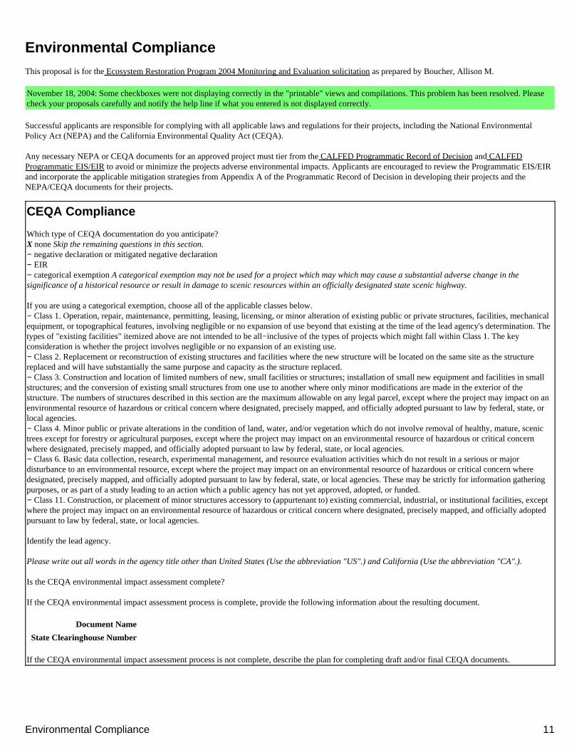
Which type of CEQA documentation do you anticipate?X none Skip the remaining questions in this section.− negative declaration or mitigated negative declaration− EIR− categorical exemption A categorical exemption may not be used for a project which may which may cause a substantial adverse change in thesignificance of a historical resource or result in damage to scenic resources within an officially designated state scenic highway.
If you are using a categorical exemption, choose all of the applicable classes below.− Class 1. Operation, repair, maintenance, permitting, leasing, licensing, or minor alteration of existing public or private structures, facilities, mechanicalequipment, or topographical features, involving negligible or no expansion of use beyond that existing at the time of the lead agency's determination. Thetypes of "existing facilities" itemized above are not intended to be all−inclusive of the types of projects which might fall within Class 1. The keyconsideration is whether the project involves negligible or no expansion of an existing use.− Class 2. Replacement or reconstruction of existing structures and facilities where the new structure will be located on the same site as the structurereplaced and will have substantially the same purpose and capacity as the structure replaced.− Class 3. Construction and location of limited numbers of new, small facilities or structures; installation of small new equipment and facilities in smallstructures; and the conversion of existing small structures from one use to another where only minor modifications are made in the exterior of thestructure. The numbers of structures described in this section are the maximum allowable on any legal parcel, except where the project may impact on anenvironmental resource of hazardous or critical concern where designated, precisely mapped, and officially adopted pursuant to law by federal, state, orlocal agencies.− Class 4. Minor public or private alterations in the condition of land, water, and/or vegetation which do not involve removal of healthy, mature, scenictrees except for forestry or agricultural purposes, except where the project may impact on an environmental resource of hazardous or critical concernwhere designated, precisely mapped, and officially adopted pursuant to law by federal, state, or local agencies.− Class 6. Basic data collection, research, experimental management, and resource evaluation activities which do not result in a serious or majordisturbance to an environmental resource, except where the project may impact on an environmental resource of hazardous or critical concern wheredesignated, precisely mapped, and officially adopted pursuant to law by federal, state, or local agencies. These may be strictly for information gatheringpurposes, or as part of a study leading to an action which a public agency has not yet approved, adopted, or funded.− Class 11. Construction, or placement of minor structures accessory to (appurtenant to) existing commercial, industrial, or institutional facilities, exceptwhere the project may impact on an environmental resource of hazardous or critical concern where designated, precisely mapped, and officially adoptedpursuant to law by federal, state, or local agencies.
Identify the lead agency.
Please write out all words in the agency title other than United States (Use the abbreviation "US".) and California (Use the abbreviation "CA".).
Is the CEQA environmental impact assessment complete?
If the CEQA environmental impact assessment process is complete, provide the following information about the resulting document.
Document Name
State Clearinghouse Number
If the CEQA environmental impact assessment process is not complete, describe the plan for completing draft and/or final CEQA documents.
Environmental Compliance 11
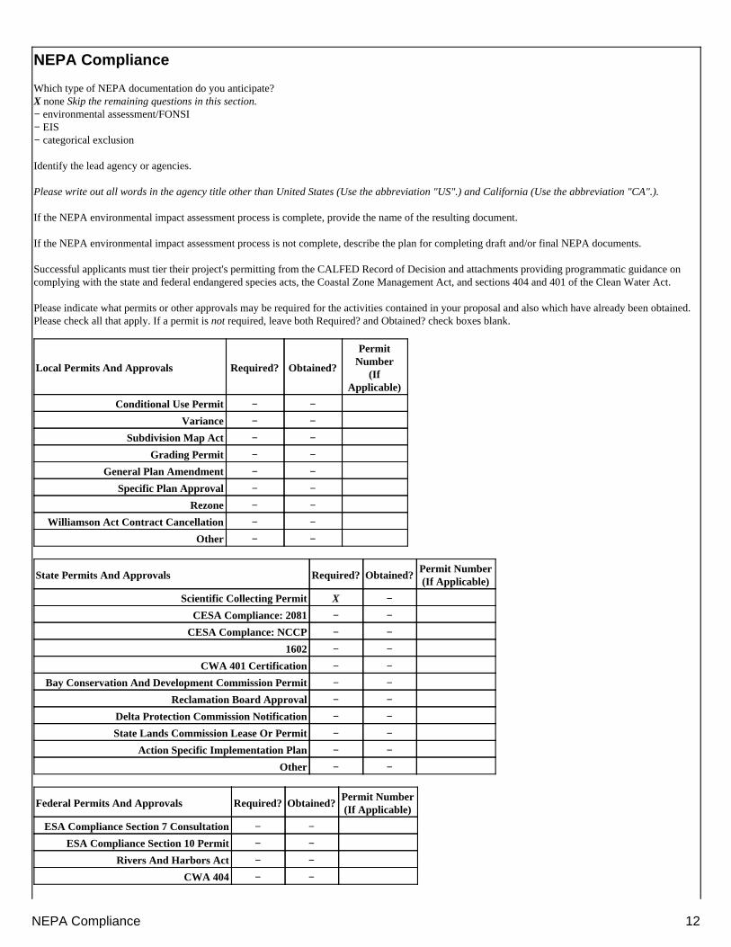
NEPA Compliance
Which type of NEPA documentation do you anticipate?X none Skip the remaining questions in this section.− environmental assessment/FONSI− EIS− categorical exclusion
Identify the lead agency or agencies.
Please write out all words in the agency title other than United States (Use the abbreviation "US".) and California (Use the abbreviation "CA".).
If the NEPA environmental impact assessment process is complete, provide the name of the resulting document.
If the NEPA environmental impact assessment process is not complete, describe the plan for completing draft and/or final NEPA documents.
Successful applicants must tier their project's permitting from the CALFED Record of Decision and attachments providing programmatic guidance oncomplying with the state and federal endangered species acts, the Coastal Zone Management Act, and sections 404 and 401 of the Clean Water Act.
Please indicate what permits or other approvals may be required for the activities contained in your proposal and also which have already been obtained.Please check all that apply. If a permit is not required, leave both Required? and Obtained? check boxes blank.
Local Permits And Approvals Required? Obtained?
PermitNumber
(IfApplicable)
Conditional Use Permit − −
Variance − −
Subdivision Map Act − −
Grading Permit − −
General Plan Amendment − −
Specific Plan Approval − −
Rezone − −
Williamson Act Contract Cancellation − −
Other − −
State Permits And Approvals Required? Obtained?Permit Number(If Applicable)
Scientific Collecting Permit X −
CESA Compliance: 2081 − −
CESA Complance: NCCP − −
1602 − −
CWA 401 Certification − −
Bay Conservation And Development Commission Permit − −
Reclamation Board Approval − −
Delta Protection Commission Notification − −
State Lands Commission Lease Or Permit − −
Action Specific Implementation Plan − −
Other − −
Federal Permits And Approvals Required? Obtained?Permit Number(If Applicable)
ESA Compliance Section 7 Consultation − −
ESA Compliance Section 10 Permit − −
Rivers And Harbors Act − −
CWA 404 − −
NEPA Compliance 12
Other − −
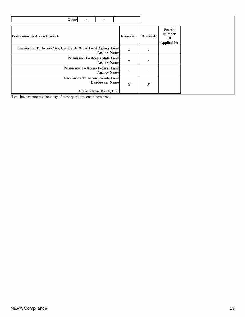
Permission To Access Property Required? Obtained?
PermitNumber
(IfApplicable)
Permission To Access City, County Or Other Local Agency LandAgency Name
− −
Permission To Access State LandAgency Name
− −
Permission To Access Federal LandAgency Name
− −
Permission To Access Private LandLandowner Name
Grayson River Ranch, LLC
X X
If you have comments about any of these questions, enter them here.
NEPA Compliance 13
Land UseThis proposal is for the Ecosystem Restoration Program 2004 Monitoring and Evaluation solicitation as prepared by Boucher, Allison M.
November 18, 2004: Some checkboxes were not displaying correctly in the "printable" views and compilations. This problem has been resolved. Pleasecheck your proposals carefully and notify the help line if what you entered is not displayed correctly.
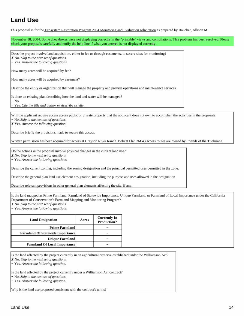
Does the project involve land acquisition, either in fee or through easements, to secure sites for monitoring?X No. Skip to the next set of questions.− Yes. Answer the following questions.
How many acres will be acquired by fee?
How many acres will be acquired by easement?
Describe the entity or organization that will manage the property and provide operations and maintenance services.
Is there an existing plan describing how the land and water will be managed?− No.− Yes. Cite the title and author or describe briefly.
Will the applicant require access across public or private property that the applicant does not own to accomplish the activities in the proposal?− No. Skip to the next set of questions.X Yes. Answer the following question.
Describe briefly the provisions made to secure this access.
Written permission has been acquired for access at Grayson River Ranch. Bobcat Flat RM 43 access routes are owned by Friends of the Tuolumne.
Do the actions in the proposal involve physical changes in the current land use?X No. Skip to the next set of questions.− Yes. Answer the following questions.
Describe the current zoning, including the zoning designation and the principal permitted uses permitted in the zone.
Describe the general plan land use element designation, including the purpose and uses allowed in the designation.
Describe relevant provisions in other general plan elements affecting the site, if any.
Is the land mapped as Prime Farmland, Farmland of Statewide Importance, Unique Farmland, or Farmland of Local Importance under the CaliforniaDepartment of Conservation's Farmland Mapping and Monitoring Program?X No. Skip to the next set of questions.− Yes. Answer the following questions.
Land Designation AcresCurrently InProduction?
Prime Farmland −
Farmland Of Statewide Importance −
Unique Farmland −
Farmland Of Local Importance −
Is the land affected by the project currently in an agricultural preserve established under the Williamson Act?X No. Skip to the next set of questions.− Yes. Answer the following question.
Is the land affected by the project currently under a Williamson Act contract?− No. Skip to the next set of questions.− Yes. Answer the following question.
Why is the land use proposed consistent with the contract's terms?
Land Use 14

Describe any additional comments you have about the projects land use.
Land Use 15
Conflict Of InterestThis proposal is for the Ecosystem Restoration Program 2004 Monitoring and Evaluation solicitation as prepared by Boucher, Allison M.
November 18, 2004: Some checkboxes were not displaying correctly in the "printable" views and compilations. This problem has been resolved. Pleasecheck your proposals carefully and notify the help line if what you entered is not displayed correctly.
Complete the following table in order to provide the full names and organizations of all individuals in the following categories.
Applicant and investigators listed in the proposal who wrote the proposal, will be performing the tasks listed in the proposal or who will benefitfinancially if the proposal is fund.
•
Subcontractors listed in the proposal who will perform some tasks listed in the proposal and will benefit financially if the proposal is funded.• Individuals not listed in the proposal who helped with proposal development, for example by reviewing drafts, or by providing criticalsuggestions or ideas contained within the proposal.
•
Parts of this table are generated from responses given in the project information form.
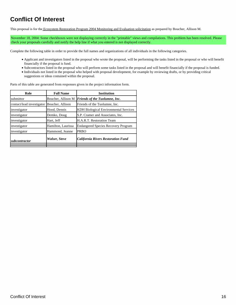
Role Full Name Institution
submittor Boucher, Allison MFriends of the Tuolumne, Inc.
contact/lead investigator Boucher, Allison Friends of the Tuolumne, Inc.
investigator Hood, Dennis KDH Biological Environmental Services
investigator Demko, Doug S.P. Cramer and Associates, Inc.
investigator Hart, Jeff H.A.R.T. Restoration Team
investigator Hamilton, Laurissa Endangered Species Recovery Program
investigator Hammond, Jeanne PRBO
subcontractorWalser, Steve California Rivers Restoration Fund
Conflict Of Interest 16
Tasks And DeliverablesThis proposal is for the Ecosystem Restoration Program 2004 Monitoring and Evaluation solicitation as prepared by Boucher, Allison M.
November 18, 2004: Some checkboxes were not displaying correctly in the "printable" views and compilations. This problem has been resolved. Pleasecheck your proposals carefully and notify the help line if what you entered is not displayed correctly.
For each task in the project's scope of work, please list major deliverables and an estimate of the start and end time (in months from the date the project'scontract is executed).
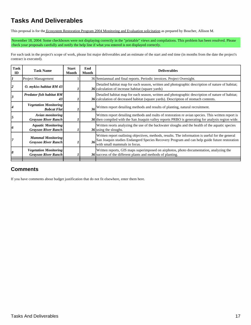
TaskID
Task NameStart
MonthEnd
MonthDeliverables
1 Project Management 1 36 Semiannual and final reports. Periodic invoices. Project Oversight.
2 O. mykiss habitat RM 431 36
Detailed habitat map for each season, written and photographic description of nature of habitat;calculation of increase habitat (square yards)
3Predator fish habitat RM
43 1 36Detailed habitat map for each season, written and photographic description of nature of habitat;calculation of decreased habitat (square yards). Description of stomach contents.
4Vegetation Monitoring
Bobcat Flat 1 36Written report detailing methods and results of planting, natural recruitment.
5Avian monitoring
Grayson River Ranch 1 36Written report detailing methods and rsults of restoration re avian species. This written report isthen compiled with the San Joaquin valley reports PRBO is generating for analysis region wide.
6Aquatic Monitoring
Grayson River Ranch 1 36Written reorts analyzing the use of the backwater sloughs and the health of the aquatic speciesusing the sloughs.
7Mammal MonitoringGrayson River Ranch 1 36
Written report outlining objectives, methods, results. The information is useful for the generalSan Joaquin studies Endangerd Species Recovery Program and can help guide future restorationwith small mammals in focus.
8Vegetation MonitoringGrayson River Ranch 1 36
Written reports, GIS maps superimposed on airphotos, photo documentation, analyzing thesuccess of the different plants and methods of planting.
Comments
If you have comments about budget justification that do not fit elsewhere, enter them here.
Tasks And Deliverables 17
BudgetThis proposal is for the Ecosystem Restoration Program 2004 Monitoring and Evaluation solicitation as prepared by Boucher, Allison M.
November 18, 2004: Some checkboxes were not displaying correctly in the "printable" views and compilations. This problem has been resolved. Pleasecheck your proposals carefully and notify the help line if what you entered is not displayed correctly.
Provide a detailed budget showing how requested funds will be used to carry out the project's scope of work for each year of the project. Costs for eachmajor task described in the "Approach and scope of work" section of your proposal must be presented. The first task in each year should be projectmanagement, including the specific costs associated with insuring accomplishment of a specific project, such as inspection of work in progress, validationof costs, report preparation, response to project specific questions and necessary costs directly associated with specific project oversight. Applicants shouldalso include costs associated with managing project funds, including preparation of quarterly and final reports to the funding agency. Tasks forenvironmental compliance, monitoring, data handling, storage, and dissemination, and public outreach should also be included as appropriate for yourproject. In calculating indirect costs, assume funds will be awarded by State of California.
The sections in this budget form are derived from the tasks you have defined in the "Tasks and Deliverables" form.
Year 1 ( Months 1 To 12 )
Task Labor Benefits TravelSupplies AndExpendables
Services AndConsultants
EquipmentLands AndRights Of
Way
OtherDirectCosts
DirectTotal
IndirectCosts
Total
1: projectmanagement(12 months)
12000 0 900 600 0 0 0 0 $13,500 0 $13,500
2: O. mykiss habitatRM 43(12 months)
0 0 0 0 41000 0 0 0 $41,000 0 $41,000
3: Predator fishhabitat RM 43(12 months)
0 0 0 0 27250 0 0 0 $27,250 0 $27,250
4: VegetationMonitoring BobcatFlat(12 months)
1560 0 120 200 0 0 0 0 $1,880 0 $1,880
5: Avian monitoringGrayson RiverRanch(12 months)
0 0 0 0 4000 0 0 0 $4,000 0 $4,000
6: AquaticMonitoring GraysonRiver Ranch(12 months)
0 0 0 0 6000 0 0 0 $6,000 0 $6,000
7: MammalMonitoring GraysonRiver Ranch(12 months)
0 0 0 0 6000 0 0 0 $6,000 0 $6,000
8: VegetationMonitoring GraysonRiver Ranch(12 months)
0 0 0 0 21750 0 0 0 $21,750 0 $21,750
Totals $13,560 $0 $1,020 $800 $106,000 $0 $0 $0 $121,380 $0 $121,380
Year 2 ( Months 13 To 24 )
Task Labor Benefits TravelSupplies AndExpendables
Services AndConsultants
EquipmentLands AndRights Of
Way
OtherDirectCosts
DirectTotal
IndirectCosts
Total
1: projectmanagement(12 months)
12000 0 900 600 0 0 0 0 $13,500 2000 $15,500
Budget 18
2: O. mykiss habitatRM 43(12 months)
0 0 0 0 39250 0 0 0 $39,250 0 $39,250
3: Predator fishhabitat RM 43(12 months)
0 0 0 0 27500 0 0 0 $27,500 0 $27,500
4: VegetationMonitoring BobcatFlat(12 months)
920 0 60 100 0 0 0 0 $1,080 0 $1,080
5: Avian monitoringGrayson RiverRanch(12 months)
0 0 0 0 0 0 0 0 $0 0 $0
6: AquaticMonitoring GraysonRiver Ranch(12 months)
0 0 0 0 6000 0 0 0 $6,000 0 $6,000
7: MammalMonitoring GraysonRiver Ranch(12 months)
0 0 0 0 0 0 0 0 $0 0 $0
8: VegetationMonitoring GraysonRiver Ranch(12 months)
0 0 0 0 10000 0 0 0 $10,000 0 $10,000
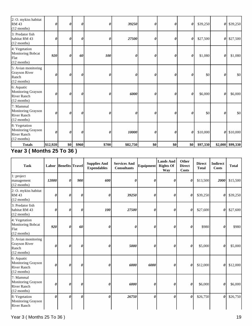
Totals $12,920 $0 $960 $700 $82,750 $0 $0 $0 $97,330 $2,000 $99,330
Year 3 ( Months 25 To 36 )
Task Labor Benefits TravelSupplies AndExpendables
Services AndConsultants
EquipmentLands AndRights Of
Way
OtherDirectCosts
DirectTotal
IndirectCosts
Total
1: projectmanagement(12 months)
12000 0 900 600 0 0 0 0 $13,500 2000 $15,500
2: O. mykiss habitatRM 43(12 months)
0 0 0 0 39250 0 0 0 $39,250 0 $39,250
3: Predator fishhabitat RM 43(12 months)
0 0 0 100 27500 0 0 0 $27,600 0 $27,600
4: VegetationMonitoring BobcatFlat(12 months)
920 0 60 0 0 0 0 0 $980 0 $980
5: Avian monitoringGrayson RiverRanch(12 months)
0 0 0 0 5000 0 0 0 $5,000 0 $5,000
6: AquaticMonitoring GraysonRiver Ranch(12 months)
0 0 0 0 6000 6000 0 0 $12,000 0 $12,000
7: MammalMonitoring GraysonRiver Ranch(12 months)
0 0 0 0 6000 0 0 0 $6,000 0 $6,000
8: VegetationMonitoring GraysonRiver Ranch
0 0 0 0 26750 0 0 0 $26,750 0 $26,750
Year 3 ( Months 25 To 36 ) 19
(12 months)
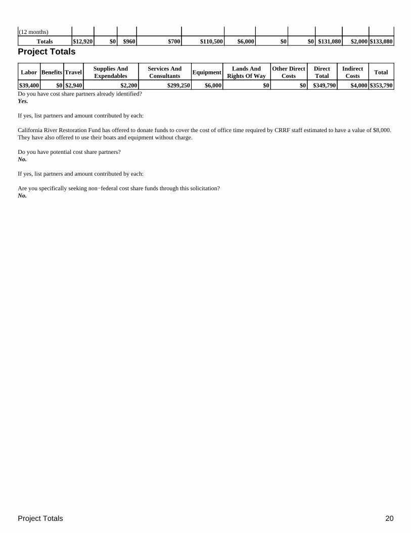
Totals $12,920 $0 $960 $700 $110,500 $6,000 $0 $0 $131,080 $2,000 $133,080
Project Totals
Labor Benefits TravelSupplies AndExpendables
Services AndConsultants
EquipmentLands And
Rights Of WayOther Direct
CostsDirectTotal
IndirectCosts
Total
$39,400 $0 $2,940 $2,200 $299,250 $6,000 $0 $0 $349,790 $4,000 $353,790Do you have cost share partners already identified?Yes.
If yes, list partners and amount contributed by each:
California River Restoration Fund has offered to donate funds to cover the cost of office time required by CRRF staff estimated to have a value of $8,000.They have also offered to use their boats and equipment without charge.
Do you have potential cost share partners?No.
If yes, list partners and amount contributed by each:
Are you specifically seeking non−federal cost share funds through this solicitation?No.
Project Totals 20
Budget JustificationThis proposal is for the Ecosystem Restoration Program 2004 Monitoring and Evaluation solicitation as prepared by Boucher, Allison M.
November 18, 2004: Some checkboxes were not displaying correctly in the "printable" views and compilations. This problem has been resolved. Pleasecheck your proposals carefully and notify the help line if what you entered is not displayed correctly.
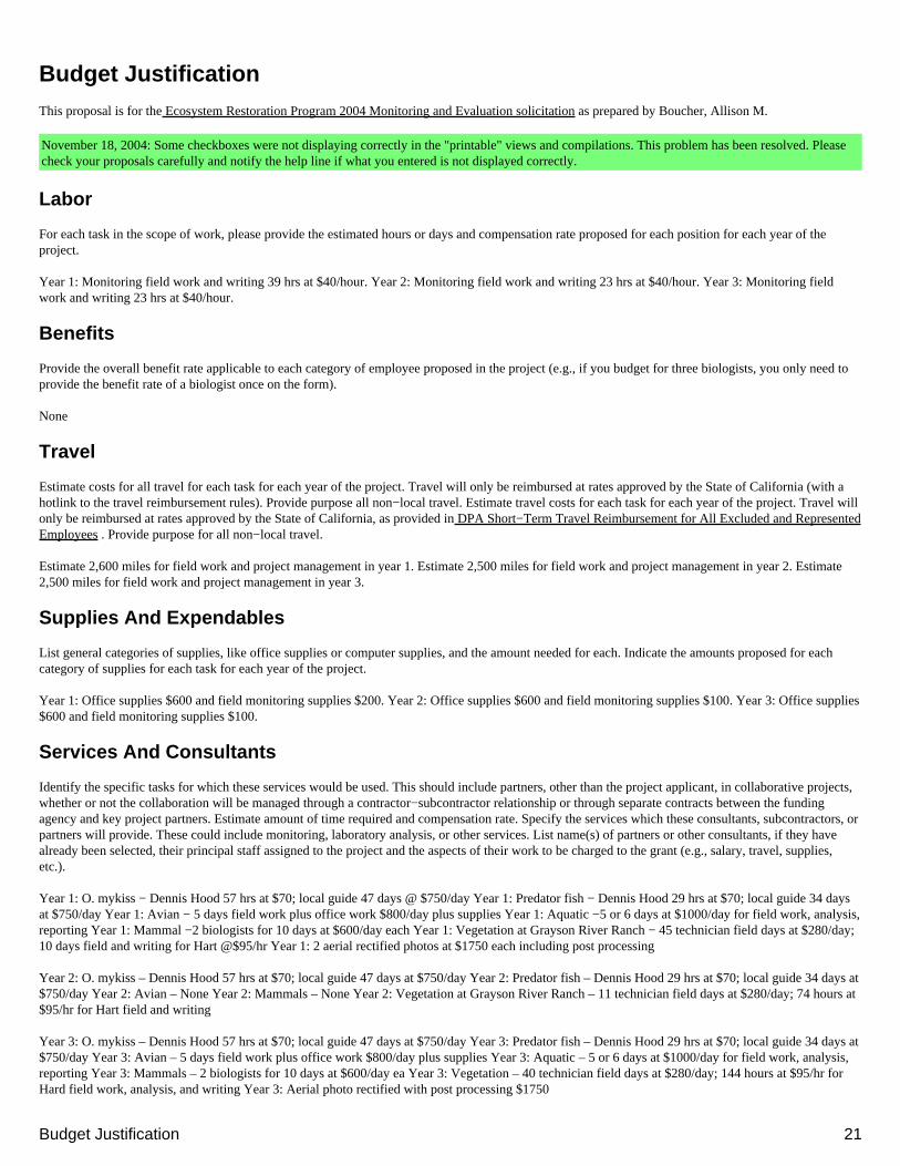
Labor
For each task in the scope of work, please provide the estimated hours or days and compensation rate proposed for each position for each year of theproject.
Year 1: Monitoring field work and writing 39 hrs at $40/hour. Year 2: Monitoring field work and writing 23 hrs at $40/hour. Year 3: Monitoring fieldwork and writing 23 hrs at $40/hour.
Benefits
Provide the overall benefit rate applicable to each category of employee proposed in the project (e.g., if you budget for three biologists, you only need toprovide the benefit rate of a biologist once on the form).
None
Travel
Estimate costs for all travel for each task for each year of the project. Travel will only be reimbursed at rates approved by the State of California (with ahotlink to the travel reimbursement rules). Provide purpose all non−local travel. Estimate travel costs for each task for each year of the project. Travel willonly be reimbursed at rates approved by the State of California, as provided in DPA Short−Term Travel Reimbursement for All Excluded and RepresentedEmployees . Provide purpose for all non−local travel.
Estimate 2,600 miles for field work and project management in year 1. Estimate 2,500 miles for field work and project management in year 2. Estimate2,500 miles for field work and project management in year 3.
Supplies And Expendables
List general categories of supplies, like office supplies or computer supplies, and the amount needed for each. Indicate the amounts proposed for eachcategory of supplies for each task for each year of the project.
Year 1: Office supplies $600 and field monitoring supplies $200. Year 2: Office supplies $600 and field monitoring supplies $100. Year 3: Office supplies$600 and field monitoring supplies $100.
Services And Consultants
Identify the specific tasks for which these services would be used. This should include partners, other than the project applicant, in collaborative projects,whether or not the collaboration will be managed through a contractor−subcontractor relationship or through separate contracts between the fundingagency and key project partners. Estimate amount of time required and compensation rate. Specify the services which these consultants, subcontractors, orpartners will provide. These could include monitoring, laboratory analysis, or other services. List name(s) of partners or other consultants, if they havealready been selected, their principal staff assigned to the project and the aspects of their work to be charged to the grant (e.g., salary, travel, supplies,etc.).
Year 1: O. mykiss − Dennis Hood 57 hrs at $70; local guide 47 days @ $750/day Year 1: Predator fish − Dennis Hood 29 hrs at $70; local guide 34 daysat $750/day Year 1: Avian − 5 days field work plus office work $800/day plus supplies Year 1: Aquatic −5 or 6 days at $1000/day for field work, analysis,reporting Year 1: Mammal −2 biologists for 10 days at $600/day each Year 1: Vegetation at Grayson River Ranch − 45 technician field days at $280/day;10 days field and writing for Hart @$95/hr Year 1: 2 aerial rectified photos at $1750 each including post processing
Year 2: O. mykiss – Dennis Hood 57 hrs at $70; local guide 47 days at $750/day Year 2: Predator fish – Dennis Hood 29 hrs at $70; local guide 34 days at$750/day Year 2: Avian – None Year 2: Mammals – None Year 2: Vegetation at Grayson River Ranch – 11 technician field days at $280/day; 74 hours at$95/hr for Hart field and writing
Year 3: O. mykiss – Dennis Hood 57 hrs at $70; local guide 47 days at $750/day Year 3: Predator fish – Dennis Hood 29 hrs at $70; local guide 34 days at$750/day Year 3: Avian – 5 days field work plus office work $800/day plus supplies Year 3: Aquatic – 5 or 6 days at $1000/day for field work, analysis,reporting Year 3: Mammals – 2 biologists for 10 days at $600/day ea Year 3: Vegetation – 40 technician field days at $280/day; 144 hours at $95/hr forHard field work, analysis, and writing Year 3: Aerial photo rectified with post processing $1750
Budget Justification 21
Equipment
Identify specific each item of equipment to be purchased and its cost. Equipment is defined as a piece of property costing $1,000 or more per unit with anexpected use of three or more years.
None
Lands And Rights Of Way
List costs of any lands, easements, or rights of way needed for monitoring activities, explaining whether cost are based on completed appraisals ofproperties to be acquired or are estimates derived by other methods Explain how these costs were estimated (prior experience, recent sales, appraisal ofparcels to be acquired, etc). State whether any appraisals used meet applicable state and federal standards, and include support or a rationale for thisstatement. Reasonable costs for appraisals, title reports, environmental site assessment, and other closing expenses may be included.
None
Other Direct Costs
Provide any other direct costs not already covered for each task for each year of the project.
None
Indirect Costs/Overhead
Overhead usually includes general office costs such as rent, phones, furniture, general office staff, etc., and is distributed by a predetermined "indirectrate" applied to other specific costs. This is usually an amount or pro rate share of existing salaries and benefits, rent, equipment, materials, and utilitiesattributable to a function or activity, but not necessarily generated by the function or activity. Where available, use indirect rates approved through state orfederal budgetary procedures, such as Office of Management and Budget Circular A−87 (Cost Principles for State, Local, and Indian Tribal Governments), Office of Management and Budget Circular A−21 (Cost Principles for Educational Institutions) or Office of Management and Budget Circular A−122(Cost Principles for Non−Profit Organizations) . Explain what direct costs this rate is applied to when budgeting indirect costs (e.g., labor, benefits, etc.).Where an approved indirect rate is not available, explain what is encompassed in the budget for indirect costs. This could include costs associated withgeneral office requirements such as rent, phones, furniture, general office staff, etc., generally distributed by a predetermined percentage (or surcharge) ofspecific costs.
Year 1: Aerial photos with post processing Year 2: Aerial photos with post processing
Comments
If you have comments about budget justification that do not fit elsewhere, enter them here.
Equipment 22
1
Tuolumne River Post Construction Habitat Evaluation
A. Project Description
This proposal is to monitor two separate restoration projects managed by Friends of the Tuolumne: BOBCAT FLAT RIVERMILE 43 and GRAYSON RIVER RANCH.
BOBCAT FLAT RIVERMILE 43 (See Grayson River Ranch pages 10 – 18
STEELHEAD AND SALMON INSTREAM RESTORATION AND FLOODPLAIN RECLAMATION
The Friends of the Tuolumne received a CBDA grant and Don Pedro Dam FERC Settlement Funds from the City and County of San Francisco to purchase and restore 300 acres on the Tuolumne River approximately 23 miles upstream from Modesto. The property was purchased and the funded restoration construction will be completed in the summer of 2005. In 2002 Turlock Irrigation District on behalf of the Technical Advisory Committee was funded for Rivermile 43 gravel augmentation.
The construction will harvest aggregate from the floodplain, sort and clean the aggregate, and place it in the river for fishery habitat. The design for the instream placement of the gravel is unique to the Tuolumne River; it is the first project incorporating steelhead and trout spawning and holding water integrated into the design to provide both steelhead and salmon spawning habitat.
The riffle designs include contours with velocity above and below the shallow salmon riffles to provide a variety of habitats. The shallow riffle ledges will be bracketed with pocket water for steelhead spawning and holding areas. A deep transportation corridor will be included to provide protection for fish movement up and downstream. Streamside vegetation will be preserved for rearing and holding habitat. The patches of gravel will be placed to provide maximum steelhead and salmon spawning and holding habitat.
The harvesting of the aggregate will lower the floodplain by approximately four feet on about 9 acres. The reclamation design is intended to encourage natural regeneration of native trees and forbs. A high water scour channel across the same area will reduce the instream pressures during large flood events to better protect the constructed riffles from being washed out.
1. Problem, Goals, and Objectives: Steelhead and salmon spawning habitat in the Tuolumne River is insufficient. Although some good spawning habitat remains upstream at La Grange, very little remains in the dredger reach (Habitat Restoration Plan for the Lower Tuolumne River Corridor prepared for the
2
Tuolumne River Technical Advisory Committee, January 2001). This is the first instream design to implement steelhead, as well as salmon, spawning needs.Bobcat Flat is located within the reach of viable trout water. Bobcat Flat has the potential to significantly increase usable spawning habitat and increase the abundance of Chinook salmon spawning within its 1.6 miles of instream habitat (Habitat Restoration Plan for the Lower Tuolumne River Corridor).
Monitoring will provide guidance for future gravel augmentation projects on the Tuolumne and Merced Rivers in order to maximize both salmon and steelhead/trout spawning and holding habitat. The riffle designs are adapted from successful designs on the Stanislaus River that provide steelhead and salmon spawning on each riffle. The successful Stanislaus River gravel augmentation projects are used as a template. The monitoring of Bobcat Flat Rivermile 43 will help future Tuolumne River projects adapt for trout and salmon at the time of design.
Problem, Goals, and Objectives re predatory fish: The abundance of predatory fish in the Lower Tuolumne River may be a limiting factor for salmonid survival (FERC Settlement Agreement, Habitat Restoration Plan for the Lower Tuolumne River Corridor). Large backwater areas are ideal for predatory fish to hold and procreate. Bobcat Rivermile 43 has large numbers of bass, a known predator fish, and several areas documented as bass habitat.
Problem, Goals, and Objectives re vegetation: The dredger tailings were removed during the 1970’s to build New Don Pedro Dam. The floodplain was left level, compacted, and covered with large aggregate. The new dam effectively limits spring flooding. Under these conditions natural regeneration of native trees and forbs has been minimal. The 9 acres in the funded restoration is covered with Star Thistle, an invasive weed.
The reclamation is designed to lower the floodplain allowing more frequent spring flooding in an effort to encourage natural regeneration of native trees and forbs.Because the floodplain will be lower to the water table, trees should be more successful in establishing a riparian forest. Once a riparian forest is established on this open and nearly barren land, the shade it provides will encourage native forbs. Planting of trees and forbs will test the hypotheses that (a) lowering the floodplain will encourage natural regeneration and (b) planted trees will be more easily established because the water table will be closer to the root zone. The construction also uses the aggregate for the instream riffle construction thus providing a double benefit.
2. Justification: Steelhead returning to spawn have few usable riffles. Gravel augmentation providing additional square yards for spawning can be designed to provide both salmon and steelhead spawning habitat, steelhead holding water, and transportation corridors for trout/steelhead.
3
Most areas actively used by steelhead/trout for spawning are on the downstream edge of the riffle and provide holding water that is at least four feet deep immediately downstream of the riffle. Although the recent gravel augmentation projects on the Tuolumne have been able to increase the square yards used by spawning salmon, they have not enhanced steelhead/trout habitat and may, in fact, have diminished useable trout habitat. The designs built at Bobcat Flat Rivermile 43 have incorporated steelhead/trout needs based on empirical observation upstream in the La Grange area on the Tuolumne River and on the Stanislaus River where adult steelhead/head trout have been recorded during spawning season. Building the Rivermile 43 instream restoration project is expected to provide additional useable square yards in the Tuolumne River for both steelhead/trout and salmon.
The Coarse Sediment Management Plan for the Lower Tuolumne River fundedby the USFWS Anadromous Fish Restoration Program and administrated by Turlock Irrigation District includes mapping of general trout habitat and recommends monitoring of trout habitat both pre and post-project.
Steelhead/trout need spawning gravel of a smaller size than do Chinook salmon.Steelhead/trout also prefer riffles with higher velocity and/or surface turbulence providing cover. Steelhead/trout also need deeper holding water in the immediate vicinity of their spawning redds. All these attributes have been designed into Rivermile 43 construction.
Based on the monitoring results, the velocity, depth, gravel size, and length of riffles can be adjusted to improve future gravel projects on both the Tuolumne River and the Merced River. Velocity and linear length of the spawning riffles, depth and linear length of the holding water, and gravel size will be studied and compared to where and how the fish use the constructed project spawning riffles/pools. The exact design features can be fine tuned for the next instream restoration, particularly at Bobcat Flat since the next Bobcat Flat restoration is expected to be immediately adjacent to Rivermile 43.
Bobcat Flat has gravel available for instream restoration and will analyze the results of this project before implementing additional gravel infusion projects. We will also be certain that our results are fully shared with the Technical Advisory Committee as they begin implementation of the Coarse Sediment Plan for the Lower Tuolumne River gravel infusion projects. Steelhead/trout and salmon use patterns will be documented and analyzed in order to maximize available instream habitat for adult steelhead/trout, spawning salmon, and juvenile salmonid.
Justification re predatory fish: The construction of salmonid spawning, holding, and rearing habitat should reduce the available bass habitat. Post-construction monitoring will document any change in bass habitat and provide information for construction in areas that also have a predatory fish concern.
4
Bobcat Flat Rivermile 43 is an excellent choice of locations for this study because it is downstream toward the lower end of beneficial trout habitat and harbors large numbers of bass in the warmer backwaters.
The oversized cobble that will not be used to build the spawning riffles will be placed in some of the large, slow backwaters to reduce bass habitat as well as reduce the width of the stream and increase the velocity.
Justification re vegetation: Reestablishing a riparian forest in the dredger tailings section of the Lower Tuolumne River has been problematic due to the poor soil. By removing the large aggregate from the floodplain and using it for spawning riffle construction or other instream restoration, the soil will be improved enough to provide an adequate growing medium. The planting will leave some part of the 9 acres unplanted to test whether or not natural regeneration can occur with improved soil composition and a closer water table.
3. Previously Funded Monitoring: The report “Adult O. mykiss Habitat in the Lower Tuolumne River” was included in the Coarse Sediment Management Plan for the Lower Tuolumne River funded by USFWS Anadromous Fish Restoration Program and administrated by Turlock Irrigation District. The purpose for the report was to analyze successful steelhead/trout habitat on the Tuolumne River.Those elements have been designed into this construction project.
The Tuolumne River Technical Advisory Committee has prepared a three year monitoring proposal that will include seining for juvenile fish in the Lower Tuolumne River, including post-project Rivermile 43. The seining report will be incorporated into a comprehensive Bobcat Flat Rivermile 43 report.
California Department of Fish and Game has conducted salmon redd surveys for many years that include Rivermile 43. In addition, a pre-project salmon redd survey for Rivermile 43 is currently being implemented by McBain and Trush under funding by Department of Water Resources. DWR has funded $300,000 of the restoration for Rivermile 43 gravel augmentation including the pre-project redd survey and physical processes monitoring such as pebble counts, permeability, and facies mapping. The pre-project baseline monitoring reports will be included in a comprehensive analysis of the post-project results of restoration and reclamation at Rivermile 43.
Previously Funded Monitoring re predatory fish: Baseline predatory fish populations, their habitat use, feeding habits, and species will be completed before the instream construction begins. The baseline monitoring is funded by the original CBDA grant.
Previously Funded Monitoring re vegetation: Baseline vegetation monitoring has been completed with an inventory and photos (both aerial and landscape). The baseline vegetation monitoring has been funded by the original CBDA grant.
5
4. Approach as Scope of Work:
Adult Steelhead/trout: Trout habitat will be monitored using angling, cinema photography, and mapping GPS locations. Because other monitoring programs (McBain and Trush for the Technical Advisory Committee and Turlock Irrigation District) will monitor fish using seining and the physical processes such as pebble counts, permeability, and as built velocity, slope, etc., our program will focus on adult steelhead/trout. The construction at Rivermile 43 will be monitored by Dennis Hood with support from a local guide each year from January through June. The guide is capable of catching the elusive returning adult steelhead and native steelhead/trout. Previous angling efforts by other agencies have been unable to hook these large and difficult-to-catch fish. The guide was able to hook and land steelhead/trout weighing between 2 and 12 pounds for the California Department of Fish and Game DNA sampling in the Spring of 2004. Documentation of fish habitat usage will be mapped using GPS and cinema photography.
The deliverables will include a detailed map of the Rivermile 43 construction area for each of the three years, written and photo descriptions of the nature of habitat being used by steelhead/trout, and calculations of increased square yardage of use. Dennis Hood will prepare the reports and analysis comparing the results to the pre-project baseline monitoring and prior year monitoring results. We expect to be able to draw conclusions about the impact of the riffle designs on both Chinook salmon and steelhead/trout usage of Rivermile 43.
Because these riffles will be the first on the Tuolumne River designed to provide both Chinook salmon and steelhead spawning, holding, and rearing habitat, the analysis of how the post-project riffles are used will be valuable to the next designs prepared for both the Tuolumne and Merced Rivers. The hypothesis is that these riffle designs will increase use by both species for spawning, as well as provide holding water and a transportation corridor for trout movement up and downstream. We will also include in our reports the results of the juvenile seining at Rivermile 43 and evaluate how the post-construction affects rearing habitat usage.
Approach and Scope of Work re predator fish: Predator fish use of Rivermile 43 will be studied using angling, cinema photography, GPS location mapping, and stomach contents sampling. Currently predator fish use this part of the Tuolumne River for feeding and spawning. Our studies will compare the different species’ use of the area each of the three years May through October and compare the approximate abundance and type and location of use to the pre-project monitoring report and to the prior years’ reports. The goal is to establish the locations and water type used by predator fish and the impact salmonid restoration projects may have on predator fish.

6
Because other monitoring projects (McBain and Trush for the Technical Advisory Committee and Turlock Irrigation District) propose to study juvenile fish using seining and adult predator fish in other sections of the river using the same guide, our project will focus on adult predator fish specifically and in detail at Rivermile 43. Our results will be folded into McBain and Trush’s reports to compile a river-wide report on adult predator fish.
Our monitoring results will be folded into a comprehensive report for Rivermile 43 detailing how predator fish use the habitat designed to enhance salmonids.Patches 4 and 5 of the gravel augmentation plan will use the oversize cobble to partially fill in backwater areas in an effort to reduce predator fish abundance as well as increase flow velocity. This angling and cinema photography will be intense so that an analysis can be prepared to recommend methods of reducing predator fish abundance throughout the entire 52 miles of the Lower Tuolumne River.
The deliverables will include a detailed map of the Rivermile 43 construction area for each of the three years, written and photo descriptions of the nature of habitat being used by predator fish, and calculations of decreased square yardage of use. Dennis Hood will prepare the reports and analysis comparing the results to the pre-project baseline monitoring and prior year monitoring results. We expect to draw conclusions about the impacts on predator fish abundance and habitat usage as affected by the gravel augmentation as designed and implemented.
The hypothesis is that these riffle designs will increase use by both salmon and steelhead/trout and reduce predator abundance by reducing predator spawning and feeding habitat. We will also include in our reports the results of the juvenile seining at Rivermile 43 and evaluate how the post-construction affects the abundance of juvenile predator fish.
Approach and Scope of Work re Vegetation: Monitoring the floodplain reclamation and revegetation will document how the vegetation was planted, what plant species survived, increased size, the methods of maintenance, and the degree and locations in which natural recruitment occurred. The physical characteristics of the post-construction floodplain will be described and photographed and compared to the pre-project floodplain.
Monitoring will be done during May of the first year post-construction and again in late summer or early fall in each of the three contract years.
Because we will be lowering the floodplain by approximately four feet, we need to document what effect this has on plant survivability and recruitment. The water table will be closer and we expect trees and plants to grow more easily. We will place water monitoring wells (tubes) during construction that will enable us to track the water table throughout the contract years. Readings will be taken
7
throughout the seasons to track how the water table is affected by flows and how it relates to plant survival.
The deliverables will include written and photographic descriptions of the re-vegetation results with conclusions regarding how the reclamation construction, planting methods, and maintenance methods affected success of which species, both planted and naturally occurring.
5. Feasibility: These monitoring tasks are feasible. The project construction is scheduled to be completed during the summer of 2005 so the post-project monitoring can begin January 2006 with the return of adult steelhead to the river.The contractor will have the necessary collection permits from CDFG and scientific research permits from NOAH. The steelhead/trout monitoring is seasonal and should begin in January in order to cover the full season from January through June.
As described above, we are using angling, photo cinema photography, and GPS mapping because we are focused on adult fish. Other monitoring programs on the Tuolumne River such as seining and snorkeling will and have covered juvenile and smaller fish during the summer months. Only angling has been able to study the elusive adult steelhead/trout and native trout. Most steelhead/trout monitoring is done during cold months when snorkeling is not suggested.Angling has been able to document the presence and location of steelhead/trout in the range up to 12 pounds.
The Tuolumne River Technical Advisory Committee is cooperating with us and we will be folding the results of their monitoring for juvenile fish and physical processes into our final report. We will share with them the results of our monitoring because we are the only study of adult steelhead/trout and we hope to draw conclusions about riffle design suitability. Our goal is to be able to guide future riffle designs to accommodate both Chinook salmon and steelhead/trout together and maximize the resources. The results will be useful for future riffle designs on both the Tuolumne and Merced Rivers. Bobcat Flat was purchased by Friends of the Tuolumne with the original CBDA grant. Therefore, no special permission is needed to perform the monitoring.
The vegetation monitoring needs no special permits. We plan to share our results with the Technical Advisory Committee, California Department of Fish and Game, and other groups managing restoration projects on the Tuolumne and Merced Rivers. Many of these projects face the same challenges of cobble rich but soil poor floodplains. Our experiment with lowering the floodplain by using the cobble for instream work in an effort to maximize the resource will gain some knowledge on the advantages/disadvantages of this strategy. Our monitoring reports will summarize our results for others managing projects in the region.
8
6. Expected Outcomes and Products: Steelhead
Our reports will detail the successful or unsuccessful aspects of the riffle designs with respect to how steelhead/trout use the restored habitat. We will fold into our report the information from the McBain and Trush salmon redd surveys and juvenile seining surveys so that we can analyze and make recommendations for the next instream gravel restoration projects on the Tuolumne and Merced Rivers. We expect the report to show that both species are using the restoration site in greater numbers than pre-project and that the heterogeneity provides excellent habitat for adult and juvenile Chinook salmon and steelhead/trout.
Expected Outcomes and Products: Predatory Fish
Our final report will analyze how the restoration has impacted predatory fish use of the area. Part of the design includes predator fish habitat reduction by filling large backwater areas where they spawn and feed and increasing flow velocity.The report will compare the predator fish use of the area and their diet to the results of the pre-project site. We will quantify the impact in an effort to measure the effectiveness of reducing predator fish so that the next restoration projects on the Tuolumne and Merced Rivers can adapt our results to their designs and use the opportunity to both enhance salmonid habitat as well as reduce predator impacts on salmonids.
Expected Outcomes and Products: Vegetation
Our report is expected to reach conclusions regarding the success of planting and the likelihood of natural regeneration on a lowered floodplain in the dredger reach. Each project to date on the Tuolumne River has improved and adapted from previous projects by all the project managers. This project will add to the knowledge base for restoration projects in cobble areas with little or no soil.
7. Data Handling, Storage, and Dissemination
Our reports and the results will be shared with the Technical Advisory Committee, local and county agencies restoring riparian habitat, California Fish and Game for their work on the Merced River, and any and all interested parties. We will provide tours and presentations to all interested groups and agencies. We work closely with many of the local and county agencies and will share with them all the knowledge learned in this monitoring program. We will continue our work to disseminate Tuolumne River knowledge as we work with cooperating groups.
8. Public Involvement and Outreach
As members of the Tuolumne River Technical Advisory Committee, Ceres River Bluff Regional Park floodplain restoration committee, regular participants in
9
discussions about the Tuolumne River Regional Park floodplain restoration, project managers of two CALFED projects, a member of the Tuolumne River Coalition (local watershed group with 12 agencies/non-profits), and active members in our community, we will give tours, assist in planning, offer our reports, and be available for questions on a regular basis. Our reports will be available for others’ use.
9. Work Schedule
Each segment of our monitoring proposal can stand alone. Each segment of our monitoring is implemented annually for the three years of the contract.Steelhead/trout monitoring is January through June each year. Predator fish monitoring is May through October each year. The vegetation monitoring is May the first year and October of each year.
Although each segment can stand alone, together they provide a comprehensive study of an exciting new design theory for the Tuolumne River gravel augmentation program. Combined with the Technical Advisory Committee monitoring for juveniles, Chinook salmon redds, snorkeling, and general predatory fish in other projects, we will have a complete picture of the impact (success) of the different design features built into Bobcat Flat Rivermile 43 instream restoration and floodplain reclamation. Small, S. , Nur, N, Black A., Geupel, G. and D. Humple. 2000. Riparian BirdPopulations of the Sacramento River System: Results form the 1993 – 1999Field Season. PRBO unpublished report to The Nature Conservancy and TheUS Fish and Wildlife Service.
B. Applicability to CALFED Bay-Delta Program ERP Goals, the ERP Draft Stage 1 Implementation Plan, and CVPIA Priorities
Bobcat Flat Rivermile 43
1. ERP and CVPIA Priorities: Our proposal seeks to address fall run Chinook salmon and steelhead habitat needs. Our construction project is instream and riparian rehabilitation in the salmonid spawning reach of the Lower Tuolumne River. The riffle designs are unique because they aim to provide spawning areas for both Chinook salmon and steelhead/trout in an area decimated by gold dredging 50 years ago.
Limited spawning is documented each year; the restoration aims to significantly increase the amount of usable riffle area and provide holding water and a transportation corridor for steelhead. Our proposal goal is to analyze the effectiveness of the riffle and gravel augmentation designs and the effectiveness of lowering the floodplain by utilizing the gravel for instream restoration. The

10
success of natural recruitment and plantings on the floodplain will be monitored.The proposal also addresses the expected impacts on predatory fish in the immediate vicinity of the rehabilitated instream habitat.
Bobcat Flat RM 43 addresses several ERP and CVPIA goals – ERP Strategic Goal 1: At-Risk Species, “big R”. Goal 3: Harvestable Species. Goal 4: Riparian Habitat, and CVPIA Priority SJ3: Rearing and spawning habitat for Chinook salmon, steelhead, and splittail.
2. Relationship to Other Ecosystem Restoration Actions, Monitoring Programs, or System-wide Ecosystem Benefits: Our proposal builds on both past and future monitoring of the Lower Tuolumne River. Past snorkeling, seining, and redd surveys results will be compiled with our results to develop a comprehensive analysis of the Bobcat Flat Rivermile 43 rehabilitation. Proposed monitoring by the TRTAC will also be combined with our results to further the comprehensive analysis of the hypothesis that Chinook salmon and steelhead/trout spawning can be effectively designed together.
The results of our monitoring for the instream restoration will be available for future gravel augmentation projects under the Coarse Sediment Management Plan for the Lower Tuolumne River, at Bobcat Flat, and on the Merced River.We are eager to share the knowledge of this project and its monitoring program.We work closely with the TRTAC and California Fish and Game on the Tuolumne River. We expect the report to be a vital link in the association between Chinook spawning gravel projects and steelhead/trout habitat needs.
3. Land Acquisition: Not applicable.
A. PROJECT DESCRIPTION Grayson River Ranch Perpetual Conservation Easement and Restoration FLOODPLAIN RESTORATION TO RETURN CONVERTED RIPARIAN AREA TO FUNCTIONAL CONDITION FOR AVIAN, MAMMAL, AND FISH SPECIES.
Friends of the Tuolumne and the East Stanislaus Resource Conservation District partnered to apply for funding to undertake the 140 acre Grayson River Ranch Perpetual Conservation Easement and Restoration Project. It is located on the Lower Tuolumne River at Rivermile five.
It was funded through the 1998 CBDA ERP and by the U.S. Fish and Wildlife, Anadromous Fish Restoration Program (AFRP), and the U.S Department of Agriculture, Natural Resources Conservation Service (NRCS).
The perpetual conservation easement was finalized during the spring of 2000 with funds provided by the AFRP and NRCS. Construction of the site began in
11
August of 2000 when CBDA funds became available. The project was completed in October 2004. Long term monitoring of biologic response remains.
1. Problem Goals and Objectives: The riparian forest of the eastern section was cleared and converted to agricultural use sometime prior to 1939. The western section was subsequently cleared and converted later. Aerial photographs taken in 1939 document a richly vegetated habitat on the western section and a completely converted eastern section. As intensive agriculture and modern technologies improved, the site was protected from river flood waters. As a consequence, the rich wildlife habitat of this site was lost and river flood functions were greatly diminished. Wildlife habitat value for all species was reduced to near zero. Agricultural use of the lower Tuolumne River has similarly converted the great majority of historic riparian land. Habitat necessary for both migratory and resident aquatic, avian, and terrestrial species is in short supply (Habitat Restoration Plan for the Lower Tuolumne River Corridor, prepared for the Tuolumne River Technical Advisory Committee).
Goal and Objectives Create a healthy riparian forest where none existed that addresses the habitat needs of target species including resident and migratory avian, aquatic, and terrestrial species including “Big R” species identified in the Multi-Species Conservation Strategy (CBDA 2000): Central Valley steelhead ESU, Central Valley fall-/late-fall Chinook salmon SU, Valley Elderberry longhorn beetle .
Restoration actionsTwo 2000 foot long backwaters were excavated to create off-channel fish habitat. 75,000 yards of material were moved to create backwater habitat that will fill from the downstream end and drain back out as river levels recede. These waterways are engineered to begin filling at approximately 4,300 CFS and fill the entire length with flows of 4,600 CFS. These are common high flows on the Tuolumne river that have occurred in approximately 50% of the years in recent history.Unfortunately, since completion of the construction, no such flows have occurred.
Riparian planting: The site has been devoid of riparian habitat for at least 30 and 65 years. It was replanted in 2001 and 2003 with a mix of approximately 7000 native riparian trees and grass. Some large areas on the site were left unplanted with the expectation that natural recruitment would vegetate those areas over time. Irrigation was reduced during 2004 and terminated in the fall of 2004.Establishment is well under way. The trees are beginning to establish very well and the native grass has taken hold in places and are beginning to spread.Wildlife use of the site is accelerating.
Physical restoration is 100% complete. Evaluation of wildlife biologic response to the improvements and continued monitoring of the vegetation will complete the project.
12
2. JustificationAs outlined above, the site was bare cropland prior to restoration. It had almost no wildlife value due to its lack of habitat. Our conceptual model assumes that lack of wildlife use on this site was attributable to its impoverished habitat, and that creation of new habitat would produce a substantial increase. Proximity to the San Joaquin Wildlife Preserve and other heavily used local habitats indicates that good habitat is used when it exists. Grayson River Ranch contains good soils for vegetation growth. The soil types however have proven to be highly variable within localized project areas. This variability has apparently manifested itself in diverse vegetative viability and vigor (Hart Restoration, Inc).
3. Previously Funded Monitoring Monitoring was funded as part of the original grant. The CBDA Cooperative Agreement expired October 2004. It is not possible to extend that contract to complete the planned long-term monitoring.
Monitoring of the site began with baseline monitoring prior to construction. Discrete components of the monitoring plan include actions to evaluate the biological response to restoration of the site. Funding to continue project evaluation has expired. Continued long term monitoring as originally envisioned will not be possible without additional funds.
Four key areas were selected from the ecosystem components because they represent the project performance across all possible components due to the inter-related processes of habitat creation and wildlife use. Project performance was related to wildlife population changes on the site for avian, mammals, and aquatic species relative to those of pre-construction. Vegetation monitoring evaluated early stage processes of survival and growth.
Performance measures for the project were evaluated by field monitoring by consultants from three of the four disciplines (Aquatic monitoring has not been possible due to inadequate river flow conditions to accommodate study requirements).
Vegetation is developing on the site with some regional areas showing substantial variability in growth and viability. More investigation is needed to determine the causes of these differences.
Wildlife population changes and use are important components of our conceptual model. It has been postulated that small mammals would show an earlier response to the habitat than larger ones due to their less mobile habits. In the mammal population, that appears to be true.
13
Avian populations responded immediately. Migratory songbirds and upland game birds have greatly expanded and increase each season as the project matures.
Scheduled monitoring activities to continue evaluation of biologic response will need to be postponed or cancelled if no additional funding is located. Preliminary data collected to date will provide limited value without continued monitoring as the project matures.
4. Approach and Scope of Work:
AvianRecent studies have demonstrated that the presence of a suite of riparian bird species, and in particular, the successful breeding of these species, provides a good indicator of riparian health, and good gauge of restoration success (Griggs and Small, 2000). Natural process restoration and establishment of limited meander will create vegetation conditions (increased early successional habitat, vegetation structure and volume, patch diversity) that enhance and restore declining migratory bird species (Small et al 2000). Further information regarding the value of riparian habitat to birds and their roles as indicators of habitat health, is provided in the Riparian Habitat Joint Venture’s Riparian Bird Conservation Plan (2000).
Overview and ObjectivesThe project will monitor trends in the avifauna and vegetation of the Grayson River Ranch site as a result of restoration activities. Data collected on the occurrence and abundance of bird species will be correlated with vegetation variables and compared to nearby control sites, which include undisturbed and other restored plots. These data will provide useful information to gauge the success of restoration at the site and help guide future restoration projects to better benefit birds. Collaborative data will be collected concurrently at nearby sites on the San Joaquin River. Data will be integrated with similar efforts on the San Joaquin National Wildlife Refuge. Furthermore, data from the site will be included in a statewide database that maps the current distribution of birds in California. For more information on this effort, please see the Riparian Bird Conservation Plan (Riparian Habitat Joint Venture 2000).
Objectives of this study are: To assess bird species richness and diversity. To determine abundance and distribution of select species. To assess changes in the composition and structure of the plant community. To use information to assess the constraints, and likelihood of recolonization of
the restored riparian habitat. To integrate data collected at this site with other projects to develop more
complete models for riparian restoration along the San Joaquin River and its tributaries.
14
HypothesesHypothesis 1: Species richness and diversity of native riparian-associated birds
increasesafter riparian areas are restored.
Hypothesis 2: The occurrence and abundance of certain riparian-associated species is
linked to particular vegetation variables, specifically related to the health of the native
plant community.
AquaticFloodplain habitat provides valuable refugia to Chinook salmon and steelhead.Conditions in such habitats provide shelter from flood waters and improved feeding and rearing habitat for improved survival and growth. The floodplain backwater will be seine netted during appropriate flows to capture juvenile Chinook salmon and steelhead utilizing the backwater refugia. The nearby in-channel site will be seined as well. Data of captured fish will be compared to establish size differences between the two habitats. Such backwater locations also provide suitable habitat for splittail production. They will be sampled for splittail larvae.
Objective Evaluate Grayson River Ranch restoration project to determine possiblebenefits to the Tuolumne River fishery. Determine fish species composition, density, and condition factor of salmonids in restored floodplain habitats compared to similar habitats in the main river channel. Sample for presence of splittail larvae. These objectives have been unfulfilled since the construction was completed because the required high river flows have not occurred. In recentyears the required flows have occurred in about 50% of the years.
Hypotheses1) Salmonids will use restored floodplain habitat during high river flows.
2) Salmonids utilizing restored floodplain habitat are more robust than those that use the adjacent in-channel habitat.
3)Splittail are present in the lower Tuolumne River during high flows and will use restored floodplain habitat.
TerrestrialOverviewMonitoring efforts will be focused on two of three segments of the mammalian community – shrews and most rodents, which can be detected and enumeratedby live trapping, and fossorial gophers and moles, which can be detected and their numbers indexed by counting the piles of castings on belt transects; on
15
medium and large sized species whose presence can be detected by the use of tracking stations, remote cameras, and direct observation. Medium and largemammal detection thresholds for determining population changes in such mobile populations is problematic. Because small mammals have lower vagility and often are more community-specific in their habitat requirements than medium and large-sized species, they are more likely to change in species composition and number with early successional changes in the plant community than are larger species. Thus, the small-mammal species will receive strongest emphasis in trend analysis monitoring.
Objectives:Monitor selected mammalian species to document changes in the mammalian community throughout the project’s establishment and maturation.
Hypothesis: Changes in mammal species composition and number is related tosuccessional changes in the plant community.
Vegetation:Overview: Vegetation monitoring typically involves three different phases. Phase I implementation monitoring documents the number and kinds of plants installed, their initial health, and planting location. Phase II maintenance and establishment monitoring occurs during the first several years. It documents plant health and growth during the first critical several years.
Phase I is complete. Phase II requires one more session to complete. Hypothesis 1) Vegetative restoration will successfully establish.
Phase III monitoring remains in its entirety. It will document the transition of the plantings from individual plants to stands of vegetation that have habitat value.
There has been some debate regarding the relative merit of planting native riparian plant species vs. natural recruitment and colonization. Portions of the project were not planted with the expectation that natural regeneration would occur. Since approximately 1/3 of the property has been set aside as open (not planted) areas, the project area is ideally positioned to test the hypotheses:2) Horticultural techniques of planting is (or is not) a more reliable approach than the results of allowing for natural recruitment to develop riparian habitat.3) Growth rates of plants at this former agricultural site exceed growth rates of plants from nearby “natural sites”.4) Relative success of the different tree species is dependant upon environmental conditions at the site.
Monitoring of the riparian habitat will consist of the following research components:
16
1)Survival of woody plants/habitat development. : a) 100% inventory of all plants to determine percent survival compared to original plantings; b) GPS determinations of these trees by species; and, c) using geo-rectified air photos of the 133 acre restoration site, a GIS study will map and to analyze the areal extent of habitat conditions (i.e., actively restored habitat, natural recruitment, invasive plant communities). 2)Site Quality Index Evaluation. Growth and development of established habitat will be compared to natural plant growth in nearby natural “idealized” habitat areas. Within Grayson Ranch, site quality physical differences will be subsequently analyzed. As soil quality differences are likely related to soil profile and moisture differences, soil trenches will be dug to assess differences in soil quality and moisture availability. 3) Natural Recruitment/natural regeneration. We will design a sampling scheme to detect whether native plants are colonizing the site under the present conditions.4) Native Grass Plantings. 15 acres of the site was planted with native grass seed. To determine the success of these plantings, plots will be located at random locations along transects within these areas. Measurements of density, percent cover and frequency will be made, comparing the planted grass species with other native and exotic species.
Feasibility This restoration site is complete and biological responses are now developing. Project restoration began in 1999 and is now mature enough to offer meaningful observation and conduct research on developing processes. Data is now readily available and can be ascertained through continuation of monitoring activities previously described.
Fishery monitoring is one component of the proposal with a level of uncertainty because it relies upon appropriate river flow conditions. Scheduling those investigations will opportunistic.There are no environmental compliance checklist items that are relevant during this phase of the project.
The project is located on an easement purchased in 1998 from Grayson River Ranch, LLC. The landowner of Grayson River Ranch has agreed to allow access through and across his property. Attachment___
Interested parties to this project include the property owner, The Tuolumne River Technical Advisory Committee, The East Stanislaus Resource Conservation District, Yokuts chapter of the Sierra Club, The Stanislaus County Audubon Society, and representatives of State and Federal agencies. All listed parties are highly supportive of these described efforts and there is no opposition. This phase of the project has no third party impacts since it is solely investigational.
17
Expected Outcomes and Products Each of the four components of the monitoring program at Grayson River Ranch will prepare reports each season monitoring is conducted and a final compilation report with study conclusions the final year. All reports will be forwarded to our partners on the Tuolumne River, including the Tuolumne river Technical Advisory Committee and others actively working on the Tuolumne River. We will use the opportunity to share our information with the several groups we actively meet and work with. The project is generating good data. We will make presentations to various forums to share our findings. Articles will be prepared for agency publications and web-sites.
Avian- Reports will be compiled with the San Joaquin Valley reports PRBO is generating for analysis region wide. Reports generated will expose population and habitat use trends in response to maturing restored habitat. Populations and species diversity are expected to increase and nesting populations are anticipated as the project matures. Bird populations have already shown substantial increases and were the first to respond substantially to the restoration.
Aquatic- Reports generated will document use of the constructed floodplain backwater habitat. The fishery consultant performing the study also performs similar work for Turlock Irrigation District. This study will be included with District reports. It will produce quantitative and qualitative assessment of Juvenile Chinook salmon and steelhead trout using the habitat as compared to those that remain in the nearby river channel.
Terrestrial- Reports generated will be prepared to document population changes in mammal species. Increases are positive indicators that restoration goals are being achieved. It is expected that small mammal populations will lead the way as indicators for habitat recovery due to their more stationary life histories.
Vegetation- It is expected that phase II will document restored vegetation survival and establishment. It is also expected that the experimental species in the planting mix may begin to show stress during the summer of 2005 and begin to experience die off now that irrigation was been terminated in the fall of 2004.The site quality index evaluation being conducted is a pilot study for further investigation and refinement. GIS mapping will be produced indicating planting locations and survival with overlays of natural regeneration and the Site Quality Index. It will generate further investigation and improved understanding of plant response to environmental circumstances
Data Handling, Storage, and Dissemination See section 7 in the Bobcat Flat RM 43 section
Public Involvement and Outreach See section 8 in the Bobcat Flat RM 43 section.
18
Work ScheduleThe monitoring plan for this project is comprised of four discrete components. Each one is free standing and independent of the others.
As previously discussed, aquatic monitoring scheduling needs to be opportunistic to take advantage of river flow conditions that inundate the floodplain back-water areas. Study will be conducted any season conditions are appropriate.
Avian - May through June in contract years 1 and 3. Terrestrial – August through September in contract years 1 and 3. Vegetation – April through October in contract years 1 and 3. Aquatic – Opportunistic in any year December through May. Public outreach will be continuous as we interact with our river partners and provide them with updates.
B. Applicability to CALFED Bay-Delta Program ERP Goals, the ERP Draft Stage 1 Implementation Plan, and the CVPIA Priorities
1. ERP and CVPIA Priorities This project addresses multiple Bay-Delta ERP Goals and CVPIA Priorities listed below in the San Joaquin Region management Zone. The project design and monitoring plan addresses concerns of two “big R” species, (steelhead and splittail) as part of the monitoring plan. Additionally, Tuolumne River hosts a population of naturally spawning fall run Chinook salmon. This project is a previously CBDA funded riparian restoration to restore biotic function. It is the first on the river and the most mature.
ERP Draft Stage 1 Implementation Plan: goals 1. At risk species 3. Harvestable Species and 4. Riparian Habitat.
Ecosystem Restoration Program Priorities for the San Joaquin Region.SJ-3 Improve rearing and spawning Habitat … for Chinook salmon and steelhead trout and splittail
CVPIA Priorities for the San Joaquin Region 3. Improve rearing and spawning habitat particularly for Chinook salmon, steelhead trout and splittail.
2. Relationship to other Ecosystem Restoration Actions, Monitoring Programs, or System-wide Ecosystem Benefits There are several active restorations in progress over the length of the Tuolumne, Stanislaus and Merced Rivers. Restoration techniques, approaches, and observations have been widely shared. Grayson River Ranch is an early CBDA project on the Tuolumne River. It is four years ahead of the next comparable project on the river. It has lead the way and provided guidance and
19
instruction for implementation. The Endangered Species Recovery Program from California State, Stanislaus is one of our monitoring investigators. They will gain good information to add to their knowledge base and pass it on to other partners.
C. Qualifications Allison Boucher, Co-project Manager Occupation: Practicing CPA Focused on habitat and issues and habitat of the Tuolumne since 1992. Has performed the roles of Co-Project Restoration Manager at Bobcat Flat (CBDA funded), Waterford Perc Ponds site, Grayson River Ranch (CBDA funded). Was 1995 FERC Settlement Agreement negotiator/signatory, member of the Tuolumne River Technical Advisory Committee, and the Tuolumne River Coalition, Treasurer, Friends of the Tuolumne, Inc. Her financial skills will be useful during the project and her past experience in riparian and aquatic habitat make her well suited to surround herself with good people and guide the project through the process.
Dave Boucher, Co-project Manager Occupation: Medical Same as above except officer roles. Husband and wife team. President, Friends of the Tuolumne, Inc. Co-project Restoration Manager Stanislaus River gravel infusions 1997 and 1998. Past President and current Treasurer Stanislaus Fly Fishermen. Associate Director, East Stanislaus Resource Conservation District.
Dennis Hood, KDH Environmental Services Fish and Wildlife Biologist Mr. Hood has 16 years experience in his field in disciplines including fisheries and aquatic ecology, wildlife biology, and threatened and endangered species management. He has experience in fish and wildlife impact analysis and in developing, implementing, and monitoring of several fishery projects in the California central valley.
Doug Demko, PhD. S.P. Cramer and Associates, Inc. Fish Biologist Dr. Demko is has many years of experience on San Joaquin River Tributaries. He operates seining surveys on the Tuolumne River for the Dam operator and is responsible for data analysis, interpretation, and report preparation.
Dr. Jeff Hart, PhD., H.A.R.T. Restoration Team Botanist and Plant Ecologist Dr. Hart is well experienced the California Central Valley. He has performed restoration design work and performance monitoring on the Tuolumne River in the past for Friends of the Tuolumne at Grayson River Ranch and Bobcat Flat. He has also performed similar tasks for Turlock Irrigation District projects.
20
Laurissa Hamilton, Endangered Species Recovery Program Wildlife BiologistMs. Hamilton is an experienced small mammal biologist with extensive experience monitoring small mammals on the San Joaquin River and its tributaries. She has led the mammal monitoring effort in the past at Grayson River Ranch.
Jeanne Hammond, PRBO Avian Biologist Ms Hammond is an experienced avian biologist with extensive experience monitoring bird populations of the California Central Valley. She devotes most of her investigations to local riparian habitats. She has led the avian monitoring in the past at Grayson River Ranch.
D. Cost sharing
Bobcat Flat Rivermile 43 Our proposal is linked with other monitoring by the Turlock Irrigation District and Tuolumne River Technical Advisory Committee. We will compile elements of their studies (salmon redds, juvenile seining, etc.) into a comprehensive report for Bobcat Flat Rivermile 43. We will share data from our studies with them for their reports. The California Rivers Restoration Fund (CRRF) is cost sharing on O. mykiss and predatory fish monitoring.
Grayson River Ranch Our monitoring is part of a comprehensive study of the San Joaquin River and its tributaries by both PRBO and the Endangered Species Recovery Program. Results from our studies is included in their comprehensive reports as well as distributed to groups and agencies working on the Tuolumne and Merced Rivers.
The fishery monitoring of the created floodplain backwaters will be included in the comprehensive reports by Cramer & Associates with their studies for the Turlock Irrigation District.
E. Compliance with Standard Terms and Conditions
We are willing and able to comply with the terms of standard ERP grant agreements.
G. Literature Cited
Habitat Restoration Plan for the Lower Tuolumne River Corridor prepared for The Tuolumne River Technical Advisory Committee, January 2001
Coarse Sediment Management Plan for the Lower Tuolumne River prepared the Tuolumne River Technical Advisory Committee, Turlock and Modesto
21
Irrigation Districts, USFWS Anadromous Fish Restoration Program, California Bay-Delta Authority, July 2004
Griggs, T. and Small, S. 2000. Riparian Vegetation White Paper for CALFED. Draft of 27 March 2000. 64 pages. Available from [email protected] [email protected].
RHJV (Riparian Habitat Joint Venture). 2000. Version 1.0. The riparian bird conservation plan: a strategy for reversing the decline of riparian associatedbirds in California. California Partners in Flight. http://www.prbo.org/CPIF/Riparian/Riparian.html
Small, S. , Nur, N, Black A., Geupel, G. and D. Humple. 2000. Riparian BirdPopulations of the Sacramento River System: Results form the 1993 – 1999Field Season. PRBO unpublished report to The Nature Conservancy and the US Fish and Wildlife Service.
H. Nonprofit Verification
See attached scanned letter from IRS dated October 2000.
Tuolumne River Post Construction Habitat Evaluation
List of Attachments
Locator map
Bobcat Flat RM 43 restoration aerial planform
IRS 501( c)(3) status letter
Grayson River Ranch access permission
3
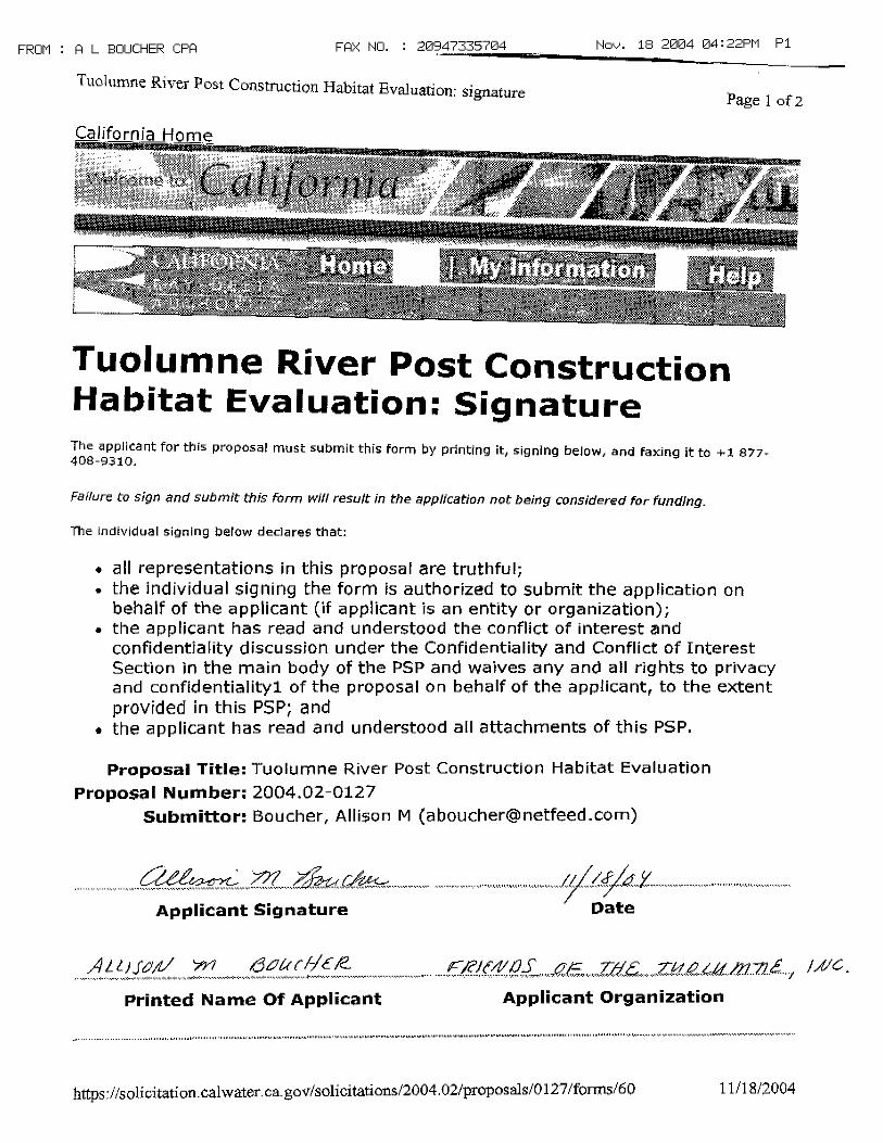
TID PSP 2004: Page 1 of 53 November 19, 2004
Tuolumne River Restoration Monitoring
A. PROJECT DESCRIPTION: A.1. PROBLEM, GOALS, AND OBJECTIVES
1a. Problem Statement
The Tuolumne River, the largest of the three major tributaries to the San Joaquin River, drains a
1,960-square-mile watershed on the western slope of the Sierra Nevada Range (Figure 1). The lower
Tuolumne River corridor, which extends 52.2 miles from La Grange Dam to the San Joaquin River,
has been extensively altered by fl ow regulation and diversion, instream and fl oodplain gold dredging,
instream and fl oodplain aggregate mining, and agricultural and urban development. These alterations
have reduced habitat quantity and quality for native salmonids (Chinook salmon [Oncorhynchus
tschawytscha] and rainbow trout/steelhead [O. mykiss]) and contributed to declines in their populations.
Since 1971, the Turlock and Modesto Irrigation Districts (the Districts), in cooperation with the
California Department of Fish and Game (CDFG) and the U.S. Fish and Wildlife Service (USFWS),
have conducted extensive studies of Chinook salmon population dynamics and habitat in the lower
Tuolumne River. In 1995, through the FERC license amendment process for the Don Pedro Project, the
Districts and the City and County of San Francisco (CCSF) entered into a FERC Settlement Agreement
(FSA) with the USFWS, CDFG, and several environmental groups. The FSA revised minimum fl ow
requirements for the Tuolumne River downstream of the Don Pedro Project and set forth a strategy for
recovery of the lower Tuolumne River Chinook salmon population. Using adaptive management, the
FSA goals are to: (1) increase the abundance of wild Chinook salmon in the Tuolumne River, (2) protect
remaining genetic characteristics unique to the Tuolumne River Chinook salmon population, and (3)
improve salmon habitat in the Tuolumne River.
While Chinook salmon have been the subject of many years of study in the Tuolumne River, rainbow
trout/steelhead have received much less attention (though they have been recorded as incidental species
in seining and snorkel surveys). With the 1998 listing of the Central Valley steelhead ESU as threatened
under the federal Endangered Species Act, fi sheries agencies have increased their focus on this species
in the Tuolumne River. With input from the TRTAC Monitoring Subcommittee, the TRTAC recently
expanded their monitoring of O. mykiss distribution in the river. The TRTAC also revised its Coarse
Sediment Management Plan (McBain and Trush 2004) to more specifi cally address O. mykiss protection
and habitat needs. (Because it is not possible to determine whether a juvenile of this species will mature
into a resident rainbow trout or an anadromous steelhead, both life history strategies are collectively
referred to as “O. mykiss” in this proposal.)
To achieve the FSA and broader restoration goals, the Tuolumne River Technical Advisory Committee
(TRTAC) developed a comprehensive, process-based Habitat Restoration Plan for the Lower Tuolumne
River Corridor (McBain and Trush 2000) that integrates fl uvial geomorphic processes as a foundation
for overall ecosystem recovery to support salmonid populations. Several high priority projects identifi ed
in the Restoration Plan are being implemented with funding from the California Bay-Delta Authority
(CBDA), Anadromous Fish Restoration Program (AFRP), the CDWR Delta Fish Protection Agreement,
and other sources. These projects span the 25 miles of gravel-bedded river, and are being constructed
at a cost of tens of millions of dollars. With their sheer size and cost, these projects require thoughtful
design, experimentation, and adaptive management to maximize their benefi ts both to the river and to
restoration science.
The long-term biological research and monitoring data available for this river, combined with the
geomorphic studies conducted for the Restoration Plan, provide a solid foundation for hypothesis
development, adaptive management, and learning. Effective adaptive management, however, requires
long-term monitoring designs that have the capacity to detect change and identify causal linkages
in a highly variable environment. The Adaptive Management Forum, in their review of Tuolumne
TID PSP 2004: Page 2 of 53 November 19, 2004
Tuolumne River Restoration MonitoringTID PSP 2004: Page 3 of 53 November 19, 2004
Tuolumne River Restoration Monitoring
River restoration projects, emphasized the need for long-term monitoring, as well as for integration
of monitoring across spatial scales (i.e., from site-specifi c to river-wide) (AMF 2001). Tuolumne
River project proponents have attempted to develop and implement comprehensive, hypothesis-driven
monitoring plans for each restoration project, and initial monitoring has been conducted for several
projects for which construction is complete. Short-duration funding cycles for the restoration grants,
however, limit the duration of post-construction project monitoring to as little as one year. This short
duration of monitoring is usually suffi cient to document pre-project conditions and make some initial
post-project evaluations. The need to have more experimental elements in the remaining designs will
require longer term funding for monitoring to continue well after the projects are constructed. Moreover,
interpretation of restoration effects across spatial scales requires monitoring across spatial scales. In the
past, site-specifi c project monitoring has been included in restoration grants (usually funded by CBDA,
AFRP, or the CDWR Delta Fish Protection Agreement), while river-wide monitoring was funded by
Districts and CCSF (through the FSA) and CDFG. With the expiration of the FSA in 2005, these river-
wide monitoring funds have been fully expended and are no longer available. Also, CDFG funding for
surveys that they have traditionally conducted (carcass surveys, redd counts, and screw trap monitoring)
apparently may not be available in 2005 or thereafter.
This proposal seeks to support adaptive management of the lower Tuolumne River Restoration
Program and of these restoration projects by: (1) extending existing site-specifi c project monitoring
for constructed projects and projects near construction; (2) augmenting existing monitoring to include
additional metrics; and (3) continuing funding for long-term river-wide monitoring that previously was
supported by other sources.
1b. Funded Restoration Projects Included in This Proposal
Projects for which monitoring is included in this proposal are: (1) Gravel Mining Reach Restoration
(Phases I and II), (2) Special Run Pool 9 and 10 Restoration, (3) Fine Sediment Management, and (4)
Coarse Sediment Management (Phases I through III) (including coarse sediment augmentation at the
Friends of the Tuolumne [FOT] Bobcat Flat site). The locations of these projects are shown in Figure 2.
Funding and implementation status for each project is provided in Tables 1 through 4. These projects
are described in more detail below.
One additional proposal is being submitted to the CBDA ERP program (in this funding round) and
another is being prepared for submittal to the CBDA Science Program in January 2005 that complements
this proposal. Friends of the Tuolumne is submitting a separate proposal for post-project monitoring
at the Bobcat Flat and Grayson River Ranch restoration sites. Monitoring proposed by FOT at these
sites will supplement tasks presented in this proposal. FOT and TID will coordinate monitoring
implementation and will share data to ensure that monitoring is effi cient and that data gathered at all
project sites are compatible. Stillwater Sciences and Turlock Irrigation District are preparing a separate
proposal for submittal to the CBDA Science Program to study river-wide predator ecology related to the
SRPs 9 and 10 projects and potential future channel reconstruction projects. Linkages to these separate
proposals are identifi ed in the following sections.
Gravel Mining Reach Restoration Project: The Gravel Mining Reach Restoration Project extends from
RM 40.3 (near Roberts Ferry Bridge) to RM 34.4 (the Reed gravel operation) (Figure 2). Due to its
length, the project is being implemented in four phases: the 7-11 Reach (RM 37.7 to 40.3), M.J. Ruddy
Reach (RM 36.6 to 37.7), Warner-Deardorff Reach (RM 35.2 to 36.6), and Reed Reach (RM 34.3 to
35.2) (Figure 3). The project will reconstruct an appropriately scaled channel and fl oodplain through
a reach that is currently heavily impacted by in-channel and fl oodplain aggregate mining. Project
objectives are to:
TID PSP 2004: Page 2 of 53 November 19, 2004
Tuolumne River Restoration MonitoringTID PSP 2004: Page 3 of 53 November 19, 2004
Tuolumne River Restoration Monitoring
§ restore fl oodway width to convey fl oods of at least 15,000 cfs;
§ improve salmonid spawning and rearing habitat by restoring an alternate bar (pool-riffl e)
morphology within a meandering channel;
§ reduce salmon mortality and geomorphic impacts that occur when berms separating fl oodplain
mining pits from the river breach;
§ restore native riparian communities on appropriate geomorphic surfaces within the restored
fl oodway; and
§ decrease risk of fl ood damage to aggregate extraction operations, bridges, and other human
structures.
Phase I, the 7/11 Reach, was completed in 2003. Phase II, the M.J. Ruddy Reach, will begin
construction in 2005. The conceptual design for Phase I is shown in Figure 4. Pre- and post-
construction aerial photographs of the 7/11 Reach are shown in Figure 5. Additional detail for the
Gravel Mining Reach Project is provided in Tuolumne River Floodway Restoration: Project Design
Approach and Rationale (McBain and Trush 2004).
Special Run Pools 9 and 10 Restoration Project: Special Run Pools (SRPs) 9 and10 extend from RM
25.9 to RM 25.0 (Figure 2). The SRP 9 and 10 pits, which were created by in-channel aggregate mining
in the 1930s through the 1970s, are up to 400 feet wide and 36 feet deep,. Past studies of Chinook
salmon population dynamics and outmigrant survival concluded that predation by non-native predatory
bass species in these and other SRP reaches is a signifi cant factor limiting Chinook salmon production in
this river, particularly during drier years (TID/MID Engineering 1992). Project objectives are to:
§ reduce/eliminate habitat favored by predatory bass species and replace it with riverine habitat
suitable for Chinook salmon;
§ construct a channel and fl oodplain that is scaled to contemporary and future sediment and fl ow
regimes;
§ restore sediment transport continuity through the reach; and
§ revegetate reconstructed fl oodplains with native woody riparian species.
Conceptual designs for both phases are shown in Figure 6. The SRP 9 project was completed in 2002.
Pre- and post-construction aerial photographs of the SRP 9 are shown in Figure 7. Immediately prior to
construction, budget constraints required substantial modifi cation of the project design. To reduce the
volume of fi ll needed for construction, the elevation of the constructed fl oodplain at SRP 9 was lowered
by 1 to 2 feet, resulting in a design bankfull channel capacity of 1,500 cfs (compared to the initial
bankfull design capacity of 5,000 cfs). This modifi cation is expected to increase benefi ts to juvenile
Chinook salmon by increasing the duration of access to productive fl oodplain rearing areas from January
through June from an average of 18 days/year for the 5,000 cfs fl oodplain to 59 days for the 1,500 cfs
fl oodplain and may shift riparian vegetation species composition toward species that are more tolerant
of prolonged inundation. Additional detail for the SRPs 9 and 10 projects, including modifi cations to the
SRP 9 project design, are provided in Tuolumne River Floodway Restoration: Project Design Approach
and Rationale (McBain and Trush 2004).
Coarse Sediment Augmentation Projects: The Tuolumne River Coarse Sediment Management Plan
(CSMP) was completed in July 2004 (McBain and Trush 2004). The CSMP recommends adding more
than 500,000 yd3 of coarse sediment to the river at 29 locations extending from RM 51.5 (near La
Grange) to the upstream end of the 7/11 Project (Roberts Ferry Bridge, RM 39.5). Several methods for
placing coarse sediment in the river are included in the conceptual designs for augmentation projects,

TID PSP 2004: Page 4 of 53 November 19, 2004
Tuolumne River Restoration MonitoringTID PSP 2004: Page 5 of 53 November 19, 2004
Tuolumne River Restoration Monitoring
and the CSMP outlines adaptive management experiments that in should be conducted to compare the
costs, effects, and effi cacy of each approach in meeting project objectives. Objectives are to:
§ restore coarse sediment supply to the gravel-bedded reach downstream of La Grange Dam in a
manner that protects existing habitat values for both salmon and O. mykiss;
§ create immediately usable spawning habitat for both Chinook salmon and O. mykiss to supplement
existing degraded habitat and/or create new habitat where none currently exists; and
§ restore coarse sediment routing, reduce bed mobility thresholds, and initiate formation of active
alluvial bars and riffl es.
Coarse sediment augmentation projects are being implemented by CDFG (at several sites near La
Grange), FOT (at Bobcat Flat [RM 43]), and TID (from La Grange Dam to Roberts Ferry Bridge).
Augmentation locations are shown in Figure 2. From 1999 through 2003, CDFG added more than
20,000yd3 of coarse sediment at several sites near La Grange. In 2005, FOT and TID will place up
to 15,000 yd3 of coarse sediment at the Bobcat Flat site (RM 43). In 2006, TID expects to begin
implementing the Tuolumne River Sediment Transfusion Project (Phase III of the CSMP), which will
add at least 140,000 yd3 of coarse sediment to the river. The Tuolumne River Sediment Transfusion
Project has been funded by the CBDA and is currently under amendment review for a change in scope
regarding the source of aggregate for the project.
Fine Sediment Management: The Tuolumne River Fine Sediment Management Plan includes four major
components: (1) identifying fi ne sediment sources to the Tuolumne River, (2) reducing sediment supply
to the river from Gasburg Creek, (3) conducting fi eld experiments to evaluate the relationship between
Chinook salmon survival-to-emergence and substrate permeability, and (4) experimental riffl e cleaning
project (planned for summer 2005). Stillwater Sciences has completed the sediment source analysis
(Stillwater Sciences 2004). Work on Gasburg Creek will include expansion of an existing wetland to
function as an interim sedimentation basin and restoration of the creek channel and fl oodway where
it currently fl ows through a recently abandoned sand mine. Work is expected to begin in 2005. Riffl e
cleaning is also expected to be implemented in 2005. Fine sediment management objectives are to:
§ Reduce fi ne sediment and sand yield from Gasburg Creek to the mainstem Tuolumne River;
§ Increase salmonid survival-to emergence in the mainstem river.
§ Reduce the volume of sand currently stored in the Tuolumne River channel bed and thus increase
salmonid survival-to emergence; and
§ Quantify the relationship between substrate permeability and Chinook salmon survival-to-
emergence.
1c. Goals and Objectives
The overarching goal of the TRTAC restoration program is to re-establish fl uvial geomorphic functions,
processes, and characteristics within contemporary fl ow and sediment conditions and, thus, promote the
recovery and maintenance of a resilient, wild Chinook salmon population and native plant and animal
communities. Because fl ow regulation will continue into the future, this goal targets a scaled-down
version of the former river, but one in which dynamic fl uvial processes (sediment transport and scour,
fl oodplain inundation, channel migration) maintain the habitat characteristics favored by salmonids and
other native fi sh and wildlife. Several projects identifi ed in the restoration plan are in various stages of
implementation. These projects and the objectives of each are described in Section 1b. Due to short
funding cycles, monitoring funds for many of these projects extend only one to two years following
construction, which is not adequate to assess project effectiveness. Moreover, river-wide monitoring,
TID PSP 2004: Page 4 of 53 November 19, 2004
Tuolumne River Restoration MonitoringTID PSP 2004: Page 5 of 53 November 19, 2004
Tuolumne River Restoration Monitoring
which provides a longer-term and larger spatial context for interpreting site-specifi c monitoring results,
is no longer funded. (In the past, this monitoring has been funded by the FSA and CDFG.)
The goal of this proposal is to ensure that adequate project-specifi c and river-wide monitoring is in place
to: (1) assess the effectiveness of restoration projects that have been constructed or are near construction
in the Tuolumne River across a range of spatial scales (from site-specifi c to river-wide); (2) evaluate
ecosystem cumulative response to numerous restoration projects; and (3) provide monitoring data that
is comparable to data from similar projects in other watersheds (such as the Merced River and Clear
Creek). Proposal objectives are to:
§ Extend existing post-project monitoring at constructed sites for three years;
§ Augment monitoring for funded projects to collect additional baseline and post-project data needed
to evaluate project effectiveness;
§ Extend existing river-wide monitoring of Chinook salmon and O. mykiss populations.
A.2 JUSTIFICATION2a. Conceptual Models
The Habitat Restoration Plan for the Lower Tuolumne River (McBain and Trush 2000) identifi es 10
“Attributes of Alluvial River Integrity.” The Attributes are: (1) spatially complex channel morphology;
(2) variable yet predictable streamfl ow patterns; (3) frequently mobilized channel bed surface; (4)
periodic channel scour and fi ll; (5) fi ne and course sediment supply in balance with long-term transport
rates; (6) periodic channel migration and/or avulsion; (7) a functional fl oodplain; (8) infrequent channel
resetting fl oods; (9) self-sustaining, diverse riparian corridor; and (10) naturally fl uctuating groundwater
table. Based on the Attributes and our current understanding of alluvial rivers, one can describe the
linkages between physical inputs (e.g., sunlight, streamfl ow, sediment), physical processes (e.g.,
sediment transport, bank erosion, fi ne sediment deposition), habitat structure (e.g., shallow-gradient
riffl es, well-sorted and clean spawning gravels) and biological responses (e.g., healthy incubation, low
density-dependent mortality) (Figure 8). These Attributes and the simple conceptual model shon in
Figure 8 are the foundation of the conceptual models described below.
In June 2001, the UC Davis Center for the Environment and AFRP sponsored an Adaptive Management
Forum to review the science behind the large-scale restoration projects on the Tuolumne River. The
TRTAC Monitoring Subcommittee, with assistance and peer review by panel members from the
Adaptive Management Forum, developed several interconnected conceptual models depicting our
current understanding of (1) the effects of fl ow regulation and mining on geomorphic processes, habitat
structure, and salmonid abundance in the river, (2) the river’s Chinook salmon population dynamics,
and (3) effects individual restoration actions on geomorphic processes, habitat structure, and salmonid
abundance These conceptual models are presented in the report AFRP / CALFED Adaptive Management
Forum: Tuolumne River Restoration Summary Report (Stillwater Sciences 2001). Models relevant to
this proposal are described below.
Model G-1. Effects of dams and mining on geomorphic inputs and processes, habitat structure, and
population response (Figure 9). This model illustrates linkages between physical inputs, geomorphic
processes, habitat structure, and salmonid abundance and the effects of dams and mining on these
linkages. In this model, dams alter seasonal fl ow patterns in the lower river, reduce peak fl ow
magnitude, reduce fi ne sediment supply, and eliminate coarse sediment supply. Aggregate mining and
gold dredging further reduce coarse sediment supply to the river by removing stored sediment from
the channel and fl oodplain and by trapping coarse sediment that is in transport. These reductions in
fl ow and sediment supply reduce sediment transport, channel migration and avulsion, recruitment of
large wood, and fl oodplain inundation and result in channel incision, bed armoring, channel narrowing
TID PSP 2004: Page 6 of 53 November 19, 2004
Tuolumne River Restoration MonitoringTID PSP 2004: Page 7 of 53 November 19, 2004
Tuolumne River Restoration Monitoring
(through riparian vegetation encroachment), and abandonment of pre-dam fl oodplains. In-channel
mining also creates large, lake-like pits in the river channel. These alterations reduce habitat quality for
salmonid spawning, incubation, rearing, and outmigration. In addition, reductions in fl ow magnitude
and alteration of seasonal fl ow patterns potentially affect salmonid run timing and emigration timing, as
well as incubation, rearing, and outmigrant survival.
Model G-2. Fine sediment supply and storage in the Tuolumne River and effects in Chinook salmon
survival (Figure 10). This model illustrates sources and storage of fi ne sediment in the Tuolumne River
and the effects of fi ne sediment on Chinook salmon survival. In this model, fi ne sediment is supplied
to the spawning reach primarily by Gasburg Creek and erosion from the New Don Pedro Dam spillway
that occurred during the 1997 fl ood. Average annual yield of fi ne sediment (< 2mm) from Gasburg Creek
to the river is estimated to be 1,440 t/yr (Stillwater Sciences 2004). Gasburg Creek is the fi rst signifi cant
tributary to the mainstem Tuolumne River below La Grange Dam, but several smaller tributaries also
contribute fi ne sediment to the river. Based on reconnaissance-level fi eld surveys, Stillwater Sciences
(2004) concluded that Mill Gulch, Indian Hill Gulch, Gauging Station Gulch, and Morgan Gulch,
combined with failure and erosion of canal embankments, contribute about the same amount of fi ne
sediment to the Tuolumne River as Gasburg Creek. More study of these basins is required to compare
their absolute or relative fi ne sediment yield to the river. Fine sediment yield from Lower Dominici
Creek, which in the past was considered to be a potentially signifi cant source of fi ne sediment to the
river, appears to be minor (McBain and Trush 2004). Combined with reduced sediment transport
capacity caused by fl ow regulation, this increase in fi ne sediment supply has resulted in increased
storage of fi ne sediment in riffl es and possibly in pools. The sand stored in pools can be mobilized
during high fl ows, thus increasing supply. The increase in the volume of sand stored in riffl es results
in reduced permeability in spawning substrates and a concomitant reduction in salmon survival-to-
emergence.
Model S-1. Factors affecting Chinook salmon population abundance in the Tuolumne River (Figure
11). This conceptual model depicts the factors affecting each Chinook salmon life history stage, within
and outside of the Tuolumne River basin. Within the basin, research and monitoring have identifi ed
three primary factors that limit Chinook salmon population abundance: (1) redd superimposition; (2)
low survival-to-emergence resulting from low substrate permeability; and (3) low outmigrant survival
resulting from spring fl ow conditions, predation by largemouth bass, and water temperature. Other
factors could also affect Chinook salmon population abundance, but these are not considered to be
limiting. Of the limiting factors identifi ed, redd superimposition is the only density-dependent mortality
factor. The superimposition model developed by Stillwater Sciences from fi eld studies on the Tuolumne
River supports the hypothesis that superimposition and delayed fry emergence is a key factor driving
the stock-recruitment curves developed from empirical observations in the Tuolumne River (TID/MID
1997, Report 96-6). Numerous factors outside the Tuolumne River watershed also affect the numbers of
Chinook salmon returning to the Tuolumne to spawn. Such factors include (but are not limited to) Delta
exports, ocean harvest, ocean conditions, and predation and water quality in the Delta.
Model P-1. Effects of the Special Run-Pools (SRPs) 9 and 10 Projects on geomorphic process, riparian
vegetation, and Chinook salmon survival (Figure 12). Past studies of Tuolumne River Chinook salmon
population dynamics identifi ed predation by largemouth bass as a major factor limiting outmigrant
survival (and thus recruitment) in the Tuolumne River, particularly during drier years (TID/MID 1992).
Largemouth bass prefer deep, low velocity, warm-water habitats with abundant cover. In this model,
replacing the large, deep SRP pit with a shallower, narrower channel reduces habitat suitability for
adult largemouth bass and, thus, reduces adult bass carrying capacity (and adult bass abundance) and
predation pressure on outmigrating salmon at the site. During high fl ows (>1,400 cfs), reconstructed
TID PSP 2004: Page 6 of 53 November 19, 2004
Tuolumne River Restoration MonitoringTID PSP 2004: Page 7 of 53 November 19, 2004
Tuolumne River Restoration Monitoring
fl oodplains provide rearing areas and outmigration routes that are reduce juvenile salmon interactions
with adult largemouth bass. The reconstructed fl oodplain also provides a surface for colonization by
riparian vegetation. (Note that the project also includes initial planting and maintenance of riparian
vegetation.)
Model P-2. Effects of the Gravel Mining Reach Project on geomorphic processes, riparian vegetation,
and Chinook salmon survival (Figure 13). In this model, reconstructing a channel and fl oodplain that
are scaled to contemporary fl ow conditions, combined with planting native riparian vegetation on the
reconstructed fl oodplain and maintaining coarse sediment supply, improves in-channel and fl oodplain
geomorphic and riparian processes and improves Chinook salmon spawning and rearing habitat.
Constructing an appropriately scaled channel and maintaining coarse sediment supply balances sediment
transport capacity with sediment supply, thus providing a channel and fl oodplain that functions under
contemporary, regulated fl ow conditions. By providing conditions that allow the channel to construct
bars and riffl es, the project improves salmon spawning, incubation, and rearing habitats. In addition,
by reducing fl oodplain elevation, increasing fl oodplain width, and creating high fl ow channels on the
fl oodplain, the project reduces fl ow velocities during fl oods and provides refugia for rearing salmon.
Model P-3. Effects of fl ow and coarse sediment management on aquatic and riparian habitat (Figure
14). This model depicts the anticipated effects of fl ow management and gravel augmentation on in-
channel, fl oodplain, and riparian habitats and on Chinook salmon survival. In this model, increased
spring high fl ows recharge shallow groundwater tables, deposit sand and fi ne sediment on fl oodplains,
and scour and deposit coarse sediment in the channel. At the same time, adding gravel to the spawning
reach increases coarse sediment supply. The combined effects of increased fl ow and increased sediment
supply include prevention of riparian vegetation encroachment into the active channel, reconnection of
fl oodplains to the channel, reinitiation of riparian vegetation recruitment and successional processes, and
creation of active alluvial bars and riffl es. In addition, increased spring fl ows reduce water temperature
and, under some conditions, could increase salmon outmigrant survival. Increased spawning habitat
area reduces redd superimposition, and reduced storage of sand and fi ne sediment in the channel bed
improves incubation conditions. Both of these factors increase salmon survival-to-emergence.
Model P-4. Effects of fi ne sediment management on substrate conditions and Chinook salmon survival
(Figure 15). This model depicts the anticipated effects of the fi ne sediment management project on
spawning substrate conditions and salmon survival-to-emergence. The Gasburg Creek restoration
project reduces fi ne sediment supply to the Tuolumne River by: (1) enlarging an existing wetland
to function as an interim sedimentation basin to capture sediment delivered from the upper Gasburg
Creek watershed, and (2) implementing watershed management actions to reduce fi ne sediment supply.
Downstream of the At the same time, riffl e cleaning reduces sand and fi ne sediment storage in riffl es.
Potential methods of riffl e cleaning were evaluated from existing data and literature and are reported
in McBain and Trush (2004). By reducing sand and fi ne sediment storage in riffl es, riffl e cleaning
increases spawning substrate permeability, thus increasing salmon survival-to-emergence. Increased
permeability is maintained by reducing sand supply to the spawning reach from Gasburg Creek and
other tributary sources.
A.3 PREVIOUSLY FUNDED MONITORING
The Habitat Restoration Plan for the Tuolumne River Corridor (McBain and Trush 2000) recommends
a two-tiered monitoring strategy for the river: (1) project-specifi c monitoring to assess the effectiveness
of individual restoration projects in meeting specifi c objectives, and (2) river-wide monitoring that
addresses overall goals of the Restoration Plan, as well as the cumulative effects of the individual
restoration projects.
TID PSP 2004: Page 8 of 53 November 19, 2004
Tuolumne River Restoration MonitoringTID PSP 2004: Page 9 of 53 November 19, 2004
Tuolumne River Restoration Monitoring
Project-specifi c Monitoring
Project-specifi c monitoring has been developed and partially implemented for the Gravel Mining Reach,
SRPs 9 and 10, Coarse Sediment Augmentation (including augmentation at Bobcat Flat and CDFG
projects at La Grange), and Fine Sediment Management. Monitoring hypotheses, metrics, and methods
are described in Table 5. Monitoring funding and implementation status for each project is shown in
Tables 1 through 4.
River-wide Monitoring
In the past, long-term river-wide monitoring of Chinook salmon population trends in the Tuolumne
River was funded by the FSA and CDFG. The FSA allocated and expended $1,335,000 for salmonid
monitoring in the Tuolumne River. The FSA program included trend monitoring of adult Chinook
salmon escapement, distribution, and timing; spawning and incubation habitat quality (with regard to
substrate composition); fry and juvenile abundance, distribution, and stranding; outmigrant survival,
abundance, and timing, and water temperature and quality. The FSA will expire in 2005, and its funds
are now fully expended. No additional monitoring funds are available through this program.
Funds for these river-wide monitoring programs are no longer available through the FSA. Over the past
several years (or decades in some cases), CDFG has conducted Chinook salmon escapement surveys
and redd counts and has operated rotary screw traps deployed at the mouth of the river. CDFG funding
to continue these efforts in 2005 and beyond is not secure, and CDFG cannot commit to continuation of
these monitoring efforts. With the potential loss of CDFG funds and the expiration of the FSA, no funds
have been identifi ed to continue this river-wide trend monitoring. Streamfl ow is monitored at La Grange
and Modesto by the U.S. Geological Survey.
A.4 APPROACH AND SCOPE OF WORK
Tasks included in the Scope of Work are listed below and are described in more detail in Table 5.
The majority of the monitoring included in this proposal has been implemented by the TRTAC, their
consultants, and CDFG over the past several years. In these cases, this proposal would simply extend
the duration of ongoing monitoring. This proposal includes continuing existing, long-term river-wide
trend monitoring that previously was funded by CBDA or AFRP. No new trend monitoring is proposed.
Tasks not included in previous CBDA- or AFRP-funded monitoring are indicated by an asterisk (*).
Contractors or agencies expected to conduct each task are indicated in [brackets] following each task
description.
Task 1. Project Management
TID, with support from their contractors, will provide all technical and administrative services
associated with performing and completing the work for this project and will provide quarterly progress
reports, invoices, and scheduled deliverables as indicated.
Task Deliverables: Quarterly progress reports, invoices, and subcontract documentation.
Task 2. Public Participation
2A. Coordinate with TRTAC, TRTAC Monitoring Subcommitee, and Lower Tuolumne River Coalition:
Public outreach and involvement for the Tuolumne River monitoring will occur through three
venues: (1) coordination and updates through existing forums, (2) development and distribution
of user-friendly, graphically rich “brochures”, and (3) presentation of fi ndings at least one CBDA
Science Conference. TID and their consultants will continue to participate in the TRTAC, the
TRTAC Monitoring Subcommittee, and the Tuolumne River Coalition. TID currently participates
in and coordinates activities of TRTAC, which has overseen monitoring design and implementation
in the lower Tuolumne River for nearly ten years and provides a forum for input from agencies
TID PSP 2004: Page 8 of 53 November 19, 2004
Tuolumne River Restoration MonitoringTID PSP 2004: Page 9 of 53 November 19, 2004
Tuolumne River Restoration Monitoring
(NOAA, CDFG, USFWS), environmental groups (California Rivers Restoration Fund, Friends of the
Tuolumne, Tuolumne River Preservation Trust), and the Districts (CCSF, TID, and MID). TID will
continue to collaborate with TRTAC and TRTAC Monitoring Subcommittee on all project-specifi c
and river-wide monitoring included in this proposal. TID also participates in the Tuolumne River
Coalition (www.tuolumnerivercoalition.org), which brings together 25 agencies and organizations
to integrate existing plans, increase public awareness, and obtain fi nancial support for projects that
benefi t the Tuolumne River. The Coalition includes city and county agencies, water districts, local
non–governmental organizations, as well as state and federal agencies. TID is a member of the
Coalition and will use Coalition meetings and publications as opportunities to provide updates on
Tuolumne River monitoring. [TID, McBain and Trush, Stillwater Sciences]
2B. Produce and Distribute Interpretive Brochures for the Restoration Projects and Monitoring: To
provide user-friendly information about the restoration projects, ongoing monitoring, and adaptive
management on the Tuolumne River, TID or their consultant will develop an 11”x17” 4-page
brochure for each restoration project that explains the project, project monitoring activities, and
the river-wide context for each project and summarizes monitoring results. The brochures will be
concise, easily reproducible, graphically rich, and directed to a general public audience. Brochures
will be provided to CALFED (hard copies and web-ready electronic versions) and distributed
through existing forums. Electronic versions will be posted on the TID website and will be made
available for posting on other stakeholder websites. [McBain and Trush]
2C. Present fi ndings at CALFED Science Conference and Prepare Manuscript(s) for Publication: TID
and the investigators included in the proposed monitoring will make at least one presentation at at
least one CBDA Science Conference. In addition to methods and fi ndings, the presentation(s) will
include lessons learned and recommendations for future similar restoration projects and monitoring
programs. To support broad dissemination of scientifi c information and collaboration among
restoration scientists, TID and their consultants will also endeavor to publish monitoring results for
each restoration project listed in Section 1b of this proposal in an appropriate peer-reviewed journal.
Tentative publication topics include: effi cacy of constructing “scaled down” rivers as restoration,
effects of channel reconstruction on predator populations and Chinook salmon predation mortality,
and effects of coarse sediment augmentation of geomorphic processes, channel form, and salmonid
habitat. [McBain and Trush, Stillwater Sciences]
Task Deliverables: Quarterly progress reports, meeting summaries and minutes of the TRTAC, TRTAC
Monitoring Subcommittee, and Tuolumne River Coalition meetings; one hard copy and one electronic
copy of an interpretive brochure for each restoration project and related monitoring; presentation(s) at
least one CBDA Science Conference; up to three manuscripts submitted to peer-reviewed journals.
Task 3 . 7/11, M.J. Ruddy, and SRP 9 Project Monitoring
Monitoring would include the following tasks:
3A. Resurvey cross sections and a longitudinal profi les: Resurvey 7 to 9 cross sections and a longitudinal
profi le through each project site after each of two high fl ow events exceeding 4,500 cfs. [McBain
and Trush]
3B. Deploy and maintain tracer rocks: Deploy and maintain tracer rocks on approximately six cross
sections at each of the 7/11 and M.J. Ruddy sites. (No tracer rocks would be deployed at SRP 9
because the channel slope at that site is too low to support coarse sediment transport.) Rocks would
be checked and replaced after each fl ow exceeding 4,500 cfs. Budget allows at least three tracer
rock deployments at each site. [McBain and Trush]
TID PSP 2004: Page 10 of 53 November 19, 2004
Tuolumne River Restoration MonitoringTID PSP 2004: Page 11 of 53 November 19, 2004
Tuolumne River Restoration Monitoring
3C. *Map channel migration and other planform changes: Obtain and orthorectify aerial photographs
after one fl ow exceeding 9,000 cfs or if noticeable changes in channel location occur. Aerial
photographs will be true color, stereo pairs, and at suitable resolution for printing and interpretation
at a scale of 1:6,000 or larger. [McBain and Trush]
3D. *Monitor peak fl ow water surface elevations (crest gauges): Establish and maintain crest gauges at a
subset of channel cross sections to monitor peak fl ow water surface elevation. Maintain each gauge
after each fl ow exceeding 4,500 cfs. These data will be used to test actual channel capacity relative
to design capacity and calibrate the hydraulic model developed for the project. [McBain and Trush]
3E. *Continuous water surface elevation recording gauge: Establish and maintain one continuously
recording stage gauge at one cross section within the each project site. [McBain and Trush]
3F. Monitor survival, percent cover, and growth of planted riparian vegetation: Continue monitoring
survival, percent cover, and growth of planted riparian vegetation through post-project year 5 (i.e.,
2008). [McBain and Trush]
3G. *Monitor natural riparian vegetation recruitment and establishment on reconstructed fl oodplain
surfaces: Conduct annual plot-based monitoring of natural riparian vegetation recruitment and
establishment on the reconstructed fl oodplains for three years. [McBain and Trush]
3H. *Map Chinook salmon spawning location and habitat characteristics at spawning sites: Conduct
biweekly surveys to document Chinook salmon spawning and habitat characteristics of spawning
sites in the reconstructed reach from approximately November 1 through December 31 each year.
Redds would be mapped onto orthorectifi ed aerial photographs and given unique identifying codes.
At each redd, habitat characteristics, including fl ow depth and velocity, would be recorded at the
head of each redd. [Stillwater Sciences]
3I. *Conduct seine surveys to assess juvenile distribution, abundance, and size: Add one location within
the each reconstructed site in conjunction with the river-wide seining surveys (budget for this task is
included in Task 6). [Stillwater Sciences]
3J. * Monitor groundwater wells on reconstructed fl oodplains: Install and monitor fi ve groundwater
wells on reconstructed fl oodplains within each site. [McBain and Trush]
3K. *Monitor riparian nesting species composition, abundance of selected species, and associations with
vegetation structure: Conduct repeat point count bird surveys and associated riparian vegetation
relevée surveys during the breeding season (May and June) on at least one restored fl oodplain
location at each project site and at least two control sites (i.e., one “natural” riparian forest and one
unrestored site) for three years. Methods will be consistent with similar monitoring being conducted
by Pt. Reyes Bird Observatory Conservation Science on several Central Valley rivers and streams,
including the San Joaquin River, Tuolumne River (Grayson River Ranch), Sacramento River, and
Clear Creek. [McBain and Trush]
3L. Report Preparation and distribution: At the end of the funded monitoring period, prepare and
distribute a draft and fi nal report presenting monitoring methods and results for each site, including
synthesis of previous project monitoring methods and results (if available), as well as past and on-
going reach-scale and river-wide monitoring results. [McBain and Trush]
Task Deliverables: Quarterly progress reports, orthorectifi ed aerial photographs, one draft and one fi nal
monitoring report that describes each project, monitoring methods, and monitoring results; synthesizes
data from previous monitoring (if applicable); synthesizes results across spatial scales (i.e., project site
to river-wide); updates conceptual models based on monitoring results, and provides recommendations
for adaptive management of these projects and design and monitoring of future similar projects.
Technical data collected as part of the monitoring (e.g., cross section surveys, fl ow stage) will be
included in appendices to the monitoring report.
TID PSP 2004: Page 10 of 53 November 19, 2004
Tuolumne River Restoration MonitoringTID PSP 2004: Page 11 of 53 November 19, 2004
Tuolumne River Restoration Monitoring
Task 4. Fine Sediment Management Monitoring
4A. Quantify annual sediment accumulation in the interim sedimentation basin: Extend interim
sedimentation basin monitoring to include two additional total station surveys of sediment
accumulation. [McBain and Trush]
4B. Monitor channel stability and riparian vegetation establishment in the Gasburg Creek restoration
site: Extend monitoring of the reconstructed Gasburg Creek channel (repeat cross section and profi le
surveys) and planted riparian vegetation (survival and percent cover by species) for three years. One
year of this survey is funded under the existing Fine Sediment Management Plan, and this task will
extend surveys to 2007 and 2008. [McBain and Trush]
4C. *Quantify fi ne sediment contribution to the river from tributaries and prioritize future fi ne sediment
management actions: Measure suspended sediment transport rates during consistent storm event
(synoptic) in tributaries identifi ed through fi eld surveys (McBain and Trush 2004) as the largest
potential contributors of fi ne sediment to the river. Based on fi ne sediment loading, identify and
prioritize future fi ne sediment management needs and locations. [McBain and Trush]
4D. *Monitor benthic macroinvertebrate composition, abundance, biomass and diversity in the gravel-
bedded reach: Monitor benthic macroinvertebrate composition, abundance, biomass and diversity
indices using the California Stream Bioassessment Procedure (CDFG 1999) at fi ve sites (three Hess
samples each) in the gravel-bedded reach. Sample locations will be selected from cleaned riffl es and
untreated sites using staircase design (Walter et al. 1998). [Stillwater Sciences]
4E. Quantify Chinook salmon spawning habitat selection and redd superimposition. Conduct
biweekly, detailed Chinook salmon redd mapping at riffl e treatment sites (riffl e cleaning sites and
augmentation sites including CDFG sites, Bobcat Flat RM 43, and Phase III Sediment Transfusion
sites) and control sites throughout the spawning reach to compare spawner utilization of treatment
sites to similar “natural” riffl es, utilization of different cleaning and augmentation methods/
designs, and redd superimposition rates between riffl es and years (i.e., within increasing numbers
of augmentation projects constructed). Mark each redd and measure mound length, mound width,
pit depth, pit length, pit depth and length of tail spill using previously established methods (TID/
MID 1992), and measure fl ow depth and velocity at a subset of redds during each survey. This
task uses a staircase design (Walters et al. 1988) modifi cation to the “before-after-control-impact”
(BACI) approach (Stewart-Oaten et al. 1986) at six riffl e habitat sites in the lower Tuolumne River.
[Stillwater Sciences]
4F. Report Preparation and distribution: At the end of the funded monitoring period, prepare and
distribute the following draft and fi nal reports: (1) Gasburg Creek Monitoring Report (Tasks 4A and
4B), (2) Tributary Suspended Sediment Monitoring and Management Recommendations (Task 4C),
and (3) Riffl e Cleaning Report (Tasks 4D, 4E, 5E, 6D, and 6E). All reports will include synthesis of
previous project monitoring methods and results (if available), as well as past and on-going reach-
scale and river-wide monitoring results. [McBain and Trush, Stillwater Sciences]
Task Deliverables: Quarterly progress reports; one draft and one fi nal report describing the Gasburg
Creek project, monitoring methods, conclusions, and recommendations for future actions in the Gasburg
Creek watershed (if needed); one draft and one fi nal report describing locations, methods, and results
of suspended sediment monitoring and providing recommendations for locations, methods, and priority
of future tributary fi ne sediment reduction actions; one draft and one fi nal report describing locations,
methods, and results of benthic macroinvertebrate monitoring, comparing the results of this monitoring
with previous macroinvertebrate monitoring on the Tuolumne River, and providing recommendations for
future riffl e cleaning and coarse sediment augmentation implementation.
TID PSP 2004: Page 12 of 53 November 19, 2004
Tuolumne River Restoration MonitoringTID PSP 2004: Page 13 of 53 November 19, 2004
Tuolumne River Restoration Monitoring
Task 5. Coarse Sediment Augmentation Project Monitoring: Tuolumne River Sediment Transfusion
Project, CDFG Sediment Augmentation Projects at La Grange, and Bobcat Flat (RM 43) Sediment
Transfusion Project
[NOTE: The Tuolumne River Sediment Transfusion Project (ERP-02-P29) was submitted to CBDA for a Level III
Amendment on November 8, 2004 to address a change in sediment source for the project. The revised project, if
approved, would fund Task 5. Task 5 is included in this proposal as a contingency in the event that the amendment
is not approved.]
5A. Document channel bed texture and monitor bed mobility thresholds: Map channelbed sediment
facies at sediment transfusion sites, collect pebble counts and bulk samples to document surface
and subsurface sediment composition, install and monitor tracer rocks to document surface particle
mobility thresholds, install scour cores to document depth of scour during fl ood events. Recover
tracer rocks and scour cores after fl ows exceeding 4,500 cfs. A total of three redeployments is
budgeted over a three-year period. [McBain and Trush]
5B. Survey reach-scale channel cross sections and profi le and quantify net sediment removal from
augmentation sites: After fl ow exceeding 4,500 cfs, resurvey 20 cross sections to document changes
in sediment storage and channel geometry, resurvey longitudinal profi le in 3 mile reach from La
Grange Bridge to Basso Bridge, and survey topography at 2 transfusion sites to document change in
sediment storage volume. [McBain and Trush]
5C. Develop and test a predictive sediment transport model: Measure suspended sediment and bedload
transport rates using a 6-inch Helley-Smith sampler deployed from a cataraft at Riffl e 4B (repeating
sediment transport measurements conducted in 2000) at fl ows ranging from 5,500 cfs to 10,000
cfs. Budget allows for sampling three discrete fl ow events over a three-year period. The Sediment
Transfusion Project includes funds to develop HEC-RAS and sediment transport models for the
reach from La Grange Dam to Roberts Ferry Bridge (i.e., the upstream end of the Gravel Mining
Reach). The sediment transport model will be similar to those developed for the Sandy River and
Merced River (Stillwater Sciences 2000, 2004) and will be a powerful tool for predicting the effects
of coarse sediment augmentation on transport rates and channel morphology, as well as predicting
the volume of sediment needed for long-term supply maintenance. [McBain and Trush, Stillwater
Sciences]
5D. Map planform geomorphic and habitat features: Using laminated aerial photographs as base maps,
map and quantify geomorphic features (bed and banks, alternate bars, active fl oodplains, sediment
deposits) for pre- and post-augmentation in the augmentation reach. Map and quantify mesohabitat
features (pool, riffl e, run) and salmonid spawning habitat. Mapping will be conducted for one
pre- and post-augmentation year and will build on data collected by the Districts in 1988 and data
collected under the Coarse Sediment Management Plan (McBain and Trush 2004). [McBain and
Trush]
5E. Monitor spawning substrate permeability: Measure permeability, intra-gravel dissolved oxygen and
temperature, and collect and analyze bulk samples at 14 riffl e sites in the primary spawning reach
(between La Grange Dam and Basso Bridge). Methods will be consistent with prior permeability
monitoring and will include riffl e treatment sites cleaned of fi ne sediment under the Fine Sediment
Management Plan. Gravel quality analyses will be conduced in 2006 and in 2008. [Stillwater
Sciences]
5F. Report preparation and distribution. Write and distribute a summary report for each monitoring year,
presenting all data collected and analyzed, including interpretations of data for each project and
within a broader river-wide context. [McBain and Trush, Stillwater Sciences]
TID PSP 2004: Page 12 of 53 November 19, 2004
Tuolumne River Restoration MonitoringTID PSP 2004: Page 13 of 53 November 19, 2004
Tuolumne River Restoration Monitoring
Task Deliverables: Annual Monitoring Report containing all fi eld data and analyses in raw and/or
summary format, graphics presenting data results, and written descriptions and interpretations of
monitoring results.
Task 6. Monitoring of Cumulative Effects on Target Populations [Chinook salmon and O. mykiss]
This task would extend river-wide trend monitoring that, in the past, was funded by the FSA and
CDFG. FSA funds are fully expended, and no additional funds are available. CDFG funds are not
certain. Without additional, secure funding, these long-term monitoring efforts may be halted. Methods
and reporting for all Chinook salmon, O. mykiss, and macroinvertebrate monitoring under Task 6 be
consistent with the protocols and participants employed in 2004 monitoring activities.
6A. Juvenile Chinook salmon production and outmigration timing: Install and monitor two rotary
screw traps near RM 5.5 from approximately January 1 through June 15 for three years. The trap
would generally be operated 7 days/week and will be checked at least daily. Conduct up to six
trap effi ciency test releases each year. Test releases will use captured, wild juvenile salmon when
available. When suffi cient numbers of wild juvenile salmon are not available, hatchery-reared
juvenile salmon will be used for the tests. [CDFG, S.P. Cramer]
6B. Juvenile Chinook salmon and O. mykiss distribution, abundance, and size (winter and spring):
Conduct biweekly seining surveys from January through May at up to 18 locations from
approximately RM 51.5 (near La Grange) through RM 0 (including two sites in the San Joaquin
River) for three years. Sample locations would include approximately ten sites used during prior
years, as well as additional sites within the Gravel Mining Reach, SRPs 9 and 10, Bobcat Flat, and
coarse sediment augmentation projects. Data for Bobcat Flat will be extracted and provided to FOT.
[Stillwater Sciences, S.P. Cramer]
6C. Juvenile Chinook salmon and O. mykiss distribution (summer): Conduct two snorkel surveys during
June through September at up to 16 locations from RM 51.5 (La Grange Bridge) through RM 31.5
(near Hickman Bridge), including restoration project sites, to document summer distribution of
juvenile Chinook salmon and O. mykiss. Data for Bobcat Flat will be extracted and provided to
FOT. [Stillwater Sciences, S.P. Cramer]
6D. Chinook salmon adult escapement: Conduct weekly Chinook salmon carcass surveys and redd
counts from upstream of La Grange (RM 51.6) to Geer Road (RM 26) from approximately October
15 through January 15 for three years to quantify adult escapement and document spawning
distribution. [CDFG, S.P. Cramer]
6E. O. mykiss adult distribution: Conduct hook-and-line surveys from approximately RM 52 through
RM 36.5 (within the M.J. Ruddy Reach) for three years to document distribution of adult O. mykiss.
Surveys would be conducted approximately biweekly from November 1 through December 31 and
weekly from January through June. [Stillwater Sciences, S.P. Cramer with local guide subcontractor
(California Rivers Restoration Fund)]
6F. Benthic macroinvertebrate composition, abundance, and diversity indices: Conduct annual summer
benthic macroinvertebrate monitoring (composition, abundance, and diversity indices) using the
California Stream Bioassessment Procedure (CDFG 1999) over a three-year period. Three separate
kicknet samples will be taken at six sites in the gravel-bedded reach; three Hess samples will also be
collected at two of those sites. [Stillwater Sciences]
Task Deliverables: Quarterly progress reports; one draft and one fi nal report for each task describing
monitoring methods, results, and conclusions. Reports will be in a format consistent with reports
included in the Districts 2003 FERC report (TID 2004).
TID PSP 2004: Page 14 of 53 November 19, 2004
Tuolumne River Restoration MonitoringTID PSP 2004: Page 15 of 53 November 19, 2004
Tuolumne River Restoration Monitoring
Task 7. Aerial Photography and Bathymetry
Aerial photography, topography, and bathymetry available for channel design and monitoring have
been collected in a piecemeal fashion for specifi c reaches of the Tuolumne River. However, low
altitude orthorectifi ed photographs with channel and fl oodplain topography are extremely useful tools
for preparing conceptual designs, documenting pre-construction conditions, and documenting future
conditions as the channel evolves, and for developing hydraulic and sediment transport models. This
task will provide a high-quality, river-wide aerial photograph set for the lower Tuolumne River from
La Grange Dam to the San Joaquin River, with complete topography and bathymetry developed for the
upper 18 miles below La Grange Dam:
7A. Aerial photo fl ight: Take low altitude color aerial photographs from La Grange Dam (RM 53) to the
San Joaquin River (RM 0). [McBain and Trush]
7B. Ground control: Install surveyed ground control points. [McBain and Trush]
7C. Orthorectifi cation: Orthorectify aerial photographs based on ground control points from La Grange
Dam (RM 52) to RM 25. Orthorectifi cation could be extended downstream to include the entire river
at a later date, if needed and as funding permits. [McBain and Trush]
7D. Develop topography : Using standard photogrammetric analyses, generate topographic data and
maps from La Grange Dam to RM 34.2 at a 2 ft contour interval accuracy. Photogrammetry could be
completed for the entire river at a later date, if needed and as funding allows. [McBain and Trush]
7E. Channel bathymetry: Use boat-mounted bathymetric surveys or other appropriate technology (such
as water penetrating LIDAR) to generate channel bathymetry data and maps from La Grange Dam
to at least the downstream end of the Gravel Mining Reach Project (RM 34.2) and extending further
downstream if funding permits. [McBain and Trush]
Task Deliverables: The photogrammetry and bathymetry topographic data will be integrated to produce a
single digital terrain model for the upper 18 miles below La Grange Dam. This topography will provide
baseline channel and fl oodplain conditions for evaluating the topographic evolution of the channel in
the Sediment Transfusion reaches and in the Gravel Mining reaches. The digital terrain model will also
provide the topographic data needed to construct a HEC-RAS model and a sediment routing modeling
that is proposed under the revised Sediment Transfusion Project.
5. FEASIBILITY
The proposed monitoring is feasible within the project timeline and with available staff and contractor
resources, permits required for the proposed monitoring are either in-hand or in process, and access to
private property has been arranged. The greatest uncertainty that could affect the proposed monitoring
is the occurrence of fl ows large enough to do geomorphic work. Many of the geomorphic monitoring
events are triggered by fl ows exceeding 5,000 cfs. If fl ows suffi cient to trigger monitoring do not occur
during the funding period, funds for uncompleted tasks would be remain with CBDA because CBDA
only reimburses contractors for actual expenditures. At the close of the contract any unexpended funds
revert to CBDA for reallocation to other projects.
All proposed monitoring is for projects that are implemented or that are scheduled for implementation
by 2006. The 7/11 and SRP 9 projects are constructed. Construction for the M.J. Ruddy and Gasburg
Creek projects is expected to begin in 2005. Riffl e cleaning is also expected to begin in 2005. The
Tuolumne River Sediment Transfusion Project is expected to begin in 2006. Implementation of
this project will likely require two construction seasons. These implementation schedules allow for
continuation of ongoing post-construction monitoring (7/11, SRP 9, M.J. Ruddy, Gasburg Creek, Bobcat
Flat, CDFG sediment augmentation, and riffl e cleaning) or collection of baseline data with limited (1-2
years) post-project monitoring (Tuolumne River Sediment Transfusion).
TID PSP 2004: Page 14 of 53 November 19, 2004
Tuolumne River Restoration MonitoringTID PSP 2004: Page 15 of 53 November 19, 2004
Tuolumne River Restoration Monitoring
Monitoring would be implemented by contractors to TID and CDFG, with input from the TRTAC
and TRTAC Monitoring Subcommittee. These parties have worked together for many years on these
projects. Most of the monitoring included in this proposal has been implemented by the TRTAC, their
consultants, and CDFG over the past several years. In these cases, this proposal would simply extend
the duration of ongoing monitoring. New monitoring tasks would use standard methods applied by the
investigators on the Tuolumne, Merced, and other river. Invertebrate analysis and sediment transport
modeling will use methods developed by Stillwater Sciences and applied on the Merced River and other
rivers.
Depending on the task, contractors and staff participating in monitoring may be required to have
collection permits from CDFG and scientifi c research permits from NOAA (pursuant to Section 10 of
the Endangered Species Act). All investigators participating in collection and sampling of Chinook
salmon and O. mykiss (S.P. Cramer and Stillwater Sciences) have current CDFG collection permits.
Permit numbers are provided in Attachment A. TID applied to NOAA for a scientifi c research permit for
their staff and contractors on October 9, 2000. NOAA is currently processing this permit application.
Since submitting the application, TID and their contractors have worked with NOAA staff to obtain
short-term authorizations consistent with the pending application. TID will continue to work with
CDFG and NOAA to ensure that all collection permits are obtained and kept current.
Access to the majority of the Tuolumne River and Gasburg Creek monitoring sites is through public
properties (owned by Stanislaus County, Modesto ID, TID, and CDFG). Access through private
property would be required at the 7/11 and Bobcat Flat project sites. A letter from Friends of the
Tuolumne (who owns the Bobcat Flat site) authorizing access for monitoring purposes is provided
in Attachment B. TID owns an easement on the 7/11 site that allows access for monitoring and
maintenance. Several seining survey locations for river-wide monitoring (Task 6) require access through
private lands. Landowners have provided access to TID to conduct these surveys since 1986. If funding
is approved, TID obtain letters providing permission to access these properties from the landowners. If
permission is withheld, the affected seine location could be shifted to a similar site nearby.
6. EXPECTED OUTCOMES AND PRODUCTS
The CBDA and AFRP have invested nearly $30 million in restoration projects on the Tuolumne River,
managed by TID and implemented by the TRTAC and its consultants. An additional $4.4 million is
being considered by the CDBA Amendment Committee. The CBDA and AFRP have acknowledged
that more research needs to be done to better understand how to do large-scale river habitat restoration.
But if these river restoration projects are to effectively generate knowledge that is transferable to future
projects, investigations of process need to be instituted, and investment in monitoring is essential. The
proposed monitoring will provide monitoring funding during a critical period of restoration program
implementation, and will provide data and reports needed to support adaptive management at project
design, reach-wide, and river-wide scales. Data and reports to be delivered are described in Section A.4
and the Task and Deliverables form.
The Adaptive Management Forum panel stated that “The implementation of an ecosystem-based
adaptive management approach to these projects will have to be implemented gradually. However, the
monitoring of long-term project effectiveness and the implementation of comparative studies needs to be
given a higher status, adequately supported, and made more effective. The Panel recommends that this
issue be addressed directly and urgently because it will affect the degree to which investments already
made in projects sponsored by AFRP and CBDA can be leveraged into useful knowledge for future
projects.”
TID PSP 2004: Page 16 of 53 November 19, 2004
Tuolumne River Restoration MonitoringTID PSP 2004: Page 17 of 53 November 19, 2004
Tuolumne River Restoration Monitoring
The Tuolumne River is a focal point for implementation of the CBDA and AFRP program goals,
testing a fundamental hypotheses of scaled-down river channel reconstruction, river-wide restoration,
and ecosystem management under regulated fl ow and sediment conditions. Investment in continued
monitoring of these projects is essential to:
§ sustain salmonid populations and other ecosystem components on the Tuolumne River through
improved restoration project design and implementation;
§ provide information that will improve our understanding of the performance of projects recently
implemented or scheduled to be implemented in the next several years;
§ yield knowledge and information applicable to other systems or restoration programs, generated
through passive and active adaptive management experiments;
7. DATA HANDLING, STORAGE, AND DISSEMINATION
TID will function as contract manager for this project, similar to other Tuolumne River projects funded
by CBDA. TID typically develops service contracts with consultants to conduct monitoring. If specifi c
monitoring tasks are to be performed by agencies, such as CDFG, then the TID anticipates entering
into agreements for that work. Reports and analysis prepared by the contractor are submitted to the
TRTAC for review. These monitoring reports are also included with the annual Status Report submitted
to FERC along with the associated river-wide monitoring conducted by the Districts and TRTAC. All
reports, maps, GIS data, draft and fi nal project design documents, regulatory compliance documents,
bid specifi cation packages, and monitoring data are compiled by TID as project records. Information
is generally stored in MS Excel and Word, AutoCAD, and ArcInfo. All fi nal reports prepared as task
deliverables during this project will be provided to CBDA and AFRP, and additional reports and data
will be made available to CBDA/AFRP upon request.
Contractors will be responsible for quality assurance/quality control of their data collection and data
entry. All data recorded in fi eld books will be photocopied upon returning from the fi eld and archived.
Originals or copies of all other fi eld data (such as maps, photographs, etc.) will be maintained by the
Contractor and archived pending completion of the project. Electronic data fi les will be made available
to CBDA upon request.
8. PUBLIC INVOLVEMENT AND OUTREACH
Public involvement and outreach is described in Task 2. In addition to outreach described in Task 2,
several opportunities for public involvement were provided during the design and environmental review
phases of the SRPs 9 and 10 and Gravel Mining Reach projects. TID (the state lead agency) and the
U.S. Fish and Wildlife Service (the federal lead agency, completed and circulated an Environmental
Assessment/Initial Study (EA/IS) for these restoration projects. The EA/IS comment period included
a public hearing held in June 1998. The EA/IS outlines mitigation and monitoring for these restoration
projects.
With the completion of the Habitat Restoration Plan for the Lower Tuolumne River Corridor (McBain
and Trush 2000), the TRTAC hosted an additional public workshop in June 1999 to present the plan
and provide an opportunity to address the public’s questions about future restoration. This workshop
included presentations by TRTAC member groups and agencies, and TRTAC participants and their
consultants were available at topic-specifi c information stations to discuss the projects and answer
questions. To make the Restoration Plan more available to the public and other interested parties,
the TRTAC (with funding from AFRP) developed a 16-page summary. Since 1999, more than 5,000
copies of this brochure have been distributed. The brochure is also available at the TID web page at
www.tid.org.
TID PSP 2004: Page 16 of 53 November 19, 2004
Tuolumne River Restoration MonitoringTID PSP 2004: Page 17 of 53 November 19, 2004
Tuolumne River Restoration Monitoring
9. WORK SCHEDULE
See Table 6 for the work schedule.
B. APPLICABILITY TO PROGRAM GOALS
1. ERP AND CVPIA PRIORITIES
ERP Priorities: Components of the ERP Vision for the Tuolumne River Ecological Management Unit
addressed by the proposed monitoring include: spatially complex channel morphology, frequently
mobilized channel bed surface, periodic channel bed scour and fi ll, balanced coarse and fi ne sediment
budgets, periodic channel migration or avulsion, functional fl oodplain, self-sustaining riparian plant
communities, naturally-fl uctuating groundwater table (ERP Plan vol. II, pp. 387-388). Measures to
achieve this vision are addressed in more detail in the ERP Stage 1 Implementation Plan (CBDA 2001).
Proposed monitoring would specifi cally address the following Implementation Plan priorities and
specifi c action and information needs (pp. 69-74):
• SJ-1: Continue habitat restoration actions including channel-fl oodplain reconstruction projects and
habitat restoration studies in collaboration with local groups (specifi c actions/information: channel-
fl oodplain reconstruction projects, gravel augmentation projects);
• SJ-2. Restore geomorphic processes in stream and riparian corridors (specifi c actions/information:
hydrologic, hydraulic, and sediment transport models);
• SJ-3. Improve rearing and spawning habitat and downstream fi sh passage on tributary streams
and the mainstem San Joaquin River, particularly for Chinook salmon, steelhead trout and splittail
(specifi c actions/information: studies that (1) build knowledge on status and needs of steelhead in
the San Joaquin River tributaries, and (2) assess life history and habitat associations in relation to
existing and restored habitats); and
• SJ-6. Conduct adaptive management experiments in regard to natural and modifi ed fl ow regimes to
promote ecosystem functions or otherwise support restoration actions (specifi c actions/information:
mechanistic models as restoration tools).
Conservation Species: Proposed monitoring would gather and synthesize data relevant to the following
“Big R” species identifi ed in the Multi-Species Conservation Strategy (CBDA 2000): Central Valley
steelhead ESU, Central Valley fall-/late-fall Chinook salmon SU, Valley Elderberry longhorn beetle (as
related to riparian vegetation recruitment).
CVPIA/AFRP Priorities: The AFRP has made a large investment in Tuolumne River restoration. The
proposed monitoring addresses the following restoration actions identifi ed in the Final Restoration Plan
for the AFRP (AFRP 2001):
• Improve watershed management and restore and protect instream and riparian habitat, including
consideration of restoring and replenishing spawning gravel and performing an integrated evaluation
of biological and geomorphic processes (priority: high); and
• Evaluate and implement actions to reduce predation on juvenile Chinook salmon, including actions
to isolate ponded sections of the river (priority: medium).
2. RELATIONSHIP TO OTHER ECOSYSTEM RESTORATION ACTIONS,
MONITORING PROGRAMS, OR SYSTEM-WIDE ECOSYSTEM BENEFITS
This proposal extends, augments, and integrates monitoring of channel reconstruction, coarse sediment
augmentation, and fi ne sediment management projects funded by ERP and AFRP and also is linked to
TID PSP 2004: Page 18 of 53 November 19, 2004
Tuolumne River Restoration MonitoringTID PSP 2004: Page 19 of 53 November 19, 2004
Tuolumne River Restoration Monitoring
restoration projects funded by the CDWR Four Pumps Mitigation Fund. Proposed monitoring would
assess geomorphic processes at the site-specifi c and reach-scales and would assess Chinook salmon
and to some extent O. mykiss response to restoration at the site-specifi c, reach, and river-wide scales.
Information gathered through this monitoring would inform design and implementation of future
restoration projects, including SRP 10, future Gravel Mining Reach phases, and future coarse sediment
augmentation.
3. ADDITIONAL INFORMATION FOR PROPOSALS CONTAINING LAND
ACQUISITION
No land acquisition is included in this proposal.
C. QUALIFICATIONS The project team described below has been conducting monitoring on the Tuolumne River for over 15
years, and is uniquely qualifi ed to implement this project. In addition to TID and the consultants listed
below, the California Department of Fish and Game will also be participating in the monitoring efforts.
Turlock Irrigation District (TID) is the grant applicant and would manage the project. TID has
decades of experience in overseeing monitoring programs conducted through contractors and partner
agencies. Beginning in 1971, TID and its partners managed a comprehensive research program that
ultimately resulted in the fl ow schedule and restoration measures included in the FSA. TID and its
partners also managed more than $1.3 million in FSA monitoring funds, which will culminate in a
report to FERC in 2005 that provides monitoring conclusions and recommendations for future river
management. TID has received and managed several CBDA and AFRP grants for restoration projects
on the Tuolumne River, totaling nearly $30 million (see Tables 1 through 4). Primary Technical Staff
for the Project: Wilton Fryer, P.E., has been program manager for the Turlock and Modesto Irrigation
District Restoration Program since 1997. Mr. Fryer graduated from the University of California at Davis
with a BS in Soil & Water Science, an MS in Irrigation Science, and an ME in Civil Engineering with
an emphasis in water resources. He is currently registered as both a Civil Engineer and an Agricultural
Engineer. Tim Ford has been the staff aquatic biologist for TID and MID since 1981. Mr. Ford graduated
from the University of California at Davis with a BS in Wildlife and Fisheries Biology in 1977. He
worked as a Biological Technician for the Modoc, Tahoe, and Stanislaus National Forests prior to
working for the Districts. Mr. Ford oversees the aquatic resources program for the Districts.
McBain and Trush, Inc. is a professional consulting fi rm applying fl uvial geomorphic and ecological
research to river preservation, management, and restoration. McBain and Trush authored Habitat
Restoration Plan for the Tuolumne River and the Tuolumne River Coarse Sediment Management Plan.
For this project, McBain and Trush would develop and implement geomorphic, hydraulic, hydrologic
and riparian vegetation monitoring; manage the subcontract for riparian bird surveys; coordinate and
oversee aerial photography; and prepare public outreach brochures. Technical Staff for the Project: Dr.
William Trush (PhD, Forestry) was a principal scientist in developing the Habitat Restoration Plan for
the Tuolumne River, and has been designing restoration projects and conducting monitoring on the
Tuolumne River since 1989. Scott McBain (MS. Civil Engineering) was also a principal scientist in
developing the Restoration Plan and created the conceptual designs for the Gravel Mining Reach, SRPs
9 and 10, Gasburg Creek, Bobcat Flat, and Tuolumne River Sediment Transfusion Projects. Mr. McBain
has also been a lead scientist for restoration planning and investigations on Clear Creek and the Trinity
River. Darren Mierau (MA, aquatic biologist) has been involved with the Tuolumne River restoration
program since 1997, assisted in completion of the Restoration Plan, developed and implemented

TID PSP 2004: Page 18 of 53 November 19, 2004
Tuolumne River Restoration MonitoringTID PSP 2004: Page 19 of 53 November 19, 2004
Tuolumne River Restoration Monitoring
monitoring plans in the Gravel Mining Reach and SRP projects, was project manager and co-author of
the Tuolumne River Coarse Sediment Management Plan. Jennifer Vick (MLA, Environmental Planning/
Landscape Architecture) has been involved with restoration planning, implementation, and monitoring
on the Tuolumne and Merced Rivers since 1997. She was lead author on the Merced River Corridor
Restoration Plan and has designed, managed, and implemented baseline evaluations and restoration
project monitoring on the Tuolumne River since 1998. She also co-authored of the Tuolumne River
Coarse Sediment Management Plan. John Bair (MA, riparian botanist) has developed riparian and
wetland restoration designs in Clear Creek and the Tuolumne River. Stillwater Sciences is a fi rm of biological and geological scientists that specializes in developing new scientifi c
approaches and technologies for environmental problem solving in aquatic and terrestrial systems. Its founding
members are experienced in freshwater ecology, fi sheries and wildlife biology, riparian and wetland ecology,
entomology, botany, and hillslope and fl uvial geomorphology and have led ecological studies on the Tuolumne
River since 1987. Stillwater Sciences is currently developing restoration designs and has conducted detailed
hydraulic and sediment transport modeling for the Merced River Dredger Tailings Reach and will provide
important connectivity between similar restoration and monitoring projects be implemented the Merced and
Tuolumne rivers. For this project, Stillwater will oversee fi sheries and ecological monitoring, including O.
mykiss surveys, macro-invertebrate studies, redd superimposition studies, and riffl e cleaning analyses. Stillwater,
with S.P. Cramer and Associates, will also conduct seine and snorkel surveys. Primary Technical Staff for the
Project: Frank Ligon is an aquatic ecologist and geomorphologist specializing in investigations of the role of
fl uvial processes in the ecology of stream fi sh, invertebrates, and plant communities. On the Tuolumne River, Mr.
Ligon managed fi sheries studies for the Districts from 1987 to 1996. Anthony Keith is an ecologist specializing
in stream ecology and geomorphology, aquatic and terrestrial entomology, and watershed management. On the
Tuolumne River, Mr. Keith has participated in assessments of fi sh and invertebrate populations, spawning gravel
quality, and juvenile Chinook salmon outmigration. Noah Hume (Ph.D., P.E.) will provide technical oversight
of all monitoring tasks contracted to Stillwater. Dr. Hume has over 15 years experience on a wide variety of
interdisciplinary projects, as well as engineering design. Dr. Hume has been involved in projects relating to egg
survival to emergence, spawning gravel cleaning, smolt survival studies, and fi sh population composition and
distribution.
S.P. Cramer & Associates, Inc. (SPC) was established in 1987 to provide innovative solutions for
issues relating to salmon and trout on the Pacifi c Coast. Previous and ongoing fi sheries research
includes, annual juvenile salmonid outmigration monitoring, adult migrant trapping, radio-tracking,
and electrofi shing studies. SPC has conducted seine surveys, snorkel surveys, and rotary screw trap
deployment and operation on the Tuolumne River since 1998. SPC will participate in seine and snorkel
surveys with Stillwater Sciences and will provide fi eld, data management, and analysis and report
writing support for carcass surveys, rotary screw trap monitoring, and Chinook salmon redd mapping.
Primary Technical Staff for the Project: Doug Demko (Senior Consultant) manages and coordinates
project activities within SPC and between cooperating agencies and supervises data analyses,
interpretation, and report preparation activities. Mr. Demko received a BS in Biology in 1992, and a
Juris Doctor degree in 2002. Andrea Fuller (Fish Biologist) joined SPC as a fi sheries technician in 1995.
Ms. Fuller coordinates fi eld personnel and data collection activities and assists in data analyses and
report preparation. Michele Simpson (Fish Biologist) joined SPC in 2002 after working as a fi sheries
biologist for the U.S. Bureau of Reclamation and NOAA Fisheries. She received her MS in Biology in
1997 and specializes in Endangered Species Act issues regarding salmonid populations.
D. COST1. BUDGET
Costs for major tasks are provided in the website budget form. Table 7 provides a comprehensive budget
summary with more detailed cost information for tasks and subtasks.
TID PSP 2004: Page 20 of 53 November 19, 2004
Tuolumne River Restoration MonitoringTID PSP 2004: Page 21 of 53 November 19, 2004
Tuolumne River Restoration Monitoring
2. COST SHARING
TID and MID provide two full-time positions to support the Tuolumne River Restoration
Program- a project manager (Wilton Fryer) and an aquatic ecologist (Tim Ford). Other specifi c
cost-sharing has not yet been identifi ed, but will factor into long-term river-wide monitoring as
described in the following section.
3. LONG-TERM FUNDING STRATEGY
The Districts have funded over $1.3 million for a 10-year river-wide monitoring program that
ends in 2004. Additional funding of monitoring, such as redd counts and carcass surveys, was
provided by CDFG. The basis of several monitoring tasks in this PSP was derived from that
prior work. Funding for future river-wide monitoring by the Districts and CDFG have not been
identifi ed, but the Districts anticipate that portions of the current river-wide monitoring will
continue through 2016 using FERC Settlement Agreement funds. Specifi c levels of monitoring
and associated funding levels for the 2005-2016 period have not yet been identifi ed.
E. COMPLIANCE WITH STANDARD TERMS AND CONDITIONS
TID has reviewed and understands the standard terms and conditions for ERP grant agreements.
TID will comply with these standard terms and conditions.
F. LITERATURE CITED
AMF (Adaptive Management Forum Scientifi c and Technical Panel). 2001. Lower Tuolumne
River Adaptive Management Forum Report. Prepared for Anadromous Fish Restoration
Program with assistance from the CALFED Bay-Delta Program, Ecosystem Restoration
ProgramCDFG (California Department of Fish and Game). 1999. California stream bioassessment procedure.
California Department of Fish and Game Aquatic Bioassessment Laboratory. May http://
www.dfg.ca.gov/cabw/fi eld/csbpwforms.html.
McBain and Trush. 2000. Habitat Restoration Plan for the Lower Tuolumne River Corridor. Prepared for the Tuolumne River Technical Advisory Committee.
McBain and Trush. 2004. Coarse Sediment Management Plan for the Lower Tuolumne River. Revised Final Report. Prepared for the Tuolumne River Technical Advisory Committee.
McBain and Trush. 2004. Tuolumne River Floodway Restoration: Project Design Approach and Rationale Coarse Sediment Management Plan for the Lower Tuolumne River. Prepared for the Tuolumne River Technical Advisory Committee.
McBain and Trush and Stillwater Sciences 2000. Tuolumne River Restoration Project Monitoring: SRPs 9/10, 7/11 Mining Reach, Ruddy Mining Reach. Prepared for the Tuolumne River Technical Advisory Committee.
McBain and Trush and Stillwater Sciences 1999. Tuolumne River Restoration Project Monitoring: SRPs 9/10 and 7/11 Mining Reach. Prepared for the Tuolumne River Technical Advisory Committee.
Stewart-Oaten, A., Murdoch, W.W. & Parker, K.R. 1986. Environmental impact assessment:
pseudoreplication in time? Ecology 67, 929–940.
Stillwater Sciences. 2004. Gasburg Creek Sediment Source Analysis. Prepared for Tuolumne
River Technical Advisory CommitteeTID/MID (Turlock Irrigation District and Modesto Irrigation District). 1992. Lower Tuolumne River
spawning gravel studies report. Appendix 8 to Don Pedro Project Fisheries Studies Report (FERC
TID PSP 2004: Page 20 of 53 November 19, 2004
Tuolumne River Restoration MonitoringTID PSP 2004: Page 21 of 53 November 19, 2004
Tuolumne River Restoration Monitoring
Article 39, Project No. 2299). In Report of Turlock Irrigation District and Modesto Irrigation
District Pursuant to Article 39 of the License for the Don Pedro Project, No. 2299. Vol. IV.
Prepared by EA, Engineering, Science, and Technology, Lafayette, California.
TID/MID (Turlock Irrigation District and Modesto Irrigation District). 1992. Lower Tuolumne
River predation study report. Appendix 22 to Don Pedro Project Fisheries Studies Report (FERC
Article 39, Project No. 2299). In Report of Turlock Irrigation District and Modesto Irrigation
District Pursuant to Article 39 of the License for the Don Pedro Project, No. 2299. Vol. VII.
Prepared by T. Ford, Turlock and Modesto Irrigation Districts and EA Engineering, Science, and
Technology, Lafayette, California.
TID/MID (Turlock Irrigation District and Modesto Irrigation District). 1997. Redd
Superimposition Report (Report 96-6). In Report of Turlock Irrigation District and
Modesto Irrigation District Pursuant to Article 39 of the License for the Don Pedro
Project, No. 2299. Vol. VI. Prepared for TID/MID by EA Engineering, Science, and
Technology, Lafayette, California.
Walters, C. J., Collie, J. S., and Webb, T. 1988. Experimental design for estimating transient
responses to management disturbances, Canadian Journal of Fisheries and Aquatic
Sciences 45, 530-538.
H. NON-PROFIT VERIFICATION
N/A

TID
PS
P 2
00
4:
Pag
e 22 o
f 53
N
ov
emb
er 19, 2
004
Tuolu
mn
e Riv
er Resto
ration
Mo
nito
ring
T
ID P
SP
2004:
Pag
e 23 o
f 53
Novem
ber 1
9, 2
004
Tu
olu
mn
e Riv
er Resto
ration M
onito
ring
Figure 1. Tuolumne River location map.
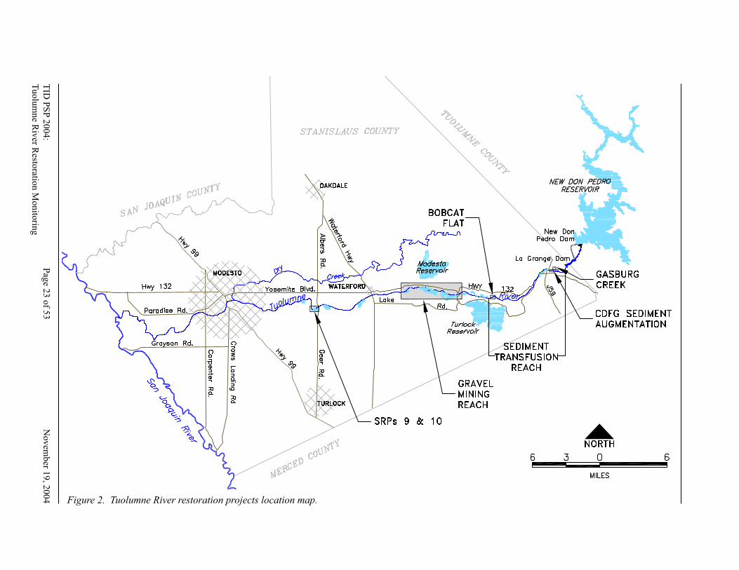
TID
PS
P 2
00
4:
Pag
e 22 o
f 53
No
vem
ber 1
9, 2
00
4
Tu
olu
mn
e Riv
er Resto
ration
Mo
nito
ring
TID
PS
P 2
00
4:
Pag
e 23 o
f 53
N
ov
ember 1
9, 2
004
Tu
olu
mn
e Riv
er Resto
ration
Mon
itorin
g
Figure 2. Tuolumne River restoration projects location map.
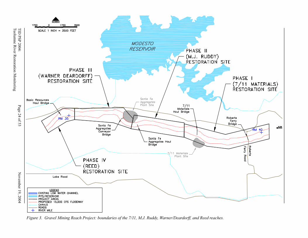
TID
PS
P 2
00
4:
Pag
e 24 o
f 53
N
ov
emb
er 19, 2
004
Tuolu
mn
e Riv
er Resto
ration
Mo
nito
ring
T
ID P
SP
2004:
Pag
e 25 o
f 53
Novem
ber 1
9, 2
004
Tu
olu
mn
e Riv
er Resto
ration M
onito
ring
Figure 3. Gravel Mining Reach Project: boundaries of the 7/11, M.J. Ruddy, Warner/Deardorff, and Reed reaches.
TID
PS
P 2
00
4:
Pag
e 24 o
f 53
No
vem
ber 1
9, 2
00
4
Tu
olu
mn
e Riv
er Resto
ration
Mo
nito
ring
TID
PS
P 2
00
4:
Pag
e 25 o
f 53
N
ov
ember 1
9, 2
004
Tu
olu
mn
e Riv
er Resto
ration
Mon
itorin
g
490 490 980
Figure 4. Conceptual design for the 7/11 phase of the Gravel Mining Reach Project, as submitted to CALFED in 1997.
TID
PS
P 2
00
4:
Pag
e 26 o
f 53
N
ov
emb
er 19, 2
004
Tuolu
mn
e Riv
er Resto
ration
Mo
nito
ring
T
ID P
SP
2004:
Pag
e 27 o
f 53
Novem
ber 1
9, 2
004
Tu
olu
mn
e Riv
er Resto
ration M
onito
ring
Figure 5. Aerial photographs of the 7/11 phase of the Gravel Mining Reach Project, pre- and post-construction.
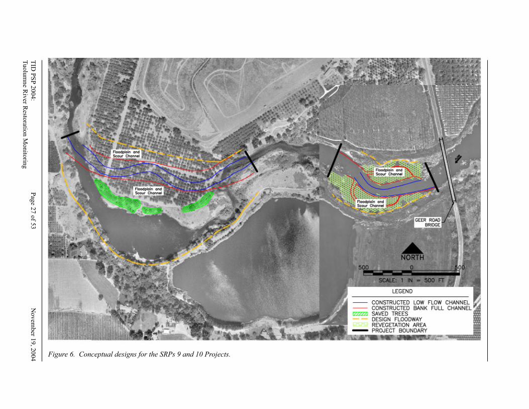
TID
PS
P 2
00
4:
Pag
e 26 o
f 53
No
vem
ber 1
9, 2
00
4
Tu
olu
mn
e Riv
er Resto
ration
Mo
nito
ring
TID
PS
P 2
00
4:
Pag
e 27 o
f 53
N
ov
ember 1
9, 2
004
Tu
olu
mn
e Riv
er Resto
ration
Mon
itorin
g
Figure 6. Conceptual designs for the SRPs 9 and 10 Projects.
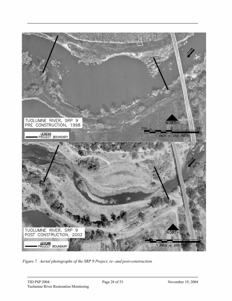
TID PSP 2004: Page 28 of 53 November 19, 2004
Tuolumne River Restoration Monitoring TID PSP 2004: Page 29 of 53 November 19, 2004
Tuolumne River Restoration Monitoring
Figure 7. Aerial photographs of the SRP 9 Project, re- and post-construction.
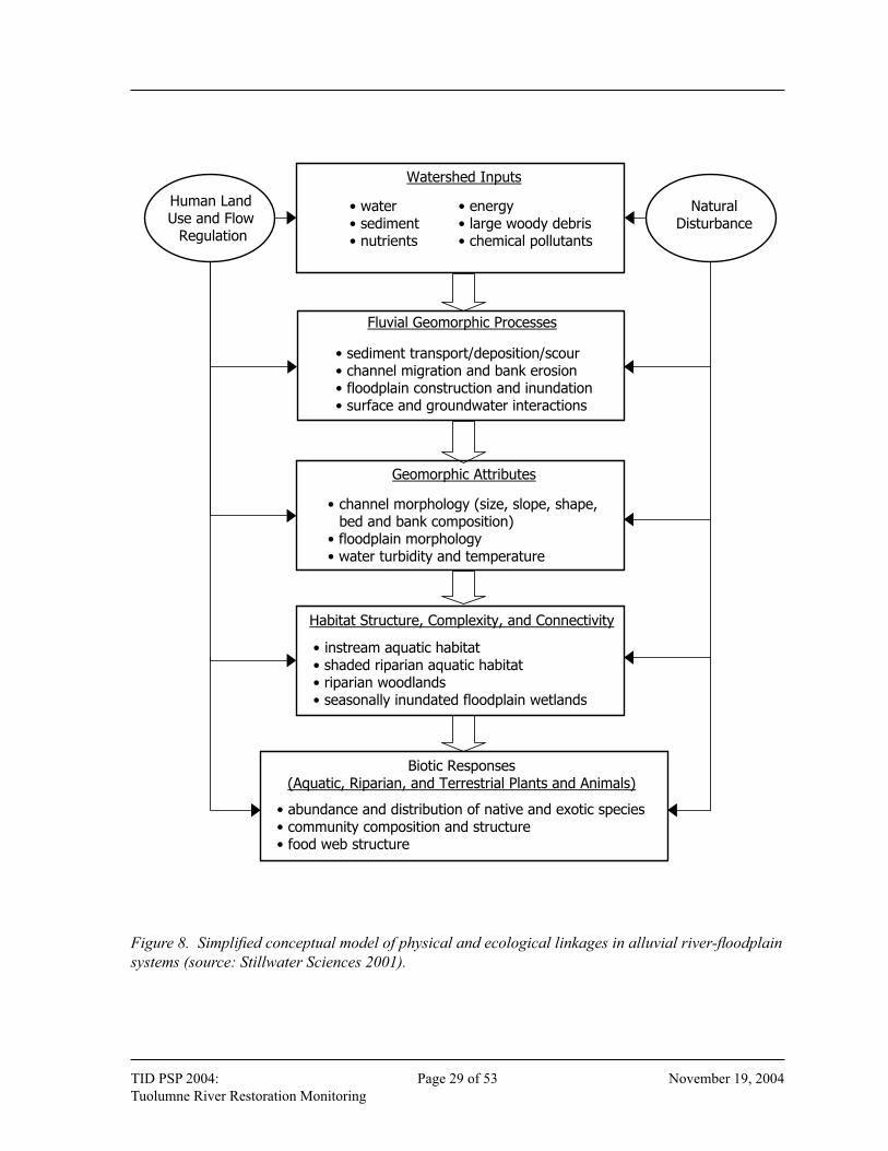
TID PSP 2004: Page 28 of 53 November 19, 2004
Tuolumne River Restoration Monitoring TID PSP 2004: Page 29 of 53 November 19, 2004
Tuolumne River Restoration Monitoring
Watershed Inputs
• water• sediment• nutrients
• energy• large woody debris• chemical pollutants
Fluvial Geomorphic Processes
• sediment transport/deposition/scour• channel migration and bank erosion• floodplain construction and inundation• surface and groundwater interactions
Geomorphic Attributes
• channel morphology (size, slope, shape, bed and bank composition)
• floodplain morphology• water turbidity and temperature
Habitat Structure, Complexity, and Connectivity
• instream aquatic habitat• shaded riparian aquatic habitat• riparian woodlands• seasonally inundated floodplain wetlands
Biotic Responses(Aquatic, Riparian, and Terrestrial Plants and Animals)
• abundance and distribution of native and exotic species• community composition and structure• food web structure
Human Land Use and Flow
Regulation
NaturalDisturbance
Figure 8. Simplifi ed conceptual model of physical and ecological linkages in alluvial river-fl oodplain
systems (source: Stillwater Sciences 2001).
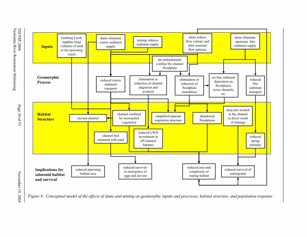
TID
PS
P 2
00
4:
Pag
e 30 o
f 53
N
ov
emb
er 19, 2
004
Tuolu
mn
e Riv
er Resto
ration
Mo
nito
ring
T
ID P
SP
2004:
Pag
e 31 o
f 53
Novem
ber 1
9, 2
004
Tu
olu
mn
e Riv
er Resto
ration M
onito
ring
Inputs
Geomorphic
Process
Implications for
salmonid habitat
and survival
Habitat
Structure
dams eliminate
coarse sediment
supply
dams eliminate
upstream fine
sediment supply
dams reduce
flow volume and
alter seasonal
flow patterns
mining reduces
sediment supply
reduced coarse
sediment
transport
elimination or
reduction of channel
migration and
avulsion
no fine sediment
deposition on
floodplains,
scour channels,
etc.
incised channelabandoned
floodplains
channel confined
by encroached
vegetation
deep pits located
in the channel
(a direct result
of mining)
elimination or
reduction of
floodplain
inundation
simplified riparian
vegetation structure
channel bed
saturated with sand
reduced survival-
to-emergence of
eggs and alevins
reduced area and
complexity of
rearing habitat
reduced survival of
outmigrants
reduced spawning
habitat area
reduced LWD
recruitment in
off-channel
habitats
reduced
fine
sediment
transport
reduced
spring
turbidity
Gasburg Creek
supplies large
volumes of sand
to the spawning
reach
pit embankments
confine the channel
floodplain
Figure 9. Conceptual model of the effects of dams and mining on geomorphic inputs and processes, habitat structure, and population response
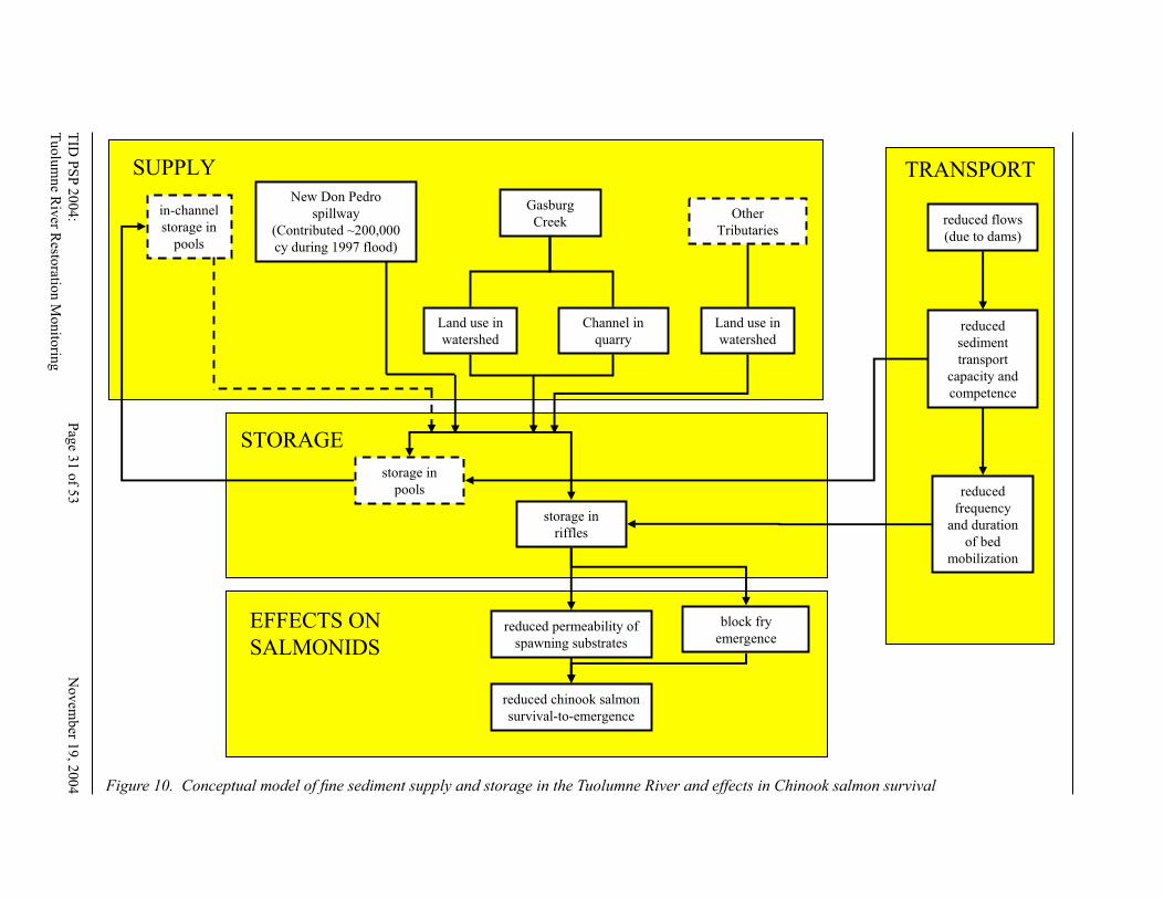
TID
PS
P 2
00
4:
Pag
e 30 o
f 53
No
vem
ber 1
9, 2
00
4
Tu
olu
mn
e Riv
er Resto
ration
Mo
nito
ring
TID
PS
P 2
00
4:
Pag
e 31 o
f 53
N
ov
ember 1
9, 2
004
Tu
olu
mn
e Riv
er Resto
ration
Mon
itorin
g
New Don Pedro
spillway
(Contributed ~200,000
cy during 1997 flood)
Other
Tributaries
Gasburg
Creek
Land use in
watershed
Channel in
quarry
Land use in
watershed
storage in
pools
reduced permeability of
spawning substrates
in-channel
storage in
pools
block fry
emergence
reduced flows
(due to dams)
reduced
frequency
and duration
of bed
mobilization
reduced
sediment
transport
capacity and
competence
storage in
riffles
reduced chinook salmon
survival-to-emergence
SUPPLY
STORAGE
TRANSPORT
EFFECTS ON
SALMONIDS
Figure 10. Conceptual model of fi ne sediment supply and storage in the Tuolumne River and effects in Chinook salmon survival
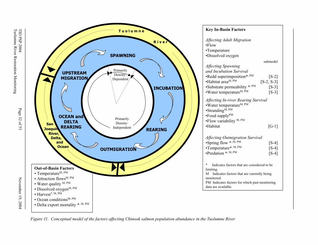
TID
PS
P 2
00
4:
Pag
e 32 o
f 53
N
ov
emb
er 19, 2
004
Tuolu
mn
e Riv
er Resto
ration
Mo
nito
ring
T
ID P
SP
2004:
Pag
e 33 o
f 53
Novem
ber 1
9, 2
004
Tu
olu
mn
e Riv
er Resto
ration M
onito
ring
Key In-Basin Factors
Affecting Adult Migration
•Flow
•Temperature
•Dissolved oxygen
Affecting Spawning
and Incubation Survival
•Redd superimposition*, PM [S-2]
•Habitat areaM, PM [S-2, S-3]
•Substrate permeability *, PM [S-3]
•Water temperatureM, PM [S-3]
Affecting In-river Rearing Survival
•Water temperatureM, PM
•StrandingM, PM
•Food supplyPM
•Flow variability M, PM
•Habitat [G-1]
Affecting Outmigration Survival
•Spring flow *, M, PM [S-4]
•Temperature*, M, PM [S-4]
•Predation *, M, PM [S-4]
* Indicates factors that are considered to be
limiting.
M Indicates factors that are currently being
monitored.
PM Indicates factors for which past monitoring
data are available.
Out-of-Basin Factors
• TemperatureM, PM
• Attraction flowsM, PM
• Water quality M, PM
• Dissolved oxygenM, PM
• Harvest*, M, PM
• Ocean conditionsM, PM
• Delta export mortality *, M, PM
Primarily
Density-
Independent
Primarily
Density-
Dependent
SPAWNING
INCUBATION
REARING
OUTMIGRATION
OCEAN andDELTA
REARING
UPSTREAMMIGRATION
San
Joaquin
River,Delta,
and
Ocean
T u o l u m n e
R i v e r
Model S-1. Overarching model of factors affecting chinook salmon
population abundance in the Tuolumne River.
[Relevant submodel numbers are indicated in brackets.]
submodel
Figure 11. Conceptual model of the factors affecting Chinook salmon population abundance in the Tuolumne River

TID
PS
P 2
00
4:
Pag
e 32 o
f 53
No
vem
ber 1
9, 2
00
4
Tu
olu
mn
e Riv
er Resto
ration
Mo
nito
ring
TID
PS
P 2
00
4:
Pag
e 33 o
f 53
N
ov
ember 1
9, 2
004
Tu
olu
mn
e Riv
er Resto
ration
Mon
itorin
g
fill in SRPs
construct bankfull channel
balance
sediment
supply with
transport
capacity
construct floodplain
that is inundated at
1,400 cfs
transport sand
and deposit
sand on the
floodplain
provide patches
of bare sediment
on floodplains
provide
germination site
restore natural riparian
regeneration and
succession processes increase
outmigrant
survival
restore sediment
transport
continuity
reduce
predator
habitat
reduce
predator
abundance
reconnect the
floodplain to
the channel
plant riparian
vegetation
Increase floodplain
rearing opportunities
Reduce interactions
between Chinook
salmon and
largemouth bass
Figure 12. Conceptual model of the effects of the Special Run-Pools (SRPs) 9 and 10 Projects on geomorphic process, riparian vegetation, and
Chinook salmon survival
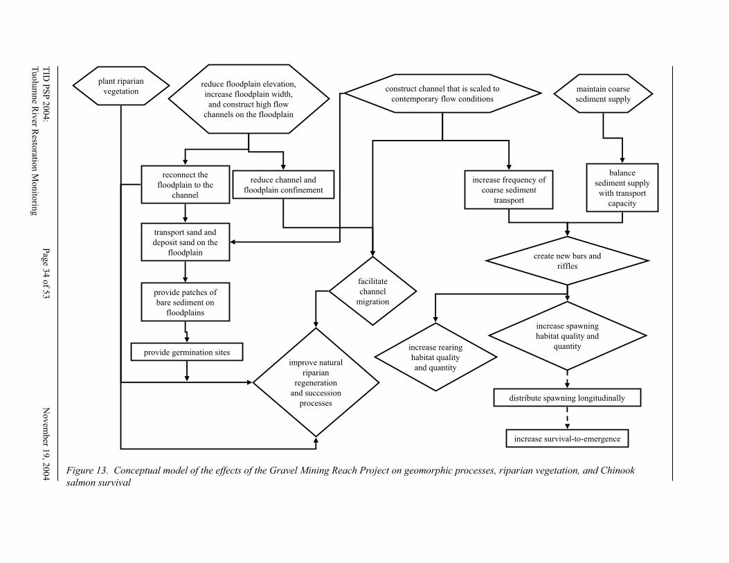
TID
PS
P 2
00
4:
Pag
e 34 o
f 53
N
ov
emb
er 19, 2
004
Tuolu
mn
e Riv
er Resto
ration
Mo
nito
ring
T
ID P
SP
2004:
Pag
e 35 o
f 53
Novem
ber 1
9, 2
004
Tu
olu
mn
e Riv
er Resto
ration M
onito
ring
construct channel that is scaled to
contemporary flow conditions
balance
sediment supply
with transport
capacity
reduce floodplain elevation,
increase floodplain width,
and construct high flow
channels on the floodplain
increase frequency of
coarse sediment
transport
transport sand and
deposit sand on the
floodplain
provide patches of
bare sediment on
floodplains
facilitate
channel
migration
provide germination sites
create new bars and
riffles
increase spawning
habitat quality and
quantity
improve natural
riparian
regeneration
and succession
processes
maintain coarse
sediment supply
distribute spawning longitudinally
increase survival-to-emergence
reconnect the
floodplain to the
channel
plant riparian
vegetation
reduce channel and
floodplain confinement
increase rearing
habitat quality
and quantity
Figure 13. Conceptual model of the effects of the Gravel Mining Reach Project on geomorphic processes, riparian vegetation, and Chinook
salmon survival
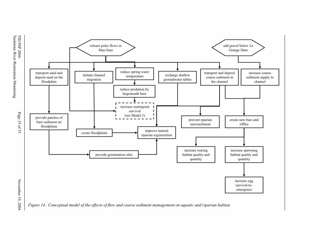
TID
PS
P 2
00
4:
Pag
e 34 o
f 53
No
vem
ber 1
9, 2
00
4
Tu
olu
mn
e Riv
er Resto
ration
Mo
nito
ring
TID
PS
P 2
00
4:
Pag
e 35 o
f 53
N
ov
ember 1
9, 2
004
Tu
olu
mn
e Riv
er Resto
ration
Mon
itorin
g
release pulse flows in
May/June
add gravel below La
Grange Dam
reduce spring water
temperaturetransport and deposit
coarse sediment in
the channel
transport sand and
deposit sand on the
floodplain
provide patches of
bare sediment on
floodplains
recharge shallow
groundwater tables
initiate channel
migration
provide germination sites
create floodplains
prevent riparian
encroachment
create new bars and
riffles
increase spawning
habitat quality and
quantity
improve natural
riparian regeneration
increase egg
survival-to-
emergence
increase coarse
sediment supply to
channel
increase outmigrant
survival
(see Model 3)
increase rearing
habitat quality and
quantity
reduce predation by
largemouth bass
Figure 14. Conceptual model of the effects of fl ow and coarse sediment management on aquatic and riparian habitat
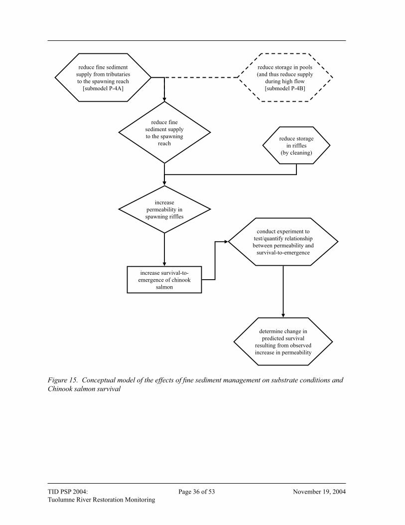
TID PSP 2004: Page 36 of 53 November 19, 2004
Tuolumne River Restoration Monitoring TID PSP 2004: Page 37 of 53 November 19, 2004
Tuolumne River Restoration Monitoring
reduce fine sediment
supply from tributaries
to the spawning reach
[submodel P-4A]
reduce fine
sediment supply
to the spawning
reach
reduce storage in pools
(and thus reduce supply
during high flow
[submodel P-4B]
reduce storage
in riffles
(by cleaning)
increase
permeability in
spawning riffles
increase survival-to-
emergence of chinook
salmon
determine change in
predicted survival
resulting from observed
increase in permeability
conduct experiment to
test/quantify relationship
between permeability and
survival-to-emergence
Figure 15. Conceptual model of the effects of fi ne sediment management on substrate conditions and
Chinook salmon survival
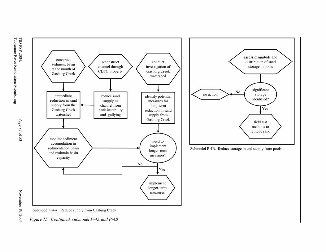
TID
PS
P 2
00
4:
Pag
e 36 o
f 53
No
vem
ber 1
9, 2
00
4
Tu
olu
mn
e Riv
er Resto
ration
Mo
nito
ring
TID
PS
P 2
00
4:
Pag
e 37 o
f 53
N
ov
ember 1
9, 2
004
Tu
olu
mn
e Riv
er Resto
ration
Mon
itorin
g
assess magnitude and
distribution of sand
storage in pools
field test
methods to
remove sand
no action
significant
storage
identified?
No
Yes
Submodel P-4B. Reduce storage in and supply from pools
construct
sediment basin
at the mouth of
Gasburg Creek
immediate
reduction in sand
supply from the
Gasburg Creek
watershed
monitor sediment
accumulation in
sedimentation basin
and maintain basin
capacity
reconstruct
channel through
CDFG property
reduce sand
supply to
channel from
bank instability
and gullying
conduct
investigation of
Gasburg Creek
watershed
identify potential
measures for
long-term
reduction in sand
supply from
Gasburg Creek
need to
implement
longer-term
measures?
implement
longer-term
measures
Submodel P-4A. Reduce supply from Gasburg Creek
Yes
No
Figure 15. Continued, submodel P-4A and P-4B
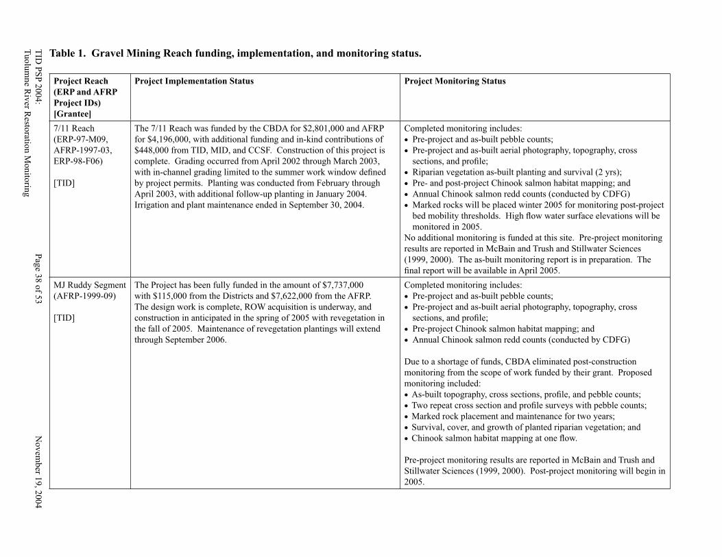
TID
PS
P 2
00
4:
Pag
e 38 o
f 53
No
vem
ber 1
9, 2
004
Tu
olu
mn
e Riv
er Resto
ration M
onito
ring
TID
PS
P 2
004:
Pag
e 39 o
f 53
Novem
ber 1
9, 2
004
Tu
olu
mne R
iver R
estoratio
n M
on
itorin
g
Table 1. Gravel Mining Reach funding, implementation, and monitoring status.
Project Reach
(ERP and AFRP
Project IDs)
[Grantee]
Project Implementation Status Project Monitoring Status
7/11 Reach
(ERP-97-M09,
AFRP-1997-03,
ERP-98-F06)
[TID]
The 7/11 Reach was funded by the CBDA for $2,801,000 and AFRP
for $4,196,000, with additional funding and in-kind contributions of
$448,000 from TID, MID, and CCSF. Construction of this project is
complete. Grading occurred from April 2002 through March 2003,
with in-channel grading limited to the summer work window defi ned
by project permits. Planting was conducted from February through
April 2003, with additional follow-up planting in January 2004.
Irrigation and plant maintenance ended in September 30, 2004.
Completed monitoring includes:
• Pre-project and as-built pebble counts;
• Pre-project and as-built aerial photography, topography, cross
sections, and profi le;
• Riparian vegetation as-built planting and survival (2 yrs);
• Pre- and post-project Chinook salmon habitat mapping; and
• Annual Chinook salmon redd counts (conducted by CDFG)
• Marked rocks will be placed winter 2005 for monitoring post-project
bed mobility thresholds. High fl ow water surface elevations will be
monitored in 2005.
No additional monitoring is funded at this site. Pre-project monitoring
results are reported in McBain and Trush and Stillwater Sciences
(1999, 2000). The as-built monitoring report is in preparation. The
fi nal report will be available in April 2005.
MJ Ruddy Segment
(AFRP-1999-09)
[TID]
The Project has been fully funded in the amount of $7,737,000
with $115,000 from the Districts and $7,622,000 from the AFRP.
The design work is complete, ROW acquisition is underway, and
construction in anticipated in the spring of 2005 with revegetation in
the fall of 2005. Maintenance of revegetation plantings will extend
through September 2006.
Completed monitoring includes:
• Pre-project and as-built pebble counts;
• Pre-project and as-built aerial photography, topography, cross
sections, and profi le;
• Pre-project Chinook salmon habitat mapping; and
• Annual Chinook salmon redd counts (conducted by CDFG)
Due to a shortage of funds, CBDA eliminated post-construction
monitoring from the scope of work funded by their grant. Proposed
monitoring included:
• As-built topography, cross sections, profi le, and pebble counts;
• Two repeat cross section and profi le surveys with pebble counts;
• Marked rock placement and maintenance for two years;
• Survival, cover, and growth of planted riparian vegetation; and
• Chinook salmon habitat mapping at one fl ow.
Pre-project monitoring results are reported in McBain and Trush and
Stillwater Sciences (1999, 2000). Post-project monitoring will begin in
2005.
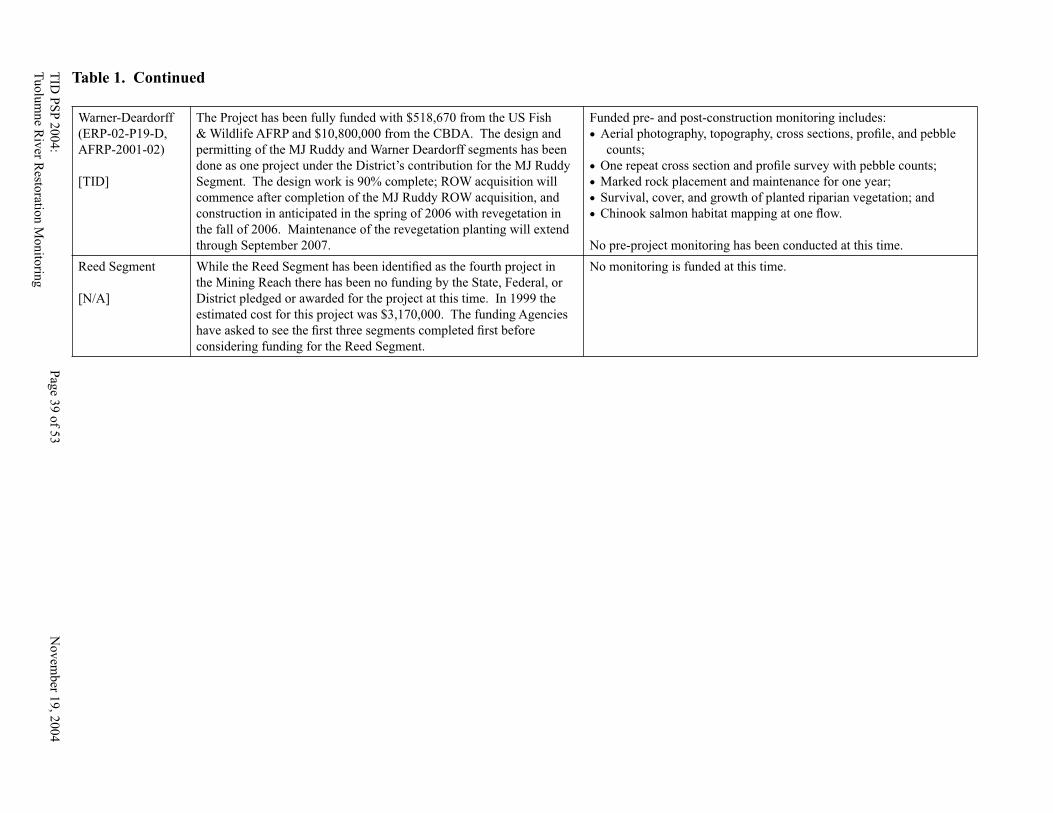
TID
PS
P 2
004
: P
age 3
8 o
f 53
N
ov
emb
er 19
, 20
04
Tu
olu
mne R
iver R
estoratio
n M
onito
ring
TID
PS
P 2
00
4:
Pag
e 39 o
f 53
No
vem
ber 1
9, 2
004
Tu
olu
mn
e Riv
er Resto
ration M
onito
ring
Warner-Deardorff
(ERP-02-P19-D,
AFRP-2001-02)
[TID]
The Project has been fully funded with $518,670 from the US Fish
& Wildlife AFRP and $10,800,000 from the CBDA. The design and
permitting of the MJ Ruddy and Warner Deardorff segments has been
done as one project under the District’s contribution for the MJ Ruddy
Segment. The design work is 90% complete; ROW acquisition will
commence after completion of the MJ Ruddy ROW acquisition, and
construction in anticipated in the spring of 2006 with revegetation in
the fall of 2006. Maintenance of the revegetation planting will extend
through September 2007.
Funded pre- and post-construction monitoring includes:
• Aerial photography, topography, cross sections, profi le, and pebble
counts;
• One repeat cross section and profi le survey with pebble counts;
• Marked rock placement and maintenance for one year;
• Survival, cover, and growth of planted riparian vegetation; and
• Chinook salmon habitat mapping at one fl ow.
No pre-project monitoring has been conducted at this time.
Reed Segment
[N/A]
While the Reed Segment has been identifi ed as the fourth project in
the Mining Reach there has been no funding by the State, Federal, or
District pledged or awarded for the project at this time. In 1999 the
estimated cost for this project was $3,170,000. The funding Agencies
have asked to see the fi rst three segments completed fi rst before
considering funding for the Reed Segment.
No monitoring is funded at this time.
Table 1. Continued
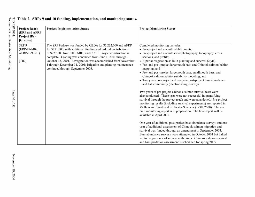
TID
PS
P 2
00
4:
Pag
e 40 o
f 53
No
vem
ber 1
9, 2
004
Tu
olu
mn
e Riv
er Resto
ration M
onito
ring
TID
PS
P 2
004:
Pag
e 41 o
f 53
Novem
ber 1
9, 2
004
Tu
olu
mne R
iver R
estoratio
n M
on
itorin
g
Table 2. SRPs 9 and 10 funding, implementation, and monitoring status.
Project Reach
(ERP and AFRP
Project IDs)
[Grantee]
Project Implementation Status Project Monitoring Status
SRP 9
(ERP-97-M08,
AFRP-1997-01)
[TID]
The SRP 9 phase was funded by CBDA for $2,232,000 and AFRP
for $271,000, with additional funding and in-kind contributions
of $227,000 from TID, MID, and CCSF. Project construction is
complete. Grading was conducted from June 1, 2001 through
October 15, 2001. Revegetation was accomplished from November
1 through December 31, 2001; irrigation and planting maintenance
continued through September 2003.
Completed monitoring includes:
• Pre-project and as-built pebble counts;
• Pre-project and as-built aerial photography, topography, cross
sections, and profi le;
• Riparian vegetation as-built planting and survival (2 yrs);
• Pre- and post-project largemouth bass and Chinook salmon habitat
mapping; and
• Pre- and post-project largemouth bass, smallmouth bass, and
Chinook salmon habitat suitability modeling; and
• Two years pre-project and one year post-project bass abundance
and fi sh community (electrofi shing) surveys.
Two years of pre-project Chinook salmon survival tests were
also conducted. These tests were not successful in quantifying
survival through the project reach and were abandoned. Pre-project
monitoring results (including survival experiments) are reported in
McBain and Trush and Stillwater Sciences (1999, 2000). The as-
built monitoring report is in preparation. The fi nal report will be
available in April 2005.
One year of additional post-project bass abundance surveys and one
year of additional assessment of Chinook salmon migration and
survival was funded through an amendment in September 2004.
Bass abundance surveys were attempted in October 2004 but halted
sur to the presence of salmon in the river. Chinook salmon survival
and bass predation assessment is scheduled for spring 2005.
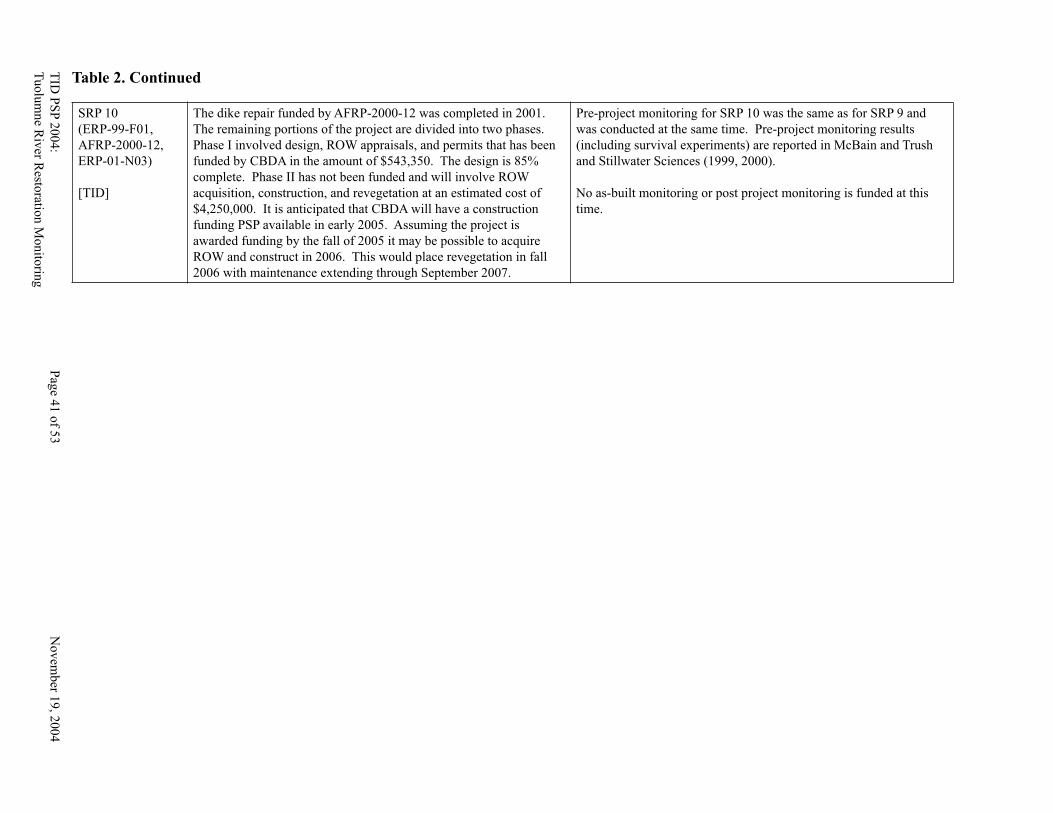
TID
PS
P 2
004
: P
age 4
0 o
f 53
N
ov
emb
er 19
, 20
04
Tu
olu
mne R
iver R
estoratio
n M
onito
ring
TID
PS
P 2
00
4:
Pag
e 41 o
f 53
No
vem
ber 1
9, 2
004
Tu
olu
mn
e Riv
er Resto
ration M
onito
ring
SRP 10
(ERP-99-F01,
AFRP-2000-12,
ERP-01-N03)
[TID]
The dike repair funded by AFRP-2000-12 was completed in 2001.
The remaining portions of the project are divided into two phases.
Phase I involved design, ROW appraisals, and permits that has been
funded by CBDA in the amount of $543,350. The design is 85%
complete. Phase II has not been funded and will involve ROW
acquisition, construction, and revegetation at an estimated cost of
$4,250,000. It is anticipated that CBDA will have a construction
funding PSP available in early 2005. Assuming the project is
awarded funding by the fall of 2005 it may be possible to acquire
ROW and construct in 2006. This would place revegetation in fall
2006 with maintenance extending through September 2007.
Pre-project monitoring for SRP 10 was the same as for SRP 9 and
was conducted at the same time. Pre-project monitoring results
(including survival experiments) are reported in McBain and Trush
and Stillwater Sciences (1999, 2000).
No as-built monitoring or post project monitoring is funded at this
time.
Table 2. Continued
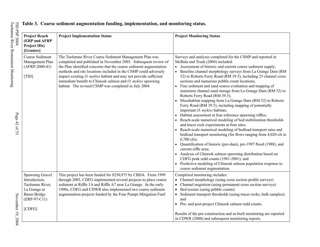
TID
PS
P 2
00
4:
Pag
e 42 o
f 53
No
vem
ber 1
9, 2
004
Tu
olu
mn
e Riv
er Resto
ration M
onito
ring
TID
PS
P 2
004:
Pag
e 43 o
f 53
Novem
ber 1
9, 2
004
Tu
olu
mne R
iver R
estoratio
n M
on
itorin
g
Table 3. Coarse sediment augmentation funding, implementation, and monitoring status.
Project Reach
(ERP and AFRP
Project IDs)
[Grantee]
Project Implementation Status Project Monitoring Status
Coarse Sediment
Management Plan
(AFRP-2000-41)
[TID]
The Tuolumne River Coarse Sediment Management Plan was
completed and published in November 2003. Subsequent review of
the Plan identifi ed concerns that the coarse sediment augmentation
methods and site locations included in the CSMP could adversely
impact existing O. mykiss habitat and may not provide suffi cient
immediate benefi t to Chinook salmon and O. mykiss spawning
habitat. The revised CSMP was completed in July 2004.
Surveys and analyses completed for the CSMP and reported in
McBain and Trush (2004) included:
• Assessment of historic and current coarse sediment supply;
• Baseline channel morphology surveys from La Grange Dam (RM
52) to Roberts Ferry Road (RM 39.5), including 25 channel cross
sections and numerous pebble count locations;
• Fine sediment and sand source evaluation and mapping of
mainstem channel sand storage from La Grange Dam (RM 52) to
Roberts Ferry Road (RM 39.5);
• Mesohabitat mapping from La Grange Dam (RM 52) to Roberts
Ferry Road (RM 39.5), including mapping of potentially
important O. mykiss habitats.
• Habitat assessment at four reference spawning riffl es;
• Reach-scale numerical modeling of bed mobilization thresholds
and tracer rock experiments at four sites;
• Reach-scale numerical modeling of bedload transport rates and
bedload transport monitoring (for fl ows ranging from 4,020 cfs to
6,700 cfs);
• Quantifi cation of historic (pre-dam), pre-1997 fl ood (1988), and
current riffl e area;
• Analysis of Chinook salmon spawning distribution based on
CDFG peak redd counts (1981-2001); and
• Predictive modeling of Chinook salmon population response to
coarse sediment augmentation.
Spawning Gravel
Introduction,
Tuolumne River,
La Grange at
Basso Bridge
(ERP-97-C11)
[CDFG]
This project has been funded for $250,975 by CBDA. From 1999
through 2003, CDFG implemented several projects to place coarse
sediment at Riffl e 1A and Riffl e A7 near La Grange. In the early
1990s, CDFG and CDWR also implemented two coarse sediment
augmentation projects funded by the Four Pumps Mitigation Funf.
Completed monitoring includes:
• Channel morphology (using cross section profi le surveys)
• Channel migration (using permanent cross section surveys)
• Bed texture (using pebble counts)
• Sediment transport thresholds (using tracer rocks, bulk samples);
and
• Pre- and post-project Chinook salmon redd counts.
Results of the pre-construction and as-built monitoring are reported
in CDWR (2000) and subsequent monitoring reports.
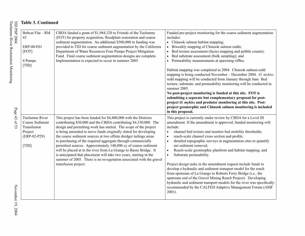
TID
PS
P 2
004
: P
age 4
2 o
f 53
N
ov
emb
er 19
, 20
04
Tu
olu
mne R
iver R
estoratio
n M
onito
ring
TID
PS
P 2
00
4:
Pag
e 43 o
f 53
No
vem
ber 1
9, 2
004
Tu
olu
mn
e Riv
er Resto
ration M
onito
ring
Bobcat Flat – RM
43
ERP-00-F01
[FOT]
4 Pumps
[TID]
CBDA funded a grant of $1,984,320 to Friends of the Tuolumne
(FOT) for property acquisition, fl oodplain restoration and coarse
sediment augmentation. An additional $300,000 in funding was
provided to TID for coarse sediment augmentation by the California
Department of Water Resources Four Pumps Project Mitigation
Fund. Final coarse sediment augmentation designs are complete.
Implementation is expected to occur in summer 2005.
Funded pre-project monitoring for the coarse sediment augmentation
includes:
• Chinook salmon habitat mapping;
• Biweekly mapping of Chinook salmon redds;
• Bed texture assessment (facies mapping and pebble counts);
• Bed substrate assessment (bulk sampling); and
• Permeability measurements at spawning riffl es.
Habitat mapping was completed in 2004. Chinook salmon redd
mapping is being conducted November – December 2004. O. mykiss
redd mapping will be conducted from January through June Bed
texture, substrate, and permeability monitoring will be conducted in
summer 2005.
No post-project monitoring is funded at this site. FOT is
submitting a separate but complementary proposal for post-
project O. mykiss and predator monitoring at this site. Post-
project geomorphic and Chinook salmon monitoring is included
in this proposal.
Tuolumne River
Coarse Sediment
Transfusion
Project
(ERP-02-P29)
[TID]
This project has been funded for $4,400,000 with the Districts
contributing $50,000 and the CBDA contributing $4,350,000. The
design and permitting work has started. The scope of the project
is being amended to move funds originally slated for developing
the coarse sediment sources at two offsite dredger tailings areas
to purchasing of the required aggregate through commercially
permitted sources. Approximately 140,000 cy of coarse sediment
will be placed at in the river from La Grange to Basso Bridge. It
is anticipated that placement will take two years, starting in the
summer of 2005. There is no revegetation associated with the gravel
transfusion project.
This project is currently under review by CBDA for a Level III
amendment. If the amendment is approved, funded monitoring will
include:
• channel bed texture and monitor bed mobility thresholds;
• reach-scale channel cross section and profi le;
• detailed topographic surveys at augmentation sites to quantify
net sediment removal;
• Reach-scale geomorphic planform and habitat mapping; and
• Substrate permeability.
Project design tasks in the amendment request include funds to
develop a hydraulic and sediment transport model for the reach
from upstream of La Grange to Roberts Ferry Bridge (i.e., the
upstream end of the Gravel Mining Reach Project). Developing
hydraulic and sediment transport models for the river was specifi cally
recommended by the CALFED Adaptive Management Forum (AMF
2001).
Table 3. Continued
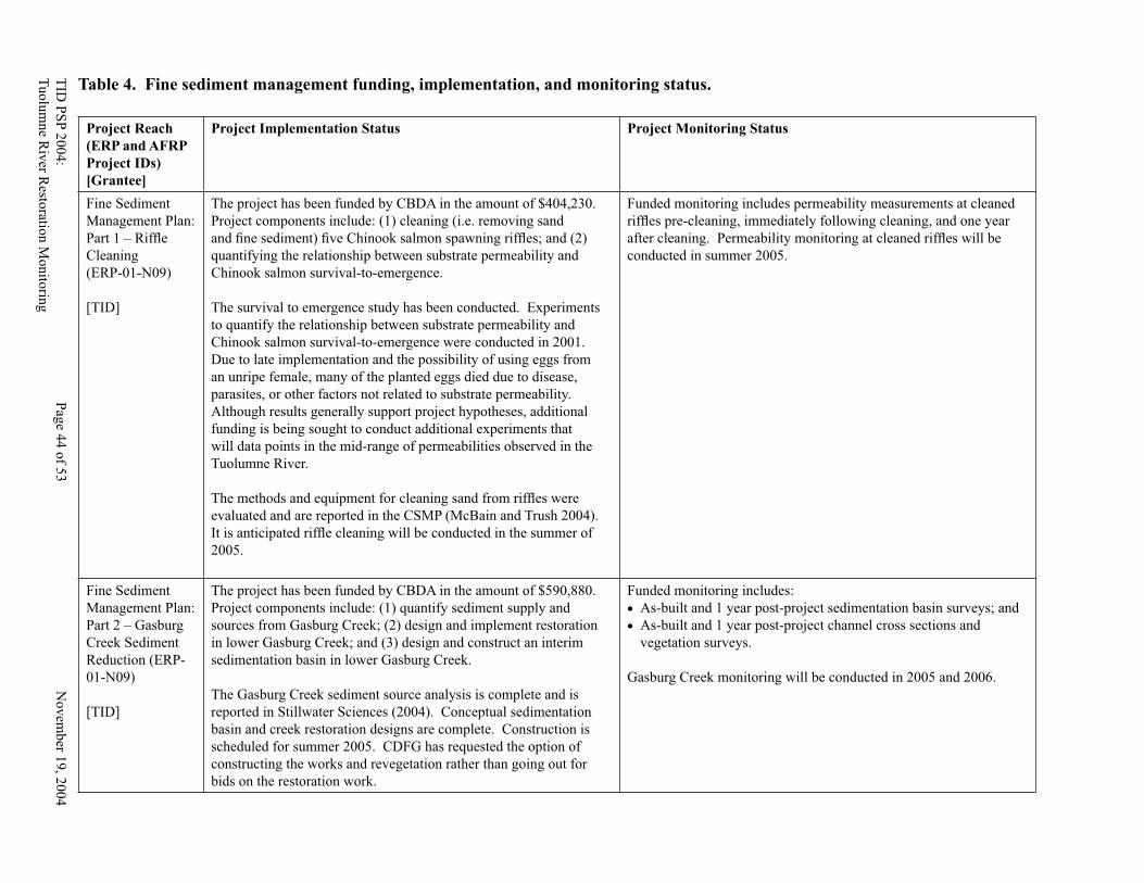
TID
PS
P 2
00
4:
Pag
e 44 o
f 53
No
vem
ber 1
9, 2
004
Tu
olu
mn
e Riv
er Resto
ration M
onito
ring
TID
PS
P 2
004:
Pag
e 45 o
f 53
Novem
ber 1
9, 2
004
Tu
olu
mne R
iver R
estoratio
n M
on
itorin
g
Table 4. Fine sediment management funding, implementation, and monitoring status.
Project Reach
(ERP and AFRP
Project IDs)
[Grantee]
Project Implementation Status Project Monitoring Status
Fine Sediment
Management Plan:
Part 1 – Riffl e
Cleaning
(ERP-01-N09)
[TID]
The project has been funded by CBDA in the amount of $404,230.
Project components include: (1) cleaning (i.e. removing sand
and fi ne sediment) fi ve Chinook salmon spawning riffl es; and (2)
quantifying the relationship between substrate permeability and
Chinook salmon survival-to-emergence.
The survival to emergence study has been conducted. Experiments
to quantify the relationship between substrate permeability and
Chinook salmon survival-to-emergence were conducted in 2001.
Due to late implementation and the possibility of using eggs from
an unripe female, many of the planted eggs died due to disease,
parasites, or other factors not related to substrate permeability.
Although results generally support project hypotheses, additional
funding is being sought to conduct additional experiments that
will data points in the mid-range of permeabilities observed in the
Tuolumne River.
The methods and equipment for cleaning sand from riffl es were
evaluated and are reported in the CSMP (McBain and Trush 2004).
It is anticipated riffl e cleaning will be conducted in the summer of
2005.
Funded monitoring includes permeability measurements at cleaned
riffl es pre-cleaning, immediately following cleaning, and one year
after cleaning. Permeability monitoring at cleaned riffl es will be
conducted in summer 2005.
Fine Sediment
Management Plan:
Part 2 – Gasburg
Creek Sediment
Reduction (ERP-
01-N09)
[TID]
The project has been funded by CBDA in the amount of $590,880.
Project components include: (1) quantify sediment supply and
sources from Gasburg Creek; (2) design and implement restoration
in lower Gasburg Creek; and (3) design and construct an interim
sedimentation basin in lower Gasburg Creek.
The Gasburg Creek sediment source analysis is complete and is
reported in Stillwater Sciences (2004). Conceptual sedimentation
basin and creek restoration designs are complete. Construction is
scheduled for summer 2005. CDFG has requested the option of
constructing the works and revegetation rather than going out for
bids on the restoration work.
Funded monitoring includes:
• As-built and 1 year post-project sedimentation basin surveys; and
• As-built and 1 year post-project channel cross sections and
vegetation surveys.
Gasburg Creek monitoring will be conducted in 2005 and 2006.
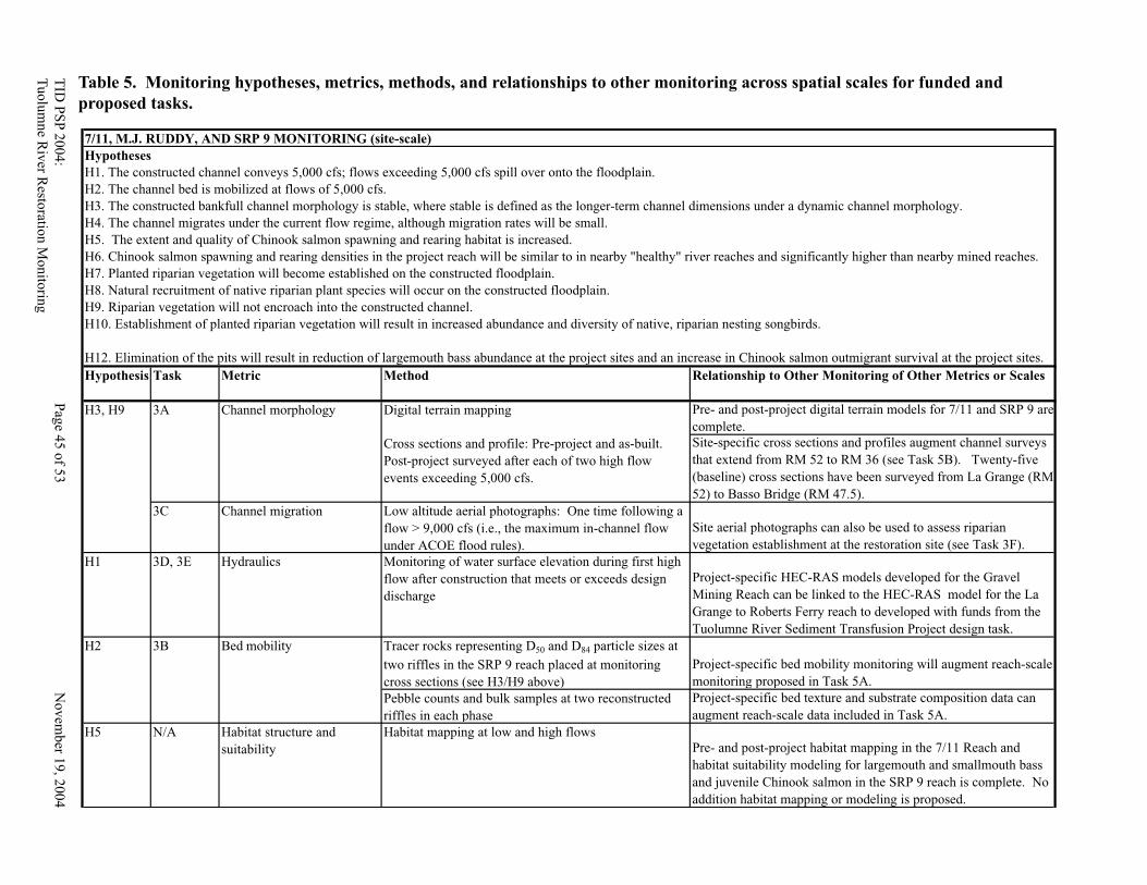
TID
PS
P 2
004
: P
age 4
4 o
f 53
N
ov
emb
er 19
, 20
04
Tu
olu
mne R
iver R
estoratio
n M
onito
ring
TID
PS
P 2
00
4:
Pag
e 45 o
f 53
No
vem
ber 1
9, 2
004
Tu
olu
mn
e Riv
er Resto
ration M
onito
ring
Table 5. Monitoring hypotheses, metrics, methods, and relationships to other monitoring across spatial scales for funded and
proposed tasks.
Hypothesis Task Metric Method Relationship to Other Monitoring of Other Metrics or Scales
Digital terrain mapping Pre- and post-project digital terrain models for 7/11 and SRP 9 are
complete.
Cross sections and profile: Pre-project and as-built.
Post-project surveyed after each of two high flow
events exceeding 5,000 cfs.
Site-specific cross sections and profiles augment channel surveys
that extend from RM 52 to RM 36 (see Task 5B). Twenty-five
(baseline) cross sections have been surveyed from La Grange (RM
52) to Basso Bridge (RM 47.5).
3C Channel migration Low altitude aerial photographs: One time following a
flow > 9,000 cfs (i.e., the maximum in-channel flow
under ACOE flood rules).
Site aerial photographs can also be used to assess riparian
vegetation establishment at the restoration site (see Task 3F).
H1 3D, 3E Hydraulics Monitoring of water surface elevation during first high
flow after construction that meets or exceeds design
discharge
Project-specific HEC-RAS models developed for the Gravel
Mining Reach can be linked to the HEC-RAS model for the La
Grange to Roberts Ferry reach to developed with funds from the
Tuolumne River Sediment Transfusion Project design task.
Tracer rocks representing D50 and D84 particle sizes at
two riffles in the SRP 9 reach placed at monitoring
cross sections (see H3/H9 above)
Project-specific bed mobility monitoring will augment reach-scale
monitoring proposed in Task 5A.
Pebble counts and bulk samples at two reconstructed
riffles in each phase
Project-specific bed texture and substrate composition data can
augment reach-scale data included in Task 5A.
H5 N/A Habitat structure and
suitability
Habitat mapping at low and high flows
Pre- and post-project habitat mapping in the 7/11 Reach and
habitat suitability modeling for largemouth and smallmouth bass
and juvenile Chinook salmon in the SRP 9 reach is complete. No
addition habitat mapping or modeling is proposed.
H10. Establishment of planted riparian vegetation will result in increased abundance and diversity of native, riparian nesting songbirds.
H12. Elimination of the pits will result in reduction of largemouth bass abundance at the project sites and an increase in Chinook salmon outmigrant survival at the project sites.
H2 Bed mobility 3B
H3. The constructed bankfull channel morphology is stable, where stable is defined as the longer-term channel dimensions under a dynamic channel morphology.
H3, H9 3A Channel morphology
H4. The channel migrates under the current flow regime, although migration rates will be small.
H5. The extent and quality of Chinook salmon spawning and rearing habitat is increased.
H6. Chinook salmon spawning and rearing densities in the project reach will be similar to in nearby "healthy" river reaches and significantly higher than nearby mined reaches.
H7. Planted riparian vegetation will become established on the constructed floodplain.
H8. Natural recruitment of native riparian plant species will occur on the constructed floodplain.
H9. Riparian vegetation will not encroach into the constructed channel.
7/11, M.J. RUDDY, AND SRP 9 MONITORING (site-scale)
Hypotheses
H1. The constructed channel conveys 5,000 cfs; flows exceeding 5,000 cfs spill over onto the floodplain.
H2. The channel bed is mobilized at flows of 5,000 cfs.
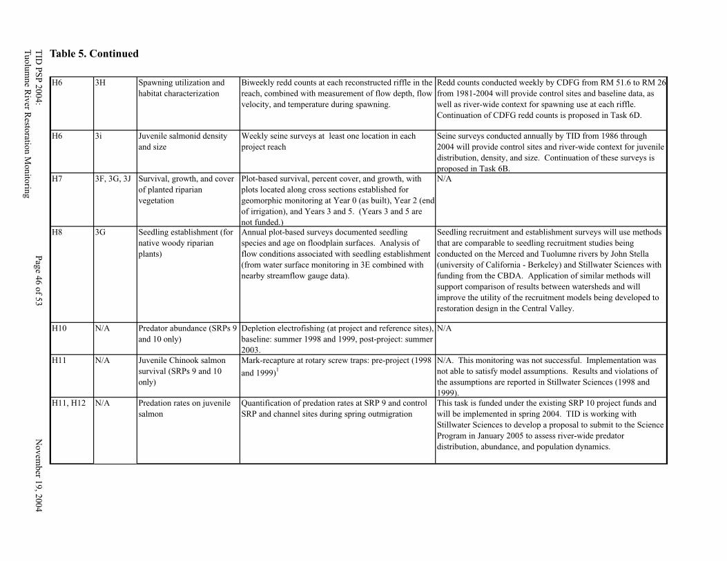
TID
PS
P 2
00
4:
Pag
e 46 o
f 53
No
vem
ber 1
9, 2
004
Tu
olu
mn
e Riv
er Resto
ration M
onito
ring
TID
PS
P 2
004:
Pag
e 47 o
f 53
Novem
ber 1
9, 2
004
Tu
olu
mne R
iver R
estoratio
n M
on
itorin
g
Table 5. Continued
H6 3H Spawning utilization and
habitat characterization
Biweekly redd counts at each reconstructed riffle in the
reach, combined with measurement of flow depth, flow
velocity, and temperature during spawning.
Redd counts conducted weekly by CDFG from RM 51.6 to RM 26
from 1981-2004 will provide control sites and baseline data, as
well as river-wide context for spawning use at each riffle.
Continuation of CDFG redd counts is proposed in Task 6D.
H6 3i Juvenile salmonid density
and size
Weekly seine surveys at least one location in each
project reach
Seine surveys conducted annually by TID from 1986 through
2004 will provide control sites and river-wide context for juvenile
distribution, density, and size. Continuation of these surveys is
proposed in Task 6B.
H7 3F, 3G, 3J Survival, growth, and cover
of planted riparian
vegetation
Plot-based survival, percent cover, and growth, with
plots located along cross sections established for
geomorphic monitoring at Year 0 (as built), Year 2 (end
of irrigation), and Years 3 and 5. (Years 3 and 5 are
not funded.)
N/A
H8 3G Seedling establishment (for
native woody riparian
plants)
Annual plot-based surveys documented seedling
species and age on floodplain surfaces. Analysis of
flow conditions associated with seedling establishment
(from water surface monitoring in 3E combined with
nearby streamflow gauge data).
Seedling recruitment and establishment surveys will use methods
that are comparable to seedling recruitment studies being
conducted on the Merced and Tuolumne rivers by John Stella
(university of California - Berkeley) and Stillwater Sciences with
funding from the CBDA. Application of similar methods will
support comparison of results between watersheds and will
improve the utility of the recruitment models being developed to
restoration design in the Central Valley.
H10 N/A Predator abundance (SRPs 9
and 10 only)
Depletion electrofishing (at project and reference sites),
baseline: summer 1998 and 1999, post-project: summer
2003.
N/A
H11 N/A Juvenile Chinook salmon
survival (SRPs 9 and 10
only)
Mark-recapture at rotary screw traps: pre-project (1998
and 1999)1
N/A. This monitoring was not successful. Implementation was
not able to satisfy model assumptions. Results and violations of
the assumptions are reported in Stillwater Sciences (1998 and
1999).
H11, H12 N/A Predation rates on juvenile
salmon
Quantification of predation rates at SRP 9 and control
SRP and channel sites during spring outmigration
This task is funded under the existing SRP 10 project funds and
will be implemented in spring 2004. TID is working with
Stillwater Sciences to develop a proposal to submit to the Science
Program in January 2005 to assess river-wide predator
distribution, abundance, and population dynamics.
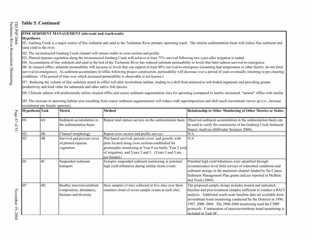
TID
PS
P 2
004
: P
age 4
6 o
f 53
N
ov
emb
er 19
, 20
04
Tu
olu
mne R
iver R
estoratio
n M
onito
ring
TID
PS
P 2
00
4:
Pag
e 47 o
f 53
No
vem
ber 1
9, 2
004
Tu
olu
mn
e Riv
er Resto
ration M
onito
ring
Table 5. Continued
FINE SEDIMENT MANAGEMENT (site-scale and reach-scale)
Hypothesis Task Metric Method Relationship to Other Monitoring of Other Metrics or Scales
H1 4A Sediment accumulation in
the sedimentation basin
Repeat total station surveys on the sedimentation basin Observed sediment accumulation in the sedimentation basin can
be used to verify the conclusions of the Gasburg Creek Sediment
Source Analysis (Stillwater Sciences 2004).
H2 4B Channel morphology Repeat cross section and profile surveys N/A
H3 4B Survival and percent cover
of planted riparian
vegetation
Plot-based survival, percent cover, and growth, with
plots located along cross sections established for
geomorphic monitoring at Year 0 (as built), Year 2 (end
of irrigation), and Years 3 and 5. (Years 3 and 5 are
not funded.)
N/A
H1 4C Suspended sediment
transport
Synoptic suspended sediment monitoring in potential
high yield tributaries during similar storm events
Potential high yield tributaries were identified through
reconnaissance-level field surveys of watershed conditions and
sediment storage in the mainstem channel funded by the Coarse
Sediment Management Plan grants and are reported in McBain
and Trush (2004).
H7 4D Benthic macroinvertebrate
composition, abundance,
biomass and diversity
Hess samples (3/site) collected at five sites over three
summers (total of seven sample events at each site)
The proposed sample design includes treated and untreated,
baseline and post-treatment samples sufficient to conduct a BACI
analysis. Additional reach-scale baseline data are available from
invertebrate trend monitoring conducted by the Districts in 1996,
1997, 2000–2004. The 2000-2004 monitoring used the CSBP
protocols. Continuation of macroinvertebrate trend monitoring is
included in Task 6F.
H1. Gasburg Creek is a major source of fine sediment and sand to the Tuolumne River primary spawning reach. The interim sedimentation basin will reduce fine sediment and
sand yield to the river.
H2. The reconstructed Gasburg Creek channel will remain stable in cross section and profile.
H3. Planted riparian vegetation along the reconstructed Gasburg Creek will achieve at least 75% survival following two years after irrigation is ended.
H4. Accumulation of fine sediment and sand in the bed of the Tuolumne River has reduced substrate permeability to levels that limit salmon survival-to-emergence.
H6. In cleaned riffles, substrate permeability will increase to levels that can support at least 80% survival-to-emergence (assuming that temperature or other factors do not limit
survival-to-emergence). As sediment accumulates in riffles following project construction, permeability will decrease over a period of years eventually returning to pre-cleaning
conditions. (The period of time over which increased permeability is observable is not known.)
H9. The increase in spawning habitat area (resulting from coarse sediment augmentation) will reduce redd superimposition and shift stock-recruitment curves up (i.e., increase
recruitment per female spawner).
H7. Reducing the volume of fine sediment stored in riffles will alter invertebrate habitat, leading to a shift from armored to soft-boded organisms and providing greater
productivity and food value for salmonids and other native fish species.
H8. Chinook salmon will preferentially utilize cleaned riffles and coarse sediment augmentation sites for spawning (compared to nearby uncleaned, "natural" riffles with similar
habitat characteristics).
Hypotheses
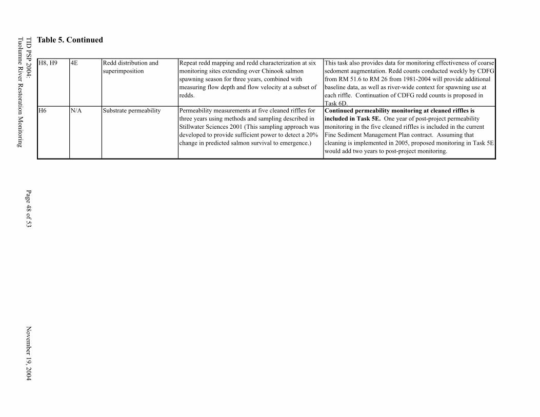
TID
PS
P 2
00
4:
Pag
e 48 o
f 53
No
vem
ber 1
9, 2
004
Tu
olu
mn
e Riv
er Resto
ration M
onito
ring
TID
PS
P 2
004:
Pag
e 49 o
f 53
Novem
ber 1
9, 2
004
Tu
olu
mne R
iver R
estoratio
n M
on
itorin
g
H8, H9 4E Redd distribution and
superimposition
Repeat redd mapping and redd characterization at six
monitoring sites extending over Chinook salmon
spawning season for three years, combined with
measuring flow depth and flow velocity at a subset of
redds.
This task also provides data for monitoring effectiveness of coarse
sedoment augmentation. Redd counts conducted weekly by CDFG
from RM 51.6 to RM 26 from 1981-2004 will provide additional
baseline data, as well as river-wide context for spawning use at
each riffle. Continuation of CDFG redd counts is proposed in
Task 6D.H6 N/A Substrate permeability Permeability measurements at five cleaned riffles for
three years using methods and sampling described in
Stillwater Sciences 2001 (This sampling approach was
developed to provide sufficient power to detect a 20%
change in predicted salmon survival to emergence.)
Continued permeability monitoring at cleaned riffles is
included in Task 5E. One year of post-project permeability
monitoring in the five cleaned riffles is included in the current
Fine Sediment Management Plan contract. Assuming that
cleaning is implemented in 2005, proposed monitoring in Task 5E
would add two years to post-project monitoring.
Table 5. Continued
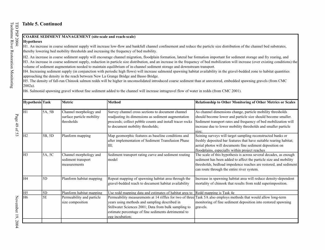
TID
PS
P 2
004
: P
age 4
8 o
f 53
N
ov
emb
er 19
, 20
04
Tu
olu
mne R
iver R
estoratio
n M
onito
ring
TID
PS
P 2
00
4:
Pag
e 49 o
f 53
No
vem
ber 1
9, 2
004
Tu
olu
mn
e Riv
er Resto
ration M
onito
ring
COARSE SEDIMENT MANAGEMENT (site-scale and reach-scale)
Hypothesis Task Metric Method Relationship to Other Monitoring of Other Metrics or Scales
H1 5A, 5B Channel morphology and
surface particle mobility
thresholds
Survey channel cross sections to document channel
readjusting its dimensions as sediment augmentation
proceeds; collect pebble counts and install tracer rocks
to document mobility thresholds;
As channel dimensions change, particle mobility thresholds
should become lower and particle size should become smaller.
Sediment transport rates and frequency of bed mobilization will
increase due to lower mobility thresholds and smaller particle
size;
H2 5B, 5D Planform mapping Map geomorphic features as baseline conditions and
after implementation of Sediment Transfusion Phase
III;
Seining surveys will target sampling reconstructed banks or
freshly deposited bar features that have suitable rearing habitat;
aerial photos will documents fine sediment deposition on
floodplains, especially within project reaches
H3 5A, 5C Channel morphology and
sediment transport
measurements
Sediment transport rating curve and sediment routing
model
The scale of this hypothesis is across several decades, as enough
sediment has been added to affect the particle size and mobility
thresholds, bedload impedence reaches are restored, and sediment
can route through the entire river system.
H4 5D Planform habitat mapping Repeat mapping of spawning habitat area through the
gravel-bedded reach to document habitat availability
Increase in spawning habitat area will reduce density-dependent
mortality of chinook that results from redd superimposition.
H5 5D Planform habitat mapping Use redd mapping data and estimates of habitat area to Redd mapping is Task 4e
H6 5E Permeability and particle
size composition
Permeability measurements at 14 riffles for two of three
years using methods and sampling described in
Stillwater Sciences 2001; Data from bulk sampling to
estimate percentage of fine sediments detrimental to
egg incubation;
Task 5A also employs methods that would allow long-term
monitoring of fine sediment deposition into restored spawning
gravels.
H4. Increasing sediment supply (in conjunction with periodic high flows) will increase salmonid spawning habitat availability in the gravel-bedded zone to habitat quantities
approaching the density in the reach between New La Grange Bridge and Basso Bridge.
H5. The density of fall-run Chinook salmon redds will be higher in unconsolidated introduced coarse sediment than at unrestored, embedded spawning gravels (from CMC
2002a).
H6. Salmonid spawning gravel without fine sediment added to the channel will increase intragravel flow of water in redds (from CMC 2001).
Hypotheses
H1. An increase in coarse sediment supply will increase low-flow and bankfull channel confinement and reduce the particle size distribution of the channel bed substrates,
thereby lowering bed mobility thresholds and increasing the frequency of bed mobility.
H2. An increase in coarse sediment supply will encourage channel migration, floodplain formation, lateral bar formation important for sediment storage and fry rearing, and
H3. An increase in coarse sediment supply, reduction in particle size distribution, and an increase in the frequency of bed mobilization will increase (over existing conditions) the
volume of sediment augmentation needed to maintain equilibrium of in-channel sediment storage and downstream transport.
Table 5. Continued

TID
PS
P 2
00
4:
Pag
e 50 o
f 53
No
vem
ber 1
9, 2
004
Tu
olu
mn
e Riv
er Resto
ration M
onito
ring
TID
PS
P 2
004:
Pag
e 51 o
f 53
Novem
ber 1
9, 2
004
Tu
olu
mne R
iver R
estoratio
n M
on
itorin
g
Table 6. Project Schedule*
Ja
n
Feb
Ma
r
Ap
r
Ma
y
Ju
ne
Ju
ly
Au
g
Sep
t
Oct
No
v
Dec
Ja
n
Feb
Ma
r
Ap
r
Ma
y
Ju
ne
Ju
ly
Au
g
Sep
t
Oct
No
v
Dec
Ja
n
Feb
Ma
r
Ap
r
Ma
y
Ju
ne
Ju
ly
Au
g
Sep
t
Oct
No
v
Dec
1 PROJECT MANAGEMENT
Quarterly reports
2 PUBLIC PARTICIPATION
2a. TRTAC participation
2b. Brochure development
2c. CALFED Science Conference + publications
3 CONTINUE 7/11, MJR, AND SRP9 PROJECT MONITORING
3a. Resurvey cross sections and a longitudinal profiles
3b. Deploy and maintain tracer rocks
3c. Map channel migration and other planform changes
3d. Monitor peak flow water surface elevations
3e. Continuous water surface monitoring
3f. Monitor planted vegetation
3g. Monitor natural recruitment
3h. Map spawning location and habitat characteristics
3i. Conduct Seine Surveys
3j. Monitor Groundwater
3k. Monitor avian species
3l. Report preparation and distribution
4 CONTINUE FINE SEDIMENT MANAGEMENT MONITORING
4a. Quantify annual sediment accumulation
4b. Monitor channel stability and riparian vegetation
4c. Monitor tributary fine sediment contribution
4d. Benthic Macroinvertebrate monitoring
4e. Quantify Chinook salmon spawning habitat selection and redd superimposition
4f. Report preparation and distribution
5
AUGMENT BASELINE AND POST-PROJECT MONITORING FOR COARSE SEDIMENT
AUGMENTATION
5a. Map Sediment Facies, Pebble Counts, Install Tracer Rocks, Scour Cores
5b. Survey XS's, LP's, Topography
5c. Sediment Transport Measurements at R4B
5d. Planform Mapping (alluvial features and meso/microhabitat)
5e. Monitor permeability
5f. Report preparation and distribution
6
MONITORING OF CUMULATIVE EFFECTS ON TARGET POPULATIONS [CHINOOK
SALMON AND O. MYKISS]
6A. Juvenile Chinook salmon production and outmigration timing
6b. Juvenile Chinook salmon and O. mykiss distribution, abundance, and size (winter and spring)
6c. Juvenile Chinook salmon and O. mykiss distribution (summer)
6d. Chinook salmon adult escapement and redd distribution
6e. O. mykiss adult distribution and redd distribution
6f. Benthic macroinvertebrate composition, abundance, and diversity indices.
N/A Report preparation and distribution (In the scope of work, report funds are included in each task.)
7 Aerial photography, orthorectification, photogrammetry, and bathymetry
7a. Air photo flight from LaGrange to San Joaquin River
7b. Install ground control points
7c. Orthorectify aerial photographs
7d. Photogrammetry topography
7e. Survey channel bathymetry
*Schedule assumes CBDA Action by June 2005 (as stated in the PSP, p. 24) and contract issuance by December 31, 2005.
2008TASKS 2006 2007
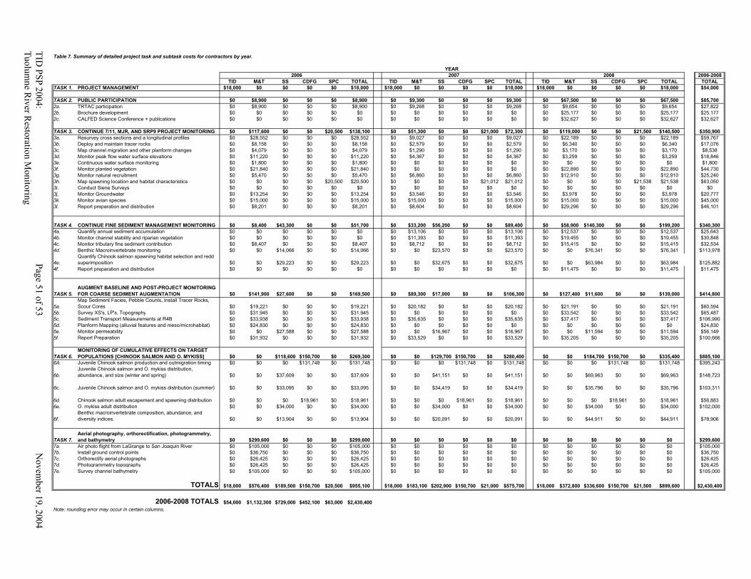
TID
PS
P 2
004
: P
age 5
0 o
f 53
N
ov
emb
er 19
, 20
04
Tu
olu
mne R
iver R
estoratio
n M
onito
ring
TID
PS
P 2
00
4:
Pag
e 51 o
f 53
No
vem
ber 1
9, 2
004
Tu
olu
mn
e Riv
er Resto
ration M
onito
ring
Table 7. Summary of detailed project task and subtask costs for contractors by year.
2006-2008
TID M&T SS CDFG SPC TOTAL TID M&T SS CDFG SPC TOTAL TID M&T SS CDFG SPC TOTAL TOTAL
TASK 1. PROJECT MANAGEMENT $18,000 $0 $0 $0 $0 $18,000 $18,000 $0 $0 $0 $0 $18,000 $18,000 $0 $0 $0 $0 $18,000 $54,000
TASK 2. PUBLIC PARTICIPATION $0 $8,900 $0 $0 $0 $8,900 $0 $9,300 $0 $0 $0 $9,300 $0 $67,500 $0 $0 $0 $67,500 $85,700
2a. TRTAC participation $0 $8,900 $0 $0 $0 $8,900 $0 $9,268 $0 $0 $0 $9,268 $0 $9,654 $0 $0 $0 $9,654 $27,822
2b. Brochure development $0 $0 $0 $0 $0 $0 $0 $0 $0 $0 $0 $0 $0 $25,177 $0 $0 $0 $25,177 $25,177
2c. CALFED Science Conference + publications $0 $0 $0 $0 $0 $0 $0 $0 $0 $0 $0 $0 $0 $32,627 $0 $0 $0 $32,627 $32,627
TASK 3. CONTINUE 7/11, MJR, AND SRP9 PROJECT MONITORING $0 $117,600 $0 $0 $20,500 $138,100 $0 $51,300 $0 $0 $21,000 $72,300 $0 $119,000 $0 $0 $21,500 $140,500 $350,900
3a. Resurvey cross sections and a longitudinal profiles $0 $28,552 $0 $0 $0 $28,552 $0 $9,027 $0 $0 $0 $9,027 $0 $22,189 $0 $0 $0 $22,189 $59,767
3b. Deploy and maintain tracer rocks $0 $8,158 $0 $0 $0 $8,158 $0 $2,579 $0 $0 $0 $2,579 $0 $6,340 $0 $0 $0 $6,340 $17,076
3c. Map channel migration and other planform changes $0 $4,079 $0 $0 $0 $4,079 $0 $1,290 $0 $0 $0 $1,290 $0 $3,170 $0 $0 $0 $3,170 $8,538
3d. Monitor peak flow water surface elevations $0 $11,220 $0 $0 $0 $11,220 $0 $4,367 $0 $0 $0 $4,367 $0 $3,259 $0 $0 $0 $3,259 $18,846
3e. Continuous water surface monitoring $0 $1,800 $0 $0 $0 $1,800 $0 $0 $0 $0 $0 $0 $0 $0 $0 $0 $0 $0 $1,800
3f. Monitor planted vegetation $0 $21,840 $0 $0 $0 $21,840 $0 $0 $0 $0 $0 $0 $0 $22,890 $0 $0 $0 $22,890 $44,730
3g. Monitor natural recruitment $0 $5,470 $0 $0 $0 $5,470 $0 $6,860 $0 $0 $0 $6,860 $0 $12,910 $0 $0 $0 $12,910 $25,240
3h. Map spawning location and habitat characteristics $0 $0 $0 $0 $20,500 $20,500 $0 $0 $0 $0 $21,012 $21,012 $0 $0 $0 $0 $21,538 $21,538 $63,050
3i. Conduct Siene Surveys $0 $0 $0 $0 $0 $0 $0 $0 $0 $0 $0 $0 $0 $0 $0 $0 $0 $0 $0
3j. Monitor Groundwater $0 $13,254 $0 $0 $0 $13,254 $0 $3,546 $0 $0 $0 $3,546 $0 $3,978 $0 $0 $0 $3,978 $20,777
3k. Monitor avian species $0 $15,000 $0 $0 $0 $15,000 $0 $15,000 $0 $0 $0 $15,000 $0 $15,000 $0 $0 $0 $15,000 $45,000
3l. Report preparation and distribution $0 $8,201 $0 $0 $0 $8,201 $0 $8,604 $0 $0 $0 $8,604 $0 $29,296 $0 $0 $0 $29,296 $46,101
TASK 4. CONTINUE FINE SEDIMENT MANAGEMENT MONITORING $0 $8,400 $43,300 $0 $0 $51,700 $0 $33,200 $56,200 $0 $0 $89,400 $0 $58,900 $140,300 $0 $0 $199,200 $340,300
4a. Quantify annual sediment accumulation $0 $0 $0 $0 $0 $0 $0 $13,106 $0 $0 $0 $13,106 $0 $12,537 $0 $0 $0 $12,537 $25,643
4b. Monitor channel stability and riparian vegetation $0 $0 $0 $0 $0 $0 $0 $11,393 $0 $0 $0 $11,393 $0 $19,455 $0 $0 $0 $19,455 $30,848
4c. Monitor tributary fine sediment contribution $0 $8,407 $0 $0 $0 $8,407 $0 $8,712 $0 $0 $0 $8,712 $0 $15,415 $0 $0 $0 $15,415 $32,534
4d. Benthic Macroinvertebrate monitoring $0 $0 $14,066 $0 $0 $14,066 $0 $0 $23,570 $0 $0 $23,570 $0 $0 $76,341 $0 $0 $76,341 $113,978
4e.
Quantify Chinook salmon spawning habitat selection and redd
superimposition $0 $0 $29,223 $0 $0 $29,223 $0 $0 $32,675 $0 $0 $32,675 $0 $0 $63,984 $0 $0 $63,984 $125,882
4f. Report preparation and distribution $0 $0 $0 $0 $0 $0 $0 $0 $0 $0 $0 $0 $0 $11,475 $0 $0 $0 $11,475 $11,475
TASK 5.
AUGMENT BASELINE AND POST-PROJECT MONITORING
FOR COARSE SEDIMENT AUGMENTATION $0 $141,900 $27,600 $0 $0 $169,500 $0 $89,300 $17,000 $0 $0 $106,300 $0 $127,400 $11,600 $0 $0 $139,000 $414,800
5a.
Map Sediment Facies, Pebble Counts, Install Tracer Rocks,
Scour Cores $0 $19,221 $0 $0 $0 $19,221 $0 $20,182 $0 $0 $0 $20,182 $0 $21,191 $0 $0 $0 $21,191 $60,594
5b. Survey XS's, LP's, Topography $0 $31,945 $0 $0 $0 $31,945 $0 $0 $0 $0 $0 $0 $0 $33,542 $0 $0 $0 $33,542 $65,487
5c. Sediment Transport Measurements at R4B $0 $33,938 $0 $0 $0 $33,938 $0 $35,635 $0 $0 $0 $35,635 $0 $37,417 $0 $0 $0 $37,417 $106,990
5d. Planform Mapping (alluvial features and meso/microhabitat) $0 $24,830 $0 $0 $0 $24,830 $0 $0 $0 $0 $0 $0 $0 $0 $0 $0 $0 $0 $24,830
5e. Monitor permeability $0 $0 $27,588 $0 $0 $27,588 $0 $0 $16,967 $0 $0 $16,967 $0 $0 $11,594 $0 $0 $11,594 $56,149
5f. Report Preparation $0 $31,932 $0 $0 $0 $31,932 $0 $33,529 $0 $0 $0 $33,529 $0 $35,205 $0 $0 $0 $35,205 $100,666
TASK 6.
MONITORING OF CUMULATIVE EFFECTS ON TARGET
POPULATIONS [CHINOOK SALMON AND O. MYKISS] $0 $0 $118,600 $150,700 $0 $269,300 $0 $0 $129,700 $150,700 $0 $280,400 $0 $0 $184,700 $150,700 $0 $335,400 $885,100
6A. Juvenile Chinook salmon production and outmigration timing $0 $0 $0 $131,748 $0 $131,748 $0 $0 $0 $131,748 $0 $131,748 $0 $0 $0 $131,748 $0 $131,748 $395,243
6b.
Juvenile Chinook salmon and O. mykiss distribution,
abundance, and size (winter and spring) $0 $0 $37,609 $0 $0 $37,609 $0 $0 $41,151 $0 $0 $41,151 $0 $0 $69,963 $0 $0 $69,963 $148,723
6c. Juvenile Chinook salmon and O. mykiss distribution (summer) $0 $0 $33,095 $0 $0 $33,095 $0 $0 $34,419 $0 $0 $34,419 $0 $0 $35,796 $0 $0 $35,796 $103,311
6d. Chinook salmon adult escapement and spawning distribution $0 $0 $0 $18,961 $0 $18,961 $0 $0 $0 $18,961 $0 $18,961 $0 $0 $0 $18,961 $0 $18,961 $56,883
6e. O. mykiss adult distribution $0 $0 $34,000 $0 $0 $34,000 $0 $0 $34,000 $0 $0 $34,000 $0 $0 $34,000 $0 $0 $34,000 $102,000
6f.
Benthic macroinvertebrate composition, abundance, and
diversity indices. $0 $0 $13,904 $0 $0 $13,904 $0 $0 $20,091 $0 $0 $20,091 $0 $0 $44,911 $0 $0 $44,911 $78,906
TASK 7.
Aerial photography, orthorectification, photogrammetry,
and bathymetry $0 $299,600 $0 $0 $0 $299,600 $0 $0 $0 $0 $0 $0 $0 $0 $0 $0 $0 $0 $299,600
7a. Air photo flight from LaGrange to San Joaquin River $0 $105,000 $0 $0 $0 $105,000 $0 $0 $0 $0 $0 $0 $0 $0 $0 $0 $0 $0 $105,000
7b. Install ground control points $0 $36,750 $0 $0 $0 $36,750 $0 $0 $0 $0 $0 $0 $0 $0 $0 $0 $0 $0 $36,750
7c. Orthorectify aerial photographs $0 $26,425 $0 $0 $0 $26,425 $0 $0 $0 $0 $0 $0 $0 $0 $0 $0 $0 $0 $26,425
7d. Photogrammetry topography $0 $26,425 $0 $0 $0 $26,425 $0 $0 $0 $0 $0 $0 $0 $0 $0 $0 $0 $0 $26,425
7e. Survey channel bathymetry $0 $105,000 $0 $0 $0 $105,000 $0 $0 $0 $0 $0 $0 $0 $0 $0 $0 $0 $0 $105,000
TOTALS $18,000 $576,400 $189,500 $150,700 $20,500 $955,100 $18,000 $183,100 $202,900 $150,700 $21,000 $575,700 $18,000 $372,800 $336,600 $150,700 $21,500 $899,600 $2,430,400
2006-2008 TOTALS $54,000 $1,132,300 $729,000 $452,100 $63,000 $2,430,400
Note: rounding error may occur in certain columns.
YEAR
2006 2007 2008
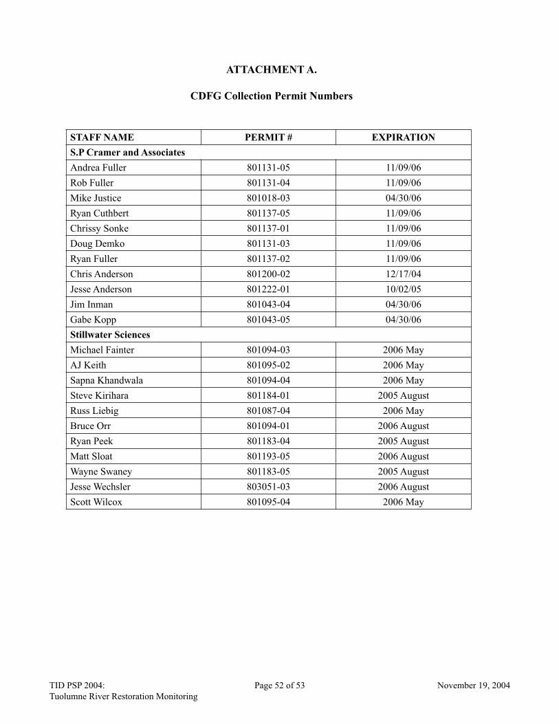
TID PSP 2004: Page 52 of 53 November 19, 2004
Tuolumne River Restoration Monitoring
TID PSP 2004: Page 53 of 53 November 19, 2004
Tuolumne River Restoration Monitoring
ATTACHMENT A.
CDFG Collection Permit Numbers
STAFF NAME PERMIT # EXPIRATION
S.P Cramer and Associates
Andrea Fuller 801131-05 11/09/06
Rob Fuller 801131-04 11/09/06
Mike Justice 801018-03 04/30/06
Ryan Cuthbert 801137-05 11/09/06
Chrissy Sonke 801137-01 11/09/06
Doug Demko 801131-03 11/09/06
Ryan Fuller 801137-02 11/09/06
Chris Anderson 801200-02 12/17/04
Jesse Anderson 801222-01 10/02/05
Jim Inman 801043-04 04/30/06
Gabe Kopp 801043-05 04/30/06
Stillwater Sciences
Michael Fainter 801094-03 2006 May
AJ Keith 801095-02 2006 May
Sapna Khandwala 801094-04 2006 May
Steve Kirihara 801184-01 2005 August
Russ Liebig 801087-04 2006 May
Bruce Orr 801094-01 2006 August
Ryan Peek 801183-04 2005 August
Matt Sloat 801193-05 2006 August
Wayne Swaney 801183-05 2005 August
Jesse Wechsler 803051-03 2006 August
Scott Wilcox 801095-04 2006 May
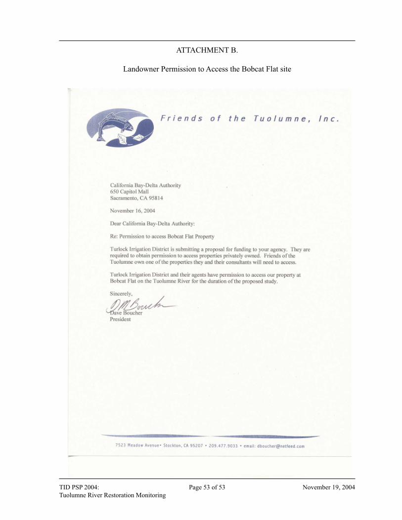
TID PSP 2004: Page 52 of 53 November 19, 2004
Tuolumne River Restoration Monitoring
TID PSP 2004: Page 53 of 53 November 19, 2004
Tuolumne River Restoration Monitoring
ATTACHMENT B.
Landowner Permission to Access the Bobcat Flat site