Tum2014 november
52
Land use and mobility Marco te Brömmelstroet TU Munich 19112014
Transcript of Tum2014 november

Land use and mobility
Marco te Brömmelstroet TU Munich 19-‐11-‐2014

Who am I? Dr. Marco te Brömmelstroet • Assistant professor in Urban Planning
– University of Amsterdam – Land use and Mobility
• Research – Knowledge technologies for strategymaking processes – Deep uncertainty – Urban cycling
• I came by bicycle -‐> airplane -‐> S Bahn -‐> U Bahn. And you?
Land use and mobility
?

Table of Content è Why is mobility so important? è Double challenge for transport and land use
planning è Influences between land use and mobility è New opportuniJes for integrated planning è Amsterdam, as example è Instruments for planners è Take home lessons

Importance = mobile society with very dispersed activities accessible through mobility
(Reijndorp et al.)

A mobile society: dispersed production processes, connected
through mobility networks (Philips in NWE)
(Boelens)

(Allen, 1997)


So:
Mobility is important: to connect dispersed acJviJes of
people and businesses AND to create the necessary condiJons for this

(WBCSD)

(WBCSD)

Mobility is important
but also very expensive, and not
sustainable
a classic dilemma

What are possible strategies? Encourage mobility (1970) didn’t work… Discourage mobility (1990) didn’t work either… Is there a third way?
Dilemma: mobility vs. sustainability

3) Coping with the dilemma:
Reciprocal relaJons between land use and mobility

System thinking: The chicken and the egg
Eggs
Chicken +
+ etc.
Time
Pop
ulat
ion
Reinforcing feedback loop +

Time
Pop
ulat
ion
Eggs
Chicken +
+
Stabilising feedback loop +
# Road crossings +
-‐
etc.
-‐
System thinking: The chicken and the egg
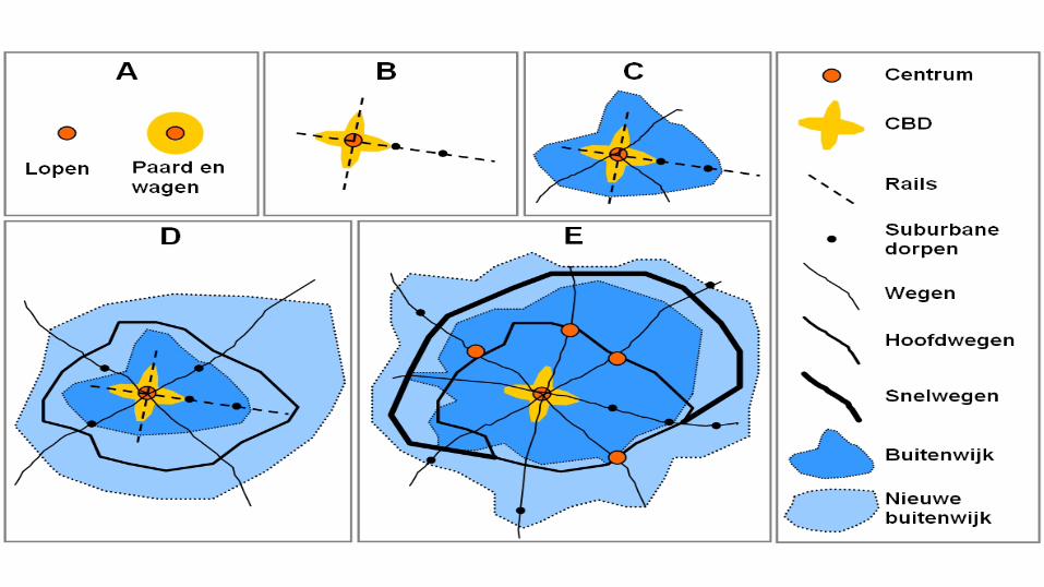

Mobility system (networks)
Land use system
(locations)
Activities Accessibility
Socio-demografic, economic and cultural factors
Regional demand Available land Land use policy
Infrastructue investments Mobility policy
fast
slow
slow
direct
fast

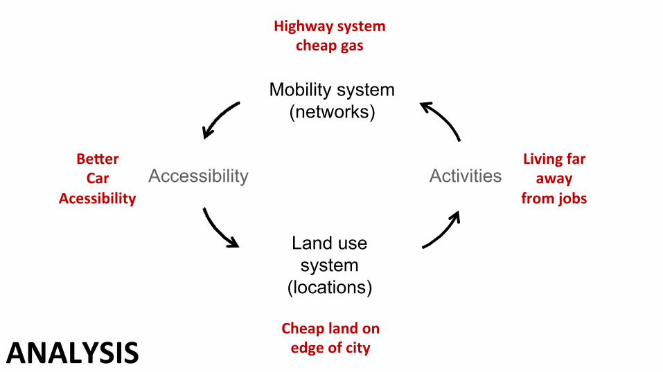
Mobility system (networks)
Land use system
(locations)
Activities Accessibility
Cheap land on edge of city
Living far away
from jobs
Highway system cheap gas
BeMer Car
Acessibility
ANALYSIS
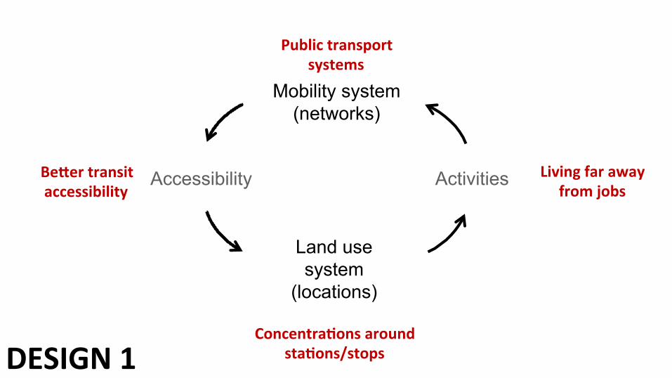
DESIGN 1 ConcentraSons around
staSons/stops
Living far away from jobs
Public transport systems
BeMer transit accessibility
Mobility system (networks)
Land use system
(locations)
Activities Accessibility

DESIGN 2 Compact and diverse ciSes
and neighbourhoods
Living close to jobs
Cycling and walking systems
BeMer accessibility by cycling/walking
Mobility system (networks)
Land use system
(locations)
Activities Accessibility
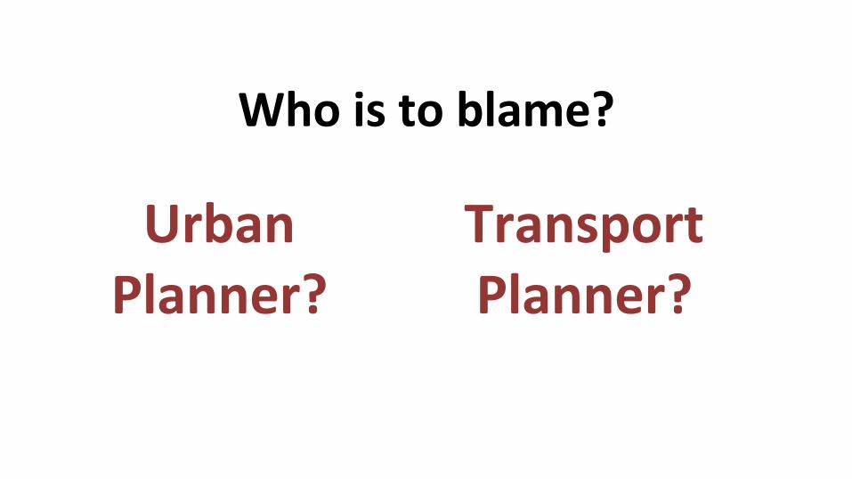
Who is to blame?
Urban Planner?
Transport Planner?

‘The quarreling couple’
She: Is nagging He: goes to the bar
He: I am going to the bar because you are nagging at me. She: I am nagging at you because you always go to the bar
+
+
+
+
+
ISOLATED PROBLEM SOLVING FAILS

New possibiliSes for integrated
land use and mobility
The balancing planner

Finding a balance • “To make mobility sustainable, we have to improve the accessibility… …while prevenJng negaJve social-‐, environmental-‐, and economic problems that are larger than the added value of the intervenJon” (WBCSD, 2001)

“improving accessibility” Ü Mobility is not a goal in itself, but a means to take
part in relevant acJviJes (it is a derived demand) Ü Increase the number and diversity of acJviJes within
an acceptable travel Jme/travel costs î Increase travel speeds î Network form î Land use densiJes î FuncJonal mix
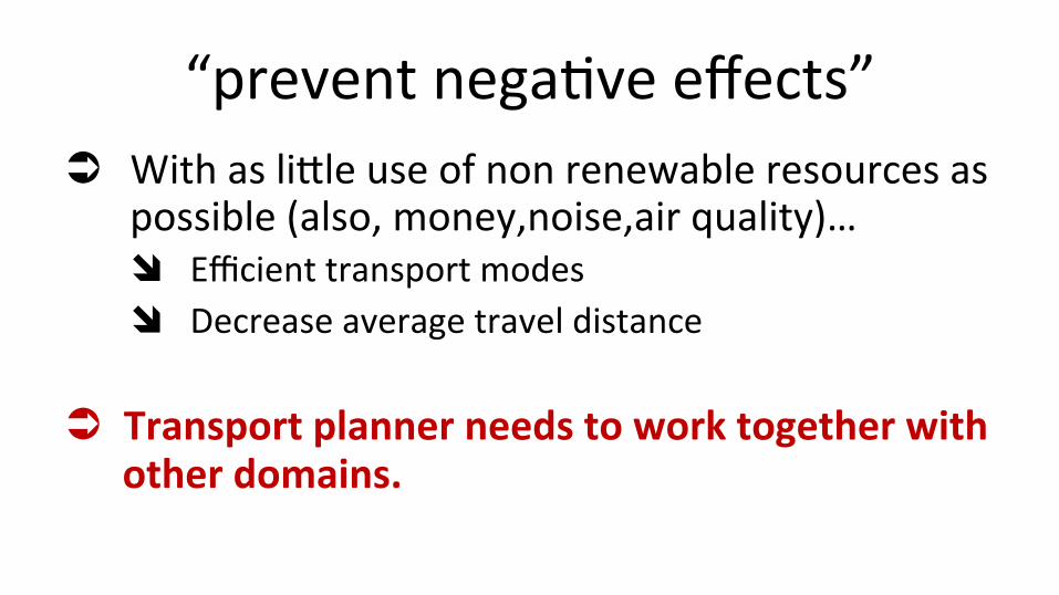
“prevent negaJve effects” Ü With as lidle use of non renewable resources as
possible (also, money,noise,air quality)… î Efficient transport modes î Decrease average travel distance
Ü Transport planner needs to work together with other domains.


Zevensprong byVerdaas To solve a mobility problem, follow seven steps in the following order: 1. Develop a proper spaJal vision. 2. Use pricing mechanisms for mobility 3. Explore possibiliJes of mobility management 4. OpJmize public transport 5. Use exisJng infrastructure beder 6. Adapt exisJng infrastructure 7. Develop substantaJon for new infrastructue

The new transport planner (Banister)
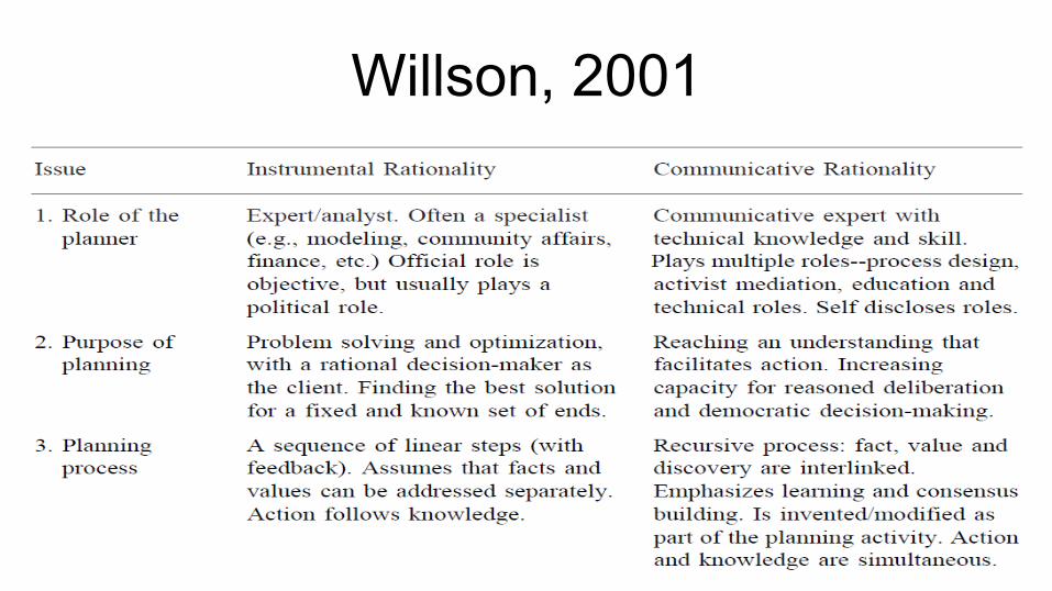
Willson, 2001
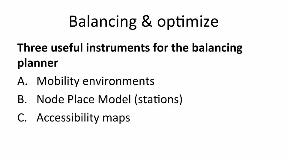
Balancing & opJmize Three useful instruments for the balancing planner A. Mobility environments B. Node Place Model (staJons) C. Accessibility maps
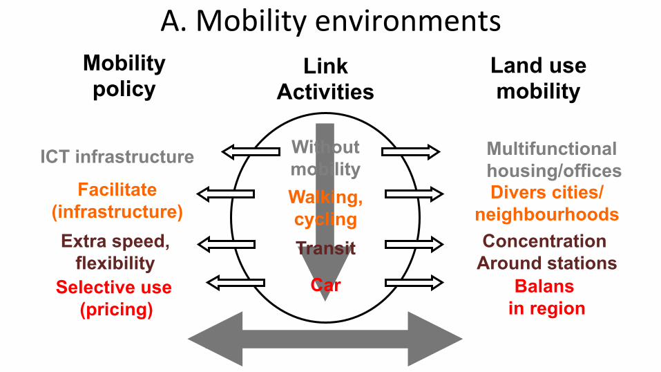
Without mobility Walking, cycling Transit
Car
Link Activities
Divers cities/neighbourhoods
Facilitate (infrastructure)
Concentration Around stations
Extra speed, flexibility
Multifunctional housing/offices
ICT infrastructure
Selective use (pricing)
Balans in region
A. Mobility environments Land use mobility
Mobility policy
Car (% all trips)
Public transport (%
all trips)
Biking and walking (% all
trips)
Per capita transport
emissions (kg/p
Per capita transport CO2 emissions (kg/
p)
Per capita metropolitan
income (USD)
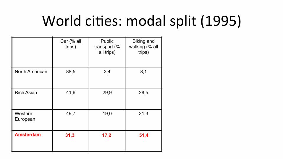
North American 88,5 3,4 8,1 265 4.405 31.386
Rich Asian 41,6 29,9 28,5 37 825 31.579
Western European
49,7 19,0 31,3 98 1.269 32.077
Amsterdam 38 1.035 28.322
World ciJes: modal split (1995)
31,3 17,2 51,4

Modal split Amsterdam city parts
Bike 22% PT 25% Car 53%
Bike 40% PT 24% Car 36%
Bike 53% PT 21% Car 27%
(dIVV Amsterdam)

Bicycle- walking environment (historic city: ‘within ring)

Car environments (highway corridors)

Without mobility Walking, cycling Transit
Car
Link Activities
Divers cities/neighbourhoods
Facilitate (infrastructure)
Concentration Around stations
Extra speed, flexibility
Multifunctional housing/offices ICT infrastructure
Selective use (pricing)
Balans in region
A. Mobility environments Land use mobility
Mobility policy

Modal split ring line (commuters)
Bike 9% PT 51% Car 40%
(dIVV Amsterdam)
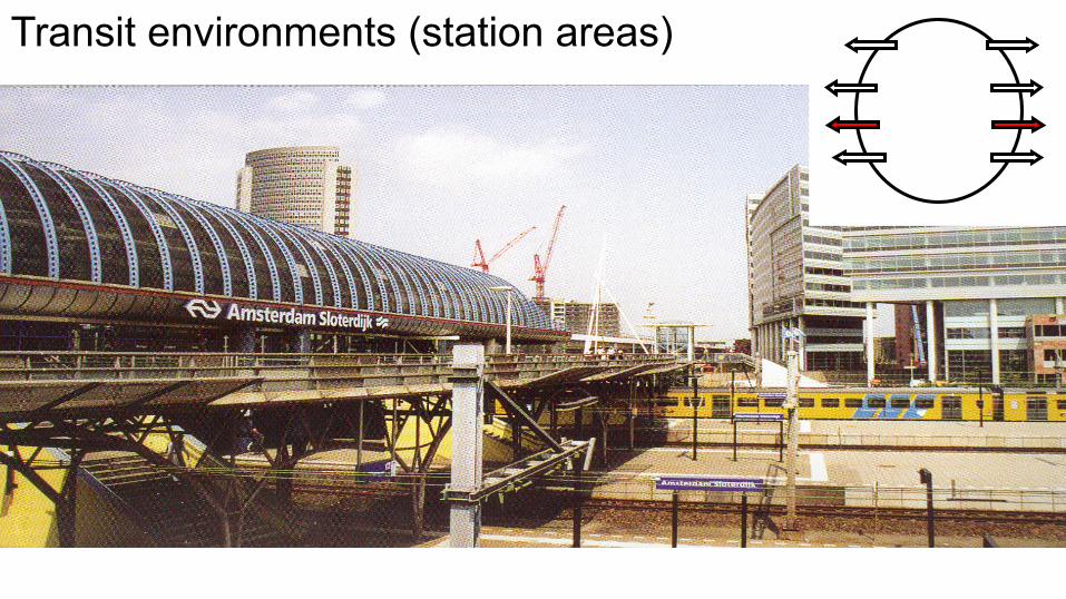
Transit environments (station areas)

Sloterdijk
Bijlmer Arena
Zuid Wtc
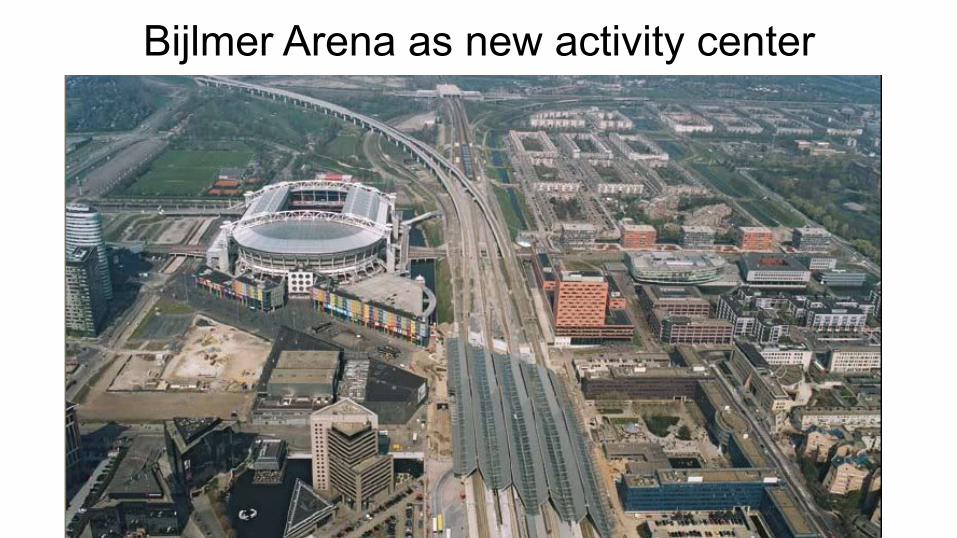
Bijlmer Arena as new activity center

B. Node-‐Place model Balancing the #acSvites (demand)
Around transit nodes with #transit services
Node value (#PT, hiërarchie,…)
Place value (#jobs, #inhabitants) Stressed
node
underuJlized Node
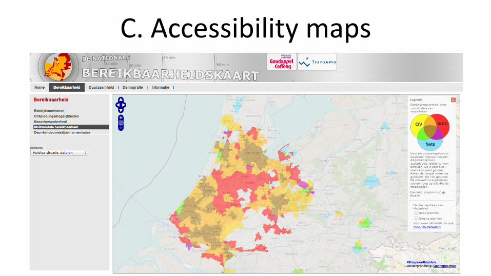
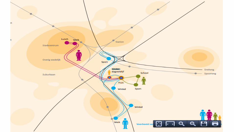
C. Accessibility maps

Take home lessons Ü Henry Ford is the most influenJal urban planner
Ü Le Corbusier is the most influenJal transport planner
Take home lessons
Ü Mobility system and land use system are strongly interdependent
Ü Land use needs to be aligned with desired accessibility
Ü Transport planners need to be holisJc Ü Transport planners need to be communicaJve Ü Difficult in pracJce, but higly needed Ü Coherence in policy packages (and in Jme) is crucial
Ü InternaJonal Master on Metropolitan Transport Planning Ü Summer School on Planning the Cycling City
Ü [email protected] Ü www.twider.com/fietsprofessor Ü +31 20 5254149