Tu 16 e - California
22
Tu 16 e ST;(TE OF CALIFORNIA ··THE RESOURCES AGENCY GRAY DAVIS, Governor • FORNIA COASTAL COMMISSION ENTRAL COAST AREA H CALIFORNIA ST., SUITE 200 VENTURA, CA 93001 Filed: 180 1 h Day: Staff: 8/2/02 2/1/03 J Jo 11/21/02 12/10/02 (805) 585 • 1800 Staff Report: • • PACKET COPY Hearing Date: Commission Action: STAFF REPORT: REGULAR CALENDAR APPLICATION NO.: 4-02-104 APPLICANT: Eugene Cordes AGENT: None PROJECT LOCATION: 28247 Via Acero Road, City of Malibu PROJECT DESCRIPTION: Construct a detached 1.400 sq. ft. two car garage with a second story workshop studio and storage with no plumbing and 288 cubic feet of remedial grading. Lot area 87,400 sq. ft . New Building coverage 1,400 sq. ft Total Building coverage 3,800 sq. ft Pavement coverage 4,500 sq. ft. Landscape coverage 10,000 sq. ft. Height Above Finished Grade 18 ft. Total No. Parking spaces 7 Summary of Staff Recommendation Staff recommends approval of the proposed project with five special conditions regarding {1) geotechnical engineering recommendations, (2) assumption of risk, waiver of liability and indemnity, (3) erosion control, drainage and polluted runoff, (4) future improvements, and (5) a generic deed restriction. Staff Note Due to Permit Streamlining Act Requirements the Commission must act on this permit application no later than the January 2003 Commission meeting. LOCAL APPROVALS RECEIVED: City of Malibu Planning Department, Approval in Concept, April4, 2002; City of Malibu Environmental and Building Safety, Approved, 10/16/2001; County of Los Angeles Fire Department Final Fuel Modification Plan Approved 12/27/2001 . SUBSTANTIVE FILE DOCUMENTS: Certified Malibu Local Coastal Program; City of Malibu Geology Review Sheet, Approved in Concept, dated 2/5/2001, Response to City of Malibu Review Sheet, dated May 18, 2001 by Property at 28247 Via Acero, dated January 31, 2000 by Evans, Colbaugh & Associates, Inc.; Review of City of Malibu, dated March 1, 2001 by Evans, ·,
Transcript of Tu 16 e - California

Tu 16 e ST ;(TE OF CALIFORNIA ··THE RESOURCES AGENCY GRAY DAVIS, Governor
•
FORNIA COASTAL COMMISSION ENTRAL COAST AREA
H CALIFORNIA ST., SUITE 200
VENTURA, CA 93001
Filed: 1801
h Day: Staff:
8/2/02 2/1/03 J Jo 11/21/02 12/10/02
(805) 585 • 1800 Staff Report:
•
•
PACKET COPY Hearing Date: Commission Action:
STAFF REPORT: REGULAR CALENDAR
APPLICATION NO.: 4-02-104
APPLICANT: Eugene Cordes
AGENT: None
PROJECT LOCATION: 28247 Via Acero Road, City of Malibu
PROJECT DESCRIPTION: Construct a detached 1.400 sq. ft. two car garage with a second story workshop studio and storage with no plumbing and 288 cubic feet of remedial grading.
Lot area 87,400 sq. ft . New Building coverage 1,400 sq. ft Total Building coverage 3,800 sq. ft Pavement coverage 4,500 sq. ft. Landscape coverage 10,000 sq. ft. Height Above Finished Grade 18 ft. Total No. Parking spaces 7
Summary of Staff Recommendation Staff recommends approval of the proposed project with five special conditions regarding {1) geotechnical engineering recommendations, (2) assumption of risk, waiver of liability and indemnity, (3) erosion control, drainage and polluted runoff, (4) future improvements, and (5) a generic deed restriction.
Staff Note Due to Permit Streamlining Act Requirements the Commission must act on this permit application no later than the January 2003 Commission meeting.
LOCAL APPROVALS RECEIVED: City of Malibu Planning Department, Approval in Concept, April4, 2002; City of Malibu Environmental and Building Safety, Approved, 10/16/2001; County of Los Angeles Fire Department Final Fuel Modification Plan Approved 12/27/2001 .
SUBSTANTIVE FILE DOCUMENTS: Certified Malibu Local Coastal Program; City of Malibu Geology Review Sheet, Approved in Concept, dated 2/5/2001, Response to City of Malibu Review Sheet, dated May 18, 2001 by Property at 28247 Via Acero, dated January 31, 2000 by Evans, Colbaugh & Associates, Inc.; Review of City of Malibu, dated March 1, 2001 by Evans,
·,

4-02-104 (Cordos) Page2
Colbaugh & Associates, Inc; Relative Stability, dated January 17, 2001 by Evans, Colbaugh & • Associates, Inc.; Property at 28247 Via Acero,dated January 31, 2000 by Evans, Colbaugh & Associates, Inc.;
I. Staff Recommendation
MOTION: I move that the Commission approve Coastal Development Permit No. 4-02-104 pursuant to the staff recommendation.
Staff Recommendation of Approval:
Staff recommends a YES vote. Passage of this motion will result in approval of the permit as conditioned and adoption of the following resolution and findings. The motion passes only by affirmative vote of a majority of the Commissioners present.
Resolution to Approve the Permit:
The Commission hereby approves a coastal development permit for the proposed development and adopts the findings set forth below on grounds that the development as conditioned will be in conformity with the Malibu Local Coastal Program. Approval of the permit complies with the California Environmental Quality Act because either 1) feasible mitigation measures and/or alternatives have been incorporated to substantially lessen any significant adverse effects of the development on the environment, or 2) there are no further feasible mitigation measures or alternatives that would substantially Jessen any significant adverse impacts of the development on the environment.
II. Standard Conditions
1. Notice of Receipt and Acknowledgment. The permit is not valid and development shall not commence until a copy of the permit, signed by the permittee or authorized agent, acknowledging receipt of the permit and acceptance of the terms and conditions, is returned to the Commission office.
2. Expiration. If development has not commenced, the permit will expire two years from the date on which the Commission voted on the application. Development shall be pursued in a diligent manner and completed in a reasonable period of time. Application for extension of the permit must be made prior to the expiration date.
3. Interpretation. Any questions of intent or interpretation of any term or condition will be resolved by the Executive Director or the Commission.
4. Assignment. The permit may be assigned to any qualified person, provided assignee files with the Commission an affidavit accepting all terms and conditions of the permit.
5. Terms and Conditions Run with the Land. These terms and conditions shall be perpetual, and it is the intention of the Commission and the permittee to bind all future owners and possessors of the subject property to the terms and conditions.
•
•

4-02-104 (Cordos) Page3
• Ill. Special Conditions
•
•
1. Plans Conforming to Geotechnical Engineer's Recommendations
PRIOR TO THE ISSUANCE OF THE COASTAL DEVELOPMENT PERMIT, the applicant shall submit, for the review and approval by the Executive Director, evidence of the Geotechnical Engineer consultant's review and approval of all project plans including the Erosion Control, Drainage and Polluted Runoff Control Plans. All recommendations contained in the submitted reports titled: Response to City of Malibu Review Sheet, dated May 18, 2001 by Property at 2824 7 Via Acero, dated January 31, 2000 by Evans, Colbaugh & Associates, Inc.; Review of City of Malibu, dated March 1, 2001 by Evans, Colbaugh & Associates, Inc; Relative Stability, dated January 17, 2001 by Evans, Colbaugh & Associates, Inc.; Property at 28247 Via Acero,dated January 31, 2000 by Evans, Colbaugh & Associates, Inc. All plans must be reviewed and approved by the consultant.
The final plans approved by the consultant shall be in substantial conformance with the plans approved by the Commission relative to construction, grading and drainage. Any substantial changes in the proposed development approved by the Commission which may be required by the consultant shall require an amendment to the permit or a new coastal permit.
2. Assumption of Risk, Waiver of Liability and Indemnity
By acceptance of this permit, the applicant acknowledges and agrees {i) that the site may be subject to hazards from landslides, ground movement, or wildfire; (ii) to assume the risks to the applicant and the property that is the subject of this permit of injury and damage from such hazards in connection with this permitted development; (iii) to unconditionally waive any claim of damage or liability against the Commission, its officers, agents, and employees for injury or damage from such hazards; and (iv) to indemnify and hold harmless the Commission, its officers, agents, and employees with respect to the Commission's approval of the project against any and all liability, claims, demands, damages, costs (including costs and fees incurred in defense of such claims), expenses, and amounts paid in settlement arising from any injury or damage due to such hazards.
3. Erosion Control, Drainage and Polluted Runoff Control Plans
Prior to the Issuance of the Coastal Development Permit, the applicant shall submit for the review and approval of the Executive Director; a) a Local Storm Water Pollution Prevention (SWPPP) Plan to control erosion and contain polluted runoff during the construction phase of the project; and b) a Storm Water Management Plan (SWMP) for the management of post-construction storm water and polluted runoff. The plans shall be certified by a California Registered Civil Engineer or Licensed Architect and approved by the City's Department of Public Works, and include the information and measures outlined below.
·,

4-02-104 (Cordos) Page4
a) Local Storm Water Pollution Prevention Plan, for the construction phase of the • project shall include at a minimum the following:
• Property limits, prior-to-grading contours, and details of terrain and area drainage • Locations of any buildings or structures on the property where the work is to be
performed and the location of any building or structures of adjacent owners that are within 15 ft of the property or that may be affected by the proposed grading operations
• Locations and cross sections of all proposed temporary and permanent cut-and-fill slopes, retaining structures, buttresses, etc., that will result in an alteration to existing site topography (identify benches, surface/subsurface drainage, etc.)
• Area (square feet) and volume (cubic yards) of all grading (identify cut, fill, import, export volumes separately), and the locations where sediment will be stockpiled or disposed
• Elevation of finished contours to be achieved by the grading, proposed drainage channels, and related construction.
• Details pertaining to the protection of existing vegetation from damage from construction equipment, for example: (a) grading areas should be minimized to protect vegetation; (b) areas with sensitive or endangered species should be demarcated and fenced off; and (c) native trees that are located close to the construction site should be protected by wrapping trunks with protective materials, avoiding placing fill of any type against the base of trunks, and avoiding an • increase in soil depth at the feeding zone or drip line of the retained trees.
• Information on potential flow paths where erosion may occur during construction • Proposed erosion and sediment prevention and control BMPs, both structural and
non-structural, for implementation during construction, such as: o Stabilize disturbed areas with vegetation, mulch, geotextiles, or similar
method. o Trap sediment on site using fiber rolls, silt fencing, sediment basin, or
similar method. o Ensure vehicles on site are parked on areas free from mud; monitor site
entrance for mud tracked off-site. o Prevent blowing dust from exposed soils.
• Proposed BMPs to provide adequate sanitary and waste disposal facilities and prevent contamination of runoff by construction chemicals and materials, such as:
o Control the storage, application and disposal of pesticides, petroleum and other construction and chemical materials.
o Site washout areas more than fifty feet from a storm drain, open ditch or surface water and ensure that runoff flows from such activities do not enter receiving water bodies.
o Provide sanitary facilities for construction workers. o Provide adequate disposal facilities for solid waste produced during
construction and recycle where possible.
b) Storm Water Management Plan, for the management of post construction storm water and polluted runoff shall at a minimum include the following: •

•
•
•
4.
4-02-104 (Cordos) PageS
• Site design and source control BMPs that will be implemented to minimize or prevent post-construction polluted runoff (see 17.5.1 of the Malibu LIP)
• Drainage improvements (e.g., locations of diversions/conveyances for upstream runoff)
• Potential flow paths where erosion may occur after construction • Methods to accommodate onsite percolation, revegetation of disturbed portions of
the site, address onsite and/or offsite impacts and construction of any necessary .Lffiprovements
• Storm drainage improvement measures to mitigate any offsite/downstream negative impacts due the proposed development, including, but not limited to:
o Mitigating increased runoff rate due to new impervious surfaces through on-site detention such that peak runoff rate after development does not exceed the peak runoff of the site before development for the 1 00 year clear flow storm event (note; Q/1 00 is calculated using the Caltrans Nomograph for converting to any frequency, from the Caltrans "Hydraulic Design and Procedures Manual"). The detention basin/facility is to be designed to provide attenuation and released in stages through orifices for 2-year, 1 0-year and 1 00-year flow rates, and the required storage volume of the basin/facility is to be based upon 1-inch of rainfall over the proposed impervious surfaces plus 1/2-inch of rainfall over the permeable surfaces. All on-site drainage devices, including pipe, channel, and/or street & gutter, shall be sized to cumulatively convey a 1 00 year clear flow storm event to the detention facility, or;
o Demonstrating by submission of hydrology/hydraulic report by a California Registered Civil Engineer that determines entire downstream storm drain conveyance devices (from project site to the ocean outlet) are adequate for 25-year storm event, or;
o Constructing necessary off-site storm drain improvements to satisfy b. above, or;
o Other measures accomplishing the goal of mitigating all offsite/downstream impacts
Future Improvements
This permit is only for the development described in coastal development permit No. 4-02-118. Pursuant to Title 14 California Code of Regulations §13253{b){6), the exemptions otherwise provided in Public Resources Code §30610(a) and (b) shall not apply to the entire parcel. Accordingly, any future improvements, or change of use to the permitted structure approved under Coastal Development Permit No. 4-02-104, shall require an amendment to Permit No.4-02-104 from the Commission or shall require an additional coastal development permit from the Commission or from the applicable certified local government
5. Deed Restriction Condition
Prior to the issuance of the coastal development permit, the applicant shall submit to the Executive Director for review and approval documentation demonstrating that the applicant has executed and recorded against the parcel(s) governed by this permit a deed restriction, in a form and content acceptable to the Executive Director: (1) indicating that, pursuant to this
·,

4-02-104 (Cordos) Page6
permit, the California Coastal Commission has authorized development on the subject property, • subject to terms and conditions that restrict the use and enjoyment of that property; and (2) imposing the Special Conditions of this permit as covenants, conditions and restrictions on the use and enjoyment of the Property. The deed restriction shall include a legal description of the entire parcel or parcels governed by this permit. The deed restriction shall also indicate that, in the event of an extinguishment or termination of the deed restriction for any reason, the terms and conditions of this permit shall continue to restrict the use and enjoyment of the subject property so long as either this permit or the development it authorizes, or any part, modification, or amendment thereof, remains in existence on or with respect to the subject property.
IV. Findings and Declarations
The Commission hereby finds and declares:
A. Project Description and Background
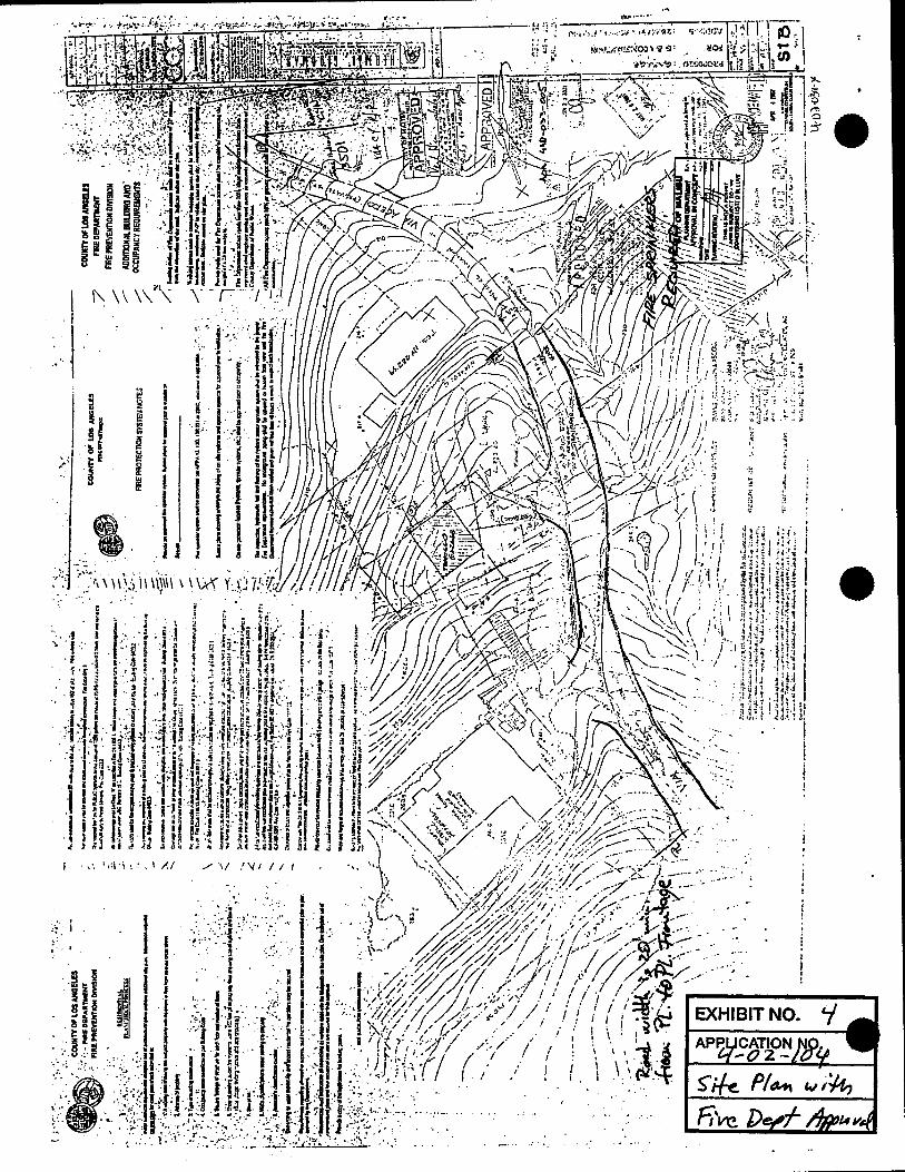
The applicant is proposing to construct a two story, 672 sq. ft. two car garage with a 728 sq. ft. second floor workshop and storage, a new access driveway and grade a total of 288 cubic yards of material on an existing two acre lot with an existing residence. The addition is considered a detached structure totaling 1,400 sq. ft. on a two acre lot with an existing 2,400 sq. ft. residence (Exhibits 3-5). The proposed project will result in about 1 ,500 sq. ft. of additional impervious surface for the structure and driveway.
The subject site is a two acre parcel located inland of Pacific Coast Highway, east of Kanan Dume Road (Exhibits 1 and 2}. The site is located on the inland side of Via Acero Street which is accessed from Ramirez Canyon Road. The project site is located at the 240 foot elevation above sea level on a small ridge between two drainages leading to Ramirez Canyon. The project site is surrounded by mature landscaping such that is not visible from any public roads and existing or planned public trails in the vicinity. The project site is relatively flat and is planted with ice plant and a lawn and surrounded by mature landscape trees, including pine, eucalyptus, citrus and avocado.
On April4, 2002, the applicant requested a coastal permit exemption for the proposed two story two car garage and workshop/studio on the second floor. On April 22, 2002, Commission staff determined that the proposed two story structure with the workshop/studio on the second floor did not qualify for an exemption pursuant to Section 13250 of the California Code of Regulations. On May 3, 2002, the applicant submitted a request for a coastal permit waiver with an application. Because the proposed project raises coastal issues related to water quality and future improvement issues, Staff determined that the project did not qualify for a permit waiver. The application for a regular coastal permit was filed as complete on August 6, 2002 and scheduled for the November 2002 Commission agenda. Due to other priority applications, this application was scheduled for the December 2002 Commission agenda.
On September 13, 2002, the Commission adopted the Malibu Local Coastal Program (LCP). The subject permit application was filed prior to the date the LCP was adopted and therefore remains under the jurisdiction of the Commission. Prior to the adoption of the LCP the standard of review for permit applications in Malibu were the chapter three policies Coastal Act. After the
•
adoption of the LCP the standard of review for permit applications is the LCP. •

• B. Hazards
4-02-104 (Cordos) Page7
The proposed development is located at the 240 foot elevation above sea level on a small ridge between two drainages leading to Ramirez Canyon Creek. The City of Malibu is an area generally considered to be subject to an unusually high amount of natural hazards. Geologic hazards common to Malibu include landslides, erosion, and flooding. In addition, fire is an inherent threat to the indigenous chaparral community of the coastal mountains. Wild fires often denude hillsides in the Santa Monica Mountains of all existing vegetation, thereby contributing to an increased potential for erosion and landslides on property.
The Malibu Local Coastal Program (LCP} contains the following development policies related to hazards and bluff top development that are applicable to the proposed development:
Section 30253 of the Coastal Act, which is incorporated as part of the Malibu LCP, states in pertinent part that new development shall:
(1) Minimize risks to life and property in areas of high geologic, flood, and fire hazard.
(2) Assure stability and structural integrity, and neither create nor contribute significantly to erosion, instability, or destruction of the site or surrounding area or in any way require the construction of protective devices that would substantially alter natura/landforms along bluffs and cliffs.
• In addition, the following LCP policies are applicable in this case:
•
3.1 New development that requires a grading permit or Local SWPPP shall include landscaping and re-vegetation of graded or disturbed areas, consistent with Policy 3.50. Any landscaping that is required to control erosion shall use native or droughttolerant non-invasive plants to minimize the need for fertilizer, pesticides, herbicides, and excessive irrigation. Where irrigation Is necessary, efficient irrigation practices shall be required.
4.2. All new development shall be sized, designed and sited to minimize risks to life and property from geologic, flood, and fire hazard.
4.5. Applications for new development, where applicable, shall include a geologic/soils/geotechnical study that identifies any geologic hazards affecting the proposed project site, any necessary mitigation measures, and contains a statement that the project site is suitable for the proposed development and that the development will be safe from geologic hazard. Such reports shall be signed by a licensed Certified Engineering Geologist {CEG) or Geotechnical Engineer (GE) and subject to review and approval by the City Geologist.
4.10. New development shall provide adequate drainage and erosion control facilities that convey site drainage In a non-erosive manner in order to minimize hazards resulting from increased runoff, erosion and other hydrologic impacts to streams.
1.45 New development shall minimize risks to life and property from fire hazard through:
• Assessing site-specific characteristics such as topography, slope, vegetation type, wind patterns etc.;
• Siting and designing development to avoid hazardous locations;

4-02-104 (Cordos) Page8 ..
• Incorporation of fuel modification and brush clearance techniques in accordance • with applicable nre safety requirements and carried out in a manner which reduces impacts to environmentally sensitive habitat to the maximum feasible extent;
• Use of appropriate building materials and design features to insure the minimum amount of required fuel modification;
• Use of fire-retardant, native plant species in landscaping.
4.49. Applications for new development, which require fuel modification, shall include a fuel modification plan for the project, prepared by a landscape architect or resource specialist that incorporates measures to minimize removal of native vegetation and to minimize impacts to ESHA, while providing for fire safety, consistent with the requirements of the applicable fire safety regulations. Such plans shall be reviewed and approved by the Forestry Division.
6.29 Cut and fill slopes and other areas disturbed by construction activities shall be landscaped or revegetated at the completion of grading. Landscape plans shall provide that:
• Plantings shall be of native, drought-tolerant plant species, and blend with the existing natural vegetation and natural habitats on the site, except as noted below.
• Invasive plant species that tend to supplant native species and natural habitats shall be prohibited.
• Non-Invasive ornamental plants and lawn may be permitted in combination with native, drought-tolerant species within the Irrigated zone(s) required for fuel modification nearest approved residential structures. •
• Lawn shall not be located on any geologically sensitive area such as coastal blufftop.
• Landscaping or revegetation shall provide 90 percent coverage within nve years. Landscaping or revegetation that Is located within any required fuel modification thinning zone (Zone C, If required by the Los Angeles County Fire Department) shall provide 60 percent coverage within five years.
The project site is an irregular shaped parcel that includes an existing residence and attached garage. The project site is relatively flat and is planted with ice plant and a lawn and surrounded by mature landscape trees. The subject site is subject to erosion from sheet flow across the property; the specific project site where the structure is proposed drains to the drainage gully located to the north and the proposed driveway leading to the garage drains to the drainage gully located to the south which is a designated blue line stream. The proposed project is a two story structure with a garage on the lower level and a workshop/studio and storage on the second floor.
The Malibu LCP requires that new development be sited and designed to minimize risks to life and property from geologic, flood, and fire hazard. In addition. the LCP requires a geologic/soils/geotechnical study that identifies any geologic hazards affecting the proposed project site, any necessary mitigation measures, and contains a statement that the project site is suitable for the proposed development and that the development will be safe from geologic hazard.
The applicant provided four geotechnical Engineering letter reports for the subject site • completed by Evans, Colbaugh & Associates dated January 31, 2000, January 17, 2001, March 1, 2001 and May 18, 2001. These reports identify a prehistoric landslide located partially on the
•
•
•
4-02-104 (Cordos) Page 9
project site but beyond the proposed site for the garage and workshop/studio. These reports state that:
The proposed garage/storage structure is located on a near-level area, outside the limits of landsliding, which appears to have been formed, at least in part, by grading. A small wedge of man-made fill forms the down-slope portion of the area and a portion of the structure "footprint" is within this fill. The "footprint" is outside the limits of landsliding and there is no evidence of instability although the quality of the man-made fill is questionable. For purposes of design of the garage/storage facility, we recommend the following:
Within the area bounded by a line at least five feet outside the structure foundation, remove and recompact the upper three feet of soil below proposed grade and the existing man-made fill.
Size the structure footings using net allowable bearing capacity of 2500 pounds per square foot. Compact the upper three feet of soil supporting the slab-on-grade at a mixture content at or above the optimum for the soil and maintain that moisture content until the slab concrete is placed.
The City of Malibu has cor:npleted a Geology Review Sheet dated February 5, 2001 that confirms that the geology review is approved in concept. As a result of this review, the applicant has obtained a stamped approval from the City of Malibu Environmental and Building Safety Department dated 10/16/01. The Geology reports noted above include recommendations to ensure geologic stability and geotechnical safety on the site as part of the design of the project. The applicant has obtained this review by his consultants confirming that these recommendations are incorporated in the final plan as evidenced by a stamp by his geotchnical engineer consultant, Mr. Dennis Evans. However, one of the recommendations of this consultant in the reports above is to prepare a drainage plan that includes geotechnical information. To ensure that this recommendation by the geotechnical engineer consultant is incorporated into the proposed new development, Special Condition No. One {1) requires the applicant to submit project drainage plans certified by the consulting geotechnical engineer as conforming to the geologic and geotechnical recommendations, as well as any new or additional recommendations by the consulting geologist and geotechnical engineer to ensure structural and site stability. The final plans approved by the consultants shall be in substantial conformance with the plans approved by the Commission relative to construction, foundations, grading, and drainage. Any substantial changes to the proposed development approved by the Commission which may be recommended by the consultants shall require an amendment to the permit or a new coastal permit.
Although the geology information noted above provides that the building site is considered stable from a geologic standpoint, the property includes a landslide and risk of instability. The Coastal Act requires that new development minimize the risk to life and property in areas of high geologic and fire hazard. The Coastal Act also recognizes that new development may involve the taking of some risk and that Coastal Act policies require the Commission to establish the appropriate degree of risk acceptable for the proposed development and to establish who should assume the risk. When development in areas of identified hazards is proposed, the Commission considers the hazard associated with the project site and the potential cost to the public, as well as the individual's right to use his property .
The applicant has provided a landscape plan for the property with the proposed project that includes a Final Fuel Modification Plan approved by the Los Angeles County Fire Department dated 12/27/01 that identifies areas of vegetation removal and thinning on the property to

4-02-104 (Cordos) Page 10
address the fire hazard. Due to the fact that the proposed project is located in an area subject • to an extraordinary potential for damage or destruction from landslides, ground movement, and wildfire, the Commission can only approve the project if the applicant assumes the liability from these associated risks. Through the Assumption of Risk, Waiver of Liability and Indemnity Special Condition, the applicants acknowledge and appreciate the nature of the landslide, ground movement, and wildfire hazard which exist on the site and which may affect the safety of the proposed development, as incorporated by Special Condition Number Two.
The proposed project will increase the amount of impervious coverage on-site which may increase both the quantity and velocity of stormwater runoff. If not controlled and conveyed offsite in a non-erosive manner, this runoff may result in increased erosion, affect site stability, and impact downslope water quality. The applicant's geologic I geotechnical consultant has recommended that a drainage plan be prepared so that water may be collected and distributed in a non-erosive manner. In addition, the Malibu LCP policy 4.10 requires that "new development shall provide adequate drainage and erosion control facilities that convey site drainage in a non-erosive manner in order to minimize hazards resulting from increased runoff, erosion and other hydrologic impacts to streams". Therefore, to ensure that drainage is conveyed off site in a non-erosive manner, the Commission finds that it is necessary to require the applicant, as required by Special Condition No. Three, to submit drainage and polluted runoff management plans for the construction and post-construction phases of development that are prepared by the consulting engineer.
The project site is surrounded by mature landscaping which reduces erosion on site. The proposed structure and driveway will require a limited amount of remedial grading. The • applicant has provided a landscape plan that include ground cover plants surrounding the proposed development. The applicant has also obtained an approved final fuel modification plan from the Los Angeles County Fire Department on this landscape plan. As a result, there is no need for a special condition requiring a new landscape plan and final fuel modification plan in this application.
In addition, Special Condition No. Five requires the applicant to record a deed restriction that imposes the terms and conditions of this permit as restrictions on use and enjoyment of the property and provides any prospective purchaser of the site with recorded notice that the restrictions are imposed on the subject property.
Therefore, for the reasons discussed above, the Commission finds that the proposed project, as conditioned, is consistent with the applicable policies of the Malibu LCP.
C. Water Quality
The Malibu LCP provides for the protection of water quality. The policies require that new development protects, and where feasible, enhances and restores wetlands, streams, and groundwater recharge areas. The policies promote the elimination of pollutant discharge, including nonpoint source pollution, into the City's waters through new construction and development regulation, including site planning, environmental review and mitigation, and project and permit conditions of approval. Additionally, the policies require the implementation of Best Management Practices to limit water quality impacts from existing development, including septic system maintenance and City services. •

--- ---------------------------------
4-02-104 (Cordos) Page 11
• Section 30251 of the Coastal Act, which is incorporated as a policy of the Malibu LCP, states that:
•
•
The biological productivity and the quality of coastal waters, streams, wetlands, estuaries, and lakes appropriate to maintain optimum populations of marine organisms and for the protection of human health shall be maintained and, where feasible, restored through, among other means, minimizing adverse effects of waste water discharges and entrainment, controlling runoff, preventing depletion of ground water supplies and substantial interference with surface water flow, encouraging waste water reclamation, maintaining natural vegetation buffer areas that protect riparian habitats, minimizing alteration of natural streams.
In addition, the following water quality LCP policies are applicable in this case:
3.95 New development shall be sited and designed to protect water quality and minimize impacts to coastal waters by incorporating measures designed to ensure the following:
• Protecting areas that provide important water quality benefits, areas necessary to maintain riparian and aquatic biota and/or that are susceptible to erosion and sediment loss.
• Limiting increases of impervious surfaces. • Limiting land disturbance activities such as clearing and grading, and cut-and-fill
to reduce erosion and sediment loss. • Limiting disturbance of natural drainage features and vegetation.
3.95 New development shall not result in the degradation of the water quality of groundwater basins or coastal surface waters including the ocean, coastal streams, or wetlands. Urban runoff pollutants shall not be discharged or deposited such that they adversely impact groundwater, the ocean, coastal streams, or wetlands, consistent with the requirements of the Los Angeles Regional Quality Control Board's municipal storm water permit and the California Ocean Plan.
3.97 Development must be designed to minimize, to the maximum extent feasible, the introduction of pollutants of concern1 that may result in significant impacts from site runoff from impervious areas. To meet the requirement to minimize "pollutants of concern," new development shall incorporate a Best Management Practice (BMP) or a combination of BMPs best suited to reduce pollutant loading to the maximum extent feasible.
3.99 Post-development peak stormwater runoff discharge rates shall not exceed the estimated pre-development rate. Dry weather runoff from new development must not exceed the predevelopment baseline flow rate to receiving waterbodies.
3.100 New development shall be sited and designed to minimize impacts to water quality from increased runoff volumes and nonpoint source pollution. All new development shall meet the requirements of the Los Angeles Regional Water Quality Control Board (RWQCB) in its the Standard Urban Storm Water Mitigation Plan For Los Angeles County And Cities In Los Angeles County (March 2000) (LA SUSMP) or subsequent versions of this plan.
3.102 Post-construction structural BMPs (or suites of BMPs) should be designed to treat, infiltrate, or filter the amount of stormwater runoff produced by all storms up to and
1 Pollutants of concern are defined in the Standard Urban Storm Water Mitigation Plan For Los Angeles County And Cities In Los Angeles County as consisting • of any pollutants that exhibit one or more of the following characteristics: current loadings or historic deposits of the pollutant are impacting the beneficial uses of a receiving water , elevated levels of the pollutant are found in sediments of a receiving water and/or have the potential to bioaccumulate in organisms therein, or the detectable inputs of the pollutant are at a concentrations or loads considered potentially toxic to humans and/or flora or fauna·.

4-02-104 (Cordos) Page 12
including the 85th percentile, 24-hour storm event for volume-based BMPs and/or the 85th • percentile, 1-hour storm event (with an appropriate safety factor, i.e. 2 or greater) for flow-based BMPs. This standard shall be consistent with the most recent Los Angeles Regional Water Quality Control Board municipal stormwater permit for the Malibu region or the most recent California Coastal Commission Plan for Controlling Polluted Runoff, whichever is more stringent.
3.110 New development shall include construction phase erosion control and polluted runoff control plans. These plans shall specify BMPs that will be implemented to minimize erosion and sedimentation, provide adequate sanitary and waste disposal facilities and prevent contamination of runoff by construction chemicals and materials.
3.111 New development shall include post-development phase drainage and polluted runoff control plans. These plans shall specify site design, source control and treatment control BMPs that will be implemented to minimize post-construction polluted runoff, and shall include the monitoring and maintenance plans for these BMPs.
3.115 Permits for new development shall be conditioned to require ongoing maintenance where maintenance is necessary for effective operation of required BMPS. Verification of maintenance shall include the permittee's signed statement accepting responsibility for all structural and treatment control BMP maintenance until such time as the property is transferred and another party takes responsibility.
3.116 The City, property owners, or homeowners associations, as applicable, shall be required to maintain any drainage device to insure it functions as designed and intended. All structural BMPs shall be inspected, cleaned, and repaired when necessary prior to September 30th of each year. Owners of these devices will be responsible for insuring that • they continue to function properly and additional inspections should occur after storms as needed throughout the rainy season. Repairs, modifications, or installation of additional BMPs, as needed, should be carried out prior to the next rainy season.
3.118 Some BMPs for reducing the impacts of non-point source pollution may not be appropriate for development on steep slopes, on sites with low permeability soil conditions, or areas where saturated soils can lead to geologic instability. New development in these areas should incorporate BMPs that do not increase the degree of geologic instability.
3.119 New development that requires a grading permit or Local SWPPP shall include landscaping and re-vegetation of graded or disturbed areas, consistent with Policy 3.50. Any landscaping that is required to control erosion shall use native or drought-tolerant non-invasive plants to minimize the need for fertilizer, pesticides, herbicides, and excessive irrigation. Where Irrigation is necessary, efflcient Irrigation practices shall be required.
3.120 New development shall protect the absorption, purifying, and retentive functions of natural systems that exist on the site. Where feasible, drainage plans shall be designed to complement and utilize existing drainage patterns and systems, conveying drainage from the developed area of the site in a non-erosive manner. Disturbed or degraded natural drainage systems shall be restored, where feasible, except where there are geologic or public safety concerns.
The applicant is proposing to construct a two story, 672 sq. ft. two car garage with a 728 sq. ft. second floor workshop and storage, a new access driveway and grade a total of 288 cubic yards of material on an existing two acre lot with an existing residence. The addition is • considered a detached structure totaling 1,400 sq. ft. on a two acre lot with an existing 2,400

•
•
•
4-02-104 (Cordos) Page 13
sq. ft. residence. The proposed project will result in about 1 ,500 sq. ft. of additional impervious surface for the structure and driveway.
As such, the proposed project will result in an increase of impervious surface on site, which in turn decreases the infiltrative function and capacity of existing permeable land on project sites. The Commission notes that this reduction in permeable surface leads to an increase in the volume and velocity of stormwater runoff that can be expected to leave the site. The cumulative effect of increased impervious surface is that the peak stream discharge is increased and the peak occurs much sooner after precipitation events. Changes in the stream flow result in modification to stream morphology. Additionally, grading, excavations and disturbance of the site from construction activities and runoff from impervious surfaces can result in increased erosion of disturbed soils and in sedimentation of nearby coastal stream and waters.
In addition, pollutants commonly found in runoff associated with new development include petroleum hydrocarbons including oil and grease from vehicles; heavy metals; synthetic organic chemicals including paint and household cleaners; soap and dirt from washing vehicles; dirt and vegetation from yard maintenance; litter and organic matter; fertilizers, herbicides, and pesticides from household gardening or more intensive agricultural land use; nutrients from wastewater discharge, animal waste and crop residue; and bacteria and pathogens from wastewater discharge and animal waste.. The discharge of these pollutants to coastal waters can cause cumulative impacts such as: eutrophication and anoxic conditions resulting in fish kills and diseases and the alteration of aquatic habitat including adverse changes to species composition and size: excess nutrients causing algae blooms and sedimentation increasing turbidity, which both reduce the penetration of sunlight needed by aquatic vegetation which provides food and cover for aquatic species; disruptions to the reproductive cycle of aquatic species; acute and sublethal toxicity in marine organisms leading to adverse changes in reproduction and feeding behavior; and human diseases such as hepatitis and dysentery. These impacts reduce the biological productivity and the quality of coastal waters, streams, wetlands, estuaries, and lakes and reduce optimum populations of marine organisms and have adverse impacts on human health.
The LCP water quality policies cited above are designed to protect water quality and prevent pollution of surface, ground, and ocean waters. The Malibu LCP requires the preparation of a Storm Water Management Plan (SWMP) for all projects that require a coastal development permit or a Water Quality Mitigation Plan (WQMP) for new residential developments that involve one acre or more of disturbance or redevelopment projects that result in the creation or addition or replacement of 5,000 sq. ft. or more of impervious surface. A SWMP illustrates how the project will use appropriate site design and source control best management practices (BMPs) to minimize or prevent adverse effects of the project on water quality. A WQMP requires treatment control (or structural) BMPs, in addition to site design and source control BMPs that are required for a SWMP, to minimize or prevent the discharge of polluted runoff from a project site. In this case, the project involves the creation or addition of less than 5,000 sq. ft. of impervious surface area on an already developed site. Therefore, pursuant to the requirements of the Malibu LCP, and to ensure the proposed project will not adversely impact water quality or coastal resources, the Commission finds it necessary to require the preparation of a SWMP for the subject site, that utilizes site design, source control and treatment control BMPs, as specified in Special Condition No. Three •
Furthermore, erosion control and storm water pollution prevention measures implemented during construction will serve to minimize the potential for adverse impacts to water quality

4·02·104 (Cordos) Page 14
resulting from runoff during construction. The Malibu LCP requires that a Local Storm Water Pollution Prevention Plan (SWPPP) be prepared for all development that requires a Coasta!.._______Development Permit and a grading or building permit, and it shall apply to the construction phase of the project. The SWPPP includes measures and BMPs to prevent erosion, sedimentation and pollution of surface and ocean waters from construction and grading activities. In this case, the proposed project does involve grading and construction that requires grading and building permits. Therefore, pursuant to the Malibu LCP and to ensure the proposed development does not adversely impact water quality or coastal resources during the construction phase of the project, the Commission finds it necessary to require the applicant to submit a Local SWPPP for the subject site, consistent with the requirements specified in Special Condition No. Three.
The Commission finds that based on the above findings the proposed project, as conditioned, will not result in adverse impacts to water quality and is consistent with the Malibu LCP.
D. Cumulative Impacts
The Malibu LCP policies address new residential development. The maximum number of structures allowed in a residential development is one main residence, one second residential structure, and additional accessory structures provided that all such structures are located within the approved development area and clustered to minimize required fuel modification, landform alteration, and removal of native vegetation. In addition, the LCP limits the size of second residential units to 900 square feet.
•
Sections 30250 and 30252 of the Coastal Act, which are incorporated as a policies of the • Malibu LCP, state:
Section 30250 (a):
New residential, commercial, or industrial development, except as otherwise provided in this division, shall be located within, contiguous with, or in close proximity to, existing developed areas able to accommodate it or, where such areas are not able to accommodate it, in other areas with adequate public services and where it will not have significant adverse effects, either individually or cumulatively, on coastal resources. In addition, land divisions, other than leases for agriculturaf uses, outside existing developed areas shall be permitted only where 50 percent of the usable parcels in the area have been developed and the created parcels would be no smaller than the average size of surrounding parcels.
Section 30252:
The location and amount of new development should maintain and enhance public access to the coast by (/) facilitating the provision or extension of transit service, (2) providing commercial facilities within or adjoining residential development or In other areas that will minimize the use of coastal access roads, (3) providing nonautomobile circulation within the development, (4) providing adequate parking facilities or providing substitute means of serving the development with public transportation, (5) assuring the potential for public transit for high intensity uses such as high-rise office buildings, and by (6) assuring that the recreational needs of new residents will not overload nearby coastal recreation areas by correlating the amount of development with local park acquisition and development plans with the provision of on site recreational facilities to serve the new development. •
4-02-104 (Cordos) Page 15
• In addition, the following LCP policies are applicable in his case:
•
•
5.21 The maximum number of structures permitted in a residential development shall be limited to one main residence, one second residential structure, and accessory structures such as stable, workshop, gym, studio, pool cabana, office, or tennis court provided that all such structures are located within the approved development area and structures are clustered to minimize required fuel modification.
5.22 Second residential units (guesthouses, granny units, etc.) shall be limited in size to a maximum of 900 square feet. The maximum square footage shall include the total floor area of all enclosed space, including lofts, mezzanines, and storage areas. Detached garages, including garages provided as part of a second residential unit, shall not exceed 400 square feet (2-car) maximum. The area of a garage provided as part of a second residential unit shall not be included in the 900 square foot limit.
Pursuant to LCP policies cited above, new development raises issues relative to cumulative impacts on coastal resources. The construction of additional detached residential units and accessory structures on a site where a primary residence exists intensifies the use of the subject parcel. The intensified use creates potential additional demands on public services, such as water, sewage, electricity, and roads. Thus, second residential units and accessory structures pose potential cumulative impacts in addition to the impacts otherwise caused by the primary residential development. The applicant is proposing to construct a two story, 672 sq. ft. two car garage with a 728 sq. ft. second floor workshop and storage, a new access driveway and grade a total of 288 cubic yards of material on an existing two acre lot with an existing residence. The addition is considered a detached structure totaling 1,400 sq. ft. on a two acre lot with an existing 2,400 sq. ft. residence. Although the applicant is proposing that the garage on the first floor and the workshop/studio on the second floor will not be habitable space, there is the potential that this structure could become habitable in the future and its use intensified.
The adopted Malibu LCP limits the size of second residential units to 900 sq. ft. In its review and action on the Malibu LCP, the Commission found that placing an upper limit on the size of second units (900 sq. ft.) was necessary given the traffic and infrastructure constraints which exist in Malibu and given the abundance of existing vacant residential lots. Furthermore, in allowing these small units, the Commission found that the small size of units (900 sq. ft.) and the fact that they are intended for limited residential use, such units would have less impact on the limited capacity of Pacific Coast Highway and other roads (as well as infrastructure constraints such as water, sewage, and electricity) than an ordinary single family residence.
The second unit issue has also been raised by the Commission with respect to statewide consistency of both coastal development permits and Local Coastal Programs (LCPs). Statewide, additional dwelling units on single family parcels take on a variety of different forms which in large part consist of: 1) a second unit with kitchen facilities including a granny unit, caretaker's unit, or farm labor unit; and 2) a guesthouse, with or without separate kitchen facilities. Past Commission action has consistently found that both second units and guest houses inherently have the potential to cumulatively impact coastal resources. Thus, conditions on coastal development permits and standards within LCPs have been required to limit the size and number of such units to ensure consistency with Chapter 3 policies of the Coastal Act.
The proposed workshop/studio and storage on the second floor of this structure is not intended to be a second residentral unit. However, the Commission notes that in the event that this proposed structure were to be converted to residential use in the future, such conversion would significantly intensify the use of this property and result in significant adverse cumulative

4-02-104 (Cordos) Page 16
impacts to coastal resources. Furthermore, additions or improvements to the detached • structures could easily convert to additional residential square footage, beyond the allowable 900 sq. ft. square footage limit in the Malibu LCP. Therefore, in order to ensure that any modifications or additions to the proposed accessory structure are reviewed by the Commission, Special Condition No. Four has been imposed. Special Condition No. Four requires the applicant to obtain an amended or new coastal permit if any additions or improvements to the proposed non-habitable accessory structures on the property are proposed in the future.
Although the proposed detached garage and workshop will result in a separate fuel modification zone that will expand the fuel modification zones in this case no protected habitat will be affect as the surrounding vegetation consists of planted landscaping.
Finally, Special Condition No. Five requires the applicant to record a deed restriction that imposes the terms and conditions of this permit as restrictions on use and enjoyment of the property and provides any prospective purchaser of the site with recorded notice that the restrictions are imposed on the subject property.
Therefore, as conditioned to minimize the potential for cumulative impacts resulting from the proposed development, the Commission finds that the proposed project is consistent with applicable policies of the Malibu LCP.
E. California Environmental Quality Act
Section 13096(a) of the Commission's administrative regulations requires Commission approval • of a Coastal Development Permit application to be supported by a finding showing the application, as conditioned by any conditions of approval, to be consistent with any applicable requirements of the California Environmentally Quality Act (CEQA). Section 21080.5(d)(2)(A) of CEQA prohibits a proposed development from being approved if there are feasible alternatives or feasible mitigation measures available, which would substantially lessen any significant adverse effect that the activity may have on the environment.
The Commission finds that, the proposed project, as conditioned, will not have any significant adverse effects on the environment, within the meaning of the California Environmental Quality Act of 1970. Therefore, the proposed project, as conditioned, has been adequately mitigated and is determined to be consistent with CEQA and the policies of the Coastal Act.
4021 04cordosgaragestudioreport
•

~
$
a 'IS !!ii
1 il!ii
'i iilii
= I I I I I
'' I "{
J.
,:;
': 'I ··I•,:'
! ' i ~ :>
.!
. ESCOIID100 8£ACII
(4?. 'I G: 'fr. I .. \!i j' \l--·· -If:,'·-, \,~-{ --
33 II~
~
~
c b VI .

-0 .... ~ .c: (/)·
-i ~~ 0
I '
M' M 0
I ' "'-I ((), V' v:
' I I
ml m: I I
co' ml ml ..-J <{ ~ ();
-i fill
..!!:!: Q)! 0)! c:l <( fJl
.3
-------·---·----· ---~-----------·~-·---·-----·--------~~----......... -·-··-"-·--~-~
1-809-34§~ 73:'14
rTrr 1'~1 rrrn I I 1 J'TI ITTrf]'" rrr' f ~I j r I II II I J I I I II j I j ~ tCiiU .. 1110 OF AIIIIICR
.-:1 ----------- ' ............. -........ ·-·-~··. -· .. "·- ···~'-·· ... ,_ ........... -· . .... ....... -~.""=•·:C ................. :::m.:::~:::z:e::._ ~ .. ~:was -··
•.• ..... _ •• -4,..,;.:_
4467· 33 1998
ZOO'
0
..,.,,; r--n*--~
I ' ' ', .... l ~-~~ ')II \ ~~ "I. ' ~~' \ ~\ \
I ' I ' ~ \
\ ~ \ \
10• ,.)f
\ JIIU'IM
~ ~~s!:.:-~\
't). ~,
\ \ \ \ \ \
~rv t.sst.-·r ~~r: u.n
I
-_...;;:,.~ ---~l'..tl'.#t>.
"J'~•.;ar 4ruk
0
PARCEL MAP - - -REf:ORO_OF SJ:.IijVF;)'
•
S>I'I?/I!Jt>flt»Z.(J(>I"t)7 ltkm!S
Projr4 s;t-e
0
P. ~- 241:68-§9
fLS.54.::37-.J9
FEB 11 1\f,H.SSOR'S M~l'
;;our·l"f Of !.OS MIGF 1. f..S.
• .. ·-

,.,. ..... .
• I
. I ;. ; r ...... i"f 1
< ...• ·:·· ··~r . t· l - :o· p.1 · .. l J ~jl
• I Jl g t .•
I .. ~ I i i ! t·! ; . ~ .•.. ,. th ! E ~ l •
E I ·.;;. . . ... '
I H ..... ·il" n•· . Its! ~ • g i ...• ··(I
··I ·f i!! i ~
• I 'Jt .. ~· ~ j ' 8 " 1 .. I I i ~ flll I u ~ l I I I I J.
J . ·t· , .. I 1 1 I J,l 1 I I t • l 11 · . J J j J ul. l
·' -~
·~ ~
~ ~ 1.! ""
.... ·":·
:-~:\ \ "\~.~~ '\)1i, \ ' ,_;x r:.d 7:-. :-·:;J . ··. •
. ..... . . · ..
. ·-....
1 · . ·. • ,:1 ·, , · • ' /. r ·,
...

• ' '' ' ' '. ~ :, ' Si ,, ! J I : ,. -~'r I• ,1
~~!V'· !i :'i J • ~ ~~ l II 1~ iti;J I n t· dl il 1t~tl U ~ U'f'i 1;u1 •I I r I fa:
ll i!,iiJU Jllii ' -u·i·n··n·Hr
.- ·-:' .. ··
r ,. J
t th I J Jfl' • "Ia ,j I s ·"I i ~~~~~~ ' !il iJ* I jlh f•
j. ' . i ~ ~ ~
\ \
J
!i I r I
H! I f 't'l ~~~, g ,. ··i' ·=·!; .....
11"'11 I'll ·I··· .t I
.. '• ..
' '< ~ I , ,. . ' li 't
fr '113 t , 11 lsill ·· I i$ ·~ a • ~~~ i
-~ .. ~ ..... ; ,; ~'~•W ,.~L ?1
.l.lU !; -· __ ,,
I: • 1: lit
!ilC] UL ______ _
' .
I rr--· d il I! i!!
f!j il:
-n ll
i1i '' . ,'' I' LJI . !Di . ~-=- •. __ j! u li -··-·--··-lf~ flt''i . •'-',
11 Nj ~ ··~~~~ . II*" s. :.. ... t>-~~ •
i ,,
. ~L
,, ,,,
OBnVW 'Oid3::l'O'VIA Ltli<li ' SS3UOOV
NO~OI:l.l.SH<X> 1 t D .I 110~
Oll'i 3!!lYUO.l.S t 30WVO 'OlSOdOIId
'I
-~
z It 5 a: Q. 0 a: g 0 u. 0. .J'C u.·
't l
·,

1
•
•
•