Trend and geographical distribution of landslides in Nepal based on
12
New Technologies for Urban Safety of Mega Cities in Asia Trend and geographical distribution of landslides in Nepal based on Nepal DesInventar data Chaudhary Suresh CHAUDHARY 1 , Ganesh Kumar JIMEE 2 and Gopi Krishna BASYAL 3 1 Geographer, National Society for Earthquake Technology-Nepal (NSET) 2 Director, National Society for Earthquake Technology-Nepal (NSET) 3 Geographer, National Society for Earthquake Technology -Nepal (NSET) [email protected] ABSTRACT Nepal is known as one of the most disaster-prone countries in the world. Fragile geological condition, diverse topographical feature, high precipitation and deeply weathered rock material as well as socio-economic conditions have made the country vulnerable to various types of natural disasters. Floods, landslides, earthquakes, epidemics, fires, thunderstorm and windstorm are quite common and frequent in the country. Every year it is suffering from number of large to small-scale natural disasters, causing a significant loss of life and property throughout the country. This study is mainly based on DesInventar database, being maintained by NSET. Nepal DesInventar database shows that more than 3,220 landslide events have been reported in different printed media during the last 42 years. While looking these analysis and data for this period, one can specify the following losses: Besides the high number of human deaths 4,691, about 18,902 houses were destroyed and nearly 34,126 damaged. Moreover, almost 225,76 ha. of arable land and more than 10,798 livestock were lost. Concerning public property, more than 130 educational facilities, 8 medical centers and 334 km roads were damaged. The total loss by disasters during this period is about 12 billion NRs at present value. In early years, reports on disasters were not frequent. There is a gradual increase in the number of reports in recent years. Mountain and hill regions are more prone to landslides. However, landslides are also affecting Churia and Mahabharat range of the Terai region.. Keywords: landslide, historical data, trend, geographical distribution 1. HAZARD PROFILE OF NEPAL Nepal lies in the most active and fragile mountain range. Mountain is still rising and its rocks are under constant stress, Thus pressure forces the Himalayas to rise continuously, which is released from time to time in the form of earthquakes. Active nature of the range and the process is also manifested by frequent earthquakes in this region. This stress is responsible for the complexities in folding, faulting and fracturing of subsurface rock strata making the entire country very fragile and susceptible to other natural hazards such as landslide and erosion (UNDP/BCP 2004). Intense monsoon rainfalls also trigger slope failure, landslide, debris flow, and other secondary hazards. Hence that a combination of rough topography, steep slopes, active tectonic and seismic process and intense impact of monsoon rain has made this fragile environment vulnerable to a variety of natural hazards. Nepal is one of the most disaster-prone countries in the world and has experienced several natural catastrophes causing high economic and human losses. Heavy
Transcript of Trend and geographical distribution of landslides in Nepal based on

New Technologies for Urban Safety of Mega Cities in Asia
Trend and geographical distribution of landslides in Nepal based on Nepal DesInventar data
Chaudhary Suresh CHAUDHARY1, Ganesh Kumar JIMEE2 and Gopi Krishna BASYAL3
1 Geographer, National Society for Earthquake Technology-Nepal (NSET)
2 Director, National Society for Earthquake Technology-Nepal (NSET) 3 Geographer, National Society for Earthquake Technology -Nepal (NSET)
ABSTRACT
Nepal is known as one of the most disaster-prone countries in the world. Fragile geological
condition, diverse topographical feature, high precipitation and deeply weathered rock
material as well as socio-economic conditions have made the country vulnerable to various
types of natural disasters. Floods, landslides, earthquakes, epidemics, fires, thunderstorm and
windstorm are quite common and frequent in the country. Every year it is suffering from
number of large to small-scale natural disasters, causing a significant loss of life and
property throughout the country.
This study is mainly based on DesInventar database, being maintained by NSET. Nepal
DesInventar database shows that more than 3,220 landslide events have been reported in
different printed media during the last 42 years. While looking these analysis and data for this
period, one can specify the following losses: Besides the high number of human deaths 4,691,
about 18,902 houses were destroyed and nearly 34,126 damaged. Moreover, almost 225,76
ha. of arable land and more than 10,798 livestock were lost. Concerning public property,
more than 130 educational facilities, 8 medical centers and 334 km roads were damaged. The
total loss by disasters during this period is about 12 billion NRs at present value. In early
years, reports on disasters were not frequent. There is a gradual increase in the number of
reports in recent years. Mountain and hill regions are more prone to landslides. However,
landslides are also affecting Churia and Mahabharat range of the Terai region..
Keywords: landslide, historical data, trend, geographical distribution
1. HAZARD PROFILE OF NEPAL
Nepal lies in the most active and fragile mountain range. Mountain is still rising and its rocks
are under constant stress, Thus pressure forces the Himalayas to rise continuously, which is
released from time to time in the form of earthquakes. Active nature of the range and the
process is also manifested by frequent earthquakes in this region. This stress is responsible for
the complexities in folding, faulting and fracturing of subsurface rock strata making the entire
country very fragile and susceptible to other natural hazards such as landslide and erosion
(UNDP/BCP 2004). Intense monsoon rainfalls also trigger slope failure, landslide, debris flow,
and other secondary hazards.
Hence that a combination of rough topography, steep slopes, active tectonic and seismic
process and intense impact of monsoon rain has made this fragile environment vulnerable to a
variety of natural hazards. Nepal is one of the most disaster-prone countries in the world and
has experienced several natural catastrophes causing high economic and human losses. Heavy


October 2015, Kathmandu Nepal
New Technologies for Urban Safety of Mega Cities in Asia
rain and storms cause severe flooding, or trigger landslides that have an enormous effect on
property, structures and lives.
The geological reasoning of Nepal being susceptible to a variety of natural hazards is
confirmed by the real occurrence of disastrous events. Most frequent hazards are landslides,
floods, epidemics, fires, earthquake and other hydro-meteorological disasters (heavy rain,
thunderstorm, hailstorm, windstorm etc.), causing heavy loss of human lives as well as
economic loss including housing and infrastructures. For example, the 1934 Bihar-Nepal
Earthquake (M8.3), the 1988 Udaypur Earthquake (M6.6) and the 2015 Gorkha Earthquake
(M7.6) were the most devastating earthquakes in Nepal during last 80 years. Jure landslide of
2014 and the 1993 floods in south-central Nepal resulted in huge loss of lives and properties
including housing and other infrastructures (roads, hydropower, and electricity). The
economic cost associated with natural disasters has increased tremendously.
The Terai experiences sheet flooding that becomes serious when the flow along braided rivers
overflows the banks because of heavy deposition of sand and gravel in the river bed. Fire,
drought and epidemics are also prevalent in this geographic region. The Hill region, including
the Siwaliks (or the Churia Range) experiences landslide, debris flow along creeks along
steep slopes, floods in the lower stages of river terraces and erosion along the river banks
during monsoon period. The higher Mountain region is exposed to rock and snow avalanches,
rock slides, and debris flows. There are numerous lakes of glacial origin in the higher
Himalayan regions of Nepal. These lakes are rapidly expanding in area and volume due to
melting of the glacier tongue, believed to be due to rise in global temperature. “20 lakes in
Nepal are potentially dangerous. The lives of tens of thousands of people who live high in the
mountains and in downstream communities could be at severe risk”(ICIMOD, 2007; Mool,
2001). The following table provides an overview of the hazard exposure of Nepal.
Table 1 : Types of Natural and Man-induced Hazards in Nepal
Types of Hazard Prevalence
Natural Hazards
Earthquake All of Nepal is a high-hazard earthquake zone
Flood Terai (sheet flood), Middle Hills
Landslide and landslide dam breaks Hills, Mountains
Debris Flow Hills and Mountain, severe in areas of elevations greater than 1700 m that are covered
by glacial deposits of previous ice-age
Glacier Lakes Outburst Floods (GLOF) Origin at the tongue of glaciers in Higher Himalayas, Higher Mountains, flow reach up
to middle Hill regions
Avalanche Higher Himalayas
Fire (forest ) Hills and Terai (forest belt at foot of southern-most Hills
Drought All over the country
Storms/ Hailstorm Hills
Man-Induced Hazards
Epidemics Terai and Hills, also in lower parts of Mountain region
Fire (settlements) Mostly in Terai, also in mid-Hill region
Accidents Urban areas, along road network
Industrial/Technological Hazards Urban / industrial areas
Soil erosion Hill region
Social Disruptions Follows disaster-affected areas and politically disturbed areas
Source: NSET 2009 (adopted from Dixit, 1996)
The seismic record of the country suggests that a major earthquake of the 1934-magnitude (up
to MMI Scale X) occurs approximately every 75 years (UNDP/BCP 2004). Even though this
October 2015, Kathmandu Nepal
New Technologies for Urban Safety of Mega Cities in Asia
is only a statistical estimate, no one questions that major earthquakes are an unavoidable part
of Nepal’s future.
A large part of the country is affected by severe meteorological events (floods and landslides)
during rainy season (particularly in monsoon season during late June to September). Also,
there are events of cloudburst in the part of the hills causing debris flow and landslides.
Precipitation records show that 80 percent of rainfall occurs during monsoon; whereas rest of
rainfall occurs during pre-monsoon (5 percent during April – May) and post-monsoon (15
percent during October to March). Precipitation varies from place to place and ranges from
250 mm to over 5,200 mm per annum (Pokhrel, 2003).
As global environmental changes have affected the world throughout the age of time; which
generate a complex of risks and vulnerabilities for areas and societies especially for those not
well prepared to face them. The impact of global change is more readily visible in the form of
melting of glacier ice and increasing potential of glacier lakes outburst floods (GLOFs) that
have been recorded as causing great loss of life and damage to physical infrastructures and
property. In Nepal, glacier lakes are common in mountainous region and out of them many
are potentially dangers in terms of GLOFs. These lakes containing huge volume of water and
remain in unstable condition (ICIMOD, 2007).
Epidemics and fire cases are other most significant disaster types in Nepal; they are frequent
during the months of hot and rainy seasons. The poor access to health facilities are the most
important thing to epidemics particularly in remote areas of the country as well as among the
people living in poverty. Fires are frequent in thatch-roofed houses in the Terai and also in
slum areas. In recent times, cases of fire are increasingly happening in small industries using
or producing synthetic materials.
Thus Nepal faces a variety of natural hazards of geologic and climatologic origins. The entire
country is exposed to one or multiple forms of natural hazards. Compared to the area of the
country and the population, the extent and intensity of natural hazards are way too high if
looked at from global perspective. Further, most of the hazard events easily get translated into
disasters because of prevalent vulnerability.
2. METHODOLOGY
Although living in the "information age" and in a culture that is very data incentive, the
organized and uniform data pertaining to natural disaster losses is quite less. No exact
statistics are available on the loss of lives and property caused by historical disaster events.
Few available records are only on the events with big impacts but thousands of small and
medium size events are missing from the records, which sum to significant loss of lives and
property.
In this context, the effort was carried out by the National Society for Earthquake Technology
– Nepal (NSET) to establish a systematic data inventory of natural disaster events in Nepal.
The effort has been focused on collection and computer-entry of natural disaster data. So far
NSET has maintained the data for 42 years (1971-2013) and has been continued for
subsequent years. The information is collected from different printed media and entered into
the DesInventar System, a methodological tool developed by Latin American Network of
Social Studies on Disaster Prevention (LARED).
Daily newspapers and periodicals have been considered as major sources of information.
Beside these, relevant reports, journals and researches are also taken into account. The data
thus collected is verified for consistency and accuracy, largely by going to the source when in
doubt. After the verification, trained personnel entered the data into the DesInventar System.
The inventoried landslides data have been analyzed from different angles to draw an overview
of landslides. Furthermore, distribution and other analysis also made based on geographical

October 2015, Kathmandu Nepal
New Technologies for Urban Safety of Mega Cities in Asia
and political regions while finding spatial distribution as well as making analysis on
seasonality, trend, pattern, and the extent of human and property losses. The findings are
presented in the form of tables, graphs, and maps.
This study draw a brief overveiw of the landslides in Nepal and how each impact variable has
distributed spatialy, seasonally and chronologically. All these findings are based on the
information collected through secondary source of information and findings are depends on
how accurately the information was reported in the printed media.
3. LANDSLIDES – OVERALL SCENARIO
Landslide is a kind of moderate to rapid soil movement including lahar, mudslide and debris
flow (CRED 2009). It is the movement of soil or rock controlled by gravity and the speed of
the movement usually ranges between slow and rapid. It can be superficial or deep, but the
materials have to make up a mass that is portion of the slope or the slope itself. The
movement has to be downward and outward with a free face. But this study has focused only
on the ground movement, such as rock falls, deep failure of slopes and shallow debris flows.
Although gravity is the primary reason for a landslides, there are other contributing factors
affecting the original slope stability: The natural causes are: erosion by rivers, glacier melting,
saturation by snowmelt or heavy rains, seismic activity, volcanic eruptions, excess weight
from accumulation of rain or snow, and groundwater pressure acting to destabilize the slope.
Human impacts such as vibrations from machinery, traffic and road construction, explosions
or mining as well as the removal of deep-rooted vegetation that binds the soil to bedrock or
overgrazing can also trigger landslides.
For the period of 1971 to 2013 the number of landslide events is summed to a total of 3,220 –
a yearly average of 76 disaster events. The overall death toll is about 4,691 people which
mean that on average every year in Nepal causes 111 fatalities. A striking number is seen on
affected population, totaling of more than 600,736 (average of about 14,303 people per year).
Besides the high number of human losses (fatalities, missing, injured, affected : 607, 806),
about 18,902 houses were destroyed and nearly 34,126 houses damaged. Moreover almost
22,576 ha land and more than 10,798 livestock were lost. Concerning public property, more
than 130 educational facilities, 8 medical centers and 334 km roads were damaged. The total
loss by disasters during this period is about 12 billion NRs at present value. However,
landslide impacts on human and property is differ as year and geographic location.
4. SEASONAL VARIATION OF LANDSLIDES
As stated above, the factors contributing to high vulnerability of landslides are of geographic,
geological, ecological and demographic nature. This factor mainly open the fragility of the
land masses, high elevation and steep gradient of the mountain slopes. Specific weather
events related to the geography of the country, high degree of environmental degradation and
the rapid growth of population as well slow economic development are also forces to the
vulnerability of landslides.
Regarding the geography of Nepal, the Hill region seems to be the most affected area by
landslides. As the peak of landslide events is in July during monsoon season, we can say
heavy rain, floods and landslides are interrelated. Some landslides are triggered by riverbank
erosion, undercutting of slopes by fast flowing rivers or human impact on slopes such as the
construction of roads. On the other hand landslides can block riverbanks and consequently
aggravate the risk of (flash) floods.

October 2015, Kathmandu Nepal
New Technologies for Urban Safety of Mega Cities in Asia
Figure 1: Seasonality of Landslides, 1971-2013
(Data source: Nepal DesInventar Database, NSET 2015)
Figure 1shows that death from landslide was recorded high in the rainy season from June to
October.
5. TREND OF LANDSLIDES
Besides the above stated natural causes of landslides, in Nepal the major anthropogenic
factors for landslides are: intensive deforestation, improper agriculture and irrigation practices,
overgrazing on slopes, quarrying for construction materials, and construction of infrastructure
beyond the bearing capacities of the hill slopes(Petley et.al 2007). Moreover the haphazard
urbanisation with so called modern development without proper studies in hills has forced
people to move at risk of landslide, which has been increasing everey year.
The analysis of effects of landslide during the 42 years period shows that each year, on
average 111 people are killed and 14,303 affected with high number of buildings destroyed
and damaged (about 1262 each year). Makwanpur, Sindhupalchok, Dhading and Kaski
districts are highly affected.
Figure 2: Trendline of landslides, 1971-2013
(Data source: Nepal DesInventar Database, NSET 2015)
0
500
1000
1500
2000
2500
Jan Feb Mar Apr May Jun Jul Aug Sep Oct Nov Dec
No
. o
f d
ata
-ca
rds/
Dea
ths
No. of Data-cards Deaths
0
50
100
150
200
250
300
350
400
450
500
No
. o
f d
ata-
card
s/d
eath
s
Year
No. of Data-card Deaths
October 2015, Kathmandu Nepal
New Technologies for Urban Safety of Mega Cities in Asia
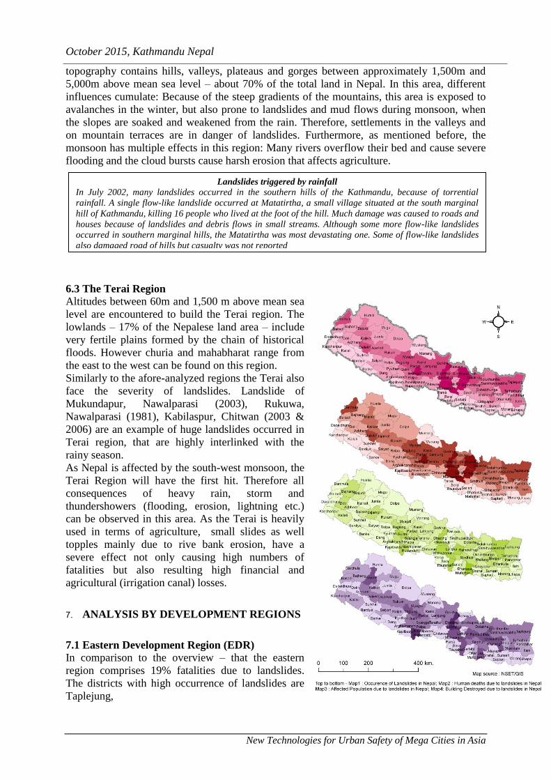
Jure Landslide
On August 2, 2014, due to heavy rainfall, a landslide
was occurred at the Sunkoshi River, killing 156 people
and blocking the river to form and artificial lake in
Sindhupalchok district, Nepal. Araniko highway, the
main (and only) artery of goods and people flow to
China, was blocked by the landslide ripping out of 5 km
of highway, and causing huge traffic jam, 2 dozens
houses had been swept by the landslide. The landslide
had a volume of 5.5 million cubic meters.
The landslide had a massive effects far beyond. The
dammed river was threatening to unleash a torrent of
water to hundreds of downstream villages that would
ravage as far as Northern India. Despite the use of
dynamite, it took the Nepal Army 45 days to dig a canal
through the blockage to allow water in the lake to drain.
The Lake created was 47 meters deep and over 400
meters long. The hasty emergency draining through the
lake canal itself had caused damage to houses
downstream and threatens to take out Lamosanghu
Hydropower dam.
The analysis of landslides trendline shows that in the beginning of 1990s, it can be observe a
high number of landslide events. Moreover, the number of fatalities increased as well.
However, in recent years, the number of events and fatalities went down again. An
explanation for this curve cannot be found solely from the DesInventar database. However
one could question whether this trend is interlinked with the construction of roads and
increase of population.
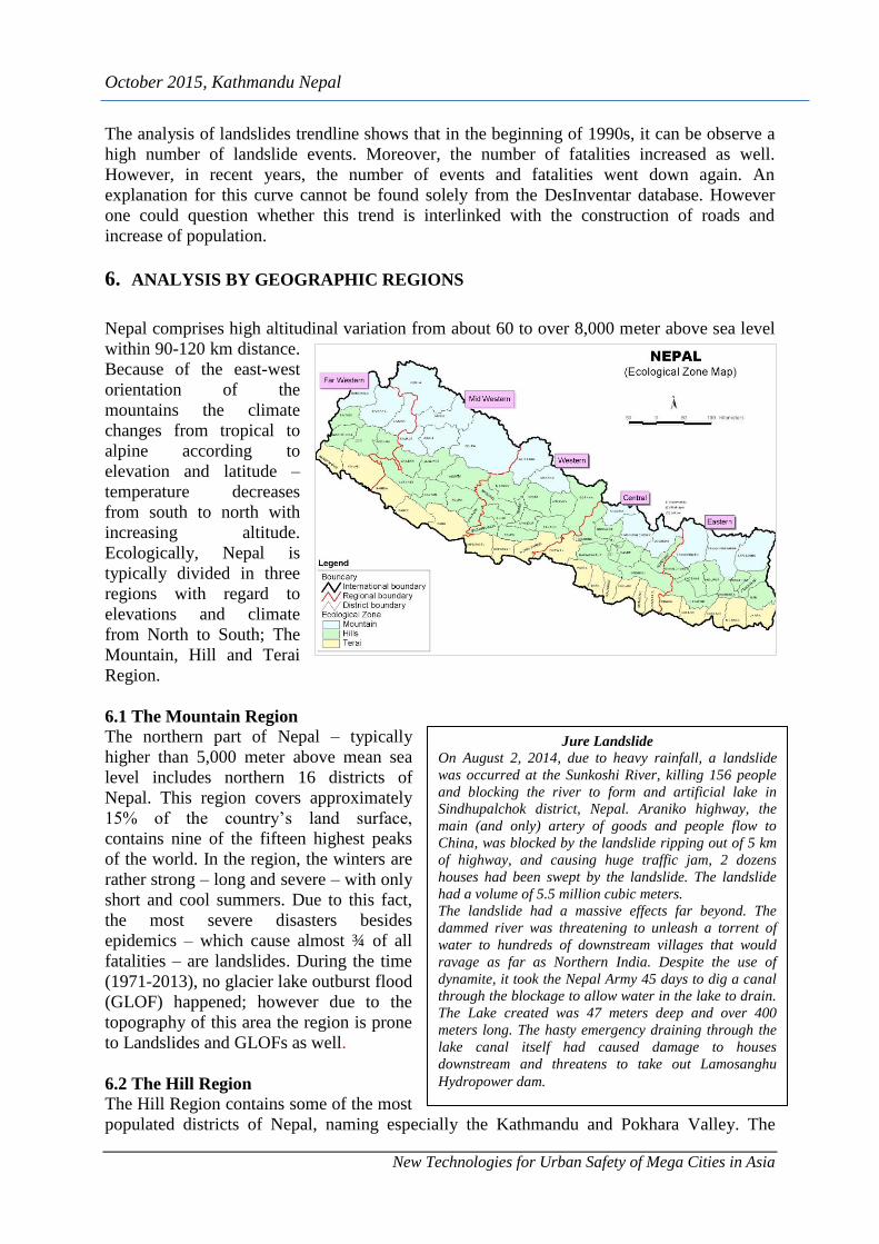
6. ANALYSIS BY GEOGRAPHIC REGIONS
Nepal comprises high altitudinal variation from about 60 to over 8,000 meter above sea level
within 90-120 km distance.
Because of the east-west
orientation of the
mountains the climate
changes from tropical to
alpine according to
elevation and latitude –
temperature decreases
from south to north with
increasing altitude.
Ecologically, Nepal is
typically divided in three
regions with regard to
elevations and climate
from North to South; The
Mountain, Hill and Terai
Region.
6.1 The Mountain Region
The northern part of Nepal – typically
higher than 5,000 meter above mean sea
level includes northern 16 districts of
Nepal. This region covers approximately
15% of the country’s land surface,
contains nine of the fifteen highest peaks
of the world. In the region, the winters are
rather strong – long and severe – with only
short and cool summers. Due to this fact,
the most severe disasters besides
epidemics – which cause almost ¾ of all
fatalities – are landslides. During the time
(1971-2013), no glacier lake outburst flood
(GLOF) happened; however due to the
topography of this area the region is prone
to Landslides and GLOFs as well.
6.2 The Hill Region
The Hill Region contains some of the most
populated districts of Nepal, naming especially the Kathmandu and Pokhara Valley. The
October 2015, Kathmandu Nepal
New Technologies for Urban Safety of Mega Cities in Asia
Landslides triggered by rainfall
In July 2002, many landslides occurred in the southern hills of the Kathmandu, because of torrential
rainfall. A single flow-like landslide occurred at Matatirtha, a small village situated at the south marginal
hill of Kathmandu, killing 16 people who lived at the foot of the hill. Much damage was caused to roads and
houses because of landslides and debris flows in small streams. Although some more flow-like landslides
occurred in southern marginal hills, the Matatirtha was most devastating one. Some of flow-like landslides
also damaged road of hills but casualty was not reported
topography contains hills, valleys, plateaus and gorges between approximately 1,500m and
5,000m above mean sea level – about 70% of the total land in Nepal. In this area, different
influences cumulate: Because of the steep gradients of the mountains, this area is exposed to
avalanches in the winter, but also prone to landslides and mud flows during monsoon, when
the slopes are soaked and weakened from the rain. Therefore, settlements in the valleys and
on mountain terraces are in danger of landslides. Furthermore, as mentioned before, the
monsoon has multiple effects in this region: Many rivers overflow their bed and cause severe
flooding and the cloud bursts cause harsh erosion that affects agriculture.
6.3 The Terai Region
Altitudes between 60m and 1,500 m above mean sea
level are encountered to build the Terai region. The
lowlands – 17% of the Nepalese land area – include
very fertile plains formed by the chain of historical
floods. However churia and mahabharat range from
the east to the west can be found on this region.
Similarly to the afore-analyzed regions the Terai also
face the severity of landslides. Landslide of
Mukundapur, Nawalparasi (2003), Rukuwa,
Nawalparasi (1981), Kabilaspur, Chitwan (2003 &
2006) are an example of huge landslides occurred in
Terai region, that are highly interlinked with the
rainy season.
As Nepal is affected by the south-west monsoon, the
Terai Region will have the first hit. Therefore all
consequences of heavy rain, storm and
thundershowers (flooding, erosion, lightning etc.)
can be observed in this area. As the Terai is heavily
used in terms of agriculture, small slides as well
topples mainly due to rive bank erosion, have a
severe effect not only causing high numbers of
fatalities but also resulting high financial and
agricultural (irrigation canal) losses.
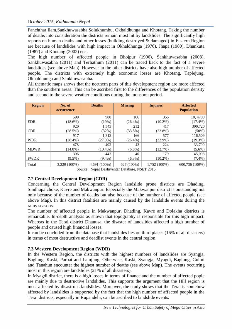
7. ANALYSIS BY DEVELOPMENT REGIONS
7.1 Eastern Development Region (EDR)
In comparison to the overview – that the eastern
region comprises 19% fatalities due to landslides.
The districts with high occurrence of landslides are
Taplejung,
October 2015, Kathmandu Nepal
New Technologies for Urban Safety of Mega Cities in Asia
Panchthar,Ilam,Sankhuwasabha,Solukhumbu, Okhaldhunga and Khotang. Taking the number
of deaths into consideration the districts remain most hit by landslides. The significantly high
reports on human deaths and other losses (building destroyed & damaged) in Eastern Region
are because of landslides with high impact in Okhaldhunga (1976), Jhapa (1980), Dhankuta
(1987) and Khotang (2002) etc .
The high number of affected people in Bhojpur (1996), Sankhuwasabha (2008),
Sankhuwasabha (2011) and Terhathum (2011) can be traced back to the fact of a severe
landslides (see above Map). However in the other districts have also high number of affected
people. The districts with extremely high economic losses are Khotang, Taplejung,
Okhaldhunga and Sankhuwasabha.
All thematic maps shows that the northern parts of this development region are more affected
than the southern areas. This can be ascribed first to the differences of the population density
and second to the severe weather conditions during the monsoon period.
Region No. of
occurrence
Deaths Missing Injuries Affected
Population
EDR
599
(18.6%)
900
(19%)
166
(26.4%)
355
(10.2%)
10, 4700
(17.4%)
CDR
920
(28.5%)
1,543
(32%)
212
(33.8%)
417
(23.8%)
300,720
(50%)
WDR
917
(28.4%)
1,313
(27.9%)
166
(26.4%)
577
(32.9%)
116,509
(19.3%)
MDWR
478
(14.8%)
492
(10.4%)
43
(6.8%)
224
(12.7%)
33,799
(5.6%)
FWDR
306
(9.5%)
443
(9.4%)
40
(6.3%)
179
(10.2%)
45,008
(7.4%)
Total 3,220 (100%) 4,691 (100%) 627 (100%) 1,752 (100%) 600,736 (100%)
Source : Nepal DesInventar Database, NSET 2015
7.2 Central Development Region (CDR)
Concerning the Central Development Region landslide prone districts are Dhading,
Sindhupalchoke, Kavre and Makwanpur. Especially the Makwanpur district is outstanding not
only because of the number of deaths but also because of the number of affected people (see
above Map). In this district fatalities are mainly caused by the landslide events during the
rainy seasons.
The number of affected people in Makwanpur, Dhading, Kavre and Dolakha districts is
remarkable. In-depth analysis as shown that topography is responsible for this high impact.
Whereas in the Terai district Dhanusa, the disaster of landslides affected a high number of
people and caused high financial losses.
It can be concluded from the database that landslides lies on third places (16% of all disasters)
in terms of most destructive and deadlist events in the central region.
7.3 Western Development Region (WDR)
In the Western Region, the districts with the highest numbers of landslides are Syangja,
Baglung, Kaski, Parbat and Lamjung. Otherwise, Kaski, Syangja, Myagdi, Baglung, Gulmi
and Tanahun encounter the highest number of deaths (see above Map). The events occurring
most in this region are landslides (21% of all disasters).
In Myagdi district, there is a high losses in terms of finance and the number of affected pople
are mainly due to destructive landslides. This supports the argument that the Hill region is
most affected by disastrous landslides. Moreover, the study shows that the Terai is somehow
affected by landslides is supported by the fact that the high number of affected people in the
Terai districts, especially in Rupandehi, can be ascribed to landslide events.

October 2015, Kathmandu Nepal
New Technologies for Urban Safety of Mega Cities in Asia
7.4 Mid-Western Development Region (MWDR)
The districts most at risk of landslides are Dailekh, Rukum, Jajarkot and Kalikot. Moreover
Pyuthan, Kalikot, Jajarkot, Rolpa and Dailekh comprise the highest number of fatalities in the
Mid-Western Region. The number of affected people in the Terai, as proven by the Dang and
Banke district, come off the effects of the landslides during monsoon season.
Comparing the ratio of number of events to number of deaths of the different development
regions one can conclude, that the landslides in the Mid-West are less destructive than in the
previous three regions. This can also be interpreted in the way that the mid-western districts
are more vulnerable to other type of disasters ; flood, epidemic etc.
7.5 Far Western Development Region (FWDR)
Considering the above maps the finding is that the districts most hit by landslides and also the
highest numbers of deaths. These districts are Darchula, Bajura, Doti and Baitadi. The
landslides are more severe which cause more than 9 % fatalities. Additionally the number of
affected people in the whole development regions comes off the side effects of the monsoon.
Moreover one can say likewise other regions, the districts in the Far Western Region are also
vulnerable to landslides as the numbers of events and deaths are fairly high. This means, that
the events of landslides are affecting on the population of Far-western development Regions.
8. CONCLUSION Nepal lies in a multi-hazard zone exposed to various types of disaster. However, due to the
various geography, topographic features, climatic variation and different levels of socio-
economic development within the country, the type, frequency and degree of the impact of
disasters differs from place to place.
Landslide impacts on human life, property and economy seems vary. Landslide is the most
destructive natural disaster in Nepal. It does not only cause a high number of casualties and
grave agricultural losses but also effects structures and infrastructure causing huge economic
loss. Landslides, moreover, occur on a regular basis during monsoon.
The trendline of landslide shows that in the beginning of 1990s, there was a high number of
landslide events. Moreover, the number of fatalities increased as well. In recent years, the
number of events and fatalities went down again.
Districts of hill region as well mountain region are mostly affected by disastrous landslide
events. However, the effects in the latter are more severe because landslides can cause other
disasters like flash flood. Among the development regions, central development region
recorded the highest number of human deaths 1,543 (32%) closely followed by western
development regions with 1,313 (27.9%) deaths (above table). Similarly eastern and mid-
western regions each have accounted for 19% and 10.4% respectively. Furthermore, in terms
of the affected population, Central development region has recorded the highest population
300,720 (50%) with the lowest in far western development region 45,008 (7.4%).
Querying disaster impact by political regions, mostly landslide disasters can be seen on the
central and eastern part of Nepal. Nearly 50 percent of landslides are recorded in these regions.
Moreover as the aforementioned regions have high population these landslide events have
also a high effect on people and property.
Furthermore, the high number of events does not imply a high number of deaths and vice
versa. For example in the mountainous part of the eastern development region, the number of
disaster events is high but due to the fact of a small density of population, the death toll is
rather low. However, in the far western region, where only a small number of events occur,
the death toll is lesser high. the analysis also shows that the landslides are highly interlinked
to the geographic conditions – whereas the northern mountains are highly affected by
October 2015, Kathmandu Nepal
New Technologies for Urban Safety of Mega Cities in Asia
landslides. The Hill districts mostly experiences the side effects of the landslides. And the
Terai suffers all monsoon effects – especially floods and landslides together.
One concluding remark for further research and mitigation approach is necessary in Nepal.
REFERENCES
CRED (2009), Disaster Category Claasification and peril Terminology for Operational
Purposes.
DWIDP (2002), Water Induced Disasters in Nepal and Its Management, in Disaster Review
2004, (July 2005), Kathmandu Nepal.
DWIDP (2006), DWIDP Bulletin F.Y. 2005/2006, DWIDP (Department of Water Induced
Disaster Prevention), Ministry of Water Resources, Government of Nepal. Page 2.
Khanal, R. K.(1991), Historic Landslides of Nepal during 1902 – 1990 AD: Extent and
Economic Significance; unpublished MSc. Thesis submitted to Central Department of
Geology, Tribhuvan University, Kathmandu.
Mool, Pradip (2001), Glacial lakes and glacial lake outburst flood events in the Hindu Kush –
Himalayan Region in Mountain Flash Floods (no.38, Winter 200/2001), Kathmandu:ICIMOD
page 7 – 8.
National Society for Earthquake Technology – Nepal (NSET) 2009, Global Assessment of
Risk, Nepal Country Report, Submitted to ISDR Global Assessment Report on Poverty and
Disaster Risk 2009 Submitted by NSET.
Pradhan, B. K. (2007), Disaster Preparedness for Natural Hazards: Current Status in Nepal,
Kathmandu: ICIMOD (International Centre for Integrated Mountain Development)
UNDP Nepal (1997), Comomprehensive Database (Basic Information) On Natural Disaster
Management Capabilities In Nepal, United Nations Development Programme, Kathmandu,
(unpublished report, nicknamed the Brown Book).
Petley D.N, Gareth J Hearn, Andrew Hart, Nicholas J. Rosser, Stuart A. Dunning, Katie Oven,
Wishart A. Mitchell (2007), Trends in landslide occurrence in Nepal, pulished on Natural
hazards, Origional Paper 43:23-44 (http://www.researchgate.net/publication/226792669,
retrieved on 02 October 2015)
UNDP/BCPR (2004), A Global Report Reducing Disaster Risk-A Challenge for Development,
United Nations Development Programme, Bureau for crisis Prevention and Recovery.
Pokhrel, L. N. (2002), Water Induced Disasters in Nepal and Its Management, in Disaster
Review 2002, (July 2003) DWIDP.
ICIMOD (2007), Disaster Preparedness for Natural Hazards: Current Status in Nepal),
Kathmandu, May 2007, ICIMOD
http://www.panda.org/about_wwf/what_we_do/climate_change/publications/asia_pacific. as
of 17 June 2008)
www.desinventar.net
http://www.proventionweb.net/english/hyogo/gar/2009/UNDP_NP_Nepal Country
Report.pdf
https://en.wikipedia.org/wiki/2014_Sunkoshi_blockage
http://iaeg2006.geo/soc.org.uk/cd/PAPER/IAEG-819.PDF
http://www.np.undp.org/content/dam/nepal/docs/reports/UNDP_NP_UNDP%20Nepal%20An
nual%20Report%202014.pdf

October 2015, Kathmandu Nepal
New Technologies for Urban Safety of Mega Cities in Asia