TRCA Environmental Impact Statement Guidelinestrca.on.ca/dotAsset/40021.pdf · TRCA Environmental...
39
TRCA Environmental Impact Statement Guidelines November 2007 This document is adapted from the Carolinian Canada Guide for Environmental Impact Statements. It is dated November 2007 and is consistent with current policies adopted by the TRCA at this time. These guidelines are not meant to be exhaustive but present the typical requirements of the TRCA and are subject to change.
Transcript of TRCA Environmental Impact Statement Guidelinestrca.on.ca/dotAsset/40021.pdf · TRCA Environmental...

TRCA Environmental Impact Statement Guidelines
November 2007
This document is adapted from the Carolinian Canada Guide for Environmental Impact Statements. It is
dated November 2007 and is consistent with current policies adopted by the TRCA at this time. These guidelines are not meant to be exhaustive but present the typical requirements of the TRCA and are
subject to change.

INTRODUCTION 4
Purpose of an EIS 4
TRCA Terrestrial Natural Heritage System Strategy 5
EIS REVIEW PROCESS 7
Step 1: Initial Consultation and EIS Scoping 7
Step 2: Terms of Reference Development and Initial Site Visit 7
Step 3: EIS Report 8 Part I – Defining the Natural Heritage System 8 1.0 Existing Conditions 8 1.1 Site Description 9 1.2 Assessment of Function 10 1.3 Development of the Natural Heritage System 12 Part II – The Development Proposal 12 2.0 Evaluation of the Ecological Impacts 12 2.1 Description of Mitigating Measures 13 2.2 Policy and Legislative Framework 14 2.3 Recommendations 15 2.4 Appendices 15 2.5 Executive Summary 15
Step 4: Ongoing Consultation 15
Step 5: Review of EIS by the Technical Review Team 16
Step 6: Monitoring 16
REFERENCES 17
APPENDIX A A1
DATA COLLECTION STANDARDS FOR THE INVENTORY OF NATURAL HERITAGE COMPONENTS FOR AN EIS A1-1
Guiding Principle A1-1
Background A1-1
Biophysical Inventories A1-1 Reporting on Aquatic and Terrestrial Species of Conservation Concern A1-1 Vegetation Communities Survey and Reporting A1-2 Vascular Plants Survey and Reporting A1-2 Wildlife Surveys and Reporting A1-3
Breeding Bird Surveys A1-3 Amphibian Surveys A1-5
Aquatic communities and habitats survey and Reporting A1-7 Fisheries and Habitat Inventory A1-7 Fish Habitat Assessment and Stream Analysis A1-7 Fish Community and Habitat Assessment Requirements for Ephemeral Streams A1-7 Benthic Survey A1-9 Freshwater Mussels A1-11
Data Collection Summary Table A1-13
APPENDIX B B1
TRCA POST-CONSTRUCTION RESTORATION GUIDELINES B1-1
TRCA STORMWATER MANAGEMENT POND PLANTING GUIDELINES B2-1
TRCA SEED MIX GUIDELINES B3-1
TRCA FOREST EDGE MANAGEMENT PLAN GUIDELINES B4-1
EROSION AND SEDIMENT CONTROL GUIDELINE
FOR URBAN CONSTRUCTION B5-1

TRCA Environmental Impact Statement Guidelines November 2007
4
INTRODUCTION As stipulated under the Conservation Authorities Act, the object of Conservation Authorities is to further
the conservation, restoration, development, and management of natural resources within their
jurisdictions. For the purposes of accomplishing this, authorities have the power to study and investigate their watersheds and to determine a program whereby the natural resources of the watershed may be
conserved, restored, developed and managed. Given these powers, Conservation Authorities have an interest in ensuring that development applications conform to the policies and programs established to
achieve these objectives.
In addition, in 2005 the Province of Ontario revised and updated the Provincial Policy Statement (PPS),
which provides policy direction on matters of provincial interest related to land use planning and development. With respect to natural heritage, the PPS does not permit development and site alteration
in significant natural heritage features unless it is demonstrated that there will be “no negative impacts” on the natural features or their ecological functions. Municipalities, through their official plans, set out
how to satisfy the requirements of the Provincial Policy Statement (PPS). An Environmental Impact
Statement (EIS) is normally completed for all development proposals where it has been identified that there may be an impact on a natural heritage feature, or area, or the function of the feature.
The Toronto and Region Conservation Authority is an agency that holds Memoranda of Understanding
with all of our municipal partners to provide technical advice relating to various planning applications and
development proposals requiring approval under the Planning Act. A component of our role as a commenting agency is, in concert with our municipal partners, to establish the requirement for an EIS,
and provide technical input into the content of the EIS through the terms of reference development. These guidelines have been prepared to assist in the processing of Planning Act applications. Upon
review of the completed EIS, TRCA provides advice to the municipality as to whether the findings of the report are acceptable. However, ultimately it is the municipality that is responsible for approving a
development application. TRCA may also require that an EIS be conducted in support of a permit
application made pursuant to Section 28 of the Conservation Authorities Act (Development, Interference with Wetlands and Alterations to Shorelines and Watercourses Regulation).
Purpose of an EIS
The purpose of an EIS is to determine the potential impacts, direct and indirect, of a proposed development application on the natural heritage system of an area, excluding areas on the Oak Ridges
Moraine (note that technical papers have been prepared by Ontario Ministry of Natural Resources to guide the development of Natural Heritage Evaluations on the Oak Ridges Moraine). These studies are
typically completed for smaller-scale developments or in-fill developments that are not associated with
detailed studies conducted to satisfy higher-level planning processes (i.e. Secondary Plans, MESPs, etc.), although these guidelines can be used to guide the environmental components required for these higher-
level studies as well. An EIS can also be required when an assessment of ecological impacts has not been addressed at earlier planning stages or one may be required at detailed design through the permitting
process. Key components of the EIS reporting are:
• a biophysical inventory and analysis;
• identification of constraints and opportunities;
• an assessment of impacts from the proposed activities;
• the analysis of mitigation measures;
• the determination of net effects;
• the identification of monitoring for developments within and/or adjacent to natural areas or
hazards.

TRCA Environmental Impact Statement Guidelines November 2007
5
The function of the EIS is to describe potential impacts, to better inform municipal and TRCA staff in
making decisions about which impacts of development are acceptable, and which should be avoided. The EIS will assess impacts that are anticipated from the proposed development application on natural
heritage features, functions and linkages including but not limited to:
• Fish and aquatic habitat;
• Wetlands;
• Woodlands;
• Valleylands;
• Wildlife Habitat;
• Vegetation Communities;
• Environmentally Significant Areas (ESAs);
• Areas of Natural and Scientific Interest (ANSIs);
• Habitats of Vulnerable, Threatened and Endangered Species (VTEs);
• TRCA’s Terrestrial Natural Heritage System;
• Groundwater recharge and discharge areas;
• Groundwater and surface water quantity and quality as related to natural heritage features and
functions; • Flood and erosion hazards of streams and valleylands;
• Flood and erosion hazards of dynamic beaches.
The proponent of a given development has a financial responsibility to fulfill the requirements established
by the Province and the municipality for an Environmental Impact Study. The EIS will contain recommendations that discuss whether or not the impacts of the proposed development are acceptable
or not, and measures to maintain, mitigate or enhance the natural heritage features and functions of the site. This includes management and mitigation of impacts that are unavoidable. We expect that the
results of the analysis be based in good sciences that are technically defensible and adequately protect
the features and functions on the site.
Through this process it is anticipated that development proposals will be modified to reduce impacts where possible. The EIS will be reviewed for technical accuracy and extent of impacts. The completion
of an EIS does not assure the approval of a development proposal. An EIS provides the mechanism for assessing impacts. Additional modification of development proposals may result during review, if the
development concept is deemed to be acceptable. Accepting, modifying or rejecting development
proposals in and adjacent to natural areas will take place after the EIS is completed and submitted. In general, the natural areas of concern to the municipality are those designated as natural heritage
features in the Official Plan. Other natural heritage features not specifically identified may be identified as also requiring an EIS.
TRCA Terrestrial Natural Heritage System Strategy
Conservation Authorities are given powers under the Conservation Authorities Act (R.S.O.1990) to develop programs to conserve and restore the natural resources of our watersheds. Applicants should be
aware that TRCA has adopted a Terrestrial Natural Heritage System Strategy (TNHSS) that attempts to
address the ongoing loss of biodiversity within TRCA’s watersheds by implementing a more comprehensive and pro-active approach to conserving terrestrial biodiversity than the traditional
approach to protect “islands of green”. The recognition that there is currently insufficient habitat and linkages across the GTA’s landscape to sustain populations at regional and local scales supports
integration of both protection and restoration of natural habitats as key components. Hence, the
quantitative targets for protection and restoration established through the TNHSS will be developed in order to achieve a quantity, distribution, and quality of natural cover that will accomplish the long-term
ecosystem viability objectives. The TNHSS identifies a land base for inclusion within a regional natural heritage system. Proponents of development applications should be aware that these targeted areas

TRCA Environmental Impact Statement Guidelines November 2007
6
would need to be addressed through the EIS process. The model policies of the TNHSS outline the
requirement for compensation and restoration in areas within the targeted system that will be directly impacted by development and site alteration. Proponents should be familiar with these policies and be
prepared to accommodate their objectives within development applications.

TRCA Environmental Impact Statement Guidelines November 2007
7
EIS REVIEW PROCESS
Step 1: Initial Consultation and EIS Scoping
Oftentimes, a proponent will make initial contact with TRCA planning staff when a development application is first contemplated. During this initial meeting, TRCA staff may establish the need for an EIS
through an initial screening process. The planner will typically advise the proponent of the general expertise that the applicant should seek in order to meet the general requirements for the EIS. These
requirements will be further refined through a scoping exercise meeting that will occur at a later date.
Prior to the scoping exercise that is conducted with TRCA’s Technical Review Team, the proponent should
retain appropriate technical staff at this time who would be qualified to carry out the expected works. TRCA expects that the EIS and the biophysical surveys undertaken in support of the EIS will be
completed by competent, professional experts in a field relevant to the components of the report to
which they are contributing. For example, a botanist must complete a flora survey; an aquatic biologist must complete a fisheries survey, a hydrogeologist (P.Geo) must complete the groundwater analysis, etc.
The final EIS report must be analyzed and written by a qualified ecologist.
Members of the TRCA Technical Review Team will be identified at this stage. The Technical Review Team will provide technical advice and may consist of the TRCA staff (ecologists, planners, hydrogeologists,
stormwater engineers, geotechnical engineers, etc.), but may also include municipal staff, and any
relevant agencies (e.g. Ministry of Natural Resources, Ministry of Environment, Department of Fisheries and Oceans, Environment Canada), as required.
The EIS scoping exercise is held to scope out the terms of reference for the EIS with technical staff from
the agencies and the technical staff representing the applicant. The applicant is expected to provide
information pertaining to the development application, permitted uses, and any existing background information available to the applicant. This review of background information should include existing fish
and wildlife data records, soils mapping, aerial photos, Natural Heritage Information Centre (NHIC) and Species at Risk Act (SARA) websites, Species of Conservation Concern lists, etc.
TRCA and municipal staff will review current legislative and policy requirements with the applicant, advise of the planning context, and discuss existing information, known ecological sensitivities, available data
and sources, and recommendations provided in other studies. Existing studies may include watershed and subwatershed studies, Wetland Evaluations, ESA reports, Fisheries Management Plans, and Natural
Heritage Site Reports that may be relevant to the subject lands and the development proposal.
Step 2: Terms of Reference Development and Initial Site Visit The applicant will be given direction and guidance as to the anticipated scoping, form and content of the
EIS based on preliminary identification of issues and concerns in Step 1. It is at this stage that all parties will agree on whether the EIS will be scoped to exclude some or all expected biotic inventories,
depending on the scale of the proposed development, anticipated impacts, and availability of existing
data. Otherwise, a full EIS will be required.
The applicant and their consultants and members of the Technical Review Team should conduct a site visit. This will aid on-site interpretation and help to define pertinent natural heritage areas and identify
natural hazard concerns that require further investigations. All natural feature boundaries will need to be
staked at some point during the development and approval of the EIS. Staking could be completed at this time and could be included in the analysis of impacts through the EIS. Timing of the staking exercise
should be identified in the Terms of Reference (TOR).

TRCA Environmental Impact Statement Guidelines November 2007
8
Gaps in information are determined through the review of secondary sources during the Step 1 and the
subsequent site visit. The applicant’s consultants develop the content and scope of the TOR for the EIS in consultation with TRCA Technical Review Team. This step provides details for the accepted methods of
data collection, analysis and evaluation of potential impacts, and specifies the qualifications of personnel required to carry out these evaluations. The applicant and/or their consultants should provide a work plan
and signed letter of understanding that formalizes the required TOR. In addition, some municipalities
have their own EIS guidelines. Through the consultation process with municipalities, the TOR should incorporate both guidelines, if relevant. Once TRCA is in receipt of and is satisfied with the TOR, TRCA
staff will provide final sign off.
Step 3: EIS Report The following guidelines should be used when completing the EIS report. We have outlined specific
direction and content for each heading that should be included in the final EIS report, as follows, unless scoped-out as part of Step 2.
Part I – Defining the Natural Heritage System
Prior to the assessment of the proposed development and anticipated impacts, the first step of the EIS report should analyze the existing natural heritage features and functions of the site in order to define
the natural heritage system that will be required to maintain ecosystem function given that changes to
the landscape or site may result. The natural heritage system should include linkages between natural features to ensure that life cycles can continue to be completed and that genetic exchanges can occur.
1.0 Existing Conditions
The initial step in defining the natural heritage system will be gathering existing or secondary source information to gain an understanding of the site, to identify preliminary issues, and to outline information
gaps and the need for additional surveys and data collection. This first section should provide:
• The planning context including any existing designations, zoning, and permitted uses;
• Location maps detailing both site specific and regional perspectives;
• Identification of known natural heritage designations within and beyond the site, such as Areas of
Natural and Scientific Interest (ANSI), Provincially and Locally Significant Wetlands (PSWs and LSWs), Environmentally Significant Areas (ESAs), Oak Ridges Moraine designations, Greenbelt
designations, Niagara Escarpment designations, habitat of significant wildlife, sensitive fish
habitat, etc. • Natural heritage features and functions present on the site and within the landscape;
• Potential cover that could be affected by the development which has been targeted under TRCA’s
Terrestrial Natural Heritage Strategy;
• Specific location of boundaries or edges of identified features or functions;
• Existing interconnections or corridors with adjacent natural features;
• Identification of hazards;
• Overview of critical issues;
• Watershed targets and recommendations.

TRCA Environmental Impact Statement Guidelines November 2007
9
1.1 Site Description The importance of the site should be considered at all scales, including the landscape, vegetation
community, species, and (if possible) the genetic scale. Site description of the area should include all primary source information collected in support of the EIS. This information should be as detailed as
possible and should include the following requirements:
a) A description of the soils, landforms and surficial geology based on a review of available mapping
and literature. Topographical information should be provided on constraints mapping. Any feature staking that has been done to date (e.g. staking the top and/or toe of the valley slope) should
also be indicated as well as the calculated hazard land limits (e.g. floodplain analysis,
geotechnical review of slope stability and watercourse erosion, meander belt width analysis, etc.).
b) Identify any hydrological or hydrogeological resources and issues, including surface water
features, recharge/discharge zones, groundwater quality and quantity, groundwater elevations and flow directions, connections between groundwater and surface water features. More in-depth
information (i.e. boreholes, surface flow measurements) may be required, depending on the
scope, scale and issues identified for the proposal.
c) A pre-development water balance should be completed for the site in order to assess the quantity and quality of existing water budget components on the site. If there are existing natural
heritage features on the subject property, including wetlands, woodlands, and watercourses,
then a more detailed feature-based water balance will be required to determine existing flow paths and contributions to these features. This assessment will identify existing precipitation,
evapotranspiration, runoff and infiltration volumes on a monthly basis.
d) A biophysical inventory and analysis of both terrestrial and aquatic communities, physical
functions and processes that occur on and beyond the site that will be affected, or that might reasonably be expected to be affected, either directly or indirectly. This should include
information addressing quality, quantity and distribution of the resource(s). Please refer to the Appendix for further detail regarding biophysical inventories. It is expected that studies will be
undertaken during the appropriate season.
e) An analysis of the inter-relationship of the biophysical information, to provide an overview of the
existing ecosystem both within the subject site and as it relates to the larger local and regional ecosystem. For example, linkages between features, such as groundwater-vegetation
communities or groundwater-surface water relationships should be described. The investigation of the existing features should extend beyond the subject site and include adjacent areas. The
level of effort may be reduced for the adjacent areas since a full investigation may be hindered
by access issues, however a remote investigation should occur as a minimum. The extent of the off site investigation in terms of level of information and the geographic extent must be agreed
to by the review team, and should occur during the consultation process.
f) A description of the present natural features and components of the natural heritage system of the subject property (i.e. wetland, ESA, ANSI, woodland, vegetation patch, geological or
landform features, river, stream, or ravine corridor) and the proposed criteria to be applied for
evaluation of their significance, if not yet established. The proponent is encouraged to refer to the TRCA Terrestrial Natural Heritage Strategy, our Vegetation Communities/Species of
Conservation Concern lists, Natural Heritage Information Centre (NHIC) records, and COSEWIC/COSSARO lists.

TRCA Environmental Impact Statement Guidelines November 2007
10
h) A description of the methodology, timing, and techniques selected and used to undertake the
ecological inventory. Qualifications of the study team members should be outlined. Please refer to the Appendix for detailed requirements in this regard.
i) A complete literature review including relevant reports prepared for/by other agencies and
consultation with local naturalists who may be familiar with the site should be part of the study.
j) Include the natural heritage planning components within the area under study, such as the
following (if applicable):
• natural heritage features (woodlands, wetlands, watercourses, etc)
• adjacent sections of rivers and valleys;
• linkages and corridors to natural areas;
• information obtained from previous studies such as life science inventories;
• environmental targets and recommendations in local policy and watershed plans; and
• environmental management strategies and policies that may have been developed.
1.2 Assessment of Function
The EIS is to discuss in detail the nature and extent of ecological features and their functions on the subject site. This section should include an evaluation of components of the natural heritage system and
the characteristics of the site. Identification of the key features and functions including:
• Whether the feature or function is measurable in its occurrence, and if so its significance in
terms of maintaining biodiversity;
• Whether the feature or function contributed to the quality and integrity of the area;
• Whether the feature or function contributes to the identification of the area as a natural
heritage feature or area or; • Whether there is a reasonable expectation that the feature or function is sensitive to
development of the type proposed.
A partial list of topics to be covered, as necessary, is provided below:
Ecological functions: are the natural processes, products or services that species and non-living environments provide or perform within or between ecosystems and landscapes. They include, but are
not limited to the following:
• biodiversity (landscape, community, species and genetic levels)
• habitat (provision of food, shelter, reproduction, refuge from predators, and movement for
species) for aquatic and terrestrial species • habitat contiguity (size and shape)
• species and habitat representation and abundance
• vegetation structure, density, diversity and distribution
• connections and linkages
• proximity to other areas
• proximity to water
• hydrological functions (hydrogeology, fluvial geomorphology and hydrology)
• nutrient and energy cycling
• succession and disturbance
• reproduction and dispersal
• landscape linkages
• relationships between species and communities
TRCA Environmental Impact Statement Guidelines November 2007
11
Wetland Functions: (the biological, physical and socioeconomic interactions that occur in an
environment because of the properties of the wetlands that are present). These may include, but not be limited to, the following:
• ground water recharge and discharge;
• water storage and release;
• flood damage reduction;
• shoreline stabilization;
• sediment trapping;
• nutrient and contaminant uptake and removal;
• food chain support;
• habitat for fish and wildlife;
• attendant social and economic benefits.
Natural Heritage Features and Landscapes:
Ecological functions and benefits include:
• Moderating climate
• Maintaining water cycles
• Providing habitat for all species
• Supplying oxygen and sequestering carbon dioxide
Benefits of importance to humans:
• Contributing to healthy and productive landscapes
• Cleaning, conveying and storing water
• Improving air quality
• Preventing erosion
• Converting and storing atmospheric carbon
• Providing natural resources and green space for human activities
• Aesthetic and quality-of-life benefit
Corridors and linkages:
Provide a discussion around the existing and potential linkages between natural heritage areas. The EIS should assess the following linkage functions of the site:
• Hydrological function (riparian areas, flood plains, valley lands, drainage areas, surface and
ground water connections, recharge and discharge areas);
• Degree of connection with natural areas (proximity, distance, intervening land use, corridors) and
opportunities for connections through restoration;
• Linkage along the river corridor and the effect of stormwater management proposals on these;
Movement patterns of wildlife groups.
Assessment of linkages should take into account both linkage within the site and connections with other sites and include an evaluation of:
• The natural areas and habitats linked (number of sites linked and site sizes and conditions);
Linkage habitat type (anthropogenic [e.g. utility corridor, hedgerow, plantation]; to natural
community, river floodplain, etc);
• Main cover type quality;
• Width;

TRCA Environmental Impact Statement Guidelines November 2007
12
• Length;
• Continuity (e.g. long gaps >100 m, or gaps containing roads or other barriers to gaps <30 m
wide containing no barriers);
• Existing wildlife use in corridors;
• Opportunities to restore or enhance cover within corridors between natural areas. Existing
linkages should also consider the existing matrix and its ability to facilitate wildlife movement and how this matrix may change after the proposed development occurs. Existing linkage areas may
not be located within natural areas.
1.3 Development of the Natural Heritage System The end result of this assessment of function analysis will be the development of a natural heritage
system that contains all features, functions, and connections between features. This is the Natural Heritage System that is to be protected from development. Once the natural heritage system is defined
on constraints mapping, the preliminary development area will be identified. Note that the natural
heritage system that is defined at this time will not include additional buffering that will likely be required to mitigate the impacts of the proposed development.
Part II – The Development Proposal
Part II will outline the proposed development, impact analysis, and recommended mitigation and/or compensation. A concept plan for the development should be provided that is respectful of the natural
heritage system that has been identified in Part I. The intent of this piece of the EIS is to determine, first, whether the form of the development can be accommodated given the ecological sensitivities and natural
hazards of the site. Secondly, if the development is not compatible on its own, whether mitigation and/or
compensation measures could be proposed to ensure that negative effects are mitigated and that the development results in a net ecological gain. Although the development concept will be presented in the
report as the final development proposal, the actual process will be iterative and will involve periodic revisions to the development layout as impacts are identified and mitigation is incorporated into the
design.
If the impacts cannot be mitigated, then the form of development that is proposed made need to be
revised in order to make the use more compatible. It is possible, however, that the area may be so ecologically sensitive that no form of development is compatible.
2.0 Evaluation of the Ecological Impacts
The following items are required for the evaluation of the effects of the proposal on the environment. Scientific literature must be consulted and cited in the body of the report to support all statements made.
Although we have separated the impacts and mitigation into distinct sections below, these two pieces can be combined in the EIS report, if it makes more sense to do so.
a) Complete mapping of all resources including existing and proposed grades is required. The environmental constraints to development should be overlaid onto one map illustrating the
subject site and adjacent lands so that the opportunities and constraints can be clearly identified. A current aerial photograph is ideal for this exercise. Mapping should also include an overlay of
the proposed development concept onto the opportunities and constraints map. When there is a
question whether there is adequate or suitable area for development, concept plans for the lots in question will be required showing building envelopes, relevant building setbacks, roads,
driveways, parking, grading and location of utilities. Mapping shall be provided in paper copy and digital format compatible with the TRCA’s GIS facilities, if required;

TRCA Environmental Impact Statement Guidelines November 2007
13
b) Map and describe the sensitivity of the features and functions to the development proposal.
c) Describe the environmental effects of the development proposal that might reasonably be
expected to impact on the natural areas. This may include, but are not limited to the following:
• Direct on-site effects (i.e. direct loss of feature or habitat);
• Description of the nature, extent and duration of potential impacts to the site, adjacent lands,
and potential cumulative effects;
• Impacts on areas targeted as the TRCA Terrestrial Natural Heritage System; • Effects on surface drainage systems such as ponding, erosion, changes in volume of surface
runoff, changes in water quality (e.g. temperature, suspended sediment, chlorides and other
pollutants, clarity, etc.), timing and intensity of surface flow, associated impacts to natural
features and functions, pre- to post-development water balance changes; • Effects on groundwater such as reduced surface water recharge to groundwater, changes in
groundwater contribution to natural features, impedance of groundwater movement, impacts
to groundwater discharge areas, construction-related impacts to aquifer integrity (i.e. puncturing, dewatering requirements), groundwater contamination, and redirection of
groundwater flow;
• A post-development overall water balance assessment will be required depending on the size,
form, and use of the proposed development. A post-development feature-based water balance will be required for woodlots, wetlands and watercourses. The post-development
scenario must be compared to the existing condition and mitigation measures will be required in order to maintain existing flow regimes on a monthly basis for both groundwater
and surface water;
• A description of the municipal requirements, standards, such as setbacks that will effect the development proposal and could impact the ability to maintain appropriate buffers, etc.;
• A preliminary grading plan indicating both existing and proposed grades for services and
building envelopes, including useable privacy areas, etc. It will need to be demonstrated that
grading can be accommodated without impacts to natural features • Effects on adjacent areas, including transported effects such as sedimentation;
• Effects on the key characteristics of the natural area including loss of habitat, change in
habitat, edge effects and impacts to sensitive species or communities;
• Effects on connectivity, and fragmentation and isolation of habitat;
• Potential for further demand on resources;
• Cumulative effects;
• Irreversible and reversible effects;
• Immediate and long-term effects;
• Effects of occupancy (i.e. increased disturbance and indirect impact from increased access,
pets, lighting, noise, encroachment, etc.).
d) Provide an explanation of the methods used to determine the effects and provide literature
references in support of this, where possible.
e) Summarize the effects in table format.
2.1 Description of Mitigating Measures The description of mitigation measures must include identification and detailed explanation of alternative
options and measures that would mitigate any predicted environmental impacts. This should include modifications to development proposals to avoid effects on key features or functions, and/or methods to
restore features or functions that might be impacted. Of these, avoidance is preferred. Where avoidance
is not possible, a rationale should be provided along with alternative options including measures to

TRCA Environmental Impact Statement Guidelines November 2007
14
minimize impacts. Subsequent monitoring of effects to ensure successful implementation may be
required. This section should include the following:
a) Indicate and explain as many feasible mitigating measures as possible that are relevant to the potential impacts of the proposed development.
b) Provide an analysis of buffers and setbacks that are relevant to protect the type of natural area being affected.
c) Describe in detail the mitigating measures proposed to eliminate or reduce the effects (e.g.
timing restrictions, design techniques, buffers, sediment control fencing, tree hoarding, edge or buffer plantings, etc.) and include drawings or plans indicating the design details.
d) Describe any proposed compensation for those effects that cannot be mitigated and/or rehabilitation/restoration plans for areas disturbed.
e) Maps depicting the location and extent of all proposed mitigation measures, where applicable.
For more detailed direction on certain aspects of the mitigation and restoration measures proposed, please refer to Appendix B, which outlines a series of TRCA ecological guidelines. A list of available
guidelines are listed below:
TRCA Post-Construction Restoration Guidelines TRCA Stormwater Management Pond Planting Guidelines
TRCA Seed Mix Guidelines
TRCA Forest Edge Management Plan Guidelines Sediment and Erosion Control Guidelines for Urban Construction
2.2 Policy and Legislative Framework
The proposed development may be subject to a number of federal, provincial, regional, or local policy or legislative requirements/restrictions relevant to the EIS. The proponent should be aware of how all
applicable policy and legislation affects their property, and the EIS should detail how the proposed development meets the intent and requirements of this policy and legislative framework.
Federal legislative requirements that could apply on the property and the responsible agencies are partially listed below:
• Federal Fisheries Act (Department of Fisheries and Oceans);
• Migratory Birds Convention Act (Environment Canada);
• Navigable Waters (Transport Canada);
• Species at Risk Act (Environment Canada or Department of Fisheries and Oceans);
• Canadian Environmental Assessment Act (Canadian Environmental Assessment Agency or
Responsible Authority).
Provincial and municipal legislative and policy requirements that could apply on the property, and the responsible agencies are partially listed below. In some cases, the responsible authority is the Province,
however implementation and administration of the policy or legislation may be by a local authority, such as a municipality or relevant Conservation Authority, in this case the Toronto and Region Conservation
Authority (TRCA):
• Provincial Policy Statement (Ministry of Municipal Affairs and Housing - municipalities and TRCA);
• Natural Heritage Reference Manual (Ontario Ministry of Natural Resources);

TRCA Environmental Impact Statement Guidelines November 2007
15
• Planning Act, Greenbelt Act and Plan, Oak Ridges Moraine Conservation Act and Plan (Ministry of
Municipal Affairs and Housing - municipalities and TRCA);
• Official Plan Policies (local and regional municipalities)
• Ontario Species at Risk Act, Lakes and Rivers Improvement Act, Public Lands Act (Ontario
Ministry of Natural Resources); • Ontario Water Resources Act (Ontario Ministry of Environment);
• Conservation Authorities Act, Valley and Stream Corridor Management Program, Terrestrial
Natural Heritage System Strategy (TRCA);
• Tree Cutting Bylaws, Grading Bylaws (regional and local municipalities).
2.3 Recommendations
Recommendations should outline how the proposal can maintain or enhance ecological functions of the natural area and include the following issues:
• Should the proposal proceed as planned;
• Should the proposal be revised to reduce/eliminate effects and if so, how (proposed revisions
should be illustrated conceptually on the resource mapping base);
• Mitigation and/or compensation measures required;
• Development conditions, including any recommended monitoring requirements.
It is expected that the EIS report will identify measures that will be taken to mitigate the effects on the
natural heritage system. The proponent will be responsible for assessing the feasibility of the proposed
mitigation measures and ensuring that they can be incorporated into the development proposal. Future reviews will ensure that these measures have been incorporated.
2.4 Appendices
The EIS appendices should include all relevant supplementary information such as the following:
• Literature cited;
• Field collection record, flora and fauna species lists by area and by date of inventory (see
Appendix A for further detail on reporting); • Borehole/water level reading data;
• Flow measurements;
• Water quality data sheets;
• Calculations;
• List of people contacted during the study or referenced in the report.
2.5 Executive Summary Include a summary at the front of the report that contains a description of the proposed development,
the effects of the environment and all recommendations.
Step 4: Ongoing Consultation Interim reporting to the Technical Review Team is recommended so that the consulting team and the
Technical Review Team can maintain an ongoing dialogue throughout the process and the Terms of
Reference can be adapted as warranted.

TRCA Environmental Impact Statement Guidelines November 2007
16
Step 5: Review of EIS by the Technical Review Team The EIS is submitted to the Technical Review Team for review. If the report is not acceptable it will be
sent back to the consulting team for further work with comments from the Technical Review Team. The Technical Review Team will indicate when the EIS documents are satisfactory for content, clarity and
completeness. At that time the municipality can accept and process the development application, taking
into consideration the final recommendations of the Technical Review Team for the EIS, or reject the application. The standard review period is 30 days.
Step 6: Monitoring
The purpose of monitoring is to measure effects over time. Monitoring will enable planning agencies, through development agreements, to require subsequent changes to site conditions if the environmental
effects are found to exceed predicted effects or targets, or if there are identifiable negative effects. Monitoring the environmental effects of developments also provides well-documented, local examples of
best management practices for particular types of development and particular types of features or
functions.
Where mitigation is achieved through avoidance of negative impacts, a simplified monitoring plan to ascertain the success of the project is all that may be required. In these situations, the predicted net
effects after mitigation may be negligible, and only the assumptions need to be tested. However, where
mitigation is achieved by methods or measures to minimize but not to eliminate environmental effects, the predicted net effects after mitigation will be described and a monitoring plan designed to measure
those effects may be required.
The Natural Heritage Reference Manual produced by the Ministry of Natural Resources (MNR) states that monitoring may be required where:
• The large scale of a development or the sensitivity of the key functions are such that effects may
be difficult to predict and/or are relatively untested or unproven in the field; • The mitigation technology proposed is not proven in Ontario;
• There are some long-term operations associated with a development that could facilitate some
future or ongoing refinement to the mitigation strategy.
Depending on specific circumstances, monitoring may be required in pre-construction,
construction/operation and post construction periods. Details of the monitoring program will be specific to
the development proposal and will be determined through the review of the development application and the EIS. Monitoring may be conducted by the proponent or can be completed by TRCA using cash-in-lieu
funding from the proponent.

TRCA Environmental Impact Statement Guidelines November 2007
17
REFERENCES Argus, G.W. and K.M. Pryer, 1990. Rare vascular plants in Canada. Our natural heritage. Canadian
Museum of Nature, Ottawa. 191 pp.
Bakowsky, W.D., 1997. Natural heritage resources inventory of Ontario: S-Ranks for communities in Site
Regions 6 and 7. Ontario Natural Heritage Information Centre, Ministry of Natural Resources, Peterborough, Ontario. 11 pp.
Bowman, I. 1996. Species at risk in Ontario. Report of the rare, threatened and endangered task force. OMNR, Toronto, Ontario.
Cadman, M.D., P.F.J. Eagles and F.M. Helleiner (eds.) 1987. Atlas of the breeding birds of Ontario.
University of Waterloo Press. 617 pp.
Committee on the Status of Endangered Wildlife in Canada (COSEWIC), 1996. Canadian species at risk.
COSEWIC, Ottawa.
Committee on the Status of Species at Risk in Ontario (COSSARO), 1996. Ontario species at risk. COSSARO.
Lee, H., W.D. Bakowsky, J.L. Riley, J.M. Bowles, M. Puddister, P. Uhlig and S. McMurray, 1998. Ecological Land Classification for Southern Ontario: First Approximation and its App;ication. Ontario
Ministry of Natural Resources Science, Southcentral Science Section, Science Development and Transfer Branch. SCSS Field Guide FG-02.
Oldham, M.J., 1993. Distribution and status of the vascular plants of Southwestern Ontario. Draft.
Ontario Ministry of Natural Resources, Aylmer District. 150 pp.
Oldham, M.J., 1996. Natural heritage resources of Ontario: rare vascular plants. Natural Heritage
Information Centre. Ministry of Natural Resources, Ontario. 53 pp.
Ontario Breeding Bird Atlas, 2001. Guide for Participants. Atlas Management Board, Federation of Ontario
Naturalists, Don Mills.
Ontario Ministry of Natural Resources, 2005. Ontario Stream Assessment Protocol. Version 7.
Ontario Ministry of Natural Resources, 2000. Draft Distribution and Status of Vascular Plants of the GTA.
Stabb, M. 1996. Ontario’s Old Growth: A Learner’s Handbook. Canadian Nature Federation and Ancient
Forest Exploration and Research, Ottawa.
Strayer, D.L., and D.R. Smith. 2003. A guide to sampling freshwater mussel populations. American Fisheries Society Monograph 8:1-103
Sutherland, D.A., 1994a. Natural heritage resources of Ontario: mammals. Natural Heritage Information Centre, Peterborough, Ontario. 8 pp.
Sutherland, D.A., 1994b. Natural Heritage Resources of Ontario: birds. Natural Heritage Information
Centre, Peterborough, Ontario. 8 pp.
Sutherland, D.A., 1994c. Natural heritage resources of Ontario: butterflies. Natural Heritage Information
Centre, Peterborough, Ontario. 14 pp.

TRCA Environmental Impact Statement Guidelines November 2007
18
Sutherland, D.A., 1994d. Natural heritage resources of Ontario: freshwater fishes. Natural Heritage
Information Centre, Peterborough, Ontario. 14 pp.
White, D.J., E. Haber and C. Keddy, 1993. Invasive plants of natural habitats in Canada. Canadian Wildlife Service, Canadian Museum of Nature. 121 pp.

TRCA Environmental Impact Statement Guidelines November 2007
A1
APPENDIX A
� Data Collection Standards for the Inventory of Natural Heritage Components for an EIS

TRCA Environmental Impact Statement Guidelines November 2007
A1-1
DATA COLLECTION STANDARDS FOR THE INVENTORY OF NATURAL HERITAGE COMPONENTS FOR AN EIS
GUIDING PRINCIPLE Knowledge about the features and function of natural areas is considered central to the assessment of
the potential impacts of development.
BACKGROUND A natural area is characterized by natural features and by ecological functions, and these are inter-
connected. They form the basis for assessing the effects of a proposed development on an area and its adjacent lands. Establishment of “significance” (as in “significant woodland” in the Provincial Policy
Statement) may be less clear until comparative evaluations are undertaken. Data from Ontario indicates that in landscapes with less than 30% natural cover, such as that within the TRCA jurisdiction, all natural
heritage features are important to regional biodiversity and watershed function. Comparative evaluations
require extensive knowledge of regional ecosystems. Similar comparisons will be more difficult in isolated studies such as a site-specific EIS unless regional information is available.
Watershed and sub-watershed studies establish a good baseline of information from which comparative
evaluations can be made. The intention of data collection standards is to ensure that all new information
collected for various studies, including an EIS, uses a similar approach and format so that it may be entered into regional databases and compared with existing information. The size of the study area
should not affect the ability to make comparative evaluations.
The initial consultation between the proponent and the Technical Review Team will establish whether a
principle for development is acceptable, or unacceptable because of the high probability of negative impacts on natural heritage features. The Technical Review Team will make recommendations on the
level of effort required to address the potential for impacts, and the specific elements of study that will be required for the EIS based on our understanding of the environment. The specific elements required for
the EIS will be selected from a detailed list. Not all elements will need to be studied for each EIS.
Specific requirements for the natural heritage inventory and analysis of an EIS will vary depending on the
size, type, location of the development and the natural feature that may experience negative impacts. The following guidelines indicate the features and level of information that may be required.
BIOPHYSICAL INVENTORIES
Reporting on Aquatic and Terrestrial Species of Conservation Concern
Global, national, provincial, regional and local significance should be assessed from the best available
information, including the following:
• COSEWIC status reports, or Federal Species at Risk listings;
• MNR species at risk in Ontario, COSSARO lists;
• Natural Heritage Information Centre (NHIC) website for G-ranks and S-ranks for various groups
should be assessed based on the best available information including provincial atlases and county lists;
• Local status for terrestrial species should be determined using TRCA species of conservation
concern lists.

TRCA Environmental Impact Statement Guidelines November 2007
A1-2
Vegetation Communities Survey and Reporting A survey of vegetation community types should be undertaken during the main growing season,
preferably over three seasons (spring, summer and fall), but otherwise during the period late May to July. Community description outlines may be qualitative, but should follow the Ecological Land Classification for
southern Ontario (Lee et al., 1998) to Vegetation Community Type, or contain an equivalent or greater
level of structural and floristic detail. The report should present both a description of the communities and vegetation maps superimposed preferably on an air photo or a base map of scale no greater than
1:10,000 that shows contours and watercourses and the location of natural heritage features.
All vegetation communities that are considered to be of conservation concern by TRCA and MNR should
be highlighted. Please refer to vegetation community scoring documents available from TRCA.
For each community type the following technical information should be included:
i) An assessment of soil type(s), drainage regime and moisture regime. ii) An identification, where possible, of the Ecological Land Classification unit (Lee et al., 1998).
iii) The element ranking for each ELC community types identified (Bakowsky, 1997) and local
vegetation community ranks, as determined by TRCA, and the location of all L1-L3 communities. iv) Calculation of the following floristic quality indicators (Oldham et al. 1996) by community:
number of native species, number of non-native species, number of conservative species (conservatism coefficient >=7), mean conservatism coefficient and sum of weediness scores.
v) A summary of tree species, with age and/or size class distribution, including basal area by size
class and proportion of tree species within size classes. vi) A summary of disturbance factors, including their intensity and extent as in ELC disturbance card
(Lee et al., 1998). vii) Other indications of community condition including amount of structural diversity, including
snags, downed logs, cavity trees and decay levels (according to Stabb, 1996).
viii) Where appropriate, community profile diagrams showing the relationship between the vegetation communities and topographic features.
Vascular Plants Survey and Reporting
As surveyors traverse each vegetation community polygon, a complete list of all vascular plants observed on the site should be assembled.
Locations of globally, nationally, provincially, regionally and locally rare vascular plant species should be
mapped and overlaid on an orthophoto base that also includes the ELC vegetation communities and their
associated ELC codes. The extent of habitat for each species of conservation concern should be outlined. Annotations on the population size, condition, and the significance of the site for all species of concern
should be included in the EIS. Recommendations should be made for additional protection that is required for each species of concern.
Nationally rare species are listed on the Federal Species at Risk website.
Provincially rare species are listed on the NHIC website. You may also refer to the Draft MNR document entitled Distribution and status of Vascular Plants of the GTA (2000) for Provincial status.
Local status (L ranks) of species of conservation concern should be assessed based on lists provided by
the TRCA. Location of species with local ranks of L1-L3 should be indicated and the extent of habitat
supporting these species should be mapped. In areas where the surrounding landuse matrix is predominately urban, L4 species should also be included and mapped. A list of local ranks for flora
species is available from TRCA.

TRCA Environmental Impact Statement Guidelines November 2007
A1-3
Reporting:
Flora species of concern should be identified as numbered points on constraints mapping. The following
information must be included in the report regarding flora surveys:
1. Names of surveyors and qualifications;
2. Date of the survey; 3. The global, national, provincial, regional, and local priority ranks for each species;
4. Species observed by scientific name or NHIC code. Reporting should cross-reference each plant species back to the appropriate vegetation communities as through ELC data collection (as
outlined above); 5. Population size (categories of “1-2”; “3-5”, “6-20”; “21-50”; “51-100”; “over 100”);
6. Whether the species was planted;
7. Geo-referenced digital data should be provided using UTM Zone 17 NAD83 ESRI Native File data (shapefiles).
Wildlife Surveys and Reporting
Habitat, den sites, nesting, breeding, migratory stopover, spawning, nursery, overwintering areas and other locations should be mapped for fauna that are sensitive to impacts associated with the
development proposal, where appropriate. This will typically include all species with local ranks of L1, L2, and L3. Species of concern within urban areas (L4) are mapped generally within urban boundaries and
up to a 2km distance outside of the urbanized area. Other wildlife functions should be identified and assessed, and, where possible, mapped. Wildlife
functions include, but are not limited to, waterfowl staging areas, fish spawning or nursery habitat, hepetofaunal breeding or hibernacula areas, wintering grounds, areas that provide temporary shelter or
feeding areas for migratory wildlife, areas that provide critical life cycle habitat, and wildlife corridors.
Weather conditions can be deemed unfavourable when it affects the behaviour of the target species or
when it negatively affects the effectiveness of the surveyor. The assessment of appropriate weather conditions for conducting a survey relies on the surveyor’s own expertise, but some guidance is provided
below.
While some taxa are often difficult to survey correctly, we have provided the preferred approach to
surveying each taxonomic group below. The requirement to survey which of these groups will be established through the scoping exercise at the commencement of the EIS process. Please also refer to
Table 3 which outlines the requirements for surveying fauna.
Breeding Bird Surveys Survey Protocol:
A survey of breeding birds should be carried out between May and July following the Ontario Breeding
Bird Atlas Protocol (2001). A minimum of 2 visits to the site is required to occur at least 15 days apart
during the breeding season (early June to mid-July). All initial visits are to be completed by the end of the third week of June. Breeding bird surveys start at half an hour before sunrise and continue to about
midday. For several songbird species the maximum song period will be from shortly after dawn to mid-morning, but other species are likely to continue singing, at least intermittently, into the early afternoon.
A qualified person must carry out the survey.

TRCA Environmental Impact Statement Guidelines November 2007
A1-4
Tape-Playback:
The use of tape-playback within the course of the bird surveys is standardized for the duration of
playback and the target species. The more important of these two standardized elements is the choice of species targeted by playback. The selection has been based on:
– those species that tend not to voluntarily self-advertise – the likelihood of eliciting a response to playback of that species’ song or call.
The following is a list of species that should be sought using tape-playback at sites where the species has
not already been reported:
Table 1: Selected Species for tape playback
1. sharp-shinned hawk
2. Cooper’s hawk 3. broad-winged hawk
4. red-shouldered hawk
5. Northern goshawk 6. whip-poor-will
7. northern saw-whet owl 8. eastern screech-owl
9. long-eared owl 10. barred owl
11. pied-billed grebe
12. least bittern 13. American bittern
14. Virginia rail
15. sora 16. American coot
17. common moorhen 18. yellow-billed cuckoo
19. black-billed cuckoo 20. scarlet tanager
When using tape-playback for hawks and owls a strict sequence is adhered to for the order of playback:
smaller species must be played first, with the larger species played last in the sequence. The correct order within each suite of species (hawks and owls) is as shown in the list above (species numbered 1. to
5. and 7. to 10.).
The situation in which to use playback is left to the judgement and skill of the biologist, who should be
able to identify the optimal habitat for each of the species in the list above. However, it is important not to bias the use of playback to particular sites: once optimal habitat has been identified then playback
should be conducted wherever such habitat occurs throughout the region. A 1-minute duration for play-
back at reasonable volume should suffice to elicit a response from any bird that is likely to respond. Once a response has been elicited and identification has been confirmed the playback should cease.
Tape-playback is also used to re-locate individuals during the second round of visits. In most instances
this should be unnecessary, but for species that have a very sparse distribution within the TRCA jurisdiction such a process may provide the surveyor with the only opportunity to confirm the species as a
breeding species for that site.
Breeding Codes for Birds and Amphibians:
Breeding codes are derived as follows (as per Ontario Breeding Bird Atlas, 2001):
1. Breeding – Possible (PO):
H = species observed in its breeding season in suitable nesting habitat
S = singing male present, or breeding calls heard, in suitable nesting habitat in breeding season.
Note that two consecutive “possible” records (“S” or “H”) – separated by at least a week – will be
upgraded to a “probable” record (reflecting the presence of a persisting territory, “T”). Note that

TRCA Environmental Impact Statement Guidelines November 2007
A1-5
the second site visit must be made some time after the end of the 3rd week of June in order for
breeding status to be upgraded. Site visits made in early to mid-June are likely to encounter migrants that may be designated by the previous two codes (“H” or “S”) but these individuals will
have moved on by the time of the repeat site-visits and thus will not be incorrectly identified as probable breeders.
2. Breeding – Probable (PR):
P = pair observed in suitable nesting habitat in nesting season T = permanent territory presumed through the registration of territorial behaviour on at least two
dates, a week or more apart, at the same location. D = courtship or display, including interaction between a male and a female or two males,
including courtship feeding or copulation.
V = visiting probable nest site. A = agitated behaviour or anxiety calls of an adult
N = nest-building or excavation of a nest-hole
3. Breeding – Confirmed (CO):
DD = distraction display or injury feigning
NU = used nest or egg shells found (occupied or within the period of the survey). FY = downy young (nidifugous species), including those incapable of sustained flight. In the
case of frogs, new froglets are observed. AE = adult leaving or entering nest site in circumstances indicating occupied nest; the parent bird
is seen to enter and remain at nest (as opposed to the code “V”).
FS = adult carrying fecal sac CF = adult carrying food for young
NE = nest containing eggs; for frogs, egg masses observed NY = nest with young seen or heard; for frogs, tadpoles present
Reporting:
The following technical information should be included in the report:
1. Number, date, time, and weather conditions during surveys;
2. Names of surveyors and qualifications; 3. A full list of bird species present and on-site abundance;
4. The global, national, provincial, regional, and local priority ranks for each species; 5. The location of each species of conservation concern mapped to the appropriate vegetation
communities; 6. An annotated assessment of confirmed, probable or possible breeding birds (based on breeding
codes) and the number of territories;
7. Geo-referenced digital data should be provided using UTM Zone 17 NAD83 ESRI Native File data (shapefiles).
Amphibian Surveys
Survey Protocol:
A salamander survey may be required given the habitat conditions of the site. However, only MNR and/or TRCA staff will be permitted to conduct salamander surveys. Please consult with agency staff for
further detail.

TRCA Environmental Impact Statement Guidelines November 2007
A1-6
A frog and toad survey should be carried out according to either the Marsh Monitoring Protocol or the
North American Amphibian Protocol. Three surveys should be conducted in spring at least 15 days apart in order to capture the full range of possible amphibians using the site. The first survey should generally
occur between April 15-30, the second between May 15-30 and the third survey should occur between June 15-30. Early breeding species include chorus frog, spring peeper and wood frog. Peak calling
activity for these species is very temperature dependent as illustrated in Table: 2; visits can be made
throughout April when the appropriate temperature is reached. Surveys are started ½ hour after sunset.
During the course of the frog surveys in early spring, the surveyor should record all other breeding fauna sightings. For this purpose, surveyors should follow the tape-playback protocol outlined above under
breeding bird surveys.
Table 2: Peak Breeding Times for Amphibians
Early Breeders Middle Breeders Late Breeders
Times mid Apr. To mid May mid May to mid June mid June to late July
Nighttime Air
Temperature greater than 50C greater than 100C greater than 170C
Early Breeders: Wood Frog, Chorus Frog, Spring Peeper, Northern Leopard Frog Middle Breeders: American Toad, Northern Leopard Frog, Grey Treefrog
Late Breeders: Green Frog, Bullfrog
Population abundance should be reported using the following call codes. Both call codes and abundance
estimates should be reported (ex. Code 2, 5 individuals).
– Code 1 – indicates that there are only a few frogs present and their calls tend not to overlap – Code 2 – more frogs calling and are starting to overlap
– Code 3 – full chorus, number of individuals is impossible to accurately estimate
See Breeding Codes section under Bird Surveys for amphibian breeding codes.
Reporting:
The following information is required to be reported:
1. Date and time of each survey; 2. Names of surveyors and qualifications;
3. A description of local weather conditions, including wind (use Beaufort scale), cloud cover, air
temperature, and precipitation; 4. List of all species recorded and include the call codes, abundance codes and breeding codes;
5. Priority ranks for all species, including TRCA local ranks; 6. Map the location of all frogs and toads on aerial photos;
7. Geo-referenced digital data should be provided using UTM Zone 17 NAD83 ESRI Native File data (shapefiles).
Incidental Observations:
Unless evidence of breeding exists, overwintering, migrating, loafing, foraging, and feeding species should be recorded as incidental observations. Although these species may not be breeding on-site,
recording their presence on the site is important as they are utilizing the habitat to complete their life
cycle.

TRCA Environmental Impact Statement Guidelines November 2007
A1-7
Aquatic communities and habitats survey and Reporting A survey of aquatic communities and habitats should be completed at the most appropriate times for
sampling various species over the course of a year. Aquatic surveys must follow the Ontario Stream Assessment Protocol. A scientific collectors permit must be obtained from MNR for most surveys. The
following technical information may include, but is not limited to the following:
Fisheries and Habitat Inventory The following techniques can be employed to collect fisheries information: Electrofishing, Seines, Minnow
Traps and Dip Nets.
The preferred method for conducting fisheries inventories in wadable streams is the method outlined in
the Ontario Stream Assessment Protocol (OSAP). The Site Identification Form, Site Features Form and the Fish Sampling Form must be fully completed at a minimum. All fisheries information must be
forwarded to MNR and TRCA.
Electrofishing must be conducted in wadable streams and should employ the single-pass method with
block nets. In non-wadable sections of streams, seines, gill nets, or boat electrofishing should be employed if possible. Additional supplementary sampling can include gill nets, angling, minnow traps and
dip netting to identify the presence of species.
For wetland habitats a variety of methods should be employed in the various habitat types. Spawning
surveys may be required to determine areas of spawning activity.
Fish Habitat Assessment and Stream Analysis
Habitat information would ideally be collected using the OSAP protocols, however if other methods are
employed, the following information should be included:
• The identification of in-stream barriers to fish passage
• channel morphology measurements
• bank undercuts
• point source impacts
• base flow (water velocity, stream order, discharge, water depth, stream width, bankfull width
and morphology) • water chemistry (dissolved oxygen, temperature, pH, conductivity, water colour and clarity)
• substrates (texture, presence of aquatic vegetation, odours/discolouration of the sediments)
• in-stream riparian cover (presence and extent) and shading
• critical habitats (spawning, nursery or rearing grounds)
• groundwater discharge and upwellings (e.g. presence of watercress or iron floc)
• surrounding land uses
• other measurements that indicate the quality of the habitat such as entrenchment, erosion,
• degradation, debris, barriers, sources of pollution, etc.
• rehabilitation opportunities
Fish Community and Habitat Assessment Requirements for Ephemeral Streams
The objective of this assessment is to determine if fish habitat is present in streams that do not flow
permanently and if fish are using it. Specific sampling guidance is being provided as frequently aquatic assessments are not completed in these streams and as a result, difficulty is encountered in determining
the potential for harmful alteration, disruption or destruction (HADD) under the Federal Fisheries Act.

TRCA Environmental Impact Statement Guidelines November 2007
A1-8
Timing: Ideally, assessments should be conducted in May or early June to document if water is present
at a time when fish may be using these streams for spawning purposes. Where pike may use a stream, assessments may also be required as soon as ice is out (usually early April). Assessments may also be
undertaken at other times of the year as project limitations dictate but ideally are coupled with additional observations in other seasons. Additional seasonal observations may be required to document the
duration and extent of wetted conditions.
Habitat Assessment: Tools such as the OSAP protocol may continue to be used but that level of detail
is typically not required.
The reach of stream to be assessed should be mapped to define the type and extent of:
� Pools
� Channel form (e.g. defined, swale, ditch) � Vegetative cover (riparian and instream)
� Connections with up and downstream reaches � Ground water contributions/ tile drainage
Fish Community: Tools such as the OSAP protocol may continue to be used but the determination of appropriate sampling effort is more difficult and the sampling gear may need to reflect the conditions
present.
� Unless the stream is dry in May/June, fish should be sampled using nets, electrofishing or minnow traps. (Visual observations are insufficient to document fish presence);
� Pools and available habitat should be assessed. Sampling should include at least 3 – 4 pools or
for approximately 100 m of stream, particularly where no fish have been captured. � All fish captured to be identified and enumerated
Assessment: Assessment to identify current functions of the channel as fish habitat and make a
determination of the potential for HADD as per Section 35(2) of the Fisheries Act for the works under
consideration.
Reporting:
The following information should be collected in the fish and fish habitat surveys and included in the
report:
1. Date and time of each survey; 2. Names of surveyors and qualifications;
3. List and abundance of all species recorded; 4. Status of any species of conservation concern;
5. Locations and abundance of any observed spawning redds and relevant species;
6. A description of aquatic sensitivities and critical habitats; 7. Length of surveyed site and an indication of the catch per unit effort;
8. Survey methodology employed; 9. A description and analysis of the existing habitat and any restoration or enhancement
opportunities;
10. All fisheries sampling locations should be geo-referenced, and digital data should be provided using UTM Zone 17 NAD83 ESRI Native File data (shapefiles).

TRCA Environmental Impact Statement Guidelines November 2007
A1-9
Benthic Survey
The Benthic Surveys should follow a defined protocol, preferably the Traveling Kick and Sweep Technique
across defined transects as outlined in OSAP. However, the Ontario Benthic Biomonitoring Network protocols are also acceptable. Specific targeted sampling will need to be conducted to properly assess
the numbers and species of crayfish present at a given site. Unknown specimens may need to be
preserved. It is also critical to identify crayfish to a species level to identify Alien Invasive Species.
Samples are collected using a traveling kick and sweep-transect method (OMNR, 2005). This method maximizes reproducibility between years and provides a more complete community assessment as
sampling is conducted in all stream microhabitats (e.g. riffles, pools, glides). In brief, sampling is carried out along a number of transects established across the entire stream width and perpendicular to the flow.
The number of transects is determined by the minimum stream width measured at the site with narrower
streams requiring a larger number of transects. Starting at the transect furthest downstream, the sample is collected in a 500 micron mesh screen D-net by kicking the stream bottom with the flow forcing the
disturbed stream material (with invertebrates) into the net. This process is continued across the entire transect, moving upstream along the stream margins to the next transect until all transects have been
sampled. The sample is a composite of all transects with a minimum of 300 invertebrates identified to the
lowest practical level (i.e. typically genus or species).
Detailed Procedure:
a) Site definition
To define a site, locate a riffle that can also be recognized as a “cross-over” point in the stream; that is,
an area where the banks on either side of the stream are level with each other AND the flow is fastest in the middle of the stream (for more detail see OMNR, 2005). This starting point (i.e. riffle/cross-over) will
mark the downstream limit of the site. Next, walk upstream at least 40m. Continue walking until another cross-over is found. In practice, another cross-over may not be found for some distance past the 40m
point. If this distance is prohibitive to getting sampling done, simply return to the 40m mark, again walk
upstream and locate the nearest riffle (Important: not all riffles are cross-overs). The upstream limit will be this second cross-over and/or next riffle upstream of the 40m mark.
b) Transects: Number and spacing
Once the sampling site has been defined with an upstream and downstream marker, measure the
distance between the markers by following the path of the stream (ideally, with minimal impact, along
the center of the channel). This measurement is called the site length. Then, find and measure the minimum stream width within the site to determine the number of transects to be sampled
(see table below).
Stream width (m) Number of Transects
> 3 10
1.5 - 3.0 12
1.0 - 1.5 15
< 1.0 20
To determine the longitudinal spacing of the transects, simply divide the length of the site by the number
of transects required minus one (i.e. transect spacing = site length / (# of transects - 1)) This spacing must now be measured down the center of the stream from one transect to the next
beginning from the first downstream marker. Each transect is set up perpendicular to the stream. It helps

TRCA Environmental Impact Statement Guidelines November 2007
A1-10
to have someone on the banks of the stream marking out transects using flagging tape as people in the
stream are measuring the spacing.
c) Sample collection
Avoid walking in the stream as much as possible except along the prescribed transects. Also note that
benthic invertebrates are not collected at a site that has been electro-shocked within the previous two weeks. Invertebrate sampling is carried out as follows:
1. One person with the D-net (500 micron) enters the stream (on the left bank, looking upstream)
at the first transect/marker. The D-net is positioned so that the current is flowing into the net. 2. If sampling in pairs (recommended), another person stands slightly upstream of the D-net.
3. The surface of the substrate, upstream of the D-net, is disturbed to a depth of no more than 5
cm for several seconds to dislodge any invertebrates present. This is accomplished by shuffling your feet back and forth across the stream bottom. The D-net is placed firmly on the
bottom of the stream-bed ensuring no invertebrates can pass underneath. 4. In slower moving streams/habitats, it may be necessary to move the D-net through the water
towards the area where the substrate was disturbed but ensuring no material becomes dislodged
from the D-net. 5. Capture only the material that is “kicked” from the stream bottom and moving downstream (this
helps to reduce the amount of material collected, which can become large). It may be necessary to periodically use the Dnet as a sieve in the stream to prevent clogging. Continue to kick and
sweep the substrate along the entire length of the transect by moving slowly across the stream. 6. In some instances, the stream site will be very wide (greater than 10m). In these cases, use
“point-sampling” along the established transects within the site. At these points, carry out the
kick and sweep technique at equal distances along the transect. As a rule of thumb, try to space each point approximately 1m from each other.
7. Unembedded rocks or logs are picked up and carefully brushed/scraped to dislodge any invertebrates from their surface.
8. Once the first transect has been sampled, walk upstream along the right bank to the second
transect and again begin the same process, continuing until all transects have been sampled. Again, use alternating banks to walk up and then across in order to get to the next transect.
d) Sample Sorting and Preserving
Once the sample has been collected in the D-net; set up on the stream bank to preserve the sample.
Initially remove all large rocks and wood debris from the net after rinsing them down with a water bottle
over top of the D-net to ensure that all invertebrates are captured. Once completed, use the water bottle to rinse down the sides of the D-net to ensure all the material and invertebrates are at the bottom of the
D-net. Transfer all of the collected material from the D-net to 1 (or more) 1 liter containers to no more than 2/3 full (use your fingers to pack the material, if necessary). Once emptied, re-examine the D-net
for any remaining invertebrates and left over material and add to the container (a pair of tweezers may
help). Add 10% buffered formalin to the container to no more than ¾ full. Seal the container tightly (with tape) and gently invert to ensure all the sample gets mixed with the preservative. Each container is
labeled with a stream name, site code, the number of sample jars taken (1 of x), the date, and the kind of preserving agent used. Place a label on the lid of the jar and on the jar itself. As a preservative, 80%
ethanol can be used in place of 10% buffered formalin. However, in cases where detailed taxonomy is required, particularly on Oligochaetes (aquatic worms), formalin must be used. If buffered formalin is
used, replace it with alcohol after a couple of days to prevent hard body parts (e.g., clam and snail
shells) from dissolving.

TRCA Environmental Impact Statement Guidelines November 2007
A1-11
Reporting:
The following information should be provided for benthic surveys. The absolute minimum for taxonomic
resolution is “Major Groups” (i.e. order/family), however identification to genus and/or species (where possible) is typically required. A qualified taxonomist should undertake the identification. TRCA are able
to accommodate “lowest practical level” (i.e. genus/species) taxonomy and this level of detail is
encouraged as it will afford greater opportunity to detect more specific impacts.
1. Date and time of each survey; 2. Names of surveyors, qualifications, and contact information;
3. Stream name; 4. All benthic sampling locations should be geo-referenced, and digital data should be provided
using UTM Zone 17 NAD83 ESRI Native File data (shapefiles). Note: Record these geodata from the first transect (i.e. furthest downstream) where the collection is taken. If the planned benthos collection is from habitats other than wadeable streams, collection technique must be reviewed by TRCA technical staff and habitat type must be recorded.
5. Site Length (m), number of transects, and transect spacing (m);
6. Collection method used;
7. Sample Size - total (mL or gm). Sample Size – not picked (mL or gm). Minimum number of individuals in a given sample can be 100+, however 300+ is recommended;
8. Taxonomist Name(s) and contact information (phone, email, address, affiliation); 9. Taxonomy according to the following table:
Freshwater Mussels
In general because freshwater mussels lack motility and are often found below the substrate surface, special attention needs to be paid to their presence at a given location. Particular attention should be
paid to smaller sized species that are less obvious and are not identified as readily in timed searches and require more intensive quadrat surveys.
Surveys should be conducted during summer low flow conditions from July-September when there has been a minimum of two days without rain, and when there is a maximum visibility of the stream bottom.
Mussel surveys should be conducted in areas where there are plans for physical alteration to the stream bed, where dewatering is proposed, where significant sediment accumulation may occur or where there
are significant changes to water velocity. Surveys should also be conducted in the area immediately
downstream of the impact site for a minimum distance of 100m. As freshwater mussel beds are federally protected and individuals may need to be relocated upstream from the impact site to protect them from
harm. Where SARA listed species are located special permits from DFO will need to be obtained to allow for the collection and transport of individuals.
It is recommended that both qualitative and quantitative search methods be employed;
Qualitative Methods: Shoreline Searches for Shells
Snorkeling
Quantitative Methods:
Visual or Tactile Searches within quadrats or along transect lines. See Strayer and Smith (2003) for sample design.
1) Timed Surveys – 4.5 Man Hours for the survey site.
2) Quadrats – A systematic sampling design using 1m2 quadrat

TRCA Environmental Impact Statement Guidelines November 2007
A1-12
Reporting:
The following information should be collected in the surveys and included in the report:
1. Species Present;
2. Status of species present;
3. Mussel Densities by Species; 4. Size of Individuals;
5. Substrate type; 6. Water depth;
7. Velocity of flow; 8. Clarity (NTU’s);
9. Live Mussel Beds, Dead Shells;
10. Geo-referenced digital data should be provided using UTM Zone 17 NAD83 ESRI Native File data (shapefiles).
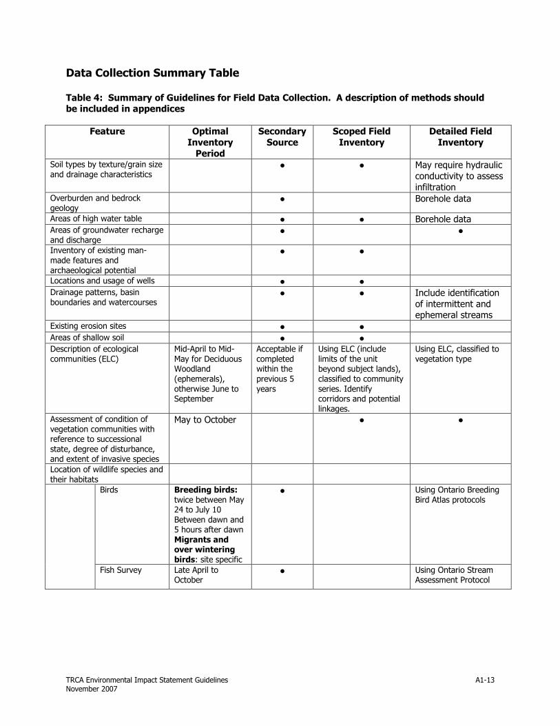
TRCA Environmental Impact Statement Guidelines November 2007
A1-13
Data Collection Summary Table Table 4: Summary of Guidelines for Field Data Collection. A description of methods should be included in appendices
Feature Optimal
Inventory
Period
Secondary
Source
Scoped Field
Inventory
Detailed Field
Inventory
Soil types by texture/grain size
and drainage characteristics ● ● May require hydraulic
conductivity to assess
infiltration Overburden and bedrock
geology ● Borehole data
Areas of high water table ● ● Borehole data Areas of groundwater recharge
and discharge ● ●
Inventory of existing man-
made features and
archaeological potential
● ●
Locations and usage of wells ● ● Drainage patterns, basin
boundaries and watercourses ● ● Include identification
of intermittent and ephemeral streams
Existing erosion sites ● ● Areas of shallow soil ● ● Description of ecological
communities (ELC)
Mid-April to Mid-
May for Deciduous Woodland
(ephemerals),
otherwise June to September
Acceptable if
completed within the
previous 5
years
Using ELC (include
limits of the unit beyond subject lands),
classified to community
series. Identify corridors and potential
linkages.
Using ELC, classified to
vegetation type
Assessment of condition of
vegetation communities with reference to successional
state, degree of disturbance, and extent of invasive species
May to October ● ●
Location of wildlife species and
their habitats
Birds Breeding birds:
twice between May 24 to July 10
Between dawn and 5 hours after dawn
Migrants and over wintering
birds: site specific
● Using Ontario Breeding
Bird Atlas protocols
Fish Survey Late April to October
● Using Ontario Stream Assessment Protocol

TRCA Environmental Impact Statement Guidelines November 2007
A1-14
Fish habitat In snow/ice-free
conditions ● Observations
(mapping) should include the following:
flow, channel form, riparian characteristics,
anthropogenic and other disturbances,
enhancement opportunities,
substrate, instream habitat features and
structures.
Using Ontario Stream
Assessment Protocol, if applicable.
Benthos Spring or fall ● Using Ontario Stream
Assessment Protocol,
Ontario Benthos Biomonitoring Network
Protocol
Mussels July to September,
min. 2 days without rain
● Qualitative and
Quantitative (using Strayer and Smith,
2003)
Mammals Species dependent ● Sightings and tracking
Flora Site specific: Spring
ephemerals– mid-April to mid-May;
Woodland Sedges- mid-May to early
July; forbs-June to October
● Botanical inventory
Amphibians Early spring –
summer (species dependent)
● Marsh Monitoring
Protocol
Reptiles April – June ● ● Location of subject lands in relation to components of the
Natural Heritage System
● ●
Locally, Regionally, and
Provincially significant areas ● ●
Ecologically functional natural linkages and potential linkages
● ●
Other natural features and functions (migration routes,
deer yards, snake hibernacula etc)
● ●
Other development
applications known to be in progress in the area that
would affect the natural heritage
● ●

TRCA Environmental Impact Statement Guidelines November 2007
B1
APPENDIX B
� TRCA Post-Construction Restoration Guidelines
� TRCA Stormwater Management Pond Planting Guidelines
� TRCA Seed Mix Guidelines � TRCA Forest Edge Management Plan Guidelines
� Sediment and Erosion Control Guidelines for Urban Construction

TRCA Environmental Impact Statement Guidelines November 2007
B1-1
TRCA POST-CONSTRUCTION RESTORATION GUIDELINES
INSERT TRCA POST-CONSTRUCTION
RESTORATION GUIDELINES

TRCA Environmental Impact Statement Guidelines November 2007
B2-1
TRCA STORMWATER MANAGEMENT POND PLANTING GUIDELINES
INSERT TRCA Stormwater Management Pond Planting Guidelines

TRCA Environmental Impact Statement Guidelines November 2007
B3-1
TRCA SEED MIX GUIDELINES
INSERT TRCA SEED MIX GUIDELINES
TRCA Environmental Impact Statement Guidelines November 2007
B4-1
TRCA FOREST EDGE MANAGEMENT PLAN GUIDELINES
INSERT TRCA FOREST EDGE MANAGEMENT PLAN GUILDEINES

TRCA Environmental Impact Statement Guidelines November 2007
B5-1
EROSION AND SEDIMENT CONTROL GUIDELINE FOR URBAN CONSTRUCTION
INSERT EROSION AND SEDIMENT CONTROL GUIDELINE
FOR URBAN CONSTRUCTION