TRANSPORTATION STATUS QUO TECHNICAL … Status Quo: Technical Node Revised 14 August 2015 for:...
23
TRANSPORTATION STATUS QUO TECHNICAL NOTE: KWAMASHU A (TEMBALILHE & DUFFS ROAD)
Transcript of TRANSPORTATION STATUS QUO TECHNICAL … Status Quo: Technical Node Revised 14 August 2015 for:...

TRANSPORTATION
STATUS QUO TECHNICAL NOTE:
KWAMASHU A (TEMBALILHE & DUFFS ROAD)

Royal HaskoningDHV (14 August 2015)
ii
This report represents a working draft report for the:
Transportation Status Quo:
Technical Node
Revised 14 August 2015 for:
eThekwini Municipality
By:
Royal HaskoningDHV (PTY) Ltd

Royal HaskoningDHV (14 August 2015)
iii
1 INTRODUCTION ................................................................................................. 1
1.1 STUDY AREA ................................................................................................................. 1 1.2 OBJECTIVE ................................................................................................................... 1 1.3 METHODOLOGY ........................................................................................................... 1
2 GENERAL ACCESS ............................................................................................ 2
3 NON- MOTORISED TRAFFIC ............................................................................. 3
3.1 EXTERNAL ROAD NETWORK ............................................................................................ 3 3.2 INTERNAL ROAD NETWORK ............................................................................................. 3
4 MOTORISED TRAFFIC ........................................................................................ 4
4.1 PUBLIC TRANSPORT ........................................................................................................ 4 4.2 PRIVATE VEHICLES ......................................................................................................... 6
5 ACCIDENT STATISTICS ....................................................................................... 9
5.1 MAJOR ROADS ............................................................................................................ 9
6 IMPORTANT FINDINGS AND IMPLICATIONS ................................................ 10
6.1 FUTURE PUBLIC TRANSPORT PLANNING FOR THE AREA ..................................................... 10 6.2 KEY ISSUES .................................................................................................................. 11 6.3 OPPORTUNITIES ........................................................................................................... 12 6.4 INFORMATION GAPS ................................................................................................... 12
7 CONCLUSION .................................................................................................. 13
8 APPENDICES .................................................................................................... 13
APPENDIX A: STUDY AREA .................................................................................... 14
APPENDIX B: PROPOSED BRT LAYOUT AND STOPS ........................................... 15
APPENDIX C: DUFF’S STATION UPGRADE LAYOUT & PROPOSED FEEDER .... 17
APPENDIX D: TRAFFIC COUNTS ........................................................................... 20
FIGURE 1.1: KWAMASHU STUDY AREA LOCALITY PLAN ................................................................. 1
FIGURE 2.1: VEHICULAR AND PEDESTRIAN ACCESSES TO KWAMASHU STUDY AREA ............................ 2
FIGURE 3.1: KWAMASHU STUDY AREA SUBSECTIONS ................................................................... 3
FIGURE 4.1: LOCATION OF TEMBALIHLE AND DUFF'S ROAD STATION ................................................ 4
FIGURE 4.2: COMPARISON OF RAIL PASSENGERS FOR STATIONS NORTH OF THE UMGENI RIVER .............. 4
FIGURE 4.3: NORTH DURBAN RAIL NETWORK ............................................................................. 5
FIGURE 4.4: VEHICLE ACCESSES ................................................................................................ 6
FIGURE 4.5: ROAD NETWORK COMPARISON (KWAMASHU A AND KWAMASHU B) ............................ 6
FIGURE 4.6: LINKAGES BETWEEN NEIGHBOURHOODS ..................................................................... 7
FIGURE 4.7: ROAD NETWORK LAYOUT ....................................................................................... 7
FIGURE 4.8: THROUGH VOLUMES WITHIN STUDY AREA .................................................................. 8
FIGURE 6.1: C1 AND C3 ROUTES ............................................................................................ 10
FIGURE 6.2: LOCATION OF BRT STOPS ..................................................................................... 10
FIGURE 6.3: DUFF'S ROAD STATION UPGRADE ........................................................................... 11
FIGURE 6.4: DUFF'S ROAD STATION UPGRADE CONCEPT PLANS .................................................... 11
FIGURE 6.5: LAND USE FOR KWAMASHU STUDY AREA ................................................................. 11
FIGURE 6.6: TRANSIT ORIENTATED DESIGN TOWARD PUBLIC TRANSPORT NODES ............................. 12
TABLE 4.1: : TEMBALIHLE AND DUFF'S ROAD STATION PASSENGER VOLUMES .................................... 4
TABLE 4.2: RAIL STATION CHARACTERISTICS ................................................................................ 5
TABLE 4.3: 12 HOUR TRAFFIC COUNTS AT INTERSECTIONS .............................................................. 8
TABLE 5.1: ACCIDENT STATISTICS FOR THE PERIOD 2012 - 2014 ..................................................... 9

Royal HaskoningDHV (14 August 2015)
1
1 Introduction
1.1 Study Area
Royal HaskoningDHV has been appointed to undertake the KwaMashu
Regeneration plan. This project involves the identification and prioritisation of the
role of infrastructure, facilities and land use planning in assisting and supporting
the community in its upliftment efforts.
The main national route providing access to the study area is the N2. The site can
also be accessed from the R102 to the east and Inanda Road to the west.
Figure 1.1: KwaMashu Study Area Locality Plan
The study area is directly accessed by four major roads; Malandela Road to the
north, the MR577 to the south, KwaMashu Highway to the east and Queen Nandi
Drive to the west. A study area plan layout can be found in Appendix A of this
report.
The study area is ideally situated in terms of close proximity to economic and
industrial hubs such as the Phoenix Industrial, Umgeni Business Park and Springfield.
1.2 Objective
The objective of this report is to present the traffic and transportation status quo
for the KwaMashu study area, as well as committed traffic and transportation
projects for the area. SA
1.3 Methodology
Information was gathered via the following:
1) Interviews
Engagement with eThekwini Municipality (eThekwini Transport Authority)
o Consultation with Senior Managers Mr. Robin Chetty and Mr. Manoj
Rampersad
o Consultation with Mr. Carlos Esteves regarding traffic and
infrastructure aspects of the proposed BRT
Engagement with PRASA
o Consultation with Sonitha Pooran and team regarding the PRASA rail
station upgrades
2) Document Reviews
Northern Public Transport and Land Use Corridor Study: Consolidated
Report (Phases 1-6)
IRPTN conceptual plans of BRT stations
Feeder networks for Bus Rapid Transport ( BRT)
eThekwini Municipality IRPTN wall – to – wall Plan
Traffic counts from eThekwini Municipality
Accident statistics from eThekwini Municipality

Royal HaskoningDHV (14 August 2015)
2
2 General Access
The main national route providing access to the
study area is the N2. The site can also be accessed
from the R102 to the east and Inanda Road to the
west.
The study area is directly accessed by four major
roads; Malandela Road to the north, the MR577 to
the south, KwaMashu Highway to the east and
Queen Nandi Drive to the west.
A layout of the study area showing the major roads
can be found in Appendix A of this report.
There are only four vehicular accesses to the study
area. These are found at the intersection of:
Queen Nandi Drive/ Amamzimtoti Drive
Malandela Road/ Musa Road
MR577/ Lark Road
The Umbundo Road overpass
There are three pedestrian bridges across the rail
lines as well as one across the MR577. The two rail
stations found within the area are the Tembalihle
and Duff’s Road stations.
Figure 2.1: Vehicular and Pedestrian Accesses to KwaMashu Study Area
Royal HaskoningDHV (14 August 2015)
3
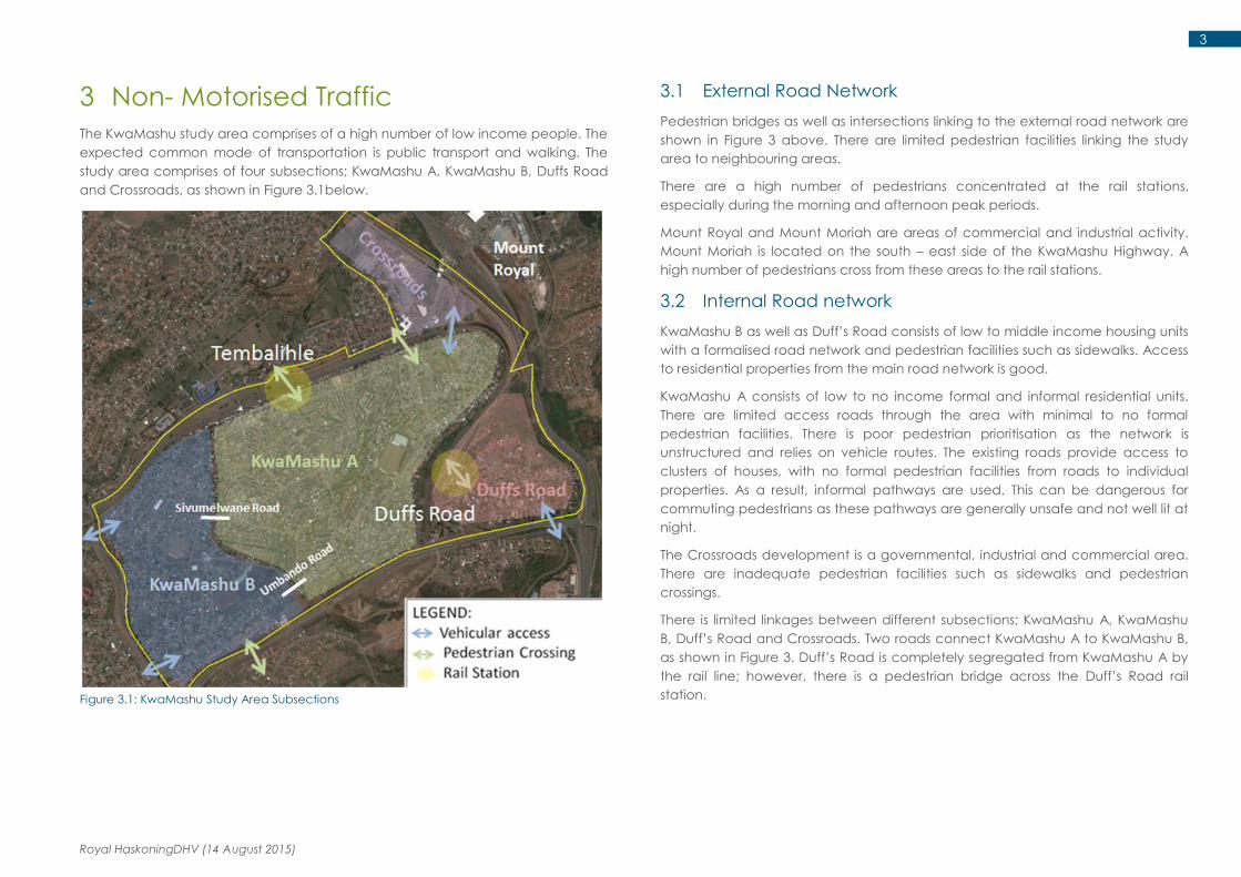
3 Non- Motorised Traffic
The KwaMashu study area comprises of a high number of low income people. The
expected common mode of transportation is public transport and walking. The
study area comprises of four subsections; KwaMashu A, KwaMashu B, Duffs Road
and Crossroads, as shown in Figure 3.1below.
Figure 3.1: KwaMashu Study Area Subsections
3.1 External Road Network
Pedestrian bridges as well as intersections linking to the external road network are
shown in Figure 3 above. There are limited pedestrian facilities linking the study
area to neighbouring areas.
There are a high number of pedestrians concentrated at the rail stations,
especially during the morning and afternoon peak periods.
Mount Royal and Mount Moriah are areas of commercial and industrial activity.
Mount Moriah is located on the south – east side of the KwaMashu Highway. A
high number of pedestrians cross from these areas to the rail stations.
3.2 Internal Road network
KwaMashu B as well as Duff’s Road consists of low to middle income housing units
with a formalised road network and pedestrian facilities such as sidewalks. Access
to residential properties from the main road network is good.
KwaMashu A consists of low to no income formal and informal residential units.
There are limited access roads through the area with minimal to no formal
pedestrian facilities. There is poor pedestrian prioritisation as the network is
unstructured and relies on vehicle routes. The existing roads provide access to
clusters of houses, with no formal pedestrian facilities from roads to individual
properties. As a result, informal pathways are used. This can be dangerous for
commuting pedestrians as these pathways are generally unsafe and not well lit at
night.
The Crossroads development is a governmental, industrial and commercial area.
There are inadequate pedestrian facilities such as sidewalks and pedestrian
crossings.
There is limited linkages between different subsections; KwaMashu A, KwaMashu
B, Duff’s Road and Crossroads. Two roads connect KwaMashu A to KwaMashu B,
as shown in Figure 3. Duff’s Road is completely segregated from KwaMashu A by
the rail line; however, there is a pedestrian bridge across the Duff’s Road rail
station.

Royal HaskoningDHV (14 August 2015)
4
4 Motorised Traffic
4.1 Public Transport
4.1.1 Rail
The passenger rail line in eThekwini expands from Umlazi – Durban – KwaMashu.
There are two rail stations located within the KwaMashu study area: The Duff’s
Road and Tembalihle Stations as shown in the figure below. Within the morning
peak, a train stops approximately every hour at the stations, travelling from
KwaMashu to Durban. Within the afternoon peak, a train arrives at the stations
around every 20 minutes, originating from the Durban CBD and areas of Durban.
Figure 4.1: Location of Tembalihle and Duff's Road Station
The daily passenger volumes using these stations in both directions are shown in
Table 4.1 below.
Table 4.1: : Tembalihle and Duff's Road Station Passenger Volumes1
Station Passenger Volumes
(in both directions)
Tembalihle 16 590
Duffs Road 31 210
It can be seen from these values that the Duff’s Road station caters for almost
twice the volumes of the Tembalihle Station.
According to PRASA statistics, an additional 10 – 20% of these volumes contribute
to pedestrian walk throughs, as there are pedestrian bridges across the rail
stations.
The figure below presents a comparison of the number of rail passengers for rail
stations north of the Umgeni River. The Duff’s Road and Tembalihle Stations have
the highest number of passengers on a weekday. The utilisation of these stations is
high and should be taken into consideration in the planning of pedestrian
facilities.
Figure 4.2: Comparison of rail passengers for stations north of the Umgeni River2
1 Iyer - Northern Public Transport and Land Use Corridor Study: Consolidated Report (Phases 1-6)
2 PRASA (2006) - Rail Capacity Study and PRASA (2008) - Rail Census
Royal HaskoningDHV (14 August 2015)
5
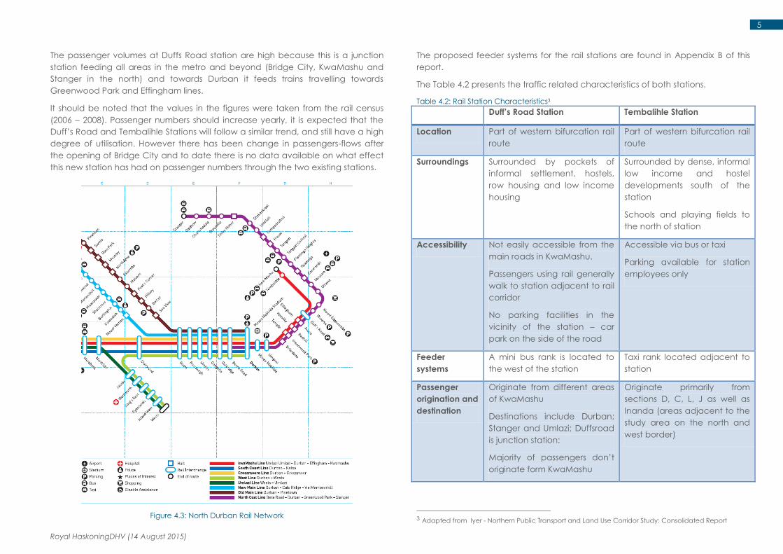
The passenger volumes at Duffs Road station are high because this is a junction
station feeding all areas in the metro and beyond (Bridge City, KwaMashu and
Stanger in the north) and towards Durban it feeds trains travelling towards
Greenwood Park and Effingham lines.
It should be noted that the values in the figures were taken from the rail census
(2006 – 2008). Passenger numbers should increase yearly, it is expected that the
Duff’s Road and Tembalihle Stations will follow a similar trend, and still have a high
degree of utilisation. However there has been change in passengers-flows after
the opening of Bridge City and to date there is no data available on what effect
this new station has had on passenger numbers through the two existing stations.
Figure 4.3: North Durban Rail Network
The proposed feeder systems for the rail stations are found in Appendix B of this
report.
The Table 4.2 presents the traffic related characteristics of both stations.
Table 4.2: Rail Station Characteristics3
Duff’s Road Station Tembalihle Station
Location Part of western bifurcation rail
route
Part of western bifurcation rail
route
Surroundings Surrounded by pockets of
informal settlement, hostels,
row housing and low income
housing
Surrounded by dense, informal
low income and hostel
developments south of the
station
Schools and playing fields to
the north of station
Accessibility Not easily accessible from the
main roads in KwaMashu.
Passengers using rail generally
walk to station adjacent to rail
corridor
No parking facilities in the
vicinity of the station – car
park on the side of the road
Accessible via bus or taxi
Parking available for station
employees only
Feeder
systems
A mini bus rank is located to
the west of the station
Taxi rank located adjacent to
station
Passenger
origination and
destination
Originate from different areas
of KwaMashu
Destinations include Durban;
Stanger and Umlazi; Duffsroad
is junction station:
Majority of passengers don’t
originate form KwaMashu
Originate primarily from
sections D, C, L, J as well as
Inanda (areas adjacent to the
study area on the north and
west border)
3 Adapted from Iyer - Northern Public Transport and Land Use Corridor Study: Consolidated Report

Royal HaskoningDHV (14 August 2015)
6
4.1.2 Taxis and Buses
The taxi and bus networks for the area are currently not clearly defined. There are
taxi ranks located adjacent to the rail stations as well as a formalised taxi rank at
Crossroads.
There are also lay-byes on the MR577 as well as Malandela Road.
Information on the services is currently not available from the relevant Transport
Authority.
4.2 Private Vehicles
The study area is bordered by four major roads; Malandela Road to the north, the
MR577 to the south, KwaMashu Highway to the east and Queen Nandi Drive to
the west as shown in the figure below.
In terms of vehicular access, there are four accesses into the study area. These
are located at the intersection of:
1) Queen Nandi Drive/ Amamzimtoti Drive
2) Malandela Road/ Musa Road
3) MR577/ Lark Road
4) The Umbundo Road overpass
Figure 4.4: Vehicle Accesses
4.2.1 External Road Network
Linkages to the external neighbouring communities are limited. The KwaMashu B
area has one vehicular access to Queen Nandi Drive, as well as access to areas
of KwaMashu D via the Umbundo Road overpass.
The Duff’s Road area has only one vehicular access, found on the intersection of
Lark Road and the MR577.
Crossroads is well located in terms of access to the KwaMashu Highway/
Malandela Road interchange.
4.2.2 Internal Road network
The subsections of KwaMashu have different characteristics with regard to a road
network and vehicle circulation.
KwaMashu B and Duff’s Road have a more developed road network in terms of
ease of access to individual residential properties. There is a defined road network
with adequate circulation through the area.
KwaMashu A has few roads within the area. The roads provide access to clusters
of housing units and not individual properties. Informal pedestrian paths have
been created because of this. These paths are generally unsafe as they are not
well lit at night.
A section of KwaMashu A as well as a section from KwaMashu B is shown below.
Figure 4.5: Road Network Comparison (KwaMashu A and KwaMashu B)
Royal HaskoningDHV (14 August 2015)
7
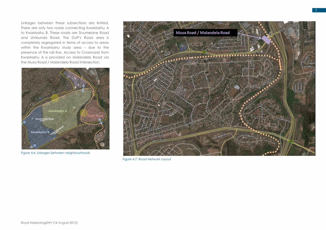
Linkages between these subsections are limited.
There are only two roads connecting KwaMashu A
to KwaMashu B. These roads are Sivumelane Road
and Umbundo Road. The Duff’s Road area is
completely segregated in terms of access to areas
within the KwaMashu study area – due to the
presence of the rail line. Access to Crossroads from
KwaMashu A is provided on Malandela Road via
the Musa Road / Malandela Road intersection.
Figure 4.6: Linkages between neighbourhoods
Figure 4.7: Road Network Layout
Royal HaskoningDHV (14 August 2015)
8
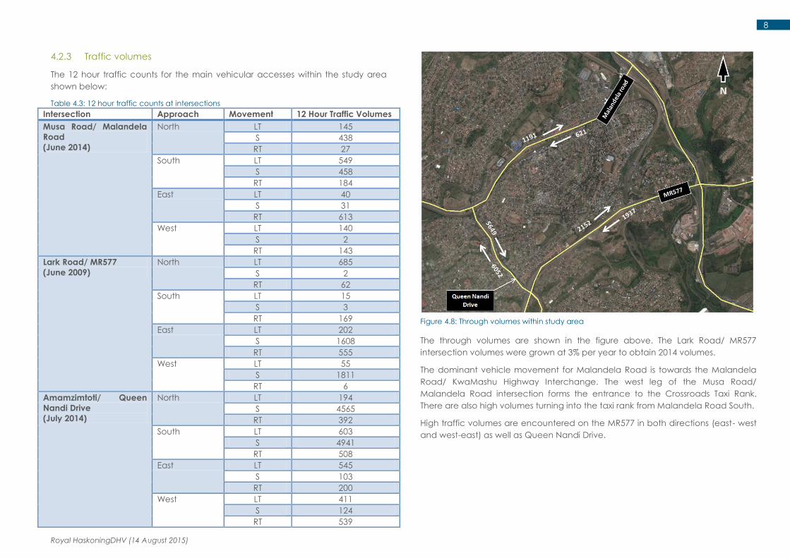
4.2.3 Traffic volumes
The 12 hour traffic counts for the main vehicular accesses within the study area
shown below:
Table 4.3: 12 hour traffic counts at intersections
Intersection Approach Movement 12 Hour Traffic Volumes
Musa Road/ Malandela
Road
(June 2014)
North LT 145
S 438
RT 27
South LT 549
S 458
RT 184
East LT 40
S 31
RT 613
West LT 140
S 2
RT 143
Lark Road/ MR577
(June 2009)
North LT 685
S 2
RT 62
South LT 15
S 3
RT 169
East LT 202
S 1608
RT 555
West LT 55
S 1811
RT 6
Amamzimtoti/ Queen
Nandi Drive
(July 2014)
North LT 194
S 4565
RT 392
South LT 603
S 4941
RT 508
East LT 545
S 103
RT 200
West LT 411
S 124
RT 539
Figure 4.8: Through volumes within study area
The through volumes are shown in the figure above. The Lark Road/ MR577
intersection volumes were grown at 3% per year to obtain 2014 volumes.
The dominant vehicle movement for Malandela Road is towards the Malandela
Road/ KwaMashu Highway Interchange. The west leg of the Musa Road/
Malandela Road intersection forms the entrance to the Crossroads Taxi Rank.
There are also high volumes turning into the taxi rank from Malandela Road South.
High traffic volumes are encountered on the MR577 in both directions (east- west
and west-east) as well as Queen Nandi Drive.

Royal HaskoningDHV (14 August 2015)
9
5 Accident Statistics
The accident statistics for the three year period 2012 – 2014 is shown below:
Table 5.1: Accident statistics for the period 2012 - 2014
5.1 Major Roads
There seems to be no upward trend in terms of the number of accidents occurring on these major roads within our study area.
Same direction accidents were found to be the most common accident type occurring on these roads, especially at signalised intersections. These consist mostly of rear
end accidents at stops.
Most vehicle/pedestrian accidents were found to most occur at the following intersections:
Queen Nandi/ MR577
Queen Nandi Drive/ Malandela Road
Queen Nandi Drive/ Amamzimtoti Drive
There is currently no information available on accident statistics within the area.

Royal HaskoningDHV (14 August 2015)
10
6 Important Findings and Implications
6.1 Future Public Transport Planning for the Area
The eThekwini Municipality IRPTN has various public transport initiatives for the
area. Part of the IRPTN pertaining to the study area consists of the proposed Bus
Rapid Transport (BRT) and PRASA Station Modernisation Upgrades.
6.1.1 BRT
The BRT for this area will include two corridors, the C1 and C3 corridors. The C1
corridor will extend between the Durban CBD to Bridge City while the C1 corridor
will extend between Pinetown to Bridge City, as shown in the figure below.
According to the eThekwini Transport Authority, the C3 corridor will be developed
and operational in the short term will the C1 corridor is to be developed in the
longer term.
Figure 6.1: C1 and C3 Routes
For our proposed study area, the BRT stops are to be located at the intersection
of:
Queen Nandi Drive/ MR577
MR577/ Avoca Hills Drive
Malandela Road/ KwaMashu Highway
Figure 6.2: Location of BRT Stops
The BRT lanes will be in the middle of the roadway, in two separate lanes, with a
central raised pedestrian platform at the stops. Currently, we have typical layout
plan of a BRT stop – we will acquire stop specific layouts upon meeting with the
eThekwini Transport Authority.
The proposed BRT feeder system layouts can be found in Appendix B of this
technical note.

Royal HaskoningDHV (14 August 2015)
11
6.1.2 PRASA Station Modernisation Upgrades
The PRASA modernisation plan consists of the upgrade of station infrastructure as
well as upgrades to the informal trader stalls surrounding these areas.
Duff’s Road station is part of Phase One of the upgrade and is already under
construction. The Tembalihle station is part of Phase Two – within the next 2 years.
The Duff’s Road station upgrade layout is shown in Figure 6.3 and Figure 6.4 below
as well as in Appendix C.
Figure 6.3: Duff's Road Station Upgrade
Figure 6.4: Duff's Road Station Upgrade Concept Plans
6.2 Key Issues
The Mount Royal and Mount Moriah areas are industrial and economic hubs
within this region, as well as a residential area. As a result, there are high numbers
of pedestrians crossing on the railway line between Mount Royal and Mount
Moriah and the rail stations. The KwaMashu Highway separates KwaMashu from
these two areas.
The Duff’s Road residential area is completely segregated in terms of vehicular
access to KwaMashu A and the western areas because of the rail line. The only
vehicular access lies at the intersection of the MR577 and Lark Road.
Pedestrian links to the main access routes as well as hubs of social and economic
activity should be prioritised. Integration with the external communities should be
encouraged. The study area should have a clearly defined modal hierarchy, in
which pedestrians are prioritised. The Figure below shows the areas of economic
and social activity. Pedestrian links to these areas, as well as any proposed new
developments, are important.
Figure 6.5: Land use for KwaMashu Study area
Royal HaskoningDHV (14 August 2015)
12
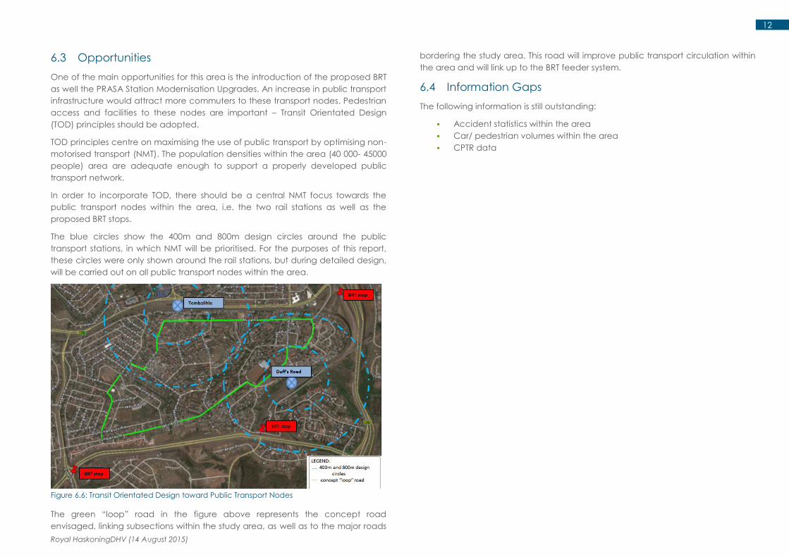
6.3 Opportunities
One of the main opportunities for this area is the introduction of the proposed BRT
as well the PRASA Station Modernisation Upgrades. An increase in public transport
infrastructure would attract more commuters to these transport nodes. Pedestrian
access and facilities to these nodes are important – Transit Orientated Design
(TOD) principles should be adopted.
TOD principles centre on maximising the use of public transport by optimising non-
motorised transport (NMT). The population densities within the area (40 000- 45000
people) area are adequate enough to support a properly developed public
transport network.
In order to incorporate TOD, there should be a central NMT focus towards the
public transport nodes within the area, i.e. the two rail stations as well as the
proposed BRT stops.
The blue circles show the 400m and 800m design circles around the public
transport stations, in which NMT will be prioritised. For the purposes of this report,
these circles were only shown around the rail stations, but during detailed design,
will be carried out on all public transport nodes within the area.
Figure 6.6: Transit Orientated Design toward Public Transport Nodes
The green “loop” road in the figure above represents the concept road
envisaged, linking subsections within the study area, as well as to the major roads
bordering the study area. This road will improve public transport circulation within
the area and will link up to the BRT feeder system.
6.4 Information Gaps
The following information is still outstanding:
Accident statistics within the area
Car/ pedestrian volumes within the area
CPTR data

Royal HaskoningDHV (14 August 2015)
13
7 Conclusion
The following conclusions were drawn from the study:
KwaMashu B, Duff’s Road and Crossroads have adequate infrastructure
with regards to the provision of pedestrian facilities as well as a suitable
road network and circulation.
Pedestrian movement within the KwaMashu A area is limited in terms of
proper pedestrian pathways and facilities to the areas of economic and
social activity, as well as to individual residential properties. Informal
pathways are used.
Vehicular access to KwaMashu A is inadequate. KwaMashu A has few
roads within the area. The roads provide access to clusters of housing
units and not individual properties.
There are currently undefined feeder systems within the study area ( Taxi
and bus)
The rail stations as well as the proposed BRT situated within the study area
are important public transport nodes for the residents of KwaMashu and
should be a focus when considering the detail design for the area. Transit
orientated design is a key prioritisation for this.
8 Appendices
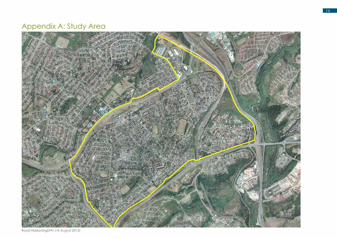
Appendix A: Study Area
Appendix B: Proposed BRT Layout and Stops
Appendix C: Duff’s Road Station Upgrade Layout And Proposed Feeders
Appendix D: Traffic Counts
Royal HaskoningDHV (14 August 2015)
14
Appendix A: Study Area

Royal HaskoningDHV (14 August 2015)
15
Appendix B: Proposed BRT Layout and Stops

Royal HaskoningDHV (14 August 2015)
16

Royal HaskoningDHV (14 August 2015)
17
Appendix C: Duff’s Station Upgrade Layout & Proposed Feeder

Royal HaskoningDHV (14 August 2015)
18

Royal HaskoningDHV (14 August 2015)
19

Royal HaskoningDHV (14 August 2015)
20
Appendix D: Traffic Counts