Transport for London - WordPress.com · 2012-01-07 · Transport for London PERS and CSA 07/08...
122
Transport for London PERS and CSA 07/08 Category A Station Audits King’s Cross and St. Pancras Stations TRL REF: UPR/T/029/08 Final Report Date: 12 th March 2008 TRL Lead Reporters: Ko Sakamoto, Shaneen Khambata and Ellie Gould Living Streets Lead Reporter: Jeremy Leach
Transcript of Transport for London - WordPress.com · 2012-01-07 · Transport for London PERS and CSA 07/08...

Transport for London PERS and CSA 07/08 Category A Station Audits
King’s Cross and St. Pancras Stations TRL REF: UPR/T/029/08
Final Report
Date: 12th March 2008 TRL Lead Reporters: Ko Sakamoto, Shaneen Khambata and Ellie Gould Living Streets Lead Reporter: Jeremy Leach

TRL Limited Living Streets
PERS AND CSA AUDITS 07/08 CATEGORY A STATION AUDITS TFL: King’s Cross and St. Pancras Stations Version: Final Report
TRL Lead Reporters: Ko Sakamoto, Shaneen Khambata and Ellie Gould Living Streets Lead Reporter: Jeremy Leach Prepared for: Transport for London Client: Julie Dye and Spencer Clark
Copyright TRL Limited, March 2008 This report has been prepared for Transport for London. The views expressed are those of the author(s) and not necessarily those of Transport for London. Unpublished Project Reports are written primarily for the Customer rather than for a general audience and are published with the Customer’s approval.
Approvals
Project Manager
Quality Reviewed

This report has been produced by TRL Limited and Living Streets, under/as part of a Contract placed by Transport for London. Any views expressed are not necessarily those of Transport for London.
TRL is committed to optimising energy efficiency, reducing waste and promoting recycling and re-use. In support of these environmental goals, this report has been printed on recycled paper, comprising 100% post-consumer waste, manufactured using a TCF (totally chlorine free) process.
Please note that the comments in this report reflect the auditor’s comments at the time of the audit. Significant redevelopment work being undertaken around the station area may mean some of the points noted by auditors and CSA participants may no longer be relevant.

CONTENTS
1 Introduction 2
1.1 Audit Procedure 2 1.2 King’s Cross and St. Pancras Stations 3
2 Methodology 6
2.1 Introduction 6 2.2 PERS audit 6 2.3 Community Street Audit 8
3 Background Information 9
3.1 Introduction 9 3.2 Pedestrian Collision Statistics 9 3.3 Crime Data 10 3.4 Land Use Data 11
4 PERS and CSA Audits 13
4.1 Introduction 13 4.2 General observations 14 4.3 Links 15
4.3.1 PERS overall scores 15 4.3.2 CSA priorities 15 4.3.3 PERS/CSA joint findings 16 4.3.4 Link parameter assessment 21 4.3.5 Summary: Priority links 24
4.4 Crossings 25 4.4.1 PERS overall scores 25 4.4.2 CSA priority crossings 25 4.4.3 PERS/CSA joint findings 26 4.4.4 Crossing parameter assessment 34 4.4.5 Summary: Priority crossings 38
4.5 Routes 39 4.5.1 PERS overall scores 39 4.5.2 CSA priority routes 39 4.5.3 PERS / CSA Joint Findings 40 4.5.4 Routes parameter assessment 43 4.5.5 Summary: Priority routes 46
4.6 Waiting Areas and Spaces 47 4.6.1 PERS overall scores 47 4.6.2 CSA priority waiting areas and spaces 48 4.6.3 PERS/CSA joint findings 48 4.6.4 Waiting area and spaces parameter scores 55 4.6.5 Summary: Priority waiting areas and spaces 59
5 Audit Summary 60
6 Conclusions and Recommendations 65
6.1 Conclusions 65 6.2 Overview of Recommendations 65 6.3 Specific Recommendations 67
7 Acknowledgements 76
Appendix A: Component assessments 77
A.1 Links 77 A.2 Crossings 90 A.3 Routes 103 A.4 Waiting areas and spaces 105
Appendix B: CSA Stakeholder List 114
Appendix C: Reference codes for all audit components 115

King’s Cross and St. Pancras Stations PERS AND CSA Audit Final Report
March 2008 1
Key Findings General impressions
• King’s Cross and St. Pancras Stations are heavily used by those transferring between the two stations and to local transport services.
• The highly-trafficked Euston Road and Pentonville Road run immediately south of the stations, causing heavy noise, pollution and community severance.
• Environmental quality of the area diminishes along Euston Road and Gray’s Inn Road, due to the heavy traffic and vacant commercial property.
• The area is undergoing extensive re-development. Construction work impacts on pedestrian movement and the quality of the environment.
• A number of informal crossing movements are observed, including some across the highly dangerous Euston Road and the roads running alongside the stations.
• Signage between the stations or to some nearby facilities is not clear, partially due to the continued redevelopment of the area.
• A shortage of public spaces is observed in the area surrounding the stations.
Key audit findings
• The pedestrian environment was found to be generally poor in both the PERS audit and CSA, highlighting specific and general deficiencies in terms of pedestrian provision.
• The links surrounding the stations are often found to be of limited effective width, creating congested conditions and conflicts amongst users.
• Crossing provision is found to be inadequate across the audit area, often resulting in informal crossings being made across heavily trafficked roads.
• Provision for sensory and mobility impaired users is lacking at key strategic locations, including some crossings across the busy Euston Road and those across the vehicle access roads around St. Pancras Station.
• Environmental quality and personal security are often compromised by inadequate lighting, heavy vehicle noise and pollution, as well as neglected private and commercial properties.
• The pedestrian experience is further compromised by the sheer dominance and impact of road traffic owing to its speed and the number of lanes it occupies.
• Wayfinding is made difficult by the low profile of King’s Cross Station, the lack of signs to key attractors, construction work surrounding the two stations, and outdated information of the area on maps and signs.
Headline recommendations
• Increase the effective width of links by reallocating carriageway space to the footpath wherever appropriate, and by removing/realigning obstructions.
• Enhance the permeability and safety of the main roads around the station by providing formal crossings at all necessary locations.
• Provide dropped kerbs and correct information for mobility and sensory impaired users at all crossings, especially around St. Pancras Station and Euston Road.
• Improve road safety around the station by introducing traffic calming measures. • Provide signage to all major attractors in the area. Enhance the visibility of King’s
Cross Station from all directions. • Minimise the effect of the ongoing construction work by ensuring that footpaths
and crossings are kept clear. Provide temporary signage at visible locations, particularly for those transferring between the two stations.

King’s Cross and St. Pancras Stations PERS AND CSA Audit Final Report
March 2008 2
1 Introduction This report describes the results from the TRL PERS (Pedestrian Environment Review System) audit and Living Streets CSA (Community Street Audit) of King’s Cross and St. Pancras Stations.
1.1 Audit Procedure TRL PERS Audit A PERS review is based upon the following two key principles:
• That the quality of the pedestrian environment may be evaluated according to the degree to which it meets pedestrians’ needs.
• That in evaluating the degree to which pedestrians’ needs are met by the environment, the objective should be to satisfy as many people as possible, with the ‘standard’ pedestrian being considered to be towards the vulnerable end of the spectrum.
PERS recognises the needs of pedestrians in both undertaking a journey on foot and as people using spaces in the public realm for leisure and non-transport based activities. In a PERS audit, the auditor is required to consider the extent to which the environment under consideration provides easy, convenient and pleasant conditions for all users. The overall aim in applying PERS is to seek to provide an optimal pedestrian environment for all users. Living Streets Community Street Audit A Living Streets Community Street Audit looks at public space through the eyes of place users rather than place managers. By harnessing the views of local users, the audit seeks to establish how people on foot feel about the space they use, their likes and dislikes, their priorities for improvement and the problems they face in going about their everyday life. Auditors are encouraged to share their experiences of the area at differing times of the day and year, and to take into account the needs of all space users. Chapter 2 briefly describes the standard methodologies for applying a PERS and CSA to an audit area.

King’s Cross and St. Pancras Stations PERS AND CSA Audit Final Report
March 2008 3
1.2 King’s Cross and St. Pancras Stations King’s Cross and St. Pancras are two major railway termini located north of London’s main business district. The two stations are separated only by Pancras Road, and effectively act as one large interchange. The stations are served by trains to various parts of the country, including the Midlands and the North. Since November 2007, Eurostar services to Paris and Brussels also operate from St. Pancras Station, following a major refurbishment of the station building. The area around the two stations is heavily used by commuters and tourists transferring between them, as well as by those changing between various transport modes (e.g. buses, taxis and underground). Land use surrounding the two stations is diverse, ranging from retail space along Euston Road and Pentonville Road, office space towards the east of King’s Cross Station and residential areas around the quieter streets further away from the stations. Redevelopment continues to take place on the two stations and the surrounding areas, with plans in place for the opening of a large hotel, expansion of retail space and a new layout for the area in between the two stations. Roads around the station are heavily trafficked. Euston Road and Pentonville Road in particular are a large source of noise, air pollution and traffic accidents. Roads adjacent the stations, including York Way, Pancras Road and Midland Road are characterised by cars, taxis and buses picking up and dropping off passengers. Lane changing behaviour is also prominent at these locations. A number of major trip attractors are found in the vicinity, including the British Library, the Royal National Throat, Nose and Ear Hospital, and the Eastman Dental Hospital. A map of the PERS audit area described in this report is shown in Figure 1.1. This is followed by a RAG map of the scores from the PERS audit and a priority map from the CSA in Figures 1.2 and 1.3 respectively.

King’s Cross and St. Pancras Stations PERS AND CSA Audit Final Report
March 2008 4
Ordnance Survey © Crown copyright 2007. All rights reserved. Licence No. AL100021177
Figure 1.1: King’s Cross/St. Pancras Station area outline
Ordnance Survey © Crown copyright 2007. All rights reserved. Licence No. AL100021177
Figure 1.2: All audit components with PERS RAG output

King’s Cross and St. Pancras Stations PERS AND CSA Audit Final Report
March 2008 5
Euston Road (including crossings)
York Way (including informal
crossings and PT7)
South end of Caledonian Rd
Knot of crossingsat south end of
York Way
Pancras Road
Tunnel on Goods Way
West end of Pentonville Rd
Ordnance Survey © Crown copyright 2007. All rights reserved. Licence No. AL100021177
Figure 1.3: Living Streets Priority areas with absolute priorities indicated in text

King’s Cross and St. Pancras Stations PERS AND CSA Audit Final Report
March 2008 6
2 Methodology
2.1 Introduction This chapter describes the methodologies applied to undertake the PERS and Community Street audits of King’s Cross and St. Pancras Stations. The PERS audit preceded the CSA with the results of PERS used as a guide to undertake the CSA.
2.2 PERS audit The PERS audit consists of five stages as follows: Stage 1: Definition of the study area The first key step in a PERS audit is to ensure that the boundary of the study area is clearly defined with any key objectives for the review of the study area established. TRL met with TfL’s Cycling, Walking and Accessibility and Interchange teams, along with relevant local officers, to discuss the following:
• The boundary of the study area • The specific reasons for undertaking the audit and any particular emphasis
required in reviewing the pedestrian environment • Specific routes undertaken by significant numbers of pedestrians in the audit
area • Any temporary works currently being undertaken in the audit area which may
affect the survey • Any planned developments in the area • Any cultural or sporting events which may be of interest for the survey
Stage 2a: Desktop identification of links, crossings, routes and spaces The second stage (part a) of the audit process is to use mapping to initially indicate the likely links, crossings, routes, public transport waiting areas, interchange spaces and public spaces in the audit area. This assists with referencing the site pre-audit and to evaluate the resources required for the audit. Stage 2b: Optional collation of existing information To accurately assess the walking environment, the collation of existing information can provide a valuable foundation for the review by improving the accuracy for assessment. For this PERS audit, the following information has been collated:
• Casualty statistics for the area concerned • Crime and disorder data • Land use information
Such information may, if significant, affect specific PERS outputs but can also guide the auditor in focussing upon particular areas of concern.
King’s Cross and St. Pancras Stations PERS AND CSA Audit Final Report
March 2008 7
Stage 3: On-street evaluation Having undertaken the necessary preparatory work in stages 1 and 2, the on-street audit can be undertaken. For each review framework, a review form is available for manual entry on street. Each framework consists of a number of parameters requiring evaluation. Each audit form requires the auditor to score and comment on each parameter which is summed to create an overall score for each link, crossing, route, waiting area or space. Stage 4: Data analysis using the PERS v2 software For the audit area, the scores and comments from the on-site audit are entered into the PERS v2 software for evaluation. The software automatically applies weighting factors to the scores attributed by the auditor (at a default level). For each audit form, the software produces an aggregate score and a percentage score ranging from -100% to +100% with an average of 25%. The software also bands the performance of a facility into red, amber and green (RAG score). At a neutral level, green represents good or very good provision, amber represents average provision and red represents poor or very poor and should be of most concern. Stage 5: Display and review outputs
Having entered the data, the PERS v2 software enables the user to automatically generate graphics to demonstrate the results. These can be displayed for individual components detailing parameter scores, or display overall scores so that particular links, crossings, routes, waiting areas or spaces can be compared. In addition, the PERS findings can be mapped on to an image file to display the RAG ratings for all links, crossings, routes, waiting areas and spaces. For further information on the theory behind PERS and the methodology adopted for a PERS audit please refer to the PERS v2 handbook supplied in the help file on PERS v2 software.

King’s Cross and St. Pancras Stations PERS AND CSA Audit Final Report
March 2008 8
2.3 Community Street Audit The Community Street Audit (CSA) consists of three key stages, as described below. Stage One: Planning and Preparation
The key findings of the PERS audit conducted by TRL and associated background information about the audit area are reviewed by the Living Streets team to identify the priority areas to be covered by the Community Street Audit. The CSA audit routes include the links, crossings, public transport waiting areas, interchange spaces and public spaces that the PERS audit has indicated most require attention, but also includes those which Living Streets or the audit participants may consider important.
Station users, residents, businesses and other local stakeholders, including TfL and borough representatives, are invited to participate in the audit sessions through local publicity.
Stage Two: Conducting Street Audits
Audit participants attend either a lunchtime or evening Community Street Audit session, which starts with a briefing at an agreed meeting point near the station. The briefing explains the purpose of the audit, which is to assess the quality of the walking environment around the station and identify priorities for improvement.
Participants have the opportunity to choose which audit group to join, in order that they can comment on the areas of most interest to them, such as the routes they use regularly.
After a briefing on safety, small groups undertake detailed examination of the routes with a Living Streets facilitator who takes notes of their comments about the positive and negative aspects of the environment and their proposals for improvement. Finally the groups return to the meeting point to review their experiences and identify priorities.
Stage Three: Reporting Audit Findings
The detailed notes from the audit sessions are collated and used to summarise the key points of concern and opportunities to enhance the walking environment based on station user’s observations. Priorities are then assigned for the links, crossings, public transport waiting areas, interchange spaces and public spaces in the PERS audit.

King’s Cross and St. Pancras Stations PERS AND CSA Audit Final Report
March 2008 9
3 Background Information
3.1 Introduction This chapter aims to provide a brief overview of key information associated with the King’s Cross/St. Pancras Station audit area, namely:
• Casualty statistics • Crime and disorder data • Land use data
This data will inform the PERS and CSA audit results detailed in Chapter 4.
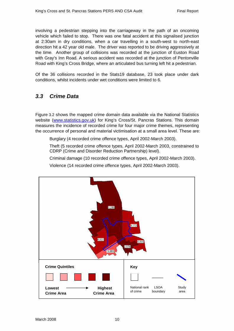
3.2 Pedestrian Collision Statistics Figure 3.1 shows collisions involving pedestrians around King’s Cross/St. Pancras Stations between Jan 2004 and Dec 2006 (36 month period). No data is yet available for the period after the update of St. Pancras Station; hence the figure below shows the old station and street layout.
Ordnance Survey © Crown copyright 2007. All rights reserved. Licence No. AL100021177
Figure 3.1: Euston Station casualty statistics
The results show that in the period reviewed there were:
• 21 slight accidents • 14 serious accidents • 1 fatal accident
The majority of collisions can be seen occurring around Euston Road and Pentonville Road on the south side of the two stations. Nearly a third of these collisions took place at the junction of Euston Road/Pentonville Road with York Way mostly
King’s Cross and St. Pancras Stations PERS AND CSA Audit Final Report
March 2008 10
involving a pedestrian stepping into the carriageway in the path of an oncoming vehicle which failed to stop. There was one fatal accident at this signalised junction at 2:30am in dry conditions, when a car travelling in a south-west to north-east direction hit a 42 year old male. The driver was reported to be driving aggressively at the time. Another group of collisions was recorded at the junction of Euston Road with Gray’s Inn Road. A serious accident was recorded at the junction of Pentonville Road with King’s Cross Bridge, where an articulated bus turning left hit a pedestrian. Of the 36 collisions recorded in the Stats19 database, 23 took place under dark conditions, whilst incidents under wet conditions were limited to 6.
3.3 Crime Data
Figure 3.2 shows the mapped crime domain data available via the National Statistics website (www.statistics.gov.uk) for King’s Cross/St. Pancras Stations. This domain measures the incidence of recorded crime for four major crime themes, representing the occurrence of personal and material victimisation at a small area level. These are:
• Burglary (4 recorded crime offence types, April 2002-March 2003).
• Theft (5 recorded crime offence types, April 2002-March 2003, constrained to CDRP (Crime and Disorder Reduction Partnership) level).
• Criminal damage (10 recorded crime offence types, April 2002-March 2003).
• Violence (14 recorded crime offence types, April 2002-March 2003).
Crime Quintiles
Lowest HighestCrime Area Crime Area
Key
National rank LSOA Study of crime boundary area

King’s Cross and St. Pancras Stations PERS AND CSA Audit Final Report
March 2008 11
Figure 3.2: Crime ranking by Lower Super Output Area
The ranking of crime for the audit site is based on Lower Super Output Areas (LSOAs), a hierarchical tool which facilitates the reporting of local level statistics. England is formed of over 32,000 such areas; 6 of which border the audit site. The Figure shows that the King’s Cross and St. Pancras area have some relatively high ranking wards for crime especially towards the northwest and southeast, raising concern for personal security.
3.4 Land Use Data To provide an overview of the types of land use in the area, Figure 3.3 shows an approximation of the distribution of uses across the audit area. This information has been collated from notes taken by the auditors on site.
KeyResidential
Retail
Public Transport
Office
Parkland
Industrial
Place of worship
Public building
Police Station
Hotel
Healthcare
Under construction
KeyResidential
Retail
Public Transport
Office
Parkland
Industrial
Place of worship
Public building
Police Station
Hotel
Healthcare
Under construction
Ordnance Survey © Crown copyright 2007. All rights reserved. Licence No. AL100021177
Figure 3.3: Audit area land use
Land use within the audit area is heterogeneous, including retail space along Euston Road and Pentonville Road, office space towards the east of King’s Cross Station and residential areas around the quieter streets further east and west of the two stations. The two major railway stations of St. Pancras and King’s Cross dominate the audit area, and attract large amounts of commuters and tourists, often with large pieces of luggage. The area surrounding the two stations is continuously being redeveloped. A significant portion of the work on St. Pancras Station is now finished, with the Eurostar services operational since November 2007. However, there is still

King’s Cross and St. Pancras Stations PERS AND CSA Audit Final Report
March 2008 12
construction taking place on the southern side of the St. Pancras Station building, as well as the area in between the two stations.

King’s Cross and St. Pancras Stations PERS AND CSA Audit Final Report
March 2008 13
4 PERS and CSA Audits
4.1 Introduction To assess the pedestrian environment around King’s Cross/St. Pancras Station, TRL have undertaken a PERS audit and Living Streets have undertaken a CSA. The PERS audit was undertaken on two separate occasions. The areas surrounding King’s Cross Station and Euston Road were audited on the 22nd and 23rd of May 2007 between the times of 09:00 and 17:00. The weather conditions were fair and warm. St. Pancras Station and its surroundings were audited on the 9th, 18th and 22nd of January 2008 to take into account the changes that have resulted from the major upgrade of the station. The weather conditions for the latter audit ranged from dry and sunny to cold rain. Efforts were also taken to ensure that any changes in the pedestrian environment between these two audits were incorporated into the scores and descriptions, for example the improvements made on signage along Euston Road. The Living Streets CSA was undertaken on 31st January at 12pm and 6pm, lasting just over an hour each. Twenty members of the public attended the lunchtime CSA, and twelve attended the evening audit. People with a range of experiences attended including representatives from First Capital Connect, Friends of Capital Transport, the Calley Rail Group, London Borough of Camden, King’s Cross Environment Group, London TravelWatch, Local SNTs, RNIB and Camden Civic Society. Community auditors were divided into small groups and each group went on a circular route within the audit area using safe crossing points only. This section aims to present the key findings from the audit of King’s Cross and St. Pancras Stations, particularly focusing on those parts of the pedestrian environment which scored negatively or were identified as a problem by the community and are in need of improvement. The results are divided into the following components of the pedestrian environment:
• Links • Crossings (both formal and informal) • Routes • Public Transport Waiting Areas • Public Spaces • Interchange Spaces

King’s Cross and St. Pancras Stations PERS AND CSA Audit Final Report
March 2008 14
4.2 General observations Before providing a detailed account of the audit findings, the following key observations were noted across the audit area in reference to the accessibility and attractiveness of the pedestrian environment:
• The audit area encompasses the busy interchange between King’s Cross and St. Pancras stations. The area is heavily used by those transferring between the two stations, as well as by those changing between various transport modes (e.g. buses, taxis and underground).
• Pedestrians exiting from the main entrance of King’s Cross Station
immediately encounter the highly-trafficked Euston Road, which they are required to cross in order to reach nearby hospitals, offices, local shops and services. Guard rails along the central reservation of this road significantly limit pedestrians' opportunities to cross.
• The area around St. Pancras Station is currently undergoing extensive re-
development, incorporating residential premises, a hotel and provision for Eurostar services.
• Some improvements to the pedestrian environment around St. Pancras
Station have been made. However, construction work continues to have an impact on pedestrian movement and the quality of the environment.
• A number of informal crossing movements are observed, including some
across Euston Road and the roads running alongside the stations. Many people also cross informally across Pancras Road at the junction with Euston Road.
• Environmental quality of the local area diminishes along Euston Road and
Gray’s Inn Road towards the Hospital and Dental Clinic, mainly due to the heavy traffic noise, pollution and vacant commercial property.
• The volumes and speeds of traffic have a dramatic effect on the pedestrian
experience. The combination of wide one-way streets and large amounts of guard railing lead people to feel they are walking in and around an urban motorway.
• Signage between the stations and to some nearby facilities is not clear,
partially due to the continued redevelopment of the area.
• There is a shortage of public spaces around the two stations, reducing the potential for social interaction and recreational activities.
• A high level of police presence (including PCSOs) and station officials result
in good safety perceptions at waiting areas.

King’s Cross and St. Pancras Stations PERS AND CSA Audit Final Report
March 2008 15
4.3 Links This section describes the findings from an assessment of the pedestrian links in the audit area. PERS reference codes are used in this reporting – a full list of all codes can be found in Appendix C.
4.3.1 PERS overall scores All PERS components were marked as ‘strategic’ because of the importance of the pedestrian environment around the mainline station and generally high pedestrian flows in this area. Analysis of the PERS RAG outputs results in the following scores:
RAG Rating No. of links RED 14 (45%)
AMBER 12 (39%) GREEN 5 (16%)
14 links were attributed a red RAG rating with the following seven scoring below zero, presented in the order of the worst total score:
• L18 York Way (westside) from Railway St to opposite Caledonia St • L20 York Way (westside) from opposite Caledonia St to Euston Rd • L19 Caledonian Road (eastside) from Keystone Crescent northside to
Pentonville Rd • L31 Footway to the east of Pancras Road • L28 Midland Rd (eastside) from St. Pancras Rd to St. Pancras westside
entrance • L7 Pentonville Rd (southside) from King’s Cross Rd to King’s Cross Bridge • L8 Pentonville Rd (southside) from King’s Cross Bridge to Gray’s Inn Road
4.3.2 CSA priorities The CSA gave 16 links a red RAG rating. Of these, 12 links were also given a red RAG rating in the PERS audit:
• L5 Pentonville Rd (northside) from York Way to Caledonian Rd • L7 Pentonville Rd (southside) from King’s Cross Rd to King’s Cross Bridge • L8 Pentonville Rd (southside) from King’s Cross Bridge to Gray’s Inn Road • L10 Euston Rd (southside) from Crestfield St to Argyle Rd • L11 Euston Rd (southside) from Argyle St to Judd St • L17 York Way (eastside) from Wharfdale Rd to Pentonville Rd • L18 York Way (westside) from Railway St to opposite Caledonia St • L19 Caledonian Road(eastside) from Keystone Crescent (northside) to
Pentonville Rd • L20 York Way (westside) from opposite Caledonia St to Euston Rd

King’s Cross and St. Pancras Stations PERS AND CSA Audit Final Report
March 2008 16
• L22 Pancras Road (westside) from St. Pancras central entrance to Goodsway • L23 Pancras Rd (eastside) from Euston Rd to Old Pancras Rd • L28 Midland Rd (eastside) from St. Pancras Rd to St. Pancras westside
entrance The three links listed below were given an amber or green rating in the PERS audit:
• L25 Goodsway tunnel (southside) from Pancras Rd to Midland Rd • L26 Goodsway tunnel (northside) from Pancras Rd to Midland Rd • L2 Euston Rd (northside) from Pancras Rd to St. Pancras entrance
Finally, the following link audited by the CSA was outside the PERS audit area and was therefore not given a PERS score:
• Gray’s Inn Road from Birkenhead St to St Chad’s St
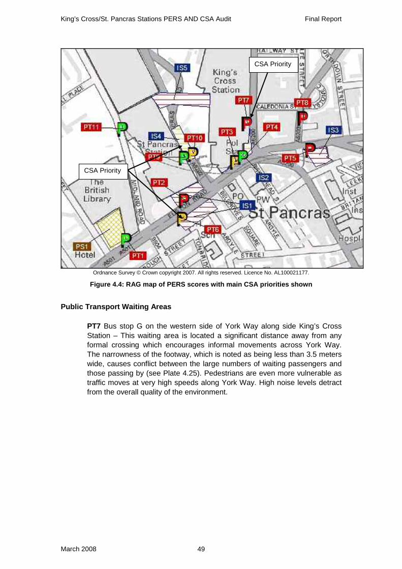
4.3.3 PERS/CSA joint findings Figure 4.1 shows the RAG map resulting from the PERS audit and highlights the main priority links resulting from the CSA.
CSA Priority
CSA Priority
CSA Priority
CSA Priority CSA Priority CSA Priority
Ordnance Survey © Crown copyright 2007. All rights reserved. Licence No. AL100021177
Figure 4.1: RAG map of PERS scores with main CSA priorities shown
The two audits were generally in accordance with each other’s findings, with links along Pancras Road, Euston Road, York Way, Pentonville Road and Caledonian
King’s Cross and St. Pancras Stations PERS AND CSA Audit Final Report
March 2008 17
Road being highlighted as in most need of attention. The links along the newly created tunnel on Goodsway were also identified as a problem. The majority of these links are situated alongside and directly in front of the two stations. The key links for improvement around King’s Cross and St. Pancras Stations are described below.
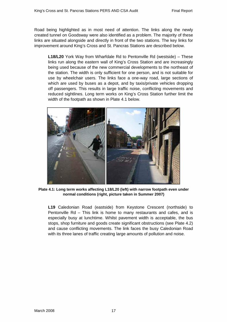
• L18/L20 York Way from Wharfdale Rd to Pentonville Rd (westside) – These links run along the eastern wall of King’s Cross Station and are increasingly being used because of the new commercial developments to the northeast of the station. The width is only sufficient for one person, and is not suitable for use by wheelchair users. The links face a one-way road, large sections of which are used by buses as a depot, and by taxis/private vehicles dropping off passengers. This results in large traffic noise, conflicting movements and reduced sightlines. Long term works on King’s Cross Station further limit the width of the footpath as shown in Plate 4.1 below.
Plate 4.1: Long term works affecting L18/L20 (left) with narrow footpath even under normal conditions (right, picture taken in Summer 2007)
• L19 Caledonian Road (eastside) from Keystone Crescent (northside) to
Pentonville Rd – This link is home to many restaurants and cafes, and is especially busy at lunchtime. Whilst pavement width is acceptable, the bus stops, shop furniture and goods create significant obstructions (see Plate 4.2) and cause conflicting movements. The link faces the busy Caledonian Road with its three lanes of traffic creating large amounts of pollution and noise.

King’s Cross and St. Pancras Stations PERS AND CSA Audit Final Report
March 2008 18
Plate 4.2: Shop signs and other street clutter on L19
• L5/L7/L8 Pentonville Rd (both sides) from King’s Cross Rd to Gray’s Inn
Road – These links are found on either side of the busy Pentonville Road, with high volumes of speedy traffic causing large amounts of pollution and noise, and subtracting from the perception of road safety. The width of the footpath is inconsistent (as shown in Plate 4.3) and narrow at various locations, despite the large peak flows observed. Railings and A boards further limit the width at several locations. Some maps and signs in the area are outdated, and still show the relocated King’s Cross Thameslink Station. Surface quality is acceptable along L8, but poor reinstatements and uneven surfaces are observed along most parts of L5 and L7.
Plate 4.3: Inconsistent width on Pentonville Road (L5 left, L8 right)
• L22 Pancras Road (westside) from St. Pancras central entrance to Goodsway
– This link is found along the eastern wall of St. Pancras Station. Permeability is poor due to the large traffic flows around the station entrance and shortage of controlled crossing points. The environmental quality is reduced towards Goodsway, where neglected private frontages and commercial property are observed. Colour contrast is not used effectively to highlight the steel bollards around the station entrance area, tactiles and building pillars (see Plate 4.4).

King’s Cross and St. Pancras Stations PERS AND CSA Audit Final Report
March 2008 19
Plate 4.4: Steel bollards on L22
• L23 Pancras Rd (eastside) from Euston Rd to Old Pancras Rd – The link is
used by pedestrians traversing between the two stations, who may opt for the subway being constructed once it becomes operational. The link traverses an area which is currently being redeveloped; hence the effects of construction material and temporary works are strongly felt (see Plate 4.5). Permeability is low due to the scarcity of formal crossings, parked vehicles and the large level of taxi traffic. Surface quality decreases towards the south end, where obstructions such as trees, parked bicycles and poorly aligned sign/lighting posts also exist.
Plate 4.5: Temporary works and poor surface quality on L23
• L28 Midland Rd (eastside) from Pancras Rd to St. Pancras westside entrance
– This link is found on the western side of the newly refurbished St. Pancras Station and faces a taxi lane. The overhanging roof offers shelter from the weather, although leaking is also observed. Users suffer from the very narrow footpath and large pillars of the station building (see Plate 4.6). Although width increases towards the station entrance, dropped kerbs are not provided across the large vehicle entrance to the station. Kerbs are abnormally high, and create a large barrier for wheelchair users. Furthermore, signs are missing on the entire length of the link, making it difficult for pedestrians to find King’s Cross Station and other nearby attractors.

King’s Cross and St. Pancras Stations PERS AND CSA Audit Final Report
March 2008 20
Plate 4.6: Pillars of St. Pancras Station narrowing footpath on L28
• L10/L11 Euston Rd (southside) from Crestfield St to Judd St – The two links
are situated directly south of St. Pancras Station, along the noisy and polluted Euston Road. Permeability is poor, owing to the 6 lanes of heavy two-way traffic and the central barriers. As shown in Plate 4.7 below, the underground entrance limits width on L10, which is exacerbated by the presence of a sign post. Crossfall and paving surface is poor along L11 (also shown in Plate 4.7), where a bus stop, kiosk and unnecessary street furniture (e.g. bollards and dysfunctional lighting columns) create obstructions.
Plate 4.7: Underground entrance on L10 (left) and crossfall on L11 (right)
• L25/L26 Goodsway tunnel (both sides) from Pancras Rd to Midland Rd – This
tunnel was perceived by Community Street auditors to be highly unattractive, despite the new build and acceptable lighting. Width is adequate, except for the area around the corners where wheelchair users may struggle to pass through. As illustrated in Plate 4.8, permeability is poor due to the lack of dropped kerbs, heavy traffic and a shortage of controlled crossings at either end where strong desire lines exist.

King’s Cross and St. Pancras Stations PERS AND CSA Audit Final Report
March 2008 21
Plate 4.8: Lack of crossing points and narrow corners on L25 and L26
4.3.4 Link parameter assessment In addition to an assessment of individual links, the audit process identified key problems with specific parameters across the pedestrian environment. These are described in Table 4.1.

King’s Cross and St. Pancras Stations PERS AND CSA Audit Final Report
March 2008 22
Table 4.1: PERS and CSA assessment of links
Parameter PERS CSA Obstructions (Clutter)
• Pillars of the station building act as obstructions on the links surrounding St. Pancras Station, particularly for wheelchair users. Similarly, bollards and pedestrian fencing limit the approaches to crossing points around the two stations.
• On those links with shops and cafes (e.g. Caledonian Road), shop signs, café tables and shop merchandise encroach on the footpath.
• Street furniture (including sign posts, utility boxes and lighting columns) are often poorly aligned, limiting the effective width of the footpath.
• There are lots of opportunities to reduce clutter - many redundant poles along Euston Road that are relics of the development work. They should be removed. Also opportunities to remove bollards outside King’s Cross (at IS1).
Permeability (Volume and speed of traffic)
• Permeability is poor along the heavily trafficked roads surrounding the two stations, due to the shortage of controlled crossings, lack of dropped kerbs and abundance of parked vehicles.
• Euston Road and Pentonville Road are especially impermeable due to high traffic flows (particularly buses) and barriers on the central refuge.
• Permeability is particularly poor at the new tunnel on Goodsway, mainly due to the lack of formal crossing provision at either end.
• Euston Road is an obvious and major barrier. Many auditors felt intimidated by the volume of motor traffic and the associated noise, fumes and perceived danger that it poses. Given the opportunity, some traffic passes close by at inappropriate speeds, for example near the junction of York Way with Euston Road, and auditors felt that introducing a lower speed limit of 20mph would be safer and more welcoming to pedestrians and may even help the flow of motor traffic through the area.

King’s Cross and St. Pancras Stations PERS AND CSA Audit Final Report
March 2008 23
Colour contrast
• Colour contrast is not effectively being used to highlight major obstructions such as subway entrances and building pillars.
Legibility (wayfinding)
• Signs to guide pedestrians to the two stations are missing at various locations, including streets in close proximity to the station (e.g. Midland Road and York Way).
• Although the high-profile façade of St. Pancras Station is easily identifiable, its main entrance is less easier to find, especially from the west.
• The construction work taking place around the two stations reduces the legibility of signs and maps. King’s Cross Station and its entrances are particularly difficult to find.
• The lack of quality wayfinding information for pedestrians was apparent with at least 5 different styles noted, some pointing the wrong way, some broken and most not containing any information about distance or time to the destination.
• Auditors could not understand why some destinations are signed and others, like The Royal National Throat, Nose and Ear Hospital, aren't.
• Provision is lacking in volume and consistency.
• Islington's wayfinding signage was welcomed but one needs to know that its there to find it. Auditors wanted a co-ordinated system regardless of who is the managing authority with a level of information that started inside the station.
• Auditors commented that they are often being stopped to be asked for destinations - often to the Travelodge on Gray’s Inn Road. Lack of signs at King’s Cross about which entrance to use for East Midlands or Thameslink (First Capital Connect) causes confusion.

King’s Cross/St. Pancras Stations PERS AND CSA Audit Final Report
March 2008 24
4.3.5 Summary: Priority links
Location PERS ref
PERS RAG CSA Rating Overall rating
York Way from Wharfdale Rd to Pentonville Rd (westside)
L18 L20
RED RED
RED RED *****
Caledonian Road(eastside) from Keystone Crescent (northside) to Pentonville Rd
L19 RED RED
*****
Pentonville Rd (both sides) from King’s Cross Rd to Gray’s Inn Road
L5 L7 L8
RED RED RED
RED RED RED *****
Pancras Road (westside) from St. Pancras central entrance to Goodsway
L22 RED RED
*****
Pancras Rd (eastside) from Euston Rd to Old Pancras Rd
L23 RED RED *****
Midland Rd (eastside) from Pancras Rd to St. Pancras westside entrance
L28 RED RED
****
Euston Rd (southside) from Crestfield St to Judd St
L10 L11
RED RED
RED RED ****
Goodsway tunnel (both sides) from Pancras Rd to Midland Rd
L25 L26
AMBER AMBER
RED RED ****

King’s Cross/St. Pancras Stations PERS AND CSA Audit Final Report
March 2008 25
4.4 Crossings This section describes the findings from an assessment of the pedestrian crossings in the audit area. PERS reference codes are used in this reporting – a full list of all codes can be found in Appendix C.
4.4.1 PERS overall scores All PERS components were marked as ‘strategic’ due to the importance of the pedestrian environment around the mainline station and generally high pedestrian flows in this area. As a result, analysis of the PERS RAG outputs shows that:
RAG Rating No. of crossings RED 23 (44%)
AMBER 18 (35%) GREEN 10 (19%)
24 crossings were attributed a red RAG rating with 11 achieving a score below -10. These are listed below in order of the worst total score:
• C45 Informal across Pancras Rd northeast of Midland Rd • C43 Informal across Goodsway at junction with Pancras Rd (westside) • C19 Informal across Pentonville Rd near King’s Cross Bridge • C48 Across vehicle entrance to St. Pancras Station off Midland Rd (eastside) • C30 Informal across York Way south of Caledonia St • C34 Informal across Pancras Rd from St. Pancras Station exit towards taxi stand • C46 Informal across Midland Rd southside of Pancras Rd • C3 Across Euston Rd at junction with Midland Rd (westside) • C39 Across Euro Despatch Centre access at junction with Pancras Rd (westside) • C40 Across car park access at junction with Pancras Rd (westside) • C18 Across King’s Cross Bridge at junction with Pentoville Rd (southside)
4.4.2 CSA priority crossings
In total, the CSA gave 29 crossings a red RAG rating. Of those, 23 crossings were also given a red RAG rating in the PERS audit:
• C1 Across Ossulston St at junction with Euston Rd (northside) • C2 Across Euston Rd at junction with Ossulston St (eastside) • C3 Across Euston Rd at junction with Midland Rd (westside) • C4 Across Euston Rd at junction with Midland Rd (eastside) • C5 Across Midland Rd at junction with Euston Rd (northside) • C9 Across York Way eastern stage at junction with Pentonville Rd (northside) • C11 Across Euston Rd between refuges at York Way • C13 Across Gray's Inn Rd at junction with Pentonville Rd (southside) • C14 Across Pentonville Rd at York Way to corner of Gray's Inn Rd

King’s Cross/St. Pancras Stations PERS AND CSA Audit Final Report
March 2008 26
• C15 Across Pentonville Rd at Caledonian Rd (westside) • C18 Across King’s Cross Bridge at junction with Pentoville Rd (southside) • C19 Informal across Pentonville Rd near King’s Cross Bridge • C24 Across Judd St at junction with Euston Rd (southside) • C30 Informal across York Way south of Caledonia St • C33 Across Omega Place at junction with Caledonian Rd (eastside) • C34 Informal across Pancras Rd from St. Pancras Station exit towards taxi stand • C39 Across Euro Despatch Centre access at junction with Pancras Rd (westside) • C40 Across car park access at junction with Pancras Rd (westside) • C43 Informal across Goodsway at junction with Pancras Rd (westside) • C45 Informal across Pancras Rd northeast of Midland Rd • C46 Informal across Midland Rd southside of Pancras Rd • C48 Across vehicle entrance to St. Pancras Station off Midland Rd (eastside) • C52 Across York Way at junction with Wharfdale Road (The CSA
incorporated the route towards Goodsway and across)
Three crossings (listed below) were given an amber or green rating in the PERS audit:
• C8 Across Pancras Rd at junction with Euston Rd (northside) • C10 Across York Way western stage at junction with Euston Rd (northside) • C6 Across access to construction site on Euston Rd east of Midland Rd
Finally, the following crossings, which were not audited in PERS, were given a red score in the CSA:
• Across Euston Road just to the east of Mabledon Place • Crossing York Way at Railway Street • Junction of York Way and Goodsway
4.4.3 PERS/CSA joint findings Figure 4.2 shows the RAG map resulting from the PERS audit and highlights the main priority crossings resulting from the CSA.

King’s Cross/St. Pancras Stations PERS AND CSA Audit Final Report
March 2008 27
CSA Priority
CSA Priority
CSA Priority
(York Way junction with Goodsway)
Ordnance Survey © Crown copyright 2007. All rights reserved. Licence No. AL100021177
Figure 4.2: RAG map of PERS scores with main CSA priorities shown
It can be seen from the map that the poorest scoring crossings are clustered around several points. Those along Euston Road, Pentonville Road and Caledonian Road are shown to score poorly. Crossings around the northern half of the extended St. Pancras Station are also found to be problematic. Several informal crossings are observed outside the entrances of the two main stations. There are several crossings in particular which stand out in both the PERS and CSA processes as being inadequate:
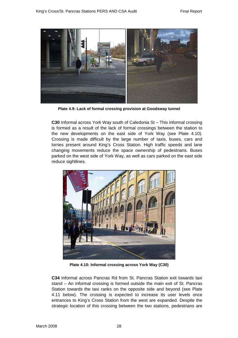
• C43/C45/C46 Informal crossings at both ends of Goodsway tunnel – Both the PERS audit and CSA identified the lack of formal crossings on both ends of the newly-built tunnel to the north of St. Pancras Station (as shown in Plate 4.9). The presence of guardrails, heavy traffic (with a high proportion of taxis), and undropped kerbs make informal crossings very difficult and hazardous, particularly for mobility impaired users.
King’s Cross/St. Pancras Stations PERS AND CSA Audit Final Report
March 2008 28
Plate 4.9: Lack of formal crossing provision at Goodsway tunnel
• C30 Informal across York Way south of Caledonia St – This informal crossing
is formed as a result of the lack of formal crossings between the station to the new developments on the east side of York Way (see Plate 4.10). Crossing is made difficult by the large number of taxis, buses, cars and lorries present around King’s Cross Station. High traffic speeds and lane changing movements reduce the space ownership of pedestrians. Buses parked on the west side of York Way, as well as cars parked on the east side reduce sightlines.
Plate 4.10: Informal crossing across York Way (C30)
• C34 Informal across Pancras Rd from St. Pancras Station exit towards taxi
stand – An informal crossing is formed outside the main exit of St. Pancras Station towards the taxi ranks on the opposite side and beyond (see Plate 4.11 below). The crossing is expected to increase its user levels once entrances to King’s Cross Station from the west are expanded. Despite the strategic location of this crossing between the two stations, pedestrians are

King’s Cross/St. Pancras Stations PERS AND CSA Audit Final Report
March 2008 29
confronted with heavy and speedy traffic along Pancras Road. Dropped kerbs are provided on both sides of the crossing but are not aligned.
Plate 4.11: Informal crossing (C34) outside St. Pancras Station main exit
• C18 Across King’s Cross Bridge at junction with Pentonville Rd (southside) –
Despite this being a controlled crossing, the lack of request boxes, short pedestrian green phase and excessive waiting time lead to many users crossing on red. As exemplified by Plate 4.12, such users are placed under danger by the heavy traffic, most notably buses turning left onto King’s Cross Bridge. Safety for sensory impaired users is severely limited by the lack of rotating cones and audible information.
Plate 4.12: Lack of controls at crossing C18 across King’s Cross Bridge placing pedestrians in danger of turning traffic
• C19 Informal across Pentonville Rd near King’s Cross Bridge – Despite the
presence of pedestrian fencing and a warning sign reading “Pedestrians do not cross here”, numerous informal crossings are performed at this location (as shown in Plate 4.13). The strong desire line across Pentonville Road

King’s Cross/St. Pancras Stations PERS AND CSA Audit Final Report
March 2008 30
remains unserved. The alternative of navigating across the remaining three arms of this junction is unattractive to the majority of users. The central refuge is not suitable as a waiting area, and users are placed under great hazard from the heavy traffic.
Plate 4.13: Dangerous informal crossing C19 across Pentonville Road
• C2/C3/C4/C7 Crossings across Euston Rd – The major crossing points
across the heavily trafficked Euston Road (as pictured in Plate 4.14 below) are a major source of concern. On C3, the pedestrian aspect is missing. C4 suffers from inadequate refuge capacity, leaving pedestrians exposed to the speedy traffic. Delay is a major concern at all crossing points, due to the long wait times (often reaching 60 seconds) and the lack of synchronisation of the multiple stages. Cyclists often encroach on the crossing space due to the lack of advanced stop lines.
Plate 4.14: Inadequate crossing provision across Euston Road (C3 left, and C4 right)

King’s Cross/St. Pancras Stations PERS AND CSA Audit Final Report
March 2008 31
• C39/C40/C48/C6 Across vehicle access roads to St. Pancras Station Building – There are several vehicle access points into St. Pancras Station (as shown in Plate 4.15 below), including the car park entrance (C40) and delivery gates (C40/C48). These often come without dropped kerbs; instead the height of the kerbs is found to be excessive. Combined with the presence of bollards on the approach path, access by wheelchair users is made very difficult. C6 currently performs well due to the lack of traffic, but when the hotel inside the St. Pancras Station building opens a constant flow of taxis and other vehicles is expected across the footway.
Plate 4.15: Lack of dropped kerbs and presence of obstacles across vehicle access roads to St. Pancras Station (C39 top left, C40 top right, C48 lower left, C6 lower right)
• C5 Across Midland Rd at junction with Euston Rd (northside) – This is a two
stage crossing (pictured in Plate 4.16) whose capacity is limited by the narrow eastern waiting area as well as the central refuge. Midland Road is a one-way street, which increases the space ownership of pedestrians. However, the lack of an advanced stop line allows cyclists to encroach on the crossing space.

King’s Cross/St. Pancras Stations PERS AND CSA Audit Final Report
March 2008 32
Plate 4.16: Crossing across Midland Road (C5)
• C8 Across Pancras Rd at junction with Euston Rd (northside) – This crossing
is strategically located between the entrances to both stations; hence it is used heavily by many travellers transferring between the two. Deviations are caused by the pedestrian fencing on both approaches and on the central refuge, together with the poor alignment of the crossing area. Many pedestrians therefore prefer to cross on the desire line at the mouth of the junction (as shown in Plate 4.17 below). Large delays are created by the lack of synchronisation of the two stages, excessive waiting time and short green phase (approximately 6 seconds) for pedestrians.
Plate 4.17: Desire line not being met at crossing across Pancras Road at junction with Euston Road (C8)
• C9/C10 Across York Way at junction with Pentonville Rd/Euston Rd
(northside) – The capacity of this crossing is limited by its insufficient width and the narrowness of the central refuge (see Plate 4.18), creating an overflow of pedestrians into the road at peak hours. Space ownership is severely reduced by the heavy and speedy traffic, which also queues up over the crossing space when roads are congested. Road markings, including pedestrian delineation, are faded and the crossing space is no longer clear.

King’s Cross/St. Pancras Stations PERS AND CSA Audit Final Report
March 2008 33
Plate 4.18: Insufficient crossing capacity across York Way (C9/C10)
• C52 Across York Way at junction with Wharfdale Road – This is a complex
set of crossings with three arms branching out of a central refuge, found outside the northern entrance to King’s Cross Station on the west side of York Way. Deviations are created by the use of the shared refuge for all directions, aggravated by the poor alignment of the arms (see Plate 4.19 below). Pedestrians wishing to travel across York Way must perform a Z-shaped movement, adding to delay. The new developments to the north of Wharfdale Road (e.g. The Guardian office) may create further demand for this crossing in the future.
The northern entrance to King’s Cross is widely used by local people. Community street auditors were extremely concerned this could be closed off to pedestrians during redevelopment of the station; they observed it was regularly used by people on foot which implied need for entrance at this point. Local people felt it was vital to retain this northern access to the station. If closed, alternative access would be via Goods Way or York Way which were felt to be dangerous, especially at night.
Plate 4.19: Poor alignment of crossing arms at C52
King’s Cross/St. Pancras Stations PERS AND CSA Audit Final Report
March 2008 34
4.4.4 Crossing parameter assessment In addition to an assessment of individual crossings, the audit process identified key problems with specific parameters across the pedestrian environment. These are described in the table below.

King’s Cross/St. Pancras Stations PERS AND CSA Audit Final Report
March 2008 35
Table 4.2: PERS and CSA assessment of crossings
Parameter PERS CSA Crossing Provision
• A large number of informal crossings are identified within the audit area, mostly in close proximity to the stations entrances, indicating the lack of crossing provision for users wishing to access the station.
• Several crossings lack pedestrian aspects and controls, despite the heavy and speedy traffic observed at these locations.
• Crossing roads in the area was one of the aspects most mentioned in the community audits. The dominance of provision for motor vehicles over pedestrians and cyclists led to:
• Crossings had
insufficient capacity for the numbers who needed to cross (e.g. C9/C10).
• Crossings that were complex for pedestrians owing to the need to maximise vehicle flows (e.g. C7 & C52).
• Crossings that did not follow the pedestrian desire line (e.g. C8)
• Underprovision of crossing points and the use of informal crossing points (e.g. C30 and C34)
Performance • The performance of
crossings in the audit area suffers from the heavy traffic flows along the major roads around the station, with a high ratio of taxis and buses.
• Parked vehicles (including double-decker buses), pillars of buildings and construction material reduce sightlines at several locations, reducing the performance and safety of crossings.
• The performance of formal crossings was particularly reduced by cars, taxis and buses parking over the pedestrian crossing point during the green man phase.
• As with the Charing Cross audit, auditors were keen to create Yellow Boxes for pedestrian crossings.

King’s Cross/St. Pancras Stations PERS AND CSA Audit Final Report
March 2008 36
Dropped Kerbs
• Dropped kerbs are missing at key locations, including the vehicle access points into St. Pancras Station. Kerbs are often higher than average, reducing the accessibility of mobility impaired users.
• The numerous informal crossings found in the area are, by their nature, lacking in dropped kerbs.
Legibility for Sensory Impaired People
• Provision for sensory impaired users (e.g. rotating cones, proper tactile information and audio information) is lacking at key locations, including the crossings across Euston Road and King’s Cross Bridge.
• Those who were blind and partially sighted had particular problems with Euston Rd. They felt that there was a lack of audible or tactile feedback on traffic crossings.
• Ideally they felt that all crossings would be fitted with an audible bleeper, but they were aware that when two crossings are close together this could be dangerous, and in these situations a rotating cone underneath the control box would be a huge improvement.
• At present they felt there was very little provision for visually impaired people on Euston Road crossings. They were certain that adding these features would help blind people in the King’s Cross area to get around without consistently having to put their trust in strangers to help them cross these busy roads.

King’s Cross/St. Pancras Stations PERS AND CSA Audit Final Report
March 2008 37
One Way Systems
• The usage of one-way systems may be of advantage to motor vehicles but it has a profoundly corrosive effect on the public realm in the area. Crossings are made far wider and more complicated to negotiate and up to 4 lanes of traffic can be approaching junctions at certain time. The south end of Caledonian Road which is undergoing a significant renaissance at the moment is severed by a wall of traffic heading south at speed or stopped at the traffic light at Pentonville Road.

King’s Cross/St. Pancras Stations PERS AND CSA Audit Final Report
March 2008 38
4.4.5 Summary: Priority crossings Location PERS
ref PERS RAG
CSA Rating
Overall rating
Informal crossings at both ends of Goodsway tunnel
C43 C45 C46
RED RED RED
RED RED RED
*****
Informal across York Way south of Caledonia St
C30 RED RED *****
Informal across Pancras Rd from St. Pancras Station exit towards taxi stand
C34 RED RED *****
Across King’s Cross Bridge at junction with Pentonville Rd (southside)
C18 RED RED *****
Informal across Pentonville Rd near King’s Cross Bridge
C19 RED RED *****
Crossings across Euston Rd C2 C3 C4 C7
RED RED RED AMBER
RED RED RED AMBER
*****
Across vehicle access roads to St. Pancras Station Building
C39 C40 C48 C6
RED RED RED GREEN
RED RED RED RED
****
Across Midland Rd at junction with Euston Rd (northside)
C5 RED RED ****
Across Pancras Rd at junction with Euston Rd (northside)
C8 AMBER RED ****
Across York Way at junction with Pentonville Rd/Euston Rd (northside)
C9 C10
RED AMBER
RED RED ****
Across York Way at junction with Wharfdale Road
C52 RED RED ****
King’s Cross/St. Pancras Stations PERS AND CSA Audit Final Report
March 2008 39
4.5 Routes This section describes the findings from the PERS and CSA assessment of the routes in the audit area. PERS reference codes are used in this reporting – a full list of all codes can be found in Appendix C.
4.5.1 PERS overall scores All PERS components were marked as ‘strategic’ because of the importance of the pedestrian environment around the mainline station and generally high pedestrian flows in this area. Analysis of the PERS RAG outputs results in the following scores:
RAG Rating No. of routes RED 3 (75%)
AMBER 1 (25%) GREEN 0 (0%)
Two routes were attributed negative scores (below 25) with a red RAG rating. These are:
• R4 From St. Pancras Station along Gray’s Inn Road to the Royal National Throat, Nose and Ear Hospital
• R3 From St. Pancras Station along Gray’s Inn Road to Eastman Dental Hospital
One other route received a red RAG rating, although with a low positive score (+4):
• R1 From St. Pancras Station along Euston Road to the former King’s Cross Thameslink Station
The final route received a high positive score (+40) with an amber RAG rating:
• R2 From St. Pancras Station (western entrance) along Midland Road to the British Library
Furthermore, a route between Euston Station and Kings’ Cross/St. Pancras was audited as part of a PERS/CSA audit of Euston Station in Autumn 2007, the results of which are presented in the Euston Station Final Report (TRL Ref: UPR/T/156/07).
4.5.2 CSA priority routes The CSA provided insight into several of the routes audited in PERS. Concern was raised with regards to the following routes:
• R1 From King’s Cross and St. Pancras Stations along Euston Road to the former King’s Cross Thameslink station

King’s Cross/St. Pancras Stations PERS AND CSA Audit Final Report
March 2008 40
• R3 From St. Pancras Station along Gray’s Inn Road to Eastman Dental Hospital
Note: the CSA audit did not explicitly assess R4 from St. Pancras Station to the Royal National Throat, Nose and Ear Hospital. However, many of the audit findings from R3 are also applicable to R4 since they follow the same footways for much of the way.
4.5.3 PERS / CSA Joint Findings Figure 4.3 shows the RAG map resulting from the PERS audit. The three worst-scoring routes commence at the front entrance of St. Pancras Station and branch out towards other nearby points of interest. The remaining route leads visitors from the new western entrance of St. Pancras Station south towards the British Library.
© Crown copyright. All rights reserved. Licence No. AL100021177 Figure 4.3: RAG map of PERS scores for Routes
Below is a brief description of each of the routes identified, focussing on the worst scoring parameters. All routes, regardless of their overall scores, are presented below for the benefit of the reader. R3 follows an identical pathway to R4 and then extends for a short distance further along Gray’s Inn Road. R3 and R4 will be discussed together since the main issues raised are applicable to both routes.
• R4/R3 From St. Pancras Station along Gray’s Inn Road to the Royal National Throat, Nose and Ear (TNE) Hospital and the Eastman Dental Hospital –

King’s Cross/St. Pancras Stations PERS AND CSA Audit Final Report
March 2008 41
These routes scored very poorly for the majority of parameters, which aside from directness all received negative scores. Permeability is very low along Euston Road due to the presence of pedestrian barriers and very high traffic flows. Gray’s Inn Road also experiences moderate traffic flows along a fairly wide carriageway. Informal crossings occur along the route due to the shortage of crossing points. In particular, there is no formal crossing point opposite or in the nearby vicinity of the Royal National TNE Hospital entrance (see Plate 4.22). Crossing is made dangerous by poor sightlines along Gray’s Inn Road due to parked cars, numerous buses, footway obstructions and the curvature of the carriageway (as shown in Plate 4.20 below).
Plate 4.20: Curvature and parked vehicles reducing sightlines on Gray’s Inn Road
Road safety is of concern along Euston Road where traffic is heavy and fast-flowing and there are also high pedestrian flows. The crossing points opposite St. Pancras and King’s Cross station entrances force pedestrians to significantly deviate from their desire line via sheep pens and therefore encourage highly dangerous informal crossings. Street furniture and bus stops create pinch points causing user conflict, especially during peak hours. Environmental quality is low due to noise and air pollution from Euston Road. The private frontages of low quality shops and fast food outlets are poorly maintained, and some are vacant (see Plate 4.21). There is evidence of anti-social behaviour and the lack of footway focussed lighting is likely to make this area intimidating at night. Surface quality is also a problem due to undulating and cracked pavements, especially around street trees. Tactile paving is also incorrectly coloured at some crossing points. There are no specific rest points other then at a bus stop near the Dental Hospital, raising concern for mobility impaired users or those with heavy luggage.

King’s Cross/St. Pancras Stations PERS AND CSA Audit Final Report
March 2008 42
Plate 4.21: Closed shops and heavy traffic leading to poor environmental quality along R3/R4
Finally, legibility scored very poorly as there is no signage to either destination and the only means of identifying the route is from the map inside St. Pancras Station.
Plate 4.22: Crossing outside the Eastman Dental Hospital (left) and lack of crossing in front of the Royal National TNE Hospital (right)
• R2 From St. Pancras Station (western entrance) along Midland Road to the
British Library – This route scored well in both audits due to its directness, improved legibility (see Plate 4.23) and relatively high road safety. Wide footways and formal crossing provision outside the St. Pancras Station western exit allow good access to the library. However, the CSA audit highlighted the threat to pedestrians caused by the relatively high traffic speeds along Midland Road. This results from the lack of vehicle speed controls and the wide, straight, one-way format of Midland Road. The absence of soft landscaping to the frontages opposite the station and the lack of activity at the public space in front of the library creates a slightly isolated environment for pedestrians, although CCTV is present to increase personal security (as pictured in Plate 4.23). As with many routes and links in the area, there are many examples along Midland Rd and Euston Rd of redundant street furniture in the form of poles (related to the Eurostar terminal construction) that now simply need to be removed.

King’s Cross/St. Pancras Stations PERS AND CSA Audit Final Report
March 2008 43
Plate 4.23: Good signage and CCTV coverage outside the British Library
• R1 From King’s Cross and St. Pancras Stations along Euston Road to the former King’s Cross Thameslink station (see Plate 4.24 below) – This route scored poorly in both the PERS and CSA audits due to issues with permeability, road safety and a lack of rest points. High volumes of aggressive traffic are evident along Euston Road, and the presence of narrow footways create pedestrian congestion at crossing points. King’s Cross Thameslink station was recently relocated in December 2007 and therefore this route is now of limited significance.
Plate 4.24: Outside King’s Cross Thameslink Station (photograph from June 2007, Thameslink services relocated since December 2007)
4.5.4 Routes parameter assessment In addition to an assessment of individual routes, the audit process identified key problems with specific parameters across the pedestrian environment. These are described in the table below.

King’s Cross/St. Pancras Stations PERS AND CSA Audit Final Report
March 2008 44
Table 4.3: PERS and CSA assessment of routes
Parameter PERS CSA Rest points • There is a lack of formal
rest points along all routes. Bus stop shelters and low walls provide limited opportunities for seating. Protection from the weather is absent, except for building entrances and the overhanging roof of St. Pancras Station. This is of large concern when taking into account the high proportion of pedestrians with large pieces of luggage in this area.
• Those on the audit noted the lack of seating throughout the whole area. They felt that its absence (except at bus stops) underscored the fact that this was an area to be moved through and was not somewhere they should remain for long.
Permeability • The majority of routes involve the crossing of major roads including York Road, Euston Road and Gray’s Inn Road. Crossing provision across these roads are often insufficient, and users face risk of collisions with vehicles.
• There is no viable crossing point outside the Royal National TNE hospital.
• The combination of crossings that are insufficiently wide to accommodate the numbers that wish to cross, short green man phases, long phases for vehicles and the enormous amounts of guard railing made crossing the roads on each of these routes protracted and uncomfortable.

King’s Cross/St. Pancras Stations PERS AND CSA Audit Final Report
March 2008 45
Legibility • Signs to the Royal National TNE hospital and Eastman Dental Hospital are limited to a map at the station.
• Sightlines are often reduced as a result of street clutter, parked vehicles and bends in the road (especially along Gray’s Inn Road).
• Auditors struggled to understand the different stations housed in St. Pancras. They were confused about the new location of the trains they knew as Thameslink.
• They were confused as to the entrances and locations of the different parts of St. Pancras. They were particularly unclear as to where the First Capital Connect trains were based and the fact that the entrance to the Underground (not Eurostar) was at the front of the station.
Personal Security
• Personal security is compromised by the vacant shops along Gray’s Inn Road and evidence of anti-social behaviour such as graffiti.
• Lighting is insufficient at most locations, where the lamps focus on the carriageway and not the footpath.
• Owing to the sheer numbers of people that were around throughout the daytime and evening audits, auditors said that felt largely safe in the parts of the area covered by the community audits.

King’s Cross/St. Pancras Stations PERS AND CSA Audit Final Report
March 2008 46
4.5.5 Summary: Priority routes
Location PERS ref PERS RAG CSA Rating Overall Rating
From St. Pancras Station along Gray’s Inn Road to Eastman Dental Hospital
R3 RED RED ****
From St. Pancras Station along Gray’s Inn Road to the Royal National Throat, Nose and Ear Hospital
R4 RED N/A ****

King’s Cross/St. Pancras Stations PERS AND CSA Audit Final Report
March 2008 47
4.6 Waiting Areas and Spaces This section describes the findings from an assessment of the public transport waiting areas, interchange spaces and public spaces in the audit area. PERS reference codes are used in this reporting – a full list of all codes can be found in Appendix C. All PERS components were marked as ‘strategic’ due to the importance of the pedestrian environment around the mainline station and generally high pedestrian flows in this area.
4.6.1 PERS overall scores
RAG Rating No. of waiting areas
No. of interchange
spaces
No. of public spaces
RED 4 (36%) 3 (60%) 0 (0%) AMBER 3 (27%) 2 (40%) 0 (0%) GREEN 4 (36%) 0 (0%) 1 (100%)
Four Public Transport Waiting Areas were attributed a red RAG score. These low scoring Public Transport Waiting Areas obtained total scores of -20, -14, 13 and 15 respectively and are listed below:
• PT8 Bus Stop eastern side of Caledonian Road south of Caledonia Street • PT5 Bus Stop X outside former King’s Cross Thameslink Station • PT2 Bus Stop M northern side of Euston Rd outside King’s Cross tube entrance • PT7 Bus Stop G western side on York Way alongside King’s Cross Station
There are five Interchange Spaces in the audit. Three were attributed a red RAG score, with total scores of 10, 35 and 37, and are listed below:
• IS3 Between former King’s Cross Thameslink & Bus Stop • IS5 Between St. Pancras Station & King’s Cross Station side entrances • IS1 Between St. Pancras Station, Underground and Bus Stops A&M on
Euston Rd
The following Public Space received a positive score but obtained an amber RAG score of 76:
• PS1 British Library Plaza

King’s Cross/St. Pancras Stations PERS AND CSA Audit Final Report
March 2008 48
4.6.2 CSA priority waiting areas and spaces Eight public transport waiting areas were identified by the CSA, of which five were given red RAG scores. These were all given either a red or amber score in the PERS audit.
• PT2 Bus Stop M northern side of Euston Rd outside King’s Cross tube entrance
• PT5 Bus Stop X outside King’s Cross Thameslink Station • PT6 Bus Stop A outside Camden Town Hall southside of Euston Rd • PT7 Bus Stop G westside on York Way alongside King’s Cross Station • PT8 Bus Stop eastside on Caledonian Rd south of Caledonia St
Further to this the remaining two waiting areas audited in the CSA were given amber RAG ratings (PT3 and PT4). Within the PERS audit PT3 was given an amber rating and PT4 was given a green score.
• PT3 Bus Stop D outside King’s Cross Station - south stand • PT4 Bus Stop E outside King’s Cross Station - north stand
Of the 5 PERS audited Interchange Spaces, three of the spaces were given Red RAG ratings in CSA audit. With the remainder Interchange space now no longer relevant as King Cross Thameslink has been closed (IS3). These are:
• IS3 Between former King’s Cross Thameslink & Bus Stop • IS5 Between St. Pancras Station & King’s Cross Station side entrances • IS1 Between St. Pancras Station, Underground and Bus Stops A&M on
Euston Rd
The single public space identified was given an amber RAG rating in the CSA. In the PERS audit, PS1 was given a green RAG rating:
• PS1 British Library Plaza
4.6.3 PERS/CSA joint findings Figure 4.4 shows the RAG map resulting from the PERS audit and highlights the main priority waiting areas and spaces resulting from the CSA.
King’s Cross/St. Pancras Stations PERS AND CSA Audit Final Report
March 2008 49
Ordnance Survey © Crown copyright 2007. All rights reserved. Licence No. AL100021177.
Figure 4.4: RAG map of PERS scores with main CSA priorities shown
Public Transport Waiting Areas
• PT7 Bus stop G on the western side of York Way along side King’s Cross Station – This waiting area is located a significant distance away from any formal crossing which encourages informal movements across York Way. The narrowness of the footway, which is noted as being less than 3.5 meters wide, causes conflict between the large numbers of waiting passengers and those passing by (see Plate 4.25). Pedestrians are even more vulnerable as traffic moves at very high speeds along York Way. High noise levels detract from the overall quality of the environment.
CSA Priority
CSA Priority

King’s Cross/St. Pancras Stations PERS AND CSA Audit Final Report
March 2008 50
Plate 4.25 Narrow footway width causes conflict between waiting pedestrians and passing flows at PT7
• PT8 Bus stop on the eastern side of Caledonian Road south of Caledonia
Street – This waiting area has reduced safety perception levels with places for concealment and poor quality frontages (as shown in Plate 4.26 below). Poor perceptions are further exacerbated by reduced lighting (only one lamp column is visible in close proximity) and there is limited scope for reporting incidents at night. The presence of a number of bus stops causes congestion and means there is little space for those waiting for buses and those using the footway. Formal crossings across Caledonian Road are not located close by, which can encourage informal crossings.
Plate 4.26 Poor quality frontages reduce safety perceptions at PT8

King’s Cross/St. Pancras Stations PERS AND CSA Audit Final Report
March 2008 51
• PT5 Bus stop outside King’s Cross Thameslink Station – This waiting area has unsuitable kerbs which are not raised sufficiently to aid mobility impaired or pushchair users when boarding or disembarking buses. The bus stop has an inadequate waiting area capacity mainly because the stop is located on a link with very high flows. This causes conflicts between waiting pedestrians and those passing by. Also of concern are the barriers (shown in Plate 4.27) which force pedestrians to deviate to formal crossings which are not on the pedestrian desire line to the bus stop. The barrier is intended to protect pedestrians from passing traffic, but results in pedestrians climbing over the barrier. The surrounding link is heavily vandalised, with places for concealment and rough sleepers all of which reduce the negative perceptions of safety.
Plate 4.27 Narrow waiting area capacity at PT5 with barriers causing deviations
• PT2 Bus stop M on the northern side of Euston Road outside King’s Cross
tube entrance – As shown in Plate 4.28, this waiting area lacks provision with regards to waiting area comfort, because of the lack of both shelter and seating which leaves pedestrians exposed to adverse weather conditions and mobility impaired or elderly pedestrians without viable rest points. This is partly due to the narrow footway width which would not be able to accommodate a shelter. There is a lack of security measures around PT2. The stop is wholly reliant upon informal surveillance from passing pedestrians which could leave waiting pedestrians in an isolated and vulnerable position when flows are lower at night. There are no additional measures in place at this stop to assist pedestrians when boarding and disembarking buses. Also, the access and egress points are obstructed by a pedestrian barrier.

King’s Cross/St. Pancras Stations PERS AND CSA Audit Final Report
March 2008 52
Plate 4.28 A lack of shelter and seating at PT2 and obstructions to access and egress points
• PT6 Bus Stop A outside Camden Town Hall southern side of Euston Road –
The CSA has highlighted this stop as being of concern because the non-transparent side panel of the bus stop causes a significant pinch point and reduces sightlines (see Plate 4.29).
Plate 4.29 Bus shelter causes a pinch point at PT6 which can create user conflict during peak hours

King’s Cross/St. Pancras Stations PERS AND CSA Audit Final Report
March 2008 53
Interchange Spaces
• IS5 Between St. Pancras and King’s Cross Station side entrances – At present the area to the east of this interchange is undergoing large scale construction which involves building a subway linking both King’s Cross and St. Pancras Stations, which once built should improve the score for this interchange. The shared space appears to work successfully, helping the ease of movement between the modes. However, the main desire line when crossing Pancras Road is blocked by waiting taxis and can restrict movements. St. Pancras Station is easy to identify (see Plate 4.30) when emerging from King’s Cross, as the signage on the front of the station as well as finger post are well located and visually apparent. However when emerging from St. Pancras it is not obviously apparent where King’s Cross station is. This is due to a shortage of sign posts, as well as the lack of branding or large signage on the side entrance to King’s Cross. There is a possibility that this will be improved once the construction work is completed.
Plate 4.30 Visible signage at IS5 easily identifies where St. Pancras station is when exiting King’s Cross Station
• IS1 Interchange space between St. Pancras Station, Underground and Bus
Stops A&M on Euston Rd – This space is used by rail or tube users continuing their journey on local buses or vice versa. The bus stops are a very short distance away from the tube station and pedestrians have the option of crossing Euston Road to get to PT6 by either a subway or an over ground crossing. There is clear information for pedestrians in the form of a map at the Underground exit to indicate to pedestrians where the bus stops are but there is very little information at the bus stops themselves. The effective widths of both footways on the Euston Road at this interchange are narrow, which results in both congestion and user conflict mainly between waiting bus users and passing pedestrians using the links. For this reason

King’s Cross/St. Pancras Stations PERS AND CSA Audit Final Report
March 2008 54
there is only a waiting area on the southern side. In addition, high noise traffic reduces the aesthetic appeal at this interchange.
• IS3 Between King’s Cross Thameslink & Bus Stop – This Interchange scored poorly for the parameters: Feeling Comfortable, Quality of the Environment and Maintenance but the closure of Thameslink rail station in November 2007 now makes this interchange space less relevant.
• IS4 Between Bus Stop T, Taxi Rank on Pancras Rd and St. Pancras/ King’s
Cross Stations – The effectiveness of this interchange is reduced predominately because of the poor crossing provision across Pancras Road. Moving between the two modes is made difficult especially for mobility impaired users as there are no dropped kerbs. A raised table was proposed at this point and has not as yet been installed. If and when this table is installed, moving across Pancras Road will be improved. Again because building works have not finished around this interchange, signage has not been fully installed, with maps and finger boards placed on temporary boarding at the taxi rank (see Plate 4.31 below). It is predicted that once the works have finished, there will be improved navigational prompts for pedestrians. Sightlines are good and it is clear to see St. Pancras Station from the taxi rank and vice versa. Traffic speeds can be high on Pancras Road, and with high levels of pedestrian congestion at peak times, pedestrians can be considered as being vulnerable.
Plate 4.31: Signage placed on temporary boarding at PT10

King’s Cross/St. Pancras Stations PERS AND CSA Audit Final Report
March 2008 55
Public Spaces
• PS1 British Library Plaza – This public space scores positively for all parameters. The space allows pedestrians to move easily within the space, with good surface quality and provision within it. There are no obstructions that impede and a ramped access allows wheelchair access. The personal safety parameter receives the highest score owing to a good degree of CCTV directed into the space and lighting at a low level frequently provided throughout, with informal surveillance available from café users. Pedestrians are able to feel comfortable within the space as a result of ample shelter at the café and benches and walls to sit on (see Plate 4.32), available throughout. Toilets are available within the Library. The nature of the space, the tranquil environment and good maintenance allows the space to have an excellent sense of place, despite audible traffic noise. Various activities are observed at PS1, including people having lunch and school children sat with teachers, all of which are appropriate for the type of space. Notably there are no signs of dereliction of delay. Of concern is the presence of tall hedges which can obstruct sight lines and reduce the ease of movement. The auditors have also commented that the space is not well sign posted and pedestrians new to the area could easily miss the space when walking along Euston Road (as pictured in Plate 4.32 below).
Plate 4.32: PS1 with good seating (left), but not easily identifiable from outside (right)
4.6.4 Waiting area and spaces parameter scores In addition to an assessment of individual waiting areas and spaces, the audit process identified key problems with specific parameters across the pedestrian environment. These are described in Table 4.4.

King’s Cross/St. Pancras Stations PERS AND CSA Audit Final Report
March 2008 56
Table 4.4: PERS and CSA assessment of waiting areas and spaces
Waiting Area Parameter
PERS CSA
Infrastructure to the Waiting Area
• Informal crossings are observed as a result of the location of bus stops in relation to formal crossings such as at PT7, PT8 and PT10.
• Surface quality is poor, particularly at PT8 & PT10.
• Footway widths are insufficient, particularly on Euston Road and York Road which causes congestion around the associated waiting areas (PT2, PT6 and PT7).
Safety Perceptions
• Potential places for concealment are caused by the built infrastructure.
• Heavy vandalism of shelters and low quality retail shops reduce the feeling of safety.
• A lack of telephones or instant response facilities impairs safety perceptions as it reduces the ability to report incidents in times of emergency.
•
Quality of Environment
• Bus stops in the audit area reveal poor aesthetics predominately because of low levels of soft landscaping, large volumes of traffic creating high noise levels and extensive construction work presently being undertaken.
• The cramped conditions for those waiting for buses were underscored on the community audits. People noted the lack of space that they were given, in particular on York Way, Pentonville Rd and Euston Rd and repeatedly contrasted it with the vast widths of the roads for traffic.
Waiting area comfort
• A lack of shelters is seen at bus stops such as PT2 which means they are not protected from adverse weather conditions. Additionally where they are provided they often lack side panels.
• Due to the insufficient footway widths on Euston Road, there is not enough space to accommodate a shelter at PT2.
King’s Cross/St. Pancras Stations PERS AND CSA Audit Final Report
March 2008 57
• Where provided seating and shelter provision is often under capacity, leaving pedestrians out on the footway causing potential conflict with passing pedestrians.
Interchange Space Parameter
PERS CSA
Moving between modes
• Sheep pen crossings can be seen to cause conflict when moving between modes as seen at IS1.
• Poorly installed crossings and a lack of formal crossings result in informal crossings across heavily trafficked roads, jeopardising pedestrian safety.
• Construction work at present means pedestrians must negotiate poor trails between stations.
• High vehicle speeds and crowded environments reduce the accessibility of interchange spaces.
• Narrow footway widths reduce the effective space around the interchange space and can cause congestion.
Quality of the Environment
• The impact of traffic is high throughout the audit area and has a high negative effect on the quality of environment.
Identifying where to go
• Information to bus stops and to other stations is available at underground entrance/exits in the form of maps, but is not always available at bus stops.
• Heavy construction work is still being undertaken and signage is not yet fully installed.
• King’s Cross Station is not easily identifiable from side entrances i.e. on Pancras Road and York Way.

King’s Cross/St. Pancras Stations PERS AND CSA Audit Final Report
March 2008 58
Public Space Parameter
PERS CSA
Interpreting the Space
• Hedges within the British Library Plaza have the potential to restrict visibility.
• The space could be made more welcoming and visitors may not realise that this is a public space.
Feeling Comfortable
• Background traffic can be heard and can cause a disturbance to those relaxing in the space.
Moving in the space
• Walls and hedges are seen to divide the space and can restrict movement.

King’s Cross/St. Pancras Stations PERS AND CSA Audit Final Report
March 2008 59
4.6.5 Summary: Priority waiting areas and spaces
Location PERS Ref
PERS RAG
CSA Rating
Overall Rating
Bus Stop G western side on York Way alongside King’s Cross Station
PT7 RED RED *****
Bus Stop eastside of Caledonian Road south of Caledonia Street
PT8 RED RED ****
Bus Stop X outside King’s Cross Thameslink Station
PT5 RED RED ****
Bus Stop M northern side of Euston Road outside King’s Cross tube entrance
PT2 RED RED ****
Bus stop A outside Camden Town Hall southern side of Euston Road
PT6 AMBER RED ***
Between St. Pancras Station & King’s Cross Station side entrances
IS5 RED RED ****
Between St. Pancras Station, Underground and Bus Stops A&M on Euston Road
IS1 RED RED ****
Between Bus stop T, Taxi Rank on Pancras Road and St. Pancras/King’s Cross Stations
IS4 AMBER RED ***
British Library Plaza PS1 AMBER AMBER **

King’s Cross/St. Pancras Stations PERS AND CSA Audit Final Report
March 2008 60
5 Audit Summary The following points highlight the key issues which have been drawn out from this analysis of the pedestrian environment around King’s Cross and St. Pancras Stations. The scores given from the PERS audit and CSA were generally poor, highlighting specific and general deficiencies in terms of pedestrian provision. The audits have highlighted some specific themes for improvement around King’s Cross and St. Pancras Stations. These are listed below:
• Links surrounding the two stations are often of inadequate width, with obstructions such as building pillars and road signs further limiting the space available for pedestrians. This leads to crowded conditions and conflicts amongst users, especially during peak hours. The sheer amount of guard railing that is used throughout the area further underscores the lack of capacity for pedestrians and the resulting overcrowding encourages people away from the formal crossings.
• Permeability is poor across the main roads around the two stations, as a
result of the scarcity of formal crossings, parked vehicles (with a large concentration of buses and taxis) and the lack of dropped kerbs.
• Dangerous informal crossing movements are observed at various locations,
including points in close proximity to the station entrances. These are caused by the lack of formal crossing provision, together with the large deviations, delays and lack of capacity found at existing crossings. Informal crossings often take place outside bus stops, as most are not effectively served by viable crossing points.
• Road safety is often compromised at major crossing points close to the
station, where vehicles turn in and out at high speeds. Lane changing behaviour is also frequently observed, partly caused by vehicles dropping passengers off at the station. Adequate traffic management measures are not in place at these locations. The canyon effect of wide (often one way) roads and the large amounts of guard railing encourages high vehicle speeds.
• Provision for mobility and sensory impaired users are absent at key locations.
Some crossings across the hazardous Euston Road lack audible information and request boxes with rotating cones. Dropped kerbs and tactile information are missing from the crossings across the vehicle access roads around St. Pancras Station, severely limiting the accessibility and safety of vulnerable users.
• Although the new sign posts along Euston Road are welcomed, legibility and
wayfinding are still problematic at key locations. King’s Cross Station is not easily identifiable to those exiting St. Pancras Station, due to the lack of signs on its side walls, continued construction work and small entrances. Signs and

King’s Cross/St. Pancras Stations PERS AND CSA Audit Final Report
March 2008 61
maps are often not up to date, and still show the former King’s Cross Thameslink Station. Directions are often not given to major attractors in the area, such as the Royal National Throat, Nose and Ear Hospital.
• The quality of the environment in the area is degraded by the heavy traffic
along the major artilleries including Euston Road and Pentonville Road. Shops and private frontages are neglected at several locations, especially along Gray’s Inn Road where vacant commercial property are seen.
• The pedestrian experience is further compromised by the sheer dominance
and impact of road traffic owing to its speed and the number of lanes it occupies.
• Although the upgrade to St. Pancras Station and the surrounding area is
partly finished, the effect of continued construction work continues to affect the pedestrian environment through reduced environmental quality, limited capacity of links and crossings as well as poor legibility.
Table 5.1 summarises the key audit components within the King’s Cross and St. Pancras Stations study area which require the most attention in terms of pedestrian provision:

King’s Cross/St. Pancras Stations PERS AND CSA Audit Final Report
March 2008 62
Table 5.1: All low scoring audit components
LINKS Component PERS
ref PERS RAG
CSA Rating
Overall priority (star rating)
York Way from Wharfdale Rd to Pentonville Rd (westside)
L18 L20
RED RED
RED RED *****
Caledonian Road(eastside) from Keystone Crescent (northside) to Pentonville Rd
L19 RED RED *****
Pentonville Rd (both sides) from King’s Cross Rd to Gray’s Inn Road
L5 L7 L8
RED RED RED
RED RED RED
*****Pancras Road (westside) from St. Pancras central entrance to Goodsway
L22 RED RED *****Pancras Rd (eastside) from Euston Rd to Old Pancras Rd
L23 RED RED *****Midland Rd (eastside) from Pancras Rd to St. Pancras westside entrance
L28 RED RED **** Euston Rd (southside) from Crestfield St to Judd St
L10 L11
RED RED
RED RED ****
Goodsway tunnel (both sides) from Pancras Rd to Midland Rd
L25 L26
AMBER AMBER
RED RED ****
CROSSINGS Component PERS
ref PERS RAG
CSA Rating
Overall priority (star rating)
Informal crossings at both ends of Goodsway tunnel
C43 C45 C46
RED RED RED
RED RED RED
*****Informal across York Way south of Caledonia St
C30 RED RED *****

King’s Cross/St. Pancras Stations PERS AND CSA Audit Final Report
March 2008 63
Informal across Pancras Rd from St. Pancras Station exit towards taxi stand
C34 RED RED *****Across King’s Cross Bridge at junction with Pentonville Rd (southside)
C18 RED RED *****Informal across Pentonville Rd near King’s Cross Bridge
C19 RED RED *****Crossings across Euston Rd C2
C3 C4 C7
RED RED RED AMBER
RED RED RED AMBER
*****Across vehicle access roads to St. Pancras Station Building
C39 C40 C48 C6
RED RED RED GREEN
RED RED RED RED
****
Across Midland Rd at junction with Euston Rd (northside)
C5 RED RED **** Across Pancras Rd at junction with Euston Rd (northside)
C8 AMBER RED **** Across York Way at junction with Pentonville Rd/Euston Rd (northside)
C9 C10
RED AMBER
RED RED ****
Across York Way at junction with Wharfdale Road
C52 RED RED ****
ROUTES Component PERS
ref PERS RAG
CSA Rating
Overall priority (star rating)
From St. Pancras Station along Gray’s Inn Road to Eastman Dental Hospital
R3 RED RED ****
From St. Pancras Station along Gray’s Inn Road to the Royal National Throat, Nose and Ear Hospital
R4 RED N/A ****

King’s Cross/St. Pancras Stations PERS AND CSA Audit Final Report
March 2008 64
WAITING AREAS AND SPACES Component PERS
ref PERS RAG
CSA Rating
Overall priority (star rating)
Bus Stop G western side on York Way alongside King’s Cross Station
PT7 RED RED *****Bus Stop eastside of Caledonian Road south of Caledonia Street
PT8 RED RED **** Bus Stop X outside King’s Cross Thameslink Station
PT5 RED RED **** Bus Stop M northern side of Euston Road outside King’s Cross tube entrance
PT2 RED RED ****
Bus stop A outside Camden Town Hall southern side of Euston Road
PT6 AMBER RED *** Between St. Pancras Station & King’s Cross Station side entrances
IS5 RED RED **** Between St. Pancras Station, Underground and Bus Stops A&M on Euston Road
IS1 RED RED ****
Between Bus stop T &Taxi Rank on Pancras Road & St. Pancras and King’s Cross
IS4 AMBER RED ***
British Library Plaza PS1 AMBER AMBER **

King’s Cross/St. Pancras Stations PERS AND CSA Audit Final Report
March 2008 65
6 Conclusions and Recommendations
6.1 Conclusions This report has described the findings from the PERS audit and CSA of King’s Cross and St. Pancras Stations, supported by background information on the audit area. The audit area centred on the two major railway stations of King’s Cross and St. Pancras. Large numbers of commuters and tourists were observed, often with large pieces of luggage. Land use surrounding the stations was found to be diverse, ranging from retail space along Euston Road and Pentonville Road, to housing estates and offices to the east and west of the two stations. An analysis of the collision statistics found that the majority of accidents involving pedestrians occurred along Euston Road and Pentonville Road, with a cluster of incidents observed at the junction with York Way. Crime data portrayed the audit area as moderate to high in crime. The links surrounding the stations were often found to be of limited effective width, creating congested conditions and conflicts amongst users. Crossing provision was found to be inadequate across the audit area, often resulting in informal crossings being made across heavily trafficked roads. Provision for sensory and mobility impaired users were lacking at key strategic locations, including some crossings across the busy Euston Road and those across the vehicle access roads around St. Pancras Station. Environmental quality and personal security were often compromised by inadequate lighting, heavy vehicle noise and pollution, as well as neglected private and commercial properties. Wayfinding was made difficult by the low profile of King’s Cross Station, the lack of signs to key attractors, construction work surrounding the two stations, and outdated information of the area on maps and signs. In conclusion, the audits highlighted widespread deficiencies with regards to the pedestrian environment in this area, leaving scope for improvement.
6.2 Overview of Recommendations Based on the study findings the following recommendations can be made:
• Increase the effective width of links surrounding the two stations by reallocating carriageway space to the footpath wherever appropriate, and by removing/realigning obstructions such as sign posts, bus stops and shop signs.
• Enhance the permeability and safety of the main roads around the station by
providing formal crossings at all necessary locations. Ensure that desire lines are met, and that delays are minimal. Consider the location of crossings in conjunction to those of the bus stops in order to mitigate dangerous informal crossings at these locations. The key crossing location at the southern end of
King’s Cross/St. Pancras Stations PERS AND CSA Audit Final Report
March 2008 66
York Way should be redesigned and a shared space created that allows safe pedestrian movement east-west and north-south.
• Increase provision for mobility and sensory impaired users at all crossing
points, in particular those across the hazardous Euston Road where audible information and request boxes with rotating cones are not always provided. Provide dropped kerbs and correct tactile information at all crossings, especially across the vehicle access roads around St. Pancras Station.
• Improve road safety and space ownership of pedestrians around the station
by installing proper traffic calming measures, enforcing/revising speed limits and increasing the visibility of pedestrian crossing points. Where appropriate, provide raised tables at crossing points. Ensure that vehicles, including buses, do not encroach on crossing space. Lower vehicle speeds by cars, motorcycles and construction traffic lorries are essential for visitors and local people to feel more comfortable and be safer throughout the area.
• Provide signage to all major attractors in the area, including nearby hospitals,
stations and other public facilities. Enhance the visibility of King’s Cross Station from all directions. Update maps and signs to incorporate recent changes made to the area, including the relocation of King’s Cross Thameslink Station. Provide area maps at all bus stops to help navigation between different modes of transport.
• Minimise the effect of the ongoing construction work on the pedestrian
environment. Ensure that construction material does not encroach on footpaths and crossings. Provide temporary signage at visible locations, particularly for those transferring between the two stations.

King’s Cross/St. Pancras Stations PERS AND CSA Audit Final Report
March 2008 67
6.3 Specific Recommendations LINKS Location Ref Recommendations Priority Timeframe York Way from Wharfdale Rd to Pentonville Rd (westside)
L18 L20
• Increase footpath width to cater for increasing flows caused by the redevelopments to the north of Wharfdale Road.
• Install traffic calming measures to slow down traffic.
• Promote the route inside the station as an alternative.
• Manage the taxis, cars and buses dropping people off at the station.
HIGH
HIGH
MEDIUM
MEDIUM
LONG
MEDIUM
SHORT
MEDIUM
Caledonian Road (eastside) from Keystone Crescent (northside) to Pentonville Rd
L19 • Ensure sufficient width of the footpath by relocating street clutter (e.g. shop signs and sign posts).
• Reallocate some carriageway space to pedestrians.
HIGH
HIGH
SHORT
LONG
Pentonville Rd (both sides) from King’s Cross Rd Gray’s Inn Road
L5 L7 L8
• On L5, assess the apparent under-utilisation of the adjacent cycle lane and consider widening the pavement.
• Update maps and signage to incorporate changes that have been made to the area (e.g. the relocation of King’s Cross Thameslink and update of St. Pancras).
• On L7, review the excessive railing and consider the removal of some, subject to the insurance of safety.
HIGH
HIGH
HIGH
MEDIUM/ LONG
SHORT
MEDIUM

King’s Cross/St. Pancras Stations PERS AND CSA Audit Final Report
March 2008 68
• On L8, consider reallocating the space used for loading bays to increase footpath width.
• Increase traffic calming measures to reduce vehicle speeds and flows.
MEDIUM
HIGH
MEDIUM/ LONG
MEDIUM
Pancras Road (westside) from St. Pancras central entrance to Goodsway
L22 • Improve crossing provision across Goodsway.
• Highlight major obstructions such as the building pillars and steel bollards using tactiles and colour contrast.
HIGH
MEDIUM
MEDIUM
SHORT
Pancras Rd (eastside) from Euston Rd to Old Pancras Rd
L23 • Create a high quality/capacity footpath in the course of the King’s Cross and St. Pancras station upgrades.
• Ensure that construction material does not encroach heavily on the footpath.
HIGH
HIGH
MEDIUM
SHORT
Midland Rd (eastside) from Pancras Rd to St. Pancras westside entrance
L28 • Increase width of the footpath, and/or provide alternative paths for wheelchair users.
• Ensure that high quality dropped kerbs are provided at all necessary locations along the link, to compensate for the excessive kerb height.
HIGH
HIGH
LONG
SHORT/ MEDIUM
Euston Rd (southside) from Crestfield St to Judd St
L10 L11
• On L10, improve consistency of signage for pedestrians (currently there are three different types).
• On L10, relocate the sign post near the underground entrance to alleviate the pinch point.
• On L11, remove unnecessary bollards, sawn-off lighting
MEDIUM
HIGH
HIGH
SHORT
SHORT
SHORT

King’s Cross/St. Pancras Stations PERS AND CSA Audit Final Report
March 2008 69
columns and other street clutter.
• On L11, improve lighting and signage near the Town Hall (towards Bidborough Street).
• On L11, reduce the crossfall observed on the footpath.
MEDIUM
MEDIUM
MEDIUM
LONG
Goodsway tunnel (both sides) from Pancras Rd to Midland Rd
L25 L26
• Increase permeability by providing controlled crossings at the two ends of the tunnel.
• Increase the width of the footpath at the corners to ensure accessibility for wheelchair users.
HIGH
HIGH
MEDIUM/ LONG
LONG

King’s Cross/St. Pancras Stations PERS AND CSA Audit Final Report
March 2008 70
CROSSINGS Location / Parameter
Ref Recommendations Priority Timeframe
Informal crossings at both ends of Goodsway tunnel
C43 C45 C46
• Provide controlled crossing points across Goodsway and adjacent streets on both ends of the tunnel. Ensure the provision of dropped kerbs, rotating cones and proper tactile information to offset the hazard caused by the speedy traffic.
• Improve signage to navigate users to nearby attractors such as the two stations, the nature reserve and nearby town centres (e.g. Camden).
HIGH
MEDIUM
MEDIUM/ LONG
SHORT
Informal across York Way south of Caledonia St
C30 • Provide a formal crossing across York Way just past the junction with Caledonia Street, by the Premier Inn.
• Enforce/revise traffic speeds and regulations to create a safer environment for pedestrians along York Way.
HIGH
HIGH
MEDIUM/ LONG
SHORT/ MEDIUM
Informal across Pancras Rd from St. Pancras Station exit towards taxi stand
C34 • Create a safe crossing point outside the St. Pancras Station exit with pedestrian priority. Consider installing a raised table to increase space ownership.
• Ensure proper provision for sensory and mobility impaired users, including proper tactile information and high-profile dropped kerbs.
HIGH
HIGH
MEDIUM/ LONG
MEDIUM

King’s Cross/St. Pancras Stations PERS AND CSA Audit Final Report
March 2008 71
Across King’s Cross Bridge at junction with Pentonville Rd (southside)
C18 • Reduce waiting time (currently up to 70 seconds).
• Improve drainage around the dropped kerbs where severe ponding is currently observed.
• Restrict encroachment of crossing space by vehicles, particularly articulated buses turning left onto King’s Cross Bridge.
HIGH
HIGH
HIGH
SHORT
MEDIUM
MEDIUM
Informal across Pentonville Rd near King’s Cross Bridge
C19 • Provide a controlled crossing at this point, ensuring adequate crossing time, synchronisation of stages and adequate capacity at the central refuge.
HIGH MEDIUM/ LONG
Crossings across Euston Rd
C2 C3 C4 C7
• Provide advanced stop lines for cyclists, so that they will not be tempted to encroach on the crossing area.
• Ensure that capacity is sufficient at all waiting areas and central refuges.
• Synchronise the green phase of the multiple stages, reduce waiting times and increase green phase time to minimise delay and ensure a safe crossing.
• Install pedestrian aspect on C3.
MEDIUM
HIGH
HIGH
HIGH
SHORT
MEDIUM/
LONG SHORT
SHORT
Across vehicle access roads to St. Pancras Station Building
C39 C40 C48 C6
• Provide high quality dropped kerbs at all locations, to partly compensate for the excessive height of the current kerbs.
HIGH
SHORT/ MEDIUM

King’s Cross/St. Pancras Stations PERS AND CSA Audit Final Report
March 2008 72
• Ensure space ownership of pedestrians by raising the crossing surface, clearly marking the crossing space and installing proper traffic management measures.
HIGH MEDIUM/ LONG
Across Midland Rd at junction with Euston Rd (northside)
C5 • Widen the central refuge to provide enough capacity during peak periods.
• Consider the installation of an advanced stop line for cyclists, so that they will not encroach on crossing area.
HIGH
MEDIUM
MEDIUM/ LONG
SHORT/ MEDIUM
Across Pancras Rd at junction with Euston Rd (northside)
C8 • Relocate the crossing point further towards the mouth of the junction to better serve the desire line and minimise deviation.
• Improve driver behaviour around the junction by enforcing/revising speed limits and installing traffic calming measures.
HIGH
HIGH
LONG
SHORT/ MEDIUM
Across York Way at junction with Pentonville Rd/Euston Rd (northside)
C9 C10
• Increase the width of the crossing to cater for peak demand.
• Increase capacity of the central refuge, or remove the refuge to enable pedestrians to cross in one movement.
• Reduce traffic speeds around the junction by installing traffic calming measures.
HIGH
HIGH
HIGH
MEDIUM
MEDIUM
SHORT/ MEDIUM
Across York Way at junction with Wharfdale Road
C52 • Improve alignment of the multiple stages across York Way, so that deviations are minimal.
• Monitor usage levels over time, as new developments take place in the area.
MEDIUM
MEDIUM
MEDIUM
SHORT/ LONG

King’s Cross/St. Pancras Stations PERS AND CSA Audit Final Report
March 2008 73
ROUTES Location / Parameter
Ref Recommendations Priority Timeframe
From St. Pancras Station along Gray’s Inn Road to Eastman Dental Hospital
From St. Pancras Station along Gray’s Inn Road to the Royal National Throat, Nose and Ear Hospital
R3
R4
• Provide formal crossing provision outside TNE Hospital.
• Improve footway lighting and formal surveillance.
• Improve surface quality, especially around street trees.
• Better align street furniture to prevent pinch points.
• Provide adequate rest points for pedestrians that are mobility impaired or with heavy luggage. Include seating, distanced from main throughway of footway.
• Ensure that tactile is correctly coloured.
• Provide frequent signposting along route. Ensure that users do not cross Euston Road when going to the Royal National TNE Hospital.
• Address issues of crossings on Euston Road (see recommendations on crossings).
HIGH
HIGH HIGH
HIGH
HIGH
HIGH
HIGH
HIGH
MEDIUM
MEDIUM MEDIUM
MEDIUM
SHORT/ MEDIUM
SHORT
SHORT
MEDIUM/ LONG
From St. Pancras Station (western entrance) along Midland Road to the British Library
R2 • Install traffic calming measures along Midland Road.
• Improve soft landscaping.
HIGH
MEDIUM
MEDIUM
MEDIUM

King’s Cross/St. Pancras Stations PERS AND CSA Audit Final Report
March 2008 74
WAITING AREAS AND SPACES Location / Parameter
Ref Recommendations Priority Timeframe
Bus Stop G western side on York Way alongside King’s Cross Station
PT7 • Consider installing signage at PT7 to indicate where King’s Cross Station entrance is.
• Consider widening both the temporary and long term footways to improve the effective widths and reduce user conflict.
• Consider implementing traffic calming measures of a 20mph zone to protect waiting and passing pedestrians.
HIGH
HIGH
MEDIUM
SHORT
MEDIUM
LONG
Bus Stop eastside of Caledonian Road south of Caledonia Street
PT8 • Increase the effective width of the footways to reduce user conflict.
• Add footway focussed lighting to the waiting area.
• Consider relocating the bus stop closer to the signalised crossing to deter informal crossings.
HIGH
HIGH MEDIUM
MEDIUM/ LONG MEDIUM MEDIUM
Bus Stop X outside King’s Cross Thameslink Station
PT5 • Increase the kerb height of footways to aid bus boarding.
• Increase the effective width of surrounding footways to reduce user conflict.
• Consider relocating the bus stop closer to the signalised crossing to deter informal crossings which involves negotiating a barrier.
• Clean dirt and graffiti from bus stop shelter.
MEDIUM
HIGH
HIGH
MEDIUM
SHORT
MEDIUM
MEDIUM
SHORT
Bus Stop M northern side of Euston Road outside King’s Cross tube entrance
PT2 • Increase the width of the surrounding footway to reduce user conflict and to allow installation of shelter and seating.
• Increase security measures through CCTV etc.
• Remove pedestrian barriers
HIGH
HIGH MEDIUM
MEDIUM
SHORT SHORT

King’s Cross/St. Pancras Stations PERS AND CSA Audit Final Report
March 2008 75
to ensure easy access and egress to and from buses.
Bus stop A outside Camden Town Hall south side of Euston Road
PT6 • Increase the effective width of the surrounding footway in order for the shelter to not cause a pinch point.
MEDIUM MEDIUM
Between St. Pancras Station & King’s Cross Station side entrances
IS5 • Improve legibility by installing more signage and ensuring the side entrance to King’s Cross is more visible.
• Ensure taxis do not queue over crossing points to ensure sightlines are clear and to help ease of crossing.
MEDIUM
MEDIUM
MEDIUM
SHORT
Between St. Pancras Station, Underground and Bus Stops A&M on Euston Road
IS1 • Improve information at bus stops in the form of more detailed maps.
• Improve capacity of bus stop waiting areas.
• Widen the footway on the northern side of Euston Road to allow for a shelter and seating.
MEDIUM
MEDIUM HIGH
SHORT
MEDIUM MEDIUM
Between Bus stop T, Taxi Rank on Pancras Road and St. Pancras/King’s Cross Stations
IS4 • Ensure a raised table is installed at crossing C34, and if not ensure kerbs are dropped.
• Ensure signage is displayed prominently when construction is finished.
• Reduce traffic speeds on Pancras Road through traffic control measures.
• Consider widening the eastern side of Pancras Road to reduce the effects of clutter and to ease congestion.
HIGH
MEDIUM
HIGH
HIGH
SHORT
MEDIUM
MEDIUM
MEDIUM
British Library Plaza
PS1 • Reduce the height of hedges to improve sightlines.
• Improve signage to the space along Euston Road.
MEDIUM
MEDIUM
SHORT
SHORT

King’s Cross/St. Pancras Stations PERS AND CSA Audit Final Report
March 2008 76
7 Acknowledgements The work described in this report was carried out in the Sustainable Communities Group of TRL Limited. The authors are grateful to Erica Tucker who carried out the quality review and auditing of this report.

King’s Cross/St. Pancras Stations PERS AND CSA Audit Final Report
March 2008 77
Appendix A: Component assessments
A.1 Links York Way (westside) from Railway Street to opposite Caledonia Street (L18) PERS Audit CSA Audit The effective width of the link is inadequate with space for only one pedestrian to pass another. User flows are lower on this link than that to the south but congestion occurs due to the narrow width and obstructions. A lamp post is situated in the centre of the footway which causes the most severe obstruction, rendering this section of the link inaccessible for pedestrians in a wheelchair. There is no provision to cross the carriageway of York Way and is highly inaccessible for all pedestrians, but most notably those with mobility restrictions. Buses waiting at stands also obscure sightlines for informal crossing although pedestrians only have to take account of traffic from one direction as this is a one way carriageway. There is no pedestrian-specific signage provided other than that to advertise CCTV. It is unclear as to where the stations are. Frequent “piggy-back” lighting is provided, which illuminates the footway well. The link is very noisy from high traffic levels and waiting buses, and is lined by a blank brick wall which lacks maintenance. Surfaces are dirty and numerous paving slabs are cracked and are breaking up in places.
The eastern side of the street is affected by the long-term works in King’s Cross station that have caused the pavement width to be narrowed considerably. This is now an extremely poor pedestrian environment that is made worse by the usage of long sections of this link by buses as a depot before they set on their next journey. Given the poor state of this route, it would clearly be advisable to promote the route inside the station as an alternative for those who know the area well enough.
RAG status: RED CSA status: RED Overall Priority: *****

King’s Cross/St. Pancras Stations PERS AND CSA Audit Final Report
March 2008 78
York Way (westside) from opposite Caledonia Street to Euston Road (L20) PERS Audit CSA Audit The footway is over two metres wide but there is a lamp post and traffic sign positioned in the centre of the footway restricting movement. These are not colour contrasted or in any way highlighted. Buses can obscure sight lines for crossing. There is also severe conflict at the bus stop where pedestrians must navigate large queues of people. Cyclists are also seen using the footway. There are no dropped kerbs to cross York Way anywhere on the link, despite there being a clear desire line to the bus stop. Although formal crossing over York Way is absent, there are opportunities to cross informally as the traffic comes from one direction only and comes in phases, but this is not suitable for those who require more time to cross or dropped kerbs. Additionally, pedestrians on the link cannot access the Euston Road crossings to the south. There is information provided at the bus stop as well as a map to aid navigation around the station. The link is lined by a wall which restricts the view. The wall creates very poor environmental quality particularly as it is dirty and there is no other landscaping. There are also very high noise levels from the carriageway. To the narrow section to the north, paving slabs are cracked and various surface undulations are present, including an access point to the southern end of the link which has a large pothole. Lighting on the link is relatively infrequent although the ‘piggy back’ low level provision is good. CCTV is provided and advertised but this is not likely to improve perceptions of safety at night. In the day the bus queues also provide some informal surveillance.
Again affected for the long terms by the works going on to the station. There is a long, narrow covered walkway under scaffolding on western side of road. Auditors felt that walking in this enclose space feels dangerous. Although it is a temporary measure, many were unclear exactly how long it will be there but they felt that as it was likely to be for a number of years far better provision should have been made for pedestrians while these works were going on. Pavement widths are severely compromised throughout this link and are especially crowded around bus stop PT7. At the Euston Road end there is a need for proper thought to go into how cars and especially taxis should drop off passengers for the station. At present the situation is chaotic and frequently vehicles are backed up to crossing C10 and reduce this already limited crossing space still further.
RAG status: RED CSA status: RED Overall Priority: *****
No photograph available

King’s Cross/St. Pancras Stations PERS AND CSA Audit Final Report
March 2008 79
Caledonian Road (eastside) from Keystone Crescent (northside) to Pentonville Road (L19) PERS Audit CSA Audit The width of the link meets minimum standards but various obstructions cause some narrowing and congestion. Bus queues, shop furniture, café tables and chairs also cause conflict. Street furniture does have tonal contrast. There is a steep incline at the crossing across Caledonia Street (C26) and a slight incline towards the south of the link is observed, although this is less likely to impede pedestrians. There are few crossing points, and the use of guard railing and heavy (mostly queued) traffic also affect pedestrians’ ability to cross. At Keystone Crescent kerbs are also poorly dropped. Tactile paving at Omega Place also presents a trip hazard to pedestrians and there are other areas where surfacing is poor. Lighting is infrequent and is focussed on the carriageway, but there may be additional lighting cast on the footway from shop fronts. Some of the shops are of poor quality and the area is under regeneration. This lessens the quality of the environment, as does the high noise level and poor air quality. CCTV is present.
This area is becoming increasingly important as the area to the west is redeveloped. Many people use and cross to this eastern side of the Caledonian Rd as it is home to many restaurants and cafes that are increasingly well used especially at lunchtime. While pavement widths are good, the overall feel is one of extreme traffic domination. The Caledonian Road is 3 lanes wide at this point and is one way. Traffic is either going fast along this section or is at a standstill. Again the role of the area needs a rethink along the lines of the comments envisaged in C26.
RAG status: RED CSA status: RED Overall Priority: *****

King’s Cross/St. Pancras Stations PERS AND CSA Audit Final Report
March 2008 80
Pentonville Road (northside) from York Way to Caledonian Road (L5) PERS Audit CSA Audit Pedestrian flows on the link are relatively high, and the width of the footway does not always accommodate the pedestrian flows entirely although standards are met. Several obstructions cause pinch points, such as A boards being located in close proximity to permanent street furniture. Surface undulations are present, but as a whole the footway is generally level. Dropped kerbs are provided at crossing points, although not all are sufficiently flush to the carriageway. The crossing points are located at either end of the (short) link, but otherwise kerbs are high and may limit informal crossings. Tactile information is present at crossing points, although there are interruptions at Caledonian Road. Pedestrians with sensory impairments could potentially use the adjacent buildings as a tapping line, although A boards frequently interrupt. Very poor quality reinstatements affect the level of tonal contrast on the footway. Generally link surfaces are variable, with some areas of particularly poor quality surfacing. In terms of legibility, there is a signage board with a detailed map, and fingerposts on the link appear newly installed. Street activity on the link aid perceptions of personal security, and CCTV is present. Lighting is carriageway focussed and footway illumination after dark would rely on lighting from frontages. Frontages are of fair quality and maintenance, although on the opposite side of the carriageway frontages appear to be of poorer quality. Environmental quality is decreased by discarded litter, cigarette ends and chewing gum. High traffic noise also degrades environmental quality.
A quirk in the kerb line at the junction of York Way means that approximately 1 metre+ of nearside carriageway is very under utilised by cyclists. Auditors noted that many cyclists appear to cycle in the main carriageway, partly due to positioning and to the quality of the surface of the cycle lane. There would appear to be an opportunity to increase pavement width, which is much needed along the length of this link. It is important to assess the apparent under utilisation of the cycle lane and consider widening the pavement. If the cycle lane is necessary reallocate road space to pavement. The Islington map (outside McDonalds) still shows King’s Cross Thameslink Station. The footway is obstructed by A boards. There is severe ponding on the carriageway near the Pentonville Road entrance to Regents Quarter. Throughout there is a lack of bike parking. There is no east west link into King’s Cross from Regent Quarter (off York Way). The Islington map needs to be updated, the A boards removed, cycle parking is needed and the ponding needs to be addressed.
RAG status: RED CSA status: RED Overall Priority: *****
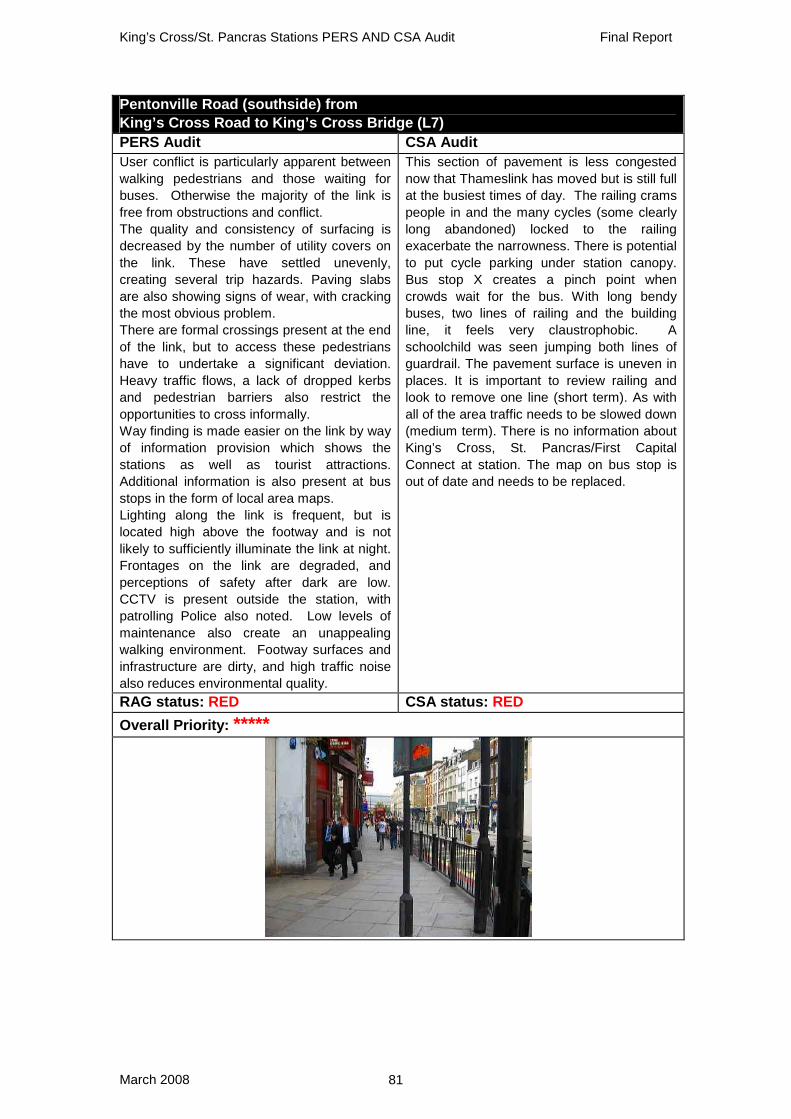
King’s Cross/St. Pancras Stations PERS AND CSA Audit Final Report
March 2008 81
Pentonville Road (southside) from King’s Cross Road to King’s Cross Bridge (L7) PERS Audit CSA Audit User conflict is particularly apparent between walking pedestrians and those waiting for buses. Otherwise the majority of the link is free from obstructions and conflict. The quality and consistency of surfacing is decreased by the number of utility covers on the link. These have settled unevenly, creating several trip hazards. Paving slabs are also showing signs of wear, with cracking the most obvious problem. There are formal crossings present at the end of the link, but to access these pedestrians have to undertake a significant deviation. Heavy traffic flows, a lack of dropped kerbs and pedestrian barriers also restrict the opportunities to cross informally. Way finding is made easier on the link by way of information provision which shows the stations as well as tourist attractions. Additional information is also present at bus stops in the form of local area maps. Lighting along the link is frequent, but is located high above the footway and is not likely to sufficiently illuminate the link at night. Frontages on the link are degraded, and perceptions of safety after dark are low. CCTV is present outside the station, with patrolling Police also noted. Low levels of maintenance also create an unappealing walking environment. Footway surfaces and infrastructure are dirty, and high traffic noise also reduces environmental quality.
This section of pavement is less congested now that Thameslink has moved but is still full at the busiest times of day. The railing crams people in and the many cycles (some clearly long abandoned) locked to the railing exacerbate the narrowness. There is potential to put cycle parking under station canopy. Bus stop X creates a pinch point when crowds wait for the bus. With long bendy buses, two lines of railing and the building line, it feels very claustrophobic. A schoolchild was seen jumping both lines of guardrail. The pavement surface is uneven in places. It is important to review railing and look to remove one line (short term). As with all of the area traffic needs to be slowed down (medium term). There is no information about King’s Cross, St. Pancras/First Capital Connect at station. The map on bus stop is out of date and needs to be replaced.
RAG status: RED CSA status: RED Overall Priority: *****

King’s Cross/St. Pancras Stations PERS AND CSA Audit Final Report
March 2008 82
Pentonville Road (southside) from King’s Cross Bridge to Gray’s Inn Road (L8) PERS Audit CSA Audit At each end of the link, the footway capacity is wide. However in the middle section there is a significant narrowing. This is created by a taxi bay and a shop frontage. Additionally, demolition boards surrounding a shop also obstruct the footway. Crossing is prevented in places by barriers, although pedestrians cross the carriageway informally in other locations. The legibility of the link is aided by finger posts at each end of the link, as well as the visibility of the stations from the link. The link has high flows, which aids perceptions of safety although telephone boxes have cards offering sex services which may make the link an unsafe area to walk in at night particularly as the carriageway focussed lighting is inadequate. Poor perceptions of safety are reinforced as the link is aesthetically poor, with the majority of shops boarded up. Maintenance levels also appear inadequate, as water pools are evident, barriers are bent with peeling paint work, and surfaces are dirty.
This is a narrow piece of pavement that provides an important connecting feature for east/west movement. An opportunity was missed to reallocate the loading bays to pavement whilst the adjacent 'Lighthouse' buildings were derelict. The effective width is <2m with the current hoarding in place. Plans should be made to reduce the loading as the buildings are regenerated and permanently reallocate some of the space to pedestrians.
RAG status: RED CSA status: RED Overall Priority: *****

King’s Cross/St. Pancras Stations PERS AND CSA Audit Final Report
March 2008 83
Pancras Road (westside) from St. Pancras central entrance to Goodsway (L22) PERS Audit CSA Audit The width of the link is significantly affected to the north side of the Euro dispatch owing to building pillars. Security pillars also obstruct. There is a potential overhead obstruction as a traffic sign is relatively low. The permeability of the link is low. The only crossing on the link is located to the south, near the station exit. The tactile paving here is coloured grey. Parked vehicles and heavy traffic flows also make it difficult for pedestrians to cross informally. There are no information boards on the link, despite there being a clear desire for pedestrian information as indicated by the number of pedestrians asking questions and looking at maps. Lighting along the link appears suitable, and is the ‘piggy back’ design which illuminates the footway well. The space also appears ‘open’ which aids perceptions of safety. Beyond the Euro dispatch pedestrian flows are lower and the environmental quality of the link decreases. The link has a new, good quality surface and this is in keeping with the new built feel to the link. There may be potential for decay, as there is low pedestrian use and it is used mainly for vehicle access to and from the station.
In spite of being brand new, this route is not pedestrian friendly owing to the poor crossing provision towards the junction with Goodsway (C39, C40 & C43) . There is an urgent need to address problem of pedestrians moving through relatively attractive environment on Pancras Road alongside St. Pancras, then abruptly finding themselves in 'no-mans land' as Goodsway is approached. The environment moves from the extremely attractive and alive atmosphere around the new station entrances to a series of dead frontages and commercial units further north.
RAG status: RED CSA status: RED Overall Priority: *****

King’s Cross/St. Pancras Stations PERS AND CSA Audit Final Report
March 2008 84
Pancras Road (eastside) from Euston Road to Old Pancras Road (L23) PERS Audit CSA Audit This is a well used link by commuting pedestrians. At present the width is suitable for pedestrian flows. There are no obstructions on the northern end of the link but the southern end has tapering trees, bicycles locked to railings, sign posts and lighting columns. Congestion is limited, and flows are expected to be further reduced once the subway between the two stations becomes operational. There is no footway available between the taxi rank and Euston Road. There is one formal crossing at the northern end of the link but the southern end is inaccessible due to lack of footway. Queuing taxis, the taxi rank and pedestrian barriers add to the poor permeability, together with the lack of dropped kerbs. There is a clear crossing, with tactile paving present to one major entrance to St. Pancras Station (across St. Pancras Road) and yet there are no dropped kerbs at this location. The area may feel isolated at night when the station closes. The northern end of the link has ‘piggy back’ lighting, whereas lighting to the southern end is carriageway focussed with small footway focussed spot lights. Levels of maintenance are mixed. The northern end is smarter with a newly laid footway, whereas the southern area is more run down with dirty frontages/railings and litter on the edge of the link. Here, depressions, cracks and puddles have formed especially where there are reinstatements and tree roots.
Very poor. Clearly at present the other side of the street where there has been little investment compared to footways on the western side. The link passes the chaos of the redevelopment of King’s Cross, the chaos other taxi rank and ends at the chaos of yet another. building site. In the longer term it is hoped that the aim is to create a pedestrian environment that is attractive as the western side of the road.
RAG status: RED CSA status: RED Overall Priority: *****

King’s Cross/St. Pancras Stations PERS AND CSA Audit Final Report
March 2008 85
Midland Road (eastside) from St. Pancras Road to St. Pancras west side entrance (L28) PERS Audit CSA Audit The width of the link is narrow at the northern end with station pillars causing a pinch point which would make using a wheelchair or pushchair very difficult. There is some minor conflict in front of the station from pedestrians with suitcases and users waiting for a taxi. There are dropped kerbs available and well located at the crossing to PT3, however no dropped kerbs are provided across the large vehicle entrance to St. Pancras Station, where kerbs are excessively high. This would prevent access for mobility impaired pedestrians and pushchairs. Informal crossings occur at the northern end of the link, due to the lack of formal crossings. Pedestrian barriers and the row of taxis reduce permeability. Tactile paving is provided at the formal crossings over the taxi lane and at formal crossing over Midland Road but are missing over the vehicle entrance. There is no signage on the entire length of this link. A number of pedestrians asked where King’s Cross Station is, despite its proximity to the link. Lighting on the link is in the form of yellow panels and its effectiveness may be questionable. The link is likely to have much lower flows at night. As such, the northern end by the tunnel may become isolated and threatening after dark. Although the link is well maintained, fumes and noise from waiting taxis are high.
Another source of surprise from a brand new link. Pedestrians will often want to use this eastern side of the road as the overhanging roof offers shelter when the weather is poor. The pavement is, however, extremely narrow here and tow people cannot pass each other without having to negotiate their way around the enormous pillars that block their path. Disabled users found this link particularly problematic and noted that the pavement was double the usual height and quite narrow.
RAG status: RED CSA status: RED Overall Priority: ****

King’s Cross/St. Pancras Stations PERS AND CSA Audit Final Report
March 2008 86
Euston Road (southside) from Crestfield Street to Argyll Road (L10) PERS Audit CSA Audit The underground entrance reduces the width of the link and reduces sightlines which is most likely to be problematic during peak periods but generally the effective width of the link is adequate. A-frames and posts are generally aligned. Posts and guard railings are also contrasted. Heavy traffic and guard railing reduce pedestrians’ crossing options. There are also few dropped kerbs across Euston Road. Navigation is aided by the sight of major landmarks, pedestrian signage, new fingerposts and street names. St. Pancras Station gives a good sense of place, but noise levels are high and air quality feels poor. There are warnings on the link about street crime, but there is CCTV present and street activity is high which aids perceptions of safety. There are a mixture of lighting types, with some focussed solely on the footway. Environmental quality is aided by adequate maintenance, although the link may suffer from dropped leaves during autumn months and surface quality can be poor. For example, sunken utility covers create trip hazards and there is also uneven paving at the crossing across Argyle Street.
There are lots of A boards here. There are 3 different types of pedestrian signage - none with distance or time on. The pavement is narrowed by the entrance to subway, but is busy with people on foot. There is a black pole with signage exacerbating the pinch point. Auditors felt the signage pole should be relocated nearer the kerb line.
RAG status: RED CSA status: RED Overall Priority: ****

King’s Cross/St. Pancras Stations PERS AND CSA Audit Final Report
March 2008 87
Euston Road (southside) from Argyle Street to Judd Street (L11) PERS Audit CSA Audit There are quite high flows of pedestrians on the link and some points are narrowed by bus stops which have the potential to cause some conflict when pedestrian flows are at their highest. Most posts, bins and bollards are well aligned. There is some tonal contrast between the footway and the carriageway and street furniture is contrasted. The carriageway is difficult to cross. There are few dropped kerbs but more significantly there is heavy traffic flow across six lanes with a central reservation. At crossing points, tactile paving is installed. There is likely to be a high number of blind and partially sighted pedestrians in the area owing to the proximity of the RNIB building. The quality of the surface is reasonable; however uneven paving slabs do feature on the link and may cause users to trip. More serious is the level of cross fall and the undulations towards the carriageway, which may destabilise vulnerable users. There is frequent lighting but it is not focussed on the footway, which may make the link quite initimidating at night. CCTV is present and informal surveillance is provided by high pedestrian flows; however there are signs warning about crime in the area. Frontages opposite are of a high quality, but the environment is degraded by high levels of noise and the general impact of the six lanes of traffic.
The cross fall is big and paving surface is poor throughout the length of this link. There are unnecessary bollards and two sawn off lighting columns are waiting to be removed. There is poor lighting under the Town Hall to Bidborough Street and no signage either on this important link. The kiosk by junction of Argyle Street reduces sight lines and creates a pinch point near the junction. It has a noisy generator attached to it - auditors wondered why not is could not use solar power?! Bus stop W creates a pinch point and has a solid end panel. A loose wire pokes out of a tree pit. There are sawn off posts throughout. The whole link needs to be re-engineered to design out cross fall. At same time all the clutter and general detritus needs to be removed along with the solid end panel of the bus stop which should be replaced with half clear panel.
RAG status: RED CSA status: RED Overall Priority: *****

King’s Cross/St. Pancras Stations PERS AND CSA Audit Final Report
March 2008 88
Goodsway tunnel (southside) from Pancras Road to Midland Road (L25) PERS Audit CSA Audit The entire link is of sufficient width which allows for obstructions and user flows. The only obstruction is the pedestrian fence on the west side of the link. The link is not permeable owing to heavy traffic flows, the absence of dropped kerbs or crossings and also pedestrian barriers throughout the length of the link. Contrast clearly separates the footway from the carriageway and taxi rank. There is no signage available on the link and local information on the destination either side of the tunnel would be helpful. There is CCTV on the west side of the link only, which is not likely to view the rest of the link. However, feelings of personal security are fair. Despite the link being a tunnel, exceptional lighting and a reasonable feeling of space aid perceptions. The surface is of a good quality and maintenance of the link is excellent.
It is hard to believe that this has only been recently constructed. Auditors were uniformly shocked that they were being sent down such an unattractive tunnel which was at once subterranean in feel, a canyon of concrete and clearly engineered only for vehicles.
RAG status: AMBER CSA status: RED Overall Priority: ****

King’s Cross/St. Pancras Stations PERS AND CSA Audit Final Report
March 2008 89
Goodsway tunnel (northside) from Pancras Road to Midland Road (L26) PERS Audit CSA Audit Width is acceptable throughout for very low pedestrian flows. The wide link allows for safety from vehicles and also allows for obstructions which are simply poorly aligned. A vehicle sign in the tunnel causes narrowing of width and a signpost on the west end is very poorly aligned, but the width of the footway allows for this. Pedestrians and cyclists are segregated due to the presence of a cycle lane. However cyclists were observed ignoring the lane separation entirely. There is no formal crossing along the whole length of the tunnel or at each end. Informal crossing is difficult owing to a central barrier, step to the carriageway and a high kerb. Tactile information is present at the formal crossings at each end of the link. There is better signage when approaching from the west, with a vehicle and pedestrian sign half way through. There is a finger post at the west end which is clear, but shows no distances. Although well lit, the tunnel would feel isolated and exposed at night due to lack of users and lack of surrounding activity. Once on the link there is no other route to exit and there are places for concealment at both ends. CCTV present on the opposite side of carriageway. The white light used is best practice. The walking environment is very loud owing to the tunnel acoustics, despite only low to moderate traffic flows.
Auditors felt that this link was well lit but otherwise an awful environment for pedestrians (see L25).
RAG status: AMBER CSA status: RED Overall Priority: ****

King’s Cross/St. Pancras Stations PERS AND CSA Audit Final Report
March 2008 90
A.2 Crossings Informal crossings at both ends of Goodsway tunnel (C43, C45 & C46) PERS Audit CSA Audit C43 There is no formal crossing provided to match pedestrians’ desire to cross at this location. Users are placed under danger by the high and speedy traffic flows. Obstructions are numerous at the crossing, including taxis, a pedestrian barrier, pillars and traffic signal columns. There are no dropped kerbs or provision for sensory impaired users. C45 There are no measures to protect pedestrians against speedy traffic. Delay is significant due to numerous obstructions and multiple lanes of traffic. The barriers and pillars force users to deviate from the natural pedestrian desire line. There is no provision for pedestrians with mobility difficulties, and kerbs are not dropped. At the crossing point, kerbs are actually ‘double kerbs’ which mean they are very high. C46 A temporary refuge (bollard and traffic signal column island) tempts users to cross here. Crossing is highly dangerous as pedestrians must take account of traffic in three directions. Because of a taxi lane, the crossing traverses three crossing stages, meaning that pedestrian delay is significant, particularly as the crossing lacks a pedestrian phase and it is unclear when traffic is stopped by traffic signals.
C43 There is no formal crossing here even though this is the natural place to cross for pedestrians heading north from the station. There is no means of crossing safely on left hand side of road - auditors felt that it was truly terrible for pedestrians. A formal crossing needs to be created here. It is difficult to access the nature reserve on foot from the south side of the road. One of roadside barriers by the reserve has crushed. This needs to be repaired or more properly the need for it should be re-assessed and the barriers removed completely. C45 Again new and very poor. Exactly as with C43 at the eastern end of the tunnel there is no crossing here. Auditors again felt that this was unacceptable and that a formal crossing needs to be installed to accommodate people wanting to walk to Camden from the station. C46 It appears that pedestrians are supposed to cross over junction to be on right hand side of Midland Road if they are healing south. Signage is not pedestrian friendly, as it is not obvious where they should cross. This is also a sign indicating the way to St. Pancras that is pointing in wrong direction (on north corner of junction). The signage should be improved.
RAG status: ALL RED CSA status: ALL RED Overall Priority: *****

King’s Cross/St. Pancras Stations PERS AND CSA Audit Final Report
March 2008 91
Informal across York Way south of Caledonia St (C30) PERS Audit CSA Audit Another informal crossing with no provision to aid pedestrians who want to cross at a point where the carriageway is heavily trafficked with fast flowing vehicles. Many vehicles also change lanes at the precise desire line as the carriageway narrows, meaning that drivers may be concentrating on their manoeuvre and may not realise pedestrians cross here. Other vehicles accelerate aggressively where pedestrians cross. Parked vehicles on the eastern side of the carriageway and buses on the west side cause sightline reductions. The delay to pedestrians is uncertain as pedestrians have to wait for a gap in the traffic to cross, and the carriageway is reasonably wide increasing crossing time. Kerbs are not dropped and are approximately 12cm in height.
Demand to cross from the station to developments on the east side of York Way drive large numbers to cross informally at this location. It is not an easy crossing owing to the numbers of vehicle movements (buses, taxis, cars and lorries (especially construction)), their speeds and the width of the road. A formal crossing is needed just past junction with Caledonia St by the Premier Inn.
RAG status: RED CSA status: RED Overall Priority: *****

King’s Cross/St. Pancras Stations PERS AND CSA Audit Final Report
March 2008 92
Informal across Pancras Rd from St. Pancras Station exit towards taxi stand (C34) PERS Audit CSA Audit There is no crossing provided here despite there being a clear desire to go from the side exit of the station to the taxi stand and King’s Cross Station. As an informal crossing, it lacks features such as dropped kerbs, measures to aid sensory impaired pedestrians. Heavy traffic flows make this a particularly risky crossing. Additionally metal security pillars obstruct the approach to the crossing, and sight lines are reduced by parked cars.
This is a widely used informal crossing as there is a lot of pedestrian movement between the 2 stations at all times and it is a long distance from the formal crossing at Euston Rd and at the new shared space by St. Pancras station. Pancras Rd suffers from high vehicle speeds at times owing to its straight and clear sightlines. At the original meetings about this project, it appeared that a raised table was planned for this spot to slow vehicles down and to improve the crossing. This still needs to be installed. A drop kerb exists on left hand side of road opposite taxi rank but there is no drop kerb by the rank. The drop kerbs on each side of road are, therefore, not aligned.
RAG status: RED CSA status: RED Overall Priority: *****

King’s Cross/St. Pancras Stations PERS AND CSA Audit Final Report
March 2008 93
Across King’s Cross Bridge at junction with Pentonville Rd (southside) (C18) PERS Audit CSA Audit Provision is poor given the high vehicle flows and speeds and also high pedestrian flows. There are no pedestrian request boxes so pedestrians continuously cross informally at the formal crossing. Pedestrian barriers prevent any sort of deviation. There is no pedestrian priority. Sightlines when crossing from the north are blocked by waiting buses. Waiting areas are adequate but the crossing is highly unlikely to cope during the peak hours as so many pedestrians cross informally. High vehicle flows are present around the crossing, including many turning buses. The pedestrian phase is very short and has a long waiting time which leads to excessive numbers of pedestrians crossing informally. The crossing delineation is faded but red demarcation assists legibility. Tactile paving is correct and intact but there are no buttons, audible information or rotating cones. Dropped kerbs are generally well flush with white edges. Buses continually queue over the crossing point; this provides obstructions for pedestrians wanting to cross. Some utility covers are not flush and a pot hole is present in the carriageway. Generally the crossing is clean but there is a high degree of debris and discarded cigarette ends by the kerb edge.
This crossing is often blocked by bendy buses turning left. There is severe ponding at the drops when it is wet. There is a delay of 70 secs whilst waiting for green man whilst traffic flows along Pentonville Road. As with the whole of the area, this is a location that would particularly benefit from the review of the one way system and the creation of increased opportunities for pedestrian crossing on C19.
RAG status: RED CSA status: RED Overall Priority: *****

King’s Cross/St. Pancras Stations PERS AND CSA Audit Final Report
March 2008 94
Informal across Pentonville Rd near King’s Cross Bridge (C19) PERS Audit CSA Audit This informal crossing is used by high numbers of pedestrians. A lack of crossing provision on one side of the square either forces pedestrians to deviate over three crossings or cross the carriageway informally. At the informal crossing point, traffic can queue, hiding pedestrians from view and barriers which are in place to restrict this movement have to be negotiated. At other times, traffic moves quickly and pedestrians have to run across the carriageway. There is a wide waiting area on the eastern side of the crossing, but otherwise there is little space to wait for a gap in the traffic. To the Caledonia Road side, dropped kerbs are present and tactile information is provided but is very dirty and faded. A traffic bollard in the central reservation reduces the space available for pedestrians.There is a significant pot hole to the carriageway surface.
Providing a formal crossing on this arm should be a priority as part of a complete review of this junction. Pedestrian demand to cross on this desire line is obvious and many cross here in spite of the advice not to and the clear risk involved. There are 3 signs saying 'Pedestrians do not cross here'. The long-winded alternative is to cross the three associated arms of the crossing, or to dog leg to C19 along two already congested links. There are lots of poles and railings that need to be assessed and some removed. There are opportunities for cycle parking on triangle between King’s Cross Road and Pentonville Road.
RAG status: RED CSA status: RED Overall Priority: *****

King’s Cross/St. Pancras Stations PERS AND CSA Audit Final Report
March 2008 95
Crossings across Euston Rd (C2, C3, C4 and C7) PERS Audit CSA Audit C2 Moderate to high traffic flows on the carriageway are observed. Pedestrians only have priority when the signal is on which means pedestrian users are subject to delay. The capacity of the crossing may not cope at peak times particularly as sheep pen railings constrain movements. Of the two stages, the waiting time on the northern side is excessive and the pedestrian phase is short. On the northern side of the crossing, queuing vehicles block the crossing and sight lines are obstructed. Rotating cones and colour contrast are correctly provided but tactile paving is interrupted by utility covers. The gradient of some drops are quite steep. There may be a drainage problem at the northern side dropped kerb. C3 This marked crossing is at a busy intersection, with no pedestrian aspect.Pedestrians have to cross when they can, often running across the carriageway during peak hours when there are only small gaps in the traffic. C4 With medium flows of pedestrians and vehicles, the controlled crossing type is adequate for the context. The crossing is on the pedestrian desire line to the north, but pedestrians using the crossing do not benefit from direct access to King’s Cross Station. There is one pedestrian phase for all crossings, but the wait time is very long. Visibility of the green man is slightly obscured by the visors installed to stop visibility of the aspect by vehicles. Tactile paving has been provided; however studs are made of metal and are of the wrong colour. Security bollards are a significant obstruction at the crossing but posts have been rationalised with crossing lights on the lamp column. C7 The controlled crossing is appropriate for the context but the sheep pen refuge becomes congested at peak times. Pedestrians can face long delays as crossing depends on traffic phase. The multiple lanes of queuing traffic reduce sight lines and some vehicles queue over the crossing space when traffic signals are green. The refuge is likely to be congested at peak
C2 This is a staggered crossing with a narrow central pen. There is a 60s delay whilst Euston Road moves east-west. There is a steep drop on both sides of carriageway. This is an important crossing that is right outside the British Library. When crossing from north to south there is a delay whilst pedestrians are held in the central pen waiting for green man on the second stage. As with many crossings over the Euston Rd, the delay before pedestrians can cross are so long that pedestrians often attempt to jaywalk in spite of the high volumes of often fast moving vehicles. Auditors felt that the pedestrians should be catered for better and the green man cycle times should be reduced. C3 There is no green man - but drops, tactile and coloured surface on carriageway allow people to cross informally if they choose to - and they do. There is no ASL for cyclists so they encroach and have a habit of blocking crossings. There is a need to install a green man and introduce ASL. C4 Here there is a staggered green man crossing with a central pen. Crossing either way pedestrians get stuck on central island. There is a delay of 60s before crossing begins. On south arm there is a fault - there is a 15 second delay between the traffic stopping and the green man appearing - so the green man phase is effectively shortened. On the northern arm the grill stops the green man being seen - the grill faces east down the road, not across the road. There is no ASL for cyclists so they encroach and have a habit of blocking crossings. The obvious timing fault needs to be corrected. Signals should be phased to prevent delays and to prevent pedestrians being held up on central island. An ASL should be introduced. C7 This is a staggered crossing across 5 lanes of traffic with a 60 sec delay. It is comfortable to cross all the way in one go when heading south, but auditors found that they had to be quick to make it in one go when crossing northbound. They saw that the fastest pedestrians only just make it. The delay should be reduced and the crossing designed so that both arms can be crossed in one go.

King’s Cross/St. Pancras Stations PERS AND CSA Audit Final Report
March 2008 96
times. There is a good waiting area width to the north but it is restricted to the south. Overall, the time required to cross is very long. Crossing from the south to the north is easier and quicker as the northern stage gives pedestrian priority for a longer period. The timing on the southern stage is much too short. There is no audible information provided but all rotating cones are operational. Tactile paving extends to the building line on both sides as desired. There is temporary clutter on the south side of the crossing. The refuge has no obstructions but maybe congested at peak times, leading to user conflict. There is good lighting over the crossing with some 'piggy back' lighting at the waiting areas. Stickering to the request buttons is a problem here. There is gum staining to surfaces but very little litter. Surfaces are well maintained. RAG status: 3 RED (C7 AMBER) CSA status: 3 RED (C7 AMBER)Overall Priority: *****

King’s Cross/St. Pancras Stations PERS AND CSA Audit Final Report
March 2008 97
Across vehicle access roads to St. Pancras Station Building (C39, C40, C48 and C6) PERS Audit CSA Audit C39/C40 These crossings traverse across vehicle entrances to St. Pancras Station. Provision is lacking at these crossings, with no dropped kerbs, road markings or signage available. Information for impaired people is completely missing, placing vulnerable users under risk. The kerbs are excessively high, severely limiting accessibility for wheelchair users. C48 Pedestrians are unsafe from very high kerbs. Building works inside and pillars cause sightlines to be blocked. The southern side has space for an informal waiting area but the northern side has bollards, pillars and posts leaving little room to wait. Dropped kerbs and tactile information are missing, severely limiting usage by sensory and mobility impaired users. Stop line and delineation are missing, and spot lights in the tunnel are unlikely to illuminate sufficiently. C6 This is a crossing across a currently disused vehicle access point to the south entrance of St. Pancras Station. At the present, vehicles are not present and space ownership is therefore high. Dropped kerbs are adequately provided, and are equipped with tactiles.
C39 This is a difficult crossing with no dropped kerbs and is shocking as it is brand new. The pavement narrows considerably at this point and provision for pedestrians is much better on the eastern side of road (L24). The desire line is, however, here on this western side of the road where an overhanging roof provides some shelter. Pedestrians are clearly encouraged to make use of this crossing and this link as an M&S is about to open close by. It is essential to remedial work is undertaken on this and the other crossings on link L22 and a drop kerb is installed at the crossing by the Despatch Centre. C40 Again a brand new crossing made difficult by the absence of a drop kerb. A drop kerb needs to be installed. C48 Kerbs are steep and stepped. Provide dropped kerbs. C6 When the hotel opens there will be a constant flow of taxis across the footway. Both crossings should be raised to increase safety for pedestrians. This will have no impact on traffic capacity.
RAG status: 3 RED (C6 GREEN) CSA status: ALL RED Overall Priority: ****

King’s Cross/St. Pancras Stations PERS AND CSA Audit Final Report
March 2008 98
Across Midland Rd at junction with Euston Rd (northside) (C5) PERS Audit CSA Audit This is a two-staged crossing across a moderately-trafficked road. A high number of pedestrians use the crossing, which suffers from under-capacity. Waiting area on the north side is narrow, and the refuge is particularly congested and hence not suitable for peak flows or for those on wheelchairs. A number of obstructions including bollards, CCTV cameras and temporary construction material are present.
There is no ASL for cyclists so they encroach and have a habit of blocking crossings. There is a green man with refuge. The refuge should be widened to allow greater capacity to wait safely in middle of road. All surfaces are well made and flush. Midland Road is one way, which is quite convenient for crossing. The delay is short and the crossing time long. An ASL should be created and the refuge should be widened.
RAG status: RED CSA status: RED Overall Priority: ****

King’s Cross/St. Pancras Stations PERS AND CSA Audit Final Report
March 2008 99
Across Pancras Rd at junction with Euston Rd (northside) (C8) PERS Audit CSA Audit The two stages to this crossing are unsynchronised, leading to severe delay. The west stage has a very short crossing time of 6 seconds and very long waiting times, but intermittent flows assist in crossing informally. Wheelchair users have extreme difficulty in crossing. Large deviations are caused by the sheep pen.
This junction does not cater well for pedestrians walking along Euston Road. It deviates from the desire line so far that a sign has been installed that states "Do not cross here". Pedestrians prefer cross on the desire line at the mouth of the junction to avoid a 30 metre dog leg that is encumbered by using the signal controlled crossing provision. With so many pedestrians crossing on the desire line at the mouth of the junction, it needs to be redesigned to cater for this movement.
RAG status: AMBER CSA status: RED Overall Priority: ****
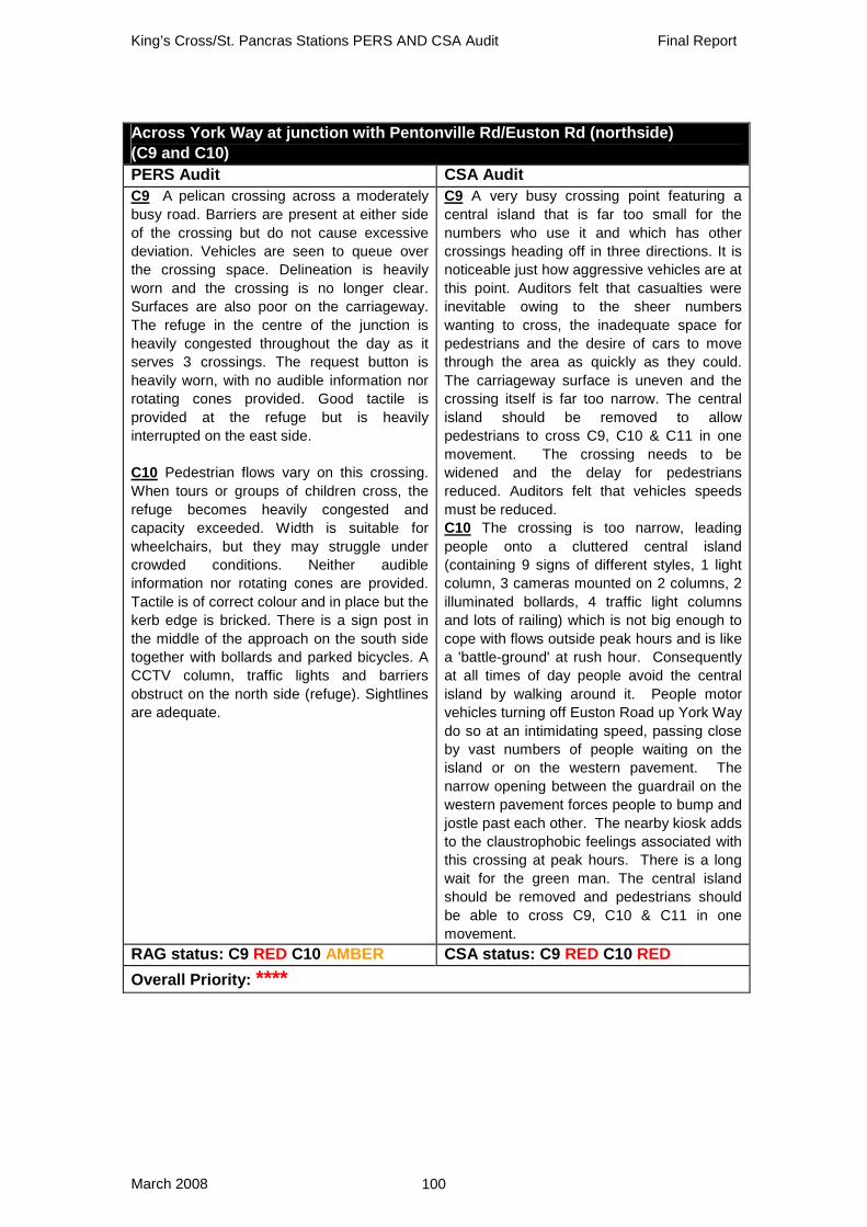
King’s Cross/St. Pancras Stations PERS AND CSA Audit Final Report
March 2008 100
Across York Way at junction with Pentonville Rd/Euston Rd (northside) (C9 and C10) PERS Audit CSA Audit C9 A pelican crossing across a moderately busy road. Barriers are present at either side of the crossing but do not cause excessive deviation. Vehicles are seen to queue over the crossing space. Delineation is heavily worn and the crossing is no longer clear. Surfaces are also poor on the carriageway. The refuge in the centre of the junction is heavily congested throughout the day as it serves 3 crossings. The request button is heavily worn, with no audible information nor rotating cones provided. Good tactile is provided at the refuge but is heavily interrupted on the east side. C10 Pedestrian flows vary on this crossing. When tours or groups of children cross, the refuge becomes heavily congested and capacity exceeded. Width is suitable for wheelchairs, but they may struggle under crowded conditions. Neither audible information nor rotating cones are provided. Tactile is of correct colour and in place but the kerb edge is bricked. There is a sign post in the middle of the approach on the south side together with bollards and parked bicycles. A CCTV column, traffic lights and barriers obstruct on the north side (refuge). Sightlines are adequate.
C9 A very busy crossing point featuring a central island that is far too small for the numbers who use it and which has other crossings heading off in three directions. It is noticeable just how aggressive vehicles are at this point. Auditors felt that casualties were inevitable owing to the sheer numbers wanting to cross, the inadequate space for pedestrians and the desire of cars to move through the area as quickly as they could. The carriageway surface is uneven and the crossing itself is far too narrow. The central island should be removed to allow pedestrians to cross C9, C10 & C11 in one movement. The crossing needs to be widened and the delay for pedestrians reduced. Auditors felt that vehicles speeds must be reduced. C10 The crossing is too narrow, leading people onto a cluttered central island (containing 9 signs of different styles, 1 light column, 3 cameras mounted on 2 columns, 2 illuminated bollards, 4 traffic light columns and lots of railing) which is not big enough to cope with flows outside peak hours and is like a 'battle-ground' at rush hour. Consequently at all times of day people avoid the central island by walking around it. People motor vehicles turning off Euston Road up York Way do so at an intimidating speed, passing close by vast numbers of people waiting on the island or on the western pavement. The narrow opening between the guardrail on the western pavement forces people to bump and jostle past each other. The nearby kiosk adds to the claustrophobic feelings associated with this crossing at peak hours. There is a long wait for the green man. The central island should be removed and pedestrians should be able to cross C9, C10 & C11 in one movement.
RAG status: C9 RED C10 AMBER CSA status: C9 RED C10 RED Overall Priority: ****

King’s Cross/St. Pancras Stations PERS AND CSA Audit Final Report
March 2008 101

King’s Cross/St. Pancras Stations PERS AND CSA Audit Final Report
March 2008 102
Across York Way at junction with Wharfdale Road (C52) PERS Audit CSA Audit This is a 2 stage crossing requiring some deviation around barriers. The 2 stage nature of the crossing with the fast moving traffic creates some delay. Damage to pedestrian barriers need to be addressed.
This is a very poor crossing and its sheer over-engineering points to many of the problems in the area. At no point is direct crossing possible and pedestrians have to wait on the island in middle of road. The damage that has been caused to the crossing and its guard rail point to the high vehicle speeds and heavy vehicles movements in the area. Auditors felt that the crossing should be redesigned to allow pedestrians to cross road in one go and vehicle speeds should be lowered to reduce the threat to pedestrians at the crossing. Key here too is the proximity of the crossing to the northern entrance to King’s Cross which is widely used by local people. Auditors were extremely concerned this could be closed off to pedestrians during redevelopment of the station; they observed it was regularly used by people on foot which implied need for entrance at this point. Local people felt it was vital to retain this northern access to the station. If closed, alternative access would be via Goods Way which felt to be dangerous, especially at night.
RAG status: RED CSA status: RED Overall Priority: ****

King’s Cross/St. Pancras Stations PERS AND CSA Audit Final Report
March 2008 103
A.3 Routes From St. Pancras Station along Gray’s Inn Road to Eastman Dental Hospital (R3) PERS Audit CSA Audit Deviations are minimal on this route. Crossing points are limited along the entire length of the route especially across the A5200, but a good Zebra crossing is provided opposite the dental hospital. All side roads are easy to cross. Barriers and very high traffic flow restrict movement on Euston Road. Sightlines are reduced by the bend in the road on Gray’s Inn Road. Road safety is poor along Euston Road with very high vehicle flows. The environment is degraded and unattractive towards the southern end, with low quality shops and fast food outlets. Frontages are of poor quality and appear run down. Lighting is carriageway focused, leaving the footpath dark at night. Information to the hospital is limited to a map at St. Pancras Station. Tactile is provided at all formal crossings but incorrectly coloured grey at some side roads. Textured paving is provided around trees. No formal rest points are seen along the route, although some seating at bus stops and low walls provide informal rest points. The southern end of the route would not feel safe to rest especially at night. Some attempts have been made with soft landscaping but low branches and uplifting roots cause problems. Poor surface quality is observed at some locations.
It was widely agreed that this is an important route and that it is not very good due to crossing the Euston Road and the relative width of the pavement at particular hotspots, like bus stop R (see PT7). The route is utterly dominated by up to 4 lanes of one-way traffic.
RAG status: RED CSA status: RED Overall Priority: ****

King’s Cross/St. Pancras Stations PERS AND CSA Audit Final Report
March 2008 104
From St. Pancras Station along Gray’s Inn Road to the Royal National Throat, Nose and Ear Hospital (R4) PERS Audit CSA Audit The route follows the same path with R3 for the most part. Formal crossing points exist along Euston Road, but are missing along Gray's Inn Road. Importantly there is no crossing outside of the Hospital. Moderate to high traffic flows are observed, especially on Euston Road. A lack of dropped kerbs is evident at several locations. Parked vehicles, carriageway curvature and footway obstructions significantly reduce sightlines on Euston Road. The environment is very intimidating even during the day due to lower quality frontages and a lack of maintenance. Many shops are closed or abandoned. There is some evidence of anti-social behaviour. Lighting is carriageway focused so the area is likely to feel quite dark at night. There is no signage to the Royal National TNE Hospital – the only information available is on the map at the station. It is therefore difficult to follow the route, especially since the areas around the station are very busy with pedestrians and high traffic volumes on large carriageways. Tactile is provided at most formal crossing points but is not necessarily correct.
RAG status: RED CSA status: N/A Overall Priority: ****

King’s Cross/St. Pancras Stations PERS AND CSA Audit Final Report
March 2008 105
A.4 Waiting areas and spaces
Bus Stop G westside on York Way alongside King’s Cross Station (PT7) PERS Audit CSA Audit Pedestrians have to run across York Road as there are few crossings and the carriageway is wide and heavily trafficked. As informal crossings, there are no measures in place to aid pedestrians trying to cross to the bus stop; as such this is a dangerous manoeuvre. The capacity of the waiting area and the shelter is inadequate, resulting in user conflict on the adjacent footway. Signs at the stop advertise CCTV in the area and incidents could be reported to the local police station. However, at night there is likely to be a decrease in footway activity and informal surveillance may not be so readily gained. Environmental quality of the waiting area is poor. The stop faces a blank wall of King’s Cross Station and not all frontages are occupied on the other side of the carriageway. In particular, the boarded up adult book shops lower visual appeal. There are high levels of traffic noise but maintenance appears fair.
PT7 was identified by auditors as a major public transport waiting area for people going to/from KX. This bus stop is major drop off point, but currently the pavement is extremely narrow. There is again a problem with lack of signage to the King’s Cross station entrance. This is especially difficult for pedestrians with children or who are infirm. The available space is wholly weighted in favour of cars at present: there is a need to widen the pavement (both now while the works on the station are in progress and in the longer term once they have finished), to give pedestrians and bus stop users the space they need. The pavement is less than 3.5m wide and passing pedestrians typically bypass the queues by walking into the road. Auditors said it is a bad place to wait and to pass by at the busiest times. In general auditors felt that traffic was moving too fast along York Way and there was a need to slow down traffic. They recommended introducing 20 mph speed limit on this and surrounding roads. It was also felt to be important to get across the message that the area is partly residential. At present there are no seats and no shelter at the stop - these should be installed once more space is created.
RAG status: RED CSA status: RED Overall Priority: *****

King’s Cross/St. Pancras Stations PERS AND CSA Audit Final Report
March 2008 106
Bus Stop eastside of Caledonian Rd south of Caledonia St (PT8) PERS Audit CSA Audit The main problem with the waiting area is the poor environmental quality of the stop and surrounding area, which makes it unwelcoming for waiting pedestrians and also decreases users’ perceptions of safety. Shop frontages are poor, there is no landscaping and noise levels are high. There is graffiti in a stairwell recess near to the stop, which could also be used as a place for concealment. Lighting is present but offers illumination to the carriageway only. There is a light to the shelter. Maintenance also appears insufficient; there is a lot of dust around the waiting area and surfaces are not clean. There is also a problem with access to the waiting area. Crossings are some distance away from the waiting area, which encourages informal crossing of a busy road. Additionally, at the formal crossings there is minimal tactile paving. The waiting area is quite narrow, and in particular wheelchair users are likely to struggle to get past waiting pedestrians.
As with many bus stops in the area there is little space for those waiting for the bus and pedestrians using the pavement. Space needs to be re-allocated from vehicles to the large numbers of pedestrians in the area.
RAG status: RED CSA status: RED Overall Priority: ****

King’s Cross/St. Pancras Stations PERS AND CSA Audit Final Report
March 2008 107
Bus Stop X outside former King’s Cross Thameslink Station (PT5) PERS Audit CSA Audit The attractiveness of the stop is reduced by the heavy vandalism to the waiting area shelter, possible places for concealment, a lack of nearby lighting, no soft landscaping, homeless people using the shelter to sleep and sit, high traffic noise levels and poor maintenance. Additionally, there is no seating and the shelter is small for the number of users which results in pedestrians using the station for cover. Both of these factors result in high levels of user conflict around the waiting area. Kerbs at the stop are not suitably raised, causing problems and delay to some boarding and alighting passengers. The waiting area scores poorly as pedestrians are unable to directly cross to the waiting area owing to the presence of central reservation barriers, and the formal crossing approximately 20m to the south of the waiting area has uneven paving on approach. The waiting area itself is clearly visible from the pedestrian route, with a bus map visible on the shelter and the majority of timetables are present. Additionally, real time information is provided.
Situated on a link that is very busy. Auditors suggested removing the railing and taking away much of the clutter in the area.
RAG status: RED CSA status: RED Overall Priority: ****

King’s Cross/St. Pancras Stations PERS AND CSA Audit Final Report
March 2008 108
Bus Stop M northside of Euston Rd outside King’s Cross tube entrance (PT2) PERS Audit CSA Audit The information in the station is useful and shows the approximate location of the waiting area, and the bus stop is visible and branded. There is a standard set of information at the stop which is well presented. A key problem at the stop is that there is no shelter, and seating is not provided. There is a crossing approximately 20m north east of the stop, but 100m to the south west. Conflict may be a problem at the stop between waiting passengers and passing footway pedestrians. The high numbers of pedestrians do result in high levels of informal surveillance although in the off peak the waiting area may feel isolated. Lighting is present within close proximity of the waiting area. There is a telephone to the south west of the stop, but is approximately 80 to 100m away. Frontages are well presented, which aids perceptions of safety. However they are dirty, thus lowering environmental quality. Much of the footway is clean but the footway edges have dirt and debris. There is no litter bin.
Auditors felt that this was a ludicrous place to locate a bus stop. The pavement is far to narrow to accommodate a shelter or seats. The pavement needs to be widened regardless of whether the bus stop is there or not. The bus stop needs to be relocated.
RAG status: RED CSA status: RED Overall Priority: ****

King’s Cross/St. Pancras Stations PERS AND CSA Audit Final Report
March 2008 109
Bus Stop A outside Camden Town Hall southside of Euston Rd (PT6) PERS Audit CSA Audit There is no opportunity for pedestrians to cross informally at the waiting area as central barriers prevent crossing. This results in deviations to access formal crossings of approximately 30m in either direction of the waiting area. Kerbs at the waiting area are not suitably raised, and pedestrian conflict on the footway results from waiting pedestrians. Other infrastructure problems include a lack of footway focussed lighting, where the closest lighting to the stop is obscured by a tree. There is both seating and a shelter present. The waiting area is clearly visible but there is no local information or additional information provided. Timetables are present, and there is only minor graffiti to infrastructure. The stop is clean owing to street sweepers and cleansing workers. However, a litter bin has not been provided. Environmental quality is somewhat decreased by very high noise levels; however this is partially offset by the excellent sense of place that St. Pancras Station offers, as well as the presence of soft landscaping.
Bus stop W creates a pinch point and has a solid end panel. The solid end panel should be removed to reduce pinch point.
RAG status: AMBER CSA status: RED Overall Priority: ***
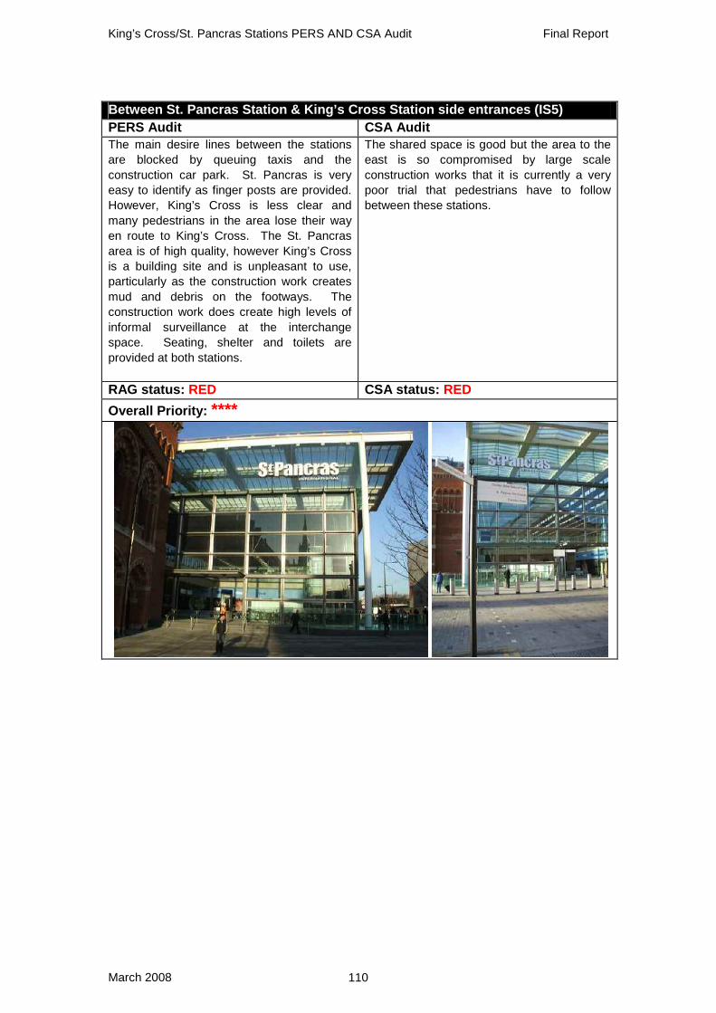
King’s Cross/St. Pancras Stations PERS AND CSA Audit Final Report
March 2008 110
Between St. Pancras Station & King’s Cross Station side entrances (IS5) PERS Audit CSA Audit The main desire lines between the stations are blocked by queuing taxis and the construction car park. St. Pancras is very easy to identify as finger posts are provided. However, King’s Cross is less clear and many pedestrians in the area lose their way en route to King’s Cross. The St. Pancras area is of high quality, however King’s Cross is a building site and is unpleasant to use, particularly as the construction work creates mud and debris on the footways. The construction work does create high levels of informal surveillance at the interchange space. Seating, shelter and toilets are provided at both stations.
The shared space is good but the area to the east is so compromised by large scale construction works that it is currently a very poor trial that pedestrians have to follow between these stations.
RAG status: RED CSA status: RED Overall Priority: ****

King’s Cross/St. Pancras Stations PERS AND CSA Audit Final Report
March 2008 111
Between St. Pancras Station, Underground and Bus Stops A & M on Euston Rd (IS1) PERS Audit CSA Audit Crossings are provided for pedestrians at surface level as well as there being subways. Pedestrians do not have to cover large distances at the interchange space. Information is not present at all potential areas but there is no clear interchange space. In particular there is a lack of assistance or provision to aid disabled pedestrians. High street activity results in fair levels of user perception and CCTV is present at the subway entrance. One of the most significant problems is the lack of seating, which is only present at the subway entrance. The significant impact of the traffic is detrimental to the overall environmental quality.
This is very poor. As we have seen the bus stops on the northern side are located on extremely narrow pavements. On the south side the shelter causes a pinch point. Pavement widths on the northern side of Euston Rd are simply inadequate.
RAG status: RED CSA status: RED Overall Priority: ****
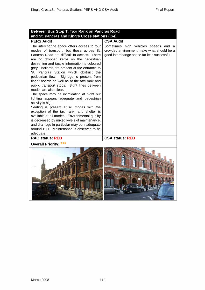
King’s Cross/St. Pancras Stations PERS AND CSA Audit Final Report
March 2008 112
Between Bus Stop T, Taxi Rank on Pancras Road and St. Pancras and King’s Cross stations (IS4) PERS Audit CSA Audit The interchange space offers access to four modes of transport, but those across St. Pancras Road are difficult to access. There are no dropped kerbs on the pedestrian desire line and tactile information is coloured grey. Bollards are present at the entrance to St. Pancras Station which obstruct the pedestrian flow. Signage is present from finger boards as well as at the taxi rank and public transport stops. Sight lines between modes are also clear. The space may be intimidating at night but lighting appears adequate and pedestrian activity is high. Seating is present at all modes with the exception of the taxi rank, and shelter is available at all modes. Environmental quality is decreased by mixed levels of maintenance, and drainage in particular may be inadequate around PT1. Maintenance is observed to be adequate.
Sometimes high vehicles speeds and a crowded environment make what should be a good interchange space far less successful.
RAG status: RED CSA status: RED Overall Priority: ***

King’s Cross/St. Pancras Stations PERS AND CSA Audit Final Report
March 2008 113
British Library Plaza (PS1) PERS Audit CSA Audit The public space is very well signed for wheelchair users, showing the access route which avoids using steps. The entrance to the public space is visible from most points although hedges (used to divide the space) partly restrict visibility. CCTV is seen pointing into the space, and low level lighting is frequently provided. The café also gives the opportunity for informal surveillance and additionally provides shelter. Benches and low wall are present for use and the library offers toilets. The space is very clean and surfaces are well kept. The public space is extremely tranquil, with people relaxing with a drink, workmen sitting during breaks, library users and school children sitting with teachers.
Auditors questioned whether this was really a public space as it gets locked at night and on some days of the year. Visitors could easily walk past it and not realise it is a public space. If it is being classified as such, it needs to be more welcoming.
RAG status: GREEN CSA status: AMBER Overall Priority: **

King’s Cross/St. Pancras Stations PERS AND CSA Audit Final Report
March 2008 114
Appendix B: CSA Stakeholder List
Organisation Participants
Lunchtime Audit Local Residents 6 King's Cross Environment Group 2 Camden Civic Society 2 Other Local Organisations (names not taken) 3 Friend of Capital Transport 1 Cyclists' Touring Club (CTC) 1 Sustrans 1 Cambridge Rail User Group member 1 Transport for London 1
Sub Total 18
Evening Audit The National Council for Voluntary Organisations (NCVO) 2 Islington Living Streets 1 Cally Rail Group 1 Local Resident - Pentonville Rd 1 Local Resident - Wharfdale Rd 1 King's Cross Environment Group 1 Camden Corner 1 Royal National Institute of Blind People (RNIB) 1 Camden Council 1 Local Resident - Argyll Square 1 Local Resident – New Wharf 1
Sub Total 12
Grand Total 30
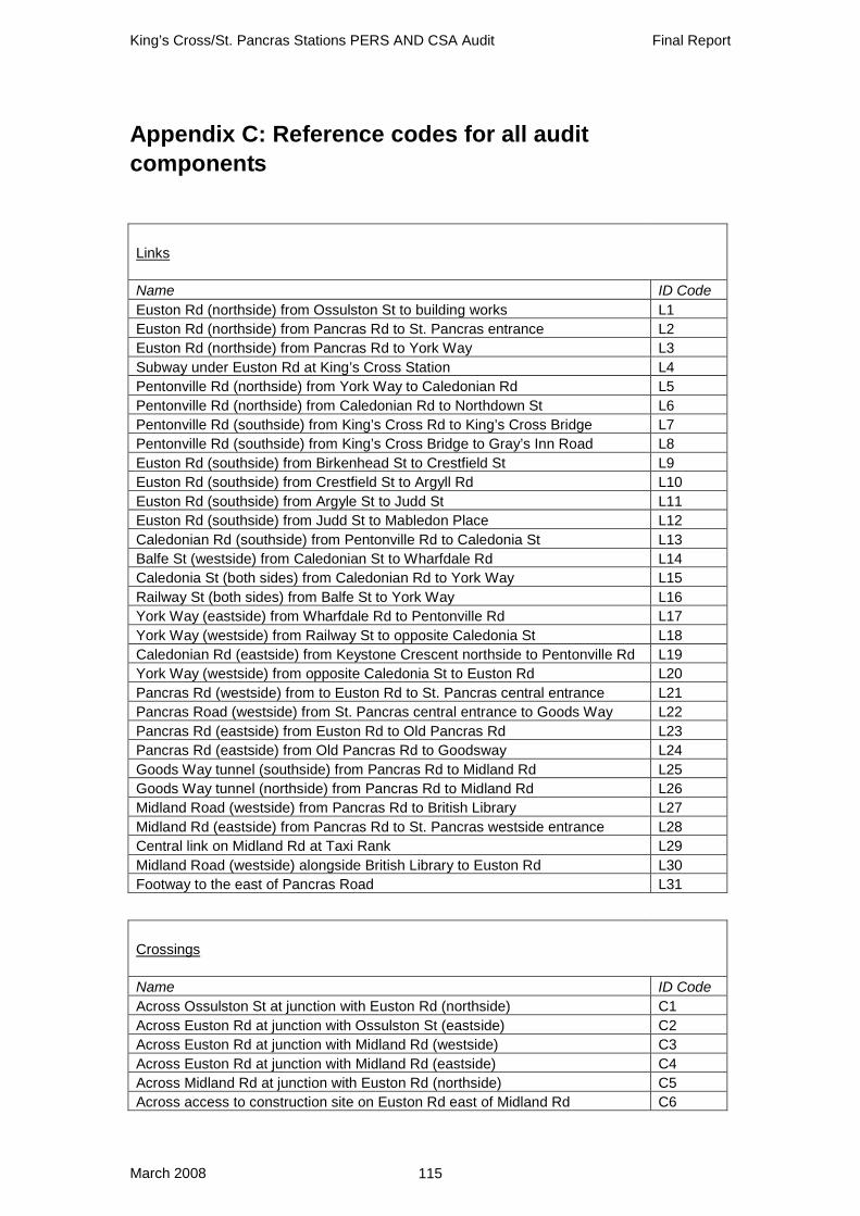
King’s Cross/St. Pancras Stations PERS AND CSA Audit Final Report
March 2008 115
Appendix C: Reference codes for all audit components
Links
Name ID Code Euston Rd (northside) from Ossulston St to building works L1 Euston Rd (northside) from Pancras Rd to St. Pancras entrance L2 Euston Rd (northside) from Pancras Rd to York Way L3 Subway under Euston Rd at King’s Cross Station L4 Pentonville Rd (northside) from York Way to Caledonian Rd L5 Pentonville Rd (northside) from Caledonian Rd to Northdown St L6 Pentonville Rd (southside) from King’s Cross Rd to King’s Cross Bridge L7 Pentonville Rd (southside) from King’s Cross Bridge to Gray’s Inn Road L8 Euston Rd (southside) from Birkenhead St to Crestfield St L9 Euston Rd (southside) from Crestfield St to Argyll Rd L10 Euston Rd (southside) from Argyle St to Judd St L11 Euston Rd (southside) from Judd St to Mabledon Place L12 Caledonian Rd (southside) from Pentonville Rd to Caledonia St L13 Balfe St (westside) from Caledonian St to Wharfdale Rd L14 Caledonia St (both sides) from Caledonian Rd to York Way L15 Railway St (both sides) from Balfe St to York Way L16 York Way (eastside) from Wharfdale Rd to Pentonville Rd L17 York Way (westside) from Railway St to opposite Caledonia St L18 Caledonian Rd (eastside) from Keystone Crescent northside to Pentonville Rd L19 York Way (westside) from opposite Caledonia St to Euston Rd L20 Pancras Rd (westside) from to Euston Rd to St. Pancras central entrance L21 Pancras Road (westside) from St. Pancras central entrance to Goods Way L22 Pancras Rd (eastside) from Euston Rd to Old Pancras Rd L23 Pancras Rd (eastside) from Old Pancras Rd to Goodsway L24 Goods Way tunnel (southside) from Pancras Rd to Midland Rd L25 Goods Way tunnel (northside) from Pancras Rd to Midland Rd L26 Midland Road (westside) from Pancras Rd to British Library L27 Midland Rd (eastside) from Pancras Rd to St. Pancras westside entrance L28 Central link on Midland Rd at Taxi Rank L29 Midland Road (westside) alongside British Library to Euston Rd L30 Footway to the east of Pancras Road L31
Crossings
Name ID Code Across Ossulston St at junction with Euston Rd (northside) C1 Across Euston Rd at junction with Ossulston St (eastside) C2 Across Euston Rd at junction with Midland Rd (westside) C3 Across Euston Rd at junction with Midland Rd (eastside) C4 Across Midland Rd at junction with Euston Rd (northside) C5 Across access to construction site on Euston Rd east of Midland Rd C6

King’s Cross/St. Pancras Stations PERS AND CSA Audit Final Report
March 2008 116
Across Euston Rd at junction with Argyle St (eastside) C7 Across Pancras Rd at junction with Euston Rd (northside) C8 Across York Way eastern stage at junction with Pentonville Rd (northside) C9 Across York Way western stage at junction with Euston Rd (northside) C10 Across Euston Rd between refuges at York Way C11 Across Gray's Inn Rd to the central refuge at junction with York Way C12 Across Gray's Inn Rd at junction with Pentonville Rd (southside) C13 Across Pentonville Rd at York Way to corner of Gray's Inn Rd C14 Across Pentonville Rd at Caledonian Rd (westside) C15 Across Caledonian Rd at junction with Pentonville Rd (northside) C16 Across Pentonville Rd & King’s Cross Rd at junction with Northdown St (westside) C17 Across King’s Cross Bridge at junction with Pentoville Rd (southside) C18 Informal across Pentonville Rd near King’s Cross Bridge C19 Across Birkenhead St at junction with Euston Rd (southside) C20 Across Crestfield St at junction with Euston Rd (southside) C21 Across Belgrove St at junction with Euston Rd (southside) C22 Across Argyle Street at junction with Euston Rd (southside) C23 Across Judd St at junction with Euston Rd (southside) C24 Across Caledonia St at junction with Caledonian Rd (westside) C25 Across Caledonian Rd between Balfe St & Keystone Crescent C26 Across Railway St at junction with Balfe St (westside) C27 Across Railway St at junction with York Way (eastside) C28 Across Caledonia St at junction with York Way (eastside) C29 Informal across York Way south of Caledonia St C30 Across Keystone Crescent northside access at Caledonian Rd (eastside) C31 Across Keystone Crescent southside access at Caledonian Rd (eastside) C32 Across Omega Place at junction with Caledonian Rd (eastside) C33 Informal across Pancras Rd from St. Pancras Station exit towards taxi stand C34 Across Pancras Rd south of split with old Pancras Rd C35 Across new Pancras Rd just north of split with old Pancras Rd C36 Across old Pancras Rd just north of split with new Pancras Rd C37 Across new Pancras Rd north of split with old Pancras Rd C38 Across Euro Despatch Centre access at junction with Pancras Rd (westside) C39 Across car park access at junction with Pancras Rd (westside) C40 Across Goods Way at junction with Pancras Rd (eastside) C41 Across Carnley St at junction with Goods Way (northside) C42 Informal across Goods Way at junction with Pancras Rd (westside) C43 Across Pancras Rd at junction with Midland Rd (northside) C44 Informal across Pancras Rd northeast of Midland Rd C45 Informal across Midland Rd southside of Pancras Rd C46 Across Brill Place at junction with Midland Rd (westside) C47 Across vehicle entrance to St. Pancras Station off Midland Rd (eastside) C48 Across Midland Rd south of Brill Place to central link between carriageway & Taxis C49 Across Taxi Rank from St. Pancras Station to central link at Midland Rd C50 Across Midland Rd to central link between carriageway & taxis (south of C49) C51 Across York Way at junction with Wharfdale Road C52

King’s Cross/St. Pancras Stations PERS AND CSA Audit Final Report
March 2008 117
Routes
Name ID Code From St. Pancras Station to the former King’s Cross Thameslink Station R1 From St. Pancras Station (western entrance) along Midland Rd to the British Library R2 From St. Pancras Station along Gray's Inn Rd to Eastman Dental Hospital R3 From St. Pancras Station along Gray's Inn Road to the Royal National Throat, Nose and Ear Hospital R4
Public Transport Waiting Areas
Name ID Code Bus stop outside Library northside of Euston Rd west of Midland Rd PT1 Bus Stop M northside of Euston Rd outside King’s Cross tube entrance PT2 Bus Stop D outside King’s Cross Station - south stand PT3 Bus Stop E outside King’s Cross Station - north stand PT4 Bus Stop X outside former King’s Cross Thameslink Station PT5 Bus Stop A outside Camden Town Hall southside of Euston Rd PT6 Bus Stop G westside on York Way alongside King’s Cross Station PT7 Bus Stop eastside of Caledonian Rd south of Caledonia St PT8 Bus stop T outside St. Pancras Station westside of St. Pancras Rd PT9 Taxi rank outside St. Pancras Station eastside of Pancras Rd PT10 Bus Stop S at St. Pancras Station entrance on Midland Rd PT11
Public Spacecs
Name ID Code British Library Plaza PS1
Interchange Spaces
Name ID Code Between St. Pancras Station, Underground and Bus Stops A & M on Euston Rd IS1 Between King’s Cross Station & Bus Stops northside on Euston Rd IS2 Between former King’s Cross Thameslink & Bus Stop IS3 Between Bus Stop T, Taxi Rank on Pancras Rd and St. Pancras & King’s Cross stations IS4 Between St. Pancras Station & King’s Cross Station side entrances IS5