Transport and Travel in Scotland 2012 · Transport and Travel in Scotland ... 1.13 Most people...
78
Statistical Bulletin Transport Series Trn / 2013/ 2 28 August 2013 Transport and Travel in Scotland 2012 This bulletin summarises a range of transport statistics in Scotland to highlight the main trends and present the results of the 2012 Scottish Household Survey transport questions in context. Some comparisons with Great Britain (or the UK) are also included. 1 Main Points Motor vehicles, traffic and driving 1.1 The estimated total volume of traffic on Scotland's roads in 2012 was over 43 billion vehicle kilometres – 0.4 per cent more than in 2011 and the first increase since 2007. [Table S1] 1.2 In 2012 there were around 216,000 new vehicle registrations in Scotland, an increase of 7 per cent on 2011, the largest increase in the last ten years. [Table S1] 1.3 There were 2.7 million motor vehicles licensed in Scotland in 2012, a one per cent increase on 2011 and 17 per cent higher than in 2002. [Table S1] 1.4 68% of people aged 17 or over had a full driving licence in 2012, the highest figure for the last decade. [Table S3] 1.5 Driving licence possession varies with age. Seventeen to 19 year olds have the lowest rate of licence possession (28%) with the rate increasing with age to peak at 80 per cent of 40 to 49 year olds, before decreasing back down to 37 per cent of those 80 or over. [Table 1] 1.6 Males were more likely to hold a full driving license than females (76% vs. 62%); male licence possession has been fairly stable whilst female possession has been steadily increasing over the last decade. [Table S3] 1.7 Twenty-six per cent of households had access to two or more cars in 2012, whilst 31 per cent had no access to a car. The proportions have remained similar over the last five years. [Table S3] 1.8 One in five respondents had made a journey in the last month where they chose to drive only part of the way, and completed their journey using another form of transport. Of these, 29 per cent parked in a designated Park & Ride facility and a
Transcript of Transport and Travel in Scotland 2012 · Transport and Travel in Scotland ... 1.13 Most people...

Statistical Bulletin Transport Series
Trn / 2013/ 2 28 August 2013 Transport and Travel in Scotland 2012 This bulletin summarises a range of transport statistics in Scotland to highlight the main trends and present the results of the 2012 Scottish Household Survey transport questions in context. Some comparisons with Great Britain (or the UK) are also included.
1 Main Points
Motor vehicles, traffic and driving 1.1 The estimated total volume of traffic on Scotland's roads in 2012 was over 43 billion vehicle kilometres – 0.4 per cent more than in 2011 and the first increase since 2007. [Table S1]
1.2 In 2012 there were around 216,000 new vehicle registrations in Scotland, an increase of 7 per cent on 2011, the largest increase in the last ten years. [Table S1]
1.3 There were 2.7 million motor vehicles licensed in Scotland in 2012, a one per cent increase on 2011 and 17 per cent higher than in 2002. [Table S1]
1.4 68% of people aged 17 or over had a full driving licence in 2012, the highest figure for the last decade. [Table S3]
1.5 Driving licence possession varies with age. Seventeen to 19 year olds have the lowest rate of licence possession (28%) with the rate increasing with age to peak at 80 per cent of 40 to 49 year olds, before decreasing back down to 37 per cent of those 80 or over. [Table 1]
1.6 Males were more likely to hold a full driving license than females (76% vs. 62%); male licence possession has been fairly stable whilst female possession has been steadily increasing over the last decade. [Table S3]
1.7 Twenty-six per cent of households had access to two or more cars in 2012, whilst 31 per cent had no access to a car. The proportions have remained similar over the last five years. [Table S3]
1.8 One in five respondents had made a journey in the last month where they chose to drive only part of the way, and completed their journey using another form of transport. Of these, 29 per cent parked in a designated Park & Ride facility and a

further 29 per cent used an ordinary car park at a bus station, train station or airport. [Table 21]
1.9 Half of households spend £100 or less on fuel for their cars each month, the same amount as in 2011. Households reported an average spend of £134 on fuel for their cars in the past month – an increase of £34 over the last three years. [Table 2]
Public transport, ferries and aviation
1.10 More people are using trains. ScotRail patronage increased by 2.7 per cent (to 83.3 million) in 2012/13 – the highest level recorded and an increase of 45% since 2003/04. [Table S1]
1.11 Twenty-eight per cent of respondents to the SHS used the train in the last month, up from 26 per cent in 2011 and an increase from 15 per cent in 2002. Forty two per cent used a local bus in the last month. [Table S3]
1.12 The majority of people are satisfied with public transport. Seventy-two per cent of people were satisfied or very satisfied in 2012. This is a fall from 76 per cent in 2011 and higher than in 2007 (69%). [Table 4]
1.13 Most people agreed that it was easy to change from buses and trains to other forms of transport (82% for trains and 75% for buses) and to find out route and timetable information (91% for trains and 84% for buses). [Table 29]
1.14 Younger people and women are more likely to use the bus. Two thirds of 16-19 year olds had used the bus in the last month, compared to one third of those aged 40-49. 45 per cent of women had used the bus in the last month compared to 38 per cent of men. [Table 28]
1.15 Fifty-five per cent of those aged 60 or over used their concessionary pass at least once a month. Thirty-four per cent have a pass but haven’t used it. Twelve per cent have no pass. [Table 32]
1.16 There were 22.2 million air terminal passengers at airports in Scotland in 2012. An increase of less than one per cent on 2011. [Table S1]
1.17 The number of passenger journeys from Scottish airports to destinations outwith the UK was higher than the number of internal flights for the first time (10.21m compared to 10.05m) [Table S4]
1.18 Forty-six per cent of SHS respondents took a flight for leisure purposes in 2012 and 8 per cent for business.
1.19 In 2012, 5.5 million passengers were carried on Caledonian MacBrayne, Northlink Orkney and Shetland and Orkney ferry services, a fall of 2.5 per cent from 2011. [Table S1] Walking and cycling 1.20 Thirty-five per cent of households had access to at least one bicycle for adult use in 2012. This proportion has remained stable over the last decade. [Table S3]
2

Travel to work and school 1.21 Thirty per cent of respondents travelled to work by public or active transport, continuing the trend of little change in recent years. This figure provides an update to the indicator used in the Scottish Government’s National Performance Framework which is considered to be ‘performance maintaining’. [Table S3]
1.22 Active travel accounted for 16 per cent (walking: 13.6%, cycling: 2.0%) and public transport 14 per cent (bus: 10.1%, rail: 4.3%) of all journeys to work in 2012. [Table S3]
1.23 Fifty-two per cent of all journeys to school were made by walking or cycling in 2012. The levels have remained relatively stable over the last ten years. [Table S3]
1.24 Children in primary school were more likely to walk or be driven to school than children in secondary school. Secondary school pupils are more likely to catch a bus. [Table 15]
Access to services 1.25 Eighty-four per cent of respondents felt that public transport was very or fairly convenient to access in 2012. [Table 33] Freight 1.26 The amount of freight lifted in Scotland continues to fall. Excluding road transport, freight lifted fell 3% to 64.9 million tonnes in 2012.
1.27 Two thirds of freight lifted in Scotland was transported by road in 2010 (the latest year for which road freight data is available).
3
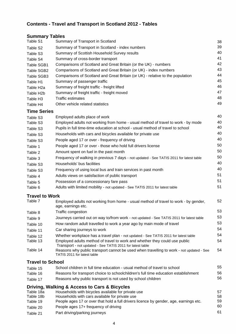
Contents - Travel and Transport in Scotland 2012 - Tables
Summary Tables
Table S1 Summary of Transport in Scotland 38
Table S2 Summary of Transport in Scotland - index numbers 39
Table S3 Summary of Scottish Household Survey results 40
Table S4 Summary of cross-border transport 41
Table SGB1 Comparisons of Scotland and Great Britain (or the UK) - numbers 42
Table SGB2 Comparisons of Scotland and Great Britain (or UK) - index numbers 43
Table SGB3 Comparisons of Scotland and Great Britain (or UK) - relative to the population 44
Table H1 Summary of passenger traffic 45
Table H2a Summary of freight traffic - freight lifted 46
Table H2b Summary of freight traffic - freight moved 47
Table H3 Traffic estimates 48
Table H4 Other vehicle related statistics 49
Time Series
Table S3 Employed adults place of work 40
Table S3 Employed adults not working from home - usual method of travel to work - by mode 40
Table S3 Pupils in full time-time education at school - usual method of travel to school 40
Table S3 Households with cars and bicycles available for private use 40
Table S3 People aged 17 or over - frequency of driving 40
Table 1 People aged 17 or over - those who hold full drivers license 50
Table 2 Amount spent on fuel in the past month 50
Table 3 Frequency of walking in previous 7 days - not updated - See TATIS 2011 for latest table 50
Table S3 Households' bus facilities 40
Table S3 Frequency of using local bus and train services in past month 40
Table 4 Adults views on satisfaction of public transport 51
Table 5 Possession of a concessionary fare pass 51
Table 6 Adults with limited mobility - not updated - See TATIS 2011 for latest table 51
Travel to Work
Table 7 Employed adults not working from home - usual method of travel to work - by gender, age, earnings etc.
52
Table 8 Traffic congestion 53
Table 9 Journeys carried out on way to/from work - not updated - See TATIS 2011 for latest table 53
Table 10 How random adult travelled to work a year ago by main mode of travel 53
Table 11 Car sharing journeys to work 54
Table 12 Whether workplace has a travel plan - not updated - See TATIS 2011 for latest table 54
Table 13 Employed adults method of travel to work and whether they could use public Transport - not updated - See TATIS 2011 for latest table
54
Table 14
Reasons why public transport cannot be used when travelling to work - not updated - See TATIS 2011 for latest table
54
Travel to School
Table 15 School children in full time education - usual method of travel to school 55
Table 16 Reasons for transport choice to schoolchildren's full time education establishment 56
Table 17 Reasons why public transport is not used by school children 56
Driving, Walking & Access to Cars & Bicycles
Table 18a Table 18b
Households with bicycles available for private use Households with cars available for private use
57 58
Table 19 People ages 17 or over that hold a full drivers licence by gender, age, earnings etc. 59
Table 20 People ages 17+ frequency of driving 60
Table 21 Part driving/parking journeys 61
4
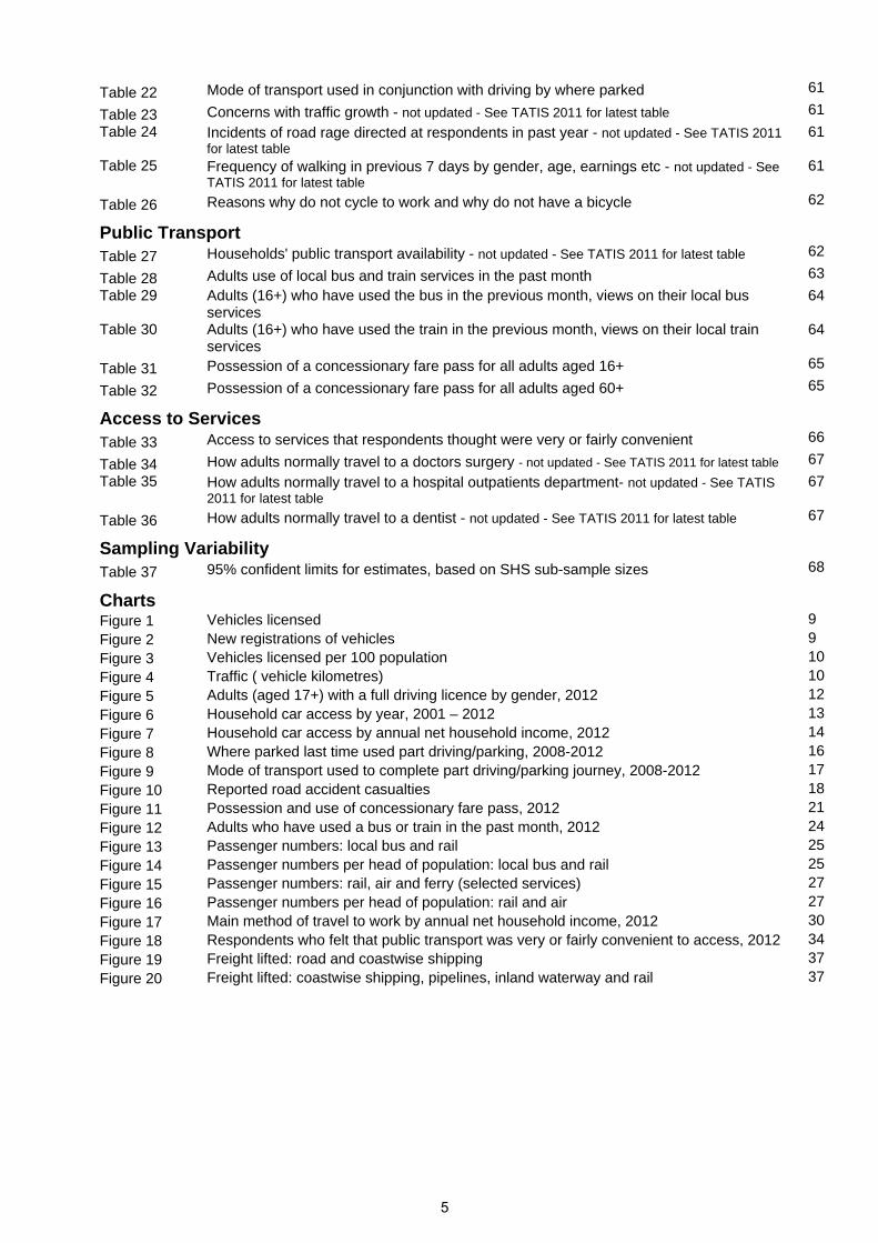
Table 22 Mode of transport used in conjunction with driving by where parked 61
Table 23 Concerns with traffic growth - not updated - See TATIS 2011 for latest table 61
Table 24
Incidents of road rage directed at respondents in past year - not updated - See TATIS 2011 for latest table
61
Table 25
Frequency of walking in previous 7 days by gender, age, earnings etc - not updated - See TATIS 2011 for latest table
61
Table 26 Reasons why do not cycle to work and why do not have a bicycle 62
Public Transport
Table 27 Households' public transport availability - not updated - See TATIS 2011 for latest table 62
Table 28 Adults use of local bus and train services in the past month 63
Table 29
Adults (16+) who have used the bus in the previous month, views on their local bus services
64
Table 30
Adults (16+) who have used the train in the previous month, views on their local train services
64
Table 31 Possession of a concessionary fare pass for all adults aged 16+ 65
Table 32 Possession of a concessionary fare pass for all adults aged 60+ 65
Access to Services
Table 33 Access to services that respondents thought were very or fairly convenient 66
Table 34 How adults normally travel to a doctors surgery - not updated - See TATIS 2011 for latest table 67
Table 35
How adults normally travel to a hospital outpatients department- not updated - See TATIS 2011 for latest table
67
Table 36 How adults normally travel to a dentist - not updated - See TATIS 2011 for latest table 67
Sampling Variability
Table 37 95% confident limits for estimates, based on SHS sub-sample sizes 68
Charts
Figure 1 Vehicles licensed 9Figure 2 New registrations of vehicles 9Figure 3 Vehicles licensed per 100 population 10Figure 4 Traffic ( vehicle kilometres) 10Figure 5 Adults (aged 17+) with a full driving licence by gender, 2012 12Figure 6 Household car access by year, 2001 – 2012 13Figure 7 Household car access by annual net household income, 2012 14Figure 8 Where parked last time used part driving/parking, 2008-2012 16Figure 9 Mode of transport used to complete part driving/parking journey, 2008-2012 17Figure 10 Reported road accident casualties 18Figure 11 Possession and use of concessionary fare pass, 2012 21Figure 12 Adults who have used a bus or train in the past month, 2012 24Figure 13 Passenger numbers: local bus and rail 25Figure 14 Passenger numbers per head of population: local bus and rail 25Figure 15 Passenger numbers: rail, air and ferry (selected services) 27Figure 16 Passenger numbers per head of population: rail and air 27Figure 17 Main method of travel to work by annual net household income, 2012 30Figure 18 Respondents who felt that public transport was very or fairly convenient to access, 2012 34Figure 19 Freight lifted: road and coastwise shipping 37Figure 20 Freight lifted: coastwise shipping, pipelines, inland waterway and rail 37
5

2 Background 2.1 This bulletin provides some of the main transport trends in Scotland from a range of administrative and survey data sources. It provides analysis of the Transport related questions asked in the Scottish Household Survey and uses some of the main transport trends in Scotland from a range of data sources and included some comparisons with Great Britain as context. This publication replaced two publications, Main Transport Trends and Household Transport, in 2011.
2.2 This publication is split into 6 broad themes:
Motor vehicles, traffic and driving Public transport, ferries and aviation Walking and cycling Travel to work and school Access to services Freight
2.3 The tables are split as follows:
modal trends in Scotland over the past ten years - Tables S1 and S2 Scottish Household Survey trends over the past ten years - Table S3 cross-border transport trends over the past ten years - Table S4 Scotland and GB (or the UK) comparisons - Tables SGB1 to SGB3 longer-term trends in some statistics, for Scotland - Tables H1 to H4 Scottish Household Survey tables – Tables 1 to 37 (note that not all tables are
updated and included in this publication due to changes to the SHS, see para 2.12) 2.4 Table S3 contains statistics which underpin Scotland’s National Indicator on travel to work. More information on National Indicators can be found on the Scotland Performs website.www.scotland.gov.uk/About/scotPerforms/indicators/publicTransport
2.5 This bulletin's purpose is to highlight the main trends in transport and travel in Scotland and present the results of the 2012 Scottish Household Survey transport questions in context. For a full list of Transport statistics publications see: http://www.transportscotland.gov.uk/analysis/statistics/publications.
2.6 Data sources are listed in Section 9 of this publication. Further explanation of definitions can be found in the relevant topic chapters of Scottish Transport Statistics http://www.transportscotland.gov.uk/analysis/statistics/publications/scottish-transport-statistics-previous-editions
2.7 Scottish Transport Statistics will be published in February 2014 and will contain a comprehensive statistical picture of transport statistics in Scotland. Analysis of the Scottish Household Survey Travel Diary will be published in November 2013.
6
2 - Background
Scottish Household Survey 2.8 A number of tables in this bulletin provide analyses of transport related questions, asked by the Scottish Household Survey (SHS) from 1999 to 2012.
2.9 The SHS is a survey of private households and does not cover some sections of the population - e.g. those living on military bases and most students living in halls of residence will not be included.
2.10 The SHS collects a wide range of information with questions asked of either:
the household as a whole one randomly-chosen adult (aged 16 or over) member of the household one schoolchild (if there is one in the household) Highest Income Householder
2.11 To produce representative results, data are weighted to take account of differences in selection probabilities and non-response.
2.12 There were changes to the SHS survey methodology for the 2012 survey. This needs to be considered when analysing the survey results. The main changes affecting this publication are a reduction in the sample size for some questions, and a change in the survey structure meaning some questions now only provide data biennially. Additionally, a number of questions (including some which previously provided data for this publication) have been removed from the survey.
2.13 Where no new data is available, a table has not been included in this publication. The most recent data for these tables can be found in Transport and Travel in Scotland 2011. Table numbers have not been changed as updated versions of these tables are likely to be included in Transport and Travel in Scotland 2013. More detail about the changes can be found in the 2012 Scottish Household Survey Annual Report and on the Transport Scotland statistics pages.
Sample size and variability
2.14 Results are subject to sampling variability and care should be taken when interpreting year-on-year changes. Table 37 shows the confidence limits for the results (Appendix A describes how these should be used).
2.15 Where questions were asked of small numbers of individuals (due to sub sampling or the particular relevance of a question) results are produced by combining years to increase the sample size and therefore the reliability.
2.16 The data was extracted from the SHS database in summer 2013 and does not take into account any subsequent revisions to the data.
Prepared for publication by: Matt Perkins, Andrew Knight, Andrew Paterson, Charlie Lewis
Transport Analytical Services Transport Scotland Victoria Quay Edinburgh EH6 6QQ Telephone: 0131 244 7256 or 0131 244 1457 [email protected]
7
3 Motor vehicles, traffic and driving The estimated total volume of traffic on Scotland's roads in 2012 was over 43
billion vehicle kilometres – 0.4 per cent more than in 2011 and the first increase since 2007.
In 2012 there were around 216,000 new vehicle registrations in Scotland, an increase of 7 per cent on 2011, the largest increase in the last ten years.
There were 2.7 million motor vehicles licensed in Scotland in 2012, a one per cent increase on 2011 and 17 per cent higher than in 2002.
68% of people aged 17 or over had a full driving licence in 2012, the highest the level has been since the survey began in 1999.
Driving licence possession varies with age. Seventeen to 19 year olds have the lowest rate of licence possession (28%) with the rate increasing with age to peak at 80 per cent of 40 to 49 year olds, before decreasing back down to 37 per cent of those 80 or over. [Table 1]
Males were more likely to hold a full driving license than females (76% vs. 62%); male licence possession has been fairly stable whilst female possession has been steadily increasing over the years of the survey.
Twenty-six per cent of households had access to two or more cars in 2012, whilst 31 per cent had no access to a car. Whilst the percentage of households with more than 2 cars proportions is currently the highest it has been, the proportions have remained broadly similar over the last five years.
Households with higher annual net household income are more likely to have access to a car.
People living in rural areas used their cars more frequently than those in urban areas. Around three quarters of those living in rural areas drove at least once a week. This contrasts with around half of those living in large urban areas driving at least once a week.
One in five respondents had made a journey in the last month where they chose to drive only part of the way, and completed their journey using another form of transport. Of these, 29 per cent parked in a designated Park & Ride facility and a further 29 per cent used an ordinary car park at a bus station, train station or airport. [Table 21]
Half of households spend £100 or less on fuel for their cars each month, the same amount as in 2011. Households reported an average spend of £134 on fuel for their cars in the past month – an increase of £34 over the last three years.
Licensed Vehicles
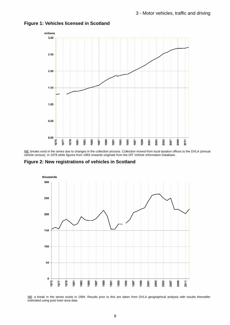
3.1 There were 2.7 million motor vehicles licensed in Scotland in 2012, a one per cent increase on the previous year and 17 per cent higher than in 2002. The steady upward trend has flattened out in the last couple of years. [Table S1] Figure 1 shows the trends since 1975: showing increases in almost every year, and the number of vehicles licensed has almost doubled in the last 30 years.
3.2 In 2012 there were 216,000 new vehicle registrations in Scotland, an increase of 7 per cent on 2011, the largest increase in the last ten years. Figure 2 shows new vehicle registrations rising and falling a number of times since 1975, reaching a quarter of a million per year a few times in the last 10 years (2002 – 2005; 2007).
8
3 - Motor vehicles, traffic and driving
Figure 1: Vehicles licensed in Scotland
NB: breaks exist in the series due to changes in the collection process. Collection moved from local taxation offices to the DVLA (annual vehicle census) in 1978 while figures from 1993 onwards originate from the DfT Vehicle Information Database.
Figure 2: New registrations of vehicles in Scotland
NB: a break in the series exists in 1994. Results prior to this are taken from DVLA geographical analysis with results thereafter estimated using post town area data.
9

3 - Motor vehicles, traffic and driving
Figure 3: Vehicles licensed per 100 population
Figure 4: Traffic (vehicle kilometres) in Scotland
NB: breaks in the series exist as the DfT revised its method of estimating traffic volumes from 1993. Estimates of traffic on minor roads are not available prior to 1993.
10
3 - Motor vehicles, traffic and driving
The road network
Provisional figures show there were almost 55,900 kilometres of public road in Scotland in 2012 with the trunk road network accounting for 6 per cent. Compared to Great Britain, Scotland has a greater road length relative to the size of the population: in 2012, Scotland had 10.5 kilometres of road per 1,000 population whereas GB had only 6.4 kilometres per 1,000 population.
Road traffic
3.3 The estimated total volume of traffic on Scotland's roads in 2012 was over 43 billion (thousand million) vehicle kilometres – 0.4 per cent more than 2011, the first increase since traffic levels peaked at 44.7 billion vehicle kilometres in 2007. Prior to this, the trend had been steadily upward, rising from 35.2 billion vehicle kilometres in 1993. [Table S1]
3.4 Whilst Scotland saw a 0.4 per cent increase, Great Britain as a whole saw a 0.4 per cent decrease in volume of traffic. [Table SGB1].
3.5 Figure 4 shows the longer-term trends in Scotland. It is estimated that the volume of car traffic on major roads (Motorways and A roads) has more than doubled, from an estimated 9,300 million vehicle kilometres in 1975 to around 22,170 million vehicle kilometres in 2012. Figure 4 shows much of this rise was between 1983 and 1995.
3.6 Compared to Great Britain as a whole, Scotland had less traffic (per head of population) on Motorways, more traffic on A roads, and more traffic on all roads taken together (including B, C and unclassified roads). Despite accounting for 20 per cent of the road network, Motorway and A roads account for two thirds of traffic in Scotland.
Possession of driving licenses
3.7 68.3% of respondents to the Scottish Household Survey aged 17 or over had a full driving licence in 2012, an increase of almost 4 percentage points over the last ten years, and the highest figure since the survey began in 1999.
3.8 Driving licence possession varies with age. Seventeen to 19 year olds have the lowest rate of licence possession (28%) with the rate increasing with age to peak at 80 per cent of 40 to 49 year olds, before decreasing back down to 37 per cent of those 80 or over. [Table 1]
3.9 There is a disparity in driving licence possession with regards to gender. Seventy-six per cent of males and only 62 per cent of females possessed a licence in 2012. However, due to an increase in percentage of females with a full driving licence since 1999, this gap has decreased from 23 percentage points in 2002 to 14 percentage points in 2012. [Table 1] The gender gap is more marked in the older age groups than it is in the younger age groups, which explains why it is decreasing over time. [Table 19] (Figure 5)
3.10 Household income is also a factor in whether a person holds a full driving licence, with 45 per cent of those in the lowest income bracket (up to £10,000 per year) holding a licence, compared to 90 per cent of those in households earning over £40,000 per year. [Table 19]
11

3 - Motor vehicles, traffic and driving
Figure 5: Adults (aged 17+) with a full driving licence by gender, 2012
3.11 At Great Britain level the patterns are similar. Seventy-three per cent of adults had a full driving licence in 2012 (the latest National Travel Survey data available – DfT website, table nts0201), with men more likely to own a licence than women (80% and 66%, respectively). The National Travel Survey also found that 40 to 49 year-olds were the most likely group to own a licence (85%) across the whole of Great Britain.
Access to cars / vans
3.12 In 2012, there were 51 vehicles per 100 population in Scotland compared with 56 in Great Britain. Figure 3 shows that the number of vehicles per head of population had been rising steadily, though the trend has flattened in the last three years. Vehicles per head of population has been consistently lower in Scotland than in Great Britain, though the gap has narrowed over the last ten years.
3.13 The Scottish Household Survey shows there has been little change in the number of households with access to a car over the last few years. In 2012, 26 per cent of households had access to two or more cars, an increase of 5 percentage points since 2002. [Table S3] Conversely, there was a decrease of 4 percentage points from 2002 (35%) to 2012 (31%) in the number of households with no access to a car. In both cases, the significant change happened between 2002 and 2007. (Figure 6)
3.14 Households with only one adult (single adult, single parent & single pensioner) were the least likely to have access to a car in 2012. In particular, 61 per cent of single pensioner households had no access to a car, compared to 12 per cent for large family households. [Table 18b]
3.15 Car access was found to be dependent on annual net household income (Figure 7), i.e. car access increased as income increased. Thirty six per cent of those households with up to £10,000 net income per year had access to at least one car, compared to 98 per cent of those in households with over £40,000 net income per year. Fourteen per cent of households in the highest income bracket had access to three or more cars. This may, in
12

3 - Motor vehicles, traffic and driving
part, be due to household type, with higher earning household more likely to contain two or more adults. [Table 18b]
3.16 Forty-one per cent of households in large urban areas had no access to a car. This compares to only seventeen per cent in rural areas. This chimes with the findings that there is greater car use in rural areas and reflects the necessity of a car in more rural areas in order to have access to services, such as food shopping and medical facilities. [Table 18b]
3.17 The patterns seen in the SHS results are similar to the trends and patterns seen across Great Britain using the National Travel Survey, Expenditure and Food Survey and the General Household Survey.
Figure 6: Household car access by year, 2001 – 2012
13

3 - Motor vehicles, traffic and driving
Figure 7: Household car access by annual net household income, 2012
14

3 - Motor vehicles, traffic and driving
Frequency of driving
3.18 Sixty one per cent of respondents drove at least once a week, and of those the majority drove on a daily basis (42% of respondents), a trend that has been consistent since 2003.1 [Table S3] Those who said they drove at least 3 times a week (but not every day) rose from 8 per cent in 2002 to 13 per cent in 2012.
3.19 Employed respondents were more likely to drive every day. In particular, 65 per cent of self employed people drove every day, compared to 15 per cent of unemployed people. [Table 20]
3.20 Respondents aged 30 to 59 were more likely to have driven every day than younger and older respondents, and men were more likely to have driven every day than women. [Table 20]
3.21 Fifty two per cent of respondents living in large urban areas drove a car at least once a week. In contrast, three quarters of those living in rural areas drove at least once a week, with around half driving every day. [Table 20]
Income
3.22 Those in high income households were more likely to drive at least once a week. Eighty-eight per cent of those in households with an income of over £40,000 per year drove at least once a week compared to 33 per cent of those in households earning up to £10,000 per year. [Table 20] These findings are as expected given the higher levels of car access in households with higher incomes.
Park & Ride
3.23 In 2007 new questions were added to the Scottish Household Survey on Park & Ride use in Scotland. Park & Ride facilities allow drivers to park at dedicated car parks and continue the rest of their journey via public transport, such as bus or train. In most cases either the parking or the bus/train fare are free. Due to small sample sizes, responses on Park & Ride from the 2008-2012 Scottish Household Surveys have been combined in order to produce more robust results.
3.24 As part of wider survey changes, the park and ride questions were modified from the 2012 onwards.
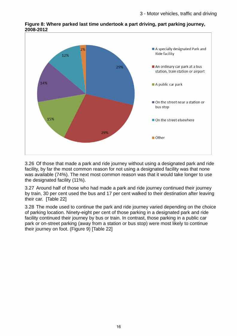
3.25 One in five respondents had made a journey in the last month where they chose to drive only part of the way, and completed their journey using another form of transport. Of these, 29 per cent parked in a designated Park & Ride facility and a further 29 per cent used an ordinary car park at a bus station, train station or airport. (Figure 8) [Table 21]
1 The apparent increase since 1999 is due to a change in the question. Pre 2003 the question was asked of the highest income householder only.
15
3 - Motor vehicles, traffic and driving
Figure 8: Where parked last time undertook a part driving, part parking journey, 2008-2012
3.26 Of those that made a park and ride journey without using a designated park and ride facility, by far the most common reason for not using a designated facility was that none was available (74%). The next most common reason was that it would take longer to use the designated facility (11%).
3.27 Around half of those who had made a park and ride journey continued their journey by train, 30 per cent used the bus and 17 per cent walked to their destination after leaving their car. [Table 22]
3.28 The mode used to continue the park and ride journey varied depending on the choice of parking location. Ninety-eight per cent of those parking in a designated park and ride facility continued their journey by bus or train. In contrast, those parking in a public car park or on-street parking (away from a station or bus stop) were most likely to continue their journey on foot. (Figure 9) [Table 22]
16

3 - Motor vehicles, traffic and driving
Figure 9: Mode of transport used to complete part driving/parking journey, 2008-2012
Fuel spend
3.29 Over a third of households reported spending over £150 on fuel for their cars in the last month, a small increase from last year but more than double the amount spent in 2005. [Table 2]
3.30 Households reported an average spend of £134.50 on fuel for their cars in the past month - up a little from £131 in 2011, but a significant increase from £78 in 2003.
3.31 The median spend reported in 2012 was £100 (ie half of people spend £100 a week or less) which is the same as 2011 and an increase from £80 in 2010 and £60 in 2003.
3.32 Some of this increase in earlier years will be due to households’ increasing access to cars and in more recent years a rise in distance travelled (vehicle kilometres) and single occupancy car journeys. However, the increase is still below the level of inflation recorded for fuel prices over the period. Care should be taken when using SHS figures as they are based on a sample survey and spend figures are estimated by household members. [Table 2]
Reported road casualties
3.33 Provisional figures for 2012 were published in Key Reported Road Casualties Scotland in June 2013. This is the data used to monitor National Indicator 32, to reduce deaths on Scotland’s roads, and to measure progress towards the targets set out in Scotland’s road safety framework. Final figures for 2012, taking account of late amendments to the data, will be published in Reported Road Casualties Scotland 2012 in October 2013.
17

3 - Motor vehicles, traffic and driving
3.34 The provisional figures show there were 170 road deaths reported in Scotland in 2012, 16 (or 9%) fewer than in 2011, and the lowest figure since current records began. 1,959 people were reported as seriously injured in road accidents in 2012, 4 per cent more than in 2011. Over the past ten years, the number of people reported injured in road accidents has fallen by 35 per cent to 12,575 in 2012. Figure 10 shows falls in most years since 1979 and indicates a general downward trend in road casualties
3.35 Since 2002, the fall in the number of people killed or seriously injured in road accidents in Scotland has been slightly better than for Great Britain (40% lower compared to 37%). The number of people killed or seriously injured per thousand population was the same for Scotland as Great Britain in 2012 (0.4 per thousand population).
Figure 10: Reported road casualties*
* figures for 2012 are provisional
18

4 Public transport, ferries and aviation
More people are using the train. ScotRail patronage increased by 2.7 per cent (to 83.3 million) in 2012/13 – the highest level recorded and an increase of 45% since 2003/04. [Table S1]
Twenty-eight per cent of respondents to the SHS used the train in the last month, up from 26 per cent in 2011 and 15 per cent in 2002. Forty two per cent used a local bus in the last month. [Table S3]
There were 439 million passenger journeys on local bus services in Scotland in the (financial year) 2011/12, an increase of 2 per cent on the previous year.
The majority of people are satisfied with public transport. Seventy-two per cent of people were satisfied or very satisfied in 2012. This is a fall from 76 per cent in 2011 and higher than 2007 (69%). [Table 4]
Younger people and women are more likely to use the bus. Two thirds of 16-19 year olds had used the bus in the last month, compared to one third of those aged 40-49. 45 per cent of women had used the bus in the last month compared to 38 per cent of men. [Table 28]
Most people agreed that it was easy to change from buses and trains to other forms of transport (82% for trains and 75% for buses) and to find out route and timetable information (91% for trains and 84% for buses). [Table 29]
Fifty-five per cent of those aged 60 or over used their concessionary pass at least once a month. Thirty-four per cent have a pass but haven’t used it. Twelve per cent have no pass. [Table 32]
Of all adults aged 60 or over, those who were permanently retired were more likely to have a pass than those in employment (91% and 76% respectively). [Table 32]
There were 22.2 million air terminal passengers at airports in Scotland in 2012. An increase of less than one per cent on 2011. [Table S1]
The number of passenger journeys from Scottish airports to destinations outwith the UK was higher than the number of internal flights for the first time (10.21m compared to 10.05m). [Table S4]
Forty-six per cent of SHS respondents took a flight for leisure purposes in 2012 and 8 per cent for business.
In 2012, 5.5 million passengers were carried on Caledonian MacBrayne, Northlink Orkney and Shetland and Orkney ferry services. This was 2.5 per cent lower than the previous year. [Table S1]
Local bus services
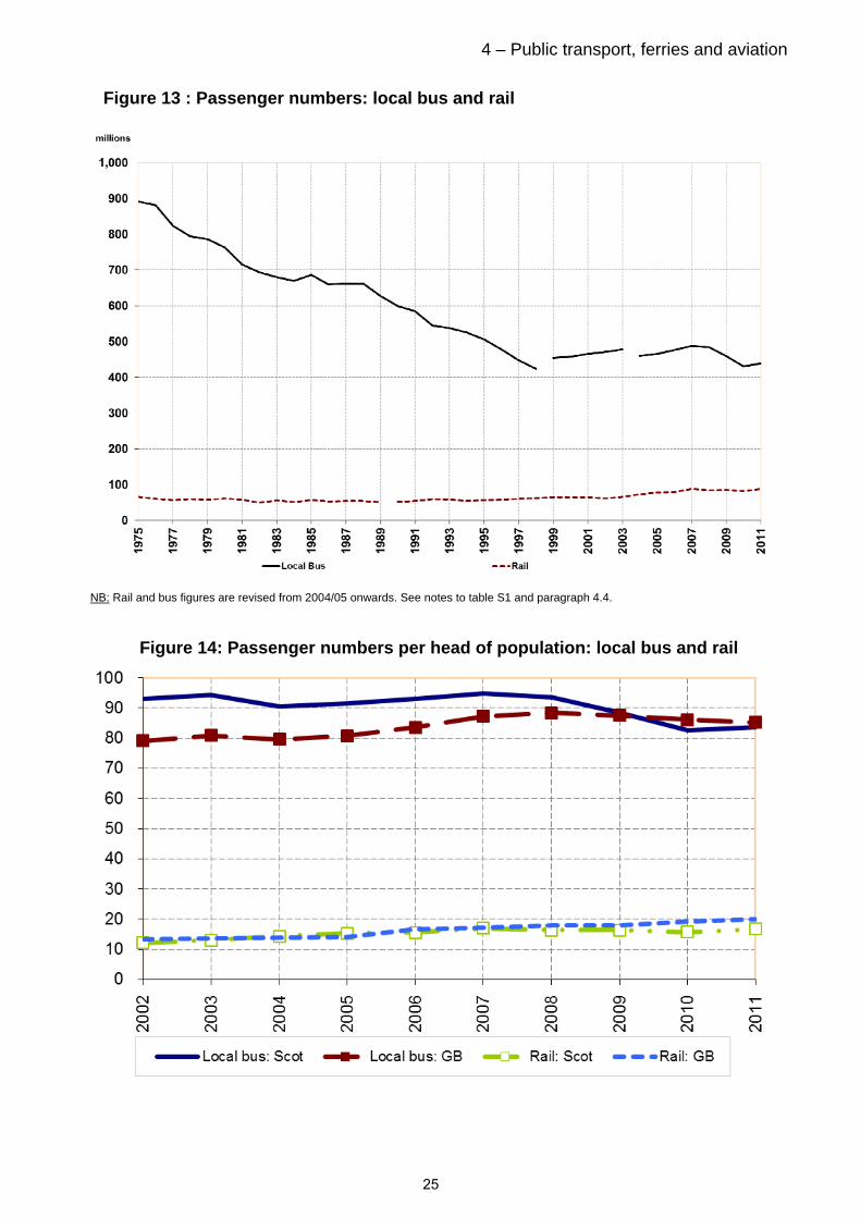
4.1 There were 439 million passenger journeys on local bus services in Scotland in the (financial year) 2011/12. This is an increase (of 2%) on the previous year and a flattening of the downward trend from a peak of 488 million passenger journeys in 2007. These figures represent a revised series from 2004/05 onwards and caution is advised when comparing with data prior to 2004/05.
4.2 Longer-term trends show a decline in bus patronage. There were almost 1,700 million passenger journeys on local bus services in 1960. The number had almost halved by 1975. Since then, it has roughly halved again, from 891 million in 1975 to 467 million in
19

4 – Public transport, ferries and aviation 2009-10 with falls in almost every year between 1960 and 1999. Figure 13 shows the trends since 1975 and show (alongside Figure 14) that local bus passenger numbers are significantly higher than other modes of public transport.
4.3 Forty-two per cent of respondents had used the local bus service in the past month. This is broadly similar to 2002 levels although 4.5 percentage points lower than a recent peak in 2008. [Table S3]
Age/gender
4.4 Younger and older age groups were the most likely to use the bus. Two thirds of 16-19 year olds had used the bus in the past month which contrasts with only one third of those aged 40-49. This is consistent with the results on frequency of driving, which showed that the 30 to 59 year age groups were the most likely to drive every day. [Table 28]
4.5 Women were more likely to use the bus, with 45 per cent responding that they had used the bus in the last month, compared to only 38 per cent of men. This again reflects driving trends reported in Section 3. [Table 28]
Income, deprivation and urban/rural
4.6 Those in large urban areas were the most likely to travel by bus almost or every day (15% compared to only 3% of those living in remote rural areas). [Table 28] This is unsurprising as data previously collected through the SHS shows that urban areas receive more frequent and accessible bus services. [See Table 17 of Transport and Travel in Scotland 2011]
4.7 Areas of multiple deprivation tend to be located in urban areas and therefore it is unsurprising that bus use is also higher amongst those living in areas of multiple deprivation. [Table 28]
Satisfaction with service
4.8 People were satisfied with most aspects of bus services that the survey asked them about. At least 74 per cent of respondents were satisfied with: the extent to which buses ran to timetable; the cleanliness of buses; the ease of changing to other forms of transport; the ease of finding out route and timetable information and; the simplicity of deciding what ticket they need.[Table 29]
4.9 Respondents gave lower satisfaction scores for the extent to which buses were environmentally friendly (56%) and whether the fares were good value (55%).
4.10 Additionally, there was a noticeable difference in those who felt safe on the bus during the day and in the evening. Ninety-three per cent of respondents agreed that they felt safe using the bus during the day compared to 62 per cent in the evening. [Table 29]
Great Britain comparison
4.11 The SHS shows broadly similar levels of bus use in Scotland to that of Great Britain. Figures for Great Britain were collected through the 2012 National Travel Survey and found that 27 per cent of respondents used the bus at least once a week (compared to 28% from the SHS). (From Table: NTS0313)
20
4 – Public transport, ferries and aviation Concessionary travel
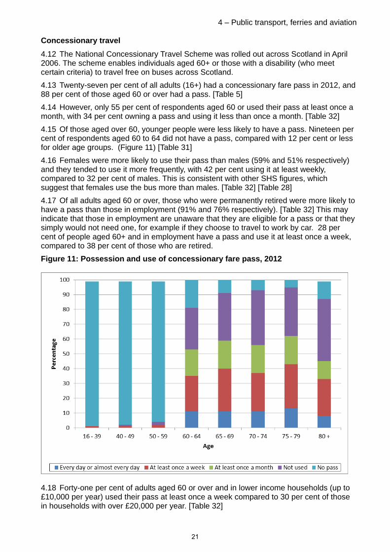
4.12 The National Concessionary Travel Scheme was rolled out across Scotland in April 2006. The scheme enables individuals aged 60+ or those with a disability (who meet certain criteria) to travel free on buses across Scotland.
4.13 Twenty-seven per cent of all adults (16+) had a concessionary fare pass in 2012, and 88 per cent of those aged 60 or over had a pass. [Table 5]
4.14 However, only 55 per cent of respondents aged 60 or used their pass at least once a month, with 34 per cent owning a pass and using it less than once a month. [Table 32]
4.15 Of those aged over 60, younger people were less likely to have a pass. Nineteen per cent of respondents aged 60 to 64 did not have a pass, compared with 12 per cent or less for older age groups. (Figure 11) [Table 31]
4.16 Females were more likely to use their pass than males (59% and 51% respectively) and they tended to use it more frequently, with 42 per cent using it at least weekly, compared to 32 per cent of males. This is consistent with other SHS figures, which suggest that females use the bus more than males. [Table 32] [Table 28]
4.17 Of all adults aged 60 or over, those who were permanently retired were more likely to have a pass than those in employment (91% and 76% respectively). [Table 32] This may indicate that those in employment are unaware that they are eligible for a pass or that they simply would not need one, for example if they choose to travel to work by car. 28 per cent of people aged 60+ and in employment have a pass and use it at least once a week, compared to 38 per cent of those who are retired.
Figure 11: Possession and use of concessionary fare pass, 2012
4.18 Forty-one per cent of adults aged 60 or over and in lower income households (up to £10,000 per year) used their pass at least once a week compared to 30 per cent of those in households with over £20,000 per year. [Table 32]
21
4 – Public transport, ferries and aviation 4.19 Frequency of driving had a considerable effect on how often concessionary passes were used by those aged over 60. Of those who drove every day, only 16 per cent used their pass at least once a week compared to over 54 per cent of those who drove less than once a week. [Table 32]
Rail passenger services
4.20 There were 83.3 million ScotRail passenger journeys recorded in 2012/13, 2.15 million (2.7 per cent) more than in the previous year and an increase of 45 per cent since 2003/04.
4.21 The ORR publish figures for the whole of Great Britain so include cross border services. ORR figures show a five per cent increase to 87.1 million passenger journeys, between 2010/11 and 2011/12. Figure 15 shows that, from 1982 until 2002/03, passenger numbers remained between 50 million and 60 million per year. Since 2002, passenger numbers have been rising steadily, reaching 87 million in 2011. Note that ORR have revised the methodology used to calculate journeys based on ticket sales which has resulted in a revision to data in previous years.
4.22 Over the last ten years, the number of passenger journeys started or finishing in Scotland has increased at a similar rate to rail travel in Great Britain. Figure 16 shows that, per head of population, there are fewer rail passenger journeys originating and / or finishing in Scotland than in Great Britain as a whole: 16.6 per head in Scotland in 2011-11, compared with 20 per head in Great Britain.
Train use
4.23 Twenty-eight per cent of respondents had used the train in the past month. This is an increase from 26 per cent in 2011 and an increase of 13 percentage points since 2002. Only 9 per cent used the train once a week or more. [Table S3]
4.24 As in the past few years, 4 per cent of respondents travelled to work by train in 2012. [Table S3]
Age
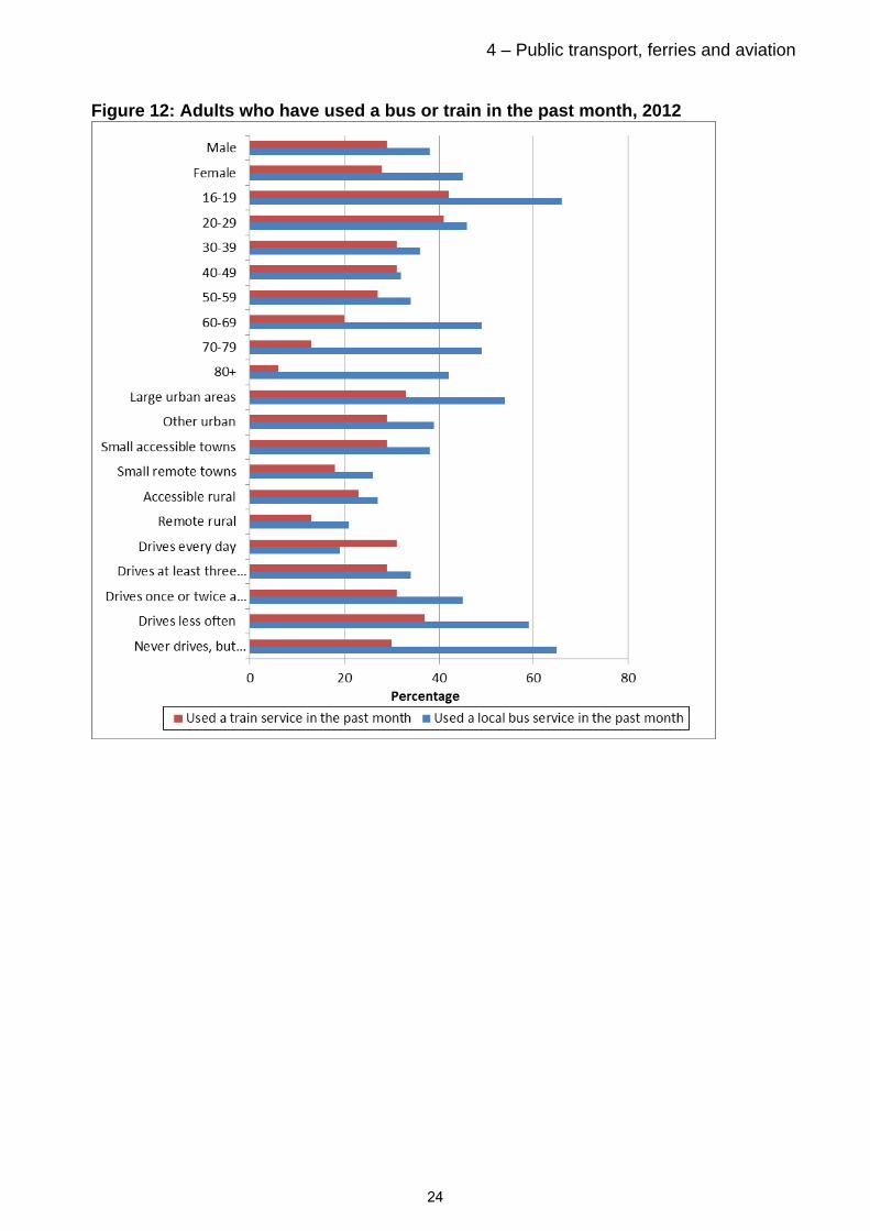
4.25 The younger the age group the more likely they were to have used a train in the last month. (Figure 12) [Table 28] Over 40 per cent of those aged 16-29 used the train in the last month, compared to less than 20 per cent of those aged over 60.
Income
4.26 Broadly speaking, train use increased as household income increased. Forty-two per cent of those in households earning over £40,000 per year used the train at least once a month compared to 21 per cent of those in the lowest income households (up to £10,000 per year). [Table 28]
Urban/rural
4.27 Those living in more rural areas were less likely to travel by train. Only 13 per cent of those living in remote rural areas using a train at least once a month compared to at least 29 per cent of those living in urban areas and accessible towns. [Table 28]
22

4 – Public transport, ferries and aviation Satisfaction with train services
4.28 In general, people were satisfied with train services offered. At least 82 per cent of respondents were satisfied with: the extent to which trains ran to timetable; the ease of finding out route and timetable information; the simplicity of deciding what ticket is needed and; ease to change from train to other forms of transport. [Table 30]
4.29 As with buses, there was a noticeable difference in feelings of safety on trains during the day and in the evening. Ninety-seven per cent of respondents agreed that they felt safe using the train during the day compared to 77 per cent feeling safe during the evening.[Table 30]
4.30 The lowest level of satisfaction related to whether train fares are good value(51% agreed).
Great Britain comparison
4.31 The SHS shows similar results on train use to that of Great Britain (2012 National Travel Survey), which found that 7 per cent used the train at least once a week (SHS shows 8%). (See NTS table: NTS0313)
Bus use compared to train use
4.32 Frequency of driving and driving licence possession had a significant effect on whether respondents travelled by bus. Twenty-nine per cent of those holding a full driving licence had used the local bus service in the past month, compared to 68 per cent of those who didn’t hold a full licence. Those who drove more frequently were less likely to travel by bus.
4.33 However, train travel was comparatively unaffected by either frequency of driving or driving licence possession. This could suggest that trains are more likely to be used for longer journeys where cars are not a viable alternative, such as long distance journeys. [Table 28]
4.34 Females were more likely to use the bus than males, while there was no difference in train use by gender. (Figure 12) Table 28
4.35 Adults aged 16 to 19 were much more likely to use the bus almost or every day than older age groups (20% compared to an average of 9% for all adults), however, 20-29 year olds were the age group most likely to use the train every day. Older age groups (60 and over) were more likely to travel by bus than those aged 30-59, while train use decreased as age increased. [Table 28]
4.36 The lower the household income bracket the more likely it is that the respondent used the bus in the last month. This is in direct contrast to train use, which, broadly speaking has a decreased likelihood the lower the household income, implying that the higher cost of rail travel is a deterrent to those on lower incomes. [Table 28]
Satisfaction with public transport
4.37 Seventy-two per cent of respondents were satisfied with public transport. This was a drop of 4 percentage points from 2011. There was actually no change in the proportion of people who were dissatisfied with public transport, instead there was an increase in the proportion responding that they were ‘neither satisfied nor dissatisfied’. [Table 4]
23
4 – Public transport, ferries and aviation Figure 12: Adults who have used a bus or train in the past month, 2012
24
4 – Public transport, ferries and aviation
Figure 13 : Passenger numbers: local bus and rail
NB: Rail and bus figures are revised from 2004/05 onwards. See notes to table S1 and paragraph 4.4.
Figure 14: Passenger numbers per head of population: local bus and rail
25
4 – Public transport, ferries and aviation
Aviation
Air passengers
4.38 There were 22.2 million air terminal passengers at airports in Scotland in 2012: 0.6 per cent more than in the previous year, and 12 per cent more than in 2002. Figure 15 shows the increase since 1975. Over the longer-term, terminal passenger numbers grew from 1.2 million in 1960 to 22.2 million in 2012. [Table S1]
4.39 For the first time in 2012, the number of passenger journeys to destinations outwith the UK was higher than the number of passenger journeys from Scottish airports with destinations within the UK. [Table S4]
Air Travel
4.40 Forty-six per cent of respondents took a flight for leisure purposes in 2012 and 8 per cent for business. Around half of those taking leisure flights took 1 or 2 over the year, with about a quarter taking 3 or 4. Business travel shows quite different patterns with over two fifths (44%) taking 7 or more trips.
4.41 The most common reason for respondents choosing to fly within the UK as opposed to other forms of travel was because they viewed it as ‘quicker’, with the next most common reason being ‘cheaper’. UK Comparison
4.42 Between 2002 and 2012, the number of air terminal passengers increased by 12 per cent for Scotland and 17 per cent for the UK as a whole. Over the past ten years, the number of passengers per head of population has been higher for Scotland than for the UK (4.2 vs. 3.5). [Table SGB1] Ferry services
4.43 In 2012, 5.5 million passengers were carried on those shipping services within Scotland for which figures are available back to 1973 (i.e. Caledonian MacBrayne, P&O Scottish Ferries / NorthLink Orkney and Shetland, and Orkney Ferries). This was a decrease of 2 per cent on the previous year. Figure15 shows the long-term trends, which were affected by the reduction in traffic that followed the opening of the Skye Bridge in 1995. [Table S1]
26
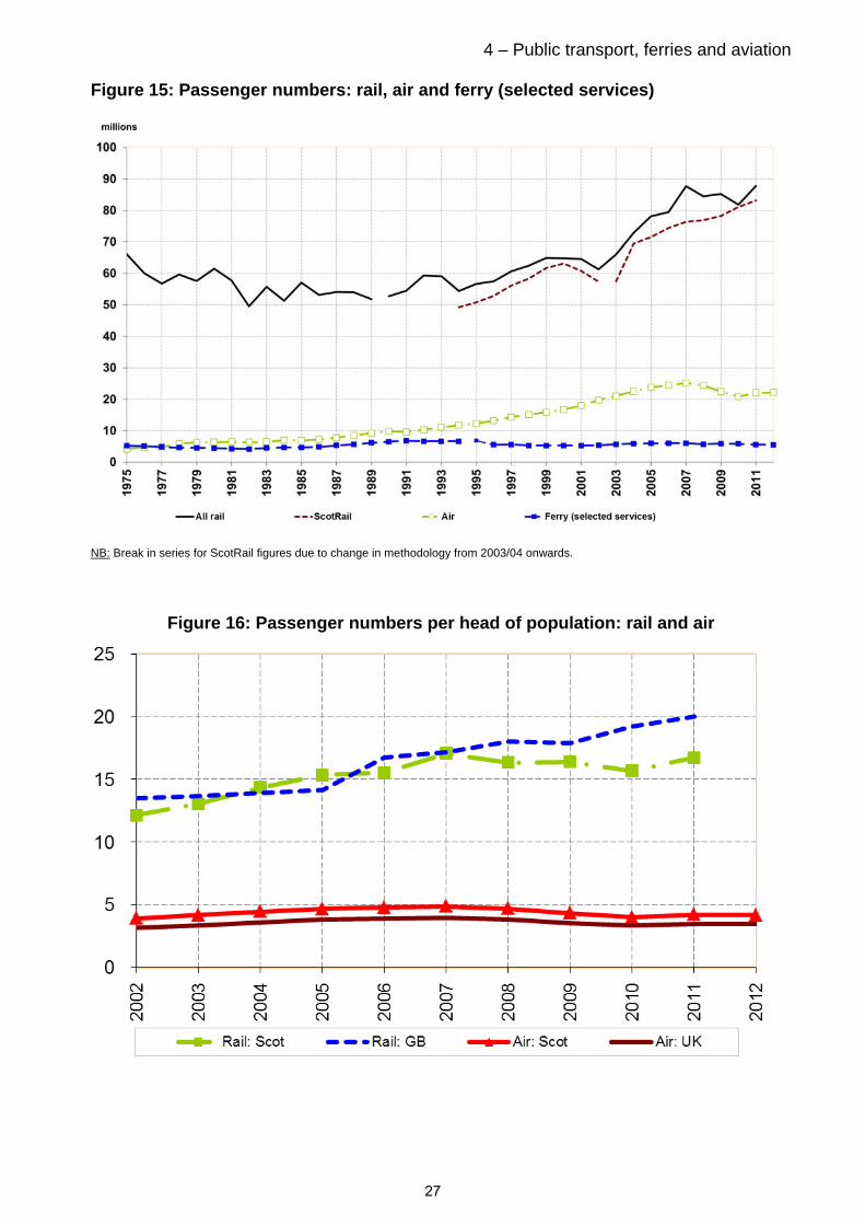
4 – Public transport, ferries and aviation Figure 15: Passenger numbers: rail, air and ferry (selected services)
NB: Break in series for ScotRail figures due to change in methodology from 2003/04 onwards.
Figure 16: Passenger numbers per head of population: rail and air
27
5 Walking and Cycling
Thirty-five per cent of households had access to at least one bicycle for adult use in 2012. This proportion has remained stable over the last decade. [Table S3]
Bicycle access
5.1 Thirty-five per cent of households had access to at least one bicycle in 2012, continuing the trend of little change over the last decade. [Table S3] The percentage of households with access to a bicycle varied with household type with families and large adult households the most likely to have access to a bicycle (52 – 64%) and single pensioners the least likely to have access to a bicycle (6%). [Table 18a]
5.2 As household income increased so did the likelihood of the household having access to at least one bicycle. Sixty-seven per cent of households in the highest income bracket (over £40,000 per year) had access compared to 17 per cent of households in the lowest income bracket (up to £10,000 per year). [Table 18a]
5.3 Similar patterns can be seen in the deprivation and the urban/rural figures. As levels of deprivation decrease, the likelihood of a household having access to a bicycle increases and as rurality increases, the likelihood of having a bicycle also increases. [Table 18a]
Reasons for not cycling to work
5.4 The most common reasons cited for not cycling to work can be split into a number of categories. The two main reasons are physical, that it was too far to cycle (36%) and poor weather’(19%). A number of reasons were related to safety, that there were too many cars (14%), speed of traffic (12%) and inconsiderate drivers (9%). There were also reasons around practicalities, respondents did not have a bike (14%), no showers at work (8%), unable to carry luggage / shopping (9%). [Table 26]
Walking
5.5 The SHS Travel Diary showed that walking accounted for 22 per cent of journeys in 2011. The 2012 survey shows that 13.6 per cent of commutes are made on foot.
5.6 Questions relating to frequency of walking are now asked biennially in the survey. Results for 2011 can be found in Transport and Travel in Scotland 2011. An update to these figures will be included in Transport and Travel in Scotland 2013.
28

6 – Travel to work and school 6 Travel to work and school Thirty per cent of respondents travelled to work by public or active transport,
continuing the trend of little change in recent years. This figure provides an update to the indicator used in the Scottish Government’s National Performance Framework which is considered to be ‘performance maintaining’. [Table S3]
Active travel accounted for 16 per cent (walking: 13.6%, cycling: 2.0%) and public transport 14 per cent (bus: 10.1%, rail: 4.3%) of all journeys to work in 2012. [Table S3]
Females were more likely to walk or travel by bus to work than males, while males were more likely to drive to work than females.
Forty per cent of car drivers and 32 per cent of passengers experienced delays to work at least once a week due to traffic congestion. [Table 8]
Over a quarter of respondents regularly travelled to work using different modes on different days in 2012.
Fifty-two per cent of all journeys to school were made by walking or cycling in 2012. The levels have remained relatively stable over the last ten years. [Table S3].
Children in primary school were more likely to walk or be driven to school than children in secondary school. Secondary school pupils are more likely to catch a bus.
Travel to work
6.1 The Scottish Household Travel Diary shows that commuting is the most frequent purpose for travel in Scotland. The SHS travel to work data underpin Scotland’s National Indicator on travel to work. More information on National Indicators, including more detail on the Travel to Work indicator can be found on the Scotland Performs website 2.
6.2 Thirteen per cent of employed adults worked from home in 2012. This is an increase of four percentage points since 2001. [Table S3] Since 2005, the proportion has been around 10 or 11 per cent so a figure of 13 per cent is a relatively large increase. This could be a result of changes to the survey methodology, rather than an actual change in the number of people working from home.
Mode of travel
6.3 Thirty per cent of respondents travelled to work by public or active transport, continuing the trend of little change in recent years. This figure provides an update to the indicator used in the Scottish Government’s National Performance Framework and is considered to be ‘performance maintaining’ [Table S3]
2 Active travel accounted for 16 per cent (walking: 13.6%, cycling: 2.0%) and public transport 14 per cent (bus: 10.1%, rail: 4.3%) of all journeys to work in 2012. [Table S3] There has been little change in these proportions over the past decade.
6.1 In 2012, 67 per cent of adults travelled to work by car. Although there has been no change in the percentage travelling to work by car since 2001, there has been an increase in those driving, rather than being a passenger, with the percentage of those travelling as passengers falling from 11 per cent in 2002 to 6 per cent in 2012. This is likely to be due to
2 www.scotland.gov.uk/About/scotPerforms/indicators/publicTransport
29

6 – Travel to work and school increased access to cars and the number of households with more than one car since 2001. (Figure 18)
Gender and household composition
6.2 Respondents’ methods of travelling to work were dependent on gender, with females more likely to walk than males (16% and 12% respectively), while males were more likely to drive to work than females. [Table 7]
6.3 Adults in single adult or single parent families were the most likely to walk to work or take the bus with adults in large families (ie three or more adults in a household) being the most likely to drive.
Employment status and income
6.4 Self-employed people were the least likely to travel to work by bus, and part time workers were the most likely to walk, this could be because people are less willing to travel longer distances for a part time job. [Table 7]
6.5 As household income increases respondents were more likely to drive to work and generally less likely to walk or take the bus. (Figure 17) [Table 7]
Figure 17: Main method of travel to work by annual net household income, 2012
30
6 – Travel to work and school Urban/rural and car ownership
6.6 Those living in large urban areas were more likely to use public transport to get to work (22% compared to the average for all adults of 14%), which is likely to be due to the increased accessibility and frequency of public transport services in these areas.
6.7 The more cars a household had access to the greater the likelihood of them driving to work. Those households with no cars generally took the bus (36%) or walked to work (40%). [Table 7] 83% of adults living in households with two or more cars drove to work, this could be the reason for owning the cars.
Congestion
6.8 Around two-thirds of those who drove or travelled to work by bus reported that their journey had been delayed by congestion, with 40 per cent of drivers and 46 per cent of bus commuters experiencing congestion at least once a week. Sixty-five per cent of drivers and 63 per cent of bus passengers allowed more than 5 extra minutes travel time for their journey as a result. [Table 8]
Car sharing and travel plans
6.9 Fifteen per cent of respondents were involved in a car sharing arrangement in 2008-2012. The vast majority (89%) of these were arranged informally. The most common reason given for not car sharing was ‘nobody in work lives near me’ and that respondents did not work regular hours . [Table 11]
Changes to mode of travel
6.10 Most people had not changed their mode of travel for their journey to work from the previous year. Car/van drivers were the least likely to do this with 97 per cent of those using this method the previous year continuing to do so. Those who travelled by bike the previous year were least likely (except for those using ‘other’ modes) to still be using this method of travel (16% had changed to another mode). [Table 10]
6.11 The most common reasons cited for not cycling to work were that it was too far to cycle (36%), poor weather’(19%), that there were too many cars (14%), and that respondents did not have a bike (14%). [Table 26]
31

6 – Travel to work and school Alternative travel mode to work
6.12 Over a quarter of respondents regularly travelled to work using different modes on different days in 2012. Data from 2010-2012 shows that those who usually cycled to work were most likely to regularly use an alternative way of travelling to work, with 70% doing so. The most popular alternative modes were driving and walking respectively. This may be due to differing working patterns, weather conditions or participation in recreational activities.
6.13 Respondents who drove to work were least likely to use an alternative mode, with only 19 per cent citing another method (most commonly walking or bus). This contrasts with those who usually commuted as a car or van passenger, half of which regularly travelled to work by another means. The most common alternative mode for car passengers was bus.
Great Britain comparisons
6.14 Thirteen per cent of employed adults worked at or from home in Scotland in 2012. In contrast, 2012 National Travel Survey figures for Great Britain show that 5 per cent of employed adults usually work from home. The higher figures seen in Scotland will be in part due to different questions being asked but may also be due to the less accessible landscapes found in Scotland, which make it more demanding to travel to a workplace. SHS data supports this with a higher proportion of employed adults in rural areas working from home.
6.15 Great Britain figures from the National Travel Survey 2012 show walking accounts for 11 per cent of commuting trips, which is similar to the SHS 2012 figure of 14 per cent of people who walk to work.
Travel to school
6.16 Over half (51%) of journeys to school were made on foot in 2012 and there has been little change since 2002. The proportion of school pupils being driven to school has remained between 21 and 25 per cent since 2003. [Table S3]
6.17 How children travel to school is dependent on their age. Children in primary school, aged between 4-11, were more likely to walk or be driven to school than children in secondary, aged between 12-18. Secondary school children were more likely to take the bus than those in primary school. This is likely to be partly due to primary schools generally being closer than secondary schools, therefore people are more likely to walk, but also, many respondents from the survey indicated that they felt primary school children were too young to travel on public transport on their own. [Table 15]
6.18 The travel to school patterns reported in the Scottish Household Survey are broadly similar to those reported in the Sustrans Hands Up Scotland Survey, with walking being the most popular mode of transport (45.1% in Hands Up Scotland, with another 7.6% using ‘park and stride’, part driving, part walking). It is not possible to make direct comparisons due to differences in the survey methodology and questions asked.
6.19 Over half of children in towns and urban areas walked to school in 2012. Children in rural areas were much less likely to walk to school and tended instead to travel by school bus, which will in part be due to the distance to school. This service is less widely available in large urban areas, where 11 per cent of children used a conventional ‘service’ bus to get to school. [Table 15]
32

6 – Travel to work and school 6.20 For those children who walked to school, 85 per cent stated the reason for walking was that the school was nearby. Those taking the bus and car cited convenience as the most common reason for mode choice, with many feeling that it was too far to walk and car travel was both the safest and quickest mode of travel. [Table 16]
Great Britain comparisons
6.21 The results have some differences with those found for Great Britain in the National Travel Survey (NTS). For instance, the proportion of pupils walking to school is lower in the NTS than the SHS (42% vs 51%) and the percentage being driven to school is higher (35% vs 24%).
6.22 It should be noted that NTS methodology differs slightly and there is a different geographical coverage between this and the SHS - the NTS excludes school journeys greater than 50 miles and the Scottish Islands are excluded from the sample.
33
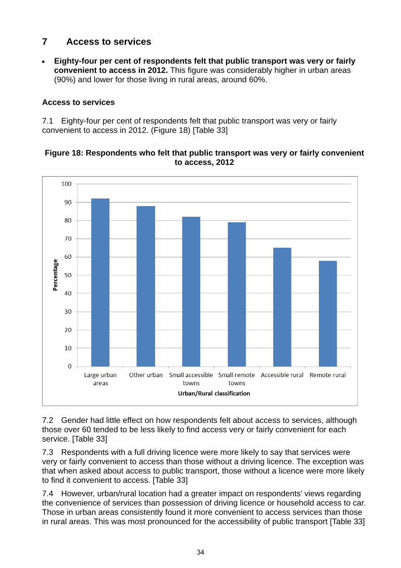
7 Access to services Eighty-four per cent of respondents felt that public transport was very or fairly
convenient to access in 2012. This figure was considerably higher in urban areas (90%) and lower for those living in rural areas, around 60%.
Access to services 7.1 Eighty-four per cent of respondents felt that public transport was very or fairly convenient to access in 2012. (Figure 18) [Table 33]
Figure 18: Respondents who felt that public transport was very or fairly convenient
to access, 2012
7.2 Gender had little effect on how respondents felt about access to services, although those over 60 tended to be less likely to find access very or fairly convenient for each service. [Table 33]
7.3 Respondents with a full driving licence were more likely to say that services were very or fairly convenient to access than those without a driving licence. The exception was that when asked about access to public transport, those without a licence were more likely to find it convenient to access. [Table 33]
7.4 However, urban/rural location had a greater impact on respondents’ views regarding the convenience of services than possession of driving licence or household access to car. Those in urban areas consistently found it more convenient to access services than those in rural areas. This was most pronounced for the accessibility of public transport [Table 33]
34
8 - Freight 8 Freight
The amount of freight lifted in Scotland continues to fall. Excluding road transport, freight lifted fell 3% to 64.9 million tonnes in 2012.
Two thirds of freight lifted in Scotland was transported by road in 2010 (the latest year for which road freight data is available). (A slight fall from a peak of 71% in 2007). Four per cent is carried by rail, 14 per cent by pipeline and the rest by water. These proportions have changed little over the last ten years.
Sixteen million tonnes of coastwise freight traffic was lifted in Scotland in 2011, a fall of 30 per cent from the peak in 2008.
Freight lifted in Scotland.
8.1 Road Freight data for 2011 has yet to be published by DfT, it will be released in December 2013.
8.2 The amount of freight lifted in Scotland has been falling in recent years. Volume peaked in 2007 at 250.8 million tonnes. In 2010, 198.6 million tonnes were lifted, a fall of 20.8 per cent.
8.3 The amount of freight lifted by methods other than road has also been falling. Volumes peaked in 2008 at 75 million tonnes and by 2011 had fallen back to 64.9 million tonnes, a reduction of 14 per cent, this included a fall of 3% between 2010 and 2011.
Road
8.4 There were 132 million tonnes of freight lifted by road in Scotland in 2010.
8.5 Caution is advised when comparing with figures prior to 2004-05 as DfT has improved the survey methodology and processing.
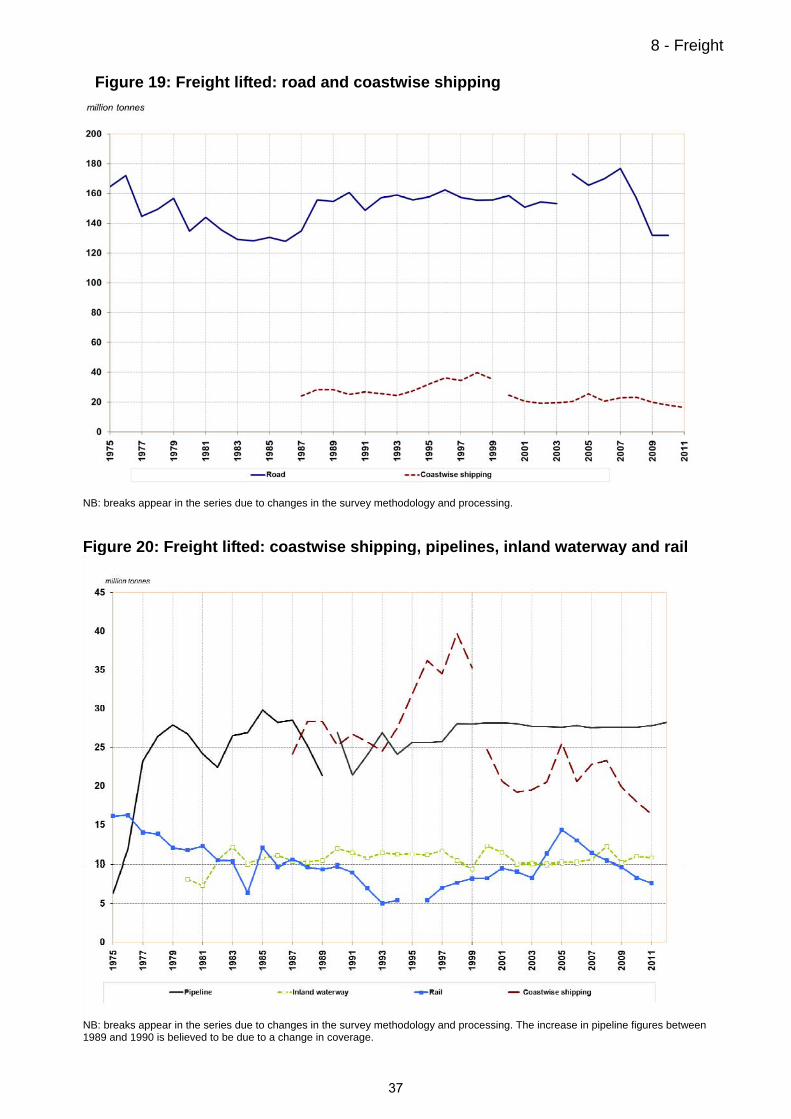
8.6 The 2010 figure continues a fall from a peak of 182 million tonnes in 2007. Over the longer-term, the amount of freight carried by road fluctuated between 1975 and 1987 (see Figure 19), rising to 172 million tonnes in 1976 and falling to 128 million tonnes in 1986. After 1988, it was more stable, varying between 149 million tonnes (in 1991) and 162 million tonnes (in 1996). Figures 26 and 27 show that, in terms of tonnes lifted, much more freight is carried by road than by any other mode of transport. Per head of population, the amount of freight which is lifted by road is slightly higher in Scotland than in Great Britain.
Rail
8.7 The volume of rail freight traffic lifted in Scotland fell from 29.8 million tonnes in 1960 to 5.4 million tonnes in 1994-95. Figure 20 shows that since then it increased to a peak of 14 million tonnes in 2005-06 before falling back again to 7.6 million tonnes in 2011-12 (a fall of 47%).
Coastal
8.8 Levels of Coastwise freight traffic lifted in Scotland have been falling since 2008, reaching 16.8 million tonnes in 2011. This is a fall of nine per cent on 2010 and 47 per cent on 2008. Per head of population, much more freight is lifted by coastwise shipping in Scotland than in Great Britain. [Table SGB3]
35
8 - Freight Inland Waterways
The annual amount of freight lifted for inland waterways has remained between about 9 and 12 million tonnes since 1982. Figure 20 shows the trends since 1980 (inland waterway) and 1987 (coastwise traffic). [Table S1]
Air
8.9 Fifty two thousand tonnes of freight was carried by air in 2012. This is 15 per cent higher than the amount carried in 2011 and the highest level for five years. It is still 37 per cent lower than the peak of 83 thousand tonnes in 2006. Air freight makes up less than 0.1 per cent of all freight transported in Scotland. [Table S1]
Pipelines
8.10 The amount of oil carried in Scottish pipelines rose rapidly to 28 million tonnes in 1979, and has remained at 28 million tonnes over the last ten years. Figure 20 shows the trends since 1975. Per head of population, the amount of freight which is lifted by pipeline is significantly greater in Scotland than in Great Britain.
Freight moved - tonne-kilometres
8.11 Figures 26 and 27 showed that, in terms of tonnes lifted, more freight is carried by road than by any other mode of transport. However, a different picture can be seen when account is taken of the distance that freight is carried. Table H2(b) shows that, in terms of tonne-kilometres, coastwise shipping accounted for the largest amount of freight moved in most years, with road coming second (in 2004 the position was reversed). Rail and pipeline still move smaller amounts of freight than road. However, they represent a higher proportion of the total when they are measured in tonne-kilometres, because of the greater distance (on average) for which freight is carried by rail and by pipeline.
36
8 - Freight
Figure 19: Freight lifted: road and coastwise shipping
NB: breaks appear in the series due to changes in the survey methodology and processing.
Figure 20: Freight lifted: coastwise shipping, pipelines, inland waterway and rail
NB: breaks appear in the series due to changes in the survey methodology and processing. The increase in pipeline figures between 1989 and 1990 is believed to be due to a change in coverage.
37

Table S1 Summary of Transport in ScotlandNumbers
2002 2003 2004 2005 2006 2007 2008 2009 2010 2011 2012
Vehicles Licensed thousands
Private and Light Goods 1 2,058 2,104 2,158 2,231 2,259 2,313 2,347 2,362 2,364 2,369 2,395
All Vehicles 1 2,330 2,383 2,448 2,531 2,564 2,627 2,665 2,684 2,685 2,691 2,717
New Registrations 259 262 263 251 243 251 215 216 209 202 216
Local Bus Services2 millionsPassenger Journeys
(boardings)3 471 478 460 466 476 488 484 459 431 439 ..
Vehicle Kilometres3 374 369 359 374 384 389 386 376 346 338 ..
Passenger Revenue £ million
at latest year's prices3 .. .. .. .. 637 661 683 675 638 639 ..
Freight Lifted million tonnes
Road 4, 9 154.4 153.4 173.1 165.6 170.0 176.8 157.0 131.9 131.9 ..
Rail 2 9.12 8.32 11.25 14.32 12.96 11.35 10.36 9.69 8.33 7.61 ..
Coastwise traffic 19.2 19.5 20.5 25.5 20.6 22.8 23.3 19.8 18.0 16.3 ..
One Port traffic 1.81 1.54 1.33 1.76 1.48 1.83 1.75 3.59 1.88 2.42 ..
Inland waterway traffic 10.01 10.06 9.97 10.19 10.16 10.50 12.19 10.10 10.89 10.70 ..
Pipelines 5 28.0 27.7 27.6 27.6 27.8 27.5 27.6 27.6 27.6 27.8 28.2
Public Road Lengths kilometres
Trunk (A and M)10 3,488 3,485 3,482 3,505 3,518 3,505 3,505 3,520 3,518 3,530 3,530
Other Major (A and M) 7,417 7,418 7,418 7,433 7,424 7,381 7,421 7,421 7,414 7,467 7,473
Minor Roads 43,687 43,659 43,693 43,911 44,029 44,303 44,420 44,594 44,696 44,771 44,871
All Roads10, 12 54,592 54,562 54,593 54,849 54,971 55,188 55,346 55,535 55,628 55,768 55,874
Road Traffic million vehicle-kilometres
Motorways 11 5,730 5,856 6,094 6,151 6,433 6,577 6,683 6,633 6,503 6,570 7,140
A roads 21,533 21,826 22,114 21,904 22,465 22,408 22,127 22,327 21,992 21,996 21,713
All roads (incl. B, C, uncl.) 41,535 42,038 42,705 42,718 44,119 44,666 44,470 44,219 43,488 43,390 43,549
Reported Road Accident Casualties 12
Killed 304 336 308 286 314 281 270 216 208 186 170
Killed and Serious 3,533 3,293 3,074 2,952 2,949 2,666 2,845 2,504 2,176 2,061 2,129
All (Killed, Serious, Slight) 19,275 18,756 18,502 17,885 17,269 16,238 15,591 15,043 13,338 12,770 12,575
Passenger Rail 2,6 millions
ScotRail passenger journeys 6 57.4 57.5 64.0 69.4 71.6 74.5 76.4 76.9 78.3 81.1 83.3
ORR data:
Rail journeys in/from Scotland 7 54.8 58.4 63.7 69.3 72.6 75.6 79.3 79.8 83.2 87.1 ..
Passenger receipts (£2011 mill) 256.0 269.5 285.5 286.4 295.0 335.8 337.1 370.4 383.8 393.4 ..
Air Transport thousands
Terminal Passengers 19,783 21,084 22,555 23,795 24,437 25,132 24,348 22,496 20,907 22,065 22,207
Transport Movements 362.6 367.3 385.6 408.8 420.6 428.2 417.1 382.7 354.4 366.3 372.1thousand tonnes
Freight 77.0 80.8 81.0 79.4 83.3 66.1 50.2 50.9 47.5 45.2 52.2
Ferries (selected services 8 ) thousands
Passengers 5,365 5,721 5,921 5,971 6,020 6,012 5,699 5,935 5,872 5,626 5,488
Vehicles 1,241 1,260 1,338 1,365 1,372 1,416 1,377 1,445 1,408 1,351 1,305
1 DfT has revised the figures for the light goods and goods body types back to 2001. DfT does not have the underlying data to revise earlier years' figures.
2 Financial years3 The DfT have revised figures from 2004/05 onwards as a result of methodological improvements. Figures prior to this period are not directly comparable.
See Chapter 2 for more detail. Figures from 2006 include Government support for buses which is not available for the two previous years.4 Freight lifted in Scotland by UK-registered hauliers, regardless of whether the destination is in Scotland, elsewhere in the UK or outwith the UK.
The figures for 2004 onwards are not compatible with those for earlier years due to changes in methodology and processing system for the survey.5 The estimated amounts of crude oil and products carried by pipelines over 50km in length. 2012 figures are provisional.
6 ScotRail introduced a new methodology which better estimates Strathclyde Zonecard journeys from 2009/10. Figures from 2003/04 onwards
present the impact of this on previously reported data to provide a more meaningful year on year comparison. Note that this has no impact on actual
journeys undertaken.
7 The Office of Rail Regulation (ORR) produce total passenger figures. These are not adjusted to reflect ScotRail's revised methdology and are therefore
not comparable with ScotRail figures. There is a series break between 2007-08 and 2008-09 due to a change in the methodology.
From 2008-09 estimates of PTE travel (zone cards) are included.
8 Those services for which figures are (at least) available back to 1975: Caledonian MacBrayne, P&O Scottish Ferries / NorthLink Orkney & Shetland, and Orkney Ferries.
9 Domestic freight estimates for 2006 to 2009 were revised on 27 October 2011
10 Totals have been revised in 2012 to include slip roads on Trunk A roads which had previously excluded. See Road Network chapter for more information. Data for 2012 are provisional.
11 Changes in the layout of the M74/M77/M8 during 2012 are likely to have affected the traffic data for motorways.
12 Figures for 2012 are provisional.
38

Table S2 Summary of Transport in Scotland - index numbersIndex 2002=100
2002 2003 2004 2005 2006 2007 2008 2009 2010 2011 2012
Vehicles Licensed
Private and Light Goods 1 100.0 102.2 104.9 108.4 109.7 112.4 114.1 114.8 114.9 115.1 116.4
All Vehicles 1 100.0 102.3 105.1 108.6 110.1 112.7 114.4 115.2 115.2 115.5 116.6
New Registrations 100.0 101.2 101.3 96.8 93.6 96.7 82.9 83.3 80.5 78.0 83.4
Local Bus Services2
Passenger Journeys (boardings)3 100.0 102.1 104.7 103.9 98.5 92.5 94.2 ..
Vehicle Kilometres 3 100.0 102.7 104.0 103.2 100.5 92.5 90.4 ..
Passenger Revenue
at latest year's prices( 2006=100) 3 100.0 103.3 102.1 96.6 96.7 ..
Freight Lifted
Road 4, 9 100.0 99.4 112.1 107.3 110.1 114.5 101.7 85.4 85.4 .. ..
Rail 2 100.0 91.2 123.4 157.0 142.1 124.5 113.6 106.3 91.3 83.4 ..
Coastwise traffic 100.0 101.6 106.7 133.0 107.2 118.7 121.3 103.3 93.5 85.1 ..
One Port traffic 100.0 85.1 73.5 97.2 81.8 101.1 96.7 198.3 103.9 133.7 ..
Inland waterway traffic 100.0 100.5 99.6 101.8 101.5 104.9 121.8 100.9 108.8 106.9 ..
Pipelines 5 100.0 98.8 98.6 98.4 99.1 98.1 98.4 98.4 98.4 99.1 100.6
Public Road Lengths
Trunk (A and M) 100.0 99.9 99.8 100.5 100.9 100.5 100.5 100.9 100.9 101.2 101.2
Other Major (A and M) 100.0 100.0 100.0 100.2 100.1 99.5 100.1 100.1 100.0 100.7 100.7
Minor Roads 100.0 99.9 100.0 100.5 100.8 101.4 101.7 102.1 102.3 102.5 102.7
All Roads 12 100.0 99.9 100.0 100.5 100.7 101.1 101.4 101.7 101.9 102.2 102.3
Road Traffic
Motorways 100.0 102.2 106.4 107.3 112.3 114.8 116.6 115.8 113.5 114.7 124.6
A roads 100.0 101.4 102.7 101.7 104.3 104.1 102.8 103.7 102.1 102.2 100.8
All roads (incl. B, C, uncl.) 100.0 101.2 102.8 102.8 106.2 107.5 107.1 106.5 104.7 104.5 104.8
Reported Road Accident Casualties 10
Killed 100.0 110.5 101.3 94.1 103.3 92.4 88.8 71.1 68.4 61.2 55.9
Killed and Serious 100.0 93.2 87.0 83.6 83.5 75.5 80.5 70.9 61.6 58.3 60.3
All (Killed, Serious, Slight) 100.0 97.3 96.0 92.8 89.6 84.2 80.9 78.0 69.2 66.3 65.2
Passenger Rail 2,6
ScotRail passenger journeys 6 100.0 100.1 111.6 121.0 124.8 129.8 133.2 134.1 136.4 141.3 145.1
Rail journeys in/from Scotland 7 100.0 106.6 116.2 126.5 132.4 138.0 144.7 145.6 151.8 158.9 ..
Passenger receipts (£2011 mill) 100.0 105.3 111.5 111.9 115.2 131.2 131.7 144.7 149.9 153.6 ..
Air Transport
Terminal Passengers 100.0 106.6 114.0 120.3 123.5 127.0 123.1 113.7 105.7 111.5 112.3
Transport Movements 100.0 101.3 106.4 112.7 116.0 118.1 115.0 105.5 97.7 101.0 102.6
Freight 100.0 104.9 105.1 103.1 108.1 85.8 65.2 66.1 61.7 58.6 67.8
Ferries (selected services 8 )
Passengers 100.0 106.6 110.4 111.3 112.2 112.1 106.2 110.6 109.4 104.9 102.3
Vehicles 100.0 101.5 107.8 110.0 110.6 114.1 111.0 116.4 113.4 108.9 105.2
1 DfT has revised the figures for the light goods and goods body types back to 2001. DfT does not have the underlying data to revise earlier years' figures.
2 Financial years
3 The DfT have revised figures from 2004/05 onwards as a result of methodological improvements. Figures prior to this period are not directly comparable.
See Chapter 2 of Scottish Transport Statistics for more detail. Figures from 2006 include Government support for buses which is not available for the two previous years.
4 Freight lifted in Scotland by UK-registered hauliers, regardless of whether the destination is in Scotland, elsewhere in the UK or outwith the UK.
The figures for 2004 onwards are not compatible with those for earlier years due to changes in methodology and processing system for the survey.
5 The estimated amounts of crude oil and products carried by pipelines over 50km in length. 2012 figures are provisional.
6 ScotRail introduced a new methodology which better estimates Strathclyde Zonecard journeys from 2009/10. Figures from 2003/04 onwards
present the impact of this on previously reported data to provide a more meaningful year on year comparison. Note that this has no impact on actual
journeys undertaken.
7 The Office of Rail Regulation (ORR) produce total passenger figures. These are not adjusted to reflect ScotRail's revised methdology and are therefore
not comparable with ScotRail figures.
8 Those services for which figures are (at least) available back to 1975: Caledonian MacBrayne, P&O Scottish Ferries / NorthLink Orkney & Shetland, and Orkney Ferries.
9 Domestic freight estimates for 2006 to 2009 were revised on 27 October 2011
10 Figures for 2012 are provisional.
39

Table S3 Summary of Scottish Household Survey results 1
2002 2003 2004 2005 2006 2007 2008 2009 2010 2011 2012
column percentagesPlace of work
Works from home 9.3 9.1 9.0 11.1 10.7 11.2 10.0 11.4 10.1 10.6 13.2Does not work from home 90.7 90.9 91.0 88.9 89.3 88.8 90.0 88.6 89.9 89.4 86.8
Sample size (=100%) 6,597 6,681 7,058 6,841 6,845 5,888 6,092 6,103 5,862 6,189 4,734
Travel to work 2
Walking 13.2 12.6 12.7 12.7 13.8 11.9 12.5 12.3 13.4 12.9 13.6Car or Van 67.7 68.5 67.0 67.4 66.8 68.0 66.0 67.0 67.3 66.6 67.3
Driver 56.6 59.8 58.9 59.8 59.8 61.3 59.9 60.7 61.0 59.1 61.4Passenger 11.0 8.7 8.1 7.5 7.0 6.7 6.1 6.4 6.3 7.5 6.0
Bicycle 1.6 1.8 1.9 1.6 2.0 1.7 2.3 2.4 2.3 2.0 2.0Bus 12.2 11.6 12.7 12.1 11.8 12.7 12.1 12.1 10.8 12.0 10.1Rail, including underground 3.1 2.9 3.5 3.9 3.6 3.5 4.3 3.9 3.6 3.9 4.3Other 2.3 2.6 2.3 2.3 2.0 2.3 2.7 2.3 2.7 2.6 2.6
Sample size (=100%) 5,973 6,033 6,359 6,044 6,068 5,175 5,437 5,371 5,221 5,508 4,103
Travel to schoolWalking 55.5 52.4 51.2 52.5 51.1 52.8 48.8 50.0 49.7 50.6 51.4Car or Van 19.0 21.7 21.6 21.0 21.7 21.9 23.6 24.4 23.0 23.4 24.1Bicycle 0.7 1.2 1.0 0.6 0.9 0.8 1.5 1.0 1.4 1.4 0.8Bus (school or service) 22.4 22.4 23.6 23.6 23.7 21.9 23.9 22.0 23.9 21.7 21.1
School bus 15.1 16.9 16.9 16.5 17.0 14.8 16.5 16.0 16.1 15.1 14.9Service bus 7.3 5.5 6.7 7.1 6.7 7.1 7.3 5.9 7.8 6.6 6.2
Rail, including underground 0.4 0.5 0.9 0.7 1.2 0.9 0.7 0.7 0.3 0.7 0.4Other 2.1 1.8 1.8 1.6 1.3 1.7 1.5 1.8 1.7 2.2 2.2
Sample size (=100%) 3,295 3,250 3,347 3,272 3,240 2,517 2,750 2,881 2,676 2,715 1,923
Household access to car/bikeNo car 34.8 32.7 33.7 31.7 32.0 30.3 30.2 30.7 30.3 30.1 31.0One car 44.4 44.5 43.0 44.5 43.6 44.3 43.9 43.7 44.0 44.5 43.0Two Cars 18.2 19.8 19.9 20.5 20.5 21.4 21.8 21.5 21.6 21.0 21.3Three or more cars 2.5 3.0 3.4 3.3 3.8 4.0 4.0 4.2 4.1 4.4 4.6
One or more cars 65.2 67.3 66.3 68.3 68.0 69.7 69.8 69.3 69.7 69.9 69.0Two or more cars 20.8 22.8 23.3 23.8 24.4 25.3 25.8 25.6 25.7 25.4 26.0
1+ Bicycles which can be used by adults 34.9 34.4 35.0 35.0 35.3 36.9 36.8 35.4 34.3 35.1 35.0
Sample size 15,073 14,880 15,942 15,392 15,616 13,414 13,821 14,190 14,214 14,358 10,644
Driving (aged 17+) Those with a full driving licence
Male 76.7 76.5 75.8 75.7 75.5 75.8 76.0 76.2 75.6 75.6 75.6Female 53.8 56.0 56.9 56.4 58.0 59.2 59.9 60.6 60.2 59.8 61.6All 64.6 65.8 65.8 65.6 66.4 67.0 67.6 68.0 67.6 67.3 68.3
Frequency of driving Every day 45.5 43.3 41.4 41.8 40.9 45.2 44.9 43.4 41.4 40.7 42.0At least three times a week 8.0 10.2 11.2 11.2 11.6 10.0 10.4 11.9 12.8 13.3 13.1Once or twice a week 4.2 5.5 5.7 5.8 6.7 5.1 5.6 5.6 6.0 6.2 6.0At least 2-3 times a month 0.9 0.7 0.8 0.8 1.0 0.9 1.0 0.9 0.9 0.9 0.8At least once a month 0.4 0.4 0.6 0.5 0.5 0.6 0.4 0.4 0.4 0.4 0.3Less than once a month 2.1 1.7 1.6 1.4 1.4 1.7 1.3 1.6 1.8 1.7 1.7Holds full licence, never drives 3.5 4.1 4.5 4.1 4.4 3.5 4.0 4.2 4.3 4.1 4.5Does not have a full driving licence 35.4 34.2 34.2 34.4 33.6 33.0 32.4 32.0 32.4 32.7 31.7
Sample size (=100%) 13,936 13,850 14,660 13,968 14,075 12,152 12,263 12,447 12,361 12,801 9,828
Frequency of use of local bus/train service (aged 16+)Bus service
Every day or almost every day 11.0 10.5 11.1 11.9 12.0 12.3 12.6 11.3 11.0 11.1 9.32 or 3 times per week 11.6 11.5 11.2 11.6 11.7 11.7 12.2 11.8 11.7 12.5 11.0About once a week 7.9 7.6 7.5 7.7 7.9 7.7 7.8 8.4 7.7 7.8 7.8Once or twice a month 10.9 10.6 10.6 12.1 12.2 13.9 13.9 14.1 13.5 14.2 13.7Not used in the past month 58.6 59.7 59.5 56.7 56.2 54.4 53.6 54.5 56.1 54.3 58.2
Train service
Every day or almost every day 1.6 1.7 1.8 2.0 2.0 2.0 2.3 2.1 1.9 2.0 2.52 or 3 times per week 1.0 1.3 1.6 1.5 1.6 1.8 2.0 2.1 1.9 2.2 2.4About once a week 2.0 2.5 2.7 2.6 2.8 3.2 3.2 3.7 3.5 3.7 4.2Once or twice a month 10.4 11.4 12.3 14.3 13.7 16.3 16.4 15.9 17.3 17.9 19.1Not used in the past month 84.9 83.1 81.6 79.5 79.8 76.6 76.1 76.2 75.5 74.2 71.8
Sample size (=100%) 14,037 13,960 14,774 14,063 14,183 12,118 12,298 12,517 12,422 12,888 9,893
1. The apparent year-to-year fluctuations in some of the figures may be due to sampling variability.
2. Employed adults (aged 16+) not working from home3. Those who had made a trip of more than quarter of a mile for the specified purpose on at least one of the previous seven days
40
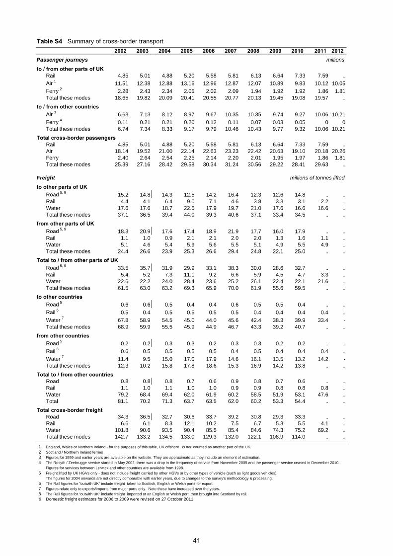
Table S4 Summary of cross-border transport
2002 2003 2004 2005 2006 2007 2008 2009 2010 2011 2012Passenger journeys millions
to / from other parts of UKRail 4.85 5.01 4.88 5.20 5.58 5.81 6.13 6.64 7.33 7.59 ..
Air 1 11.51 12.38 12.88 13.16 12.96 12.87 12.07 10.89 9.83 10.12 10.05
Ferry 2 2.28 2.43 2.34 2.05 2.02 2.09 1.94 1.92 1.92 1.86 1.81Total these modes 18.65 19.82 20.09 20.41 20.55 20.77 20.13 19.45 19.08 19.57 ..
to / from other countriesAir 3 6.63 7.13 8.12 8.97 9.67 10.35 10.35 9.74 9.27 10.06 10.21
Ferry 4 0.11 0.21 0.21 0.20 0.12 0.11 0.07 0.03 0.05 0 0Total these modes 6.74 7.34 8.33 9.17 9.79 10.46 10.43 9.77 9.32 10.06 10.21
Total cross-border passengers Rail 4.85 5.01 4.88 5.20 5.58 5.81 6.13 6.64 7.33 7.59 ..Air 18.14 19.52 21.00 22.14 22.63 23.23 22.42 20.63 19.10 20.18 20.26Ferry 2.40 2.64 2.54 2.25 2.14 2.20 2.01 1.95 1.97 1.86 1.81Total these modes 25.39 27.16 28.42 29.58 30.34 31.24 30.56 29.22 28.41 29.63 ..
Freight millions of tonnes lifted
to other parts of UKRoad 5, 9 15.2 14.8 14.3 12.5 14.2 16.4 12.3 12.6 14.8 .. ..Rail 4.4 4.1 6.4 9.0 7.1 4.6 3.8 3.3 3.1 2.2 ..Water 17.6 17.6 18.7 22.5 17.9 19.7 21.0 17.6 16.6 16.6 ..Total these modes 37.1 36.5 39.4 44.0 39.3 40.6 37.1 33.4 34.5 .. ..
from other parts of UKRoad 5, 9 18.3 20.9 17.6 17.4 18.9 21.9 17.7 16.0 17.9 .. ..Rail 1.1 1.0 0.9 2.1 2.1 2.0 2.0 1.3 1.6 1.1 ..Water 5.1 4.6 5.4 5.9 5.6 5.5 5.1 4.9 5.5 4.9 ..Total these modes 24.4 26.6 23.9 25.3 26.6 29.4 24.8 22.1 25.0 .. ..
Total to / from other parts of UKRoad 5, 9 33.5 35.7 31.9 29.9 33.1 38.3 30.0 28.6 32.7 .. ..Rail 5.4 5.2 7.3 11.1 9.2 6.6 5.9 4.5 4.7 3.3 ..Water 22.6 22.2 24.0 28.4 23.6 25.2 26.1 22.4 22.1 21.6 ..Total these modes 61.5 63.0 63.2 69.3 65.9 70.0 61.9 55.6 59.5 .. ..
to other countriesRoad 5 0.6 0.6 0.5 0.4 0.4 0.6 0.5 0.5 0.4 .. ..
Rail 6 0.5 0.4 0.5 0.5 0.5 0.5 0.4 0.4 0.4 0.4 ..
Water 7 67.8 58.9 54.5 45.0 44.0 45.6 42.4 38.3 39.9 33.4 -Total these modes 68.9 59.9 55.5 45.9 44.9 46.7 43.3 39.2 40.7 .. ..
from other countriesRoad 5 0.2 0.2 0.3 0.3 0.2 0.3 0.3 0.2 0.2 .. ..
Rail 8 0.6 0.5 0.5 0.5 0.5 0.4 0.5 0.4 0.4 0.4 ..
Water 7 11.4 9.5 15.0 17.0 17.9 14.6 16.1 13.5 13.2 14.2 -Total these modes 12.3 10.2 15.8 17.8 18.6 15.3 16.9 14.2 13.8 .. ..
Total to / from other countriesRoad 0.8 0.8 0.8 0.7 0.6 0.9 0.8 0.7 0.6 .. ..Rail 1.1 1.0 1.1 1.0 1.0 0.9 0.9 0.8 0.8 0.8 ..Water 79.2 68.4 69.4 62.0 61.9 60.2 58.5 51.9 53.1 47.6 ..Total 81.1 70.2 71.3 63.7 63.5 62.0 60.2 53.3 54.4 .. ..
Total cross-border freightRoad 34.3 36.5 32.7 30.6 33.7 39.2 30.8 29.3 33.3 .. ..Rail 6.6 6.1 8.3 12.1 10.2 7.5 6.7 5.3 5.5 4.1 ..Water 101.8 90.6 93.5 90.4 85.5 85.4 84.6 74.3 75.2 69.2 ..Total these modes 142.7 133.2 134.5 133.0 129.3 132.0 122.1 108.9 114.0 .. ..
1 England, Wales or Northern Ireland - for the purposes of this table, UK offshore is not counted as another part of the UK. 2 Scotland / Northern Ireland ferries3 Figures for 1999 and earlier years are available on the website. They are approximate as they include an element of estimation.4 The Rosyth / Zeebrugge service started in May 2002, there was a drop in the frequency of service from November 2005 and the passenger service ceased in December 2010.
Figures for services between Lerwick and other countries are available from 1998.5 Freight lifted by UK HGVs only - does not include freight carried by other HGVs or by other types of vehicle (such as light goods vehicles)
The figures for 2004 onwards are not directly comparable with earlier years, due to changes to the survey's methodology & processing.6 The Rail figures for "outwith UK" include freight taken to Scottish, English or Welsh ports for export.7 Figures relate only to exports/imports from major ports only. Note these have increased over the years.8 The Rail figures for "outwith UK" include freight imported at an English or Welsh port, then brought into Scotland by rail.
9 Domestic freight estimates for 2006 to 2009 were revised on 27 October 2011
41

Table SGB1 Comparisons of Scotland and Great Britain (or the UK) - numbersNumbers
2002 2003 2004 2005 2006 2007 2008 2009 2010 2011 2012Vehicles Licensed (all vehicles) thousand
Scotland 2,330 2,383 2,448 2,531 2,564 2,627 2,665 2,684 2,685 2,691 2,717GB 30,557 31,207 32,259 32,897 33,070 33,651 33,883 33,958 34,120 34,229 34,522
Households with a Car 1 (National Travel Survey) percent
Scotland .. 69 .. 69 .. 70 .. 70 .. 70 ..GB .. 74 .. 75 .. 75 .. 75 .. 72 ..
Public Road Lengths (all roads) thousand kilometres thousand kilometres
Scotland 54.6 54.6 54.6 54.8 55.0 55.2 55.3 55.5 55.6 55.8 55.9GB 2 391.6 392.3 387.7 388.0 398.4 398.9 394.5 394.4 394.3 394.3 394.9
Road Traffic billion vehicle kilometres
Motorway
Scotland 5.73 5.86 6.09 6.15 6.43 6.58 6.68 6.63 6.50 6.57 7.14GB 92.6 93.0 96.6 97.0 99.4 100.6 100.1 99.5 98.2 99.5 100.4
A roads
Scotland 21.5 21.8 22.1 21.9 22.5 22.4 22.1 22.3 22.0 22.0 21.7GB 3 218.6 221.0 224.1 223.1 226.1 224.9 222.8 222.4 219.5 220.4 218.5
All roads (incl. B, C, unclassified)
Scotland 41.5 42.0 42.7 42.7 44.1 44.7 44.5 44.2 43.5 43.4 43.5GB 3 486.5 490.4 498.6 499.4 507.5 513.0 508.9 504.0 495.9 488.9 487.1
Reported Road Accident Casualties: Killed or Seriously Injured thousand
Scotland 12 3.53 3.29 3.07 2.95 2.95 2.67 2.85 2.50 2.18 2.06 2.13GB 39.4 37.2 34.4 32.2 31.8 30.7 28.6 26.9 24.5 25.0 24.8
Local bus passenger journeys 2, 4 million
Scotland 471 478 460 466 476 488 484 459 431 439 ..GB 4,550 4,681 4,631 4,721 4,915 5,165 5,272 5,214 5,203 5,233 ..
Rail passenger journeys 4, 5, 6 million
Scotland 61.4 66.1 72.9 78.1 79.5 87.7 84.5 85.2 81.9 87.9 ..GB 11 775 791 808 827 984 1,018 1,074 1,065 1,160 1,230 ..
Air terminal passengers Scotland 19.8 21.1 22.6 23.8 24.4 25.1 24.3 22.5 20.9 22.1 22.2UK 188.8 200.0 215.7 228.2 235.2 240.7 235.4 218.1 210.7 219.3 220.6
Freight Lifted million tonnes
Road 8, 9
Scotland 154 153 173 166 170 177 157 132 132 .. ..GB 1,627 1,643 1,744 1,746 1,776 1,822 1,668 1,356 1,489 .. ..
Rail 4
Scotland 9.12 8.32 11.25 14.32 12.96 11.35 10.36 9.69 8.33 7.61 ..GB 87 89 100 105 108 102 103 87 90 102 113
Coastwise traffic
Scotland 19.2 19.5 20.5 25.5 20.6 22.8 23.3 19.8 18.0 16.3 ..UK 59.5 58.5 59.8 65.1 56.7 57.6 58.1 54.6 50.5 49.3 ..
Pipelines 7
Scotland 28.0 27.7 27.6 27.6 27.8 27.5 27.6 27.6 27.6 27.8 28.2GB 58.4 54.9 56.1 55.4 54.5 53.1 53.3 53.6 53.5 53.7 54.3
Travel to Work (Autumn: Labour Force Survey) percent
Car (or van, minibus, works van)
Scotland 70 70 69 68 69 69 69 70 71 68 ..GB 71 71 71 71 70 69 70 70 70 68 ..
Public transport (bus, rail, underground)
Scotland 14 15 15 16 17 16 17 15 14 16 ..GB 14 14 14 14 15 16 15 15 15 16 ..
1 Figures are for combined years e.g. 2011 covers 2011/12.
2 DfT revised its methodlogy from 2004, causing a break in the series.3 The GB figures relate to motor vehicle traffic only, and therefore exclude a small amount of pedal cycle traffic.
4 Financial years
5 Total passenger figures are produced by the ORR and have not been adjusted to reflect ScotRail's revised zonecard methdology.
6 Figures are based on the origin and destination of trips and do not count stages of these trips separately.
7 The estimated amounts of crude oil and products carried by pipelines over 50km in length. 2012 figures are provisional.
8 These figures are for freight lifted by Heavy Goods Vehicles. The GB figures are for freight transported within GB; the Scottish
figures include small amounts of freight destined for Northern Ireland and outside the UK.
9 Domestic freight estimates for 2006 to 2009 were revised on 27 October 2011
10 Figures for 2012 are provisional.
11 Figs for 2008-09 onwards have been revised due to an error in the LENNON calculation of journeys between Edinburgh and Glasgow.
42
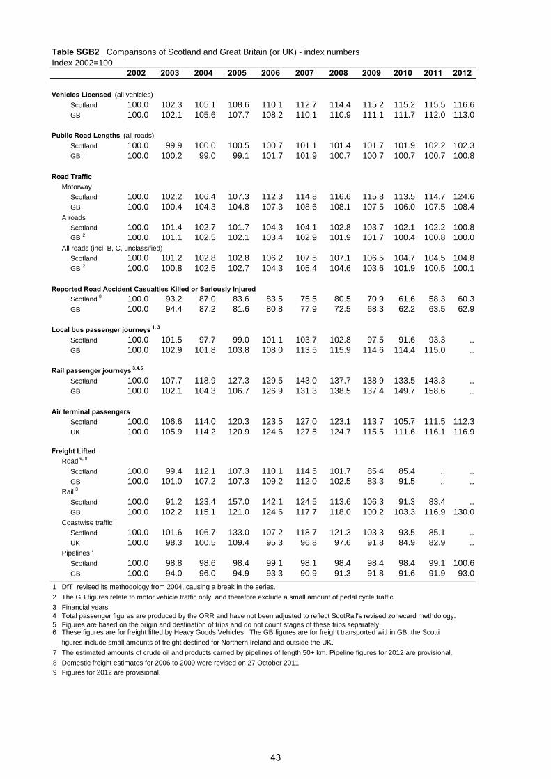
Table SGB2 Comparisons of Scotland and Great Britain (or UK) - index numbersIndex 2002=100
2002 2003 2004 2005 2006 2007 2008 2009 2010 2011 2012
Vehicles Licensed (all vehicles)
Scotland 100.0 102.3 105.1 108.6 110.1 112.7 114.4 115.2 115.2 115.5 116.6GB 100.0 102.1 105.6 107.7 108.2 110.1 110.9 111.1 111.7 112.0 113.0
Public Road Lengths (all roads)
Scotland 100.0 99.9 100.0 100.5 100.7 101.1 101.4 101.7 101.9 102.2 102.3GB 1 100.0 100.2 99.0 99.1 101.7 101.9 100.7 100.7 100.7 100.7 100.8
Road TrafficMotorway
Scotland 100.0 102.2 106.4 107.3 112.3 114.8 116.6 115.8 113.5 114.7 124.6GB 100.0 100.4 104.3 104.8 107.3 108.6 108.1 107.5 106.0 107.5 108.4
A roads
Scotland 100.0 101.4 102.7 101.7 104.3 104.1 102.8 103.7 102.1 102.2 100.8GB 2 100.0 101.1 102.5 102.1 103.4 102.9 101.9 101.7 100.4 100.8 100.0
All roads (incl. B, C, unclassified)
Scotland 100.0 101.2 102.8 102.8 106.2 107.5 107.1 106.5 104.7 104.5 104.8GB 2 100.0 100.8 102.5 102.7 104.3 105.4 104.6 103.6 101.9 100.5 100.1
Reported Road Accident Casualties Killed or Seriously InjuredScotland 9 100.0 93.2 87.0 83.6 83.5 75.5 80.5 70.9 61.6 58.3 60.3GB 100.0 94.4 87.2 81.6 80.8 77.9 72.5 68.3 62.2 63.5 62.9
Local bus passenger journeys 1, 3
Scotland 100.0 101.5 97.7 99.0 101.1 103.7 102.8 97.5 91.6 93.3 ..GB 100.0 102.9 101.8 103.8 108.0 113.5 115.9 114.6 114.4 115.0 ..
Rail passenger journeys 3,4,5
Scotland 100.0 107.7 118.9 127.3 129.5 143.0 137.7 138.9 133.5 143.3 ..GB 100.0 102.1 104.3 106.7 126.9 131.3 138.5 137.4 149.7 158.6 ..
Air terminal passengers Scotland 100.0 106.6 114.0 120.3 123.5 127.0 123.1 113.7 105.7 111.5 112.3UK 100.0 105.9 114.2 120.9 124.6 127.5 124.7 115.5 111.6 116.1 116.9
Freight Lifted Road 6, 8
Scotland 100.0 99.4 112.1 107.3 110.1 114.5 101.7 85.4 85.4 .. ..GB 100.0 101.0 107.2 107.3 109.2 112.0 102.5 83.3 91.5 .. ..
Rail 3
Scotland 100.0 91.2 123.4 157.0 142.1 124.5 113.6 106.3 91.3 83.4 ..GB 100.0 102.2 115.1 121.0 124.6 117.7 118.0 100.2 103.3 116.9 130.0
Coastwise traffic
Scotland 100.0 101.6 106.7 133.0 107.2 118.7 121.3 103.3 93.5 85.1 ..UK 100.0 98.3 100.5 109.4 95.3 96.8 97.6 91.8 84.9 82.9 ..
Pipelines 7
Scotland 100.0 98.8 98.6 98.4 99.1 98.1 98.4 98.4 98.4 99.1 100.6GB 100.0 94.0 96.0 94.9 93.3 90.9 91.3 91.8 91.6 91.9 93.0
1 DfT revised its methodology from 2004, causing a break in the series.
2 The GB figures relate to motor vehicle traffic only, and therefore exclude a small amount of pedal cycle traffic.
3 Financial years4 Total passenger figures are produced by the ORR and have not been adjusted to reflect ScotRail's revised zonecard methdology. 5 Figures are based on the origin and destination of trips and do not count stages of these trips separately. 6 These figures are for freight lifted by Heavy Goods Vehicles. The GB figures are for freight transported within GB; the Scotti
figures include small amounts of freight destined for Northern Ireland and outside the UK.
7 The estimated amounts of crude oil and products carried by pipelines of length 50+ km. Pipeline figures for 2012 are provisional.
8 Domestic freight estimates for 2006 to 2009 were revised on 27 October 20119 Figures for 2012 are provisional.
43
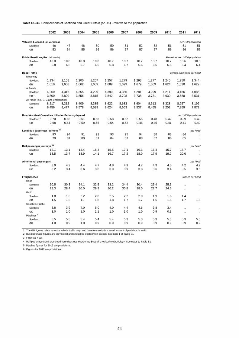
Table SGB3 Comparisons of Scotland and Great Britain (or UK) - relative to the population
2002 2003 2004 2005 2006 2007 2008 2009 2010 2011 2012
Vehicles Licensed (all vehicles) per 100 population
Scotland 46 47 48 50 50 51 52 52 51 51 51GB 53 54 55 56 56 57 57 57 56 56 56
Public Road Lengths (all roads) kilometres per 1,000 population
Scotland 10.8 10.8 10.8 10.8 10.7 10.7 10.7 10.7 10.7 10.6 10.5GB 6.8 6.8 6.7 6.6 6.8 6.7 6.6 6.6 6.5 6.4 6.4
Road Traffic vehicle kilometres per head
Motorway
Scotland 1,134 1,158 1,200 1,207 1,257 1,279 1,293 1,277 1,245 1,250 1,344 GB 1,610 1,608 1,662 1,659 1,689 1,699 1,679 1,669 1,624 1,620 1,622
A Roads
Scotland 4,260 4,316 4,355 4,299 4,390 4,356 4,281 4,299 4,211 4,186 4,086 GB 1 3,800 3,820 3,856 3,815 3,842 3,798 3,738 3,731 3,630 3,588 3,531
All roads (incl. B, C and unclassified)
Scotland 8,217 8,312 8,409 8,385 8,622 8,683 8,604 8,513 8,328 8,257 8,196 GB 1 8,456 8,477 8,578 8,539 8,624 8,663 8,537 8,455 8,202 7,959 7,872
Road Accident Casualties Killed or Seriously Injured per 1,000 population
Scotland 6 0.70 0.65 0.61 0.58 0.58 0.52 0.55 0.48 0.42 0.39 0.40GB 0.68 0.64 0.59 0.55 0.54 0.52 0.48 0.45 0.41 0.41 0.40
Local bus passenger journeys 2,3 per head
Scotland 93 94 91 91 93 95 94 88 83 84 ..GB 79 81 80 81 84 87 88 87 86 85 ..
Rail passenger journeys 3,4 per head
Scotland 12.1 13.1 14.4 15.3 15.5 17.1 16.3 16.4 15.7 16.7 ..GB 13.5 13.7 13.9 14.1 16.7 17.2 18.0 17.9 19.2 20.0 ..
Air terminal passengers per head
Scotland 3.9 4.2 4.4 4.7 4.8 4.9 4.7 4.3 4.0 4.2 4.2UK 3.2 3.4 3.6 3.8 3.9 3.9 3.8 3.6 3.4 3.5 3.5
Freight Lifted tonnes per head
Road
Scotland 30.5 30.3 34.1 32.5 33.2 34.4 30.4 25.4 25.3 .. ..GB 28.3 28.4 30.0 29.9 30.2 30.8 28.0 22.7 24.6 .. ..
Rail 3
Scotland 1.8 1.6 2.2 2.8 2.5 2.2 2.0 1.9 1.6 1.4 ..GB 1.5 1.5 1.7 1.8 1.8 1.7 1.7 1.5 1.5 1.7 1.8
Coastwise traffic
Scotland 3.8 3.9 4.0 5.0 4.0 4.4 4.5 3.8 3.4 .. ..UK 1.0 1.0 1.0 1.1 1.0 1.0 1.0 0.9 0.8 .. ..
Pipelines 5
Scotland 5.5 5.5 5.4 5.4 5.4 5.3 5.3 5.3 5.3 5.3 5.3GB 1.0 0.9 1.0 0.9 0.9 0.9 0.9 0.9 0.9 0.9 0.9
1 The GB figures relate to motor vehicle traffic only, and therefore exclude a small amount of pedal cycle traffic. 2 Bus patronage figures are provisional and should be treated with caution. See note 1 of Table S1.
3 Financial Year
4 Rail patronage trend presented here does not incorporate Scotrail's revised methodology. See notes to Table S1.
5 Pipeline figures for 2012 are provisional.
6 Figures for 2012 are provisional.
44

Table H1 Summary of passenger traffic
Year 1 Car Bus Rail Air Ferry Car Bus Rail Air Ferryvehicle passenger passenger terminal passengerskilometres journeys journeys passengers on selectedon major on originating at ferry
roads local in airports services 4
(M and A) services 2 Scotland3
million Index, 1985 = 100
1960 .. 1,664 64.9 1.20 .. .. 242 114 17 ..1961 .. 1,633 63.4 1.41 .. .. 238 111 20 ..1962 .. 1,579 72.3 1.59 .. .. 230 127 23 ..1963 .. 1,561 71.7 1.82 .. .. 227 126 26 ..1964 .. 1,506 73.0 2.07 .. .. 219 128 30 ..1965 .. 1,417 71.0 2.29 .. .. 206 124 33 ..1966 .. 1,344 65.8 2.56 .. .. 196 115 37 ..1967 .. 1,297 65.9 2.76 .. .. 189 115 40 ..1968 .. 1,220 67.0 2.69 .. .. 178 117 39 ..1969 .. 1,169 68.4 2.91 .. .. 170 120 42 ..1970 .. 1,057 70.7 3.10 .. .. 154 124 45 ..1971 .. 1,019 66.5 3.20 .. .. 148 116 46 ..1972 .. 998 61.2 3.64 .. .. 145 107 52 ..1973 .. 975 60.5 4.07 4.82 .. 142 106 59 1031974 .. 896 69.1 4.00 4.96 .. 131 121 58 1061975 9,318 891 66.2 4.18 5.28 68 130 116 60 1131976 9,438 881 60.1 4.78 5.17 69 128 105 69 1111977 9,622 824 56.8 4.85 4.82 71 120 99 70 1031978 9,749 794 59.7 5.90 4.64 72 116 105 85 991979 9,643 786 57.6 6.33 4.56 71 114 101 91 981980 10,262 763 61.5 6.37 4.48 75 111 108 92 961981 10,418 716 57.8 6.50 4.27 77 104 101 94 911982 10,733 694 49.5 6.37 4.19 79 101 87 92 901983 11,043 680 55.7 6.48 4.51 81 99 98 93 971984 12,794 669 51.3 6.99 4.67 94 97 90 101 1001985 13,606 687 57.1 6.94 4.67 100 100 100 100 1001986 14,012 660 53.1 7.24 4.85 103 96 93 104 1041987 14,881 662 54.1 7.81 5.35 109 96 95 112 1151988 15,946 662 54.0 8.51 5.66 117 96 95 123 1211989 17,027 628 51.8 9.23 6.18 125 91 91 133 1321990 17,476 600 52.8 9.86 6.54 128 87 92 142 1401991 17,553 585 54.5 9.57 6.80 129 85 95 138 1461992 18,068 545 59.3 10.38 6.63 133 79 104 150 1421993 18,211 538 59.1 11.12 6.63 134 78 104 160 1421994 18,683 526 54.4 11.79 6.65 137 77 95 170 1421995 19,226 506 56.7 12.31 6.86 141 74 99 177 1471996 19,888 478 57.5 13.21 5.59 146 70 101 190 1201997 20,266 448 60.7 14.39 5.63 149 65 106 207 1211998 20,456 424 62.5 15.19 5.33 150 62 109 219 1141999 20,700 455 64.9 15.94 5.33 152 66 114 230 1142000 20,566 458 64.8 16.79 5.29 151 67 113 242 1132001 20,977 466 64.6 18.08 5.30 154 68 113 260 1142002 21,760 471 61.4 19.78 5.37 160 69 107 285 1152003 21,922 478 66.1 21.08 5.72 161 70 116 304 1232004 22,308 460 72.9 22.55 5.92 164 67 128 325 1272005 22,060 466 78.1 23.80 5.97 162 68 137 343 1282006 22,610 476 79.5 24.44 6.02 166 69 139 352 1292007 22,392 488 87.7 25.13 6.01 165 71 154 362 1292008 22,221 484 84.5 24.35 5.70 163 70 148 351 1222009 22,496 459 85.2 22.50 5.93 165 67 149 324 1272010 21,998 431 81.9 20.91 5.87 162 63 143 301 1262011 21,986 439 87.9 22.07 5.63 162 64 154 318 1212012 22,170 .. .. 22.21 5.49 163 .. .. 320 118
1 The figures for Car and Air are for calendar years; latterly, the figures for Bus and Railare for the financial years which start in the specified calendar years (eg the 1996 figures are for 1996-97)
2 Pre-1975, the figures are the totals of passenger journeys for the Scottish Bus Group and the four city corporations. Therefore, they include any non-stage (non-local) services run by these operators, and exclude other operators' stage (local) services.Glasgow Corporation's figures may have included passenger journeys on trolley buses and the Glasgow Underground.Figures from 2004 onwards have been subject to revision due to methodological improvements
3 Rail patronage trend from 2003 onward incorporates Scotrail's revised methodology. See notes to Table S1. 4 Those routes for which figures are available back to 1973: Caledonian MacBrayne, P&O Scottish Ferries /
NorthLink Orkney and Shetland Ferries, and Orkney Ferries. The figures from 1995 are affected by the reduction in traffic caused by the withdrawal of the Kyle-Kyleakin service when the Skye Bridge opened in October 1995.
45
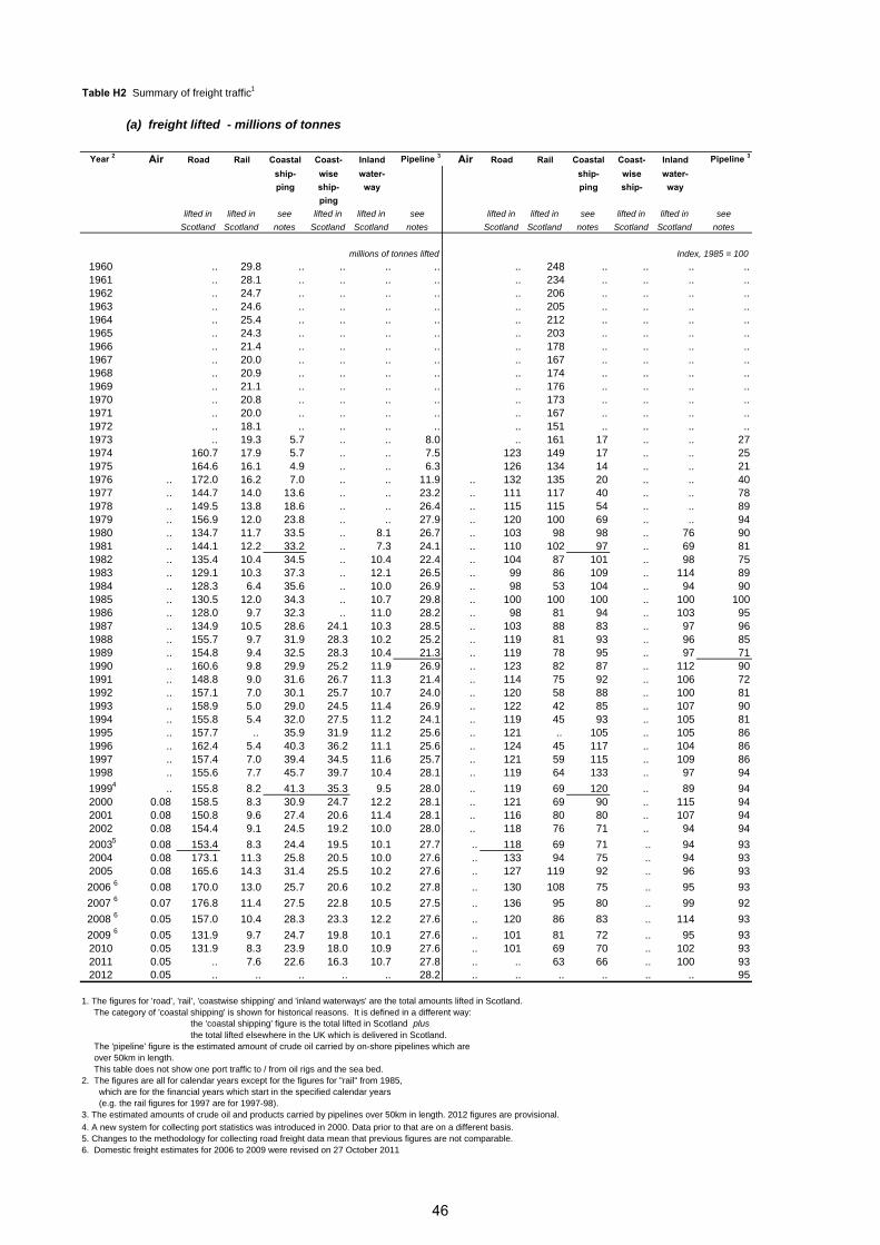
Table H2 Summary of freight traffic1
(a) freight lifted - millions of tonnes
Year 2 Air Road Rail Coastal Coast- Inland Pipeline 3 Air Road Rail Coastal Coast- Inland Pipeline 3
ship- wise water- ship- wise water-ping ship- way ping ship- way
pinglifted in lifted in see lifted in lifted in see lifted in lifted in see lifted in lifted in see
Scotland Scotland notes Scotland Scotland notes Scotland Scotland notes Scotland Scotland notes
millions of tonnes lifted Index, 1985 = 100
1960 .. 29.8 .. .. .. .. .. 248 .. .. .. ..1961 .. 28.1 .. .. .. .. .. 234 .. .. .. ..1962 .. 24.7 .. .. .. .. .. 206 .. .. .. ..1963 .. 24.6 .. .. .. .. .. 205 .. .. .. ..1964 .. 25.4 .. .. .. .. .. 212 .. .. .. ..1965 .. 24.3 .. .. .. .. .. 203 .. .. .. ..1966 .. 21.4 .. .. .. .. .. 178 .. .. .. ..1967 .. 20.0 .. .. .. .. .. 167 .. .. .. ..1968 .. 20.9 .. .. .. .. .. 174 .. .. .. ..1969 .. 21.1 .. .. .. .. .. 176 .. .. .. ..1970 .. 20.8 .. .. .. .. .. 173 .. .. .. ..1971 .. 20.0 .. .. .. .. .. 167 .. .. .. ..1972 .. 18.1 .. .. .. .. .. 151 .. .. .. ..1973 .. 19.3 5.7 .. .. 8.0 .. 161 17 .. .. 271974 160.7 17.9 5.7 .. .. 7.5 123 149 17 .. .. 251975 164.6 16.1 4.9 .. .. 6.3 126 134 14 .. .. 211976 .. 172.0 16.2 7.0 .. .. 11.9 .. 132 135 20 .. .. 401977 .. 144.7 14.0 13.6 .. .. 23.2 .. 111 117 40 .. .. 781978 .. 149.5 13.8 18.6 .. .. 26.4 .. 115 115 54 .. .. 891979 .. 156.9 12.0 23.8 .. .. 27.9 .. 120 100 69 .. .. 941980 .. 134.7 11.7 33.5 .. 8.1 26.7 .. 103 98 98 .. 76 901981 .. 144.1 12.2 33.2 .. 7.3 24.1 .. 110 102 97 .. 69 811982 .. 135.4 10.4 34.5 .. 10.4 22.4 .. 104 87 101 .. 98 751983 .. 129.1 10.3 37.3 .. 12.1 26.5 .. 99 86 109 .. 114 891984 .. 128.3 6.4 35.6 .. 10.0 26.9 .. 98 53 104 .. 94 901985 .. 130.5 12.0 34.3 .. 10.7 29.8 .. 100 100 100 .. 100 1001986 .. 128.0 9.7 32.3 .. 11.0 28.2 .. 98 81 94 .. 103 951987 .. 134.9 10.5 28.6 24.1 10.3 28.5 .. 103 88 83 .. 97 961988 .. 155.7 9.7 31.9 28.3 10.2 25.2 .. 119 81 93 .. 96 851989 .. 154.8 9.4 32.5 28.3 10.4 21.3 .. 119 78 95 .. 97 711990 .. 160.6 9.8 29.9 25.2 11.9 26.9 .. 123 82 87 .. 112 901991 .. 148.8 9.0 31.6 26.7 11.3 21.4 .. 114 75 92 .. 106 721992 .. 157.1 7.0 30.1 25.7 10.7 24.0 .. 120 58 88 .. 100 811993 .. 158.9 5.0 29.0 24.5 11.4 26.9 .. 122 42 85 .. 107 901994 .. 155.8 5.4 32.0 27.5 11.2 24.1 .. 119 45 93 .. 105 811995 .. 157.7 .. 35.9 31.9 11.2 25.6 .. 121 .. 105 .. 105 861996 .. 162.4 5.4 40.3 36.2 11.1 25.6 .. 124 45 117 .. 104 861997 .. 157.4 7.0 39.4 34.5 11.6 25.7 .. 121 59 115 .. 109 861998 .. 155.6 7.7 45.7 39.7 10.4 28.1 .. 119 64 133 .. 97 94
19994 .. 155.8 8.2 41.3 35.3 9.5 28.0 .. 119 69 120 .. 89 942000 0.08 158.5 8.3 30.9 24.7 12.2 28.1 .. 121 69 90 .. 115 942001 0.08 150.8 9.6 27.4 20.6 11.4 28.1 .. 116 80 80 .. 107 942002 0.08 154.4 9.1 24.5 19.2 10.0 28.0 .. 118 76 71 .. 94 94
20035 0.08 153.4 8.3 24.4 19.5 10.1 27.7 .. 118 69 71 .. 94 932004 0.08 173.1 11.3 25.8 20.5 10.0 27.6 .. 133 94 75 .. 94 932005 0.08 165.6 14.3 31.4 25.5 10.2 27.6 .. 127 119 92 .. 96 93
2006 6 0.08 170.0 13.0 25.7 20.6 10.2 27.8 .. 130 108 75 .. 95 93
2007 6 0.07 176.8 11.4 27.5 22.8 10.5 27.5 .. 136 95 80 .. 99 92
2008 6 0.05 157.0 10.4 28.3 23.3 12.2 27.6 .. 120 86 83 .. 114 93
2009 6 0.05 131.9 9.7 24.7 19.8 10.1 27.6 .. 101 81 72 .. 95 932010 0.05 131.9 8.3 23.9 18.0 10.9 27.6 .. 101 69 70 .. 102 932011 0.05 .. 7.6 22.6 16.3 10.7 27.8 .. .. 63 66 .. 100 932012 0.05 .. .. .. .. .. 28.2 .. .. .. .. .. .. 95
1. The figures for 'road', 'rail', 'coastwise shipping' and 'inland waterways' are the total amounts lifted in Scotland. The category of 'coastal shipping' is shown for historical reasons. It is defined in a different way:
the 'coastal shipping' figure is the total lifted in Scotland plus the total lifted elsewhere in the UK which is delivered in Scotland.
The 'pipeline' figure is the estimated amount of crude oil carried by on-shore pipelines which are over 50km in length. This table does not show one port traffic to / from oil rigs and the sea bed.2. The figures are all for calendar years except for the figures for "rail" from 1985, which are for the financial years which start in the specified calendar years (e.g. the rail figures for 1997 are for 1997-98).3. The estimated amounts of crude oil and products carried by pipelines over 50km in length. 2012 figures are provisional.
4. A new system for collecting port statistics was introduced in 2000. Data prior to that are on a different basis.5. Changes to the methodology for collecting road freight data mean that previous figures are not comparable.6. Domestic freight estimates for 2006 to 2009 were revised on 27 October 2011
46

Table H2 Summary of freight traffic1
(b) freight moved - millions of tonne-kilometres
Year 2 Road Rail Coastwise Inland Pipeline 3,6
shipping waterwaylifted in lifted in lifted in lifted in see
Scotland Scotland Scotland Scotland notes
millions of tonne-kilometres
1960 .. .. .. ..1961 .. .. .. ..1962 .. .. .. ..1963 .. .. .. ..1964 .. .. .. ..1965 .. .. .. ..1966 .. .. .. ..1967 .. .. .. ..1968 .. .. .. ..1969 .. .. .. .. ..1970 .. .. .. .. ..1971 .. .. .. .. ..1972 .. .. .. .. ..1973 .. .. .. .. ..1974 .. .. .. .. ..1975 .. .. .. .. ..1976 .. .. .. .. ..1977 .. .. .. .. ..1978 .. .. .. .. ..1979 .. .. .. .. ..1980 .. .. .. .. ..1981 .. .. .. .. ..1982 .. .. .. .. ..1983 .. .. .. .. ..1984 .. .. .. .. ..1985 9,706 .. .. .. ..1986 9,332 .. .. .. ..1987 10,225 .. 19,810 262 ..1988 11,520 .. 22,910 264 ..1989 12,339 .. 23,020 268 ..1990 12,309 .. 19,090 315 ..1991 11,909 .. 22,850 298 ..1992 12,121 .. 20,940 270 5,1321993 12,426 .. 19,710 290 ..1994 12,995 .. 19,740 290 5,2791995 13,965 .. 25,110 300 5,6931996 14,163 1,427 29,250 300 5,6881997 14,236 2,145 26,280 310 5,7171998 14,856 2,787 29,610 260 5,946
19994 14,988 2,891 26,850 240 5,9052000 14,817 2,462 20,100 280 5,9332001 14,425 3,099 15,600 280 5,9292002 14,170 2,737 14,540 240 5,909
20035 14,432 2,519 14,850 240 5,8322004 15,195 3,734 14,060 240 5,8202005 13,507 4,304 17,457 251 5,8692006 14,233 3,597 14,491 249 5,7152007 15,349 2,883 16,909 268 5,7262008 13,936 2,543 17,890 312 5,7252009 12,348 2,549 15,321 244 5,7252010 12,695 2,486 13,557 280 5,7252011 .. 2,001 13,011 270 5,7522012 .. .. .. .. 5,836
1. The figures for 'road', 'rail', 'coastwise shipping' and 'inland waterways' relate to freight lifted in Scotland; for 'pipeline' it is the estimated tonne-kilometres for crude oil carried by on-shore pipelines which are over 50km in length. This table does not show the tonne-kilometres for one port traffic to / from oil rigs and the sea bed or for coastal shipping (as defined in part [a] of this table).2. The figures are all for calendar years except for the figures for rail, which are for the financial years which start in the specified calendar years (e.g. the rail figures for 1997 are for 1997-98).3. Over 50km4. A new system for collecting port statistics was introduced in 2000. Data prior to that are on a different basis.5. Changes to the methodology for collecting road freight data mean that previous figures are not comparable.6. Pipeline figures for 2012 are provisional.
47
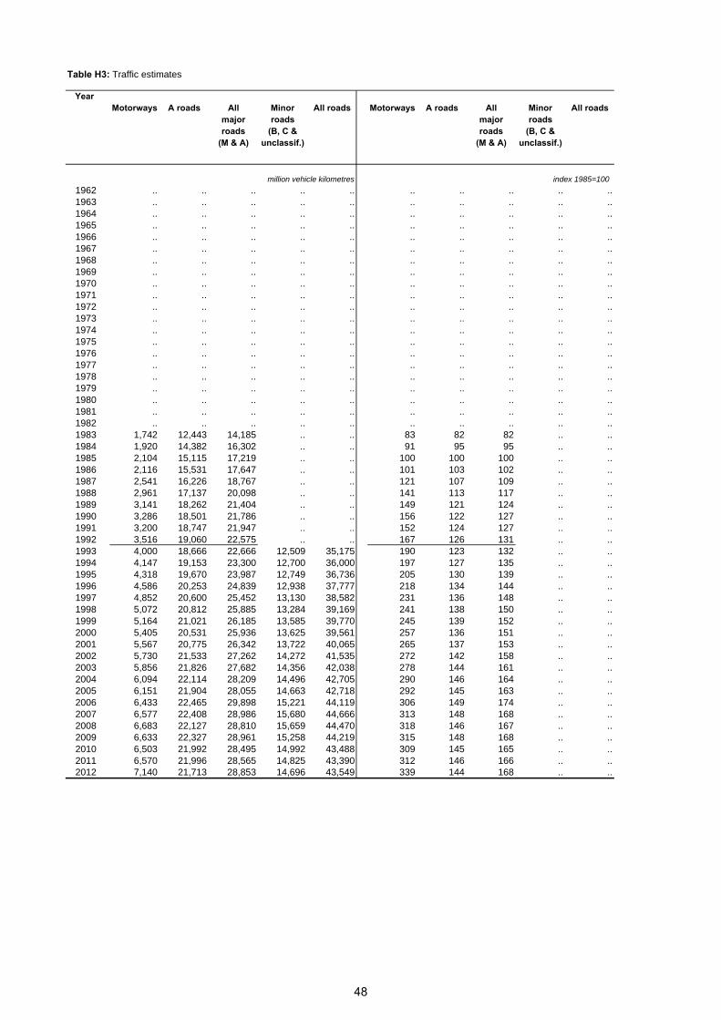
Table H3: Traffic estimates
Year Motorways A roads All Minor All roads Motorways A roads All Minor All roads
major roads major roadsroads (B, C & roads (B, C &
(M & A) unclassif.) (M & A) unclassif.)
million vehicle kilometres index 1985=100
1962 .. .. .. .. .. .. .. .. .. ..1963 .. .. .. .. .. .. .. .. .. ..1964 .. .. .. .. .. .. .. .. .. ..1965 .. .. .. .. .. .. .. .. .. ..1966 .. .. .. .. .. .. .. .. .. ..1967 .. .. .. .. .. .. .. .. .. ..1968 .. .. .. .. .. .. .. .. .. ..1969 .. .. .. .. .. .. .. .. .. ..1970 .. .. .. .. .. .. .. .. .. ..1971 .. .. .. .. .. .. .. .. .. ..1972 .. .. .. .. .. .. .. .. .. ..1973 .. .. .. .. .. .. .. .. .. ..1974 .. .. .. .. .. .. .. .. .. ..1975 .. .. .. .. .. .. .. .. .. ..1976 .. .. .. .. .. .. .. .. .. ..1977 .. .. .. .. .. .. .. .. .. ..1978 .. .. .. .. .. .. .. .. .. ..1979 .. .. .. .. .. .. .. .. .. ..1980 .. .. .. .. .. .. .. .. .. ..1981 .. .. .. .. .. .. .. .. .. ..1982 .. .. .. .. .. .. .. .. .. ..1983 1,742 12,443 14,185 .. .. 83 82 82 .. ..1984 1,920 14,382 16,302 .. .. 91 95 95 .. ..1985 2,104 15,115 17,219 .. .. 100 100 100 .. ..1986 2,116 15,531 17,647 .. .. 101 103 102 .. ..1987 2,541 16,226 18,767 .. .. 121 107 109 .. ..1988 2,961 17,137 20,098 .. .. 141 113 117 .. ..1989 3,141 18,262 21,404 .. .. 149 121 124 .. ..1990 3,286 18,501 21,786 .. .. 156 122 127 .. ..1991 3,200 18,747 21,947 .. .. 152 124 127 .. ..1992 3,516 19,060 22,575 .. .. 167 126 131 .. ..1993 4,000 18,666 22,666 12,509 35,175 190 123 132 .. ..1994 4,147 19,153 23,300 12,700 36,000 197 127 135 .. ..1995 4,318 19,670 23,987 12,749 36,736 205 130 139 .. ..1996 4,586 20,253 24,839 12,938 37,777 218 134 144 .. ..1997 4,852 20,600 25,452 13,130 38,582 231 136 148 .. ..1998 5,072 20,812 25,885 13,284 39,169 241 138 150 .. ..1999 5,164 21,021 26,185 13,585 39,770 245 139 152 .. ..2000 5,405 20,531 25,936 13,625 39,561 257 136 151 .. ..2001 5,567 20,775 26,342 13,722 40,065 265 137 153 .. ..2002 5,730 21,533 27,262 14,272 41,535 272 142 158 .. ..2003 5,856 21,826 27,682 14,356 42,038 278 144 161 .. ..2004 6,094 22,114 28,209 14,496 42,705 290 146 164 .. ..2005 6,151 21,904 28,055 14,663 42,718 292 145 163 .. ..2006 6,433 22,465 29,898 15,221 44,119 306 149 174 .. ..2007 6,577 22,408 28,986 15,680 44,666 313 148 168 .. ..2008 6,683 22,127 28,810 15,659 44,470 318 146 167 .. ..2009 6,633 22,327 28,961 15,258 44,219 315 148 168 .. ..2010 6,503 21,992 28,495 14,992 43,488 309 145 165 .. ..2011 6,570 21,996 28,565 14,825 43,390 312 146 166 .. ..2012 7,140 21,713 28,853 14,696 43,549 339 144 168 .. ..
48

Table H4 Other vehicle related statistics
Year Vehicles New Reported Vehicles New Reported licensed registr- road licensed registr- road
ations casualties ations casualtiesof of
vehicles all severities vehicles
thousand thousand number index 1985=100
1962 775 86 26,703 51 48 981963 836 100 27,728 55 56 1021964 900 117 30,527 59 65 1121965 951 113 31,827 63 63 1171966 991 113 32,280 65 62 1181967 1,035 116 31,760 68 64 1161968 1,065 119 30,649 70 66 1121969 1,106 110 31,056 73 61 1141970 1,124 117 31,240 74 65 1141971 1,135 128 31,194 75 71 1141972 1,181 161 31,762 78 89 1161973 1,252 173 31,404 83 96 1151974 1,274 143 28,783 84 79 1051975 1 1,304 154 28,621 86 85 1051976 1,314 159 29,933 87 88 1101977 .. 155 29,783 .. 86 1091978 1,308 179 30,506 86 99 1121979 1,353 185 31,387 89 102 1151980 1,398 176 29,286 92 97 1071981 1,397 166 28,766 92 92 1051982 1,416 171 28,273 94 95 1041983 1,448 193 25,224 96 107 921984 1,489 183 26,158 98 101 961985 1,514 181 27,287 100 100 1001986 1,546 181 26,117 102 100 961987 1,575 187 24,748 104 103 911988 1,657 200 25,425 109 111 931989 1,729 213 27,532 114 118 1011990 1,788 194 27,228 118 107 1001991 1,830 154 25,346 121 85 931992 2 1,884 154 24,173 124 85 891993 1,874 170 22,414 124 94 821994 3 1,900 170 22,573 125 94 831995 1,910 173 22,194 126 96 811996 1,966 183 21,716 130 101 801997 2,023 206 22,629 134 114 831998 2,073 210 22,467 137 116 821999 2,131 216 21,002 141 120 772000 2,188 220 20,518 145 122 752001 4 2,262 241 19,911 149 134 732002 2,330 259 19,275 154 144 712003 2,383 262 18,756 157 145 692004 2,448 263 18,502 162 145 682005 2,531 251 17,885 167 139 662006 2,564 243 17,269 169 134 632007 2,627 251 16,239 174 139 602008 2,665 215 15,592 176 119 572009 2,684 216 15,044 177 120 552010 2,685 209 13,338 177 116 492011 2,691 202 12,777 178 112 472012 2,717 216 12,575 179 120 46
1. The figures for vehicles licensed for 1974 to 1978 are on different bases, due to the effect on the annual "census" of the transfer of licensing records from local offices to the then DVLC
2. For years up to 1992 estimates are taken from the DVLA annual vehicle census, from 1993 onwards
estimates are taken from the Vehicle Information Database and are not consistent with previous years. The VID figure for 1992 was 1,840,000 compared with the DVLA figure of 1,884,000.
3. New registration results to 1994 are taken from geographical analysis provided by DVLA. Results for 1995 onwards are
estimated using post town area data. The vehicle taxation system was subject to major revisions from July 1995.
4. DfT has revised the figures for the light goods and goods body types back to 2001. DfT does not have the underlying
data to revise earlier years' figures.
49

Table 1: [Driving licence] People aged 17 or over - those who hold full driving licence, 1999 – 20122003 2004 2005 2006 2007 2008 2009 2010 2011 2012
All aged 17+ 65.8 65.8 65.6 66.4 67 67.6 68 67.6 67.3 68.3by gender:Male 76.5 75.8 75.7 75.5 75.8 76 76.2 75.6 75.6 75.6Female 56 56.9 56.4 58 59.2 59.9 60.6 60.2 59.8 61.6by age:17-19 27.8 26 20.8 30.2 28.1 32.5 24.8 26.6 25.9 27.520-29 58.1 60.6 59.6 58.5 57.7 56.4 58.4 57.8 54.1 58.330-39 79.9 78.6 78.7 76 78.4 78.5 76.8 76.3 77 74.940-49 80.5 79.2 79.2 79.3 80 82.6 80.1 80.8 80.3 79.850-59 74 74.3 74.8 76.1 76.4 77.8 78.1 77.9 78.1 79.360-69 64 65.2 65.4 68.2 69.1 70.1 74.6 72.3 73.9 73.570-79 44.8 47.5 48.9 50.8 55.2 53.4 54.6 54.2 57.5 5980+ 27 28.3 26.6 28.7 35.4 30.8 37.4 36.5 35.4 37.2Sample size (=100%) 13,850 14,660 13,970 14,075 12,152 12,267 12,447 12,361 12,801 9,828
Table 2: [Fuel] Amount spent on fuel in the past month*, 2001-20122003 2004 2005 2006 2007 2008 2009 2010 2011 2012
Amount spent on fuel in the past month£1 to £19 4.2 3.9 3.8 3.1 .. .. 2.7 2 1.6 1.1£20 to £39 17.8 17.4 15.8 14.6 .. .. 13.8 11.5 7.5 7.9£40 to £59 24.4 23.6 22.7 21.7 .. .. 20.4 18.3 14.7 15.3£60 to £99 24.3 24.3 24.6 23.8 .. .. 22.9 20.9 20.3 21.2£100 to £149 16.8 17.3 17.9 18.6 .. .. 18.9 20.3 22.6 19.8£150 and over 12.5 13.5 15.2 18.2 .. .. 21.3 27 33.3 34.7
Median 60 60 60 70 .. .. 80 80 100 100Average 78.2 81.1 85 92.1 .. .. 99.6 112.2 131 134.5Sample size(=100%) 7084 9845 9685 9839 .. .. 9103 9098 9275 4579
Frequency of walking in previous 7 daysTable 3 has not been updated - See TATIS 2011 for latest table.
*In 2001, the question referred to expenditure on fuel for "motor vehicles" of which around 95% were cars. From April 2003, the question refers to cars only. The question was not asked at all in 2002, 2007 and 2008 or in the first quarter of 2003.
50

Table 4: [Public Transport] Adults views on satisfaction* of public transport, 2007-2012Satisfaction with public transport
2007 2008 2009 2010 2011 2012Very satisfied 18.6 20.6 26.8 26.8 26.3 21.2
Fairly satisfied 50.7 52.2 48.2 47.5 49.7 51Neither satisfied nor dissatisfied 13.8 12 10.6 12.1 9.9 13.8Fairly dissatisfied 10.7 10 9 8.6 8.7 9.4Very dissatisfied 6.2 5.2 5.4 5 5.4 4.7
sample size † (=100%) 8,600 7,743 8,106 7,590 8,215 8,333
Table 5: [Concessionary fare pass] Possession of a concessionary fare pass, 2003-20122003 2004 2005 2006 2007 2008 2009 2010 2011 2012
National Concessionary Travel SchemeAdults aged 16+ 21.8 22.9 23 24.5 23.5 24.5 26.4 26.6 26.7 27Adults aged 60+ 75.7 78.2 80.2 82.6 81.5 84.3 86.7 87.1 87.5 88.4Adults aged 60-64 60 65.8 69.3 74.7 74.9 74.7 78.1 78.5 80.3 81.5Adults aged 65+ 81 82.2 83.9 85.3 84 88.1 90 90.5 90.2 91Sample size = (100%) 10,285 14,778 14,071 14,190 12,242 12,372 12,543 12,439 12,893 9,893
Adults with limited mobilityFollowing changes to the Scottish Household survey, data for Table 6 is no longer collected - Please see TATIS 2011 for the most recently produced version of the table.
* Excludes respondents who answered 'no opinion' in line with figures published in the SHS Annual Report and the National Indicator on improving people's perceptions of the quality of public i A i l 1 % f ll d d ' i i ' i 200 2011† Sample sizes relate to those who provided an opionion on public transport only and so will differ from that reported in the SHS Annual Report.
*Figures from 2003, relate to the period from April to December 2003, as the concessionary pass question was asked only from April. Figures from 2006, relate to April to December 2006, as a new concessionary fare scheme was introduced in April 2006. Prior to April 2006 the question only concerned off-peak concessionary passes.
51

Table 7: [Travel to work] Employed adults not working from home -usual method of travel to work*, 2012
Walking Driver Passenger bicycle bus rail OtherSample
size (=100%)
All 13.6 61.4 6 2 10.1 4.3 2.6 4,103by gender:Male 11.7 63.5 5.5 3 8.1 4.2 4 1,902Female 15.5 59.2 6.5 1.1 12 4.5 1.1 2,201by age:16 - 20 18.9 33.9 21.4 0 21.8 2.8 1.1 13021 - 29 19.7 50.4 5.7 2.7 11.9 7.2 2.5 58030 - 39 13.2 62.1 4.6 2.3 10.7 4.9 2.2 94040 - 49 11.3 67.2 4.4 2.6 7.8 4.6 2.1 1,12350 - 59 10.7 68.4 5.4 1.4 7.8 2.3 3.9 95660 and over 13.8 63.2 6.8 0.9 9.9 2.6 2.9 374by current situation:Self employed 8.7 71.9 4.1 0.1 5.6 2.2 7.4 220Employed full time 11.8 63.5 5.4 2.5 9 5.1 2.7 2,943Employed part time 20.7 51.8 8.3 1 14.6 2.4 1.2 940by annual net household income:up to £10,000 p.a. 27.7 38.3 4.7 1.7 21.7 3.7 2.1 169over £10,000 - £15,000 23 46.2 7.8 2 16.1 2.4 2.6 449over £15,000 - £20,000 16.4 48.6 10.3 1.1 16.9 4.5 2.2 532over £20,000 - £25,000 17.6 55.1 7.6 2.5 12.1 3.7 1.3 603over £25,000 - £30,000 16.8 58.7 5.2 1.6 11.3 3.3 3.1 510over £30,000 - £40,000 11.4 67.2 5.6 2 8.8 3.3 1.7 800over £40,000 p.a. 6.2 73.3 3.9 2.4 4 6.4 3.8 1,018by Scottish Index of Multiple Deprivation:1 - Most Deprived 15.9 49.4 9.1 1.6 16.7 5.3 1.9 6542 15.9 56.8 7 1.7 12.8 4.2 1.6 8483 15.8 59.3 6.4 1.4 10.1 3.1 4 8704 9.6 72.2 4.6 1.8 5.5 3.2 3.1 9835 - Least Deprived 11.6 66.2 3.5 3.6 6.8 6.1 2.3 748by urban/rural:Large urban areas 16.9 51.2 5.4 2.8 15.9 5.8 2 1,344Other urban 11.7 65.6 8 1.3 7 4.5 1.9 1,248Small accessible towns 8.9 72.9 5.4 1.1 5.2 2.1 4.4 374Small remote towns 27.5 51.5 4.3 3.2 6.8 2.5 4.1 254Accessible rural 6.5 75.2 4.2 2.1 6 2.7 3.4 445Remote rural 16 67.6 5.1 1.5 3.9 1.3 4.6 438by number of cars:none 39.5 2.1 9.1 4 35.6 7.2 2.6 659one 14.7 58.4 7.4 2.4 9.5 4.8 3 1,942two + 4.3 83 3.6 1.1 2.7 3.1 2.2 1,502Household typeSingle adult 18.5 55.4 3.1 2.4 13.7 4.1 2.8 978Small adult 14.2 59.8 6.1 1.7 9.9 4.9 3.4 1,017Single parent 18.1 55.2 3.2 1 15.4 4.8 2.4 280Small family 10.5 66.5 4.7 2.7 8.5 5.3 1.8 765Large family 10 66.8 4.8 3.3 9.9 2.1 3.1 280Large adult 13.5 60.4 9.6 1.5 8.3 4.5 2.2 440Older smaller 13.6 62.5 7.7 1.3 11 2.2 1.6 343*Those in full-time employment, part-time employment and self-employed only.
52

Table 8: [Congestion] Effects of traffic congestion on travel to work journey, 2008-2012
(a) How often journey to work affected by traffic congestion
Driver car/van
Passenger car/van
Bus Other All
column percentagesAt least once a week 40 32 46 8 32Less Often 23 21 21 8 19Never 37 47 33 84 48Sample size (=100%) 9,243 865 1,706 3,507 15,321
(b) How much extra time normally allowed for journey to workDriver Passenger bus Other All
column percentagesNone 27 29 30 40 28less than 5 mins 8 9 7 11 85-10 mins 26 26 23 21 2511-30 mins 31 29 30 20 3031-60 mins 6 5 7 7 6more than 1 hr 2 2 3 3 2Sample size (=100%) 5,411 411 1,110 548 7,480
Journeys carried out on way to/from workFollowing changes to the Scottish Household survey, data for Table 9 is no longer collected - Please see TATIS 2011 for the most recently produced version of the table.
Table 10: [Travel to work] How random adult usually travelled to work a year ago by current main mode of travel
Walking Driver Passenger bicycle bus rail Other AllCurrent usual modeWalking 87 1 2 3 3 1 3 12Driver 6 97 7 9 6 6 9 62Passenger 2 1 88 0 3 1 2 6bicycle 1 0 0 84 0 1 2 2bus 3 1 3 2 85 5 2 11rail 1 1 0 1 2 86 2 4Other 1 0 0 1 0 2 80 2Sample size (=100%) 1,820 8,751 707 316 1,494 495 302 13,885
Usual mode one year ago
53

Table 11: [car share] Car sharing journeys to work, 2008-2012
(a) Whether involved in any car sharing arrangement
column percentagesYes 15No 85Sample size (=100%) 14,528
(b) How car sharing is organisedcolumn percentages
Normally between ourselves 89Through Employer 11Other 1Sample size (=100%) 2,061
(c) Reasons why not involved in a car share arrangement
column percentagesNobody in my work lives near me 54Don't work regular hours 27Journey to work is not regular/work in different places 8Wouldn't like to share with a stranger 7Prefer to drive on my own 5Prefer to drive than be a passenger 2Make journey longer 1Only work a few days a week 1Other people would be unreliable / late 1Other 1Sample size (=100%) 12,466
Whether workplace has a travel planFollowing changes to the Scottish Household survey, data for Table 12 is no longer collected - Please see TATIS 2011 for the most recently produced version of the table.
Employed adults method of travel to work and whether they could use public transport, 2010Table 13 has not been updated - See TATIS 2011 for latest table.
Reasons why public transport cannot be used when travelling to workTable 14 has not been updated - See TATIS 2011 for latest table.
54
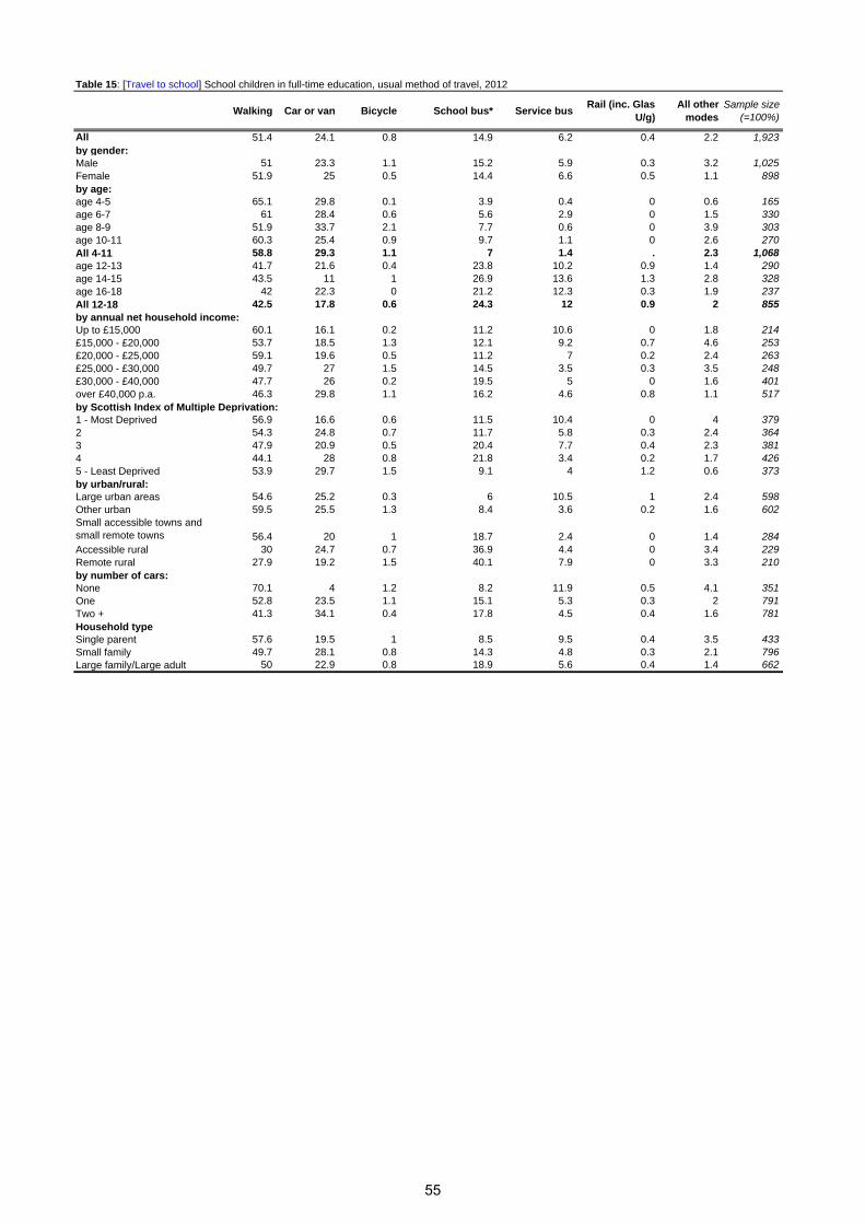
Table 15: [Travel to school] School children in full-time education, usual method of travel, 2012
Walking Car or van Bicycle School bus* Service busRail (inc. Glas
U/g)All other
modesSample size
(=100%)
All 51.4 24.1 0.8 14.9 6.2 0.4 2.2 1,923by gender:Male 51 23.3 1.1 15.2 5.9 0.3 3.2 1,025Female 51.9 25 0.5 14.4 6.6 0.5 1.1 898by age:age 4-5 65.1 29.8 0.1 3.9 0.4 0 0.6 165age 6-7 61 28.4 0.6 5.6 2.9 0 1.5 330age 8-9 51.9 33.7 2.1 7.7 0.6 0 3.9 303age 10-11 60.3 25.4 0.9 9.7 1.1 0 2.6 270All 4-11 58.8 29.3 1.1 7 1.4 . 2.3 1,068age 12-13 41.7 21.6 0.4 23.8 10.2 0.9 1.4 290age 14-15 43.5 11 1 26.9 13.6 1.3 2.8 328age 16-18 42 22.3 0 21.2 12.3 0.3 1.9 237All 12-18 42.5 17.8 0.6 24.3 12 0.9 2 855by annual net household income:Up to £15,000 60.1 16.1 0.2 11.2 10.6 0 1.8 214£15,000 - £20,000 53.7 18.5 1.3 12.1 9.2 0.7 4.6 253£20,000 - £25,000 59.1 19.6 0.5 11.2 7 0.2 2.4 263£25,000 - £30,000 49.7 27 1.5 14.5 3.5 0.3 3.5 248£30,000 - £40,000 47.7 26 0.2 19.5 5 0 1.6 401over £40,000 p.a. 46.3 29.8 1.1 16.2 4.6 0.8 1.1 517by Scottish Index of Multiple Deprivation:1 - Most Deprived 56.9 16.6 0.6 11.5 10.4 0 4 3792 54.3 24.8 0.7 11.7 5.8 0.3 2.4 3643 47.9 20.9 0.5 20.4 7.7 0.4 2.3 3814 44.1 28 0.8 21.8 3.4 0.2 1.7 4265 - Least Deprived 53.9 29.7 1.5 9.1 4 1.2 0.6 373by urban/rural:Large urban areas 54.6 25.2 0.3 6 10.5 1 2.4 598Other urban 59.5 25.5 1.3 8.4 3.6 0.2 1.6 602Small accessible towns and small remote towns 56.4 20 1 18.7 2.4 0 1.4 284Accessible rural 30 24.7 0.7 36.9 4.4 0 3.4 229Remote rural 27.9 19.2 1.5 40.1 7.9 0 3.3 210by number of cars:None 70.1 4 1.2 8.2 11.9 0.5 4.1 351One 52.8 23.5 1.1 15.1 5.3 0.3 2 791Two + 41.3 34.1 0.4 17.8 4.5 0.4 1.6 781Household typeSingle parent 57.6 19.5 1 8.5 9.5 0.4 3.5 433Small family 49.7 28.1 0.8 14.3 4.8 0.3 2.1 796Large family/Large adult 50 22.9 0.8 18.9 5.6 0.4 1.4 662
55
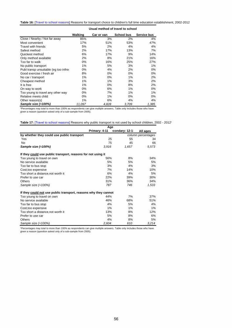
Table 16: [Travel to school reasons] Reasons for transport choice to children's full time education establishment, 2002-2012
Walking Car or van School bus Service busClose / Nearby / Not far away 85% 3% 2% 4%Most convenient 17% 51% 53% 47%Travel with friends 5% 2% 4% 4%Safest method 2% 17% 13% 7%Quickest method 6% 17% 9% 14%Only method available 2% 8% 21% 16%Too far to walk 0% 16% 25% 27%No public transport 1% 5% 3% 1%Publ transp unsuitable (eg too infreq 0% 4% 2% 0%Good exercise / fresh air 8% 0% 0% 0%No car / transport 1% 0% 1% 2%Cheapest method 1% 1% 3% 2%It is free 1% 0% 8% 2%On way to work 0% 6% 1% 0%Too young to travel any other way 0% 7% 1% 1%Relative meets child 0% 1% 0% 0%Other reason(s) 1% 6% 4% 4%Sample size (=100%) 11,097 4,828 3,709 1,385
Table 17: [Travel to school reasons] Reasons why public transport is not used by school children, 2002 - 2012*
Primary: 4-11 econdary: 12-18
by whether they could use public transport Yes 25 55 34 No 75 45 66Sample size (=100%) 3,916 1,657 5,573
If they could use public transport, reasons for not using itToo young to travel on own 56% 8% 34%No service available 5% 5% 5%Too far to bus stop 3% 4% 3%Cost,too expensive 7% 14% 10%Too short a distance,not worth it 6% 4% 5%Prefer to use car 22% 39% 30%Others 31% 36% 34%Sample size (=100%) 787 746 1,533
If they could not use public transport, reasons why they cannotToo young to travel on own 44% 7% 37%No service available 46% 68% 51%Too far to bus stop 4% 5% 4%Cost,too expensive 1% 1% 1%Too short a distance,not worth it 13% 8% 12%Prefer to use car 5% 8% 6%Others 4% 8% 5%Sample size (=100%) 2,604 610 3,214
Usual method of travel to school
*Percentages may total to more than 100% as respondents can give multiple answers. Table only includes those who have given a reason (question asked only of a sub-sample from 2005).
*Percentages may total to more than 100% as respondents can give multiple answers. Table only includes those who have given a reason (question asked only of a sub-sample from 2005).
AgeAll ages
column percentages
56

Table 18a: [Bicycle access] Households with bicycles available for private use, 2012
None One Two Three + One + Two +Sample
size (=100%)
All households in 2012 65 17 12 6 35 18 10,644by household type:Single adult 72 23 4 2 28 5 1,883 Small adult 58 19 18 5 42 24 1,729 Single parent 70 21 5 4 30 9 610 Small family 42 19 28 12 58 40 1,242 Large family 36 19 24 21 64 45 610 Large adult 48 20 14 18 52 32 960 Older smaller 76 12 10 2 24 12 1,805 Single pensioner 94 5 1 1 6 1 1,805 by annual net household income:up to £10,000 p.a. 83 12 3 2 17 5 1,456 over £10,000 - £15,000 83 12 4 2 17 5 1,964 over £15,000 - £20,000 75 15 6 3 25 9 1,621 over £20,000 - £25,000 64 20 11 5 36 15 1,348 over £25,000 - £30,000 58 20 15 8 42 23 993 over £30,000 - £40,000 46 22 21 11 54 32 1,317 over £40,000 p.a. 33 20 30 17 67 47 1,562 by Scottish Index of Multiple Deprivation:1 - Most Deprived 80 13 5 2 20 8 2,030 2 72 16 8 3 28 12 2,209 3 64 17 13 6 36 19 2,288 4 55 19 16 10 45 26 2,285 5 - Least Deprived 52 18 18 11 48 29 1,832 by urban/rural classification:Large urban areas 72 15 9 5 28 13 3,524 Other urban 65 17 12 6 35 18 3,232 Small accessible towns 61 18 13 8 39 21 956 Small remote towns 64 17 13 6 36 19 621 Accessible rural 53 18 19 11 47 30 1,147 Remote rural 53 19 18 11 47 28 1,164
Bicycles that can be used by adults:
57

Table 18b: Car access] Households with cars available for private use, 2012
None One Two Three +One+ Two+
Sample size
(=100%)All 31 43 21 5 69 26 10,644by household type:Single adult 51 45 3 0 49 4 1,883 Small adult 20 43 33 4 80 37 1,729 Single parent 53 43 4 0 47 4 610 Small family 12 42 42 3 88 45 1,242 Large family/adult 11 32 37 20 89 57 1,570 Older smaller 17 57 23 2 83 25 1,805 Single pensioner 61 38 1 0 39 1 1,805 by annual net household income:up to £10,000 p.a. 64 30 5 1 36 6 1,456 over £10,000 - £15,000 51 40 8 1 49 9 1,964 over £15,000 - £20,000 37 53 9 1 63 10 1,621 over £20,000 - £25,000 21 57 19 3 79 22 1,348 over £25,000 - £30,000 13 55 26 6 87 32 993 over £30,000 - £40,000 7 47 38 8 93 46 1,317 over £40,000 p.a. 2 29 54 14 98 69 1,562 by Scottish Index of Multiple Deprivation:1 - Most Deprived 53 36 9 1 47 11 2,030 2 39 44 15 2 61 18 2,209 3 27 45 22 5 73 27 2,288 4 17 47 28 8 83 36 2,285 5 - Least Deprived 15 44 33 8 85 41 1,832 by urban/rural classification:Large urban areas 41 41 16 2 59 18 3,524 Other urban 30 43 23 5 70 27 3,232 Small accessible towns 23 47 25 5 77 30 956 Small remote towns
31 49 17 3 69 20 621 Accessible rural 14 42 34 10 86 44 1,147 Remote rural 17 48 27 7 83 35 1,164
Cars available for private use:
58

Table 19:[ Driving licence] People aged 17+ that hold a full driving licence, 2012
17-19 20-29 30-39 40-49 50-59 60-69 70-79 80+All 17+
Sample (=100%)
percentage of the relevant sub-group**
All people aged 17+ in 2012: 28 58 75 80 79 73 59 37 68 9,828
by gender:Male 35 59 78 86 85 83 79 63 76 4,377 Female 19 57 71 74 75 65 43 22 62 5,451 by current situation:Self employed 63 85 95 96 97 96 100 100 95 582 Employed full time 61 74 86 89 88 88 100 * 84 3,135 Employed part time 16 50 74 71 79 79 71 89 68 1,014 Looking after the home or family 19 31 61 58 69 68 58 100 55 476 Permanently retired from work * * * 100 78 70 59 37 60 3,201 Unemployed and seeking work 10 24 33 52 63 67 * * 39 485 In further / higher education 37 52 66 75 * 41 * * 50 308 Permanently sick or disabled * 16 27 43 41 45 17 * 38 506 by annual net household income:up to £10,000 p.a. 19 38 44 55 50 60 43 29 45 1,385 over £10,000 - £15,000 13 37 54 54 64 63 50 33 50 1,869 over £15,000 - £20,000 25 50 52 66 74 69 59 42 59 1,528 over £20,000 - £25,000 15 63 75 72 80 76 75 61 70 1,254 over £25,000 - £30,000 23 64 84 81 79 79 78 53 75 897 over £30,000 - £40,000 41 79 85 92 87 87 87 51 84 1,171 over £40,000 p.a. 47 81 93 95 95 97 93 63 90 1,364 by Scottish Index of Multiple Deprivation:1 - Most Deprived 12 47 56 52 57 49 29 22 47 1,874 2 29 55 74 72 69 61 50 30 61 2,063 3 17 58 77 84 78 78 62 36 70 2,135 4 36 68 87 90 92 85 71 46 80 2,102 5 - Least Deprived 46 71 85 96 96 90 78 47 84 1,654 by urban/rural:Large urban areas 26 55 68 72 75 65 52 34 62 3,256 Other urban 23 59 76 80 75 70 57 35 67 2,961 Small accessible towns 24 67 79 88 85 79 62 52 75 889 Small remote towns 44 51 80 74 73 77 72 33 67 584 Accessible rural 28 80 90 92 93 88 69 36 83 1,046 Remote rural 47 44 87 89 90 88 74 47 79 1,092 Sample size of age groups 210 1,154 1,466 1,626 1,641 1,752 1,261 718 9,828 * Cells with 100 respondents or less are not shown. ** Denominator includes people for whom it was not known, or not recorded, what type of driving licence (if any) was held.
59
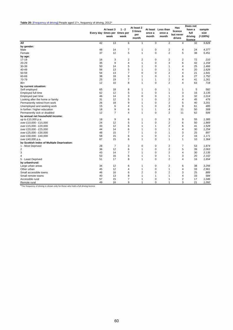
Table 20: [Frequency of driving] People aged 17+, frequency of driving, 2012*
Every dayAt least 3 times per
week
1 - 2 times per
week
At least 2 -3 times
per month
At least once a month
Less than once a month
Has licence
but never drives
Does not have a
full driving licence
sample size
(=100%)
All 42 13 6 1 0 2 4 32 9,828by gender:Male 48 14 7 1 0 2 4 24 4,377Female 37 12 5 1 0 2 5 38 5,451by age:17-19 16 3 2 2 0 2 2 72 21020-29 35 9 4 1 0 3 6 42 1,15430-39 50 14 5 1 0 1 4 25 1,46640-49 56 13 5 1 0 1 4 20 1,62650-59 54 13 7 0 0 2 4 21 1,64160-69 38 18 9 1 0 1 6 27 1,75270-79 25 19 7 1 1 2 4 41 1,26180+ 12 10 8 1 0 2 4 63 718by current situation:Self employed 65 18 8 1 0 1 1 5 582Employed full time 62 12 5 1 0 1 3 16 3,135Employed part time 46 14 3 0 0 1 3 32 1,014Looking after the home or family 31 12 5 1 0 2 4 45 476Permanently retired from work 26 18 9 1 0 2 5 40 3,201Unemployed and seeking work 15 6 4 1 0 3 9 61 485In further / higher education 18 9 6 1 1 4 11 50 308Permanently sick or disabled 12 7 4 1 0 2 11 62 506by annual net household income:up to £10,000 p.a. 18 9 6 1 0 3 9 55 1,385over £10,000 - £15,000 24 12 5 1 0 2 6 50 1,869over £15,000 - £20,000 33 12 6 1 1 2 6 41 1,528over £20,000 - £25,000 44 14 6 1 0 1 4 30 1,254over £25,000 - £30,000 48 15 7 1 0 1 3 25 897over £30,000 - £40,000 58 15 6 1 0 1 2 16 1,171over £40,000 p.a. 67 15 6 1 0 1 1 10 1,364by Scottish Index of Multiple Deprivation:1 - Most Deprived 28 7 3 0 0 2 7 53 1,8742 36 12 6 1 0 2 5 39 2,0633 43 14 7 1 0 2 4 30 2,1354 53 16 6 1 0 1 3 20 2,1025 - Least Deprived 51 17 8 1 0 2 4 16 1,654by urban/rural:Large urban areas 34 12 6 1 0 2 6 38 3,256Other urban 45 12 4 1 0 1 4 33 2,961Small accessible towns 46 16 6 2 0 2 3 25 889Small remote towns 40 13 8 1 1 1 4 33 584Accessible rural 57 15 7 1 0 1 2 17 1,046Remote rural 49 16 9 1 0 1 3 21 1,092*The frequency of driving is shown only for those who hold a full driving licence
60
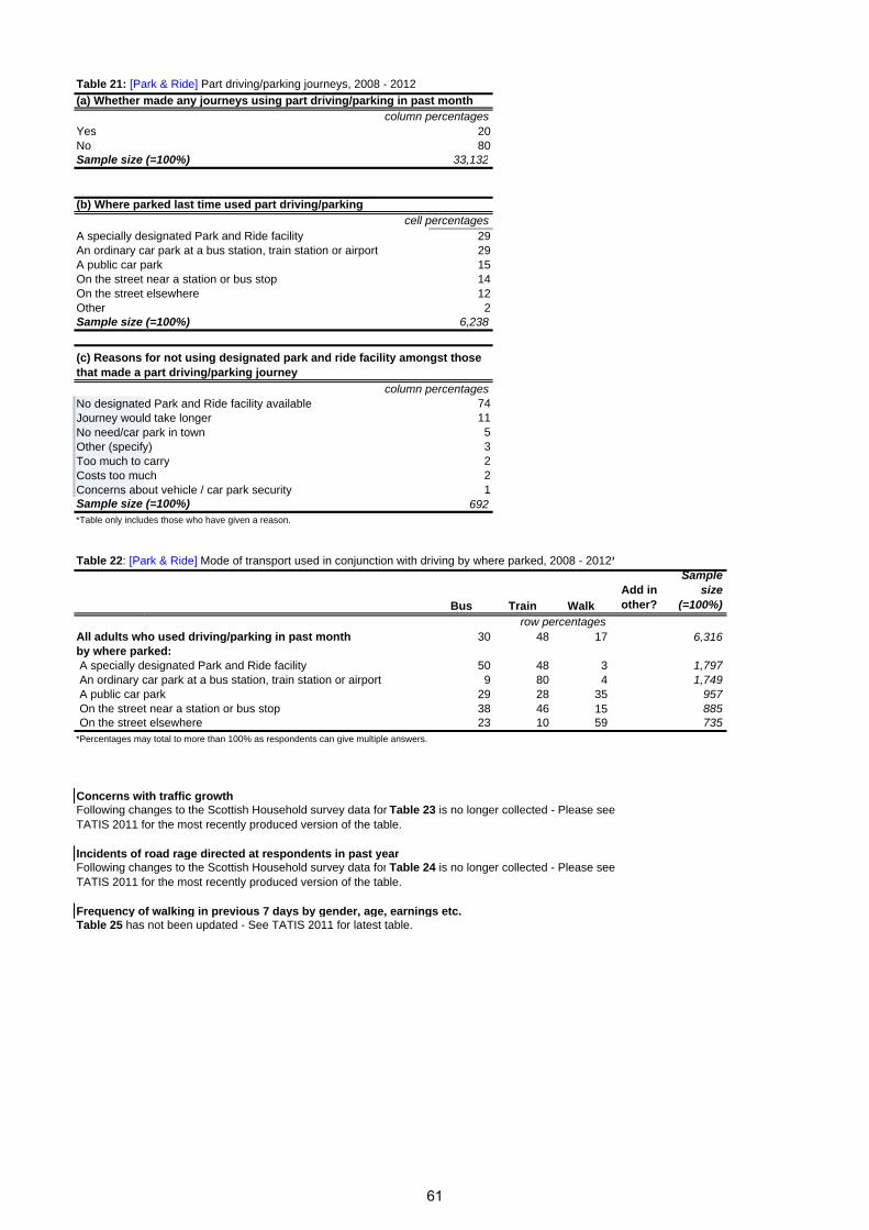
Table 21: [Park & Ride] Part driving/parking journeys, 2008 - 2012
(a) Whether made any journeys using part driving/parking in past monthcolumn percentages
Yes 20No 80Sample size (=100%) 33,132
(b) Where parked last time used part driving/parkingcell percentages
A specially designated Park and Ride facility 29An ordinary car park at a bus station, train station or airport 29A public car park 15On the street near a station or bus stop 14On the street elsewhere 12Other 2Sample size (=100%) 6,238
column percentagesNo designated Park and Ride facility available 74Journey would take longer 11No need/car park in town 5Other (specify) 3Too much to carry 2Costs too much 2Concerns about vehicle / car park security 1Sample size (=100%) 692*Table only includes those who have given a reason.
Table 22: [Park & Ride] Mode of transport used in conjunction with driving by where parked, 2008 - 2012*
Bus Train WalkAdd in other?
Sample size
(=100%)
row percentagesAll adults who used driving/parking in past month 30 48 17 6,316by where parked: A specially designated Park and Ride facility 50 48 3 1,797 An ordinary car park at a bus station, train station or airport 9 80 4 1,749 A public car park 29 28 35 957 On the street near a station or bus stop 38 46 15 885 On the street elsewhere 23 10 59 735*Percentages may total to more than 100% as respondents can give multiple answers.
Concerns with traffic growthFollowing changes to the Scottish Household survey data for Table 23 is no longer collected - Please see TATIS 2011 for the most recently produced version of the table.
Incidents of road rage directed at respondents in past yearFollowing changes to the Scottish Household survey data for Table 24 is no longer collected - Please see TATIS 2011 for the most recently produced version of the table.
Frequency of walking in previous 7 days by gender, age, earnings etc.Table 25 has not been updated - See TATIS 2011 for latest table.
(c) Reasons for not using designated park and ride facility amongst those that made a part driving/parking journey
61
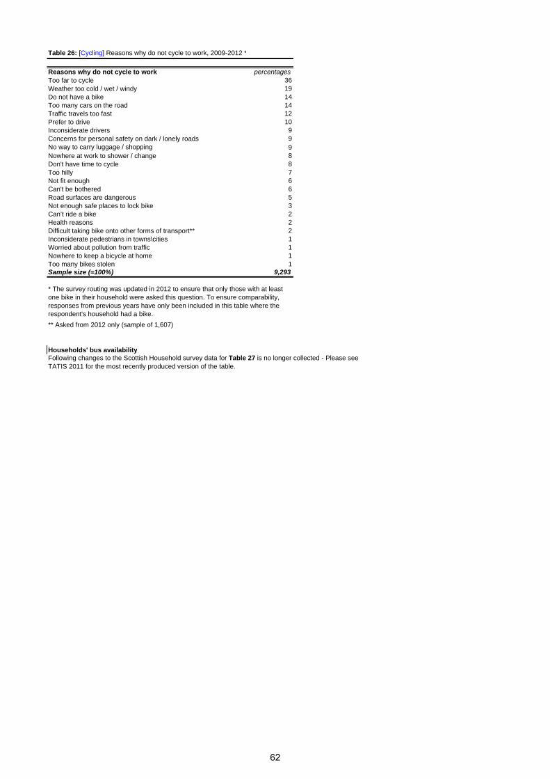
Table 26: [Cycling] Reasons why do not cycle to work, 2009-2012 *
Reasons why do not cycle to work percentagesToo far to cycle 36Weather too cold / wet / windy 19Do not have a bike 14Too many cars on the road 14Traffic travels too fast 12Prefer to drive 10Inconsiderate drivers 9Concerns for personal safety on dark / lonely roads 9No way to carry luggage / shopping 9Nowhere at work to shower / change 8Don't have time to cycle 8Too hilly 7Not fit enough 6Can't be bothered 6Road surfaces are dangerous 5Not enough safe places to lock bike 3Can’t ride a bike 2Health reasons 2Difficult taking bike onto other forms of transport** 2Inconsiderate pedestrians in towns\cities 1Worried about pollution from traffic 1Nowhere to keep a bicycle at home 1Too many bikes stolen 1Sample size (=100%) 9,293
** Asked from 2012 only (sample of 1,607)
Households' bus availabilityFollowing changes to the Scottish Household survey data for Table 27 is no longer collected - Please see TATIS 2011 for the most recently produced version of the table.
* The survey routing was updated in 2012 to ensure that only those with at least one bike in their household were asked this question. To ensure comparability, responses from previous years have only been included in this table where the respondent's household had a bike.
62
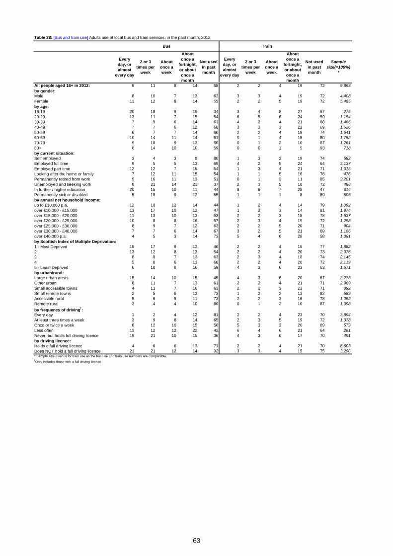
Table 28: [Bus and train use] Adults use of local bus and train services, in the past month, 2012
Bus Train
Every day, or almost
every day
2 or 3 times per
week
About once a week
About once a
fortnight, or about once a month
Not used in past month
Every day, or almost
every day
2 or 3 times per
week
About once a week
About once a
fortnight, or about once a month
Not used in past month
Sample size(=100%)
*
All people aged 16+ in 2012: 9 11 8 14 58 2 2 4 19 72 9,893by gender:Male 8 10 7 13 62 3 3 4 19 72 4,408Female 11 12 8 14 55 2 2 5 19 72 5,485by age:16-19 20 18 9 19 34 3 4 8 27 57 27520-29 13 11 7 15 54 6 5 6 24 59 1,15430-39 7 9 6 14 63 4 2 4 21 68 1,46640-49 7 7 6 12 68 3 3 3 22 69 1,62650-59 6 7 7 14 66 2 2 4 19 74 1,64160-69 10 14 11 14 51 0 1 4 15 80 1,75270-79 9 18 9 13 50 0 1 2 10 87 1,26180+ 8 14 10 10 59 0 0 1 5 93 718by current situation:Self employed 3 4 3 9 80 1 3 3 19 74 582Employed full time 9 5 5 13 69 4 2 5 24 64 3,137Employed part time 12 12 7 15 54 1 3 4 21 71 1,015Looking after the home or family 7 12 11 15 54 1 1 5 16 76 476Permanently retired from work 9 16 11 13 51 0 1 3 11 85 3,201Unemployed and seeking work 8 21 14 21 37 2 3 5 18 72 488In further / higher education 20 15 10 11 44 8 9 7 28 47 314Permanently sick or disabled 5 18 9 12 55 1 1 1 8 89 506by annual net household income:up to £10,000 p.a. 12 18 12 14 44 1 2 4 14 79 1,392over £10,000 - £15,000 13 17 10 12 47 1 2 3 14 81 1,874over £15,000 - £20,000 11 13 10 13 53 2 2 3 15 78 1,537over £20,000 - £25,000 10 8 8 16 57 2 3 4 19 72 1,258over £25,000 - £30,000 8 9 7 12 63 2 2 5 20 71 904over £30,000 - £40,000 7 7 6 14 67 3 2 5 21 69 1,186over £40,000 p.a. 4 5 3 14 73 5 4 6 28 58 1,381by Scottish Index of Multiple Deprivation:1 - Most Deprived 15 17 9 12 46 2 2 4 15 77 1,8822 13 12 8 13 54 2 2 4 20 73 2,0763 8 8 7 13 63 2 3 4 18 74 2,1454 5 8 6 13 68 2 2 4 20 72 2,1195 - Least Deprived 6 10 8 16 59 4 3 6 23 63 1,671by urban/rural:Large urban areas 15 14 10 15 45 4 3 6 20 67 3,273Other urban 8 11 7 13 61 2 2 4 21 71 2,989Small accessible towns 4 11 7 16 63 2 2 3 22 71 892Small remote towns 2 5 6 13 73 1 2 2 13 82 589Accessible rural 5 6 5 11 73 2 2 3 16 78 1,052Remote rural 3 4 4 10 80 0 1 2 10 87 1,098
by frequency of driving†:Every day 1 2 4 12 81 2 2 4 23 70 3,894At least three times a week 3 9 8 14 65 2 3 5 19 72 1,378Once or twice a week 8 12 10 15 56 5 3 3 20 69 579Less often 13 12 12 22 42 6 4 6 21 64 261Never, but holds full driving licence 19 21 10 15 36 4 3 6 17 70 491by driving licence:Holds a full driving licence 4 6 6 13 71 2 2 4 21 70 6,603Does NOT hold a full driving licence 21 21 12 14 32 3 3 4 15 75 3,290
†Only includes those with a full driving licence
* Sample size given is for train use as the bus use and train use numbers are comparable.
63
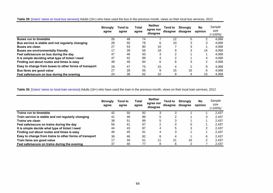
Table 29: [Users' views on local bus services] Adults (16+) who have used the bus in the previous month, views on their local bus services, 2012
Strongly agree
Tend to agree
Total agree
Neither agree nor disagree
Tend to disagree
Strongly disagree
No opinion
Sample size
(=100%)
Buses run to timetable 26 48 74 7 12 5 2 4,068Bus service is stable and not regularly changing 28 50 78 6 10 3 3 4,068Buses are clean 27 53 80 10 7 3 1 4,068Buses are environmentally friendly 17 39 56 18 9 3 14 4,068Feel safe/secure on bus during the day 47 46 93 3 2 1 1 4,068It is simple deciding what type of ticket I need 47 42 89 4 2 1 4 4,068Finding out about routes and times is easy 38 46 84 6 6 3 2 4,068
Easy to change from buses to other forms of transport 28 47 75 10 4 2 9 4,068Bus fares are good value 27 28 55 9 15 16 6 4,068Feel safe/secure on bus during the evening 24 38 62 10 9 4 15 4,068
Table 30: [Users' views on local train services] Adults (16+) who have used the train in the previous month, views on their local train services, 2012
Strongly agree
Tend to agree
Total agree
Neither agree nor disagree
Tend to disagree
Strongly disagree
No opinion
Sample size
(=100%)
Trains run to timetable 42 50 92 3 3 1 1 2,437Train service is stable and not regularly changing 41 48 89 5 2 1 3 2,437Trains are clean 38 51 89 5 3 1 1 2,437Feel safe/secure on trains during the day 56 41 97 2 0 0 1 2,437It is simple decide what type of ticket I need 44 43 87 4 5 3 2 2,437Finding out about routes and times is easy 46 45 91 4 3 1 1 2,437Easy to change from trains to other forms of transport 36 46 82 8 4 1 6 2,437Train fares are good value 17 34 51 11 21 16 2 2,437Feel safe/secure on trains during the evening 37 40 77 8 6 2 7 2,437
64

Table 31: [Concessionary fare pass] Possession of concessionary fare pass for all adults aged 16+, 2012
How often uses free travel pass
Every day Almost every day
2 or 3 times a
week
Once a week
Once a fortnight
Once a month Not used No pass
Sample size
(=100%)All adults aged 16+ 1 3 5 3 2 3 10 73 9,89316 - 39 0 0 1 0 0 0 0 98 2,89540 - 49 0 0 1 0 0 0 1 97 1,62650 - 59 0 0 1 1 0 0 2 95 1,64160 - 64 3 8 15 9 8 10 28 19 88265 - 69 2 9 19 10 10 9 32 9 87070 - 74 3 8 19 7 6 13 37 8 68775 - 79 3 10 20 10 6 13 33 6 57480 + 2 6 17 8 6 6 42 12 718
Table 32: [Concessionary fare pass] Possession of concessionary fare pass for all adults aged 60+, 2012
How often uses free travel pass
Every day Almost every day
2 or 3 times a week
Once a week
Once a fortnight
Once a month Not used No pass
Sample size
(=100%)All 3 8 18 9 7 10 34 12 3,731 by gender:Male 2 7 15 8 8 11 35 15 1,590 Female 3 9 20 10 7 10 33 9 2,141 by current situation:employed 2 8 11 7 9 8 32 24 484 Other 10 5 17 6 2 8 32 20 58 Permanently retired 2 8 19 9 7 11 34 9 3,100 Permanenently sick/disabled 2 5 17 7 6 6 30 27 89 by annual net household income:up to £10,000 p.a. 3 11 19 8 7 8 31 12 724 £10,000 - £15,000 3 8 22 9 6 10 32 9 1,036 £15,000 - £20,000 2 7 19 11 8 9 35 9 714 over £20,000 p.a. 2 8 12 8 8 12 37 14 1,074 by Scottish Index of Multiple Deprivation quintiles:1 - Most Deprived 6 13 21 8 5 7 31 8 612 2 4 11 19 8 7 9 32 10 767 3 1 6 17 9 7 11 36 14 846 4 1 5 14 8 7 11 40 15 835 5 - Least Deprived 2 8 19 10 11 12 29 11 671 by urban/rural classification:Large urban areas 5 13 23 11 7 7 24 10 1,106 Other urban 2 9 18 9 8 10 36 9 1,135 Small accessible towns 1 5 16 8 9 15 38 8 351 Small remote towns 3 1 8 7 6 13 49 12 234 Accessible rural 1 4 13 5 8 11 40 18 406 Remote rural 0 2 6 6 7 14 47 19 499 by frequency of driving:Every day 0 2 7 7 11 13 43 16 1,030 At least once a week 0 5 18 10 8 14 35 10 940 Less often 7 13 23 11 6 5 25 10 325 by whether they hold a full driving licenceHolds a full driving licence 1 4 13 9 9 12 38 13 2,266 Does NOT hold a full driving licence 5 15 25 9 4 6 27 9 1,465 by whether has disability/illnessYes, disability 1 5 18 8 5 11 38 14 266 Yes, illness or health problem 3 9 15 9 8 9 35 11 606 Yes, both disability and illness or health pr 2 6 17 6 4 8 39 16 358 No, neither 3 8 17 9 9 11 33 10 1,367
65
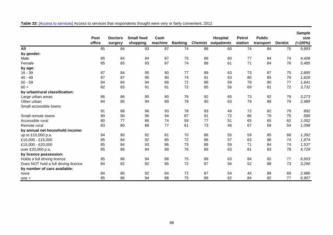
Table 33: [Access to services] Access to services that respondents thought were very or fairly convenient, 2012
Post office
Doctors surgery
Small food shopping
Cash machine Banking Chemist
Hospital outpatients
Petrol station
Public transport Dentist
Sample size
(=100%)
All 85 84 93 87 74 88 60 74 84 75 9,893by gender:Male 85 84 94 87 75 88 60 77 84 74 4,408Female 85 85 93 87 74 88 61 71 84 76 5,485by age:16 - 39 87 84 95 90 77 89 63 73 87 75 2,89540 - 49 87 87 95 90 74 91 63 80 85 79 1,62650 - 59 84 84 94 88 72 88 59 78 80 77 1,64160 + 82 83 91 81 72 85 56 69 81 72 3,731by urban/rural classification:Large urban areas 86 86 95 90 76 92 65 73 92 79 3,273Other urban 84 85 94 89 78 90 63 79 88 79 2,989Small accessible towns
91 88 96 93 78 93 49 72 82 79 892Small remote towns 90 90 96 94 87 91 72 86 79 75 589Accessible rural 80 77 86 74 59 77 51 65 65 62 1,052Remote rural 83 80 88 77 61 73 46 67 58 54 1,098by annual net household income:up to £10,000 p.a. 84 80 92 81 70 86 55 59 85 68 1,392£10,000 - £15,000 85 84 92 85 72 86 57 63 86 74 1,874£15,000 - £20,000 85 84 93 86 73 88 59 71 84 74 1,537over £20,000 p.a. 85 86 94 89 76 89 63 81 83 78 4,729by licence possession:Holds a full driving licence 85 86 94 88 75 89 63 84 82 77 6,603Does NOT hold a full driving licence 84 82 92 85 72 87 56 52 88 73 3,290by number of cars available:none 84 80 92 84 72 87 54 44 89 69 2,986one + 85 86 94 88 75 89 62 84 82 77 6,907
66

How adults normally travel to a doctors surgeryFollowing changes to the Scottish Household survey data for Table 34 is no longer collected - Please see TATIS 2011 for the most recently produced version of the table.
How adults normally travel to a hospital outpatients departmentFollowing changes to the Scottish Household survey data for Table 35 is no longer collected - Please see TATIS 2011 for the most recently produced version of the table.
How adults normally travel to a dentistFollowing changes to the Scottish Household survey data for Table 36 is no longer collected - Please see TATIS 2011 for the most recently produced version of the table.
67
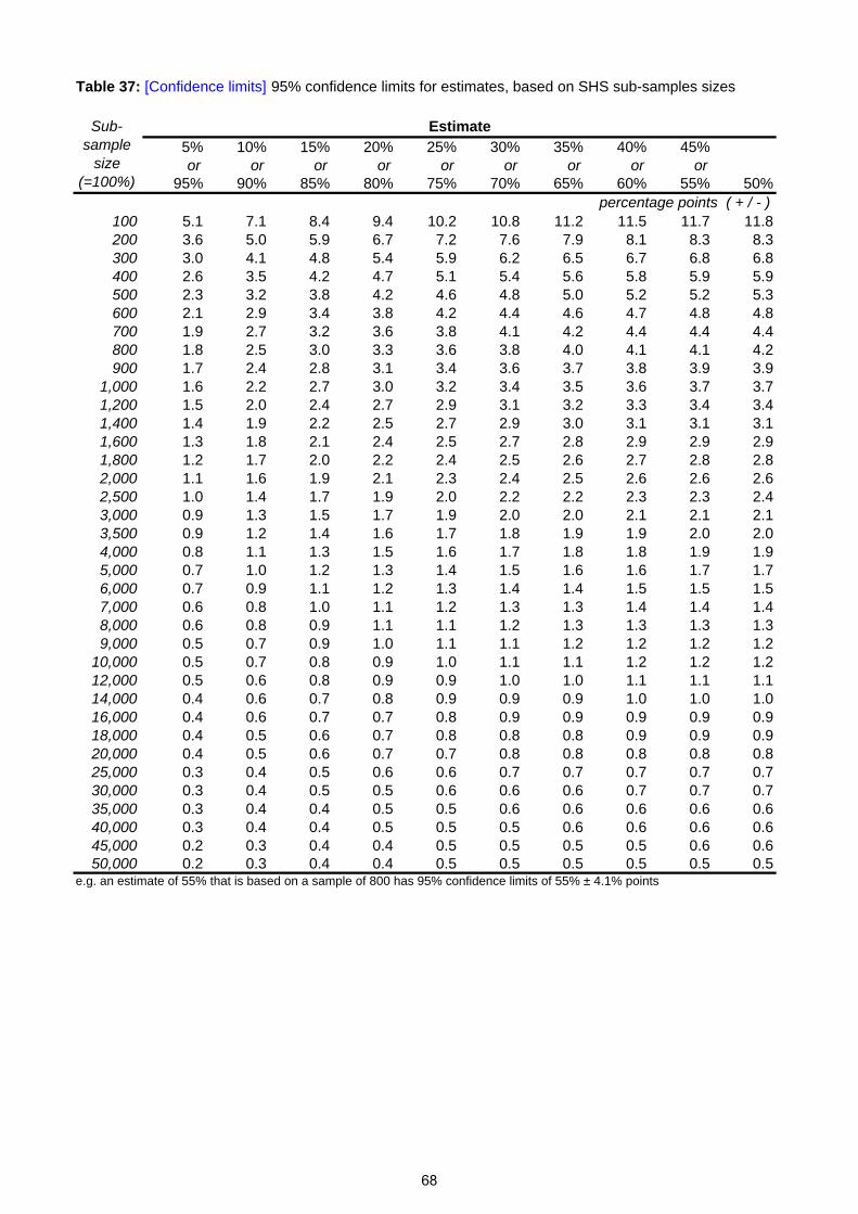
Table 37: [Confidence limits] 95% confidence limits for estimates, based on SHS sub-samples sizes
5% 10% 15% 20% 25% 30% 35% 40% 45%or or or or or or or or or
95% 90% 85% 80% 75% 70% 65% 60% 55% 50%
100 5.1 7.1 8.4 9.4 10.2 10.8 11.2 11.5 11.7 11.8200 3.6 5.0 5.9 6.7 7.2 7.6 7.9 8.1 8.3 8.3300 3.0 4.1 4.8 5.4 5.9 6.2 6.5 6.7 6.8 6.8400 2.6 3.5 4.2 4.7 5.1 5.4 5.6 5.8 5.9 5.9500 2.3 3.2 3.8 4.2 4.6 4.8 5.0 5.2 5.2 5.3600 2.1 2.9 3.4 3.8 4.2 4.4 4.6 4.7 4.8 4.8700 1.9 2.7 3.2 3.6 3.8 4.1 4.2 4.4 4.4 4.4800 1.8 2.5 3.0 3.3 3.6 3.8 4.0 4.1 4.1 4.2900 1.7 2.4 2.8 3.1 3.4 3.6 3.7 3.8 3.9 3.9
1,000 1.6 2.2 2.7 3.0 3.2 3.4 3.5 3.6 3.7 3.71,200 1.5 2.0 2.4 2.7 2.9 3.1 3.2 3.3 3.4 3.41,400 1.4 1.9 2.2 2.5 2.7 2.9 3.0 3.1 3.1 3.11,600 1.3 1.8 2.1 2.4 2.5 2.7 2.8 2.9 2.9 2.91,800 1.2 1.7 2.0 2.2 2.4 2.5 2.6 2.7 2.8 2.82,000 1.1 1.6 1.9 2.1 2.3 2.4 2.5 2.6 2.6 2.62,500 1.0 1.4 1.7 1.9 2.0 2.2 2.2 2.3 2.3 2.43,000 0.9 1.3 1.5 1.7 1.9 2.0 2.0 2.1 2.1 2.13,500 0.9 1.2 1.4 1.6 1.7 1.8 1.9 1.9 2.0 2.04,000 0.8 1.1 1.3 1.5 1.6 1.7 1.8 1.8 1.9 1.95,000 0.7 1.0 1.2 1.3 1.4 1.5 1.6 1.6 1.7 1.76,000 0.7 0.9 1.1 1.2 1.3 1.4 1.4 1.5 1.5 1.57,000 0.6 0.8 1.0 1.1 1.2 1.3 1.3 1.4 1.4 1.48,000 0.6 0.8 0.9 1.1 1.1 1.2 1.3 1.3 1.3 1.39,000 0.5 0.7 0.9 1.0 1.1 1.1 1.2 1.2 1.2 1.2
10,000 0.5 0.7 0.8 0.9 1.0 1.1 1.1 1.2 1.2 1.212,000 0.5 0.6 0.8 0.9 0.9 1.0 1.0 1.1 1.1 1.114,000 0.4 0.6 0.7 0.8 0.9 0.9 0.9 1.0 1.0 1.016,000 0.4 0.6 0.7 0.7 0.8 0.9 0.9 0.9 0.9 0.918,000 0.4 0.5 0.6 0.7 0.8 0.8 0.8 0.9 0.9 0.920,000 0.4 0.5 0.6 0.7 0.7 0.8 0.8 0.8 0.8 0.825,000 0.3 0.4 0.5 0.6 0.6 0.7 0.7 0.7 0.7 0.730,000 0.3 0.4 0.5 0.5 0.6 0.6 0.6 0.7 0.7 0.735,000 0.3 0.4 0.4 0.5 0.5 0.6 0.6 0.6 0.6 0.640,000 0.3 0.4 0.4 0.5 0.5 0.5 0.6 0.6 0.6 0.645,000 0.2 0.3 0.4 0.4 0.5 0.5 0.5 0.5 0.6 0.650,000 0.2 0.3 0.4 0.4 0.5 0.5 0.5 0.5 0.5 0.5
e.g. an estimate of 55% that is based on a sample of 800 has 95% confidence limits of 55% ± 4.1% points
Sub-sample
size (=100%)
Estimate
percentage points ( + / - )
68

9 List of Data Sources Topic Source
Vehicle Licensing
Department for Transport https://www.gov.uk/government/organisations/department-for-transport/series/vehicle-licensing-statistics
Local Bus Services
Department for Transport https://www.gov.uk/government/organisations/department-for-transport/series/bus-statistics#publications
Freight (Road)
Department for Transport https://www.gov.uk/government/organisations/department-for-transport/series/road-freight-statistics
Freight (Rail) Freightliner/English Welsh & Scottish Railways/Direct Rail Services [email protected]
Coastwise Traffic
Department for Transport https://www.gov.uk/government/organisations/department-for-transport/series/domestic-waterborne-freight-statistics
Pipelines Department of Energy and Climate Change [email protected]
Public Road Lengths Transport Scotland [email protected]
Road Traffic
Department for Transport https://www.gov.uk/government/organisations/department-for-transport/series/road-traffic-statistics
Road Accident Casualties Transport Scotland Transport Statistics [email protected]
Rail Services Office of Rail Regulation & ScotRail [email protected]
Air Transport Civil Aviation Authority http://www.caa.co.uk/default.aspx?catid=80&pagetype=88&pageid=3&sglid=3
Ferries Caledonian MacBrayne & North Link Ferries [email protected]
Scottish Household Survey [email protected] Travel in GB - National Travel Survey [email protected] Sustrans Hands Up Scotland Survey
http://www.sustrans.org.uk/scotland/what-we-do/schools-and-universities/hands-scotland
Scotland and GB Travel to Work – Labour Force Survey [email protected]
69

70
Appendix A – SHS Background Information
Appendix A Scottish Household Survey - Background information
Interviewing, response rates and weighting
Highest Income Householder
Adult
Household types
Annual net household income
The SHS urban/rural classification
The Scottish Index of Multiple Deprivation (SIMD)
Sampling variability and confidence limits
Published results, and anonymised data
Enquiries and further information
A.1 The Scottish Household Survey (SHS) started in February 1999. Its principal purpose is to collect information to inform policy on Transport, Communities and Local Government, but other topics are covered, such as household composition, amenities, employment or unemployment, income, assets and savings, credit and debt, health, disabilities and care, and other topics. The SHS provides the first representative Scottish data on many subjects, such as access to the Internet, daily travel patterns, etc.
A.2 Where appropriate, the SHS uses the harmonised concepts and questions for government social surveys which have been developed by the Government Statistical Service, to facilitate comparison with the results of other government surveys. However, differences in sampling and survey methods mean that SHS results will differ from those of other surveys. The SHS is not designed to produce statistics on unemployment or income: it collects such information only for selecting the data for particular groups of people (such as the unemployed or the low-paid) for further analysis, or for use as background variables when analysing other topics.
A.3 The SHS is intended to be a survey of private households. For the purposes of the survey, a household is defined as one person or a group of people living in accommodation as their only or main residence and either sharing at least one meal a day or sharing the living accommodation. A student's term-time address is taken as his/her main residence, in order that they are counted where they live for most of the year.
A.4 The sample was drawn from the Small User file of the Postcode Address File (PAF), which is a listing of all active address points maintained by the Post Office. The Small User file excludes addresses where an average of more than 25 items of post is delivered per day. Blocks of flats etc, which have several dwellings at the same address, are not excluded from the Small User file: in such cases, the file's Multiple Occupancy Indicator is used to count each dwelling separately for the selection of the sample.
A.5 People in certain types of accommodation (such as nurses’ homes, student halls of residence etc.) will be excluded from the SHS unless the accommodation is listed on the Small User file of the PAF and it represents the sole or main residence of the people concerned. People living in bed and breakfast accommodation may be included, if it is listed in the Small User file of the PAF and if it is their sole or main residence. Prisons, hospitals and military bases are excluded.
71
Appendix A – SHS Background Information
Interviewing, response rates and weighting
A.6 The survey interviews are carried out in respondents’ homes using Computer Aided Personal Interviewing (CAPI). Each interview has two parts. The first part is carried out with the Highest Income Householder or their spouse or partner. This collects mainly factual information about the composition and characteristics of the household. Some questions are asked in respect of each household member. The second part is with a randomly-chosen adult (aged 16+) member of the household. This focuses on individual attitudes and behaviours.
A.7 The data are weighted to take account of the unequal probabilities of selection inherent in the sample design: the over-sampling (relative to their numbers of households) of the Councils with smaller populations, in order to obtain a minimum number of interviews in each Council; and the under-sampling (relative to their share of the adult population) of adults living in multi-adult households, because only one random adult is interviewed in each household.
A.8 In keeping with the main SHS, these results use an improved weighting system for all years which better accounts for non response bias. This was introduced in 2008 meaning time series figures will be the same as published last year but may differ slightly for years prior to this although the main trends are mostly not affected.
A.9 Totals may appear to differ slightly from the apparent sums of their component parts, in cases where they have been calculated by adding up the unrounded values of the components and then rounding each figure independently. Similarly, percentages may appear not to sum to 100 per cent.
A.10 In tables that analyse the results of questions for which multiple answers were allowed, the percentages may total more than 100 per cent.
A.11 The underlying sample numbers shown in different tables may not be the same. There are a number of reasons for this – the questionnaire is streamed to allow more questions to be asked so not all respondents are asked all questions, tables may relate to specific populations (e.g. working aged population), not all questions will be applicable (e.g. households with no children would not be asked questions about children) and, in some cases, respondents were unable to, or did not want to, provide an answer (e.g. for income questions).
Highest Income Householder
A.12 This is the household reference person for the first part of the interview. This must be a person in whose name the accommodation is owned or rented, or who is otherwise responsible for the accommodation (i.e. spouse or partner). In households with joint householders, the person with the highest income is taken as the household reference person. If householders have exactly the same income, the older is taken as the household reference person.
Adult
A.13 For the purposes of the SHS, an adult is someone who was aged 16 or over at the time of the interview; a child is someone who was aged 15 or under.
72
Appendix A – SHS Background Information
Household types
Single pensioner household consists of one adult of pensionable age (60+ for women, and 65+ for men) and no children
Single parent household contains an adult and one or more children.
Single adult household consists of an adult of non-pensionable age and no children.
Older smaller household contains either (a) an adult of non-pensionable age and an adult of pensionable age and no children or (b) two adults of pensionable age and no children.
Large adult household has three or more adults and no children.
Small adult household contains two adults of non-pensionable age and no children.
Large family household consists of either (a) two adults and three or more children or (b) three or more adults and one or more children.
Small family households consist of two adults and one or two children.
Annual net household income
A.14 This is the total annual net income (i.e. after taxation and other deductions) from employment, benefits and other sources, which is brought into the household by the highest income householder and/or their spouse or partner. This includes any contribution to household finances made by other household members. Due to refusals or don’t knows, full information for the main components of household income was not collected from all households. Subsequently, SHS contractors impute the missing components of income for almost all of these households, using information that was obtained from other households that appeared similar.
The Scottish Index of Multiple Deprivation (SIMD)
A.15 The Scottish Index of Multiple Deprivation (SIMD) is used to rank the data zones used for the production of Scottish Neighbourhood Statistics in order of deprivation. More information can be found at the SIMD website ( http://www.scotland.gov.uk/simd ).
A.16 Households in the SHS sample have been allocated the SIMD value of the data zone that contains the postcode of the residence. In the small number of cases where a postcode is split between more than one data zone, the SIMD value used is that of the data zone into which the largest number of dwellings in that postcode falls. The SIMD values have further been assigned to one of 5 quintiles, with quintile 1 containing the most deprived 20 per cent of data zones in Scotland, and quintile 5 the least deprived 20 per cent.
73

Appendix A – SHS Background Information
The SHS urban/rural classification
A.17 The urban/rural classification is based on settlement sizes and (for the less-populated areas) the estimated time that would be taken to drive to a settlement with a population of 10,000 or more. The classification is based on postcodes. Six categories were then defined:
Large urban areas - settlements with populations of 125,000 or more.
Other urban areas - other settlements of population 10,000 or more.
Accessible small towns - settlements of between 3,000 and 9,999 people, which are within 30 minutes drive of a settlement of 10,000+ people
Remote small towns - settlements of between 3,000 and 9,999 people, which are not within 30 minutes drive of a settlement of 10,000+ people
Accessible rural areas - settlements of less than 3,000 people, which are within 30 minutes drive of a settlement of 10,000+ people
Remote rural areas - settlements of less than 3,000 people, which are not within 30 minutes drive of a settlement of 10,000+ people
A.18 The urban/rural classification used for the SHS data is based on the Settlement file maintained by the National Records of Scotland (NRS).
Sampling variability and confidence limits
A.19 Although the SHS's sample is chosen at random, the people who take part in the survey will not necessarily be a representative cross-section of the people of Scotland. Purely by chance, the sample could include disproportionate numbers of certain types of people, in which case the survey's results would be affected.
A.20 The likely extent of sampling variability can be quantified, by calculating the standard error associated with the estimate of a quantity produced from a random sample. Statistical sampling theory states that, on average only about one sample in three would produce an estimate that differed from the (unknown) true value of that quantity by more than one standard error; only about one sample in twenty would produce an estimate that differed from the true value by more than two standard errors; only about one sample in 400 would produce an estimate that differed from the true value by more than three standard errors. By convention, the 95 per cent confidence interval for a quantity is defined as the estimate plus or minus about twice the standard error (from sampling theory, the interval is plus or minus 1.96 times the standard error), because there is only a 5 per cent chance (on average) that a sample would produce an estimate that differs from the true value of that quantity by more than this amount.
A.21 Table 37 shows the 95 per cent confidence limits for estimates of a range of percentages calculated from sub-samples of a range of sizes (NB: the confidence limits for estimates of x per cent and for (100-x) per cent are the same).
A.22 The interpretation of an entry in Table 37 is best explained by an example:
The value in the cell at the intersection of the 45 per cent or 55 per cent column and the 800 row is 4.5
This means that the 95 per cent confidence limits for an estimate of 55 per cent which is produced from a sub-sample of 800 are +/- 4.5 percentage-points
74
Appendix A – SHS Background Information
The 95 per cent confidence interval for the estimate is 55 per cent +/- 4.5 percentage-points (i.e. from about 50.5 per cent to around 59.5 per cent, assuming that the value of the estimate is 55.0 per cent)
A.23 As the survey's estimates may be affected by sampling errors, apparent differences of a few percentage points between the figures for two sub-groups of the population may not be significant: it could be that the true values for the two sub-groups are similar, but the random selection of households for the survey has, by chance, produced a sample which gives a high estimate for one sub-group and a low estimate for the other.
A.24 One way of assessing significance at the 5 per cent level involves comparing the difference with the 95 per cent confidence limits for the two estimates. Suppose that these are +/- 3.0 percentage-points and +/- 4.0 percentage-points, respectively. Clearly a difference which is less than the magnitude of the largest limit (4.0 percentage-points) is not significant; and a difference which is greater than the sum of the magnitudes of the limits (3.0 percentage-points + 4.0 percentage-points = 7.0 percentage-points) is significant. Statistical sampling theory suggests that a difference whose magnitude is between these values is significant if it is greater than the square root of the sum of the squares of the magnitudes of the limits for the two estimates - in this case, (3.02 + 4.02)0.5=5.0. So, in this case, a 5.0 percentage-point difference would be considered statistically significant (at the conventional 5% level). However, one may well find some apparently significant results that are actually just the result of sampling variability, having arisen by chance.
A.25 The above information relates only to sampling variability. The survey's results could also be affected by non-contact/non-response bias: the characteristics of the people who should have been in the survey but who could not be contacted, or who refused to take part, could differ markedly from those of the people who were interviewed. If that is the case, the SHS results will not be representative of the whole population. Without knowing the true values (for the population as a whole) of some quantities, one cannot be sure about the extent of any such biases in the SHS. However, comparison of SHS results with information from other sources suggests that they are broadly representative of the overall Scottish population, and therefore that any non-contact or non-response biases are not large overall. The Fieldwork Outcomes and Methodology volumes of Scotland's People provide more information on these matters.
Published results, and anonymised data
A.26 SHS results are also included in other Transport Scotland publications, such as
Scottish Transport Statistics Scottish Household Survey Travel Diary results Bus & Coach Statistics – available as web tables Local Area Analysis – available as web tables
A.27 These publications are available on the Transport Scotland Statistics webpages at http://www.transportscotland.gov.uk/analysis/statistics/publications
A.28 The SHS Annual Report is published by the Scottish Government and can be found here: http://www.scotland.gov.uk/Topics/Statistics/16002/PublicationAnnual
A.29 Anonymised copies of the survey data are deposited at the UK Data Archive.
75
Appendix A – SHS Background Information Enquiries and further information
A.30 General enquiries about the SHS should be addressed to the survey’s Project Manager:
SHS Project Manager Communities Analytical Services Scottish Government Victoria Quay Edinburgh, EH6 6QQ Tel: 0131 244 8420 Fax: 0131 244 7573 E-mail: [email protected]
A.31 Enquiries about the statistics in this bulletin should be addressed to:
Transport Statistics Transport Scotland Scottish Government Victoria Quay Edinburgh, EH6 6QQ Tel: 0131 244 1457 E-mail: [email protected]
A.32 Further information about the survey can be found on the SHS website at http://www.scotland.gov.uk/shs
A.33 This website provides some background to the survey, information about the progress of the survey, and the published results. Copies of the Transport Statistics bulletins can be found on the Transport Scotland Statistics webpages at: http://www.transportscotland.gov.uk/analysis/statistics/publications
A.34 Please use the SHS Web site to register your interest in Population and Household Surveys if you wish to be added to an e-mail mailing list to be kept informed of SHS news and developments. The Project Manager will also, on request, distribute paper copies of information about the survey, and about significant developments when they occur, to people who are unable to access the website.
A.35 To keep informed with changes to Scottish statistics, please register your interest with ScotStat at www.scotland.gov.uk/scotstat.
76
SCOTTISH GOVERNMENT STATISTICIAN GROUP OUR AIM To provide relevant and reliable information, analysis and advice that meet the needs of government, business and the people of Scotland. OBJECTIVES 1. To produce statistics and analysis relevant to user needs by
Developing our understanding of customer requirements to ensure statistics are kept relevant and analysis is well targeted;
Developing the range of statistics and analysis we produce; Where practicable improving timeliness; Providing more statistics disaggregated by age, gender and ethnicity; Developing more data for small areas through the Neighbourhood Statistics project; Contributing to production of comparable statistics across the UK and internationally.
2. To ensure effective use of our statistics by
Contributing more directly to policy processes inside and where possible outside government; Improving access to and presentation of data and analysis; Improving the advice provided on statistics.
3. To work effectively with users and providers by
Maintaining arrangements to consult and involve users and providers; Involving users and providers in planning developments in outputs and processes; Minimising the burden on data providers through dropping or streamlining collections as appropriate, to ensure the
benefits of the information justify the costs of collection. 4. To develop the quality of statistics by
Assuring and improving quality as an integral part of data collection and analysis and through regular reviews in line with National Statistics quality strategy;
Developing statistical methods, systems and classifications; Working with the rest of the Government Statistical Service to develop joint approaches/solutions where
appropriate. 5. To assure the integrity of statistics by
Maintaining and promoting integrity through implementation of the National Statistics Code of Practice and related protocols;
Safeguarding the confidentiality of data subjects. 6. To ensure the efficient and effective delivery of statistics products and services by
Making best use of all sources including administrative sources; Working with other analysts to maximise the contribution of our own and other analysts’ work; Ensuring value for money; Making best use of Information and Communications Technology; Ensuring effective communication within the Statistician Group.
7. To develop our workforce and competences
Ensuring recruitment of staff with the necessary skills and potential; Ensuring development of expertise amongst existing staff; Promoting and upholding the standards of the statistics profession.
This is a National Statistics publication "This is a National Statistics publication. It has been produced to high professional standards set out in the National Statistics Code of Practice Protocol. http://www.statisticsauthority.gov.uk/assessment/code-of-practice/index.html
These statistics undergo regular quality assurance reviews to ensure that they meet customer needs. They are produced free from any political interference." Details of pre-release access will be provided in the Scottish Government Statistics Website under 'Forthcoming Releases'
77
A NATIONAL STATISTICS PUBLICATION FOR SCOTLAND The United Kingdom Statistics Authority has designated these statistics as National Statistics, in accordance with the Statistics and Registration Service Act 2007 and signifying compliance with the Code of Practice for Official Statistics. Designation can be broadly interpreted to mean that the statistics:
• meet identified user needs;
• are well explained and readily accessible;
• are produced according to sound methods, and
• are managed impartially and objectively in the public interest. Once statistics have been designated as National Statistics it is a statutory requirement that the Code of Practice shall continue to be observed. Further information about Official and National Statistics can be found on the UK Statistics Authority website at www.statisticsauthority.gov.uk SCOTTISH GOVERNMENT STATISTICIAN GROUP Our Aim
To provide relevant and reliable information, analysis and advice that meets the needs of government, business and the people of Scotland. For more information on the Statistician Group, please see the Scottish Government website at www.scotland.gov.uk/statistics Correspondence and enquiries Enquiries on this publication should be addressed to: Andrew Knight Transport Analytical Services Transport Scotland Area 2F(North) Victoria Quay Edinburgh EH6 6QQ Telephone: 0131 244 7256; Fax: 0131 244 7281 e-mail: [email protected]
General enquiries on Scottish Government statistics can be addressed to: Office of the Chief Statistician Scottish Government GWR, St Andrews House EDINBURGH EH1 3DG Telephone: (0131) 244 0442 e-mail: [email protected]
Further contact details, e-mail addresses and details of previous and forthcoming publications can be found on the Scottish Government Website at www.scotland.gov.uk/statistics Complaints and suggestions
If you are not satisfied with our service, please write to the Chief Statistician, 3WR, St Andrews House, Edinburgh, EH1 3DG, Telephone: (0131) 244 0302 e-mail: [email protected] . We also welcome any comments or suggestions that would help us to improve our standards of service. ScotStat
If you would like to be consulted about new or existing statistical collections or receive notification of forthcoming statistical publications, please register your interest on the Scottish Government ScotStat website at www.scotland.gov.uk/scotstat Most recent editions of Transport Statistics Publications - available here http://www.transportscotland.gov.uk/analysis/statistics/publications
Ref no. Title Last published Price
Scottish Transport Statistics December 2011
Trn / 2010 / 2 Main Transport Trends – Now part of TATIS August 2010 Web only
Trn / 2012 / 2 Transport and Travel in Scotland August 2012 Web only
Trn / 2010 / 3 Household Transport – Now part of TATIS September 2010 Web only
SHS Transport: Local Area Analysis September 2011 Web only
National Travel Survey Scottish results March 2012 Web only
Bus and Coach Statistics February 2012 Web only
Reported Road Casualties Scotland October 2011
Trn / 2012 /1 Key Reported Road Casualty Statistics June 2012 Web only
Scottish Household Survey Travel Diary results November 2011 Web only
ISSN 1351 3869 ISBN 978-1-908181-55-8 Crown Copyright Brief extracts from the Crown Copyright material in this publication may be reproduced provided the source is fully acknowledged.