Transit and Land Use Design - University of Wisconsin ... · areas and transit facilities designed...
18
Transit and Land Use Design Goals - Rethink land use/travel patterns to facilitate non-automotive travel - Create human scale neighborhood - Reduce dominance of automobile - Enhance movement by pedestrians, bicycles and access to transit - Facilitate internal circulation - Create a particular architectural style ?? New Directions for Land Use and Site Design - Fundamentally we need to consider pedestrians, bicycles and transit in the land use process - Provide and preserve choices for the future - Need to ask how will people walk or bicycle safely before land use decisions are made - Adopt a vision, positive approach, how to make it work, rather than reasons why it won't - Increase awareness of the market and design to serve new land use and travel markets Approaches - Many terms and approaches: - New Urbanism, - Traditional Neighborhood development - Neo-Traditional Design, - Transit Sensitive Design, - Transit Oriented Development, - Walkable Design - Pedestrian Pocket, - Cluster Design - Conservation Subdivision - Many principles and techniques can also be applied to conventional subdivisions H:\Projects\Transit course\transit and land use.doc 11/14/2006 1 of 18
Transcript of Transit and Land Use Design - University of Wisconsin ... · areas and transit facilities designed...
Transit and Land Use Design Goals
- Rethink land use/travel patterns to facilitate non-automotive travel - Create human scale neighborhood - Reduce dominance of automobile - Enhance movement by pedestrians, bicycles and access to transit - Facilitate internal circulation - Create a particular architectural style ??
New Directions for Land Use and Site Design
- Fundamentally we need to consider pedestrians, bicycles and transit in the land use process
- Provide and preserve choices for the future - Need to ask how will people walk or bicycle safely before land use decisions are made - Adopt a vision, positive approach, how to make it work, rather than reasons why it won't - Increase awareness of the market and design to serve new land use and travel markets
Approaches
- Many terms and approaches: - New Urbanism, - Traditional Neighborhood development - Neo-Traditional Design, - Transit Sensitive Design, - Transit Oriented Development, - Walkable Design - Pedestrian Pocket, - Cluster Design - Conservation Subdivision
- Many principles and techniques can also be applied to conventional subdivisions
H:\Projects\Transit course\transit and land use.doc 11/14/2006 1 of 18

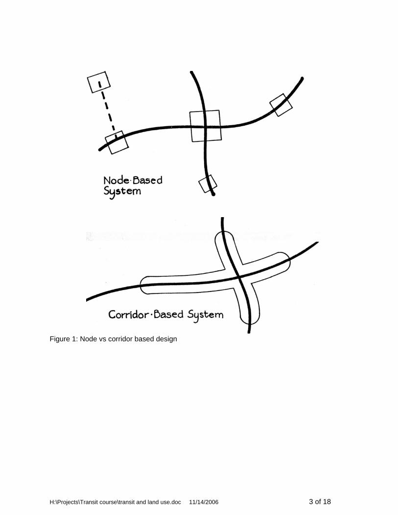
Traditional Neighborhood Development
- Origins in Planning Architecture Community - Design for a phased implementation of transit corridors. - Node based design - Attempt to recreate traditional neighborhood design as it was done prior to mid-1950's - Grid street pattern, alleys, no cul-de-sacs - Multiple entry and exit points into neighborhoods - Local commercial land use mixed with residential land uses - Public amenities - Often have a distinctive architectural style with specific required details - May not have any transit, may not necessarily be “transit friendly”
Transit Based Design
- Origins in Transit Community - Corridor based design - Land use is arranged to facilitate success of transit services. - Predesignate future transit routes - Transit corridor zoning overlay district - Separate transit and auto oriented land uses - Use mixed land uses - Control of through auto traffic - Provide a quality access system to transit by walking or bicycles
H:\Projects\Transit course\transit and land use.doc11/14/2006 2 of 18
H:\Projects\Transit course\transit and land use.doc 11/14/2006 3 of 18
Figure 1: Node vs corridor based design

Walkable Design
- Origins in Planning Architecture community – “Pedestrian Pods” - Node oriented design - Places where people can walk safely - Places with amenities and activities to walk to - Pathways along all roads and in other areas to provide short connections - May not have any transit or be “transit friendly” - A component of TND or transit friendly design
Transit and Conventional Subdivision/Neighborhoods
- Use Good Traffic Management - Avoid driveways on main roads - Provide Proper sight distance - Provide Good connectivity to adjacent parcels - Use Access management
- Avoid cul de sacs
- Extra public cost - Extra travel - Concentrates traffic on arterials - Poor connectivity for pedestrians and bicycles
- Provide pedestrian and bicycle facilities
- Shortcut connections - Paths parallel to main roads
- Use Appropriate Geometry
- Speed = f(width) - Be willing to accept narrow streets
H:\Projects\Transit course\transit and land use.doc11/14/2006 4 of 18

Transit Sensitive Land Use Design Guidelines Background Series of Federal Transit Administration projects
- Market Based Transit Facility Design - The New Suburb - Guidelines for Transit Sensitive Land Use Design - Measurement of Transit Benefits
Administration and Policy Guidelines
- Modify state and local policies to include transit as an element of land development. - Zoning should encourage transit-sensitive land use design through the designation of
Transit Corridor Districts (TCDs) . - Provide for transit-sensitive review of site plans and development proposals. - Provide transit checklist for potential developers. - Parking requirements in TCDs should reflect availability of transit services. - Establish a Transportation Management Association to oversee transportation services
and land use development along the transit corridor. - Provide a mechanism for transfer of development rights (TDRs) for the land surrounding
the TCDs.
H:\Projects\Transit course\transit and land use.doc 11/14/2006 5 of 18
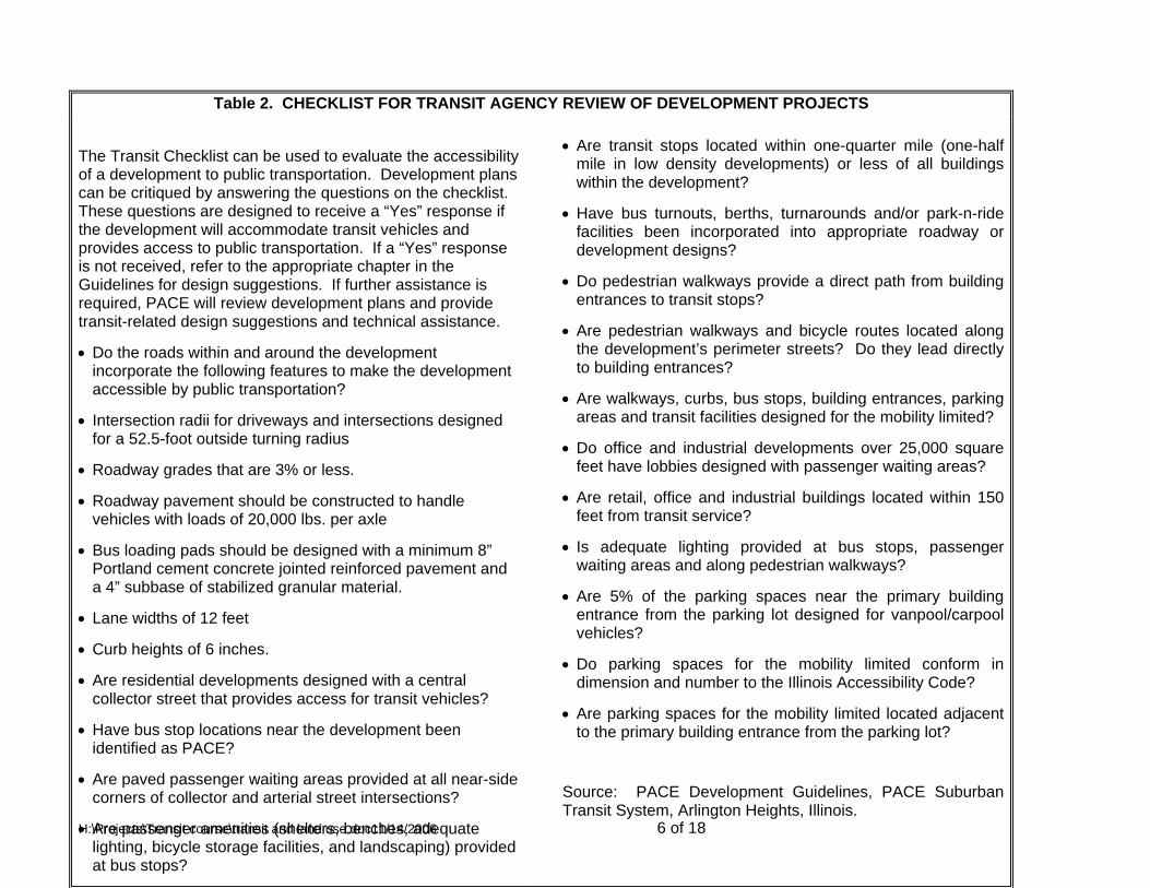
Table 2. CHECKLIST FOR TRANSIT AGENCY REVIEW OF DEVELOPMENT PROJECTS
H:\Projects\Transit course\transit and land use.doc11/14/2006 6 of 18
• Are transit stops located within one-quarter mile (one-half
mile in low density developments) or less of all buildings within the development?
The Transit Checklist can be used to evaluate the accessibility of a development to public transportation. Development plans can be critiqued by answering the questions on the checklist. These questions are designed to receive a “Yes” response if the development will accommodate transit vehicles and provides access to public transportation. If a “Yes” response is not received, refer to the appropriate chapter in the Guidelines for design suggestions. If further assistance is required, PACE will review development plans and provide transit-related design suggestions and technical assistance.
• Have bus turnouts, berths, turnarounds and/or park-n-ride
facilities been incorporated into appropriate roadway or development designs?
• Do pedestrian walkways provide a direct path from building
entrances to transit stops?
• Are pedestrian walkways and bicycle routes located along the development’s perimeter streets? Do they lead directly to building entrances?
• Do the roads within and around the development
incorporate the following features to make the development accessible by public transportation?
• Are walkways, curbs, bus stops, building entrances, parking
areas and transit facilities designed for the mobility limited? • Intersection radii for driveways and intersections designed
for a 52.5-foot outside turning radius • Do office and industrial developments over 25,000 square
feet have lobbies designed with passenger waiting areas? • Roadway grades that are 3% or less.
• Are retail, office and industrial buildings located within 150 feet from transit service?
• Roadway pavement should be constructed to handle vehicles with loads of 20,000 lbs. per axle
• Is adequate lighting provided at bus stops, passenger waiting areas and along pedestrian walkways?
• Bus loading pads should be designed with a minimum 8” Portland cement concrete jointed reinforced pavement and a 4” subbase of stabilized granular material. • Are 5% of the parking spaces near the primary building
entrance from the parking lot designed for vanpool/carpool vehicles?
• Lane widths of 12 feet
• Curb heights of 6 inches. • Do parking spaces for the mobility limited conform in
dimension and number to the Illinois Accessibility Code? • Are residential developments designed with a central collector street that provides access for transit vehicles?
• Are parking spaces for the mobility limited located adjacent to the primary building entrance from the parking lot? • Have bus stop locations near the development been
identified as PACE?
• Are paved passenger waiting areas provided at all near-side corners of collector and arterial street intersections? Source: PACE Development Guidelines, PACE Suburban
Transit System, Arlington Heights, Illinois. • Are passenger amenities (shelters, benches, adequate
lighting, bicycle storage facilities, and landscaping) provided at bus stops?

10-7
H:\Projects\Transit course\transit and land use.doc 11/14/06
Systems Level Actions -- Land Use
- Create transit corridor zoning overlay districts -- areas that will have future transit service - Separate transit oriented and auto oriented land uses. Land uses which are conducive to
transit; compact residential, schools, health care, office buildings, should be located along transit corridors
- Predesignate a future system of transit corridors; areas that have higher densities, mixed use development, and are served by transit with quality pedestrian and bicycle facilities with control of through automobile movement
- Establish transit service zones along existing arterials. - Explore public/private opportunities for transit stop joint development. - Provide adequate population size and density to support transit use. - Provide for mixed use development to facilitate shorter trips and use of non-vehicle travel
System Level Actions -- Transit
- Relate services design to market conditions - Provide for passenger safety and security - Provide high quality transit service. - Use Transit vehicles that are quiet and have low air pollution levels. - Create a consistent Transit Identity: Signage, etc. and compatibility of stops. - Avoid need for shuttle services - Design for a phased implementation of transit corridors. - Provide for Technological and infrastructure flexibility. - Provide for high level geometric design of transit corridors. - Provide regular maintenance at transit stops.
10-8
H:\Projects\Transit course\transit and land use.doc 11/14/06
Transit Oriented Land Uses The following land use categories were judged to have high transit compatibility (ratings of 4 or 5) and should be located in areas to be served by transit.
Commercial airport Park and ride station General heavy industry Apartments Residential condominiums High density residential Retirement community Hotel – non-CBD Stadium Elementary school High school Junior/community college University Hospital General office building Office park Shopping center
The following had low compatibility (a rating of 1) and it is unlikely that large numbers of people would use transit to get to these places on a regular basis. It is possible that if these places had a high employment, that there could be travel to the site for employees.. These land uses can generally be separated from public transit services.
Water port General aviation airport Truck terminal Mini-warehousing Utilities Recreational homes Resort hotel Marina Golf course Day care center Nursing home State motor vehicle department Building materials and lumber Hardware/paint store Nursery/garden center Quality restaurant New car sales Service station Car wash Highway oasis Truck stop Furniture store Drive-in bank Drive-in savings and loan

10-9
H:\Projects\Transit course\transit and land use.doc 11/14/06
Transit-related development/automobile related development
________________________ Source: Snohomish County “Guide . . .,” p. 8-7 from Portland “Public streets for Public Use.”

10-10
H:\Projects\Transit course\transit and land use.doc 11/14/06
System Level Actions -- Pedestrian/Bicycle
- Develop standards for pathways to be included with arterial, and collector highway projects, parallel but separate from roadway
- Institute a plat review that includes consideration of pathway connections, safety of pedestrian and bicycle movement
- Control of through automobile traffic. - Use transit corridors for primary pedestrian, bicycle and transit movement.
Project Level Actions – Land Use
- Provide mixed land use including housing, office, retail, light industrial and recreational uses.
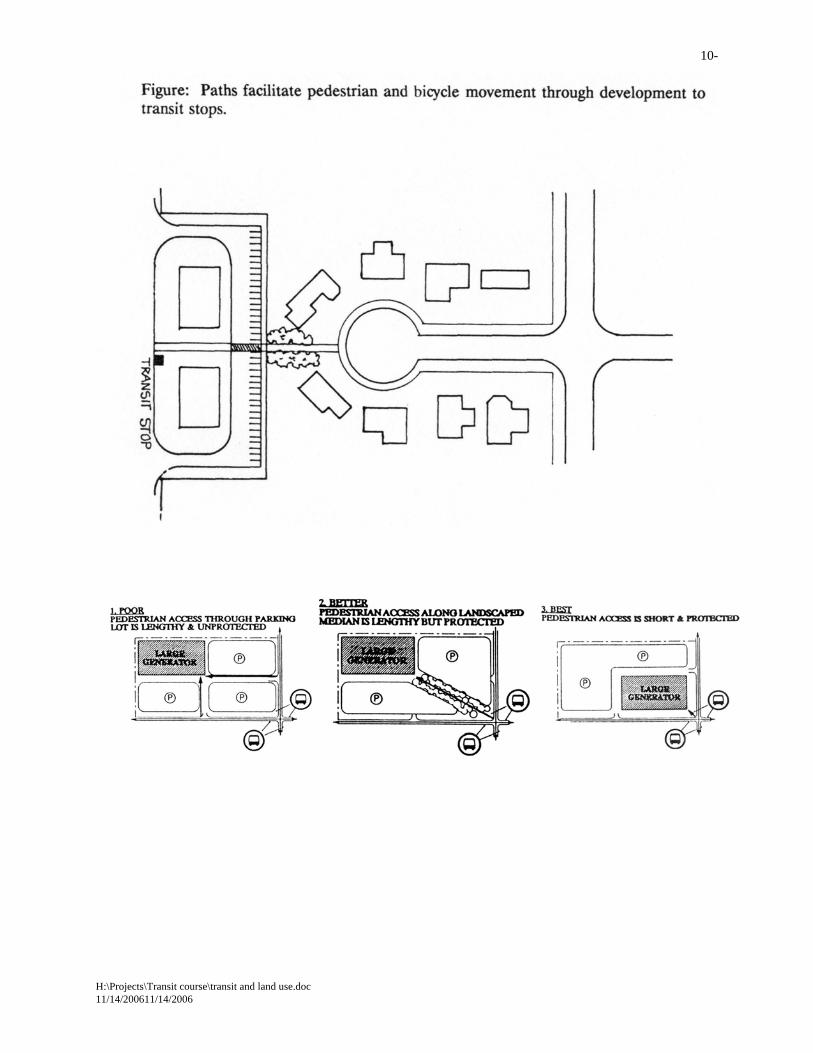
- Provide variety within the district. - Locate buildings near streets; maximize utilization of curb space to serve many users - Land use density gradient. (Higher densities close to transit) - Utilize appropriate land use adjacencies. - Provide recreational opportunities and amenities. - Accommodate multiple developers and development patterns. - Use a parking density gradient. - Develop a program to encourage shared parking facilities. - Building location and design should be sensitive to transit-generated noise and views.
Project Level Actions – Transit
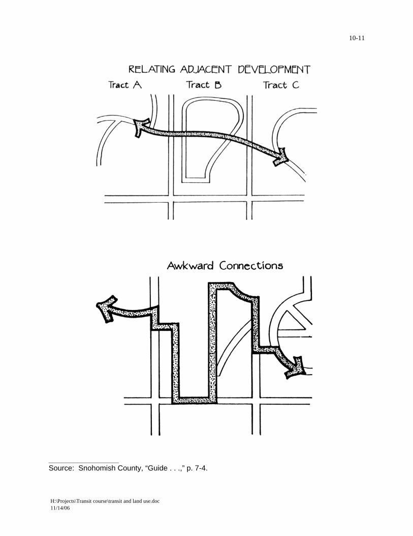
- Provide for better connections between adjacent development projects -- connect across "seams".
- Provide logical connections between buildings and pedestrians/bicycles/transit, minimize the distance between vehicle door and building door.
Project Level Actions – Pedestrian/Bicycle
- Create a pedestrian/bicycle friendly environment (safe, secure, storage, interesting, human scale)
- Provide pathway connections between subdivisions, at ends of cul de sacs, to improve connectivity -- shortcuts
- Narrow neighborhood streets - Provide Pedestrian/bicycle pathway system. - Provide for safe, convenient pedestrian circulation. - Promote bicycle access through high quality pathways and secure storage systems.
10-11
H:\Projects\Transit course\transit and land use.doc 11/14/06
_________________ Source: Snohomish County, “Guide . . .,” p. 7-4.

Pedestrian and Bike Transit Access Distance
H:\Projects\Transit course\transit and land use.doc 11/14/2006

10-
H:\Projects\Transit course\transit and land use.doc 11/14/200611/14/2006

H:\Projects\Transit course\transit and land use.doc 11/14/2006
10-
H:\Projects\Transit course\transit and land use.doc 11/14/200611/14/2006

H:\Projects\Transit course\transit and land use.doc 11/14/2006 22 10-11/14/2006

10-
References Guidelines for Transit Sensitive Suburban Land Use Design, US DOT Technical Sharing DOT-91-13, July 1991, summarized in TRB Record 1349; also at http://www.uwm.edu/Dept/cuts/research.htm. “Inside the Black Box, Making Transportation Models Work for Livable Communities,” available from Citizens for a Better Environment, (414) 271-7280. “Livable Wisconsin Newsletter,” also available from Citizens for a Better Environment, (414) 271-7280. “Smart Growth, Creating Communities for People” also available from Citizens for a Better Environment, (414) 271-7280. SEWRPC Rural Cluster Development Guide, Planning Guide No. 7, (414) 547-6721. Traditional Neighborhood Design Guidelines, Institute of Transportation Engineers, August, 1997 Useful Web pages: http://www.uwm.edu/Dept/cuts/ University of Wisconsin Milwaukee, Center for Urban Transportation Studies http://scitech.dot.gov/partech/sustran/sustran.html National Science Council Sustainable Communities Team http://www.tlcnetwork.org/ Transportation for Livable Communities Network http://www.cnu.org/ Congress for the new Urbanism http://www.smartgrowth.org/ Smart Growth Network http://www.sustainable.org/ Sustainable Communities Network http://www.natlands.org/Planning/growgreen.html Pennsylvania Growing Greener Program http://www.vtpi.org/ Victoria Transportation Policy Institute list of web sites http://www.lcd.state.or.us/issues/tgmweb/index_f.htm Oregon Smart Growth Program
H:\Projects\Transit course\transit and land use.doc 10-23 11/14/200611/14/2006

http://www.city.toronto.on.ca/mte/ Toronto, 'Moving the Economy' Sustainable Transport
H:\Projects\Transit course\transit and land use.doc 11/14/2006 24 10-11/14/2006