Transhumance and biodiversity in European mountains Bunce et al.pdf · protection and management...
334
See discussions, stats, and author profiles for this publication at: http://www.researchgate.net/publication/40125001 Transhumance and biodiversity in European mountains ARTICLE · JANUARY 2004 Source: OAI CITATIONS 12 READS 585 6 AUTHORS, INCLUDING: R.G.H. Bunce Estonian University of Life Sciences 186 PUBLICATIONS 3,992 CITATIONS SEE PROFILE M. Pérez-Soba Wageningen University 105 PUBLICATIONS 1,076 CITATIONS SEE PROFILE Rob H.G. Jongman 285 PUBLICATIONS 4,411 CITATIONS SEE PROFILE Felix Herzog Agroscope 188 PUBLICATIONS 3,691 CITATIONS SEE PROFILE Available from: Rob H.G. Jongman Retrieved on: 26 December 2015
Transcript of Transhumance and biodiversity in European mountains Bunce et al.pdf · protection and management...

Seediscussions,stats,andauthorprofilesforthispublicationat:http://www.researchgate.net/publication/40125001
TranshumanceandbiodiversityinEuropeanmountains
ARTICLE·JANUARY2004
Source:OAI
CITATIONS
12
READS
585
6AUTHORS,INCLUDING:
R.G.H.Bunce
EstonianUniversityofLifeSciences
186PUBLICATIONS3,992CITATIONS
SEEPROFILE
M.Pérez-Soba
WageningenUniversity
105PUBLICATIONS1,076CITATIONS
SEEPROFILE
RobH.G.Jongman
285PUBLICATIONS4,411CITATIONS
SEEPROFILE
FelixHerzog
Agroscope
188PUBLICATIONS3,691CITATIONS
SEEPROFILE
Availablefrom:RobH.G.Jongman
Retrievedon:26December2015

i
Transhumance and Biodiversity in European Mountains
Edited by: R.G.H. Bunce, M. Pérez-Soba, R.H.G. Jongman, A. Gómez Sal, F. Herzog and I. Austad

ii ii
ISBN 903270337 4 NUR 910 This publication should be cited as follows: R.G.H. Bunce, M. Pérez-Soba, R.H.G. Jongman, A. Gómez Sal, F. Herzog and I. Austad (Eds.)2004. TRANSHUMANCE AND BIODIVERSITY IN EUROPEAN MOUNTAINS, Report of the EU-FP5 project TRANSHUMOUNT (EVK2-CT-2002-80017). IALE publication series nr 1, pp 321 Published by ALTERRA Wageningen UR in collaboration with IALE Available from IALE: http://www.landscape-ecology.org Price: € 45,00 including handling and mailing Info: Rob Jongman ALTERRA Green World Research, Wageningen UR Postbox 47, 6700AA Wageningen, The Netherlands tel: 31 317 477626, fax: 31 317 419000 E-mail: [email protected] Cover photograph: Antonio Gómez Sal Cover design: Ponsen & Looijen bv, Wageningen, The Netherlands Printed by Ponsen & Looijen bv, Wageningen, The Netherlands No part of this publication may be reproduced or published in any form or by any means, or stored in a database or retrieval system, without the written permission of IALE. Alterra and IALE assume no liability for any losses resulting from the use of the research results or recommendations in this report.

iii
CONTENTS Page Preface ...................................................................................................................................vii Introduction ............................................................................................................................ 1 Definition of mountains and area covered ........................................................................... 3 NORTHERN MOUNTAINS.......................................................................................................... 5
Norway An overview of Norwegian summer farming I. Austad, A. Norderhaug, L. Hauge & A. Moen............................................................... 7
The mountain summer farm landscape of Innfjorden, Western Norway A. Bryn............................................................................................................................ 19
Summer farming in Jotunheimen, Central Norway E.G.A. Olsson ................................................................................................................. 25
Diversity of macrofungi in seminatural grasslands of the subalpine summerfarm landscape around Dovre, Southern Norway J.B. Jordal........................................................................................................................ 31
Contribution to the prehistory of the use of summer farms in Southern Norway D. Moe............................................................................................................................. 35
Outlying boreal haylands in Central Norway A. Moen, D.-I. Oien & L.S. Nilsen ................................................................................. 39 Island summer farming at Kalvøya, Central Norway L.S. Nilsen & A. Moen ................................................................................................... 43
Transhumance in the Stolsheinen mountain area, Western Norway K. Potthoff & S. Eiter...................................................................................................... 47
The outfarm landscapes of the Upper Setesdal Valley - history, vegetation and red listed species E. Svalheim ..................................................................................................................... 57
Summer farming in Vangroftdalen, Os, Denmark V. Vandvik ...................................................................................................................... 61

ii iv
Summer farming in Roldal, Western Norway V. Vandvik ...................................................................................................................... 65 United Kingdom Transhumance in the British Isles – decline or transformation? D.G.L. Jones & I.Ll. Wmffre, .. ...................................................................................... 69
ALPS AND CARPATHIAN MOUNTAINS ................................................................................... 91
Austria History and current state of transhumance in the Austrian Alps T. Wrbka, J. Peterseil, J. & I. Schmitzberger.................................................................. 93 France Transhumant sheep systems of South-eastern France, with special reference to long-distance transhumance from the plain of the Crau to the Alps A. Wolff & P. Fabre...................................................................................................... 113
Some considerations in the implementation of agri-environmental schemes F. Véron......................................................................................................................... 133
Germany Transhumance in Germany R. Luick ........................................................................................................................ 137
Romania Romanian transhumance – the past, the present and future scenarios A. Mertens & S. Huband .............................................................................................. 155
Poland Traditional pastoralism and Biodiversity in the Western and the Eastern Carpathians W. Mróz & A. Olszańska ............................................................................................. 171
Slovakia Transhumance in Slovakia L. Gonda, V. Krajčovič, I. Ilavská, D. Šúr, B. Valihora, J. Golecký, M. Zimková & M. Kizeková......................................................................................... 183 Switzerland Alpine summer farms in Switzerland S. Dreier, M. Ramsauer & F. Herzog............................................................................ 191
MEDITERRANEAN MOUNTAINS ........................................................................................... 209
Greece Transhumance in Greece: past, present and future prospects I. Ispikoudis, M. K. Sioliou & V.P. Papanastasis ........................................................ 211

v
Italy Transhumance in the Italian Alps and Apennines (abstract only) P. Susmel, C. Fabro & S. Filacorda .............................................................................. 231 Spain The Present status and ecological consequences of transhumance in Spain A. Gómez Sal & I. Lorente ........................................................................................... 233 The national network of transhumance routes in the Kingdom of Spain J. M. Casas .................................................................................................................... 249 The history and characteristics of the Mesteña Transhumance Routes P. García Martín ............................................................................................................ 255 Recovering transhumance in Spain for long-term nature conservation J. Garzón-Heydt ............................................................................................................ 259
Recovery of the national network of transhumance routes: the programme of the Ministry of the Environment J. M. Mangas Navas ...................................................................................................... 265 The integration of drove roads into regional planning: the example of Andalusia, Southern Spain I. Ortiz Borrego ............................................................................................................. 271
The stock raising culture of transhumant herders M. Rodríguez Pascual ................................................................................................... 277
Portugal Portugal’s transhumance legacy: an ecological approach (abstract only) J. Castro & F. Matos ..................................................................................................... 283
Application of the DPSIR (Driving forces, Pressures, State, Impact, Response) framework for the identification of the habitats depending upon transhumance R.G.H. Bunce, M. Pérez-Soba & G. Beaufoy...................................................................... 285 Conclusions from the Policy Review................................................................................. 303 F. Herzog & R.G.H. Bunce with comments from participants of the Policy Workshop Transhumance in Pictures................................................................................................. 307 Various authors

vi

vii
Preface
The present volume brings together the main outcomes of the project
TRANSHUMOUNT – A review of the role of transhumance in mountain ecosystem process and dynamics (EVK2-CT-2002-80017). TRANSHUMOUNT is an Accompanying Measure from the EU 5th Framework, running from 01/01/2003 until 30/06/2004.
This Accompanying Measure was built around a Review Conference in Spain (September 2003) and a Policy Workshop in the Swiss Alps (May 2004). During the Review Conference held in Alcalá de Henares, the consortium and invited experts discussed the current state of transhumance in the principal European Mountain regions. The conference evaluated the role of transhumance in the maintenance of biodiversity in mountain ecosystems in Europe, as defined by the Annex I Habitats, especially those identified as Priority habitats in the Habitat Directive. During the conference Tables were produced using expert judgement, matching strong environmental pressures against susceptible habitats. This was further developed to using the Driving forces/ Pressure/ State/ Impact/ Response (DPSIR) Framework, which is effective in obtaining efficient conclusions. The results of the DPSIR framework formalised the conclusions of the meeting. The final Policy Workshop was held in Landquart and had a transdisciplinary character, combining scientific research with non-academic, societal knowledge, as well as considering demands for regional solutions. Regional and European administrators and experts from other countries were therefore invited. The societal objective of this workshop was to examine the viability of sustainable policies and to examine alternatives to transhumance.
The main objectives of the project specified in the proposal were: 1. To identify the links between transhumance in European mountains and the
management of the Priority Habitats of the Habitats Directive 2. To organise a conference of European experts to discuss and evaluate to what
extent grazing determines the composition of mountain ecosystems 3. To use the Driving forces/ Pressure/ State/ Impact/ Response Framework
(DPSIR) to identify the critical factors affecting mountain ecosystems, and then to determine which habitats are actually threatened
4. To identify the gaps in knowledge, evaluate the threats and determine whether further research is required
5. To organise a policy workshop to identify measures which could ameliorate potential de-clines in biodiversity and maintain transhumance under modern social conditions
6. To produce a book summarising the status of transhumance and whether its decline threatens mountain ecosystems, especially Priority Habitats.
The project team consisted of ALTERRA (Wageningen, NL, co-ordination), Alcalá
University (Madrid, ES), the Swiss Federal Research station for Agroecology and Agriculture (Zurich, CH), European Forum for Nature Conservation and Pastoralism (Argyll, UK), Sogn og Fjordane University College (Sogndal, NO).
Originally it was planned to publish the present volume as a commercial book.
However, the conversion of the submitted papers into a popular format proved to be beyond the resources of the project. Instead, the contents consist of the individual chapters written by the people who participated in the project. Therefore, although the styles vary, the chapters present a scientific overview of the current knowledge on transhumance in Europe. It is

Preface viii
recognised that there is a bias towards Norway and Spain but it would have been disappointing not to publish all the documents produced during the course of the project and they contain much useful information.
The Norwegian chapters were written for a workshop organised by Anne Norderhaug
and Ingvild Austad and they present an overall picture of one of the most well known transhumant countries. The Spanish chapters are mainly written by people mainly concerned with maintaining the network of transhumant routes in Spain and demonstrate the increasing common interest in their maintenance.
The publication of this book has been made financially possible through the support of
the European Union, the Research Programmes of the Dutch Ministry of Agriculture Nature and Food Quality (ANF) on Regional Identity and Landscape Development (Programme Nr 382) and Rural Areas (Programme Nr 430), the Junta de Andalucia and the International Association for Landscape Ecology (IALE).
We thank all the participants for their contributions and Corine Tak for typing the text
and finalising the document.
R.G.H. Bunce, M. Pérez-Soba & R.H.G. Jongman June 2004

ix


Transhumance and Biodiversity in European Mountains 1
Introduction
This introduction is an edited version of the “Transhumount Declaration of Alcalá” which was produced by Antonio Gómez Sal following the Review conference in September 2003.
Extensive animal systems based on livestock displacement are called transhumance
and constitute and important but declining element of the European cultural tradition. They have played a significant role in the origin and maintenance of many European cultural landscapes, especially those in the mountains. Because their ecological rationale is based on distant but complementary pastures or forage resources and they developed over centuries, they represent an exemplary method of sustainable land use.
Transhumance systems have significant cultural values, e.g. the shepherd people in Greece and Romania. In Spain, the knowledge and management rules associated with long distance transhumance, originating from the breeding of the Merino sheep, were once essential for the world wool industry. There are also itinerant shepherding systems, founded in a distinct evolutionary use of the traditional multiple land use landscapes, termed polyculture. They still exist in some remote but strategic regions, which are important for nature conservation in Europe.
There is a close and recognisable relationship between traditional farming practices, Cultural landscapes and biodiversity. The fascinating historical cultural elements associated with transhumance, have been developed over many centuries-and therefore have their distinctive patterns and structure. They involve management procedures based in the maintenance of ecosystem function and associated key ecological elements.
In many cases transhumance systems have generated a significant legacy of drove roads. These elongated grazing corridors often have a width of up to 70m and support a specific plant association and form a reticular structure across countries e.g. Spain and Greece. High mountain and lowland pastures, and as the renowned dehesas (wood pastures) form complex patterns within, the drove road network and maintain important habitats and rare species, both of animals and plants. Drove roads have an ecotone gradient with adjacent land. They also probably act as ecological corridors, as has been shown in Germany. Further research is needed to demonstrate the positive effects of these structures and adjacent habitats for nature conservation.
The role of drove roads as corridors can be increased by means of appropriate protection and management policies. Safeguarding the ecological links with other natural networks such as rivers and mountain slopes is also important. They could then constitute a framework for increasing the connectivity between protected areas, because they often pass through such land. These types of semi-natural silvopastoral landscapes can therefore reinforce the connection between the wider countryside and protected areas.
In general, these extensive livestock systems have an important role in nature and landscape conservation. Herbivory is a key factor for plant evolution, control of vegetation growth and a stimulus for plant productivity. Herbivory is a complex function that depends on the interaction between several animal species and breeds. It should therefore be studied and systematised in order to be applied in adapted management policies based on extensive

2 Introduction
livestock systems. A number of ancient livestock breeds are linked to transhumance. They should be preserved, not only because of their ecological significance, but also because of their educational, cultural and aesthetic value. They are also an important source of genetic material for future generations.
Herbivory and extensive livestock systems should play an increased role in nature
management and conservation, and could then recover in some measure their original role in the traditional countryside and landscapes. Appropriate policies need therefore to be developed to maintain such systems. The indirect effects will help to control serious fires, improve pastures for grazing, and maintain habitat diversity. The associated species of fauna and flora, as well as cultural landscape conservation and the water balance will also be conserved if traditional agricultural systems are maintained.
In order to assure the conservation of this important legacy of drove roads, and high mountain and lowland pastures, it is necessary to find new functions for them. Tourism, green ways, education, leisure and nature conservation are all complementary uses, in addition to the production of high value foods. These new uses could help support people in the countryside, whilst maintaining landscapes and agriculture. Transhumance and associated extensive livestock systems, should have therefore be given policy support at a European level, in coordination with local authorities.

Transhumance and Biodiversity in European Mountains 3
Definition of mountains and area covered
Following the discussion at the Transhumount Review conference it was decided to take a broader view of mountains than was included in the initial proposal. The areas to be excluded are pure lowlands e.g. the Valley of the Somme in France and East Anglia in the UK. The original proposal only included habitats that were associated with mountain geo-morphological situations. However, that definition excluded a number of habitats directly involved in transhumance. e.g. mesic neutral grasslands in valleys within mountain regions. The original intention was to use the Environmental Zones of the Wageningen university Research Environmental Classification of Europe (EnC). The EnC classification is derived from statistical analyses of altitude and climate and the interaction between them. However, the classification alone did not adequately represent mountains in Atlantic north Continental/Pannonian regions because the zones were not based exclusively on altitude and included many non-mountain areas. In some cases such extensive lowlands are linked to latitudinal transhumance and still involve some transhumant activity, and therefore link mountain areas to relatively remote lowlands. However, such regions would extend the area to be covered beyond the practical reach of the present project. Two examples of such regions are the Hungarian plain in the Pannonian region and Extremadura in the western Mediterranean. The latter region is lowland, but has maintained the link with the mountains of Leon by using lorries for transport.
An altitudinal mask alone was considered, but was rejected for two reasons: (a) It is difficult to define objectively what altitudinal level to use – 100m is mountainous in
Scotland, whereas 2000 m would be appropriate in South-eastern Spain. (b) In many mountain areas valleys are managed by the same farms as mountain pastures and
are therefore an integral part of the transhumance systems.
It follows that any map should include both true mountains and adjacent lowlands. The objective procedure determined was to leave the Alpine and Mediterranean mountain zones as defined the classification, but to join the individual mountainous classes of the Atlantic North region with the Scandinavian mountains. Some of the lower mountains of central Portugal and southern Spain are excluded using this approach, although they are linked to mountains further north. This is because warmer climate of the south overrides altitude. Some such drawbacks will be present in any approach because inevitably local variations cannot be identified across the whole of Europe. This methodology is however based on a rigorous statistical approach and is not based on expert judgement as in other published examples. The three zones that resulted and there associated countries are:
1. Northern Mountains: Norway, UK 2. Alpine and Carpathian mountains: Slovakia, Poland, Germany, Austria, Switzerland, Italy
(part), France (part), Spain (part, linked to the ‘alpage’ of the southern Pyrenees and northern Iberian mountains)
3. Mediterranean mountains: Italy (part), Spain (part), Portugal, Greece, France (part). These zones are shown in Figure 1 with the most obvious limitations being in part Southern Germany and South-western Spain.

4 Definition of mountains and area covered
Figure 1. Indicative map of European Mountain Zones derived from the Environmental Classification of Europe produced by Wageningen University Research. The Mediterranean Mountains and Alpine South zones are published in the website of the BioHab project http://www.biohab.alterra.nl . The Northern Mountains derived from the Alpine North zone with the addition of mountain classes from the Atlantic North zone. The environmental classification was produced by statistical analyses of climate, altitude and locational data.
Transhumance and Biodiversity in European Mountains 5
NORTHERN MOUNTAINS

6 Northern Mountains
Transhumance and Biodiversity in European Mountains 7
An overview of Norwegian summer farming
I. Austad1 , A. Norderhaug², L. Hauge1 & A. Moen3
1Sogn & Fjordane University College (HSF), Box 133, N-6851 Sogndal, Norway, e-mail: [email protected]
2The Norwegian Crop Research Institute, Kvithamar, N-7500 Stjørdal, Norway 3NTNU, Norwegian Institute of Science & Technology, Museum of Natural History, N 7491 Trondheim, Norway, e-mail: [email protected]
Abstract Norwegian summer farming has a long history and can be dated back to the Iron Age and even to the Bronze Age. Since the area that can be used for crops is limited in Norway, the pre-industrial agriculture here depended on the resources of outlying land usually above the lowlands. Summer farming was widespread, but there was much variation in the local practices, depending on the local natural conditions. Forest summer farming was common especially in the southeast part of the country and along the coast the islands were used for summer farming. In the mountains summer farms located at different altitudes made it possible to utilize the grazing resources also far from the farm. Many farms had several summer farms with a spring farm near the main farm and one or several summer farms higher up in the mountains. It was common to utilize the summer farms both for hay making and grazing as well as for harvesting of other outfield resources. The distance to the main farm was often too long for transportation of fresh diary products. Instead different milk products were produced at the summer farm, a production demanding large amounts of wood. Many mountain summer farms were therefore situated in the subalpine birch forest where both wood for fuel and alpine pastures were available. The summer farming created an open landscape where the flora from the lowland and the alpine meadows met. Depending on the ecological conditions and types of utilization several different semi-natural vegetation types were developed. They may be identified according to Fremstad (1997) as for example moist poor meadows, Deschampsia cespitosa meadows, Nardus stricta meadows, Potentilla crantzii-Festuca ovina meadows, Trollius europaeus meadows, but also as different dwarf shrub heaths and fens. The golden period of summer farming was in the 19th century. During the 20th century the land use has changed and the number of summer farms has decreased to about 2000. The mountain areas are mostly used for sheep grazing. Due to the decrease in summer farming activities, a large-scale overgrowing and reduced biodiversity are now characterizing the mountain area situation in Norway.

8 I. Austad, A. Norderhaug, L. Hauge & A. Moen
Introduction
This paper includes much information from the summary of ”Environment, variation and regional vegetation” contributed for the Scandinavian Workshop by A. Moen and the prehistory of the use of summer farms by D. Moe. The latter is included as a separate contribution in the present volume. Norwegian nature is varied. The contrast between different parts of the country when it comes to landscape, types of environment, and plant and animal life is striking. Such great variations over short distances are rare, not only in a Nordic, but also in a global context. The land use and agriculture varies accordingly, depending on climate, geology and topography. Since the land that can be used for arable crops is limited in Norway, pre-industrial agriculture depended on the resources from the outlying areas.
Norwegian summer farming has a very long history and can be traced back to the Iron Age or even to the Bronze Age (Moe et al. 1988), and was widespread throughout the country. However, there was a wide range of variation in the manner of agricultural practice in summer farming, depending on the local natural conditions. It was common to utilize the summer farms both for hay making and grazing as well for the harvesting of other outfield resources (firewood, peat, leaf-fodder and lichen) and for hunting and fishing. The summer farms have also through history been important as resting places when crossing the mountains for both people and domestic animals. Daugstad & Sæter (2001) describe the variation of the Norwegian summer farms in the following way: “a summer farm could be located 10 minutes or 10 hours from the main farm, and 5 or 1405 m a.s.l. The summer farm could be very old or quite young. They could be used for a three to four weeks period every year, or a three to four months period. The summer farm could be a tiny house or a big house built in timber or in stone, lonely situated or in a cluster, consisting of one combined building or of a lot of specialized buildings (cowsheds, barns). Production could be based on cows or goats, on different milk products, butter or cheese, or on hay-making”.
Summer farming created an open landscape and strongly influenced the vegetation, creating several, often species-rich semi-natural vegetation types including habitats for many specialised plants. The semi-natural vegetation types connected to the summer farming areas often have a high biological diversity being a meeting place for the flora from the lowland and the alpine meadows.
The golden period of summer farming was in the 19th century. At that time there were
more than 70,000 summer farms in Norway (Daugstad & Sæter 2001).
The 20th century has seen dramatic changes in agriculture, also affecting the summer farms. More use of cultivated grasslands in the lowlands and high consumption of feed concentrates for the domestic animals, reduced the importance of the outfield resources and many summer farms fell into disuse (Timberlid 1990). Today less than 2000 summer farms remain and the outfields and mountain areas are mostly used for sporadic and casual sheep grazing. Due to the decrease in summer farming activities, a large-scale expansion of shrubs and trees and reduced biodiversity now characterises the outlying land and the mountains (Aas & Farlund 1996, Bryn et al. 2001). Many of the summer farm buildings and other cultural elements have detoriated since there is no longer a need for them. In addition many buildings have been modified and supplemented with new cabins. This changes the summer farm landscapes and causes deterioration and a loss of an important part of the Norwegian cultural heritage (Bryn & Daugstad 2001)

Transhumance and Biodiversity in European Mountains 9
Landform, geology and climate
Norway (originally Nordweg, meaning the “northern way”) is located in northwest Europe between 57° 58' and 71° 7' N and 4° 56' and 31° 3' E. It covers an area of 323,752 km², 5.3% being lakes and 6.9% islands in salt water. (In addition, Svalbard and Jan Mayen comprise 63,080 km², but these areas are not included in this article). The coastline (excluding the fjords) measures 2650 km; the distance between the extreme south (Lindesnes) and the extreme northeast on the mainland (Nordkynn) is 1752 km. Inland borders are with Sweden (1619 km), Finland (727 km) and Russia (196 km).
Norway has an extremely broken topography and comparatively large variations in elevation over short distances. 32% of the country is below 300 m a.s.l. and 20% is higher than 900 m a.s.l. The highest mountain (Galdhøpiggen at 2469 m a.s.l.) is in the Jotunheimen, in the central part of south Norway. The geological history of Norway is complicated. A variety of Precambrium rocks form the basement to Lower Palaeozoic sedimentary and igneous rocks formed 600-425 million years ago. These and some Precambrian gneisses underwent severe deformation and metamorphism during the main Caledonian orogeny around 420-390 million years ago, when a vast mountain chain was formed. This terrain was subsequently eroded before being rejuvenated to form the present Scandinavian mountain chain during the Alpine orogeny some 55 million years ago. The most common bedrock is siliceous (granites, quartzites, etc.), giving poor (acidic) mineral soils, which cover large parts of the country. Readily weathered, calcareous and schistose bedrock (mainly Lower Palaeozoic) underlie extensive areas of central and northern Norway, and some small areas of limestone and shale are found further south, notably in the Oslo region.
The shape and the location of the country result in an unusually moist climate with mild winters, particularly in the west. However, the mountainous spine means that inland areas are located in a rain shadow and have warm summers and cold winters. The climate in Norway thus varies very much, the following being particularly important: - its location far north, stretching a long distance both south-north and west-east - its location on the east side of the Atlantic Ocean Current (the Gulf Stream) and the
prevailing westerly winds give a much warmer climate than its location should indicate. - the marked relief of the country, only short distances separating the lowlands and high
mountains in most districts. Inland areas are in the rain shadow of mountain ranges.
The warmest region is along the coast of south Norway, where the average temperature is 7-8 °C. The coldest areas are in the mountains and the north, where large areas have an average temperature of less than - 2°C. The coastline from Lindesnes to Lofoten has monthly winter means above 0°C. Inland areas are influenced by continental air masses which create temperature inversions in the valleys in winter, with January mean temperatures under -10°C in large areas. Areas just inland from the coast, especially on the west side of high mountains, receive most precipitation; large areas have more than 2000 mm as their normal annual precipitation (3575 mm at Brekke in the Sognefjord). The parts of west Norway that receive most precipitation are among the wettest in Europe. On the whole, precipitation decreases northwards and eastwards from western Norway. The interior parts of southeast Norway and

10 I. Austad, A. Norderhaug, L. Hauge & A. Moen
Finnmark are the driest regions with an annual precipitation of less than 500 mm (Sjåk in southern Norway has 278 mm). Information (including maps and references to literature) on landforms, elevation, bedrock, climate etc. follow Statistisk sentralbyrå et al. (1994), and phytogeography Moen (1999). Vegetation – regional variation
The variation between different parts of Norway can partly be explained by the large differences in abiotic conditions. The regional variation is a response to climate and the local variation is related to variations in geology, geomorphology, etc. The following two main types of regional variation in the vegetation have been distinguished and mapped in Norway (Moen 1999).
The vegetation zones display variations from south to north and from lowland to upland, and are linked with the demands of the plants for warmth during the growing season. In the lowlands, it is the nemoral zone which predominates furthest south. If we stay at sea level and travel northwards, we meet the other zones one after the other, the boreonemoral, southern boreal, middle boreal, northern boreal and southern arctic (furthest north in Finnmark). In alpine areas, three zones are distinguished above the northern boreal zone, the low, middle and high alpine zones, thus giving a total of nine vegetation zones.
The variation in the zonal vegetation in most parts of Norway is greatest where there are short distances from the lowlands to the mountains, such as in the counties of western Norway (e.g. Sogn & Fjordane). There, the boreonemoral and southern boreal zones are found at sea level, whereas all the zones from the boreonemoral to the high alpine are represented in the altitudinal direction. The vegetation zones reach their highest altitude in southern Norway and decline towards the north. The upper boundary of the northern boreal zone forms the climatic forest limit. This limit reaches its highest altitude in the Jotunheimen mountains and drops from there in all directions. Towards the north, it reaches sea level in Finnmark; north of this limit is the southern artic zone.
The vegetation sections display the variation between coast and inland (or west-east)
and five are recognised in Norway. These are the highly oceanic (O3; often subdivided into winter-mild and humid sub-sections), markedly oceanic (O2), slightly oceanic (O1), indifferent (OC) and slightly continental (C1) sections. These sections are tied to differences from oceanic to continental climates.
Sogn, Fjordane and Sør-Trøndelag are the only counties where all five vegetation sections are represented, although the slightly continental section is only marginally present. The other counties along the coast from Hordaland in the south to Troms in the north have four sections. Most of the remaining counties have three vegetation sections represented.
Vegetation ecological regions are obtained by combining vegetation zones and sections. Altogether 36 such regions are defined in Norway. If the three alpine zones and the southern arctic zone are combined into one zone, Norway has 26 ecological regions (Moen 1999). Sogn & Fjordane is the county with the largest regional variation, 22 of the 26 regions are occurring here. In Denmark, Finland and Sweden the numbers are about 2, 10 and 17 regions respectively.

Transhumance and Biodiversity in European Mountains 11
The natural conditions; the outer framework for resource utilization, settlement and farming – regional differences
At the end of the last Ice Age, some 10,000 years ago, Norway was only a barren, natural landscape. Gradually, as the ice retreated, the plant cover became established and grazing animals like reindeer, beats of prey and Man followed. The bedrock, landforms and altitude are external factors, which have remained largely stable over the last few thousand years, whereas the climate, plant cover, soil and animal life have undergone major changes. During the period from around 9000 to 5000 years ago, summers were about 2°C warmer than today. The woodland limit was considerably higher than it is now, and all the vegetation zones were displaced upwards and northwards relative to the present time.
The development of agriculture has varied from one part of Norway to another, in close harmony with the variation in the climate. A main distinction can be made between the highly oceanic section and the rest of the country; and between the nemoral and boreonemoral parts of southern Norway; and those in the boreal valley districts such as are found throughout large parts of southern Norway and northwards to northern Nordland (cf. Moen 1999:156). The most important food crops (e.g. cereals) have limited possibilities for being cultivated in Norway because they require a quantity of warmth in the growing season that is only available in relatively few parts of the country. Areas in the nemoral, boreonemoral and, for certain species, the southern boreal zones are best suited for such production. The middle boreal zone is less suited for cultivating food crops than the more southerly zones, but old-established farms, mainly based on dairy- and fodder production, have been located here, particularly in the lowermost part. The growing period is too short in the northern boreal zone and farms solely concerned with agriculture have never existed in this zone. Along the coast of Finnmark, northern boreal farming was combined with fishing, and the upland districts elsewhere in the county, agriculture was often combined with trapping, shooting, or mining-related work. The history of summer farming and summer farm systems
Summer farming is a well-known activity in Norway as well as in other countries, and has been economically important during historical times, documented for Norway (e.g. Hougen 1947, Mikkelsen 1989, Birks et al. 1988). In the sagas, covering the period back to about 1200 B.P., the practice is portrayed as being relatively wide spread. The most important natural resources for running summer farms have been: 1) pastures, 2) wood and 3) water. In addition, hunting must also have played an important role.
Interdisciplinary projects studying summer farms known during the historical time showing relatively widespread grazing on pastures back to about 2500 BP. Several pollen diagrams have been produced to support this concept showing changes in the vegetation composition with reduced birch (Betula pubescens) and pine (Pinus sylvestris) woodland, with variable amounts of charcoal dust. Different anthropogenic plants species have also been found.
In the mountains of southwestern and western Norway, the development of summer farming activity has been documented as stepwise (see the case study described by D. Moe in this volume). Here some of the sites, also some summer farms “villages”, have been more or less in continuous use since their establishment during the last 2600/2500 years. Others have a

12 I. Austad, A. Norderhaug, L. Hauge & A. Moen
shorter history. Evidence for a younger expansion/establishment in the use of such areas, both within the same valley-systems and in new areas, began around 1240 – 1350 BP. In addition, hunting must also have played an important role. Later on, a further expansion occurred from the Viking Age onwards into the Nordic Medieval time, followed by further evidence of expansion 3-400 years ago. This is also known from historical records (Hougen 1947).
The Vikings took with them the knowledge of summer farming practise to Iceland, Scotland and northern England in the eighth to ninth centuries, although summer-farming activity already existed in Ireland, Wales and other Celtic areas (Daugstad & Sæter 2001).
The Norwegian name støl is derived from the old Norwegian name stoðul, which means a place where the animals are collected (standing) when being milked. Seter means sete (sitting place = settlement). The meaning of the words støl and seter to day are the same. However, the word støl is most common used in the southwest and western parts of Norway, while seter is most common used in the southern, eastern and northern parts of the country. The støl and seter names are connected to mountains, valleys and to many local places in Norway, Setesdalen and Stølsnostind are some examples . Many plants also have the prefix seter in their Norwegian names, for instance seterfrytle (Luzula frigida) and setermjelt (Astragalus alpinum). In the Norwegian flora (Lid & Lid 1994) ten seterplants are mentioned.
As mentioned above, the summer farming activity has been very varied in Norway, according to the natural conditions in different regions. The activity has also changed through time according to among others climatic degradation (for instance during the 18th century), and an increasing population (especially during the 19th century). These changes resulted in more need for resources of the outlaying land and the summer farms. Description and classification of summer farming activity varies accordingly (Reinton 1955), and has for instance been based on the distance to the main farm: “heimestøl” (meaning close to the main farm), “midtstøl” (summer farm lying in between the heimestøl and the fjellstøl) and “fjellstøl” (located far from the main farm in the mountains). The summer farms have also been classified according to the season when they were used: “vårstøl” (spring farm), “sommerstøl” (summer farm) and “høststøl” (autum farm) (the spring and autum farms could be the same). In some (continental) areas also winter farming was practised, i.e. the livestock was brought to the mountain (summer) farm also in wintertime to utilize the fodder (mostly lichens) collected there (Reinton 1955). In addition the summer farms could be classified with regard to type of production: ”melkeseter” (milk with refinement on the main farm), “slåtteseter” (hay production) and “fullseter” (milk with refinement on the summer farm often in combination with other types of nature resources utilization as haymaking on meadow enclosures and outlaying land, and other fodder harvesting). When describing the summer farming activity and the transhumance systems in Norway all these types should be included. The different types could be found in specific regions, but also in many combinations within the same region, making a clear classification difficult. Many farms had several farms with a spring farm near the main farm and one or several summer farms higher up in the mountains. In general most farms had two summer farms, one close to the main farm (heimestøl used in the spring and in the autumn) and one in the mountains (fjellstøl). In the southeast part of the country the summer farming activities were concentrated to the forests (“skogsetring”), and along the coast the islands were used for summer farming (“øysetring”).

Transhumance and Biodiversity in European Mountains 13
In the mountain regions the farmland areas are vertically distributed. The old main farms in the valleys of Southern Norway are usually situated in the middle of the south-facing mountain slopes where the local climate is most favourable. The farmers used however, the landscape from the bottom of the valley to the low alpine zone in the mountains for grazing, collecting leaf fodder, haymaking and summer farming. In the fjord landscape the main farm could be situated at the fjord as well as in the mountain slopes. The vertical distribution of the farm land here, made it possible to use the natural resources from the fjord to the mountains, including fishing in the fjord and hunting in the mountains.
The transhumance systems made it possible to use the pastures at different altitudes when they turned green in the spring and early summer. This way of moving animals from the lowland to the mountains was formerly regulated by law, for instance the Magnus Lagabøter Code from 1274 (Brøgger 1925). It was common to stay at the spring and autumn farms for a couple of weeks. The stay at the summer farms however, usually lasted for a couple of months; from the beginning of July to the beginning of September. Customs normally set firmly defined dates for moving the animals. The distance to the main farm was too long for transportation of fresh diary products. Instead different milk products were produced at the summer farm, a production demanding large amounts of firewood. Many mountain summer farms were therefore situated in the subalpine birch forest where both wood for fuel and alpine pastures were available. The grazing and logging affected and suppressed the timberline in many places 100-200 meters and also up to 400 meters (Ve 1941, Aas & Faarlund 1996). This is still to be seen in the landscape to day, especially in the western parts of Norway. The lack of firewood led people to use peat, or in more serious situations, to even moves the summer farms.
In southern Norway another transhumance system supplemented the ordinary summer farming activity. Some central mountain areas were intensively used for grazing by domestic animals during the summer, waiting for transportation from the coast and lowlands of western Norway to the eastern parts of Norway and from the rural areas to the towns. This is called “driftehandel”, meaning commercial trade with cattle and horses. This transhumance system supplemented the ordinary summer farming activity and was especially common in the 18th, 19th and 20th centuries.
The types and number of buildings at the summer farms vary considerably. A summer farm of one farm might stand alone or could be a part of a cluster or a linear structure of summer farms belonging to several farms (“stølslag”). Still each farm usually had separate buildings e.g. dwelling houses, animal sheds and barns whereas the grazing rights were held in common. According to climate and materials available the buildings could be wooden, very often cross-jointed, or built of stone. Peat, stone flags and wood were used as roofing material, now often replaced by corrugated iron. The size depended on the use and time spent at the summer farm, the largest buildings being on summer farms used for the longest period (Austad et al. 1993, Kvamme & Norderhaug 1999).
The cultural landscape, semi-natural vegetation types and flora
Summer farming activity strongly influenced the vegetation, creating an open landscape and several often species-rich semi-natural vegetation types. The subalpine birch forest was removed or transformed to a park-like landscape by logging, grazing and mowing. In this landscape the flora from lowland grasslands as Antennaria dioica, Cerastium fontanum

14 I. Austad, A. Norderhaug, L. Hauge & A. Moen
ssp. vulgare, Euphrasia stricta, Galium boreale, Gentianella campestris, Gymnadenia conopsea, Poa pratensis and Rhinanthus minor met alpine species as for example Antennaria alpina, Bartsia alpina, Cerastium alpinum coll., Euphrasia frigida, Gentiana nivalis, Phleum alpinum, Poa alpina and Saussurea alpina (Austerheim et al. 1998, Lunnan et al. 1999). They are light demanding species and mostly weak competitors thus depending on grasslands and human activity that limits forest recolonisation of the summer farming areas. Both lowland and alpine species were probably spread to the subalpine summer farming landscape by transhumance activity (transport of diasporas/seeds; Moe 1973, Moe & Knaap 1990, Moe 1996, Bruteig 2003) as well as by wind through the open landscape (Bryn et al. 2001).
The semi-natural vegetation varies with the natural conditions and differences in the management regimes (Norderhaug 1987). Still some main vegetation types may be identified according to Fremstad (1997):
Heavy trampling and grazing around the summer farm buildings result in a flora of trampling-tolerant species like Plantago major and many annuals like Poa annua, but also alpine species like Cerastium cerastoides and Sibbaldia procumbens (“Trampling vegetation”, F 13, associated with Plantanginetalia majoris).
The enclosures at the summer farms (“setervoll/beitevoll”) used as meadows or pastures (often for night grazing) consist of different vegetation types depending on the land-use regimes. The enclosures may be ploughed, undersown and fertilized but may also still be less anthrophogenous influenced and consist of semi-natural grasslands. Especially old semi-natural and still traditionally managed hay meadows may be very species-rich (“slåttekvier/stølskvier” and “utslåtter”). They are, however, rare today and usually replaced by cultivated leys or heavily fertilized pastures or meadows that are less species-rich. The most species-rich grasslands in the summer farming areas are therefore now found in the outlaying land where grazing still maintains some semi-natural grasslands and keeps the landscape open.
One of the most common semi-natural grassland vegetation types is Agrostis capillaries/Festuca rubra/Anthoxanthum odoratum grasslands (G4, associated with Nardo-Agrostion tenuis) occurring in areas that are poor to medium nutrient rich and not too dry or too wet. This meadow type include species like Agrostis capillaris, Anthoxanthum odoratum spp. odoratum and alpinum, Carex spp., Poa alpina, Poa pratensis ssp. alpigina, Deschampsia flexuosa, Festuca ovina and Phleum alpinum together with low-growing herbs like Achillea millefolium, Alchemilla alpina, Bistorta vivipara, Leontodon autumnalis, Euphrasia frigida and Viola biflora. Moist pastures that have been intensively used for a long time may be totally dominated by Nardus stricta (Nardus stricta/Festuca ovina grasslands, G5, associated with Nardo-Agrostion tenuis) or especially if they are fertilized, by Deschampsia cespitosa (Deschampsia cespitosa grasslands, G3). These two grassland types are not species-rich but Nardus stricta grasslands may still contain species that have become more rare due to the land use changes as for example Arnica montana and Gentiana purpurea. Also in Agrostis capillaries/Festuca rubra/Anthoxanthemun odoratum grasslands such species occur as for example Platanthera bifolia and Rhinanthus minor.
Transhumance and Biodiversity in European Mountains 15
Moist, nutrient rich semi-natural grasslands are characterized by lush vegetation and species like Alchemilla spp., Cirsium helenioides, Geranium sylvaticum, Trollius europaeus as well as less tall, alpine species like for example Bartsia alpina, Omalotheca norwegica and Phleum alpinum (Trollius europaeus grasslands, G 13).
In base rich mountain areas the old semi-natural and unfertilized grasslands are very species-rich. Herb-rich Potentilla crantzii-Festuca ovina grasslands (G8, associated with Potentillo-Festucetum ovinae) occur in slightly moist and medium base-rich areas. This vegetation type is characterized by several rare or “retreating” species as for example Antennaria dioica, Botrychium spp., Gentianella campestris ssp. campestris, Gentianella amarelle ssp. amarella, Leuchorchis albida and Primula scandinavica. Other characteristic species are: Coeloglossum viridi, Potentilla crantzii and alpine-northern boreal species like Astragalus frigidus, Erigeron acer ssp. acer, Gentiana nivalis, Oxytropis lapponica and Pulsatilla vernalis. Such species-rich flora often gives a diverse fauna as well, especially with regard to insects.
Other semi-natural vegetation types occurring in the summer farming landscape are for example moist poor grasslands (G1, associated with Nardetalia), but also different dwarf shrub heath and fens (H,K). In less grazed areas Juniperus communis, Betula nana (in moist areas) Salix spp. are more frequent occurring in the different semi-natural vegetation types (Emanuelsson & Johansson 1987, Austad et al. 1993, Kvamme & Norderhaug 1999).
In addition to the biodiversity regarding vascular plant species and plant communities, the traditional summer farming areas are of crucial importance for grassland fungi. As underlined in one of the case studies (from the Dovre area, described by J.B. Jordal) this group of species is especially vulnerable to land use changes and many of them are today threatened both in Norway and in the rest of Europe. In Norway 123 red list fungi species are known (Jordal 1977) and some of these may be characterized as “summer farm species”. Conclusion Values
The summer farming landscapes are important parts of the Norwegian natural and cultural heritage. Today most of the remaining semi-natural grasslands are found on outlaying land (Bruteig et al. 2003). The summer farming areas therefore are of vital importance for the biodiversity of the Norwegian cultural landscape on both landscape, vegetation type (plant community/habitat) and species levels. At the same time remaining summer farms are living history, telling us about pre-industrial agriculture and former utilization of outlaying land resources. The summer farming landscapes and systems had qualities that made them a symbol for the Norwegian national Romanticism (Daugstad & Sæter 2001). They are described and hailed in numerous books, poems and paintings. However, also the farmers especially the dairymaids appreciated summer farming despite the hard work it represented. The tourists both today and in ancient times, like the aesthetics of the summer farming landscapes and the recreation opportunities. Research projects also show that remaining summer farms represent potential for sustainable agricultural development (Tuv 2002, BioScene 2002).

16 I. Austad, A. Norderhaug, L. Hauge & A. Moen
Woodland colonisation and deterioration
The work effort that summer farming required and the long distances between the main farms and the summer farms without access by road or tractor track, caused reduced use of many summer farms from the last decades of the 19th century. Changes in social and economic conditions and agricultural development accelerated this process during the 20th century. Due to the abandonment a large-scale colonisation by trees and shrubs now causes extensive landscape changes and reduced biodiversity in the mountain areas in Norway. Shrubs as Juniperus communis, Salix spp. and Betula nana are invading the summer farming areas, followed by birch and spruce. The mountain birch forest is gaining ground again and climate change is speeding up the process. Many semi-natural vegetation types are gradually overgrown and light demanding species are disappearing (Austrheim 1998, Olsson et al. 2000, Bryn et al. 2001). Today sheep are the most important grazers in outlaying land and may keep some semi-natural grasslands open. However, since logging, hay making and most other summer farming activities have stopped, an intermediate grazing pressure by sheep is not sufficient to stop forest succession in productive habitats in the long term (Bruteig et al. 2003).
Fertilizing to improve production has also diminished the biodiversity of many semi-natural grasslands and others have been destroyed and transformed into less biodiverse leys. Governmental subsidies were given to farmers from 1921 onwards for clearing and ploughing new land in the sub-alpine zone to improve grass-production. These subsidies were especially common in the 1970s but stopped in the 1980s. From 1990s onwards traditional summer farming has been stimulated through new subsidies. Changes in management regimes, such as livestock changes, or more heavy grazing pressure around new cooperative summer farms may, however, also cause species extinction and disappearance of semi-natural vegetation types.
Many of the summer farm buildings and other cultural elements have deteriorated since there is no longer a need for them. In some areas, however, the buildings are still in use but have been modified and often supplemented by new cabins. This also changes the summer farm landscapes and causes together with deterioration, a loss of an important part of the cultural heritage (Ueland 1998, Stoknes 2001). Actions
Authentic and species-rich summer farming landscapes are disappearing. Remaining areas thus are of high conservation value and increasing attention is now paid to them, especially since they also are of special interest for tourism. To maintain valuable summer farming areas different management regimes and restoration methods have been developed (Tuv 2002, BioScene 2002, Hansen & Norderhaug 2003, Sickel et al. 2003) showing that it is possible to both strengthen the economy of the farmer and maintain the biodiversity of the summer farming landscape. However, our knowledge of today’s grazing regimes relative to historical land use is still limited. To be able to preserve the values of the summer farming landscape we therefore among others need better knowledge about optimal grazing pressure with regard to biodiversity at different levels and about effects of the current fragmentation of semi-natural grasslands (Bruteig et al. 2003). In addition we need an agricultural policy that stimulates traditional summer farming.

Transhumance and Biodiversity in European Mountains 17
References Austad, I., Hauge, L. & Helle, T. (1993). Kulturlandskap i Sogn og Fjordane. Bruk og vern. Sluttrapport – Sogn og Fjordane distriktshøgskule. Austrheim, G. (1998). Plant biodiversity and land use in subalpine grasslands. A conservation biological approach. Dr. scient thesis. NTNU Trondheim. BioScene (2003). Birks, H.H., Birks H.J., Kaland, P.E. & Moe, D. (eds.)(1988). The cultural landscape, past, present and future. – Cambr. Univ. Press. Bryn, A., Norderhaug, A. & Daugstad A.K. (2001). Bryn, A. & Daugstad, A.K. (2001). Re-growth effects on vascular plan richness in Norwegian, abandoned summer farm areas. – Skogræktarritid 2001:163-166. Brøgger, A.W. (1925). Det norske folk i oldtiden. Institutt for sammenlignende kulturforskning. 222 pp. Oslo. Daugstad, K. & Sæter, S. (2001). Seterliv. – Det norske samlaget. Oslo. Emanuelsson & Johansson (1987). Fremstad, E. (1992). Vegetasjonstyper i Norge. NINA Temahefte 12. 279 pp. NINA/NIKU. Hansen, S. & Norderhaug, A. (2003). Restaureringsforsøk i et gjengroende seterlandskap. Noen resultater fra prosjekt ”Levande stølar og kulturlandskap”. I Austad, I., Hamre, L.N. & Ådland, E. (eds.): Gjengroing av kulturmark. Rapport fra nordisk forskerseminar i Sogndal 15.-18.september 2001. Bergen Museums Skrifter nr. 15: 111-118. Hougen, B. (1947). Fra Sæter til Gård. – Norsk Arkeologisk selskap. Oslo. Håland, S. (2002). Fem tusen år med flammer. Det europeiske lyngheilandskapet. – Vigmostad Bjørke. Jordal, J.B. (1977). Kaland, P.E. (1999). Kystlynghei. In Norderhaug, A., Austad, I., Hauge, L. & Kvamme, M. (eds.): Skjøtselsboka for kulturlandskap og gamle norske kulturmarker. Pp. 113-126. – Landbruksforlaget. Kvamme, M. & Norderhaug, A. (1999). Stølslandskapet. In Norderhaug, A., Austad, I., Hauge, L. & Kvamme, M. (eds.): Skjøtselsboka for kulturlandskap og gamle norske kulturmarker. Pp. 183-192. – Landbruksforlaget. Lid, J. & Lid, D.T. (1994). Norsk flora. 6.utgåve v/Reidar Elven. – Det norske samlaget. Lunnan, T., Norderhaug, A. & Sickel; H. (1999). Supplerende forprosjekt til prosjekt ”Levande stølar”. Rapport til Norges forskningsråd. Unpubl. 54 pp. Mikkelsen, E. (1989). Fra jeger til bonde. Utviklingen av jordbrukssamfunn i Telemark i steinalder og bronsealder. - Universitetets Oldsakssamling Skrifter 1989 nr. 11. 441 pp. Moe, D. (1973). Studies in the Holocene vegetation development on Hardangervidda, southern Norway. I. The occurrence and origin of pollen of plants favoured by man’s activity. – Norwegian Archaeological Review 1973, 6, 2:67-73. Moe, D. (1996). The utilisation of un-cultivated rural land in southern Norway during the last 2500 years – from the coastal areas to the artic-alpine zone : a pollen analytical survey. In Colardelle, M. (ed.): L’homme et la nature au Moyen Age: 122-128. Vth Congres International d’archeologie medievale (Grenoble 1993). Editions Errance. Moe, D. & van der Knaap, W.O. (1990). Transhumance in mountain areas: Additional interpretation of three pollen diagrams from Norway, Portugal and Switzerland. In Moe, D. & Hicks, S. (eds.): Impact of Prehistorie and Medieval man on the vegetation: Man at the forest limit. – PACT 1990. Vol. 31: 91-105. Moe, D., Indrelid, S. & Fasteland, A. (1988). The Halne Area, Hardangervidda. Use of a High Mountain Area during 5000 Years – An Interdisciplinary Case Study. In Birks, H.H.,

18 I. Austad, A. Norderhaug, L. Hauge & A. Moen
Birks, H.J.B., Kaland, P.E. & Moe, D. (eds.): The Cultural Landscape. Past, Present and Future. pp.429-444. Cambridge University Press. Moen, A. (1998). Nasjonalatlas for Norge: Vegetasjon. 199 pp. –Statens kartverk. Norderhaug, A. (1988). Urterike slåtteenger i Norge. Rapport fra forprosjektet. –Økoforsk utredning 1988:3. Norderhaug, A., Austad, I., Hauge,L., & Kvamme, M. (eds.) (1999). Skjøtselsboka for kulturlandskap og gamle norske kulturmarker. – Landbruksforlaget. Olsson, E.G.A., Austrheim, G. & Grenne, S.N. (2000). Landscape change patterns in mountains, land use and environmental diversity, Mid-Norway. 1960-1993. –Landscape Ecology15:155-170. Reinton, L. (1955-1961). Sæterbruket I Noreg. Instituttet for sammenlignende kulturforskning. I (1955), II (1957), III (1961). Sickel, H., Ihse, M. Norderhaug, A. & Sickel, M. (2003). How to monitor semi-natural key habitats and grazing preferences of cattle in mountain summer farming areas. An aerial photo and GPS method study. –Landscape and Urban planning. Statistisk Sentralbyrå. (1994). Stoknes, S. (2001). Alrekstølen – vernet gjennom ny bruk? In Skar, B. (ed.): Kulturminner og miljø. Forskning i grenseland mellom natur og kultur. Pp.109-134. –NINA/NIKU. Timberlid, A. (1990). Driftsendringar i jordbruket som årsak til forsuring av norske vassdrag? Ein samanliknande studie av utmarksbruket på Vest- og Sørlandet i perioden 1850-1080. – Økoforsk rapport 1989:14. 354 pp. Tuv, K.H. (2002). Sluttrapport Levande stølar. Det Kgl. Selskap for Norges Vel. Ueland, T. (1998). Forvaltning og skjøtsel av stølar. Prosjektrapport. 125 pp. Ve, S. (1941). Bonden, buskapen og skogen i gamle vestlandsbygder. –Tidsskr. For skogbruk 49:149-157 and 205-215. Aas, B. & Farlund, T. (1996). The present and the Holocene subalpine birch belt in Norway. Special issue. EFS project. European Palaeoclimate and Man. 13. European Science Foundation. Stuttgart.

Transhumance and Biodiversity in European Mountains 19
The mountain summer farm landscape of Innfjorden, Western Norway
A. Bryn
Norwegian Institute of Land Inventory Box 115, N-1431, AS, Norway e-mail: [email protected]
Introduction
The village of Innfjorden is located at the Romsdalsfjorden in the municipality of Rauma about 10 km southwest of Åndalsnes. The village has about 500 inhabitants, 20 farms, a school and several family enterprises. There is also tourism in the region characterized by mountains up to 1800 m above sea level, steep slopes and deep valleys. The mountain region has traditionally been used for summer farming, hunting and fishing. The mountain summer farm area in Innfjorden is a valley about 450 m above sea level. The area is located in the mountain birch zone of the oceanic vegetation section and the mellomboreal vegetation zone. Areas in the north boreal and low-alpine zone are also grazed. Temperature in July is about 10-14 degrees and annual average precipitation between 1000-1500 mm. There are 100-124 days during wintertime when 50% of ground is covered by snow. Bedrock in the region is gneiss, granite, mica schist and amphibolites formed in the pre-cambric era. There are also glacial deposits in the region. (Moen 1998). Mountain summer farming in Innfjorden
Mountain summer farms are located in the Innfjordsfjellet at Berildstølen, Bøstølen and Svartrøsta according to different parts of the village Innfjorden and Berild. Main farms in Berild are located 130 m above sea level and have short routes to the mountain grasslands at Berildstølen 380 m above sea level. Most farmers have their main farms closer to the sea in the village of Innfjorden and have longer distances to the mountain summer farms at Bøstølen 430 m above sea level. Farmers from relatively big farms in Ner-Bø (Innfjorden) have summer farms at Svartrøsta 450 m above sea level. There are also several farms that have summer farms in other mountain areas in the region. (Bygdeboknemnda for Voll 1979 & 1980). Past situation
In former times summer farms have been used for milk and meat production by cattle, goats and sheep (Sæbø 1964). Since about 1900 summer farms have been used for milk production by cattle and meat production by cattle and sheep. There was a mountain dairy at Bøstølen around 1900 until 1920 for production of butter using waterpower. At Berildstølen milk has been carried down to the main farms two days a week. Butter has been exported to England. Cheese and other milk products have been produced on the summer farms. For the production of brown cheese and warming houses much wood was cut in the mountains. Additionally large amount of hay were made in the mountain summer farm region.
During the principal period of traditional farming, sheep were released from barns after lambing in the end of April or beginning of May. The first grazing period was in the slopes close to the farms. In the end of May sheep were moved to the mountains where they
20 A. Bryn
grazed the mountain outlands until the middle of September. Until first snow arrived, sheep were again grazing the slopes closed to the main farms.
Farmers from main farms in Berild released milk cows in May for grazing in the
slopes closed to the farms until around 20th of July. By that time, cows were moved up to summer farms for grazing the mountain grasslands until the end of August or the beginning of September.
Farmers from other parts in the village of Innfjorden released milk cows from barns also in May and first grazing period was in the slopes closed to the farms. The last week in May or first week in June cattle were moved to spring farms at two to three km distance from the main farms for grazing in the outlands. During the hay harvesting period on main farms milk cows were moved back for two weeks in the end of June or beginning of July for grazing the slopes closed to main farms. During that time out-barns were used for milking cows. From middle of July milk cows were grazing in the mountain summer farm region at Bøstølen and Svartrøsta for about eight weeks (six to ten weeks). In the middle of September milk cows were moved back to main farms for grazing slopes closed by. After some days cattle were moved to spring farms, than called autumn farms, at two to three km distance to main farms. For two to three weeks milk cows were allowed to graze hay meadows at spring/autumn farms. In the end of September milk cows were finally moved home for grazing on cultivated land of the main farms before taking them into the barns in October/November. Vegetation of the mountain summer farm landscape
The birch forest in the mountain region is relatively poor in species. The field layer is dominated by species such as Vaccinium myrtillus, V. vitis-idea, Deschampsia flexuosa, Cornus suecica and Melampyrum sylvaticum. Mosses and vascular plant species like Viola palustris, Potentilla palustris, Carex echinata and Eriophorum-species dominate moist areas and mires. With increasing grazing pressure juniper Juniperus communis and grassland species like Agrostis capillaris, Anthoxantum odoratum, Deschampsia cespitosa, Poa pratensis, Leontodon autumnalis, Bistorta vivipara and Veronica officinalis become more usual in the grazed and more open mountain birch forest. Open grasslands close to summer farms at Bøstølen and Svartrøsta are dominated by grass and herbs. The vegetation composition is varying according to drainage situation, grazing pressure, tramping etc. In addition to the named species Nardus stricta, Festuca rubra, Carex nigra, C. panicea, C. binervis, Luzula multiflora, Achillea millefolium, Ranunculus acris, Hieracium lactucella, Euphrasia sp., Sibbaldia procumbens, Trifolium repens, Plantago major, Urtica dioica and Stellaria media are common species in grasslands closed to summer farms.
During the 19th century meadows at Bøstølen were used for haymaking. Meadows were situated closed to summer farms and in more or less longer distance to summer farms in the outlands. Cultural evidence shows that hay meadows closed to summer farms had been fenced. Haymaking tradition at Bøstølen was given up before 1900 because of the possibility to cultivate land on main farms. After that period former hay meadows at Bøstølen have been grazed.
Hay meadows on the summer farms at Berildstølen are cut in the end of July or
beginning of August. Hay meadows at Berildstølen have varying drainage and nutrient conditions. Upper parts are drier and nutrient availability is lower. These parts are dominated

Transhumance and Biodiversity in European Mountains 21
by Agrostis capillaris, Anthoxantum odoratum, Deschampsia cespitosa, Festuca rubra and are rich in species with exclusive and rare species like Rhinantus minor, Succisa pratensis, Antennaria dioica, Botrichium lunaria and B. boreale. The threatened fungi Hygrocybe flavipes is growing in these upper parts of the meadow that continuously has been managed in the traditional way. In lower parts of the hay meadow dairy manure has been used and drainage conditions are better. Mown parts are dominated by Agrostis capillaris, Rumex acetosa, Achillea millefolium and Leontodon autumnalis, grazed parts of former mown meadow are now dominated by Deschampsia cespitosa, Geranium sylvaticum and Anemone nemorosa. (Hansen 2002) Buildings, cultural evidences and traditions
The shape and position of buildings, fences, paths and other technical facilities in the summer farm landscape of Innfjordsfjellet have been planned with regard to their function for people and husbandry. According to different historical management regimes, Berildstølen, Bøstølen and Svartrøsta have a different building structure. At Berildstølen hay from meadows has been an important resource. Hay meadows are fenced and divided into parts for use by four to five owners. Stones mark the borders of owners. Summer farmhouses and barns are positioned in two parallel lines across hay meadows. A path leads animals from grazing areas in the outlands directly into the barns for milking. Dairy manure is easily spread from barns over lower parts of the hay meadow. In comparison to barns, summer farmhouses are big at Berildstølen in order to accommodate people during the hay harvest period. There are indications that the "systematic" building structure with animal path from outlands has been constructed around 1850 at Berildstølen and is inspirited by a similar building structure on the main farms in the village of Innfjorden. This characteristic building structure was usual in many places in Norway over a long period of time, at least since the 11th century. The original building structure on main farms in Innfjorden has been changed in later times but is well conserved in the summer farm region at Berildstølen. In addition the species rich hay meadow vegetation has here been maintained.
At Bøstølen a greater number of farmers have summer farms. Probably in order to
save space and building material wooden houses have here been constructed on barns of stones. A typical summer farmhouse from around 1800 or older time has been authentically restored. On the outside of one long side of this building there are small separate rooms for sheep and lambs indicating that sheep have been used as milk producer in former times.
At Svartrøsta the oldest cow barns are quite big and form separate buildings. In addition, farmers had a room for smaller animals (sheep and goats) under the houses. For farmers at Svartrøsta the mountain grasslands probably were the most important resource that had been exploited by a high number of grazing animals. Fences have been built out of peat and dead bushes, in order to keep animal herds from other summer farms away from these grasslands. There is other evidence from cultural artefacts, e.g. a cooking place and a place for cooling milk, at Svartrøsta.
Archaeological findings from the early Iron age (0-575 AD) in this mountain region and a written source from the year 1028 give evidence that the use of this mountain region has a long history (Sølvberg 1976). There are several historical paths in the summer farm landscape of Innfjorden. These have been used e.g. to transport horses from several regions to the market in Åndalsnes (Standal 1995). Traditions connected to the traditional use of this

22 A. Bryn
mountain region are various e.g. with singing traditions for calling cows, special traditions for moving husbandry up to the mountain grasslands and the production of a specially prepared and inedible cheese as charitable gift (Bygdeboknemnda for Voll 1979, 1980 & 1991, Sæbø 1964). The situation today
There are still a considerable number of grazing animals including milk cows during summer time in this mountain area but traditional use has been essentially reduced and simplified. Today sheep are grazing two to three weeks in May on cultivated land before moving to the mountains during summer. Also the final grazing period from the middle of September is on cultivated land beside the main farms. There are today three herds of milk cows in addition to a greater number of calves and heifers grazing in the mountains from the beginning of July. Spring and autumn farms are no longer in use. Today, only a little wood is cut in the mountains for warming houses and cooking brown cheese. There are reduced and qualitative changes of use of the mountain grasslands that is leading to tree and shrub regeneration in former open and species rich areas. There is also lower grazing quality of mountain grasslands and less use of local traditions and knowledge. In this way important knowledge about sustainable use of local resources is being lost and species diversity is decreasing.
The greatest threat for biological and cultural diversity in this mountain summer farm region is the increasing economic and time pressure for the maintenance of traditional farming in general and the reducing number of farmers. Reducing the number of farmers has the consequence that cultivated land in the village of Innfjorden is more easily available for the remaining farmers. Since management of cultivated land is less labour-intensive and more profitable than traditional farming, including the use of outlands for grazing, mountain summer farming becomes less attractive. Parallel to an increasing economic pressure on traditional farming in general, there is also an increasing demand for leisure-time and relaxing activities in society. The mountain summer farm landscape in Innfjorden is attractive for such activities. Decreasing knowledge about conditions to save the special character of this cultural landscape is leading to conflicts with traditional users. There is an underlying wish of leisure time users to conserve the summer mountain farm landscape, especially the exterior of buildings, in the state of a "romantic" time époque as scenery for leisure-time activities. This is leading to limited understanding for traditional summer farmers who want to adjust buildings and traditional farming to the needs of a profession. References Bygdeboknemnda for Voll (1979). Bygdeboka for Voll I. Næringsgrunnlag og sammfunnsvokster. Volda Bygdeboknemnda for Voll (1980). Bygdeboka for Voll II. Gards- og ættesoge. Tingvoll Bygdeboknemnda for Voll (1991). Bygdeboka for Voll III. Den gamle bygda. Molde Hansen, S. (2002). Seterlandskapet på Innfjordsfjellet. Historisk utvikling, dagens bruk og utviklingsmuligheter for framtiden. Fylkesmannen i Møre og Romsdal, landbruksavdelinga, rapport nr. 2-2002 Moen, A. (1998). Nasjonalatlas for Norge: Vegetasjon. Statens kartverk, Hønefoss Standal, R. (1995). Vegar før vegar var. Hjørundfjord sogelag. Volda

Transhumance and Biodiversity in European Mountains 23
Sæbø, A. (1964). Frå fjøs og fjell i indre Romsdal. Åndalsnes Sølvberg, I.Ø. (1976). Driftsmåter i vestnorsk jordbruk ca. 600 – 1350. Universitetsforlaget Oslo. Voll Kulturlag. Gamalt arbeitdsliv i Voll. Videoopptak.

24 A. Bryn
Transhumance and Biodiversity in European Mountains 25
Summer farming in Jotunheimen, Central-Norway
E.G.A. Olsson
Department of Biology, Norwegian University of Science and Technology, N-7491 Trondheim, Norway.
e-mail: [email protected] Introduction
The Jotunheimen mountain range is part of the summer farming land belonging to the villages in Vågå and Lom in the county Oppland. This is one of the core areas for the Norwegian rural peasant culture which has inspired famous Norwegian writers such as Nobel Prize winners Sigrid Undset with the novel cycle Kristin Lavransdotter, and Henrik Ibsen with the famous theatre drama Peer Gynt. This was also later turned into the opera with the same name by composer Edward Grieg. In these masterpieces it is the wealthy farms in the fertile valley and their associated summer farming land in the distant mountains that are central to the plots.
The contrast between the secure valley and the remote and challenging mountain is
also characteristic for the Jotunheimen Summer Farming region. The narrow valley Vågå-Lom orientated from west to east in south-central Norway is characterised by fertile soils derived from clay schist and calcium rich minerals in the bedrock, and a typical continental climate with annual precipitation around 450 mm. The vegetation in this region is alpine in character and below the tree limit is boreal forest dominated by Pinus sylvestris and Picea abies with a few deciduous tree species like Alnus incana and Prunus padus along rivers and brooklets and a number of mountain willow species (Salix spp.). The area belongs to the northern boreal region (Moen 1998). The timber line here reaches the highest altitudes in Scandinavia, at approximately 1300 m a s l, and is mostly constituted by Betula tortuosa but in some places this species is replaced by Pinus sylvestris. It is debatable whether this is a response to climate or to earlier anthropogenic impact (cf. Aas & Faarlund, 1996).
The outfields belonging to the villages of the Vågå-valley, are located in the mountain
commons southward of Vågå valley which comprise the eastern regions of the present Jotunheimen National Park. The summer farming system in Jotunheimen
In the Jotunheimen, upland resources were exploited through the movement of stock to seasonally occupied summer farms. The number of such farms and, therefore the scale of high land used increased from the 17th century onwards. In some cases, these summer farms were set as much as 50-70 km from the permanent winter farms (Olsson et al. 2000). The stock that were kept and routinely moved between winter and summer farms were mixed comprising horses, cattle, sheep and goats. In addition to this mixed stocking, three other aspects of husbandry practice had potential significance for habitat change. First, the upland pastures were exploited via open range grazing, with no attempt to disaggregate stock or grazing areas. Second, summer farms were established as fixed and defined sites, each one traditionally attached to an individual farmer with buildings for humans, hay and stock and a tied enclosure that was maintained and mown as a hay meadow (setervoll), stock only being

26 E.G.A. Olsson
allowed access after the hay crop had been taken.. In continental mountain areas like Jotunheimen where the climate did not favour development of wetlands, the enclosed meadows for hay harvest were larger than in other mountain with higher precipitation (Olsson, et al. 1998, Dodgshon & Olsson, 2003). Third, the size of meadow enclosure has a bearing on how farms used the open pasture of their mountain ground. In the higher and drier mountain areas, where heathland dominated by Ericaceous species, there was little or no possibilities for mowing hay from the hill ground, so that the enclosed meadowland represents the only source of hay. However, hay was not the only source of fodder used in such areas, farms also invested much labour in the gathering of lichen, mainly Cladonia and Cetraria, as fodder. By contrast, in the lower mountain areas, farmers invested much labour in gathering or mowing hay from the fens and mesic grasslands that existed on the land that was near their summer farms. In the Jotunheimen mountains the special form of summer farming termed “Mountain Winter Farming” after the Norwegian word was applied. This system implied that the livestock were brought back to the mountains again in the autumn and kept in the stables of the summer farms to consume the collected fodder - lichen - and then again in late winter transferred back to the permanent farms in the valley - see Reinton 1955 for further elaboration of this system. The distance between the summer farms and the permanent farms in the valley could be quite considerable. The maintenance of this system had wide-ranging effects on biological resources and landscapes in Jotunheimen (Olsson 2002, Olsson in press). The human use of the mountain landscape reflected in vegetation and habitats
These husbandry practices of the Jotunheimen affected habitat development in a number of ways. First, the level of grazing, coupled with the high level of demand for wood for fuel and construction, suppressed tree growth. It has been estimated the tree line has been suppressed by anthropogenic activities some 200 m (Aas & Faarlund, 1996). Added to this, the climatic degradation of the Little Ice Age would also have depressed the overall tree limit, recovery only taking place with the climatic amelioration of the late 19th and early 20th centuries. Second, plant ecological analyses of traditional or unimproved meadows and semi-natural pastures show much higher levels of species richness when compared to modern agriculturally improved leys and pastures. It was found that semi-natural sub-alpine pastures, formerly managed as meadows, had about twice the number of plant species, 28 per 0.25m2, compared to fertilized leys, 15 per 0.25m2 (Austrheim et al., 1999). Third, the human use of the sub-alpine woodlands including livestock grazing, reduced the areas covered by woodlands and created semi-natural sub-alpine grasslands and heathlands. This implies that many alpine plant species have extended their distribution to sub-alpine regions and form a significant element in those plant communities (Austrheim et al. 1999). The maintenance of semi-natural grasslands at high altitudes in the mountains has allowed the development of specific plant communities with a mixture of lowland grassland plants and alpine species and this feature is also contributing to the high plant biodiversity here Olsson et al. 1998). Some of those species are now considered to be rare species since their habitats are extinct in the lowlands. One of the very few endemic plants in Scandinavia, Primula scandinavica, belongs to this group (Aarnes, 2003). Some plant species display indications of population differentiation when growing in the alpine and the subalpine habitats, respectively. It is hypothesized therefore, that the shaping of those semi-natural sub-alpine habitats might contribute to an increase of biological diversity (Olsson & Myklebust, submitted, Vesterbukt, 2003).
Transhumance and Biodiversity in European Mountains 27
Present challenges in Jotunheimen
After the second world war a number of agricultural changes affected the mountains in Norway (Dodgshon & Olsson, 2003). Those changes can be summarized in four steps: 1) Abandonment of haymaking in semi-natural hay-meadows in favour of cultivation of leys. This change included both the transformation of semi-natural grasslands in the mountains into leys by ploughing and re-seeding, as well as transforming semi-natural hay-meadows into pastures. This process was supported by governmental subsidies to stimulate increased yields in fodder production in order to stimulate livestock productivity. The ecological result was a reduction in biological diversity on both ecological community and species levels. The landscape diversity also decreased by reduction of habitat variability. 2) Fertilization of semi-natural meadows and pastures to increase biological production. The ecological result was decreased biological diversity and the disappearance of plant species vulnerable to increased nitrogen and phosphorus levels (Berlin 1998). 3) Changes in the composition of herds. Horses disappeared together with the mechanisation of agriculture, although horses never were a significant part of the herds in mountains. Goats, on the other hand, constituted the largest number of the livestock components in Sjodalen, eastern Jotunheimen in 1907 (Agricultural Statistics 1997). Goats are browsers; they prefer to graze on woody species like shrubs and trees, and they have a significant grazing impact on the landscape. There was an evident decline in number of goats in the mountain herds from the 1920s and today goats exist solely in a few farms as mono-specific herds of milk producers (Olsson, submitted). They have a geographically limited impact on the landscape (Endresen 2001). During the 1980ies there has been a continuous increase in number of sheep and today the number of sheep in Norwegian mountains is twice as large as in the beginning of the 20th century (Agricultural Statistics 1997). 4) Changes in grazing regimes – due to changes in livestock composition. Sheep prefer to graze in alpine region of the mountains. Soon after they being released in the mountains after snow melting in early June they move to the alpine sites and spend the summer there. The subalpine zone that was earlier grazed by goats and cattle has little or no grazing pressure today in many Norwegian mountains (Olsson et al 2000). The result is that the birch forest is invading the sub-alpine semi-natural heathlands and grasslands here and the tree line is advancing up the mountain slopes (Aas & Faarland 1996).
This development was studied in mid-Norway and fundamental landscape changes were documented that can be related to the above-mentioned changes in agriculture, livestock composition and thus in the mountain resource use. Over the period 1964-1989 the open heathlands in Sjodalen, Jotunheimen, decreased by 70% and pine-birch woodland increased by a similar proportion (Olsson et al. 2000). The species-rich semi-natural grasslands used for haymaking in the enclosures at the summer farm sites, have to a high degree been transformed into leys (ibid.).
The primary present challenge is to cope with these trends in agricultural use leading
to abandonment of long-term resource uses and the effects on biological diversity, viz. how to maintain mountain biological diversity shaped by long-term human use when human use is changing or abandoned? Those issues are not unique for Norway but existing also in many other mountainous countries worldwide. In a new European project we are dealing with those issues where we involve comparisons among mountain areas in six European countries. The overriding aim is to develop options for conservation of biodiversity in mountain areas including sustainable land use which - maximise opportunities for biodiversity conservation
28 E.G.A. Olsson
and enhancement and minimise negative impacts. In this aspiration we are working interactively with users (stakeholders) to identify conflicts and attempt resolution / mitigation. The project focuses on the multi-functional dimension of agriculture that has defined and sustained mountain biodiversity in Europe through management of habitats, species and landscapes since pre-historic times. The current trend of agricultural adjustment, contraction, decline and abandonment are occurring throughout Europe with potential major impacts on mountain biodiversity through colonisation of semi-natural habitats and their replacement by secondary forests. The project with the acronym BioScene adopts a scenario approach related to different agro-economical frameworks, and the work is performed jointly by socio-economists and ecologists. Each scenario will be tested in a Sustainability appraisal involving both biodiversity and economic goals (BioScene 2002). References Agricultural Statistics Norway. (1997). Agricultural statistics. Oslo. Austrheim, G, Olsson, E.G.A, Grøntvedt, E. (1999). Land-use impact on plant communities in semi-natural sub-alpine grasslands of Budalen, central Norway. Biological Conservation 87, pp 369-379. Berlin, G. (1998). Semi-natural meadows in southern Sweden - changes over time and the relationship between nitrogen supply and management. PhD thesis in Plant Ecology. Department of Ecology. University of Lund Sweden. Lund. BioScene .(2002). BioScene program and project description 2002. Dodgshon, R.A. & Olson, E.G.A. (2003). Conserving European mountain habitats: what can their past tell us about their future? In: Ecosystems and Sustainable Development IV (Ecosud 2003), Edited by E. Triezzi, C.A. Brebbia and J-L, Uso, Advances in Ecological Science, vol. 18, pp. 137-149. WIT Press, 2003. Endresen, M. (2001). Effekter av husdyrsbeite på vegetasjonen I subalpine enger i Griningsdalen, Jotunheimen. Influence of livestock grazing on subalpine mountain landscape and vegetation. Hovedfagsoppgave. Botanisk institutt. NTNU. Trondheim Fischer, M. and Wipf, S. (2002). Effect of low-intensity grazing on the species-rich vegetation of traditionally mown subalpine meadows. Biological Conservation, 104, pp. 1-11. Kaland, P.E. (1992). Pollenanalytiske undersøkelser utenfor boplassen i Kotedalen. In: Kotedalen – en boplass gjemnnom 5000 år. Bind 2. Naturvitenskapelige undersøkelser. eds. Hjelle, K.L., Hufthammer, A.K., Kaland, P.E. Olsen, A.B. & Soltvedt, E.C., Universitetet i Bergen: Bergen, pp. 65-89. Moe, D., Indrelid, S & Fasteland, A. (1988). The Halne area, Hardangervidda. Use of a high mountain area during 5000 years – an interdisciplinary case study. The Cultural Landscape – Past, Present and Future. eds. Birks, H.H., Birks, H.J.B., Kaland, P.E. and Moe, D. Cambridge University Press: Cambridge, pp. 429-444. Moen, A. (1998). Vegetation regions in Norway… Olsson, E.G.A., Austrheim, G. Bele, B. (1998). Resursutnytting og økologiske endringer i seterlandskapet: Jordbrukets kulturlandskap (eds. Framstad, E & Lid, I. B.) pp. 68-76. Universitetsforlaget. Oslo. Olsson, E.G.A., & Myklebost, H. Does grazing increase biological diversity in mountains? Population differences in Gentiana nivalis L. in alpine and subalpine habitats in Norwegian mountains. Submitted to Biological Conservation. Olsson, E.G.A., Austrheim, G. and Grenne, S.N. (2000). Landscape change patterns in mountains, land use and environmental diversity, Mid-Norway, 1960-1993. Landscape Ecology, 15, pp. 155-170.

Transhumance and Biodiversity in European Mountains 29
Olsson, E G.A. (2002). Skandinaviskt fjällandskap - vildmark för turister, vårdobjekt eller framtidens matpotential? BIOLOG 3/4 2002: 6-12. Olsson. E.G.A. in press. (2003).The use and management of Norwegian mountains reflected in biodiversity values and cultural heritage - what are the options for future food production? in 'Mountains and People'. Scottish Natural Heritage. Edinburgh. Reinton, L. (1955). Saeterbruket I Noreg I. Saetertypar og driftsformer. Institutt for Sammenlignende Kulturforskning, H. Aschehoug and co. (W. Nygaard): Oslo. Smout, T.C. (2000). Nature Contested. Environmental History in Scotland and Northern England Since 1600. Edinburgh University Press: Edinburgh. Vesterbukt, P. (2003). Populasjonsdifferensiering hos Gentiana nivalis L. Hovedfagsoppgave. Planteøkologi. Biologisk institutt. NTNU. Trondheim. Aas, B. and Faarlund, T. (1996). The present and the Holocene subalpine birch belt in Norway. Special issue. EFS Project. European Palaeoclimate and Man. 13. European Science Foundation. Gustav Fischer Verlag: Stuttgart. Aarnes, E. (2003). The influence of disturbance on the rare alpine grassland plant (Primula scandinavica). Hovedfagsoppgave. Planteøkologi. Biologisk institutt. NTNU. Trondheim.

30 E.G.A. Olsson

Transhumance and Biodiversity in European Mountains 31
Diversity of macrofungi in seminatural grasslands of the subalpine summerfarm landscape around Dovre, Southern Norway
J.B. Jordal
N-6610 Øksendal, Norway e.mail: [email protected]
Introduction
This study is a synthesis of different projects made for management purposes in summer farm areas and grazed pastures in subalpine and low alpine areas (e.g. Jordal 2000, Jordal & Gaarder 1999). The study is dealing principally with grassland fungi, i.e. fungi occurring mainly in grasslands, without regard to type of grassland. Special attention is paid to the pasture fungi, i.e. specialized fungi of Hygrocybe, Entoloma, Clavariaceae and others occurring mainly in old, poorly manured seminatural grasslands and forming an ecological group of distantly related taxa. These group of species is especially vulnerable to changes in land use such as ploughing, fertilization or reduction in grazing intensity (Jordal 1997, Arnolds 1999, Newton et al. 2003).
The study area is lying around the Dovre mountain massif in the northern part of Southern Norway (Figure 1). 138 localities were investigated. Localities in the southwest (Rauma, Lesja) mainly have an acid soil created by erosion of gneisses. The rest of the area (Sunndal, Oppdal, Midtre Gauldal, Dovre) has more or less calcareous soils created from different kinds of cambro-silurian rockbeds. The visited localities are mostly summer farms surrounded by seminatural grasslands which have either been mown and grazed, or only grazed. The localities are situated mainly 600-1100 m a.s.l. in the north boreal to low alpine vegetation region and in weakly oceanic to slightly continental vegetation sections. The size of the localities was mostly 0.2-1.0 hectare, but some localities were 2.0-3.0 hectares in extent.
The vegetation in the study area is described in more detail elsewhere. Of special interest is the wide variety of meadow types, some of which are recently described as threatened vegetation types by Fremstad & Moen (2001). Dry meadow community with Avenula pubescens is an important type in Sunndal and Oppdal up to at least 900 m a.s.l. One of the most abundant types, which is regarded as vulnerable, is the Potentilla crantzii/Festuca ovina-meadow. This type still occupies considerable areas and contains many rare and ecologically demanding species like Botrychium lunaria, B. boreale, B. lanceolatum, Gentiana nivalis, Gentianella amarella, G. campestris, G. tenella, Primula scandinavica and Viola rupestris ssp. rupestris. Methods
Most localities have been visited once or twice. The aim of the work has been to get a picture of biological diversity and conservation value in seminatural grasslands. Vegetation and species diversity of vascular plants is not further treated here. Species lists of fungi were taken by walking across the localities to get as complete species lists as possible. Frequencies of particular species in different altitudinal belts are calculated based on a larger study area in

32 J.B. Jordal
northern parts of Southern Norway (see Jordal 1997). Most records are collected and deposited in the herbaria of Oslo or Trondheim. Results
The numbers of taxa and records of fungi are shown in Table 1. Table 1. Number of taxa and records of different groups of fungi in the investigated localities. For further definitions of groups: see Jordal (1997).
Group Taxa Records
Grassland fungi (including pasture fungi) 144 1134 Pasture fungi (grassland fungi specialized in old seminatural grasslands)
70 509
Red list fungi 28 72 Hygrocybe species (important group of pasture fungi) 26 239 Entoloma species (important group of pasture fungi) 31 230
In total 1134 records of 144 taxa of grassland fungi were identified. The material
further contains 509 records of 69 species and 1 variety of pasture fungi. 28 of the species are red listed in Norway (all of them were pasture fungi). Several of these are regarded as threatened in most parts of Europe (Jordal 1997). In the group of pasture fungi, species of the genera Hygrocybe and Entoloma are dominating in the collected material. Comparisons made with lowland localities in northern parts of Southern Norway indicate that species such as Entoloma porphyrophaeum, Hygrocybe helobia, H. nitrata, H. salicisherbaceae, H. turunda and Melanoleuca subalpina show a higher frequency in the subalpine areas compared to the lowlands. Discussion
The summer farm landscape in central mountain areas around Dovre is essential to a number of fungi. The total number of grassland fungi in Norway is estimated to be approximately 500 (Jordal 1997). The number of grassland fungi recorded in this study is about 30% of the estimated number in the whole country. It is a well known fact that many species of fungi have a southern distribution and are not to be expected in the study area. As defined by Jordal (1997), the total species number of pasture fungi in Norway is about 140. In this study 50% of these were found, which is a high proportion. In addition, there are 123 red listed species of grassland fungi known in Norway (Jordal 1997 p.76). Many of these have a limited distribution, often in the lowlands or the southern parts of the country. In the present study 28 red listed species were found which is 23% of the total number of the country. The summer farm areas seem to be especially important for species of the genera Entoloma and Hygrocybe. Some of these can be regarded as “summer farm species”, with a higher frequency in the subalpine areas compared to the lowlands (Jordal 1997).

Transhumance and Biodiversity in European Mountains 33
These results underline the national importance of the summer farm landscape as an important habitat for grassland fungi. The total conditions for continued land use, especially the economy of sheep grazing, is of strategic importance for maintenance of the seminatural grasslands where these species live. Maintaining these grasslands will be an important challenge for future management. References Arnolds, E. (1999). Conservation and management of fungi in Europe. In: Synge, H. & Akeroyd, J. (eds.) (1998): Planta Europa, Proc. Second Eur. Conf. on the Conservation of Wild Plants, 9-14 June 1998, Uppsala, Sweden. pp. 129-139. Fremstad, E. & Moen, A. (red.), (2001). Truete vegetasjonstyper i Norge. NTNU rapport botanisk serie 2001-4, 231 s. Vitenskapsmuseet, NTNU og Botanisk hage og museum, UiO, rapport. 35 s. Jordal, J.B. (1997). Sopp i naturbeitemarker i Norge. En kunnskapsstatus over utbredelse, økologi, indikatorverdi og trusler i et europeisk perspektiv. Direktoratet for Naturforvaltning, Utredning for DN nr. 6- 1997. 112 s. Jordal, J.B. (2000). Biologiske undersøkingar i fjellgardane og seterdalane i Grøvuvassdraget, Sunndal kommune. Statusrapport for kulturlandskapet. Fylkesmannen i Møre og Romsdal, Landbruksavdelinga, rapport nr. 3-2000. 84 s. Jordal, J.B. & Gaarder, G. (1999). Biologiske undersøkingar i kulturlandskapet i Møre og Romsdal 1992-98. Samlerapport. Fylkesmannen i Møre og Romsdal, Landbruksavd. rapport nr. 1 – 99. 278 s. + kart. Newton, A.C., Davy, L.M., Holden, E., Silverside, A., Watling, R. & Ward, S.D. (2003). Status, distribution and definition of mycologically important grasslands in Scotland. Biological Conservation 111:11-23.

34 J.B. Jordal

Transhumance and Biodiversity in European Mountains
35
Contribution to the prehistory of the use of summer farms in Southern Norway
D. Moe
Botanical Museum, DNS, University of Bergen, Allegaten 41, N5007 Bergen
e-mail: [email protected] Introduction
Summer farming is a well-known activity in Norway as well as in other countries, and has been economically important during historical times, documented for Norway (e.g. Hougen 1947; Mikkelsen 1989; Birks et al. 1988). In the sagas, covering the period back to about 1200 B.P., the practice is portrayed as being relatively wide spread. The most important natural resources for running summer farms have been (1) pastures, (2) wood, and (3) water. In addition, hunting must also have played an important role.
Based on a west-east transect of 200 km from the western coast eastwards, the
following vegetation zones are found: the heathland coastal zone, "boreo-nemoral" zone, the boreal zone and the arctic-alpine zone (Dahl et al., 1986). Overall, the latter is the most predominant. The climatic tree line increases along the transect, from 300/400 m at the coast in the west to 1150 m a.s.1. in the east.
Only very limited agricultural land for crops is available, - in some areas not at all
(Aaheim 1983). Flatter areas, which may be used for agricultural purposes, are found in the outer coastal area (mainly bogs and glaciofluvial and marine terraces), and in the lowlands of the east of Norway. The natural soils are generally very thin. The economy during history and prehistory times has been based on (1) small cultivated fields, (2) pastures (coastal heath areas, the Fjord district and the Alpine and Mountain valleys), (3) salt and fresh water fishing, (4) wild food gathering, and (5) small and large game hunting. The Mountain Valleys (the sub alpine or northern boreal zone)
The mountain valleys are here defined as the areas just below the tree line, covering the sub alpine birch zone and partly the pine zone. The tree line from the outer coast to the central parts of southern Norway increases gently from around 3-400 meters above sea level in the west to around 11-1200 m in the east, about 200 km from the coast.
While the connection to the sea has played an important role in the economy supplying food all the year round, the slopes of the mountain-valleys, and with the unforested arctic-alpine areas above, have been of great importance for pasturing and hunting, even though the importance of the area for year-round occupation is limited by the 6-8 month snow- and ice-cover. These areas provide an extensive area for large game hunting, pastures and some fishing during the summer-autumn season. Nowadays the authorities try to use such areas all the year round, and several cabins and hotels have been built for summer and winter tourist activities.

36 D. Moe
Willow, tall herb vegetation, together with seedlings, leaves, and branches of deciduous trees, have played a major part in the diet of domestic animals. This type of economy in the natural low alpine and sub alpine region reduced the tree line by 100m to 150 m in most places. In some areas peat was used as a substitute for the jack of wood both for house building and heating. Close to three studied summer farms, Skisete (Eidfjord) (Moe 1978), Gudmedalen (Aurland) (Indrelid 1990; Indrelid & Moe, in prep.) and Fjellsetergrend (Hol) (Moe 1978), evidence for early peat cutting has been found at Hol, dated to 1710 B.P.
The same area is also known used a large number of tracks used for example for
transport of domestic animals from lowland to higher altitudes during the summer season as well as transport for longer distances. This kind of transport also includes movement of animals from lowland and alpine zones into the man made pastures in the mountain valleys (for Norway e.g. Moe 1973; Moe & Knaap 1990; Moe 1996).
In addition, the zone also includes several Iron-Age sites with finds of slag, iron,
ovens, and the remains of buildings, shown relatively widespread and intensive pasturing iron smelting activity are dated back to 2000 - 2100 B.P. (Johansen 1963; Indrelid & Moe 1983; Moe et al.1986; Indrelid 1990; Espelund 1991; Hohle 1993; Nilsen 1993).
During the last 20-30 years several interdisciplinary projects have been run studying
summer farms known during the historical time and show relatively widespread pasturing back to about 2500 BP. (About 50% of the country belongs the alpine zone). Several pollen diagrams have been produced to support this data showing changes in the vegetation composition with reduced birch (Betula pubescens) and pine (Pinus sylvestris) woodland, and variable amounts of charcoal dust have been found. Different anthropogenic plants species were also present.
The development of the summer farm activity has been stepwise. Some of the sites,
also some summerfarms “villages” have been in more or less continuous use since the establishments during the last 2600/2500 years. Others have a shorter history. Evidence for a younger expansion/establishment in the use of such areas, both within the same valley-systems and in new areas, began around 1240-1350 B.P. In addition, hunting must also have played an important role. An increased number of arrowheads seem to occur from about 1400 B.C. onwards (Egil Mikkelsen pers. comm.).
Later on, a further expansion occurred from the Viking Age onwards into the Nordic
Medieval time, followed by further evidence of expansion 3-500 years ago. This is also known from historical records (Hougen 1947). The present day situation demonstrates that most of the former full summer farm with butter; cheese production is very limited, mostly connected to some kind of tourism. Regeneration of forest has taken place and the tree line is recovering up to the levels of the potential altitudinal limit. Most summer farms were abandoned about 1945-1955 as shown in Table 1. (After Moe 1996).

Transhumance and Biodiversity in European Mountains
37
Table 1. List of studied sites with references: 1 Moe 1978; 2 Indrelid & Moe (in prep); 3 Kvamme 1985; 4 Kvamme 1988; 5 Prøsch-Danielsen 1990; Prøsch-Danielsen & Bakkevig 1990; 7 Paus et al. 1987; 8 Høeg 1990; Birks 1988. (After Moe 1996).
Site names
Municipality
County
m a.s.l.
Start of summer farming, in 14C years before SD
1950
Ref no.
Seltufttstølen Seltuftøyri Finnabu Fretheimsdalstølen Gudlabakkane Øvstebø Sunndalssaetra Seltuftene, Erdal Hovden, Vetlefjell Fjellset, Skurdalen Hadlemyrane Frettestølen Blomstølsvatnet Kvannvatn Kyrkjestølen Holmane Breidastølen Røstvangen Saetersetra Flonan Kittibu Liumholsaeter
Aurland Aurland Aurland Aurland Aurland Aurland Stryn Stryn Balestrand Hol Eidfjord Etne Etne Suldal Suldal Suldal Suldal Tynset Tynset Tynset Gausdal Gausdal
Sogn & Fj. Sogn & Fj. Sogn & Fj. Sogn & Fj. Sogn & Fj. Sogn & Fj. Sogn & Fj. Sogn & Fj. Sogn & Fj. Buskerud Hordaland Hordaland Hordaland Rogaland Rogaland Rogaland Rogaland Hedmark Hedmark Hedmark Oppland Oppland
890 813 940 950
1050 820 460 600 340
1135 1005 580 630 650 860 600 700 825 785 785 820 745
1650 300
2400 2700 1600 920
1430 c1400 1100
c1700 2600 930
760-130 780
c2500 c2500-730
c2450 450 450
2300 1570 1240
2 2;9 2 2 2 2;9 4 4 4 1 1 3;4 3 5 5 5 5 7 7 7 8 8
References Aaheim R. (1983). Forest and agricultural areas, In Nasjonalatlas for Norge, Map 8.2.1, (Landbruksdepartementet) 1983, Statens kartverk, Hønefoss. Birks J. (Ed.) (1988). The cultural landscape - past, present and future, Excursion guide - Rapport (Univ. of Bergen, Bot. inst.) 1988,42, 150 pp. Dahl. E, Elven R., Moen A. & Skogen A. (1986). Vegetasjonsregionkart over Norge 1:1 500 000, In Nasjonalatlas for Norge, Map 4.1.1, Statens kartverk, 1986, Hønefoss. Espelund, A. (Ed.) (1991). Bloomery ironmaking during 2000 years, Proc. Sem. Comite pour la siderurgie ancienne, UISPP, 1991, Trondheim. Hougen B. (1947). Fra Sæter til Gård.- Norsk Arkeologisk selskap, Oslo. Høeg H.I. (1990). Den pollen analytiske undersøkelsen ved Dokkfløyvatn i Gausdal og Nordre Land, Oppland, Varia (Univ. of Oslo, Oldsaksamlingen) 1990,21, 145pp. Indrelid S. (1990). Om bruken av fjellet i gamal tid, Arkeo, (Univ. of Bergen, Hist. mus.) 1, p. 4-8.

38 D. Moe
Indrelid S. & Moe D. (1983). Februk på Hardangervidda i yngre steinalder, Viking (Oslo) (1982) 1983, p. 36-71. Johansen A.B. (1963). Iron production as a facto r in the settlement history of the mountain valleys surrounding Hardangervidda, Norw. Arch. Rev. 1963,6,2, p. 84-101. Kvamme M. (1985). Vegetasjonshistoriske undersøkelser i Etnefjellene 1983/84. In (Eds. Marthinussen, A.O. & Myhre, B.) Kulturminna i Etnefjella, 1985, p. 111-142.- Arkeologiske rapporter (Historisk museum, Univ. of Bergen). 150pp. Kvamme M. (1988). Pollen analytical studies of mountain summer-farming in western Norway, In "The cultural landscape Past, present and future" (Birks H.H., Birks H.J.B., Kaland P.E. & Moe D(Eds.)) 1988, p. 349-367, Cambridge Univ. Press, Cambridge. Mikkelsen E. (1989). Fra jeger til bonde. Utviklingen av jordbrukssamfunn i Telemark i steinalder og bronmsealder, Universitetets Oldsaksamling Skrifter, 1989, n.r. 11, 441 pp. Moe D. (1973). Studies in the Holocene vegetation development on Hardangervidda, southern Norway. I. The occurrence and origin of pollen of plants favoured by man's activity, Norwegian Archaeological Review 1973, 6,2, p. 67-73. Moe D. (1978). Studier over vegetasjonsutviklingen gjennom Holocen på Hardangervidda, Sør-Norge. Il. Generell utvikling og tregrensevariasjoner, 1978, Univ. of Bergen, Thesis, 97pp. Moe D. (1996). The utilisation of un-cultivated rural land in southern Norway during the last 2500 years – from the coastal areas to the arctic-alpine zone: A pollen analytical survey.- In Colardelle, M. (ed.) L’homme et la nature au Moyen Age:122-128. Vth Congrès International d’archéologie médiévale (Grenoble, 1993) Editions Errance. Moe D. & Hicks S. (Eds.) (1990). Impact of. Prehistorie and Medieval Man on the Vegetation: Man at the forest limit.- PACT,1990, Vol. 31,116 pp. Moe D. & van der Knaap W.O. (1990). Transhumanee in mountain areas: Additional interpretation of three pollen diagrams from Norway, Portugal and Switzerland. In Impact of Prehistorie and Medieval man on the vegetation: Man at the forest limit (Moe D. & Hicks S. (Eds.)).- PACT, 1990, Vol.31, p. 91-105. Moe D., Indrelid S. & Fasteland A. (1988). The Halne area, Hardangervidda. Use of a high mountain area during 5 000 years - interdisciplinary case study.- In" The cultural landscape - Past, present and future" (Birks H.H., Birks H.J.B., Kaland P.E. & Moe D. (Eds.)), 1988, p. 429-444, Cambridge Univ. Press, Cambridge. Nilsen O. (1991). Fra myrmalm til kismalm i Budalen. Geonytt, 1991,3 p. 3,9,13-14. Paus A.A., Jevne O.E. & Gustafson L. (1987). Kulturhistoriske undersøkelser i Innerdalen, Kvikne, Hedmark. Rapport, ark. ser. (Univ. of Trondheim, Vit. mus.) 1987, 1, 151pp. Prøsch-Danielsen L. (1990). Vegetasjonshistoriske studier fra Suldal og Sauda kommuner, Nord-Rogaland.- Ams-Rapport, 1990,2, 74pp. Prøsch-Danielsen L. & Bakkevig S. (1990). Spor etter forhistoriske krøtterstier mellom Forsandlandsbyen og utmarka, Frå haug ok heidni (Stavanger), 1990,13 (1), p. 22-26.

Transhumance and Biodiversity in European Mountains 39
Outlying boreal haylands in Central Norway
A. Moen1, D.-I. Oien2 & L.S. Nilsen 1Museum of Natural History and Archaeology, Section of Natural History, Botany,
7491 Trondheim, Norway. 2NTNU, Norwegian University of Science and Technology, Norway.
e-mail: [email protected]
Abstract Large areas of the outlying lands in the boreal uplands of Norway are semi-natural ecosystems that originated from pastoral agriculture and were formerly utilised for grazing and haymaking. Since the end of the 19th century, this form of land use has declined, resulting in conspicuous effects on landscape character and species distribution. Research, using permanent plot methods and treatments such as experimental scything has been carried out annually for more than 20 years in two upland areas of central Norway: Solendet in Roros and Tagdalen in Surnadal. Scything reduces the biomass as explained by the effects of disturbance but no nutrient depletion takes place in the rich fen and grassland communities. The numbers of individuals/shoots and the fertility of many low growing, less competitive species have increased as a result of scything, while tall-growing herbs and grasses have been reduced. Absence of cutting first gives increased botanical diversity but after some decades reduced diversity is then found in fertile biotopes. An experiment with cattle grazing showed strong negative impact on the rich fen lawn vegetation. The experience clearly shows the positive effect of scything/mowing on the botanical diversity, and the negative effect of grazing by cattle.
Introduction, former utilisation of outlying land and aims
In the agricultural ecology of former times, wide areas of the land lying outside of the cultivated area (Norwegian utmark) were utilised, and large amounts of energy and materials were brought to the farm during grazing and haymaking. In large areas in Norway, and for centuries, most of the supplies of winter fodder were obtained from such outlying areas; in Central Norway most of these areas were situated in upper boreal regions (Moen 1990, 1999). Areas covered by rich vegetation represented the best and most productive areas for grazing and haymaking. These were therefore the areas most heavily utilised, and the areas where the utilisation lasted longest. These areas also have a generally high botanical diversity.
Boreal plant communities off rich fens and wooded grasslands were maintained as a
consequence of long-term scything and grazing. This form of land use prevented the invasion and expansion of shrubs and trees, reduced the accumulation of peat on rich fens, and slowed down the succession from rich fen to ombrotrophic bog (Moen 1990) It also favoured a number of plant species adapted to open, low vegetation and tolerant to a moderate level of disturbance (e.g. small grasses and herbs, like orchids; mainly S-strategists after Grime 1979).

40 A. Moen, D.-I. Oien & L.S. Nilsen
When it declined in the beginning of the 20th century (Reinton 1955, Moen 1990), the open and often completely deforested, agro-pastoral landscape that was created over most of the country started to be colonised by shrubs and trees. Many of the favoured species typical of agricultural systems declined in number and even became extinct over large areas. Today, most of these former agricultural landscapes have disappeared. The remaining areas, especially haylands, are to a large extent part of protected areas, like our study areas. An understanding of the dynamics of plant communities and populations will improve our ability to predict changes in populations and communities in such areas, this is important for carrying out the appropriate management.
The main aim of this work has been to increase the knowledge of the old cultural
landscape, and to find appropriate methods to maintain and eventually increase the botanical diversity as well as the quality of the landscape. The secondary objectives have been to find relationships between the variation in plant communities, the number of flowing individuals (e.g. of orchid species), and environmental conditions (e.g. climate).
Study areas and some main publications
The main study areas are Solendet nature reserve in Roros (e.g. Moen 1990, Oien & Moen 2003) and tagdalen nature reserve in Surnadal, Nordmarka (Moen 2000). Both areas represent the upper boreal vegetation zone; the traditional utilisation lasted to about 1950; and both areas include nature reserves. Tagdalen is situated in the markedly oceanic vegetation section (terminology after Moen 1999), with about 2000mm of yearly precipitation; Solendet is situated in a much more continental area of Norway with about 600mm of precipitation. The vegetation in the study areas is dominated by birch woodlands and sloping fens. Large areas are also covered with rich vegetation; i.e. communities with alliances Lactucion alpinae and Caricion atrofuscae (Moen 1990, 2000). The management includes clearing of scrub and mowing, and has restored the former semi-natural landscape with its open, species-rich low-herb and graminoid-dominated vegetation. At Solendet 160ha were cleared in the 1970s, and later managed by mowing with intervals of three to ten years. In Tagdalen clearing and mowing started in 2002. In both areas permanent plots have been experimentally scythed since the early 1970s.
Three doctoral theses (Moen 1990, Arnesen 1999c, Oien 2002) and other theses have
been finished since 1990. A large number of international botanical papers have also been published, e.g. Arnesen (1999a,b,c), Arnesen & Moen (1997), Aune, Kubicek, Moen & Oien (1994, 1995a,b, 1996a,b), Moen (1990, 1994, 1995), Moen et al. (1999), Moen & Oien (2003), Oien & Moen (2001, 2002). A number of popular scientific articles (e.g. an excursion guide for Solendet, Arnesen & Moen 2002) and reports to the environmental authorities have also been published. A full list of publications from Solendet nature reserve is given in Oien & Moen (2003), from Tagdalen/Nordmarka in Moen (2000).
Some main results
Regular scything of fen and grassland communities leads to an overall reduction in shrubs (e.g. Betula nana, B. pubescens, Salix spp.), dwarf shrubs (e.g. Vaccinium spp.) and the litter layer. The proportion of herbs, particularly tall herbs, is generally reduced, whereas that of the graminoids is increased. The pleurocarpous, prostrate bryophytes (e.g. Campylium

Transhumance and Biodiversity in European Mountains 41
stellatum and Rhytidiadelphus squarrosus) are favoured, whereas acrocarpous and hummock-building bryophytes (e.g. Sphagnum spp.) are reduced (Moen 1990).
The common occurrence of a number of weakly competitive alpine species in the fen communities (e.g. Carex atrofusca, Juncus alpinoarticulatus, J. castaneus , J. triglumis and Saxifraga aizoides) is considered to be a result of the regular scything of these areas in past centuries. Both the numbers of shoots and the fertility of these species, as well as of Carex dioica, C. capillaries, C. flava, C. nigra, Eriophorum angustifolium and E. latifolium, increase as a consequence of scything in fen communities. Molinia caerulea, however, was much reduced by intensive scything (Moen 1990, 1995). Orchids (e.g. Cactylorhiza lapponica, Gymnadenia conopsea; Oien & Moen 2002) and Pedicularis oederi do not tolerate intensive scything, but are favoured by extensive scything (every 4-10 years), which reduces competition from shrubs and species such as Molinia caerulea. Intensive scything of wooded grasslands reduces the proportion of tall herbs (e.g. Aconitum septentrionale, Cicerbita alpina), and increases that of grasses such as Agrostis capillaris and low herbs such as Botrychium spp., Gentianella spp. and Leucanthemum vulgare.
Experimental mowing of permanent plots show that the dry matter yield of the field payer in fens and grasslands decreases to about 30% of the first harvesting when scythed annually, and to about 70% when scythed biennially. The latter corresponds to the yield and intensity of traditional haymaking on this outlying land (Moen 1990). The reduced proportion is not a consequence of nutrient depletion, but to the disturbance caused by the scything (Oien & Moen 2001). Intensive scything also reduces the belowground biomass; the ratio of aboveground to belowground biomass increases with an increasing scything frequency. In unscythed areas, the belowground proportion represents about 70% or more of the total biomass, but when scythed every year the belowground part is reduced to 50-60% (Aune et al. 1996a). The scything forces the plants to mobilise resources to produce photosynthetic tissue to counteract the loss caused by cutting. This induces transport of resources from their belowground organise to shoots resulting in the belowground biomass increasing more than the aboveground, field-layer biomass.
Grazing strongly affects rich-fen lawn vegetation traditionally used for haymaking at Solendet (Nilsen, 1995, 1998). Trampling exposes the soil surface and damages the vegetation, thereby decreasing the number of species. These observed changes are undesirable from the point of view of maintaining high species richness and conserving rare species. The species that suffer are typical fen lawn species such as Molinia caerulea and Trichophorum cespitosum, and a large number of herbs like Gymadenia conopsea, Leontodon antumnalis and Pedicularis oederi (Moen et al. 1999). Heavy trampling promotes weakly competitive species like Juncus alpinoarticulatus and Poa annua. Another large group of species, mainly graminoids, are favoured by cattle grazing (e.g. Carex flava, Equisetum palustre, Eriophorum angustifolium and Triglochin palustris).
If cattle grazing is to be recommended in the management of rich fens, then it is especially important to use low-weight breeds and young cattle. Sheep grazing is not recommended for fen vegetation, partly because sheep easily get stuck in the peat and partly because their grazing pattern is unsuitable for fen vegetation. Shrubs and trees that are heavily grazed by sheep are not common on fens, and also sheep crop plants very close to the ground, so that their roots are easily destroyed. Furthermore, sheep grazing on fens are easily attacked by parasites. To avoid extensive trampling damage, the stocking rate needs adjusting to the size of the area to be grazed and the duration of the grazing period.

42 A. Moen, D.-I. Oien & L.S. Nilsen
Orchids
Most species of terrestrial orchids in Norway are good examples of adaptation to open, low vegetation and tolerant to a moderate level of disturbance, favoured by the long-term scything and grazing of former times. The orchids, with their beautiful and conspicuous flowers are characteristic features of fens and grassland vegetation of many of the remaining traditional agricultural landscape areas in Norway (e.g. in the Solendet Nature Reserve). They attract much attention and also have a high emotional appeal to the public. Some are also rare or even threatened species in Scandinavia (e.g. Dactylorhiza lapponica and Nigritella nigra). It is an important aim of the management of cultural landscape areas to maintain large populations of these species. Furthermore, they are suitable monitoring objects and useful model plants for studying the population ecology and the effect of various management measures on single species. To be able to carry out an appropriate management, it is important to study the population ecology of the species, including gathering data on demography, population flux, survivorship, longevity, as well as responses to changes in management or variation in resources and environmental conditions.
At Solendet, 20 orchid taxa and at Nordmarka 15 taxa have been monitored, together with a number of other fen and grassland species in the reserve, for more than 20 years. One of the unique properties of the study areas is the large populations of many terrestrial orchids. This provides a rare opportunity to carry out experimental studies in the field of the important underground phase without harming the population of these rare and endangered species.
Studies on terrestrial orchid populations (Dactylorhiza lapponica, Gynmadenia conopsea and Nigritella nigra) in the Solendet Nature Reserve (Oien 2002, Oien and Moen 2002, Moen & Oien 2003, Oien & Pedersen in press) have greatly improved the knowledge about population ecology of these species. The studies also revealed that the knowledge about a number of important features in the population ecology of boreal orchids is limited, especially in the early belowground life stages. There is also limited information about the recruitment in the populations, e.g. the factors that influence seed germination.
The orchid Nigritella nigra, now a threatened species in Scandinavia due to the change in land use, is favoured by extensive scything (Moen & Oien 2003). It is still flowering at Solendet and management of its most important sites started in 1991 and 1993. It is now showing a weak expansion to managed and, less so, unmanaged areas.
Multidisciplinary research and long-term studies
In both study areas the cultural history has been mapped (Moen 1990, Kjelland 1996, Tretvik & Krokstad 1999): although the studies in both areas has been concentrated to botanical studies, it would also be possible to subsequently connect studies in other subjects (e.g. insect fauna) in the permanent plots of the investigation areas. Because both sites are nature reserves, they are well suited for monitoring of biodiversity and long-term studies of colonisation of trees and variation in management methods.

Transhumance and Biodiversity in European Mountains 43
Island summer farming at Kalvøya, Central Norway
L.S. Nilsen & A. Moen
Norwegian University of Science & Technology, Museum of Natural History
and Archaeology, Section of Natural History, N-7491 Trondheim, Norway.
e-mail: Abstract
Norway has a special responsibility for the biodiversity of the oceanic sections on the Eurasian continent. Summer farming in these areas in Central Norway has not been common. Habitats such as coastal heathland and other cultural landscapes are endangered. During the last decades, ecologists and environmental authorities have been increasingly aware of the need for management to preserve semi-natural ecosystems. The protection of such areas needs a dynamic approach, where human influence is necessary to maintain the values in the landscape. The management must rely on knowledge of prior use. The main aim of the management plan is to keep the larger parts of Kalvøya as an open coastal heathland landscape Introduction
Kalvøya is an island northwest in Vikna, Central Norway (Figure 1) covering a land area of about 7 km2. It is a part of Borgan and Frelsøy nature reserve, and belongs to the southern boreal zone and highly oceanic section. The mean precipitation is about 850 mm and the annual mean temperature is 6.0 οC; the mean January temperature is 0.5 οC. While the major rock type in Vikna is migmatit, calcareous/siliceous slate and mica schist dominates at Kalvøya. Heathland- and mire vegetation cover 90 % of the land area, but also salt marsh and deciduous forests are common vegetation types (Figure 2). The summer farming system and modern use
Kalvøya was never inhabited, but until the 1890s it was the summer-farm island of the Borgan community (Borgan 1965). The introduction of a dairy on the main land was probably the reason why this utilization ended. They were at “Staulan” from the middle of May to the end of July. All together eight summer farming houses were placed at “Staulan” (one for each farm at Borgan), a drawing of a summer farming house is shown in Figure 3. All houses were moved immediately after the cessation of summer farming.
The summer farming history is approx. 400-500 years old, and even today, 107 years
after the cessation, the summer farming inland (voll) is still distinct (Figure 4). The small islands around Borgan and Kalvøya were used either for sheep grazing or haymaking. The vegetation from drift-walls, mires and grasslands were mowed and the grass was taken over to Borgan where it was dried, stored and used as winter fodder. In 1896 the scythed islands gave 96 loads of hay (i.e. about 18 tons). This use ended in the early 1940s. After the cessation of summer farming, the island has been used for sheep grazing. The number of animals decreased in the 1960s and for a period of 20-30 years there was no grazing. For the last

44 L.S. Nilsen & A. Moen
decade about 300 sheep have been at Kalvyøa in the summer season and for the last three years approx. 30 Norwegian traditional sheep have been grazing the whole year. The number of Norwegian traditional sheep is increasing. Heathland has been burned, mostly for increasing the amount of grass and herbs for the summer pasture and for increased cloudberry production.
Figure 1. Kalyøya, in Vikna, Central Norway. Figure 3. A drawing of a summer farming house from ”Staulan”, Kalvøya (Borgan 1965).
Figure 2. The landscape at Kalvøya. Figure 4. The summer farming area. The summer farm inland (voll) is the brightest area to the right in the picture.

44 L.S. Nilsen & A. Moen
Vegetation types, plant geography, landscape changes and future management
Heathland vegetation covers about half of the land area, damp heath is most common and rich heaths are also common. Mires cover about 30%, dominated by ombrotrophic hummock vegetation; rich fens are common. Deciduous forests cover about 5 % of the island, most of the area dominated by low-herb birch (Betula pubescens) woodlands; Populus tremula and Salix aurita are also common (Nilsen & Moen 2003). Kalvøya has large areas of shallow marine and backwater systems and lakes.
Western species: Luzula sylvatica is a distinctly western species, and is rather common in the deciduous forests, but rare in the region. Carex hostiana, Carex pulicaris, Erica tetralix and Narthecium ossifragum are weakly western species, and Blechnum spicant and Carex demissa are species with a western tendency. Southern species: No typical southern species are recorded in the area, but many weakly southern species such as Carex flacca, Carex lepidocarpa, Juncus articulatus, Juncus conglomeratus, Juncus supinus ssp. supinus, Linum catharticum, Polygala vulgaris, Ranunculus flammula and Salix aurita are present. Alpine and northern boreal species: Carex bigelowii and Carex rariflora are the only distinctly alpine species. Many weakly alpine species appear such as Arctostaphylos alpinus, Loiseleuria procumbens, Salix glauca, Saxifraga aizoides and Thalictrum alpinum,. Betula nana, Carex capillaris, Empetrum nigrum ssp. hermaphroditum, Salix lapponum and Selaginella selaginoides are quite common. Eastern species: No strongly eastern species are recorded, but the rare species Epipogium aphyllum was found in an old Populus forest; this species is distinctly eastern. Picea abies is also an eastern species, and is rare in the coastal areas in Norway, exept in Namdalen. Here it is common, with a growth more horizontal than vertical. Salix pentandra has an eastern tendency. Some graminoids (most of them rare) have an east or southeast tendency distribution, like Calamagrostis stricta, Carex appropinquata, Carex chordorrhiza, Carex diandra, Carex livida, Hierochlöe odorata ssp. odorata and Trichophorum alpinum.
Decreased utilization has led to landscape changes even on the most outer coast areas, and at Kalvøya the invasion of shrubs and trees has increased. In an intensively studied area of 1.2 km2, using aerial photos and field registrations, the overgrowing situation has been studied in detail: In 1961 2.7 % of the land was covered by forest; in 1981 3.3 %, and in 2001 7.3 %. The scrub covered areas also changed during the four decades: 0.2 %, 0.9 % and 4.2 % for 1961, 1981 and 2001, respectively. Trees of birch, Populus tremula, Salix caprea and Sorbus aucuparia were found to be more than 100 years of age (max 175 years); so some of the woodlands at Kalvøya are rather old (Aasmundsen 2003). The forest is even mentioned in a land consolidation from 1830 (Tretvik 2003). The flora of Kalvøya (289 vascular species) is rich compared to other coastal areas of central Norway and including many basiphilous species.
A management plan is proposed for Kalvøya. The main aim is to keep the larger part of Kalvøya as an open coastal heathland by clearing, grazing and burning. In addition some areas are proposed to be untouched; e.g. old woodlands including rare species, like the protected Epiphogium aphyllum. An old, traditionally used path from the farms (at Borgan) to the summer farm area at Kalvøya is proposed for restoration, as well as some of the houses of the summer farm.

Transhumance and Biodiversity in European Mountains 45
References Borgan, B. (1965). Seterstell og øydrift i Borgan i gammel tid. – Namdals historielags årbok 1965: 10-19. Nilsen, L.S. & Moen, A. (2003). Plantelivet på Kalvøya i Vikna, og forslag til skjøtsel av kystlyngheilandskapet. – NTNU Vitensk.mus. Rapp. Bot. Ser. 2003-3: 1-51. Tretvik, A.M. Landskap og levemåte i små kystsamfunn – Tarva i Bjugn og Borgan i Vikna ca. 1865-2000. – NTNU Vitensk.mus. Rapp. Bot. Ser. 2003-4: 1-xx. Aasmundsen, A. (2003). Skogkolonisering i kystlynghei på Namdalskysten. Hovedfagsoppgave. – NTNU 69 s. Unpubl.

46 L.S. Nilsen & A. Moen


Transhumance and Biodiversity in European Mountains 47
Transhumance in the Stølsheimen mountain area, western Norway
K. Potthoff1 & S. Eiter2
1Department of Geography, Norwegian University of Science and technology, Dragvoll,
7491 Trondheim, Norway. E-mail: [email protected] 2Department of Geography, University of Bergen, Breiviksvein 40, 5045 Bergen, Norway
Abstract This paper describes the historical and current situation in a mountain area in Western Norway with very oceanic climate and typical vegetation of this zone. The mountain summer farms were often situated on low hills without enclosures. However, the influence of the old farming practice around the buildings can still be seen. The paper discusses the details of these differences for describing the present situation and the challenge for maintaining the characteristics of the vegetation of the summer farms in the 21st century. Introduction Transhumance has been an important part of the cultural history of the area that about five decades ago was named 'Stølsheimen' by the Bergen Mountain Touring Association (Bergen Turlag 1952). The importance of transhumance can be seen in this name, which means "the home of seasonal farms". The background for the paper is several projects carried out in the Stølsheimen mountain area. In 1998, a landscape ecological study was made of the mountain ecosystem and the influences of grazing and technical encroachments. It formed the basis of three masters’ theses (Eiter 1999, Potthoff 1999, Weichert 1999, see also Eiter et al. 2000). Thereafter, in two Ph.D. projects we have started to explore the relationship between customary rights, cultural practice and biodiversity, and natural and cultural diversity and their management respectively. By the example of ten mountain summer farms, the paper presents a historical perspective on transhumance and its influence on the vegetation. Diversity within the study area is also pointed out. After a presentation of the main physical-geographical landscape features and relevant methods of the projects, we describe the transhumance system. The historical description relates to the decades just before the abandonment of mountain summer farming. However, the practices described may of course have existed for much longer. The imprint on the material landscape is presented in general and on vegetation in particular. Finally, other uses of the landscape at present that coexist with or have replaced mountain summer farming are presented. The study area The Stølsheimen mountain area is located in the western part of Norway south of Sognefjord (see Fig. 1). It belongs to the counties of Sogn og Fjordane and Hordaland, including several
local authority districts (communes). The main types of bedrock in the area are mica schist in the east, gneiss in the west, and serpentine outcrops locally (Rekstad 1909). The relief is characterised by steep slopes between the fjord and the main mountain plateau with valleys down to about 600m and the highest ridges up to over1300m a.s.l. The climate is oceanic with a high annual precipitation. Short-time measurements by different authors have led to

48 K. Potthoff and S.Eiter
estimated values for different parts of the mountains - between about 1200 to 1600 mm (Utaaker 1979 after Skaar 1976) and up to 3000 mm (Knaben 1950 after Bolann, unpubl.). In terms of vegetation sections the area is located in the "markedly oceanic" (O2; Moen 1998). The vegetation of the low alpine belt (Fig. 2), which covers the main part of the mountains, consists mainly of dwarf shrub and grass heaths. Common species of the dwarf shrub heaths are Empetrum hermaphroditum, Vaccinium myrtillus, V. uliginosum and V. vitis-idaea (Knaben 1950, Hesjedal 1971, Eiter et al. 2000). Their dominance varies according to factors such as moisture, wind exposure, and duration of snow cover. Grass heaths are partly dominated by Nardus stricta, but Deschampsia flexuosa and Anthoxanthum odoratum (ssp. alpinum) are also typical. Snow-bed vegetation is common with for example Salix herbacea as a dominating species (Knaben 1950, Hesjedal 1971, Eiter et al. 2000). In addition, mires of varying size, tall-perennial communities and, in the lower parts of the mountains, birch forest are common.
Figure 1: The study area and its location (Map references: Statens kartverk; detailed: N50 Kartdata versjon 2002, permission no. MAD12002-R125031; overview: Gratis Norgeskart 1998) Methods Ten mountain summer farms were chosen for closer investigation (see Fig. 1). They are situated in different high-lying valleys in the central part of Stølsheimen, in Vik and

Transhumance and Biodiversity in European Mountains 49
Høyanger communes, Sogn og Fjordane county. On the one hand, the mountain summer farms were selected to reflect the diversity of mountain summer farms and their use in the area. On the other hand, it was desirable that they differ ideally only in one feature such as their altitude, bedrock or present use. The second criterion was difficult to fulfil for several reasons. One of them was that the mountain summer farms had to be selected before closer details of their use history were known, but also the physical diversity of mountain summer farms turned out to be high. The goals of the projects made it necessary to use a number of different data sources. This can be seen as both advantage and disadvantage. The strength is that information can be confirmed by different sources, which increases its reliability. A disadvantage may be that different types of data are gained by different methods that all have their particular methodological problems. For the recent projects, however, the advantages have been evaluated to be greater than the disadvantages. Important data were gained with the help of vegetation quadrats. On each mountain summer farm curtilage (in our case the unfenced area directly around the buildings) species coverage in percent and subplot frequencies were recorded in 15 randomly placed quadrats of 1x1 m². Vegetation height, amount of grazed vegetation and of bare ground, exposition, inclination and altitude were documented as environmental factors. Soil samples for chemical analysis were also taken.
Figure 2: Low-alpine-belt vegetation at the gneiss–mica schist border Interviews with among others mountain summer farm owners and more informal conversations were used to obtain information about the use history of the area. The interviews were supported by different written sources. Former investigations of the area by researchers in different disciplines like e.g. Rekstad (1909; geology), Knaben (1950, 1956; vegetation, mountain summer farming), Einevoll (ed., 1971; natural inventory, land use) Brekke (ed., 1979; registration of seasonal farmsteads), Aastorp & Skarpen (1989; vegetation), Stoknes (1997; vegetation), and Valvik (1998; archaeology) were considered. In addition, information from the local history (Hoprekstad 1951, 1956, 1957, 1958) and smaller articles in the local historical journal of Vik, yearbooks and journals of the Bergen Mountain Touring Association, and diaries of dairymaids were also included.

50 K. Potthoff and S.Eiter
The mountain summer-farming landscape A mountain summer farm can be classified as a seasonal settlement with periodic regularity of usage (in the sense of Uhlig & Lienau 1972), and its surrounding pasture. Mountain summer farmstead refers only to the building(s) and, in our case unfenced, curtilage of a mountain summer farm. Mountain summer farming in Stølsheimen is a cultural practice, which—as seen by local people—comprises livestock grazing as well as milking and dairy production (interview data). For other seasonal farms that are not located in the mountains and/or used in other seasons than summer, analogous terminology is used. Spring and autumn farms, for example, are located closer to the permanent farms and in lower altitudes. Land-use history Reinton (1955, 1957, 1961) shows a large diversity in mountain summer farming in Norway. A part of this diversity was found within the study area, and Table 1 displays some natural and cultural features that point to this diversity. There are, however, more seasonal farms in the area than the ones investigated (see e.g. Brekke 1979). Table 1: Natural and cultural features of the investigated mountain summer farms
Archaeological investigations of a site one kilometre from the present mountain summer farmstead of Bjergane show human use since 140–380 AD until about 1290–1380 AD with interruptions in between (Valvik 1998: 79 ff.) and thereby give an indication when mountain summer farming may have started. The mountain summer farms are, like the permanent farms, integral parts of the main farms. The permanent farms are situated in the relatively favourable climatic environment along the fjord, but their infields are very much restricted in size due to the steep slopes. This restriction

Transhumance and Biodiversity in European Mountains 51
made the seasonal farms an essential part of the farming system. On the one hand they gave access to grazing resources, and on the other hand they were the production centres of marketable butter and cheese in the most productive time of the year. The mountain summer farms belong to the main farms as—according to Sevatdal's term (1998)—"land jointly owned by farm units" (Potthoff forthcoming). That means the mountain summer farms are jointly owned by one or in one case several main farms with farm units as holders of the use and ownership rights. At least two seasonal farms belong to each permanent farm at the fjord. An exception is the main farm of Lee which owns Bjergane as its only seasonal farm. The seasonal farmsteads are situated at altitudes from about 20 to 1000 m a.s.l. and at distances of several hundred metres to 20 km from the permanent farmsteads. The movement pattern has been characterized by shorter stays on the spring/autumn farm and a more extended stay on the mountain summer farm. The latter has lasted from about the beginning of July until the end of August/middle of September, i.e. about 7–11 weeks. However, a variation of, for example, up to 3 weeks between the earliest and latest day for the movement to the mountain summer farms existed. This was caused by a variation mainly in snow conditions and related development of the pastures. Mountain summer farming in the area has consisted of pasture and dairy production. Because of both long distances and steep slopes between mountain summer farms and permanent farmsteads no hay was produced on the mountain summer farms and no other winter fodder was gathered there either. In some cases the trip with the livestock took up to 8 hours and crossed areas above 1200 m a.s.l. Goat milk has been used for cheese production, cow milk for both butter and cheese production. In addition to these products that were mainly for sale, the main farm obtained, for example, skimmed milk. On some of the mountain summer farms both cows and goats were kept, on others just cows. Moreover, the areas have been used for sheep grazing. Sometimes pigs were also taken to the mountain summer farms. Horses were involved in weekly transport. For the farm units—at least in the eastern part—it was common to have 5–6 milk cows, young cattle, 1 horse and 15–20 sheep in winter which means extra lambs in summer (Lee 1985: 24, Potthoff in prep.). Those who had goats had about 25 animals (Potthoff in prep.).
Figure 3: Hallsetdalen mountain summer farmstead at 790 m a.s.l.

52 K. Potthoff and S.Eiter
Firewood was needed for cheese production and heating. With one exception the mountain summer farms needed supply from lower parts of the area. The means of transportation was horse, and the trip was not just to carry firewood and food for the dairymaid, but also to take products, e.g. cheese and butter, to the permanent farmstead. In addition, peat was used on some of the mountain summer farms. The past and present use of the area has left visible traces in the landscape. Many mountain summer-farm buildings are still present (e.g. Fig. 3). Their condition, however, varies from well-kept to falling-apart. The mountain summer farmsteads are often situated on slight hills and they usually consist of relatively small buildings with different rooms for cowshed, living room, and dairy. Some had a separate cowshed. The building materials were wood and stone, and the common material for the roof seems to have been peat and later corrugated iron (Ingvaldsen & Nyrens 1979; Fig. 4). For a long time the mountain summer farms were accessible by footpaths only. The parts of the paths that could be difficult to find are marked by cairns. The paths are still visible and in use, e.g. for the movement of livestock to the summer pastures, for trips to check the grazing livestock, and by hiking tourists. Since the 1950s some of the mountain summer farms got a road connection. Even if there are no enclosures on the mountain summer farms, the unfenced curtilages can be detected quite easily by their dominance of grasses, sedges and herbs, in contrast to the surrounding dwarf shrub heath dominated vegetation. This distinction can be made for all investigated mountain summer farms independent of their use. Semi-natural vegetation Even if more or less the whole mountain area has been used for grazing, the influence on vegetation by grazing, trampling, and natural fertilizing has had its highest concentration on the unfenced curtilages. The livestock was collected there at least twice a day for milking. This influence can still be seen independent of location, time of abandonment and present use. It leads to vegetation that is characterized by a combination of grass, sedge and herb species. At present typical species are Deschampsia cespitosa, Agrostis capillaris, Carex nigra and Rumex acetosa. On some of the curtilages, Cerastium cerastoides and Poa annua are very abundant. The number of species found on the curtilages varies between 11 and 27. Some of these species like, for example, Deschampsia cespitosa, Rumex acetosa, Cerastium cerastoides and Poa annua are uncommon outside the curtilages. Deschampsia cespitosa, for example, could only be found along paths and besides tourist cabins, Cerastium cerastoides and Poa annua no other places than the curtilages.
Figure 4: Bjergane mountain summer farmstead
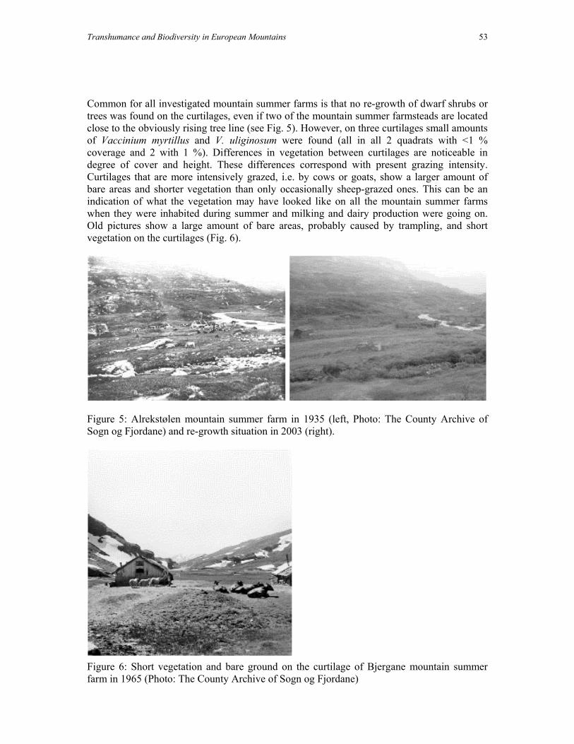
Transhumance and Biodiversity in European Mountains 53
Common for all investigated mountain summer farms is that no re-growth of dwarf shrubs or trees was found on the curtilages, even if two of the mountain summer farmsteads are located close to the obviously rising tree line (see Fig. 5). However, on three curtilages small amounts of Vaccinium myrtillus and V. uliginosum were found (all in all 2 quadrats with <1 % coverage and 2 with 1 %). Differences in vegetation between curtilages are noticeable in degree of cover and height. These differences correspond with present grazing intensity. Curtilages that are more intensively grazed, i.e. by cows or goats, show a larger amount of bare areas and shorter vegetation than only occasionally sheep-grazed ones. This can be an indication of what the vegetation may have looked like on all the mountain summer farms when they were inhabited during summer and milking and dairy production were going on. Old pictures show a large amount of bare areas, probably caused by trampling, and short vegetation on the curtilages (Fig. 6).
Figure 5: Alrekstølen mountain summer farm in 1935 (left, Photo: The County Archive of Sogn og Fjordane) and re-growth situation in 2003 (right).
Figure 6: Short vegetation and bare ground on the curtilage of Bjergane mountain summer farm in 1965 (Photo: The County Archive of Sogn og Fjordane)

54 K. Potthoff and S.Eiter
A general distinction concerning the development of vegetation can be made. In contrast to the curtilages that do not yet show any re-growth of shrubs and trees, tree regrowth can be observed around the farmsteads at the fjord, on the spring/autumn farms and— as already mentioned—close to the tree-line. Present land use The abandonment of mountain summer farming started at the beginning of the 20th century (see Table 1). In some cases the mountain summer farm was given up before the spring/autumn farm, in other cases the mountain summer farm was used exclusively for some time after the other had been abandoned. Reasons given by the individual farmers for abandonment can be summarized as economic, personal and practical (Eiter & Potthoff forthcoming). The use of the area for farming purposes is mainly reduced to sheep and some cattle grazing (see Table 1). Whereas sheep graze more freely—even when farmers keep them attached to certain areas by giving them salt—our observations show that cattle seem to be more connected to the mountain summer farmsteads. Unique in the area is the mountain summer farm of Skjelingen, where use with cattle was taken up again in 1958 (Bergfjord 1996: 130). At first it was limited to milking, but since the 1970s dairy production of mainly goat but also cow milk is also taking place (e.g. Eiter 2003). One factor behind this is the good road connection of that mountain summer farm; a national road connects it with the permanent farm. New land uses have, however, come in addition. The earliest reports of hiking tourists date back to the end of the 19th century (Øvrebø, oral communication). In their active farming period, mountain summer farmsteads were often used as lodgings by the hikers. Paths were marked by the mountain touring association. As mountain summer farming continuously declined, hiking tourists were provided with special cabins, most of them run by the Bergen Mountain Touring Association. The number of reported visits to three of the cabins in the area varied in 2001 between 120 and 940 (Bergen Turlag unpublished), and many of the hikers come from the agglomeration of the city of Bergen. Mountain summer farm buildings are, if still existent, mostly used for leisure stays by their owners, for summer or weekend holidays, or in the hunting season. Since about the 1960s, hydropower development has taken place. Construction roads were built, lakes dammed and high voltage lines constructed. This development gave rise to a counter movement based around nature conservation (e.g. Refsdal 2003) that has resulted in the establishment of a landscape protection area in the central part of the area in 1990. This area is now protected against further encroachments that may alter the character of the landscape, as e.g. further hydropower development (e.g. Fylkesmannen i Sogn og Fjordane 1998). What can be said about future farming use in the area? Summer pasture for livestock—especially sheep—will most probably remain an important resource because of limited grazing areas at the fjord. An increase in mountain summer farming with dairy production in the near future seems unlikely. The remote location of most summer farms makes, for example, necessary transport both economically and practically difficult. However, maybe hiking tourism—a land use presumably still having a high growth potential—will be able to create a market which can have a stimulating effect on mountain summer farming. Acknowledgements The authors thank The County Archive of Sogn og Fjordane for the permission to reproduce photographs. Mary Edwards, Michael Jones, Anders Lundberg and Kenneth Olwig have

Transhumance and Biodiversity in European Mountains 55
given valuable comments on the manuscript. The study has been supported financially by The Research Council of Norway. References Aastorp, S.M. & Skarpen, A.M. (1989) Stølsheimen. Et kulturlandskap i endring. Kandidatoppgave i Landskapsforvaltning og -planlegging, Høgskulen i Sogn og Fjordane, Sogndal. Bergen Turlag (ed.) (1952) Årbok 1952. Stølsheimen. Bergen. Bergen Turlag (unpublished) Besøksstatistikk for Bergen Turlags hytter 1969-2001. Bergen. Bergfjord, K. (1996) Tradisjon og fornying i stølsdrifta. Pridlao 13(1), 126-131. Brekke, N.G. (ed.) (1979) Stølar i Stølsheimen. Fylkeskonservatoren i Hordaland, Registreringsrapport nr. 5. Einevoll, O. (ed.) (1971) Stølsheimen. Landbruk, friluftsliv, vassdragsregulering – naturvern. Rapport utarbeidd for Stølsheimsutvalet, Ås. Eiter, S. (1999) Technische Eingriffe in norwegische Hochgebirgslandschaften und ihre ökologischen Auswirkungen – Beispieluntersuchungen im Stølsheimen/Vikafjellet-Gebiet. Diplomarbeit, Carl von Ossietzky Universität Oldenburg. Eiter, S. (2003) Kari Wester – Moderne budeie i Skjelingen. Aase, T.R. (ed.) Stølsheimen, 62-64. Eide forlag, Bergen. Eiter, S. (in prep.) Botaniske og økologiske studier som informasjonskilder for en landskapshistorisk tilnærming. Eiter, S. & Potthoff, K. (forthcoming): Landscape change and management in the Stølsheimen mountain area, a case study from western Norway. Bunce, R.G.H., Howard, D.C. & Pinto-Correia, T. (eds.) The landscape ecology of Atlantic mountains. Landscape series, IALE-UK. Eiter, S., Potthoff, K. & Weichert, K. (2000) Struktur von Ökosystemen und ihre anthropogene Beeinflussung im Stølsheimen/Vikafjellet-Gebiet – Ein Beitrag zur Hochgebirgsökologie Westnorwegens. Oldenburger Geoökologische Studien 3, Carl von Ossietzky Universität Oldenburg. Fylkesmannen i Sogn og Fjordane, Miljøvernavdelinga (1998) Forvaltningsplan for Stølsheimen landskapsvernområde. Rapport nr. 3, Hermansverk. Hesjedal, O. (1971) Vegetasjonstypar i Stølsheimen. Einevoll, O. (ed.) Stølsheimen. Landbruk, friluftsliv, vassdragsregulering – naturvern, 48-56. Rapport utarbeidd for Stølsheimsutvalet, Ås. Hoprekstad, O. (ed.) (1951, 1956, 1957, 1958) Bygdabok for Vik i Sogn I-III(2). Boktrykk L.L., Bergen. Ingvaldsen, H. & Nyrnes, M. (1979) Byggeskikken og dei einskilde bygningane. Brekke, N.G. (ed.) Stølar i Stølsheimen, 15-17. Fylkeskonservatoren i Hordaland, Registreringsrapport nr. 5. Knaben, G. (1950) Botanical investigations in the Middle Districts of Western Norway. Universitetet i Bergen, Årbok, Naturvitenskapelig rekke, Nr. 8. Knaben, G. (1956) Arnafjord- og Vikafjell, plantevekst og stølsliv. Hoprekstad, O. (ed.) Bygdabok for Vik i Sogn II, 30-80. Boktrykk L/L, Bergen. Lee, B. (1985) Stølen - Stølsdrift. Pridlao 2(3), 24-26. Moen, A. (1998) Nasjonalatlas for Norge: Vegetasjon. Statens kartverk, Hønefoss. Potthoff, K. (1999) Der Einfluß von Beweidung auf eine westnorwegische Hochgebirgslandschaft unter besonderer Berücksichtigung der Vegetation. Beispielhafte

56 K. Potthoff and S.Eiter
Untersuchungen im Raum Stølsheimen/Vikafjellet. Diplomarbeit, Carl von Ossietzky Universität Oldenburg. Potthoff, K. (forthcoming) The demarcation of property boundaries in the Stølsheimen mountain area, western Norway. Landscape, Law & Justice International Conference, Oslo 15–19 June 2003, Proceedings. Potthoff, K. (in prep.) Change in mountain summer farming practices: a case study from Stølsheimen, Western Norway. Refsdal, B. (2003) Kampen for Stølsheimen. Aase, T.R. (ed.) Stølsheimen, 10-19. Eide forlag, Bergen. Reinton, L. (1955, 1957, 1961) Sæterbruket i Noreg I-III. Instituttet for sammenlignende kulturforskning, H. Aschehoug & Co., Oslo. Rekstad, J. (1909) Geologiske jagttagelser fra strøket mellem Sognefjord, Eksingedal og Vossestranden. Norges geologiske undersøkelse Nr. 53, Norges geologiske undersøkelses aarbog I., Kristiania. Sevatdal, H. (1998) Common Property in Norway's Rural Areas. Berge, E. & Stenseth, N.C. (eds.) Law and the governance of renewable resources. Studies from Northern Europe and Africa, 141–161. Institute for Contemporary Studies, Oakland, California. Stoknes, K. (1997) Human-induced effects on vegetation. A quantitative community level study on alpine summer farms in Sogn, Western Norway. Cand. Scient. Thesis, Botanical Institute, University of Bergen. Uhlig, H. & Lienau C. (eds.) (1972) Die Siedlungen des ländlichen Raumes–Rural settlements–L'habitat rural. Internationale Arbeitsgruppe für die geographische Terminologie der Agrarlandschaft–International working group for the terminology of the agricultural landscape–Groupe internationale pour la terminologie géographique du paysage agraire: Materialien zur Terminologie der Agrarlandschaft–Basic material for the terminology of the agricultural landscape–Matériaux pour la terminologie du paysage agraire, Vol. II, Lenz-Verlag, Gießen. Utaaker, K. (1979) Lokal- og vekstklima i Sogn. Forskning og forsøk i landbruket 30(2), 113-204. Valvik, K.A. (1998) Lee – En tradisjonell vestlandsgård? En arkeologisk punktundersøkelse av gården Lee, Vik, Sogn og Fjordane. Hovedfagsoppgave, Universitetet i Bergen. Weichert, K. (1999) Geoökologische Untersuchungen in Westnorwegen am Beispiel eines Nord-Südhang-Profils im Vikafjellet-Gebiet. Magisterarbeit, Carl von Ossietzky Universität Oldenbur
Transhumance and Biodiversity in European Mountains 57
The outfarm landscapes of the Upper Setesdal Valley - history, vegetation and red listed species
E. Svalheim
Address e-mail: [email protected]
Introduction
This paper is based on studies conducted on the old high
summer outfarms of Bygland, Valle and Bykle, the three municipalities in the uppermost reaches of the Setesdal valley. These upland meadow landscapes are located along the edges of the high country where it meets the upper slopes of the valley in a zone ranging in elevation from 1640-4600 ft. (500-1400 m.) above sea level. Known as the heimeheia, or the home uplands, it is where livestock was kept on summer pasture and where grass was harvested for the winter.
Setesdal is a valley running north and south through Aust Agder, a county in
Norway’s southernmost region. It is in the transition zone between the Atlantic coastal climate and the inland continental climate of eastern Norway. The bedrock substrate in most of the region is composed of sour, hard rock materials such as granite and gneiss, which contribute little in the way of plant nutrients. However, deposits of calcareous cambro-silurian sedimentary rock (phyllite) at the north end of Bykle have produced a fertile soil rich in natural vegetation. The vegetation in this district belongs to the middle boreal, northern boreal, low alpine and middle alpine zones1. The high alpine type is not represented. But in most of the region, the low nutrient quality of the bedrock has resulted in sparse vegetation with few species. Most of Setesdal’s high summer meadowland is in the middle to northern boreal vegetation range (subalpine birch forest), with a few districts extending into the low alpine range. History and character of the high summer meadows
The farmers of the upper Setesdal valley (Figure 1) have been utilizing the high summer meadows for centuries. As early as 1660, between 95 and 97.5% of the farms in Valle, Bykle and Bygland had upland meadows, and the remaining farms eventually acquired such meadow land as well. It was also common for individual farms to have several summer outfarms. Setesdal was one of the areas in Norway in which the harvesting of grass was the most important function of the summer outfarms. Grass was harvested from bogs, upland pastures, woodland clearings and heath land and gathered into hay sheds or hayricks scattered around the area. In the mid-1800s it was normal for individual farms to bring in 10 to 30 tons of hay (Figure 2) from their outfields and outfarms. A meadow was normally mown at two or three-year intervals and grazed during the intervening years. Each farm had its own system for rotating its meadowlands between grazing and haymaking on a three to four-year rota.
1 Dahl, Elven, Moen & Skogen 1986
Figure 1. Aust Agder in southern Norway.

58 E. Svalheim
There were two types of outfarms: home outfarms and summer outfarms. The former were used spring and autumn, or only during the autumn. The summer outfarms were further off – from 3 to 25 km from the main farm, though the average was 4.2 km. The dairy people moved with the herds up to the outfarm around the middle of June and stayed there until the end of August. Harvesters came up after the middle of July to make hay, and kept at it until the end of September, breaking off only to harvest the cereal and grass crops on the home fields.
Over ninety per cent of the winter forage consumed in Setesdal was brought down from the upland meadows. Setesdal outfarm operations developed a distinctive character distinguished by the extensive harvesting of outfields and the largest number of outfarms per individual farmholding.
This type of operation continued unchanged into the early years of the 20th century. Outfield and outfarm utilization started declining in the 1930s, though the Second World War reversed the trend for a few years. The decline resumed and accelerated after the war, and by 1960 virtually all traditional outfarm operations had ended. Today, only sheep graze the upland meadows.
Types of vegetation linked to outfield cultivation
The utilization of outfields and the high summer meadows has had an impact on the local vegetation. Most of the outfarms are located in the northern boreal vegetation zone, with vegetation alternating between lichen and heather birch forest and bilberry birch forest. There are also smaller areas with the more fertile meadow birch forest. In this type of landscape, the most common anthrophogenous grasslands are: • Purple moor-grass (Molinia caerulea) grassland (G2). The predominance of purple
moorgrass is due in some degree to the substantial reduction or termination of grazing. • Common bent/red fescue/sweet vernal grass (Agrostis capillaris/Festuca
rubra/Anthoxanthum odoratum) grassland (G5). • Mat-grass/sheep’s fescue (Nardus stricta/Festuca ovina) grassland (G3). Develops under
heavy long-term grazing on nutrient-poor land from which thrifty woodland types have been cleared. Heavy grazing of healthy common bent/red fescue/sweet vernal grassland (G4) can lead to G5.
Other common, though less widespread, anthrophogenous grasslands include damp
poor grasslands (G1) and tufted hairgrass (Deschampsia cespitosa) grassland (G3). Intermediate/dry, medium base-rich upland grassland (G8), with a relatively high species count, is found in the old outfarm areas in the more fertile phyllitic parts of Bykle.
Figure 2. Setesdal’s outfarms were heavily used for haymaking. Photo: G.M. Haugland, ca. 1910.

Transhumance and Biodiversity in European Mountains 59
Redlist species in the outfarm landscape The occurrence of Arnica montana (Figure 3) is most widespread in Setesdal. Often found in mat-grass and sheep’s fescue grassland (G5) that was formerly outfarm pasture or meadowland, where mat-grass is able to dominate completely. Mat-grass predominance develops under heavy long-term grazing and grass harvesting on nutrient-poor land. In Bykle, Arnica montana grows up to elevations of 3000 ft. Hvitkurle (Leucorhis albida ssp albida) (Bykle 3600 ft.). Found in pasture and meadowland and in open rich-to-fairly-poor birch woodland. This species is declining. Often found growing with Leucorhis albida ssp straminea or in G8 grassland.
Current condition of outfarm landscapes – future challenges
Encroachment by trees and shrubs has reached an advanced stage in the old outfarm landscapes of Setesdal. This is especially true of the spring outfields near the home farms. Encroachment has not progressed so far at higher elevations. The degree of encroachment varies with the amount of grazing and other recent use.
In Setesdal, the number of grazing sheep has remained high, especially since traditional outfarm operations with grazing and grass harvesting came to an end in the 1950s. The Setesdal uplands are chiefly grazed by sheep, with approximately 35,000 in the home uplands and the high country beyond in Bygland, Valle and Bykle. In 1907 there were 28,250 sheep-equivalents2 grazing in the uplands and in 1939 there were 17,250 with cattle accounting for a large portion of this.
Sheep have helped keep encroachment under control in the old outfield landscapes, though they have not been sufficient to halt encroachment by trees on outfields in woodland areas from the softwood up to the birch belt. Nonetheless, grazing has helped maintain a wide range of anthrophogenous species. As meadows and unfertilised pasturelands revert to their natural state, the grazed woodlands become the last holdout for the old anthrophogenous species.
In Setesdal, the challenge of preserving the old outfarm landscapes may be met through more focused grazing and range management practices. Clearance of trees and shrubs and concentrated grazing are the key words.
2 Five sheep-equivalents is a forage-capacity measurement equal to one cow-equivalent or one horse-
equivalent.
Figure 3. Arnica montana in an outfarm pasture in Valle. Growing here with Nardus stricta.

60 E. Svalheim
References Jansen, L. & Ryningen, A., (1994). Valle kommune, vol. VII and VIII, Kultursoge. Reinton, L. (1955 and 1961). Sæterbruket i Norge, I .and III. Svalheim, E. & Jansen, L. (2002). Stølslandskapet på indre Agder. ISBN 82-92026-01-0. Project report. Fremstad, E. (1997). Vegetasjonstyper I Norge. NINA Temahefte (theme booklet) 12:1-279.

Transhumance and Biodiversity in European Mountains 61
Summer farming in Vangroftdalen, Os, Hedmark
V. Vandvik Department of Botany, University of Bergen, Allegaten 41,
N-5007 Bergen, Norway. e-mail: [email protected]
Introduction
The Vangroftdalen valley system, Os Municipality, eastern Norway (10o49’E, 62o37’N) covers an area of ca. 60km2 at altitudes between 700-800m above sea level (m.a.s.l.), and is surrounded by mountains reaching 1100-1200 m.a.s.l. The climate is continental, with a precipitation of only (504mm), and cold winters and relatively warm summers, with January and July mean temperatures of -11.2oC and 10.1oC respectively (data from the 30-year normal period 1960-1990, www.DNMl.no). The bedrock is relatively homogeneous, and consists of relatively base-rich Cambro-Silurean sediments (Elven 1984). The landscape is characterised by semi-natural subalpine birch forest and extensive mire systems, with summer farms scattered throughout .
The summer farming in Os
The Os community is a farming community, and livestock (cattle, goats, sheep) has been the primary source of income for the farmers. Due to the proximity to the mining community in Rors (high activity from ca. 1640 onwards) the demand for farm produce and wood has been high, and the landscapes have since developed under considerable cultural impact (Elven, 1984).
Vangroftdalen is one of the two major summer farming valleys of the Os community.
Up until ca. 1920 these were managed under a rotational system: each farmer had two summer farms, one in each of the valleys, and the valleys were used for summer farming with free-ranging grazers and set aside for outfield mowing in alternating years. In addition, they had separate summer farms, closer to the permanent settlement, and these were used in the spring and autumn. In the 1920’s outfield mowing ceased, the rotation system was discontinued, and most farmers now use only one of their summer farms. As a result, many summer farms have been abandoned, and of the 83 summer farms that have been registered in the valley (a survey based on all available maps from the area 1896 – 1960). Most farmers in the community still practice summer farming, 28 of the summer farms are in active use today. The remaining farms are no longer in active use. These have fallen out of use at a relatively constant rate during the last century, and for individual summer farms abandonment seems to be more closely linked to the individual farmer’s economy, family situation, etc. than to any characteristic of the summer farms (personal observation).
Traditionally the animals were walked up to the summer farms in early June, and
stayed there until early September. Most farmers followed the main route along the road up the valley. The distance between the permanent settlement and the summer farms is up to 50km. Today ca. 50% of the animals are still walked to the summer farms, the remaining use lorries for transport.

62 V. Vandvik
Traditionally, a relatively small local breed of cattle (Rorosku), goats, and sheep were held. Today, standard Norwegian NRF cattle and sheep prevail.
The summer farming landscape
Most of the summer farms in Vangroftdalen are concentrated in seven relatively extensive aras within the valley, but with a few farms scattered in between. The houses, typically traditional timber cottages with two rooms and a central kitchen is oriented east-west to intercept sunlight maximally. There has been timber barns on most summer farms, but most of these have been replaced by modern buildings at all farms in active use today. When the rotational system was still active there were large numbers of hay sheds scattered in the outfields, but these have mostly been lost during the past 80 years. Most farms have mowing fields, typically a few to ca. 20. These are generally fertilised by commercial fertiliser, any many are ploughed and resown. Additionally, considerable areas of mire have been converted to silage-producing grassland over the past 30 years.
The animals range freely in the mountains and subalpine forest during the day. The
outlying aras, as well as abandoned summer farms, are sporadically grazed by wild reindeer (especially in the early spring) and free-ranging domestic sheep. Today the valley is dominated by birch forest. In large areas of the valley, the forest has become dense and shrubs (Juniperus communis, Salix spp.) are expanding, making the landscape less accessible to the grazers.
The semi-natural vegetation
The flora of the area is rich, with 620 species of higher plants registered in the municipality (Elven 1984). The cultural impact has had considerable influence on the local flora, and Elven (1984) considers 97 of these taxa, 18.7% to be primarily of anthropochorous origin in the area. The vegetation of 55 summer farms in the valley was surveyed in 1997 (V. Vandvik, unpublished data). Vegetation types with different cultural impacts were found, from heavily trampled ruderals communities along paths and near the summer farm houses, productive relative species poor manured grassland, but also low-productive species-rich communities such as semi-natural grassland and meadows, as well as mires with clear evidence of former mowing. In the survey, that did not include mire vegetation, 232 species of higher plants were registered, with a mean of 74 species per summer farm. The species included ruderals such as Poa annua, Stellaria media and Veronica serpyllifolia, common grassland species such as Campanula rotundifolia, Geranium sylvaticum, and Viola tricolour, semi-natural grassland specialists such as Bothrychium lanceolata, Alchemilla wichurae, Carum carvi, Gentianella campestris, Leucanthemum vulgaris, common subalpine species such as Trollius europaeus and Ranunculus platanifolius, along with alpine species such as Gentiana nivalis, Primula scandinavica, and Veronica alpine that take advantage of the relatively open vegetation at the summer farms. Many of the grassland specialist species are declining in Norway today, and one of these species in the data, Botrychium lanceolatum, is listed as ‘requiring consideration (DC)’ in the Norwegian red list (www.dirnat.no).

Transhumance and Biodiversity in European Mountains 63
The present situation and challenges
As described above, summer farming is actively practiced in the valley today, but using different proportions of animals, and different breeds, than the traditional summer farming. Additionally, summer farming practices have changed, with the use of commercial fertiliser on the mowing fields and the discontinuation of the rotational system and the outfield mowing being the most dramatic changes. The result is successional change, especially in the outfields, and rapid loss of low-productive semi-natural grassland due to the combined effect of fertiliser application and abandonment.
References Vandvik, V. (2002). Pattern and Process in Norwegian upland grasslands: an integrated ecological approach. Dr. Scient thesis, Department of Botany, University of Bergen, ISBN 82-7460-011-8. 96pp. Elven, R. (1984). Floraen I Roros-omradet. University of Tromso, Unpublished report. 561pp.

64 V. Vandvik

Transhumance and Biodiversity in European Mountains 65
Summer farming in Roldal, Western Norway
V. Vandvik Department of Botany, University of Bergen,
Allegaten 41, N-5007 Bergen, Norway. e-mail: [email protected]
Introduction
The Suldal valley (59o50’N, 6o50’N) runs southwest to northeast into the Hardangervidda plateau in western Norway. The valley has a characteristic glacial topography with flat bottom, steep hillsides, and hanging side-valleys, and is surrounded by mountains reaching 1600 – 1700m above sea level (a.s.l.). Bedrock consists predominantly of Precambrian basement gneiss, with phyllitic Cambrio-Ordovician sedimentaries and amphibolites present locally (Naterstad et al. 1973). The climate is sub-oceanic, with high autumn precipitation and winter snowfall, and relatively small temperature amplitude (ca. 18oC). Two meteorological stations Roldal at 393 m.a.s.l. and Svandalsfona at 1200 m.a.s.l., record annual precipitation of 1444mm and 1245mm, respectively (Forland 1993), and July mean temperatures of 14.1oC and 9.8oC, respectively (Aune 1993). Steep relief and variable topography cause local climate variation within the broad-scale altitudinal climatic gradient (Sterten 1974). The climatic forest limit is ca. 800 m.a.s.l. on north-facing slopes, and 900m on south-facing slopes, but is heavily depressed around summer farms. The sub-alpine forest consists almost exclusively of Betula pubescens, and tall-herb and tall-fern communities are prominent on the steep hillsides. Above the forest limit the vegetation is mainly dwarf-shrub heath dominated by Vaccinium myrtillus, Calluna vulgaris, and Empetrum hermaphroditum (Odland 1981).
The summer farming in Roldal
Roldal is the uppermost community in the valley at 380 m.a.s.l. Large, productive summer-farming areas are located in the side-valleys at 650-850 m.a.s.l., and from ca. 1850 onwards Roldal was the major summer farming community in this region. Livestock (sheep, cattle, goats) from farms in distant parts of Ryfylke (e.g. Suldal, Kvinherad and Etne, up to 50-100km away) were transported here for the summers in a transhumance system involved close cooperation among farming communities in the region (Reinton 1961). This practice gradually declined during the 20th century, and was completely discontinued in 1965 when several large reservoirs for hydroelectric power were constructed around Roldal. These flooded many of the summer farms, others lost their access and were abandoned, whereas farms below the dams and in the other side-valleys were little affected and a local summer farming system, involving animals from the local Roldal community only, continued.
The summer farming landscape
As the most intensively utilised and most productive summer farming areas were set under water in 1965, the remaining summer farms around Roldal today are scattered in the landscape above and around the reservoirs. Today pure goatherds largely replace the traditional mixed herds, although few farms keep cattle. The houses, typically a traditional cottage and a milking shed where the goats can be kept inside during the night, is surrounded by ruderals communities, dung heaps, and paths. The goats range freely in the mountains and

66 V. Vandvik
subalpine forests during the day. Most farms have mowing fields, typically a few to ca. 20. These are generally fertilised with commercial fertiliser, any many are plough and resown. The outlying areas, as well as abandoned summer farms, are sporadically grazed by sheep.
The semi-natural vegetation
This case study is based on an ecological study of the vegetation o twelve summer farms in this valley system, representing a chronosequence from farms in use today to farms abandoned ca. 10, 20 and 40 years ago (Vandvik & Birks 2002a, b, Vandvik & Birks 2003). 189 taxa of macro-lichen, bryophyte, and vascular plants were recorded on the farms, with an average of 21 taxa per plot.
Three major vegetation types can be distinguished at the summer farms (Vandvik &
Birks 2003). The major features of these vegetation types can be summarised as follows:
(1) Dwarf shrub heaths and subalpine birch forest. These are located on steep ground away from the farms, and reflect semi-natural vegetation with relatively weak cultural influence. The soils are low in P and N. Vegetation is dominated by dwarf shrubs (Calluna vulgaris, Vaccinium myrtillus, V. uliginosum). Deschampsia flexuosa, Cornus suecica and Maianthemum bifolium are characteristic. The dense ground-layer is dominated by Pleurozium schreberi, Barbilophozia lycopodioides and Dicranum scoparium.
(2) Semi-natural low-productive grasslands. These occur on relatively flat ground at intermediate distances from farm centres. Soils are minerogenic, with intermediate pH and higher N content than the heaths. These infertile grasslands are characterised by Agrostis capillaries, Anthoxanthum odoratum, Carex bigelowi, C. brunnescens, Deschampsia flexuosa, Nardus stricta Phleum alpinum and Poa alpigena. Alchemilla alpine and Rumex acetosella are common. A number of less frequent herbs and grasses occur here, and species richness can be relatively high. The ground-layer is very variable, but often contains Rhytidiadelphus squarrosus and Drepanocladus uncinatus.
(3) Weedy and ruderal communities near farms. These vegetation types appear on soils with considerably higher pH, P and N values than the other vegetation types, whereas cation concentrations and organic content are variable. Species typical of intensively grazed and manured meadows dominate, but the vegetation composition is variable, with few species common throughout. Agrostis capillaris, Deschampsia cespitosa, Poa alpigena, P. annua, Rumex acetosa and Trifolium repens are characteristic. The ground-layer is sparse.
Rather than being distinct communities, these should be seen as reference points in a continuum, however, The vegetation at the summer farms is structured along a strong farms-to-surrounds gradient where grazing animal effect – both disturbance and fertilisation from urine and faeces – create strong gradients in both species composition and diversity Species richness in the data varies from very low to relatively high (7-46 taxa plot-1), with the most species rich communities being found at intermediate distances from farms. Overall the summer farms contribute to increase the habitat heterogeneity of the area, creating ecological room for a larger number of species and vegetation types (Vandvik & Birks 2003).

Transhumance and Biodiversity in European Mountains 67
The present situation and challenges
Since the dramatic changes in 1965 the summer farms in Roldal has been subjected to a gradual decline in use – following the general national trend. The relatively slow successional change at summer farms can at least partly be attributed to relatively high numbers of free-ranging grazing sheep in these mountain areas, and also too the practice of letting cows and goats roam freely in the mountains during the days. The grazers prefer the abandoned summer farms to the surrounding heaths (Personal observation) and this contributes to slow down successional trends of abandoned summer farms in the landscape. Still there is a significant successional trend in species composition, indicating that a continuation of the abandonment trend will have consequences for the flora and vegetation structure of the semi-natural vegetation types in the area.
References Forland, E.J. (1993). Nedbornormaler, normalperiode 1961-1990. Det Norske Meteorologiske Institutt, Oslo. Aune, B. (1993). Temeraturnormaler, normalperiode 1961-1990. Det Norske Meteorologiske Institutt, Oslo. Odland, A. (1981). Pre- and subalpine tall herb vegetation in Roldal, W Norway. Nord. J. Bot. 1: 671-690. Naterstad, J., Andresen, A. & Jorde, K. (1973). Tectonic succession on the Caledonian Nappe Front in the Haukelisaeter-Roldal Area, Southwestern Norway. Nor. Geol. Unders. 292: 1-20. Reinton, L. (1955, 1957 & 1961). Saeterbruket I Noreg I, II & III. Institutt for Sammenlignende Kulturforskning, Serie B, Skrifter, XLVIII, Oslo. Vandvik, V. & Birks, H.J.B. (2002a). Partitioning floristic variance in Norwegian upland grasslands into within-site and between-site components. Are the patterns determined by environment or by land-use? Plant. Ecol. 162: 233-245. Vandvik, V. & Birks, H.J.B. (2002b). Pattern and process in Norwegian upland grasslands – the relative importance of environmental factors and grazing effects can be elucidated by plant functional responses. J. Veg. Sci. 13: 123-134. Vandvik V. & Birks, H.J. B. (2003). Mountain summer farms in Roldal, western Norway – vegetation classification and patterns in species turnover and richness. Plant Ecol. in press.

68 V. Vandvik

Transhumance and Biodiversity in European Mountains 69
Transhumance in the British Isles – decline or transformation?
D.G.L. Jones1 & I.Ll. Wmffre2
1 SAC, Somerled Square, Portree IV51 9EH, Scotland, UK, e-mail: [email protected]
2 3 Pwllswyddog, Tregaron SY25 6JG, Wales, UK
e-mail: Abstract
Seasonal oscillatory movements of livestock accompanied by their herders were common throughout large parts of the British Isles in the sixteenth century. By the beginning of the twenty-first century movements of herders have ceased completely, but the extreme seasonality of growth on semi-natural pastures which underlies transhumance is still an important feature of grazing systems on those pastures which remain unimproved. We discuss the history of transhumance, reason why it might emerge and the factors that led to its transformation. We highlight some of the gaps in knowledge about transhumance in the past. Present day transhumance may be split for convenience into short- and long-distance varieties. We suggest that the latter may be a modern development and give examples of both from the Isle of Skye.
What is transhumance?
Transhumance is the seasonal oscillatory movement of livestock whether or not they are accompanied by their herders. Random or one-way movements of livestock have nothing to do with transhumance. Transhumance does not therefore encompass the selling of upland sheep to lowland farmers for crossing (the ‘stratified British system’), or the driving of cattle or sheep on foot to lowland markets. The ‘surviving transhumance’ of the Isle of Lewis, which occurs nowadays mostly for peat cutting and social reasons, now involves no livestock movements, and is no longer part of a transhumant pastoral system.
Transhumance does not need to involve the movement of people. But while animals’
movements with and without herds may well be ecologically equivalent (all else being equal), they are socially quite distinct. We therefore use the phrase ‘transhumant herding’ to distinguish the former practice.
French practice is to contrast transhumance (‘proper’) with ‘inverse’ transhumance. In
the former, stock move up to the summer pastures from the home farm. In the latter, the stock move down from the home farm for wintering. Our view is that transhumance (and other practices such as those we have just excluded from our consideration) usually occurs where one area of land has a pattern of production which is more seasonal than that which characterises another. Given the variety of climatic and edaphic conditions in the various parts of Europe, a more helpful distinction is one between situations where the stock

70 D.G.L. Jones & I.Ll. Wmffre
originates at (and belongs to) a farm located in the area of most seasonality and one where the home farm is in the area of least seasonality.
It is also worth recalling that although most transhumance in the British Isles was to a
summer pasture, the assumption that this is always the case obscures the importance of semi-natural winter pastures in areas like the Burren.
It is clear that for transhumance to occur, certain needs have to be present which can
then best be fulfilled by transhumance. For example: A. 1) Either there is insufficient fodder for livestock at some particular time of year
2) Or the livestock needs to be cleared from some area of land at some particular time of year
B. Land is available that can fill the need (this has legal/institutional as well as physical aspects)
For transhumant herding to be present: 1) Either herders need to remain with the livestock at all times for herding purposes 2) Or herders need to remain with the livestock at all times for production purposes
From this analysis it can be seen that there are in fact at least 4 combinations of conditions which result in transhumant herding, and changes in any of these can lead to its disappearance. However, some combinations do not lead to the disappearance of transhumance per se. Sources of information on past transhumance
Transhumance does not occur anywhere in the British Isles at the beginning of the twenty first century. The extent of transhumance in times past has to be estimated from a combination of primary sources. Dearth is too weak a word to convey the incomplete nature of the extant evidence relating to the exploitation of the seigniorial commons and which must be pieced together from a patchy and wide range of heterogeneous sources. Toponyms, legal documents and oral tradition are three categories which have their problems, particularly if one is interested in the importance of transhumance as a land use, rather than its mere existence, in an area.
To take place-name study as an example, transhumance is associated with a suite of
terminology that varies a great deal from one region to the next. Table 1, while not comprehensive, is an attempt to set out the various words used in parts of the British Isles, where known. Unfortunately, many of these words are not exclusively linked to transhumance. The distribution of the place name elements skáli (ON) and schele (ME), both meaning a hut, temporary shelter (Ekwall, 1960) may indicate the location of a pasture used by transhumant herders, but they may not. The Norse suffix -sætr, which undoubtedly means shieling, is nevertheless difficult, if not impossible, to distinguish adequately from the similar (and cognate) suffix -setr, a dwelling, except by a subjective analysis of the first element of the name or its location in the landscape (Nicolaisen 1976). Nicolaisen uses this logic to read all Skye’s -shadder place names as phases in the expansion of the area of Norse permanent settlement. MacSween (1959), on the other hand, sees an expansion up the hill of sheilings

Transhumance and Biodiversity in European Mountains 71
from ‘Norse’ to ‘Gaelic’ times, with the former Norse summer dairies becoming the permanent settlements they are today (Marrishadder, Ellishadder, Sulishadder, Uigishadder, Sheadar, etc.).
Similarly, in Wales writers tend rather simplistically to see the word hendre as being inextricably linked to hafod (summer dwelling). Wmffre (in prep.) shows that the link of hendre to mountain areas is in fact much more tenuous and that in the vast majority of cases signifies nothing more than ‘the old settlement’ of universal applicability.
Written records, particularly official ones, would perhaps seem more reliable. These
deal mostly with legal matters, and therein lies the root of their weakness. Matters of no legal consequence are ignored, while legally-significant issues are dealt with in terms which the legal system comprehends. Ideal legal systems attempt to impose order on disorder, but real ones sometimes impose a new order on a pre-existing, but incompatible, old order. In many areas of the British Isles traditional land use customs and systems (for example under Welsh or Irish or Norse or Saxon law) were a round peg which fitted with difficulty, if at all, into the centralising concepts of lawyers familiar only with southern England.
Verbal evidence or that of tradition is even more fraught with difficulties. Tradition
tends to be understood in terms familiar to the person and a practice, once dead, is easily forgotten. For example, in the Isle of Man, post-Mediaeval commentators were unaware of the former practice of transhumance and of the meaning of the term eary (shieling, Manx).
Pointers to the former distribution and decline of transhumant herding in different
parts of the British Isles This study has drawn overwhelmingly on secondary sources. Geographical coverage
of academic investigation of transhumance has been rather patchy. While its study has at times been in vogue (the 1930s–40s were such a period), the focus of the work has changed, reflecting the move away from ‘regional’ studies to a more process-based ‘scientific’ approach. The following is a brief synopsis of the distribution of transhumant herding over time and space in the various parts of the British Isles, based on the literature immediately available to the authors, and does not claim to be exhaustive, particularly for the Pennines and Southern Uplands: Scotland
Roy’s map of Scotland (1747–55, quoted in O'Dell, A. C. & Walton, K., 1962) shows that even then country was dominated by grazing land. The arable ground – a term still used in Scotland for any improved land in fields – was in those days just that, but it was almost all unenclosed. Such a system, where cattle were very important, could only work if stock was moved en masse seasonally, and transhumance must have occurred in more or less all parts of the country, if only for purely herding purposes. Even in Royal (hunting) Forests, grazing cattle at shielings was an accepted practice (O'Dell, A. C. & Walton, K. 1962).
Examples of work with maps showing the location of shielings are: Perthshire – Bil
(1990); NE Skye – MacSween (1959), Lochtayside, Assynt, Rum – Miller (1967). How long such transhumance had existed can only be guessed at, but it seems clear
that it predates the Norse invasions a thousand years ago. How its relative importance

72 D.G.L. Jones & I.Ll. Wmffre
changed over time is however not so clear. Dodgshon (1994, 1998) shows how in the Highlands (at least) land use was governed more by the needs of cereals on the arable than by the needs of cattle. At some times in the past then, the need to clear the unfenced arable land of stock may have been at least as important a reason for transhumance as the opportunity to take advantage of abundant seasonal growth on the hills
Working against this was the fact that tathing (the overnight dunging of fields by cattle
let out on the pastures during the day) was an essential part of maintaining the fertility of the inbye in the absence of farmyard manure (the cattle were outwintered), artificial fertilisers or nitrogen fixing crops. This gave an incentive not to send cattle too far from the fields, but to keep as large a number of cattle as possible. However, the number of cows that could be supported was determined not by the amount of summer grazing, but by the area suitable for wintering.
Even by the time Roy was making his map, transhumance involving herders had
started on its long demise. Haymaking was unknown in some areas until the eighteenth century, and the introduction of this simple technology, alongside more complex rotations (with legumes and fodder crops as well as cereals) and the potato together had very significant implications for transhumance. On the one hand more cattle could be overwintered, but on the other, the need to send them away to some far shieling became less urgent, and the labour demands of the new potato crop extended through much of the traditional summering period.
At much the same time the Union with England, the demise of the clan system in the
Highlands and the pacification of the country by the construction of hundreds of miles of new high standard roads opened up the possibility of huge new markets for Scottish beef. The suckler cow and bullock rearing sectors grew and dairying became localised in certain areas of Scotland. Only the lack of fencing out on the hills made any sort of herding necessary.
Enclosure of arable land in most of Scotland meant that the survival of transhumant
herding became more closely linked to that of dairy systems using summer pastures. In parts of North-east Scotland, these were completely lost to a two-pronged attack. The open rough pastures were almost all enclosed and improved and the cattle trade became geared to the export of high quality beef of the newly-developed Aberdeen Angus breed.
By way of contrast, the late enclosure of arable in the crofting areas of the North and
West meant that a form of transhumant herding persisted there even after the emphasis had shifted completely towards sheep and beef cattle (well into the twentieth century in the Staffin area of Skye, for example – James MacDonald, pers. comm.). At some times in the past then, the need to clear the unfenced arable land of stock may have been at least as important a reason for herding as the opportunity to take advantage of abundant seasonal growth on the hills.
The Scottish Borders became, for some reason, a region of agricultural innovation on a
European scale. Here in the twelfth century King David endowed the abbey of Kelso with 1000 acres of shielings on the slopes of the Lammermuir hills on which they kept 1400 sheep, as well as horses, cattle and pigs and on which they had 16 cottages for their staff. These were wintered on granges at lower altitudes (Franklin (1953)). By the eighteenth century, the local landlords’ control over the land led to the disappearance, not just of transhumant

Transhumance and Biodiversity in European Mountains 73
herding, but of the common pastures themselves (on a scale unique in the whole of the British Isles). They realised the potential of outwintered hill sheep based on the local Cheviot and Blackfaced breeds and these new sheep systems soon spread, usually at the expense of both cattle and people (Haldane, 1997). So while the likes of Kelso’s shieling might in other areas have developed into 16 small farms, in the Borders the growth of large ‘efficient’ farms was more common.
While sheep and goats are likely to have always been present in transhumant flocks,
they were apparently relatively few in number (perhaps the same number as the number of cattle) and most were inwintered. Generalisations on this matter are just that. Perhaps unexpectedly, the minister of Harris, writing in Statistical Account of 1791-99, complains that
‘the number of sheep … is great. Few of them are domesticated. They range unherded through the mountains and commons, where many of them are allowed to run wild, uncaught for years.’
His estimate of 11000 sheep means that there were 4½ times as many sheep as cattle
even at that time. (c.f. Present day ratio of 50092 sheep to 263 cattle (Ekos, 2001)). Similarly in the Lewis parish of Barvas (home, ironically, of the last airighean if not the last transhumant herding in the British Isles) , the minister notes that the sheep 'wander without a herdsman through the moor'. The simple picture of there having been but a few herded sheep did not obtain everywhere at any rate. It is interesting in the light of these accounts to speculate to what extent the economic importance of cattle as the main earner led to the downplaying of sheep and goats in other contemporary documents.
Nevertheless, it is generally true to say that across the country the number of sheep
rose markedly after 1750 as the new Borders techniques spread. Old misconceptions that sheep could not outwinter or were not suitable for droving were swept aside. Within a few decades there was a noticeable decline in pasture quality and numbers began to fall again (O'Dell, A. C. & Walton, K. 1962). But by now the cattle economy had moved on and the shieling did not return. Instead many large estates turned their hills over to deer stalking – a pastime popularised by the Royal family and made more commercially feasible in the nineteenth century by the gradual extension of the railway network.
The ending of transhumance at the Scottish Border has been dated to the seventeenth
century onwards, with remnants in some of the more backward areas on the poorest land until the mid eighteenth century. In Naworth the last shield rent was paid in 1634, being replaced by summer grazing leases. That in turn gave way to all year-round use of the moor by cattle bought from Scotland, kept a year and sold on down the ever-more-important droving route south. Only in the nineteenth century did breed improvement and better drainage techniques make sheep farming a more attractive prospect.
Shieling of sorts persisted in the far North West, but its last true vestige was the
clearing of house cows, hens and horses from open townships, not the summer peat-cutting excursion to the bothan that still clings on in Lewis. Northern and Western England

74 D.G.L. Jones & I.Ll. Wmffre
That transhumance in the upland province of Britain, west of a line from the Tees to the Exe, predates the Norman conquest is suggested by the existence of the existence of the cognate words hafod and hewas in Welsh and Cornish respectively (and even one example of hañvoud in Breton toponymy). Certainly the amount of semi-natural land potentially available for summer grazing was much greater in the early Middle Ages. In North-west England most names ending in -thwaite (ON Þveit ‘clearing’) were not recorded in Domesday, suggesting that extension of the œcumene onto the 'waste' was very much an active process at that time (Darby (1936). However, it is not so clear whether we are to infer an extension of permanent settlement or of any economic use. Any pre-Norse place-names in Cumbria and the Pennines that might have suggested transhumance seem to have been lost by subsequent occupiers.
We can however say for certain that the Scandinavian invaders definitely practised
transhumance. Place names with the ambiguous -setr and -skáli (both meaning 'temporary hut') and the easily-confused -sætr (summer pasture) are found alongside the unambiguous -erg, cognate with the Gaelic airigh (summer pasture). -Erg place names take transhumance back to the tenth and eleventh centuries and for there are numerous documentary references to the practice over the next few hundred years (Ramm et al. (1970). In some areas, such as at the boundary of Northumberland and Cumberland, the word 'shield' (derived from -skáli) certainly applied (inter alia) to herdsmen's huts and records suggest that the practice was active from before 1599 and survived until at least the eighteenth century. Nevertheless, it is noteworthy that the sheepwalks (herdwicks) that the Norse immigrants established have given their name to a breed of sheep that is just as good at hefting as any other mountain breed. How and when did this ability develop, and what implications does it have for the implied role of actual transhumant herding in the past management of the upland pastures?
It is a similar story with the Cistercian monasteries. There is no doubt that they owned
vast tracts of unimproved pastures or that they introduced large scale sheep raising for the first time to many areas of the uplands. However, to what extent did their management involve anything more than the active shepherding which prevailed in most of these areas in living memory - did it necessarily involve transhumance or transhumant herding?
The growth of centralised government in England from the twelfth century onwards
saw lowland models, 'describing' and governing the use of common pastures, 'wastes' and the like, applied without distinction to upland areas where different conditions obtained.. For instance, in English Common Law intercommoning (the grazing of animals from one lordship on the common land of both that lordship and the adjacent common of another lordship) was theoretically banned over more than two commons and was held not to be a right on the adjacent common, but only to occur with consent. Nevertheless, some of the largest tracts of common land in England have very complex rules allowing multiple intercommoning as of right.
The right of intercommoning of many parishes surrounding the remnants of the once
much larger Forest of Clee in Shropshire is one example (Rowley, 1972). Even more famous are the complex rules governing the use of the commons of Dartmoor – the largest area of semi-natural vegetation in Southern England. Not only is there intercommoning between the surrounding parishes on the central Forest of Dartmoor, but the surrounding Commons of Devon are theoretically open to stock from the whole of the county (Hoskins & Stamp (1963)).

Transhumance and Biodiversity in European Mountains 75
Are these therefore remnants of pre-Norman transhumance? The existence of these
rights and customs may suggest that they were established before the King’s courts had fully asserted their authority. On the other hand, an argument may be made that all the ‘separate’ commons are in fact the relicts or the subdivisions of one great common all belonging to one lord – the Duke of Cornwall in the case of Dartmoor, for example.
It is not clear when transhumant herding disappeared in south-west England, but there
is little reason to doubt that, in common with the Pennines, it declined in the seventeenth century (Ramm et al, 1970). In the Northern Pennines, some moors became sheepwalks, while others were turned, at least for a time, to bullock-fattening pastures, taking in beasts from Scotland and sending them a year later down to lowland England to be killed. South-east England
In the England south and east of the Tees-Exe line, cattle were traditionally secondary to sheep. These were a key part of the open field system which dominated in much of the area, helping to maintain fertility by facilitating nutrient transfers within and between the fields. Technical limitations meant that even in the lowlands feudal theory had to deal with the management of the 'waste' of the manor. This might include marshes or heaths, downs or sand dunes and would have been much more extensive than the few relict areas which survive today. Areas such as East Anglia, which today are thought of as centres of arable cultivation, became rich on the back of the wool trade and a multitude of lowland breeds of sheep were developed in the various sheep-raising centres - Norfolk, Hampshire Down, Dorset Down, South Down, Romney Marsh, etc.. Suffolk was famous for its sheep’s cheese.
Does the existence and importance of these sheep imply that there was transhumant
herding? Carrier (1936), quoting Youatt, states categorically that in some areas there certainly was – prior to land improvement, Somerset was apparently one great sheepwalk from the fens of Sedgemoor to the limestone uplands of Mendip, with flocks moving from one to the other according to the season. Similarly, 'in Domesday times' flocks moved from the fens of East Anglia to the chalk grasslands of the 'uplands' and the sandy soils of the Breckland. Hoskins and Stamp (1963) point out that the frequent occurrence of intercommoning on the Lincolnshire marshes probably dates transhumance here to pre-Norman times. Wales
The history and distribution of transhumance in much of Wales has been set out by in a series of papers (Davies, 1935a, 1935b, 1973, 1977, 1979, 1980, 1984) and need not be repeated here. Suffice it to say that there are no areas of Wales above 250 m or so where it is clear that it did not take place. Wmffre (in prep.) provides as critical review of toponymic elements generally associated with transhumance. For the shieling settlement one finds the medieval hafod, a term replaced by the sixteenth century by hafoty (North Wales) and by lluest (South Wales). Previous authors have pointed out that hafod is less confined to mountains than the terms which superseded it – Hafod y morfa (Merionethshire) means 'summer dwelling of the saltings'. This may indicate that transhumance was (as in the rest of Britain) more widespread and used more types of land in earlier times.

76 D.G.L. Jones & I.Ll. Wmffre
Medieval records from Gwynedd refer to havoteries (a mixed French-Welsh composition based on hafod) which seem to have exploited extensive areas of upland as an agricultural unit akin to extensive cattle ranches. Deeds from Cardiganshire written following the incorporation of Wales into England in 1536–42 contain intriguing references to summer pastures and their boundaries, dairies and the like.
As in the rest of upland Britain, fitting Welsh transhumance practice into centralised
concepts of English lawmakers proved difficult. In a manner reminiscent of Dartmoor, Hoskins & Stamp (1963) report that the whole of the lordship of Gower from the hills of the South Wales coalfield to the moors at the very tip of the peninsula was once open to any of the commoners of the lordship. According to Hoskins and Stamp, the survival of the present-day Gower commons remind us how much more attractive an interest coal mining was for local landowners compared to agriculture improvement. To what extent are these also examples of lordships which, for whatever reasons, ‘narrowed their horizons’, regarding the remaining commons as being part of a local rather than a regional agricultural system? After all, if there is only one legal common, there is no ‘problem’ of intercommoning!
Was this pattern mirrored in the rest of Wales? Some lords had large, extensive lands
where rights of use might extend over tens of kilometres or more (e.g. the rights of the monastery of St Dogmael’s to the grazings of Mynachlog Ddu). However, it is one thing to have rights, it is another thing to exercise them yourself. It is yet another thing to exercise them in two widely separated places using the same livestock. The benefits of ownership of stock compared to the guaranteed income of a grazing rent from a third party are by no means clear and there must be suspicions that such arrangements would have arisen at least occasionally in the past, particularly as ‘lords’ became ‘landlords’ and feudal ties weakened.
If intercommoning is a question whose implications are more or less confined to the
law school, other issues were of real practical significance. As long as local law was enforced by local courts leet, and while disputes were between graziers steeped in the same traditions and customs, problems could be avoided. Questions concerning the degree to which land which was grazed as discrete shielings (libert, sheepwalk) could be described as 'common' were academic. The thorny issues arising out of the inclosure of these liberts of upland grazing in the nineteenth century surfaced when transhumant herding had already breathed its last, but raises issues which cast a light back into the use of upland pastures in earlier times. This involves considering complex historical and legal issues and there still remains an enormous amount of research to be carried out before we can accept the following scenario, which is based on work carried out in Cardiganshire (Wmffre in prep.), as the full and final picture.
As far as can be ascertained, most of the oscillatory livestock movements in Wales
(and indeed the British Isles) in former times entailed the transfer of animals to seigniorial commons. These commons were typically constituted of extensive tracts of upland rough pastures or low-lying wet areas and in contrast to appurtenant commons – which were in the exclusive ambit of the landowners concerned – seigniorial commons were administered by jurisdictional authorities (King, Church, lords) through seigniorial courts.
It would appear that seigniorial commons were originally administered in each
lordship as one economic unit, a practice which may have survived to this day in Ysbyty-Ystwyth where a shepherd manages the hefting of sheep on behalf of the farmers of the

Transhumance and Biodiversity in European Mountains 77
locality. By the mid eighteenth century, however, we find Cardiganshire's seigniorial commons partitioned into a number of independent sections, termed libert in Welsh and sheepwalk in English. Lewis Morris, the mining agent of the Crown in its lordship of Perfedd, Cardiganshire, reported:
There hath been time out of mind, a division of the common [of the lordship] into particular districts or liberties next adjoyning to the freeholds or cottages which all the shepherds thro’ boldness or ignorance claim as their own right, and sometimes chase other people’s cattle away.
Each libert was a dependent upon a farm, whether adjacent or some miles away, and seems to have enjoyed the exclusive benefits of an ordinary holding except that it could not be sold separately from its possessing farm.
It is not known whether or not such permanent partition of seigniorial commons into
individual liberts was occurred in ‘time out of mind’. But judging by the English origin of the word (from liberty, with the meaning 'franchise'), it seems likely that permanent partitioning may have had something to do with the emergence of sheep as the main economic earner (though note the fact that Morris mentions chasing cattle and not sheep). The sheep’s hefting instinct allowed for less supervision and a consequent relaxing in the need of manpower, thus the demise of full transhumant herding seems to have accompanied the demise of cattle as the main economic earner during the eighteenth century. The apparent continued productivity of the terms hafoty and lluest as descriptive terms for locations in deeds up till the end of the seventeenth century suggests that there existed till that time a category of summer settlement that supposes the continued existence of transhumant herding. It is however important to remember in this context that cattle raising for beef was much more important in Wales pre-1750, than it was in Scotland and that Welsh hill pastures and summer dwellings cannot be considered as exclusively dairying-related.
The partitioning of the seigniorial commons between farms differed according to
localities and can be compared in the tithe maps of the early nineteenth century. In some cases every holding in the lordship acquired a libert (Pennardd). In many other cases only holdings adjacent to the commons acquired a libert (much of northern Cardiganshire). In the extensive lordship of Mebwynion only the farms in the parish of Llanfair Clydogau – that is the parish adjacent to the seigniorial commons – acquired liberts, effectively transforming a seigniorial common into a parochial one.
Beyond the disparities between localities we can perceive that those holdings which
were in geographical proximity to the commons had an almost inexorable economic advantage to holdings situated further away, irrespective of whether their legal claims to the commons were equal. The corollary to the geographical advantages of adjacent holdings in the partitioning of the commons was that in Cardiganshire many of farms adjacent to the mountains came to specialise in shepherding the livestock of more distant farms this being the means by which the economic logic behind transhumance continued.
Davies's detailed work in several Welsh counties shows the shielings he dealt with
were just on the waste beyond the farm boundary. Over the years many of them became incorporated by encroachment not just into the general area of settled agriculture, but into their home farm. This was one way in which transhumance became either lost or hidden

78 D.G.L. Jones & I.Ll. Wmffre
within the practices of the individual unit. In other areas, the hills remained in common, but again the absence of written rules for most commons under English law means that we have very little information on which to hang our suppositions. Ireland
The evidence of the loan word -erg, shieling, cognate with modern airigh, in the Norse of the ninth century invaders of the Lake District suggests that summer pasturing was a common feature in the Gaelic world at that time. Aalen, Whelan and Stout (1997) say that cattle have always been at the heart of Irish culture. They point out that in Ireland legends are more likely to involve fields and bulls and cattle than forests, wolves and bears. Although there was also cereal growing in Ireland and although the present bocage landscape is relatively recent in many areas, there is nevertheless a stress on pasture land that sets it apart from, for example, lowland England. In contrast to North-east Scotland, for example, the mild winter temperatures allowed for some grass growth throughout the year and only with the coming of the potato did dairy products lose their central place in the Irish diet.
As in Scotland, large tracts of Ireland remained open rough pastures until the
seventeenth century, and while this was the case, transhumance (or booleying, from the Irish buaile, a shieling) thrived. Graham (1970) has been able to map the location and connection between winterings on the shores of Loch Corrib and summer pastures on the moors of Cois Fharraige in Western Co. Galway based on documents from the seventeenth century. Two hundred years later, place names containing the ‘booley’ element gradually become absorbed into the area of permanent settlement. The foundations of the South-western dairy industry were laid as early as this period. The rest of ‘productive’ Ireland became more specialised in 'tillage' and beef, with the latter having no choice but to be more and more 'field-based' as the open land was gradually encroached away.
By the middle of the twentieth century, the remnants of transhumant herding in Achill,
Co. Mayo, were regarded as something of an antiquarian curiosity and it seems inconceivable that conditions would have been any more conducive to its practice since well before the potato famine of the 1840s. While the bocage landscape and beef production took over much of the lowlands, the Irish mountains were no more immune than the in the rest of the British Isles to the spread of sheep and the Scottish Blackface is now by far the commonest breed in Western Ireland. And as in the rest of the British Isles, their seasonal movements are by no means well-documented.
Isle of Man
'Excavations at a group of 50 mounds at 300 m on the North slopes of Snaefell have yielded evidence of cheese-making, weaving and stock control, as well as a penny bearing the image of King Stephen (c. 1131). These are found at a significantly higher altitude than the surviving 'eary' (cognate with G airigh) place names, which are generally now on the upper, enclosed, areas of farms. Some writers postulate that these two sets of features are from different ages and/or cultures. In any event, the meaning of eary was lost in post-mediaeval times. While the high altitude shielings were abandoned, possibly in response to climatic deterioration after the Middle Ages Optimum, the lower eary sites were absorbed into permanent occupation as population pressure grew (all the preceding from

Transhumance and Biodiversity in European Mountains 79
http://member.rivernet.com.au/manxman/mod (acc. 2003) and http://member.rivernet.com.au/manxman/mod2 (acc.2003)). Patterns in the decline and transformation of transhumance
In the British Isles, some of the factors surmised by various authors to have contributed to a decline in transhumant herding in different areas have included: - the fencing of open rough grazings (so that herding became unnecessary) - the improvement of rough grazings (so that seasonality became less important) - the improvement of stock hardiness (so that seasonality became less important) - encroachment - hill becomes inbye (so that in combination to the above, rights to
summering land became separated from the home farm) - the fencing of inbye (so that keeping stock away from the land stopped involving constant
supervision) - the extension (and enforcement) of claims of property rights over open land by large
landowners - the extermination of predators (wolves in particular) - the cessation of widespread cattle rustling - the decline of upland dairying as cattle farming became more market-led and as the size of
the market grew as a result of better transport links and specialisation spread (loss of production rationale)
- the introduction of large-scale sheep farming, partly as a result of overcoming superstitions about the ability of sheep to outwinter (hefting, and later fencing, become important labour savers)
- the introduction of improved rotations, including hay, clovers, fodder crops etc. (enabled cattle to be summered on the farm)
- a decline in the keeping of wethers on hills (purchased wethers needed herding or at least a period of intense shepherding before they were settled on their new hill, e.g. 3 weeks night and day on the Brecon Beacons (Glyn Davies, pers. comm.))
- the availability of alternative employment for herders - climatic change? - the Middle Ages were a period of climatic 'Optimum', but it was
followed by the 'Little Ice Age', possibly leading to a deterioration of summer pastures - the repeal of the Corn Laws, making the keeping of cattle on inbye fields more attractive
relative to tillage
In practice, this mish-mash led to relatively few types of outcome, which can perhaps be summarised as follows: 1) Complete enclosure and/or improvement and drainage of the land involved and a shift to
various 'lowland' agricultural systems. This was driven by technology on the one hand and population pressure on the other. This led to the complete demise of transhumance and happened mostly in the lowlands of the British Isles, particularly, but not only, in the drier East.
2) A change to unherded systems of livestock husbandry, possibly with some seasonal movements, particularly of young stock. Technical developments that contributed to this included the development of hardy, hefting sheep breeds and wire fencing. Improved transport and socio-political developments (particularly the Union of England and Scotland and the suppression of the Scottish Highlands) promoted the regional

80 D.G.L. Jones & I.Ll. Wmffre
specialisation of agriculture, which for the hills meant the production of store stock and late-maturing wethers and bullocks. The ending of stock rustling must also have been of local significance.
3) The introduction of new patterns of seasonal movement, made possible by the better transport networks and the erosion of old feudal rules governing who could use what land. Livestock could now move long distances, in a way which could not possibly have developed directly out of transhumant herding. Examples are the presence of Galloway cattle on Dartmoor (Carrier, 1936), Sussex and Kent sheep on dairy farms in Somerset and Northumbrian sheep on the Brecks of East Anglia.
An example of present-day transhumance in the British Isles
The Isle of Skye in NW Scotland will be used to illustrate some of the present-day manifestations of transhumance in the British uplands. Skye has a surface area of just under 174 000 ha, of which over 130 000 ha are divided into 146 common grazings and used by about 1950 tenanted smallholdings called crofts organised into about 600 agricultural businesses. These businesses, plus 20 or so larger farms, between them carry about 95000 sheep and 2900 cows (all data in this paragraph from www.bambi.demon.co.uk/skyedata/crofting.html (acc. 02/08/03) and associated pages).
The climate of Skye is cool temperate, with a significant oceanic influence. Winters
are cool, wet and windy, with short days. Summer days are long, and sunshine figures are high, but temperatures remain cool and rain is frequent. These conditions produce a large flush of vegetation from about May to September. In the other months, temperatures may often be conducive to plant growth, but soil conditions are waterlogged for long periods.
These conditions allow for the outwintering of sheep, but are nevertheless difficult,
particularly for young females in their first winter (hoggs). These animals are still growing and are not put to the ram for another year. Even without the extra burden of a developing lamb inside them, they succumb easily to the rigours of a Skye winter. The solution is to winter them on inbye fields on farms on the east coast of Scotland – in Easter Ross, E Inverness-shire, Nairnshire and Morayshire.
Cattle are also outwintered on some holdings, but on others they are inside. Some
crofters avoid the necessary capital investment by sending all their cows away to the same areas for wintering.
Few crofters have their own lorries, depending instead on commercial hauliers.
Assuming that ewes have a breeding life span on Skye of 4-5 years, there are around 19 000 hoggs. The island’s local carriers haul around 6000 a year (D MacLeod, E MacKinnon, pers.comm.), so a conservative estimate of the total movement must be around 10 000 animals. On top of this at least 15% of the island’s cow population moves East for the winter.
For the stock that stays at home, there are short-distance local movements, some
probably carried out for historical reasons (the need to clear stock from the previously unfenced township, for example), but others allow for greater township control over bulling and tupping, marking of lambs and the like. These movements are not only between crofts and township grazings, but also in some areas onto larger ‘general’ grazings, shared by many townships.
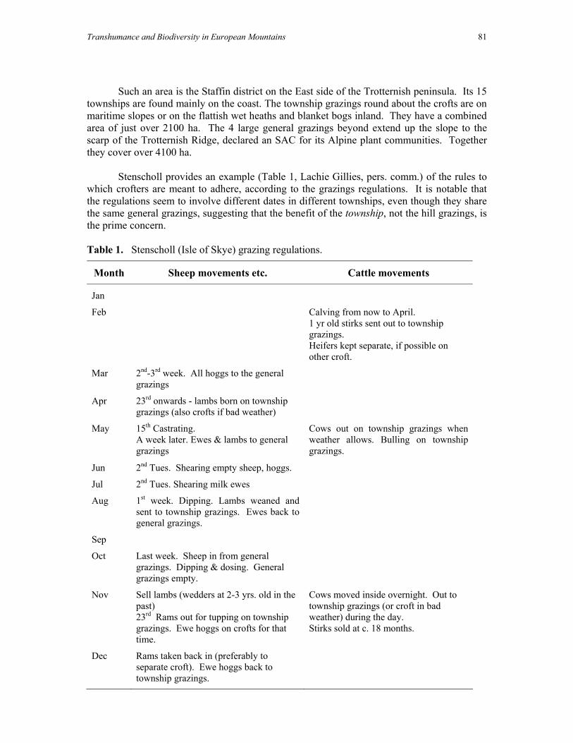
Transhumance and Biodiversity in European Mountains 81
Such an area is the Staffin district on the East side of the Trotternish peninsula. Its 15 townships are found mainly on the coast. The township grazings round about the crofts are on maritime slopes or on the flattish wet heaths and blanket bogs inland. They have a combined area of just over 2100 ha. The 4 large general grazings beyond extend up the slope to the scarp of the Trotternish Ridge, declared an SAC for its Alpine plant communities. Together they cover over 4100 ha.
Stenscholl provides an example (Table 1, Lachie Gillies, pers. comm.) of the rules to
which crofters are meant to adhere, according to the grazings regulations. It is notable that the regulations seem to involve different dates in different townships, even though they share the same general grazings, suggesting that the benefit of the township, not the hill grazings, is the prime concern.
Table 1. Stenscholl (Isle of Skye) grazing regulations.
Month Sheep movements etc. Cattle movements
Jan
Feb
Calving from now to April. 1 yr old stirks sent out to township grazings. Heifers kept separate, if possible on other croft.
Mar
2nd-3rd week. All hoggs to the general grazings
Apr
23rd onwards - lambs born on township grazings (also crofts if bad weather)
May
15th Castrating. A week later. Ewes & lambs to general grazings
Cows out on township grazings when weather allows. Bulling on township grazings.
Jun 2nd Tues. Shearing empty sheep, hoggs.
Jul 2nd Tues. Shearing milk ewes
Aug
1st week. Dipping. Lambs weaned and sent to township grazings. Ewes back to general grazings.
Sep
Oct
Last week. Sheep in from general grazings. Dipping & dosing. General grazings empty.
Nov
Sell lambs (wedders at 2-3 yrs. old in the past) 23rd Rams out for tupping on township grazings. Ewe hoggs on crofts for that time.
Cows moved inside overnight. Out to township grazings (or croft in bad weather) during the day. Stirks sold at c. 18 months.
Dec
Rams taken back in (preferably to separate croft). Ewe hoggs back to township grazings.

82 D.G.L. Jones & I.Ll. Wmffre
It can be seen from Fig 1 that the present-day transhumance involves much the same distances and direction of travel as the old herder-accompanied movements, with the exception that cattle seem not to move onto the highest hill ground as they once did.
What were/are the distances involved in transhumance in the British Isles?
This is perhaps one of the most difficult questions involved with transhumance. Too often twentieth century authors have extrapolated past practice from what went on in at the time of writing. There is transhumance between the hills of Wales and the lowlands, between the Lake District fells and the Solway saltmarshes, between Romney Marsh and the ‘uplands’, in Dartmoor, and so on (e.g. Walton (1919–20), Carrier (1936)). None of these summering and wintering systems now involve transhumant herding, but do they mirror earlier movements of both livestock and people?
In some cases the answer has surely to be no. Cattle would never have moved from
Galloway to Dartmoor or from Northumberland to the Norfolk/Suffolk border in the days before the advent of efficient rail and road transport. In many cases these movements would also have been, if not impossible, then rather difficult to rationalise in the days before today’s extreme regional agricultural specialisation emerged. Somerset dairy farms would have taken Somerset sheep, while the sheep from South-east England which are now sent there would no doubt have used pasture land on local farms now completely given over to arable. In the same way, Northumbrian sheep would in the past have had to compete for Breckland grazing with East Anglian sheep.
Bearing in mind the caveat made earlier that having rights to a grazings is not the
same as actually using the grazings yourself, we can divide the reported distances from the home farm to the shieling (Table 2) into local transhumance (5 miles and below) and (at least apparent) long-distance transhumance (5 miles and above). The evidence collected – admittedly cursory – suggests that the distances involved in most transhumance across the British Isles were strikingly short. Transhumance over great distances – the grande transhumance of France and the trashumancia of Spain – seems unknown. Table 2. Distances between home settlement and dependent pasture.
Source Location Range of distances
Miller (1967) Assynt, North Lochtayside, Rum 1–2 miles Bil (1990) Perthshire 1–3 miles (home shielings)
3–12 miles (summertowns) MacSween (1959) NE Skye 1–4 miles Wmffre (in prep.) Cardiganshire 1–5 miles Davies (1973, 1977, 1979) Merionethshire, Denbighshire,
Caernarfonshire ‘no great distance’ (a few miles at most)
Ó Moghráin (1943) Achill 2–6 miles Graham (1970) Co Galway 1–25 miles Gaffney (1959) Strathavon 3–18 miles Wmffre (in prep.) St Dogmaels –> Mynachlog-ddu 10 miles O'Dell, A. C. & Walton, K. (1962)
Loch Monar (Lochalsh shieling grounds)
20 miles
Sayce (1956, 1957) Aberconway –> Cerrig-y-drudion c. 25 miles

Transhumance and Biodiversity in European Mountains 83
The distances involved in most movements in the British Isles may differ little from some of the longer daily movements to hill pastures undertaken by some dairy herds in present-day Romania, for example. There is evidence from the sources that a hybrid system was common in many areas – the stock remained at the shieling and their milkers travelled up and down daily (or twice daily) (e.g., Sayce, 1957). If we consider dispassionately the reasons for transhumance, perhaps this should not be so surprising. Movements whose main purpose was to clear the inbye of stock were likely to be as short as possible. To take advantage of seasonal growth transhumance ‘proper’ would start at a distance where travelling back and forth in a day became inconvenient.
The contrast Bil reports in Perthshire between the adjacent ‘home shielings’, which
were associated with daily movements of people (and probably tathing practices) and the more distant ‘summertowns’, which were separate residences is probably a more accurate picture of the coexistence of different practices within one locality. The two types of transhumance appear to have operated in Dartmoor, with local transhumance only in the Forest of Dartmoor, and a mix of local and long-distance transhumance in the Commons of Devon. Swedish hem-fäboden (Sayce, 1956, 1957) appear to involve the same concept as does 'pendulation' in Romania or trasterminancia in Spain which cover distances of a few kilometres.
Nowadays, the pattern of seasonal movements in Wales corresponds quite closely to
that of Skye, but with much more variation in practice due to the lack of detailed rules for the use of commons and the fact that many more hills are for the sole use of one farm. Over and above local (often within-farm) movements on a similar scale to those to the 'home shielings', there are long-distance movements of yearling sheep and some older ewes, similar to those as detailed in Davies (1935a,b). Distances of 10–30 miles are not unusual. The seasonality of vegetation growth which gave rise to these movements to 'tack' are the same as those which necessitated transhumant herding, but are they therefore on the same scale?
The grandmother of first author of this paper came from a farm, Cwmdulas, in central
Cardiganshire (Wales) whose hill ground had been subject to enclosure from the common in the 1889. Her parents lived in a time of meagre capital and ample job opportunities, for men at least, in the collieries of South Wales. Account books record that a dozen farms and more sent sheep to be summered on their land, and, according to one of their sons (Glyn Davies, pers. comm.) this pattern was repeated across the mountain at that time. Some sent many, some sent just one. Other farms sent geese to the same mountain. Few of these farms were within the immediate vicinity of Cwmdulas, but were up to 15 miles away. Tantalisingly, some were from parishes formerly all belonging to the same lordship – that of the Bishop of St. David's. Many others were not, but were close enough to raise hopes of an underlying pattern. None of these type of movements are recorded anywhere in any official documentation.
The question is, were they the ghost of former long-distance transhumant herding on a
world where it had long since died or a 'modern', 'commercial' response to the economic conditions of the day, no more 'traditional' than sending hoggs to the lowlands? Gaffney (1959) tells of the practice of taking in gall (i.e. foreign) cattle to graze shielings on the Banffshire/Aberdeenshire border along with the local cattle in the mid-eighteenth century.

84 D.G.L. Jones & I.Ll. Wmffre
Mentions of obviously transhumance-related items in Welsh deeds from the sixteenth and seventeenth century could mean that the practice was still very much alive. On the other hand, the fact that they are mentioned at all could itself signify that transhumance's true vitality had already gone. Even in Caernarfonshire, where Welsh custom and law might perhaps be expected to be most long-lasting, Davies says that transhumance, although it survived in places until the mid nineteenth century,
‘had been in recession since the sixteenth century [our emphasis] at the latest, and with gathering speed since the end of the seventeenth century'.
Kay, writing of Caernarfonshire in 1794, only 20 years after Thomas Pennant made
his famous description of shielings in that very county, failed to find any traces of the practice. Perhaps Pennant’s curiosity was aroused both in Wales and, equally famously, in Glen Tilt, by the very unusualness of the practice by that time.
It may be hypothesised that transhumant herding over longer distances, while not
necessarily older than shorter movements, decayed earlier and that very little evidence remains of them in the written record. Why they would have disappeared earlier might simply be due to the likelihood that the farms involved would have been on better ground. They would have benefited earlier from developments in farming techniques and in the expansion of the market. For them absolute need to shift in order to survive would have disappeared and the number of positive reasons to stay would have increased at a very early date. If these were the movers and shakers of society, then perhaps just their increasing lack of interest would itself have served to weaken the institution. We don’t really know. As time progressed their specialisation into arable or dairying would again have opened up the possibility of transhumance onto under-utilised forage resources, but this time taking in stock from specialist hill stock farms. What types of livestock were and are involved in transhumance?
The demands of dairying were in all probability the main rationale for shieling in most of the British Isles for the vast majority of the period over which transhumant herding persisted. Wales, where raising beef cattle for the distant urban markets was important much earlier than in Scotland, for example, may be an exception. The interesting question is to what extent shieling survived the increased specialisation of agriculture in the eighteenth century or whether the decline of dairying geared towards subsistence, e.g. cheeses, or at most a local market was the main reason for its demise. Cattle, even when accustomed to going to hill ground for summering, do not develop a hefting behaviour with each cow adhering to its own individual patch of moorland. They maintain a loose herd structure, moving in set patterns across the hill. In the absence of fencing, herding to prevent wandering onto neighbours' land is essential. It seems therefore that the shift from dairying to the keeping of suckler cows (or the finishing of bullocks on hill ground) was accompanied not by the abandonment of active herding, but a change from 'whole-family' movements to one in which only some of the men needed to participate. The demands of the potato crop would have given an additional rationale to such developments.

Transhumance and Biodiversity in European Mountains 85
In the absence of milking for cheese (which was certainly significant in Suffolk), the significance of transhumant herding in sheep husbandry is arguably related mainly to the need for constant attention. In lowland areas this would have been necessary where field boundaries were not stockproof, or where daily movements were necessary. In Scotland the traditional 'Hebridean' breed, although they do have home ranges to which they adhere, have more of the herding behaviour of goats and cattle and the Statistical Account (1791–99) descriptions of them wandering about (see above) were probably quite literally true. However, it is not clear to the authors when and how hefting sheep breeds (in the conventional sense) developed. There are at least 4 types in the British Isles – the Pennine blackfaced breeds, the Cheviot from the Anglo/Scottish border, the Herdwick of the Lake District and the various white-faced Welsh varieties. Whenever they did, continuous herding would have become redundant. Even wethers bought from another hill could be 'settled' on their new home in 3–4 weeks of 24-hour shepherding (Glyn Davies, pers. comm.).
In many parts of the British Isles it was traditionally goats which accompanied the
herders rather than sheep. It was they that grazed the more inaccessible crags and provided milk for the use of the herders. In modern times, the keeping of goats is something barely alive even in folk memory (in south-western Welsh a goat is colloquially known only as nani-gôt (E. nanny-goat) with the native term gafr only found in the toponymy. An informant mentioned a reliable tradition of goats in the Tywi valley in the central Welsh mountains in the mid-eighteenth century (Wmffre in prep.). However, evidence of the practice lives on in the feral goat herds of many part of upland Britain (e.g., Rhinogydd, Isle of Islay, Lochalsh). Some authors have noted that the population density of feral goats is limited primarily by the availability of dry places (mostly caves) in which they can sleep overnight. This adds weight to their being very closely connected with the buaile.
In the early twentieth century, geese used to move seasonally to summer pastures in
mid-Cardiganshire. In some cases these movements were over short distances from farms adjacent to the moorlands (Tommy Hughes, pers. comm.). The last geese to go to Llanddewibrefi mountain were taken in a cart, but previous flocks had their feet dipped in tar and walked the 30–40 km (Glyn Davies, pers. comm.) In the former case, the geese went of their own accord and slept on a lake each night, so tending was definitely not required. In the latter, they slept in a specially made turf hut, but daily tending would have amounted to little more than opening and closing the door. The extent to which these practices were remnants of more widespread transhumance customs is therefore not clear.
Horses and hens were, along with the house cow, perhaps the last animals to be take
part in transhumant herding in the British Isles. Both needed to be cleared from the arable fields in areas such as North-east Skye where field boundaries were not stock-proof. Similar practices occurred until relatively recently in Braes (Skye), Lewis, Harris and North Uist (Whitaker, 1959). Neither had a hefting behaviour which would allow them to be left unattended - on the contrary, horses are notoriously good at finding their way home. So whereas hens could be kept in huts a few kilometres from the croft and visited only twice daily at dawn and dusk, horses had to be tended at all times (Donald MacDonald, pers. comm.).

86 D.G.L. Jones & I.Ll. Wmffre
Transhumance and the landscape
We can list some of the type of habitats for which transhumant livestock movements are a significant management feature today: Table 3. Examples of habitats used by transhumant livestock in the present-day.
Some examples of areas with transhumance
Some examples of habitat types affected
Uplands of Ireland, Wales, N England and Scotland
Blanket bog, Atlantic wet heaths, dry heaths (incl. Alpine heaths), acid grasslands, calcareous grasslands (incl. Alpine grasslands)
Low-lying coasts of S Wales, S & E England
Salt marsh, coastal grazing marshes.
Breckland of Norfolk & Suffolk Dry heaths, acid grasslands, calcareous grassland.
Burren Dry limestone & bare rock communities, turloughs, fens.
If we believe that grazing livestock was fundamentally important in shaping the
landscape, then the seasonal movements necessary to take best advantage of unimproved grazings in most parts of the British Isles must also be considered central to its development. It is quite another thing to say with certainty how these effects have changed over time. To what extent did transhumance create the landscape itself and the habitats within it, to what extent did it change them? We can describe the current condition of landscapes where there was, in the past, transhumant herding, for example. We cannot say for sure exactly what was there when it was going on.
Some habitats which we know to have been used by transhumant herders have of
course been transformed into improved fields by subsequent agricultural encroachment. What they looked like, we can but surmise. The raised bogs and marshes which remain unenclosed on the lowlands of Aberdeenshire or the Irish Midlands are more likely to be unrepresentative of what was lost than the last surviving fragments of a larger similar area. Even when hydrologically intact, their whole ecological context has completely changed. These are not the effects of the loss of transhumance per se, but of agricultural improvement.
The remaining chalk downland of Southern England is probably much more
representative, but it is reduced in most areas to small fragments of the original, and those small fragments will unrepresentatively steep and again out of their original context. Species which need a certain size of habitat patch and a network of suitable sites - those which occur in metapopulations, for example - are bound to find these changes detrimental. Again these changes are no more linked to the loss of transhumance than the original habitat depended only on transhumance for its survival - Salisbury Plain proves that.

Transhumance and Biodiversity in European Mountains 87
What about the hills, mountains and moorlands of Britain? Here surely we can be rather more definite. We know that there was some transhumance almost everywhere. We know that by the time herding died out, it was concentrated within a short distance of enclosed land, even in Highland Perthshire, with its almost limitless pasture resource. We don’t know if this was always the case, but we might guess that it was, for reasons of both necessity and convenience. We know that the total load and mix of stock has changed a lot over time. To characterise this as just a straightforward substitution of cows by sheep is to oversimplify. Milch cows may have given way to suckler cows, then perhaps to fattening bullocks and then back to suckler cows. On the sheep side, the importance of wethers has certainly changed over time. Some ecologist bemoan the current influence of sheep on upland pastures. We know that there was a period after the introduction of ‘modern’ sheep farming when they were said to have contributed to the agricultural deterioration of upland grazings. Conclusions
The extreme seasonality of growth in most semi-natural vegetation communities in the British Isles has necessitated the development of transhumant livestock systems. The sociologically-interesting movement of herders disappeared in these islands earlier than in most of Europe - the practice was dead over 150 years ago. However the development of a new type of transhumance without herders has reached an importance here unrivalled in the rest of the continent. Speculation as to the past effects of transhumance on vegetation is made difficult by two factors. Firstly, detailed knowledge of plant-animal interactions on some of the vegetation communities involved are based solely on present-day management, which may be very different from what went before. Secondly, while we can make presence/absence statements with some degree of certainty for at least some periods of history and in some areas of the British Isles, quantitative data is rare and what there is, poorly studied. References Aalen, F. H. A., Whelan, K. & Stout, M. (1997). Atlas of the Irish Rural Landscape Dublin. Bil, A (1990). The Shieling 1600–1840 Edinburgh. Carrier, E. H. (1936). The pastoral heritage of Britain London. Darby, H. C. (1936). An historical geography of England before A.D. 1800 Cambridge. Davies, E. (1935a). Sheep farming in upland Wales. Geography XX, 97-111. Davies, E. (1935b). Seasonal movements of sheep in Wales. Jour. Manchester Geog. Soc. 45, 24-40. Davies, E. (1973-6). Hendre and hafod in Merioneth, Transactions of the Merioneth Historical Research Society 7, 13-27. Davies, E. (1977). Hendre and hafod in Denbighshire, Denbighshire Historical Society Transactions 26, 49-72. Davies, E. (1979). Hendre and hafod in Caernarfonshire, Transactions of the Caernarvonshire Historical Society 40, 17-46. Davies, E. (1980). Hafod, hafoty, and lluest: their distribution, features and purpose, Ceredigion 9, 1-14. Davies, E. (1984-5). Hafod and lluest, the summering of cattle and upland settlement in Wales, Folk Life 23, 77-96.

88 D.G.L. Jones & I.Ll. Wmffre
Denman, D. R., Roberts, R. A. & Smith, H. J. F. (1967). Commons and Village Greens London. Dodgshon, R. A. (1994). Rethinking Highland field systems and Budgeting for survival: nutrient flow and traditional Highland farming. in 'The history of soils and field systems', eds Foster, S. & Smout, T. C. Aberdeen pp 53–65, 83–93. Dodgshon, R.A. (1998). From chiefs to landlords: social and economic change in the Western Highlands and Islands, c. 1493-1820 Edinburgh. Ekos (2001). The acquisition of crofting data: a baseline study. Report to Crofters Commission. Inverness. Ekwall, E. (1960). The concise Oxford dictionary of English place-names Oxford. Franklin, T. B. (1953). British Grasslands London. Gaffney, V. (1959). Summer shealings Scottish Historical Review XXXVIII, 20-35. Graham, J. M. (1970). Rural Society in Connacht 1600–1640 pp 192-208 in 'Irish Geographical Studies', ed. Stephens, N. & Glasscock, R. E. Belfast. Haldane, A. R. B. (1997). The drove roads of Scotland Edinburgh. Harris, B & Ryan, G. (1967). An outline of the law relating to Common Land and public access to the countryside. London. Hoskins, W. G. & Stamp, R. D. (1963). The common lands of England and Wales London MacSween, M. D. (1959). Transhumance in North Skye. Scot Geog Mag 75, 75-88. Miller, R (1967). Land use by summer shielings Scottish Studies 5, 193–221. Nicolaisen, W. H. F. (1976). Scottish place-names London. O'Dell, A. C. & Walton, K. (1962). The Highlands and Islands of Scotland. London & Edinburgh. Ó’Moghráin, P. (1943). Some Mayo traditions of the buaile Béaloideas XIII, 161–172. Ramm, H.G; McDowall, R. W. & Mercer, E. (1970). Shielings and Bastles. London. Rowley, T (1972). The Shropshire Landscape. Southampton. Sayce, R. U. (1956, 1957). The old summer pastures. The Montgomeryshire Collections 54, 117-145 and 55, 37-86. Statistical Account of Scotland (1791–1799). Republished 1983, Wakefield. Vol XX The Western Isles. Walton, J. A. S. (1919-20). Transhumance and its survival in Great Britain. Geog Teacher 10, 103-106. Whitaker, I. (1959). Some traditional techniques in modern Scottish farming Scottish Studies 3, 163-188. Wmffre, Iwan (in prep.). Welsh Place-name Elements.

Table 1. Some transhumance-related terminology in the British Isles.
Concept N & W Scotland
S & E Scotland
N England
Wales Ireland Cornwall Isle of Man
area of common pasture
common grazings
n.a. common cyffredin, comins, cwmins common E
commonage common
summer dwelling (bothan) airigh G scalan G
shieling (hut)
shiel setr ON skáli ON -erg ON
hafod, (ha)foty (nW), lluest (sW)
bothán, bothóg
laity C *eary M
dependent summer pasture
airigh G ruighe/righe G
cynefin (nW), arhosfa (sW)
buaile I (booley E)
hewas
home settlement
??hendre ??hendra
enclosure at the shieling
*buaile G
C Cornish G Gaelic I Irish M Manx OE Old English ON Old Norse W Welsh Items in italic occur in place names only
Transhumance and Biodiversity in European M
ountains
89

90 Short title Jones, D. G. L. & Wmffre, I. L.I.

Transhumance and Biodiversity in European Mountains 91
ALPINE AND CARPATHIAN MOUNTAINS

92 Alpine and Carpathian Mountains

Transhumance and Biodiversity in European Mountains 93
History and current state of transhumance in the Austrian Alps
T. Wrbka, J. Peterseil & I. Schmitzberger
Institute of Ecology and Conservation Biology, University Vienna, Department of Conservation Biology, Vegetation Ecology and Landscape Ecology,
Althanstraße 14, 1090 Vienna – Austria e-mail: [email protected]
Abstract
Transhumance is an economic system where agriculture and animal husbandry are carried out in spatial separated areas. The owners of the herds live in an area near to the Alps and the animals are driven to the summer pastures in the Alps either by paid herdsman or by the owners themselves. During the winter times the herd is kept in the permanent settlements which are placed in the lowlands. This means that part of the stock keeping is separated by time and region, with a fairly long distance between the settlement and the pasture areas (horizontal transhumance). The main productive time and region for stock farming is the summer period in the highlands, which have to be of high productivity to survive during the winter. Prerequisite for this is the ability of preservation of the products, especially of milk which is the main product of alpine agriculture. Cheese and butter production therefore play an important role. These were and in some areas still are the main products from alpine agriculture. In the lowland areas the land is used for hay-making or crop farming during the summer, thus providing for the winter fodder. The Alps, with their dense forests and the frequently inundated valleys, are primarily not used for the mixed agriculture in prehistoric times - which is characterised by cropland agriculture and animal husbandry - because an all year maintenance with food for the herd was not possible. There are less favourable conditions for crop land farming in the Alps than for animal husbandry, because the animals graze in the river valleys and on the alpine grasslands above the timber line during the summer. Therefore two different farming types developed within the Alps: a) the transhumance (‘Transhumanz’) and b) subsistence farming (‘Subsistenzwirtschaft’). We can presume that the landscapes with favourable conditions to crop land farming in the forelands of the Alps, e.g. the Po valley, have been densely settled since 5500 BP. These areas are mostly characterised by a summer drought which is not favourable for animal husbandry. Therefore the high alpine regions within the Alps have been utilised since this time for summer grazing, either by sheep or cattle. The knowledge of the metallurgy, which comes to the Alps about 3800 BP, has markedly increased the existence potential for the human population in and near the Alps. By looking for new grazing areas man explored the Alps systematically starting obviously from the dry continental inner-alpine valleys and was utilising and expanding grazing
94 T. Wrbka, J. Peterseil & I. Schmitzberger
areas in the northern parts of the Alps. The way how traditional transhumance is performed remains nearly unchanged since the earliest beginnings till the current days. On the other hand the subsistence farming (‘Subsistenzwirtschaft’) developed since the Roman period in to a highly diverse and complex land use system (e.g. roman alpine agriculture ‘Romanische Bergwirtschaft’, German alpine agriculture ‘Germanische Bergwirtschaft’, Schwaighof- und Walserwirtschaft). It consists of a combination of lowland agriculture in the valleys (colline and montane altitudinal range) and the summer pastures in the sub-alpine and alpine range. This can be termed as vertical transhumance, but the distances to the summer pastures are shorter compared to the horizontal transhumance mentioned above. Until today animals are still driven from the Southern Tyrol to pastures in the Northern Tyrol over a distance of about 40km. They cross the main ridge of the Alps at a height of about 3150m a.s.l. to get to the summer pastures near Vent and Gurgl in the Ötztal Valley on the Austrian side of the Alps. Every year still about 4000 sheep are driven over glaciers and rocky areas to their pastures. More to the west mainly cows and young cattle are brought from the farms in Southern Tyrol to the summer pastures in the Defreggental (East Tyrol), Zillertal (Tyrol) or near Krimml in Salzburg. Formerly this cattle was driven but today they are transported by lorries. Recently a new form of transhumance has developed. Cattle –mainly young animals - from Germany and Switzerland are brought to mountain pastures in Austria (‘Annehmvieh’) and stay there during the summer. This is done especially in Vorarlberg and along the northern alpine fringe in Northern Tyrol. In alpine habitats summer farming is a particularly important factor. Many valuable habitats are linked to pasture use. However, the intensity and the structure of the pastures have changed greatly during the last decades. Whereas pasturing in the higher parts of the Alps is declining the use of the lower alpine pastures has intensified. Concentrated feed and silage are used for an intensive dairy farming. Also on the local level of the individual summer farm segregation processes between easily accessible, intensified parts, and more remote abandoned areas are taking place. This has a major impact on the habitat diversity of sub-alpine ranges. Whereas in older times only milk cows were kept at the alpine pastures during the summer and cheese and butter were the principal alp products, today mainly young cattle are brought to the alpine grassland. It is now easier to produce milk in the lowlands and the lower ranges of the Alps near to the permanent settlements.

Transhumance and Biodiversity in European Mountains 95
Transhumance also plays an important social role. The use of the pastures is controlled by old rights which connect the regions together. Even changes in the border of countries did not stop transhumance. Today the number of animals is declining and the importance is only a matter of agricultural subsidies.
Introduction
The Alps cover an area of about 200,000km² in total (Brendel, 1998). The mountain chain ranges over a length of about 1,200 km from Monaco, France, Switzerland, Italy and Germany to the eastern parts of Austria. The Austrian part of the Alps is about 55,000km², which is 65% of the countries area. A clear distinction between the northern, the central and the southern parts of the Alps can be shown. The Northern Alps, characterised by a high mountain relief and limestone and dolomite bedrock, show a high annual precipitation, whereas the Central Alps are characterised by crystalline bedrock and a still fairly high annual precipitation of about 2,500mm. Only the inner alpine basins and valleys, like the Ötztal or the Inntal, which are in the rain shadow of the northern mountain chain, show a significant lower annual precipitation of only about 700mm (Fink, 1993). The Southern Alps are characterised mainly by limestone and warmer climate conditions.
In prehistoric time nearly the whole of the Alps was covered by forests, except in
ecological extreme conditions, such as along the altitudinal gradient or at special site conditions, which are not favourable for tree growth, such as alpine altitudinal range or bogs and mires. These were the only naturally open landscapes. In total about 90 to 95% of Europe were covered by forests (Kral, 1994). About 4,000 BC man started to clear areas in the Alps and putting land into crop production. This process drastically changed the distribution pattern of forested areas as well as the tree species composition.
The Alps have been inhabited by farming cultures since the Neolithic period (Bätzing,
1986, 2003). With the first permanent settlements, arable crops were also introduced to the alpine area (Messerli, 1989). Crop fields were only in a small scale and near to the settlements. This cultural development was restricted to the lower parts with favourable conditions.
Alpine areas, with their dense forests and the frequently inundated valleys, were not
used primarily for mixed agriculture in prehistoric times - which is characterised by cropland agriculture and animal husbandry - because an all year maintenance with food for the herds was not possible. In general there are less favourable conditions for crop land farming in the Alps than for animal husbandry. The cattle could use the forest free areas in the river valleys but also the alpine grasslands above the timber line during the summer period. Therefore two different farming types developed within the Alps: a) the transhumance (‘Transhumanz’) and b) subsistence farming (‘Subsistenzwirtschaft’).
Transhumance is an economic system where agriculture and animal husbandry are carried out in spatial separated areas. The owners of the herds live in an area near to the Alps and the animals are drove to the summer pastures in the Alps either by paid herdsman or by the owners themselves. During the winter times the herd is kept in or near to the permanent settlements which are placed in the lowlands mostly outside of the Alps or near to the alpine

96 T. Wrbka, J. Peterseil & I. Schmitzberger
fringe. This means that part of the stock keeping is separated by time and region, with a fairly long distance between the settlement and the pasture areas (horizontal transhumance).
The main productive time and region for stock farming is the summer period in the
highlands, which have to be of high productivity to survive during the winter. A prerequisite for this farm type is also the ability of preservation of the produced goods during the summer period. This goes especially for milk which is the main product of alpine agriculture. Cheese and butter production therefore played an important role. These were and in some areas still are the main products from alpine agriculture. In the lowland areas the land is used for hay-making or crop farming during the summer, thus providing food for the people and fodder for the animals for the winter period.
We can presume that the landscapes with favourable conditions to crop land farming in the forelands of the Alps, e.g. the Po valley, have been densely settled since 5,500 BC. These areas are mostly characterised by a summer drought which is not favourable for animal husbandry. Therefore the high alpine regions within the Alps have been utilised since this time for summer grazing, either by sheep or cattle. The knowledge of metallurgy, which comes to the Alps about 3,800 BC., has markedly increased the existence potential for the human population in and near the Alps. By looking for new grazing areas man explored the Alps systematically starting obviously from the dry continental inner-alpine valleys and was utilising and expanding grazing areas to the northern parts of the Alps. The way how traditional transhumance was carried has remained virtually unchanged since its inception. It is carried out in the same way until the present time.
On the other hand the subsistence farming (‘Subsistenzwirtschaft’) developed since the Roman period into a highly diverse and complex land use system (e.g. Roman alpine agriculture ‘Romanische Bergwirtschaft’, German alpine agriculture ‘Germanische Bergwirtschaft’, Schwaighof- und Walserwirtschaft) (Bätzing, 2003). It consists of a combination of lowland agriculture in the inner alpine valleys and basins (colline and montane altitudinal range) and the summer pastures in the sub-alpine and alpine altitudinal range. This can be termed as vertical transhumance, but the distance to the summer pastures are shorter compared to the horizontal transhumance mentioned above. Alpine habitats
Transhumance together with the more important traditional summer farming within the Alps plays a major role in developing and sustaining of many habitats and vegetation types. The transformation of the closed forests and the decrease of the timber line by grazing have led to a series of habitats being connected to pasturing as shown in Table 1. Changes in the economic situation and the intensity of land use of alpine farms have led to changes in the configuration and distribution of habitats in the landscape. The intensity and the type of the pastures have greatly changed during the last decades. Segregation processes are taking place on a regional as well as on a local scale. Whereas the intensity of pasturing in the higher altitudinal ranges of the Alps is declining, the use of the lower alpine pasture has intensified. Raising livestock and the use of high energy and nutrient concentrates together with silage production is indicative of the intensification process of dairy farming in the lower alpine areas at the level of the individual summer farm these segregation processes can also be shown. There is a clear distinction between easily accessible, intensified parts, and the more

Transhumance and Biodiversity in European Mountains 97
remote parts which are mostly abandoned. This development has a great impact on the habitat diversity and quality of sub-alpine altitudinal range (Groier, 1993; Hoppichler et al., 2002). Products
Whereas in older times only milk cows were kept at the alpine pastures during the summer and cheese and butter were the main alp products, today principally young cattle are brought to the higher alpine pastures (Groier, 1993). Dairy farming is easier in the lower ranges of the Alps near to the permanent settlements but also in the lower alpine valleys and basins which directly compete with dairy production at the summer farms. The current situation of transhumance in Austria
Transhumance and traditional summer farming are important factors for the development and the understanding of the semi-natural cultural landscape of the Alps. Transhumance has taken, and still plays, an important role in many regions of the Austrian Alps. Even the demarcation of new borderlines between Austria and its neighbouring countries after World War I did not stop transhumance. However, nevertheless some transhumance routes, especially those in the south eastern part of the Austrian Alps, have diminished in the last century. Northern Tyrol
Sheep have shaped the alpine cultural landscape over the last 5,000 years. Until recently animals were driven from Southern Tyrol to alpine pastures in Northern Tyrol over a distance of about 40 km. An old grazing right, which dates back to more then several hundred years, is the use of alpine pastures in the Gurgl valley. These pastures are still used by shepherds from the Southern Tyrol but the number has decreased drastically. The drove roads go over several small passes crossing the main mountain ridge of the Alps. Shepherds from the Passeier valley are also using the Timmelsjoch (Hempel, 1958).
The drove roads cross the main ridge of the Alp at an altitude of about 3,150 m asl. to reach the summer pastures near Vent and Gurgl in the Ötztal Valleys on the Austrian side of the Alps. Every year in June about 5,000 sheep are still driven over glaciers and rocky areas via the Timmelsjoch, Hochjoch and Niederjoch to their pastures in Northern Tyrol. From Mid-September the cattle and sheep are driven back to the home farms. The Ötztal is one of the core sheep breeding areas in Austria. About 15,000 sheep are kept on the alpine pastures during the summer. About 5,000 of these belong to farmers in Southern Tyrol. According to the official statistics, 191 farmers from Southern Tyrol, from the municipalities Pfitsch, Steinhaus im Ahrntal, St. Leonhard, Schnals and Laas, brought their cattle to Northern Tyrol, especially to the municipalities Sölden, St. Jakob im Defreggen, Finkenberg, Nauders. In total a number of 132 milk cows, 1,596 young cattle, 37 horses, 4,965 sheep and 162 goats were brought to Austrian alpine pastures during the summer. East Tyrol and Salzburg
Further west mainly cows and young cattle are brought from the farms in Southern Tyrol to the summer pastures in the Defreggental (East Tyrol), Zillertal (Northern Tyrol) or near Krimml in Salzburg. Formerly these cattle were driven but today they are transported by

98 T. Wrbka, J. Peterseil & I. Schmitzberger
lorries using the main motorways between Austria and Italy. From Southern Tyrol cows and young cattle is driven over the Brinlückepass to the Krimmler Rinderkar in Salzburg, a distance of about 30km.
To reach the summer pasture areas in the Defreggen and the Schwarzach valley the
farmers of the villages St. Lorenzen, Antholz, Dietenheim, Olang, Ahornbach and Uttenheim in Southern Tyrol (Italy) had to cover long distances. By crossing the Klammjoch or the Kellersattel it took them 12 to 20 hours to reach the alpine pasture areas. The shepherds avoided the narrow and dangerous tracks and used the better drove road. These drove roads often lead along the valley slopes and then into the valley bottoms in the upper parts of the valleys. They were often the only access to the more distant parts to the alpine valleys. From these drove roads, smaller, often very steep tracks led to the alpine huts. The better and less steep drove roads were favoured for the driving of cattle whereas, the smaller tracks were used by shepherds. Northern alpine fringe and Bregenzer Wald
Recently a new form of transhumance has developed. Cattle –mainly young animals - from Germany and Switzerland are brought to mountain pastures in Austria (‘Aufnehmvieh’) and stay there during the summer. This is especially done in Vorarlberg and along the northern alpine fringe in Northern Tyrol. Carinthia
In the year 1876 about 7% of the population of the southern part of the Gail region was on summer farms. Some short distance routes were used frequently. From the Gail valley, similar to the transhumance present in the Klagenfurter basin, the herds were driven over the watersheds to the Kanaltal (Italy) and to the alpine summer pastures of Goggau and Uggowitz (Zwittkovits, 1974). The farmers from Friaul (Italy) on the other hand brought their cattle to the alpine parts of the Gail region. The products of the summer farms were brought back to the home range. Beside cattle also sheep, in special the Bergamasker breed, were involved.
There were also other routes from the lower Gail valley region to the Westkarawanken
and the Kreuzen valley or from the villages Draschitz, Dreulach, Emmersdorf and Bleiberg to the Plöcken region. The distance of this route is about 75km and it took them one and a half to two days to cover this distance.
The number of animal involved in these form of transhumance has decreased
drastically from the beginning of the 20th century. One of the main reasons were the economical and social changes in the agricultural population, but also the demarcation of the new border between Austria and its neighbouring countries after World War I.
From the Klagenfurter basin, which has nearly no summer farming areas present, hundreds of cattle were driven to the summer pasture areas in near surrounding, such as the Saualpe, Zirbitzkogel, Turrach or west of the Neumarkter Sattel (Zwittkovits, 1974). Until the late 50s larger transhumance routes were performed between the Klagenfurter basin and the Turrach valley. But the numbers of animals involved decreased very rapidly in the following years. The better quality and the higher amount of fodder due to better production possibilities in the home areas were one of the reasons for the decrease. In the year 1923 1,393 cattle, 75
Transhumance and Biodiversity in European Mountains 99
horses and 256 sheep were driven to the Turrach region, in the mid seventies only 16 cows, 172 young cattle and three horses remained (Zwittkovits, 1974). Most of the infrastructure for summer pasturing like the huts or stables has been abandoned. Today tourism plays an important role in this area. The transhumance from the Klagenfurter basin has nearly diminished.
Nowadays a total of about 4,000 to 5,000 foreign cattle are driven to Austrians alpine pastures every year. The transport normally is done by lorries using the main motorways between the neighbouring countries. Most of the cattle belong to German or Italian farmers as shown in Table 2. The number of foreign cattle on Austrian alpine pasture was slightly increased between 2001 and 2002. Transhumance and social system
Transhumance played an important social role. The use of the pasture is controlled by old rights which connect the regions. Even altering the border of countries could not stop transhumance. Today the number of animals is declining and the importance is only due to agricultural subsidies.
Many people were involved. Sometimes the owners of the animals, together with the whole family stayed with the cattle on the summer pasture areas. But in some parts this was done by shepherds who looked after the sheep. The whole summer farm infrastructure was needed for example to produce cheese and butter during this period. Due to changes in the stock of animals, much of this infrastructure is no longer needed.
Nevertheless the movement of sheep between the Southern Tyrol and Northern Tyrol
is of touristic importance. Many tourists watch this spectacle every year. In the recent years efforts have been undertaken to sustain the movement of pasture animal between the two countries. Changing alpine agriculture
Alpine agriculture, especially the specialised dairy farms of the northern alpine area, had a predominant role on the European market for cheese and milk in the 19th century. The extension of the railway network and an increasing importance of cereals to the alpine area caused a shift in the production opportunities for the lowland alpine agriculture. The relationships between the high alpine agriculture and the lowland alpine agriculture then shifted from a complementary situation to competition for the same market. The prices were progressively controlled by the more favoured lowland alpine agriculture. This led to a decrease of the economic power and ability of the high alpine agriculture. Additional sources of income are increasingly important for the alpine agriculture, with tourism becoming one of the main sources of income. This development started in the beginning of the 20th century and has led to major changes in the structure of the agricultural society but also of the cultural landscape.
After the demarcation of the border after the World War I the old grazing rights and the ownership of summer farms for farmers from Southern Tyrol remained unchanged. Until the late 50s the relation between the two countries remained intact. In this time about two thirds of the sheep stock of Southern Tyrol was kept on alpine pastures in Austria during the

100 T. Wrbka, J. Peterseil & I. Schmitzberger
summer months (Paldele, 1994). In the year 1956 in total 12,288 sheep and 2,096 cattle from Southern Tyrol were kept on summer pastures in East and North Tyrol (Leidlmair, 1958). In the year 1966 shepherds from the Hochpuster valley in Southern Tirol drove in total 700 goats only to the Erlsbacher Alm in the municipality of St. Jakob im Defreggen. In addition to that 500 sheep from Southern Tyrol grazed on alpine pastures in the Zillertal valley.
With changes in the structure of the agriculture on both sides of the border and the prohibition of grazing in the forests (‘Waldweide’) the sheep stock decreased. But also a shortage of shepherds was crucial for the decrease of using the grazing grounds across the border (Paldele, 1994). Changing alpine vegetation
Throughout the Alps, many high mountain pastures have been abandoned during the last one and a half centuries (Bätzing 1991). For lowland areas, cessation of traditional grazing regimes has repeatedly been shown to severely affect the diversity of various plant and animal taxa (Milchunas et al. 1998, Pärt & Söderström 1999, Balmer & Erhardt 2000, Barabaro et al. 2001). Although evidence is scarcer, similar trends are likely for high mountain summer farms (Austrheim & Eriksson 2001). As a case study, we present and discuss results of own research on diversity effects of pasture abandonment in a subalpine region of the North-eastern Calcareous Alps (Austria).
The study area covers about 150 km² of subalpine and alpine terrain across four
neighbouring mountain ranges (Mt. Hochschwab, Mt. Schneealpe, Mt. Rax and Mt. Schneeberg, 15° E to 16° E and 47°30’ N to 47°50’ N, see Figure 1). Summits vary between 1900 and 2300 m asl. The whole mountain system is formed by Mesozoic limestone and dolomites. Climatic conditions are temperate humid. Summer pasturing (June to September) in the area dates back at least to the 16th century (Hafner 1979, Zwittkowits 1974). Most of the area has been historically influenced by livestock grazing. Since the middle of the 19th century grazing intensity has decreased and much former pastureland has become abandoned. Approximately 30% of the area is still pastured by free-ranging cattle at an intensity of about 0.5 cattle/ha (data form official sources, cf. Dullinger et al. 2003b).
Under natural conditions Norway spruce (Picea abies (L.) Karsten) and European
larch (Larix decidua Mill.) forests together with prostrate pine (Pinus mugo Turra) scrub dominate from 1400 m asl. up to the tree-line (ca. 1900 m asl.). Today, the subalpine belt is a mosaic of woody and non-woody vegetation. Non-forest vegetation below the treeline mainly consists of different kinds of pastures and natural grasslands with the latter covering disturbed sites like avalanche paths and exposed ridges or substituting abandoned pastures as a first step of secondary succession. Above the treeline, natural grasslands dominate with a gradual change from prevailing Carex sempervirens Vill. to Carex firma Mygind grasslands with increasing altitude. Additionally, rock faces, scree and snowbeds are widespread from the valley bottoms up to the summits, covering about 25% of the area.
We assessed effects of summer farming on plant species diversity by comparing landscape-scale plots and local-scale sampling quadrats among currently used summer farms and areas which had been abandoned between 1850 and 1927 (see Dullinger et al. 2003b for methodological details). The results of this comparison were ambiguous. Whereas the cessation of livestock-grazing clearly decreased species diversity at the landscape scale as
Transhumance and Biodiversity in European Mountains 101
shown in Figure 2, individual plant communities, as evaluated by local-scale quadrats, responded in different ways (Table 3). We hypothesize that these individualistic responses are due to the varied net effects of competition and facilitation among plant communities and to the diet preferences of livestock (cf. e.g. Shurin & Allen 2001, Callaway et al. 2002). Detrimental effects of pasture abandonment at the landscape scale are mainly driven by the balance of successional pathways being strongly biased towards an increase of comparatively species poor plant communities and by a general reduction of community diversity, i.e. a homogenization of the vegetation cover. The main trend of secondary succession is an increase of species-poor Pinus mugo-scrubs at the expense of different grassland types, mainly of comparatively species-rich semi-natural Leontodon hispidus-Crepis aurea-pastures (see Figure 3 and Dullinger et al. 2003a).
In summary, these results suggest that, similar to lowland habitats (e.g. Pykälä 2000), the maintenance of livestock grazing may be an important strategy of biodiversity conservation at least in subalpine areas. However, it also underpins the fact that to function as a successful tool for plant species diversity management, summer farming should best be applied in the form of traditional transhumance practices, i.e. to large areas coupling a heterogeneous environment with a spatially varied disturbance regime. Trends to segregate summer farms into intensified, easily accessible parts and abandoned remote areas may not only decrease α-diversity of pastured areas due to increased nutrient input triggering competitive exclusion processes and to intensified disturbance regimes excluding sensitive species (e.g. Grime 2001). More important, they will considerably reduce β-diversity thus reversing the especially pronounced landscape scale effects of traditional high mountain pasturing on plant species diversity.
The additional benefit that traditional transhumance provides for biodiversity
conservation may become even more important under scenarios of global climate change. With increasing temperatures alpine tree-lines are commonly expected to shift upwards in the European Alps (Theurillat & Guisan 2001). Especially for lower mountain ranges, this altitudinal expansion of subalpine forests may involve a considerable reduction and fragmentation of alpine habitats eventually driving parts of the alpine species pools to regional or, in the case of endemics, to overall extinction (cf. Figure 4, Grabherr et al. 1995, Dirnböck et al. 2003). In the context of such scenarios, maintenance of traditional high mountain summer farming may have important rescue effects as it provides open, non-forest habitats that may serve as substitutes for the alpine grassland areas lost to climate change driven forest encroachment. Changing alpine landscapes
Although mountain pastures differ between regions some general structural features can be observed. Sometimes a single valley has its own unique traditions as to how alpine pastures are structured. Typically, we find a gradient of land use intensity with distance from the farm huts of the summer farms. Whereas pastures close to the stable are used intensively, medium intensity is exerted in a rather easily accessible zone but a bit further away. The more remote zones are used less frequently and are thus more extensively grazed. This pattern is of course modified by the terrain, specifically the often very pronounced relief with rock faces, steep slopes and gorges, although the preferred situations for mountain summer farms are soft ridges and less steep slopes.

102 T. Wrbka, J. Peterseil & I. Schmitzberger
To get a better impression of the semi-natural alpine cultural landscapes some examples from mountain pasture landscapes in Western Austria are given in Figure 6. The landscape sections are characteristic examples of summer farm areas which are normally used for cattle pasture. They represent different summer farms along the altitudinal gradient. The landscape sections of one square kilometre size, following the national grid, were mapped in respect to landscape structure, land use and a series of ecological attributes such as hemerobic state as degree of antropogenic influence.
The first example, Andlisbrongen, is situated in the montane zone in about 1,200m asl. (1,000-1,300m). Mixed spruce-beech forests are the potential natural vegetation of this altitudinal range. Remnants of this vegetation type only cover the steepest slopes. Three different summer farms are present in the section: the lowest, northernmost being a “Vorsäß”. This is the second storey – after the home farm- of the typical three storey horizontal transhumance system of the region “Bregenzerwald”. In the “Vorsäß” the cattle is kept in late spring before it is moved to the higher pastures of the “Hochalpe”. The easternmost summer farm in this landscape section is also used as a small skiing resort. In all three cases, the typical sequence of intensive pastures close to the summer farm building followed by more extensive ones further away exists. Extensive meadows, predominantly used for haymaking, are found close to the “Vorsäß”. The land use intensity, estimated by the hemerobiotic state, shows a clear sequence of decreasing influence with increasing distance to the farmstead.
The second example, Vorderüntschen, is also situated in the Bregenzerwald, but at a higher altitude. It is situated at the uppermost border of sub-alpine forest showing a much steeper terrain. The altitudinal range is from 1,550 m asl. in the southwest to a ridge of about 2,000 m asl. in the northeast of the landscape section. In contrast to the small privately owned summer farms of the example Andlisbrongen, this is a large collective summer farm (“Gemeinschaftsalpe”) which is owned by about 15 farmers with 100 milk cows. The total area of this collectively owned summer farm covers twice the area of the sample landscape section. It includes relatively large areas of extensive grazing further away. The sequence in the hemerobiotic state in relation to the distance to the farm stead can also be shown.
The landscape section Gappenfeldalpe is even higher up in the alpine zone between 1,700 and 2,100m asl. The intensively managed and grazed zone around the farm hut is rather small in comparison to the other examples, but the area showing an intermediate intensity level of management and grazing is fairly large. This part is characterised by moderate slopes. The steeper and more remote areas are hardly grazed at all. The pastures are only slightly transformed, including large tracts of alpine meadow vegetation
When comparing the configuration and distribution of different hemerobiotic states in the landscape sections we find a decrease of stronger influenced areas (α-euhemeobic) and an increase of close-to-nature (ahemerobic and oligohemerobic) along the altitudinal gradient. This can be explained by the fact that biophysical conditions play an even greater role in setting limits to land use if we get closer to the summit region.
The pattern of graduated grazing intensity is not stable. All over the Austrian Alps the trend to give up grazing of more remote or less productive areas is evident. Different successional stages of these abandoned pasture areas, like overgrown with bushes such as green alder and dwarf pine, can be observed quite frequently. Modern cow breeds are too heavy for grazing the steep slopes and personnel to drive the cattle further away cannot be

Transhumance and Biodiversity in European Mountains 103
afforded nowadays. Undergrazing of more remote parts may lead to an increase in dwarf shrubs and grassland gradually is changing into heathland. This leads to a loss in fodder quality. Soil erosion phenomena are also attributed to undergrazing under certain site conditions. In winter, long grass on steep slopes is frozen into the snow mantle and may be “peeled” when the snow slides. Both these phenomena can be observed in the example Vorderüntschen.
On the other hand, trends of “internal development” with roads, like in Andlisbrongen,
lead to a partial intensification. It for example facilitates fertilising areas that before were not or hardly ever treated. The subtle graduation of intensities will be eventually changed and simplified to a more uniform pattern with relatively high intensive pastures in easily accessible and favourable parts and natural succession in formerly extensively used areas. Conclusion
The change in the structure of agriculture had an effect on the need for summer farm areas. The shift from crop land to permanent grassland in the valleys, the trend to intensive dairy farming and changes in the animal stock and breeds as well as the modernisation in cattle husbandry and the use of concentrated feed has had major impact on the need of alpine pastures, especially those at higher altitudes.
During the last decade there has been an intensive scientific and public debate about
the ecological effects of alpine agriculture. This is based on the fact, that alpine agriculture, with an area cover of about 9%, has developed also other fields of activities beside the agricultural purpose (Groier, 1993). Tourism, especially with large increase in of infrastructure, like pathways, skiing courses, parking lots, ski lifts, has caused severe ecological problems in the Alps. In addition, also the public is more sensitive to ecological issues. The liberation of the milk quotas at the national level and the regulations of the European Union for alpine dairy production as well as the loss of pasture areas due to afforestation or successional processes, has led to an increasing stocking rate per area unit. This is true in relative but also in absolute terms. These intensification processes have severely negative ecological effects.
Transhumance still takes place, but now plays a subsidiary role in the maintenance of alpine landscapes. The ‘normal’ summer farming, affected by the influence of national and European agricultural policy, tend to be separated in their development. On the one hand abandonment is now taken place and large areas, especially at higher altitudes, are no longer used. On the other hand, summer farms at lower altitudes are changing to intensive and high productive dairy farming because of the current subsidies of the CAP. References Austrheim, G. & Eriksson, O. 2001. Plant species diversity and grazing in the Scandinavian mountains – patterns and processes and different scales. Ecography 24: 683-695. Balmer, O. & Erhardt, A. 2000. Consequences of succession on extensively grazed grasslands for central European butterfly communities: rethinking conservation practices. Conserv. Biol. 14: 746-757. Barbaro, L., Dutoit, T. & Cozic, P. 2001. A six year experimental restoration of biodiversity by shrub-clearing and grazing in calcareous grasslands of the French Prealps. Biodivers. and

104 T. Wrbka, J. Peterseil & I. Schmitzberger
Conserv. 10: 119-135. Bätzing, W., 1986. Die Alpen – Naturbearbeitung und Umweltzerstörung. Sendler, Frankfurt a.M. Bätzing, W., 1991: Die Alpen. Entstehung und Gefährdung einer europäischen Kulturlandschaft. München: C.H. Beck. Bätzing, W., 1994. Nachhaltige Nutzung im Alpenraum. –In: Gefährdung und Schutz der Alpen (=Veröffentl. Komm. Humanökologie, Bd.5). Österr. Akad. Wiss. Bätzing, W., 1996. Landwirtschaft im Alpenraum. Ansätze für eine Synthesedarstellung. – In: Europäische Akademie Bozen (Eds.): Landwirtschaft im Alpenraum – unverzichtbar aber zukunftslos? Eine alpenweite bilanz der aktuellen Probleme und mögliche Lösungen. Blackwell, Berlin-Wien. pp. 229-242. Bätzing, W., 2003. Die Alpen. Geschichte und Zukunft einer europäischen Kulturlandschaft. Verlag C.H. Beck, München. Berger, H., 1956. Formen des Almwesens in den östlichen karnischen Alpen. Mitt. der Geogr. Ges. Wien, Bd. 98/1, Wien. pp. 29-42. Brendl, U., 1998. Vögel der Alpen. Verlag Ulmer, Stuttgart. Callaway, R.M., Brooker, R.W., Choler, P., Kikvidze, Z., Lortie, C.J., Michalet, R., Paolino, L., Pugnaire, F.I., Newingham, B., Aschehoug, E.T., Armas, C., Kikodze, D. & Cook, B.J. 2002. Positive interactions among alpine plants increase with stress. Nature 417: 844-848. Dirnböck, T., Dullinger, S. & Grabherr, G. 2003. A regional impact assessment of climate and land use change on alpine vegetation. Journal of Biogeography, 30, 401-418. Dullinger, S., Dirnböck, T. & Grabherr, G. 2003a. Patterns of shrub invasion into high mountain grasslands of the Northern Calcareous Alps (Austria). Arctic, Antarctic and Alpine Research 35, in press. Dullinger, S., Dirnböck, T., Greimler, J. & Grabherr, G 2003b. A resampling approach for evaluating effects of pasture abandonment on subalpine plant species diversity. Journal of Vegetation Science, 14: 243-252. Fink, M.H., 1993. Geographische Gliederung und Landschaften Österreichs. In: Grabherr, G., Mucina, L. (Eds.). Die Pflanzengesellschaften Österreichs. Vol. I. Gustav Fischer Verlag, Jena. pp. 29-42. Grabherr, G., Gottfried, M., Gruber, A., and Pauli, H., 1995. Patterns and Current Changes in alpine Plant Diversity. In Chapin, F.S. and Körner, C. (eds.), Arctic and alpine biodiversity: pattern causes and ecosystem consequences. New York: Springer, 167-181. Grime, J.P. 2001. Plant Strategies, Vegetation Processes, and Ecosystem Properties. 2nd ed. John Wiley & Sons, New York. Groier, M., 1993. Bergraum in Bewegung. Almwirtschaft und Tourismus – Chancen und Risken. Forschungsbericht 31. Bundesanstalt für Bergbauernfragen, Wien. Hafner, F. 1979. Steiermarks Wald in Geschichte und Gegenwart. Wien: Österreichischer Agrarverlag. Haid, H., 1991. Vom alten Leben. Herold Verlag, Wien. Hempel, L., 1958. Zur Kulturgeographie der ötztaler Alpen. In: Westfälische Geographische Studien 13. Hoppichler, J., Blab, A., Götz, B., Nowak, H., Oberleitner, I., Paar, M, Schwarzl, B., Zethner, G., 2002. Biodiversität im Alpengebiet – Evaluation und Bewertung. Forschungsbericht 48. Bundesanstalt für Bergbauernfragen, Wien. Hübl, E., 1986. Ökologie und Soziologie des Grünraumes. Vorlesungsunterlage der Univ. für Bodenkultur, Wien. Kral, F., 1994. Waldgeschichte. In: Österreichischer Forstverein (Eds.). Österreichs Wald.

Transhumance and Biodiversity in European Mountains 105
Vom Urwald zur Waldwirtschaft. Österreichischer Forstverein, Wien. Leidlmair, A., 1958. Bevölkerung und Wirtschaft im Südtirol. Tiroler Wirtschaftsstudien 6. Messerli, B., Ives, J.D. (Eds.), 1997. Mountains of the World – A Global Priority. The Parthenon Publishing Group, New York-London. Messerli, P., 1989. Mensch und Natur im alpinen Lebensraum – Risken, Chancen, Perspektiven. Verlag Paul Haupt, Bern – Stuttgart. Milchunas, D.G., Lauenroth, W.K. & Burke, I.C. 1998. Livestock grazing: animal and plant biodiversity of shortgrass steppe and the relationship to ecosystem function. Oikos 83: 65-74. Paldele, B., 1994. Die aufgelassenen Almen Tirols. Innsbrucker Geographische Studien 23. Selbstverlag des Institutes für Geographie der Universität Innsbruck, Innsbruck. Pärt, T. & Söderström, B. 1999. Conservation value of semi-natural pastures in Sweden: contrasting botanical and avian measures. Conserv. Biol. 13: 755-765. Pykälä, J. 2000. Mitigating human effects on European biodiversity through traditional animal husbandry. Conserv. Biol. 14: 705-712. Sambraus, H.H., 1994. Gefährdete Nutztierrassen. Ihre Zuchtgeschichte, Nutzung und Bewahrung. Verlag Eugen Ulmer, Stuttgart. Senft, H., Senft, W., 1986. Unsere Almen. Erleben, Verstehen, Bewahren. Leopold Stocker Verlag, Graz-Stuttgart. Shurin, J.B. & Allen, E.G. 2001. Effects of competition, predation, and dispersal on species richness at local and regional scales. Am. Nat. 158: 624-637. Theurillat, J.-P. & Guisan, A. 2001. Potential impact of climate change on vegetation in the European Alps: A review. Climatic Change, 50, 77-109. Zwittkovits, F. 1974. Die Almen Österreichs. Selbstverlag, Zillingsdorf.

106 T. Wrbka, J. Peterseil & I. Schmitzberger
Table 1. Main vegetation types along the altitudinal gradient in the Alps (according to Hübl, 1986).
Climatic zone
alt. range dominant vegetation type substitute vegetation type
planar < 200m asl. oak forest fields, gardens, dry and wet meadows and pastures
collin 200-400masl. oak-hornbeam forest forest, fields, meadows
submontan 400-800 m asl. pine-beech-oak forest forest, meadows, pastures
montan 800-1400m asl. spruce-fir-beech forest pine forests, forests, meadows, alpine summer pastures
lower subalpine
1400-1800m asl. spruce forests green elder, alpine dwarf shrubs
higher subalpine
1800-2100m asl. larch, dwarf shrub, Pinus cembra
alpine summer pastures (Nardetum)
Alpin 2100-2500m asl. alpine grassland alpine summer pastures
Subnival > 2700m asl. cushion plants
Nival > 3000m asl. lichens and mosses

Transhumance and Biodiversity in European Mountains 107
Table 2. Source and number of foreign cattle driven to Austrian alpine pastures. (Source: Agrarmarkt Austria (AMA), Alm- und Weidemeldung 2001 & 2002). Country codes: AT … Austria, CH … Switzerland, LI … Lichtenstein, DE … Germany, IT … Italy.
2002 Source Sum County AT CH LI DE IT with
AT without
AT Vorarlberg 35578 1166 93 210 2 37049 1471
Tyrol 97546 0 0 1346 1497 100389 2843Salzburg 56180 0 0 114 94 56388 208
Upper Austria 4892 0 0 0 0 4892 0Lower Austria 8500 0 0 0 0 8500 0
Carinthia 44092 0 0 33 363 44488 396Styria 39875 0 0 0 1 39876 1
Sum 286663 1166 93 1703 1957 291582 4919 2001 Source Sum County AT CH LI DE IT with
AT without
AT Vorarlberg 35560 1224 32 228 0 37044 1484Tyrol 101759 0 0 1122 1536 104417 2658Salzburg 60601 0 0 188 68 60857 256Upper Austria 5008 0 0 0 0 5008 0Lower Austria 8535 0 0 0 0 8535 0Carinthia 43775 0 0 15 169 43959 184Styria 40949 0 0 0 1 40950 1Sum 296187 1224 32 1553 1774 300770 4583 *The statistic is for veterinary reasons. Only those foreign cattle have to be recorded which comes in contact native herds in Austria. Isolated pasture areas for foreign cattle which are separated from native herds are not included in the statistic.

108 T. Wrbka, J. Peterseil & I. Schmitzberger
Table 3. Response of individual plant communities to abandonment of summer farms in terms of different diversity measures. S – Species richness; H – Shannon-Index; E – Evenness. Sampling quadrats were 30 m² in size. Significance levels were calculated after partialling out differences due to variation in abiotic site conditions by means of multivariate Generalized Linear Models: * = p < 0.05, ** = p < 0.01, *** = p < 0.001.
Plant community S H E
Carex ferruginea grasslands -14*** -0,60** -0,09*
Deschampsia cespitosa pastures -3** -0,40* -0,10
Nardus stricta pastures -8 -0,68 -0,16*
Agrostis alpina-Festuca pumila grasslands +1 +0,06 +0,01
Leontodon hispidus-Crepis aurea pastures -4 +0,10 +0,04*
Carex firma grasslands +3 -0,07 -0,04
Carex sempervirens grasslands -1 -0,16 -0,04

Transhumance and Biodiversity in European Mountains 109
Figure 1. A: Geographic position of the study area within the European Alps; A – Austria, CH – Switzerland, D – Germany, F – France, FL – Liechtenstein, I – Italy, MC – Monaco, SLO – Slovenia. B: The four mountain ranges considered; C: View of the easternmost of these mountain ranges (Mt. Schneeberg, uppermost summit at 2075m asl.
Figure 2. Difference in mean vascular plant species richness of abandoned and pastured
sampling plots with plot sizes varying from 0.3 to 25 ha. Filled dots: pastured plots; Empty dots: abandoned plots.
4.0 4.5 5.0 5.5 6.0
70
100
130
Spec
ies
Ric
hnes
s
Log(plot-size)

110 T. Wrbka, J. Peterseil & I. Schmitzberger
Figure 3. Frequencies of the most important plant communities of the study area in 16 pastured and 16 abandoned landscape-scale plots (25 ha, 9 sampling points per plot). Black bars: pastured plots; grey bars: abandoned plots. Error bars represent standard deviations. Cfi – Carex firma-grasslands; Cfe – Carex ferruginea-grasslands; Cse – Carex sempervirens-grasslands; LhCa – Leontodon hispidus-Crepis aurea-pastures; Ns – Nardus stricta-pastures; Dc – Deschampsia cespitosa-pastures; Pm – Pinus mugo-shrublands; PaLa – Picea abies-Larix decidua-forests.
Cfi Cfe Cse LhCa Ns Dc Pm PaLa
Community
0
2
4
6
Freq
uenc
y

Transhumance and Biodiversity in European Mountains 111
Figure 4. Frequency distribution of predicted change in habitat size for the 85 most common graminoid and herbaceous species of the study area under an assumed 2°C-increase in mean annual temperature. Predictions are derived from static habitat distribution models (see Dirnböck et al. 2003 for details). The reference under current climatic conditions is at 100%.
Relative habitat size (%)0 50 100 150 200
Num
ber o
f spe
cies
0
10
20
30
40
50

112 T. Wrbka, J. Peterseil & I. Schmitzberger
Figure 5. Example landscape sections representing characteristic cattle summer farms along the altitudinal gradient in the Bregenzerwald: a, b, c … Land use intensity; d,e,f .. Hemerobiotic state. Sample a Andlisbrongen, b Vorderüntschen, c Gappenfeldalpe.
A d
B e
C f
Land use Hemerobiotic state

Transhumance and Biodiversity in European Mountains
113
Transhumant sheep systems of south-eastern France, with special reference to long-distance transhumance from the plain of the Crau to the Alps
A. Wolff1 & P. Fabre²
1 Espaces Naturels de Provence – C.E.E.P. Ecomusée de la Crau,
Boulevard de Provence, 13310 Saint-Martin de Crau, France. e-mail: [email protected], website: http://www.espaces-naturels-provence.com/
² Maison de la Transhumance, Hôtel de Ville, F-13310 Saint-Martin-de-Crau. e-mail [email protected], website http://www.transhumance.org/entrez.html /
Chambre d’Agriculture des Bouches-du-Rhône, 22 avenue Henri Pontier, 13626 Aix-en-Provence Cedex, France.
Abstract
In France, transhumant systems persist in the southern part of the country, where animals are moved to the mountain pastures of the Alps, the Pyrenees and the Central Range. We focus on sheep systems of south-eastern France, and more specifically on transhumance between the plain of the Crau (east of the Rhône river mouth) and the French Alps. Of the 620,000 sheep which move to the French Alps in summer, 110,000 come from the Crau. The local “Mérinos d’Arles” breed, originally created for wool production, is now mainly bred for lamb meat. The grazing system rests on the exploitation of three main types of pasture: in autumn (lambing) and winter, sheep graze on the rich hay meadows of the Crau. In March, sheep are moved to the Crau’s natural steppic grasslands or to other types of grassland, sometimes in hill country outside the Crau area. In mid-June, flocks undertake a 200-450 km transhumance to mountain pastures where they remain for four months. Formerly done on foot, this trip is now made by trucks. Over 8,000 km² of grassland are grazed by sheep in south-eastern France. Most of these grasslands are listed in Annex I of the Habitats Directive. These include 4,000 km² of mountain pastures, from mountain hay meadows to alpine grasslands. In hill country, grazing of scrub and Mediterranean forests is now widely used for fire protection. In the Crau, extensive grazing by sheep maintains 115 km² of semi-arid pseudo-steppe and enters the traditional management cycle of 120 km² of Mediterranean humid hay meadows. These habitats are used by a bird fauna unique in France, including the only French population of pintail sandgrouse, and the largest populations of species such as lesser kestrel, little bustard or calandra lark. The organisations of farmers and environmentalists of the Crau have been working together for almost 15 years in order to preserve the extensive transhumant sheep system and the exceptionally rich nature it supports. Agri-environmental schemes and similar measures have been developed to help shepherds carry on their activity, but serious problems such as commercial viability or control of land prices remain to be solved.
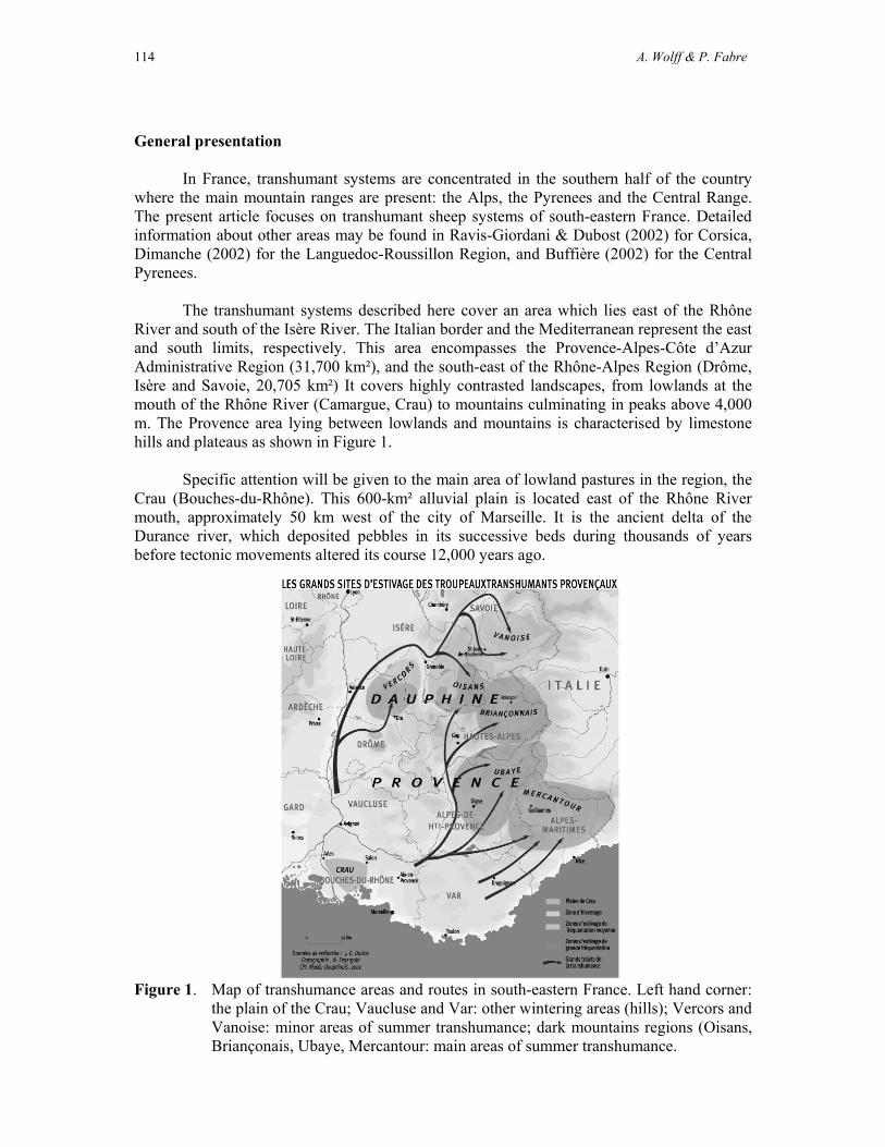
114 A. Wolff & P. Fabre
General presentation In France, transhumant systems are concentrated in the southern half of the country
where the main mountain ranges are present: the Alps, the Pyrenees and the Central Range. The present article focuses on transhumant sheep systems of south-eastern France. Detailed information about other areas may be found in Ravis-Giordani & Dubost (2002) for Corsica, Dimanche (2002) for the Languedoc-Roussillon Region, and Buffière (2002) for the Central Pyrenees.
The transhumant systems described here cover an area which lies east of the Rhône
River and south of the Isère River. The Italian border and the Mediterranean represent the east and south limits, respectively. This area encompasses the Provence-Alpes-Côte d’Azur Administrative Region (31,700 km²), and the south-east of the Rhône-Alpes Region (Drôme, Isère and Savoie, 20,705 km²) It covers highly contrasted landscapes, from lowlands at the mouth of the Rhône River (Camargue, Crau) to mountains culminating in peaks above 4,000 m. The Provence area lying between lowlands and mountains is characterised by limestone hills and plateaus as shown in Figure 1.
Specific attention will be given to the main area of lowland pastures in the region, the
Crau (Bouches-du-Rhône). This 600-km² alluvial plain is located east of the Rhône River mouth, approximately 50 km west of the city of Marseille. It is the ancient delta of the Durance river, which deposited pebbles in its successive beds during thousands of years before tectonic movements altered its course 12,000 years ago.
Figure 1. Map of transhumance areas and routes in south-eastern France. Left hand corner: the plain of the Crau; Vaucluse and Var: other wintering areas (hills); Vercors and Vanoise: minor areas of summer transhumance; dark mountains regions (Oisans, Briançonais, Ubaye, Mercantour: main areas of summer transhumance.

Transhumance and Biodiversity in European Mountains
115
Historical aspects Birth and development of the transhumant sheep system
The results of archaeological researches conducted in the natural steppe of the Crau
involved the discovery of Roman sheep-barns by the Regional Service of Archaeology and suggest that transhumance already existed during the Roman Era, probably between the Crau and nearby mountain ranges such as the Mountain of Lure (Alpes-de-Haute-Provence). During the High Middle Age, the important decrease in sheep numbers in the Crau, as well as the restrictions of long flock movements linked to insecurity problems, appear to have limited transhumance for some time. In fact, transhumance from the lowlands to the mountains seemed to actually develop between the 13th and the 15th centuries, at which time several beneficial factors coincided: peace and the installation of a real state organisation in Provence guaranteed security and allowed the development of a complex organisation of transhumance, an active trade of wool and skins that justified large-scale production. During the 14th and 15th centuries, flocks mainly spent the summer in the Dauphiné (Vercors and around Durbon), on the Mountain of Lure (where grasslands were practically reserved for the flocks of the Crau’s), in the valleys of Alpes-de-Haute-Provence (Ubaye, Bléone, Durance), but also on the Mont Lozère (Central Range) located in the kingdom of France.
A practice often denounced
Transhumance generated conflicts since it was born, to such a point that shepherds, sometimes backed by the authorities, were often forced to get together in order to preserve this ancestral practice. The increase in sheep numbers, between the 13th and the 14th centuries, generated complaints from local populations in the mountains. In their view, transhumance threatened the maintenance of their own flocks because of the competition it implied on mountain grasslands. Transhumance was also a threat to forests, as it was a cause of deforestation. Furthermore, the increased number of transhuming sheep was to lead to the degradation of alpine grasslands. During the second half of the 19th century, hostility against transhumance grew everywhere, especially among foresters. In reality, overgrazing had become to be a generalised pattern in high valleys as soon as the 18th century, and damage caused by flocks along transhumant routes was sometimes considerable. Transportation means Transhumance on foot
Drove roads used by transhuming flocks (generally called “drailles” in southern France, but “carraires” in Provence and in the Alps and canadas in Spain) were stony roads entirely devoted to this activity. They were the first links between the lowlands of Provence and the Alps. At the time they were built, roads were scarce, narrow and not adapted to travelling flocks. To make transhumance easier, drove roads were built up to 100 m wide, and as straight as possible, irrespective of slope. Itineraries usually went along the ridges of hills or gentle mountains, avoiding valleys, cultivated plains and larger villages where conflicts with the population were frequent. Drove roads were marked with milestones planted on each side of the road every 400 to 500 m, and were delimited by stone piles so that flocks could also travel by night. Even when they were not marked, drover roads were usually visible because of the repeated passage of flocks. Drove roads were finally absorbed by neighbouring

116 A. Wolff & P. Fabre
landowners, or were integrated into the road network from the 1950s onward. Only a few sections still remain today. Transhumance by train As soon as the 19th century, some flocks started to travel by train. Starting in 1878, the Paris-Lyon-Méditerranée train company offered special fees for transhuming flocks. Railway wagons were reserved to sheep owners between May 13 and November 15. Animals were loaded onboard from the Arles-Miramas line. Those from the Camargue boarded the train at Arles or Saint-Gilles, those from the Crau at Arles, Saint-Martin de Crau, Salon, Miramas or Istres. Flocks disembarked from the stations closest to their summer pastures: Grenoble (Isère), Saint-Jean-de-Maurienne and Modane (Savoie), Mont-Dauphin-Guillestre, Argentières and Briançon (Hautes-Alpes), Laragne, Digne and Chorges (Alpes-de-Haute-Provence). Special fees for transhuming flocks were suppressed in 1972, which led to the abandonment of trains as a transportation means for transhumance. Transhumance by truck
The competitiveness of road transport increased by the 1950s thanks to the first trucks with two and then three floors, which could hold more sheep. Roads were then narrow and sinuous, and the way up to the Alps was thus rather risky and accidents were not that rare. The modernisation of trucks and of the road and highway system progressively made transhumance by truck the safest and fastest alternative. Trucks allow more flexibility than trains; animals can be loaded at the door of the sheep barn and are driven in no time up to the mountains. Then, in a day’s walk at most, the flocks reach their summer pastures. Trucks also allow to easily dividing the flock into several loads on the way to, or back from, the mountain. The Mérinos d’Arles breed
In 1802, the first cross between ewes of the local breed and Spanish Merino rams was performed in the Crau. The resulting Mérinos d’Arles, renown for the quality of its wool, should logically have disappeared during the second half of the 19th century, because of the crosses imposed by the crash of the wool market and by the reorientation of sheep breeding toward meat production. However, Provence sheep owners, moved by the desire to preserve tough and rustic animals adapted to transhumance, preferred –by selection– to adapt their breed to the new economic context. Nowadays, the evolution of the breed follows precise selection criteria imposed by the “Union de Promotion de la Race Mérinos d’Arles” (the syndicate of breeders to promote the breed), but it is also influenced by individual breeder’s choices, especially in terms of aesthetics. Although the Mérinos d’Arles has been transformed from a wool breed to a meat breed, all sheep owners and shepherds consider their sheep and flock as a source of pride in which they identify: an emblem renowned for its rusticity and, although it has now become a by-product, for its wool. Transhumance and environment in history
During times of maximum human occupation (early 14th and 19th centuries, Hubert 1991), grasslands covered large areas in south-eastern France, from the sea to the mountains. Forests were reduced to a minimum, due to intensive cutting for construction and fire wood, and giving way to extensive pastures.
In the Crau, pastoralism remained for centuries the sole possible way of exploiting the semi-arid stony steppe, or coussoul, which covered most of the plain (about 550 km²). Then in the mid-16th century, irrigation started to develop thanks to the construction of canals that

Transhumance and Biodiversity in European Mountains
117
bring the waters from the Durance River. This allowed the cultivation of the coussoul thanks to the rich Durance silt deposited on the soil when fields are flooded for irrigation. Irrigation and cultivation of the coussoul remained slow until the middle of the 19th century. At that time, the fauna was characteristic of semi-arid agro-pastoral landscapes, with abundant great bustards Otis tarda, pintail sandgrouse Pterocles alchata and stone curlew Burhinus Oedicnemus. The development of agriculture resulted in a mosaic of steppic grassland, wet hay-fields and various crop types, which attracted new species, such as the little bustard Tetrax tetrax which was not know to nest in the Crau before the 1950s (Wolff et al. 2001). The reduction of coussoul areas in the Crau experienced a defined decrease after the end of World War II. While the coussoul still covered 260 km² in the 1930s, it had shrunk to 124 km² in 1980. This was at first due to the development of traditional crops such as hay meadows or cereals, as well as to the extension of industries, military buildings and urbanisation. Then in the 1970s, rotational melon cultivation became responsible for the ploughing of much of the coussoul. However, this type of intensive farming was abandoned in the 1980s. The melon fields became fallows and then went back to pastoralism, but the original coussoul vegetation (Brachypodium retusum grassland) still has not returned after 30 years of abandonment. Finally in the 1980s, intensive peach orchards rapidly extended over large areas of coussoul. Orchards now cover 65 km² in the Crau. Although their progression over steppic grasslands has been stopped, thanks to the protection of this habitat in the 1990s, (see below), orchards still continue to extend into unprotected grasslands such as hay meadows, fallows and fodder crops. Present state Characteristics of the transhumant sheep system A practice which has never ceased to adapt
Whilst adapting to the evolution of society, sheep owners managed to preserve the authentic and natural characteristics of pastoralism in Provence, the keystone of which is transhumance. As a result, transhumance remains an important economic and social phenomenon in the Provence-Alpes-Côte d’Azur region. Each year, some 600,000 sheep move up to the mountains in summer, while about 100,000 from the mountain regions spend the winter down in the lowlands as shown in Table 1.
Table 1. Summer movements of flocks transhuming to the Alps. Sources:FRGDS/DSV
PACA – 2001/2002.
Number of transhuming animals (head) Département of origin To the Southern Alps To the Northern Alps
Alpes de Haute-Provence Hautes-Alpes Alpes-Maritimes Bouches-du-Rhône Var Vaucluse
130,000 190,000 40,000 70,000 60,000 10,000
110,000
10,000
Total 500,000 120,000

118 A. Wolff & P. Fabre
Extensive systems As the keystone of a rearing system based on grazing, transhumance guarantees hi-
quality products of meat and wool, linked to the natural cycle of grass and of the sheep. Flocks consist of rustic breeds: Mérinos d’Arles, Préalpes, Mourérous, the product of long and patient selection processes, adapted to movement over long distances under rough feeding and climatic conditions.
The many forms of transhumance • The « long summer transhumance » links the lowlands of Provence and of the littoral to the
grasslands of the Alps (see Tables 2 and 3). • The « local » transhumance (pendulation), is when flocks from mountain or foothill
villages climb up to nearby alpine pastures to spend the summer. • The “winter” (or “reverse”) transhumance is practised by a certain number of flocks from
mountain farms, which come down in the lowlands or hills of Provence during the wintertime.
Table 2. Summary of the principal characteristics of summer transhumance to the Alps.
Some key figures about mountain grazing management
Mean flock size on mountain pasture: 1,300 head Mean area of grazing unit: 700 hectares Mean duration of stay: 110 days 80% of grazing units benefit from permanent shepherding 200 grazing units use helicopters for supply
Table 3. Approximate cost of a summer season in the Southern Alps (in euros/head). Costs
stand for a mean flock size of 1,300 heads.
Object euros/head
Transportation (truck) 3.0 Rent of the pasture 3.0 Shepherd’s salary 5.5 Other expenses (salt, veterinary products, dog food, helicopter transport)
1.0
TOTAL 12.5

Transhumance and Biodiversity in European Mountains
119
Life on mountain pastures: some recent improvements Since the “Mountain Law” was adopted in 1972, many improvements were brought to
the camps of the shepherds in the mountains. They mainly concern the living of the shepherd and their working conditions. Cabins were built on pastures, those that already existed were renovated. Road tracks to the pastures were opened or improved. Water holes as well as facilities to sort and enclose animals were created. When mountain cabins were not accessible by car, all products necessary to the shepherd’s and flock’s summer life can be carried out by grouped helicopter deliveries.
Those improvements are critical to the continuation of shepherding. Nowadays, it is not so uncommon to meet shepherds who come up to the mountain with his wife and, sometimes, children. Summer pastures: from the Mercantour to the Vanoise
The traditional summer pastures extend from the “Alpes de Provence” (Mercantour, Ubaye, Haut-Verdon) and the southern “Dauphiné” mountains (Vercors, Briançonnais). Thanks to the development of transhumance by truck, some flocks now go as far north as the Oisans or Vanoise (Figure 1).
Nowadays, most flocks are indeed moved using trucks that may hold up to 400 sheep
on three or four floors. Only a few flocks (about 75,000 head) which spend the winter in the lowlands of the Var, the Alpes-Maritimes or the Alpes-de-Haute-Provence, continue to transhume on foot towards nearby mountain grasslands. The Crau’s transhuming sheep system
The sheep system of the Crau (160 flocks totalling 110,000 sheep) is based on an extensive but strict management of the production system (average productivity of 0.95 lamb/ewe/year), and is characterised by large flock sizes (from 300 to 6,000 heads), by a high working productivity (one man for 500 head on average), a very rustic breed (Mérinos d’Arles), and by a “reversed” breeding cycle (lambing in autumn).
The major advantage of this system is that it is based on pastures with very low productivity, which at present cannot be devoted to any other agricultural use. Animals feed almost exclusively on pasturelands: summer is spent on alpine grasslands, autumn lambing and winter on the Crau’s hay meadows, and spring (reproduction) is mainly spent on dry pastures: coussoul and fallow in the Crau and scrub in the hills.
The key to profitability for the system therefore lies in a rustic breed that makes the
most out of poor pastures. Lamb per head-productivity objectives remain low and are compensated for by large flock size, even though mean productivity has increased during recent years in the Crau.
The complementation between sheep owners and hay producers, through the autumn grazing of hay meadows, also partly explains the continuation of the sheep system, the economic status of which remains locally important.
The profession is very much structured, even hierarchical. Different groups may be
distinguished, each one of them in constant evolution:

120 A. Wolff & P. Fabre
- The “Herbassiers” are landless sheep owners, whose flock is almost their only farming capital. They rent grazing places at all phases of the cycle, in the lowlands as well as in the mountains. They may increase their income by shepherding other people’s flocks together with their own in the mountain, a practice which has become almost a requisite for installation. - The “Herbassiers stabilisés” are former landless sheep owners who have managed to buy part of the land they graze in the lowlands, or may have obtained a lifetime tenancy on it. This land becomes the central point around which they will organize the rest of the grazing cycle. - Sheep rearers – hay producers own a sufficient surface of hay meadows to make it profitable for themselves. The hay is almost entirely sold for export. The balance between sheep production and hay trade depends on the economic context. The sheep rearing activity within the farm partly allows the absorption of the economic consequences of hay price fluctuations. - Large-flock rearers. The flock, divided into smaller flocks, contains at least 2,000 head, and requires the employment of a least one permanent shepherd. The functioning of these large flocks sometimes depart from the typical organisation of most local flocks, as high flock size raises specific management problems, especially in terms of work organisation and stability of the grazing resource. There is therefore a need to rent multiple pastures in the lowland as well as in the mountains.
Furthermore, because of its large grazing units and of the large size of the flocks, the
Crau remains a major zone of employment for professional shepherds. Most shepherds are now employed part of the year only, either for autumn lambing, for the spring season on the coussoul, or for the whole season spent in the lowland (October-June). Many of them are only hired to keep the flock during the summer season in the mountains. The ecological value of transhumant sheep systems Landscapes shaped by pastoralism and transhumance
As previously stated, pastoralism greatly influenced the formation and transformation of landscapes in most of south-eastern France. This influence is especially striking in landscapes where pastoralism has now disappeared. The hills of Provence, where thick scrub and evergreen oak forests now completely cover landscapes formerly dominated by grasslands and are the most demonstrative example of this phenomenon. The abandonment of transhumance on foot also had some influence on landscape dynamics in hill country: it used to be common practice for transhuming shepherds to rent pastures in the hills, where sheep may graze for a few weeks on their way from the Crau to the Alps. Such “inter-season” grasslands in hill country gave shepherds more flexibility, especially in years when draught came in early in the Crau and/or when snow melted late in the mountains. This practice disappeared with the generalisation of transhumance by truck, and accentuated landscape changes in hill country, already struck by massive rural abandonment from the end of World War II onwards.
In the Crau, the persistence of extensive grazing allowed the preservation of large areas of coussoul in the south of the plain, where irrigation is less developed. In this area, the original open landscape still extends almost untouched over about 40 km², although recently planted orchards now present on the horizon. Interestingly, the development of hay-meadows in the north of the plain created a new type of farmed “bocage” landscape now considered as typical of the area. The north-east of the Crau, where hay-meadows and other crops are

Transhumance and Biodiversity in European Mountains
121
interspersed with mid-sized parcels of coussoul (one to four km²), represents an intermediate state between open grasslands and bocage landscapes. Although the steppe-dominated part of the Crau remains the principal habitat for important bird species such as the pintail sandgrouse, the calandra lark or the lesser kestrel, the mixed landscape of steppe, crops and hay meadows in the north-east of the plain holds the highest densities of other species such as the little bustard and the stone curlew. These species benefit from the proximity of highly contrasting types of grasslands which provide them with complementary resources during the year-cycle or at shorter time scales (Wolff et al. 2001, 2002). A major role for the preservation of EU priority habitats…
Pastoralism plays a part in the management of most EU Priority Habitats encountered in south-eastern France as shown in Table 4. A majority of them are open habitats such as grasslands, rocky slopes or bogs, but several types of mountain forests are also grazed. The importance of grazing varies between habitats: it is an essential management tool for many grasslands or bogs, but may be of secondary importance for the management of other habitats such as mountain forests. In rare cases (e.g. Pinus mugo bushes or juniper forests), priority habitats may transiently develop as a result of grassland abandonment. In addition to priority habitats, most alpine and Mediterranean grasslands of south-eastern France are listed in Annex I of the Habitats Directive. In the Provence-Alpes-Côte d’Azur Region alone, grazed habitats are estimated to cover 8,000 km², i.e. roughly 25% of the region’s area (Legeard 2002). Mountain pastures account for 50% of all pastoral lands. In the lowlands and hills, the preservation of virtually all types of dry grasslands is dependent on the continuation of extensive grazing. Grazing by sheep or cattle is also developing as a tool for protection against fire in several types of matorral and Mediterranean forests listed in Annex I of EU Habitats Directive. This management contributes to the protection of these habitats and to the restoration of abandoned grasslands subject to scrub encroachment.
In the Crau, extensive sheep grazing remains the only management tool for about 100 km² of coussoul steppe, which is a unique Thero-brachypodietea priority habitat (“Crau Steppe – Asphodeletum fistulosi”, Corine Land Cover code 34.152). In addition, winter grazing by transhuming sheep flocks enters the management cycle of the Crau’s hay meadows (110 km²), also listed in Annex I of the Habitats Directive (“Medio-European lowland hay meadows - Gaudinio Arrhenaterum elatioris”, Corine code: 38.22).

122 A. Wolff & P. Fabre
Table 4. Priority EU Habitats concerned with transhumance in south-eastern France. The the last column shows the total number of Natura 2000 sites where the habitat is present. Data adapted from the French ministry of environment.
Priority Habitats Mountains Hills Lowlands Nb sites
4070 Bushes with Pinus mugo and Rhododendron hirsutum (Mugo-Rhododendretum hirsuti)
x 4
6110 Rupicolous calcareous or basophilic grasslands of the Alysso-Sedion albi
x 16
6120 Xeric sand calcareous grasslands x x 4
6210 Semi-natural dry grasslands and scrubland facies on calcareous substrates (Festuco-Brometalia)
x x 63
6220 Pseudo-steppe with grasses and annuals of the Thero-Brachypodietea
x x 25
6230 Species-rich Nardus grasslands, on silicious substrates in mountain areas
x 10
6240 Sub-Pannonic steppic grasslands x 5
7110 Active raised bogs x 20
7240 Alpine pioneer formations of the Caricion bicoloris-atrofuscae
x 16
8240 Limestone pavements x 13
9180 Tilio-Acerion forests of slopes, screes and ravines
x 33
91D0 Bog woodland x 8
9430 Subalpine and montane Pinus uncinata forests (if on gypsum or limestone)
x 26
9560 Endemic forests with Juniperus spp. x 13
9580 Mediterranean Taxus baccata woods x x 2
… and EU priority species
Surprisingly few EU priority species of the Habitats Directive are concerned with pastoralism and transhumance in south-eastern France. Only two species are cited, Rosalia alpina and Callimorpha quadripunctaria (Arthropods). The former is found in 16 Natura 2000 sites, mainly in mountain and foothill areas, while the latter is widespread (61 sites from lowlands to mountains). However, numerous species listed in Annexes II and IV of the Habitats Directive are strongly dependent on the continuation of grazing. These include species of high regional or national conservation importance such as Aquilegia bertolonii (Ranunculaceae), Graellsia isabellae (Saturnidae), Vipera ursinii (Viperidae) or Lynx lynx

Transhumance and Biodiversity in European Mountains
123
(Felidae) in the mountains, Arenaria provincialis (Caryophyllaceae), Testudo Hermanni (Testudinidae) in the hills, Leucojum nicaeense (Amaryllidaceae) or Saga pedo (Tettigonidae) in the lowlands.
On the contrary, many species listed in Annex I of EU Birds Directive depend to some extent on pastoralism are shown in Table 5. This is especially the case of ground-nesting grassland species such as Pterocles alchata, Tetrax tetrax or Melanocorypha calandra, and for species that feed on grassland-dwelling animals such as Coracias garrulus, Falco naumanni, Hieraaetus fasciatus or Lanius collurio. Species that feed on carrion such as Gypaetus barbatus (mountains) or Neophron percnopterus (hills and lowland) also rely heavily on extensive pastoralism.
Table 5. Priority EU Bird Species (Annex I of Birds Directive) concerned with transhumance in 3 contrasted Special Protection Areas of south-eastern France: Les Ecrins National Park (918 km², Hautes-Alpes, max. elevation 4,100 m), Massif du Petit Luberon Regional Park (177 km², Vaucluse, max. elevation 915 m), and Crau Sèche (115 km², Bouches-du-Rhône, max. elevation 75 m). B, breeding; W, wintering; M, migration stopover. Data adapted from the French ministry of environment.
Species Ecrins (mountain) Luberon (hills) Crau (lowland) Anthus campestris B B B Aquila chrysaetos B W Bubo bubo B B Burhinus oedicnemus B B Calandrella brachydactyla B Caprimulgus europaeus B B Charadrius morinellus M M Ciconia ciconia M M Circaetus gallicus BM B M Circus aeruginosus B B Circus cyaneus BWM W W Circus pygargus B B Coracias garrulus B B Emberiza hortulana B B Falco naumanni B Falco peregrinus B W W Gypaetus barbatus WM Hieraaetus fasciatus B W Hieraaetus pennatus B Lanius collurio BM B Lanius minor B B Lullula arborea B B B Melanocorypha calandra BW Milvus migrans BM M B Milvus milvus WM M W Neophron percnopterus B M Perdix perdix italica B Pluvialis apricaria W Pterocles alchata BW Pyrrhocorax pyrrhocorax B Sylvia undata B W Tetrax tetrax BW

124 A. Wolff & P. Fabre
A practice that benefits biodiversity at all scales
The benefits of transhumance are clear at a regional scale. The preservation of grasslands in highly contrasted contexts such as lowlands, hills and mountains, results in increased regional diversity of grassland species. Table 5 illustrates this phenomenon for EU priority bird species, many of which only breed in specific altitudinal conditions (e.g. Pyrrhocorax pyrrhocorax in the mountains, Neophron percnopterus in the hills or Pterocles alchata in the lowlands). Other species such as Lullula arborea or Anthus campestris may breed in very contrasted types of grasslands from the mountains to the lowlands, so that their distribution area at the regional scale is strongly influenced by transhumance. Although most alpine grasslands over the tree line may persist without being grazed by domestic animals, this is not the case at lower altitudes where grasslands have been created and maintained by shepherds. The case of the coussoul in the Crau is particularly striking in this respect, as it is the only semi-natural dry lowland grassland remaining in France.
Transhuming sheep systems also participate to the preservation of high biodiversity
levels at smaller scales. The following examples are taken from the Crau area: - At the landscape scale, the existing sheep system relies on the use of highly contrasted types of grasslands within the Crau: hay meadows in the autumns and winter, steppe, fallows and fodder crops in the spring. Besides increasing the very diversity of grassland species at the landscape level, this diversity of grassland types also benefits species which may use different grassland types to fulfil various ecological requirements (e.g. nesting in one habitat and feeding in another) or at different times of the year (e.g. little bustard or stone curlew, see above). - Within a single grassland type, the spatial and temporal variations in grazing pressure generate differences in vegetation composition and structure, which in turn create contrasted environmental conditions that benefit species diversity. In the Crau steppe, the coussoul, this occurs at two scales. First, among grazing units, overall grazing pressure or timing of grazing may differ for various reasons: differences in flock size or grazing unit size, location of the summer pastures (flocks that spend the summer at the highest elevations usually tend to leave latest from the Crau), or any other technical reason (e.g. availability or not of complementary spring grassland types such as fodder crops). Over the years, these differences in grazing pressure or timing shape the vegetation characteristics of each grazing unit (unit size varies from one to four km²), which in turn determine the communities they shelter. For instance, pintail sandgrouses prefer short grasslands dominated by annuals, which occur on more heavily grazed units, whereas little bustards tend to select higher vegetation characteristic of units with lower grazing pressure. Second, grazing intensity may be highly variable within single units. In the coussoul, each unit has a sheep barn, located more or less centrally, where the sheep are kept at night. Each flock is guarded by a single shepherd, who determines where the sheep go during the day. Because of the central function of the barn (where the sheep may also come back at midday), grazing pressure and nutrient input decrease from the barn to the edge of the unit, creating a marked spatial heterogeneity of vegetation composition and structure within each grazing unit. In addition, coussoul units in the Crau are not enclosed, but only delimited by landmarks such as stone piles. To maintain good relationships between neighbours, shepherds do not allow their sheep to graze beyond the limits of their own unit, and therefore avoid grazing too close to the boundaries. Because of this, the corners and limits of each holding are little grazed. Shepherding practices therefore increase the spatial heterogeneity of the vegetation within each grazing unit, which again promotes species diversity at that scale. It has been shown, for instance, that little bustards preferentially breed

Transhumance and Biodiversity in European Mountains
125
in higher vegetation near holding borders, whereas stone curlews and especially pintail sandgrouses nest and feed in shorter vegetation, sometimes less than 100 m from barns. The growing importance of agri-environment schemes
By their very nature, transhuming flocks have been highly addressed by agri-environmental and land management policies during the last years, for obvious reasons: - they are the principal keepers of most open habitats, which have been created by pastoralism and undergo severe changes when grazing ceases. - they are based on extensive, environment-friendly practices.
Transhumant sheep flocks thereby hold a central position in many agri-environmental schemes elaborated at the national, regional or local level. Most measures enter either of the following rationales: 1) continue, or resume, grazing to preserve or restore important habitats or habitats of high conservation-value species; 2) adapt grazing practices (e.g. grazing dates and pressure) to benefit target species for which specific problems linked to pastoralism have been identified. Agri-environment schemes have been applied to virtually all types of pasturelands in south-eastern France. Following are examples of schemes applied to areas representative of the main types of pastures in the region: mountain pastures, hills (Alpilles), and lowlands (Crau). Agri-environment schemes on mountain pastures
In the mountains, pastoralism plays a central part in land management, in landscape conservation and in ecosystem functioning. Grazed mountain areas are less subject to avalanches and hold higher fauna and flora diversity. When grazing decreases or ceases, abandoned grasslands are subject to scrub encroachment and eventually become forested, ecological processes are modified and biological diversity usually decreases.
Transhuming flocks from the Crau or other Provence lowland areas, as well as local
mountain flocks, have been engaged in agri-environmental schemes recently developed in several areas where transhuming flocks traditionally spend the summer: - Ubaye Valley (Alpes de Haute-Provence): incentives to local or transhuming sheep rearers for the preservation or restoration of landscape elements typical of the valley. For examples, incentives promote grazing of abandoned low-altitude hay-meadows (Festuca paniculata meadows) at specific times of the year (early and late summer), in order to benefit plant species such as Eryngium alpinum, and to provide favourable nesting habitats for Tetrao tetrix. Other specific measures are applied for the management of grasslands at higher altitudes. - Queyras and Vercors Regional Parks, Ecrins National Park. Land management contracts, signed between sheep rearers and municipalities, parks or public land-owners such as the National Forest Office (ONF), aim at the preservation of mountain fauna and flora (e.g. Tetrao tetrix, Eryngium alpinum, species-rich Nardus grasslands, abandoned alpine hay meadows). Most contracts imply specific changes in the way flocks are managed in order to even out grazing pressure in space and time; they are also designed to avoid overgrazing on specific sectors of mountain pastures.

126 A. Wolff & P. Fabre
Grazing management of matorral and forests in the Alpilles hills
The Alpilles is a limestone mountain located north of the Crau in the hills of Provence (Bouches-du-Rhône). This 25,000 ha area comprises typical dry Mediterranean habitats such as Quercus coccifera scrub, dry grasslands (Thero-Brachypodietea), as well as Quercus ilex and Pinus halepensis forests. This area has been almost entirely deserted by sheep flocks for about 30 years, leading to important scrub encroachment. Despite important efforts devoted to protection against fire (D.F.C.I. programs) and active forest management by the National Forest Office on 85 km² of public forests, fire hazard remains extremely high in the area.
The idea of incorporating grazing into the existing fire-defence management
techniques appeared after repeated fires occurred in the 1980s. Grazing in the Alpilles forests is done using flocks from nearby foothill and plain areas (Crau, Comtat). The operation is steered by a committee created in 1990, which brings together firemen, foresters, sheep rearers and nature conservation associations. Today, more than 9,000 sheep participate in the management of firebreaks in the Alpilles. This action is now reinforced by the development of a global management plan for forest management (PIDAF) and an agri-environmental scheme. The latter has been developed on an area covering 15 villages and includes biotope and landscape conservation objectives on top of fire protection. Conservation measures in the Crau’s steppe and hay meadows.
The essential role played by extensive agricultural practices for the preservation of habitats and species of conservation interest, at the first rank of which stands transhumant sheep rearing, was recognised very early in the development of a conservation strategy for the Crau. On the other side, the steppic grasslands of the Crau represent a pasture of high economic interest, the preservation of which is essential for the continuation of the existing pastoral system. This mutual dependency rapidly led to a tight collaboration between farmers organisations and environmentalists. The acknowledgment of this common objective was triggered by the fast decline in the area of steppe, first due to the expansion of industries and urbanisation during the 1970s, then by the development of intensive peach orchards in the 1980s. Agri-environment schemes
The will to preserve the remaining patches of steppe in the Crau whilst keeping extensive pastoralism alive led to the creation in 1990 of agri-environment schemes in application of Article 19 of EU Directive 797/85 on the efficiency of agricultural structures. Two distinct operations were developed, one on steppe and one of hay meadows, due to the high degree of integration between sheep rearing and hay production for the management of both habitats. These measures were subsequently integrated in new agri-environment programs, and have been subscribed by over one hundred sheep rearers for a total of 79 km² of steppe and 60 km² of hay-fields. Both types of measures promoted the continuation of traditional extensive management techniques, i.e. extensive spring grazing on steppe and autumn-winter grazing of the aftermath of hay meadows. An additional measure was developed in 1996 to promote the traditional irrigation technique of hay meadows (periodic flooding), a technique that accounts for 70% of the input to the water table which provides drinking water for the neighbouring cities (250,000 persons). About 98 km² of meadows are under contract.
Transhumance and Biodiversity in European Mountains
127
New sets of measures were proposed to be included in the agri-environment program (CTE, Contrats Territoriaux d’Exploitation) developed by the French government in application of the 1999 Agriculture Orientation Law (LOA). The proposed measures follow the same general objectives, but take recent finding into considerations; for example, new measures promote the preservation of pastoral activities on arable land (fallows and fodder crops) outside of the SPA to benefit bird species such as little bustards or stone curlews; other measures propose incentives to promote shepherding instead of fencing. Other measures
Agri-environment schemes developed in the Crau have been reinforced by a series of actions devoted to the conservation of habitats and species. Examples of such measures are given below: - A Special Protection Area covering 115 km² of steppe and long-term fallow was designated in 1990 to insure the conservation of important steppe bird species. In 1998, the SPA was included into a larger Natura 2000 site (“Crau Centrale-Crau Sèche”, 315 km²) which also covers most of the hay meadows as well as other extensive arable lands devoted to pastoralism (fallows, grazed fodder crops). The Natura 2000 site is administrated by the Syndicate of hay producers, with the scientific assistance of the CEEP (Conservatoire-Etudes des Ecosystèmes de Provence) - Supports to land acquisition were developed through a LIFE program (1992-1997) in order to reinforce the protection status of important steppe areas while stabilising the pastoral vocation of the land. This support allowed the acquisition of over 30 km² of steppe for conservation purposes, by NGOs (CEEP, 2.9 km²), public institutions (Conservatoire de l'Espace Littoral et des Rivages Lacustres, 2.8 km² ; Conseil Général des Bouches-du-Rhône, 10 km²), as well as individual sheep breeders (over 10 km²). - Actions for the improvement of living conditions of shepherds were implemented by the syndicate of sheep rearers (Syndicat des Éleveurs du Mérinos d'Arles) and the CEEP with the support of various institutions. The main action consisted in the distribution of photovoltaic equipment which allowed providing electric light for the barn and the shepherd’s cabin, as well as power to pump water from existing wells. - Studies on the interactions between grazing practices and ecological processes were initiated as part of the 1992-1997 LIFE program. These studies were conducted jointly by pastoral organisations (CERPAM, Agricultural Chamber), research institutes (National Institute for Agronomical Research -INRA) and nature conservation NGOs (CEEP). This program allowed to study in detail how shepherds manage their flocks, and provided valuable insight on how animal populations are influenced by the spatial structuring of vegetation induced by grazing practices. Other programs were subsequently developed to carry on these researches. - A Natural Reserve covering 74 km² of steppe (included in the SPA perimeter) was designated in 2001 by the French government. This Natural Reserve includes all public land as well as private lands purchased with financial support from the LIFE program. The decree states that extensive grazing is the principal management practice for the conservation of steppe habitats and the species it shelters. The Chambre d’Agriculture des Bouches-du-Rhône and the CEEP have applied to be co-managers of the Natural Reserve, in order to insure that nature conservation and pastoral matters be considered jointly in the management of the reserve.
128 A. Wolff & P. Fabre
Which future for transhumance? A model for sustainable development
Often considered as a relict from the past, the transhuming sheep system of Provence and the Alps does possess precious advantages. Based on the natural vegetation cycle and on the exploitation of the sheep’s natural abilities, transhumance meets the aims of the most recent French Agricultural Orientation Law (LOA): natural and high-quality products (meat, wool), environment-friendly management practices, preservation of rural, social and economic activities both in the mountains and in the lowlands, of employment (shepherds) and of landscapes, of biotopes and species of conservation priority.
By its ability to preserve optimal relationships with natural habitats and to satisfy all
kinds of requirements (social, environmental, cultural, alimentary, even spiritual), transhuming sheep reared according to current practices today by a majority of shepherds is a convincing model.
In spite of all the efforts already developed in the favour of the transhumant sheep system, many problems remain to be solved. Some of the objectives to achieve in order to ascertain the sustainability of the Crau’s sheep system are listed in Table 6, together with the environmental aims that need to be attained.
As shown in Table 6, agri-environment schemes appear to provide part of the present
and future solutions to several key problems faced by pastoralists. The measures developed in the CTE agri-environment scheme meant to answer problems not addressed in previous schemes, such as incentives to encourage the continuation of shepherding. The CTE also introduced regressive payments in order to even out subsidies received by smaller and larger flocks. Many of the measures elaborated locally for the CTE aimed simultaneously at improving working conditions for sheep owners and shepherds while satisfying environmental objectives. This was possible thanks to the tight cooperation and constant discussion between environmentalists such as the CEEP and farmers organisations such as the Chambre d’Agriculture or the Comité du Foin de Crau. For instance, the proposal to give incentives for fodder crops aimed at improving the wintering and breeding conditions of Little bustards, while providing valuable financial help for shepherds to develop this kind of crops which tended to regress because of its high cost. The CTE scheme was stopped by the French government in the summer of 2002, before it could be applied in the Crau. A new scheme, the CAD (Contrat d’Agriculture Durable), should replace it by 2004. Local organisations strongly hope that the measures developed in favour of pastoralists in the CTE will be implemented in the future CAD scheme.

Transhumance and Biodiversity in European Mountains
129
Table 6. Problems and proposed solutions to sustain the extensive transhuming sheep system of the Crau and the ecological values it supports. See text for abbreviations.
PROBLEM / AIM PRESENT SOLUTIONS PROPOSED FUTURE SOLUTIONS - Installation of young sheep owners - Limit flock size
CTE (regressive AE payments)
- Improve status of landless sheep owners - Tutoring of young shepherds - Global management of the Crau
Professional shepherds - Improve working conditions - remuneration of environmental services - Formation
- AE schemes - CTE - Domaine du Merle (shepherds school)
- Natura 2000 - Natural Reserve - Specific schemes - CAD (grid of salaries)
Landless sheep owners - Improve status - Recognise double use of hay meadows for payments
CTE - CAD - Use GIS for payment calculation
Recognition of existing good agricultural practices in AE schemes
- CTE - AE schemes
- CAD - Natural Reserve - Natura 2000 - Continue AE schemes
Complementation lowland / mountain
- CTE - « Pastoral groups »
- CAD “transhumant sheep farm” - PMT “Prime au Maintien de la Grande Transhumance” (subsidy to sustain transhumance) - Subsidies for sheep transportation SU
STA
INA
BL
E D
EVE
LO
PME
NT
OF
TH
E
SHE
EP
SYST
EM
Improve marketing of products (meat, wool)
CTE (S.O.Q., official quality label)
SOQ, official quality label
Preserve Coussoul (100 km²)
SPA / Natural Reserve / AE schemes / Land Purchase schemes (LIFE) / CTE contracts
CAD / Land purchase schemes
Preserve Fallows (40 km²)
SPA / Natural Reserve (1,500 ha of fallow)
CAD contracts (grazing of fallows outside SPA)
Preserve of Develop Grazed fodder crops (<10 km²)
CTE contracts CAD contracts
Preserve Hay-Fields and management practices (120 km²)
AE schemes / Certification (AOC) / CTE contracts
CAD contracts / Land policy
LAN
DSC
APE
MA
NA
GE
ME
NT
: H
ABI
TA
T T
YPE
S A
ND
TH
EIR
EX
TE
NT
Limit or target Intensive Agriculture, Industries…
Limited or absent Concerted management planning of the Crau area
maintain heterogeneity of steppe vegetation within Grazing unit
CTE shepherding contracts CAD contracts / Natural Reserve Management plan
BIO
DIV
ER
SITY
-FR
IEN
DLY
GR
AZ
ING
M
AN
AG
EM
EN
T
maintain heterogeneity of steppe vegetation among grazing units
None (lack of constraints and control of AE schemes
- Preserve flexibility of proposed schemes (e.g. CAD) - Natural Reserve Management Plan

130 A. Wolff & P. Fabre
Agri-environment schemes do not however provide answers to all the problems faced by the Crau’s transhuming flocks. Firstly, agri-environmental measures are just another type of subsidy, which come on top of many others but do not compensate for the lack of sustainability of the system, as total subsidies represent about 40-60% the income of sheep owners. Market prices of sheep products remain very low; in the best years, wool market prices barely cover the costs of shearing, while lamb meat may drop below 2.5 euros a kilo because of the fluctuations on the EU meat market, largely influenced by big distribution outlets. Marketing opportunities nevertheless exist. Annual lamb meat consumption per inhabitant in south-eastern France is about two times higher than the national average, although only 15% of the meat produced in the region is consumed here. The adoption of official quality labels is under development in an attempt to improve meat marketing. Other possible solutions include improved price negotiation with big distribution outlets and development of local consumers networks. Secondly, poor access to land also remains a major problem for the installation of young sheep owners in the Crau. Land prices for coussoul and hay meadows experienced sharp increases in the 1980s and 1990s because of the pressure imposed by peaches. Because of the large areas required for extensive grazing, purchasing enough grassland for a single flock is virtually impossible for a young farmer. Furthermore, available areas of spring pastures such as coussoul have become so much reduced that only 35 of the 160 flocks established in the Crau graze on coussoul in the spring. The others, especially recently established sheep rearers, often have to move to hill areas in the Alpilles or in the Luberon in order to find spring pastures. The purchase of land by public institutions or NGOs, as already implemented through the LIFE program, appears as a good solution to remove this financial burden from the shoulders of the farmers, who may graze these land for very low rental fees.
The increasing dialogue between the different actors of the Crau has given birth to the concept of a global management plan in the region. The rationale behind this concerted management plan is to insure the synergy of all actions, implantations, modifications, surveys or measure follow-ups. It should be able to integrate all types of aspirations (e.g. environment, agriculture and industry) and allow the coexistence of different activities with mutual respect and a better understanding of ongoing trends. The implementation of all present schemes and conservation measures (e.g agri-environmental schemes and Natura 2000 actions, Natural Reserve) is a good step towards this concerted management plan. The constant dialogue and the adoption of nature conservation objectives by socio-economical actors prefigures tomorrow’s land management.
In the end however, the future of the Crau’s sheep system remains dependent on decisions taken at higher levels. The adoption of the mid-term review of the CAP is a good example of such unpredictable pressures, as no one today may tell what will be the consequences of this policy change for lamb meat or hay production and marketing. In the face of omnipresent threats, liable to impede the future of transhumant sheep rearing in south-eastern France, the Maison de la Transhumance was created in order to build a network of “interpretation centres for transhumance activities and cultures” around the Mediterranean. This initiative is supported and implemented by transhuming shepherds and sheep rearers. The network intends to act as a lookout structure for transhumant sheep systems, using new communication techniques. New actions of solidarity are needed amongst Mediterranean shepherds, with the help of all those who study and acknowledge the economic, ecological and cultural benefits of sheep transhumance.

Transhumance and Biodiversity in European Mountains
131
References Association Ovine Méditerranéenne, C.E.R.P.A.M., Chambre d'Agriculture des Bouches du Rhône, Espaces naturels de Provence, I.N.R.A, (1998). Patrimoine naturel et pratiques pastorales en Crau. Programme Communautaire Life Ace Crau, Impr. Vallière, Miramas. Buffière, D. (2002). Pastoralisme montagnard et transhumance dans les Hautes-Pyrénées. In « La transhumance. Relique du passé ou pratique d’avenir ? ». Editions Cheminements, Maison de la Transhumance : 145-152. Dimanche, M. (2002). La transhumance en Laguedoc-Roussillon : état des pratiques en l’an 2000. In « La transhumance. Relique du passé ou pratique d’avenir ? ». Editions Cheminements, Maison de la Transhumance: 137-144. Drouot, E. & Molénat, G. (2002). Vers une gestion de la flore des alpages : enjeux et approches. In « La transhumance. Relique du passé ou pratique d’avenir ? ». Editions Cheminements, Maison de la Transhumance : 221-234. Fabre, P., (1997). Hommes de la Crau, des coussouls aux alpages, Ed. Cheminements. Fabre P., Boutin J., (2002). Troupeaux transhumants et gestion de l’écosystème pâturé de la Crau. In « La transhumance. Relique du passé ou pratique d’avenir ? ». Editions Cheminements, Maison de la Transhumance, 177-196. Fabre, P. & Boutin, J. (2002). Troupeaux transhumants et gestion de l’écosystème pâturé de la Crau. In « La transhumance. Relique du passé ou pratique d’avenir ? ». Editions Cheminements, Maison de la Transhumance : 177-196. Fabre P., Lebaudy G., (in press). La mémoire longue d’un métissage: la «métisse» ou la race ovine mérinos d’Arles. Anthropozoologica. Hubert, B. (1991). Changing land uses in Provence (France). Multiple use as a management tool. In Baudry J. & Bunce R. (eds.) Land abandonment and its role in conservation. Zaragoza: CIHEAM-IAMZ. Options Méditerranéennes Série A, séminaires méditerranéens, 15: 31-53. Lapeyronie, P., Olivier, L. & Molénat, G. (2002). Fonctions de l’élevage dans la protection de l’environnement en montagne. In « La transhumance. Relique du passé ou pratique d’avenir ? ». Editions Cheminements, Maison de la Transhumance : 197-212. Legeard, J.-P. (2002). Les transhumances ovines provençales dans les Alpes du Sud. In « La transhumance. Relique du passé ou pratique d’avenir ? ». Editions Cheminements, Maison de la Transhumance : 153-164. Pluvinage J., Molénat G., (1993). L'élevage ovin en Crau, un système pastoral articulé sur l'agriculture. IVème Congrès International des Terres de Parcours, 2: 826-828. Ravis-Giordani, G. & Dubost, M. (2002). Passé et présent de la transhumance corse. In « La transhumance. Relique du passé ou pratique d’avenir ? ». Editions Cheminements, Maison de la Transhumance : 125-136. Wolff A., Paul J.-P., Martin J.-L., Bretagnolle V. (2001). The benefits of extensive agriculture to birds : the case of the Little Bustard. Journal of Applied Ecology, 38: 963-975. Wolff A., Dieuleveut T., Martin J.-L., Bretagnolle V. (2002). Landscape context and little bustard abundance in a fragmented steppe : implications for reserve management in mosaic landscapes. Biological Conservation 107(2): 211-220. Wolff A. (2002). Ecological consequences of pastoral practices in the Crau. La Cañada, Newsletter of the European Forum on Nature Conservation and Pastoralism, 15: 6-7.

A Wolff & P Fabre
132

Transhumance and Biodiversity in European Mountains
133
Some considerations in the implementation of agri-environmental schemes
F. Véron
Cemagref - AMM, Grenoble, France
e-mail: [email protected]
Agri-environmental schemes aim at promoting farming practices that are more favourable toward landscapes and environment. They form part of a set of several additional instruments as rules or regulations on the one hand, as opposed to economical tools on the other hand. They can be helpful for transhumant systems to become more economically and environmentally efficient practices.
However, experience achieved on several French agri-environmental schemes has shown the great importance of the conditions in which theses programs are made and implemented. The present paper will first point out some key questions that must be considered in the preparation of such schemes, and secondly draw up a typology of these conditions and their associated consequences.
The key questions highlight some strategic decisions, for which the answer will guide
the whole process: the general objective, i.e. to give money for :
(1) paying protection services. Farmers, or shepherds, are invited to introduce or develop practices that are, from a farming point of view, technically and economically un-viable. They must be paid by society for them. If payments are stopped, then services are bound to finish. (2) sustaining farmers to carry on environmental friendly practices. Farmers, or shepherds, have to carry on with the production goal, but they also have just to improve their environmental impact and to be compensated for this deal, in order to restore competition with those who do not respect. (3) helping farmers temporarily to introduce new practices or even to change their current farming system. The goal, here, is to help farmers temporarily to modernise or to adapt to new practices that will be more favourable for environment without reducing mid-term farm viability.
the design of the scheme: top-down versus bottom-up. Top-down processes could be quickly operational but less relevant with local conditions and unjustly demanding ; inversely bottom-up processes could be better fitted and well adopted more easily by farmers, although they take longer to negotiate and are environmentally less demanding.
the contract form, which can be expressed in terms of "obligation of means" or "obligation of result". This point is of major importance when uncertainties remain. For example, the best way, or practices, to restore a specific biodiversity target are often not well established. An obligation of result in which success is not guaranteed, will charge the farmer with a risk for which he is not responsible. He will more easily accept an obligation of means, which can be more restricting by obliging him to carry out, or avoid some precise practices. On the other hand, politicians often prefer obligations of result, that are easier to evaluate and that allow them to draw attention to their efficiency.

F. Veron
134
the possible requirements for entering the scheme (for instance: at one extreme an
attractive and simple basic measure may be more or less connected with more exacting ones. At the opposite end of the spectrum, a basic compulsory measure may be more attractive others).
The typology is based on some main features of the schemes in which combinations
are strongly linked. These factors are: 1) The actors' network, nature (e.g. agronomy and ecology); 2) The reference, place of the zoning, the targeted farmers and the way the information is delivered and the methods used for collecting the contracts; 3) who takes (ecological, economical and technical) risks, and; 4) what are the main uncertainties ?
According to these criteria it is possible to identify four types of agro-environment schemes (configurations):
1) The agri-technical is built on the idea that environmental questions can be solved by a technical innovation which makes the farm environmentally (and economically) more efficient ("surpassing by innovation"). The information is mainly delivered by farming organisations, with agronomical references. The objectives are expressed in farming terms, and offer technical innovations for solving environmental problems. They are well understood and easily adopted by farmers, mainly by the most dynamic ones, who are stimulated by the farming challenge. Those who are out the way of farming development are less receptive. The main risk, from the environmental point of view, is that projects are representative of farmers' conception of environment.
2) The agri-ecological is defined by the main place given to the ecological request, which leads to an operational compromise ("solving by compromise"). Based on ecological or landscape diagnosis, the prescriptions are submitted to farmers by environmental advisors. These prescriptions are often restricting for farmers, as they take farming constraints into low consideration. Because of that, individual negotiations are often long and difficult, especially about the content of the prescriptions, their compatibility with the farming system and the level of payment. The main risk is a low rate of adoption, which would compromise the desired environmental effects.
3) The agri-territorial is built on a project intending to increase the value of local networks and environmental resources ("joining a development plan"). The aims of such schemes are less environmental than development linked ones. All the inhabitants are involved in the proposal of the prescriptions, which can go over agricultural goals. The expertise is global and emanates from the community. Prescriptions are offered to farmers and other rural contractors by the community leader. Social control required easy arrangements to usually ensure a good take up rate. The main risk lies in few demanding prescriptions which may lead to limited basic changes.
4) The agri-regulation is built on the encouragement to comply with an average negotiated standard which is designed to improve the impact of farming ("respecting a negotiated standard”). This type of scheme is often supported by administrators who seek for a quick and simple implementation with a large group of farmers. The prescriptions are
Transhumance and Biodiversity in European Mountains
135
negotiated with representative organisations and based on widely recognized standards. Farmers who are in agreement with the prescription have only to contact the authorities and to sign. In return, the requirement of the prescriptions is often unsuitable for local conditions. The incentive to basic changes in farming systems is also low and the final impact on environment remains very uncertain.
Some short examples of the mind of prescriptions to clarify the explanation:
1 - Scrub control.
Agri-technical Incentives to mix animals (cows, sheep, goats, horses), to increase the stocking density, to get a better distribution of animals all on the area and to enlarge the dates of grazing.
Agri-ecological Zoning of areas to clean, identification of scrub to be eliminated, special indications (e.g. directions for intervention dates, banning of burning).
Agri-territorial Solving of farming problems which can make grazing easier (e.g. water trough, accessibility), development of alternative activities (e.g. accommodation, direct sales), creation of tourist paths.
Agri-regulation Rules on the stocking rate, the ratio of open/closed areas and what level of result allows payment.
2 - Protection of Tetrao tetrix tetrix (black grouse).
Agri-technical Reorganisation of a grazing plan in order to avoid all areas able to house birds during the reproduction period. Development of strategies for temporary limitation of herds using mobile fencing.
Agri-ecological Annual expertise to localise reproduction areas and to exclude grazing, as long as the reproduction is not finished. Incentives to improve the vegetation structure in areas favourable for reproduction.
Agri-territorial Simple rules, discussed with local organisations, in order to reduce bird perturbation during reproduction but rarely complete bans. Promotion about the bird, creation of sheltering sites.
Agri-regulation Payments for farmer who exclude grazing from all potential sensitive areas until a definite date, which includes a margin of uncertainty.

F. Veron
136
3 - Prevention of forest fires by inverse transhumance (in France, the goal is generally to reach a shrub phyto-volume below 2500 m3/ha at the end of June).
Agri-technical Advising on palatability of main species, on the best grazing periods for limiting their development. Incentives to improve grazing plans, stocking rates and scrub density on overgrown areas.
Agri-ecological Diagnosis of vegetation boundaries, zoning of most sensitive ones for fighting against fire and those that must be reduced in order of priority.
Agri-territorial Negotiation with farmers, particularly local ones, in order to prolong their grazing period. Making access and the use of forest easier.
Agri-regulation Payment based on the percentage of area having achieved the result, whatever the means used to reach it.
When listing the characteristics of these configurations, it appears that they can be
divided between generic <->localised processes, and selective <-> integrative processes.
Processes Selective Integrative
Generic Agri-technical Agri-regulation
Localised Agri-ecological Agri-territorial
Selective processes are applied to a part of the farmers' population: they are selected
either indirectly through their technical ability to change their functioning or because they are directly affected by the environmental issue and specifically pointed out in the zoning. Integrative processes are addressed to all farmers who have requested to be involved. Regarding the typology of farms, there is generally a greater diversity in integrative processes than in selective configuration.
Localised processes are set up with prescriptions specially designed in relation with local environmental, social and economical conditions. Alternatively, generic processes may be based on wide principles which can be repeated in various areas with only minor changes. These principles can be either applied to agronomic rules or environmental standards.
This overview demonstrates that each type of scheme has advantages and drawbacks.
The objective for building such schemes is to optimise the different elements in order to prevent the problems inherent in setting up the schemes.

Transhumance and Biodiversity in European Mountains
137
Transhumance in Germany
R. Luick
European Forum on Nature Conservation & Pastoralism (EFNCP)
& Applied University of Rottenburg / Fachhochschule Rottenburg Schadenweilerhof 72108 Rottenburg, Germany
e-mail: [email protected]
Abstract
Three main types of mobile livestock systems may be distinguished: nomadism, transhumance and the alp-system. Focussing on transhumance there is only one region where a genuine system has ever developed in Germany. This is the Swabian-Franconian transhumance, which involved sheep in the federal states of Baden-Württemberg and Bavaria. In contrast to Mediterranean types of transhumances with their long history, the Southern German transhumance is a result of late medieval developments and had its most important economic significance in the first half of the 19th century. It is estimated that by the mid-19th century about three million sheep took part in transhumance. Today, the number of shepherds who are still practicing transhumance in these regions is negligible. From the total of approximately 230 full time shepherds there are only 100 to 120 shepherds practicing transhumance involving 70,000 to 90,000 sheep. This is about 20 to 30 % of the total number of sheep in the area. In this paper the historical background of transhumance is given together with a discussion of the reasons for the structural changes and the present standing of the transhumant sheep regime in Southern Germany.
General remarks on mobile livestock systems from a German anthropologic perspective
Until the second half of the 19th century stationary livestock systems in Europe had been very much restricted to areas with sufficient year-round feeding. This was the case either in areas with the climatic possibility of grazing for the entire year or in areas where the growth conditions allowed the production and storage of winter fodder. In areas where year-round grazing was not possible, or where technology and traditions did not allow for the production of winter keep, mobile livestock systems had to develop. In the first decades of the 20th century French anthropologists, geographers and ethnologists intensively investigated the history, types, and (particularly) the sociological aspects of mobile livestock systems (Arbos 1922, Blache 1933, Bladé 1892, Cavaillès 1931, Grenier 1905, Lefebre 1928, Martonne, de 1904). Since then three main types of spatial dislocations of livestock systems are distinguished (meaning the seasonal division of the land used for production into two or more separate areas): nomadism, transhumance and the alp-system. Figure 1 shows how these systems function (according to Boesch 1951, Hornberger 1959, Jacobeit 1961).

R. Luick
138
Nomadism means that whole tribes, along with all their livestock, families and belongings move steadily or are driven by environmental constraints from one grazing area to the next. Nomadism has not existed in most of Europe for many years. The seasonal migrations of the Sami people in Northern Scandinavia are the closest analogue in modern times.
The term transhumance is correctly applied to livestock systems exhibiting a loose dependence between stationary arable cultivation and full-year mobile livestock keeping - with sheep in most European cases. According to the French writers, this link existed during the 'classical' periods of all the various forms of transhumances which developed (in Europe and elsewhere in the world). In surviving transhumance systems, however, the arable sector has often disappeared and the movements between summer and winter grazing areas are often made with lorries. The author considers that regular seasonal movements between mountain areas and distant lowlands also fit into this category. In contrast to nomadism, the movements of the livestock in transhumance was accompanied by herders only - the owners of the livestock and the families of the herdsmen stayed at their residential places where they were (‘classically’, at least) occupied with subsistence arable farming.
The third type, the alp-system, involves the movement of some of the livestock (usually heifers and dairy cows) up to mountain areas, the so called alps, for a short summer period. The cultivated land in the valleys is used in the meantime for raising crops and as hay meadows to produce winter fodder. During the alpine grazing season, hired personnel or family members live in permanent solitary cabins on the alps; when various partners share a larger alp area even small settlements may have developed. The main duties on the alps comprised (historically) the management of the livestock and maintenance of pastures and settlements, the procurement of fire wood and cheese making. The alpine pastures often stretch over a vast altitudinal zoning starting with grassland which originates in previous wooded areas and extending to high altitude natural alpine meadows above the timber line. In some areas high alps and intermediate alps with additional hay-meadows exist to exploit a greater altitudinal range. The Swabian-Franconian transhumance
In this paper the author follows the French-German definition and discusses only the second class of mobile livestock system ('transhumance'), ignoring the Alpine movements which still flourish in Bavaria ('alp-system') and which will be presented in detail form Swiss and Austrian contributions in this book. In Germany there is only one region where a transhumance system ever properly developed. This is the Swabian-Franconian transhumance with sheep in the Southwest of Germany in the federal states of Baden-Württemberg and Bavaria (Figure 2).
Today, the number of shepherds who are still practicing transhumance in these regions is negligible. Taking into account the proper meaning of transhumance (dislocated summer and winter grazing) it must be stated that in Bavaria transhumance has virtually disappeared and only exists anymore in the state of Baden-Württemberg3. Their, from the total of
3 The total number of sheep keepers in Baden-Württemberg is about 4,500 (status 2002). In Bavaria the total number of sheep keepers is about 12,000 of which 300 to 330 are full-time farmers. The number of sheep is estimated with ca. 480,000 (status 2002). It is assumed that about 130 full-time shepherds with about 100,000 to 115,000 sheep are practicing a regional movement with their flocks - at least during the summer grazing period.

Transhumance and Biodiversity in European Mountains
139
approximately 230 full time shepherds only 100 to 120 shepherds are still carrying out transhumance with their 70,000 to 90,000 sheep (according to the author's inquiries). This is about 20 to 30 % of the total number of sheep in the area (= 320,000 sheep, see also Table 1). Considering a realistic flock size with an average of 700 ewes, this means that the summer grazing still comprise an area of 17,000 to 23,000 hectares (calculated at on the basis of four to five sheep per ha) and the winter grazing may have an area of approximately 35,000 to 45,000 hectares (on the basis of two to three sheep per ha).
This situation was different in the past. The scale of transhumance in Southern Germany in former times becomes obvious when one considers the equivalent numbers in the early 1950s : At this time between 500,000 and 600,000 sheep (about 60 to 70 % of the total number) were kept by transhumant shepherds between all the Southern German states (Hornberger 1959). Note that this data represents a time when transhumance was already in historic decline. The number is even more significant when compared with the much better known transhumance in Southern France. The "transhumance provencale" of the 1920s involved between roughly 250.000 and 300.000 sheep (Arbos 1923) and the movement between the Languedoc and the Massif Central in the 1910s involved only about 60,000 head (Sorre 1912).
In contrast to Mediterranean types of transhumance found in Spain, France, Italy or the systems in Southeastern European countries, which can often be traced back as long as to Neolithic times, the Southern German transhumance is a result of late medieval developments (Pistorius, 1838, Hornberger 1959, Jacobeit 1961).
The story of the Swabian-Franconian transhumance started with the monastic economy of the 12th century, which in this area meant specifically Cistercian order (Ribbe 1989). More than other monastic brotherhoods, the Cistercians widely influenced the activities of cultivation and settlements in Central Europe and with it agriculture and livestock keeping, interestingly, a similar effect emanated from their large estates in the British Isles. The Cistercian monasteries were economically successful and their richness depended to a large extent on the production and merchandising of woven products. This meant therefore a flourishing sheep farming system. As far as we know today, the medieval sheep system was not mobile. Small flocks based on farms which belonged to a nearby monastery were moved in a close perimeter across the area of these dependent farms. This happened as long as possible throughout the year and as long as feeding sources of any kind were available. It can be assumed however that some winter fodder was stored on the monastic leasehold farms.
In the 14th century the extension of the Cistercians' sheep systems reached their peak (Ribbe 1989). Both economic and social factors contributed to this development: As the monasteries lost their attraction for the lay brothers who were necessary to operate the extended agricultural enterprises, the Cistercians were forced to extensify the agriculture sector. And this extensification was easily achieved through an increase in sheep keeping. This system ensured a similar or even a higher economic revenue from a smaller labour input. What developed, which in later centuries was taken over by "normal" secular farmers or urban entrepreneurs, was known as "das Landgefährt". This term can be translated as something like "moving around in the countryside" (a very similar derivation to 'transhumance') and the system existed with ups and downs until the second half of the 18th century.
Parallel to the monastic system a primitive sheep system (and similar cattle, pig, horse and goat systems) existed in the rural communities. These relied entirely on the year-round

R. Luick
140
grazing of the local commons. With the heavy depletion of the population in the 14th century (as the result of climatically-induced famines and successive epidemics of plague), extensive sheep grazing was able to expand into newly-vacant rural areas. This was doubly rewarding for the rural populations because of at the same time the manufacturing of woollen cloths in the fast growing cities had developed, creating an enormous demand for wool.
In the second half of the 18th century economic interest encouraged the leading social and political classes in the dukedom of Württemberg to further expand and develop the weaving industry as a source of government revenue. There was only one major problem that had to be overcome: Although various local breeds of sheep were common in Central Europe (the most widespread were local races based on the "Zaupelschaf"-species), they all had the disadvantage that they had poor quality wool and were not hardy enough for long transhumance journeys. While it was known that the Spanish Merino sheep had both these qualities, Spain maintained a strict prohibition on the export of these sheep until 1760. Requests from countries such as France, Sweden and Saxony to import Merino sheep had been denied. Only with the enthronement of Phillip V. were the first exceptions made and in 1785 the Duke of Württemberg finally succeeded in getting permission to purchase 30 rams and 10 Merino ewes. It is reported that the king of Spain was rewarded with a present of a group of albino deer for his generosity (Hornberger 1959).
An interesting historical document tells of the journey of two Württemberg shepherds who were sent to Spain to buy the sheep (Volz 1845): In 1785 they first travelled to Southern France to get first-hand experience of Southern French Merino breeds and in Spring 1786 they continued to Spain to the markets of the Segovia area. They started back from Segovia on the 15th of May, 1786. The description of their travels, documents their struggles with thieves and wild animals and their sheep losses. On July 2nd they arrived just three rams short in the South-western French town of Perpignan where they completed their mission with the purchase of 49 rams and 20 ewes of the Roussillon breed. By September 9th, and with total losses of only six animals, the two celebrated shepherds were back in the city of Münsingen on the Swabian Jura. It can fairly be said that the modern Southern German transhumance had its origin with these few sheep.
The precious Merino rams were kept at royal sheep farms. By crossing with the local breeds a new breed, the Southern German Merino landrace (= Deutsches Merinolandschaf), had evolved within a few decades. This sheep is the dominant breed in the Southern German states even today (70 % of the total flock).
Within a very few years (before the end of the century, in fact), the first real transhumant shepherds, accompanied by this new sheep, with its much-improved wool and physiognomy, took off on long journeys between now dislocated summer and winter grazing areas. The demand for wool was such as to make systems involving widely-separated pasture areas viable.
This new system was made politically possible because at the same time power
struggles between the numerous and so far independent countries were resulting in a geopolitical reshaping of the Central European landscape. The shepherds could now cross what had previously been tight borders more easily and the new sheep system was also endowed by the state with rights to travel from the summer to the winter grazings and (especially importantly) to have the right to winter grazings in suitable regions.

Transhumance and Biodiversity in European Mountains
141
Finally an important social point has to be mentioned in the context of the success of
transhumance: The small farm holdings on the Swabian Jura, the poor growth conditions due to climate and soils and the large families had led to a dramatic impoverishment of rural communities. This was especially the case for those sons who were excluded from the takeover of farms due to the law of succession or those who could not find a job in the crafts sector. For these the expanding sheep system opened up new job opportunities.
Table 2 shows the tremendous growth of the sheep numbers in the various territories of present-day Germany in the first half of the 19th century as a result of the enormous demand for wool. But only in the Southwest of Germany did the fast developing sheep sector work in a transhumant way. In the kingdoms of Bavaria and Württemberg and in the dukedom of Baden the number of sheep grew from about 1,8 million at the beginning of the 19th century to about 3 million sheep by around 1860 and 90 % of these sheep were kept in transhumance (Hornberger 1959). An interesting aspect is that large quantities of the now high quality German wool was being exported to Great Britain (Mayer 1999).
Traditionally, the Swabian-Franconian system worked in the following way: From late spring until late summer the shepherds grazed the extensive upland areas in the Swabian and Franconian Jura mountains. Then, depending on weather and growth conditions of the vegetation they started their journey to lowland wintering, sometimes several hundred kilometres away. It can be assumed that the daily walking distances ranged between 10 and 20 kilometres, so for many shepherds the journey may have lasted several weeks. Important days in the calendar of the shepherds were the 23rd of April (St. George's Day), when they usually arrived in their summer grazing areas and the 24th of August (The Feast of St. Bartholemew) when they again left. An intermediate grazing period, the autumn grazing, lasted until 6th of December (The Feast of St. Nicholas). In the heyday of transhumance the system occupied an area which extended around 400 kilometres from West to East and around 300 kilometres from South to North.
Figure 3 depicts the main transhumance routes and wintering grounds. The latter
included the valleys of the Rhine, Danube and Main and the Lake Constance Basin.
Tables 1 and 2 also reveal that this transhumance system flourished for less than a hundred years and had its peak in the middle of the 19th century. After 1860 the demand for wool declined rapidly. Cotton and cheaper imported wool was being substituted for European wool. An interesting historical analysis is that the clearances of the Highlands and Islands of Scotland, which resulted in millions of impoverished people leaving for overseas countries, leading to the establishment of large sheep industries in North and South America, South Africa, Australia and New Zealand. Whatever the exact mechanism, these New World flocks posed a significant challenge to the established European industries, and had the severest impacts on the German sheep economy. From a peak of almost three million the number of sheep in Southern Germany collapsed to about 800,000 by the end of the 19th century. In Germany as a whole the number decreased from about 30 million to about 10 million over the same period. Moreover, the agricultural progress which had been imposed with ever greater vigour on the rural societies of Southern Germany in the second half of the 19th century eventually started to impact on the transhumance system. The new techniques included the housing of livestock and a move to dairy systems, the production of winter fodder (hay) on what had previously been grazing land, the growing of new crops such as

R. Luick
142
potatoes or lucerne where there had once been fallows and commons and the inclosure of common land. The situation of sheep rearing and of transhumance in particular in Southern Germany today
Today sheep farming in the core regions of the historic Swabian-Franconian transhumance faces many obstacles (many of which are shared by other more 'modern' systems. The following overview briefly outlines the most important:
Until the second half of the 20th century the most important product of all sheep-
farming systems in Germany was wool. This was the case irrespective of the region or which breed was kept. Today, wool has no economic importance at all and in general the shearing costs are higher than the revenues obtained by selling the wool. The prices in 2002 for high quality wool ranged between € 0,30 and € 0,90 per kg (depending on colour and fineness) with a yield of 4-5 kg per sheep and shearing costs of € 3 - € 3.50 per sheep. For many sheep farmers therefore, wool is a problem of disposal. At the same time Germany is estimated to be 5 % self-sufficient in wool - 95 % of all wool is imported.
Today, for the first time in recorded history, the sheep economy relies on the production of lambs for meat. This has necessitated a complete change in the production regime. In the past the feeding for the flocks had to be sufficient only for them to survive and to raise the lambs. This was possible on the uplands of the Jura mountains although the growth rate of the lambs was, of course, due to the poor diet, very limited. In contrast, a modern and profitable working shepherd cannot make a living by depending only on upland pastures, since the production of marketable lambs requires grazing of better quality and additional high energy feeding at finishing. This leads to a "bottleneck" in modern sheep farming - the difficulty of finding the necessary good grazing at low cost. Where good ground is theoretically available sheep farmers are often in competition with other interest groups, such as suckler cow farmers. Because Suckler Cow Premium is higher than Sheep Annual Premium (on a Livestock Unit basis) and suckler beef achieves better prices on the market than lamb, extensive beef farming is much more rewarding than sheep farming. A second challenging group in the Jura mountains are hay producing part-time and hobby farmers. Due to the high level of support for extensive hay meadows (which are of course also of high ecological value, often Natura 2000 sites) hay meadows are more profitable than the renting of grazings to sheep farmers. A third competitor is the very attractive payment for afforestation.
At present, income from sheep farming is derived from subsidies and countryside management services (e.g. Sheep Annual Premium, MEKA II-payment scheme, Countryside Management Scheme) and selling lamb makes only a minor contribution. Calculations show that the net income that can be achieved by full-time sheep farming (which is just half of the average net income of a full-time farmer) is no higher than the subsidies the farmer receives, i.e. he gains no income directly from his production. Or in other words, the income from the meat is just enough to compensate for the production costs. Current prices for lambs range from €1,80 to €2,10 per kg live weight. Therefore, the survival of sheep farming in Germany at the moment is only possible by optimising the following income sources: service partnerships for the management of high nature value areas, agricultural subsidies and the production of high quality and high priced lamb. Historically a flock of 100 to 200 ewes was

Transhumance and Biodiversity in European Mountains
143
enough to make a reasonable living. Today, a shepherd has to have at least 800 to 1,000 ewes, which even then are just enough to make a poor living.
It is documented that large numbers of sheep as shown in Table 1, grazed the hundreds of thousands of hectares of extensive grasslands (mainly chalk grassland on the Jura mountains) in the first half the 19th century. This led, of course, to overuse and resulted in ecologically depleted areas with severe environmental problems (Gaukler 1938). Today, on the other hand, there is evidence that extensive grazing with sheep occurs only on about 7,400 hectares of high nature value chalk grassland in the Swabian Jura (Beinlich 1996). These changes have caused great concern and have given rise to the almost philosophical debate concerning grazing models and appropriate conservation techniques for Juniperus-heaths and chalk grassland sites. In the 1970s and 1980s, nature conservation interests highlighted the ecological richness of heathland and associated chalk grassland formations. However, it has not been easy to match the interests of conservationists with the needs of the shepherds. There is, for instance, the problem that for many botanists the occurrence of orchids is not compatible with grazing even at a very extensive level. Thus, in western parts of the Swabian Jura up to 90 % of sites with conservation interests are not grazed by sheep any more, but rather are artificially managed by mowing and (often) the subsequent disposal of the biomass (Table 3). Furthermore, the remaining upland grazing, designated as nature reserves, are very scattered and are usually fairly small. A survey of 1.000 chalk grassland sites in the 1980s showed that most of them are isolated and separated by long distances (Figure 3, Meluf 1982). This is a crucial point when new grazing models are considered.
The South-western German transhumance relied upon rules and privileges for the wandering shepherds. Unlike in Provence or in Spain there never existed a special or coherent system of legally-established drove roads. The paths the transhumances took on their journey from the summer pastures to the various winter grazing areas can more be described as a system of spatial corridors. Whereas the actual passage of the flocks is generally allowed, the daily grazings have to be individually sanctioned by the particular community and in most cases shepherds are charged a rent depending on the size of the flock and/or the length of time on the communal territory. Over time a tradition evolved as shepherds used the same transhumance corridors and had contracts with the same municipalities every year. In the past shepherds could even gain a small revenue if they kept their sheep overnight in folds on arable fields.
Today, the fragmentation of the landscapes by many types of transport networks make transhumance almost impossible. Modern highways and railways do not mix well with sheep flocks. In addition, a shepherd making his journey form the Swabian Jura to the valleys of the Rhine or Danube, has to cope with the fact that his traditional winter grazing lands have been converted to maize and/or cereal fields. Even cereal stubbles - very much appreciated by the shepherds as a source of forage - have also disappeared, since they are now immediately ploughed in and reseeded after harvest.
The development of the sheep sector for Baden-Württemberg from 1830 until now (Table 1) shows that the lowest level with almost only 100,000 sheep was recorded in the mid 1960s. Since then, numbers have risen steadily to about 320,000 head, which is the highest number since the beginning of the 20th century. This positive development can be attributed to the following reasons. First, due to the interest and assistance of nature conservation initiatives it is highlighted that the existence of high nature value heaths and grassland is

R. Luick
144
depending on extensive sheep grazing (Fischer 1929, Mattern et al. 1980, Fischer & Mattern 1987, Beinlich & Manderbach 1996). Secondly, growing numbers of sheep are now kept by hobby farmers with a maximum of 50 head as a cheap management tool for small private properties. But as already pointed out, modern sheep systems are no longer carried out in a transhumant manner. There has been a conversion to stationary systems, using fenced off grazings from spring to autumn and supplementary feeding in sheds during winter. The vegetation of extensive (transhumant) sheep grazings
The vegetation of grassland related to transhumant sheep pastoralism is not easy to describe. The following points must be elucidated: - Only few records exist of the historic scale and of the floristic and structural
characteristics of the traditional sheep grazings of old. What we know, due to the large numbers of sheep kept on the Jura mountains, is that they must have covered vast areas and that the grazings were widely overused and exploited. Most probably they were not of comparable quality to "modern" ecologically-valued grazings. However, what is widely forgotten by ecologists is the fact that the ecological value and the biodiversity of the grazings are the results of strong selection by grazing sheep as well as the extreme (calcareous and Karstic) site conditions and the lack of fertilization.
- Site conditions, the selection of feeding plants, overuse and erosion processes are driving forces that once resulted in mosaic-like vegetation patterns, which might change from season to season in a stochastic way. This is very much in contrast to the homogeneous conditions found in meadows or in well managed modern grazings.
- Most of today's sheep grazing areas originate of course in historic pastoral use. But grazing was only recently reinstated in many of these after decades of abandonment. Furthermore, many sites had been managed for quite a long time in an artificial way by means of mowing. It has to be assumed that these factors influenced the composition of the vegetation both by depleting the seedbank and by introducing new plants which were favoured due to new site conditions.
- Recent research about conservation strategies for grazed chalk grassland pointed out that the distribution of the seeds and fruits of many plant species is very much related to transport vectors such as the sheep. Since the number of transhumant sheep is permanently declining it is to assume that in the long run this may cause negative effects on the recolonization of sites and the necessary refreshment of seedbanks (Beinlich & Plachter 1995, Fischer 1995, Fischer et al.1996, Amler et al. 1999).
The following list describes main vegetation formations of extensive grassland which
can be assumed to be a result of long-standing traditional sheep grazing with special emphasis on summer grazings in transhumant systems, using the standard European phytosociological nomenclature. - Carlino-Caricetum sempervirentis Lutz 47 (calcareous grassland with Carlina acaulis
and Carex sempervirens).
- Polygalo-Nardetum Oberd. 57 (siliceous grassland with Nardus stricta).
- Festuco-Genistetum sagittalis Issl. 27 (grazing formation with Genista sagittalis).
- Calluno-Sarothamnetum Malc. 29 (heathland formation with Sarothamnus scoparius and Calluna vulgaris).

Transhumance and Biodiversity in European Mountains
145
- Gentiano-Koelerietum pyramidatae Knapp 42 ex. Bornk. 60 (grazing formation with Genista sp. and Koeleria pyramidata).
- Gentiano vernae-Brometum Kuhn 37 (grassland formation / meadows with occasional grazing with Gentiana verna).
- Genisto-Callunetum typicum Tx. 37 (dry heathland formation).
- Genisto-Callunetum molinietosum Tx. 37 (moist heathland formation).
- Adonido vernalis-Brachypodietum pinnati Krausch 59 (grazing formation with Adonis vernalis and Brachypodium pinnatum).
Figure 4 shows the geographical distribution of the Gentiano-Koelerietum
pyramidatae formation, which is the main type of grazed chalk grassland. In addition, table 4 shows the approximate area of chalk grassland in Germany. It is obvious that Baden-Württemberg is an important area. Only two other states, Bavaria and Thüringen also have significant numbers of sites. This distribution is, of course, a result of the geological and climatic conditions, but also very much related to the historical existence of large scale summer grazings related to the Swabian-Franconian transhumance. Table. 5 depicts a typology of extensive grazings according to the Natura 2000 nomenclature, showing how it correlates with extensive (transhumant) sheep grazing. Final Remarks
An aspect that has to be addressed and which is often badly neglected in nature conservation strategies (and indeed in the whole rural development concept) is that of the 'missing' value for low intensity livestock systems and their products. A scenic landscape produced by high nature value farming systems is highly esteemed by visitors as well as by the tourist industry. But the value that visitors ascribe to this service provided by agricultural systems is not reflected in their consumption habits. Rössler (2001) demonstrated the interactions of tourism and the transhumant sheep systems in the central part of the Swabian Jura: In 44 restaurants in the Lauter-valley (the Lauter-valley and the surrounding area is one of the regions in the Swabian Jura with the richest chalk grassland sites) the consumption rate of lamb is only about 1.2 % of the total meat (= 1.505 kg) of a year. Furthermore, significant part of this small amount (because it can be bought cheaper from catering services) comes from abroad. What is lacking in the first place is an awareness of the interdependence between the performance of landscape, ecological richness, low intensity farming and consumption behaviour.
Rössler (2001) calculated that, if the consumption of lamb in the Lauter-valley
restaurants increased from 1 to 25 %, this would mean that about 1,500 more ewes could be kept and thereby ca. 650 hectares of upland could be managed/preserved in a natural way. The case study from the Lauter-valley can be transferred to many other regions. To solve the problems of the sheep sector it is not enough to only call for more and higher subsidies. To improve the situation for extensive sheep farming (especially for the remaining transhumance shepherds), a change in the consciousness of the people and a change in the mentality of both meat and tourism marketing must take place. To remedy this situation creative cooks, shepherds with marketing competence, and probably most important of all, intelligent moderators and programmes will be needed to bring together these various interests.
R. Luick
146
References Amler, K., Bahl, A., Henle, K., Kaule, G., Poschlod, P. & Settele, J. (Hrsg.) (1999): Populationsbiologie in der Naturschutzpraxis.- Ulmer. Arbos, P. (1922): La vie pastorale dans les Alps francaises.- Etude de Géographie humains, Bull. Soc. scient. de l`Isère, 43, Grenoble. Arbos, P. (1923): The geography of pastoral life, illustrated with European examples.- Geographical Review 13. Beinlich, B. & Manderbach, D. (1996): Die historische Landschafts- und Nutzungsentwicklung in Württemberg unter besonderer Berücksichtigung der Schwäbischen Alb. In: Beinlich, B. & Plachter, H. (Hrsg.): Schutz und Entwicklung der Kalkmagerrasen der Schwäbischen Alb.- Beih. Veröff. Natursch. u. Landschaftspfl. in Bad.-Württ. 83, 65-86, Karlsruhe. Beinlich, B. & Plachter, H. (1995): Nutzungsorientierte Schutz- und Entwicklungsstrategien für die Kalkmagerrasen (Mesobromion) der Schwäbischen Alb.- Tagungsber. Landschaftspflege Quo vadis II?, 25-55, Landesanst. Umweltsch. Bad.-Württ., Karlsruhe. Beinlich, B. (1996): Die historische Entwicklung der Schäfereien in Südwestdeutschland. In: Beinlich, B. & Plachter, H. (Hrsg.): Schutz und Entwicklung der Kalkmagerrasen der Schwäbischen Alb.- Beih. Veröff. Natursch. u. Landschaftspfl. in Bad.-Württ. 83, 97-109, Karlsruhe. Blache, J: (1933): Les Types de Migrations pastorale montagnarde.- Revue de Géographie Alpine, 22. Bladé, J.F: (1892): Essai sur l´histore de la transhumance dans le Pyrénées francaises.- Bull. de Géographie hist. Et descriptive, No. 3. Boesch, H. (1951): Nomadismus, Transhumanz und Alpwirtschaft.- In: Die Alpen, Monatszeitschrift des Schweizer Alpenclubs 27, Bern. Cavaillès, H. (1931): La transhumance pyrénéenne et al circulation des troupeaux dans les plaines de Gasgogne, Paris. Deutscher Bauernverband (DBV) (2003): Situationsbericht - Trends und Fakten zur Landwirtschaft.- Frankfurt. FIscher, G. & mattern, H. (1987): Schafe in der Landschaftspflege auf der Schwäbischen Alb und deren Bedeutung für die Wacholderheiden.- Deutsche Schafzucht 18, 378-382. Fischer, S. (1995): Die Bedeutung der Wanderschäferei für den Artenaustausch zwischen isolierten Schaftriften.- Beih. Veröff. Natursch. Landschaftspfl. Bad.-Württ. 83. Fischer, S., Poschlod, P. & Beinlich, B. (1996): Die Bedeutung der Wanderschäferei für den Artenaustausch zwischen isolierten Schaftriften. In: Beinlich, B. & Plachter, H. (Hrsg.): Schutz und Entwicklung der Kalkmagerrasen der Schwäbischen Alb.- Beih. Veröff. Natursch. u. Landschaftspfl. in Bad.-Württ. 83, 229-256, Karlsruhe. Fischer, W.J. (1929): Die Schafweiden der Ostalb und ihre Pflanzenbestände.- Veröff. Staatl. Stelle Natsch. Württemberg, Heft 6, 29-40. Gaukler, K. (1938): Steppenheide und Steppenheidewald der Fränkischen Alb in pflanzensoziologischer, ökologischer und geographischer Betrachtung.- Ber. Bayer. Bot. Ges. 23, 5-134. Grenier, A. (1905): La transhumance des troupeaux en Italie et son rôle dans l`histore romaine.- Mélange d`Archéologie et d`Histoire Vol. 25. Hornberger, T. (1959): Die kulturgeographische Bedeutung der Wanderschäferei in Süddeutschland.- Forschungen zur deutschen Landeskunde, Veröffentl. des Zentralausschusses für deutsche Landeskunde u. der Bundesanstalt für Landeskunde Bd. 109, 168 S., Remagen.

Transhumance and Biodiversity in European Mountains
147
Jacobeit, W. (1961): Schafhaltung und Schäfer in Zentraleuropa bis zum Beginn des 20. Jh.- Veröff. Institut für Deutsche Volkskunde Bd. 25, Akad. Verlag, 604 S., Berlin. Lefebre, T. (1928): La transhumance dans les Basse-Pyrénées.- Ann. de Géographie 37. Martonne, de, E. (1904): La vie pastorale et la transhumance dans les Karpathes meridionales, leur importance géographique et historique.- Festschrift F. RATZEL, Leipzig. Mattern, H., wolf, R., Mauk, J. (1980): Heiden im Regierungsbezirk Stuttgart - Zwischenbilanz im Jahr 1980.- Veröff. Natursch. u. Landschaftspfl. Bad.-Württ. 51/52, 153-165. Mayer, S. (1999): Schäfer und Schafhaltung in Schwaben.- Schriftenr. d. Museen d. Bezirks Schwaben Bd. 22, Stuttgart. Meluf (= Ministerium für Ländlichen Raum, Ernährung, Landwirtschaft und Forsten Baden-Württemberg (1982): Wacholderheiden im Regierungsbezirk Tübingen, Drucknummer EM 329.81, Stuttgart. Pistorius, W. (1838): Beiträge zur Geschichte des Schäfereiwesens in Württemberg.- Dissertation Univers. Tübingen, 44 S., Tübingen. Ribbe, W. (1980): Die Wirtschaftstätigkeit der Zisterzienser im Mittelalter: Agrarwirtschaft.- In: Elm, K (Hrsg,): Die Zisterzienser, Ordensleben zwischen Ideal und Wirklichkeit. Schriftenr. der Rheinischen Museumsamtes H. 10, 203-215, Aalen. Rieger, D. (1966): Wanderschäferei im süddeutschen Raum - Anpassungsmöglichkeiten an die veränderten Wirtschaftsbedingungen.- In: Berichte über Landwirtschaft, Z. f. Agrarpolitik und Landwirtschaft 44,493-517. Rösler, M. (2001): Arbeitsplätze durch Naturschutz am Beispiel der Biosphärenreservate und der Modellregion Mittlere Schwäbische Alb.- (Hrsg.: IG B.A.U, NABU Landesverband BW & Touristikgemeinschaft Schwäbische Alb), O/D Otweiler Druckerei und Verlag. Sorre, M. (1991-2): Etude sur la transhumance dans la région monteplliéraraine.- Bull. Soc. Longuedocienne de Géographie 35. Volz (1845): Beiträge zur Geschichte der Schafzucht in Württemberg von den ältesten bis auf die neuesten Zeiten.- Württemberg. Jahrb. f. Statistik u. Landeskunde, Stuttgart.

R. Luick
148
Table 1. Development of sheep numbers in the present-day territory of the state of Baden-Württemberg (various statistical data sources).
Year Number of sheep Year Number of sheep
1800 ca. 650.000 1966 116.000
1830 ca. 880.000 1972 142.000
1873 577.000 1978 185.000
1926 128.000 1984 224.000
1936 139.000 1986 232.000
1938 153.000 1992 256.000
1943 181.000 1999 294.000
1960 152.000 2002 319.000
Table 2. Number of sheep in the present-day territory of the German state over time
(Hornberger 1959, DBV 2003).
Year Number of sheep Year Number of sheep
1810 ca. 15 million 1930 3 million
1850 ca. 25 million 1950 2,7 million
1860 ca. 30 million 1970 2,4 million
1880 ca. 15 million 1990 3,2 million
1900 ca. 10 million 2000 2,7 million

Transhumance and Biodiversity in European Mountains
149
Table 3. Grazed chalk grassland in the early 1990s (various data sources compiled in Beinlich & Plachter 1995).
County Grazed Excellent Deficient
Freiburg < 5 % no data no data
Karlsruhe > 50 % no data no data
Stuttgart 81 % 74 % 7 %
Tübingen 44 % 24 % 20 %
Table 4. Distribution and scope of chalk grassland in Germany (various data sources
compiled in Beinlich & Plachter 1995).
Bundesland (federal state) Area (ha) Historical landuse
Baden-Württemberg A 25.456 Grazing/extensive meadows
Bayern B 13.426 Grazing/extensive meadows
Hessen C 2.530 Grazing
Niedersachsen D 375 Grazing
Nordrhein-Wetfalen E ca. 2.2000 Grazing
Rheinland-Pfalz F 752 Extensive meadows/Grazing
Saarland G 754 Extensive meadows
Sachsen-Anhalt H 3.837 Grazing
Thüringen I 9.550 Grazing/extensive meadows

R. Luick
150
Table 5. Typology of extensive grazings that are particularly correlated to extensive (transhumant) sheep grazing, using the Natura 2000 nomenclature.
Natura 2000-Code Type
Related agricultural system
4030 Dry heathland Extensive livestock with sheep (grazing)
5130
Formations with Juniperus communis on calcareous heaths or grassland
Extensive livestock with sheep/cattle (grazing)
6110 Karstic calcareous grasslands Extensive livestock with sheep (grazing)
6120 Xeric sand calcareous grasslands Extensive livestock with sheep (grazing)
6210 Formations on calcareous substrates
Extensive livestock with sheep (grazing and hay-making)
6230
Formation with Nardus stricta on silicious substrates in mountain areas
Extensive livestock with cattle/dairy (grazing and hay-making), suckler cow systems and sheep
6510 Lowland hay-meadows
Traditional livestock with cattle/dairy, suckler cow systems, winter grazing for sheep in still operating transhumant sheep systems
6520 Mountain hay meadows
Traditional livestock with cattle/dairy, suckler cow systems, seasonal grazed by sheep in modern stationary fenced off systems

Transhumance and Biodiversity in European Mountains
151
Figure 1. Functional differences between nomadism, transhumance and the alpine system (according to Boesch 1951, Hornberger 1959, Jacobeit 1961).
summer grazingswinter grazings
summer grazings with hay-mak
drover roads of livestocksummer camp of nomadessettlementssettlements with stables for livestables for livestock
transhumance
cropping area with hay-making
nomadism
alp-system

R. Luick
152
Figure 2. In the second half of the 18th century a unique form of transhumance with sheep developed in the Southwest of Germany (today in the federal states of Baden-Württemberg and Bavaria). Typically, the flocks spent the summer on the uplands of Swabian-Fraconian Mountain Range and then in autumn they moved to winterings in the valleys of Rhine, Main and Danube, or in the Lake Constance Basin (illustration taken from Mayer 1999 after Hornberger 1959 & Rieger 1966).
Summer grazings
Autumg grazings
Winter grazings Main domestic sites of transhumant shepherds (1950) Sheepmarkets (1953)
Moving direstions of flocks

Transhumance and Biodiversity in European Mountains
153
Figure 3. Survey of a sample of 1,000 chalk grassland sites on the Swabian Jura. Only a
very small number of sites are larger than 10 hectares (Meluf 1982). Since the 1980s the situation has not changed significantly.
1 2 3 4 5 6 7 8 90
50
100
150
200
250
300
350
400
10
11
12
13
14
15
16
17
18
19
20
21
22
ha
number of sites surveyd

R. Luick
154
Figure 4. Germany (federal states) and distribution of chalk grassland (Beinlich & Plachter 1995): A= Baden-Württemberg, B= Bayern, C= Hessen, D= Niedersachsen, E= Nordrhein-Westfalen, F= Rheinland-Pfalz, G= Saarland, H= Sachsen-Anhalt, I= Thüringen.
A
B
C
D
E
F
G
H
I

Transhumance and Biodiversity in European Mountains
155
Romanian transhumance – the past, the present and future scenarios
A. Mertens1 & S. Huband2
1Via Sardegna 81, 00187 Rome, Italy. e-mail: : [email protected] 2Institute of Ecology and Resource Management, University of Edinburgh,
Edinburgh, EH9 3JU, UK. Introduction
Transhumance has been defined as “the alternate and periodic movement of flocks between two different geographic and climatic regions” (Fribourg, 1910 in Grande, 1999). It is one of the most complex forms of pastoralism in Romania and has developed only in a limited number of Transylvanian villages (Constantinescu-Mirceşti, 1976). In Romania, different kinds of livestock practices can be distinguished, as defined by several authors (Kubijovyc, 1934; de Martonne, 1914; Someşan, 1933; Opreanu, 1928; Vulcănescu, 1966). Dunare (1965-67) describes four different types of pastoral occupation: 1. sedentary occupation, 2. local occupation, 3. pendulation and 4. transhumance. According to this author, transhumance can be subdivided into reduced transhumance, between environmental zones, and large-scale transhumance, between regions or countries.
During large-scale transhumance the sheep are taken 2-300 km on foot from mountain
villages in the transhumant centres of southern Transylvania (the counties of Sibiu, Braşov and Covasna) mainly to the two Romanian countries “Ţara Românească” (south of the Southern Carpathians until the Danube, also called Wallachia) and Moldavia (east of the Eastern Carpathians until the Ukraine) and also sometimes to winter pastures in Northern Transylvania, As shown in Figure 1.
Figure 1. Regions in Romania

A. Mertens & S. Huband
156
The main reason for the practice of transhumance in Romania, as stated also by Panaitescu (1969) is the need to find winter forage for the flocks. The transhumant flocks come from villages in mountainous areas where the grassland surfaces are limited, the growing season is short and thus not enough hay can be produced to feed the livestock throughout the winter. Panaitescu (1936) earlier explained that the need to find places to trade produce was another major reason for the development of this activity (Constantinescu-Mirceşti, 1976). Morariu (1937) mentions the importance of large-scale transhumance in cementing the national unity of the Romanian countries and Transylvania by uniting isolated populations and populations from different regions.
Transterminance is defined as the seasonal movement of flocks within the same
geographical region (Grande, 1999). A similar phenomenon is found also in Romania whereby, in summer, flocks are moved some 30-50 km, usually to high mountain pastures, from their village of origin because this is where the person responsible for the flock finds pastures to rent. However, in the most common form of sheep grazing, known as pendulation, the movements are restricted to the limits of the community owned lands, including the hay meadows belonging to the villagers and the communal pastures higher in the mountains but still in the surroundings of the village. This practice is driven by the need to produce winter fodder or hay. Livestock belonging to village households (in small households typically up to 20 sheep and three cows per household) are removed from their hay meadows in early summer and gathered into communal flocks of 200 to 1000 sheep and up to some 50 cows during the summer. They return to the householders in the autumn to graze the cut hay meadows and are then kept in small barns during the winter and fed hay.
Not much data is available about the history and the present status of transhumance in
Romania. The first evidence of this practice dates from the 12th century, where the secretary of king Bela is reported to have mentioned Romanian shepherding activities. Also, several historical findings in present Transylvania and Wallachia demonstrate a nomadic activity of the population. In 1418, Mihail, the son of Mircea cel Batrân (Mircea the Old) confirmed the privilege given by his father to the commune of Cisnădie (Sibiu) to bring their sheep into the “Romanian Mountains”. Historical evidence indicates that shepherds brought their sheep to the Romanian part of the Carpathians since at least 1366, but it is not known if by then this was a widespread practice or if it was a sporadic activity. The first written reference available about transhumance in Romania is from 1662, in the memories of the councillor Nicolae Bethlen. But the first real information about this practice is from the 18th century. After this, transhumance has repeatedly appeared in literature and scientific works up until the beginning of the 20th century when Emmanuel de Martonne published the first work on this livestock production practice in Romania (de Martonne, 1914-15). A book by Constantinescu-Mirceşti appeared in 1976, giving an overview of the state of transhumance in the past centuries. This was the last significant publication about this topic, followed only by sporadic publications in which it has been described or mentioned. Almost no data is available about the state of transhumance in recent years, particularly since the fall of the communist regime in 1989.
Romania covers 238,400 km² (23,840,000 ha). 70,5% (147,000 km²) of the national
territory is agricultural land, of which 63% is arable land, 23% are pastures and 10% are hay-meadows. The surfaces of arable lands, pastures and hay meadows have not changed since the fall of the communist regime in 1989. On the other hand, livestock numbers have greatly decreased in this period. In 1990 there were 6.2 million head of cattle, of which 33% were in the private sector, and 15 million sheep, of which 46% were in the private sector. Now 98%

Transhumance and Biodiversity in European Mountains
157
of the livestock is owned privately. Private livestock numbers have actually increased, but in the public sector they have almost disappeared. Nowadays in Romania there are some 2.8 million cattle (45% of the number in 1990) and 7.6 million sheep (49% of the numbers in 1990) (Romanian Statistic Yearbook, 2001).
The data presented in the following chapter is based on existing literature and on the
knowledge of the authors of the present chapter, gathered in the course of the development of the “Carpathian Large Carnivore Project” and during a preliminary research project funded by the British Academy. Socio-economic history of transhumance in Romania
Throughout the last centuries, up to the end of the communist regime in 1989, transhumance has been an important tradition in certain areas of Transylvania. Interestingly the practice has been restricted mainly to the two main transhumant centres in the surroundings of Braşov (on the northern slope of the Curvature Carparthians) and in the area of Sibiu (on the northern slope half way along the Southern Carpathians) and to a transhumant centre of less importance in the county of Covasna (north of Braşov). The driving forces from which transhumance developed in these areas seem to have been twofold: 1. All the main transhumant centres were located in mountainous areas on the northern slope of the Carpathians, at the border between the Austro-Hungarian Empire and the Romanian kingdom. In these areas the need for moving sheep to winter pastures came from a scarceness of grasslands available in the villages. In several mountain villages there were animal owners who owned several hundred sheep. However, being in mountainous areas with adverse climates, short growing season and limited grassland surfaces, the animal raisers did not have enough fodder available for all their animals. Also, the weather conditions in mountain areas were too harsh for the livestock. This was not the case in lowlands and in lower central Transylvania where the temperatures were milder, there were much bigger grassland surfaces and thus there was no need to take their sheep to other places. 2. Only inhabitants of “free” villages under the current regimes practiced transhumance, as the possibility to move freely was a necessary prerequisite. The big landowners of the Austro-Hungarian Empire had control over huge land surfaces in the Transylvanian plains and hills. However, they did not manage to bring under their control the villages in mountain regions, as they were too difficult to approach, be overruled and governed. The inhabitants of these villages remained “free” people, locally called “boieri” (because they were the owners of cattle - boi), differently to the serfs in the villages in the plains, which were called “iobagi”. Transhumance was practiced only by the “boieri”, who had special permissions by the rulers to move from their villages into the Ţara Românească to look for good pastures for the winter in the south and to access markets in these areas (Constantinescu-Mirceşti, 1976).
Livestock movements were from Transylvania into the other Romanian countries (Ţara Românească and Moldavia) but not the other way round. This was due to the fact that the Romanian population did not have the opportunity to exploit the Transylvanian land due to a larger population density in Transylvania and a greater power of local landlords in keeping out people from the south.

A. Mertens & S. Huband
158
The shepherds with their flocks travelled from Transylvania to Ţara Românească and Moldavia on special transhumant routes, which were numerous in the past centuries (Figure 2). In 1839, 41 different transhumant trails were reported to be connecting Transylvania to the south side of the Carpathians. However, later in the 19th Century most of the trails were closed down in order to limit the uncontrolled escape of people into the neighbouring country. Only 18 controlled border places were left open for the flocks to pass. Here the passing animals were counted (Constantinescu-Mircesti, 1976) and special taxes were received for sheep (oierit) and for cattle (văcărit) (Vuia, 1964). A commission was established to control the passage of transhumant shepherds and to protect the shepherds from abuses of the control posts (Constantinescu-Mirceşti, 1976). The commission was made of representatives of Transylvania and Ţara Românească. In the middle of the 19th century there were round 35 official trails in use, which the shepherds could use to cross the Carpathian Mountains to the south.
Figure 2. Romanian transhumant routes in the first half of the 19th century
In the following years the Romanian kingdom published a new law “Law for the regulation of the rights and obligations of pastoralists” which was supposed to control the passage of transhumant flocks between the northern and the southern side of the Carpathians. According to this law the shepherds of every flock had to sign a contract that specified the date after which they had to leave the winter pasture in spring. Due to the disadvantages represented by this law and the 1864 Agrarian Reform in Ţara Romănească the number of transhumant flocks decreased consistently at the end of the 19th century.
The main areas from where transhumant flocks originated were localised areas in the Counties of Sibiu, Braşov and Covasna (Opreanu, 1928-29, Morariu, 1937, Vuia, 1964). The main transhumant centres were made of a group of villages of which inhabitants associated their animal in flocks to be taken to the winter pastures. In the county of Sibiu the villages of Poiana Sibiului, Rod, Jina and Tilişca were the main villages transhuming their animals and the people were called “Poienari”. They went mainly north to the Rodna Mountains, the Tisa plains and Moldavia (Morariu, 1937). In the county of Braşov, the inhabitants of Săcele, called “Mocani”, and the inhabitants of Bran, called “Brăneni”, were the most active in

Transhumance and Biodiversity in European Mountains
159
transhumance. A similar group of people were present in Covasna, the county north of Braşov. In all these areas the villagers owned large numbers of livestock but insufficient land to provide winter fodder for the animals. In comparison with the Poienari, the Mocani and the people from Covasna, who owned and transhumed only sheep, the transhumant flocks of the Brăneni were made of both, cattle and sheep. The transhumant flocks from Braşov and Covasna County usually went to the Danube floodplains, the lower Danube, Dobrogea and to Moldavia (Vuia, 1964).
Sporadic reports of livestock passing border points are the only reference of the
livestock numbers that were taken on transhumance. These records mention that between 1831 and 1855 some 150 villages were taking their animals to winter pastures in Ţara Românească. Thirty-seven of these villages, which accounted for 70% of the transhumed animals, crossed the Danube and reached the Dobrogea region (between the Danube and the Black Sea). Only a part of the shepherds took their animals on transhumance regularly whereas a number of flocks were registered at the borders only sporadically. In the mid 19th century between 1 to 2.5 million sheep per year, passed the borders between Transylvania and Ţara Românească (Constantinescu-Mirceşti, 1976) and in 1833 some 590,000 sheep were reported to have crossed the Danube to Dobrogea. This period was the peak of the practice of transhumance, which then decreased throughout the 20th century. Although transhumant flocks are thought to have accounted for over two million sheep at the peak of the practice in the mid-19th century, Drăgănescu, (1997) suggests that in 1997 only 4.5 % (less than 500,000) of the national sheep flock were owned by transhumant or by former transhumant sheep producers. In comparison, during the same year, there were over one million small-scale producers owning 70 % (at that time, approximately 6.3 million sheep) of the national sheep flock. Most of these owners will have sent their sheep on pendulation.
Romanian transhumance was relatively “sedentary”, being a movement of the animals,
not of the people, who remained settled in the villages at the foot of the mountains where they developed traditional activities. This sedentary lifestyle was probably the reason for the maintenance of the Roman language in the sea of Slavian and Hungarian populations that surrounded the country (Bucur, 1978). However, several shepherds with their flocks did not return back to their villages of origin but settled down in the areas where they had the winter pastures. Like this a number of villages of Transylvanians were created in Ţara Românească and Moldavia and they were often named after the village of origin of the shepherds. This is the reason for the present existence of so-called “twin villages”, with the same names on the two sides of the Carpathians. In Ţară Românească the term “Ungureni” (from Ungur – Hungarian) applied for people settled from Transylvania, whereas the “Pamânteni” (from Pamânt - land, soil) were the Romanians who had been in the areas originally.
Little is known on the history of transhumance in the 20th century. The transhumant
centres probably remained the same but the numbers of flocks seem to have decreased. Between World War I and II the villagers of Rod, belonging to the “Poienari”, went on transhumance to the Bulgarian side of the Danube floodplains. When they wanted to make their way back their sheep were retained at the border. Most of the shepherds stayed in the area in order not to loose all their belongings and their livelihood and were later joined by their families and settled down in Bulgaria. Throughout the century, many inhabitants of the village of Tilişca (also belonging to the Poienari) settled down in Banat, western Romania, at the border of Serbia and Hungary. In Tilişca lands were very scarce whereas in Banat there

A. Mertens & S. Huband
160
was plenty of grassland available for livestock raising. Through such events the amount of people practicing transhumance decreased considerably.
In 1947, the Popular Republic of Romania was proclaimed under the guidance of the
Romanian Communist Party (PCR) and the first agricultural collectivisation occurred in 1948. By then, people voluntarily put their privately owned land into collective farms but the land remained officially privately owned. Starting from 1965, with the new constitution, landowners lost their ownership rights. After this, farming mainly came under two regimes: state farms, comprising land that had formerly been state owned, and collective farms, comprising the land from former private owners. However, similarly to what happened with the landlords during past centuries, the regime collectivised only the areas with good quality land, easily accessible by machinery. Săcele, near Braşov, was one of the places that was easily collectivised. Thus, private extensive sheep owners who practised transhumance with large sheep flocks do not exist here anymore. In this village, most households now only own a few animals for subsistence and most of the people work in big intensive farms or in industry.
Collectivisation did not affect the farms in the mountain regions, which remained
individually owned and managed. These were the places where transhumant flocks originated from and this is the reason why transhumance has survived in these areas to the present day. Collectivisation even made the practice of transhumance easier in some instances. As all the land and all the animals theoretically belonged to the state, the people who worked on the state and collective farms did not have anything against the flocks passing over arable lands and pastures, even if this caused damage. Thus, the existence of transhumant routes was no longer indispensable. However, by crossing collectivised land, shepherds ran the risk of having their entire flock confiscated if they were caught by the police. It is not known what impact communism had on the number of transhumant flocks in Romania.
Present socio-economic and legal status of transhumance
The fall of the communist regime in 1989 has changed the situation of transhumant shepherds. In 1990 land privatisation began but an accurate record of former land-ownership was not available. Also, the descendents of the families that owned the lands before collectivisation in the 1940’s now number more than the original owners. Thus, according to the landownership law (18/1991) each former owner was given back up to ten hectares of land even if they had previously owned more. With the new law on privatisation (1/2000) up to 50 hectares were given back to the owners. However, by then the land surface was already fragmented and rarely an entire area of 50 ha was available for the owners. The consequence was that people either received different scattered smaller patches of land or they received compensation in the form of wheat if no land was available. As a result, especially in hilly areas like Transylvania, most land is now subdivided in small land parcels and belongs to many different landowners. On the plains on the south side of the Carpathians huge land surfaces used to belong to the state. These areas have been subdivided into large land parcels under the ownership of the state or of big private farms.
These land management changes affected the practice of transhumance. Due to uncertain causes, former transhumant routes do not exist anymore. The routes are likely to have been less and less used throughout the past 150 years, and completely abandoned during the communist regime when flocks could freely pass wherever they wanted. Nowadays landowners do not tolerate the flocks on their lands partly because the impact of a flock of

Transhumance and Biodiversity in European Mountains
161
600 or so sheep on a small parcel of land can be great. Before they leave the summer pastures the animal owners hire a winter pasture. But they do not make any arrangements for using pasture during the journey. Thus, they have to pass where they find a way, being clandestine wherever they go. The land cover types mainly used are: 1. Forest: according to the law of hunting grounds and game protection (103/1996) grazing in the forest is forbidden in Romania. Shepherds stay on forest roads as much as they can, but they occasionally are forced to enter the forests. At these times they may be stopped by foresters and either fined or forced to deliver one or more sheep to the foresters in order to be allowed to continue. 2. Arable lands: These usually belong to private farmers. If the owners see that a transhumant flock is on their land they will send them away, bribe them or announce their presence to the town hall representatives or the police. In autumn, the shepherds often manage to find an arrangement with the animal owners, or are simply tolerated because the arable lands have been exploited and the presence of sheep does not harm them. However, in spring the fields have already been seeded and sheep are not at all welcome on the land. Though the trend of switching from spring sown to autumn sown wheat is also said to be making it more difficult for flocks to pass in the autumn. 3. Pastures: Pastures usually belong to the communities and are rented out to shepherds for their private camps. Similarly to what happens on arable lands, transhumant shepherds often manage to find an agreement with the town halls to let the sheep graze the area. This is also easier in the autumn when the pastures have already been exploited, compared to the spring when the town halls have to prepare the pastures for summer grazing. 4. ‘No-man’s-land’: verges between arable lands and roads, rivers, railways etc. These are the only areas where the flocks can freely move. However, these areas are very restricted and the animals are permanently exposed to the danger of being hit by cars, lorries or trains. 5. Transhumant flocks are not allowed to enter settlements and they avoid them in order not to be seen by landowners and town hall representatives.
National legislation concerning livestock raising (Legea Zootehniei, Nr. 72/2002) deals with transhumance very superficially. Only Article 19,2 mentions the legal bodies that are responsible for the strategy of organisation and exploitation of pastures for transhumance. The law of grassland management (Legea Păşunatului, Nr. 8/1971) states in Article 11 that the executive committees of the county councils are supposed to provide the necessary conditions for large flocks to practice transhumance but no further details are provided. The Sanitary-Veterinary law (Law Nr. 60/74) establishes the sanitary conditions that have to be fulfilled by the flocks for being moved to a different region. A new law on transhumance has been submitted to the Ministry of Agriculture, Forestry, Water and Environment but it has never been discussed in parliament (Morariu personal communication).
Overall, there is no sound legal background that regulates transhumance. There is no
guidance as to where the shepherds and their flocks should pass during their travel and to ensure adequate working conditions for shepherds. Romania is scheduled for accession to the European Union in 2007. In preparation of this, the country is in the process of aligning its legislation, including agricultural legislation, to EU requirements. Efforts to conserve

A. Mertens & S. Huband
162
agricultural biodiversity and to environmentally protect agricultural land are at their very first stages. Capacity within the Ministry of Agriculture, Forestry, Water and Environment is being developed and in the future there will be agri-environment schemes but there is no guarantee that these will address the needs of traditional pastoral systems.
Academic and administrative knowledge of the current state of transhumance in
Romania is very limited. The main transhumant centres are still the area of Sibiu, villages in the county of Braşov and limited areas in Covasna. The wintering areas are, as previously mentioned, in northern Transylvania, Moldavia and in the southern regions of Banat, Dobrogea, Bărăgan and the Danube floodplains. The main used routes identified during the author’s current research are shown on the map in Figure 3 but estimating the current numbers of sheep taken on transhumance has proved difficult. Administrative officials in Sibiu county claim that some 30,000 sheep are taken on transhumance. However, this census includes many villages where transhumance as we refer to it here has never been practiced. Rather, in these areas the flocks were taken on pendulation or transterminance (sensu Grande 1999) or are nomadic (phenomenon in which flocks are permanently moved during the winter and have no set winter camps (Grande, 1999)). The official numbers from the villages that have historically been known as transhumance centres (the Poienari) mention that 16,800 sheep were taken on transhumance in the year 2000. However, this number is likely to be inaccurate. The village of Bran, which used to be a transhumant centre in the county of Braşov, has only some 4-5 transhumant flocks left. In the village Vama Buzăului, at the border between the counties Braşov and Covasna, in winter 2002-2003 five flocks were taken to pastures in southern Romania. In Săcele, near Braşov, no more transhumant flocks are known to exist. No information is presently available from the County of Covasna but it is estimated that the numbers of flocks will be similar to those in the other places mentioned.
Figure 3. Present transhumant routes in Romania

Transhumance and Biodiversity in European Mountains
163
Description of transhumance as it is practiced today A typical transhumant flock usually involves between 700 and 1,200 sheep. In
general, one person (the shepherd camp owner) owns all, or the majority, of these sheep and is responsible for their management and for employing shepherds to look after them. Four to six shepherds are employed for the journey, two are usually responsible for managing the flock and others assist them. Donkeys carry the food of the shepherds and the flock is also accompanied by a number of livestock guarding dogs.
The flocks leave for the winter pasture between the beginning and the end of October.
The journey to the winter pasture takes between one and a half and three months. This is a long time considering the distance travelled which is between 2-300km. On the journey to the winter pastures the flocks do not head straight towards their final destination. Instead, they find a place where they can stop along the route for one or two weeks because of special arrangements with landowners. In this way, they save money by renting the winter pastures for less time than they would otherwise need to.
The livestock owner usually does not walk with the flock during the journey. Rather
he will maintain contact with the shepherds by mobile phone and will meet up with them every seven to ten days. At these meetings the animal owner brings food for the shepherds and the dogs and helps the shepherds to solve any problems that have occurred during the journey. If the livestock need veterinary assistance the animal owner will reach the flock with the vet from their home village. Once the flock arrives at the winter pasture the animal owner joins it from time to time to make sure the animals are in good shape. Lambing usually occurs between February and late March. From the beginning of the lambing season the animal owner stays permanently with the flock. An ancient Romanian saying “the eye of the animal owner grows the sheep” reveals the belief that the animals are in the best health and shape when their owner directly takes care of them. Most of the lambing occurs on the winter pasture, however, some lambs are also born on the way back and at the summer pastures. The journey back from the winter pastures to the mountains usually is much faster than the autumn trip. This is due, first of all, to the fact that in spring crops on the arable lands are already growing and because pastures have to recover for the summer. Thus flocks are not tolerated on these lands and have to pass quickly to find enough grazing on other land. Secondly, the flocks have to stay more or less until the end of the lambing on the winter pasture but then they have to reach the mountains by Easter, which is the main domestic market for lamb meat. If the flock is still on the journey at Easter this means a heavy financial loss for the shepherd camp owners and other sheep owners because they cannot sell their lambs. During the trip the ewes cannot be milked. Taking the lamb from the ewe, for selling it, and not consequently milking the ewe, would mean a stop of the milk production and an economic loss for the farmer throughout the summer. Thus, the flock has to manage to make its way back to the summer pasture in the short time between lambing and Easter.
Nowadays, sheep are the only livestock that is transhumed in Romania. The main breeds are:
Ţigaie: This merino breed is mainly a milk sheep breed. It produces low quantities of fine wool. It is better suited to milder lowland conditions but is also kept in mountain areas. It is the most common breed in the counties of Braşov and Covasna.

A. Mertens & S. Huband
164
Ţurcana: Sheep producers in of the area of Sibiu mainly raise this breed. It was formerly a wool breed and is characterized by long, thick wool. The wool is not adequate for making clothing but is used for the production of carpets, hats etc. As with Ţigaie, its present main product is milk. However, in some localities it is interbred with the Russian Caracul breed for the production of Astrachan skins.
The reason, mainly mentioned as to why shepherd camp owners still go on
transhumance, is the lack of grassland in the summer pasture areas. Grasslands are scarce in mountain areas and those available usually only produce enough forage for feeding the sheep throughout summer. Buying hay and additional fodder for the sheep for the winter would be too expensive for the livestock raisers and in addition would mean investing in building a barn in which to keep the animals. Also, the sheep that go on transhumance are usually healthier, and therefore the products are better quality than those of sedentary sheep (Puiu personal comments). This is because the fodder they have in winter in warmer lowland areas is more nutritious than the fodder they would be given in the mountains. Also, sheep are more resistant because they get used to harsh conditions and lambs born on the winter pastures have to survive the journey back when they are still small.
Living conditions of transhumant shepherds are very rough. During the trips they have
no accommodation and have to rest under the open sky protected by no more than a thick sheepskin coat. During these periods, from mid-October to March temperatures can be extremely low at night and snowstorms are not unusual. Also, the constant struggle with landowners and foresters during the trip is a source of stress. Interviews with shepherds have revealed shocking accounts of physical violence including being stoned, tied up and beaten. They cannot turn to the police for help in these instances because they have no rights and are always seen as being in the wrong. They also face danger whilst trying to cross roads or grazing on road and railway verges and many sheep are killed by traffic. Once they arrive to the winter pastures some shepherds have basic shelter in stables and cabins. However, many shepherds never have any shelter throughout the whole transhumance and winter period. Most of the shepherds are hired for the whole year and rarely get the chance to leave the flocks and go to their home villages. Thus, many cannot have a family life and if they do they see their families, it is very rarely.
Due to these problems, which mean that it is increasingly difficult to employ
shepherds, several animal owners have decided to give up the practice transhumance. This is especially the case in areas in which livestock numbers have decreased. This decrease is in part due to wool being heavily subsidised during the communist era and now that the market is no longer protected, sheep producers cannot compete with cheaper imports from Australia and New Zealand. In these areas, it is sometimes the case that the overall grassland surface has not decreased and there is enough grassland available for making hay to provide sufficient winter fodder. Other animal owners gather hay for two or three years during which they send their flocks on transhumance. They then keep the sheep in their villages for a winter and feed them with the accumulated hay.
On the other hand, the recent change in land ownership and land management has also
stimulated the creation of transhumant flocks. During the communist regime in the area of Vama Buzăului, county of Braşov, the animal owners used to winter their animals on plains near Braşov, some 30 km from their village. Due to the recent and high degree of land ownership fragmentation, these animal owners no longer manage to rent large land surfaces.
Transhumance and Biodiversity in European Mountains
165
They are forced to move their animals to the south side of the Carpathians where it is easier to find a winter pasture to rent. Thus, although there seem to be local decreases and increases in the number of transhumant flocks, the overall number is likely to be decreasing. Future scenarios
Various other forces are driving the abandonment of extensive sheep production, and consequently of transhumance. Present Romanian agricultural policy provides a limited amount of subsidies, which target mainly intensive agricultural activities that occur in more productive lowlands, such as the production of dairy cattle and intensive crop growing whilst no subsidies exist for sheep production.
Cheese, the main product of traditional livestock raising, could not at present be
exported to EU Member States unless substantial investments in infrastructure are made to meet rigorous EU hygiene, welfare and quality requirements. In the meantime, imports from the European Community, including cheese, are increasing at extremely fast levels. Thus, in the future there is likely to be a significant reduction in the demand for cheese produced at mountain livestock camps. Recent socio-economic developments in Romania have also raised the expectations of living conditions and the financial requirements of rural populations. The consequence is that many livestock producers and shepherds find the extremely harsh working conditions and poor financial returns unacceptable. In addition, the labour force has become increasingly expensive and it is becoming more and more difficult to employ people who are skilled at taking care of livestock.
The CAP, and even the agri-environment measures promoted within its rural
development regulation, is designed for the situation of north western Europe and, more often than not, intensive production systems. It will not be easily applied to the Romanian situation where there is still a high proportion of extensive farming, much of it small-scale and of a part-time semi-subsistence nature. It is unlikely to be flexible enough to allow the development of production support measures and agri-environment strategies that are well adapted to these traditional livestock production systems. Even EU policies designed to make agriculture less intensive, through organic conversion for example, will probably serve instead to cause extensive systems in Romania to intensify if stringent EU standards are to be met. It is likely that the polarised trends of intensification on more productive land and the abandonment of remote land will occur. Already, many mountain householders and larger sheep producers are switching their focus from sheep production to cattle production. An additional key problem is the reluctance of livestock producers to form associations to protect and promote their interests. This is a legacy of enforced cooperation during the Communist era and will be difficult to overcome. Transhumant shepherds are more reluctant than most to form associations having been independent from mainstream agriculture for many centuries.
All these obstacles stand in the way of continued extensive livestock raising and
subsequently threaten the habitats and biodiversity that they once created and now maintain. Therefore, Romania needs policies that support and encourages the maintenance of
traditional extensive production and that provide the necessary infrastructure, such as small mountain dairies that meet EU requirements and schooling and medical facilities that enable remote rural communities to continue to exist.

A. Mertens & S. Huband
166
In addition, referring specifically to transhumance, the following two conditions would probably increase the chance for its continuation:
1. The existence of transhumance routes or corridors through which flocks can pass: As already mentioned such routes seem to have existed up until the mid-19th century. However, no data exists concerning their exact location and the reason for their disappearance. Due to the fact that throughout the whole 20th century flocks travelled where they could there appear to be no remains of these former routes. Thus, it would not be easy to re-establish them. One possibility might be to agree with the major town halls (administrative units) corridors through which the sheep can pass without the shepherds encountering problems (including crossing major roads which in 2003 is reported to now be illegal), and where they can find pastures for their flocks to rest. It would be compulsory that the shepherds stay within defined areas and do not cross the land of private owners. Occasionally, flocks are driven over arable lands with young crops, causing heavy damage to the yield. This affects the willingness of landowners to be tolerant with other more responsible flocks and so the rights of landowners also need to be protected. This scenario will not be possible without public support and a firm and enforceable legal basis. 2. The provision of adequate working conditions for shepherds: it becomes increasingly difficult to find shepherds who can be hired for taking a flock on transhumance, due to the very poor or inexistent housing conditions, the dangers they face on transhumance and because they get to visit their families extremely rarely. Also, shepherds do not have life insurance or pensions, which gives these people very insecure and unfavourable working conditions. Elderly retired shepherds in particular have trouble paying for medical treatment. A legal background could protect the employment rights of shepherds. The presence of adequate housing conditions could be guaranteed by their employers who could receive financial support to make the necessary improvements. This is not a too difficult issue as in the southern plains as there are plenty of farm buildings, many of them unused, which with some willingness and financial support could be transformed into housing for shepherds. It could be said that regulating the employment of shepherds in such a way could discourage sheep owners from continuing with transhumance. However, sheep owners are citing the difficulty of finding skilled shepherds as one of the main problems of continuing transhumance. So this approach may encourage shepherds to continue in the profession and prevent the loss of traditional skills that are necessary for the job and for the continuation of transhumance.
Under present circumstances, the most likely scenario is that extensive sheep raising
will continue to decline in terms of sheep numbers and spatial extent. Some large transhumant sheep owners have articulated the desire to buy large areas of state owned land on which they would house their sheep during the winter. It is also a possibility that people with no former connection to sheep raising will enter intensive livestock production motivated by the support subsidies that will become available when Romania eventually accedes to the European Union. Transhumance is more than likely to be transformed by the animals being transported by truck or train. However, an immediate disappearance of extensive sheep pastoralism is unlikely because Romanian livestock raisers are still tightly bonded to raising sheep and because in mountainous areas and elsewhere, alternative incomes are limited at present.

Transhumance and Biodiversity in European Mountains
167
Pastoralism and Romania’s semi-natural grassland habitats
Large-scale transhumance now plays a far less significant role than pendulation in maintaining Romania’s exceptional semi-natural grasslands and cultural landscapes in terms of the relative numbers of animals involved in each category. However, large-scale transhumance may well have left an ecological legacy and may still have the potential to contribute to the maintenance of Romania’s semi-natural grassland habitats and cultural mountain landscapes. This section takes a general overview of the ecological importance of pastoralism in Romania’s mountain areas and suggests some possible consequences of large-scale transhumance on Romania’s grassland biodiversity that require research.
It is thought that pastoralists first moved from the plains and began clearing forest to
create pastures and meadows into what is now the Romanian section of the Carpathians as long as 800 years ago. Sheep production practices, adapted to the mountain environment, then spread from Romania northwards throughout the Carpathian chain. The Romanian section of the Carpathians, which reaches a maximum height of 2,544m, covers a vast area (27.8%) of the national territory and curves down from the north, at the border with Ukraine, in a westerly direction through the centre of the country. Two million hectares of the countries 4.9 million hectares of grassland are found in the mountains, or at over 500 metres. Pastures cover 1.2 million hectares and hay meadows cover 0.8 million hectares of these mountain grasslands (Pauca-Comănescu and Maruşca, 1999). For political, socio-economic and cultural reasons, these pastures and hay meadows are still remarkably diverse in species. As previously mentioned, remote mountain areas were not collectivised during the communist era and few pastures and hay meadows have been improved through mechanisation, the application of inorganic fertilisers or through drainage.
The stronger continental influence upon Romania’s climate explains some of the
differences in the altitudinal distribution of mountain vegetation compared to the Alps or the Pyrenees and variations in altitudinal distribution of vegetation belts also occur within the country. Pauca-Comanescu and Maruşca (1999) describe the influence of geographic position on primary and secondary mountain grassland plant associations (Table 1.). According to these authors, the current ratio of forest to grassland is, in general, 2:1. This changes to a maximum of 1:2.8 between 600-800m, where human settlement is denser and a minimum of 1:0.14 at altitudes of 1000-1200m. Although this ratio has always fluctuated, the decline in animal numbers and subsequent abandonment of grasslands is now favouring the increase of forest areas in the plains, hills and the mountains but estimates of current rates of abandonment are difficult to ascertain. The Carpathian Ecoregion Initiative’s (CEI) information on the status of the Carpathians (CD ROM that accompanies the report by Webster, 2001) indicates that the Corine Land Cover Unit for successional habitats covers 14.29 % of the priority and protected area of the Apuseni mountains compared to a grassland coverage of 16.72 %.
Current nature conservation priorities and initiatives for Romania’s mountain areas are
largely focused on forest habitats and maintaining a network of protected areas for large carnivores such as the brown bear (Ursus arctus), wolf (Canis lupus) and lynx (Lynx lynx). In terms of mountain grasslands, nature conservationist’s attention seems to be centred on overgrazing. Research in Piatra Craiuliu National Park, (a calcareous mountain massif containing 50 species endemic to the Carpathians including the Piatra Craiuliu carnation, Dianthus calizonus) has indicated that, at several sites, livestock numbers are 2-3 times more

A. Mertens & S. Huband
168
than the pastures carrying capacity (Marusca et al, in press). Livestock numbers have increased in the area since 1990 to compensate for reduced incomes and there has been an increase in Nardus stricta and other acidophilous species such as Rumex obtusifolius (1200-1400m) and Rumex alpinus (>1,400m). The authors also suggest that the decrease in pasture productivity means that shepherds try to find grazing for their flocks in the forests, causing negative impacts on the biodiversity of these habitats and bringing them into conflict with foresters.
For each of the priority and protected areas in Romania listed in the CEI’s report on
the Status of the Carpathians, grazing is cited as a threat. Whilst the example from Piatra Craiuliu indicates that there are problems with overgrazing in mountain areas, the issue of undergrazing seems to be given little, if any attention. The current focus on forests and on the problem of overgrazing, may well mean that large areas of semi-natural grasslands will continue to disappear through scrub encroachment. In the same CEI report referred to above, undergrazing is mentioned as a threat to the semi-natural grasslands of Pieniny National Park in Poland and efforts are being made in this area to support traditional shepherding systems. It will be a bitter irony if the role of traditional pastoral systems in maintaining semi-natural vegetation remains least well recognised and prioritised in Romania, the country in which the practice of mountain sheep production in the Carpathians originated and which arguably holds some of Europe’s finest examples and largest extents of semi-natural grassland habitats. Natura 2000 sites have yet been established in Romania and current priorities now focus on building institutional capacity and developing the necessary legal framework to allow protected areas to be designated and legally protected. There is a clear and urgent need to establish the role of pastoralism in maintaining these future protected areas and the grassland biodiversity of the wider countryside. The role of large-scale transhumance in maintaining Romania’s grassland biodiversity
Specific ecological benefits of large-scale transhumance in Romania are not immediately apparent. Unlike the situation in the Crau (see chapter X), there are no known and specific ecological relationships between large-scale transhumance and Romania’s biodiversity. Similarly, past transhumance routes in Romania are not as clearly defined as the Spanish Cañadas. However, there are several reasons why the ecological importance of large-scale transhumance in Romania deserves investigation. In Germany, recent studies have demonstrated the importance of sheep transhumance in maintaining the biodiversity and ecological functioning of semi-natural calcareous grassland fragments, particularly along former transhumant routes where they have played an instrumental role in creating semi-natural habitats (Poschlod + Wallis de Wries, 2002). Sheep encourage seed germination and establishment through browsing, trampling and dunging. In addition, they disperse diaspores in their fleeces and have been likened by Fischer et al (1996) to ‘moving pieces of habitat connecting isolated pastures’. If undergrazing in Romania continues, transhumance could possibly play an important role in maintaining the dynamics and connectivity between semi-natural grassland areas in a far more cost effective way than conservation management practices such as mowing. Information on the website of Retezat National Park mentions, in terms of the importance of ecological corridors, a former transhumant route that passed through the area and linked it to Domogled, Cerna Valley National Park, Iron Gates National Park and the proposed transboundary Derpada National Park. Research into the past influence of transhumance on biodiversity along former routes could provide an ecological basis for re-establishing corridors through which transhumant flocks could pass and link protected areas.

Transhumance and Biodiversity in European Mountains
169
Furthermore, there is likely to be a continued decrease in the numbers of sheep taken on pendulation as people continue to move away from remote mountain areas and those that stay gain an increasing part of their income from tourist related activities. In terms of Romania’s exceptional landscapes and biodiversity, it is desirable that small-scale production and pendulation is supported in the future. By its very small-scale nature, and the integral role of hay-making, pendulation systems introduce diversity into both the landscape and, therefore, the habitats within it4. However, it is inevitable that pendulation will decline as the agricultural sector restructures. Large-scale transhumance production has the potential to operate at an efficient economy of scale. If supported in an appropriate manner, (in a way that maintains functioning and socially viable systems), large-scale transhumance could play an important role in not only providing much-valued products but also in maintaining semi-natural grasslands that would otherwise revert to forest due to a decline small-scale sheep production and pendulation. The question is though, can support be gained for transhumance and related systems before it is too late and they disappear? Acknowledgements
We thank the many people, and particularly the transhumance shepherds and sheep owners in Romania, who have willingly given us their time during the course of our research. We are grateful to Vasile Boronia for his assistance with logistics and for the many discussions with him that have helped form the beginnings of our thinking on Romanian transhumance. We also thank the British Academy for funding the pilot study: ‘Preliminary research to establish the social requirements for conserving Romanian transhumance’. References Constantinescu-Mirceşti, C. (1976). Păstoritul transhumant şi implicaţiile lui în Transilvania şi Ţară Românească în secolele XVIII-XIX. Editura Academiei Republicii Socialiste România De Martonne, E. (1914). La vie pastorale et al transhumance. Bulletin de la Société de Geographie, Paris. Drăgănescu, C. (1997). Romanian sheep production: spectacular past, decline and uncertain future In Sheep and Goat Production in Central and Eastern European Countries, Proceedings of a workshop held by the FAO in Budapest: http://www.fao.org/regional/europe/PUB/RTS50/001.htm. Dunare, N. (1965). L'Occupation Pastorale de Double Alternance sur le Territoire de la Roumanie. Anural Muzeului Etnographic Al TRansilvaniei Fisher, S. F., P. Poschlod and B. Beinlich. (1996). Experimental studies on the dispersal of plants and animals on sheep in calcareous grasslands Journal of Applied Ecology, 33, 1206-1222. Grande, J. (1999). Transumanza. Coop. Pinus Nigra, Italy.
4 The importance of European pastoralism (including the importance of pastoralism in maintaining
biodiversity) is described in a series of information notes that can be downloaded from the PASTORAL Project’s website: http://www.sac.ac.uk/envsci/External/Pastoral/default.htm.

A. Mertens & S. Huband
170
Kubijovic, V. (1924). Das Hirtenleben im Maramureş-Gebiet. Buletinul Societăţii Regale Române de Geografie, Bucureşti. Marusca, T., O. Pop, A. Voda and M Vergheleţ. (in press). Evaluation of grazing pressure on the Piatra Craiuliu National Park (Romania) pastures and management. Morariu, T. (1937). La vie pastorale dans le Massif de Rodna. Buletinul Societăţii Regale Române de Geografie, Bucureşti. Opreanu, S. (1928). Contributions a la transhumance des Capathes Orientales. Travaux de L'Institut de Geographie de L'Université de Cluj (Roumanie). Vol IV. 1928-1929. Panaitescu, P. N. (1936). Însemnătatea economică a mocanilor în istoria Ţării Româneşti, Cluj. Panaitescu, P. P. (1969). Întroducere în istoria culturii româneşti. Bucureşti. 134 pp. Pauca–Comanescu, M. and T. Marusca. (1999). Considerations on the dynamics of the mountain grasslands of the southern Carpathians (Romania). In Changing Agriculture and Landscape: Ecology, Management and Biodiversity Decline in Anthropogenous Mountain Grasslands, EUROMAB Symposium, Austrian Academy of Sciences, Vienna. Poschlod, P and M. F. Wallis de Vries. (2002). The historical and socio-economic perspective of calcareous grasslands – lessons from the distant and recent past. Biological Conservation, 104, 361-376. Someşan, L. (1933). Das Leben der Hirten im Călimangebirge. Buletinul Societăţii Române de Geografie, Bucureşti. Vuia, R. (1964). Types d'Elevage Pastoral Chez Les Roumains (XIXe siecle et debut du XXe). Tipuri De Pastorit La Romani, Ed. Academiei Romane. Vulcănescu, R. (1966). L´évolution des abri pastoraux chez les Roumains. Revue Rounaine d´Histoire IV:691-737. Webster, R. (2001). The Status of the Carpathians 2001 (and accompanying CD ROM) Carpathian Ecoregion Initiative, WWF Vienna.

Transhumance and Biodiversity in European Mountains
171
Poland: Traditional pastoralism and biodiversity in the Western and Eastern
Carpathians
W. Mróz & A. Olszańska
Institute Of Nature Conservation Polish Academy Of Sciences Al. Mickiewicza 33, 31-120 Kraków, Poland
e-mail: [email protected], [email protected] Abstract
Mountain pastoralism was brought to the Carpathians together with Valahian culture spreading along the Carpathian chain since the 14th century. The combination of their nomadic shepherding with sedentary farming resulted in a traditional Carpathian type of pastoralism. Because of climatic conditions (lack of winter pastures) it was not possible to develop the transhumance in strict meaning. The livestock has been overwintering down in the villages inside the sheds and in grazing season (between May and September) was kept on mountain meadows, situated usually not further than 20-30 km from villages. The main centres of pastoralism were placed around the highest mountain ridges of the Podhale region in Poland and the Hutsul region in the Western Ukraine. The collectivization in Ukrainian Soviet Socialistic Republic almost displaced the traditional mountain meadows use with intensive management, but in the Hutsul region the pastoral traditions are still alive. In Poland the depopulation of large areas in the Polish Carpathians of indigenous people (in the 1940s) and the establishment of Tatra National Park in 1954 led to the creation of a new pastoral system similar to transhumance – the sheep from overgrazed pastures in Podhale region were transported in summer 100-200 km to abandoned submontane meadows in South Eastern Poland (it is also observed also nowadays). The total number of sheep in Poland and Western Ukraine rapidly decreased in 1990s (e.g. in Poland there were ca. 5 million head and in 1996 only 0.55 million). It was the result of economic transformation (collapse of state husbandry) and lack of profitability of wool production. The shepherding was based here on local breeds (e.g. Polish Mountain Sheep, 80,000 head in 1998) and traditionally had of multi-purpose character (wool, diary products, meat and leather). At present the main income in Polish sheep production is lamb export (95% of income) - in 1996 almost 400,000 head were exported (mainly prime lambs to Italy and Spain). Wool and milk are treated as by-products. Pastoralism severely modified the vegetation of the Carpathians. It had twofold effect – it increased biodiversity by creating of new habitats (especially in the

W. Mróz & A. Olszańska
172
montane belt and in lower mountains) but the overgrazing of mountain meadows also led to degradation of subalpine and alpine habitats. The Carpathian habitats connected with grazing might be grouped as following (habitat codes as in the EU Habitat Directive): - those created by extensive shepherding and accompanying hay management,
which might disappear after cessation of shepherding (e.g. habitats 6520, 6230)
- those endangered by too intensive grazing (e.g. habitats 6150, 6170) - natural subalpine habitats that had often been destroyed when the extension
of mountain meadows took place (e.g. habitats 6430, 4070, 4080). The maintenance of the environmental and cultural functions of pastoralism in Polish and Ukrainian Carpathians depends not only on increasing of intensive meat production but on building the market on local woollen and diary products that might be obtained from extensive shepherding, used in vegetation and landscape conservation.
Introduction
Pastoralism was one of the main human activities in northern part of the Carpathian ridge, which is situated in Poland and Ukraine. Although only a small group of local people were directly employed in shepherding. Pastoral life also strongly affected local society, e.g. by the necessity of gathering fodder for winter or by supplying the local markets with shepherding products – cheese, wool, skins. Moreover it has also had a major impact on the Carpathian folk culture.
Comparing the Carpathian pastoralism with the situation observed in mountains of
Central and Southern Europe the main difference, is the result of climatic conditions, leading to a lack of winter grasslands. Thus, in the case of Northern Carpathians we cannot talk about transhumance in the strict meaning of the term. Traditional pastoralism here was also based on grazing of mountain grassland but the sheep and cattle over-wintered lower down in sheds, placed usually in the villages. This basic Carpathian form of pastoralism might be called as “summer mountain grazing” (fr. estivage) (Kopczyńska-Jaworska 1961). In Romanian literature a more general term is used, which consists both transhumance and Carpathian forms of pastoralism – pastoritul transhumant pendulator (Herseni 1936). Transitional grazing grounds (mainly forest glades), were placed between the upper subalpine grassland and the villages, and also played an important role in the Carpathian pastoralism. Such areas were used for hay-making, gathered hay was left there. Except mowing these meadows were also used for grazing in spring and in autumn, after the summer grazing in upper grasslands. Sometimes (rarely, in the Western Carpathians only) parts of flocks and herds were left on such grasslands (but in sheds) for winter. Such a well developed stage pasturage was typical for Hutsuls’ region (Ukrainian Carpathians), famous for its pastoral traditions. It is interesting to note that just before World War II, meadows, pasturage and alpine grasslands covered 42 % of the total area and arable land only 3 %. In Poland, the region of the strongest pastoral traditions is at the base of the Tatra Mountains (the highest range in the Carpathians), called Podhale. These two regions were the centres of pastoral culture in northern slopes of the Carpathian chain.

Transhumance and Biodiversity in European Mountains
173
Another feature, except gathering hay as fodder, which differs between the pastoralism in Poland compared with the typical transhumance systems, is the short distance of pastoral migration. In the Podhale region, since establishing of pastoral system in the 15th and 16th centuries up to the 20th century – the sheep and cattle were moved in summer from villages to pastures in the nearby Tatra Mountains and some other neighbouring ranges in distance of several kilometres (Figure 2). Due to an adequate area of grassland in the immediate vicinity, there was no need to transport the flocks further. The situation changed after World War II – with the number of sheep rapidly increasing. Some pastures were overgrazed and moreover in 1954 the Tatra National Park was established, that tempted the sheep breeders to look for another solution. The exteriorisation of Lemkos and Boikos (ethnic groups of mountaineers) from the eastern part of Polish Carpathians in late 1940s opened up large areas that could be grazed by flocks from Podhale region (Figure 2). All those factors resulted with “creation” of a new pastoral system for the Polish Carpathians, which in a smaller scale survives until now (Figure 3). In the present article we give a general background of pastoral life and its changes in Northern Carpathians (mainly the Polish section), whilst in the attached table we focus only on describing a transhumance-like phenomenon which although is not an old tradition is similar to that once characteristic of Alps and Pyrenees. A review of the history of mountain pastoralism in Poland
Mountain pastoralism was brought to the Carpathians by the Romanian and Balkan nomadic shepherds (Wołosi, also called Valahians), spreading through the Carpathians up to the Moravian region. The combination of their nomadic shepherding with extensive farming resulted in a traditional Carpathian type of pastoralism. Due to the severe climatic conditions in the Carpathians, the lack and impossibility of using winter pastures, transhumance in the strict meaning did not develop in this region. The livestock over-wintered down in the villages and farms, inside the sheds and in with the beginning of grazing season in April, they were moved to mountain meadows, situated normally not further than several kilometres from the village, where sheep are kept till mid September. Sheep breeding Podhale region
Main centres of sheep pastoralism in Poland have always been on Podhale region. In the beginning of the 19th century sheep numbers increased and in 1860-1870 reached ca. 15 million in the whole area of Poland. Sheep in the Carpathians were bred mainly for wool, but the sheep industry of Australia and South America seriously influenced market wool prices, causing a decrease of sheep and wool production in the beginning of 20th century. In the 1920s the number of sheep in Poland decreased to 3 million, and production was still directed on wool acquisition.
The situation in the Podhale region was slightly different. The number of sheep until World War II was almost stable (ca. 28,000 in 1939). Because of specific, harsh climatic conditions, sheep breeds in the montane regions were more tough and with thicker wool. After years of rather uncontrolled and unsystematic breeding, only 50 years the “Polish mountain sheep” is considered as a typical breed of Polish Carpathians (in fact it is a crossbreeding of local sheep with mepshire, cygaya-corp from Romania and friesian breed). Historically, shepherds and flock owners used the higher, mountainous summer pastures to avoid grazing in more productive “lowland” areas, which were used as fields. During winter

W. Mróz & A. Olszańska
174
sheep were kept in closed sheds and sometimes could graze in forest openings or even inside forests. Sometimes, during harsh winters animals were fed with spruce branches and needles. After winter, sheep were moved to temporary pastures, normally situated not far from villages and buildings, and few weeks later, they were moved to actual high, summer pastures.
After World War II, the Polish political system change resulted with social and economic changes. Large areas of South-eastern Poland were depopulated of indigenous people in the late 1940s, with their villages, meadows and fields left and taken over by the state. In 1954, the Tatra National Park was created, which led to changes in the utilisation of former pastures. Many private, small pastures, fields and forests were “collectivised” all-over Poland. All these led to creation of a new pastoral system in Polish mountains, similar to transhumance – sheep from significantly overgrazed pastures of Podhale region were transported a 100 – 200 km distant, new summer pastures in Beskid Niski Mountains and Bieszczady Mountains, to abandoned submontane meadows. In 1945 the number of sheep in the Podhale region increased to 70,000 head, while in the late 1930s it was not more than 36,000 sheep. Mountain meadow overgrazing became a serious problem in the late 1940s – for example only on the area of subsequently created (in 1954) Tatra National Park, in 1948 more than 7,000 sheep were feeding, and in the whole Podhale region there were more than 22,000 head (plus more than 1,000 cattle). As the consequence, in 1948 first “redyk” (transhumance phenomenon) was organized. Almost 10,000 sheep from Podhale region were transported almost 80 km to the Beskidy Mountains (Jaworki region). In 1950 this number increased to almost 30,000 head transported to Jaworki region, Nowy Sącz region, Gorlice region, and Jasło region (Figure 2) – all those areas were nearly unpopulated. At the same time, more than 14,000 sheep stayed in Podhale region pastures. Sheep were transported by trains or by walking together with shepherds and guard dogs. The distance they were transported was from 80 km up to almost 200 km. The new pastures were richer and larger than in the Podhale region, and were situated lower (at 500 – 1000 m.asl.), with smooth slopes and with almost no human presence.
The new phenomenon was not transhumance in the strict sense as there was not moving animals from summer to winter pastures, but it was a similar practice, completely new in a Polish mountaineers tradition. Sheep owners stayed in their villages and shepherds with flocks were travelling and moving to the distant summer pastures, where they stayed for more than five months.
In the Polish part of Beskid Ś ląski Mountains in the early 20th century, there were almost 3,000 sheep and not more than 140 cattle. The situation was more or less stable until the late 1950s, when sheep number increased to 5,000 head. Sheep were always moved to higher summer pastures, but they were not distant from villages, no more than few hours from houses. In autumn, sheep stayed in lower pastures until the first snowfall. Beskid Żywiecki Mountains
In the late 1950s there were about 4,500 sheep (a slight decrease from 6,200 in the late 1920s). Situation in Babia Góra range changed seriously from more than 2,500 sheep and 260 cattle in late 1870s, to no more than 500 sheep in the late 1950s. In 1955 Babiogorski National Park was created and since then it was prohibited to use high mountain meadows as pastures.

Transhumance and Biodiversity in European Mountains
175
Gorce Mountains In the late 1920s the sheep number was almost 11,000 with 570 cattle. There was little
change until the late 1950s. By then, more than 7,000 sheep and 300 cattle were regularly moved to distant summer pastures to South-eastern Beskid Niski Mountains.
Beskid Sadecki Mountains the most eastern part of Western Beskidy Mountains, was never highly populated, what resulted with relatively low sheep number bred there. Yet, the situation changed after World War II and in the late 1940s, when the indigenous inhabitants were moved to other regions of Poland, leaving all households, fields and pastures to be overtaken by the state. These areas were subsequently used as summer pastures for the newly developed late 1940s phenomenon of transhumance. South-western Poland, in Sudety Mountains
The tradition of sheep breeding also existed. By the end of 18th century there were more than 90,000 sheep and 40,000 cattle in the Sudety-Silesia region. These numbers decreased after World War II – in 1947 there were only 10,000 sheep in the region. Yet, episodes of transhumance never took place , until 1954 when experimental summer pastoralism started in Karkonosze Mts. and 4,000 sheep were moved to higher mountain pastures. Table 1 shows the changes in sheep and cattle number since the16th until the beginning of the 20th century: Table 1. Sheep and cattle number in the Podhale region till 1930s (approximate data, Hołub-
Pacewiczowa, 1931).
Year Sheep Number Cattle
1636 12250 no data
1695 12500 no data
1765 11000 no data
1880 15250 25000
1900 11600 31300
1921 15000 40000
1926 9600 no data
1927 8000 33400
Cattle breeding
Cattle were raised in Poland since the 13th century, when settlers from German and central and Eastern Poland arrived, and introduced the tradition of cattle breeding. In the 16th century it was strengthened by the arrival of Valahian culture. Since the 18th century cattle were regularly bred and fed on mountain pastures, together with sheep. Usually pastures for

W. Mróz & A. Olszańska
176
cattle are situated lower, the meadows are more productive and the climatic conditions are better. In Podhale region, in 1930s the number of cattle grazing on high mountain pastures exceeded 2,000, and probably it wouldn’t be of major importance, except for the overgrazing of sheep. Current situation of pastoralism in montane areas in Poland
In the beginning of 1980s sheep husbandry was considered as dynamic and profitable. Sheep numbers increased (mainly due to subsidies, preventing wool import and encouraging lamb export). Such advantageous situation resulted in almost five million sheep in 1986, which was the highest number of sheep in Poland since the 1950s. After few years of prosperity, in early 1990s sheep number begin to decrease and this situation lasts till now (Figure 1).
Figure 1. Distribution of total sheep population, number of ewes under recording scheme
and ewes registered in flock books in years 1990 -1996 in comparison with 1986 (after Niźnikowski et al. 1996. “Country report on sheep and goat husbandry in Poland”. Report prepared for FAO).
0
500 000
1 000 000
1 500 000
2 000 000
2 500 000
3 000 000
3 500 000
4 000 000
4 500 000
5 000 000
1986 1990 1991 1992 1993 1994 1995 1996
Total population Ewes Ewes in flock books Recorded
According to the last available data (provided by Polish Association of Sheep
Breeders, which produce annually “Sheep Husbandry Report”), sheep numbers in Poland have decreased sharply, comparing to previous years. In the year 2,000, sheep numbers have not exceeded 337,000 (the ewe number was about 230,000). Sheep number in Małopolskie region is about 49,000, in Podkarpackie region about 12,000, in 290 flocks. Polish primitive sheep breeds constitute only 12% of total sheep number in Poland (Polish Mountain sheep only 7%). Yet, in Podhale region Poland Mountain sheep is most popular breed and in 2,000 there were 14,000 of this breed (other most popular breeds are Polish Highland sheep – 2,000 heads, Czarnogłówka sheep – 2,000). In Poland in general, there are about 50,000 of Polish Mountain sheep. More than 88% of the sheep population is privately owned and only 12% belongs to Agricultural Property Agency of State Treasury.

Transhumance and Biodiversity in European Mountains
177
National sheep breeding programmes
During years there has been a change in sheep husbandry towards meat production. In the 1990s national sheep breeding and production improvement programmes were elaborated and approved by the Ministry of Agriculture and Food Economy, and will be implemented until 2010. These programmes aim to increase the production level in pedigree and in commercial sheep production, and still indicate meat and lamb production as the main purpose of sheep husbandry. Milk production is treated as an additional possibility of sheep utilization. Main sheep breeds considered as crucial maternal breeds for the improvement programme are Merino, Lowland, Longwool and Polish Mountain sheep (meat breeds are considered as sire ones). Some pure breeds, especially of a small population size, are considered as genetic reserve or conservation flocks (those are mainly Polish primitive breeds as Świniarka, Wrzosówka, Żelazna and Kamieniec sheep). The Improvement Programme addresses following issues: regionalization, relations between commercial and pedigree sector, economic support for the sheep husbandry. The programme assumes that by the year 2010 sheep numbers in Poland will have increased to 1.5 millions head. It assumes also that up to 2010 number of Polish Mountain sheep will increase to 190,000 head.
The programme also states that sheep should be used for the management of uncultivated land and protected semi-natural areas and landscapes, especially when sustainable pastoralism prevents degradation of those areas and helps to maintain biological diversity of such ecosystems. It also underlines the need to subsidize sheep husbandry in especially harsh environmental conditions (poor pastures, highlands and mountains), on the fallow land and protected areas and landscapes, as is also endorsed in other EU countries.
In some landscapes and national parks of Podhale, Małopolskie region and Podkarpackie region, sheep are treated as favourable for specific, semi-natural habitats and landscape conservation, especially because they are a long-lasting tradition of Polish mountain people. Sheep flock maintenance is in some areas tourist attraction, provides employment and supports regional production. Economic conditions of sheep husbandry in South-eastern Poland
Sheep husbandry in Poland is concentrated on lamb and meat production, whilst milk and associated products, wool and skins are treated as by-products (“wastage”). There is not a local, domestic market for lamb and mutton, and there are quite profitable opportunities to export lambs (mainly to Italy and Spain). Wool production has lost its importance, but also milk and milk products are not perceived as potentially profitable. The example of Bieszczady Mountains, the most south-eastern mountain range of Polish Carpathians can be shown as a case study.
In the 1970s sheep husbandry was particularly common on the local state farms. In Bieszczady Mountains in the late 1970s there were several thousand sheep and cattle. Yet, after the economic crash at the beginning of the 1990s, those numbers seriously decreased. The 1999 census showed that there was no more than 9,000 sheep in the Bieszczady Mountains (half of those come from Podhale region, almost 200 km distant; transported mainly by trucks – Figure 3). Most of flocks owners (but only those with at least 30 head registered in the Polish Association of Sheep Breeders) benefit from subsidies. The problem is that mainly meat breeds are subsidized, whereas subsidies for Polish Mountain sheep

W. Mróz & A. Olszańska
178
husbandry are the lowest. Due to such economic conditions, currently the most popular sheep breed in Bieszczady Mountains is Suffolk sheep, then Czarnogłówka sheep (mepshire) and Polish Mountain sheep. Wolf depredation of the livestock and carnivore damage prevention measures
Carnivore depredation of the livestock is caused mainly by wolves. In the Bieszczady region, within last few years, wolves killed annually 170 sheep on average (episodes of killing cattle and goats also happened). Most of sheep breeders would prefer extreme and radical steps, like elimination of wolf packs causing damages in sheep flocks. Such a negative approach is quite common among livestock owners. We observe also significant intensification of poaching episodes and an increase of public pressure to reconsider wolf protection in Poland and to bring back the legal hunting seasons.
In fact there is not a effective and suitable compensation system in Poland. The damages are paid by the Regional Offices of Nature Conservation (because the wolf is protected by the national law, all the damages caused by such species are covered by the state money). Since a few years, some actions and damage prevention projects are undertaken to improve human-wolf relations. One of them is popularisation of livestock guarding dogs use for flock protection. In Poland there are two appropriate races: in the Tatra Mountains shepherd dog and the Polish Lowland shepherd dog. Most of shepherds from the Tatra Mountains use guard dogs (Tatra Mountains Shepherd). Damages occur mainly on pastures, where they are situated in the vicinity of forest, sheep staying without shepherd or guard dogs, are almost semi free-ranging. Some local farmers from the Bieszczady Mountains benefit from a project of sheep breeding development supported by PHARE, but this supports intensive livestock practices, big flocks of mainly typical meat sheep breeds (eg. Suffolk) and does not provide with any prevention funds or measures. Additionally Suffolk sheep hardly cooperate with guarding dogs and remain spread on pastures, increasing their accessibility for predators and the risk of wolf attacks. The other possibility of prevention measures would be use of electric fences, but local flock owners and shepherds are not used to such instruments, and rarely approving their use or use them in a wrong way (for example setting fence along the forest and pasture border, which makes the access to sheep quite easy). Pastoralism and biodiversity
There is no doubt that a few centuries of pastoralism have deeply modified the Carpathian ecosystems. Apart from the direct impact of grazing we should take into account also the effects of the other activities tied to pastoral life. These were: deforestation by tree felling and also burning the stands, removal of bushes, building the sheds and shepherd shelters and generally all of the effects of shepherd summer stay on mountain grassland. Moreover we should also remember that in mountain areas the remarkable amount of hay gathered as winter fodder for the animals was destined for the animals grazing in summer grassland situated higher in the mountains. Thus the increasing of the flock number resulted also in need of higher hay production obtained from the grasslands in lower altitudes.
Taking into account transhumance or sheep transportation influence on biological diversity of the Carpathian nature, we would assume that there is no direct impact of transhumance phenomenon on the biodiversity. Yet, maintenance or reconstruction of shepherding and in consequence, transhumance-like phenomena is crucial for semi-natural
Transhumance and Biodiversity in European Mountains
179
montane grasslands preservation and conservation, which will become afforestated when extensive grazing stops. Thus, apart from valuable and important cultural and ethnographic valour, sheep transportation as such has no importance. What makes the process important is the fact of using summer, high-mountain pastures for extensive agriculture, to maintain their natural value. We can only suppose that distant sheep transportation could have an accidental effect on e.g. seed dispersal of some rare plant species, but at the present there is no scientific evidence of such cases. Therefore, for natural, semi-natural and cultural high-mountain meadows and pastures it is fundamental to maintain extensive pastoralism, as grazing is the most important factor for such ecosystems.
The development of pastoralism in the Western and Eastern Carpathians has had a twofold effect. On the one hand it increased biodiversity by creating of new non-forest semi-natural habitats or the extending of the area of existing ones, especially in the montane belt and in the lower mountain ranges. But on the other hand overgrazing of the natural mountain meadows led to the degradation of subalpine and alpine habitats.
The Carpathian habitats connected (or might be affected) with grazing might be grouped as following: (description of the listed below habitats includes: Natural habitat code according to the Habitat Directive Annex I, used in Natura 2000 network / English name/ Physis classification units / syntaxonomic names of alliances and communities according to the Braun-Blanquet classification of vegetation / characteristic plant species / description / threats) , and sub-types according to Physis classification, syntaxonomic names according to Braun-Blanquet classification):
Created by extensive shepherding and/or accompanying hay management and threatened by the cessation of shepherding. It includes: 6510 / 38.22; 38.233 / Arrhenaterion elatioris: Gladiolo-Agrostietum, Anthyllidi-Trifolietum montani / hay meadows of anthropogenic origin, highly productive and species-rich, important for numerous species of orchids and rare fungi, characterized by extremely rich fauna of insects, occur up to 1350 m a.s.l. / threats: if not mowed or/and extensively grazed endangered by spontaneous afforestation 6520 / 38.31 / Polygono-Trisetion: Phyteumo orbicularis-Trifolietum / mountain hay meadows, dependent on mowing and/or extensive grazing, regularly fertilized, placed mainly in the montane belt of the mountains; important for such plant species as Crocus scepusensis, Phyteuma orbiculare, Ranunculus oreophilus, Carex sempervirens / threats: spontaneous overgrowing with bushes and trees caused by the cessation of mowing and grazing
Created by intensive grazing: 6230 / 35.112; 35.113; 36.3165; 36.3171 / Nardion: Hieracio-Nardetum; Hypochoeridi uniflorae-Nardetum strictae / poor and low grasslands, developed mainly in the montane belt as the result of rather intensive grazing with lack of fertilization. Some of Nardus grasslands (eg. the community Calluno-Nardetum strictae) state the last stage of the vegetation degeneration and has low natural value, but the communities listed above are of higher value and might be the important habitat for some rare plant species, eg. Arnica montana, Coeloglossum viride, Leucorchis albida, Botrychium lunaria, Diphasiastrum alpinum.

W. Mróz & A. Olszańska
180
Natural grassland that might be endangered by grazing: 6150 / 36.34631; 34.35521; 36.34321; 36.3433 / Juncion trifidi: Oreochloo distichae-Juncetum trifidi, Oreochloetum distichae (subnivale), Junco trifidi-Festucetum airoidis / natural acidophilous alpine grasslands, the habitat of numerous rare alpine plant species as: Pulsatilla alba, Silene acaulis, Cerastium alpinum, Primula minima, Campanula alpine, Gentiana frigida / threats: tourist pressure, also the shepherding might be a threat, but all of these grasslands are situated in national parks and there’s no management nowadays, no active protection required 6170 / 36.4332; 36.4391 / Seslerion tatrae: Carici sempervirentis-Festucetum tatrae; Festuco versicoloris-Seslerietum tatrae; Caricetum firmae, Festuco versicoloris-Agrostietum alpinae, Dendranthemo-Seslerietum variae, Saxifrago-Festucetum versicoloris / natural calcareous grassland formations developing on rocky substrates in subalpine and alpine belts, extremely valuable and rich in rare plant species, including endemic taxons / threats: as above
Natural subalpine habitats that had often been destroyed while the extension of mountain meadows or by the other aspects of the shepherd use of the mountain pastures neighbouring the forest: 4070 / 31.561 / Rhododendro-Vaccinienion: Pinetum mughi carpaticum / subalpine community with Pinus mugo, constituing the natural scrub belt above the upper tree line in higher mountains (at 1500-1800 m a.s.l.), important for maintaining of some typical mountain plant and animal species, play significant role in water retention and ground stabilization / threats: skiing, tourist pressure, formerly often destroyed by shepherding
6432 / 37.814 / Adenostylion alliariae: Adenostyleteum alliariae, Athyrietum distentifolii, Aconitetum firmi, Pado-Sorbetum, Petasitetum kablikliani, Arunco-Doronicetum, Pulmonario-Alnetum viridis / natural eutrophic tall herb and deciduous scrub communities, rich in mountain ferns, usually occurring near the water courses and along the upper tree line, habitat of numerous interesting plant species: (e.g. Aconitum firmum, Aconitum variegatum, Delphinium oxysepalum, Cirsium waldsteinii, Padus petraea) / threats: actually – tourist pressure, formerly – often destroyed by shepherding; planning the active protection of semi-natural grasslands by maintaining the extensive grazing the particular attention should be paid to protect the listed above valuable plant communities.
Apart from visible and evident impact on the flora, population of different groups of animals depend strongly on mountain pastoralism and shepherdism maintenance. Biodiversity and landscape protection under European and national law
Natural and cultural landscape is considered as one of the important levels of biodiversity protection, and is mentioned in most of crucial environment protection legal acts and instruments. Landscape protection refers not only to the conservation of species and species associations, but also to habitat protection, natural and cultural heritage protection, to spatial and regional planning, local, regional and cross-border cooperation. Natural and semi-natural habitats and its species are protected in Europe under the Convention on the Conservation of European Wildlife and Natural Habitats (Bern, 1979), Convention on Biological Diversity (Rio, 1992) and Council Directive on the conservation of natural habitats

Transhumance and Biodiversity in European Mountains
181
and on wild fauna and flora (92/43/EEC). European Landscape Convention (Florence, 2000) is another legal instrument to be used in landscape conservation and policy. Polish national law also protects landscape as one of the elements of natural biodiversity and national heritage.
Signed in Kiev, in May 2003 “Framework Convention on the protection and Sustainable Development of the Carpathians” is a new instrument, underlining “conservation of natural values and cultural heritage” as one of its objectives and principles. In the Article 4 of the Carpathian Convention it is highlighted to take appropriate measures “to ensure a high level of protection and sustainable use of natural and semi-natural habitats, their continuity and connectivity”. Article 11 on cultural heritage and traditional knowledge states that interested parties shall “aim at preserving the traditional architecture, land-use patterns, local breeds and domestic animals and cultivated plant varieties”.
All those legal instruments and documents should be used for sustainable use,
management and conservation of landscape, both natural and cultural, suitable spatial planning and management and conservation of biodiversity in Poland and whole Europe. Recommendations
The maintaining of the environmental and cultural functions of pastoralism in Polish
and Ukrainian Carpathians depends not on increasing of intensive meat production but on building the market on local woollen and diary products that might be obtained from extensive, controlled shepherding, which might be successfully developed for the purposes of vegetation and landscape protection. Publications The National Sheep Breeding Programmes. (1996). Institute of Animal Husbandry and Polish Sheep Breeders Association [Krajowe programy hodowlane dla owiec. Polski Związek Owczarski, Kraków, 1996.] Sheep Husbandry Reports (1998). Polish Sheep Breeders Association [Hodowla owiec i kóz w Polsce w 1998 roku. Polski Związek Owczarski, Warszawa, 1999.] Sheep Husbandry Reports (2000). Polish Sheep Breeders Association [Hodowla owiec i kóz w Polsce w 2000 roku. Polski Związek Owczarski, Warszawa, 2001.] Niznikowski R., Kuznicka E., Martyniuk E. (1996). Country report on sheep and goat husbandry in Poland. Report prepared for FAO. Herseni T. (1936). L’organisation pastorale en Roumanie. Kopczyńska-Jaworska B. (1961). Próba klasyfikacji typów pasterstwa karpackiego. Etnografia Polska, 1. Antoniewicz W. (1959). Pasterstwo Tatr Polskich i Podhala. Tom I i II. Wrocław-Kraków-Warszawa.

W. Mróz & A. Olszańska
182
Figure 2. Transportation of sheep in Polish Carpathians from Podhale region to Eastern ranges of Polish Carpathians (mainly Beskid Niski Mts, and Bieszczady Mts) about 50 years ago.
Figure 3. Transportation of sheep in Polish Carpathians from Podhale region to Eastern
ranges of Polish Carpathians (mainly Beskid Niski Mts) nowadays.

Transhumance and Biodiversity in European Mountains 183
Transhumance in Slovakia
L. Gonda, V. Krajčovič, I. Ilavská, D. Šúr, B. Valihora, J. Golecký, M. Zimková & M. Kizeková
Grassland and Mountain Agriculture Research Institute, Mládežnícka 36,
974 21 Banská Bystrica, Slovakia e-mail: [email protected]
Abstract
More than one third of agricultural land ( 2,438,353 ha) of Slovakia is covered by permanent grassland ( 881,857 ha). Unfortunately, some 200,000 ha of grassland is underutilised mainly because of the transformation of Slovak agriculture into a free market economy. As true sustainable land use requires both an environmental and an economical approach, the importance of some traditional systems of grassland utilisation, such as transhumance are now being reconsidered. The main targets of this process are forestry: what is the main impact of livestock production on the environment and is grassland farming, and especially that involving transhumance, contributing to the maintenance or enhancement of biodiversity? Secondly, could transhumance also influence the habitats and landscape and help to sustain rural communities ? These are the main questions to be answered and discussed by studying the past and present status of transhumance in Slovakia and Europe.
History of transhumance
If the word transhumance is French then its meaning according to Larousse Dictionnaire de la Langue Français is " Mouvement d'un troupeau qui, l' été, se deplace vers les montagnes et redescend à l' automne " (Movement of a herd which is moved to the mountains in summer and redescends in autumn). According to this definition it is possible to distinguish in Slovakia several systems of transhumance in the 19th and 20th centuries. In the second half of the 19th century a special law ( LIII/1871) enabled the small farmers to use so called " common pastures " for grazing cattle and sheep. Such common pastures were often situated in the mountains at higher altitudes. Shepherds and their assistants cared for the animals from the late spring until the autumn when the people and animals descended from the mountains to the villages. This system was used also in the first half of the last century and mostly young cattle and sheep were grazed in the higher altitudes. Shepherds lived at the beginning in very poor (primitive) huts (or simple shelters) made usually of wood. Only at a later stage were the huts of the shepherds (salaš in Slovak) properly built to allow both a place for living and working (cheese making).
The second half of last century brought important changes into grassland farming. In
the fifties the process of collectivisation of Czechoslovak agriculture began. Private farmers were forced to put their land, animals and agricultural machinery into the newly-formed cooperative farms. The beginning of collective farming was hard because many agricultural managers (chairmen, agronomists and zoo-technicians in the cooperative farms) were political nominees (members of leading Communist Party) without good agricultural knowledge and

184 L. Gonda, V. Krajčovič, I. Ilavská, D. Šúr, B. Valihora, J. Golecký, M. Zimková & M. Kizeková
experience. The income of people working in the cooperative farms was rather low and there was not sufficient investment to utilise all the agricultural land properly. Very often the grasslands in the higher altitudes were 'omitted' from agricultural production. There was not agricultural machinery to harvest grass in the mountains although previously all the mountain meadows were regularly cut by private farmers when they were the owners.
Thus in the sixties, when in the mountain regions the livestock numbers in cooperatives but also on private farms decreased and in the lowlands there was not enough fodder produced because of the low intensity of agricultural production. The system of seasonal mountain grazing of young cattle from the lowlands was then developed. The main characteristics of this one - or two-season 'cooperative grazing': • lowland cooperative farms made deals with mountain cooperative farms to transport
mainly heifers to the mountain pastures. • transport was done mainly by trucks so to bring animals to the pastures within 24 hours to
prevent damage during transport (e.g. by excrement) and with a minimum impact on biodiversity.
• good results were obtained when animals were prepared for the grazing season, mountain pastures were of good quality, with water resources and the development of an appropriate system of folding.
• the payment for grazing was done in agricultural products (either cereals or grain maize) • this way of payment was convenient for both sides: the lowland cooperative farms saved
the conserved fodder for winter feeding and in mountain cooperative farms obtained the necessary forage.
• because of the insufficient preparation of animals for grazing, mistakes in grazing system management and negligence of shepherds, the results of cooperative pasture grazing were not as good as expected and the take up this system of transhumance has therefore decreased.
• cooperative transhumance within the same mountain cooperative farm was more successful. Animals were displaced on foot during the night using the small dirt and forest roads and, if properly managed, there was little environmental damage.
Transhumance in recent years and the present time
The major changes of Czech and Slovak agriculture came after the ′ velvet ′ revolution in 1989. As the process of democratisation was initiated, new laws were passed and a model open market economy accepted. The owners of the land were able to reclaim their land (now parts of a cooperative farm) and could commence private farming again. A new Slovak government (after division of Czechoslovakia into the Czech and Slovak Republics in 1993) started strongly to support the development of private family farms and companies. Cooperative were farms also transformed into cooperative private enterprises. During this major reconstruction process of transformation of Slovak agriculture, animal numbers rapidly decreased as shown below:

Transhumance and Biodiversity in European Mountains 185
1190 2000
Cattle 1563,000 646,000
Dairy cows 579,000 274,000
Sheep 600,000 348,000
Many under-utilised grassland and heifer transfer from lowlands stopped. Currently there are not sufficient cattle and sheep, even in the mountain regions, to utilise all grass during the grazing season. Though ′ inner ′ transhumance is used both on private and cooperative farms, many mountain pastures are not used properly or abandoned. As a result of a low grassland management (stocking rate being less than 0.5 LU ha-1) the rate of afforestation and invasion of unfavourable species is increasing. The exploitation and/or abandonment of transhumance in mountain regions has led to about 20 % of pastures. Transhumance resources in mountain regions The Slovak mountain and submontane regions there are two types of pastures : • pastures at an altitude of 500 – 1050 m a.s.l. (usually a combination of adjacent forest and
pastures). They represent the majority of pastures in Slovakia and the main grassland resource for animals at the lower parts of the submontane regions and nearby lowlands
• true mountain pastures (“hole” in Slovak) – above the forest – line, at an altitude of 1200 – 2000 m a.s.l. More than 50 years ago they formed an important part of forage resource. Their area comprised approximately 37,000 ha. The majority of these were situated in the Low Tatras, the Liptovské hole, the Great and Small Tatra Mountains and in the Belanské Tatras.
A great part of Slovak villages from lower altitudes used to bring their cattle and sheep
to the mountain pastures because the pastures in the vicinity of villages were grazed by dairy cows. Grazing on mountain pastures helped to provide a nutrition for higher numbers of animals. E.g. in the cadastre of Štátne lesy (State Forests) of Banská Bystrica there were (in 1929) 3,686 ha of mountain pastures at an altitude of 1100 – 1670 m a.s.l., where 2,428 head of cattle were grazed.
The Low Tatras mountain pastures were grazed by 25,426 head of sheep, but also by young cattle and oxen were grazers (Maloch,1952). At present the grazing on mountain pastures is limited because of the establishment of several National Parks (e.g. TANAP – The Tatras National Park, NAPANT – National Park of the Low Tatras).
Grazing on mountain pastures is also limited by the short growing season of 80 – 90 days. There is usually no possibility to feed animals by supplementary feedstuffs and after the first snow the animals have to descend back to lower altitudes.

186 L. Gonda, V. Krajčovič, I. Ilavská, D. Šúr, B. Valihora, J. Golecký, M. Zimková & M. Kizeková
Systems of mountain pasture grazing Transhumance systems
Grazing – as the most natural system of cattle and sheep nutrition – was always linked with the movement of herds from lower to higher altitudes and/or from one region to another. It resulted from continuous grass growth on pastures of different altitudes and also from higher animal concentrations in certain areas.
The “common pastures“ mentioned above were usually situated well away from the
village. Cattle and sheep were usually brought ( on foot ) there in the second part of May and returned back to the village in October, so the cattle and sheep grazing season lasted 145 – 160 and 180 – 190 days, respectively. Cattle grazing
The system of cattle grazing was mainly extensive. Cattle was sometimes kept in large fenced plots and in case of bad weather in a shelter. Thus the cattle stayed in the shelter for a short time in spring and autumn. One herdsman cared for about 100-120 head of cattle and there were usually two men if the herd was larger. The herdsmen lived all the season in huts (salaš). During the night animals were kept on a restricted part of the pasture and this fenced area was changed every day – termed a system. The folding area needed for one head of cattle was 7 m2. In autumn a phosphorous fertiliser was applied to the folded area and the next year the grassland was cut to make hay for bulls.
The cattle grazing season on the remote common grassland lasted 150 – 160 (some years even longer) and after returning to the village, the cattle were returned to the owners. Sheep grazing
The sheep grazing (mainly sheep for milk production) season was usually determined by two dates in the Slovak calendar: the animals were brought to the remote pastures on St. Georges Day (24th April) and taken back to the village on St. Demeter Day (26th October). It therefore lasted 186 days. The main shepherds, and their assistants lived in wooden huts which were situated in the centre of the pasture. A water resource near to the hut was a necessity. Sheep were milked by hand: some 80 – 90 ewes by one shepherd. After each milking a cheese was made in a special working part of the shepherds′ hut. According to an agreement between the main shepherd and the sheep owners they were to get 10 – 11 kg of cheese per one ewe per season and the rest of cheese production was kept for himself. Cheese was sold every week to a special milk factory. Sheep were kept in folds in the evening and during the day grazed extensively under the control of shepherds and sheepdogs.
One flock of sheep comprised 350 – 500 head. The transhumance distance for common pastures was usually about 30 km, to enable people and animals to reach the pastures in one day. After having descended to the village in October the sheep were returned to the owners.

Transhumance and Biodiversity in European Mountains 187
Dairy cows grazing
In the period of a developed collectivisation where there were not enough grasslands in low areas. Some pastures in higher altitudes ( 500 – 800 m. a.s.l. ) were therefore prepared for dairy cows grazing. According to the distance from the village ( 10 – 15 km ) the dairy cows walked there or were transported in trucks. Besides the good quality of grasses such pastures had to be equipped with : • good connecting road (transport of milk, milkers and veterinary doctor) • resource of drinking water • sewer • electricity • milking machinery and milk cooling • accommodation for milkers and other staff • supplementary feeding • shelter • fencing system • fixing boxes for animals
On the pastures where the soil, climatic and ecological conditions were favourable so called ′ slurry ′ farming was applied. All the slurry was diluted with water and returned to the grassland in liquid form. The grazing season lasted about 150 days and cows then returned to the stables in the village. Transhumance of heifers over long distances
After the basic changes of Czechoslovak agriculture in the fifties and sixties, there was insufficient forage production in the lowlands and a surplus of pastures in mountain and submontane regions because of lower animal numbers. To solve this problem heifers from lowland cooperative farms were transported in trucks some 250 300 km to northern cooperative farms, mainly on mountain and submontane pastures. Two forms of transhumance were applied : • one season rearing on the base of a contact of ′ cooperative pasture ′ between two
agricultural enterprises (mainly cooperative farms) for one grazing season. Heifers (> 180 kg) came to higher pastures in the spring and in the autumn were returned to the original owners.
• two seasons ′ rearing – as a purchase - contract for heifers ′ rearing from the young calves to the high pregnant heifers ( 5-6 months of pregnancy ), i.e. heifers were staying on the cooperative pasture for two grazing seasons and during the winter time were fed in the stables by cooperating partner. Highly pregnant heifers were then sold either to the original owner in the lowland cooperative farms, or offered to some other potential buyers.
Transhumance and biodiversity
The total area of Slovakia (49,035 km2) can be divided according to altitude (in a simple way: Klinda, 1998) into : • Lowlands 94 – 300 m a.s.l. (41 % of area) • Lower highlands 300 – 1000 m a.s.l. (45 %)

188 L. Gonda, V. Krajčovič, I. Ilavská, D. Šúr, B. Valihora, J. Golecký, M. Zimková & M. Kizeková
• Highlands 1,000 – 1,500 m a.s.l. (13 %) • High mountains 1,500 – 2,665 m a.s.l. (1 %)
The major part of Slovakia belongs to the mountain group of Western Carpathians, with only a small part of eastern Slovakia belonging to the Eastern Carpathians.
A complex geological structure, varied geomorphology, climatic conditions and relief and the boundary line between Pannonian and Carpathian flora made of Slovakia a country of high biodiversity. About 41% of Slovak territory is covered by forest (57% of broadleaved trees and 43% of coniferous). Meadows and pastures (881,857 ha in 2002) belong to the agricultural ecosystems with a relatively high ecological stability. The biodiversity of mountain and submontane agricultural areas (where 50 – 80 % of area is covered by grassland) is higher than in lowlands thanks to a variety of ecosystems, such as meadows, pastures, orchards and vineyards (Kováč, Krajčovič a kol. 2000). To maintain their ecological stability, mowing is necessary to prevent succession. The initial successive stages of these ecosystems are also of a high value, as they are usually characterised by higher biodiversity of plant species and types of related zoo-cenoses. To support the continued existence of the species rich secondary communities (phyto – and zoocenoses it is necessary to apply such farming systems which respect natural patterns ( Kováč, Krajčovič a kol. 2000 ).
According to their origin grassland ecosystems can be divided into natural, seminatural and so called artificial (after recultivation and sowing of grass/clover mixtures). The majority of grasslands in Slovakia are seminatural grasslands. They were used in an environmentally friendly way by mowing and/or grazing for hundreds of years, which led to their high biodiversity and ecological stability.
As explained above they are endangered because of traditional management change,
heavy or insufficient grazing and also because of global warming (especially seminatural grassland in higher altitudes).
Much damage was caused also by wrong usage of transhumance when the large numbers of cattle were grazed on a relatively small area (the rule was 7 m2 per head of cattle), when folding replacement was not done every day and the interval between last and next folding on the same place (4 – 5 years) was not maintained. Over–folding then caused weed invasion of species such as Rumex spp. and Urtica dioica, especially on places where animals stayed for a longer time. However, if folding is properly managed then the grazing animals can help to spread (by seeds in their excrement) some protected species, e.g. Trolius altissimus. In the last decade, however, the situation has dramatically changed from over-use to under-use of grassland. As a result of a low grassland management (stocking rate being less than 0,5 LU ha-1) the rate of afforestation and weed invasion (mainly Cirsium arvense, Calamagrostis epigeios and Brachypodium pinatum) is increasing. In some parts of northern Slovakia ( e.g. in the Low Tatras ) because of one-sided utilisation by sheep grazing Deschampsia caespitosa became dominant on many mountain pastures. If appropiate management measures are not taken, the reforestation could reach 30%.

Transhumance and Biodiversity in European Mountains 189
References Maloch M. (1952). Krmovinárstvo, Diel I. Lúkárstvo a pasienkárstvo, základy náuky o pestovaní lúk a pasienkov. Oráč, Bratislava, 446 s. Michalec M. a kol. (2003). Pratotechnické systémy uplatňované na všetkých kategóriách TTP pri minimalizovaných vstupoch. Syntetická záverečná správa, VÚTPHP Banská Bystrica, s. 178 – 208. Klinda J. a kol. (1998). Životné prostredie Slovenskej republiky MŽP SR, Bratislava, 111 s. Kováč K., Krajčovič V. a kol. (2000). Agroenvironmentálny program pre Slovensko. I. Analýza environmentálnej situácie v poľnohospodárstve. Vydavateľstvo SPU Nitra, 122 s. Sláviková D., Krajčovič V. a kol. (IUCN, 1996). Ochrana biodiverzity a obhospodarovania trvalých trávnych porastov CHKO – BR Poľana, Vyd. Nadácia IUCN, Svetová únia ochrany prírody, Slovensko, Bratislava, v rámci projektu regionálneho programu IUCN so sídlom v Cambridge, Veľká Británia a Gland, Švajčiarsko, 180 s.

190 L. Gonda, V. Krajčovič, I. Ilavská, D. Šúr, B. Valihora, J. Golecký, M. Zimková & M. Kizeková

Transhumance and Biodiversity in European Mountains 191
Alpine summer farms in Switzerland
S. Dreier, M. Ramsauer & F. Herzog
Agroscope FAL Reckenholz, Swiss Federal Research Station for Agroecology and Agriculture,
Reckenholzstrasse 191, CH-8046 Zurich, Switzerland.
e-mail: [email protected] Introduction
Every summer, 400,000 cattle and 200,000 sheep graze 550,000 hectares of summer pastures in the Swiss Alps. They spend about three months on the pastures of 7,600 summer farms before farmers and herders bring them back to the permanent settlements (BLW 2003). This traditional system of vertical transhumance has evolved over many centuries and is an inherent part of traditional mountain farming in Switzerland. It has shaped the landscapes and grassland habitats of large parts of the Alps. Originally invented as a sustainable land-use system, which makes farming under the harsh mountain conditions possible, traditional alpine agriculture is today subject to change. Labour intensive practices are abandoned and the comparatively low prices for agricultural products lead to abandonment of marginal sites and to intensification of those areas, where yields can be increased and mechanised production is possible.
This affects landscapes, habitats and biodiversity, which are the major focus of this
contribution. However, the importance of mountain agriculture needs to be seen in the context of the entire mountain economy. Alpine tourism largely rests on the marketing of the spectacular mountain scenery, which is strongly influenced by agricultural management. Moreover the Swiss constitution calls for a de-centralised settlement of the Swiss territory. Settlements in Alpine valleys can only exist if they are safe from avalanches and landslides. The fragile mountain environment requires careful management and traditional grazing, including the grazing of seasonal summer pastures, has proven an adequate form of management over many centuries for which there is no feasible alternative. Government support is therefore granted to stabilise mountain farming in general and vertical transhumance in particular.
After introducing the functioning of transhumance in the Alps (section 2), we will summarise its influence on the development of mountain landscapes and habitats (section 3). Recent changes and their consequences are discussed in section 4 and the regulations and grant systems, which have been established to mitigate the detrimental effects of both, abandonment and intensification, are presented in section 5. Section 6 concludes with an outlook. History and functioning of transhumance in the Swiss Alps
Over a long period of time, traditional agricultural production systems evolved in Swiss mountain and alpine regions. The first farming operation in the Alps was a form of transhumance, which was established as early as 4000 BC (Bätzing 1996). The domestic livestock, mainly sheep, were then driven up to mountain pastures above the timberline. There

192 S. Dreier, M. Ramsauer & F. Herzog
is strong palynological evidence that by 4000 BC large parts of the southern Alps were used in this way (Zoller 1960).
As the population expanded in the Middle Ages, the demand for agricultural products
increased. In order to gain grassland for hay cutting or pasture, the timberline was lowered by 200 to 400 m during the 14th and 15th century by means of burning and clear cutting. During the 16th and 17th century cheese production boomed. This led to an increase of the density of milk cows. As a result of supplementary fodder requirements, pastures and forests were overgrazed and subsequently degraded.
In the 19th century, the start of industrialisation and hydro-electric power stations in eastern alpine regions led to a further exploitation of natural resources. Excessive overuse resulted in natural disasters (landslides, avalanches) affecting both alpine (destruction of settlements and devastation of grasslands) and lowland regions (floods). As a consequence, forest protection regulations and limitations of the number and type of livestock for pastures on seasonally used areas, were implemented in the Swiss legislation. Traditional transhumance practice
Farming in mountainous regions was only possible through high adaptation to seasonal changes of climate and vegetation. Vertical transhumance evolved as one of these adaptations. The harsh winter weather forces the farmers to keep domestic livestock inside for six to seven months where they have to be fed with hay and – more recently – with silage. This fodder needs to be produced and harvested during summertime. But the fodder from the narrow mountain valleys was often not sufficient. This resulted in a specific system of animal husbandry called “Alpwirtschaft” (Niederer 1996). It is characterized by distinctive seasonal vertical migration of livestock (mainly cattle) over relatively short distances and established stages. The idea of this sophisticated transhumance system is similar to the ones in southern Europe: to lead livestock to lush grazing grounds according to a rotational system by taking advantage of the climatic variations. Three main vertical migration steps can be distinguished as shown in Figure 1: 1) The farm in the valley with surrounding fields and meadows, where people and livestock
spend the winter months, 2) The intermediate stage, the so-called “Maiensäss”, which is located in the lower
mountain area and is normally occupied from mid-may until summertime, when the herdsmen/farmer family migrate to
3) The alpine pastures, the highest stage, where they stay for about three months, before they return to stage 2 and stage 1 in autumn.

Transhumance and Biodiversity in European Mountains 193
North slopeSouth exposed
Privat property
Privat property
Timberline
Property of an individual family
cattleherderfam ily
Indoor feeding and pasturing
Pasturing and indoor feeding
PasturingCommon property
N S
Farm in the village
PastureStable
Residen tial house
harv
est
harv
est
hay m
aking
1th May 1th November
trans
hum
ing
trans
hum
ing
Alp
„M aiensäss“
Figure 1. Schematic representation of transhumance between the farm residence (valley
bottom), the intermediate „Maiensäss“ and the summer farm (according to Burri 1995).
On the alpine pastures as well as on the “Maiensäss” there is some type of accommodation for the farmer family or the herdsman, respectively, and normally a stable for the livestock. Milk processing equipment (for butter and cheese production) is additionally found on the third stage.
While the valley farms are usually at 700 to 800 m a.s.l., the highest alpine pastures often are above 2000. This vertical distance varies considerably between the different regions and determines the number of stages in between. Thus the three-stage model is just a simplification of the diverse transhumance systems existing in the Swiss Alps. For practical reasons there are sometimes additional hay barns with stables below the “Maiensäss” where the cattle are kept at the beginning of winter and are fed with the hay harvested nearby during summer. The farmer can thus avoid carrying the fodder all the way down to the farmhouse and the manure up to the mountain hay meadows. The actual alpine pastures are often subdivided into different vertical parts; an extreme example is a pasture in the canton Wallis with 32 of these so-called “Stafel” (Niederer 1996). On the other hand there are also alpine systems without any intermediate stage, especially on the northern Alps, where the summer grazing areas are sometimes not more than 200 to 400 meters above the villages. Also in the highest altitude all year round inhabited settlements such as in Juf (2126 m), the livestock returns daily from the alpine pastures.
Laur (1947) basically distinguished two types of alpine farming systems: a) the mixed agricultural farming system and b) the grassland farming system. The former is typically found in the central and southern alpine valleys. The farms of the mixed agricultural alpine farming system combine grassland with arable agriculture. The alpine meadows are often cooperative property (see below), partly as a consequence of the fact that farmers have to

194 S. Dreier, M. Ramsauer & F. Herzog
spend a considerable amount of time in the valley for the crop harvest and other fieldwork during the summer grazing period. In the grassland alpine farming system, cattle trading and milk products are the major source of income. Farms of this type can be found mainly in the northern alpine regions. These farms are often in lower and better-developed areas than the ones of type a). The accessibility from the valley and the concentration on animal husbandry are the reasons why the family’s workforce is normally sufficient and therefore private property is a frequent form of ownership of the alpine pastures in the northern Alps.
These are simplifying typologies, however, and in the last decades the differences between the farming systems have become blurred. Ownership of summer farms
Basically, summer farms can be owned by individuals (54% of the summer farms), by corporations under private law (12%) and by corporations under public law (34%) (Table 1). However, a clear classification is often not possible, because the same summer farm may belong both to individuals and corporations under private and public law at the same time (Werthemann and Imboden 1982). Table 1: Ownership of Swiss summer farms (Source: cadastral register of Swiss summer
farms; Werthemann and Imboden 1982). Summer farms in possession of…
Number of summer farms
Grazing area
Average grazing area per summer
farm
[%] [ha] [%] [ha]
Individuals 5,698 54 108,001 18 19
Corporations under private law
1,311 12 149,695 24 114
Corporations under public law
3,512 34 354,923 58 101
Total in Switzerland
10,521 612,619 58
Private summering pastures are mostly found in the Pre-Alps and the Jura mountains, but rarely at high altitude. They are normally quite small in area compared to pastures owned by corporations, which explains that they represent only 18% of the alpine grazing area. Privately owned pastures are generally located in lower regions with better natural conditions, allowing for a higher carrying capacity.
Although only 12% of the alpine pastures belong to corporations under private law5, they cover 24% of total mountain grazing area. The members of private corporations and co-operatives possess saleable or inheritable land-use rights, which allow them to summer a certain number of livestock on the alpine pasture. This form of ownership is found frequently
5 These include private corporations, co-operatives, foundations, monasteries and other corporate bodies

Transhumance and Biodiversity in European Mountains 195
in the high alpine regions of the cantons Graubünden, Bern and Wallis, but also in some other parts of Switzerland. Due to emigration, distribution of estates, the sale and purchase of these usage rights, they were increasingly acquired by non-farmers and people from outside the municipality. Ownership is even split up further for similar reasons.
With 58% of the alpine grazing land, the biggest part of the summer pastures are in the hand of corporations under public law. Their average size is considerably larger than the privately owned ones but still smaller than the ones in possession of corporations under private law. Pastures of this category can be found almost all over Switzerland, but above all in the High Alps and the Jura mountains; they belong to public corporations, municipalities, cantons, or the confederation. There are many different and sometimes rather complex regulations for summering livestock. Often these rights are reserved for farmers who live in the relevant municipalities and in contrary to the described usage rights, in corporations under private law they are normally inalienable (Werthemann and Imboden 1982). To avoid an overuse and therefore degradation of the alpine meadows, a (sustainable) maximum stocking rate is defined which should not be exceeded.
People who use alpine pastures owned by corporations (both under private and public law) are obligated to provide their manpower for the maintenance of the paths up to the mountain pastures, the cleaning of grazing land from stones, the putting up of fences, etc. The number of days a farmer has to dedicate to the alp usually depends on the number of cattle he keeps on the pastures. Economic importance
Werthemann & Imboden (1982) estimated the total proceeds of the Swiss summer grazing system as high as CHF 185*106 per year (€120*106). This amount takes into account the value of the unprocessed milk, the alp cheese production and the accretion of livestock during the summer grazing period. The cows on the alpine pastures produce around 90*106 kg of milk during a summering period; two-thirds are brought to the village or a regional milk processing centre, one third is processed in situ to alp cheese. 3500 to 4000 tonnes of alp cheese are produced each year, mostly from cow milk with sometimes some goat milk added. Of these, 15-20% are consumed by the farmer families, the rest is sold directly to hotels and restaurants, retail shops, tourists or relatives and friends (Aegeter et al. 1998). Traditionally, every summer farm had its own informal ‘brand’, the taste depending on the techniques used, the skills of the personnel and the duration of the ripening process. Recently, the brands of alpine cheese are increasingly protected, for example as “Formaggio d’Alpe Ticinese A.O.C.” or as “Raclette du Valais A.O.C.”, in order to support their marketing as high quality, speciality products.
The rearing of young cows (before their first lactation) is another important economic function of summer pastures. Additional physical products are meet and eventually wool from sheep. In a larger sense, alpine transhumance contributes to the health and welfare of the animals, which is a pre-requisite for sustainable animal husbandry and the production of healthy food.
The importance of summer farming, however, largely exceeds the agricultural sector. Walter et al. (2004) estimated the annual turnover induced by tourism in the Alps at CHF 5.6*109 (€ 3.7*109). Two thirds of the overnight stays in Switzerland are registered in the alpine regions; in winter even more (Krippendorf 1984). Landscape management by mountain

196 S. Dreier, M. Ramsauer & F. Herzog
agriculture and alpine summer farming are a pre-requisite for outdoor sports activities and tourism. The attractiveness for tourism also depends on the aesthetic quality of the landscape. Hunziker (1995) has shown that there is a public preference for open or semi-open agricultural landscapes. Whereas an intermediate degree of spontaneous forest re-growth in abandoned agricultural lands may still be considered positive, the total absorption of alpine pastures by forests would be criticized not only as a loss of cultural heritage but also as a loss of scenic beauty.
The tourist industry provides seasonal and/or part time job opportunities for mountain farmers and for herdsmen and –women. Too rapidly increasing tourism, however, favours a decline of alpine farming because agricultural land is lost to new buildings and because farmers start to work fulltime in the better paid tourist sector. With such a development traditional agricultural landscape conservation would be neglected and therefore the fundament of tourism itself endangered (Krippendorf 1984). Development of mountain landscapes and habitats influenced by pastoralism Extent of summer pastures
About one third of the agricultural land in Switzerland (1.5*106 hectares) are seasonally grazed pastures and meadows (Figure 2). Of these, 85% are summer pastures, 9% are exclusively sheep meadows and 6% are intermediate-stage “Maiensäss” and mountain hay meadows. 80% of the summer pastures are well entertained; the rest suffers from either upcoming shrub and tree vegetation or from an increasing quantity of stones which roll down from the nearby high mountains and which are no longer removed (BFS 1999).
Figure 2. Agricultural land in Switzerland (Source: BFS 1997).
The vertical extent of mountain areas through different altitudinal zones gives space to a wide variety of habitats. As seasonally grazed pastures are dispersed over a wide altitudinal range (Figure 3), elevation is an important factor determining habitats and species composition. Actually 66 % of seasonally farmed meadows and pastures are situated in the

Transhumance and Biodiversity in European Mountains 197
Subalpine zone. The remaining summer grasslands lay in the Alpine (17 %) and in the Montane zone (16 %) (BFS 1999).
0 20 40 60 80 100
>401
401-600
601-800
801-1000
1001-1200
1201-1400
1401-1600
1601-1800
1801-2000
2001-2200
2201-2400
2401-2600
2601-2800
<2801
Area in 1000 ha
"Maiensässe",alpine haymedows favorablesummeringpasturessheep pastures,wild hay sites
alpine zone
subalpine zone
montane zone
foothill zone
m asl
central Alps 2100-2400 m asl
northern and southern Alps 1800-2100 m asl
timberline
Figure 3. Altitudinal distribution of summer pastures. (Source: BFS 1992).
acid basic
extensive pasture, without management
pasture with periodic clearing, stubbing
over fertilized pasture
hay meadow with low input manure regime
hay meadow with manure, 1-2 cuttings
(Nardion, Caricion ferrugineae )
Alpine enriched meadows(Polygono-Trisetion )
pastures
Monk's rhubarb stands(Rumicion alpini )
Mountain meadow
(Seslerion )
Man
agem
ent
Dwarf-shrub vegetation Erica-stands with (Rhododendro-Vaccinion ) Mountain-pine
Mat-grass lawn Hawkbit pastures Blue Moor-grass(Nardion ) (Poion alpinae )
Nat
ure
Spruce forests Pine forests(Vaccinio-Piceion ) (Erico-Pinion )
Figure 4. Summer pasture and meadow communities below the tree line and in the timberline ecotone on formerly clear-cut or burned forest sites (according to Landolt 1992).

198 S. Dreier, M. Ramsauer & F. Herzog
acid basic
dry Wind exposed meadow Cushion sedge lawn(Loiseleurio-Vaccinion ) (Elynion ) (Caricion firmae )
Acidophilous alpine meadow (Caricion curvulae )
Blue moor-grass(Seslerion )
(Festucetum violaceae )
Rusty sedge meadows(Caricion ferrugineae )
Common sedge fen Small sedge fens(Caricion fusci ) (Caricion davallianae )
Cotton grass fenwet (Eriophorion scheuchzeri )
Dwarf ericoid wind heaths
Mat-grass lawn(Nardion )
Violet fescue-meadows
Figure 5. Summer pastures above the tree line (according to Landolt 1992).
Habitats and vegetation
Farmers’ activities have shaped the composition of the vegetation and the landscape scenery of large parts of the Swiss mountains. Depending on the regular oscillatory movements of farmers and their livestock and also due to climatic site factors, geology and soil conditions in different alpine regions, characteristic vegetation types of pastures and meadows developed. The major habitat types are summarized in Figures 4 and 5. Originally, most grasslands were extensively used and had characteristic species compositions. Traditional enriched fertile grassland only occurs where irrigation was established.
In the zones below and within the timberline ecotone, mainly in the montane and subalpine zone, grasslands were created by clear cutting and burning of forests and maintained over centuries by low-intensity land use (Ellenberg 1996). Alpine hay meadows have existed since the iron age (850 BC). During the roman period (0-300 AC) hay meadows got a broader distribution and winter-feeding with hay became more important (Ellenberg 1996). Cattle were additionally fed on leafs during winter.
Most of the meadow plants origin from the endemic flora and elements of natural landscape. Migration of domestic animals and humans enabled diaspores, which withstand the intestinal passage or cling on the animals’ coat and hoofs, to spread (Bonn and Poschlod 1998). In the meadows these species met and formed new combinations (Ellenberg 1996). The natural pastures and meadows above the timberline were modified by domestic grazers and some species even colonized the grasslands on the clearings below the timberline (Landolt 1992). Different habitats evolved, depending on whether grasslands were used for fodder, grazing or litter supply.
Transhumance and Biodiversity in European Mountains 199
Meadows
In the upper montane up to the subalpine zone, the typical meadows are moist enriched alpine meadows (Polygono-Trisetion). Traditionally managed Polygono-Trisetion is mown once, at most twice a year and sometimes grazed in autumn. Its species composition is characterised by a high share of attractive flowers. Endangered species are e.g. Narcissus spp., Trollius europaeus, Muscari botryoides, Crocus albiflorus, Astrantja major, etc.
In the upper subalpine zone nutrient poor grasslands, which are mown every other year
- the so-called “Mähder” (Nardion, Seslerion, Caricion ferrugineae) - have been created in regions where hay production in the valley was not sufficient to feed cattle through the winter. They were probably established with the first settlements during the Middle Ages (Niederer 1996). Also in high altitudes (alpine zone), hay meadows on steep sites, where grazing is hazardous, were formerly mown for haymaking. The vegetation of “Mähder” belongs to the most species rich grassland types (Bischof 1984, Landolt 1992). Pastures
The main distribution area of dog-tail pastures (Cynosurion) is in the montane region
of Jura mountains and on the northern flanks of the Alps. In the subalpine zone Hawkbit pastures (Poion alpinae) were created as a result of human activity on former stands of heathland and forests. Both occur on neutral mesophilic soil conditions. They are tolerant to treading and mainly maintained by livestock grazing.
Pastures on acid soils are mat-grass lawns (Nardion). They have a wide distribution in the Alps, particularly on crystalline bedrocks. But also in the Jura mountains, limited local patches of Nardion occur. This vegetation type is characteristic for unfertilised pastures and incorporates a great variety of different community types (e.g. Eu-Nardion, Violo-Nardion, Festucion variae, Laserpitio-Poion violaceae, Festucetum paniculatae). Nardion evolved under anthropogenic influence by overuse of the vegetation type Poion alpinae. Caricetum curvulae, Elynetum or Caricetum ferrugineae could also have been initial states of these habitats (Hegg et al. 1993), as well as previously cleared Vaccinio-Piceetea stands (Bischof 1984). Grazing promotes the Nardion vegetation type, provided that the soil remains nutrient poor. It is assumed that sustained grazing allowed Nardus stricta, a species avoided by domestic grazers, to form extensive stands in the zone below the potential timberline (Ellenberg 1996).
In the alpine zone sedge rich grasslands (Carex sempervirens-, Carex curvula- and Elyna myosuroides-communities) have traditionally been grazed over thousands of years. In lower parts they are used as pastures for young cattle and sheep, while in upper parts they are pastured by sheep. Basically, all vegetation types in the alpine zone can also develop under the influence of game (Hegg et al. 1993).
Nitrophilous tall forbs (Rumicetum alpini) developed near stables on resting places of
cattle. Once the forbs have established on these over fertilized soils, they can outlast over decades. The vegetation type indicates where intensive grazing occurs and indicates former human settlements (Delarze et al. 1999).

200 S. Dreier, M. Ramsauer & F. Herzog
Litter meadows
Unmanured litter meadows below and above the treeline (Molinion, Caricetum davallianea, C. fuscae) are traditionally mown in autumn and the removed straw was used as litter for cattle during winter. Litter meadows contain many rare and highly specialized species. Since there is almost no more need for litter, the management of these meadows has stopped. As a consequence, today, one fifth of them disappeared after mowing had been discontinued, more than half was grazed or was converted into hay meadows by lowering the water table and only one third was cut for litter (Grünig 1994). Wooded pastures
About 15% of the Swiss mountain forests are regularly grazed by cattle, sheep or goat. Farmers make use of wooded pastures towards the end of the season, when no more fodder is left on the summer pastures. Mayer et al. (2002) have shown that, if the animal density does not exceed two large animal units per hectare during a few weeks, the pasturing of sub-alpine forests is beneficial for forest re-growth and can be considered a sustainable form of land use. Changes in transhumance practice and consequences for landscapes and habitats
The changes, which occurred in the agricultural sector in the last decades and which can be summarised by intensification and mechanisation of agricultural production, also affected the traditional ‘Alpwirtschaft’ and had consequences for landscapes and habitats of the mountains regions. Only recently, statistical data has become available. The comparison of alpine land-use categories between 1985 and 1998 reflects the continuous decrease of farming activities and also a shift in the share of the rural population in the alpine region: whilst the alpine grassland area is in decline, settlements and forests are expanding (Figure 6). Remote steep slopes and hillsides are often abandoned or reforestation occurred while on easily accessible areas a shift from extensive meadows to intensively grazed pastures takes place. Mowing was changed from former manual mowing by scythes and rakes to scythe mowers and transportation by hay loaders.
-20 -10 0 10 20
forests, bushes, hedges
settlements
unproductive area
mountain meadows, "Maiensässe"
pastures with shrup invasion
sheep pastures
favorable pastures
rocky pastures
Area in km2
Figure 6. Changes in land use categories in the alpine region between 1985 and 1997
(Source: BFS 1999).

Transhumance and Biodiversity in European Mountains 201
Both, intensification and extensification, occur and can have detrimental effects on landscapes and habitats. In the subalpine and lower alpine zone, for example, overgrazing in mat-grass pastures (Nardion) leads to a dominance of Nardus stricta because neither cattle nor sheep feed on it, whereas a reduction of the grazing pressure leads to the disappearance of the species rich mat-grass communities. Intensification
Drainage, smoothing of the relief and fertilisation level out the contrasts between dry and humid sites and therefore vegetation becomes more and more uniform. Polygono-Trisetion, an abundant enriched grassland type, is endangered in the montane zone due to fertiliser input and enhanced cutting regime, namely earlier first cut in spring. To enhance productivity and fodder quality, graminoids and clover species are sown in the actual stands. In valley bottoms, Polygono-Trisetion is also losing ground as a result of increasing arable cropping, especially maize.
When alpine grasslands are fertilised, the typical species – namely weak competitors
such as characteristic forbs and orchids – disappear within a few years (Lüdi 1941, Hegg 1984). A change from dung to slurry regime (liquid manure) enhances nutrient availability for plants sufficiently to lead to a shift in species composition. In the beginning of the 20th century, Lüdi (1959) conducted a fertilizer experiment in an over-used Sieversii-Nardetum at 1930 m asl. Sixty years later, the vegetation on the plots with different fertilizer treatments still differs from those of the untreated control plots (Dähler 1990). This illustrates the dramatic, long lasting consequences of fertilizer input, promoting a shift in vegetation composition from Nardion to Poion alpinae (Hegg et al. 1993).
Abandonment
Abandonment of formerly grazed or mown areas leads to succession, the progress of which depends of the initial vegetation type and on the site conditions (Bischof 1980). Basically, grasslands within and below the timberline ecotone are more susceptible against abandonment and change in land-use management than those situated above the treelike because in the regions, where trees can potentially grow, succession may lead to forest whereas above the tree line, the potential natural vegetation is some form of grassland. Therefore habitat change and as a result a dramatic change in landscape scenery is more likely in pastures and meadows in subalpine and montane zone than in those of the alpine zone.
In the central alpine region, there are only comparatively few unfertilised, mown
species rich mat-grass meadows left (Geo montani-Nardetum, Festucion variae) (Bischof 1984). In comparison with their former extent, these vegetation communities are marginal and fragmented. In the region of Davos for example, they decreased by 70 % between 1945 and 1984 (Günter 1985). The remaining relict habitats are located on marginal sites in the transition zone between the subalpine and alpine zone. Today, they are usually subject to abandonment. In abandoned meadows, species richness decreases and namely light demanding species disappear (Klötzli et al. 1994). Abandoned “Mähder” vegetation develops in a succession to Picea abies and Larix decidua forests (Vaccinio-Piceion associations) or to stands of dwarf shrub vegetation (Bischof 1984).

202 S. Dreier, M. Ramsauer & F. Herzog
Meadows with dense and high vegetation (Caricion ferrugineae) on basic, north exposed steep slopes are often no longer mown as well. Abandonment induces reforestation (Alnus viridis and Picea abies forests) or proneness for landslides that lead to pioneer stands. In either case, plant diversity decreases.
Moist Molinion meadows on marginal sites in the montane and subalpine zone are no
longer used for the production of litter (Kienzle 1979). Particularly in the Jura mountains, succession towards reforestation (Molinio-Pinion) is observed (Kienzle 1989). In the fen like vegetation (Caricetum davallianae, Calthion), which occurs on moderate, north facing slopes of the Flysch dominated subalpine zone, after abandonment an accumulating litter layer increases nutrient status. This favours the abundance of neutrophilous Ranunculus aconitifolius and little space is left for formerly typical species like Carex spp. and Caltha palustris. Colonisation by bushes and tree saplings takes place and succession towards reforestation (Piceetum montanum) starts (Rosset et al. 1999).
While the process of reforestation will start immediately in subalpine regions (Bischof 1980), investigations in the Swiss National Park show that abandonment of alpine meadows does not cause dramatic biodiversity loss since the grazing is maintained by a dense game population (Schütz 2000). On alpine pastures in the region of Säntis, the different browsing effect of cattle and game did not affect poor and dry alpine meadows while on fertile and moist sites, changes in vegetation composition were observed. Tall herb vegetation with dominance of Festuca rubra, Agrostis tenuis and Carex sempervirens developed and light demanding species disappeared (Dietl 1982). From mowing to grazing
In some cases formerly mown sites are now grazed from July until the end of September. Intensive grazing negatively affects the quality of meadow vegetation, both from a conservation and from an agricultural point of view (Landolt 1992, Fischer and Wipf 2002) and causes threading witch can lead to erosion (Hegg et al., 1993). The dominance of grasses and of species that have high concentrations of chemical defence substances may be enhanced (Klötzli et al. 1984). Grazing of formerly mown meadows leads to an impoverishment of biomass and diversity (Fischer and Wipf 2002).
If animals are not herded, their social behaviour leads to a reallocation of nutrients.
Large parts become impoverished and a vegetation of low productivity with low turnover rates develops whereas at the locations, where the animals frequently gather, high dung depositions cause high P content of the soil which allows for the development of more productive vegetation with fast turnover (Jewell 2002). Animal substitution
Over the last hundred years, the overall figures of animals and the distribution between species has remained remarkably stable (Figure 7). Different forms of cattle were and still are the dominating animal species to be summered, followed by sheep and goat. The latter, however, show a significant decline whereas the number of sheep is increasing and more recently, other animal species such as lamas and yaks make their appearance as exotic browsers.
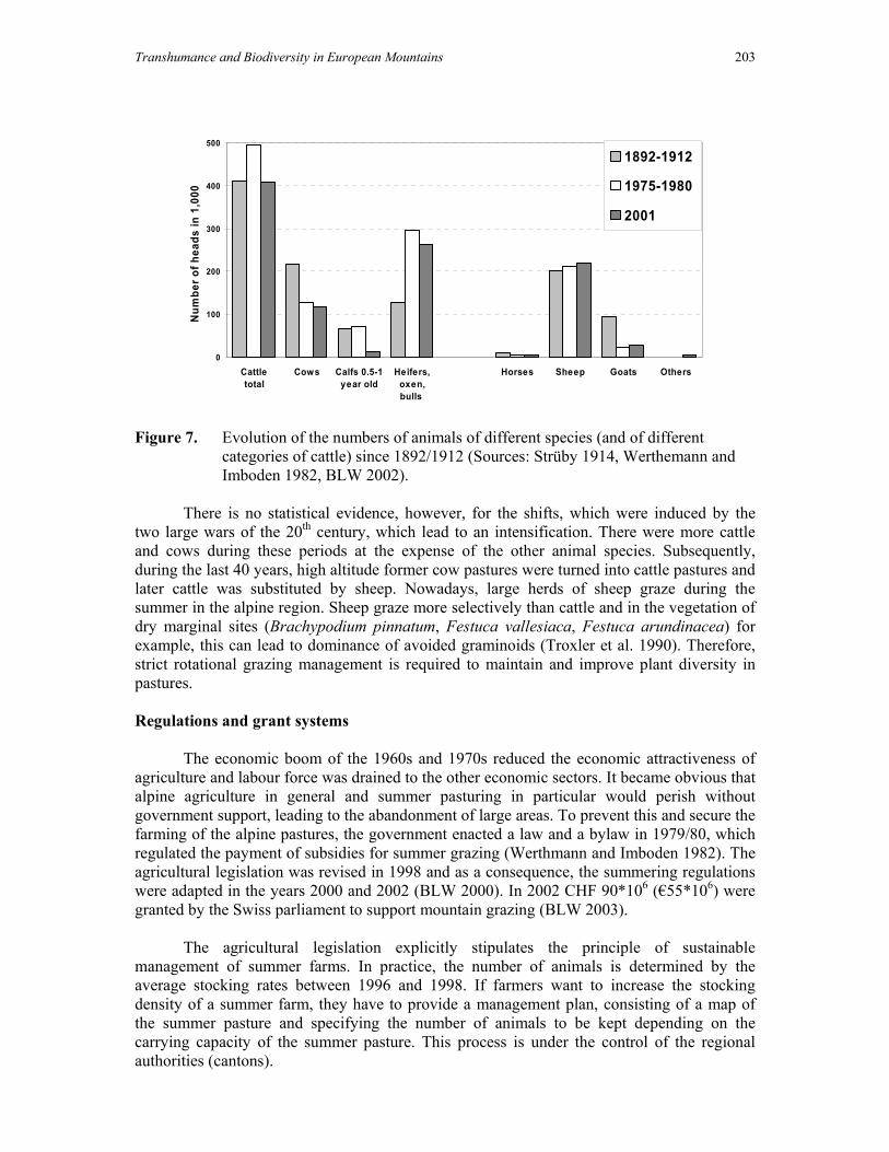
Transhumance and Biodiversity in European Mountains 203
0
100
200
300
400
500
Cattletotal
Cows Calfs 0.5-1year old
Heifers,oxen,bulls
Horses Sheep Goats Others
Num
ber o
f hea
ds in
1,0
00
1892-1912
1975-1980
2001
Figure 7. Evolution of the numbers of animals of different species (and of different
categories of cattle) since 1892/1912 (Sources: Strüby 1914, Werthemann and Imboden 1982, BLW 2002).
There is no statistical evidence, however, for the shifts, which were induced by the
two large wars of the 20th century, which lead to an intensification. There were more cattle and cows during these periods at the expense of the other animal species. Subsequently, during the last 40 years, high altitude former cow pastures were turned into cattle pastures and later cattle was substituted by sheep. Nowadays, large herds of sheep graze during the summer in the alpine region. Sheep graze more selectively than cattle and in the vegetation of dry marginal sites (Brachypodium pinnatum, Festuca vallesiaca, Festuca arundinacea) for example, this can lead to dominance of avoided graminoids (Troxler et al. 1990). Therefore, strict rotational grazing management is required to maintain and improve plant diversity in pastures. Regulations and grant systems
The economic boom of the 1960s and 1970s reduced the economic attractiveness of agriculture and labour force was drained to the other economic sectors. It became obvious that alpine agriculture in general and summer pasturing in particular would perish without government support, leading to the abandonment of large areas. To prevent this and secure the farming of the alpine pastures, the government enacted a law and a bylaw in 1979/80, which regulated the payment of subsidies for summer grazing (Werthmann and Imboden 1982). The agricultural legislation was revised in 1998 and as a consequence, the summering regulations were adapted in the years 2000 and 2002 (BLW 2000). In 2002 CHF 90*106 (€55*106) were granted by the Swiss parliament to support mountain grazing (BLW 2003).
The agricultural legislation explicitly stipulates the principle of sustainable management of summer farms. In practice, the number of animals is determined by the average stocking rates between 1996 and 1998. If farmers want to increase the stocking density of a summer farm, they have to provide a management plan, consisting of a map of the summer pasture and specifying the number of animals to be kept depending on the carrying capacity of the summer pasture. This process is under the control of the regional authorities (cantons).

204 S. Dreier, M. Ramsauer & F. Herzog
The Federal Office for Agriculture on the other hand defines the maximum stocking
for sheep (except milk sheep) per hectare net grazing area, distinguishing between the different locations, grazing organisation and grazing system. Subsidies are higher for sheep in paddocks and for herded sheep as compared to free ranging flocks in order to encourage grazing systems, which prevent damage by overgrazing. The authorities also determine areas where grazing is limited or even prohibited.
Additional regulations concern fertilisation (no mineral fertiliser), the use of herbicides (only local applications allowed), the prevention of trading damage and of overgrazing in areas outside the actual pastures. The cantons are obliged to check 10% of all summer farms every year.
Furthermore, subsidies for the modernisation and entertainment of building and transport infrastructure can be granted. Conclusions and Outlook
In the second part of the 20th century alpine agriculture entered a crisis, which is continuing until today. The most visible consequences of this process are fallow land and progressive reforestation. Thus the question arises if and how the alpine landscape with its diverse man-made habitats will be maintained in the future.
Effects resulting from the elimination of subsidies on the relative share of fallow land
in 2010, calculated in a spatial sectoral linear programming model (Flury et al. 2001), show clearly, that the management would decrease drastically on steep slopes and at higher altitude on sites with difficult accessibility. In better accessible regions where additional employment opportunities outside agriculture exist, at least moderate steep areas near the farm would be further cultivated. If grant levels remain as they presently are, the model predicts a reduced management of steep sites only in regions of difficult access. In both scenarios, sites and habitats are most threatened by abandonment, which have never been intensively managed and therefore are particularly valuable in terms of biodiversity. Furthermore, abandoning the management of steep sites may increase the risk for landslides and avalanches, which endanger settlements and traffic infrastructure.
Alpine landscapes are the product of an enormous effort of the former generations of
alpine inhabitants. They stand for ecological stability, sustainable production, natural diversity and scenic beauty. Alpine summer farming, mountain agriculture and the alpine economy as a whole depend on each other. Their functioning is a pre-requisite for the maintenance of the settlements and population in the Alps. The predicted impacts of climatic change (Nagy et al. 2003) are a new challenge, the extent of which is still largely uncertain.
In the future it seems likely that the polarisation between intensively developed,
prosperous regions and remote, marginalized ones will continue, although some promising attempts to promote new multifunctional land-use models exist (Messerli 1989). The extent to which mountain farming, the associated landscapes and the particular mountain way of life will continue to exist, depends on the capacity of the mountain population to invent and re-invent solutions which are adapted to today’s socio-economic conditions. It also depends on the consensus of the entire Swiss population to regard well managed and functioning Alpine

Transhumance and Biodiversity in European Mountains 205
landscapes as a central feature of the national identity and to further grant public support to its population. References Aegerter E., Brugger M., Lehmann B. und Stucki E. (1998). Die Milchwirtschaft in Grindelwald: Grundlagen zur Gestaltung der Zukunft. Institut für Agrarwirtschaft, ETH Zürich. Bätzing W. (1996). Landwirtschaft im Alpenraum – unverzichtbar, aber zukunftslos? Blackwell Wissenschafts-Verlag, Berlin. Bischof N. (1984). Pflanzensoziologische Untersuchungen von Sukzessionen aus gemähten Magerrasen in der subalpinen Stufe der Zentralalpen. Beiträge zur Geobotanischen Landesaufnahme der Schweiz, 60. BLW (2000). Verordnung über Sömmerungsbeiträge 910.133. Bern, Bundesamt für Landwirtschaft (available in French, German and Italian at http://www.bk.admin.ch/) Bonn S. and Poschlod P. (1998). Ausbreitungsbiologie der Pflanzen Mitteleuropas. Grundlagen und kulturhistorische Aspekte. Quelle und Meyer, Wiesbaden. BLW (2002). Agrarbericht 2002. Bundesamt für Landwirtschaft, Bern. BLW (2003). Agrarbericht 2003. Bundesamt für Landwirtschaft, Bern. BFS (1992). Bodennutzung der Schweiz. Arealstatistik 1979/85. Bundesamt für Statistik, Bern. BFS (1999). Arealstatistik der Schweiz 1979/85 und 1992/97. Bundesamt für Statistik, Neuchâtel. Burri K. (1995). Schweiz Suisse Svizzera Svizra: Geographische Betrachtungen. Lehrmittelverlag des Kantons Zürich, Zürich. Dähler W. (1993). Langfristige Auswirkungen menschlicher Eingriffe in alpine Vegetation. Beiträge zur Geobotanischen Landesaufnahme der Schweiz 60, 1-128. Flück-Wirth, Teufen. Delarze R., Gonseth Y., Galland P. (1999). Lebensräume der Schweiz. Ökologie, Gefährdung, Kennarten. Ott-Verlag, Thun. Dietl W. (1982). Schafweiden im Alpsteingebiet. Bericht des Geobotanischen Institutes der ETH Zürich, Stiftung Rübel, 49. Dietl W., Hug L., Indermühle P., Lauener H., Peterer R., Schläppi W., Stadler F. und Wäfler P. (1997). Alpwirtschaft. Landwirtschaftliche Lehrmittelzentrale, Zollikofen. Ellenberg H. (1996). Vegetation Mitteleuropas mit den Alpen in ökologischer, dynamischer und historischer Sicht. Ulmer, Stuttgart. Fischer M., Wipf S. (2002). Effect of low-intensity grazing on the species-rich vegetation of traditionally mown subalpine meadows. Biological Conservation 104, 1-11. Flury Christian, Gotsch N., Rieder P. (2000). Socio-economic and ecological effects of alternative direct payment regimes on different Swiss Alpine regions. Cahiers d’Economie et Sociologie Rurales 57, 5-26. Grünig A. (Ed.) (1994). Mires and Man. Mire conservation in a densely populated country – the Swiss experience. Excursion guide and symposium proceedings of the 5th field symposium of the international mire conservation group (IMCG) to Switzerland 1992. Flück-Wirth, Teufen. Haefner H., Günter T. (1984). Landnutzungswandel und ökologische Veränderung im Schweizer Berggebiet. S. 139 ff. In: Brugger E.A., Furrer G., Messerli B., Messerli P. (Edits.). Umbruch im Berggebiet: die Entwicklung des schweizerischen Berggebietes zwischen Eigenständigkeit und Abhängigkeit aus ökonomischer und ökologischer Sicht. Haupt, Bern.

206 S. Dreier, M. Ramsauer & F. Herzog
Hegg O. (1985). 50jährige Dauerflächenbeobachtungen im Nardetum auf der Schynigen Platte ob Interlaken. In. O. Hegg (Ed.). Verh. Ges f. Ökologie Xll. Bern. Hegg O., Béguin C., Zoller H. (1993). Atlas schutzwürdiger Vegetationstypen der Schweiz. Bundesamt für Umwelt, Wald und Landschaft BUWAL, Bern. Hunziker M. (1995). The spontaneous reafforeastation in abandoned agricultural lands: perception and aesthetic assessment by locals and tourists. Landscape and Urban planning 31, 399-410. Jewell P. (2002). Impact of cattle grazing upon vegetation of an Alpine pasture. In: Schriftenreihe Nahhaltige Land- und Forstwirtschaft im Alpenraum. Band 5. Hrsg. Nikolaus Gotsch, Hans Rudolf Heinimann, Michael Kreuzer und Peter Rieder. Wissenschaftsverlag Vauk, Kiel. Kienzle U. (1979). Sukzessionen in brachliegenden Magerwiesen des Jura und Napfgebietes. Teildruck der Diss. Von Ah, Sarnen. Klötzli F., Landolt E., Zumbühl G. (1984). Veränderungen im Vegetationsbereich. In: Brugger E.A., Furrer G., Messerli B., Messerli P. (Edits.). Umbruch im Berggebiet: die Entwicklung des schweizerischen Berggebietes zwischen Eigenständigkeit und Abhängigkeit aus ökonomischer und ökologischer Sicht. Haupt, Bern. Krippendorf J. (1984). Das Kapital des Tourismus in Gefahr. In: Brugger E.A., Furrer G., Messerli B. und Messerli P. (Edits.). Umbruch im Berggebiet. Bern, Stuttgart. Landolt E. (1992). Unsere Alpenflora. Fischer, Stuttgart. Laur E. (1947). Der Schweizer Bauer, seine Heimat und sein Werk. Buchverlag Verbandsdruckerei, Bern. Lüdi W. (1959). Versuche zur Alpweideverbesserung auf der Schynigen Platte bei Interlaken. Jahresbericht des Vereins Alpengarten Schynige Platte.Interlaken, p. 8. Mayer A.C., Stöckli V., Konold W., Estermann B.L. and Kreuzer M. (2002). Effects of grazing cattle on subalpine forests. In: Bottarin, R. and Tappeiner, U. (Eds.), Interdisciplinary Mountain Research. Blackwell Verlag GmbH, Berlin, Wien, pp. 208-218. Messerli P. (1989). Mensch und Natur im alpinen Lebensraum – Risiken, Chancen und Perspektiven, zentrale Erkenntnisse aus dem schweizerischen MAB-Programm. Bern/Stuttgart. Nagy L., Grabherr G., Körner Ch., Thompson D.B.A. (2003). Alpine Biodiversity in Space and Time: a Synthesis. In: Nagy L., Grabherr G., Körner Ch., Thompson D.B.A. (Eds.). Alpine Biodiversity in Europe. Springler, Berlin. Niederer A. (1996). Alpine Alltagskultur zwischen Beharrung und Wandel: Ausgewählte Arbeiten aus den Jahren 1956 bis 1991. Anderegg V. K., Bätzing W. (Edits.) 2. Aufl. Haupt, Bern. Rosset M., Gerber N., Tanner M. and Fuhrer J. (1999). In: Cernusca A., Tappeiner U., Bayfield N. (Edits.). Land-use changes in European mountain ecosystems - ECOMONT - concepts and results. Blackwell-Wissenschafts-Verlag, Berlin. Schütz M., Wohlgemuth T., Achermann G., Krüsi, B.O., Grämiger H. (2000). Influence of increasing grazing pressure on species richness in subalpine grassland in the Swiss National Park / Einfluss von zunehmendem Beweidungsdruck auf die Artenvielfalt in subalpinem Grünland im Schweizerischen Nationalpark. - Natl.park-Forsch. Schweiz 89, 39-65. Troxler J., Jans F., Floch C. (1990). Utilisation et entretien des zones marginales sèches pal la pâture des ovins et des vaches allaitantes. ll. Influence sur la végétation. Revue Suisse Agricole 22(4), 231-238. Walter F., Marti M., Osterwald S., Simmen H. (2004). Leben die Alpen auf Kosten der übrigen Schweiz? Montagna (15) 4, 24-27.

Transhumance and Biodiversity in European Mountains 207
Werthemann A., Imboden A. (1982). Die Alp- und Weidewirtschaft in der Schweiz : Zusammenfassung der Alpkatastererhebungen = L'Economie alpestre et pacagère en Suisse. BLW (Ed.). Emmentaler Druck, Langnau. Zoller H. (1960). Pollenanalytische Untersuchungen zur Vegetationsgeschichte der insubrischen Schweiz. Denkschr. Schw. Naturf. Ges. 83.

208 S. Dreier, M. Ramsauer & F. Herzog

Transhumance and Biodiversity in European Mountains 209
MEDITERRANEAN MOUNTAINS

210 Mediterranean Mountains

Transhumance and Biodiversity in European Mountains 211
Transhumance in Greece: Past, present and future prospects
I. Ispikoudis, M. K. Sioliou & V. P. Papanastasis
Laboratory of Rangeland Ecology, Aristotle University,
54124 Thessaloniki, Greece. e-mail: : [email protected]
Abstract
Transhumance is a traditional pastoral activity in Greece, and has been practised since time immemorial. In the past, one could easily see nomads moving their animals from lowlands to uplands in late spring and vice versa in early autumn. Also, their temporary settlements made of local materials, such as tree branches or reeds, were conspicuous almost all over the country. They were identified according to the ethnic group practicing transhumance. The “Karagouni” and “Sarakatsani” were called skinites (literally: tent-dwellers) for they did not usually have permanent homes either at their summer or their winter camps. The “Koutso-vlachs”, on the contrary, had one permanent village during winter, called home. The predominant social organization of the nomadic people was “tseligato”, an autonomous and closed, economic and cultural, unit. This unit included not only shepherds but all kind of professions, e.g. grocers, cheese makers, tailors, bakers, etc that ensured its autonomy. Since the beginning of the 20th century, nomadic people had to face social, economic and political changes. In 1917, the agricultural reform decreased the available grazing land in the lowlands, while quite a few nomads have settled down. This settling process was speeded up after World War II, when restrictions to grazing were also imposed in mountain areas besides the expansion of arable agriculture. The problem was further aggregated by the rural emigration in the 1960s and 1970s. Nowadays, although nomadic people have established permanently in different places in Greece, transhumance is still practiced, but the number of animals involved has dramatically decreased compared to the past. Also, the system applied is modified compared with the ancient one. Nevertheless, the diversification of the landscape and consequently of the biodiversity due to transhumance is still evident as well as its cultural impact. The most typical landscapes, created and maintained by transhumance are the pseudo-alpine grasslands and the silvopastoral systems, where “kladonomi” and “koura” were applied in tree management. Several of these landscapes are now included in the Natura 2000 network. The prospects of transhumance in Greece are not favourable unless coordinated action is taken to socially and economically support this activity.
Introduction
Transhumance is the cyclical, annual movement of livestock between distinctive rangelands to exploit their seasonal growth (Vallentine 2001). In mountainous countries, such as Greece, this is a vertical movement between established points, namely lowlands (winter

212 I. Ispikoudis, M. K. Sioliou & V. P. Papanastasis
rangelands) and uplands (summer rangelands). For about half a year, animals are kept on the lowlands to graze on common land or on fallow cropland during the winter period. Then they are moved to the uplands together with families to graze the lush forage growth during the summer period (four to six months) and return back again to the winter pastures during the early autumn months.
In the past, the seasonal movement of the animals in Greece had rather the form of nomadism, characterized by no main home base (Vallentine 2001). More specifically, flocks, families and belongings were moved from place to place along Greece and in the Balkans (before the creation of the ethnic states in the early 20th century), without having a permanent base. Although this form of movement has now disappeared, and it has been totally replaced by transhumance, the livestock farmers following this latter practice are still called nomads.
In Greece, transhumance is a traditional pastoral activity linked with certain ethnic groups. In this paper, its evolution over the years is analyzed, the specific habitats and landscapes created are described and its future scenarios are discussed. Ethnic groups and evolution of transhumance
Several studies concerning the customs of ethnic groups linked with transhumance were done over the last decades. Laography (the science of folks) treated these particular societies in their spatial or non-spatial dimension (Prevelakis 1992). Nomads’ population figures are notoriously hard to substantiate. On the one hand, the characterisation of somebody as a nomad was not very respectful and, on the other, the unstable political situation (Sivignon 1975) as well as the mobility of nomads made their census very hard. The existing scattered statistics till the 1960s can be considered rather as a rough guide than as reliable data.
The ethnic groups linked with nomadism and transhumance are:
1. Sarakatsani. They are considered the ethnic group that is closest to ancient transhumance. They are found all over continental Greece, especially in Thrace and Macedonia. They believed to be pure Greek people and practiced endogamy. They did not own particular summer and winter pastures, and considered by the local village communities as foreigners in both lowlands and uplands. This is why they were also called skinites (literally: tent dwellers). They did not have permanent homes either at their summer or their winter encampments. They used to build their reed huts anew each year or patch up those that remained usable from the previous year (Sirkou & Skarlatou 2001). In 1919, the measure of “enoikiostasio” (rent) was applied and Sarakatsani were obliged to use the same summer and/or winter pastures every year. In 1938, the Government forced them to get registered in a mountain or lowland community.
Because of their mobility, their total population was never registered. In the region of Drama, northern Greece, for example, they were about 50 settlements of Sarakatsani from 1912 until 1940. This means 350,000 sheep and goats and about 8,000 horses (Prefecture of Drama 2002). It is estimated that only in the region of Thrace the number of sheep and goats were 400,000 and the families 2,500-3,000 in 1924, which amount to more or less 17,000 to 20,000 people. The last census for the Sarakatsani of Thrace was done in 1980, when 6,014 families with 25,400 members were recorded, and 1031 flocks with 177,965 sheep, distributed in 291 settlements (Anonymous 1999). A similar trend was also observed in the region of Epirus, western Greece, where there were 323 settlements, 1875 families and

Transhumance and Biodiversity in European Mountains 213
285,440 sheep and goats in the 1950s (Hatzimichali 1957). In 1984, however, when a more detailed census was done, no settlements were found and the families amounted to 1602 with 7,007 people who owned 81,000 sheep and goats (Makris 1997). In the 1950s, the total number of Sarakatsani in Greece was 10,604 families corresponding to about 74,228 people in 2,890 settlements with 1,729,141 sheep and goats, (Hatzimichali 1957). Nowadays, it is estimated that Sarakatsani are about 100,000 people (Makris 1997).
2. Karagouni. Their name is derived from the black cape they used to wear. They were also called skinites like Sarakatsani.
3. Vlachs. They are divided to Arvanitovalaques who also speak Albanian and Koutsovalaques (literally the Lame Vlachs), who do not speak Albanian. The Koutso-vlachs usually had one permanent village, which they called home. Some Koutso-vlachs considered their winter home as the permanent settlement and the summer pastures the encampment, but there is evidence indicating that the opposite was also true. Probably their main “base” was on the Pindus mountains since a big part of this mountain range was called Great Vlachia during the 13th century. Their presence is confirmed by travellers of the Ottoman period (Heuzey 1927). Before the fall of Ottoman Empire, Vlachs were moving all over the Balkan peninsula. When the modern Balkan states were created in the early 20th century, they were divided among them. At that time, their population was estimated to 500,000 (Balamaci 1995); recent estimates, however, are less than half of this number. Since Vlachs were wandering in the Balkans, the maintenance or not of their transhumance was also a political issue: the convention of Neuilly in 1919 gave them the right to cross the Greek- Bulgarian borders but the convention of Lausanne in 1923 deprived their right to pass to other Balkans countries and of course to Turkey. The most recent number for the population of Vlachs of Greece is 39,885 in 1951 (Winnifrith 2003), but this must be much higher given that it was not very comfortable for a Vlach to denote his identity for socio-cultural reasons .
4. Koupatsari, or “oak people”. They are livestock farmers, who have settled down, practicing transhumance, perhaps ancient Vlachs (Sivignon 1975). They are mainly found in Thessaly and Macedonia.
The most common organization of the society of nomadic people was “tseligato” (stockbreeding clan), an autonomous and closed, economical and cultural, unit. Tseligato included not only shepherds but all kinds of professions (grocers, cheese makers, tailors, bakers, etc) which ensured its autonomy. It was considered as a “family” in the wide sense of the word. Many shepherds owning smaller flocks would join the tseligato in order to obtain better rent for the summer pastures, since the leader of tseligato, the powerful “tseligas”, could ensure the best prices for his flocks. The economic, social and cultural structure of tseligato favoured independence of Greece from the Ottoman Empire and quite often it became the seedbed where liberal ideas and perceptions were developed. Several warriors were born in tseligata during the Ottoman Empire. In fact, their constant displacement, their movement to isolated mountains, the abundant resources they could exploit and a rather particular sense of morality, necessary for their survival, helped them to become powerful clans.
After the liberation of the Greek nation from the Ottoman Empire, nomadic life started to decline. Since the beginning of the 20th century, nomadic people had to face social, economic and political changes. In 1917, the agricultural reform decreased the available grazing land in the lowlands. Furthermore, the main organisation of their society, the

214 I. Ispikoudis, M. K. Sioliou & V. P. Papanastasis
tseligato, formerly the reason of their survival, could not adjust to the new socio-economic conditions. In addition, the lack of education, the rivalry with the local societies and the general perception of nomads more or less as troublemakers (Damianakos 1996) contributed to their decline. Moreover, a law in 1924 deprived them of their summer pastures. The II World War and, especially, the Greek Civil War in 1946-48, that mainly took place in the mountainous areas of northern Greece, made transhumance very difficult. In the 1950s, although many nomadic people re-started their wandering life (Sanders 1954), they had to confront not only the lack of grazing land in lowlands and the restriction of grazing in the mountainous areas, applied by the Greek Forest Service, but also the racial prejudices and discrimination. Gradually, the majority of nomads have settled, and only a few of them continued to practice transhumance. In the 1960s and 70s, the rural depopulation, the search for a modern lifestyle, and the massive flow of emigration to urban centres and abroad resulted in an even bigger decrease.
This evolution is clearly depicted in the animal statistics kept by the National Statistical Service of Greece (NSSG) since 1961 (Figure 1). Although the total number of sheep and goats were increased from 1962 to 1998 by 17% and 34% respectively, the nomadic sheep and goats, which follow the practice of transhumance, were decreased by 32% and 6.6% respectively. This decrease was sharper during 1961-1971 (by 40%) while later on became milder to get stabilised in the more recent decades. Nowadays, only 255,881 of sheep and 659,415 of goats still follow transhumance, while the majority of the animals are still grazing in rangelands but they are have settled (in flocks) (NSSG 2000). That flow of emigration between 60s and 70s, contributed to the decrease of sheep and goats in flocks by 8.2% and 6.3% respectively. Nevertheless, since 1971 there is an increase in the number of animals in flocks (Figure 1).
0
1
2
3
4
5
6
7
8
Householdsheep
Householdgoats
Sheep inflocks
Goats inflocks
Nomadicsheep
Nomadicgoats
Num
ber o
f hea
ds (m
illio
ns)
19611971198119911998
Figure 1. Number of sheep and goats in the different modes of exploitation between 1961
and 1998 (NSSG 2000).
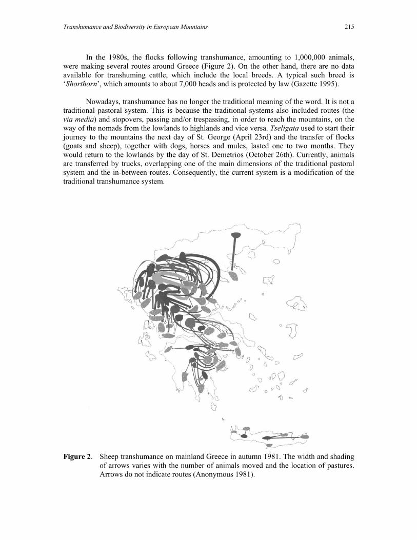
Transhumance and Biodiversity in European Mountains 215
In the 1980s, the flocks following transhumance, amounting to 1,000,000 animals, were making several routes around Greece (Figure 2). On the other hand, there are no data available for transhuming cattle, which include the local breeds. A typical such breed is ‘Shorthorn’, which amounts to about 7,000 heads and is protected by law (Gazette 1995).
Nowadays, transhumance has no longer the traditional meaning of the word. It is not a traditional pastoral system. This is because the traditional systems also included routes (the via media) and stopovers, passing and/or trespassing, in order to reach the mountains, on the way of the nomads from the lowlands to highlands and vice versa. Tseligata used to start their journey to the mountains the next day of St. George (April 23rd) and the transfer of flocks (goats and sheep), together with dogs, horses and mules, lasted one to two months. They would return to the lowlands by the day of St. Demetrios (October 26th). Currently, animals are transferred by trucks, overlapping one of the main dimensions of the traditional pastoral system and the in-between routes. Consequently, the current system is a modification of the traditional transhumance system.
Figure 2. Sheep transhumance on mainland Greece in autumn 1981. The width and shading
of arrows varies with the number of animals moved and the location of pastures. Arrows do not indicate routes (Anonymous 1981).

216 I. Ispikoudis, M. K. Sioliou & V. P. Papanastasis
Transhumance landscapes in Greece
Transhumance is a production system developed by the livestock farmers in order to cope with the seasonality of Mediterranean climate. This climate involves a cold and wet winter period followed by a hot and dry summer time. This seasonality creates a big feed gap in the summer, which significantly affects the welfare of livestock. In order to fill up this gap and ensure abundant and nutritious feed to the animals, Mediterranean livestock farmers were forced to move to the mountains, where plants were still actively grown due to wetter climatic conditions. In other words, traditional transhumance systems followed the seasonally available forage by taking advantage of the growth cycle of the vegetation and exploiting efficiently the natural resources. As a result, an extraordinary diversity of Mediterranean landscapes was created that present common features all around the Mediterranean basin. In Greece, transhumance landscapes are found almost everywhere. They were shaped by the communal grazing system practiced by nomads. In addition, they bear the vernacular structures of tseligata. Until the late 1940s, one could easily see these characteristic structures to stand out picturesquely now and there throughout Greece; the round branch and reed huts, surrounded by wattled sheepfolds, put up either in some isolated, sheltered spot or at the edge of some village (Figure 3). In addition, he could also spot the tents that nomads used to put on their way to the mountains (Figure 4). After their settling process in the lowlands, however, the roofs of buildings were replaced by weatherboards (Figure 5).
Figure 3. Traditional nomads’ huts made of reeds.

Transhumance and Biodiversity in European Mountains 217
Figure 4. Traditional tents of nomads on their way to the mountains.
Figure 5. Modern building of nomads covered by weatherboards. Around these primitive huts, animal corrals were built, called “strougges”. Some of these are still found in the mountains of Pindus as shown in Figure 6.

218 I. Ispikoudis, M. K. Sioliou & V. P. Papanastasis
Figure 6. Corrals made of local materials (e.g. stones, shrub or tree branches) to keep the
animals in and also milk them.
The grazing pressure of sheep, goats, horses and/or mules, driven from lowlands to uplands and vice versa, created openings and corridors in forests and rangelands resulting in the development of mosaic-like landscapes. These landscapes are dynamic systems, produced from the interaction between man and nature and depended on natural, social and economic forces. As typical transhumance landscapes could be considered the following:
1. Grasslands. Generally, rangelands occupy an area larger than 5,200,000 ha in Greece, which cover 40 % of its total area and extent mainly in the mountain regions of the country. A large part of these rangelands (about 33%) are classified as grasslands (Papanastasis 1982). These grasslands were to a large extent created by livestock activity including transhumance. Grazing animals, especially goats, can efficiently control woody species in favour of herbaceous plants thus keeping landscapes open. In fact, all grasslands in Greece are considered successional, meaning that they were created and maintained by human activities, including livestock husbandry (Papanastasis & Noitsakis 1992). Among these grasslands, the ones located above the timber line, also called pseudo-alpine pastures, should be considered as products of the transhumance husbandry, which was the main activity that kept these pastures free of woody species. The area of such grasslands is about 4,000 ha (Papanastasis & Pittas 1984).

Transhumance and Biodiversity in European Mountains 219
Figure 7. Routes of transhumance in Pindus mountains. (Aravantinos 2003).
2. Silvopastoral landscapes. A common landscape around the Mediterranean basin is the one composed of silvopastoral systems, very widespread in the Iberian peninsula and known as dehesa in Spain and montado in Portugal. Generally, this system involves two components: a pasture in the understory and a sparse tree, orchard like, overstory. Sometimes, there is a third component with crops and the system becomes agro-silvo-pastoral. The simplification of the structure of the autochtonous forests results from the elimination of the shrubs in order to obtain pastures or arable land (Clément 1999).
In Greece, dehesa-like landscapes are linked with traditional tree management. There are mainly two techniques of tree management; “kladonomi”, that is translated as lopping; and “koura”, that is translated as pollarding. Kladonomi consists of cutting the lower branches of the tree for fodder in order to store them and feed the domestic livestock during winter and/or to build the huts of nomads. Koura involves cutting of the branches of a tree at a height of at least 1,5-2 m of the trunk in order that the new sprouts are out of the reach of the animals. The technique of koura was a way of protecting the trees from browsing. It dates back to antiquity, since it is mentioned by Theophrastus (Zaharis 1977). It seems that this technique increases the life of a tree (Rackham 1998). The etymology of the word koura implies exactly the same thing, since it derives from the words “kouros” (young) and “kourizo” (making young)

220 I. Ispikoudis, M. K. Sioliou & V. P. Papanastasis
(Dormparakis 1989). This tree exploitation was practiced by both have settled population and nomads. The former were pollarding the trees in order to protect them from the transhumant flocks (a rivalry with the nomads). The latter were pollarding and shredding the trees to feed their animals on their way to the mountains (Figure 7). Pollarded and shredded trees are found even today on the old transhumance routes of the Pindus mountains as shown in Figure 8.
Figure 8. Shredded trees in the Pindus mountains
In the mountains of south Macedonia, great oaks, pollarded and shredded in different styles, are found scattered in the landscape. A whole cultural landscape depends on various tree forms of at least seven species of deciduous oaks, managed by the ethnic group of Koupatshari, the oak people (Grove & Rackham 2001), who practiced transhumance.
“Kouri” is also used as a location name, found all over Greece. All the places named
“kouri” are situated in areas where there was a high grazing pressure, and their majority coincide either with areas or with the routes of the transhumant flocks. It is possible that all these places were dehesa-like landscapes in the past. There is a high variety of trees forming dehesa-like landscapes in Greece. The principal ones are deciduous oaks that occupy large areas, especially in western Macedonia, west Thessaly, Epirus and in smaller areas in central and western Crete. The species are Quercus pubescens, Quercus sessiliflora, Quercus cerris, Quercus ithaburensis, Quercus macedonica; the pasture is composed of several species, depending on the altitude. As an example, the oak species Quercus ithaburensis subsp. macrolepis, which occupies 29,631 ha, forms dehesa-like landscapes (Pantera 2001). Herbaceous cover is usually composed of Cirsium creticum, Asphodelus microcarpus, Asparagus acutifolius, Urginea maritima and Phlomis fruticosa. These species demonstrate the high grazing pressure, since they are not palatable to sheep and goats.
Transhumance and Biodiversity in European Mountains 221
Dehesa-like landscapes of Pinus nigra are found mostly in western Macedonia and in Peloponnese, at high altitudes (Grove & Rackham 2001), where there is high grazing pressure. In the past, there were crossed by the traditional transhumant flocks. It should be noted that since the 1950s, grazing is not being allowed by law in pine forests (Makris 1974). This strict prohibition frustrated nomads that used to trespass the pine forests.
One unique case is Cupressus orientalis, found only in Crete. Surprisingly enough,
this tree species forms silvopastoral systems. It is found in areas where transhumance was common in the past. It is the only pollarded conifer. It has the capacity to produce offshoots, mentioned already by Theophrastus (Zaharis 1977). Biodiversity and transhumance; a landscape-scale issue
Until very recently, there was a lack of recognition of the ecological and cultural importance of transhumance. Nowadays, more and more it is realized that understanding of the ecological interactions between the management practices and the ecology of pastoral habitats at a landscape level can help implementing conservation and management of protected areas. There is a growing awareness for these issues, but research is needed to establish the ecological links between transhumance landscapes and biodiversity in Greece.
Grazing animals play an important role in vegetation dynamics at the landscape scale.
For example, the traditional practices of animal folding along long-distance transhumance routes acted as vectors for dispersal of plant species, since propagules may be transported long distances on the wool and fur of animals, moving between different areas (Ruiz & Ruiz 1986, Kollman & Pirl 1995, Fischer et al. 1996). Most grassland species have transient seed banks or the wind dispersal of their seeds is low. In this case, sheep or other animals are the essential dispersal agents for these species. Therefore, grasslands are dependent on these animal vectors to restore species richness (Dutoit & Allard 1995, Bakker et al. 1996, Poschlod et al. 1998).
The modification of traditional livestock systems can trigger changes in vegetation composition in remote areas due to secondary succession following abandonment. This modification can have significant consequences on landscape diversity (Tucker & Evans 1997). It should be noted that the traditional animal transhumance included not only sheep and goats but a large number of horses and/or mules too. These latter animals contributed also to species dispersal and to the creation of diversified landscape.
Transhumance landscapes are also of great importance to wildlife. For example, in the Grammos mountain of northwestern Greece, it was found that the presence of Neophron percnopterus and Aquila chrysaetos depends on the maintenance of the open pastoral landscape (Papanastasis et al. 2001.). Especially for the preservation of Aquila chrysaetos population, landscape structure and diversity is essential (Watson 1991). Gyps fulvus is also threatened by the closing up of open patches. The populations of Pyrrhocorax graculus and Pyrrhocorax pyrrhocorax are positively affected by livestock husbandry (Dendaletche 1991).
Sick animals provide vultures with plenty of food. It is not without reason that Sarakatsani used to consider vultures and eagles, which followed their flocks, as demons (Hatzimichali 1957). Since their home ranges are quite large, the most possible explanation is that they were just looking for food, and they could find it mainly in these open pastoral landscapes.
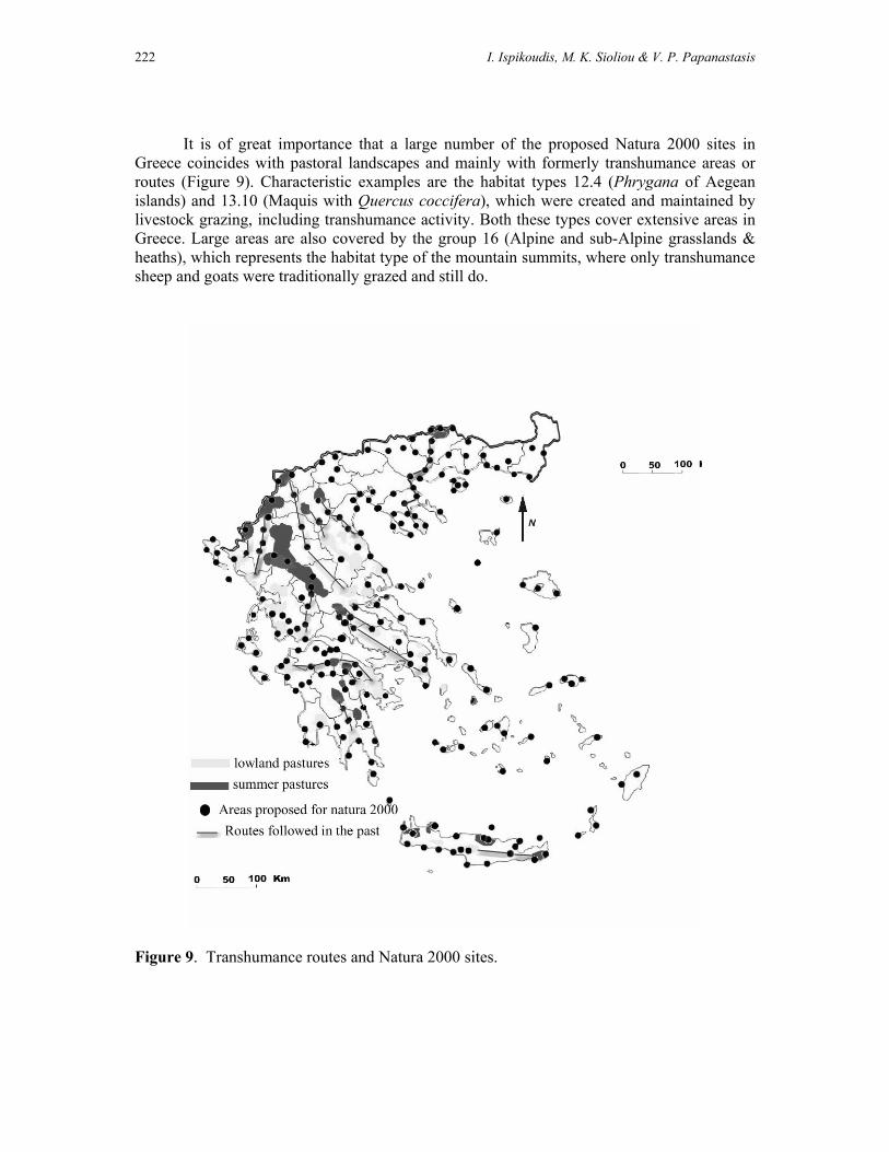
222 I. Ispikoudis, M. K. Sioliou & V. P. Papanastasis
It is of great importance that a large number of the proposed Natura 2000 sites in
Greece coincides with pastoral landscapes and mainly with formerly transhumance areas or routes (Figure 9). Characteristic examples are the habitat types 12.4 (Phrygana of Aegean islands) and 13.10 (Maquis with Quercus coccifera), which were created and maintained by livestock grazing, including transhumance activity. Both these types cover extensive areas in Greece. Large areas are also covered by the group 16 (Alpine and sub-Alpine grasslands & heaths), which represents the habitat type of the mountain summits, where only transhumance sheep and goats were traditionally grazed and still do.
Figure 9. Transhumance routes and Natura 2000 sites.

Transhumance and Biodiversity in European Mountains 223
As far as the number of priority habitat types contained in each group is concerned, it seems that most of them (18%) are concentrated in habitat groups 14 (dry grasslands) and 19 (mountainous coniferous forests), while habitat group 6 (shingle and sandy beaches dunes) follows with 12% of the total (Dafis et al. 1996). All these priority habitats are closely related with livestock activities, including transhumance. Their area amounts to 865,873 ha, which represents 19% of the total area of these pastoral landscapes or 6.56% of the total area of Greece. The most important habitat groups for transhumance are included in Appendix I, while the most representative ones are described in Appendix II. A case study
The significance of abandonment and/or modification of traditional livestock practices in the landscape can be illustrated with an example from the mountain areas in Greece (Chouvardas & Ispikoudis 2001). The study was carried out in an area of 120 km2, located in the Pindus mountain of Central Greece. In the north part of this area with high altitudes, grasslands decreased by 32% and scrubs by 11% between 1945 and 1992. Moreover, there has been a shift from sparser to denser scrubs. Also, agricultural land decreased by 46.72%. On the contrary, coniferous forests increased by 14.70% and broad-leaved forests by 21.31%, while a significant shift was observed from sparser to denser forests. These changes can be attributed to demographic and socio-economic changes that altered the traditional husbandry systems. For example, the numbers of grazing sheep and goats decreased from 5,192 to 4,233 between 1961 and 1991. Some notable alterations were the concentration of grazing pressure around the villages, the decline of grazing pressure in forested areas and the expansion of coniferous and broad-leaved forests in abandoned agricultural land and rangelands. The majority of these places coincide either with areas or with the routes of transhuming flocks. What is the future of transhumance?
Transhumance systems are particularly complex not only in that they utilise summer and winter pastures in different regions often separated by hundreds of kilometres, but also because they involve a cultural dimension and a specific way of lifestyle. They are valuable systems, not only for the particular cultural landscapes that they have created and still do, but for their habitat and biodiversity value. Transhumance is also a basic element of Greek identity, while it is linked with certain ethnic groups. Even nowadays, social events (e.g. festivals, fiestas) related with transhumance lifestyle are taking place in the mountain areas of Greece, which attract a large number of people searching for their origin and identity. Furthermore, certain transhumance landscapes constitute an element of cultural identification.
Although it is necessary to maintain transhumance systems for both ecological and
cultural reasons, such an endeavour is not easy because these systems are vulnerable to socio-economic factors. For example, the rural population is constantly declining and the retiring farmers are not replaced. The younger farmers look for more intensive systems, often with high total invested capital for modern housing and equipment (milking machines, small cheese making plants, etc), for new and more productive animal breeds, and for higher living standards for their families (Zervas 1997). Today, it is extremely difficult to persuade young people to practice transhumance by moving to the upland areas where there is no social life. Moreover, women keep abandoning mountain areas. In addition, farmers can ensure a high income due to national and European subsidies, even without transhumance.

224 I. Ispikoudis, M. K. Sioliou & V. P. Papanastasis
On the other hand, transhumance practices are adapted to the seasonal growth of vegetation. In addition, they can comply easily with the standards of biological husbandry and the code of good farming practices. The production methods of transhumance respect and enhance the natural environment, they are highly efficient and can produce high quality products, ecologically sustainable. As for the Natura 2000 sites, transhumance can play an important role, since it is not excluded as a management option in these areas. It can be always adapted to the biological “needs” of each area, according to the management plan, serving as a major tool for landscape conservation.
If certain measures are taken, transhumance can be proved a sustainable pastoral
system, ecologically, economically and socially speaking. Some of such measures may include infrastructure (e.g. roads, sheds) at both the summer and winter pastures, decent accommodation for shepherds, and small dairies for the milking sheep, so that they meet EU requirements for hygiene. In addition, special marketing measures should be created to increase the sales of products from transhumance. Finally, both transhumance shepherds and their flocks should be eligible to be included in the agri-environment measures, even if they are not staying in one region for the entire year. References Anonymous, (1981). Ministry of Agriculture. Athens. Aravantinos, Ch. (2003). Personal communication. Bakker, J.P., E.S. Bakker, E. Rosen, G.L. Verweij & R.M. Bekker. (1996). Soil seed bank composition along a gradient from dry alvar grassland to Juniperus shrubland. Journal of vegetation Science, 7: 165-176. Chouvardas, D. & I. Ispikoudis. (2001). Temporal change analysis of landscapes with the use of Geographic Information Systems (GIS). p. 129-137. In: Papachristou T. and O. Dini-Papanastasi (eds) Proc. of the Hellenic Range and Pasture Society 2nd Conferenc on: Range science on the threshold of 21th Century. 4-6 October 2000. Ioannina, Greece. Thessaloniki. (In Greek). Clément, V. (1999). Les milieux forestiers méditerranéennes, in Dubois J.J ; les milieux forestiers, aspects géographiques, DIEM, ed SEDES. p.182-333. Dafis S., Eva Papastergiadou, K. Georgiou, D. Babalonas, T. Georgiadis, Maria Papageorgiou, Thalia Lazaridou & Vasiliki Tsiaoussi. (1996). Directive 92/43/EEC The Greek “Habitat” Project NATURA 2000: An Overview. Life Contract B4-3200/94/756, Commission of the European Communities DG XI, The Goulandris Natural History Museum-Greek Biotope/Wetland Centre. pp. 917. Damianakos, S. (1996). Le paysan grec, Défis et adaptations face à la société moderne, Paris, Ed. l’Harmatttan. pp. 500. Dendaletche, C. (1991). Alpine Choughs and Choughs: biological integrators of agro-pastoral ecosystems in the Pyrenees, p. 68-69. In: D.J. Curtis, E.M. Bignal and M.A. Curtis (eds). Birds and pastoral agriculture in Europe. Proc. of the 2nd European Forum on Birds and Pastoralism, Port Erin, Isle of Man, 26-30 Oct 1990. Scottish Chough Study Group. Dormparakis, X.P. (1989). Glossary of classic Greek language. I.D. Kollaros & AE, Athens. pp. 926. (In Greek) Dutoit, T. & D. Allartd. (1995). Permanent seed banks in chalk grassland under various management regimes – their role in the restoration of species-rich plant communities. Biodiversity and Conservation, 4: 939-950. Fischer, S.F., P. Poschlod & B. Beinlich. (1996). Experimental studies on the dispersal of plants animals on sheep in calcareous grasslands. Journal of Applied Ecology, 33: 1206-1222.

Transhumance and Biodiversity in European Mountains 225
Gazette. (1995). Low No 434, Issue No 248 A/ 30.11.1995. Athens (In Greek) Grove A.T., & O. Rackham. (2001). The nature of Mediterranean Europe, an ecological History, Yale University press, New Haven and London. pp. 384. Hatzimichali, A. (1957). Saracatsani. Vol. First. Part A. ATHENS. (In Greek). Heuzey L. (1927). Excursions dans la Thessalie Turque en 1858, Paris, société d’édition des Belles Lettres. Kollman, J. & M. Pirl. (1995). Spatial pattern of seed rain of fleshy-fruited plants in a scrubland grassland transition. Acta Oecologica. 16:213-222. Makris, K. (1974). Forest Policy. Aristotle University, Thessaloniki. pp. 81. (In Greek) Makris, P. E. (1997). Life and Tradition of Sarakatsani. Ioannina. pp. 350. (In Greek) NSSG. 2000. Catalogue of statistical publications. General Secretary of the National Statistical Service of Greece, Athens. (In Greek) Pantera, A. (2001). Enstablisment of Quercus ithaburensis Decaisne subsp. Macrolepis Hedge & Yalt under competition from herbaceous vegetation in silvopastoral systems. PhD, thesis. Aristotle University, Thessaloniki. pp. 143. (In Greek) Papanastasis, V. P. & A. K. Pittas. (1984). Rangelands and grazed forests. In: Strategic Plan for Development of Greek Forestry. Bulletin No. MS-84-05. Forest Research Institute of Thessaloniki, pp. 23 (In Greek). Papanastasis, V. & V. Noitsakis, (1992). Rangelands Ecology. Giahoudi-Giapouli. Thessaloniki, pp.244. (In Greek) Papanastasis, V. P., I. Ispikoudis, M.S. Vrachnakis, K. Iovi, I. Tsougrakis & D. Bousbouras. (2001). Special Management Plan of Grasslands of Grammos Mountain. Arcturos, Thessaloniki. pp. 128. (In Greek) Papanastasis, V.P. (1982). Production of grasslands in relation to air temperature and percipitation in northern Greece. Dassiki Erevna, 3 (III)-Appendix, pp. 111 (In Greek with English Summary). Poschlod, P., S. Koifer, U. Trankle, S. Fischer & S. Bonn. (1998). Plant species richness in calcareous grasslands is affected by dispersibility in space and time. Applied Vegetation Science. 1:75-90. Prefecture of Drama. (2002). Sarakatsani in Prefecture of Drama. Mimeo report. Prevelakis, G. 1992. La laographie grecque, Geographie et cultures, No5. p. 75-84 Rackham, O. (1998). Trees and woodland in a crowded landscape – The cultural landscape of the British Isles. In: The cultural landscape – past, present and future. H.H. Birks, H.J.B. Birks, P.E. Kaland, D. Moe (eds), Cambridge University Press, Cambridge. p. 53-77. Ruiz, J.P. & M. Ruiz. (1986). Ecological history of transhumance in Spain. Biological Conservation. 37:73-86. Sanders, T. I. (1954). The nomadic peoples of northern Greece: Ethnic puzzle and cultural survival. Social Forces, vol. 33, N° 2, printed in USA, p.121-129. Sirkou, D. & A. Skarlatou. (2001). Sarakatsani of Epirus. p. 65-69. In: Papachristou T. and O. Dini-Papanastasi (eds) Proc. of the Hellenic Range and Pasture Society 2nd Conferenc on: Range science on the threshold of 21th Century. 4-6 October 2000. Ioannina, Greece. Thessaloniki. (In Greek). Sivignon, M. (1975). La Thessalie analyse géographique d’une province grecque, Lyon, institut des études Rhodaniennes des universités de Lyon. pp. 572. Tucker, G.M. & M.I. Evans. (1997). Habitats for Birds in Europe. A Conservation Strategy for the Wider Environment. Birdlife International, Cambridge. Vallentine, J. (2001). Grazing Management. Academic Press. San Diego. pp. 659. Watson, J. (1991). The Golden Eagle and pastoralism across Europe, p. 56-57. In: D.J. Curtis, E.M. Bignal & M.A. Curtis (eds). Birds and pastoral agriculture in Europe. Proc. of

226 I. Ispikoudis, M. K. Sioliou & V. P. Papanastasis
the 2nd European Forum on Birds and Pastoralism, Port Erin, Isle of Man, 26-30 Oct 1990. Scottish Chough Study Group. Zaharis, S.A. (1977). The forests of Crete from antiquity until today. Forest Service, no 39. Aspioti –ELKA, Athens. pp. 146. (In Greek). Websites Anonymous. 1999. Saracatsani of Thrace. http://www.sarakatsanos.gr (In Greek). Balamaci, N. S. 1995. The Balkan Vlachs: Born to Assimilate? http://www.farsarotul.org/nl18_1.htm Winnifrith, T. J. 2003. The Vlachs of Greece. http://www.farsarotul.org/nl21_2.htm Zervas, G. 1997. Current trends in animal production practices in southern European systems. Livestock systems in integrated rural development. The future development of EU rural policy mechanisms and the implications for livestock farming research in the disadvantaged areas. LSIRD workshop, Granada 23rd–24th May 1997. http://www.mluri.sari.ac.uk/livestocksystems/
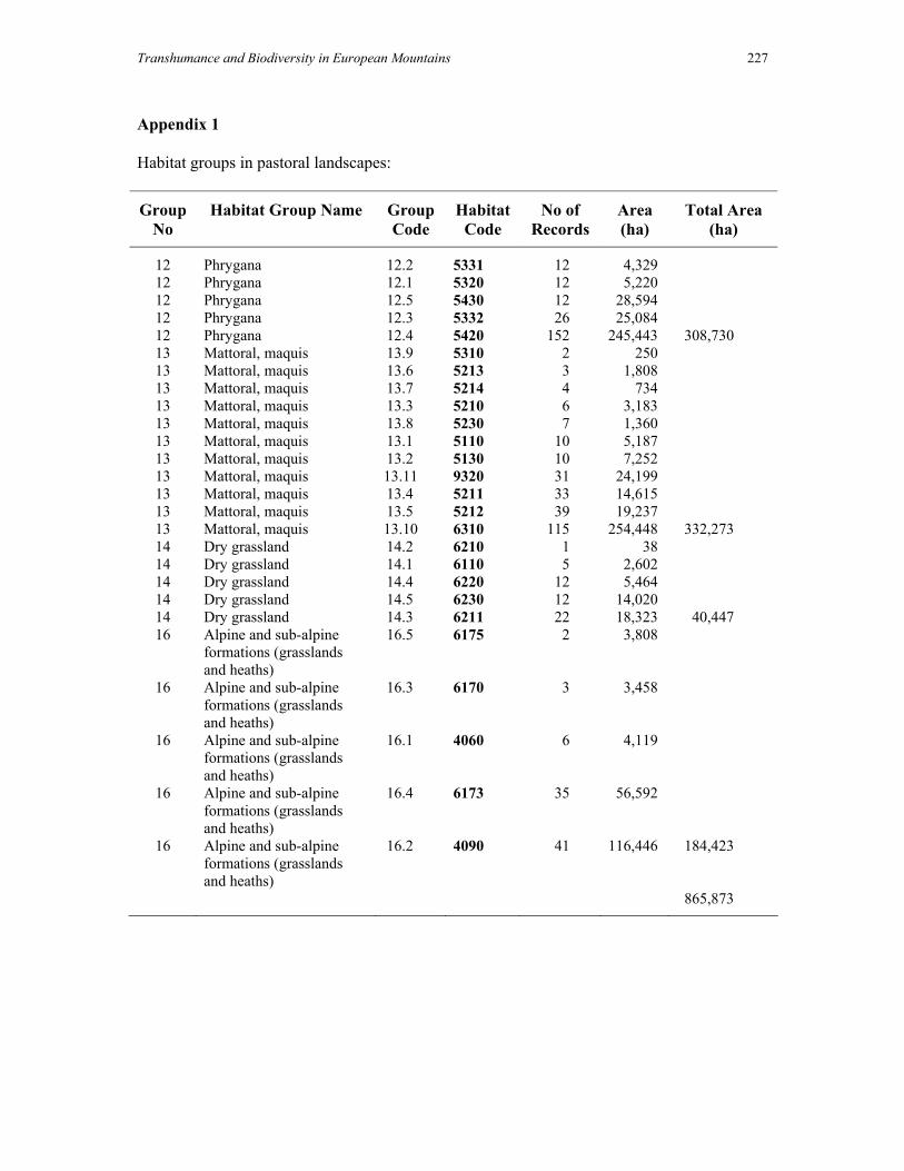
Transhumance and Biodiversity in European Mountains 227
Appendix 1 Habitat groups in pastoral landscapes:
Group No
Habitat Group Name Group Code
Habitat Code
No of Records
Area (ha)
Total Area (ha)
12 Phrygana 12.2 5331 12 4,329 12 Phrygana 12.1 5320 12 5,220 12 Phrygana 12.5 5430 12 28,594 12 Phrygana 12.3 5332 26 25,084 12 Phrygana 12.4 5420 152 245,443 308,730 13 Mattoral, maquis 13.9 5310 2 250 13 Mattoral, maquis 13.6 5213 3 1,808 13 Mattoral, maquis 13.7 5214 4 734 13 Mattoral, maquis 13.3 5210 6 3,183 13 Mattoral, maquis 13.8 5230 7 1,360 13 Mattoral, maquis 13.1 5110 10 5,187 13 Mattoral, maquis 13.2 5130 10 7,252 13 Mattoral, maquis 13.11 9320 31 24,199 13 Mattoral, maquis 13.4 5211 33 14,615 13 Mattoral, maquis 13.5 5212 39 19,237 13 Mattoral, maquis 13.10 6310 115 254,448 332,273 14 Dry grassland 14.2 6210 1 38 14 Dry grassland 14.1 6110 5 2,602 14 Dry grassland 14.4 6220 12 5,464 14 Dry grassland 14.5 6230 12 14,020 14 Dry grassland 14.3 6211 22 18,323 40,447 16 Alpine and sub-alpine
formations (grasslands and heaths)
16.5 6175 2 3,808
16 Alpine and sub-alpine formations (grasslands and heaths)
16.3 6170 3 3,458
16 Alpine and sub-alpine formations (grasslands and heaths)
16.1
4060 6 4,119
16 Alpine and sub-alpine formations (grasslands and heaths)
16.4 6173 35 56,592
16 Alpine and sub-alpine formations (grasslands and heaths)
16.2 4090 41 116,446 184,423
865,873

228 I. Ispikoudis, M. K. Sioliou & V. P. Papanastasis
Appendix 2 The most indicative, important habitats (Natura 2000) of transhumance landscapes are: Habitat code 4090: Endemic oro-Mediterranean heaths with gorse 5110: Stable Buxus sempervirens formations slopes (Berberidion p) 5210 : Juniper formations 5230: Matorral with Laurus nobilis 5420: Sarcopoterium spinosum phrygana 5430: Cretan formations (Euphorbio-verbascion) 6110: Karstic calcareous grasslands (Alysso-Sedion albi) 6170: Alpine calcareous grasslands 6173: Calciphilous stepped and garland grasslands 6210-6211: Semi-natural dry grasslands on calcareous substrates 6220: Pseudo-steppe with grasses (Thero-Brachypodietea) 6310: Sclerophillous grazed forests (dehesas) with Quercus suber and/or Quercus ilex Example of indicative species present in: Habitat 4090: Endemic oro-Mediterranean heaths with gorse (Palaearctic habitat class code: 31.7) (Dafis et al., 1996) 31.78 Helleno-Balkanic sylvatic Astragalus hedgehog-heaths Hedgehog-heaths occupying situations peripheral to the main range of the alti- and oro-Mediterranean hedgehog-heath communities of high Hellenic mountains (31.79 and 31.7A), mostly dominated by Astragalus angustifolius, characteristic, in particular, of zoogenous clearings within the forest belt of southern Greek mountains and of regions of irradiation of Mediterranean communities within the hills and mountains of the Moesian zone. 31.79 Hellenic oro-Mediterranean hedgehog-heaths. Daphno-Festucetea: Eryngio-Bromion p. hedgehog-heath developed on relatively humus-rich rendziniform soils at or above treeline, in the 1700-2200m altitudinal range of high Greek mountains; hegdehog-heath facies of associated grasslands; similar, impoverished formations descending into the forest belts of the same mountains, with the exception of those of the Peloponnese, where they are replaced by distinctive formations, listed under 31.78. 31.7A Hellenic alti-Mediterranean hedgehog-heaths. Daphno-festucetea: Astragalo-Seslerion. Shrubby formations of the high mountains of the Peloponnese, of the southern mainland Greek mountains and of the Thessalian Olympus system, colonizing the altitudinal range immediately above that occupied by the communities of 31.79, as well as stony slopes with shallow soils, loose screes and humus-deficient soils within the main 1700-2200m range of these communities. Included are true spiny hedgehog-heaths, cushiony formations of dwarf suffrutescents and bush-dominated facies of stripped grasslands. Astragalus angustifolius, Acantholimon androsaceum, Astragalus lacteus, Convolvulus cochlearis, Rindera graeca, Aster alpinus, Globularia stygia, Minuartia stellata, Erysimum pusillum, Thymus teucrioides, Alyssum kioane, Paronychia kapela, Thymus hirsutus, Anthyllis aurea, Achillea ageratifolia, Siderritis scardica, Linum flavum, Thymus biossieri, Sesleria cearulans are caracteristic.

Transhumance and Biodiversity in European Mountains 229
31.7B Cretan hedgehog-heaths. Saturejetea spinosae. Hedgehog-heaths of high mountains of Crete, in the 1500-2500m altitudinal range, with Astragalus creticus ssp. creticus, A. angustifolius, Acantholimon androsaceum, Atraphaxis billardieri, Berberis cretica, Chamaecytisus creticus, Daphne oleoides, Prunus prostrata, Euphorbia acanthothamnos, Verbascum spinosum, Sideritis syriaca, Satureja spinosa, Asperula idaea, Rhamnus prunifolious, Pimpinella tragium, Acinos alpinus 31.7C Aegean summital hedgehog-heaths. Isolated endemic-rich, mostly summital hedgehog-heaths of calcareous mountains of Aegean islands and mount Athos 31.7F Southern Hellenic Genista acanthoclada hedgehog-heaths. Formations dominated by hemispherical shrubs of Genista acanthoclada of the middle levels (about 800-1200m) of mountains and plateaux of the Peloponnese. 31.7E Astragalus sempervirens hedgehog-heaths. Astragalus sempervirens ssp. sempervirens, ssp. muticus, ssp. cephalonicus formations of the southern Alps, the eastern Pyrenees, Iberia, the Apennines and Greece, transitional between the alpine and sub-alpine heaths of 31.4 and the true Mediterranean hedgehog-heaths of 31.7.

230 I. Ispikoudis, M. K. Sioliou & V. P. Papanastasis
Transhumance and Biodiversity in European Mountains 231
Transhumance in the Italian Alps and Apennines
P. Susmel, C. Fabro & S. Filacorda
Dipartimento di Scienze della Produzione Animale Universita degli Studi di Udine
Via San Mauro 2 – 33010 Pagnacco, Italy e.mail: [email protected]
The term “Transhumance”, form the Latin verb transumere (to move from or to
another place), was known in all Romaic languages but in the scientific literature was firstly used by Blade (1892). The precise meaning refers to a style of pastoral life, seasonal and rhythmic, starting with sheep grazing on the mountains during late spring and summer and resting in the plains over autumn and winter. The pastoral transhumance was prehistorically expanded over southern Italy and Europe (2000 years BC). In Italy, the political and economical importance of this activity is historically attested from the 3rd century BC. The strong organisation of pastoral transhumant society (itinera callium) emerges with the economical exploitation of ager publicus after the Romans vanquished the Italic populations and following the structural crisis of southern agriculture that occurred after the Punic wars (Varo, Cicero). Later the philosophers Democritus and Aristotle offered, the pastoral and rural world and the ancients naturalistic knowledge. Transhumance continued to develop during the Middle Ages until the last century involving customs, rules, cadastres, drove roads, fortresses, fairs and markets. Swedish and Aragonese people reunited and structurally organised the south-east pastoral society from Abruzzo to Puglia. There was also a socio-political role of pastoral bandits. There was also collective management in the Alps, the “Maso-Chiuso” in Alto Adige. The historical review traces the dynamic of evolution and explains the actual situation. The main transhumance was from the plains of the Lazio and Umbro-Marchigiano Apennines, from Tavolier of Puglia and Abruzzo and Molise Matese massifs. Traditionally transhumance originates from the central and southern Apennines, but the seasonal move of livestock – not only sheep – up and down the mountain pastures was a practice that also extended to the islands and the Alps. The main area concerned with this large movement of men and animals was in the Alpine Regions, in Sardegna from Barbagia’s mountains to the sea at Emilia and from the mountains pastures of Cusna to the Po valley and in Toscana from the Apennines to Maremma. The terms used in these cases were also “monticazione” and “alpeggio”. The social, political and economic role of transhumance was historically relevant and distinctive in each area so that it is difficult to summarise overall. The main differences among these single typologies are in:
(i) the species: mainly sheep and goats in the centre and south, but cattle in the north, horses are sporadic;
(ii) the altitude; (iii) the distance (hundred of kilometres in the centre-south) and the drove road
systems; (iv) the socio-economical organisation (duties, products, markets, farmland property
and management) and; (v) the impact on mountain ecosystems
Further aspects more related to the present situation and to the protection of threatened
landscape, habitats and systems are in progressive decline together with the residual activity.

232 P. Susmel, C. Fabro & S. Filacorda
Transhumance is still practised on the Alpine Regions, Abruzzo, Molise whereas in other regions there are probably only a few cases still active. In the Alpine Region, the familiar altitudinal transhumance was a traditional activity. The livestock were transferred to the mountain farms (malghe) grazing on natural pastures (alpeggio) during summer (monticazione). The number of Alpeggi (management unit, pastures) is lower than that from Malghe. This activity has dramatically reduced during the last 20 years, but the available data are few, not recently updated and no homogeneous. In valle d’Aosta there are about 280 alpeggi and 800 malghe. In Piemonte less than 1,000 alpeggi are still used; about 88,000 LU graze for 90-100 days on 170,000 ha. The number of utilised Alpeggi in Lombardia is about 850. In Veneto there are about 300 active malghe where 18,000 Lifestock Units graze over 35,000 ha; every year on pastures remains for 100 days 95,000 heads of livestock (57,000 LU). In Trentino about 250 active malghe utilise 35,000 ha of pastures hold about 21,000 cattle and 15,000 sheep and goats. In Friuli about 85 alpeggi are still used, 140 malghe, for 120 days by 5,200 cattle and 11,000 sheep and goats. The altitudinal sheep transhumance of Abruzzo and Molise to the southern plains is declining rapidly. The local mountain pastures, mainly in the Parks area, are still used by 400,000-500,000 sheep. Vertical transhumance is now taking place and parts of herds remain within the Region.
In order to reduce this negative trend all the interested regions have recently adopted
Measures (Rural development plan) to protect pastures and to enhance local and/or biological animal products, ecological and agro-tourism.

Transhumance and Biodiversity in European Mountains 233
The present status and ecological consequences of transhumance in Spain
A. Gómez Sal & I. Lorente
Departamento de Ecología, Universidad de Alcalá, 28871 Alcalá de Henares,
Madrid, Spain. e-mail: [email protected]
Abstract
The ecological relevance of transhumance comes from its essential role in the origin and maintenance of some the most outstanding landscapes, habitats and ecosystems in Spain. Their influence acts through two conspicuous features: a) the existence of a number of oscillatory livestock movements both going and returning, spread across the whole of Spain, and b) the long and wide network of transhumant ways comparable to drove roads in Britain. Safeguarding the ecological role of both elements presents a challenge for nature conservation action. This article presents and analyses the variety of transhumant systems according ecological factors and discusses their influence on biodiversity and habitats. Drove roads have positive effects as ecotones and, in some cases, complement other linear elements and act as ecological corridors. The orientation of the roads and their position in the landscape has a logical rationale, because of their ancient use by flocks of herbivores. This ecological role has distinctive impacts at the landscape level in terms of both structure and biodiversity. Different sections of the cañadas network vary in significance, width and cove. They change from a reticular structure in some zones characterised by itinerant shepherding, to well defined, straight and wide stretches in other areas which involve historical long transhumance. Finally the paper discusses the current natural values of the Cañadas which are dependent on the type of management. It then proposes different actions to make compatible production, nature conservation, land planning and leisure functions.
Livestock breeding systems as an adaptation to physical complexity
Habitats shaped by extensive grazing cover a high proportion of the Iberian Peninsula. The ecological rationale (Gómez Sal, 2001) of this extensive cover, lies on the physical features of the peninsula, its fluctuating climate and relief complexity. Both factors determine a variety of situations differing in the productivity of the grazed resources, which varies in quality, abundance and predictability between years. It was only possible for man to take advantage of this plant productivity, distributed with variable time-space patterns, by means of the mobility of different species and breeds of traditional herbivores, adapted to the variable and harsh ecological conditions and systems of land management existing in Spain.

234 Gomez Sal & I. Lorente
An overview of altitude in the Iberian peninsula as shown in Map 1, allows us to identify the land in different regions that is able to supply feed and grassland, that can be used by a large number of herbivores. In contrast with these mountain areas, only productive in summer, the south-western quadrant of the peninsula has mild and rainy winter conditions, because of the Atlantic rain fronts which are very active in this time in the zone.
The existence of these large areas of complementary plant production, constitute the main underlying cause of the long displacement that herbivores have made from ancient times in the west part of the peninsula. They link, in the most outstanding examples, zones which are up to 500 and 800 km apart.
Coexisting with these large-scale movements, of which Garcia Martin describes the
old economic importance in this volume, many short displacement based transhumance activities, have persisted until the present time. This kind of transhumance which connects zones lying about 150 km part, is called Transterminancia because they frequently connect pastures belonging to different but relatively close municipalities.
The existence of different models of displacement depends upon many historical facts. For example the persistence in the more distant zones of the northwest and northern mountains of more ancient breeds, are associated with relatively close and consistent agricultural systems such as self sufficiency, polyculture and communal pastures, as described by Gómez Sal (1994). This region contrasts with a higher frequency of land in the south and

Transhumance and Biodiversity in European Mountains 235
east that has been historically more open to external influences of more specialised livestock breeds, with a better defined market orientation. Drove roads as an essential part of Iberian nature
A number of factors limit the rhythms and quantities of plant productivity and the reasons for the historical importance of transhumance in Spain. Between them they form the Mediterranean type of climate (a very dry summer restricts the herbaceous production in the wintering areas), the east-west orientation of the main mountain ranges. This causes a strong and complementary difference between the north and south oriented aspects and the marked continental nature of the high plateaus which cover a significant part of the northern half of the peninsula (Gómez Sal, 2000). Isolated from the moderating effect of the ocean, this transitional extensive zone separates the available winter pastures hundreds of kilometres from the northern ranges, which are used as summer pastures. In the south-western quadrant of Spain, the mild winter climate brings rainfall in from the Atlantic, and gives rise to a generally highly productive period for the vegetation. The abrupt ending of this period forces the displacement of grazers that can live off the vegetation available at that time, to move elsewhere for feeding.
As happens in savannah systems elsewhere in the world, the oscillations typical of
Mediterranean ecosystems require the herbivores to displace towards areas of complementary production. This is true not only of grazing ungulates but also fruit and seed-eating birds. These areas are generally located in the mountains adjacent to the Mediterranean climate zones, from the high mountains of the Betica ranges (Sierra Nevada at the south) to the pastures of the Cantabrian mountains in the north.
The tracks created by the ungulates during their movements are an intrinsic feature of Mediterranean habitats. The same occurs with the mountain summer pastures, which are intensively exploited, leading to the formation of specific pasture and scrub communities. These pastures also contain specialised habitats and plant species, able to respond to the pressures of the herbivory (Rebollo & Gómez Sal, 1998).
The basic reasons related to the ecological features of the Iberian Peninsula, which are imposed by the network of transhumance ways (cañadas) and associated pastures are a legacy from earlier herbivore tracks. It follows therefore that the close interrelationship between the cañadas and the Iberian nature conservation is not surprising. The main features of transhumance in Spain
In the Iberian Peninsula livestock displacements are a widespread feature in mountain ranges as elsewhere in much of the Mediterranean region. Displacements were also common in the Atlantic areas, especially in northern mountain ranges parallel to the coast.
Grasslands with complementary production in time were frequently hundreds of
kilometres apart. In recent times, the newly irrigated lands (formerly fallow land, wastes and stubble) has led to winter grazing areas in zones typically being now devoted to long transhumance.
Summer pastures include several types: mountain pastures (called puertos), short alpine grassland with some shrubs predominating in the central and north ranges; mountain

236 Gomez Sal & I. Lorente
pastures with scattered trees – pines - in the high central ranges. In the Atlantic fringe (north of Spain), north facing mountain pastures are connected with winter meadows and wet pastures, near to the coast.
A variety of livestock species and breeds are involved in transhumance. Breeds of ancient origin remain mainly in the north - more complex land, historically more isolated, with short transhumance: Lacha sheep; Tudanca, Asturiana, Morena, Avileña cattle and Verata and Serrana goat. These type of sheep and goat breeds are milk producers. Trashumant cattle breeds are always meat producers. Modern breeds – originated and accurate from middle to modern ages - were almost exclusively devoted to wool production and were typically Merino and Entrefino types.
Extensive breeding systems develop accurate management models, able to efficiently
preserve fodder resources. Livestock grazing pressure was fitted to productivity. The planning of grazing, including displacements, was made with a long time perspective.
In recent times, new systems have been developed where breeds and species are substituted in an uncontrolled way, with consequent negative effects on resources sustainability and productivity. This lack of attention and planning for transhumance is one of the main threats to nature conservation in mountain areas.
The drove roads that are transhumance ways are called cañadas, and have a variable
complexity depending on local conditions and differ in width, quality of cover, degree of preservation, etc. The variation goes from a close network in some areas with itinerant grazing, to very straight and well-defined sections elsewhere. The width of the roads and their protection level indicates their past importance.
The Cañadas Reales (Royal Drove Roads) were designed to serve a strategic wool
industry and represent the main basic frame of the historical network, and have a more modern alignment and structure. The orientation of these roads – their position in the land - has a characteristic rationale and is derived from their ancient use by flocks of herbivores. The current state of transhumance
Maps 2 and 3 show the areas where transhumance still takes place, separating the winter and summer pastures. Data with a synthetic view of the quantity of heads, breeds and species involved can be seen in Table 1. These data come from Cuadernos de Trashumancia (DGCNA, 1992 – 1998) published by Drove Roads Office of the Environment Ministry (Mangas, 1992). Due to environmental and historical reasons, it is possible to distinguish different types of transhumance, whose distribution models are explained below: Short displacements in the Atlantic mountains
These are placed along the region between the axis of Cantabrian range and the coast,
including Galicia in the northwest. The region contains contrasting types of livestock breeding systems, although they all make altitudinal displacements between intermediate levels, or near the coast (winter pasture) as opposed to the high mountain pastures, facing to the north and are under humid winds (wet and misty sites). They carry on using livestock

Transhumance and Biodiversity in European Mountains 237
breeds of the most ancient origin in Iberia. At present these systems are threatened and endangered, especially if they are not able to integrate new values and functions to their products.

238 Gomez Sal & I. Lorente
Table 1.- The current state of transhumance in Spain
OVINE BOVINE CAPRINE EQUINE GEOGRAPHICAL REFERENCE AREAS BREED % BREED % BREED % BREED %
TOTAL Num. of
heads 1. Gredos Mountain Range [S] * 13,6 Avileña-Negra Ibérica 52,1 * 15,8 * 0,7 56.516
2. Alcudia Valley [W] Merino 94,4 * 2,5 * 3,0 - - 89.583
3. Cantabrian Mountains (Leon) [S] Merino 91,2 * 8,8 - - - 40.625
4. Iberian System (Demanda, Urbión) [S]
Merino or ‘Entrefino’ ‘Churro’ Crossed
93,2 Pardo alpina Avileña- Negra ibérica 1,3 * 2,7 * 0,3 47.889
5. Extremadura (La Serena) [W] Merino 94,0 - - * 6,0 - - 17.187
6. Aragonese Pyrenees [S , W]
Aragonian Rasa (Paloma or Ansotana) 78,2 Red Pyrenean
Parda Alpina 5,6 * 15,4 * - 124.220
7. Eastern Sierra Morena [S]
Segureña Montesina Granadina
Merino
90,1
Lidia Mixed breeds:
Avileña, Berrenda, Morucha, Andaluza
and Charolés
3,6
Serrana Murciano-granadina
(‘Montana’ and ‘Veguesi’)
6,3 - - 85.726
8. Iberian System (Albarracín – Cuenca – Molina) [S , W]
Merino Rasa Aragonesa 97,0
Vacuno de Lidia Pardo-Alpina
Avileña-Negra ibérica 0,4 Blanca Celtibérica 2,6 - - 125.253
9. Sierras Morena (Los Pedroches) [W]
Merino Rasa Aragonesa 95,7 - - * 4,3 - - 12.095
10. Sierras Béticas (Alcaraz– Cazorla– Segura) [S]
Segureña Montesina 87,3 Lidia 1,1 Serrana
Blanca Celtibérica 11,6 - 62.781
11. Sanabria [S]
Churra Merino 100,00 - - - - - - 28.725
12. Sierra Nevada [S , W]
Segureña Castellana
Merino 70,7
Pajuna o ‘Castellana’ Retinta
Pardo-Alpina 8,9
Murciano-Granadina, Malagueña
Blanca-Andaluza 20,4 - - 22.233
13. Catalan Pyrenees [S , W] Ripollesa 89,3 Bruna del Pirineus
Pardo-Alpina 8,7 * 0,4 Bretà Cerdà
Mereus Poney de Ariège
1,6 222.116
14. East Iberian System (Gúdar – Maestrazgo) [S , W]
Rasa Aragonesa Cartera 100,0 - - - - - - 32.704
15. Extremadura [W]
Merino Entrefino 64,8
Avileña Negra-Ibérica Morucha
Lidia Mixed breeds:
Asturiana de los Valles,
Retinta and Pardo Alpina
20,7 Serrana Verata 14,3 * 0,2 126.335

Transhumance and Biodiversity in European Mountains 239
OVINE BOVINE CAPRINE EQUINE GEOGRAPHICAL REFERENCE
AREAS BREED % BREED % BREED % BREED %
TOTAL Num. of
heads 16. Campos de Calatrava – Montiel [W] Entrefino Serrano 98,3 - - Serrano 1,7 - - 23.986
17. Cantabrian Mountains (Palencia, Alto Campoo) [S , W] Merino 66,7 Tudanca
Pardo − Alpina 26,2 - 0,7 - - 15.744
18. Ebro Basin (Bardenas Reales) [1] [W] Rasa Navarra *
19. Mediterranean Ranges [S , W]
Rasa Aragonesa Cartera
Alcarreña Segureña
Roja Levantina
100,0 - - * - - - 60.048
20. Pyrenees (Navarra) [S]
Rasa Navarra Lacha - * - * - - - -
21. Central System (Segovia– Ávila– Salamanca) [S , W]
Entrefino Merino 88,9 * 0,5 Verata
Serrana 10,6 - - 75.475
22. Guadalquivir Basin (Low Guadalquivir) [W]
Merino Entrefino Segureña
Talaverana or ‘Granadina’
93,4 Lidia ‘Pajuno’ 3,7 * 2,9 - - 60.037
23. South Andalusian Mountains [W]
Serranas Segureñas Merinos
86,8 Avileña y Retinta 0,7 ‘Serranas’ 12,4 - - 25.211
24. Vasque Mountains (Andía – Urbasa – Encía) [S , W]
Lacha Churra
(Merino) 77,5 Pirenaica
Navarra 15,0 - - Jaca Navarra (380 number of heads) 7,5 26.048
Reference: Own design. The data are taken from the Cuadernos de Trashumancia (numbers 1 − 24).. ICONA. First edition in 1992. Last edition in 1998.
The geographical areas indicate the works where data are taken from (Cuadernos de Trashumancia,1 − 24). Also it is identified if the works deal with the summer [S] or winter [W] pasturelands, or both [S , W]. The percentages (%) refer to each reference areas.
The number of head of animals is derived from the addition of all sheep, goats, cattle and horses, without converting the data into livestock units. [1] In this table, data referred to the following units: 100,818 number of head (ovine); 2,192 livestock units (bovine); 168 livestock units (caprine); 9,646 livestock units (equine).
[*] no specified; [-] does not exist

240 Gomez Sal & I. Lorente
The human groups involved in this transhumance have interesting origins in their habits, and generally form specialized societies devoted to raising cattle in hard conditions. We can include in this group the system practised by the Vaqueiros de Alzada in western Asturias, who kept the breed of cattle Mountain Asturian or the so-called Ratina or the cattle dealers from the valley of Cabuerniga in Cantabria (who mange in a communal way the Tudanca cattle breed), the cow herders of the valley of Pas in Cantabria and north of Burgos (displacing in summer among different mountain meadows, each one having a hut and haystack), the Basque shepherds that carry out short transhumance keeping the milk producing Lacha sheep to the Urbasa range. Finally there is another type of oscillating displacement that is not well defined (itinerant or free-ranging in common propriety lands) and maintains the traditional lines of horses and cattle (Monchina cattle, Galician horses or ponies, Asturcones horses).
Long term transhumance based on Merino sheep
Contrasting with the previous system, this mode of transhumance is built up on a single basic breed, although it is also true that it has many different lines and varieties derived from the careful selection that the owners made. This is mainly due to the great economic value that Merino fine wool had originally (Gómez Sal & Rodríguez Pascual, 1992; Rodríguez Pascual, 2000). It is the best known system because of the associated lengths of the itineraries and because it is the main reason of the origin for the most important Spanish drove roads (the Cañadas Reales).
The general distribution of these roads coincides with the old kingdoms of Leon and
Castile, in the west half of the country. The winter pastures are usually located in the plains of Extremadura in the southeast, in wide properties known as defessas (today’s dehesas) because they were strictly enclosed and protected. The summer pastures of this long transhumance are located on the south face of the northern mountains (Cantabrian and Iberian ranges). These are continental Mediterranean mountain pastures, located on the high catchments and the higher slopes are very sunny in summer.
Their dedication almost exclusively to Merino sheep goes back to the Middle Ages,
and it is part of the effort made by the kings since the 13th century to protect the breed for commercial reasons. This breed was found exclusively in Spain until the 19th century. The villages close to these mountain pastures, known as puertos de merinas, did not have the right to use them when the transhumant sheep were there.
Towards the south of the Iberian System of mountains, the summer pastures devoted to transhumance have a most varied nature and include both north-facing slopes and high altitude forested plateaus. They form original landscapes with dispersed tall pines (P.sylvestris, P.nigra) in the limestone ranges. This kind of open pine forest was carefully managed so that it became compatible with forest production and herding. The pine canopy protects the pastures from the high levels of sun exposure present in these Mediterranean upland plateaus.
The Cañadas Reales network was associated with this specialised form of
transhumance, which was originally economically very profitable, and of a pre-industrial character. These were the basic structural elements of the drove road network in the old Castile kingdom. A complex collection of wide tracks combined with many resting zones and

Transhumance and Biodiversity in European Mountains 241
linked infrastructures such as narrow bridges to count the animals and shearing farms. Some dog races (for example the Mastín for protection against wolves) and horses for transportation supported this kind of transhumance.
Until the middle of the 20th century sheep and people went on foot. The trip took two months, going and returning in the Cañadas. Later it was changed progressively for trains, which left the cattle in the closest stations at either end of the route. Latterly transportation has been by truck.
Despite its profitability and interest in conservation -pastures and habitats-, and the active action of a few enthusiastic shepherds and expert stockholders, these systems are now facing many problems for viability. The lack of official support it is due to the fact that even today the importance of the ecological functions and the high cultural values and patrimony associated to the transhumance is not recognized. Long distance sheep transhumance in the Pyrenees
Although the distances between the separated pastures are reducing less than 200 km
we can consider those in the Pyrenees also as long transhumance. The winter pastures are based in the central area of the Ebro basin – in the south of the mountain range. Unlike the former system based on Merino, the sheep belong in this case to the Entrefina breed (Rasa Aragonesa, Roncalesa, Ripollesa and others), whose origin is explained by the crossing between Merino and the ancient breeds that existed before the definition and generalisation of this specialised breed. Several authors think that Merino was imported from north Africa in Medieval times. Some local breeds older than Merino, - called Churro group - also are engaged this transhumance (Churra Tensina breed, typical of a specific valley of the Aragonian Pyrenees).
Traditional winter zones have now almost disappeared due to the new land uses such
as irrigated land, industrial settlements and urban development. However, sheep transhumance is still widespread in Aragon and Catalonia when compared with the decline in the Castilian region. The basic reasons for this are due to the smaller distance between areas involved because both form part of the same geographic, cultural and administrative regions. There is also a larger and more reliable pressure of resources for the winter present in the irrigated land. The irrigated land of the Cinca and Segre river basins supports the big Catalonian transhumance as well as the one of Aragón - central part of Pyrenees.
As we move to the west we find examples of the traditional system in which winter areas do not have irrigation and are in very hard and dry land. This type is present next to the city Zaragoza in places with scarce and irregular rainfall (average under 300 mm). We still find important flocks of Churra Tensina which move annually from Zaragoza to the high pastures near the Ordesa National Park (Central Pyrenees). The arid zones around the Ebro river has been intensely used in the last centuries. Due to the soil fragility and the unpredictable rainfall, in years with lack of rain, the Pyrenean flocks were unable to find sustenance. Under these circumstances, the lack of this resource meant that resource sustainability was exceeded.
Compared to Castilian transhumance (Merino, dehesas, Cañadas Reales) the
Aragonese type is not historically associated with an extensive area of land and good climate conditions for productivity in winter areas (Extremadura). Contrastingly, in southern Ebro the

242 Gomez Sal & I. Lorente
winter is as hard as in the Pyrenees. On a schematic way, we could say that even though in Castilia the summer zones were not abundant and the mountain pastures were all occupied – about 3.7 million transhumant sheep. In contrast in Aragon: there were scarce and fragile winter pastures and abundance pasturelands of the high Pyrenees. The erosion effects, as well as the resources and nature conservation consequences can be appreciated at present, being more positive for the Castilian traditional winter regimes.
Often the transhumance carried out in Aragon and intermediate stop in the Pre-
Pyrenean Range, placed 100 kilometres in the south of the main range, where there were farm systems (called Pardinas) and facilities to host the sheep flocks, until they consume the resources and they could move to the south. In that way, the livestock pressures were controlled as much as possible at the same time that impact depended on resources availability. At present, these grazing lands of Pre-Pyrenees are almost neglected with important lost resources due to the pine reforestation and the declining population.
In the west of the range, the Navarra has maintained transhumance to the dry lands near the Ebro river (Bardenas Reales), which have very original traces and a truly notable strength and appreciation. It has been favoured by the institutional support, based in a careful selection of the quality of the products such as cheese and lamb. In addition, the proximity between summer and winter pastures (about 100 km) helps families feel closer and assists the shepherds and herders. From the river plains, the livestock move to Pyrenees (Roncal and Salazar valleys) and the southern Basque Mountains (Urbasa and Andía). Cattle transhumance in Central Mountains
In the central mountains of the peninsula there is a particular sort of transhumance in which the main animals are cattle of traditional breeds, able to carry out long displacements and to bear harsh climatic conditions. The Avileña–Negra Iberica cattle prevails, even if the Lidia livestock is also frequent. There is an important area connecting the two faces of the Central System (Sierra de Gredos): the winter is passed in the Extremadura dehesas, and the summer in high pastures of the north of Gredos (about 30.000 head of cows are still involved in this displacement). Another area of vigorous activity links two mountain zones. The first, placed at a height of about 1500 m., open to the mild climatic influences of the Atlantic (Sierra Morena, in the north of Andalusia, with 3,000 head) acts as a winter zone. The second, continental, of extreme cold winters (Iberian mountain ranges of Albarracín, Cuenca and Molina), with the typical wooded pastures with pine trees, acts as rough grazing. Owing to the fact that the cattle do not need attention in the mountains, and because of the rise of the price of manpower - wages for shepherding and attending the flocks of sheep, the transhumance of cows is increasing to the detriment of that of sheep. In fact, bovines are competing against sheep even in pastures that were until recently exclusively used for Merino and whose expansion areas reach out as far as the northern Cantabrian summer pastures. This change results in excessive and ecologically unsustainable cattle exploitation in some mountain pastures, destroying habitats and resources that had been balance by Merino shepherds for centuries.
On the other hand, the Avileña cattle symbolise one of the examples of profitable traditional transhumance. Cattle still walk along an important section of a drove road, called Leonesa Occidental, or that of Cuenca, which links the eventual destinations. They spend about ten days to cover a distance between 200 and 300 kilometres.

Transhumance and Biodiversity in European Mountains 243
Transhumance in the south and east - Mediterranean Mountains
The network of transhumance routes stands out in this zone because of its complexity and density. In some cases it forms a structured network, whilst in other places straight and lineal stretches predominate, which is evidence of the variability of situations and driving forces. The summer pastures are placed in two main areas. The first is in the Sierra Nevada, with altitudes over 3,000m currently with a number over 22,000 of sheep (pastures known as borreguiles, settled in the catchments and lagoon basins of the summits, are the equivalent at the puertos of the northern mountains and have a certain alpine character). The second one includes Cazorla and Alcaraz ranges, more Mediterranean and covered to a greater extent by pinewood pastures (receive 63,000 number of sheep). Both mountains received herds from a certain sort of variety winter zones such as the Guadalquivir valley, Sierra Morena − which has many dehesas, which coincide in winter with herds coming from the Iberian range (Cuenca, etc) − and a number of areas that are place not far of the Sierra. This kind of transhumance is characterised by altitudinal displacements linking areas with wide differences in altitude. A variety of species and breeds (sheep, goats and also some cows like Retinta, which move between different Andalusian mountains such as the Sierra Morena and Los Alcornocales) participate.
Along the eastern coast we also find examples of short transhumance which are mainly made by sheep (sometimes goats) coming from the relatively high mountain areas (over 1500m) that are 150 km away from the Mediterranean coastal plains. The breeds are of the Entrefino group, including the Cartera sheep coming from the high mountains of Maestrazgo (the Sistema Ibérico sierra nearest to the Mediterranean sea) and the plains next to the sea (plain of Tortosa, near to the Ebro delta). The Segureña sheep do the same more in the south. Although tourism has now taken many winter pastures (some wet coastal plains) away from this transhumance, this system has, at present, alternative resources coming from the new irrigating lands (with the remains of crops and stubble fields). Influence of transhumance on land with a high value for nature conservation
Transhumance has contributed to the formation of a valuable set of sylvopastoral landscapes and associated natural habitats. These kind of habitats support a high proportion of many endangered fauna species of the country and interesting plant communities (Garzón 2001; Gómez Sal, 2002).
We will examine what are the main features of the relationship between transhumance and natural values. In Table 2 we summarise some of the main conclusions of this analysis. Data were obtained in a detailed sampling made along the Royal Drove Roads (Gómez Sal & Rodríguez Merino, 1996), coordinated by FEPMA. Implications for wilderness and scarcely populated areas
The reason underlining the alignment of the livestock routes comes from a trade off between different pre-requisites related with physical characteristics, physiological and behavioural rhythms of the animals and the need to avoid as far as possible, arable land. At the same time they must ensure a supply food - arriving every evening to a specific resting place (descansadero), generally a wide pasture with water supply, to pass the night-, and avoid the interference and conflict with more permanent land uses.

244 Gomez Sal & I. Lorente
Table 2. Main facts that support the relationship between the drove roads network (cañadas) and natural values
Presence at high altitudes and depopulated areas ♦ Cañadas have an average altitude higher than 600 m and, some of them, over 800 m
a.s.l. (Cañada Leonesa Oriental). The biggest differences between lower and higher sites are about 1,800 m but in general sections of higher altitudes predominate. In some cases more than 50% of the cañada’s length is over 1,000 m a.s.l.
Relationships with extensive land uses ♦ Sylvopastoral systems (especially Quercus dehesas) keep cañadas company until more
than 22.4% of their length (Leonesa Occidental). This fact has an influence on the cover of these species in the cañada’s width. On the other hand, Fraxinus spp and Quercus suber, are common in silvopastoral edges, and are not found in the cañadas.
♦ Quercus species ( Q.ilex; Q. pyrenaica), as tree or scrub form, are more frequent in Leonesa Oriental (42.1% ) and Segoviana (45.6%) cañada’s length.
♦ Leonesa Occidental presents the highest percentage of soil covered by herbaceous pastures (88.4% of length)
♦ The 70 m legal width is not always the usual situation. Owing to the invasions of other land uses, there are many narrow stretches up to 20 m. The width from 60 m to 70 m is the more common. The cañadas, which have their width better, conserved are Leonesa Occidental and Soriana Occidental, with many stretches of more than 70 m. The very well conserved sections can be found over 1,000 m a.s.l. At lower altitudes the invasion of other land uses predominates.
♦ Prairies and pasturelands are very common along the length of the cañada, until 34.1% in the Soriana Occidental.
In general, there is a close relationship between the shrub species placed on edges and the ones that appear in the cañadas can be also detected. In these cases, cañadas shrub cover is about 25% The connexion with protection networks ♦ From a general point of view, cañada conservation as a silvopastoral system is better in
zones that have at least some protection status. ♦ It is notable that there is a coincidence of “well conserved stretches” and the Special
Protection Areas for Birds (SPABs). More than 60% of the cañadas length in these zones can be considered as “well conserved”. The percentage of good conservation is higher than in Natural Parks and in Game Reserves (in these cases about 42%).
♦ The woody coverage of the cañada (Quercus, Pinus) is higher in protected natural areas than in SPABs. Dehesas and pastures, as adjacent cañada uses, are higher in the SPABs when we compare their situation in other protected areas.
The support for maintenance species diversity ♦ Transhumant routes maintain high value ecosystems and habitats, rich in ecotypes and
semi-natural varieties of pasture species. Ancient livestock breeds are also associated with them. It could be said that the cañada network is strongly linked to traditional uses and thus their values depend on them. The network is a more effective tool for “horizontal” conservation –the one related with sound uses-, than for “vertical” conservation –the one only based on protected areas declaration”.
Owing to the effect of ecotones, the cañada network supports high diversity. Transhumant routes can also act as refuges, nesting and feeding areas, as well as a reserve of habitats for many species. NOTE. This synthetic view summarises the positive relationships (Gómez Sal & Rodríguez Merino, 1996) between nature conservation and cañadas. It comes from a sample drawn throughout the whole network of Royal Drove Roads (Cañadas Reales) (See Map 1 and article text).

Transhumance and Biodiversity in European Mountains 245
The incorporation of cañadas in protection networks Relationships with sylvopastoral systems and extensive uses.
The fact that the cañadas form part of the framework of pastoral systems is relevant to Spanish conservation policy. Cañadas are a common component of the most valuable landscapes created by extensive grazing (Curtis & Bignal, 1990; González Bernáldez, 1991; Gómez Sal, 1997 and 2001; Gómez Sal et al. 2003). They find their most excellent expression when they are enclosed by other systems in the same condition. The cañadas width is conserved to a major extent when their adjacent use is husbandry (livestock raising) or forestry. The preservation of a continuous herbaceous cover soils that have never been ploughed is positively correlated with this kind of lateral use.
The role of cañadas in nature conservation depends on the specific circumstances of each region. For example, cañadas pass through several types of protected areas. The cañadas width tends to increase when it is included in protection areas.
When we analyse the relations between cañadas and cover of neighbouring areas and
the fact of the land passed through to be included in any protection category, (Gómez Sal & Rodriguez Moreno, 1996), there is a strong association between habitats such as dehesa, meadows, pastures as well as Special Protection Areas for Birds (SPABs). The stretches with good coverage also coincide with SPAB areas. These position conservation situations on the drove roads which fall within SPABs are even superior to those seen in the areas with a higher level of protection (National and Natural Parks). This indicates that the uses which maintain the herbaceous cover in the drove roads coincide with areas which are rich in bird diversity, independently of their belonging to a strictly protected area. The relationship between communities of birds living in open environments, perhaps the most original of all Iberian fauna, and the pasturelands appears to be based more on a functional relationship, rather than simply to geographical coincidence. This reaffirms the fact that extensive grazing areas and cañadas, independently of their inclusion in protected spaces, have a strongly positive influence on the maintenance of the land with a high natural quality throughout Spain.
Another aspect which should be highlighted is their contribution to the scenic or visual
value of the landscape. Transhumance routes enhance the beauty of the countryside, bringing contrasting colours and textures to the otherwise monotonous landscape of the high plateaus and mountains.
This function could be increased significantly through appropriate management. On the cereal growing plains, they form amenity strips which in many cases also have shrub and tree species. When the drove roads cross areas which have been deforested as a result of exclusively crop farming activity, the restoration of natural plant species could be appropriate, with brambles, bushes and trees, copses and small patches of diverse vegetation. All of these favour the diversity of habitats and are preferable to simple linear plantations. Species conservation - enhancing the role of cañadas
Cañadas contain habitats that are adequate to maintain and safeguard some threatened species. They supply food, shelter and habitats for fauna, create texture in the landscape and alter physical fluxes, by trampling or sink effects, for water, materials and propagules.

246 Gomez Sal & I. Lorente
Traditional transhumance was a well-adapted exploitation system, protected and
defended from predators. For example, by means of the Mastin breed of dogs, the Merino sheep were defended from wolves, and were thus compatible with the conservation of this species. Some cattle breeds developed horns able to defend the herd.
The creation of open habitats in mountain areas also favours the expansion of birds
typical of like-steppe open habitats. Who had designed the cañadas spatial plan? – functions at the landscape level
The course of transhumance routes, and their alignment in relation to geomorphology and human habitats, follows their own rationale, which sometimes heightens their impact on the landscape.
The reasons underlying the route of livestock trials are the result of a compromise
between different requirements related to the physical environment, physiological rhythms and the behaviour of animals and the avoidance, as far as possible, of the best agricultural land. The essential objective was to ensure feed for the livestock, stopping at the rest areas, waterholes and pastures, but interfering as little as possible with the more permanent uses of the land.
When cañadas approached the mountains they are situated on long and extended
interfluves or on high flat plateaus which separate elongated valleys. In order not to interfere with other agricultural land uses and meadows, they avoid the low and more fertile soils of the valleys.
This kind of pattern contrasts with the more frequent situations in the flat lowlands –
large river basins. Here the cañadas follow narrow wet valleys, with heavy soils, and avoid land devoted to cereal cropping. This zone contains productive and has manured pastures as well as night resting places, which are frequently planted with poplars and willows. Once in the mountain zone, the valleys have limited agricultural uses, which are often supported by old irrigation channels. Cañadas were limited to steep slopes, covered with trees or bushes, and were divided into a number of narrow and well-defined sheep tracks. In the rockier and rugged landscapes, cañadas were usually concentrated on avoiding obstacles such as gorges. A curious distinctive feature of transhumant routes, supports the hypothesis that they originated from herbivore behaviour, is the form of crossing valleys. When the cañada needs to traverse a deep valley, it descends by the steeper line called la varga by the shepherds, and ascends in the same way. This is not the case for ways designed by humans, and demonstrates that cañadas were shaped by quadruped users. The relationship of cañadas with human settlements (villages and others) is ambivalent. Whilst it was frequent to reserve for the flocks a closed plot or a common property to be benefited by manuring, for which transhumant shepherds could receive compensation. Alternatively cañadas had to be confined to the periphery of the municipalities.

Transhumance and Biodiversity in European Mountains 247
The result is that, in general terms, the cañadas generally pass through little frequented lands and avoid as far as possible passing through towns and villages. The drove roads also tend to pass through areas of common pasture where they can guarantee feed for the animals. This frequent connection with isolated, peripheral and depopulated zones, supports one of the outstanding values of the cañada network for tourism. This is one of the reasons of the significant links between cañadas and many areas relevant for birds. Their hypothetical function as ecological corridors is reinforced by their isolation from population centre.
Conclusions
Because the special feature of the cañadas is that they have been consistent over a long period (i.e. their soils have never been ploughed, nor treated with pesticides), the whole of semi-natural ecosystems linked by transhumance constitutes a natural framework of ecological maturity and health. Nevertheless, the specific role and the actual influence on species dispersion and conservation is not well understood.
The essential condition for these functions to be maintained and thus to reinforce the
cañadas role in nature conservation, is to maintain their nature of extensive and wide pastures. This traditional use is the cause of the contrasting ecotone effects with respect to adjacent areas of land, and also of habitat diversification and species conservation. On a larger scale, the connection of cañadas with other natural systems (mountain fringes, streams, vegetation patches) is needed to maintain or enhance their function as ecological corridors.
The Spanish set of cañadas (1% of the surface of the country) represent a conspicuous
and relevant European heritage. Active and imaginative actions about the functional conservation of this heritage are needed, also at national and community levels. Alternative uses such as green ways and cultural routes must be defined as complementary activities, but to maintain conservation value and grazing is essential. Data banks are needed and are indispensable for monitoring their change and evolution.
Finally, the role of cañadas in the landscape is also relevant. Their relationships with
remote, quiet and lonely places (traditional rural landscape), far away from main transport routes is a widely appreciated feature for excursions and alternative cultural tourism. Their position relationship with bird protection sites confirms this link to general high nature value areas.
References Curtis, D.J. and Bignal, E., 1990. The conservation role of pastoral agriculture in Europe. Second European form on birds and pastoralism. Isle of Man. 8 pp. Díaz Pineda, F. 1991. En : Bennett, G. (ed.), . Towards a European Ecological Network. Institute for European Environmental Policy. Arnhem. 80 pp. Garzón, J. 2001. Importancia de la trashumancia para la conservación de los ecosistemas en España. Boletín Institución Libre de Enseñanza., 40-41. 35-60 p. Gómez Sal, A. 1994. The rural landscapes of Northern Spain. Landscape Issues, 11(1):5-12. Cheltenham, U.K. Gómez Sal, A. 1997. El paisaje agrario desde la perspectiva de la ecología. En:Ciclo de Agricultura y Ecología. Fundación Bancaixa. Valencia. 145-182.

248 Gomez Sal & I. Lorente
Gómez Sal. A. 2000. The variability of Mediterranean climate as an ecological condition of livestock production systems. In: Livestock Production and climatic uncertainty in the Mediterranean. F. Guessous, N. Rihani & Iham, A. ( Eds.). EAAP publication Nº 94. Wageningen. 3-12 pp. Gómez Sal, A. 2001. The ecological rationale and nature conservation value of extensive livestock systems in the Iberian Peninsula. In: Bunce, R.G.H. et al. ( eds.) Examples of European agri-environmental schemes and livestock systems and their influence on Spanish cultural landscapes. Alterra-rapport 309. 103-123. Wageningen . Gómez Sal, A. 2002. Ecological functions of Drover`s Roads. En: Conferencia Internacional de Vías Pecuarias y Corredores Verdes. Junta de Andalucía ( Ed.) 212-226. Gómez-Sal, A., Belmontes, J.A. & Nicolau, J.M.2003. Assessing landscape values: a proposal for a multidimensional conceptual model. Ecological Modelling 168: 319-341 Chapman, A. & Buck, W.J. 1910. Unexplored Spain. Facsimile impression . Incafo 1978. Sevilla. 416 p. Gómez Sal, A. y Rodríguez Pascual, M., 1992. La montaña de León. Cuadernos de la trashumancia, nº 3. ICONA. 82 pp. Madrid. Gómez Sal y Rodriguez Merino, E. 1996. Papel de las cañadas en la conservación de la naturaleza en España. 20 pp. En: Las cañadas: viejos caminos para el futuro de la naturaleza. Fundación 2001. 19-40 pp. Gómez Sal, A., Rodríguez Merino, E., Busqué, J. y Rodriguez Pascual, M. 1995. Pernía-Páramos-Alto Campoo. Cuadernos de la Trashumancia, nº 17. Icona. 88 pp. González Bernáldez, F., 1991 a. Diversidad biológica, gestión de ecosistemas y nuevas políticas agrarias. En:: Díaz Pineda, F., Casado, M.A., De Miguel, J.M. y Montalvo, J. (eds.). Diversidad Biológica. Fundación Ramón Areces. Madrid. 23-33 pp. Hobbs, R.J., 1992. The role of corridors in conservation: solution or bandwagon?. Tree, 7(11):389-392. Mangas, J., 1992. Vías pecuarias. Cuadernos de la trashumancia, nº 0. ICONA. 202 pp. Madrid. McCracken, D.I. & Bignal. E.M. (Ed.) 1994. Farming on the edge: The nature of traditional farmland in Europe. JNCC. Peterborough. Rebollo, S. & Gómez Sal, A. 1998. Recent changes in transhumance systems: effects on mountain pastures management and conservation. In: Ecological basis of livestock grazing in Mediterranean ecosystems. Papanastasis, V.P. & Peter, D.(eds.) European Commission. 1998. 312-317 Rodríguez Pascual, M. 2001. La Trashumancia. Cultura, cañadas y viajes. Edilesa. 430 p. León. Ruiz, M. and Valero, A. 1990. Transhumance with cows as a rational land use option in the Gredos Mountains (Ventral Spain). Human Ecology 18(2): 187-202. V.V. A.A. 1992-1998. Cuadernos de la trashumancia. Nº 2-25, (Mangas, J.M. ed.). Published by The Drovers’ Roads Office. DGCNA. Ministerio de Medio Ambiente. Madrid.

Transhumance and Biodiversity in European Mountains
249
The National Network of Transhumance Routes in the Kingdom of Spain
J.M. Casas
Fundación para la Ecología y Protección del Medio Ambiente – FEPMA,
Paseo de la Castellana número 8, Madrid. Spain. e-mail: [email protected]
Abstract
The Foundation for the Ecology and Protection of the Environment (FEPMA) is an N.G.O. founded in 1978, actively involved in the support of transhumance, its associate cultural heritage, and the infrastructure necessary for its survival. This paper gives general background to the main activities and proposals of the foundation, as well as perspectives and future actions. One of their main achievements is the elaboration of a series of 25 reports that provide a comprehensive description of the present state of transhumance in Spain. The author emphasises the need to document and make complete inventories of all the extensive system in Europe, including ancient breeds, landscapes and the maintenance of their functionality.
The network of transhumance routes in Spain forms an extensive, rich and diverse matrix connecting the north and south of the Iberian Peninsula. In springtime, herders drive their animals along the cañadas, cordeles and veredas (transhumance routes of different width) towards their summer pastures or agostaderos in the northern mountains, and return south in the autumn to their wintering grounds. The decline of stock raising, the dissolution of the mesta (the ancient association that regulated the activity), the appearance of trains and later road transport, led to a profound modification of traditional ways of life. The subsequent development models adopted since the 1960s, have been the final factors causing the rapid disappearance of transhumance. Indeed, this centuries-old activity is now seriously threatened with extinction. The network of transhumance routes in Spain is, however, still impressive. It covers some 125,000 km and occupies an area of some 425.000 ha (about 1% of the national territory). Livestock censuses taken by the Foundation for Ecology and the Protection of the Environment (FEPMA) show that 800,000 sheep are still driven along these routes in seasonal migrations. The Importance of the Transhumance Routes Transhumance routes are important because: - They are a historic legacy - They are a great artistic and cultural legacy - They are important to the movement of livestock and have other traditional uses - They play a role in the conservation of nature - They help support the diversity of different breeds of livestock
J.M. Casas
250
- They help support biodiversity - They act as ecological corridors - They allow the public to appreciate different types of landscape - They can be used for leisure activities
The safeguarding of the network relies upon adherence to Law 3/1995 regarding transhumance routes, a law supported by both Regional Governments and local authorities, and written with conservation in mind. This law considers the reconstruction and reuse of the network by defining new uses for it that are compatible with its original prime function. These new uses should also help meet the needs and demands of modern society.
FEPMA proposes: 1. The creation of a study centre where interdisciplinary teams can resolve current problems
as well as those that might arise through the introduction of the Law. 2. The creation of specialised patrol units. 3. The preparation of reports detailing the problems and potential threats faced by the
network, plus the production of corresponding maps. 4. The creation of a database to define the network. 5. The recovery and potential realisation of the transhumance. 6. The drawing up of educational, touristic, cultural and stock raising plans to make use of
and improve transhumance routes. In addition the construction/implantation of certain infrastructures e.g., refuges, signposts, drinking troughs, livestock rest sites, border markers and milestones will also be supported.
7. The recovery and study of archives concerning the herding/droving way of life and
transhumance. 8. The organisation of exhibitions and media campaigns, the production of guides with
itineraries and maps, and information on the historical and environmental aspects of transhumance routes.
Since its foundation in 1978, FEPMA has demanded an active policy to end the
progressive abandonment, deterioration and disruption of the network, and the control of such problems that are threatening it. Even public construction works have often produced irreversible damage to transhumance routes. In recent years, FEPMA has met many times with European specialists, exchanging data on the survival of transhumance routes in different countries, and on the movement of livestock in the past and present. These meetings have helped to unify criteria and activities that allow the conservation, use and enjoyment of this heritage. Currently, FEPMA is designing a project within the INTERREG III-A framework to connect the transhumance routes of Spain and Portugal. A similar program involving France is underway, in which the Pyrenees are the main axis.

Transhumance and Biodiversity in European Mountains
251
FEPMA has always been able to count on the inestimable collaboration and enthusiasm of José Mª Ballester, who heads the Natural and Cultural Heritage Committee of the Council of Europe. Mr. Ballester has called for these ancestral routes to be given the status of European Itineraries (such as Saint James’ Way, the Silk Road, and the Roman Roads, etc.) within the framework of the European Landscape and Historical Communications Agreement. The initiative of the “TRASHUMOUNT” project, which should encourage transhumance inventories to be updated, are warmly received. These will help document the network’s economic, cultural, ecological and aesthetic resources for the use and enjoyment of future generations. The great interest as well as concern for our transhumance routes shown by specialists and researchers, the pressure brought to bear by environmental and cultural heritage associations, and the receptiveness shown by European, state, regional and local institutions, allows some optimism. The backing of so many bodies, a new legal framework plus the political will to enforce it, and the general mobilisation of society in favour of conservation are beginning recognition of the value of this part of our cultural heritage. In the hope that it may be of use in future Transhumount meetings, and that it may serve as a precedent for other countries, the official background to the Transhumance Routes Law is provided below, as are and the rulings of the Parliament and Senate encouraging the Spanish Government to “guarantee the conservation, integrity and rehabilitation of the cañadas reales”. Palace of the Senate, 18th February 2003.- P.D., Manuel Cavero Gómez, Letrado Mayor del Senado To the President of the Senate of the Kingdom of Spain:
Spain has 115,000 km of transhumance routes of different types, including cañadas reales, cordeles and veredas. Nine cañadas reales make up the National Network of Transhumance Routes, which together cover some 10,000 km. Millions of head of sheep, goats cows and horses once crossed the country from north to south in search of fresh grazing in the north in summer and the mild climate of the Extremaduran and Andalusian dehesas in winter. This was in the times of the Mesta, a powerful association of stock raisers whose mission it was to organise the cañadas, an institution created when Spain held a world monopoly in the highly valued wool of the Merina sheep.
Since the beginning of the Contemporary Age, however, transhumance has suffered a rapid decline made worse by the disbanding of the Mesta in 1836. The transhumance routes are now much less used, flocks being transported by train or by road.

J.M. Casas
252
This has led to the progressive abandonment of our transhumance routes and their invasion by illegal buildings, both public and private, which obstruct free passage. If solutions to these problems are not found, the traditions of the cañadas reales could disappear. These green highways are an important part of this country’s heritage and, because of their high touristic value and key natural role as axes connecting different ecosystems, they should be recovered. The Transhumance Route Law (3/1995, 23rd March) regards these trails not only as routes for transhumance, but as important elements that encourage the use of the territory, which can improve the quality of life of our citizens, and which can help conserve the environment. Since the passing of the law, work has begun to repair these routes, but in fact only a few kilometres of the National Network have been rehabilitated. Measures should be taken to accelerate these undertakings. On the 25th February 2003, The Senate approved motion 275 of the Popular Parliamentary Group of the Senate (Grupo Parlamentario Popular en el Senado) which put forward a proposal, signed by all Parliamentary groups, with the following text:
“The Senate encourages the Government in collaboration with the competent authorities, to provide impetus to those activities it considers opportune, in order to accelerate the rehabilitation of the Royal Transhumance Routes (Cañadas Reales) such that they become cultural, touristic and sporting itineraries.”
Published for the information of the public.
Palace of the Senate, 26th February 2003.-P.D., Manuel Cavero Gómez, Letrado Mayor del Senado. Palace of the Congress of Deputies, 1st April 2003.- P.D. The Secretary General of the Congress of Deputies, Piedad García-Escudero Márquez To the Table of the Congress of Deputies of the Kingdom of Spain: Within the framework of that outlined in article 193, and following the laws of this House (Reglamento de la Cámamra), the Popular Parliamentary Group of the Congress (Grupo Parlamentario Popular en el Congreso), has the honour of presenting the following Non-law Proposal concerning the encouragement of the declaration of the National Network of Transhumance Routes as an Itinerary of European Cultural Heritage by the Council of Europe, and requests its appropriate debate.
Transhumance and Biodiversity in European Mountains
253
Background The economic, cultural, and environmental importance of the transhumance routes has been recognised by this House, which unanimously approved the Non-Law Proposal regarding such routes in November 1998. In the fulfilment of this resolution, the Minister of the Environment has undertaken a program of activities in collaboration with the Autonomous Communities with respect to the identification and recovery of the said routes. This includes the study of the National Network, its digital overlay on maps of the Provinces of Castilla y León, Castilla-La Mancha, Extremadura and Madrid, the signing of a collaboration agreement between the Ministries of Agriculture and the Environment and Universidad Autonoma de Madrid for the study of the size of the transhumant animal population using the northern transhumance routes, and specific agreements between the Ministry of the Environment and several Advisory Councils of different Autonomous Communities etc. The work performed by the Ministry of Education, Culture and Sport should be encouraged and given impetus. This work involves the coordination of activities undertaken by different authorities with the aim that the transhumance route network of this country be declared part of the Cultural Heritage of Europe by the Council of Europe. It also involves activities organised by the Ministry aimed at the exhibition of transhumance in Spain. This will allow the greatest number of people possible to enter into contact with the remains of this ancient way of rural, itinerant life, and to appreciate its content in history and landscape etc. Via the Declaration of Cork (1996) and defined by the European Green Card for Rural Areas (Council of Europe, 1995), the intention of the European Union is to consider the rural world as an environment with three main functions: agriculture-silviculture-stock raising (its traditional function), plus new environmental and social functions. It is therefore an inescapable duty of the pubic authorities to encourage the proper conservation of the heritage enshrined in our cañadas reales and other transhumance routes. Given the aforementioned, the Grupo Parlamentario Popular en el Congreso, puts forward the following Non-law Proposal.
“The Congress of Deputies encourages the Government to provide impulse to the declaration of the National Network of Transhumance Routes as an Itinerary of European Cultural Heritage by the Council of Europe, and to foment those activities it considers opportune that will allow the greatest number of people possible to appreciate the ecological, cultural and historic value of these routes.”
Palace of the Congress of Deputies, 28th March 2003.- Luis de Grandes Pascual,
Spokesman for the Grupo Parlamentario Popular en el Congreso.

J.M. Casas
254

Transhumance and Biodiversity in European Mountains 255
History and Characteristics of the Mesteña Transhumance Routes
P. García Martín
Departamento de Historia Moderna, Facultad de Historia de la Universidad Autónoma de Madrid,
Ctra. de Colmenar, km.15. 28049 Madrid, Spain e-mail: [email protected]
Abstract
This paper provides an overview of the historical development of the drove road network in Spain. The first legal framework to protect the drove road network came with the selection of the Merino breed during the middle ages. These developments lead to the climax of transhumant activity in Spain reached during the 16th to 18th centuries. The breakdown of the Merino wool monopoly during the 19th century initiated the beginning of the decline. Finally, the main features of the drove roads are examined from a historical perspective.
Grazing has been a source of wealth for the people of both sides of the Mediterranean. Transhumance and nomadism has involved many people, such as the Celtiberian tribes, the goat herders of Palestinian (from the times of the Song of Solomon) and the Tuareg of the Sahara, as well as different social structures, including the well known droving routes of the Roman Empire. These trails, travelled seasonally by some people and regularly by others, have gradually become permanent components of the landscape. The raising of mobile livestock requires an infrastructure of routes along which flocks and herds can travel. Transhumance between regions of complementary grazing has been undertaken throughout the Mediterranean, following specific routes that have varied depending upon political, climatic and market conditions, as well as on conditions of war or peace. These routes are known by local names in different regions: tratturi in Italy, cabañeras in Aragón, azadores reales in Valencia, carreradas in Catalonia, carraires in Provence, caminhos in Portugal, and cañadas reales (royal transhumance routes) in Castilla y León. The cañadas reales are defined by Mesteña law as “the space between two pieces of cultivated land”. Their legal width was 90 ‘varas’ (75 m). These were subdivided into smaller trails known as cordeles that were 45 ‘varas’ (37 m) wide, and veredas of 25 ‘varas’ (20 m). A great many smaller routes that connected with these major drove roads were known by local names. The result was a network of communication trails upon which herders would begin their transhumance, moving to wherever the next grass would become available. This article examines the history of the cañadas, which in the territories of the ancient kingdom of Castille is linked to the changes in the Honourable Council of the Mesta (Concejo Honorable de la Mesta), the region’s historic but now extinct association of stock raisers.

256 P. García Martín
The underlying concept behind the cañadas is that a route of communication is a natural phenomenon that becomes artificial when altered by the technology of a superior culture. Some ecologists have considered transhumance routes to have originated in the trails used by animals in search of water. Such a hypothesis requires these routes to have existed since prehistoric time. Recently, archaeologists have discovered that sheep were exchanged between ancient Iberian tribes, and that their dwellings (e.g. caves and caverns) were reused as animal shelters by Roman and Gothic herders. The first signs of the regulation of livestock displacements and of the routes they used is found in the Visigoth code known as the Fuero Juzgo, which was disrupted by the Arab conquest and the introduction of a frontier war economy. Historically, transhumance has required laws and policies that allow periodic displacements. These were officially born in the Early Medieval period, a time when Castilian shepherds would customarily come together in annual assemblies to return lost animals to their owners (fazer mestas). The introduction of regulations was encouraged by the dynamics of the Reconquest, which favoured stock raising over agriculture, firstly because flocks and herds were easier to protect than land, and secondly because raising livestock required less labour than agriculture. This led Alphonse X the Wise to found the Honourable Council of the Mesta in 1273, not as a federation of local mestas, but as a legal framework for all stock raisers of the kingdom. In this foundation document, and in the code known as Las Partidas Alfonsinas, the width of transhumance routes was fixed. They were also declared public national assets (as they remain today), and were given the name of cañadas reales – herding routes or drover’s roads, under the protection of the king. In the Late Middle Ages, sheep raisers received the concession and confirmation of royal privileges, and further legislation governing the activity was introduced. Fiscal control of the sector also came into being, the Royal Treasury collecting a tax (the servicio y montazgo tax) at toll stations (puertos reales) along the transhumance routes.
However, the event of greatest importance to the sector was the selection of the Merina breed of sheep. These animals produced the highest quality wool in the world, and this remained in demand until the appearance of industrial fibres. The trade in this fine, white wool provided a firm link between Spain and the rest of Europe. Not only was it the first Spanish product to be traded on the world’s first stock market Amsterdam, it also gave Castille an international wool monopoly that lasted 500 years. The chroniclers of the Mestas recorded transhumance as the “main sustenance of these kingdoms”.
The expansion of the wool market in Late Medieval times culminated with the protectionist policies of Ferdinand and Isabel. Privileges were granted over pastureland (the Law of Possession); The Honourable Council of the Mesta underwent internal reorganisation, and new regulations regarding sheep raising were introduced. It was at this time when the throne would again occupy itself with matters concerning the cañadas, including them in the Mesteña Laws (the development of which was charged to Palacios Rubios) and defending their upkeep through the offices of itinerant civil servants known as Alcaldes Mayores Entregadores. In the 16th century, the Mesta fulfilled its first golden age under Charles V and Philip II of the House of Austria, at which time there some three million head of sheep under the transhumance regime. Since the Merina wool market was expanding, the cañadas were protected from damage and intrusion. However, a crisis in the 17th century led to the

Transhumance and Biodiversity in European Mountains 257
concentration of the kingdom’s sheep in the hands of a few owners, and to a deterioration in the state of repair of the transhumance routes. In his work entitled Restauración de la Abundancia de España, the arbitrista6 Miguel Caja de Leruela would cry out against this situation (it was no coincidence that this work was published in Naples where people were familiar with transhumance under the tutelage of the Dogana di Foggia). This was the Century of Iron of Don Quixote, who charged at two flocks thinking them armies ready to do battle on the plains. The 18th century brought a second age of prosperity to the Mesta because of the high price of wool in European markets. Indeed, in 1765, the number of sheep raised under transhumance reached an all time maximum of 3,750,000. This did not prevent the reformer Charles III (along with his minister Campomanes) from developing anti-Mesta policies, although the sector would still enter the 19th century as a profitable activity. The Napoleonic invasion of 1808, however, meant that peasants could no longer follow the ancient sheep rearing laws, and the Merina race began to appear in other countries that would eventually compete with Spain, eventually leading to the loss of its centuries-old European monopoly. The suspension of the Mesta in 1836 by the liberal government was the beginning of the end for transhumance. However, the practice did not disappear along with this association, but continued in the 19th century under the tutelage of the General Association of Stock Raisers of the Kingdom (La Asociación General de Ganaderos del Reino). This body commissioned inspectors known as Visitadores Extraordinarios to fix the boundaries of the transhumance routes which had by now deteriorated.
But what is the condition of the transhumance routes of Spain today?
1) The network of cañadas, cordeles and veredas forms a dense matrix. The theoretical distance of 125,000 km covered by them needs to be revised since this figure was arrived at by desk studies alone. The length and width of these routes needs to be researched: our partial knowledge needs to be made complete if we are to understand the true state of the transhumance network in numerical terms.
2) It is uncertain whether the widths of the cañadas, cordeles and veredas have been
maintained over the years. Perhaps there never really was a cañada that measured 90 ‘varas’ across its whole course: the natural topography of the land would have to have been narrower in some places, but wider in others, the flocks adapting their march to the local conditions. The heads and ends of these trails certainly tended to spread out like a funnel (so that different herds could merge and then spread out respectively), and it should always be remembered that these routes were lines of communication – they therefore met up with routes used by the cattle herders (vaqueiros) of Asturias and the drovers of Portugal, Navarre, Catalonia and the French Pyrenees. This is hard to show on maps because they become too complex.
3) The cartography of transhumance routes has two aspects. One is that of academia, the other of popular culture. The first, which is made manifest in physical maps, is an abstraction of the transhumance route network which only shows the nine major cañadas reales. The reality, however, is far more complex. The second is one of mental maps in the mind of the herder, maps that carry detailed descriptions of the routes undertaken. These two
6 A person charged with inventing ways of raising funds for the royal coffers.
258 P. García Martín
types of map need to complement one another through the production of a historical atlas of the cañadas, based both on scholarly and popular sources.
4) Cañadas are different to roads and railways because of their apparent lack of any immediate rationale. They cut across the country without seeming to take geographical difficulties into account. However these are routes that actually follow droving logic - their aim being to find grass for the animals. They also avoid towns and cities because these might have tried to impose taxes on the passage of the flocks. They do not, therefore, take the easiest route across the landscape, but take short cuts over rivers and mountains, hills, valleys and plains. In this way, the reappearance of pasture was facilitated, and problems with farmers were reduced by the flocks moving along the fine lines dividing municipalities.
5) The names of the cañadas change over the different stretches making them up and follow the nomenclature of the local people. The generic names for these routes used by professors and technicians does not invalidate these local names. It would be desirable to reflect both nomenclatures on future maps, but like the cañadas themselves, these names will become modified as the landscape is modified by man and the country undergoes political and social change. Only by knowing the historical characteristics of the cañadas mesteñas can we hope to preserve this part of Spain’s landscape and heritage. This network of routes across the countries of the Mediterranean forms the cultural heritage of the people who live in this region of Europe.

Transhumance and Biodiversity in European Mountains 259
Recovering transhumance in Spain for long-term nature conservation
J. Garzón-Heydt
Apartado de Correos 33, Cabezón de la Sal,
39500-Cantabria, Spain e-mail: [email protected]
The urgent need to develop sustainable productive systems which will ensure the long-
term conservation of the environment while providing a high quality of life to a growing human population is one of the most pressing concerns for the near future. In this context the experience of local ancient cultures that achieved a remarkable degree of adaptation to their environment, exploiting natural resources without depleting them or destroying biological diversity, is most important. It is now usual to turn to the indigenous cultures surviving in Third World countries for examples of such adaptation. Nonetheless, in Europe there are also preserved traditions of great interest and relevance, in particular considering the responsibility of our developed countries in searching for and applying strategies for sustainable well-being. Thus, since 1992 we have initiated a programme for the restoration of an Iberian culture of t transhumant shepherds, preserved in Spain since Neolithic times some 8,000 years ago with little variation, and that are currently on the brink of extinction. Their loss would imply serious environmental and cultural damage.
Spain must be regarded as a country of exceptional conservation value, with unique habitats and species, and home to a considerable proportion of Europe’s flora and fauna. It harbours a remarkable biological diversity, including a large number of endemic species and more than half of all the habitats of nature conservation interest and taxons existing in Europe. Spain constitutes the main or the only remaining refuge in the world for many endangered species, such as Iberian lynx (Lynx pardina), Pyrenean desman (Galemys pyrenaicus), Imperial eagle (Aquila adalberti), great bustard (Otis tarda), little bustard (Tetrax tetrax), and numerous fish, amphibia, invertebrate and endemic plant species. The Iberian Peninsula is also a key resting and passage area for some billion migratory birds in spring and autumn, while some 400 million European birds including crane (Grus grus), red kite (Milvus milvus), lapwing (Vanellus vanellus), plover (Pluvialis), wood pigeon (Columba palumbus), goose (Anser anser), thrush (Turdus), warbler (Sylvia), etc, have their main wintering quarters in Spain. The destruction or alteration of these ecosystems would therefore have a severe negative impact for migratory birds in Western Europe.
However, only a small fraction of Spain’s habitats is legally protected, and even in these areas the abandonment of traditional management practices is leading to a rapid process of degradation. Conservation in Spain depends mainly on extensive pastoral systems that have allowed for an optimum, environmentally friendly landuse in more than 60% of the territory, i.e. some 30 million hectares. The survival of endangered species and their habitats in Spain is only feasible if linked to the maintenance of these sustainable land uses, involving the rural population in active, long-term conservation strategies. One of the traditional land uses that has played a key role in shaping the valuable Iberian ecosystems is transhumance, the livestock migration to highlands in search of green pastures at the end of spring, and the return in autumn to the warm southern valleys.

260 J. Garzón-Heydt
Transhumance in Spain has varied little with the passing of centuries. Herds graze freely and extensively in very low, optimum density: about two sheep/hectare or one head of cattle/three hectares all year round, in sheltered southern valleys in the winter and in high mountain areas in the summer. In the golden days of transhumance in the 16th. century up to five million sheep, goats, pigs, cattle and horses would travel twice a year along the “cañadas” (drove roads), establishing a dense network of pasturelands throughout the Peninsula that linked the warm lowlands (less than 400 m. above sea level) in Extremadura, Valle de Alcudia and Valle del Guadalquivir in the southwest, with mountain ranges in the north (more than 2.000 m. above sea level). Still today this green network covers an aggregate length of 124,336 km, which amount to a surface of more than 420,000 hectares of common pasturelands, 1% of which form Spain.
This impressive natural and cultural European heritage is at present seriously threatened. Since the beginning of the 20th century, the use of rail transport has gradually substituted the long routes on foot along the cañadas. The last traditional long distance transhumance across Spain took place in the 1950s, although short distance movement of herds has continued until the present time. Recently the closing down of low-profit railway lines and the rising prices in road transport, coupled with European Union farm subsidies and low prices in animal fodder that favour intensive livestock breeding, are putting an end to transhumance. The complementary resource use of habitats in the mountains and valleys in the different seasons of the year are therefore declining, with serious environmental consequences for the fragile ecosystems present. The time factor in spring transhumance
In traditional transhumance the herds would leave their winter quarters in the south at the beginning of the dry season, in early or mid May, and reach their destination in the north some four or five weeks later, at the end of June, just when mountain pastures start to grow after the snow melts. However this ancient pattern changed suddenly some hundred years ago, following the construction of railway lines that linked the south and north of Spain. A majority of the herdsmen at the time welcomed this modern way of transport that saved them the long and often arduous journeys of walking along the drove roads. Thus, in just a few years the herds began to be transported mainly by rail, in trains that were specially constructed for the transport of livestock. But this apparently unimportant change had an major environmental impact, until now not adequately taken into consideration. The journey to northern mountain areas by train, and more recently by truck, takes only one day, and therefore the herds do not leave their winter pasture areas until mid to late June, when they can be certain of warm weather and abundant pastures in high mountain areas. Unfortunately this four or five week delay in departure, in the very critical time of mid May to mid June, is crucial in most regeneration processes of Mediterranean ecosystems.
Indeed, when grasslands dry out at this time of the year they shed the seed that will ensure the maintenance of annual species in the very diverse Mediterranean pastures that have evolved through millennia of interaction with wild and domestic transhumant herds. It is also a key late-spring time for tree species, as Holm oak and cork oak acorns have germinated and the tender shoots begin to germinate above the ground. A majority of the fauna is also culminating its reproductive cycle, be it invertebrate species including ants, butterflies and beetles, or the small and larger vertebrates. The larvae of frogs, toads, newt and salamanders are busy finishing their metamorphosis, in a dramatic race against time to complete development before late spring heat and rapid evaporation dries out ponds and small water

Transhumance and Biodiversity in European Mountains 261
courses. Lizards and snakes hunt, hiding in the vegetation that is rapidly drying out and shrivelling, and where the young hares, rabbit, and small deer also look for shelter. The breeding season of birds is also reaching a decisive point, including many species that nest in the ground in grassland areas, as larks, quail and partridge, little bustard, great bustard and harriers.
The negative consequences of the lack of movement of the herds, with their shepherds and shepherd dogs, in the winter pastures at this critical time of late spring are mainly the following: 1. Overgrazing of pastures, with a negative impact on the long term conservation of
grassland diversity due to lack of regeneration of annual species, and on the conservation of soils, denuded and exposed to the sun, the wind, summer storms and torrential autumn rains.
2. Destruction of tree regeneration, including Holm oak, cork oak and other tree species typical of agro-silvo-pastoral systems in southern Spain, that are not eaten by livestock when there is green grass available, but are avidly devoured once pastures dry at the end of spring. The end of traditional transhumance has meant the ending of natural regeneration in Mediterranean forestlands. As a result, most of the trees in southern Spain are now more than 100 years old.
3. Pollution and depletion of water points where the livestock drink, with a negative impact for the survival of aquatic fauna and amphibia.
4. Destruction of shelter and food resources vital for terrestrial fauna, from invertebrates to the larger vertebrate species, due to overgrazing of pastures by livestock. Snakes, lizards, butterflies, beetles, ants and many bird species are now disappearing.
5. Disturbance of the reproductive cycles of sensitive species due to the presence of livestock, shepherds and shepherds' dogs, and direct destruction of the eggs and young chick of birds that nest in the ground, such as partridges and bustards.
The disappearance of traditional transhumance on foot along the drove roads also
implies the loss of these natural corridors that link ecosystems in the south and in the north of Spain, while allowing for genetic exchange between different populations. It also leads to an increased isolation of population groups and frequently results in the extinction of species, such as the wolf, still abundant in northern Spain but almost extinct in the south. Ecological importance of transhumance
The maintenance of transhumance through the centuries following a consistent pattern has allowed the conservation of original ecosystems with an outstanding biological diversity in Spain until the present time. Almost all wild species have survived, though a few were replaced by domestic breeds. The pasturelands grazed by transhumant herds hold one of the highest floristic diversity known in Europe, with more than 40 different plant species in some places. The diversity of insects is also exceptional, with more than 8,000 different Coleoptera and 4,000 Lepidoptera species, amongst which 15% are endemic and found exclusively in the Iberian Peninsula.

262 J. Garzón-Heydt
The complex north-south network of cañadas, which have never been ploughed or treated with chemical fertilisers nor herbicides, is a natural green-way of outstanding environmental value. An interesting flora has developed in the drove roads and form a valuable linear biotope that introduces diversity into both farmed landscapes and in forests. Moreover, the cañadas constitute a natural corridor of particular importance in areas with a fluctuating climate such as the Mediterranean, where many animal populations depend on complementary environments to ensure their survival. Although the fragmentation of valuable habitats in Spain is less evident than in other European countries, the reduction in area of many natural areas and the disruption of natural green-ways linking them is nevertheless a serious threat.
Unfortunately, the negative impact of the abandonment of transhumance in Spanish ecosystems can already be appraised in many areas. Mountain pastures where livestock no longer arrives lose diversity and productivity, with coarse grass species substituting the finer, more varied and nutritious floristic communities which had gradually evolved through the millennia of extensive shepherding. Scrub invades the grasslands and results in a loss of environmental quality and resources as well as increasing the fire hazard. The latter has become in the last decades, one of Spain's most serious ecological problems (within the last ten years, 2.5 million hectares of shrub and forestland have been destroyed by fire).
In areas denuded by fire or overgrazing, the first rains after the summer season trigger severe erosion events, washing away the fragile Mediterranean soils, polluting rivers, and filling up dams and estuaries. Soil loss in Spain today reaches levels of 40 Tm per hectare, and more than 40% of the country suffers from serious erosion and desertification processes because of the alteration of the vegetation cover and inadequate land management. The conservation of traditional extensive grazing should therefore be an economic and environmental priority in countries such as Spain.
On the other hand, in areas where livestock now stays all year round the number of animals is no longer adapted to the carrying capacity of the environment, which varies with the season. As a result there is excessive pressure in late spring and in summer time that ruins the quality of grasslands and prevents regeneration, altering the delicate balance of ecosystems. Thus, in arid grasslands excessive grazing pressure and trampling in spring due to the abandonment of transhumance is leading to the destruction of nests and a rapid deterioration of the fragile steppe-like habitat and insect life which are vital for the survival of the world's largest population of threatened bird species such as great bustard, little bustard, stone curlew, sand grouse, pratincole and other birds. The extinction of the demoiselle crane (Anthropoides virgo) around 1930 in Extremadura and probably also the extinction of the Andalusia hemipode (Turnix silvatica) and the wolf (Canis lupus) in the 90’s in Andalucía, Extremadura and La Mancha are probably due to the loss of transhumance.
With the last transhumant shepherds much will be lost e.g. a wealth of knowledge, gastronomy, artisanal technology, vocabulary, songs, music, dressing traditions, and vernacular architecture, diversity of local plant varieties and hardy breeds. One of Europe's ancient and most interesting cultures will therefore be lost, unless something is done urgently to prevent it.

Transhumance and Biodiversity in European Mountains 263
Recovering the old transhumance in Spain
After forty years of environmental work to preserve wolf, bear, lynx, eagles, vultures, great bustard, and the wintering grounds of crane and other migratory birds in Spain, we have clearly understood that only by maintaining the ancient pastoral cultures can the long-term conservation of many valuable habitats be ensured. Thus, in 1992 a long-term project has been started to recover transhumance in Spain. Since then, ten livestock breeders and 30 different shepherds have participated in the work, travelling along some 15.000 km of drove roads that had been abandoned for decades. 20 herds have participated in the project, amounting to some 30.000 Merino sheep. In this period 20 highland areas have been rented, totalling some 10.000 hectares in the most valuable sites of the Cantabrian Mountains.
Besides looking for the best summer pastures in the mountains and renting them, the main work has been to survey the state of drove roads and to plan ahead the most suitable routes for moving large herds (1500 sheep), accompanying the shepherds to show them the way. Given the neglected state of the network of cañadas and the lack of water points and other necessary infrastructure, it is quite easy to get lost, and unforeseen problems and conflicts that have to be resolved on the spot arise almost every day. The duties of the support team therefore include resolving daily problems, and accompanying the herds with a 4x4 vehicle and trailer in which the shepherds carry their personal belongings and herding equipment, as well as providing them with handy telephones and radios for communication, electric nets to keep the herd at night, tents, sleeping bags and other camping equipment. The shepherds are also provided with rams trained to lead the herd and with mastiff dogs to protect them against wolf and bear. The extra costs of food, lodging and petrol are also financed during the spring and the autumn transhumance.
The regular travelling of these herds and shepherds during the last 12 years through fields, mountains, villages and cities has awakened memories of a once-familiar tradition in Spanish society, bringing it back to life into the 21st century, and giving the authorities no option but to cooperate with the herdsmen and to enforce the Law that protects drove roads as a public heritage, inalienable, with their primary function being the servicing of cattle movement (Act 3/95 on Cattle Trails).

264 J. Garzón-Heydt

Transhumance and Biodiversity in European Mountains 265
Recovery of the National Network of Transhumance Routes: Program of the Ministry of the Environment
J. M. Mangas Navas
Dirección de Conservación de la Naturaleza,
Ministerio de Medio Ambiente, Gran Vía de San Francisco, 4 28005 –MADRID, Spain E-mail: [email protected]
Abstract
This paper presents a review of the main political and legal activities undertaken in Spain in order to conserve and recover the drove road network in Spain since 1995. These activities mainly consist of digitisation of cartographic material, delimitation, staking off and sign-posting of the drove roads. In addition, they included new uses for tourism, sport and cultural activities, compatible with the main use, which is to facilitate and encourage the cattle movements and agricultural transport. The conservation actions are organised at national level by the Ministry of Environment at regional level by the autonomous governments.
In its preamble, the Transhumance Routes Law (3/1995; 23rd March) states that “the transhumance route network of which there is over 100,000 km in peninsula Spain] continues to be of service to extensively-raised national livestock. The routes involve some 700,000 sheep, 50,000 cattle and other species under transhumance/transterminance7 regime. The network encourages the use of under-utilised pasture land and includes more than 1,000,000 ha of marginal land. It also helps in the preservation of native races of livestock, several of which are threatened by extinction. Transhumance routes should also be considered ecological corridors essential for the migration, geographical distribution and genetic exchange of wild species. This is recognised in Royal Decree R.D. 1997/1996 (7th December) which establishes measures aimed at guaranteeing biodiversity levels, including the conservation of natural habitats for wild plants and animals (article 7). The preamble also states that “Finally, and in response to increasing social demands, the transhumance network could become an instrument that favours contact between Man and his natural environment.” In keeping with that established by Law 3/1995, transhumance routes form public domain assets of the different Autonomous Communities of Spain (article 2), who are entrusted with the administration and management of those that fall within their geographical boundaries (article 5). In principle – the only exception being when there has been a formal declaration of loss of public dominion (article 10) - they should vouchsafe the passage of livestock and guarantee other compatible (article 16) and complementary (article 17) uses. To this end, the Autonomous Communities may undertake all those actions they consider necessary, especially those that reinstate the boundaries of these routes (article 8). Actions taken with respect to transhumance routes that cross the territories of other Autonomous Communities or which facilitate the movement of livestock across national borders, should be
7 Short transhumance journeys between municipalites

266 J.M. Mangas Navas
undertaken in accordance with such knowledge. These routes form the National Network of Transhumance Routes (Red Nacional de Rutas de Trashumancia) (article 18). In order to better preserve the network, the law confers upon the state authorities (currently the Ministry of the Environment, in agreement with that set out in Royal Decree R.D. 1415/2000 [21st July] which develops the basic structure of the law) the following powers of: - Intervention, in collaboration with the Autonomous Communities, in order to ensure the integrity and adequate conservation of the public dominion of transhumance routes (article 3.2). - Tutelage over the National Network of Transhumance Routes via reports on the regulations of the Autonomous Communities that affect the network (article 18.3). - Management (custody and upgrading) of the Transhumance Route Document Bank (Fondo Documental de Vías Pecuarias) by virtue of its formal recognition (article 18.5).
Some Autonomous Communities, in line with the basic Law (considered
supplementary to its own laws by the region of Navarre) have begun to establish their own regulations: - Decree 143/1996 (1st October), which establishes regulations regarding the transhumance routes of the Autonomous Community of Extremadura (D.O.E., 17-10-96); Decree 49/2000 (8th March), which establishes regulations regarding the transhumance routes of the Autonomous Community of Extremadura (D.O.E., 14-3-00). - ‘Foral’ Law 19/1997 (15th December) regarding the transhumance routes of Navarre (B.O.N., 24-12-97; B.O.E., 10-2-98) - Decree 3/1998 (9th January) approving the regulations regarding the transhumance routes of the Autonomous Community of La Rioja (B.O.R., 22-1-98). - Law 8/1998 (15th June) regarding the transhumance routes of the Autonomous Community of Madrid (B.O.C.M., 23-6-98; B.O.E., 28-8-98). - Decree 155/1998 (21st July) approving the regulations regarding the transhumance routes of the Autonomous Community of Andalusia (B.O.J.A., 4-8-98). - Law 9/2003 (20th March) regarding the transhumance routes of the Autonomous Community of Castilla-La Mancha (D.O.C.M., 8-4-03). In this regard, The Parliamentary Environment Commission approved on 11th November 1998 a Non-law Proposal regarding transhumance, stating: “Parliament encourages the Government to develop, in collaboration with the Autonomous Communities, a national plan for the recovery of our transhumance routes and the establishment of the National Network of Transhumance Routes, and in so doing to determine the necessary instruments of adherence for inter-authority cooperation, as contemplated in article 3.2 of the Transhumance Routes Law (3/1995).

Transhumance and Biodiversity in European Mountains 267
According to the competence conferred it by Law 3/1995, and in fulfilling the Non-law Proposal of 1998, the Ministry of the Environment, via the Directorate of Nature Conservation (Dirección General de Conservación de la Naturaleza), has, in collaboration with the Autonomous Communities, introduced a program to identify and recuperate our transhumance routes – particularly those forming part of the National Network. The most significant activities undertaken to date are outlined below: Studies to identify the National Network of Transhumance Routes - Digital mapping, over maps of the provinces (E: 1/200.000), of the transhumance route network of the Autonomous Communities of Castilla y León, Castilla-La Mancha, Extremadura and Madrid (1999-2000). - Signing of a collaboration agreement (9th November 2000) between, as the first party, the Ministries of Agriculture, Fisheries and Food and of the Environment and the Universidad Autónoma de Madrid, as the second party, for the undertaking of ‘A Study to determine the livestock population under regimens of transhumance/transterminance and the use of the transhumance routes of Northern Spain (Galicia, Asturias, Cantabria and the Basque Country). Biennial 2000-2001. Projects for the recuperation of transhumance routes A – Already concluded: - Signing of a collaboration agreement, 18th March 1999 (B.O.E., 14-4-99), and its extension in 2000, between the Ministry of the Environment (pertaining to the State General Administrative Authority) (Administración General del Estado), the Agriculture and Commerce Council (Consejería de Agricultura y Comercio) and the Regional Government of Extremadura (Junta de Extremadura) regarding the setting of boundaries, milestone planting and signposting of the transhumance routes in the Badajoz-Cáceres corridor, their prolongation between Badajoz and Valverde de Leganés, and their derivations between Cáceres and Malpartida de Cáceres (Lavadero de Lanas de Barruecos) and Cáceres-Bis (Puente Romano del Salor), a distance of some 90.2 km. - Specific collaboration agreement, signed 14th December 2000 (B.O.E., 2-1-01), between the Ministry of the Environment (pertaining to the State General Administrative Authority) and the Environment Council of the Regional Government of Castilla y León (Junta de Castilla y León ) for the setting of boundaries establishing milestones and signposting of the Cañada Real Soriana Occidental between Ayllón and Villacastín (Segovia), a distance of 143.8 km. B - Underway: - Specific collaboration agreement, signed 27th November 2001 (B.O.E., 18-2-01), between the Ministry of the Environment (pertaining to the State General Administrative Authority) and the Environment, Territorial Planning and Housing Council of the Regional Government of Navarre (Gobierno de Navarra) for the setting of boundaries, establishment of milestones and signposting of the transhumance routes known as the Cañada Real de las Provincias and the Pasada Principal del Ebro, a total distance of 155 km.
268 J.M. Mangas Navas
A specific collaboration agreement, signed 23rd December 2002 (B.O.E., 22-1-03), between the Ministry of the Environment (pertaining to the State General Administrative Authority) and the Environment Council of the Regional Government of Valencia (Generalitat Valenciana) for the setting of boundaries, milestone planting and signposting of the transhumance routes of the Corredor Valle del Cabriel-Albufera de Valencia (Ramal Meridional), a total distance of 190.3 km. Even though satisfactory results have been achieved by both the completed projects and those still underway, the rate at which the aforementioned Program is proceeding is insufficient if all the routes belonging to the National Network are to be recovered in the timeframe proposed. Understanding this, and in agreement with a Motion approved on the 25th February 2003, “the Senate encourages the Government in collaboration with the competent authorities, to provide impetus to those activities it considers opportune, in order to accelerate the rehabilitation of the Royal Transhumance Routes (Cañadas Reales) such that they become cultural, touristic and sporting itineraries.” The time to accelerate the Program seems now to have arrived. Larger projects need to be taken on in agreement with the funds available, while taking advantage of the growing inter-authority cooperation demanded by the Autonomous Communities. It is within this context that the latest two agreements have been signed: A specific collaboration agreement, signed 24th October 2003 (B.O.E., 20-11-03) between the Ministry of the Environment (pertaining to the State General Administrative Authority) and the Environment Council of the Regional Government of Castilla y León (Junta de Castilla y León), for the setting of boundaries, milestone planting and signposting of the Cañada Real Soriana Occidental in the Province of Salamanca, and the planting of complementary milestones along the stretch of this same transhumance route in the Province of Segovia, a distance of 75.16 km. A specific collaboration agreement, signed 7th November 2003, between the Ministry of the Environment (pertaining to the State General Administrative Authority) and the Agriculture and Environment Council (Consejería de Agricultura y Medio Ambiente) of the Regional Government of Castilla la Mancha (Junta de Comunidades de Castilla-La Mancha) for the classification, milestone planting and signposting of the Cañada Real Conquense transhumance route and its branch routes. For the physical and/or legal recovery of transhumance routes, the setting up of boundaries and the establishment of milestones is essential, but it is not enough to ensure their correct use (with respect to those mentioned in the Motion of the Senate). The Ministry of the Environment, via the Directorate of Nature Conservation, is therefore studying the possibility of implementing a Sub-program for improving the condition of transhumance routes, which, as part of in the aforementioned Program and complementary to it, may help in the ecocompatible development of rural areas.

Transhumance and Biodiversity in European Mountains 269
Finally, the Ministry of the Environment is working in close collaboration with the Ministry of Education, Culture and Sport (Ministerio de Educación, Cultura y Deporte) with respect to archive material and document exchange (the Archive of the ‘Mesta’/General Association of Stock Raisers of the Kingdom - Archivo de la Mesta/Asociación General de Ganaderos del Reino) to provide the maximum information possible to aid the contemplated declaration of the National Transhumance Route Network as an itinerary with the status of European Cultural Heritage by the Council of Europe (in agreement with the Non-law Proposal approved by Parliament on the 29th April 2003).

270 J.M. Mangas Navas

Transhumance and Biodiversity in European Mountains 271
The integration of drove roads into regional planning: the example of Andalusia, Southern Spain
I. Ortiz Borrego
Junta de Andalucía, Consejería de Medio ambiente,
Jefe de la Oficina del Plan de Vías Pecuarias, Avda. Manuel Siurot, 50, 41071 – SEVILLA, Spain
E-mail: [email protected]
Abstract
Andalusia has the most complex and extensive network of drove roads in Europe (more than 30,000 km). Based on the identification of three basic uses of the drove roads, i.e. production, tourism/recreation and ecological (nature conservation), this paper presents the programmes developed by the regional government to include the network as structural element in regional planning. In order to stimulate the link between the network and the rural development in the region, the programme includes the production of a digital inventory of the network together with an associated database, as well as the approval of a legal Regulation for their management. This programme has led to the creation of the plan of Recovery and Organisation for Drove Roads, which represents an advanced approach to regional planning, that is further presented and discussed in the paper.
The Statute of Autonomy for Andalusia confers upon this Autonomous Community
exclusive competence in matters regarding its transhumance routes. The acquisition of competence in this area was made manifest in Royal Decree R.D. 1.096/84 (4th April) regarding the transfer of functions and services. Since taking control over these matters, the Andalusian authorities have revitalised the important historic legacy of transhumance routes, and have sought to confer upon them the functionality demanded by both Andalusian society and current environmental thinking.
The following are some of the most important steps taken in this respect: 1. The preparation of a digital inventory of transhumance routes, involving digital
maps (1:50,000) and an alpha-numeric database containing details of the itineraries and legal characteristics of all registered routes in the Autonomous Community of Andalusia. This has provided an optimum tool with which to perform analyses relating to the management of these routes, to undertake cartographic activities, and to perform statistical analyses. The inventory has been integrated into the Andalusian Environmental Information System (Sistema de Información Ambiental de Andalucía - Sinamba).
2. Passing of the Transhumance Route Law, approved by Decree 155/98 (21st July). This normative text establishes the necessary mechanisms for the protection of this part of our heritage that should allow most general interests to be satisfied. The Law is based on the principle that transhumance routes are a basic element of territorial planning (in agreement with the Regional System for the Protection of Natural Resources and with the creation of

272 I. Ortiz Borrego
Natural Area Systems in urban and metropolitan environments) and environmental planning (the promotion of landscape diversity and green corridors connecting areas of environmental interest, and the encouragement of activities bringing people into contact with Nature). The said Law, which is founded on the need to establish judicial regulation, demands specific steps (associated with the idea of sustainable socioeconomic development and in line with current environmental policies) be taken to protect transhumance routes.
3. The creation of the “Andalusian Transhumance Route Document Bank” (Fondo Documental de Las Vías Pecuarias de Andalucía) is in agreement with that established in article 6 of the Law. The aim is increase the knowledge available on these routes. This should help optimise their management and provide an information source for third parties. The Document Bank contains authorised copies of plans, documents and other kinds of background material currently held at the Ministry of the Environment (Ministerio de Medio Ambiente), the National History Archive (Archivo Histórico Nacional), and the Archive of the Association of Stock Raisers of the Kingdom (Archivo de la Asociación de Ganaderos del Reino).
4. Following the requirements of the Law, the fourth step (and a most decisive one) involves the preparation of a ‘Plan for the Recovery and Management of the Transhumance Routes of the Autonomous Community of Andalusia.’
In the development of this plan, the following factors were taken into account:
- The continuity of the network and its integration into the National Network of Transhumance Routes (Red Nacional de Vías Pecuarias)
- The regime established by the Third Amendment of Law 3/1995 regarding transhumance routes that cross natural parks and reserves
- The current status of use with respect to livestock transit - The physical status of the transhumance routes - The ecological value of these routes and their importance as biodiversity and genetic
exchange corridors - The potential for their public use and the possibility of their providing physical links
between areas of environmental interest
The priority objective of the Plan was to identify and define the Andalusian Transhumance Route Network, taking this to mean all recoverable routes that could be put to the uses contemplated by law (Law 3/95 and Decree 155/98). Once identified, priorities were determined for these different uses. These priority levels reflect the relative importance of each route and provide an order of preference for actions to be taken by the Andalusian Regional Government (Junta de Andalucía).
Once the possible uses of each route are identified and priorities established, the Plan defines the models to be used for recovering, restoring and maintaining them so that they can be put to these uses.
Finally, the Plan involves budget estimates for each of the models that might be followed.
All the transhumance routes identified and classified (and therefore registered in the digital inventory) fall under umbrella defined by the Plan.

Transhumance and Biodiversity in European Mountains 273
Following normal practice in territorial planning and management, the execution of the Plan began by defining and characterising the possible uses of the transhumance route network.
1. Traditional use: the passage of livestock and the maintenance of accessibility to farms bordering the route.
2. Recreational use/tourism: this refers to ‘rural tourism’, characterised by its connection with ecological, cultural and historical interests.
3. Ecological use: this refers to the potential of these routes for linking protected areas. Such connections would help to improve biodiversity in ‘ecologically simplified’ areas and provide corridors by which plants and animals could travel between wild areas.
The methodology used for the definition of the Andalusian Transhumance Route Network is based on the recognition of the ecological, historical and cultural assets harboured by these routes, and on the understanding that they are ideal territorial communication systems. They should, as such, be integrated into the territorial, environmental and economic planning of Andalusia.
Territorial Planning
Territorial planning is a basic tool involved in the conservation and re-launching of the use of transhumance routes since its function is to coordinate activities with effects at the territorial level. The network offers many possibilities in terms of territorial communication.
The integration of the network into the Territorial Plan is based on its being an active communication system in Andalusia. - It allows urban systems to be connected to natural resources. - It improves the quality of life and social well-being. - It helps prevent the occupation of natural and special heritage sites. - It favours sustainable development. - It favours landscape diversity. Transhumance routes have great potential in helping the conservation, rehabilitation and transformation of the landscape. The Plan contemplates a series steps necessary for recovering the vegetation of routes that pass through degraded or threatened landscapes. It also tries to strike an equilibrium between the usage of rural areas and their natural and landscape assets. In urban environments, the goal is to increase the visual pleasure derived from the landscape via the recovery of the vegetation along transhumance route boundaries. At the same time this will allow the often clear ‘frontier effect’ between urban and rural environments to be softened and increase the recreational possibilities for local inhabitants.
- It helps to harmonise the urban and rural activities of the territory.
- It can influence city planning as a complementary element in environmental proposals.
- It contributes to the System of Open Spaces (Sistema General de Espacios Libres). Few cities have been designed with open spaces in mind, even though leisure time has increased and there is a greater demand for areas where sport and other recreational activities can be practised. The network can connect currently isolated areas of the territory where recreational activities and tourism are important. They can also be used as linear spaces in their own right.

274 I. Ortiz Borrego
- It is a basic element in the Regional System for the Protection of Resources (Sistema Regional de Protección de los Recursos) (understood in terms of the conservation of natural and cultural heritage).
Transhumance routes associated with towns and cities should therefore be integrated into new urban proposals (as part of the System of Open Spaces) in such a way that they aid in the creation of an interlinked system of public parks, peri-urban protected areas, and cañadas, cordeles and veredas (transhumance routes of different widths). They should help provide pedestrian communication between town and countryside, and facilitate the creation of long distance footpaths for recreational use that would allow people to appreciate the landscape, fauna and cultural heritage of the territory.
Environmental Planning
The need to establish linear, ecological corridors between administratively consolidated areas with their own management plans is outlined in Directive 92/43 regarding the conservation of wildlife habitats. Article 10 states that “When deemed necessary for improving the coherence of the Nature 2000 Network, member states should encourage the management of elements of prime importance to wildlife.”
The EU has made its intention clear to develop an interconnected ecological network that will allow the movement of species and put an end to the isolation of protected areas. The need to connect the different protected areas of Andalusia is considered in the Sites of Community Interest (Lugares de Interés Comunitario; LIC) proposal formulated by the Regional Government. The aim is to achieve continuity between natural units. The same methodology is used to define those transhumance routes with ecological functions as well as their recognition as LICs.
The transhumance route network of Andalusia is the most extensive of all Spain and the ecological corridors of Andalusia should therefore be based on this already existing network.
Rural Development
Transhumance routes provide an axis for rural development by favouring the permanence of populations in degraded rural areas through the economic opportunities they offer (eco-tourism, rural tourism associated with cultural and historic heritage and the potential of artisanal products). They also favour the conservation of transhumance and extensive stock raising, and help to preserve habitats as diverse as those of the dehesas (tree covered grasslands), steppes and high mountain pastures. Sustainable development should be a prime goal.
All variables of interest in the potential functioning of the network have to be taken into account. However, these variables affect transhumance routes in different ways, and their importance with respect to the different uses proposed for the routes needs to be defined. The work methodology used in the execution of this plan also determines which data are collected in the field. This is essential for obtaining as much knowledge as possible on the current status of the network and for all activities designed for the recovery of transhumance.
Transhumance and Biodiversity in European Mountains 275
Together with the specialised sectorial literature, the cartographic information and databases detailed below were used as starting points for developing the methodology to determine the potential uses of the different parts of the network.
SINAMBA, Council for the Environment (Consejería de Medio Ambiente). Digital maps showing:
- Inventory of transhumance routes (scale 1:50,000) - Mosaic (20x20 m) of Andalusia prepared from Spot satellite images (1995) - Protected natural areas (1:10,000) - Land uses and vegetation (1:100,000) - Assets for public use belonging to the Council for the Environment - Public grazing land (1:50,000 and 1:10,000) - Sites of Community Interest (LIC) of Andalusia
INSTITUTO DE CARTOGRAFIA DE ANDALUCIA (1999). “Mapa digital de Andalucía 1:100,000”. Consejería de Obras Públicas y Transportes. Junta de Andalucía. Showing:
- The road network (1:10,000) - Road intersections (1:10,000) - Railways and high speed railways (1:10,000) - Water distribution network (1:10,000) - Water bodies and reservoirs (1:10,000) - Population nuclei (outlines) (1:10,000) - Contour maps (50 m intervals) - Services - Archaeological areas - Monuments - Historic sites - Administrative boundaries (1:10,000)
INSTITUTO DE ESTADÍSTICA DE ANDALUCÍA (IEA) (1998). “Atlas Estadístico
Interactivo de Andalucía. Sistema de Información Multiterritorial de Andalucía (SIMA)”. Junta de Andalucía.
- Population data (by population) - Stock raising data (by municipality) - Tourist accommodation (by municipality)
The ARC/INFO Geographical Information System (GIS) was used to examine the
combination of linear coverages represented in the digital inventory of the transhumance routes and the 1:10,000 raster coverages and satellite images.
Owing to its versatility, this GIS allowed an appropriate treatment of the information.
In-house programs were developed to treat the large range of variables involved, from the definition of the basic route network to the prioritisation of its components.

276 I. Ortiz Borrego
The combination of the necessary alpha-numeric data and the existing geographical information, plus that generated by computer analysis, led to the establishment of a series of priority routes with the help of the ARC/INFO dynamic segmentation tool, showing all the variation of the transhumance routes.
When the selection was complete, a total of 24,087 km of routes were defined as part of the Andalusian Transhumance Route Network. Over the next 20 years, the Council for the Environment will be working to recover and restore this important part of Spain’s heritage, with the goal of improving the quality of life of those living in the region.

Transhumance and Biodiversity in European Mountains 277
The stock raising culture of transhumant herders
M. Rodríguez Pascual
Consejo Superior de Investigaciones Científicas Estación Agrícola Experimental
Apartado 788. 24080 León, Spain e-mail: [email protected]
Origin and development of transhumance
Transhumance, the seasonal movement of livestock in search of better pasture and water, has been in operation on the Iberian Peninsula since ancient times. The aim of this practice is to make use of two complementary resources: the pasture of the mountains surrounding the Duero Basin in the north (a ring of mountains some 2400 km long), and the ample pastureland and warm dehesas (tree covered grasslands also known as extremos or Extremaduran dehesas) of the south. The distance separating these two grazing resources is some 500-800 km.
In 1273, King Alphonse X created the Honourable Council of the ‘Mesta’ (Concejo Honrado de La Mesta), an organisation of small stock raisers from the mountains of Leon, Soria, Cuenca and Segovia. During the 14th century, these humble herders managed to select and raise the Merina race of sheep whose wool enjoyed a monopoly on the international market for five centuries, providing wealth and economic impulse to the old kingdoms of Castille and Leon. During the 16th century, and the first half of the 17th, the wool trade reached its peak and the number of sheep raised under the transhumance regimen reached 3.5 million. Over the 19th century, however, this source of wealth for Spain gradually faded due to competition from other countries, and the importance of Honourable Council of the Mesta fell away, as did its privileges. Nevertheless, despite historic, social and economic changes, transhumance survived into the 20th century, and, after adaptations to its production system it has made it into the 21st century, although with a different structure and practised on a much smaller scale than during its heyday.
Over its history, the practice of transhumance has had important political, economic, social, ecological and environmental repercussions. One of the most important was the development of a specific stock raising culture based on the extensive grazing of the Merina sheep. This practice shaped the agricultural landscape through the formation of unique ecosystems, such as high mountain pastures and the Extremaduran pasturelands and dehesas - areas of great natural value.
The following is a brief synthesis of the most important legacies of transhumance to those of us who live in the 21st century. These include the Merina race of sheep as well as other breeds of animals, pastureland ecosystems, and a new model of transhumance based on the intrinsic capacity of the system to adapt.
278 M. Rodríguez Pascual
The herder and his culture
The term ‘culture’ is here understood to the mean way of life, customs and knowledge of a social group. The culture of transhumant herders refers to their traditional knowledge – the correct way of handling livestock and managing grazing land. This knowledge was gained in an empirical fashion - the inductive scientific method (i.e., that of making observations, formulating hypotheses and testing them experimentally - in this case by simple trial and error). The body of knowledge accumulated over the centuries became set down in routines – automatic reactions for daily business – and was passed on by the oral tradition.
In the traditional model, the job of the herder was perfectly structured, and there was a hierarchy of professional positions. According to a herder’s innate ability, years of experience and dedication to duty, he rose through this hierarchy. The lowest rung on the ladder was that of Zagal, a post usually occupied by boys of about 14 years of age. Training continued for several decades until a person reached the top of the professional ladder, becoming known as a Rabadán or Mayoral. Over this long period, as well as learning how to read, write, to perform basic arithmetic, herders acquired knowledge of animal husbandry including the care, raising and selection of livestock, the prevention and cure of the major diseases, and how to predict the weather.
As well as its stock raising culture, transhumance has left us a specific body of knowledge with its own vocabulary, constructions associated with stock raising, artisanal products, gastronomy and folklore, all enriched through the exchange of information with herders from different areas.
To undertake the demanding business of transhumance, herders had to possess special qualities. Strength and physical fitness were essential if they were to take on enormously tiring month-long displacements across half of Spain, battling sun, cold and dust all the way and sleeping out every night – and all this twice a year. Strength was also needed to overcome the steep slopes while driving herds to the mountain pasture where they could graze. An austere, self-denying character was a must for the work - herders were responsible for their animals day and night), they had to be able to handle solitude and long periods away from their families (up to eight months per year), and to be able to take on wolves, bears and other predators in the defence of their charges. The selection of the Merina sheep and other breeds of livestock
The Merina race of sheep was the basic element of transhumance from the 14th-18th centuries. Its fine, silky wool flooded and monopolised world markets. But it is largely unknown that the process of selection of this unique animal was undertaken by the competent, professional and highly trained shepherds of the mountain areas mentioned above. During the 14th century, these shepherds were the first in Europe to practise a genetic selection program with a predetermined aim: to improve the fineness of the animal’s wool. During this process, they managed to reduce the diameter of wool shafts to 18-20 microns - one quarter that of the original – and in so doing substantially increased the weight of the fleece. All this was achieved in a rustic race of animals capable of walking more than 30 km per day. In this way the first ‘industrial race’ of sheep was obtained – a race that began to spread around the world during the 19th century. Currently there are more than 300 million head of sheep derived from these Merinas.

Transhumance and Biodiversity in European Mountains 279
The great economic impulse provided by transhumance also led to the selection of
other races such as the Mastín sheep dog, whose job it was to defend the flocks from wolves etc., and the particularly strong Castellano-leonés horse, which was used by transhumant herders until very recently to carry their belongings. Races of cattle were also selected, such as the Avileña Negra Ibérica which is very well adapted to long displacements and to seasonal variation in pasture. These animals are still raised under transhumance regimens between Extremadura and the Gredos mountains. The Iberian pig, currently one of the most valuable animals to be raised on the dehesas, was also selected to accompany herders on their migrations. Nowadays, thanks to its seasonal feeding on the acorn crop, this animal produces meat of exceptional quality. Mountain pastures and the dehesas of the south
The traditional system of exploiting the Merina race under transhumance regimens follows an extensive model based on the use of high mountain pasture in the north complemented by that of the dehesas to the south. The only food supply was the grazing offered by these pasturelands, and the animals remained outdoors year-round with no shelter provided. The production of fine wool was the main goal. The females gave birth once a year, timed to occur as soon as they reached the Extremaduran dehesas where pasture was abundant. The system was autarchic and based exclusively on the use of natural resources. In years of severe drought, the Rabadán, the herder of maximum authority, might take the drastic decision to sacrifice half of the newborn lambs so that the remainder could continue to suckle and so survive. This system, with its high labour input (six shepherds for every 1200 sheep), which knew neither fences nor fixed installations, allowed large areas of pasture on the poor soils of Extremadura and other areas of the south to be productively managed for centuries: thanks to the activities of these sheep, a thin, fertile layer of soil developed and was maintained.
The grazed mountain passes, synonymous with summer or highland pasture (pasto de diente or pasto de altura), are those of the highlands bordering the Duero Basin (the Cantabrian Range, the Iberian System and the Central System). At the edge of the forests, these pastures produce fresh and nutritious grass throughout the summer which sheep will eat with great appetite. The high altitude of these lands implies, however, that production is concentrated between June and September – just four months. The proper use of this pasture requires a high stocking rate, but these animals must be moved on to lower areas for the winter. These highland areas have been reserved for centuries as summer pasture for transhumant, fine wool-producing Merina sheep.
Mountain passes have unique ecosystems that were created and maintained in production since ancient times through the positive intervention of shepherds and their flocks. Humans cleared these spaces in the forest through the use of the axe, fire and controlled sheep grazing (careos). The particular way these animals crop the grass, their trampling of it, and the fertilizer they leave behind have produced the miracle of mountain pasture with its dense, diverse and nutritious growth. Furthermore, these areas are in equilibrium with the woods, lower slope pastures and cut-meadows of the territory. However, the effect of livestock on the environment can only be positive when pastors and herders perfectly understand the animals, the pasture and the ecosystem whose management is entrusted to them. The accumulation of knowledge and the wisdom acquired over the years – culture –tells them what needs to be done at each moment. When the available grazing is inadequate for the species being raised (for example when sheep are replaced by cattle not well adapted to the conditions of mountain

280 M. Rodríguez Pascual
passes or dehesas), or when stocking rates are excessive (which leads to the erosion and degeneration of the pasture) or too low (leading to an increase in the growth of bushes), these fragile ecosystems can become unstable and impoverished. Fire, erosion, alteration of the soil structure, water problems, reductions in biodiversity, and landscape degradation etc. can then occur. Unfortunately this is happening all too often.
Towards the south of the Iberian Peninsula lie the dehesas, grasslands speckled with Holm and cork oaks - one of the most successful alterations of the natural environment ever achieved. It is on these grasslands where the flocks spend the winter and part of the spring and autumn. These lands represent an equilibrium between agriculture, grazing and forestry through the raising of cereal crops, the exploitation of wilder areas (feeding on acorns and browsing), and the use of pastureland. Currently, it is the latter two uses that prevail. The dehesas have always been appreciated by transhumant stock raisers since, apart from being warm areas, they could always rely on the acorn crop, an excellent source of supplementary food in years of scarce pasture. Further, in difficult years, at the end of winter their sheep could always feed on the leaves and twigs (feeding known as ramoneo) of branches removed during the pruning of Holm oaks (a practice known as the olivo). This helped them make it through till the spring growth. Currently, however, the acorn crop is used to fatten Iberian pigs. In some parts of Extremadura, such as the area of La Serena, pastures with no trees (rasos) but of excellent quality are grazed.
On the Extremaduran dehesas, the soils of which are generally thin, acidic and poor, the traditional way of achieving good, nutritious pasture is the use of the fertilizer provided by the animals themselves. Using a technique known as majadeo, the sheep are corralled for the night on poor pasture in order to accumulate their faeces (redileo). This, plus the trampling of the ground and the selection this makes upon the vegetation, helps primitive, low quality pasture turn into productive areas carrying high quality grazing species. The process is repeated in different areas until the entire area has been treated.
Both on the mountain pastures and on the dehesas, the daily grazing of the flocks (careos) greatly influences the nutrition of the animals and the productivity of the pasture itself. A shepherd who knows an area well will drive his flock to a new site every day, depending upon the time of year, the condition of the pasture, the weather, and the physiological state of his animals (e.g., whether he has pregnant ewes, non-pregnant ewes or rams etc.). He will prevent their spontaneous movements (querencias) towards areas that might cause the pasture to degenerate, and also avoid areas where there may be danger. In the mountains, gradual use is made of pasture on the slope, areas with different exposure to the sun, of different combinations of pasture according to the rock over which the soil develops (limestone or peñacalear, acidic or peña negra; these soils influence the quality, earliness and durability of the pasture), and even of areas with different water supplies. On the dehesas, alternative use is made of hillsides (cerros; usually dry and well drained) and low lying areas (cañadas; usually damper and more productive), and by alternating the grazing of sunny and more shady areas.

Transhumance and Biodiversity in European Mountains 281
Although the careos are usually established by custom and knowledge of the area, taking decisions about where to allow grazing (especially during difficult times such as stormy days, during cold and wet periods, when there is snow, when lambing is underway or when there are wolves in the vicinity etc.) demands special skills. Those taken will affect the general state of the flock and perhaps the animals’ very lives. Transhumance, a changing and adapting system
At first sight, transhumance may seem a static, unchanging activity, but a detailed analysis of the transformation it has undergone since the foundation of the Mesta, above all during the last third of the 20th century, shows it to be a system in constant flux. Transhumance is a dynamic system that has adapted to all kinds of adverse circumstances – including the economic changes of the last few decades. However, in moments of crisis and uncertainty such as those of the present time, and in which long distance transhumance is endangered by the lack of pastors, high costs and low market prices (the price of wool barely covers the cost of sheering), its protagonists have gradually introduced variables into the system to ensure a small profit. One of these introductions is rapid transport. What was once a journey on foot following the transhumance routes was first substituted by the use of the train, and then later by lorries. The number of shepherds per flock has been reduced while the number of head increased. Farmland has been fenced, livestock sheds have been built, feed is provided during times of scarce pasture, wool production has been abandoned because of its low profitability, the production of lambs has been intensified, and crosses with races providing more and earlier meat have been investigated etc. When the lack of shepherds was at its worst, sheep were substituted by beef cows; these are easier to handle, require less labour input, and can remain on the high mountain pastures or dehesas with only minimal surveillance. In some cases, reorganisation has been more profound, and long distance transhumance has been substituted by shorter distance displacements or “transterminance” (trasterminancia) between municipalities of the same or neighbouring provinces. An example of these changes is clearly seen in the mountains of Leon. At the beginning of the 20th century, some 135,000 head of sheep came to graze the summer pastures, while today only 10,000 do so. Alongside these animals that make the journey to Extremadura are 2000 cattle. Another 90,000 sheep only make an 80-100 km journey from the mountains to the pastures and stubble of the south of the province, where they spend the winter. The adaptation of transhumance to the demands of the 21st century
Transhumance has survived until our day because of it is ecologically rational, and because of the many herders who have maintained the tradition through the love of the work more than any profit associated with it. Nonetheless, at the beginning of the 21st century, a profound re-evaluation has to be made of our current extensive systems in order to make them economically and socially viable in a world where markets are open and competitive. What is positive in our inheritance and the traditional solutions –rutinas- it has provided needs to be retained, while the negative is eliminated. A new organisational model is needed with the technical, administrative and social means to allow the continuity of herding activities. These traditional systems need to be urgently modernised to bring them the technical and scientific innovations that could make them more efficient, and which would allow the people who live by them to lead more comfortable and dignified lives. In terms of administrative change, the long term renting of mountain pastures and dehesas may provide solutions, as may the subsidising of transport, the simplification of paperwork and animal health requirements, the improvement of infrastructures in grazing areas, and help towards better housing etc. From a

282 M. Rodríguez Pascual
social point of view, it is of great importance to attract young people to the activity, and to return to this profession the prestige and recognition it enjoyed for so many centuries. The first step should be the dignifying of the profession through adequate information, the bestowing of official titles and qualifications by schools teaching the theory and practice of the work, and the combination of traditional knowledge with the scientific and technical advances made by universities and research institutions.
Transhumance has preserved a herding culture and its traditional customs, as well as native races of animals, unique ecosystems and landscapes, and a network of migration routes without equal in Europe. For these reasons alone its continuation is justified. Properly supported and technically transformed, transhumance could continue in the 21st century, complementing other types of extensive stock raising. References Gómez Sal, A. & Rodríguez Pascual, M. (1992). Cuadernos de la Trashumancia, Nº 3 Montaña de León. ICONA. Madrid. Rodríguez Pascual, M. (2001). La Trashumancia. Cultura, cañadas y viajes. Edilesa, León. Rodríguez Pascual, M. (2003). Evolución de la trashumancia leonesa durante el siglo XX y su adaptación al siglo XXI. En: ELÍAS y NOVOA (Coord.) Un camino de ida y vuelta. La trashumancia en España. Lunwerg Editores. Barcelona.

Transhumance and Biodiversity in European Mountains 283
Portugal’s transhumance legacy: an ecological approach
J. Castro1 & F. Matos2
1Escola Superior Agraria de Braganca, Apartado 1172,
Braganca, 5300-854, Portugal. e-mail: [email protected]
2Parque Natural da Serra da Estrela, Rua 1o de Maio, 2, Manteigas, 6260-101, Portugal.
Abstract
The origin of Portugal transhumance, as elsewhere in the Mediterranean region, was the wild mammal herds’ movements along geomorphologic gradients, compensating the seasonal alteration between warm dry and cold wet weather. Estrela, Montemuro and Geres were the most important mountains where traditional transhumance markedly shaped the environmental, social and anthropological situation. Their pathways can be recognised and they represent natural and cultural resources involving historical management strategies. Several decades ago transhumance could still be extensively observed in Portuguese territory, but now there is only some relict sheep movements in summer in the Serra da Estrela region. In contrast to Spain, economical, environmental or social issues did not permit a profitable maintenance of transhumance. Nowadays, some breeds have spread over old transhumance corridors testify its legacy (for instance “Churra da Terra Quente”). Currently however, some small grazing animal production continue to use both routes; temporal and spatial. Although the scale is reduced, from a seasonal to dairy frequency and from national to local situations. Changes in the ecological processes and scale have consequences in landscape ecology in North and Central Portugal. Genetics and species corridors have been broken down, but sheep transhumance has had major historical influences and still shows some important traits in today’s production systems. Based on the historical transhumance, the presented paper discussed the past and present landscape functions of the routes used by the animals, also as the actual knowledge about small grazing animal production. In an I&D shared project, breeders associations, government departments and natural parks are developing a GPS and GIS system of goats and sheep’s monitored routes, which will provide highly accurate management data and will encourage the co-operation amongst those people involved.

284 J. Castro & F. Matos
Transhumance and Biodiversity in European Mountains 285
Application of the DPSIR (Driving forces, Pressures, State, Impact, Response) framework for the identification of the habitats depending upon transhumance
R.G.H. Bunce1, M. Pérez-Soba1 & G. Beaufoy2
1Alterra, P.O. Box 47, 6700 AA Wageningen, The Netherlands 2European Forum for Conservation and Nature Protection, Teodoro Paerianes 4, 10430
Cuacos de Yuste (Cáceres), Spain e-mail: bob.bunce @wur.nl
Implications of the Review Conference
Following the discussions between the participants during the Transhumount Review Conference in Alcalá de Henares it was decided: • to extend the range of habitats from those defined strictly as mountain in geo-
morphological terms, to all those used by transhumant animals • to modify the tables circulated during the final session, which became unwieldy because
of the large list of pressures identified during the meeting • to modify the approach of the DPSIR framework used in the MIRABEL project which
involved only table entries – such tables did not adequately reflect the complexity of the state of the habitats and the impact of the pressures in different regions
• to extend the information on habitats, including their extent, distribution and the beneficial or detrimental influence of transhumance on them
• to define transhumance. The definition adopted is that given by Jones (this volume). Several other papers expand this definition.
Therefore a more detailed approach was developed to the application of the DPSIR
framework than was originally planned as described below. This formed the basis for discussions at the Policy Workshop.
Application of the DPSIR framework The primary objective of the application of the DPSIR framework in this project is to provide a basis for identification of the habitats that are threatened by the decline in transhumance. These were based on the results of the Review Conference but also the Project Information Notes of the PASTORAL project (an EU 5th Framework Concerted Action), which provide a wealth of information about extensive grazing systems and their links to transhumance. As described in the next section, the following approach has been developed: 1. The pressures have been classified into three groups, of which only one (group 3) is
considered in the present project in order to reduce the extent of work required. 2. Habitats from the whole of Europe based on a development of the EUNIS habitat
classification during a stage of the BioHab EU 5th Framework Concerted Action project have been grouped into six classes, of which only class 6 has been elaborated at present. The latter class was assessed by Guy Beaufoy who determined the policy responses. This approach could be further developed to cover all habitats but sufficient time was not available in the present project. Several papers in the present volume also include comments on the priority habitats which might be involved, e.g. Wolff & Fabré and Ispikoudis et al.

286 Application of the DPSIR framework
The pressures on habitats in mountain regions
The pressures have been divided into three groups: 1. Pressures from driving forces not related to agriculture, which have no direct link with transhumance, but which can lead to changes in habitats and biodiversity: • Exotic reforestation, except that land may become available from transhumance decline • Urbanisation • Shielings (e.g. Scottish and Scandinavian summer pasture shepherd huts) and summer
farms, when abandoned they maybe converted into tourist accommodation • Acidification from remote industrial sources • Eutrophication from non-agricultural sources • Hunting • Climate change 2. Pressures from driving forces related to agriculture, which have no direct link with transhumance: • Passive tourism • Eco-tourism • Ecological husbandry: involving maintenance of traditional practices • Nature Conservation: involving maintenance of the status and quality of habitats • Planned utilisation of rural areas • Movement of people to towns • Ageing population • Drainage related to agricultural intensification • Irrigation 3. Pressures which are directly linked to land used by transhumant animals: • Sheep, cattle, goat and horse grazing – specifying the influence of the particular species
on the particular habitat, and which animal species is involved • Changes in the species of grazing animals, specifying the influence of a shift from one
species to another • Intensive grazing/overgrazing and links to erosion • Application of artificial fertilisers • Hay cutting followed by aftermath grazing • Hay cutting: cessation of this traditional practice has led to loss of biodiversity in many
meadows. Traditional haymaking has often created meadows with high biodiversity (e.g. alpine hay meadows), which are threatened by changes by loss of hay cutting and conversion to grazed grassland
• Silage making: early cuts stop flowering and reduce diversity • Abandonment, including removal of grazing and leading to vegetation succession. • Enclosure involving fencing of previously un-enclosed grazing land • Changes in the season of grazing • Protection of wolf populations leading to increasing predation • Lack of shepherding leading to changes in grazing patterns • Fire involving unmanaged burning and increases in scrub cover • Fire involving uncontrolled intense heat
Transhumance and Biodiversity in European Mountains 287
The relationships between habitats and transhumance
The following habitats effectively cover the whole of the European land surface and are derived from the EUNIS classification supplemented by additional categories in grassland, scrub and forest as defined by the BioHab project within the 5th framework. The habitats have been grouped into six classes, of which only class 6 has been elaborated within the DPSIR framework. The first five habitat classes are shortly defined, while habitat class 6 is described in more detail. Class 1. Habitats which are not present in transhumance regions • All coastal and marine habitats – although some may have originally been involved • Urban (although houses associated with summer farms may be indirectly affected by
declines in transhumance) • Frost mires Class 2. Habitats in transhumance regions but not affected by transhumance • Unvegetated habitats (although some such as limestone pavements may be kept open by
grazing) • Lichens/mosses of exposed mountain summits and fell fields • Habitats with over 70% herbaceous cushion plants (high altitude, above grazing levels) Class 3. Habitats in transhumance regions but of limited extent • Inland surface waters and rivers • Wetlands • Inland saline grasslands
Class 4. Habitats which are minimally affected by transhumance • Cereal fields and fallow land. These areas may be grazed by transhumant stock in the
marginal uplands, but are not central to transhumance systems. However many irrigated areas in the lowlands distant from the mountains may be used by over-wintering transhumant stock, e.g. in Spain. Cereal fields (not irrigated) are also grazed in France (Provence, Languedoc).
• Vineyards, olive groves and fruit orchards. These may also be grazed by transhumant stock in transit in the foothills of the mountains, but are mainly used for overwintering in the lowlands, e.g. in Greece and Italy
• Habitats with over 70% broadleaved herbs. This vegetation consists of limited areas by rivers and lakes. Sensitive vegetation often by streamsides and in damp places. Occasionally cut for hay, but generally only lightly grazed because of topographic location. It is widespread in the Northern and Alpine Mountains. It is sometimes grazed by cattle/horses with deleterious effects.
• Bracken. Over 70% bracken. It also includes potential expansion of acid grassland by bracken. Intensive grazing probably controls the expansion of bracken. Therefore, dense bracken areas are little used, whilst the open areas are definitely influenced. Widespread on acid soils and particularly common in the British Isles and western and northern Pyrenees. It was formally linked to transhumance but now largely independent.
• Bogs. Includes Priority Habitats 7110 Active Raised Bogs. Present on peaty soils permanently saturated with water. Directly used by transhumant animals in the Northern Mountains. Localised and rarely used for grazing in the Alpine Mountains. Rare in small patches in the Mediterranean Mountains. It has generally low sheep grazing pressure but

288 Application of the DPSIR framework
the bog structure maybe destroyed by overgrazing and erosion together with changes in species composition.
• Habitats affected by transhumance but not included in the full assessment
• Forest : woody vegetation cover over 30%, height > 5 m (other primary habitats are in this series but are not mentioned as they are not involved in transhumance)
• Coniferous: except Pinus species, which are considered independently due to their distinct
ecological characteristics. It includes tall Juniperus species and Cupressus species. The former occasionally used by transhumant animals. Picea abies and Abies alba are only intermittently grazed by animals in transit. Larix decidua: traditionally formed larchenweise (larch meadows) in Austria/Switzerland and France. Now in decline. This category also includes Priority Habitat 9560. Forests of Juniperus species and 9580 Mediterranean Taxus woods.
• Pinus species, excluding other coniferous species. Those found in the Alps and Pyrenees are occasionally grazed. Pinus sylvestris is widespread in Scandinavia and Scotland, where they are locally grazed. Pinus sylvestris and P. nigra are grazed by transhumant animals in the Guadarrama and the Iberian system and the mountain ranges of central Spain. Pinus pinea forms dehesas in Spain. Pinus halepensis forests are only intermittently grazed. Pinus uncinata makes open forests which can be grazed: Alps (Vercors) and Pyrenees (9430 subalpine and Montane Pinus mugo).
• Broad leaved deciduous: at low densities central to the sylvopastoral systems throughout transhumant regions. Fraxinus angustifolius, Quercus pyrenaica and Castanea sativa form dehesas in Spain, as does Quercus pubescens in Italy, but are mainly away from the defined mountain areas. These open deciduous forests are more utilised by local, extensive shepherding.
• Fagus sylvatica: only intermittently grazed by animals in transit, but occasionally used for pollards. There are some dehesas of Fagus in the Basque country used by local shepherds, but many are now overgrazed and disused
• Sclerophyllous: Forest with over 30% tree cover are only intermittently used.
Tall scrub: woody vegetation cover over 30%, height 2 to 5 m • Sclerophyllous: usually turned maquis (Fr.), macchia (It.) or matorral (Sp.) and consists
primarily of Quercus ilex and Quercus coccifera in various stages of development and complexity depending upon historical and current grazing patterns, widely variable according to site and country.
• Broad leaved deciduous: present in the Mediterranean region with species such as Quercus pyrenaica, elsewhere mainly in damper situations with Crataegus monogyna and Salix spp. Outside the Mediterranean region this category is widespread in mesic situations.
• Coniferous: Juniperus thurifera and J.oxycedrus are important in Spain and bushes with Priority Habitat 4070 Pinus mugho and Rhododendron spp. are widely utilised by transhumant animals.
• Ericoid: primarily in the Mediterranean region, in both mountains and lowlands, but the tall heathland is not much used by transhumant animals.

Transhumance and Biodiversity in European Mountains 289
Mid scrub: woody vegetation cover over 30%, height 0.6 to 2.0 m All these categories may form Garrigue (Fr.), Garriga (It.), Erial (Sp.) or Phyrgana (Gr.) • Sclerophyllous: the degree of openness of this category is entirely dependent upon the
degree of grazing. This category was not originally included, but is present in valleys and foothills in the Mediterranean Mountains. Quercus ilex and Quercus coccifera usually dominate and although widely used by transhumant stock, their impact is outside the scope of the present book.
• Broad leaved deciduous: in the Mediterranean region where the degree of openness is entirely dependent upon the extent of grazing.
• Coniferous: Juniperus communis is widespread in Northern Mountains and the Alps. The grassland between the bushes is often grazed by stock. Several Juniperus species are involved in the Mediterranean region: e.g. J. oxycedrus.
• Ericoid: Tall heathland is rarely grazed by stock, but Rhododendron scrub is often grazed in the Alps. Priority Habitat 4070, bushes with Rhododendron spp.
• Non leafy evergreen: Cytisus spp., Ulex spp. and taller Genista species. These are often the product of recolonization of transhumant pastures by these species, although once over 30% these are not used to any great degree.
Low scrub: woody vegetation cover over 30%, height 0. 10 to 0.6 m All these categories may form Garrigue (Fr.), Garriga (It.), Erial (Sp.) or Phrygana (Gr.) • Sclerophyllous: the degree of openness of this category is entirely dependant upon the
degree of grazing. It is frequently dominated by Quercus ilex and Quercus coccifera. • Broad leaved deciduous: may be in the Mediterranean region where the degree of
openness is entirely dependant upon the extent of grazing. However it is not central to the mountain systems described.
• Coniferous: Dwarf Juniperus in the high mountains is above the level used by stock, but the taller Juniperus scrub of the intermediate mountain zone is much affected by grazing. Several Juniperus species are also involved in the Mediterranean region: e.g. J. oxycedrus.
• Non leafy evergreen: Cytisus spp., Ulex spp. and dwarf Genista species. These are often the product of recolonisation of transhumant pastures by these species. Once over 30% shrub cover, this habitat is not then used to any great degree by stock.
Class 5. Habitats which are directly controlled by transhumant activities
Four habitats are included in this class which strictly belong to the woody vegetation of the previous section, but are included here because of their importance for transhumance. These habitats are: low dry woody scrub and low dry spiny cushion scrub, low mesic ericoid scrub and wooded pastures of the Mediterranean region, termed dehesas (Sp.) or montados (Pt.).

290 Application of the DPSIR framework
Low dry woody scrub and spiny cushion scrub: over 30% cover of woody species, below 0.6m All these categories may form Garrigue (Fr.), Garriga (It.), Erial (Sp.) or Phyrgana (Gr.) • The remaining cover may be of grass, herbs and bare ground. It therefore intergrades with
various grassland categories. Consists mainly of woody species of the Labiatae family such as Lavendula spp. Thymus spp., dwarf Cistaceae spp. e.g. Cistus and Heliantheum as well as Leguminosae e.g. Ononis spp. Also includes spiny cushion scrub with species such as Euphorbia spinosa. Excludes Ericoid scrub.
• Priority Habitats: 5220 Arborescent matorral with Zyziphus zyziphus; 5230 Arborescent
matorral with Laurus nobilis. Other Priority Habitats in this category are not used by transhumant stock.
• Widespread throughout the Mediterranean region in dry and xeric conditions. Spiny
cushion scrub especially common in Greece. Includes acid, neutral and basic soils. Central to many transhumant areas in the lower mountain slopes. Much used by transhumant animals, but also by non-transhumant animals. Mainly sheep and goats. High biodiversity in flora and fauna. Maybe locally a climax type in extreme situations.
Pressures State Impact Response Sheep grazing Goat grazing
Stable or declining,
depending on the extent of herbivores, especially goats and sheep
Intensive grazing
maintains high biodiversity.
Abandonment leads to tall and mid scrub, with biodiversity decline and increased fire risk.
Support extensive
grazing systems in general.
Facilitate use of extensive grazings according to agreed management regimes.
Fire
Used as management
tool to clear scrub and encourage re-growth of herbaceous layer.
Wild fires increasing as grazing and human presence decline.
Managed fire helps to
maintain habitat type. Intense fire is
deleterious, especially in summer.
Support managed
use of fire and grazing as a prevention tool.
Possible role for shepherds as “fire wardens”.
Afforestation
Affecting some
marginal areas, especially where subsidised by CAP Pillar2.
Loss of open habitat,
impacts on soils from sub-soiling etc.
Prevent subsidised
afforestation of valued habitat types.

Transhumance and Biodiversity in European Mountains 291
Low mesic ericoid scrub: over 30% cover of scrub woody species, height 0.05 to 0.6 m • Calluna vulgaris is the main plant species; also various species of Erica are involved; in
Scandinavia other genera are important, e.g. Phyllodoce and Emphetrum nigras. Soils are invariably acid although E. vagans and E. carnea can grow in basic soils. Their moisture status is variable; the wet facies grade into bogs and the dry facies into species-poor habitats dominated by Calluna. Cover often includes Gramineae and Cyperaceae and in some situations can also include herbs with relatively high species richness. At high altitudes and in exposed situations these heaths are climaxes, but elsewhere they are degraded from the original woodland cover.
• Priority Habitats: none linked to transhumance.
• Especially common in Atlantic Europe where they cover large areas. They also occur more locally in the Alpine, continental and Mediterranean mountains. Although not a priority habitat, this category covers large areas in western Britain and Norway and is a highly valued habitat being threatened by abandonment and conversion to other habitats. It has many important associated animal and plant species.
Pressures State Impact Response Grazing
by sheep and cattle (Alpine heaths).
High local variation at regional and zone level.
The structure and composition is directly related to the intensity of grazing, which in turn depends upon the detailed composition of the vegetation
Grazing firstly alters the structure of the vegetation, reducing height and complexity and finally the species composition, leading eventually to conversion to grassland.
Moderate grazing according to the character of the site is neutral to beneficial.
Intensive grazing is negative and destroys its character.
Eutrophication from deposition (mainly in lowlands).
Abandonment (removal of grazing) can reverse the process and lead to forest formation.
Support extensive grazing systems in general.
Facilitate use of extensive grazings according to agreed management regimes.
Restrict stocking densities.

292 Application of the DPSIR framework
Annual grassland: over 70% cover by annual species (both grasses and herbs). May include patches of other habitats especially other dry grassland categories • Priority Habitats: none but could be part of 610 and 6220 (see below) • Mainly in the Mediterranean where it is also widespread between trees in montados and
dehesas. • Much used by transhumant animals. Distribution is on dry south facing slopes in the
north but elsewhere throughout in the Mediterranean region.
Pressures State Impact Response Grazing
mainly by sheep and cattle, also pigs and goats
Susceptible to any changes in grazing
Overgrazing Locally stable because
of climate/soil conditions but depends on regular disturbance
Grazing (including overgrazing and combined with occasional ploughing) maintains high biodiversity.
Abandonment leads to tall and mid scrub, with biodiversity decline and increased fire risk
Support extensive grazing systems in general.
Facilitate use of extensive grazings according to agreed management regimes
Ploughing Halts succession and maintains appropriate conditions for annual species
Cereals may be every two to three years
Fallow may be left up to five years
Disturbance creates the conditions for this category in most areas
• Ploughing creates open conditions for colonisation
• Fallow allows development of annuals following crops
Changes rapidly to other categories if disturbance stops
Support ploughing and heavy grazing by agri-environment schemes
Fire Used as management tool to clear scrub and encourage re-growth of herbaceous layer
Fire is locally important in creating bare ground
Managed fire helps to maintain habitat type
Support managed use of fire and grazing as a prevention tool.
Possible role for shepherds as “fire wardens”.
Afforestation
Affecting some marginal areas, especially where subsidised by CAP Pillar 2
Loss of open habitat, impacts on soils from sub-soiling etc.
Prevent subsidised afforestation of valued habitat types

Transhumance and Biodiversity in European Mountains 293
Mesic Eutrophic, neutral and basic Pure grassland: over 70% grass cover • Includes all intensively managed modern commercial grasslands of planted species,
Lolium, Phleum and Dactylis as well as heavily fertilised grasslands of native species, e.g. Holcus lanatus. Widely planted with cultivars of grasses, especially Lolium and Trifolium repens. Includes mesic and dry grasslands throughout Europe.
• Priority Habitats: none. • Widespread in valleys throughout northern Mountains and Alpine Mountains. Not so
common in the Mediterranean Mountains. • Usually related to intensive dairy and beef farming. Locally created within transhumance
areas. Mainly present in valleys with low associated biodiversity. This habitat is of low value but may be of importance in supporting valuable habitats elsewhere.
Pressures State Impact Response
Intensive grazing, mainly by cows
Application of fertilizers
Cutting for silage or hay
Enclosure
Afforestation
Stable
Increasing locally because of intensification but rate is now low
Changes in species of grazing animals
Maintained by regular applications
Early cutting stops seeding
Increases stock density
Affecting some areas, e.g. Ireland, where subsidised by CAP Pillar2
Any declines in pressures are slow to have any effect, because of high residual fertility
All the pressures are involved in maintaining the current high fertility
Hay making is not important because biodiversity is low
Increases eutrophication
Loss of open habitat, impacts on soils from sub-soiling etc.
Distinguish these systems as supporting threatened habitats
Not important to control cutting date
None needed
Prevent subsidised afforestation where habitat type is valued

294 Application of the DPSIR framework
Moist acid pure grassland: grass cover over 70% • Acid grasslands dominated by Agrostis/Festuca, Nardus stricta and Molinia. Covers
large areas in western Britain but only patches elsewhere. • Priority Habitats: none but species rich Nardus below. • Mainly in Northern Mountains, especially in the British Isles. Locally important in the
Alps and Mediterranean but usually in the mixed category (see below). • Buffered and slow response to change. Changes in CAP likely to have little effect.
Present in large uniform areas.
Pressures State Impact Response
Extensive sheep grazing
Lack of shepherding
Changing seasonal grazing patterns
Trend to undergrazing because of insufficient number of animals (more interesting sectors are grazed first)
The pressures interact to maintain a stable state
Grazing slows down extension of ericoids (Vaccinium spp. and Calluna vulgaris)
Support shepherded grazing systems.
Facilitate use of extensive grazings according to agreed management regimes.
Dry and xeric pure grassland: grass cover over 70% and herb cover below 30% • Dominated by species such as Stipa and Bromus spp. Xerobromion. • Priority Habitats: None. • Present throughout the Mediterranean Mountains and on the south face of the Alps.
Includes acid, neutral and basic soil types. • Contains old meadows, now no longer grazed or managed for hay. Locally occurs as a
transition state to scrub. Linked mainly to small farms with low intensity of management.

Transhumance and Biodiversity in European Mountains 295
Pressures State Impact Response
Sheep grazing in spring and autumn
Fire
Abandonment is common.
Changes in seasonal grazing.
Lack of shepherding.
Becoming less common because of lack of people supervising
Uncontrolled fires more frequent
Declines in all pressures causes development of this category from mixed grassland
The influence of pressures varies accordingly to the local farm types
Frequent under-grazing regression
Growth of Pinus sylvestris, Buxus sempervirens, Juniperus communis
Stable as halted succession stages in some areas
Stops scrub invasion
Hot fires destroy structure
Maintain extensive grazing
Maintain traditional fire systems
Mesic acid mixed grassland: 30-70% grass e.g. Nardus stricta, Deschampsia flexuosa, 30-70% broad leaved herbs e.g. Potentilla erecta, Polygala chamaebuxus • Priority Habitats: 6230 species rich Nardus grasslands on siliceous zones in mountains
areas (and sub-montane areas in continental Europe) • Relatively frequent in the Alps and Pyrenees in medium sized patches on acid rocks.
Includes a restricted range of grasslands in the Northern Mountains. Many mixed grasslands of mountain regions in the south are important. Small patches of localised enriched acid soils may also occur in most areas.
• Highly variable containing many important areas of vegetation. Contains high
biodiversity. Often in high mountain patches. At high altitudes dependent on combination of soil and climate.

296 Application of the DPSIR framework
Pressures State Impact Response
Sheep cattle grazing
Artificial fertilisers
Generally stable, but depends on correct grazing balance and lack of artificial fertilisers – high potential for change.
Changes occurring in breed of animals.
Isolated patches susceptible to abandonment.
Formerly more widespread, now restricted
High degree of dependence upon balanced integration of main pressures.
Cases transfer to eutrophic grassland
Maintain grazing through agri-environment schemes
Control fertiliser applications
Mesic neutral mixed grassland: 40-60% grasses e.g. Festuca pratensis, Anthoxantum odoratum 40-60% broad leaved herbs e.g. Geranium sylvaticum, Chrysanthemum leucanthemum; 90% of these grasslands have been converted by modern farming methods to eutrophic pure grasslands • Highly diverse with many regional variations according to altitude and bio-geographical
location. • This category contains some of the most diverse and valued grasslands in Europe. • Whilst the majority of this category is not a Priority Habitat, it is highly valued and is a
key habitat in the aesthetic appearance of many tourist areas. • Priority Habitats: 6530 Fennoscandian wooded meadows in which tress are under 30%;
6270 Fennoscandian species rich dry to mesic grasslands (although not used now by transhumant stock)
• This is the most widespread of all the grasslands used and managed as hay meadows and
for grazing. It has been derived from broad leaved deciduous forest and always occupies the most productive ground, on deep fertile soils. Very restricted in the British Isles with under 1% of grasslands being relatively herb rich. Originally widespread in Scandinavia but now restricted. Common in the Alpine and Mediterranean Mountains. Patchy distribution depending upon the presence of less intensive farming types. Most of the mountain hay meadows and grasslands are of major importance even although they are not in the priority list.
• Linked to traditional farm practice. Managed as hay meadows, grazing alone or both.

Transhumance and Biodiversity in European Mountains 297
Pressures State Impact Response
Sheep cattle grazing
Changes in breed of animals
Now relatively stable
Majority already converted but probably stable now in west Europe
May be susceptible to abandonment in Accession countries
Lack of shepherding
Complete dependence on traditional agricultural practice to maintain biodiversity.
Abandonment leads to biodiversity decline.
Support traditional farming systems, especially shepherding and hay-making.
Hay cutting
Silage making
Hay cutting being less common
Sensitive to changes in hay making time
Silage making destroys state
Measures to maintain hay-making according to appropriate calendars.
Artificial fertilisers
Continue to expand Very sensitive to fertiliser application.
Measures to limit use of fertilisers on these grasslands.
Enclosure
Widespread and expanding in mountains
Enclosure means eutrophication and loss.
Support for shepherded, non-enclosed systems.
Mesic basic pure and mixed grassland: 40-60% grass Sesleria caerulea, Briza media; 40-60% broad leaved herbs e.g. Poterium sanguisorba, Scabiosa columbaria • Contains many threatened and rare species of high conservation value. Highly diverse
with many regional variations according to altitude and biogeography. Includes much grassland termed calcareous with relatively moist climate regions. Highly valued in conservation priorities.
• Priority Habitats: 6270 Fennescandia lowland species-rich dry to mesic grasslands
(formerly – extent not currently known) ; 6530 Fennescandia wooded meadows where tree cover is under 30% ; 6280 Nordic Alvar and Cambria flat rocks, where tree cover is under 30%
• The typical calcareous grasslands of Atlantic north-west Europe and the Alps and
Pyrenees. Always present on soils on calcareous geological formations, but also on calcareous glacial drift. This type is also widespread on appropriate sub-strata in all mountain regions. Also present in medium altitudes in the Alps and Pyrenees. Although not a priority habitat, there are important mountain habitats and many associated species.
• At higher altitudes dependent upon transhumant animals.

298 Application of the DPSIR framework
Pressures State Impact Response
Sheep/cattle grazing
The majority already converted to Eutrophic grass. Much residual protected in nature reserves.
Now often is in scattered patches.
At medium altitudes relatively stable.
Lack of shepherding
Sheep and cattle grazing essential to maintain biodiversity.
Difficult to maintain grazing in small patches.
Support extensive grazing systems in general.
Facilitate use of extensive grazings according to agreed management regimes.
Hay cutting
Silage making
Hay cutting important on the deepest soils
Conversion to silage causes destruction
Dry and xeric neutral and basic mixed grassland: for simplification, neutral grassland in dry and xeric areas is also included here. 40-60% grass, 40-60% broad-leaved herbs • Includes both steppic and xeric species in grasslands Species rich with specialised plants. • Priority Habitats (although the amount used for transhumance is unknown): 6110
Rupicolous calcareous or basiphile grasslands on the Alysso-Sedion albi; 6120 Xeric and calcareous grasslands; 6210 Semi-natural dry grasslands on calcareous sites (Festuca); 6220 Pseudo-steppe with grasses and animals of the Thero-Brachypodiete; 6240 Sub-Pannonic steppic grasslands; 6260 Pannonic sand steppes
• Currently, probably more dependent upon transhumance than Mesic basic mixed
grassland. It is highly diverse and may be cut for hay occasionally.

Transhumance and Biodiversity in European Mountains 299
Pressures State Impact Response
Grazing by cattle and horses
Low sheep grazing
Highly variable
All the habitats have traditionally depended upon grazing, albeit at low level because of limited production
State relatively stable because of range grazing at low levels in open landscapes
Lack of shepherding
Traditional grazing is required to maintain the state although at low intensity levels
Abandonment leads to scrub development.
Calcareous series slower to change.
Support extensive grazing systems in general.
Facilitate use of extensive grazings according to agreed management regimes.
Hay cutting
Silage making
Varies according to seasons
Hay cutting can be replaced by grazing, which causes low impact
Support traditional management
Mesic mixed grasslands and herbaceous evergreen cushion plants: 40-60% herbaceous cushion plants, 40-60% grasses • This category covers the majority of Alpine grasslands. Includes basic, neutral and acid
soils. Composition depends on aspect and altitude. Grades into bare rock and lichen/moss habitats. Includes some of the most important and biodiverse high mountain habitats. Although not a Priority Habitat, these habitats are widely recognised as important.
• Priority Habitats: 9240 Alpine pioneer formations of the Caricion-Fusci. • Present at high altitudes in the Alps and progressively lower in the Northern Mountains
extending to sea level in the north (limited occurrence in Northwestern Britain and Ireland). Restricted to the highest altitudes in the Mediterranean Mountains.

300 Application of the DPSIR framework
Pressures State Impact Response
Grazing by sheep/cattle
Composition depends partly on altitude: stable at high altitudes but changing at lower altitudes with decline in grazing
Some abandonment.
Changes in animal breeds.
Lack of shepherding
Shift to scrub in low altitudes (scrub invasion) following abandonment.
Slow change at high altitudes.
Many cushion plants maintained by grazing.
Support extensive grazing systems in general.
Facilitate use of extensive grazings according to agreed management regimes.
Montados (Pt.) and Dehesas (Sp.) • Many of these areas are integral to transhumance systems. However, a full impact
assessment cannot be carried out because many are present outside the mountain zones described in the map presented in the introduction. However, because of their importance a summary is given below.
• Open forest or scattered trees, mainly of Quercus. ilex and Q. suber, but also Pinus pinea
and Q. pyrenaica. Other habitats within these areas also include grasslands, cereals, fallow of one or more years, and scrub of several categories.
• Priority Habitats: none, but included in the Habitat Directive • Principally in the west and central Spain and southern half of Portugal, but also elsewhere
in the Mediterranean e.g. southern Italy and Greece. Widespread covering several million hectares.
• Important winter grazing for transhumant animals from mountain areas. However, most
dehesa/montado livestock does not transhume any more, so they are in the lowlands all year round.
• Considered to be one of the most important habitats for biodiversity in Europe containing
many species from the Species Directive, especially birds and mammals.

Transhumance and Biodiversity in European Mountains 301
Pressures State Impact Response
Grazing by sheep, cattle, pigs and goats
Tendency to overstock, partly due to CAP subsidies.
Overgrazing is common, especially in summer months if livestock does not transhume.
Tendency towards to keep more cattle, fewer sheep and goats.
Cattle less effective in controlling scrub.
Remote areas tending to be abandoned.
Structure is directly dependent upon grazing intensity and type of grazing animal.
Changes in the diversity of use lead to loss of biodiversity.
Intensive grazing maintains high biodiversity, but overstocking prevents tree regeneration.
Abandonment leads to expansion of small numbers of competitive species.
Abandonment leads to tall and mid scrub, with biodiversity decline.
Support mixed grazing systems in general.
Reduce stocking densities where these are preventing regeneration.
Promote transhumance of stock to reduce pressure during summer months.
Ploughing
Crop cultivation
Arable systems declining.
Ploughing continues as system of scrub control.
Maintenance of cropping important for biodiversity.
Provide incentives for low-intensity cropping of traditional varieties.
Fire Used as management tool to clear scrub.
Wild fires increasing in some areas as grazing and cultivation decline.
Intense fire is deleterious, especially in summer.
Possible role for shepherds as “fire wardens”.
Afforestation
Some new dehesa being established with grants from CAP Pillar2.
Positive for dehesa if executed sensitively.
Loss of open habitat, impacts on soils from sub-soiling etc.
Promote establishment of new dehesa on appropriate sites and with sensitive techniques.

302 Application of the DPSIR framework

Transhumance and Biodiversity in European Mountains 303
Conclusions from the Policy Workshop
F. Herzog and R.G.H. Bunce e-mail: [email protected]
The full transcript of the report of the TRANSHUMOUNT Policy Workshop is available at www.alterra-research.nl/transhumount. This chapter is the summary derived from the meeting using the Strenght, Weaknesses, Opportunities and Threats (SWOT) analyses. It has been circulated for comment to the participants of the workshop for their comments which have been included until the end of the project on the 30th of June. A version has been circulated to various policy makers and is available on request to the senior author. Although this chapter repeats some of the introduction to the book, it is included in total as it is one of the major outputs of the project and it is a coherent summary of the current position for policy options. Definition and importance Transhumance – the seasonal oscillatory movement of livestock – includes many diverse practices, depending upon local situations and traditions. In some countries, it is now largely historical whereas in others it is still active. The common features of transhumance are flexibility, complexity and the utilisation of complementarities in space (between habitats/landscapes) and time (between seasons). Transhumance links high mountain habitats with agricultural land in the valleys and in some cases adjacent lowlands. These elements together must be seen as integrated land management systems. Throughout Europe, probably several million hectares of agricultural land are used by transhumant animals. Many valuable cultural landscapes, rural communities, habitats and species are directly linked to transhumance and are vital for tourism in mountain regions. The functioning of transhumance is threatened by modern pressures such as industrialisation of agriculture, globalisation and by the difficulty of reconciling the demands of the practice with modern lifestyles. New ways must be found to maintain these valuable transhumance landscapes whilst taking account of modern technological and societal developments. Transhumance landscapes as regions of high nature value farming Transhumance is involved in maintaining the characteristics of many cultural landscapes, which have evolved over centuries through the adaptation of human activities to harsh and fragile mountain environments. They comprise a wealth of traditions, local highly specialised knowledge, languages, societies, handicrafts and local products. Historically, transhumant systems consist of: - seasonal grazing sites - corridors - traditional products involving specific processing - local market places Habitats are therefore only one feature of the systems involved. Actually, the landscape is the framework in which habitats, vegetation and species are integrated. Similar habitats may need different management regimes depending on short term and/or long term objectives. The appropriate grazing pressure may also be different for contrasting habitats, such as calcareous grasslands and heathlands. Although they may be part of the same systems, the management

304 Conclusions from the Policy Workshop
of drove roads (cañadas (Sp)/tratturi (It)) could be considered independently of the other components, because they may no longer be used in a traditional way. Conservation measures need to be considered at four general levels: - landscapes, either as habitat complexes or separate elements (e.g. drove roads and
summer houses) - habitats (e.g. alpine and mesic grasslands) - vegetation (e.g. Alysso-sedion albi and Molinion caeruleae) - animal and plant species (e.g. vultures and orchids) The last three represent different aspects of biodiversity and need independent measurements for assessment. Transhumant landscapes can only be maintained as integrated systems when all constituent elements maintain their function. The exception is the modern, mobile sheep flocks in The Netherlands. This means that the spatially different parts of the systems need to be maintained in a coherent way, either by market based and/or or subsidised transhumance practices. The market based system needs the maintenance of traditional agriculture or the development of new markets and the recognition of transhumance products. Any subsidy-based system needs political recognition of the value of transhumance for nature conservation, cultural and other societal functions (e.g. fire prevention, scenery for tourism). Habitats and biodiversity Some habitats involved in transhumance are in the Annex 1 list of the Habitats and Species Directives (e.g. 6150 Siliceous, Alpine and Boreal Grasslands) and others are Priority Habitats (e.g. 6230 Species Rich Nardus Grasslands). Many of these habitats can only be maintained in their current state through grazing. Transhumance can be used for their maintenance and specified grazing systems should be defined according to traditional practices, as in the management prescriptions in Environmentally Sensitive Areas in the UK. Some species and races depend on transhumance; for example, special breeds of domestic animals (e.g. Tudanca cattle in Spain), birds of prey (e.g. lammergeyers in Austria), and plant species (e.g. burnt orchid in Norway). Some of these are named in the Annex 2 of the EU-Species Directive. It is possible to develop alternative management programmes for birds of prey, but this is a difficult, or impossible, for many sensitive grassland species and their associated insects and small mammals. Therefore support of transhumance can be important to achieve the goal of halting the loss of biodiversity by 2010, which is the subject of many international and European agreements as 6th CBD Conference in 2002, UN World Summit on Sustainable Development in 2002, Gothenburg European Council in 2001. Recommendations At the TRANSHUMOUNT stakeholder workshop (Landquart/Zurich, Switzerland, May 26 – 28; attended by 35 participants from nine countries), the following recommendations were made. 1. To improve the recognition of the public services provided by transhumant
systems

Transhumance and Biodiversity in European Mountains 305
- The emphasis should not be on additional public expenditure but improving the current support schemes.
- The EU should recognise the role of transhumance in maintaining many highly valued agricultural landscapes.
- Transhumance is an integral part of traditional farming in many European mountains and its significance for sustainable development should be recognised in the formulation of agricultural policies.
- Transhumance systems are involved in many high nature value farming systems and EU countries should consider them as part of their assessment of Natura 2000 sites
- The current CAP reform is likely to accelerate the process of polarisation of land use between intensively used land and that which is being progressively abandoned – an outcome which is not actually intended by current policies.
- Although supporting transhumance agrees perfectly with the logic of the CAP reform, in practice the new regulations are likely to exacerbate the current weaknesses of the system from the point of view of marginal livestock systems.
2. To improve the interaction between rural communities and herders Local rural communities and herders are interdependent but often the role of shepherds is critical for the following reasons: - Herding requires both traditional knowledge and skills relating to animals and
sustainable grazing, as well as the aptitude to adopt new technologies. These capabilities need to be better acknowledged by society with the creation of specialised education centres to provide a recognised professional qualification.
- Herders are often only seasonally employed and they are therefore disadvantaged in terms of social security. Out-of-season jobs need to be provided for shepherds, as well as more flexible social security systems.
- Living conditions are often harsh during transhumance. Paying adequate salaries would facilitate the recruitment of skilled professionals.
- In some cases, improving lodging and accessibility could increase the attractiveness of the work. Accessibility, however, must remain at levels that do not endanger habitats and biodiversity.
- Transhumance helps to maintain viable rural communities in marginal areas, which is a core objective for agricultural policy.
3. To support the marketing of products from transhumant systems - Labelling transhumance products proves effective in some cases because it gives an
identity that consumers value. Such distinctiveness can be according to taste, region or rarity. Labelling initiatives should therefore be further supported and initiated where possible.
- Direct marketing and local distribution work well. Targeting specialised markets is also important. Identifying the extent and demand of the market is vital.
- Public awareness can come through tourism and/or through conservation agencies. Both need to be made aware of the ecological, agricultural and social importance of transhumance so that they can increase public awareness.
- The local and de-centralised processing and marketing of products should be encouraged.
4. To provide directions on the design of public financial support schemes

306 Conclusions from the Policy Workshop
Many habitats and species associated with transhumance are unique and irreplaceable and have both economic and intrinsic values. Transhumance also contributes to the protection of mountain ecosystems and landscapes from natural hazards (e.g. fire, erosion, avalanches and landslides) by maintaining a stable mosaic of patches that have developed over centuries. This saves money and avoids cost which society would otherwise have to meet. Therefore, transhumance deserves more public support. There is a necessity for the livelihoods of transhumance farmers to be supported or else they will continue to decline. - In mountain regions, transhumance is central for multifunctional agriculture. The EU
should recognise this. It could take the example of Switzerland, where an effective sophisticated support system for sustainable mountain farming already exists.
- Part of the modulation money should be spent in supporting transhumance systems through agri-environmental and other rural development programmes.
- Agri-environmental measures and rural development measures that support transhumance should receive at least 80% funding from the EU.
- Currently hygienic standards may prevent the small scale processing and marketing of transhumance products. Hygienic standards need to be flexible enough to allow for the production and marketing of local transhumance products without endangering food safety.
- Local, traditional breeds are best adapted to transhumance. They are also important reserves of genetic diversity for future breeding programmes .
- Public institutions should have a policy for maintaining the network of drove roads and tracks required for the migration of herds, including facilities for animals to be transported by trains or lorries.
- In the cases where transhumance links areas long distances apart, regional governments and local authorities need to co-operate in order to sustain and enhance transhumance. The co-operation between landowners and livestock farmers of the disparate regions needs to be recognised and supported.

Transhumance and Biodiversity in European Mountains 307
TRANSHUMANCE IN PICTURES
Transhumance is making the picturesque and scenery aspect of the European mountain landscapes. Many pictures are available to illustrate the beauty and rich history of transhumance. Several authors of the contributions to this volume have submitted pictures of which we only can print a few in full colour. The editors

308 Transhumance in Pictures
Switzerland
Alpine pasture with grazing cows in the Eastern Swiss Alps (about 2,000 m asl). Photo Felix Herzog & Suzanne Dreier
Farmers distributing the Alp cheese at the end of the summering period. Photo Felix Herzog & Suzanne Dreier

Transhumance and Biodiversity in European Mountains 309
Alp da Riein, Eastern Swiss Alps (ca. 1,800 m asl). Photo Felix Herzog & Suzanne Dreier
Brown Swiss cow browsing an alpine pasture. Photo Felix Herzog & Suzanne Dreier

310 Transhumance in Pictures
France
Flock of Merinos d'Arles entering a sheep barn in the steppic pastures of the Crau, south-eastern France. Photo Axel Wolff.
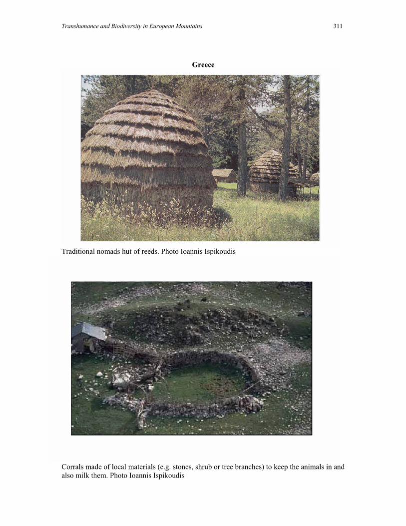
Transhumance and Biodiversity in European Mountains 311
Greece
Traditional nomads hut of reeds. Photo Ioannis Ispikoudis
Corrals made of local materials (e.g. stones, shrub or tree branches) to keep the animals in and also milk them. Photo Ioannis Ispikoudis
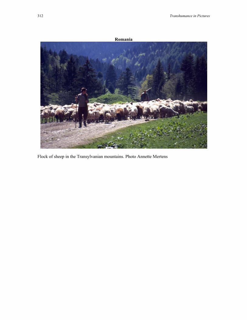
312 Transhumance in Pictures
Romania
Flock of sheep in the Transylvanian mountains. Photo Annette Mertens

Transhumance and Biodiversity in European Mountains 313
Poland
A few hundred years of traditional pastoralism in the Bieszczady Mts (Polish Eastern Carpathians) created unique grassland ecosystems, a very important habitat for rare and threatened plant species. Photo: Marta Mróz.

314 Transhumance in Pictures
Slovakia
Slovakia: Transhumance grazing in the Low Tatras. Photo Maria Zimkova.

Transhumance and Biodiversity in European Mountains 315
Norway
Hjellesetra in Western Norway is one of the best examples of a summer farm in the county. Traditional materials have been used to maintain and repair the buildings. The many hay barns on the old hay meadows are a characteristic feature. Photo Leif Hauge.
A traditional summer farm in the central part of southern Norway. Photo Leif Hauge.

316 Transhumance in Pictures
To make the most of the natural resources for agricultural production, the mountain summer farms were important elements in farm husbandry. In late June, the animals were moved to high-lying summer farms, often up to 1200 m above sea level. Photo Leif Hauge.

Transhumance and Biodiversity in European Mountains 317
Germany
German Transhumant landscape with flock of sheep. Photo Rainer Luick
Photo Rainer Luick
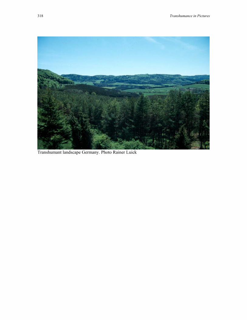
318 Transhumance in Pictures
Transhumant landscape Germany. Photo Rainer Luick

Transhumance and Biodiversity in European Mountains 319
Spain
The Cañada avoids the best cropland. Churra tensina in Ebro drylands. Photo Antonoio Gómez Sal.
Avileña cow browsing the oak (Quercus ilex). Photo Antonio Gómez Sal

320 Transhumance in Pictures
Lacha sheep in the Picos de Europa pasture land (Cantabrian mountains). Photo Antonio Gómez Sal.
Pasiego system, meadows and haystacks. Photo Antonio Gómez Sal.

Transhumance and Biodiversity in European Mountains 321
Shepherding in mountain pastureland Riaño León. Photo Antonio Gómez Sal.
Wooded mountain pastureland in southern Iberian system. Photo Antonio Gómez Sal,