TRANSBOUNDARY DIAGNOSTIC ANALYSIS (TDA)
91
TRANSBOUNDARY DIAGNOSTIC ANALYSIS (TDA)
Transcript of TRANSBOUNDARY DIAGNOSTIC ANALYSIS (TDA)
TRANSBOUNDARY
DIAGNOSTIC ANALYSIS
(TDA)
Final Report
Consortium International MarConsult & CSI Ingenieros, S.A. March, 2010 Chapter 4 – Page 2
Project for the Environmental Protection and Control of Pollution Caused by Maritime Transportation in the Gulf of Honduras
Data and Information Management Systems, Establishement of a Base Line, Preparation of a Transboundary Diagnostic and Strategic Action Plan
4. IDENTIFICATION AND CHARACTERIZATION OF THE PRIORITY
PROBLEMS AND THEIR SOCIO-ENVIRONMENTAL IMPACTS
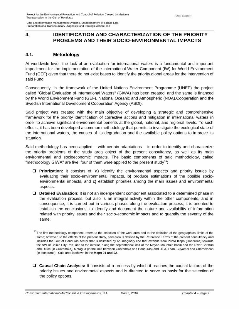
4.1. Metodology
At worldwide level, the lack of an evaluation for international waters is a fundamental and important
impediment for the implementation of the International Water Component (IW) for World Environment
Fund (GEF) given that there do not exist bases to identify the priority global areas for the intervention of
said Fund.
Consequently, in the framework of the United Nations Environment Programme (UNEP) the project
called “Global Evaluation of International Waters" (GIWA) has been created, and the same is financed
by the World Environment Fund (GEF), National Oceanic and Atmospheric (NOA),Cooperation and the
Swedish International Development Cooperation Agency (ASDI).
Said project was created with the main objective of developing a strategic and comprehensive
framework for the priority identification of corrective actions and mitigation in international waters in
order to achieve significant environmental benefits at the global, national, and regional levels. To such
effects, it has been developed a common methodology that permits to investigate the ecological state of
the international waters, the causes of its degradation and the available policy options to improve its
situation.
Said methodology has been applied – with certain adaptations – in order to identify and characterize
the priority problems of the study area object of the present consultancy, as well as its main
environmental and socioeconomic impacts. The basic components of said methodology, called
“methodology GIWA" are five; four of them were applied to the present study41
:
Priorization: it consists of: a) identify the environmental aspects and priority issues by
evaluating their socio-environmental impacts, b) produce estimations of the posible socio-
environmental impacts, and c) establish priorities among the main issues and environmental
aspects.
Detailed Evaluation: It is not an indenpendent component associated to a determined phase in
the evaluation process, but also is an integral activity within the other components, and in
consequence, it is carried out in various phases along the evaluation process; it is oriented to
establish the conclusions, to identify and document the nature and availability of information
related with priority issues and their socio-economic impacts and to quantify the severity of the
same.
___________________________ 41
The first methodology component, refers to the selection of the work area and to the definition of the geographical limits of the
same; however, to the effects of the present study, said area is defined by the Reference Terms of the present consultancy and
includes the Gulf of Honduras sector that is delimited by an imaginary line that extends from Punta Izopo (Honduras) towards
the NW of Belize City Port, and to the interior, along the septentrional limit of the Mayan Mountain basin and the River Sarstun
and Dulce (in Guatemala), Motagua (in the limit between Guatemala and Honduras) and Ulua, Lean, Cuyamel and Chamelecon
(in Honduras). Said area is shown in the Maps 01 and 02.
Causal Chain Analysis: It consists of a process by which it reaches the causal factors of the
priority issues and environmetal aspects and is directed to serve as basis for the selection of
the policy options.
Final Report
Consortium International MarConsult & CSI Ingenieros, S.A. March, 2010 Chapter 4 – Page 3
Project for the Environmental Protection and Control of Pollution Caused by Maritime Transportation in the Gulf of Honduras
Data and Information Management Systems, Establishement of a Base Line, Preparation of a Transboundary Diagnostic and Strategic Action Plan
Analysis de Political Options: It is a process oriented to indicate the potencial political
interventions, based in the indentification of the causal factors of the priority issues and their
environmental and socio-economic aspects.
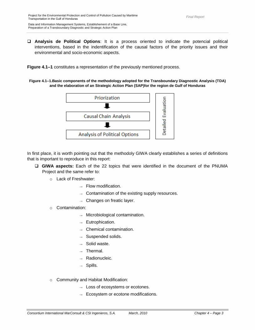
Figure 4.1–1 constitutes a representation of the previously mentioned process.
Figure 4.1–1.Basic components of the methodology adopted for the Transboundary Diagnostic Analysis (TDA)
and the elaboration of an Strategic Action Plan (SAP)for the region de Gulf of Honduras
In first place, it is worth pointing out that the methodoly GIWA clearly establishes a series of definitions
that is important to reproduce in this report:
GIWA aspects: Each of the 22 topics that were identified in the document of the PNUMA
Project and the same refer to:
o Lack of Freshwater:
→ Flow modification.
→ Contamination of the existing supply resources.
→ Changes on freatic layer.
o Contamination:
→ Microbiological contamination.
→ Eutrophication.
→ Chemical contamination.
→ Suspended solids.
→ Solid waste.
→ Thermal.
→ Radionucleic.
→ Spills.
o Community and Habitat Modification:
→ Loss of ecosystems or ecotones.
→ Ecosystem or ecotone modifications.
Final Report
Consortium International MarConsult & CSI Ingenieros, S.A. March, 2010 Chapter 4 – Page 4
Project for the Environmental Protection and Control of Pollution Caused by Maritime Transportation in the Gulf of Honduras
Data and Information Management Systems, Establishement of a Base Line, Preparation of a Transboundary Diagnostic and Strategic Action Plan
o Non-Sustainable Exploitation of the Living Resources:
→ Over-exploitation.
→ Incidental fisheries and excesive disregard.
→ Destructive fishing practices.
→ Lowest viability of the existences due to contamination and diseases.
→ Impacts on the biological and genetic diversity.
Environmental Global Change:
o Changes on hydrologic cycles and oceanic circulation.
→ Change on the sea level.
→ Increase of the UV-B radiations as a result of ozone depletion.
→ Changes on the CO2 drains for the oceans.
Environmental Impact: All adverse effect of a GIWA aspect about the aquatic ecosystem
integrity; for example, the loss of aquatic life as a result of the eutrophication.
Socio-Economic Impacts: The adverse effect of a GIWA aspect about the man wellness; for
example, the increase of the water treatment cost or the diseases resulting from contamination.
Inmediate Causes: The physical, biological, and chemical variables have a direct impact on a
GIWA aspect; for example, the highest support of nutrients in the case of eutrophication-
Sectors / Activities: on one hand, it refers to the activities (including its growing) of the
different economic sectors that produce the inmediate causes (for example, in the agricultural
sector, the excesive application of certain types of pesticides), and on other hand, to the
decisions taken by the companies, farmers, fishermen, family groups, government deficers or
politician (that is to say, socio-economic agents in general) that, directly or indirectly, can
produce a negative impact; for example, the decisions of the farmers regarding the use of a
highly contaminant pesticide.
Root Causes: It refers to the key factors, the tendencies, the processes or institutions that
influence a situation, aspect, or decision; that drive the system towards and determine the
resultant scenery; for example, the subsides for the pesticides, the regulations about their
application and control, etc.
Regarding the effects of the present consultancy, the identification and characterization of the
so-called “priority issues” is based in the components of “priorization” and “detailed evaluation”
that were made based on:
The diagnoses with regard to the physical and bio–geochemical, contamination, socio-economic
and the legal framework that were opportunely presented in the so-called “Initial Report"
(summarized in the Chapter 3 of the present report).
Said diagnoses were based on an exhaustive bibliographical review that, besides, included the
“Preliminary Transboundary Diagnostic Analysis" (Abt Associates Inc. – Woods Hole Group,
2003), the “Basin Analysis of the Mesoamerican Barrier Reef System" (WRI – ICRAM, 2006),
the diverse elaborate reports in the framework of the Project “Mesoamerican Barrier Reef
System" (SAM), the “Ecoregional Evaluation of the Mesoamerican Barrier Reef System"
Final Report
Consortium International MarConsult & CSI Ingenieros, S.A. March, 2010 Chapter 4 – Page 5
Project for the Environmental Protection and Control of Pollution Caused by Maritime Transportation in the Gulf of Honduras
Data and Information Management Systems, Establishement of a Base Line, Preparation of a Transboundary Diagnostic and Strategic Action Plan
(Kramar and Kramer, 2002), the “Baseline of the Mesoamerican Barrier Reef System" (Garcia –
Salgado, 2006), the studies carried out by Alatec – Valencia Port in the framework of the
Project “Improvement of the Environmental Management In the Ports of the Gulf of Honduras",
and the diverse studies carried out by the non-governmental organizations acting in the region,
particularly including, the studies carried out by the “Trinational Alliance for the Conservation of
the Gulf of Honduras" (TRIGOH), “World Wildlife Fund" (WWF), “The Nature Conservancy"
(TNC) and “Healthy Reefs Initiative".
The so-called “Campaign for Environmental Research" carried out in the framework of the
present consultancy, between the days 8th and 26
th of august, 2008, that included the extraction
and analysis of 12 samples of superficial water, 12 samples of sediments and 7 samples of biota
see (Section 3.2.2, Maps 39, and charts 3.2–9 and 3.2–10).
The “detailed evaluation" did not intend to be a process for massive data collection, but also a documentation of the existing information related to the environmental and socio-economic impact evaluation of priority issues identified. These informations come from several prior sources including evaluations, research works, scientific publications, governmental reports, situation reports, evaluation reports for environmental impact, economic outlines, etc. Likewise, it is worth mentioning that the identification and characterization of the so-called “priority
issues", fundamentally based on the GIWA methodology, was carried out through the identification and
characterization of the so-called “current issues" and the so-called “emerging issues". The first one
(“current issues") refers to the environmental and socio-economic impacts currently present and with
certain consequences – and obvious – on the marine and coastal areas, while the second one
(“emerging problems") refers, fundamentally, to the potential impacts – having consequences, uncertain
in a certain way – such as the ones associated to the environmental global change and the potential
development of the new infrastructure works in the marine and coastal areas of the study area object of
the present consultancy.
Final Report
Consortium International MarConsult & CSI Ingenieros, S.A. March, 2010 Chapter 4 – Page 6
Project for the Environmental Protection and Control of Pollution Caused by Maritime Transportation in the Gulf of Honduras
Data and Information Management Systems, Establishement of a Base Line, Preparation of a Transboundary Diagnostic and Strategic Action Plan
4.2. Priority Issues
4.2.1. Current Issues
4.2.1.1. Water Availability
At general level, in the countries contemplated in the study area object of the present consultancy, the
availability of the hydric resource is variable.
a) Belize
In Belize, the superficial water resources, as well as groundwater, seem to be abundant in most of the
country surface; nevertheless, the total resources cannot be evaluated since the existing data is limited;
particularly, the ones referred to the availability and quality of the groundwater. In fact, in the coastal
areas and along the rivers subject to the wind action, and consistently, to the intrusion of water
originating from the Gulf of Honduras, high concentrations of chlorides have been detected determining
that, in the dry season, when the freshwater refill by precipitation is scarce, the presence of chlorides
affect the quality and availability of the groundwater (FAO's Information System on Water and
Agriculture, 2000).
The “Food and Agriculture of the United Nations" (FAO, by its acronym in English), estimate that the
total discharge of the Belizean rivers is approximately 15.000 million m3/year.
The freshwater availability per inhabitant is high. In the year 2002, the renewable natural water
resources were 78.8 thousand m3/person (EarthTrends, 2003), a little under the corresponding one for
the year 1995 when it reached 80.8 thousand m3/person (CCAD, 1998; Belize National Assessement
Report, 2003).
The total consumption of water reaches 95.000.000 m3/year, turning out to be insignificant in
comparison to the superficial hydric resources in existence (FAO, 2000).
b) Guatemala
In Guatemala, the situation regarding the hydric availability is way different.
According to the diagnostic report of the year 2006 (Strategy for the Integrated Management of the
Hydric Resources of Guatemala), the country has a defering for 97.120 million m3 of water
corresponding to the 34, 28% (33.224 million m3) to the watershed of the Caribbean Sea. The hydric
capital ascends to 11.900 m3/person/year (CCAD, 1998).
Also, according to CCAD (1998), the total annual water extraction rises to 1.557 million m3/year; this
indicates that, in general terms, there is a resource surplus.

Final Report
Consortium International MarConsult & CSI Ingenieros, S.A. March, 2010 Chapter 4 – Page 7
Project for the Environmental Protection and Control of Pollution Caused by Maritime Transportation in the Gulf of Honduras
Data and Information Management Systems, Establishement of a Base Line, Preparation of a Transboundary Diagnostic and Strategic Action Plan
This surplus in the annual hydric balance is due to the rains and to the abundance of water resources.
Nevertheless, although the information indicates that there exists the quantity of sufficient water to
satisfy the demand, there is not an adequate management of said resources that allows developing and
maintaining the supply requirements, in terms of drinking water services and water sanitation services
for agricultural purposes (IARNA, URL and IIA, 2006).
The water shortage is a very serious problem, although the country has an annual rain average of
2.000 mm the unequal population and rain distribution, plus the inefficient resource management of
available water, are the main causes of the water supply problems.
The water resources are seen exhausted by the increase in demand that has been developed until
arriving at a critical situation. This exhaustion is due, in part, to an unequal distribution of the population
since the most densely populated areas correspond to those regions where the availability of water is
low whether for its altitudinal location or by a rain deficit (U.S. Corp de Engineers, 2000).
In the urban areas, the groundwater provides most of the supply for domestic use (and is very reliable
for supplying future needs).
c) Honduras
In Honduras, the situation is similar to the one in Guatemala, since there is a significant hydric potential,
and according to information from the year 2004, almost the 79% of the existing resource is not utilized.
The availability, or water capital is 48.628 million m3/year, according to data presented by the “Water
Platform of Honduras" in instances for the presentation of the “Water General Law" (year 2004); this
equals to about 13.500 m3/person/year, quantity way superior to the respected value as shortage
indicator (1.000 m3/person/year; Secretary de Natural and Environmental Resources, 2004).
According to the water capital data reported by FAO (2000), the total water consumption rises to 1.820
million m3/year; so, in general terms, the annual renewable water resources used by Honduras are
enough to meet the water consuming demand.
At particular level, in Tegucigalpa (capital of this country) the coverage in water infrastructure
corresponds to the 91, 4%, and the deficit of supply is 1, 0 m3/s. The water excess that has not been
counted and an inefficient distribution, explain the reason of the severe rationings that apply in this city,
particularly during the dry seasons.
In San Pedro Sula, the most favorable situation; nevertheless is necessary to reduce the water that has
not been counted and to improve the systems of distribution (OPS/WHO, 2003).
In Port Cortes, the coverage is 93, 4% and the service is 24 hours; nevertheless, due to the growth of
its population and to the enlargement of its urban limits, is necessary to incorporate, in a short-term,
new source of support (GEO Honduras, 2005).
Finally, it is worth mentioning that there exist washbasins that, in the case of producing an increase of
their irrigation potential, would be able to present, in the future, water shortage problems. Likewise,
other basins (Ulua and Chamelecon), in which the annual average resource is greater that the demand,
accuse shortages in determined periods of the year (February to May).

Final Report
Consortium International MarConsult & CSI Ingenieros, S.A. March, 2010 Chapter 4 – Page 8
Project for the Environmental Protection and Control of Pollution Caused by Maritime Transportation in the Gulf of Honduras
Data and Information Management Systems, Establishement of a Base Line, Preparation of a Transboundary Diagnostic and Strategic Action Plan
4.2.1.2. Contamination
In the study area object of the present consultancy, is growing the worry about the effects that the
activities of anthropic origin, carried out in a determined hydrographic basin, can have on the waters of
the Gulf of Honduras.
Globally, the effects of different pollutant discharges on the water quality and the aquatic biota are
diminished by the large dilution effect, but locally, the identification of the potential sources of the
pollutant discharges has a great importance; this, regardless of the magnitude of the amount
discharged or the size of the considered basin area, because often, the effects on the local environment
are significantly affected, especially water quality and sediments from the coastal zone.
In general, although differences in the urban, economic and industrial development degree among the
hydrographic basins of the different countries (Belize, Guatemala and Honduras), can be said that the
Gulf of Honduras receives contaminant contribution from point sources (pertaining to industrial
effluents, sewage effluents and solid residues) as well as diffuse contamination sources. It is worth
mentioning that the sewage effluents also contribute contaminants derived of the industrial activity; in
fact, the networks of sewer system receive contributions from industrial effluents
Additionally, due to the great importance of the Gulf of Honduras as a waterway and as a base for the
main ports focused on trading within the region (see Figure 2-14, Table 2-2), there are several factors
associated with the maritime – ports activity, which contribute to the degradation of coastal and marine
ecosystems.
The environmental aspects contemplated in the present section are centered in those types of
contamination that were identified for the study area object of the present consultancy; according to
their nature, the same can be differentiated as:
Microbiologic Contamination: Is is the one characterized by a presence of pathogenic
microorganisms in the water, with the consequent increment for the probability of water-
transmitted diseases.
Eutrophic Contamination: It is one characterized by an increment in the concentration of
nutrients that potentiate a great development of the primary products, with the consequent
alteration of the ecosystem.
Chemical Contamination: It is the one characterized, mainly, by the presence of toxic
substances that can produce effects on the living things. It is worth mentioning that the toxicity
of a certain substance will be given by its capacity of producing a certain nocive effect on the
organisms and this for a certain dosis and a certain access way. Many components can present
toxicity on the living things (organisms); however the toxicity degree varies among the different
components, depending on the toxicity level from substance quantity that makes the nocive
effect on the biologic system and the biological specie itself.
Physical Contamination: It is the one originated as a result of termal changes, color, and pH
and/or turbidity variations. As an example, the contamination of suspended solids is the
physical contaminations that occur by a presence of suspended solid concentrations that can
affect the water “use”.
Regarding the identification and analysis of the current issues and impacts on the water quality of the
study area object of the present consultancy, whether these are consequences of terrestrial or maritime

Final Report
Consortium International MarConsult & CSI Ingenieros, S.A. March, 2010 Chapter 4 – Page 9
Project for the Environmental Protection and Control of Pollution Caused by Maritime Transportation in the Gulf of Honduras
Data and Information Management Systems, Establishement of a Base Line, Preparation of a Transboundary Diagnostic and Strategic Action Plan
activities, it was considered the primary as well as the secondary information. The main source of
primary information was generated through the evaluation of the information obtained during the
“campaign of environmental research" carried out in the framework of the present consultancy; in turn,
the secondary information was obtained during the exhaustive bibliographical review carried out (from
the preliminary ADT as well as other studies already carried out for the region).
Particularly, in regard to present report, the secondary information is considered as very relevant and
highly important weight since the information pertaining to the “campaign of environmental research",
carried out in the framework of the present consultancy, possesses a synoptic character representing
an instantaneous situation to the moment of the sampling (consequently, the data obtained are
considered having indicative character).
a) Microbiologic Contamination
The disposition of excreta is, in most of the third world countries having low developed industries, the
greatest contamination source of water bodies; in this regard, there can be various source of
contamination:
As point sources: When the disposition is carried out through a sewage system that collects the
sewage liquids concentrating on a discharging point; whether or not there exists a previous
treatment for said discharge.
As dispersed or not point source: When the disposition is carried out in a direct way from the
houses toward the road, the drainage channels, or directly, toward the water bodies.
As dispersed or not point source through contamined aquifers: When the dwellings have an
excreta evacuation system for infiltration to the land, without an adequate control, the
contamination of the aquifers can be produced.
At general level, in the three countries, there exists deficit of clean-up coverage. Clean-up means the
environmental safe management of excretes; it can be carried out whether through sewage systems,
with proper treatment before its spilling, or by means of individual systems of disposition projected - and
built - in an adequate way.
This reality determines that the discharges of sewagewater impact, on the resource, superficial water
directly as point sources, and indirectly, as diffused or not point sources (mainly, through the
contamination of the groundwater).
It is worth that Abt Associates Inc. - Woods Hole Group (2003) carried out the analysis of the relative
weight of the sewage discharges with respect to the total contribution of organic matter (as DBO5) that
receive the main tributary basins to the Gulf of Honduras.
Regarding said analysis come up that, at general level, this type of discharge represents more than the
55% of the contribution of organic matter, except for the basins of the Chamalecon River and Ulua that
represent, approximately, the 35% (Table 4.2–1).

Final Report
Consortium International MarConsult & CSI Ingenieros, S.A. March, 2010 Chapter 4 – Page 10
Project for the Environmental Protection and Control of Pollution Caused by Maritime Transportation in the Gulf of Honduras
Data and Information Management Systems, Establishement of a Base Line, Preparation of a Transboundary Diagnostic and Strategic Action Plan
Table 4.2–1.Sewage Discharges: DBO5 Contributions (in % regrading the total contribution)
Basin DBO5 ( %) Contribution
Chamalecon 36,7
Ulua 34,1
Sartsun 62,6
Motagua 55,9
Izabal-Dulce River 62,4
Belize 66,1
Taken from: Abt Associates Inc. – Woods Hole Group
(2003)
Additionally, in the Gulf of Honduras, the tourism that comes by sea is particularly important and has
suffered a significant increment in recent years (Table 4.2–2); this has determined a growing worry for
the discharge of sewage originating from cruise ships as well as from the growing number of yachts.
Nevertheless, the crafts of great size possess storage systems and comply with the ANNEX IV of the
“Agreement for the Prevention of Pollution from Ships" (MARPOL) that prohibit discharging said waters
at less than 7,0 km of the closest land.
Nevertheless, the coastal and recreation crafts are not subject to the environmental scope of the
Agreement MARPOL for which, due to the lack of receptive facilities for sewagewaters in the ports from
the majority of the Caribbean Sea countries, the same discharge their sewage directly toward the
marine water, regardless of the distance from the coast, and even, in zones that are close to coral reefs
(WRI, 2005).
Table 4.2–2.Cruise Tourism Statistics in Central America per year
Country 2000 2001 2002 2003 2004 2005 2006 2007
Belize 58.131 48.116 319.640 575.295 851.436 800.331 655.929 624.128
Guatemala 1.454 4.058 6.430 19.254 22.454 17.975 20.522 42.000
Honduras 217.700 154.100 238.605 276.076 384.539 444.610 397.689 513.000
Other
Central
American
countries
391.524 484.139 577.781 690.312 782.601 931.244 1.152.474 1.335.000
Total 668.809 690.440 1.142.506 1.560.937 2-041.030 2.194.160 2.226.614 2.514.000
Source: Central American Integration System (SICA)
Final Report
Consortium International MarConsult & CSI Ingenieros, S.A. March, 2010 Chapter 4 – Page 11
Project for the Environmental Protection and Control of Pollution Caused by Maritime Transportation in the Gulf of Honduras
Data and Information Management Systems, Establishement of a Base Line, Preparation of a Transboundary Diagnostic and Strategic Action Plan
Belize
In Belize, a few municipalities have sewer or sewagewater treatment system. The information compiled
in the framework of the present consultancy indicates the 39,7% of the homes utilize latrines, the 54,
8% utilizes septic tanks, and the 3,5% does not possess any type of facility in regard to sewage waste
collection system (Belize National Plan of action, 2008).
Likewise, there exist reports that, in the rural areas of Belize, contaminated superficial waters are used
for human consumption and ground water wells, in many cases, are built without protection and near
latrines, with the consequent contamination of the groundwater.
The lack of clean-up in the rural zones, as well as an adequate provision of drinking water, have
generated for the Belizean population a high number of gastrointestinal disease cases (Belize National
Environmental Plan, 2006).
In the city of Belize, there exists a sewagewater treatment plant, which constitutes a potential and point
source of contamination for the ecosystem. The plant was built in 1981 and is conformed by primary
and secondary treatment lagoons; nevertheless, the demographic growth of the zone has not been
accompanied for an enlargement of the said plant capacity. Consequently, a considerably part of the
current population is not related to clean-ups. According to data originating from Belize Water Services,
the spilling, that drains directly to the Gulf of Honduras, complies with the regulations currently in force.
In Belmopan, the sewage system is composed by the corresponding network of sewer system, two
pumping stations and a processing plant that is currently out of service (Belize Environmental Prdeile,
2006); on the other hand, it is worth mentioning that the discharge of the sewagewater – currently
without treatment – is carried out in Mount Pleasant Creek, that flows into the Belize River that, at the
same time, constitutes the source of drinking water for the city of Belize.
According to the Belize National Plan of action (2008) concentrations of bacteria indicating fecal
contamination have been determined (E. coli) that surpass the drinking water standards, and in the
zone next to Placencia, there has been registered concentrations above the standard established by
the World Health Organization (WHO) for recreation by direct contact. Recently, Belize Beach has been
declared, for Public Health, as ineligible for baths due to the existing records of skin problems (in the
users of said recreational area).
Guatemala
According to the “Water Resource Situation" (2005) report in Guatemala, the water processing of the
sewagewater is almost nonexistent and only a 9% of the population has some sort of domestic sewage
processing.
The same report indicates that from the 223 cities more than 2.000 inhabitants with drainage system,
only 24 apply some type of treatment to their sewage (generally, “primary processing” type), the
remainder is directly discharged to the rivers.
Consequently, the microbiologic quality of the Guatemalan rivers is a remarkable issue. An example of
it is the existing situation in the city of Guatemala where the 40% of the sewagewater are discharged to
Las Vacas River that, at the same time, drains its water toward the Motagua River.
According to the U. S. Corp of Engineers (2000), as a result of the water sewage discharges directly
toward rivers and streams, during the rainy season a high contamination on aquifer as well as an
increment on the phases of the water-transmitted diseases is produced (as the cholera).

Final Report
Consortium International MarConsult & CSI Ingenieros, S.A. March, 2010 Chapter 4 – Page 12
Project for the Environmental Protection and Control of Pollution Caused by Maritime Transportation in the Gulf of Honduras
Data and Information Management Systems, Establishement of a Base Line, Preparation of a Transboundary Diagnostic and Strategic Action Plan
According to superficial water quality studies carried out by the University of San Carlos of Guatemala
(2004) in the the lake Izabal and Dulce River basins, the concentrations of thermotolerant coliforms
(fecal) showed that "there exist contamination for sewage of domestic origin in the totality of the
sampling places, which constitutes a risk for the health of the basin inhabitants. On the other hand, the
fishing, as economic activity that would be able to contribute to the sustainable development of the
region, is seen affected by the contamination of fecal origin that affects the quality of the product and
the health of the consumers. The bacteriologic contamination also affects the agricultural activity, since
the water of Izabal Lake and Dulce River is utilized for agricultural irrigation".
The situation is repeated in the basin of the Rivers Motagua and Sartsun, where studies carried out in
the framework of the Project “Environmental Justice, Commnunity Empowerment and Social Equality
for the Conservation of the Region Sartsun – Motagua" (JADE, 2006) indicate that the presence of high
concentrations of warning bacteria of fecal contamination and a tendency of greater rates for
contamination during the rainy season, for which the same one cannot be employed for the
consumption or the irrigation by direct contact.
In regard to the microbial contamination of the water in Guatemala, 50% of the 10 main causes of
morbidity are related directly to the water quality. The number of gastroenterocolitis episodes increased
to half million, at national level, during the period 2002 – 2004 (IARNA, URL and IIA, 2006).
Honduras
Also in Honduras, the served water discharges represent one of the main causes for contamination of
the resource waters, mainly in those basins that cross large cities.
The total population with any type of proper clean-up is 68%, said percentage cooresponding to a 88%
of the urban population and a 49% of the rural population. Nevertheless, said percentage – the highest
of the three countries – for the year 2035 is foreseen that the load contaminant spilling to the different
water courses are increased to a 50% (with respect to the year 2005), unless the existing capacities are
fortified in relation to the treatment of the same (GEO – Honduras, 2005).
Studies carried out by the Natural Resources and Environment Secretary (SERNA), through the Centre
for the Study and Control of Contaminants (CESCCO), indicate that the 33% of the dead fish episodes
in the basin of Ulua River (which registers the highest number of events) is a direct consequence of the
oxygen deficiency caused by the increase in the matter organic product of the discharges (GEO –
Honduras, 2005).
On the other hand, it is important to mention that there exist a low percentage of treatment plants, and
in general, that same involve a sanitary treatment type of variable efficiency (OPS/OMS, 2003).
For the Municipality of San Pedro Sula, as per the information of the Chamber of Commerce and
Industries of Cortes, in the seat of the city, a collector separative system composed by a sewer system
and a pluvial sewage system, that serves to a 65 – 68% of the population. Also, according to
information of said Chamber, the sewagewater and industrial waste water exceed the capacity of
autodepuration of the rivers, consequently “the same become true sewers of open sky", being the River
Chamalecon the most affected in this aspect.
In the city of Port Cortes, there exists a processing plant, managed by a private company (Water of Port
Cortes), that this comprised by a processing area and six lagoons (two anaerobics, two of maturation,
two of facilitation), and that currently receives the domiciliary effluents of the 20% of the population

Final Report
Consortium International MarConsult & CSI Ingenieros, S.A. March, 2010 Chapter 4 – Page 13
Project for the Environmental Protection and Control of Pollution Caused by Maritime Transportation in the Gulf of Honduras
Data and Information Management Systems, Establishement of a Base Line, Preparation of a Transboundary Diagnostic and Strategic Action Plan
(number that correspond to the percentage of the population served with connection).42
The treated
water is discharged toward the lagoon of Alvarado.
Inmunologic studies carried out in said lagoon, during the year 2005, and that were supplied with the
object of the present consultancy by the Unit of Environmental Management (UGA) of Port Cortes,
indicate that: a) there exists a permanent exchange of the water volume stored by the lagoon (the tide
effect comprises almost the totality of the water body); b) in some of the monitored points, bacteriologic
contamination of fecal origin (associated to discharges of sewagewater and excrete); and c) the
processing plant possesses a good performance given that, in the spilling point of the lagoon, the
control parameters (DBO5, nitrogen, phosphorus and coliforms) are under the spilling standards
established in the “Technical Norms for discharging waste waters into receptive bodies and sanitary
drains” of Honduras.
As already stated, the discharges of sewage water can affect the groundwater (as a result of the
infiltration process). In this respect, in accordance with the Geo – Honduras (2005) report, there exists
little information and most of the works carried out refer to evaluations of physical, chemical and heavy
metal parameters.
Additionally, the Campaign for Environmental Survey, carried out - as a "screening" - as part of this
consultancy, showed that faecal contamination, which is evident in the ports, might come from
residential sewage discharges and not from boats, because such pollution is not recorded in Puerto
Cortes, where there is an effective treatment of household waste.
b) Eutrophication and Nutrient Contributions
The water quality with regard to its biological properties can be classified, according to Jermar (1987).
in terms of: a) its saprobity, that refers to the biological state of the water (oligo, meso or polisaproby)
and that is determined based on the presence or absence of determined organisms
(algae, ciliate, bacteria); and b) its trophicity that refers to the capacity that presents the water body of
nourishing the aquatic organism (oligo, meso and eutrophic).
The term "eutrophy" or "eutrophic" is utilized to define the water bodies that present a nutrient
enrichment with the consequent effects related to: a) the excessive growth of aquatic plants and single-
cell and multi-cell algae and b) the quality reduction of the associated water to the negative biochemical
processes presented.
At global scale, the "eutrophication" is one of the most general problems of the water contamination,
with harmful effects on various ecosistemic processes (Agard et to the., 1996; Gray, 1997; Ieno et al.
2006). The eutrophication can occur in lotic or lentic systems (Ramírez and Vineyard, 1998) or in
bodies of coastal water (Clark, 1996; Clarke et al., 2006).
42 The growth projections of the company indicate that, for the year 2015, population served percentage with connection will
be raised up to 55 %.
Final Report
Consortium International MarConsult & CSI Ingenieros, S.A. March, 2010 Chapter 4 – Page 14
Project for the Environmental Protection and Control of Pollution Caused by Maritime Transportation in the Gulf of Honduras
Data and Information Management Systems, Establishement of a Base Line, Preparation of a Transboundary Diagnostic and Strategic Action Plan
The eutrophication of continental water has been an ecological issue of importance for several
decades, but the concept of marine eutrophication was initially disregarded based on the simple
premise that, being relatively extensive and dynamic, the marine ecosystem, as a whole, would be
capable of incorporating nutrients without adverse effects. It was not until the middle of the decade of
the 80´s that the investigation about the coastal eutrophication began to be increased (Nixon, 1988).
The causes of the mentioned process can be of natural origin (physical-chemical processes) although,
mainly, it is considered as an effect generated by the man (cultural eutrophication) being this the scope
of the present statemment.
In regard to the eutrophication impacts and the nutrient contribution on the ecosystems, the main are
given by the loss of habitats:
o According to Burke and Maidens (2005), the agricultural activities on the basins that drain the
adyacent zones of the coral reefs have dramatically enlarged in recent times. This way, a strong
draining of fertilizers and cattle manure from the agricultural fields, important sources of
nitrogen and phosphorus entering directly the coastal water of the zone of the Gulf of Honduras
(Belize, 2005). From the South Belize, to Guatemala and Honduras, the fertilizers are easily
drained; especially due to the banana plantations presence and citrus (BBP, 1995; Burke and
Maidens, 2005). On the other hand, the loss of mangrove swamps and marine pastures, that
constitute the main filters of the nutrients originating from the land, contributes to the
eutrophication and to the turbidity increase over the coral reefs (Belize, 2005; Burke and
Maidens, 2005).
o In Belize, in the city of Placencia and in the surrounding area to Belize City, the marine pastures
are found submitted to processes of high pressure as a result of the urbanization and the
coastal development associated to a growing tourism industry that is generating an increase in
the nutrient spilling. In this respect, the kingfishers and the recreation ships that also contribute
to the eutrophication of the coast and lagoon of Placencia (Short et al., 2006a).
o According to PROARCA (2004), in the areas of mangrove swamps an overload of nutrients
caused by the agricultural practices is detected such as the use of fertilizers in the rice
cultivations in Honduras and by the served water of the cities from Port Barrios and Port Cortes.
o Although for the beach ecosystem we cannot talk about eutrophication, it has been detected,
mainly in Port Cortes, in Tela Bay and Punta Manabique, an important overload of associated
nutrients for the urban development and to the river contribution of the Rivers Ulua,
Chamalecon and Motagua (PROARCA, 2004).
o With regard to the estuaries and the coastal lagoons, PROARCA (2004) considers, as a
pressure of medium impact and high severity (that would be able to conduct to processes of
eutrophication), the overload of the sewagewater from cities as Port Barrios, Saint Thomas of
Castilla, Port Cortes and Tela Bayc, as well as for the fertilizers contributions and waste matters
from agroindustrial and industrial companies.

Final Report
Consortium International MarConsult & CSI Ingenieros, S.A. March, 2010 Chapter 4 – Page 15
Project for the Environmental Protection and Control of Pollution Caused by Maritime Transportation in the Gulf of Honduras
Data and Information Management Systems, Establishement of a Base Line, Preparation of a Transboundary Diagnostic and Strategic Action Plan
Nutrient Contribution for Sewage Discharges and Industrial Spillings
As already stated, the sewagewater discharges without proper treatment - or directly without treatment -
constitute a common denominator of the study area object of the present consultancy. This way, it is
generated additional contributions of organic matter and nutrients (nitrogen and phosphorus) that -
jointly with the rain discharges, discharges of certain types of pluvial spillings, the discharges of certain
types of industrial spillings, the growing use of fertilizers and pesticides in the agriculture and the solid
waste leachates - impact on the water quality, accelerating the process of eutrophication.
From the estimation of the nutrient loads carried out by Abt Associates Inc. – Woods Hole Group
(2003) come up that although one of the main contaminant contributions is due to the sewage
discharges, the significance of the same varies according to the water body considered (Table 4.2–3).
Table 4.2–3.Nutrient Contributions on the water courses (in % respect to the total contribution) for discharge
type
Nitrogen (%) Phosphorus (%)
Basin / River Sewage
discharge
Pluvial
discharge
Sewage
discharge
Pluvial
discharge
Chamalecon 13,9 1,1 17,7 2,1
Ulua 21,0 0,1 28,3 0,3
Sartsun 22,0 – – – 31,5 – – –
Motagua 36,3 0,4 42,1 0,7
Izabal Lake – Dulce River 16,7 0,1 26,4 0,3
Belize 25,4 0,2 33,0 0,4
Taken from: Abt Associates Inc. – Woods Hole Group (2003)
From the analysis of said Table come up that the River Motagua is the course that receives greater
contribution of nutrients as a result of sewage discharges followed, in second place, by the River Belize.
The urban pluvial discharges, in general terms, contribute to the contamination of the water bodies by
virtue of the dragging of the inert materials and the present solid residues in the urban areas.
Nevertheless, the relative weight of nutrient contributions, by this way, is significantly smaller that the
corresponding ones to the sewage discharges.
With relation to the bovine production, pork and poultry, the same is indicated as another of the diffuse
sources of contamination in which refers upon nutrient contributions; including also important loads of
pathogenic agencies.
In the case for the cattle production, more than the 90% of the establishments utilize streams or
reservoirs for supply of drinking water. The enrichment of these water bodies in nutrients is given for the
deposition of fecal matter. The cattle production in the low zones with high aquifers, can produce the
groundwater contamination a result of the contaminant leachings.

Final Report
Consortium International MarConsult & CSI Ingenieros, S.A. March, 2010 Chapter 4 – Page 16
Project for the Environmental Protection and Control of Pollution Caused by Maritime Transportation in the Gulf of Honduras
Data and Information Management Systems, Establishement of a Base Line, Preparation of a Transboundary Diagnostic and Strategic Action Plan
The Table 4.2–4 presents the nutrient percentage, with respect to the total load, that receive the
main water bodies of the study area object of the present consultancy, as a result of animal
excreta.
Table 4.2–4. Nutrient Contributions on the wáter courses (in % respect to the total contribution) resulting from
the animal excreta
Animal Waste
Basin DBO5 (%) Nitrogen (%) Phosphorus (%)
Chamalecon 36,5 19,4 35,8
Ulúa 48,2 9,2 17,7
Sartsùn 4,8 2,5 5,6
Motagua 7,5 10,7 13,8
Izabal-Rìo Dulce 6,1 2,0 4,7
Belize 1,9 1,3 2,6
Taken from: Abt Associates Inc. – Woods Hole Group (2003)
Belize
Regarding the nutrient contributions for industrial discharges, in Belize, the effluents of the sugar
industry constitute around the 99% of the total nutrient flow caused by the industrial discharges,
corresponding the remainder 1% to the citrus, beer, rum, poultry and shrimp fedding industries (Belize
Environmental Profile, 2007).
For the particular case of the River Belize, it does have sufficient data from the nutrients contributed by
the industrial discharges although, according to the load estimation of DBO5 carried out by Abt
Associates Inc. – Woods Hole Group (2003) can be inferred that the relative weight from contributions
of said unload discharges is significantly smaller than the corresponding one to other sources (as, for
example, the solid waste or agricultural leaches).
Nevertheless, there exist registrations that report episodes of algae flowerings and death fish in the
New River (Orange Walk District); said events have been attributed to nutrient contribute and non point
sources of contamination.
In city of Belize and Dangriga Caye, there has been registered an elevation of the nitrate levels that
seem to be a consequence of natural contribution of nitrogen dissolved in rainwater or by the
mineralization of the hydrographic basin floor.
In relation to the phosphate levels, the registered tenor are found in general, within the aceptable
values; the sulfate levels in the effluents of the aquatic farms exceeding the 200 mg/l, value which is
accepted by the spilling norms (Belize National Plan of Action for the Control of Land – Based Sources
of Marine Pollution in Belize, 2008).

Final Report
Consortium International MarConsult & CSI Ingenieros, S.A. March, 2010 Chapter 4 – Page 17
Project for the Environmental Protection and Control of Pollution Caused by Maritime Transportation in the Gulf of Honduras
Data and Information Management Systems, Establishement of a Base Line, Preparation of a Transboundary Diagnostic and Strategic Action Plan
Guatemala
In Guatemala, and in accordance with the GEO – Guatemala (2003) report, the industrial contamination
sources that have the highest impact for the study area object of the present consultancy are the
Rivers: La Vaca, Los Platanos and Motagua.
The studies carried out by the Project called “Environmental Justice, Community Empowerment and
Social Equality for the Conservation of the Region of Sartsun – Motagua (JADE, 2006) indicate that “as
per the criteria of the water quality for the protection of the aquatic life1, the physical and chemical
parameters evaluated during the year 2005 do not report altered levels by the activities that are taking
place in the basin”.
Honduras
In Honduras, in 1994, approximately the 50% of the existing industries produced problematic effluents,
that is to say, that produced sewage that required a pre-treatment before of their discharge to the sewer
and sanitary systems (since they presented a DBO5 of at least, 1.000 mg/l and a DQO of, at least,
2.000 mg/l). In said country, the “Technical Norm of Sewagewaters into Receptive Bodies and Sewage
establishes values of concentration of DBO5 and DQO, for the final discharge to the receiving body
receiver, of 50 mg/l and 200 mg/l, respectively (ESA Consultants, 1994).
In San Pedro Sula, information of the Municipality, pertaining to the year 2000, reveals that most of the
industries discharge their waste liquid without treatment; nevertheless, some of them include primary
treatments, such as the oil recovery or the solid sedimentation, but very few include secondary
treatment.
As already indicated, studies carried out by the Natural Resources and Environment Secretary
(SERNA), through the Centre for the Study and Control of Contaminants (CESCCO), indicate that the
33% of the death fish episodes in the basin of the River Ulua (that registers the highest number of
events) is a direct consequence of the oxygen deficiency caused by the increase in the matter organic
product of the discharges (GEO – Honduras, 2005).
Nutrient Contributions by Solid Waste Leaching
The solid waste deposits along the rivers, lagoons and mangrove areas generate, as consequence
from the pluvial precipitations, leaches that flow toward the water bodies, and consequently, get them
contaminated.
Table 4.2–5 presents the nutrient percentage, with respect to the total load, that are received by the
main water bodies of the study area object of the present consultancy, as a consequence of the solid
waste leaching.
1 The criteria employed in the evaluation of the water quality made for the Project JADE, correspond to quality criteria for the protection
of the fish fauna of freshwater proposed by the EIFAC – FAO (Alabaster y Lloyd, 1982; Howells, 1994) and the quality criteria for the
protection of the aquatic life proposed by the Environmental Protection Agency (EPA) of the United States.

Final Report
Consortium International MarConsult & CSI Ingenieros, S.A. March, 2010 Chapter 4 – Page 18
Project for the Environmental Protection and Control of Pollution Caused by Maritime Transportation in the Gulf of Honduras
Data and Information Management Systems, Establishement of a Base Line, Preparation of a Transboundary Diagnostic and Strategic Action Plan
Table 4.2–5. Nutrient Contribution on the water courses (in % respect to the total contribution) resulting from the
solid waste leaching
Basin DBO5 (%) Nitrogen (%) Phosphorus (%)
Chamalecon 17,4 3,9 8,2
Ulúa 16,1 5,8 13,1
Sartsún 29,6 6,1 14,6
Motagua 26,4 10,1 19,5
Lago Izabal – Río Dulce 29,5 4,6 12,2
Belize 31,2 7,0 15,3
Taken from: Abt Associates Inc. – Woods Hole Group (2003)
From the analysis of said Table come up that the relative weight of the nutrient contribution on the
water courses of the tributary basins to Gulf of Honduras, consequence of solid waste leaching, is
relatively similar: the percentages vary among 16, 1 and 31, 2 % for the DBO5, between 4, 6 and 10, 1
% for the nitrogen and between 8,2 and 19,5 % for the phosphorus.
Belize
According to the information from the Environmental Department of the Ministry of Natural Resources,
Local Development and Environment of Belize, in the year 2000 the 51% of the Belizean population
included residues collection systems, a 33% eliminated them upon burning (practice that also
generates contaminant leaching) and a 8% poured it in clandestine “dumps".
In Belize, the solid wastes collected in the cities are arranged in “dumps" of open sky that constitute
lacking facilities not only of controls environments but also of the adequate technical disposition (since
they function without the adequate equipment and/or without coverage).
The major “dump", situated on the outskirts of the city of Belize, receives more than 60 tons/day of
solid waste that are spilled, directly, on a mangrove swamp area with high freatic level and lacking of
the minimum requirements to become a facility properly managed (Belize´s Solid Waste Management
Project, 2002.).
The situation previously described determines that the arriving solid waste leaches, by spilling, to the
water bodies (subterranean as well as superficial) contributing to diverse contaminants (particularly,
nitrogen and phosphorus).
From the analysis of the load nutrient estimations carried out by Abt Associates Inc. in the 2003, comes
up that the solid waste leaches represent the 7% and the 15% of the total contribution of nitrogen in the
River Belize respectively. (Belize National Plan of Action for the Control of Land – Based Sources of
Marine Pollution in Belize, 2008).
Final Report
Consortium International MarConsult & CSI Ingenieros, S.A. March, 2010 Chapter 4 – Page 19
Project for the Environmental Protection and Control of Pollution Caused by Maritime Transportation in the Gulf of Honduras
Data and Information Management Systems, Establishement of a Base Line, Preparation of a Transboundary Diagnostic and Strategic Action Plan
Guatemala
In Guatemala, the final disposition of the solid waste originating from domicilary basin recollection, at
national level, with 15 sanitary landfills, 59 controlled “dumps” and 219 “dumps” of open sky. The last
two categories are an indiscutible contamination source of the water bodies, whether in a direct form
(discharges of leaches, dragging of wastes) or in a diffuse form along the underground waters (IARNA,
URL e IIA, 2006).
Honduras
In Honduras, pursuant to the data of the National Institute of Statistics (2001) the 52% of the dwellings
of the country burn or undertake the wastes; even in the urban areas this practice is performed for the
25% of the dwellings.
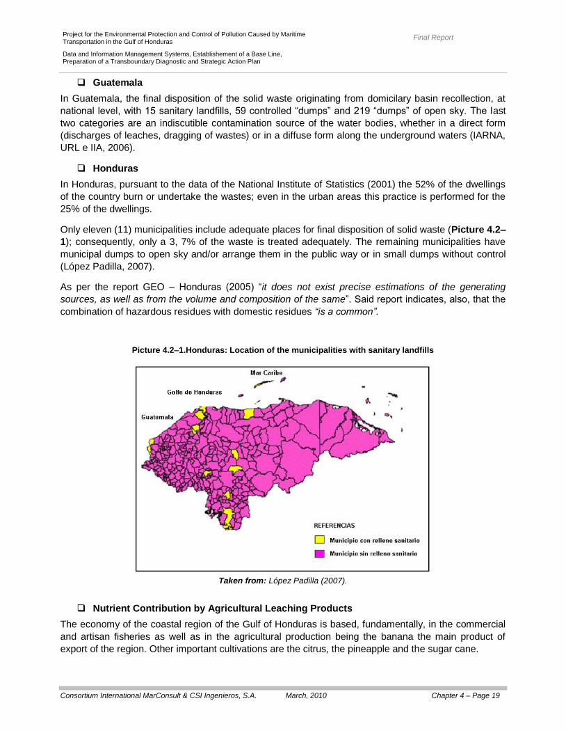
Only eleven (11) municipalities include adequate places for final disposition of solid waste (Picture 4.2–
1); consequently, only a 3, 7% of the waste is treated adequately. The remaining municipalities have
municipal dumps to open sky and/or arrange them in the public way or in small dumps without control
(López Padilla, 2007).
As per the report GEO – Honduras (2005) “it does not exist precise estimations of the generating
sources, as well as from the volume and composition of the same”. Said report indicates, also, that the
combination of hazardous residues with domestic residues “is a common”.
Picture 4.2–1.Honduras: Location of the municipalities with sanitary landfills
Taken from: López Padilla (2007).
Nutrient Contribution by Agricultural Leaching Products
The economy of the coastal region of the Gulf of Honduras is based, fundamentally, in the commercial
and artisan fisheries as well as in the agricultural production being the banana the main product of
export of the region. Other important cultivations are the citrus, the pineapple and the sugar cane.
Final Report
Consortium International MarConsult & CSI Ingenieros, S.A. March, 2010 Chapter 4 – Page 20
Project for the Environmental Protection and Control of Pollution Caused by Maritime Transportation in the Gulf of Honduras
Data and Information Management Systems, Establishement of a Base Line, Preparation of a Transboundary Diagnostic and Strategic Action Plan
With respect of the agricultural production intensive methods are utilized that include the employment of
fertilizers and chemical products whose overflow drains toward the water bodies, with the consequent
contribution of nutrients that involves the formation of algae and the potential deficiency in dissolved
oxygen.
In Belize, the use of fertilizers is extensive and the majority of chemical products produced or imported
are employed in the agriculture and the aquaculture, for which an important risk exists of eutrophication
in the water bodies. According to information of the Belize Central Statistical Office, in the year 1999 the
total quantity of fertilizers (imported and produced) was 55.000 tons; since that date to the current
moment, the utilization of fertilizers has been increased significantly passing from 289 pounds/acrid to
391 pounds/acrid in the 2003 (NPA, 2008).
In Guatemala, according to the U. S. Corp de Enginners (2000) information, there exist information
indicating that in the agricultural areas, the main source of superficial contamination are the existing
pesticides, also, records of insecticides and fertilizers in groundwater, mainly, from the banana
plantations and sugar cane.
In Honduras, the main cultivations correspond to the coffee, the banana, the sugar cane and the African
palm; in all of them, and mainly in the banana, is frequent the utilization of agrochemicals with the
consequent generation of leaching and contamination of the rivers and the water sources. In the
neighborhood of cities as San Pedro Sula, the intensive use of fertilizers is the cause of the existence of
nitrogen concentrations above to 40 mg/l (SANAA, 2001).
As already stated, the hydrologic analysis implemented in the year 2006 by the Institute of World
Resources (WRI) provides a preliminary perspective of the patterns for transportation and discharge of
sediments and nutrients at regional level. Said study establishes that: a) more than the 80% of the
sediment comes from Honduras, while the 17% is originated in Guatemala and a relatively smaller
percentage comes from Belize (and Mexico), and b) the largest source of nutrients (55% of the nitrogen
and 60% of the phosphorus) is found in Honduras, while Guatemala contributes with almost the 25% of
the total contribution of nitrogen and phosphorus and Belize with almost 12 – 13% (see Section
3.1.1.3, Pictures 3.1–8 to 3.1–10 and Table 3.1–8).
Nutrient Contribution by Aquaculture Activities
The present section is centered in the estimation of the BOD5 load (Biochemical Oxygen
Demand), nitrogen (N) and phosphorus (P) supplied by the different hydrographic basins
flowing into the Gulf of Honduras (see Figures 3.1–4 y 3.1–5 and Table 3.1–1).
The aquaculture, when is developed “in situ”, can be converted in a pressure source over the water
bodies quality (by nutrient contribution).
In Belize, the aquaculture has extended – in volume and value – more quickly than the fisheries and
that the cattle, livestock and agroindustrial production (see Section 3.3.5). The cultivation systems vary
from semintensives to superintensives for the case of the white shrimp while for the tilapia a
semiintensive system is utilized.
All the farms take in water directly from the Gulf of Honduras and the majority of their spillings are
carried out, directly to the Gulf of Honduras, through long drainage, without treatment and passing
along extensive mangrove areas. Additionally, it is produced basin overflows in rainy seasons, with the
corresponding discharge of nutrients.

Final Report
Consortium International MarConsult & CSI Ingenieros, S.A. March, 2010 Chapter 4 – Page 21
Project for the Environmental Protection and Control of Pollution Caused by Maritime Transportation in the Gulf of Honduras
Data and Information Management Systems, Establishement of a Base Line, Preparation of a Transboundary Diagnostic and Strategic Action Plan
Although in the framework of the bibliographical review carried out with the object of the present
consultancy, no concrete studies were identified which quantify the contributions of nutrients due to this
activity, it is important to emphasize in Belize´s National Environmental Action Plan (2006) that the
same are identified as one of the causes of the degradation of the water quality in that country.
In Guatemala, according to the “Inventory of Continental Water Bodies with emphasis on the Fishing
and the Aquaculture" (2005) no lentic water body from the basin of the Gulf of Honduras is used with
aquaculture purposes; nevertheless, the majority is related to tourism activities and of ecotourism.
In Honduras, the shrimp culture has become an activity of transcendental social and economic
importance since the 80´s decade, being the shrimp cultivated the third area in importance inside the
goods exported by Honduras originating from the Ocean Pacific zone of the country. The aquaculture is
carried out by practicing extensive cultivation systems, semintensives and intensive for the case of the
tilapia, while for the case of the shrimp systems of cultivation are practiced semintensives and
intensive.
Estimation of the Actual Nutrients to the Gulf of Honduras
The present statement is centered in the estimation of the loads of BOD5 (Biochemical Oxygen
Demand), nitrogen (N) and phosphorus (P) that contribute to the different hydrographic basins that
drain their water toward the Gulf of Honduras (see Picture 3.1–4 and 3.1–5 and Table 3.1–1). Said
basins belong to the countries de Honduras, Guatemala and Belize, and are the following (Picture 1–
1):
Abt Associates Inc. – Woods Hole Group (2003) determined the loads pertaining to the basins of
Belize (in Belize), of the River Sarstun (in the border between Guatemala and Belize), of Dulce River (in
Guatemala), of the River Motagua (in the border between Guatemala and Honduras) and of the Rivers
Chamelecon and Ulua (in Honduras); to such effects they considered the contributions coming from: a)
the urban and municipal sewage, b) the industrial discharges, c) the solid waste leaching, d) the
leaching of excreta from animal origin, and e) the agricultural production leaching, and f) other
contribution (that include the pastures and the forests).
With the object of the present consultancy a similar estimation for the year 2007 was carried out; to
such effects we went from the loads calculated by Abt Associates Inc. – Woods Hole Group (2003) and
it was considered that:
o The contribution coming from residual municipal water, from the solid residues and from
the urban residual liquids have an equal growing than the one for the population of each
basin.
o The contribution originating from industrial discharge has an equal growing than the one
for gross domestic product “manufacturer industries”.
o The contribution originating from animal, agricultural residues and other contributions
has a growing equal than the one for the domestic gross product “agriculture, hunting,
silviculture and fishing”.
The population from the year 2003 was estimated from the results presented by Abt Associates Inc. –
Woods Hole Group (2003)2.
2 Said population was estimated as the relation between the total load of DBO5 calculated and the load per unit of inhabitant considered
in said calculation.

Final Report
Consortium International MarConsult & CSI Ingenieros, S.A. March, 2010 Chapter 4 – Page 22
Project for the Environmental Protection and Control of Pollution Caused by Maritime Transportation in the Gulf of Honduras
Data and Information Management Systems, Establishement of a Base Line, Preparation of a Transboundary Diagnostic and Strategic Action Plan
The population for the year 2007 was estimated, for all the basins (except for the basin of the River
Sarstun) from the graphic crossing between the basins and the population of the corresponding
municipalities and/or districts. In this way, each basin was assigned the population pertaining to the
municipalities and/or districts that were – mainly – included within the same. The data of population
were obtained from the projections carried out by institutes of official statistics of each country.
For the basin of Sarstun, by being contained in municipalities that cover a territory a lot greater that the
corresponding one to the basin, the population reported was taken in the “Management Plan for the
Basin of the River Sarstun" (FUNDAECO, 2005).
The data of PBI, for the year 2003 as for the year 2007, were obtained of the Caribbean and Latin-
American Center of Demography (http://www.eclac.org/celade).
Table 4.2–6 and 4.2–7 present, respectively, the data of population and domestic gross product (years 2003 and 2007)
utilized for each one of the respected basins, is observed that the data of population are not dependable, since in various
cases the population estimated for the year 2007 is a smaller order that the respected population for the year 2003 by
Abt Associates Inc. – Woods Hole Group (2003).
Table 4.2–6. Population (by basin, for the years 2003 and 2007) considered to the effects of the estimation for the loads DBO5,
nitrogen and phosphorus.
Basin Population
2003 2007
Chamelecon 567.407 1.028.416
Ulua 3.594.222 1.721.209
Sarstun 298.333 6.455
Motagua 6.386.944 2.884.580
Dulce 949.630 91.572
Belize Basins 433.556 164.377
Table 4.2–7. Gross Domestic Product (US$/habitants) considered by estimating the OBD5 charges, nitrogen and
phosphorus (for each basin and for the years 2003 and 2007)
Basin Manufacturer Industries Agriculture, hunt, silviculture and fishing
2003 2007 2003 2007
Chamelecon 1.758 2.134 1.128 1.357
Ulua 1.758 2.134 1.128 1.357
Sarstun (*) 1.834 2.118 1.410 1.546
Motagua (**) 3.589 4.113 2.650 2.950
Dulce 3.589 4.113 2.650 2.950
Belize Basins 79 122 170 142
Notes: * The average PBI de Guatemala and Belize was considered
** The PBI de Guatemala was considered

Final Report
Consortium International MarConsult & CSI Ingenieros, S.A. March, 2010 Chapter 4 – Page 23
Project for the Environmental Protection and Control of Pollution Caused by Maritime Transportation in the Gulf of Honduras
Data and Information Management Systems, Establishement of a Base Line, Preparation of a Transboundary Diagnostic and Strategic Action Plan
Finally, the Table 4.2–8 presents the estimated loads by Abt Associates Inc. – Woods Hole Group
(2003) and the estimated in the present consultancy (up to the year 2007); in turn, the Pictures 4.2–2 a
4.2–4 represent, in a graphic form, the observed variations.
Table 4.2–8. Estimated loads by Associates Inc. – Woods Hole Group (2003) and by the present consultancy
Basin BOD5 (kg/day) Nitrogen (kg/day) Phosphorus (kg/día)
2003 2007 2003 2007 2003 2007
CHAMELECON RIVER
Municipal Residual Water 30.640 55.534 3.064 5.553 613 1.111
Industrial Discharge 5.904 7.167 ND ND ND ND
Solid Residues 14.469 26.225 851 1.542 284 515
Urban Residual Liquid 1.894 3.433 240 435 72 130
Agriculture 0 0 11.387 13.699 949 1.142
Animal Residual 30.483 36.671 4.276 5.144 1.236 1.487
Others (pastures, forests) 0 0 2.269 2.730 302 363
Total 83.391 129.030 22.087 29.103 3.455 4.748
ULUA RIVER
Municipal Residual Water 194.088 92.945 19.409 9.295 3.882 1.859
Industrial Discharge 7.914 9.606 ND ND ND ND
Solid Residues 91.653 43.891 5.391 2.582 1.797 861
Urban Residual Liquid 1.045 500 132 63 39 19
Agriculture NA NA 45.329 54.531 3.777 4.544
Animal Residual 273.705 329.268 8.517 10.246 2.432 2.926
Others (pastures, forests) NA NA 13.588 16.346 1.812 2.180
Total 568.405 476.212 92.367 93.063 1.374 12.388
SARSTUN RIVER
Municipal Residual Water 16.110 349 1.611 35 322 7
Industrial Discharge 776 851 ND ND ND ND
Solid Residues 7.608 165 448 10 149 3
Urban Residual Liquid 0 0 0 0 0 0
Agriculture NA NA 3.679 4.033 307 337
Animal Residual 1.234 1.353 184 202 57 62
Others (pastures, forests) NA NA 1.406 1.541 188 206
Total 25.727 2.717 7.329 5.821 1.022 615

Final Report
Consortium International MarConsult & CSI Ingenieros, S.A. March, 2010 Chapter 4 – Page 24
Project for the Environmental Protection and Control of Pollution Caused by Maritime Transportation in the Gulf of Honduras
Data and Information Management Systems, Establishement of a Base Line, Preparation of a Transboundary Diagnostic and Strategic Action Plan
Table 4.2–8. (Continuation)
Basin BOD5 (kg/day) Nitrogen (kg/day) Phosphorus (kg/día)
2003 2007 2003 2007 2003 2007
MOTAGUA RIVER
Municipal Residual Water 344.895 155.767 3.449 1.558 6.898 3.115
Industrial Discharge 59.878 68.635 ND ND ND ND
Solid Residues 162.867 73.557 9.580 4.327 3.193 1.442
Urban Residual Liquid 3.005 1.357 381 172 114 51
Agriculture NA NA 28.804 32.055 2.400 2.671
Animal Residual 46.401 51.638 10.183 11.332 2.255 2.510
Others (pastures, forests) NA NA 11.517 12.817 1.536 1.709
Total 617.046 350.954 94.955 62.261 16.396 11.499
DULCE RIVER
Municipal Residual Water 51.280 4.945 5.128 494 1.026 99
Industrial Discharge 1.409 1.615 ND ND ND ND
Solid Residues 24.216 2.335 1.424 137 475 46
Urban Residual Liquid 261 25 33 3 10 1
Agriculture NA NA 18.789 20.910 1.566 1.743
Animal Residual 5.005 5.570 624 694 185 206
Others (pastures, forests) NA NA 4.688 5.217 625 696
Total 82.171 14.490 30.687 27.456 3.886 2.790
BELIZE BASINS
Municipal Residual Water 23.412 8.876 2.341 888 468 177
Industrial Discharge 150 230 ND ND ND ND
Solid Residues 11.056 4.192 650 246 217 82
Urban Residual Liquid 131 50 17 6 5 2
Agriculture NA NA 2.438 2.041 203 170
Animal Residual 677 567 120 100 37 31
Others (pastures, forests) NA NA 3.658 3.062 488 408
Total 35.425 13.915 9.225 6.343 1.418 810

Final Report
Consortium International MarConsult & CSI Ingenieros, S.A. March, 2010 Chapter 4 – Page 25
Project for the Environmental Protection and Control of Pollution Caused by Maritime Transportation in the Gulf of Honduras
Data and Information Management Systems, Establishement of a Base Line, Preparation of a Transboundary Diagnostic and Strategic Action Plan
Picture 4.2–2.Evolution of the load of BOD5 (2003 – 2007)
Picture 4.2–3.Evolution of the load of Nitrogen (2003 – 2007)
Final Report
Consortium International MarConsult & CSI Ingenieros, S.A. March, 2010 Chapter 4 – Page 26
Project for the Environmental Protection and Control of Pollution Caused by Maritime Transportation in the Gulf of Honduras
Data and Information Management Systems, Establishement of a Base Line, Preparation of a Transboundary Diagnostic and Strategic Action Plan
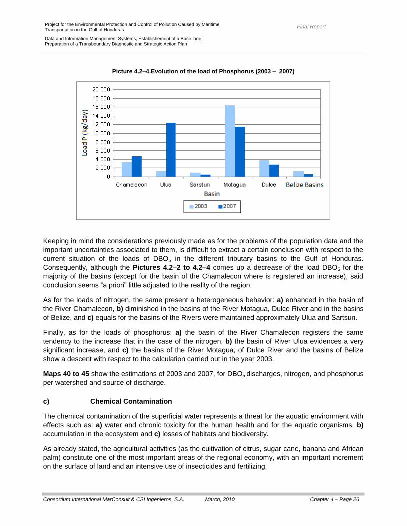
Picture 4.2–4.Evolution of the load of Phosphorus (2003 – 2007)
Keeping in mind the considerations previously made as for the problems of the population data and the
important uncertainties associated to them, is difficult to extract a certain conclusion with respect to the
current situation of the loads of DBO5 in the different tributary basins to the Gulf of Honduras.
Consequently, although the Pictures 4.2–2 to 4.2–4 comes up a decrease of the load DBO5 for the
majority of the basins (except for the basin of the Chamalecon where is registered an increase), said
conclusion seems “a priori" little adjusted to the reality of the region.
As for the loads of nitrogen, the same present a heterogeneous behavior: a) enhanced in the basin of
the River Chamalecon, b) diminished in the basins of the River Motagua, Dulce River and in the basins
of Belize, and c) equals for the basins of the Rivers were maintained approximately Ulua and Sartsun.
Finally, as for the loads of phosphorus: a) the basin of the River Chamalecon registers the same
tendency to the increase that in the case of the nitrogen, b) the basin of River Ulua evidences a very
significant increase, and c) the basins of the River Motagua, of Dulce River and the basins of Belize
show a descent with respect to the calculation carried out in the year 2003.
Maps 40 to 45 show the estimations of 2003 and 2007, for DBO5 discharges, nitrogen, and phosphorus
per watershed and source of discharge.
c) Chemical Contamination
The chemical contamination of the superficial water represents a threat for the aquatic environment with
effects such as: a) water and chronic toxicity for the human health and for the aquatic organisms, b)
accumulation in the ecosystem and c) losses of habitats and biodiversity.
As already stated, the agricultural activities (as the cultivation of citrus, sugar cane, banana and African
palm) constitute one of the most important areas of the regional economy, with an important increment
on the surface of land and an intensive use of insecticides and fertilizing.

Final Report
Consortium International MarConsult & CSI Ingenieros, S.A. March, 2010 Chapter 4 – Page 27
Project for the Environmental Protection and Control of Pollution Caused by Maritime Transportation in the Gulf of Honduras
Data and Information Management Systems, Establishement of a Base Line, Preparation of a Transboundary Diagnostic and Strategic Action Plan
Additionally, in the Gulf of Honduras, another possible source of chemical contamination of the water
are the harbor and maritime activities, the possible fossil fuels spillings and/or chemical products and
the potential losses associated to petroleum ships.
In fact, the intense maritime navigation that develops in the Gulf of Honduras if links, mainly, with the
commercial exchange and the petroleum by-products transportation as well as with the industry of the
tourism (see Tables 2–2 and 4.2–2 and Sections 3.3.5.4 and 3.3.5.5). On the other hand, all the
countries are importers of fuel, while Belize and Guatemala are, at the same time, exporters of
petroleum.
In Belize, the petroleum company (Belize Natural Energy), that initiated its activities in the year 2005
and that since the year 2006 has the installations of the Port of Big Creek, has mobilized, only in the
year 2007, 957.000 barrels of crude oil (becoming the product leader of the exports). Also, in the year
2007, the movement in Belize City’s Port rose to132.291 annual tons of fuel; said amount is similar to
the one registered in the port of Big Creek where, in the year 2007, a movement of 100.205 tons of light
crude was registered (Belize Port Authority, 2007).
Just as Belize, Guatemala is a petroleum-exporting country that, monthly, exports about 75.000 to
200.000 barrels of crude oil in three ships tanks that sail from the Port of Santo Tomas of Castilla, by
the Gulf of Honduras and Caribbean Sea, to Houston (Diagnostic of the Current State of the Coastal
and Marine Resources of Guatemala, 2003).
Honduras, although this is not a petroleum-exporting country, carries out importing of hydrocarbons and
other dangerous substances through Port Cortes and the installations of discharge of Tela Bay (see
Table 2–2).
In synthesis, the harbor installations (or next to the ports) of storage in bulk and the increase in the
movements of crude oil have become respective installations in potential sources of contamination for
the ecosystem.
On the other hand, the crafts constitute, themselves, potential sources of contamination as ballast water
discharge generators, of drain cleaning and of solid waste. According to data of the Project
"Mesoamerican Reef Barrier System" (2006), the quantification of the different types of waste that
generate, daily, in an craft type "cruise tourism" is as follows:
o 540 m3 of gray waters coming from sinks, baths, and washrooms.
o 113 m3 of sewagewaters coming from toilets.
o 13,5 m3 of greasy waters coming from the craft vessels.
o 50 litres of hazardous residuals (such as the percloroetilene coming from dry laundries,
photo finish liquids, paints and solvents, etc.)
o 7 tons of solid wastes (trash).
The water of ballast are another important problem (more than 1.000 m3 of water taken in the ports is
stored inside the helmet of the ships to balance the embarcation on the high seas); usually,
contaminants in said water exist and, even, they contain exotic species that are transported, by this
way, through the different ports.
Likewise, the potential risk of accidents exists and discharges with the consequent negative affectation
for the ecosystem. The most vulnerable areas to the accidents of discharge are the adjacent to ports
and its channels of access. Nevertheless, the accidental losses of petroleum, though they are an
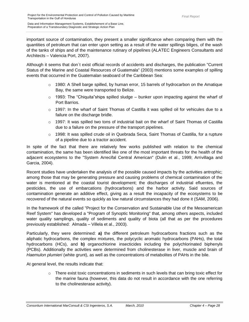
Final Report
Consortium International MarConsult & CSI Ingenieros, S.A. March, 2010 Chapter 4 – Page 28
Project for the Environmental Protection and Control of Pollution Caused by Maritime Transportation in the Gulf of Honduras
Data and Information Management Systems, Establishement of a Base Line, Preparation of a Transboundary Diagnostic and Strategic Action Plan
important source of contamination, they present a smaller significance when comparing them with the
quantities of petroleum that can enter upon setting as a result of the water spillings bilges, of the wash
of the tanks of ships and of the maintenance rutinary of pipelines (ALATEC Engineers Consultants and
Architects – Valencia Port, 2007).
Although it seems that don´t exist official records of accidents and discharges, the publication "Current
Status of the Marine and Coastal Resources of Guatemala" (2003) mentions some examples of spilling
events that occurred in the Guatemalan seaboard of the Caribbean Sea:
o 1980: A Shell barge spilled, by human error, 15 barrels of hydrocarbon on the Amatique
Bay, the same were transported to Belize.
o 1993: The “Chiquita”ships spilled sludge – bunker upon impacting against the wharf of
Port Barrios.
o 1997: In the wharf of Saint Thomas of Castilla it was spilled oil for vehicules due to a
failure on the discharge bridle.
o 1997: It was spilled two tons of industrial bait on the wharf of Saint Thomas of Castilla
due to a failure on the pressure of the transport pipelines.
o 1998: It was spilled crude oil in Quebrada Seca, Saint Thomas of Castilla, for a rupture
of a pipeline due to a tractor accident.
In spite of the fact that there are relatively few works published with relation to the chemical
contamination, the same has been identified like one of the most important threats for the health of the
adjacent ecosystems to the "System Arrecifal Central American" (Dulin et al., 1999; Arrivillaga and
Garcia, 2004).
Recent studies have undertaken the analysis of the possible caused impacts by the activities antrophic;
among those that may be generating pressure and causing problems of chemical contamination of the
water is mentioned at the coastal tourist development; the discharges of industrial efluentes, the
pesticides, the use of embarcations (hydrocarbons) and the harbor activity. Said sources of
contamination generate an additive effect, giving as a result the incapacity of the ecosystems to be
recovered of the natural events so quickly as low natural circumstances they had done it (SAM, 2006).
In the framework of the called "Project for the Conservation and Sustainable Use of the Mesoamerican
Reef System" has developed a "Program of Synoptic Monitoring" that, among others aspects, included
water quality samplings, quality of sediments and quality of biota (all that as per the procedures
previously established: Almada – Villela et al., 2003).
Particularly, they were determined: a) the different petroleum hydrocarbons fractions such as the
aliphatic hydrocarbons, the complex mixtures, the polycyclic aromatic hydrocarbons (PAHs), the total
hydrocarbons (HCs), and b) organochlorine insecticides including the polychlorinated biphenyls
(PCBs). Additionally the activities were determined from cholinesterase in liver, muscle and brain of
Haemulon plumieri (white grunt), as well as the concentrations of metabolites of PAHs in the bile.
At general level, the results indicate that:
o There exist toxic concentrations in sediments in such levels that can bring toxic effect for
the marine fauna (however, this data do not result in accordance with the one referring
to the cholinesterase activity).

Final Report
Consortium International MarConsult & CSI Ingenieros, S.A. March, 2010 Chapter 4 – Page 29
Project for the Environmental Protection and Control of Pollution Caused by Maritime Transportation in the Gulf of Honduras
Data and Information Management Systems, Establishement of a Base Line, Preparation of a Transboundary Diagnostic and Strategic Action Plan
o There were registered hydrocarbon values and organochloride pesticides in sediment
and biota.
o The patterns of pesticides found are typically from each sampling point (which can
reflect differences in regard to the use of the same).
o The presence of different fractions of oil hydrocarbons was identified (aliphatic
hydrocarbons, complex mixtures not resolved, polycyclic aromatic hidrocarbons and
total hidrocarbons).
o Quantifiable concentrations were determined for polycyclic aromatic hydrocarbons and
polychlorinated biphenyls in sediments and biota.
o Polycyclic aromatic hydrocarbon metabolites values were found in fish bile (such as
pyrene, naphthalene, phenanthrene, and benzo pyrene).
o Polycyclic aromatic hydrocarbon metabolites values were found in fish bile (such as
pyrene, naphthalene, phenanthrene, and benzo pyrene).
o Cholinesterases activity was identified in muscle, liver and brain of fish.
At particular level, the results indicate:
In sediments:
→ The highest concentrations of total hydrocarbons were found in Guatemala and
Belize, while the concentrations of polycyclic aromatic hydrocarbons (PAH) did not
show significant differences among countries (Picture 4.2–5).
→ The highest concentrations de total hydrocarbons were found in the Bay de St.
Thomas and the Belize River, but the difference between them is statistically
significant.
→ The concentrations of polycyclic aromatic hydrocarbons (PAHs) high molecular
weight predominate over those of low molecular weight, indicating that it comes
from a pirogenic source (combustion of organic matter) and not oil. Exceptions are
the sampling points of Caye Cochinos, the Ceiba and Xcalak clearly dominated the
low molecular weight PAHs, indicating that from the oil (Picture 4.2–6).
→ As for pesticides, the highest concentrations were registered for the sampling made
in Belize River, Corozal River and in some places on the coast of Mexico.
→ Concentrations of total hexachlorocyclohexanes (HCHs) and total chlordane
exceeded in some seasons, the "probable effects level" means that it is highly likely
that these concentrations have a toxic effect on aquatic biota. In particular in
Chamelecon River, Sarstun River, Dulce River and Belize River were detected
HCHs levels at concentrations where it is likely that it will hapen an adverse effect
on aquatic biota (Picture 4.2–7).
→
Final Report
Consortium International MarConsult & CSI Ingenieros, S.A. March, 2010 Chapter 4 – Page 30
Project for the Environmental Protection and Control of Pollution Caused by Maritime Transportation in the Gulf of Honduras
Data and Information Management Systems, Establishement of a Base Line, Preparation of a Transboundary Diagnostic and Strategic Action Plan
Picture 4.2–5. Polycyclic aromatic hydrocarbons (PAHs) and total hydrocarbons in sediments (by country)
Based in: García – Salgado et al. (2006)

Final Report
Consortium International MarConsult & CSI Ingenieros, S.A. March, 2010 Chapter 4 – Page 31
Project for the Environmental Protection and Control of Pollution Caused by Maritime Transportation in the Gulf of Honduras
Data and Information Management Systems, Establishement of a Base Line, Preparation of a Transboundary Diagnostic and Strategic Action Plan
Picture 4.2-6. Polycyclic aromatic hydrocarbons (PAHs) in sediments (for sampling point)
Based in: García – Salgado et al. (2006)
Picture 4.2–7. Organochlorine pesticides and polychlorinated biphenyls (PCBs) in sediment samples
Based in: García – Salgado et al. (2006)

Final Report
Consortium International MarConsult & CSI Ingenieros, S.A. March, 2010 Chapter 4 – Page 32
Project for the Environmental Protection and Control of Pollution Caused by Maritime Transportation in the Gulf of Honduras
Data and Information Management Systems, Establishement of a Base Line, Preparation of a Transboundary Diagnostic and Strategic Action Plan
o In biological samples:
→ The highest average concentrations of naphthalene were found in Punta
Manabique, as for the unresolved complex mixture of hydrocarbons. The
Pyrenes and phenanthrene were found in similar concentrations in all sampling
points.
→ Concentrations of polychlorinated biphenyls (PCBs) were the largest of all the
organochlorine compounds.
→ With regard to pesticides, the found pattern is different in each sampling point.
For example, while in Caye Cochinos dominate hexachlorocyclohexanes
(HCHs) in Punta of Manabique prevalent polychlorinated biphenyls (PCBs).
→ Most of the sampling sites located north of the Motagua River are superior to
"probable effects level" in relation to concentrations of total hydrocarbons (HCs).
The study concludes that while different pollutants have been detected, the information does not
identify potential sources of contaminants found and its possible spread into the "Mesoamerican Reef
(Garcia - Salgado et al., 2006).
With regard to this type of pollution, the Environmental Campaign Survey conducted in the framework
of this consultancy, shows quantifiable values of toxic metals in sediments, with zinc and nickel
detected in higher concentrations, in particular, nickel is dominant at the sampling points on the coast of
Guatemala. Also, on the other hand, arsenic was quantifiable at all points, the highest concentration of
copper was determined in the Alvarado Lagoon and mercury concentrations were higher in the points
on the coast of Honduras and Guatemala (and less in Belize).
Generally, the values were similar to the ones reported by Nunny et al (2001) being the concentrations
of all the metals minor than the value of concentration under which is improbable an adverse effect
(according to NOAA guides).
As to the organic pollutants like the bifenilopoliclorated (PCBS), all the values were less than the ones
belonging to to the “threshold effects level” (TEL) and the “probable effects level” (PEL) of the NOAA
guides (21, 51 and 188 µg/kg respectively).
Likewise for the organoclorated pesticides, no quantified values were determined for any sub group and
the determination of PAHS in sediments showed values in all the points, 1000 times under “probable
effects level” (PEL) proposed by NOAA, result from Nunny et al (2001). At the same time, respecting
aliphatic hydrocarbons, only heptadecan and pentacosan were quantified, being Belize Port and the
Sartsun River, the sample points that showed more concentration of heptadecan and pentacosan,
respectively.
The chemical contamination in samples of fish tissues generally reflected that, even if Wiklson Cay
presented the highest concentrations of arsenic, zinc and some mercury, Sapodilla Cay evidenced a
quantifiable presence on 5 of the 7 metals analyzed.
The concentration of arsenic found is worrying, because all the sample points exceeded the maximum
permitted value in fish tissues for the protection of the consumer Elath2 mg/kg, according to the
Australian and New Zealand Fish, Crustaceans, and Mollusks Consumption Rules - ANZFA, 2000),
being Wilson Cay and Cortez Port the most threatened.

Final Report
Consortium International MarConsult & CSI Ingenieros, S.A. March, 2010 Chapter 4 – Page 33
Project for the Environmental Protection and Control of Pollution Caused by Maritime Transportation in the Gulf of Honduras
Data and Information Management Systems, Establishement of a Base Line, Preparation of a Transboundary Diagnostic and Strategic Action Plan
d) Suspended Solids
The hydrological analysis implemented in 2006 by the World Resources Institute (WRI) included the
incorporation of the results of a hydrological model for flow and sediment transport review by the
Mesoamerican reef. To that end we used a circulation model developed by the University of Miami
entitled "Regional Modeling System Marina (Regional Ocean Modeling System - ROMS), which
provided temporary space and ocean circulation and transportation - by the action of the flow - the
unloading of rivers throughout the region Mesoamerican reef.
The results reflected the seasonal variability of the size and concentration of suspended solids pen;
Picture 4.2-8 presents the annual maximum extent and concentration of suspended solids pen.
Figure 4.2–8. Maximum extent and annual concentration of the suspended solid Plume
Taken from: WRI – ICRAM / MAR (2006)
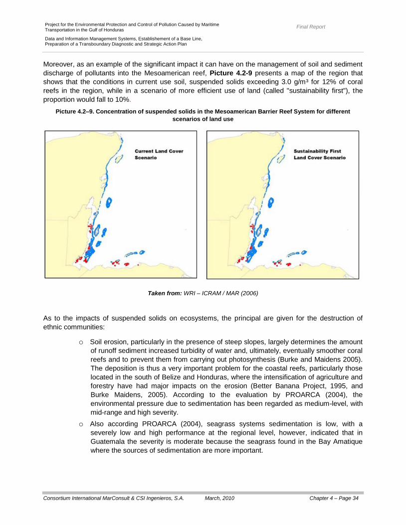
Final Report
Consortium International MarConsult & CSI Ingenieros, S.A. March, 2010 Chapter 4 – Page 34
Project for the Environmental Protection and Control of Pollution Caused by Maritime Transportation in the Gulf of Honduras
Data and Information Management Systems, Establishement of a Base Line, Preparation of a Transboundary Diagnostic and Strategic Action Plan
Moreover, as an example of the significant impact it can have on the management of soil and sediment
discharge of pollutants into the Mesoamerican reef, Picture 4.2-9 presents a map of the region that
shows that the conditions in current use soil, suspended solids exceeding 3.0 g/m³ for 12% of coral
reefs in the region, while in a scenario of more efficient use of land (called "sustainability first"), the
proportion would fall to 10%.
Picture 4.2–9. Concentration of suspended solids in the Mesoamerican Barrier Reef System for different
scenarios of land use
Taken from: WRI – ICRAM / MAR (2006)
As to the impacts of suspended solids on ecosystems, the principal are given for the destruction of
ethnic communities:
o Soil erosion, particularly in the presence of steep slopes, largely determines the amount
of runoff sediment increased turbidity of water and, ultimately, eventually smoother coral
reefs and to prevent them from carrying out photosynthesis (Burke and Maidens 2005).
The deposition is thus a very important problem for the coastal reefs, particularly those
located in the south of Belize and Honduras, where the intensification of agriculture and
forestry have had major impacts on the erosion (Better Banana Project, 1995, and
Burke Maidens, 2005). According to the evaluation by PROARCA (2004), the
environmental pressure due to sedimentation has been regarded as medium-level, with
mid-range and high severity.
o Also according PROARCA (2004), seagrass systems sedimentation is low, with a
severely low and high performance at the regional level, however, indicated that in
Guatemala the severity is moderate because the seagrass found in the Bay Amatique
where the sources of sedimentation are more important.
Final Report
Consortium International MarConsult & CSI Ingenieros, S.A. March, 2010 Chapter 4 – Page 35
Project for the Environmental Protection and Control of Pollution Caused by Maritime Transportation in the Gulf of Honduras
Data and Information Management Systems, Establishement of a Base Line, Preparation of a Transboundary Diagnostic and Strategic Action Plan
o In the coastal lagoons and estuaries, sedimentation of suspended solids is considered
high, with a high scope and severity; this is due to changing land use occurred mainly in
the rivers of Guatemala and Honduras. According PROARCA (2004), the major rivers
(Motagua and Ulua Chamalecon) produce large plumes of sediment that affect the
areas near the mouths and on the other hand, coastal lagoons (such as the Lagoon of
Alvarado) receive large volumes of sediments.
Also, the use of data obtained in the prospecting campaign in the framework of this consultancy, proves
that the highest concentrations of suspended solids were found on the coast of Honduras. Additionally,
of all the transboundery rivers, the Motagua shows a greater problem (in terms of suspended solids).
The major contribution seems to come from the Honduran basin, but the discharge of solids is a result
of activities carried out throughout the watershed.
e) Solid Waste
In general, the population dynamics and agricultural produce and industrial solid waste, liquid and
gaseous, in the study area covered by this consultancy is mostly discharged into the environment
without any treatment. Indeed, the current economic model in the study area covered by this
consultancy, believes that the generation of waste is part of the economic process of production and
consumption, and that process, given the environment the role of natural resource and waste reservoir.
The environment does, then, like a common property that is damaged to be used as a receiver of
waste, affecting the integrity of ecosystems and the quality of life.
Generally, solid wastes include those whose origins are called municipal / domestic, industrial,
agricultural wastes and those generated internationally, which directly impact on marine ecosystems -
coastal.
Land-based sources and sewage overflows are a major cause of litter found on beaches and in
waterways of the study area covered by this consultancy. They affect public health, tourism, fisheries
and marine life. There is information on species that have died or have been injured by debris that
reach the sea (as in the case of sea turtles, dolphins, sharks and corals).
Cruise ships are also a major source of pollution. A typical cruise ship generates an average de 13.5 m³
of oily bilge water and 7,0 tons of waste per day (see Section 4.2.1.2.c), on the other hand, the volume
of cruise ship tourism has increased dramatically over the past (see Table 4.2-2).
Waste generated by ships, in general, are a major source of solid waste to coastal areas. In 2003, The
Ocean Conservancy conducted a campaign called "Clean Coast", which involved more than 55.000
people and which were removed over 1.200 tons of trash along 2.100 km of coastline on the Caribbean
Sea (WRI, 2005).
Belize
In Belize, in 2003, the quantification of urban waste was 229.000 tonnes of which 94.920 tons were for
municipal solid waste. According to the Central Bureau of Statistics of the country, in six (6) the
generation of waste from the municipalities tripled from 38.148 tons produced in 1997 to 94.920 tons
generated in 2003.

Final Report
Consortium International MarConsult & CSI Ingenieros, S.A. March, 2010 Chapter 4 – Page 36
Project for the Environmental Protection and Control of Pollution Caused by Maritime Transportation in the Gulf of Honduras
Data and Information Management Systems, Establishement of a Base Line, Preparation of a Transboundary Diagnostic and Strategic Action Plan
In particular, in the cities of San Pedro Sula, Belize and the urban solid waste generation increased
from 19.328 tons / year in 1997 to 37.070 tons / year in 2000 and 48.125 tons / year in 2003, probably
as a result of increase in tourism (Belize's National Plan of action, 2008).
Also in 2003, it is estimated that cruise tourism generated 1.592 tons of solid waste and tourism
"overnight" generated 2.076 ton.
Existing data regarding characterization of solid waste back to 1997 (Table 4.2-9), noted that 60% is
organic waste, 20% paper, 5% for plastic, 5% metal and 5 % glass, mainly.
Table 4.2–9. Belize: Characterization of the solid waste
Type of Waste Composition
(%)
Organic 60
Paper and cardboard 20
Plastics 5
Metal and wood 5
Glass 5
Others 5
As previously indicated, according to information from the Department of Environment, of the Ministry
for Natural Resources and Environment of Belize Ministry of Natural Resources, Local Development
and Environment of Belize, in 2000 51% of the Belizean people have systems for collecting waste,
removing the 33% through fire and an 8% pouring in "illegal dumps".
In Belize, while the original plan was the creation of landfills, the lack of funds led to the suspension of
maintenance so that the various sites have degenerated into true "open pit dumps" (PAHO, 2005)
facilities are lacking not only controls environments but also the provision of adequate technical (and
operating without the proper equipment and / or without coverage).
The biggest "dump", located on the outskirts of Belize City, receives more than 60 tons / day of solid
waste are discharged directly over an area of mangroves at high water table and lacking the minimum
requirements to become a properly managed (Belize's Solid Waste Management Project, 2002.).
Currently there is privatization of waste management services, but it is limited to the collection,
transportation and disposal in the "dump" in the open. While the trend for this type of management
through private, increasing the contractual arrangements should be better defined and strengthened,
especially in regard to the disposal (CEPIS / BS - PAHO, 2006).
An analysis of the estimates of nutrient loads by Abt Associates Inc. - Woods Hole Group (2003),
shows that the leach of solid waste accounted for respectively 31, 2%, 7, 0% and 15, 37 % of the total
BOD5, nitrogen and phosphorus (see Table 4.2-5).
Final Report
Consortium International MarConsult & CSI Ingenieros, S.A. March, 2010 Chapter 4 – Page 37
Project for the Environmental Protection and Control of Pollution Caused by Maritime Transportation in the Gulf of Honduras
Data and Information Management Systems, Establishement of a Base Line, Preparation of a Transboundary Diagnostic and Strategic Action Plan
The problems of solid waste management in rural areas are similar to those in urban areas, except that,
in villages and small communities, population pressures are lower, minimizing the environmental impact
of the elimination of product waste.
In the islands, the shortage of waste disposal practices is of particular concern because: a) the
environmental vulnerability of ecosystems, b) its proximity to coral reefs, and c) its importance as a
tourist centers (Solid Waste Management Project, 2002).
As for the international solid waste, particularly affecting the beaches, there were estimated to quantify.
Indeed, the Boy Scouts Association of Belize collected during the period 2003 - 2005, about 9 tons of
solid waste along 124 km of coastline, just off the coast of Belize City were collected, on average, about
72 kg/km resulting in a 88, 2% in coastal and recreational activities.
As for industrial solid waste, the main sources come from the citrus industry, sugar, bananas, shrimp,
construction, transport and alcoholic beverages. In 2004, the generation of such wastes reached
529.000 tons, watching a tendency to reuse and recycling them (Belize's National Plan of action, 2008).
According to the Solid Waste Management Authority (SWMA), the citrus industry has gradually
decreased the generation of solid waste; in particular, there have been studies that conclude that
composting is an environmentally sustainable recovery of the waste.
Other waste typology refers to hospital waste, which is currently, incinerated in Belize City, Belmopan,
and Corozal (Belice Environmental Profile, 2007).
Guatemala
In Guatemala, as in other countries in the region, the rapid population growth, urbanization and patterns
of production and consumption of society resulting in an increase in solid waste generation for 2002
was estimated 4.242 tons/day 54% being generated in urban areas.
For this year, the departments of Guatemala, Izabal and Peten generated, respectively, 456.484 tons of
solid waste (30% of the total generated in the country), 44.000 tons (2, 85% of the country's total) and
51.500 tons / year (3, 33% of the country).
In studies by the National Institute of Statistics (2002), shows that the collection rate is 60% urban (and
with a bad practice of file) while in rural areas coverage is collecting only 5, 2 %.
The total volume of solid waste that is collected is about 1.010.638 tons/year (65% of the total
generated at the country level) to be arranged in the same illegal dumpsites, burned or buried. Table
4.2-10 presents the rates of collection, both urban and rural, for the Guatemalan departments within the
study area covered by this consultancy.
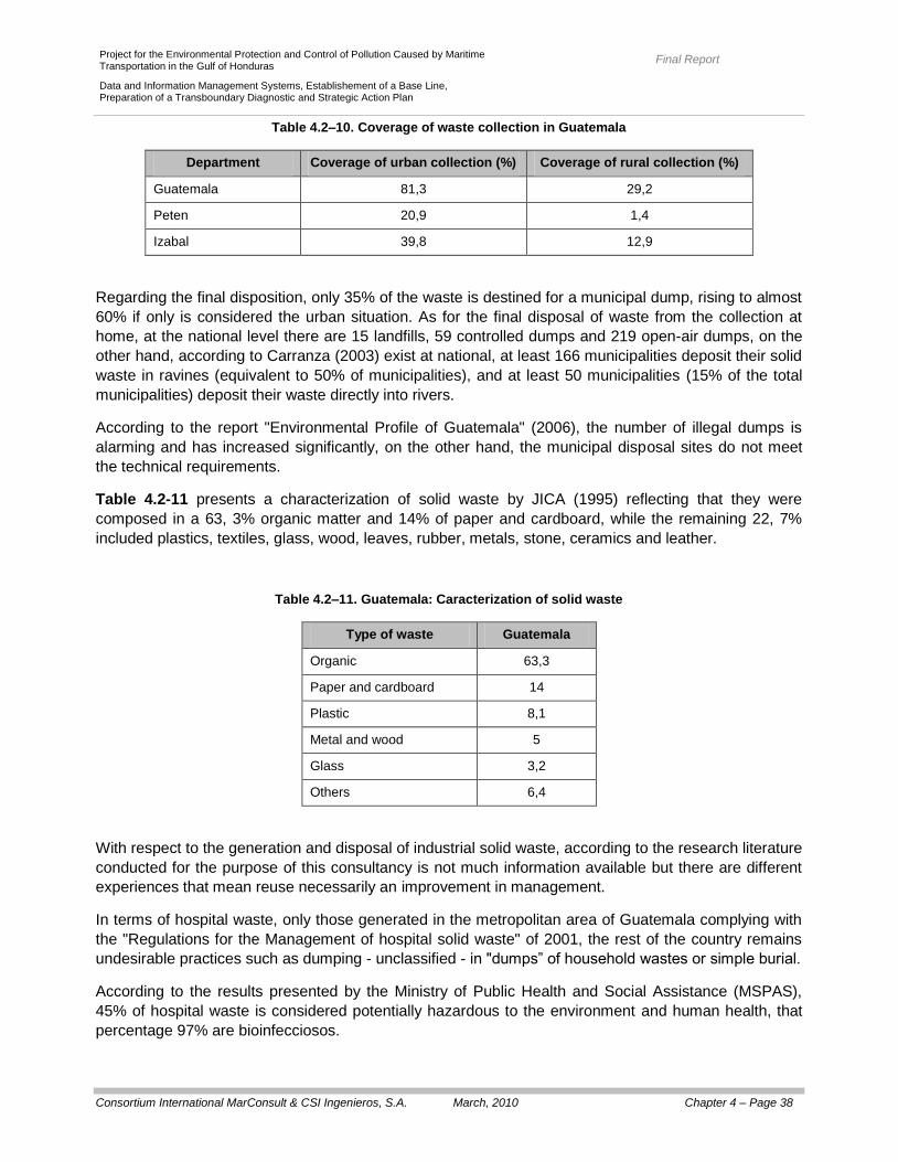
Final Report
Consortium International MarConsult & CSI Ingenieros, S.A. March, 2010 Chapter 4 – Page 38
Project for the Environmental Protection and Control of Pollution Caused by Maritime Transportation in the Gulf of Honduras
Data and Information Management Systems, Establishement of a Base Line, Preparation of a Transboundary Diagnostic and Strategic Action Plan
Table 4.2–10. Coverage of waste collection in Guatemala
Department Coverage of urban collection (%) Coverage of rural collection (%)
Guatemala 81,3 29,2
Peten 20,9 1,4
Izabal 39,8 12,9
Regarding the final disposition, only 35% of the waste is destined for a municipal dump, rising to almost
60% if only is considered the urban situation. As for the final disposal of waste from the collection at
home, at the national level there are 15 landfills, 59 controlled dumps and 219 open-air dumps, on the
other hand, according to Carranza (2003) exist at national, at least 166 municipalities deposit their solid
waste in ravines (equivalent to 50% of municipalities), and at least 50 municipalities (15% of the total
municipalities) deposit their waste directly into rivers.
According to the report "Environmental Profile of Guatemala" (2006), the number of illegal dumps is
alarming and has increased significantly, on the other hand, the municipal disposal sites do not meet
the technical requirements.
Table 4.2-11 presents a characterization of solid waste by JICA (1995) reflecting that they were
composed in a 63, 3% organic matter and 14% of paper and cardboard, while the remaining 22, 7%
included plastics, textiles, glass, wood, leaves, rubber, metals, stone, ceramics and leather.
Table 4.2–11. Guatemala: Caracterization of solid waste
Type of waste Guatemala
Organic 63,3
Paper and cardboard 14
Plastic 8,1
Metal and wood 5
Glass 3,2
Others 6,4
With respect to the generation and disposal of industrial solid waste, according to the research literature
conducted for the purpose of this consultancy is not much information available but there are different
experiences that mean reuse necessarily an improvement in management.
In terms of hospital waste, only those generated in the metropolitan area of Guatemala complying with
the "Regulations for the Management of hospital solid waste" of 2001, the rest of the country remains
undesirable practices such as dumping - unclassified - in "dumps” of household wastes or simple burial.
According to the results presented by the Ministry of Public Health and Social Assistance (MSPAS),
45% of hospital waste is considered potentially hazardous to the environment and human health, that
percentage 97% are bioinfecciosos.

Final Report
Consortium International MarConsult & CSI Ingenieros, S.A. March, 2010 Chapter 4 – Page 39
Project for the Environmental Protection and Control of Pollution Caused by Maritime Transportation in the Gulf of Honduras
Data and Information Management Systems, Establishement of a Base Line, Preparation of a Transboundary Diagnostic and Strategic Action Plan
Honduras
In Honduras, the generation of solid waste has been estimated at 3.239 tons/day, having considered a
factor in generating 0, 45 kg/person/day (GEO Honduras, 2005). 58% of the total municipal solid waste
is generated by four cities: Choloma, the Ceiba, San Pedro Sula and Tegucigalpa (Picture 4.2-10),
representing the latter two the largest share of generating such wastes (Padilla and Gonzalez, 2007).
According to Padilla (2007), only 60 municipalities (20% of the total municipalities) have recollection
systems, and none of them separate and treat dangerous residues; on the other hand, only 11
municipalities (3,7% of the total) have adequate final disposal places while the rest have open sky
municipal dumps or waste disposals in streets or a small number dumps, with no control at all(Table
4.2–12).
According to Padilla (2007) only 60 of the municipalities (20%) have systems for collecting and there is
no separation and treatment of hazardous waste, on the other hand, only 11 municipalities (3, 7%) have
sites of proper disposal while the rest is open-air landfills or municipal waste disposal in public or in
small uncontrolled landfills (Table 4.2-12).
Picture 4.2–10. Municipal solid waste generated in the main cities in Honduras
Tomado de: López Padilla (2007)

Final Report
Consortium International MarConsult & CSI Ingenieros, S.A. March, 2010 Chapter 4 – Page 40
Project for the Environmental Protection and Control of Pollution Caused by Maritime Transportation in the Gulf of Honduras
Data and Information Management Systems, Establishement of a Base Line, Preparation of a Transboundary Diagnostic and Strategic Action Plan
Table4.2–12 Honduras: Disposal of solid waste per location
Disposal type City
Landfill Machining
Port Cortes
Roatan
Talanga
Technical close and improved operation The Ceiba
Choloma
Semi Landfill - Machining
Copan Ruins
Choluteca
La Paz
Sabanagrande
San Ignacio
Villanueva
Controlled or semi controlled dump
Santa Barbara
San Pedro Sula
Tegucigalpa
Dumps 284 municipios
Taken from: López Padilla (2007).
In the Ceiba it has been developed a strategic plan for solid waste management whose main objectives
are to strengthen the collection service through municipal and local small business designing and
organizing a collection center for recyclable materials, and the execution of an educational program
directed to the local community and aimed at the segregated collection of recyclable materials (Central
Association for Health, Economics and the Environment, 2007).
Puerto Cortes is a landfill expanded to 17 Ha, which has an estimated life of 12 years; the quantity of
solid waste collected in the city is estimated at 80 tons/day, which added to the waste entering the
landfill through private collectors, totaling about 100 tons/day of solid waste collected.
In Tegucigalpa generated about 850 tons/day of solid waste of which about 650 tons/day are turning to
the municipal landfill (GEO - Honduras, 2005), Table 4.2-13 presents a characterization of them.

Final Report
Consortium International MarConsult & CSI Ingenieros, S.A. March, 2010 Chapter 4 – Page 41
Project for the Environmental Protection and Control of Pollution Caused by Maritime Transportation in the Gulf of Honduras
Data and Information Management Systems, Establishement of a Base Line, Preparation of a Transboundary Diagnostic and Strategic Action Plan
Table 4.2–13. Tegucigalpa: Caracterization of solid waste
Type of waste Honduras
Organic 40
Paper and cardoboard 14
Plastic 12
Metal and wood 8,5
Glass 7,7
Others 17,8
As for industrial waste, a study by CESCCO in 2003, on the main pollution sources in Tegucigalpa,
indicates that 21% of these establishments generated waste oils and grease, 25% organic solvents, 6
% of waste generated inks, dyes and paints, photographic waste 3%, 2% acids and strong bases and
1% pharmaceutical waste, resins and latex.
4.2.1.3. Habitat loss and modification and Communities
f) Impacts on ecosystems
The combination of anthropogenic impacts and chronic stress are subjected to which the ecosystems of
coral reefs has found that, particularly in Belize, they observe a significant decline in coral coverage and
an increase in coverage by microalgae, as well as a decrease in abundance in fish associated with
these ecosystems.
Indeed, the species Acropora have suffered since 1970; a dramatic reduction in the live coverage as a
result of the disease in white bands on the other hand, the sea urchin (Diadema antillarum) has
disappeared. Climatic effects such as Hurricane Mitch (1998) and the bleaching phenomena have led
to different rates of reduction in the coverage of coral reefs have been reported in the case of Belize
(Wilkinson and Souter, 2008): a) 62% for the area, b) 55% for the North area, c) 45% for the atolls, and
d) 36% for the central region.
Hurricanes are common phenomena in the Caribbean Sea as most of it is on the same path (see
Picture 3.1-3). Indeed, the region has a long history of hurricanes and storms of different intensity and
with greater or lesser impact on coral reef systems. Hurricanes Haiti (1961), Greta (1978) and Fifi
(1974), Mitch (1998) and Keith (2000) were particularly devastating, but it noted that the type of
damage on the reef system depends on the location of the reef of species and structural complexity of
the community (Kramer et al., 2000, Gardner et al., 2005, Crabbe et al., 2008).
Kramer et al. (2000) reported that after the passage of Hurricane Mitch, the greatest damage was found
on the barrier reefs in Belize, with 29% damage coral plain areas from 5% in the deepest areas of coral
and nearly 80% in North Glovers Reef corals.

Final Report
Consortium International MarConsult & CSI Ingenieros, S.A. March, 2010 Chapter 4 – Page 42
Project for the Environmental Protection and Control of Pollution Caused by Maritime Transportation in the Gulf of Honduras
Data and Information Management Systems, Establishement of a Base Line, Preparation of a Transboundary Diagnostic and Strategic Action Plan
There are also other associated phenomena such as:
The heavy rains that, in general, increase the sedimentation around the reefs near the coast
and / or the mouths of rivers (Burke and Maidens, 2005).
The decrease in salinity, high sedimentation and high nutrient that, in the Caribbean Sea, is
observed in the Gulf of Honduras (the same partners are the important contribution of
freshwater associated with the drainage basins of the region).
It was also reported illnesses and abundance of algae possibly associated with stress caused by a
combination of high temperatures on the sea surface (pre - Hurricane) and the flow of sediments and
nutrients (post - Hurricane).
Gardner et al. (2005) reports that in the Caribbean Sea coral cover is reduced on average by 17% in
the year following the impact of a hurricane, that value is proportional to the intensity of the hurricane
and the time between events similar. Moreover, the author also reports that while in the 80's hurricanes
contributed - significantly - the decline of coral cover in the 90's, to explore areas not impacted by
hurricanes, it was noted that coral cover also declined significantly, it shows that there are other factors
contributing to the overall pattern of decline in coral reef communities. Crabbe et al. (2008) argue that
due to the alteration of the seabed, hurricanes and severe storms limit the recruitment and survival of
corals massive unbranched Mesoamerican Barrier Reef System as well as patch reefs near the coast
of Belize; also sedimentation and turbidity have pronounced influence on the growth of corals and
decreasing salinity increases mortality.
As was indicated by the coral bleaching (loss of natural color for the expulsion of symbiotic algae) is a
phenomenon that is observed in response to different stress factors such as small changes in the
temperature and salinity of the superficial half as well as excessive light, presence of toxins and
microbial infections, and also the effect of hurricanes and storms).
For the years 1983, 1987, 1995 and 2005 have been reported bleaching phenomena. Phenomenon for
the year 1995 is reported: a) to Belize, that 52% of coral colonies are bleached and b) to Caye
Cochinos, Honduras, which 73% of scleractinian corals and 92% of hydrocorals are, bleached (Abt
Associates Inc - Woods Hole Group, 2003). Phenomenom for the year 2005:
A quick survey of five sites (145 colonies), held in August 2006, indicates that the phenomenon
had no major impact on the reefs of Guatemala: a) the mortality was lower at 1, 0% while the
disease had a prevalence 11, 0 %; and b) the mass of living coral was generally low (an
average of 8, 5%) and coverage by microalgae was 7, 3%, covering 23, 4% of the corals
(Wilkinson and Souter, 2008).
A similar survey on sixty-one sites (1363 colonies), held in June-August 2006 revealed the
bleaching phenomena in Honduras: a) the mortality was lower at 11, 0% while the disease had
a slightly higher prevalence on the reef platform that patch, although it was less than 5, 0%, and
b) live coral cover was relatively low (an average of 10, 0 to 15, 0%.) and coverage by
microalgae was 15, 0% in reef depth of 16, 0% in the patch and 19, 0% in the platform
(Wilkinson and Souter, 2008).
As indicated above, the species of Acropora have suffered since 1970, a dramatic reduction in its live
coverage as a result of various illnesses. In the Caribbean Sea region has seen a sudden onset of
diseases affecting coral reefs, even in places that are more isolated.

Final Report
Consortium International MarConsult & CSI Ingenieros, S.A. March, 2010 Chapter 4 – Page 43
Project for the Environmental Protection and Control of Pollution Caused by Maritime Transportation in the Gulf of Honduras
Data and Information Management Systems, Establishement of a Base Line, Preparation of a Transboundary Diagnostic and Strategic Action Plan
According to Garcia et al. (2002), among the most common diseases affecting coral reefs may be
quoted:
The “black band” disease (reported for the first time by Antonius, 1981a).
The “white plague” disease (described for the Florida Keys by Dustan, 1977).
The “white band” disease (reported for the first time in the Virgin Islands; Gladfelter, 1982).
The “yellow blotch” disease (reported for the first time in the Cayman Islands; Hayes and Bush,
1990).
The “dark spots” disease (reported for the first time in Colombia; Garzón – Ferreira and Gil
Aguledo, 1998).
Map 4686
provides information on the death by bleaching and disease in coral reefs in the study area
covered by this consultancy.
Finally, with regard to the seagrass, it indicates that they are also frequent scenes of the effect of
hurricanes and tropical storms, with the typical consequences they entail: strong waves and high
nutrient transport (Cruz - and Palaces van Tussenbroek, 2005). The immediate impacts on coastal
macrophytes include exfoliation, exhibition structures, burial and mortality associated with the drastic
decreases in salinity, but the sensitivity of marine macrophytes to these events also depend on the
intensity of them, is associated with the morphological characteristics (Cruz - and will Tussenbroek
Palacios, 2005).
a) Impacts on Biodiversity
While most of the impacts on the biodiversity of marine ecosystems - coastal are poorly understood, the
proposed over-the greatest threats followed in importance by habitat loss (IUCN, 2004).
Table 4.2-14 presents the results of the search within the framework of this consultancy, by country
(Belize, Guatemala and Honduras) and habitat in relation to species under threat as the "Red List" of
the "International Union Conservation of Nature (IUCN). Such a "Red List" include plant and animal
species, as assessed according to the categories and criteria of the IUCN, and is used as a guide for
resource management at multiple scales (from the conservation of specific sites to the implementation
of laws , regulations or international agreements), on the other hand, such lists are used to identify
species that could benefit from site-specific interventions (such as protected areas) and generate useful
information for prioritizing possible areas proposed for consideration as an area protected (Rodrigues et
al., 2006).
For the Gulf of Honduras, were identified 11 species threatened by activities of hunting, fishing,
destruction, alteration or degradation of habitats, including highlights: a) a critically endangered species
(the "mere" Epinephelus itajara), b) two endangered species (the green turtle, Chelonia mydas and
wreckfish criolla, Epinephelus striatus) and c) a vulnerable species (the American Indian manatee,
Trichechus manatus).
It corresponds to indicate that Table 4.2-14 does not include the species threatened by overfishing or
catch (see Section 4.2.1.4).
86 Based on the information adopted by The Nature Conservancy (Arrivillaga y Windevoxhel, 2008).

Final Report
Consortium International MarConsult & CSI Ingenieros, S.A. March, 2010 Chapter 4 – Page 44
Project for the Environmental Protection and Control of Pollution Caused by Maritime Transportation in the Gulf of Honduras
Data and Information Management Systems, Establishement of a Base Line, Preparation of a Transboundary Diagnostic and Strategic Action Plan
Table 4.2–14. Golfo of Honduras: Red List of threatened species by destruction, alteration and / or fragmentation
of habitats
Scientific name Common name Country UICN
Category Threat Comments
Carcharhinus leucas Bull shark B, G, H NT
Habitat Destruction
It is not an important
commercial species, but
placed in brackish and
freshwater areas were
severely affected by the
change in areas
Carcharhinus
limbatus Black fin shark B, G, H
NT
Hunted handmade
Habitat alteration
Spawning waters in and is
very vulnerable to fishing
pressure. Their meat and
fins are traded
Chelonia mydas Green turtle B, G, H EN
Overexploitation de
eggs and adults
Habitat
degradation
Also killed accidentally in
fishing and there is a
strong degradation of
living marine
environments and their
nesting sites. It is
estimated that the
reduction of mature
females was 48 to 67% in
the last 3 generations
Epinephelus itajara Dusky grouper (painted,
toad, batata) G, H
CR
Fishing Exploitation
/ Habitat loss
Low fecundity and slow
growth. The loss of
mangroves generate
negative consequences
for the recruitment of
juveniles
Epinephelus striatus
Creole wreckfish
G, H EN
Commercial and
recreational
exploitation / Loss
de habitat
Common Spawning. They
are inhabitants of coral
reefs
Ginglymostoma
cirratum Cat shark B, H DD
Habitat
Fragmentation
Show site fidelity, making
it highly vulnerable to
habitat degradation. They
are mainly found on reefs
and are caught by
artisanal fisheries.
Manta birostris Ray B, G, H NT
Coastal
Development /
pollution
They are easily hunted for
their large size, low speed
and frequent in the
surface. Hunted for their
fins, skin, liver and meat
Final Report
Consortium International MarConsult & CSI Ingenieros, S.A. March, 2010 Chapter 4 – Page 45
Project for the Environmental Protection and Control of Pollution Caused by Maritime Transportation in the Gulf of Honduras
Data and Information Management Systems, Establishement of a Base Line, Preparation of a Transboundary Diagnostic and Strategic Action Plan
Table 4.2–14. (Continuation)
Cientific name Common name Country UICN
Category Threat Comments
Negapríon
brevirostris Lemon Shark B, G, H
NT
Habitat
degradation /
overfishing
Juveniles remain in
coastal areas and are
affected by the
degradation of coastal
habitats. Adults are
caught for commercial
purposes.
Orcinus orca Espadarte, killer whale G, H DD
Fisheries / habitat
degradation
It is a predator control for
many fish, which has led
to its elimination.
Trichechus manatus Manatee B, G, H VU
Loss de habitat,
anthropogenic
factors
Today there are fewer
than 10.000 mature
individuals.
Urobatis jamaicensis Painted ray G LC
Artisanal fisheries /
Acuarismo / habitat
degradation
Juveniles live in seagrass
beds
UICN categories: CR () = Critically endangered; EN () = Endangered; VU () = Vulnerable; NT () = Near threatened;
LC = Least concern, DD = Insufficient data
Country: B = Belize; G = Guatemala; H = Honduras
Taken from: www.redlist.org
The National Council of Protected Areas of Guatemala (CONAP, 2003) developed a categorization
according to three categories, including those of endangered species (Category 1), species distribution
is restricted to a single type of habitat and / or low density people (Category 2), and those species that
although at present they are not in danger of extinction, may become so if their use is not regulated
(Category 3). According to the same there are: Fourteen species of endangered fish (among them can
be found several species of shark as toad shark, tip shark, black fin shark, fox shark, blue shark and
slimy shark), 93 species of amphibians, 57 species of frogs, 156 species of reptiles (almost 70% of the
species of reptiles), 3 species of the Crocodilia order, 148 species of the squamata order (nearly 62%
of the species of the order ), 15 species of Testudines (almost 88% of species), 164 bird species
(almost 24% of bird species), 69 species of mammals (32% of species) and 138 species of
invertebrates which 128 are butterflies, beetles are three, three are crustacean and four shellfish
(CONAP, 2003).
Among the above are: Tumbes crocodile, crocodile moreleti, the white alligator, iguana green, the
house gecko, turtle mask, green turtle, the hawksbill turtle and parlama, the manatee, tapir , ocelot,
some dolphins, some bats and puma (CONAP, 2003).

Final Report
Consortium International MarConsult & CSI Ingenieros, S.A. March, 2010 Chapter 4 – Page 46
Project for the Environmental Protection and Control of Pollution Caused by Maritime Transportation in the Gulf of Honduras
Data and Information Management Systems, Establishement of a Base Line, Preparation of a Transboundary Diagnostic and Strategic Action Plan
4.2.1.4. Unsustainable exploitation de living resources
Fishing activities, mainly artisanal, small-scale and subsistence, has played a role in the Caribbean Sea
as it is a relatively cheap source of protein and in turn generates employment (Burke and Maidens,
2005).
Coral reefs and especially those closest to the coast, represent an easily accessible place for
fishermen, hence the fish have been a barrier reef is easily accessible.
Moreover, the existing regulation on small business that has taken over the resort to illegal fishing,
fishing gear inappropriate (gillnets, trawls, traps), which may even be destructive when they are
dropped on reef (Belize, 2005).
According to IUCN (2001) and PROARCA (2004), in Guatemala, between San Francisco del Mar and
Cabo Tres Puntas in Estero Lagarto in Pichilingo in Punta of Palma and Santa Maria, there has been
an overexploitation of fish stocks such as Anchovy (Anchoa sp.).
Mangrove ecosystems are also very attractive areas for fishing, so the over is a major cause for the
destabilization of the ecological environment (CZMAI 2000).
As transboundery fishing problem, we must mention the illegal fishing and fishing in closed areas and
seasons (PROARCA, 2004).
A direct consequence of overfishing is to reduce the average size of various species, as fishermen are
directed - separately - to the larger organisms (because of their higher value) and they are - rightly -
that have higher reproductive success therefore the population loses its natural recruitment (Burke and
Maidens, 2005). In this way, fishing - that are above sustainable levels of exploitation - alter the
ecological balance of the reef system, for example: the removal of fish consumers of algae facilitate the
coating of algae reef, reducing live coral reef (Belize Coastal Threat, 2005, Belize Coastal Threat Atlas,
2005 Burke and Maidens, 2005).
Overfishing threatens more than 60% of Caribbean coral reefs, approximately one third of them are in
the threat level "high" and nearly 30% in the level of "average" threat.
Another way - particularly damaging - overfishing is said to aggregations of reef fish, in effect, as
described in Section 3.1.2.9.a around the full moon, and more frequently between July and December,
at least 22 species fish are added to reproductive purposes. On these occasions, fishermen removed -
directly - a very significant proportion of individual players (Burke and Maidens, 2005).
Table 4.2–15 shows the main species that are endangered by the non-sustainable exploitation of live
resources, including incidental fishing.

Final Report
Consortium International MarConsult & CSI Ingenieros, S.A. March, 2010 Chapter 4 – Page 47
Project for the Environmental Protection and Control of Pollution Caused by Maritime Transportation in the Gulf of Honduras
Data and Information Management Systems, Establishement of a Base Line, Preparation of a Transboundary Diagnostic and Strategic Action Plan
Table 4.2–15. Gulf of Honduras: Red List of threatened species
by over exploitation fishing and bycatch
Cientific name Common name Country UICN
Category Threat Comments
Aetobatus narinari Spotted eagle ray G, H NT
Fishing
Highly commercialized.
Inhabits areas accessible
to fishermen
Carcharhinus
falciformis Silky shark B, H LC Over fishing
They are hunted for their
meat and fins
Carcharhinus
longimanus Oceanic Whitetip shark B, G, H
VU
Over fishing
It is estimated that in 1990
its population in the Gulf
of Mexico decreased by
93%.
Carcharhinus perezi Caribbean reef shark B, G, H
NT
Over traof and craft
It is the most common
shark found on coral
reefs. In Belize, reported
declines in population
size. It has a low fertility
Carcharhinus
plumbeus Sandbar shark B, G, H
NT
Over fishing
Low fertility, and hunted
for consumption
Carcharhinus
porosus Smalltail shark G, H DD Fishing
Used for human
consumption and
medicine
Delphinus delphis Common dolphin G, H LC Bycatch
Dermochelys
coriacea Leatherback turtle G, H
CR
Bycatch and
overfishing eggs
Many individuals are
caught in gill nets in their
migratory routes. Plastic
pollution of the ocean is
another cause of death
Diplobatus ommata Bullseye Electric ray G, H VU
Incidentally caught
in trawls
They have no commercial
interest, although its
distribution coincides with
that of shrimp fishing,
which is highly impacted.

Final Report
Consortium International MarConsult & CSI Ingenieros, S.A. March, 2010 Chapter 4 – Page 48
Project for the Environmental Protection and Control of Pollution Caused by Maritime Transportation in the Gulf of Honduras
Data and Information Management Systems, Establishement of a Base Line, Preparation of a Transboundary Diagnostic and Strategic Action Plan
Table 4.2–15. (Continuation)
Cientific name Common name Country UICN
Category Threat Comments
Epinephelus morío Red grouper G, H NT
Over fishing
Epinephelus nigritus Warsaw grouper B CR
Bycatch
They are caught
accidentally by
commercial fishing para
other species, but are
killed by barotrauma
released.
Etmopterus bullisi Lined lanternshark H DD Bycatch
Etmopterus schultzi Fringefin lanternshark H LC Bycatch
Etmopterus virens Green lanternshark H LC Bycatch
Feresa attenuata Pygmy killer whale G, H DD Bycatch
Galeocerdo cuvier Tiger shark B, G, H NT
Over fishing
Fished especially for their
fins.
Globicephala
macrorhynchus Short-finned Pilot whale G DD
Artisanal and
incidental fisheries
Fish consumption in
Japan.
Gymnura micrura Smooth butterfly ray B, G, H DD Fishing
Caught in gillnets. Inhabit
estuaries and coastal
areas.
Himantura
schmardae Chupare stingray G, H DD
Artisanal fisheries
and commercially
Fish for human
consumption.
Hippocampus erectus Lined seahorse B, G, H VU
Para ornamental
fish species,
Chinese medicine
and degradation de
habitat
They are also accidentally
caught by trawling for
shrimp
Isurus oxyrinchus Shortfin mako B, G, H NT
Over fishing
Its meat is prized, has low
fertility.
Kogia breviceps Pygmy sperm whale G, H DD
Catch and
consumption
Mainly in Japan,
Indonesia, Sri Lanka.
Reported ingestion of
plastic materials that led
to death
Lagenodelphis hosei Fraser´s dolphin G, H DD
Opportunistic
Fishing
Very little is known of their
abundance
Mesoplodon
densirostris Blaninville´s beaked whale B, G, H DD Bycatch
They are occasionally
caught, but the biggest
threat is that they are
engaged in tuna nets.
Final Report
Consortium International MarConsult & CSI Ingenieros, S.A. March, 2010 Chapter 4 – Page 49
Project for the Environmental Protection and Control of Pollution Caused by Maritime Transportation in the Gulf of Honduras
Data and Information Management Systems, Establishement of a Base Line, Preparation of a Transboundary Diagnostic and Strategic Action Plan
Table 4.2–15. (Continuation)
Cientific name Common name Country UICN
Category Threat Comments
Mustelus canis Smooth dogfish B, H NT
Fished para
consumption
Recent growth in its direct
fishing. Not managed
fisheries.
Mycteroperca tigris Tiger grouper H LC Over fishing
Mycteroperca
venenosa Yellowfin grouper G, H
NT
Over fishing
Habitat Destruction
Negapríon
brevirostris Lemon shark B, G, H
NT
Habitat
Degradation/ Over
fishing
Juveniles remain in
coastal areas and are
affected by the
degradation de coastal
habitats. Adults are
caught for commercial
purposes.
Peponocephala
electra Melon-headed whale G LC Bycatch Low abundance
Príonace glauca Blue shark B, G, H NT
Over fishing
One of the most widely
distributed sharks and
also one of the most fish.
Have high fertility, but
there is concern about the
number of copies that are
being hunted, since they
are top predators.
Pristis perotteti Large-tooth sawfish G, H CR
Over fishing
Very popular meat, fins
and "combs"
Rhincodon typus Whale shark G,H VU
Over fishing
Low fertility and low
abundance make it
vulnerable.
Rhinoptera bonasus Cownose ray B, G, H
NT
Artisanal fishing
They have low fecundity
and late maturity which
makes them very
susceptible. In some parts
are removed as being
harmful to the shellfish
industry.
Rhizopríonodon
porosus
Caribbean sharpnose
shark H LC
Craft and
commercial fish
Scyliorhinus
hesperius Whitesaddled catshark H DD

Final Report
Consortium International MarConsult & CSI Ingenieros, S.A. March, 2010 Chapter 4 – Page 50
Project for the Environmental Protection and Control of Pollution Caused by Maritime Transportation in the Gulf of Honduras
Data and Information Management Systems, Establishement of a Base Line, Preparation of a Transboundary Diagnostic and Strategic Action Plan
Table 4.2–15. (Continuation)
Cientific name Common name Country UICN
Category Threat Comments
Scyliorhinus retifer Chain catshark B,G, H LC
ByCatch /
Ornamental Ends
Somalia fluviatilis Black dolphin H DD Bycatch
Sphyrna lewini Scalloped hammerhead B, G, H NT
Exploited
freshwater fishery
Their fins are highly
prized; there are some
reports of declining
population.
Sphyrna media Scoophead G, H DD Bycatch
Sphyrna mokarran Great hammerhead shark B, G, H EM
Bycatch
Low fertility. Prized for
their fins. Its population
dropped by 80% in the
last 25 years.
Sphyrna tiburo Bonnethead shark B, G, H NT
It is one of the shark with
the highest percentage
increase in their
populations
Sphyrna zygaena Smooth hammerhead B NT
Fishing
Highly prized fins in Asia
Squalus cubensis Cuban dogfish H DD Craft and
commercial fish
Squalus mitsukurii Shortspine spurdog H DD Bycatch
Stenella attenuata Spotted dolphin H LC Bycatch
Stenella clymene Clymene dolphin G DD Bycatch
Low abundance
Stenella longirostris Spinner dolphin G DD Bycatch
Steno bredanensis Rough-toothed dolphin G DD Fishing
UICN categories: CR () = Critically endangered; EN () = Endangered; VU () = Vulnerable; NT () = Near threatened;
LC = Least concern, DD = Insufficient data
Country: B = Belize; G = Guatemala; H = Honduras
Taken from: www.redlist.org
The Table 4.2-15 includes 48 species and between they stand out:
Three species are critically endangered, the leatherback turtle (Dermochelys coriacea), the
black grouper (Epinephelus nigritus) and the comb fish (Pristis perotteti).
An endangered species: the hammerhead shark (Sphyrna mokarran).
Four species vulnerable: Oceanic whitetip shark (Carcharhinus longimanus), the electric ray
(Diplobatus ommata), the lined seahorse (Hippocampus erectus) and the whale shark
(Rhincodon typus).

Final Report
Consortium International MarConsult & CSI Ingenieros, S.A. March, 2010 Chapter 4 – Page 51
Project for the Environmental Protection and Control of Pollution Caused by Maritime Transportation in the Gulf of Honduras
Data and Information Management Systems, Establishement of a Base Line, Preparation of a Transboundary Diagnostic and Strategic Action Plan
4.2.1.5. Non sustainable development of marine and coastal areas
As already indicated, the coastal areas account for almost one quarter of Central American territory
(23,3%) of which just under 45,5% are on the Caribbean Sea for almost three-fifths of the territory of
Belize (OdD, 2001; OdD – UCR, 2001).
According to Geo - Central (2005), the main pressures on the coastal formations are from human
activities destruction or degradation of habitats, including the impact of land-based sources of pollution.
Among the most important is to be noted: a) the conversion of natural habitat to other uses (which
affects 45,5% of the total area of the coast of Central America) and the processes of sedimentation and
pollution resulting b) those arising agriculture, aquaculture and mining, c) human settlements
(representing 0, 36% of the total area of the coast of Central America), and d) in tourism.
Regarding the situation in countries bordering the study area covered by this advisory:
According to Foer and Olsen (1992), among the most important pressures affecting the coastal
formations of Belize is, first, the expansion of farming activities. In particular, citrus and banana
crops have spread widely in the coastal districts of Stann Creek and Toledo (included in the
study area covered by this consultancy), increasing erosion and runoff of agrochemicals, with
pollution problems drinking water in the coastal town of Monkey River Town and the river of the
same name, as well as pollution problems plastic bags in the banana plantations.
Moreover, the extraction of sand beach in Dangriga, Monkey River, Placencia and the mouth of
the Sibun River (in the central region), are also considered problems.
Also, according CZMAI (2001 a and b) coastal erosion is a problem of particular importance and
is a product of: a) natural processes including the action of extreme flow events and the
passage of hurricanes, and b) process given by the man sand mining, dredging, reclaiming land
from the sea of repressive rivers, deforestation, removal of vegetation in coastal areas and the
construction of infrastructure works that stand longitudinal sediment transport along the coast.
To these factors must be added, in addition, the increase in sea level.
For example, the importance of the anthropic processes, CZMAI (2001) reports the following: a)
for the 1993-2000 period, the construction of 141 docks, and b) for the year 2000, the requests
for land sub-dividing in a total of 84.000 ha (from which more than 3.000 ha had been
authorized) and dredging works for more than 93.000 m3.
As an example of the importance of the man, CZMAI (2001) reports: a) for the period 1993 -
2000 construction of 141 docks, and b) for 2000: the request for subdivision of land for a total of
2.087, 17 acres (of which 765,7 acres were allowed) and dredging works for more than 122.500
yd³.
Among the main pressures on the Caribbean coast of Guatemala is the contribution of sediment
by erosion, deforestation occurs in the upper Motagua River (which flows along the border with
Honduras), the river system and river Sarstun Polochic - Lake Izabal – Dulce River. For
example, it has been indicated that this contribution of sediments prevents the development of
sea grasses in some parts of the bay Amatique.
Among the main pressures on the Honduran coast indicate the corresponding urban and
industrial growth along the Ulua River and mainly in the outskirts of
San Pedro Sula and Puerto Cortes, the same has increased deforestation, pollution and land
degradation (SERNA, 1997). Moreover, international tourism to the beaches on the Caribbean

Final Report
Consortium International MarConsult & CSI Ingenieros, S.A. March, 2010 Chapter 4 – Page 52
Project for the Environmental Protection and Control of Pollution Caused by Maritime Transportation in the Gulf of Honduras
Data and Information Management Systems, Establishement of a Base Line, Preparation of a Transboundary Diagnostic and Strategic Action Plan
Sea and to the Bay Islands may be an important source of pressure in the immediate future
(Foer and Olsen, 1992).
As for the current impacts of unsustainable development of marine areas - on the main coastal
ecosystems in the study area covered by this consultancy, they are given by the urban drainage and
discharge of untreated sewage, and the extraction destruction of mangrove ecosystems, the increasing
expansion of aquaculture and coastal erosion processes:
For example:
Urban drainage and large discharge of untreated sewage, the development of both urban and
tourism development, constitute an important source of nutrients entering the marine waters -
Coastal Gulf of Honduras and affect directly to Coral reefs can cause algal blooms and,
consequently, changes in community structure that can be reflected in a decrease in biological
diversity (Belize, 2005, Burke and Maidens, 2005). As an example of the impact caused by
tourism, PROARCA (2004) reports for the area of the Sapodilla Cayes, physical damage and
destruction of coral reefs due to the anchoring of vessels.
The removal and destruction of mangrove ecosystems to the establishment of shrimp and salt
or for the construction of tourism projects, implies that degrade and lose many of their
ecosystem services such as the supply of nutrients to coastal and estuarine food chains, its
ability to sequester carbon into the soil and conserve biological diversity to serve as breeding
areas for various species of mammals, reptiles, amphibians and birds (Valiela et al., 2001;
Graneky Ruttenberg, 2007). Other important sources of threats to the mangrove ecosystem,
which also determine their loss and / or modification, are associated with inappropriate
agricultural practices, to overfishing, coastal development and urbanization.
According to FAO (2007), the mangrove ecosystem has been highly fragmented due to over-
logging and, indirectly, by the construction of dams that deten pours water into the mangrove
with a major contribution nutrentes and sediments. Moreover, urban and industrial development
has caused - and is causing - discharges of pollutants and untreated effluent that influence,
directly and indirectly, the dynamics of the wetland and, consequently, the communities
associated with them (especially coral reefs) and productivity of water (CZMAI 2000, Lozano et
al., 2001).
According Granek and Ruttenberg (2007), the progressive deforestation of mangroves found that in
many coastal sites in Belize, they lose their functionality as "buffer" areas so that today this is only
less than 65% historical coverage of mangroves.
According to Orth et al. (2006) the expansion of aquaculture for raising fish and shellfish, has - a
profound and negative - on seagrass populations through physical changes and / or increase in
the deposition of sediments and nutrients.
On the beaches, the main influence on their loss and / or modification processes are associated
with coastal erosion caused primarily as a result of the construction of infrastructure works and
coastal defense, according PROARCA (2004) there are processes of erosion in the vicinity of
Puerto Cortes in Monkey River, in the Sapodilla Cayes, south of Punta Manabique between
Punta Palma and Santa Maria and Chamalecon River bar.

Final Report
Consortium International MarConsult & CSI Ingenieros, S.A. March, 2010 Chapter 4 – Page 53
Project for the Environmental Protection and Control of Pollution Caused by Maritime Transportation in the Gulf of Honduras
Data and Information Management Systems, Establishement of a Base Line, Preparation of a Transboundary Diagnostic and Strategic Action Plan
4.2.1. Emerging Problems
4.2.1.1. Climatic Changes
Peterson (2002), based on information covering the period from 1958 to 1999 (30 stations), observed
that: a) the percentage of very hot days with temperatures maximum or minimum increased while the
percentage of days with very cold temperatures dropped, b) Intra extreme range - annual temperatures
decreased, c) the number of days and warm nights increased while the number of days and cool nights
decreased d) the maximum number of consecutive dry days decreased, and e) the number of
precipitation events grew intense.
Borne, et al. (2007) analyzed the impacts of global climate change on the temperature and the average
annual rainfall in Central America (using seventeen global circulation models run under different
scenarios of climate change) and concluded that: a) the temperature increase (1 , 0° C to 2, 5 and 3, 5º
C in 2050 and more than 4, 5° C by the year 2100), b) the average annual precipitation decrease (from
0, 0 to 9,0% by 2050 and 3, 0 to 10,0% by the year 2100) and the region will become drier (especially in
the months that show such behavior) and c) changes in tropical cyclone will affect the total annual
precipitation of that extreme events (droughts and heavy rainfall) will become more frequent.
These results indicate a significant decrease in the availability of water as the temperature increases
will cause a general increase in evapotranspiration. Moreover, the annual flow of water will decrease as
the amount of water recharged by the aquifer systems.
While it is unclear how it will change in future, the frequency, intensity and distribution space - time of
precipitation events, the latest research indicates the intensification of extreme events (whether
droughts or floods). Telecommunications - connections, such as El Niño - Southern Oscillation (ENSO),
which strongly affects Central America and Caribbean region, can also be affected in a more temperate
climate, although there were uncertainties about the nature of such effects.
Changes in the behavior of tropical cyclones are likely due to increases in sea surface temperatures
and changes in the dynamics of the ocean atmosphere, although the effects are uncertain
consequences will most likely increase in: a) the maximum tropical cyclones and b) the rates of
precipitation.
a) Country-level Impacts
Belize
The United Nations Convention on Climate Change (UNFCCC, its Spanish acronym) said that Belize is
one of those countries most vulnerable to adverse impacts of climate change because it has a long
coastline and relatively low in the presence of more than a thousand islands and called Mesoamerican
Barrier Reef System (SAM), which represents the second largest coral reef in the world (see Picture 2-
13) is also very prone to natural disasters (especially hurricanes, see Picture 3.1-3).
Consequently, the country as part of the "Committee of the Caribbean Community Climate Change,"
has made the assessment of their vulnerability to climate change and has made a series of adaptation
measures in the framework of a project "Adaptation to Climate Change."
In particular, changes in relative sea level is not a new phenomenon for the coastal area since Belizean
along its coast can be found evidence of several paleolevels (given by isostatic uprisings and repeated

Final Report
Consortium International MarConsult & CSI Ingenieros, S.A. March, 2010 Chapter 4 – Page 54
Project for the Environmental Protection and Control of Pollution Caused by Maritime Transportation in the Gulf of Honduras
Data and Information Management Systems, Establishement of a Base Line, Preparation of a Transboundary Diagnostic and Strategic Action Plan
marine transgressions and regressions that have shaped the geomorphology of the coastal plain), also
on its continental shelf can be found remnants of coral islands (banks). However, the projected relative
increase in sea level, estimated at 20 to 100 centimeters during this century, the country hit by flooding
the lowlands, accelerating coastal erosion, threatening coastal infrastructure, and increasing salinity in
rivers and aquifers.
In the last two decades, there has been a remarkable development in coastal areas designed to
accommodate not only the Belizean people but also to the growing demand of the tourism industry, this
development has brought great pressure on coastal resources given among other impacts, for the
deterioration of water quality and inadequate disposal of solid wastes and urban effluents. It is
estimated that at present, 45% of the population lives in coastal areas with an annual growth rate of
around 6, 9% (which implies a considerable demand for land).
Traditionally, the sources of sand for construction work and have been filling the rivers and beaches,
but at present, demand exceeds the capabilities of these sources. In Parallel, coastal erosion has been
identified as a critical problem in the four coastal districts (Corozal, Belize, Stann Creek and Toledo)
and in the more developed islands (Ambergris Cayee and Cayee Caulker).
The four coastal districts areas above are urban and rural development are subject to seasonal flooding
and its main population centers are located in areas between 0 and 5 m above sea level, resulting in
the relative increase in sea level will flood not only most of the cayes but also densely populated areas
reaching several kilometers into the affected coastal and - next - communications, the infrastructure and
the same towns.
Whereas erosion is a problem already recognized, it is inevitable that the relative increase in the level
of sea level will exacerbate the erosion and possible flooding and destroyed numerous beaches. The
studies show that a sea level rise de 4, 0 cm would have an impact on over the next 25 years but a rise
in sea level would flood 50 cm to 50% of the beaches while an increase of 100 cm destroy more than
90% of those beaches. On the other hand, must be considered that most of the coastal wetlands and
mangroves are to be transformed into true "lakes."
In Belize City, residential areas and Vista del Mar, Bella Vista, Belama and Parat George, built on a
reclaimed wetland area, would be extremely vulnerable. Also, infrastructure developments made in
most coastal communities (Dangriga, Corozal Town, Placencia, Ambergris Caye) and even the islands
would be threatened by rising sea levels on the order of 20 cm. To protect these coastal communities
will need a constant supply of large volumes of sand, but the sources of supply have been significantly
reduced by what is required of the construction works "hard" (such as walls and dikes).
At the same time, coastal areas will become more vulnerable to flooding because the relative increase
in sea level would determine a higher base for storm waves that might spread inland (at the same time,
it would imply that more storms are weak impact on areas that are only now affected by the storms
stronger).
If the relative increase in sea level will be accompanied by an increase in rainfall, the flood plains of the
Rio Hondo, New River and Belize River remain flooded for most of the year (because the relative
increase in sea level would reduce efficiency of the drainage systems of the coastal plains), in the same
way, the alluvial plains of central and south would experience more frequent and intense flooding.
Currently, saline intrusion is a concern for most of the islands and for several communities in the
coastal plains to be the direct effect of the growing demand for drinking water (over). A relative increase
Final Report
Consortium International MarConsult & CSI Ingenieros, S.A. March, 2010 Chapter 4 – Page 55
Project for the Environmental Protection and Control of Pollution Caused by Maritime Transportation in the Gulf of Honduras
Data and Information Management Systems, Establishement of a Base Line, Preparation of a Transboundary Diagnostic and Strategic Action Plan
in sea level, next to the increasing demand for drinking water, would impact heavily on the saline
intrusion in the aquifer, in addition to agricultural land, currently present in the coastal plains, can
experience problems associated with increased salinity.
In short, both the supply and quality of drinking water as the suitability of land use could suffer
significant consequences. For example, Belize City gets its drinking water from an area where,
currently, the water is salty during the dry season; the relative increase in sea level would determine a
more extensive intrusion of salt, severely threatening the supply of drinking water city. Additionally,
other rivers, bays, wetlands and aquifers would be threatened human uses of water.
In terms of production systems, the relative increase in sea level would impact not only on agricultural
land (by flooding and salinity) but also on the activities of aquaculture and that although most of them
are in areas already this is the flood, they would be doubly affected by the relative increase in sea level:
a) increased coastal erosion would determine the erosion of the dikes of the ponds and increased
turbidity affecting the quality water, and b) on the other hand, the increase in the intensity and
frequency of storms would become a serious threat.
Finally, it indicated that the coastal habitat (such as coral reefs, sea grasses, mangroves and coastal
forests) are also vulnerable to rising relative sea level. Indeed:
o Coral reefs are particularly sensitive to increases in temperature and the intensity and frequency
of rainfall, as well as the increase in the concentration of carbon dioxide dissolved in seawater
would reduce the training capacity of the coral skeletons.
o The seagrass would also be affected by increased temperature and, additionally, the potential
increase in precipitation would increase the surface runoff and erosion by establishing higher
rates of sedimentation.
o Mangroves, as intertidal communities would also be strongly affected by the relative increase in
sea level but the potential impact will depend on the relative balance between increasing sea
levels and increased sedimentation rates (as it is possible there is a migration - inland - the
mangrove communities).
Guatemala
In Guatemala, as part of the First National Communication on Climate Change (MARN, 2001) studies
was carried out:
From the information for the period 1961 - 1990 of the network of the National Institute de
Seismology, Volcanology, Meteorology and Hydrology (INSIVUMEH) examined:
o The behavior of the historic average annual temperature (Picture 4.2-11) which showed
an upward trend in temperature is conditioned by the predominance of positive
anomalies (above the average annual values of the period) at the end of the decade of
the 70s. While this trend was not statistically significant, it appeared to be more a
reflection of the warming occurred in the quarter December to February, while during
the months they have the highest temperatures (March to May) the warming trend was
much lower. Furthermore, the years of greatest positive anomalies were apparently
those events that occurred in ENSO (El Niño - Southern Oscillation).

Final Report
Consortium International MarConsult & CSI Ingenieros, S.A. March, 2010 Chapter 4 – Page 56
Project for the Environmental Protection and Control of Pollution Caused by Maritime Transportation in the Gulf of Honduras
Data and Information Management Systems, Establishement of a Base Line, Preparation of a Transboundary Diagnostic and Strategic Action Plan
Picture 4.2–11. Guatemala: Anomalies in the average annual temperature (1961 – 1990 period)
Taken from: MARN (2001)
o The behavior of the historic precitation (Picture 4.2-12) showed that the predominance
of negative anomalies of rainfall (below the average of the period) from the mid 70’s.
These anomalies represent a trend, statistically significant; the reduction of
accumulated annual basically appeared to be the result of the reduction in rainfall in the
quarter June-August quarter while the December-February precipitation behavior
seemed to be dominated by high frequency variations. Notably, the change in the
annual series and the quarter June-August was consistent with observed changes in
atmospheric circulation in the Pacific - North America (Trenberth, 1990).
It is also to mention that the historical analysis of the behavior of precipitation in the
period from 1961 to 2001 (ENR, 2007) showed the extremes seem to be more prevalent
in recent years (Picture 4.2-13).
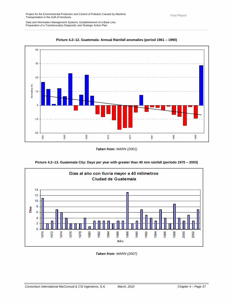
Final Report
Consortium International MarConsult & CSI Ingenieros, S.A. March, 2010 Chapter 4 – Page 57
Project for the Environmental Protection and Control of Pollution Caused by Maritime Transportation in the Gulf of Honduras
Data and Information Management Systems, Establishement of a Base Line, Preparation of a Transboundary Diagnostic and Strategic Action Plan
Picture 4.2–12. Guatemala: Annual Rainfall anomalies (period 1961 – 1990)
Taken from: MARN (2001)
Picture 4.2–13. Guatemala City: Days per year with greater than 40 mm rainfall (período 1970 – 2003)
Taken from: MARN (2007)
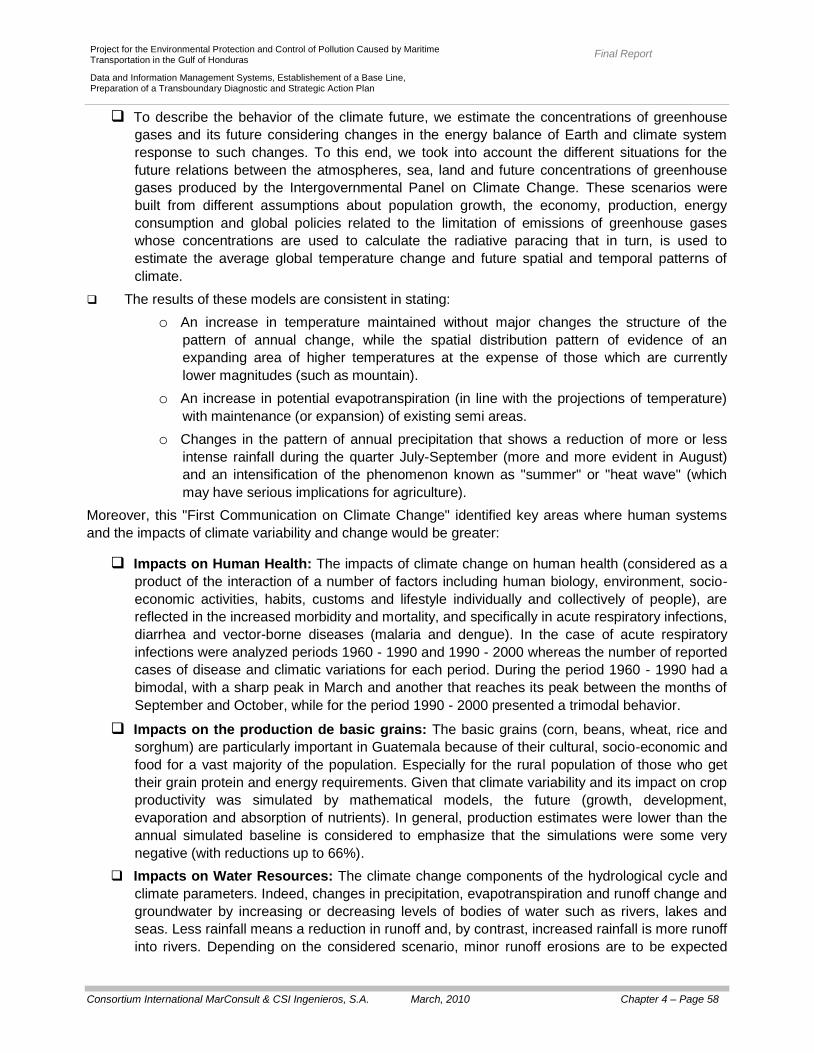
Final Report
Consortium International MarConsult & CSI Ingenieros, S.A. March, 2010 Chapter 4 – Page 58
Project for the Environmental Protection and Control of Pollution Caused by Maritime Transportation in the Gulf of Honduras
Data and Information Management Systems, Establishement of a Base Line, Preparation of a Transboundary Diagnostic and Strategic Action Plan
To describe the behavior of the climate future, we estimate the concentrations of greenhouse
gases and its future considering changes in the energy balance of Earth and climate system
response to such changes. To this end, we took into account the different situations for the
future relations between the atmospheres, sea, land and future concentrations of greenhouse
gases produced by the Intergovernmental Panel on Climate Change. These scenarios were
built from different assumptions about population growth, the economy, production, energy
consumption and global policies related to the limitation of emissions of greenhouse gases
whose concentrations are used to calculate the radiative paracing that in turn, is used to
estimate the average global temperature change and future spatial and temporal patterns of
climate.
The results of these models are consistent in stating:
o An increase in temperature maintained without major changes the structure of the
pattern of annual change, while the spatial distribution pattern of evidence of an
expanding area of higher temperatures at the expense of those which are currently
lower magnitudes (such as mountain).
o An increase in potential evapotranspiration (in line with the projections of temperature)
with maintenance (or expansion) of existing semi areas.
o Changes in the pattern of annual precipitation that shows a reduction of more or less
intense rainfall during the quarter July-September (more and more evident in August)
and an intensification of the phenomenon known as "summer" or "heat wave" (which
may have serious implications for agriculture).
Moreover, this "First Communication on Climate Change" identified key areas where human systems
and the impacts of climate variability and change would be greater:
Impacts on Human Health: The impacts of climate change on human health (considered as a
product of the interaction of a number of factors including human biology, environment, socio-
economic activities, habits, customs and lifestyle individually and collectively of people), are
reflected in the increased morbidity and mortality, and specifically in acute respiratory infections,
diarrhea and vector-borne diseases (malaria and dengue). In the case of acute respiratory
infections were analyzed periods 1960 - 1990 and 1990 - 2000 whereas the number of reported
cases of disease and climatic variations for each period. During the period 1960 - 1990 had a
bimodal, with a sharp peak in March and another that reaches its peak between the months of
September and October, while for the period 1990 - 2000 presented a trimodal behavior.
Impacts on the production de basic grains: The basic grains (corn, beans, wheat, rice and
sorghum) are particularly important in Guatemala because of their cultural, socio-economic and
food for a vast majority of the population. Especially for the rural population of those who get
their grain protein and energy requirements. Given that climate variability and its impact on crop
productivity was simulated by mathematical models, the future (growth, development,
evaporation and absorption of nutrients). In general, production estimates were lower than the
annual simulated baseline is considered to emphasize that the simulations were some very
negative (with reductions up to 66%).
Impacts on Water Resources: The climate change components of the hydrological cycle and
climate parameters. Indeed, changes in precipitation, evapotranspiration and runoff change and
groundwater by increasing or decreasing levels of bodies of water such as rivers, lakes and
seas. Less rainfall means a reduction in runoff and, by contrast, increased rainfall is more runoff
into rivers. Depending on the considered scenario, minor runoff erosions are to be expected

Final Report
Consortium International MarConsult & CSI Ingenieros, S.A. March, 2010 Chapter 4 – Page 59
Project for the Environmental Protection and Control of Pollution Caused by Maritime Transportation in the Gulf of Honduras
Data and Information Management Systems, Establishement of a Base Line, Preparation of a Transboundary Diagnostic and Strategic Action Plan
(from the precipitation erosion) and, consequently, a decrease in the rivers flow, which will
bring, as a consequence, a decrease of water sources for consumption (human and animal)
and irrigation, as well as a mayor sedimentation in the flow of said rivers.
Impact on Forest Resources: The geographical distribution of forests, their composition, their
characteristics and productivity are determined by the natural conditions of the local and global
climate. Variations in temperature and rainfall play an important role in the distribution and
productivity of forested areas: the temperature directly affects the biochemical and physiological
processes, while precipitation is the major input for soil moisture, while the humidity and
temperature directly affect the decomposition of organic matter affecting the availability of
nutrients for plants. The analysis of the impacts of climate change on forest resources was
based on various scenarios which indicated that the forest species are more vulnerable forests
confirm that show negative conditions that lead to a reduction in coverage (the increase in dry).
Honduras
In 1995, Honduras participated in the implementation of the so-called "Draft Central Climate
Change", funded by the Environmental Protection Agency (U.S.) through the development of
studies of vulnerability to climate change for the sectors "water” and "Agro - weather" (maize
crop) and coastal marine resources. Subsequently, under the "First Communication of
Honduras to the United Nations Framework Convention on Climate Change (SERNA, 1995), a
review on the vulnerability to rising sea levels and water resources was done.
From climate change scenarios recommended by the Intergovernmental Panel on Climate
Change (IPCC, by its initials in Spanish) were projected future climate scenarios envisage
considering assumptions accepted by the international scientific community and projected time
horizons consistent with other similar studies carried out in the Isthmus. The results were then
incorporated into models on ecosystems, water resources, agricultural, economic, and so on.
To assess the impacts of a changing climate may have on them. In particular, depending on the
scenarios considered, it was noted: a) an increase in temperature varies between 0, 6 and 3, 7
° C, b) a reduction of precipitation and reduction between -6, 9% -36, 6%, c) a reduction in
cloudiness between -2, 5 and -17, 2%, such changes are reflected in processes of floods and
droughts that also affect the supply of drinking water, identify major problems for the irrigation
sector, power generation electrical and agricultural production. Correspondingly, estimates were
made - very preliminary - the possible loss of land due to erosion on the beaches of the section
between the river and Playa Grande of Tela reach 7.084 m² and on the beaches of Ensenada
(Cloth) reach 400 m². In addition, the areas vulnerable to inundation by rising sea levels,
including the flow of rivers in case of high rainfall reaches, for example, 885 km² in the Sula
Valley, 20 km² in Puerto Cortes, 46 km² in the Tela Bay.
Corresponds to indicate that, in addition to the potential economic implications could be rising
sea levels, a number of socio-cultural implications of type very difficult to quantify, for example,
in the community of Omoa is Castle San Fernando of Omoa (built between 1759 and 1775 and
declared a National Monument) that could be affected by rising sea levels (although the
sedimentation, mangroves, wetlands and coral reefs appear to be marginal protecting the
coastline of area).
Final Report
Consortium International MarConsult & CSI Ingenieros, S.A. March, 2010 Chapter 4 – Page 60
Project for the Environmental Protection and Control of Pollution Caused by Maritime Transportation in the Gulf of Honduras
Data and Information Management Systems, Establishement of a Base Line, Preparation of a Transboundary Diagnostic and Strategic Action Plan
b) Biodiversity Impacts
As already indicated, the combination of chronic stress disorder and which are currently subject ecosystem of the study area covered by this consultancy has led (among other impacts) to: a) the decrease in the coverage of coral reefs, sea grasses and mangroves, b) an increase in coverage of coral reefs by microalgae, c) a sudden onset of diseases affecting coral reefs, d) a decrease in abundance of fish associated with these ecosystems, e) an increase in the supply of nutrients, organic
matter and sediment, and f) an increase in the sediment around the reefs (particularly those near the
coast and / or the mouths of rivers).
Obviously, a climate change scenarios involve changes in the composition, characteristics and
productivity of ecosystems, said changes are associated, not only to rising sea levels, but also to: a)
increasing the supply of freshwater associated with drainage basins of the region (with the consequent
reduction in salinity in the study area covered by this consultancy), b) increasing the surface
temperature of the water (thereby affecting the reef system), c) increasing the concentration of carbon
dioxide dissolved in seawater (thereby reducing the training capacity of coral skeletons), d) increases in
inputs of sediment, organic materials and nutrients (with the consequent increase in sedimentation,
particularly in areas near to the coast and / or in the mouths of rivers) and e) an increase in the intensity
of hurricanes and tropical storms (with the consequent impact on the seabed and ecosystems).
4.2.2.2. Non-sustainable development of marine and coastal areas.
In the study area covered by this consultancy projects have been identified for development of tourism infrastructure and port. Among them to include: a) the "Expansion Project and Modernization of Port Cortes, b) the "Project of Modernization of Puerto Saint Thomas of Castilla”, and c) tourism development project Tela Bay (Honduras) called as well "The Micos Beach & Golf Resort." As previously indicated Puerto Cortes is the main port of Honduras and mobilizing almost 90% of traffic
by sea in that country. Despite its regional importance and the conditions of competition has significant
capacity constraints in order to achieve optimum efficiency because it is constrained by the city (which
restricts the potential zoning port and hampers the development of specialized terminals) with long and
congested waiting ships, operations of time higher than international standards, and costs of inefficient
operations (which punishes particularly ships and bulk carriers - containers).
Accordingly, the National Port Company (ENP) has initiated a process of development its facilities by
the "Expansion Project and Modernization of Port Cortes" which will involve a strong quantum leap in
capacity and the regional projection of the port.
The project's overall objective is to improve the capacity and efficiency of port operations and their
specific objectives are (Picture 4.2-14) : a) reduce operating costs and time on the docks of ships and
goods, b) enable the development of logistics operations typical of specialized terminals (container,
bulk organic solids), c) avoid the risk of pollution caused by bulk operations and d) avoid interference
with the urban traffic, using specialized equipment and storage at the port.
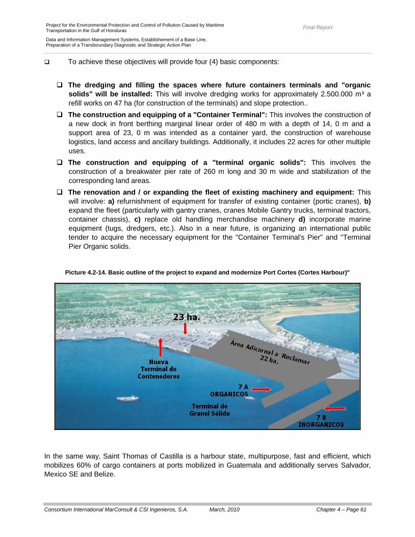
Final Report
Consortium International MarConsult & CSI Ingenieros, S.A. March, 2010 Chapter 4 – Page 61
Project for the Environmental Protection and Control of Pollution Caused by Maritime Transportation in the Gulf of Honduras
Data and Information Management Systems, Establishement of a Base Line, Preparation of a Transboundary Diagnostic and Strategic Action Plan
To achieve these objectives will provide four (4) basic components:
The dredging and filling the spaces where future containers terminals and "organic
solids" will be installed: This will involve dredging works for approximately 2.500.000 m³ a
refill works on 47 ha (for construction of the terminals) and slope protection..
The construction and equipping of a "Container Terminal": This involves the construction of
a new dock in front berthing marginal linear order of 480 m with a depth of 14, 0 m and a
support area of 23, 0 m was intended as a container yard, the construction of warehouse
logistics, land access and ancillary buildings. Additionally, it includes 22 acres for other multiple
uses.
The construction and equipping of a "terminal organic solids": This involves the
construction of a breakwater pier rate of 260 m long and 30 m wide and stabilization of the
corresponding land areas.
The renovation and / or expanding the fleet of existing machinery and equipment: This
will involve: a) refurnishment of equipment for transfer of existing container (portic cranes), b)
expand the fleet (particularly with gantry cranes, cranes Mobile Gantry trucks, terminal tractors,
container chassis), c) replace old handling merchandise machinery d) incorporate marine
equipment (tugs, dredgers, etc.). Also in a near future, is organizing an international public
tender to acquire the necessary equipment for the "Container Terminal's Pier" and "Terminal
Pier Organic solids.
Picture 4.2-14. Basic outline of the project to expand and modernize Port Cortes (Cortes Harbour)"
In the same way, Saint Thomas of Castilla is a harbour state, multipurpose, fast and efficient, which
mobilizes 60% of cargo containers at ports mobilized in Guatemala and additionally serves Salvador,
Mexico SE and Belize.
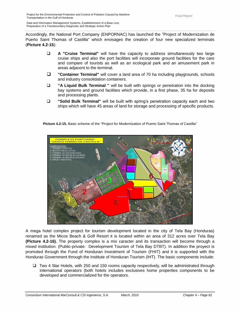
Final Report
Consortium International MarConsult & CSI Ingenieros, S.A. March, 2010 Chapter 4 – Page 62
Project for the Environmental Protection and Control of Pollution Caused by Maritime Transportation in the Gulf of Honduras
Data and Information Management Systems, Establishement of a Base Line, Preparation of a Transboundary Diagnostic and Strategic Action Plan
Accordingly, the National Port Company (ENPORNAC) has launched the "Project of Modernization de
Puerto Saint Thomas of Castilla" which envisages the creation of four new specialized terminals
(Picture 4.2-15):
A "Cruise Terminal" will have the capacity to address simultaneously two large cruise ships and also the port facilities will incorporate ground facilities for the care and compare of tourists as well as an ecological park and an amusement park in areas adjacent to the terminal.
"Container Terminal" will cover a land area of 70 ha including playgrounds, schools and industry consolidation containers.
“A Liquid Bulk Terminal " will be built with springs or penetration into the docking bay systems and ground facilities which provide, in a first phase, 35 ha for deposits and processing plants.
"Solid Bulk Terminal" will be built with spring’s penetration capacity each and two ships which will have 45 areas of land for storage and processing of specific products.
Picture 4.2-15. Basic scheme of the "Project for Modernization of Puerto Saint Thomas of Castilla"
A mega hotel complex project for tourism development located in the city of Tela Bay (Honduras)
renamed as the Micos Beach & Golf Resort it is located within an area of 312 acres over Tela Bay
(Picture 4.2-16). The property complex is a mix caracter and its transaction will become through a
mixed institution. (Public-private: Development Tourism of Tela Bay DTBT). In addition the proyect is
promoted through the Fund of Honduran Investment of Tourism (FHIT) and it is supported with the
Honduras Government through the Institute of Honduran Tourism (IHT). The basic components include:
Two 4 Star Hotels, with 250 and 150 rooms capacity respectively, will be administrated through international operators (both hotels includes exclusives home properties components to be developed and commercialized for the operators.

Final Report
Consortium International MarConsult & CSI Ingenieros, S.A. March, 2010 Chapter 4 – Page 63
Project for the Environmental Protection and Control of Pollution Caused by Maritime Transportation in the Gulf of Honduras
Data and Information Management Systems, Establishement of a Base Line, Preparation of a Transboundary Diagnostic and Strategic Action Plan
A golf course of 18 holes (with its "clubhouse"). 437 home properties exclusive complex. (Small houses, Golf Villages, Lagoon Villages, Ocean
Front Villages, Beach Front). 60 residential villages’ bungalows types will include private beach access and Beach Clubs.
Additional building installation includes a Commercial Center Mall with a size of 4, 0 acres, one
Garifunas Village, an equestrian club with a capacity for thirty horses. Basic refill, drain, water and electrical infrastructure.
Picture 4.2-16 Schematic location Los Micos Beach & Golf resort project. (Tela Bay).
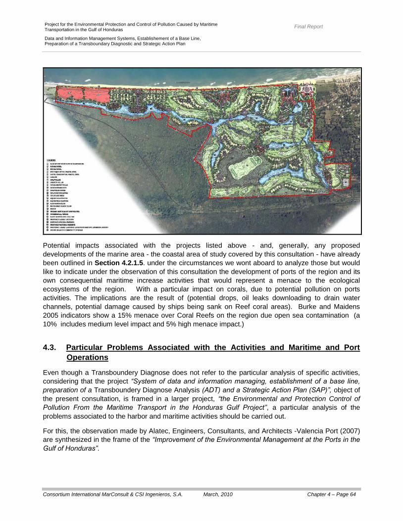
Final Report
Consortium International MarConsult & CSI Ingenieros, S.A. March, 2010 Chapter 4 – Page 64
Project for the Environmental Protection and Control of Pollution Caused by Maritime Transportation in the Gulf of Honduras
Data and Information Management Systems, Establishement of a Base Line, Preparation of a Transboundary Diagnostic and Strategic Action Plan
Potential impacts associated with the projects listed above - and, generally, any proposed
developments of the marine area - the coastal area of study covered by this consultation - have already
been outlined in Section 4.2.1.5. under the circumstances we wont aboard to analyze those but would
like to indicate under the observation of this consultation the development of ports of the region and its
own consequential maritime increase activities that would represent a menace to the ecological
ecosystems of the region. With a particular impact on corals, due to potential pollution on ports
activities. The implications are the result of (potential drops, oil leaks downloading to drain water
channels, potential damage caused by ships being sank on Reef coral areas). Burke and Maidens
2005 indicators show a 15% menace over Coral Reefs on the region due open sea contamination (a
10% includes medium level impact and 5% high menace impact.)
4.3. Particular Problems Associated with the Activities and Maritime and Port
Operations
Even though a Transboundery Diagnose does not refer to the particular analysis of specific activities,
considering that the project “System of data and information managing, establishment of a base line,
preparation of a Transboundery Diagnose Analysis (ADT) and a Strategic Action Plan (SAP)”, object of
the present consultation, is framed in a larger project, “the Environmental and Protection Control of
Pollution From the Maritime Transport in the Honduras Gulf Project”, a particular analysis of the
problems associated to the harbor and maritime activities should be carried out.
For this, the observation made by Alatec, Engineers, Consultants, and Architects -Valencia Port (2007)
are synthesized in the frame of the “Improvement of the Environmental Management at the Ports in the
Gulf of Honduras”.

Final Report
Consortium International MarConsult & CSI Ingenieros, S.A. March, 2010 Chapter 4 – Page 65
Project for the Environmental Protection and Control of Pollution Caused by Maritime Transportation in the Gulf of Honduras
Data and Information Management Systems, Establishement of a Base Line, Preparation of a Transboundary Diagnostic and Strategic Action Plan
4.3.1. Port Activities
4.3.1.1. Belize City Port (Belize)
According to Alatec, Engineers, Consultants, and Architects - Valencia Port (2007), the Belize City Port
does not have a department or specific unit related to the environmental management, as a
consequence, the environmental issues are developed by the Maintenance Manager. Also, the
mentioned authors confirm that they have not implemented a “Quality System” and that the
development for those plans, are only starting. Nevertheless the port has a “Security Plan” according
the international Code of Port and Maritime Security (ISPS) of the International Maritime Organization
(OMI) which is an international regulator for the protection of ships and ports.
Particularly, Alatec, Engineers, Consultants, and Architects -Valencia Port (2007) say that:
We have identified problems associated with air pollution caused by the loading and unloading of
bulk solids (which are particularly larger when there are cruise ships near) and no evidence of
carrying out programs to control emissions, or the availability of air quality measurements in port.
The drainage system of the municipal sewage waters has many points for discharging to the
coast. Then, at the southern part of the port there is a canal that dumps municipal residual waters
and, as because of the coastal currents, they re-circulate towards the interior of the port site,
affecting the water with pollutants which origin is not from the port (this has been confirmed by
the results obtained in the Environmental Prospection Campaign done towards effects of the
current consulting).
In the same port, some installations have septic tanks that are emptied periodically, nevertheless,
inside the port site there are no treatment or depuration of the residual waters installations.
The rain water pours directly into the body of water and does not have preventive equipments for
the elimination of the first rain waters (which contain the highest contamination of oils, greases,
solids, etc.).
Due to the kind of traffic at the port, the existence of products associated to the umballast of the
ships at the port it is not expected.
There are certain pollution problems associated to the discharge of petroleum derivatives from
small crafts going to the keys, and which moor at the docking pier; nevertheless, the port
directorate is developing “Good Practices” that tend to minimize those discharges.
The oils coming from the maintenance activities are kept in barrels and are sold for recycling.
A private company is in charge of the management of all residues, being them dangerous or not,
which are transferred to the Belize City dump.
Although Belize is a signor of the Agreement for the Prevention of the Pollution Coming from
Ships (MARPOL 1973-1978), the residues included in their annexes are not accepted in the port
(only the dry waste) due to a regulatory prohibition from the Belize Government.
A large part of the port installation is unpaved, so the risk of soil pollution is high, field trips have
confirmed the presence of oil stains in different areas close to the machinery maintenance area.
There are no evidences that there is a program for monitoring the quality of sea waters or the
control of the discharges at the port site.
Final Report
Consortium International MarConsult & CSI Ingenieros, S.A. March, 2010 Chapter 4 – Page 66
Project for the Environmental Protection and Control of Pollution Caused by Maritime Transportation in the Gulf of Honduras
Data and Information Management Systems, Establishement of a Base Line, Preparation of a Transboundary Diagnostic and Strategic Action Plan
4.3.1.2. Big Creek (Belize)
According to Alatec Consulting Engineers and Architects - Valencia Port (2007), the port of Belize City
does not have a specific department or unit linked to environmental management as a result, the
activities of environmental management and industrial safety are distributed evenly among all staff
associated with port operations.
In particular, Alatec Engineer and Architec Consulting -Valencia Port (2007) mention that:
There is no proof of the existance of any control system for the control of the emissions that result
from the port activity.
In Stan Creek as in Toledo District, the access to the sanitary facilities is extremely low
determining a contamination of the underground waters and the presence of diseases such as
gastroenteritis and hepatiitis; thus, there are a great number of discharges without treatment that
flow straight into the Gulf of Honduras.
In the specific case of the port, the oldest area has a net for water drainage that flows towards the
Gulf of Honduras (with no prior treatment) however, the new installations of storage of
hidrocarbons, have been designed and built taking into consideration a dividing net that disposes
the decantation rafts.
Nevertheless, the cleaning waters of the dock are discharged straight into the inner harbor.
Health facilities have septic tanks that are emptied periodically by a tanker and they plan to have
a new system of latrines with septic tanks for the disposal of the waste water of the port (to be
unloaded in a place specifically designated for such purposes).
The company managing the port has "contingency plans" and the necessary means to control a
small accidental spill. It must be noted that, for now, they don’t expect to work with boats bigger
than their current barge that transport oil to the United States.
Such craft does not need to operate ballasted, therefore, in this traffic, there wil be no problems
associated to the ballast waters.The rest of the traffics will not generate this kinds of problems
either.
There are water quality problems related to the presence of algal blooms; however the same will
not originate due to port activity but from leached fertilizer applied to crops near the port.
The residues that originate from the different port activities are withdrawn by the company itself
and are taken to a landfill located at 4.0 km from the port facilities; on the other hand, it must be
noted that there is no existing information regarding the type of waste generated.
Regarding hazardous waste, the waste oil from the tugs used in port operations is reused to
lubricate the chains of the cranes; as a result, there is no need to get rid of them.
Similarly, it is noted that the port has an agreement with the Guatemalan DVG Services for the
collection of oily waste and its further treatment in the plant owned by the company near the port
of Saint Thomas of Castilla.
The floating residues are gathered by a floating vessel specifically designed for this purpose.
As in the port of Belize City, the wastes included in the Annexes for the Convention for the
Prevention of Pollution From Ships (MARPOL, 1973 to 1978) are not accepted.
Final Report
Consortium International MarConsult & CSI Ingenieros, S.A. March, 2010 Chapter 4 – Page 67
Project for the Environmental Protection and Control of Pollution Caused by Maritime Transportation in the Gulf of Honduras
Data and Information Management Systems, Establishement of a Base Line, Preparation of a Transboundary Diagnostic and Strategic Action Plan
Most of the port is unpaved, so the risk of soil contamination is high. Also, the current state of the
soil around the older storage tanks is unknown (those built before the latest oil storage facilities).
4.3.1.3. Port Barrios (Guatemala)
According to the interviews conducted in the framework of the foregoing consultancy (see Annex 04
and 05) Port Barrios does not have a specific unit or department for the environment, however it’s
noted that, regarding to dangerous goods, the regulation itself for operating the Port operating states, in
its Articles 32º to 35º, that: a) “the transport of dangerous goods through the Port, and their
management should be kept under strict control on an ongoing basis, in order to protect the safety of
port facilities, staff and the population surrounding the facility", b) "Shipping agencies of vessels
carrying dangerous goods to the Port, according to the International Maritime Organization (IMO),
should be written notified within 24 hours prior to the arrival of the vessel”, c) “any dangerous goods
must be handled directly from the ship to the transportation vehicle that will be withdrawing it from the
port, its storage in warehouses and/or containers within the Port will not be allowed under any
conditions", d) “the port reserves the right to authorize the transit or non transit of dangerous goods, as
it deems as unsafe handling”.
It must be further added that the company complies with the regulations of Chapter XI - 2 and of part A
of the International Code for Ship and Port Facility Security (ISPS) and it observes the Protection Plan
approved for operations and activities with the following types of ships: cruise ships, bulk solids,
containers carriers, bankers, gas tankers, barges, refrigerated, general cargo, roll on - roll off and cargo
ships other than the above.
Alatec Consulting Engineers and Architects - Valencia Port (2007) mentioned that:
During unloading of bulk solids, and more specifically in the case of fertilizers, the release of
particles can be produced; however, this is just a marginal traffic with no particularly importance
whatsoever.
Most of the port is unpaved, thus producing the release of particles from the transit of land
vehicles and from within the container yard and due to the intense and increasing traffic and
increasing such releases become of great importance. Thus, it must be noted that in order to
prevent the emission of dust, there is a daily program of irrigation of the units.
The close relation between the port and the city of Port Barrios determine that both share the
waters of the Gulf of Honduras and the Bay of Saint Thomas of Castilla in particular: where
although the discharges are not known to be produced
directly in the port environment, it is assumed that they are important (and, moreover, is without
any control).
In the case of port facilities, sanitary water dumped into a pit and, after a pretreatment, the
collector general, for their part, the storm water is discharged directly to the dock.
It is not occurring discharges of ballast water as the import and export traffic is well balanced and
the ships coming to load goods tend to download more.
The general waste sent to landfill, with a firm hired specifically for this purpose. For its part,
hazardous wastes are managed by the DVG Services is responsible for their removal and
treatment. This company is also responsible for collecting waste oil.

Final Report
Consortium International MarConsult & CSI Ingenieros, S.A. March, 2010 Chapter 4 – Page 68
Project for the Environmental Protection and Control of Pollution Caused by Maritime Transportation in the Gulf of Honduras
Data and Information Management Systems, Establishement of a Base Line, Preparation of a Transboundary Diagnostic and Strategic Action Plan
The port is put up with rubbish bins and containers, as well as indications as to its proper use.
It corresponds to indicate that the Deparment of Health and Hygiene of the Port Barrios
Municipality, frecuently make “unscrapping” campaigns to prevent diseases like dengue, such
campaigns consist in the periodic gathering of the scrap so it can be valued and sold; at the
present there is a proposal of colaboration port municipality to profit these campaigns as effect of
the retirement of the scrap from the port.
As to the residuals included in anexes of the agreement for the prevention of the contamination
coming from ships (MARPOL 1973-1978), the oily residuals are taken away and treated by DVG
Services company (although the demand of those services is scarce) Respecting tras (Anex V),
the guatemalean law forbid expressly the picking up of trash coming from craffts.
Since, as already indicated, most of the port is unpaved; any accidental spill could become an
event of soil contamination. However, it indicated that the workshop floor is covered with "gravel"
which spills that occur in the maintenance of machinery and equipment. Periodically the "gravel"
is withdrawn and sent to landfill (without treatment). There are plans to waterproof the area and
prevent this practice.
Finally, with regard to the city - port corresponds to indicate that the port of Port Barrios is fully
integrated into the municipality of the same name. The roads around the port and its access roads are
urban, but there appears to be no complaints from people both with regard to environmental aspects
generated by the port and the air emissions of dust and noise.
4.3.1.4. Port Saint Thomas of Castilla (Guatemala)
The organizational structure - function of the National Port Santo Tomas de Castilla, approved by its
Board under Act 023 - 92 of 16 March 1992, provides your organization the existence of a Department
of Environment (Figure 4.3-1).

Final Report
Consortium International MarConsult & CSI Ingenieros, S.A. March, 2010 Chapter 4 – Page 69
Project for the Environmental Protection and Control of Pollution Caused by Maritime Transportation in the Gulf of Honduras
Data and Information Management Systems, Establishement of a Base Line, Preparation of a Transboundary Diagnostic and Strategic Action Plan
Figure 4.3–1. Structural - functional calendar of the National Port Saint Thomas of Castilla
Taken from: http://www.santotomasport.com.gt
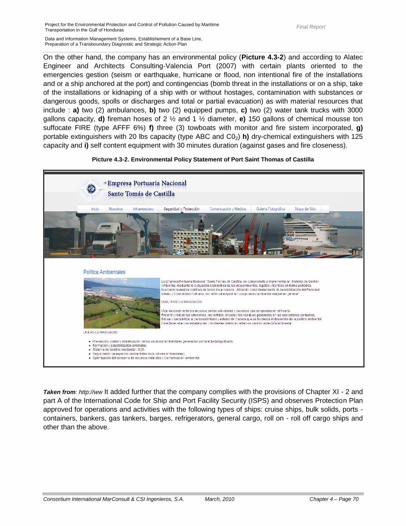
Final Report
Consortium International MarConsult & CSI Ingenieros, S.A. March, 2010 Chapter 4 – Page 70
Project for the Environmental Protection and Control of Pollution Caused by Maritime Transportation in the Gulf of Honduras
Data and Information Management Systems, Establishement of a Base Line, Preparation of a Transboundary Diagnostic and Strategic Action Plan
On the other hand, the company has an environmental policy (Picture 4.3-2) and according to Alatec
Engineer and Architects Consulting-Valencia Port (2007) with certain plants oriented to the
emergencies gestion (seism or earthquake, hurricane or flood, non intentional fire of the installations
and or a ship anchored at the port) and contingencias (bomb threat in the installations or on a ship, take
of the installations or kidnaping of a ship with or without hostages, contamination with substances or
dangerous goods, spolls or discharges and total or partial evacuation) as with material resources that
include : a) two (2) ambulances, b) two (2) equipped pumps, c) two (2) water tank trucks with 3000
gallons capacity, d) fireman hoses of 2 ½ and 1 ½ diameter, e) 150 gallons of chemical mousse ton
suffocate FIRE (type AFFF 6%) f) three (3) towboats with monitor and fire sistem incorporated, g)
portable extinguishers with 20 lbs capacity (type ABC and C02) h) dry-chemical extinguishers with 125
capacity and i) self content equipment with 30 minutes duration (against gases and fire closeness).
Picture 4.3-2. Environmental Policy Statement of Port Saint Thomas of Castilla
Taken from: http://ww It added further that the company complies with the provisions of Chapter XI - 2 and
part A of the International Code for Ship and Port Facility Security (ISPS) and observes Protection Plan
approved for operations and activities with the following types of ships: cruise ships, bulk solids, ports -
containers, bankers, gas tankers, barges, refrigerators, general cargo, roll on - roll off cargo ships and
other than the above.
Final Report
Consortium International MarConsult & CSI Ingenieros, S.A. March, 2010 Chapter 4 – Page 71
Project for the Environmental Protection and Control of Pollution Caused by Maritime Transportation in the Gulf of Honduras
Data and Information Management Systems, Establishement of a Base Line, Preparation of a Transboundary Diagnostic and Strategic Action Plan
In particular, Alatec Engeneer and Architects Consulting-Valencia Port (2007) mention that:
The main focus particle emitter to the atmosphere is associated with loading and unloading of
petroleum coke as a destination that has the facilities of "Progress Concretes" located outside the
port. The emission occurs discontinuously (every quarter) and there have been no
measurements.
Other potencial emitting focus of atmospheric contamination is the liquid bulk asociated to the
crude export, nevertheless there are no evidences that there are releases in the pass valves.
With regard to the existence of emission control measures, it is unavailable to them.
In Saint Thomas of Castilla Bay and even in the same port site, there are many municipal
discharges that affect the quality of the port waters. Even if the port has septick foses, the healing
waters discharge to the general net that has no control Systems (having the possibility of
accidental discharges of toxic or dangerous products especially on the companys located at the
Free Zone of Commerce and Industrie-ZOLIC, which uses the net of discharges of the port
company).
There are no separative nets in the susceptible areas of generating contaminant discharges.
The Port Company has its own cleaning train for the recollection of trash generated in the port
activities; the same are transported and deposited (not recicled nor treated) at the Municipal
Piteros Dumpster.
The dangerous goods are delivered to a previously authorized gestor (DVG Services), and in the
event of product spills, DVG is the company that carries out the Treatment Procedure.
The industrial waste of the warehouses of the own port company and their users are taken by
trash collecting trucks belonging to DVG Services, Clean World Services, or the Warehouses.
As to the control of the residuals generated, there is no evidence that a register of the
corresponding is being taken wether if it refers to the origin, amount or final destiny.
In addition, a classic waste must be generated by aggregating the traffic of cars collided in fact
some of them are never removed and left in port facilities. Some of these vehicles, in obvious
disrepair, including many non-hazardous waste as hazardous, it is necessary to manage, but that
management is facing administrative constraints (to restrict its output of the port).
While Guatemala is to the convention on the Prevention of Pollution From Ships (MARPOL, 1973
- 1978), the waste listed in Annex V (garbage) are not accepted on the port and those included in
Annex I (oily residues) are collected and managed by the DVG Services which has facilities for
final treatment of them.
Finally, regarding to the city - port corresponds to indicate that the National Port Saint Thomas of
Castilla pay a tax of 5% per annum to the municipality, and has for nine (9) officers to work in care the
"Wildlife Refuge Cerro San Gil."Port Cortes (Honduras)
Port Cortes counts with a department of Hygiene, indistrial security and Environment respectively
recently created as also with an environmental policy (Picture 4.3.3); it correspond to indicate that it
also fulfills with dispositions of Chapter Xl - 2 and of Part A of the International Code for the protection
of ships and Port Installations (Code PBIP) and observe the aproved Protection Plan to realize activities
and operations with the following kind of ships: passage ships, bulk, Oilers, Chemicals, General Cargo,
Roll on-Roll off, Container Carriers and ships different to the before mentioned.

Final Report
Consortium International MarConsult & CSI Ingenieros, S.A. March, 2010 Chapter 4 – Page 72
Project for the Environmental Protection and Control of Pollution Caused by Maritime Transportation in the Gulf of Honduras
Data and Information Management Systems, Establishement of a Base Line, Preparation of a Transboundary Diagnostic and Strategic Action Plan
Picture 4.3–3. Environmental Policy Statement of Port Cortes
In particular, Alatec Engineer and Architect sConsulting-Valencia Port (2007) mention that:
In 2002 a study was conducted to determine the values of particulate matter in air of the port
used for this purpose a team Dustrak Aerosol Monitor from TSI Inc. signatures, the results
showed that two of the sites sampled detected an excess of PM10 in relation to the criteria set by
the World Bank (70 mg/m3) while the third site was also detected high concentrations (although
the sampling was conducted during the activity of loading / unloading of bulk). Also, the study
showed that: a) the wind slightly contributes in raising the values or the particle matter in air, b)
the circulation of large vehicles through non-paved roads considerably raises the concentration of
Final Report
Consortium International MarConsult & CSI Ingenieros, S.A. March, 2010 Chapter 4 – Page 73
Project for the Environmental Protection and Control of Pollution Caused by Maritime Transportation in the Gulf of Honduras
Data and Information Management Systems, Establishement of a Base Line, Preparation of a Transboundary Diagnostic and Strategic Action Plan
particles c) the increase of particle matter in the air is the result of the transportation of bulk
products.
Regarding the emission of polluting gases that can alter air quality, there is no evidence that
there is any record or control system. However, during field visits showed emissions during
loading and unloading of bulk solids.
Moreover, the lack of paved roads in some favors the suspension of particles during the
movement of trucks and machinery.
In August 2001 an investigation was conducted on the various points of discharge of sewage into
the harbor as a result thereof shall be identified for various points of discharge to the sewers from
stormwater, sanitary water and other waters from both the port and the city of Puerto Cortes.
In January 2002, a study for characterization of the wastewater was made according to which
only three companies (linked to laundering activities) of the free area of the port generating
process water discharged while the rest only sanitary water. The results concluded that the
waters tested showed high concentration of aluminum and also were high concentrations of
BOD5, COD, fecal coliform, suspended solids and total phosphorus.
Regarding the storm water of the port, these are discharged directly to the dock.
According to Abt Associates Inc. - Woods Hole Group (2003) municipal waste generated in the
port are collected by the municipality and taken to the municipal landfill.
As for industrial waste similar to urban and inert, there are several storage areas, specifically
aimed at Empresa Nacional Portuaria (ENP), which are collected waste discharges.
The port has, since 1997, an incinerator 50 kg / hour capacity, but not in operation due to various
problems with the necessary authorizations.
Hazardous waste generated by various port activities (workshops, etc) are stored temporarily in
various parts of the port, usually on the same premises where they have been generated, to be
subsequently removed by specialist companies.
Honduras is a contractor of the Convention for Prevention of Pollution From Ships (MARPOL,
1973 - 1978) having ratified Annexes I, II and V which states that the port facilities must ensure to
provide reception facilities and water management oily bilge and solid waste generated on board
ships. Thus, the National Port Company (ENP) and the Merchant Navy signed a partnership
agreement which defines roles and responsibilities of each party in connection with the
implementation of the MARPOL Convention. However, it indicates that there are no facilities for
receiving and treating waste MARPOL - Type I.3
With regard to waste MARPOL - Type V, there are no specific facilities for the reception and, in
addition, there is no specific monitoring of the discharge of these wastes are removed by the
service of the municipality (the written request of any person or through a shipping agent).
3 Alatec Ingenieros Consultores y Arquitectos – Valencia Port (2007) hacen notar que, durante las visitas de campo, fuentes de la
Capitanía Marítima comentaron que algunos buques solicitan dicho servicio y que durante las inspecciones que se realizan, como
parte de las labores de control por el Estado Rector del Puerto, se constata dicha necesidad que no se puede ser debidamente
atendida.

Final Report
Consortium International MarConsult & CSI Ingenieros, S.A. March, 2010 Chapter 4 – Page 74
Project for the Environmental Protection and Control of Pollution Caused by Maritime Transportation in the Gulf of Honduras
Data and Information Management Systems, Establishement of a Base Line, Preparation of a Transboundary Diagnostic and Strategic Action Plan
For control purposes, the municipal authorities only emphasize that it is domestic waste, meaning
"those kitchen garbage generated during the journey from its port of departure to Puerto Cortés”.
Corresponds to indicate that, in Honduras, the International Regional Organization for Agricultural
Health (OIRSA) has a mandate from the executive branch to provide service for the landing of
garbage from ships, such effects are built in the port premises, but an incinerator, as indicated,
has not reached agreement as to who should provide the service. Therefore, at present, solid
waste from ships are collected by private companies that obtained previously, a permit from the
municipality and of the National Port Company (ENP).
Solid waste is deposited in the municipal dump while the parts and scrap metal are accumulated
in certain sections of the port and collected by various contractors (previously approved by the
municipality and by the National Port Company – (ENP from its Spanish translation).
In 2001, studies were conducted to characterize the soils of the port; such effects were a total of
49 calicatas depths ranging between 0.30 and 2.50 m. In general, it was observed that: a) in
several trenches were found excessive concentrations of petroleum hydrocarbons; b) Similarly,
we found an excess of heavy metals and especially of arsenic, cadmium, copper, nickel, lead and
zinc c) found an excess in relation to polycyclic aromatic hydrocarbons (PAHs) and oil d) the only
sample analyzed to determine its PCB concentration did not show any excess (at least according
to the criteria used in the study).
Contaminated soil would be closest to the main repair shops (where the handling of petroleum
products), next to certain deposits or traces of various substances and waste in the chemical
sector.
Moreover, the lack of pavement in certain areas of the port could be a possible cause of soil
contamination.
In relation to the bottom sediments from the harbor and its environs in August 2001 was a
characterization of them have been found to correspond to sand and silt and springs off the No. 3
and 4 the concentrations of heavy metals exceeded the criteria of the "Guidelines for Canadian
Sediment Quality for the Protection of Aquatic Life" (Environment Canada, 2002).
As for the city - the port, the main economic activity of the population of the city of Puerto Cortes is the
sale of labor and services to the National Port Company (ENP) and the industrial zones located in it,
otherwise, it indicates that there are traffic problems and congestion in the city, related to the transfer of
goods to and from the port and industrial areas. In facilities Hondupetrol there have been some
problems with leakage and the city has received complaints about dust and odors from the facility.
Finally, it is noted that the National Ports gave - in the municipality to use - an area adjacent to the free
zone, known as "El Malecon", dealing with its landscaping, it is used as a recreation area for residents
of Puerto Cortes.
4.3.2. Dredging Activities
According to interviews conducted for the purpose of this consultancy (see Annex 04 and 05) and
information gathered by Consulting Engineers and Architects Alatec - Valencia Port (2007) concluded
that the ports of Belize City and Big Creek (Belize ) is not engaged in dredging, on the other hand, the
areas of funding, which are the responsibility of the Port Authority (Port Authority Belize) correspond to

Final Report
Consortium International MarConsult & CSI Ingenieros, S.A. March, 2010 Chapter 4 – Page 75
Project for the Environmental Protection and Control of Pollution Caused by Maritime Transportation in the Gulf of Honduras
Data and Information Management Systems, Establishement of a Base Line, Preparation of a Transboundary Diagnostic and Strategic Action Plan
areas of sandy bottom and reef presence (whose selection would have been the result of studies that
took into account the ecosystem and biodiversity of these funds).
With a monthly bathymetry are performed to check the depth in the access channel to the port of Saint
Thomas of Castilla, in good part, is shared with Port Barrios. Maintenance dredging is carried out by the
Empresa Portuaria Nacional Santo Tomás de Castilla (EMPORNAC) and the Compañía Bananera
Independiente Guatemalteca SA (COBIGUA), as administrator of Port Barrios, bears a share of the
costs associated with those tasks. It should be noted that no information on the volume of material
dredged and that although Guatemala is to the convention on the Prevention of Marine Pollution by
Dumping of Wastes and Other Matter (London Convention) there is no evidence that in the work of
dredging the criteria established in that Convention relating to the characterization of the products of
dredging.
With respect to Port Cortes (Honduras) have been made for dredging works in the outer navigation
channel was deepened to -14 m relative to mean sea level on the average slope of the channel
dredging of the dock and mooring operation against new container terminal and bulk organic solids.
The total volume was estimated to dredge in the order of 3.73 million m3 (based on information
provided by the Superintendent of the Port and the Technical Unit of the National Port Company - ENP) and, according to the inspections and surveys recently, the Bay Area La Graciosa no areas of live coral and sand materials are so dense that, for the purpose of dredging is required the use of dredges cutters. In June 2007 the first phase of the work of dredging the navigation channel to the docks No. 6 and 7, having engaged the services of the Enterprise JAN DE NUL NV assigned to perform the dredging draga "James Cook" with which was the withdrawal of about 1.36 million m
3. A great part of
the dredged material was considered not to be good for filling, so it was discharged in high seas, at approximately 8,0 km from the zone and at an average depth of –40 m. Much of the dredged material was considered unsuitable for stuffing so it was discharged in the high
seas, about 8.0 km of the zone (to a depth of -40 m at a site where it was felt that marine life was low).
The next phases of the dredging work will be done in the context of the work of expansion and the
volume of material to draw amounts to 2.3 million m³ of material considered suitable for stuffing so that
they will be used to Filling of 45 has for the new terminal (in addition to those over 12 completed there
during the works performed by JAN DE NUL NV.
4.3.3. Navigation and Shipping
The environmental aspects associated with shipping operations include mainly the management of: a)
oil and hazardous material (accidental spills of fuel and cargo as a result of accidents during shipping or
transfer of such products), b) wastewater and other effluents (including, in particular, ballast water,
which may contain hydrocarbons, dangerous and alien bodies, and greywater and blackwater, which
may contain high levels of BOD5 and bacteria and other components that may affect life water), c) air
emissions (including, in particular, the exhaust from the engines which may contain nitrogen oxides,
sulfur dioxide, hydrocarbons, carbon monoxide and carbon dioxide and particulate materials) and d) the
generation and solid waste management (including general waste generated on board ships and
hazardous wastes and fluids, solvents and batteries from the maintenance of the boat).
The potential impacts of these environmental aspects of water quality, ecosystems and biodiversity
have been outlined in Sections 4.2.1.2 and 4.2.1.3; therefore do not address the analysis. However it

Final Report
Consortium International MarConsult & CSI Ingenieros, S.A. March, 2010 Chapter 4 – Page 76
Project for the Environmental Protection and Control of Pollution Caused by Maritime Transportation in the Gulf of Honduras
Data and Information Management Systems, Establishement of a Base Line, Preparation of a Transboundary Diagnostic and Strategic Action Plan
indicated, in the framework of the objectives of this consultancy, the development of ports in the region
implies a consequent increase in shipping, which could pose a threat to the ecosystems of the region
(as for example is the recent incident in January 2009 east of Southern Long Caye, Stann Creek,
Belize).
4.4. Socio-Economic and Environmental Impacts
Ecosystems such as coral reefs, mangroves, seagrass, beaches, coastal lagoons and estuaries - and
the rich biodiversity associated with them - offer many benefits both from the standpoint of local
communities and from the point national and regional perspective (see Section 3.3.7).
Among the most significant addition to the generation of food resources for local communities are: a)
the fishing activity, b) international receptive tourism and cruise ship, c) urban development and d) the
port (with shipping activities associated with them).
Moreover, these ecosystems provide important environmental services:
The coral reefs provide services related to protecting coastal areas from erosion and destruction
by storms.
The mangroves are the main source of supply of nutrients in the coastal and estuarine food
chains and, like other ecosystems, have a high capacity to sequester carbon into the soil (more
quickly than terrestrial ecosystems) and to preserve diversity biodiversity because they live
abundant species of mammals, reptiles, amphibians and birds (some of which are currently under
threat) also provides habitat for many species of juvenile fish and adults.
The seagrass beds are important for trapping sediments and nutrients, sources of production of
organic matter and carbon and important breeding and feeding areas for many organisms (in
particular, provide foraging areas for sea turtles and manatees and habitat of the snail - Strombus
gigas - which is the second species of commercial interest in Belize).
The beaches are environments occupied by many species of birds, fish, reptiles and other
animals that use them as nesting sites, breeding and feeding (eg sea turtles).
The estuaries and coastal lagoons have important associated areas of mangroves and wetlands
which highlight the presence of the manatee, a species classified as vulnerable to the Gulf of
Honduras.
The above elements show the environmental and socio - economic marine area - the Gulf Coast of
Honduras. Indeed, the coastal districts and departments are located on the Gulf of Honduras
concentrated, on average, 10% of the population of the three countries (Belize, Guatemala and
Honduras), but this percentage is 49.7% for Belize (or 100% if one takes into account that virtually the
entire territory of the country falls within a band of less than 100 km wide), 20.9% for Honduras and only
2.7% for Guatemala.
Moreover, the coastal population is benefiting from the natural resources of the coast are exploited to
generate the food resources of their populations or to develop economic activities of the sectors
“tourism”, “fisheries” and “services”.
Whereas the human development indicators and / or poverty in each country, and in particular to the
coastal districts and departments are located on the Gulf of Honduras shows that they are

Final Report
Consortium International MarConsult & CSI Ingenieros, S.A. March, 2010 Chapter 4 – Page 77
Project for the Environmental Protection and Control of Pollution Caused by Maritime Transportation in the Gulf of Honduras
Data and Information Management Systems, Establishement of a Base Line, Preparation of a Transboundary Diagnostic and Strategic Action Plan
characterized by better basic services than the rest the country. In the case of Honduras, the population
of the department of Cortés presents relatively low indicators of poverty and is the region of greatest
relative development (economic and industrial). Also in coastal districts and the departments of
Guatemala and Belize poverty indicators are also relatively low, however, the coastal zone
concentrated ethnic populations (indigenous, Garifuna, Creole) with high social vulnerability whose
livelihood depends on the resources Coastal - sea.
Also, from the standpoint of economic activities in the marine area - the Gulf Coast of Honduras
important activities of trade, tourism and fishing are developed.
In particular, port facilities (Big Creek and Belize City, Belize, Port Barrios and Port Saint Thomas of
Castilla in Guatemala, Port Cortes in Honduras) make an entry and exit strategy, maritime services with
high connectivity and frequency of services to different destinations. For example, in 2006 the cargo
movements operating in these ports represented 20.6% volume of port activity for the entire Central
American region and 100% and 78% of total seaborne trade of Honduras and Belize, respectively. In
the case of Guatemala, the ports located on the Bay Amatique (Port Barrios and Port Saint Thomas of
Castilla), while developing a meaningful activity in foreign trade in agricultural products, agribusiness
and oil, account for only 40.1 % of the volume of cargo operators at the ports of that country.
Another key activity of the marine area - coastal international tourism is that basically depends on the
existing natural and cultural capital along the coastline of the Gulf of Honduras and, most importantly,
its environmental quality.
The main priority issues with strong socio - economic partners are the availability of water, pollution,
and loss of habitat and community modification, unsustainable development of marine resources and
coastal areas - marine and climate change (see Section 4.2).
At a coastal scale, said problems affect – economically – through the environmental deterioration of the
coast and/or through the loss and the modification of habitats, and consequently, of the communities
associated to them. At a marine scale, the impacts not only can affect the coral reef (dredging and/or
reducing it) but could also be the cause of a decrease and/or loss of the fishing resources that sustain
various economic activities and that end up having an effect in both, the local, the national, and the
transboundary economy.
In coastal problems through economic impact of environmental degradation of coastal and / or through
the loss and alteration of habitats and, consequently, the communities associated with them. A sea
level, impacts can affect not only on the reef (degradable and / or reduced) but also can cause a
decrease and / or loss of fishery resources that sustain economic activities and significant impact on the
end economy both locally and nationally and transboundary.
The main areas affected are the tourism industry (through a reduction of the attraction sites of local and
international), the fisheries sector (through the reduction of catch per unit effort, increasing the costs of
capture and / or the loss of fisheries), basic urban services (by increased operating costs associated
with the requirements of mitigation of impacts) and shipping and port activity (by increasing the
operational costs). On the other hand, must include the indirect consequences on the economy
(associated with loss of environmental services that ecosystems offer) as well as the social and cultural
level (associated with the conflict of uses and potential transboundery).
Final Report
Consortium International MarConsult & CSI Ingenieros, S.A. March, 2010 Chapter 4 – Page 78
Project for the Environmental Protection and Control of Pollution Caused by Maritime Transportation in the Gulf of Honduras
Data and Information Management Systems, Establishement of a Base Line, Preparation of a Transboundary Diagnostic and Strategic Action Plan
4.5 CAUSAL CHAIN ANALYSIS
The so-called, according to the GIWA methodology "causal chain analysis" goes the cause – effect,
associated with each priority problem, from environmental and social economical aspects until its own
roots. The main purpose is to identify the most important root causes on each priority issue to make it
an object of appropriated political corrections.
This last feature should be emphasized, as the overall objective of GIWA methodology (and, therefore,
the causal chain analysis) is to develop a conceptual framework - strategy - to identify priorities for
"corrective action or mitigation" in international waters, it is for this reason that the "causal chain
analysis is oriented to the policies.
The methodology tries to offer a practical and systematic approach to identifying and understanding the
root and causes of the problems of transboundary waters and it aims to enable to describe how the
components are connected to identify relevant issues in a transboundary waters given. The approach is
based on theoretical models that have been accepted into several sub tested - regions, but the
methodology was adapted to suit the particular characteristics of the needs and circumstances of each
case.
The core of the causal chain analysis is to recognize the root causes of human actions that impact the
way in which water and related resources are used. To achieve this, we must identify the factors that
determine the actions that have both direct and indirect impact on the major problems aspects GIWA,
these factors are the root causes.
In addition, the methodology was developed to provide practical and systematic guidelines for
identifying and understanding the complexity of the causal factors that lead to problems of
transboundary waters. The characteristics of both, the required data and statistical tools, is to show
"causality" in a scientific way, it suggest that the construction of the causal chain is an extremely difficult
process, but if the analysis is supported by information and quantitative evidence on the process it will
be greatly simplified.
In addition, the GIWA methodology provides a list - non exhaustive - examples of root causes and how
they can act and influence each other since at present there is no unified theory to explain how the
different causes and universally roots interact. In the absence of that theory, all assumptions about the
importance of each root cause and how these interact with each other must be substantiated with
evidence.
Corresponds to indicate that, from information collected in the comprehensive scientific literature review
undertaken in the framework of this consultancy and the Environmental Campaign Survey conducted
specifically between 08 and 26 August 2008, provided sufficient information to the analysis of the
causal chain of the priority issues identified in Section 4.2 and its consequent environmental and social
– economical impact.
On the preliminary Tables 5-1 to 5-4 constitute a first approach to identifying the root causes of some
of the current priority issues identified for the study covered by this consultancy (Gulf Honduras, the
drainage basins and marine areas - coastal associated with it).

Final Report
Consortium International MarConsult & CSI Ingenieros, S.A. March, 2010 Chapter 4 – Page 79
Project for the Environmental Protection and Control of Pollution Caused by Maritime Transportation in the Gulf of Honduras
Data and Information Management Systems, Establishement of a Base Line, Preparation of a Transboundary Diagnostic and Strategic Action Plan
Also, to display - easily - pollution problems identified as a result of the Campaign for Environmental
Exploration of transboundery rivers (rivers and Motagua Sarstún) were prepared Tables 4.5-5. To this
end, the main pollutants observed were defined according to their concentration in the sampling points
into account (and Motagua rivers Sarstún) compared to the total sampling points. Additionally, those
parameters were considered as values that exceeded international guidelines. In particular, it was the
quality of sediments in fact represents the sediment matrix greater relevance in the assessment of
contamination and that water quality depends on several factors and, especially, the dynamic (tidal
winds, input from tributaries, etc.).
It was established also potential impacts product of the principal pollutants found, as well as the main
causes that could be causing the presence of these pollutants in the transboundary rivers.
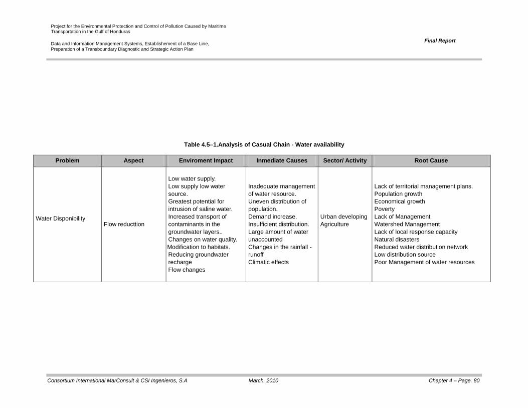
Project for the Environmental Protection and Control of Pollution Caused by Maritime Transportation in the Gulf of Honduras
Data and Information Management Systems, Establishement of a Base Line, Preparation of a Transboundary Diagnostic and Strategic Action Plan
Final Report
Consortium International MarConsult & CSI Ingenieros, S.A March, 2010 Chapter 4 – Page. 80
Table 4.5–1.Analysis of Casual Chain - Water availability
Problem Aspect Enviroment Impact Inmediate Causes Sector/ Activity Root Cause
Water Disponibility
Flow reducttion
Low water supply.
Low supply low water
source.
Greatest potential for
intrusion of saline water.
Increased transport of
contaminants in the
groundwater layers..
Changes on water quality.
Modification to habitats.
Reducing groundwater
recharge
Flow changes
Inadequate management
of water resource.
Uneven distribution of
population.
Demand increase.
Insufficient distribution.
Large amount of water
unaccounted
Changes in the rainfall -
runoff
Climatic effects
Urban developing
Agriculture
Lack of territorial management plans.
Population growth
Economical growth
Poverty
Lack of Management
Watershed Management
Lack of local response capacity
Natural disasters
Reduced water distribution network
Low distribution source
Poor Management of water resources
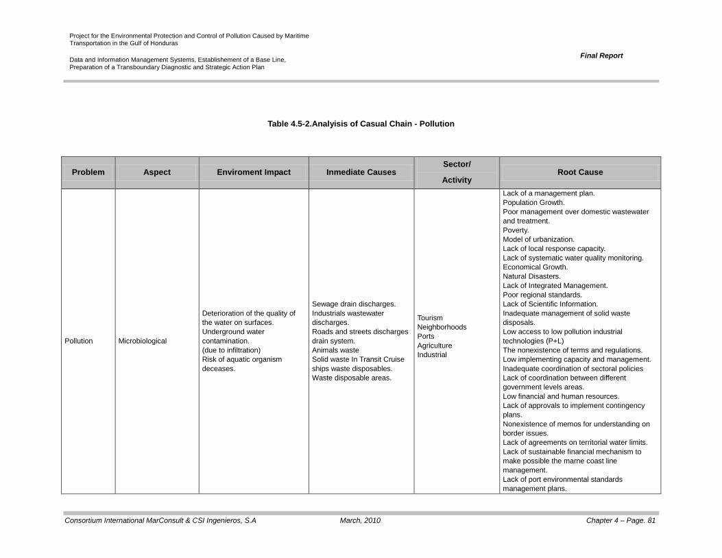
Project for the Environmental Protection and Control of Pollution Caused by Maritime Transportation in the Gulf of Honduras
Data and Information Management Systems, Establishement of a Base Line, Preparation of a Transboundary Diagnostic and Strategic Action Plan
Final Report
Consortium International MarConsult & CSI Ingenieros, S.A March, 2010 Chapter 4 – Page. 81
Table 4.5-2.Analyisis of Casual Chain - Pollution
Problem Aspect Enviroment Impact Inmediate Causes Sector/
Activity Root Cause
Pollution Microbiological
Deterioration of the quality of
the water on surfaces.
Underground water
contamination.
(due to infiltration)
Risk of aquatic organism
deceases.
Sewage drain discharges.
Industrials wastewater
discharges.
Roads and streets discharges
drain system.
Animals waste
Solid waste In Transit Cruise
ships waste disposables.
Waste disposable areas.
Tourism
Neighborhoods
Ports
Agriculture
Industrial
Lack of a management plan.
Population Growth.
Poor management over domestic wastewater
and treatment.
Poverty.
Model of urbanization.
Lack of local response capacity.
Lack of systematic water quality monitoring.
Economical Growth.
Natural Disasters.
Lack of Integrated Management.
Poor regional standards.
Lack of Scientific Information.
Inadequate management of solid waste
disposals.
Low access to low pollution industrial
technologies (P+L)
The nonexistence of terms and regulations.
Low implementing capacity and management.
Inadequate coordination of sectoral policies
Lack of coordination between different
government levels areas.
Low financial and human resources.
Lack of approvals to implement contingency
plans.
Nonexistence of memos for understanding on
border issues.
Lack of agreements on territorial water limits.
Lack of sustainable financial mechanism to
make possible the marne coast line
management.
Lack of port environmental standards
management plans.

Project for the Environmental Protection and Control of Pollution Caused by Maritime Transportation in the Gulf of Honduras
Data and Information Management Systems, Establishement of a Base Line, Preparation of a Transboundary Diagnostic and Strategic Action Plan
Final Report
Consortium International MarConsult & CSI Ingenieros, S.A March, 2010 Chapter 4 – Page. 82
Table 4.5–2. Analysis of Casual Chain – Pollution (continuation)
Table 5–2.(Continue)
Problem Aspect Enviroment Impact Inmediate Causes Sector/Activity Root Cause
Pollution Eutrophicatión
Underground water
contamination.
Deterioration of the quality of
the water on surfaces.
due to infiltration)
Lose of Habitats
Algae increase population.
Toxic substances on water.
Sewage drain discharges.
Industrials wastewater
discharges.
Roads and streets
discharges drain system.
Animals waste
Solid waste In Transit
Cruise ships waste
disposables.
Waste disposable Lixivium
dumps open pit and / or
landfill.
Agriculture waste
disposables.
Agriculture water
discharges.
Tourism
Urbanization
Ports
Agriculture
Industrial
Aquaculture
Lack of territorial management plans.
Population Growth.
Poor management of domestic wastewater Poverty.
Urban modeling.
Lack of local response capacity.
Lack of systematic monitoring of water quality
Economical Growth.
Natural disasters.
Lack of integrated management.
Unsustainable management of agricultural products.
Lack of regional quality standards.
Lack of scientific information.
Inadequate handling of waste in the region.
Low access to green technologies. (P+L)
Nonexistence of policies and regulations.
Lack of capacity for control and implementation of standards.
Lack of coordination on sector policies.
Lack of coordination between different levels of the
government.
Not enough financial and human resources
Lack of approvals to implement contingency plans.
Nonexistence of memos for understanding on border issues.
Lack of agreements on transboundary problems.
Lack of sustainable financial mechanism to make possible the
marne coast line management.
Lack of port environmental standards management plans.
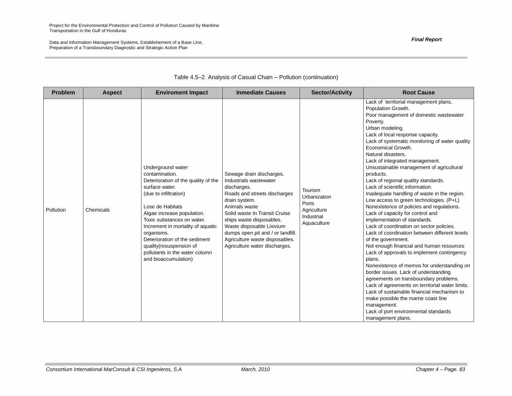
Project for the Environmental Protection and Control of Pollution Caused by Maritime Transportation in the Gulf of Honduras
Data and Information Management Systems, Establishement of a Base Line, Preparation of a Transboundary Diagnostic and Strategic Action Plan
Final Report
Consortium International MarConsult & CSI Ingenieros, S.A March, 2010 Chapter 4 – Page. 83
Table 4.5–2. Analysis of Casual Chain – Pollution (continuation)
Problem Aspect Enviroment Impact Inmediate Causes Sector/Activity Root Cause
Pollution Chemicals
Underground water
contamination.
Deterioration of the quality of the
surface water.
(due to infiltration)
Lose de Habitats
Algae increase population.
Toxic substances on water.
Increment in mortality of aquatic
organisms.
Deterioration of the sediment
quality(resuspension of
pollutants in the water column
and bioaccumulation)
Sewage drain discharges.
Industrials wastewater
discharges.
Roads and streets discharges
drain system.
Animals waste
Solid waste In Transit Cruise
ships waste disposables.
Waste disposable Lixivium
dumps open pit and / or landfill.
Agriculture waste disposables.
Agriculture water discharges.
Tourism
Urbanization
Ports
Agriculture
Industrial
Aquaculture
Lack of territorial management plans.
Population Growth.
Poor management of domestic wastewater
Poverty.
Urban modeling.
Lack of local response capacity.
Lack of systematic monitoring of water quality
Economical Growth.
Natural disasters.
Lack of integrated management.
Unsustainable management of agricultural
products.
Lack of regional quality standards.
Lack of scientific information.
Inadequate handling of waste in the region.
Low access to green technologies. (P+L)
Nonexistence of policies and regulations.
Lack of capacity for control and
implementation of standards.
Lack of coordination on sector policies.
Lack of coordination between different levels
of the government.
Not enough financial and human resources
Lack of approvals to implement contingency
plans.
Nonexistence of memos for understanding on
border issues. Lack of understanding
agreements on transboundary problems.
Lack of agreements on territorial water limits.
Lack of sustainable financial mechanism to
make possible the marne coast line
management.
Lack of port environmental standards
management plans.

Project for the Environmental Protection and Control of Pollution Caused by Maritime Transportation in the Gulf of Honduras
Data and Information Management Systems, Establishement of a Base Line, Preparation of a Transboundary Diagnostic and Strategic Action Plan
Final Report
Consortium International MarConsult & CSI Ingenieros, S.A March, 2010 Chapter 4 – Page. 84
Table 4.5–2.Analysis of Casual Chain – Pollution (continuation)
Problem Aspect Enviroment Impact Inmediate Causes Sector/Activity Root Cause
Pollution Solid Waste
Deterioration of the superficial
water quality
Deterioration of the
subterranean water quality (due
to infiltration)
Loss of habitats
Increase in the mortality of
water organisms
Deterioration of Beaches
Changes in the sediment
composition
Solid waste discharge (urban
and industrial)
Drainage discharges (street
washing, etc.)
Solid waste discharged in
streams
Solid waste generated by
vessels (cruise ships and
smaller vessels)
Solid waste generated by
beach users
Solid waste generated by the
construction of coastal urban
developments
Existence of clandestine
dumps
Increase in the generation of
residues
Tourism
Urban development
Ports
Agriculture
Industrial
Forestation
Lack of territorial ordinance plans
Population growth
Insufficient management of house waste waters
(Lack of solid holdup)
Non sustainable management of agricultural
products
Non sustainable management of solid waste
Poverty
Urban development method
Lack of local response capacity
Lack of social awareness
Economic growth
Natural disasters
Lack of integrated management of basins
Lack of quality standards (locally, nationally, and/or
regionally)
Lack of scientific information
Inadequate solid waste management
Insufficient access to cleaner production
technologies
Regulation gaps
Insufficient capacity for the control and execution of
regulations
Inadequate coordination of sectorial policies
Lack of coordination among the different
government levels (national and local)
Insufficient human and financial resources
Lack of approval and execution of contingency
plans (during floods, a great volumes of solid
residues enter the bodies of water)
Lack of understanding agreements on
transboundary problems
Lack of agreements on territorial water limits
Lack of financial mechanisms that make the coastal
and marine management sustainable
Lack of environmental management in ports
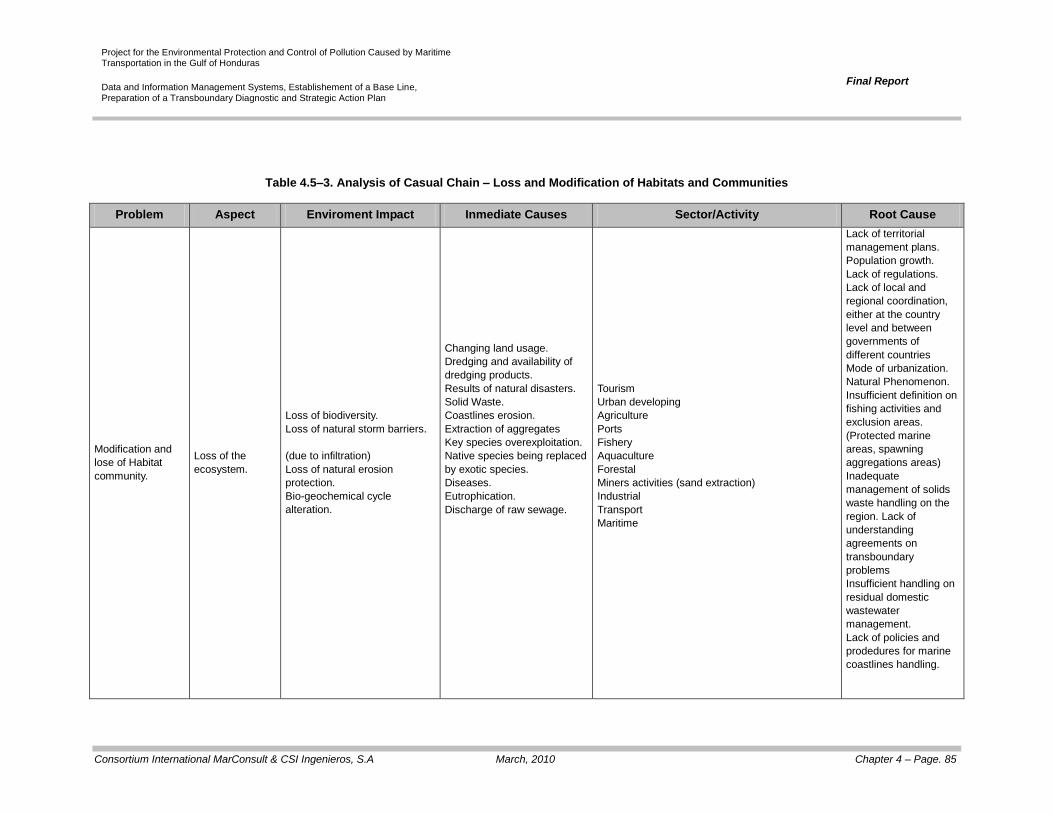
Project for the Environmental Protection and Control of Pollution Caused by Maritime Transportation in the Gulf of Honduras
Data and Information Management Systems, Establishement of a Base Line, Preparation of a Transboundary Diagnostic and Strategic Action Plan
Final Report
Consortium International MarConsult & CSI Ingenieros, S.A March, 2010 Chapter 4 – Page. 85
Table 4.5–3. Analysis of Casual Chain – Loss and Modification of Habitats and Communities
Problem Aspect Enviroment Impact Inmediate Causes Sector/Activity Root Cause
Modification and
lose of Habitat
community.
Loss of the
ecosystem.
Loss of biodiversity.
Loss of natural storm barriers.
(due to infiltration)
Loss of natural erosion
protection.
Bio-geochemical cycle
alteration.
Changing land usage.
Dredging and availability of
dredging products.
Results of natural disasters.
Solid Waste.
Coastlines erosion.
Extraction of aggregates
Key species overexploitation.
Native species being replaced
by exotic species.
Diseases.
Eutrophication.
Discharge of raw sewage.
Tourism
Urban developing
Agriculture
Ports
Fishery
Aquaculture
Forestal
Miners activities (sand extraction)
Industrial
Transport
Maritime
Lack of territorial
management plans.
Population growth.
Lack of regulations.
Lack of local and
regional coordination,
either at the country
level and between
governments of
different countries
Mode of urbanization.
Natural Phenomenon.
Insufficient definition on
fishing activities and
exclusion areas.
(Protected marine
areas, spawning
aggregations areas)
Inadequate
management of solids
waste handling on the
region. Lack of
understanding
agreements on
transboundary
problems
Insufficient handling on
residual domestic
wastewater
management.
Lack of policies and
prodedures for marine
coastlines handling.

Project for the Environmental Protection and Control of Pollution Caused by Maritime Transportation in the Gulf of Honduras
Data and Information Management Systems, Establishement of a Base Line, Preparation of a Transboundary Diagnostic and Strategic Action Plan
Final Report
Consortium International MarConsult & CSI Ingenieros, S.A March, 2010 Chapter 4 – Page. 86
Table 4.5–3.Analysis of Casual Chain – Pollution (continue)
Problem Aspect Enviroment Impact Inmediate Causes Sector/Activity Root Cause
Modification and
loss of Habitat and
community.
Modification to the
ecosystem
Modification of natural
production.
Modification of biodiversity
including lose of species.
Urban developing (modifying
ground).
Dredging and availability of
dredging products.
Solids Waste.
Unsustainable exploitation
practices.
Native species being replaced
by exotic species.
Diseases
Eutrophication.
Discharge of raw sewage.
Tourism
Urban developing.
Agriculture
Ports
Fisheries
Aquaculture
Forest
Transportation Maritime
Lack of territorial management plans.
Good handling practice
implementation.
Population growth
Lack of regulation
Lack of local and regional
coordination, either at the country
level and between governments of
different countries
Urbanization Model
Natural phenomenon
Insufficient definition on fishing
activities and exclusion areas.
Falta de acuerdos de entendimiento
sobre problemas transfronterizos
(Protected marine areas, spawning
aggregations areas)
Inadequate management of solids
waste handling on the region.
Insufficient handling on residual
domestic wastewater management.
Lack of policies and prodedures for
marine coastlines handling.

Project for the Environmental Protection and Control of Pollution Caused by Maritime Transportation in the Gulf of Honduras
Data and Information Management Systems, Establishement of a Base Line, Preparation of a Transboundary Diagnostic and Strategic Action Plan
Final Report
Consortium International MarConsult & CSI Ingenieros, S.A March, 2010 Chapter 4 – Page. 87
Table 4.5–2.Analysis of Casual Chain – Pollution (continuation)
Problema Aspecto Impacto Causas Inmediatas Sector/Actividad Causa Raíz
Pollution Solid Waste
Deterioration of the superficial
water quality
Deterioration of the
subterranean water quality (due
to infiltration)
Loss of habitats
Increase in the mortality of
water organisms
Deterioration of Beaches
Changes in the sediment
composition
Solid waste discharge
(urban and industrial)
Drainage discharges (street
washing, etc.)
Solid waste discharged in
streams
Solid waste generated by
vessels (cruise ships and
smaller vessels)
Solid waste generated by
beach users
Solid waste generated by
the construction of coastal
urban developments
Existence of clandestine
dumps
Increase in the generation
of residues
Tourism
Urban development
Ports
Agriculture
Industrial
Forestation
Lack of territorial ordinance plans
Population growth
Insufficient management of house waste waters
(Lack of solid holdup)
Non sustainable management of agricultural
products
Non sustainable management of solid waste
Poverty
Urban development method
Lack of local response capacity
Lack of social awareness
Economic growth
Natural disasters
Lack of integrated management of basins
Lack of quality standards (locally, nationally,
and/or regionally)
Lack of scientific information
Inadequate solid waste management
Insufficient access to cleaner production
technologies
Regulation gaps
Insufficient capacity for the control and
execution of regulations
Inadequate coordination of sectorial policies
Lack of coordination among the different
government levels (national and local)
Insufficient human and financial resources
Lack of approval and execution of contingency
plans (during floods, a great volumes of solid
residues enter the bodies of water)
Lack of understanding agreements on
transboundary problems
Lack of agreements on territorial water limits
Lack of financial mechanisms that make the
coastal and marine management sustainable
Lack of environmental management in ports

Project for the Environmental Protection and Control of Pollution Caused by Maritime Transportation in the Gulf of Honduras
Data and Information Management Systems, Establishement of a Base Line, Preparation of a Transboundary Diagnostic and Strategic Action Plan
Final Report
Consortium International MarConsult & CSI Ingenieros, S.A March, 2010 Chapter 4 – Page. 88
Table 4.5–3. Analysis of Casual Chain – Loss and Modification of Habitats and Communities
Problem Aspect Impact Immediate Causes Sector/Activity Root Cause
Modification and Loss of
the community and the
habitat
Loss of ecosystems
Loss of biodiversity
Loss of barriers against natural
storms
Loss of natural protection
against erosion
Alteration of the bio-
geochemical cycle
Modification of the use of
soil
Dredging and disposal of
dredging products
Results of natural disasters
Solid waste
Coastal erosion
Aggregates extraction
Over exploitation of key
species
Replacement of native
species for exotic species
Diseases
Eutrophication
Discharge of untreated
waste water
Tourism
Urban development
Agriculture
Ports
Fishing
Fish farming
Reforestation
Mining (sand
extraction)
Industrial
Maritime Transport
Lack of territorial ordinance plans
Lack of good practices management execution
Increase of Population
Lack of regulations
Lack of coordination (local and regional)
Urban development modality
Natural phenomenon
Insufficient defining of fishing exclusion areas
(protected marine areas and addition of
spawning zones)
Insufficient management of waste waters
Non sustainable solid waste management
Lack of coastal management policies
Modification of
Ecosystems
Modification of the natural
productivity
Modification of biodiversity
(including the loss of species)
Modificación de
ecosistemas
Modificación de la
productividad natural
Modificación de la
biodiversidad (incluyendo
pérdida de especies)

Project for the Environmental Protection and Control of Pollution Caused by Maritime Transportation in the Gulf of Honduras
Data and Information Management Systems, Establishement of a Base Line, Preparation of a Transboundary Diagnostic and Strategic Action Plan
Final Report
Consortium International MarConsult & CSI Ingenieros, S.A March, 2010 Chapter 4 – Page. 89
Table 4.5–4.Analysis of Casual Chain – Non Sustainable Exploitation of Live Resources
Problem Aspect Impact Immediate Causes Sector/Activity Root Cause
Non sustainable
exploitation of live
resources
Over exploitation
Reduction of key species
Changes in the trophic chains
Changes in the composition of
biologic communities
Fishing arts and
mechanization
Drop of recruitment levels
Drop of habitats
Fishing in added zones
Fishing
Lack of regulation
Lack of coordination between the governments
for the establishment of areas and closed
seasons
Lack of scientific knowledge
Incidental fishing Changes in the composition of
biologic communities
Fishing arts and
mechanization
Incidental fishing in with
nets

Project for the Environmental Protection and Control of Pollution Caused by Maritime Transportation in the Gulf of Honduras
Data and Information Management Systems, Establishement of a Base Line, Preparation of a Transboundary Diagnostic and Strategic Action Plan
Final Report
Consortium International MarConsult & CSI Ingenieros, S.A March, 2010 Chapter 4 – Page. 90
Table 4.5–5. Situation of transboundary rivers
River Countries Main detected problems Impact Causes
Sarstún Belize – Guatemala
Water:
Dissolved Oxygen
(excedes the guide value)
Suspended solids
Oils and greases
Sulfur
Loss of water quality
Deterioration of natural environments and
of biologic communities
Changes in landscape
Soil Erosion
Lixiviation of solid residues
Lixiviation of agricultural products
Presence of fuel
Sediment
Nickel (more elevated
value)
Copper (exceeds TEL)
Pentacosane
Motagua Guatemala – Honduras
Water pH
Suspended solids Reduction of the photic layer affecting the
aquatic fauna and flora
Soil erosion
Sediment
No high concentrations
were found for any
parameter