Participatory Varietal Selection, Participatory Plant Breeding

Training workshop on Participatory Integrated
Climate Services for Agriculture (PICSA) 04-08/May/2017
Bougouni, Mali
Organized by
International Crops Research Institute for the Semi-Arid Tropics (ICRISAT – Mali)
Funded by Africa RISING program / ICRISAT-Mali
A report made by:
Andree Nenkam & Bouba Traoré (ICRISAT)

I) Introduction
ICRISAT has launched a new project, under the Africa RISING program, whose objective is
to scale climate services in Mali, more precisely in Bougouni. The aim of the project is to
capacitate farmers and farming communities so that they are able to practice more
productive, resilient, profitable and sustainable intensified crop-livestock systems linked
to markets. To reach its planned objectives, ICRISAT decided to implement the
Participatory Integrated Climate Services for Agriculture (PICSA) approach. This approach,
created by the University of Reading, aims at providing famers with locally specific climate
information, together with diverse locally pertinent options on crops, livestock and other
livelihood activities to aid their decision making and therefore improve their livelihood.
The PICSA approach is now being implemented in West Africa (Burkina Faso, Ghana, Mali
and Senegal) under the CCAFS funded project “Capacitating African Smallholders with
Climate Advisories and Insurance development CASCAID)” lead by ICRISAT and ICRAF, in
Kenya, Rwanda, Uganda, Tanzania, Zimbabwe and Columbia.
In this regard, ICRISAT in collaboration with ICRAF and Mali-Meteo, has organized a
“training of trainers (TOT)”, from 04th to 08th of May 2017 in Bougouni, to capacitate Africa
RISING field agents and extension officers of other institutions with the PICSA approach.
There were in total 19 participants, including one female, from diverse institutions,
RICOB, AOPP, FENABE, Ministry of Agriculture, SLPIA, Ministry of Water and Forestry,
CMDT, AVRDC, and 6 resource persons from Mali-Meteo, ICRAF and ICRISAT. This report
therefore consists of brief summaries of each session of the training per day including the
field day, as well as the participants’ training evaluation (Appendix 2).
II) Training’s Sessions 1) Day 1
The training was opened with two speeches by Mr. Dicko Mahamadou Moctar
(Coordinator of the Africa RISING program in Bougouni) and Dr. Bouba Traoré
(Scientist at ICRISAT) who both welcomed the participants and encouraged
them to take the best out of the training.
Introduction: objectives and content of the training
The first session of the day Was made of a talk on the main objectives of the
workshop and the content of the training which were to strengthen the capacity of the
participants so that they can (1) facilitate farmers to make informed decisions based

on (i) accurate, location specific, climate and weather information and (ii) locally
relevant crop, livestock and livelihood options, (2) use participatory planning tools to
aid decision making; (3) by the end of the course, use the PICSA approach with
farmers. The presenter also stressed that the PICSA approach, a step by step one, was
designed for field staffs to (1) complement the job they are already doing with farmers
and (2) help them doing the job better with new tools, new information and data. She
concluded this session by giving the content of the 5 days training..
Introduction to the PICSA approach The aim of the presentation was to provide general information about the
PICSA approach. The presenter started off with specifying that the approach
focusses on the farmer, by bringing climate information (historical time series
and seasonal forecast), developing diverse options and making use of decision
making tools to help them individually make informed decision based on their
specific context. The presenter went on with specifying that the approach is
divided into 12 steps categorized into 4 periods (i) long before the season
where farmers are being provided with locally specific climate information,
crop, livestock and other livelihood options, together with decision making
tools to make informed decisions and therefore plan for the upcoming rainy
season; (ii) just before the season, where farmers received the climate
seasonal forecast to finalize plans made in (i); (iii) during the season, when
farmers plan and finalize their daily activities based on short term forecast and
(iv) after the season, where the approach is evaluated. The presenter
continued with introducing the twelve steps that make PICSA.
What is climate variability and change? This presentation aimed at explaining to participants the difference between
climate change and climate variability. After giving the definition of climate,
the presenter went on with defining climate variability – which is a natural
year to year dynamic of the climate (e.g.: seasonal rainfall totals year to year
dynamic), and continued with a definition of climate change – which is the
long term change (increasing or decreasing) in climate pattern observed over
a long period of time (30 years and above) and this change is usually caused
by anthropogenic activities.
What does the farmer currently do?
This is the first step of the PICSA approach (step A). Its aim is to i) identify and
understand the main activities carried by the farmer/household, its resources,
how those resources are used and what are the produce of his activities and
ii) understand how each of those activities are affected by the climate. This

step consists of two participatory tools, - the Resource Allocation Map (RAM)
which satisfies objective i) above and which helps the farmer to improve
activities and resource mapping; the Seasonal Calendar which satisfies
objective ii) above and which also helps farmers to identify which types of
climate services he may need to succeed in his activities. After having been
explained how to draw these tools, participants were split into three groups
to exercise themselves on the tools just learnt. The presenter clearly stressed
on the fact that each of these tools is drawn individually by each farmer as
farmers are different.
Figure 1: Example of Resource Allocation map (RAM - first picture) and Seasonal Calendar (SC)
Historical Climate Information
This is the second step of the PICSA approach (step B) and its aim is to explain
to farmers how rainfall data are collected, compare their perception with
historical graphics and help them understand the climate of their locality which
maybe be useful in their decision making. It also helps them to be aware of
causes other than the climate which may be additional sources of the challenges
they are facing, and together with the field agents, identify possible solution to
mitigate their negative impacts. Using historical graphics of Bougouni,
participants were tasked to identify if there is climate change and variability,
and compare the information with farmer’s perceptions. The historical graphs
consist of seasonal rainfall totals, start of the rain dates, length of the rainy
season, number of rainy days during the season, dry spells during month of critic
growth of the plant, end of the rainy season, and temperature data.
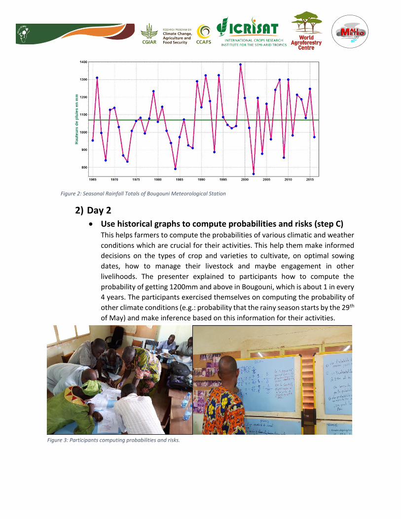
Figure 2: Seasonal Rainfall Totals of Bougouni Meteorological Station
2) Day 2
Use historical graphs to compute probabilities and risks (step C) This helps farmers to compute the probabilities of various climatic and weather
conditions which are crucial for their activities. This help them make informed
decisions on the types of crop and varieties to cultivate, on optimal sowing
dates, how to manage their livestock and maybe engagement in other
livelihoods. The presenter explained to participants how to compute the
probability of getting 1200mm and above in Bougouni, which is about 1 in every
4 years. The participants exercised themselves on computing the probability of
other climate conditions (e.g.: probability that the rainy season starts by the 29th
of May) and make inference based on this information for their activities.
Figure 3: Participants computing probabilities and risks.

Crop, livestock and other livelihoods options (step D) The objectives of this step is to develop together with the farmer, a range of
options on crop, livestock, and other livelihoods already existing in or that may
be useful to the locality, identify their performance in difference climate
scenarios and also additional related risks, so that every farmer, be it poor or
rich, female or male, may find what best suits his/her household. In Addition
information provided for each option include, who does the option, what is the
benefit and who benefits it, and what is the time needed to start benefiting? For
example, a crop option matrix, consists of all practices, locally existing or new,
that (may) contribute to the increase of yield production in the locality. After
having understood how to develop an option matrix, participants were tasked
to develop one for crop (group 1), livestock (group 2) and other livelihoods
(group 3).
Figure 4: participants presenting their work on options matrices on crops, livestock and other livelihoods
Option by context (step E) . In this step, farmers are asked to look through the options listed in step D and
identify which ones they would like to try based on their specific context (poor,
rich, female, male, shepherd, fishermen …).
Compare options and plan for the next season (step F) This step aim at helping the farmer scrutinizing various options selected in step
D, to increase their capacity to exactly decide which option (s) is (are) best for
his/her household and plan for the upcoming rainy season. The farmer makes
use of the Participatory Budget to achieve this purpose; this is a decision making
tool used to (i) assess the required investments and possible benefits of various
options selected in step D; (ii) help farmers choose which options best suit their

household; and (iii) plan and prepare how to integrate those options in the next
rainy season activities. The presenter explained to the auditors how to create a
participatory budget for budgetisable activities and tasked them to develop
their own participatory budget for specific options just like in step D.
Figure 5: Example of Participatory Budget – Decision making tool
The farmer decides (step G) The aim of this step is to -help farmers make the best decision for the next
cropping season based on all information received and on their specific context,
and -assist them in the integration of those decisions in their various activities
(by looking for sustainable ways to implement those decision). The participants
were advised not to decide for farmers but to raise the awareness on possible
risks and advantages for various context specific options that may suit their
individual household. Emphasis was put on the fact that the farmer should be
the one taking the decisions because he is the one to bear all the risks. This step
also lead farmer to update RAM and SC made in step 1.
This marks the end of the first phase of the PICSA approach, long before the season, where
farmers rely on historical climate information, various options on crop, livestock and other
livelihoods, and on decision making participatory tools to make informed decision and plan their
various activities ahead of the season. They subsequently wait for the seasonal climate forecast
to finalize those plans.
Seasonal climate forecast (SCF) and final plans ( Step H & I – second
phase of PICSA) These steps Helps farmers understand SCF (understand the meaning of the
climate being normal, below or above normal using the terciles of seasonal
rainfall totals), understand the implication of the SCF of the current year and
modify the plans made in the first phase if these are not similar to those
implications, and also based on the performance of the SCF provided by the
national meteorological Agency. The presenter started off, by presenting the
different types of forecast usually provided by Mali-Meteo as well as brief
interpretation of those, and gave a homework to participants. The homework
consisted of making inferences on agriculture, livestock, agroforestry, fisheries
and other livelihoods, based on various seasonal forecast scenarios.
Figure 6: Seasonal Rainfall Totals of Bougouni Meteorological Station divided into three equal part.
3) Day 3
Short term forecast and warnings, and final plans ( Step J & K – third
phase of PICSA) The short term forecast and warnings help farmers make decisions on their daily
activities. These steps consist of helping farmers understand short term forecast
and warnings they received, be it via radio or phone messages, how these
information can be interpreted and used in their day to day activities. The
meaning of the various symbols and terminologies used in short term forecast
were explained to the guests.
The third day then continued with a preparation of the field day, the day where participants were
to practice what they had been learning and identified room for improvement. The participants
where given a brief summary of PICSA, from step A to K, with explanations on how each step are
consistently connected to each other. In addition they received a short presentation on
facilitation tips and later prepared for the field day.

4) Day 4 – Field Day The field day was at Flola, a village located at 25 km from Bougouni. Three groups
were formed, one with only women, one with old men and another one with
young men. There were in total 50 farmers, 20 females and 30 males. Participants
used this opportunity to practice what they had been learning for the past three
days. Farmers were very enthusiastic with the historical climate information
presented to them. The group of women mentioned the need to also be involved
in the rainfall recording using the existing manual rain gauge installed in the
village. Participants left Bougouni town at 7h50 am and returned at 4 pm in the
afternoon.
Figure 6: Field day - gathering of participants and farmers of Flola (first picture), and women farmers computing probabilities (second picture)
5) Day 5 The fifth day of the training was mainly marked by:

Reports of the field day from the three groups formed – groups reported the field
day as very useful as it helped them to evaluate themselves. All groups reported that
farmers were very keen with understanding the climate information presented to
them, though teaching them how to compute probabilities and risks was not an easy
task due to the time constraints and translation of concepts into the local language.
The women group requested the field agents to make an appeal to the men of the
village so that these latter can involve them into rainfall recording. An appeal was
made by the field agents for the titles of the various graphics to be translated in local
language for future trainings.
Discussion on input accessibility – Aside providing farmers with useful
information to aid their decision making, PICSA also aims at helping them to
implement those decisions as far as inputs accessibility is concerned. During this
training actors providing inputs (seeds, fertilizers, herbicides and others) were invited.
These actors include CMDT, Dalabani Cooperative, SLPIA and Ministry of Agriculture.
Each informed participants of the various input accessible from their institutions. This
information should be shared with farmers, should there be input not accessible from
their localities.
Meeting with Africa Rising field agents – A short meeting was organized with
field agents of the project to establish operational plans to share the PICSA approach
with farmers in the week following the end of the training. There were in total height
field agents and a couple was allocated to each of the four villages. The field agents
Using a road map developed by Catherine Dembele and Djibril Dayamba from ICRAF,
It was agreed that about 4 to 6 meetings are required to completely implement PICSA
with farmers, though this can be highly influenced by farmer’s availability. The field
agents were also called to take advantage of the presence of the resource persons
and mention any challenge they had regarding the understanding of any concept of
the approach.
III) Conclusion The training successfully ended on Monday 8th of May with a word by Dr Bouba Traore,
who thanked all participants and resource persons for their hard work, and with
certificates handling. Africa RISING field agents confidently left the hall, looking forward
to start implementation in the fours Africa RISING villages (Dieba, Flola, Madina and
Sibirila). For this first year of the project 200 farmers are targeted. We are expecting to

reaching more farmers the coming year, and to scale out the approach to other Africa
RISING regions such Koutiala and Mopti.
IV) Appendices
Appendix 1 – Training program
Jour 1 Temps Thème Responsable Etape
8.30 30 Inscription Dicko Introd.
10 Mot de bienvenue et ouverture Dicko/Bouba
15 Présentation des participants
15 Introduction : Objectif et contenu de la formation Catherine
20 Généralités sur l’approche PICSA Djibril
Pause-café – 10.00-10.30 incl. photo
30 Climat, variabilité et changements du climat? Mali-Météo
1.30
Que fait le producteur ?
Carte d’allocation des ressources (exercice)
Calendrier saisonnier (exercice)
Bouba /Andrée - Etape A
10
Informations Climatiques Historiques
- Comment ont été collectées et traitées les
données historiques ?
Mali-Météo Etape B
20 Information Climatique Historique pour votre
localité 1: utilisation des graphiques (Exercice)
Andree
Déjeuner – 1.00-2.00
1h Information Climatique Historique cont.:
interprétation des graphiques (Exercice)
Andree
1h
Utilisation des graphiques pour calculer les
probabilités des conditions météorologiques et
climatiques (Exercice)
Andree Etape C
Pause-café – 16-16.30
30 Revue de la journée
Jour 2 – débute à 8.00
8.00 8.15
Revue des activités du jour 1 et programme du
jour 2
Goita / Dembele
Participants
8.15 8.30 Information Climatique Historique cont.:
interprétation des graphiques (Exercice)
Andrée
8.30 9.30
Utilisation des graphiques pour calculer les
probabilités des conditions météorologiques et
climatiques (Exercice)
Andrée Étape C
9.30 10.10 Options pour l’agriculture, la production animale
et autres moyens de subsistance (présentation)
Bouba/Djibril /
Catherine
Etape D
Pause-café – 10.10-10.30
10.30 11.30 Options pour l’agriculture, la production animale
et autres moyens de subsistance (exercices)
Bouba / Djibril /
Catherine
Etape D

11.30 12.00 Restitution Bouba / Djibril /
Catherine
Etape D
12.00 12.30 Options par contexte Andrée Etape E
Déjeuner – Prière : 12.30-14.00
14.00 15.20
Planification pour les cultures sélectionnées, les
options de production animale et autres moyens
de subsistance (Budgets Participatifs) /
Restitutions de l’exercice sur le budget
participatif
Catherine / Andrée Etape F
15.20 15.30 Le producteur décide Andree G
15.30 16.00
Qu’est-ce que la prévision saisonnière?
Comment est-elle produite et communiquée,
quels sont ses avantages et ses limites?
Mali-Météo Etape H
Pause-café – 16.00-16.10
16.10 16.307.
00
Comprendre et interpréter la prévision
saisonnière (graphique des terciles) - Exercice
Comment communiquer avec les producteurs ?
Adaptation des plans des activités à l’information
climatique (Se préparer à modifier les plans)?
Mali-Météo/
Jour 3 - débute à 8.30
8.30 8.45 Revue du jour 2 Maiga/ Bamba
Participants
8.45 10.00
Comprendre et interpréter la prévision
saisonnière (graphique des terciles) - Exercice
Comment communiquer avec les producteurs ?
Adaptation des plans des activités à l’information
climatique (Se préparer à modifier les plans)?
Mali Meteo Etape J
pause-café – 10.-10.30
10.30 11.00 Prévisions à court terme et alertes. Comment et
quand sont-elles produites et communiquées ?
Mali-Météo Etape J
11.00 11.30
Interpréter les messages d’alerte et de prévision à
court terme (exercice)
Quel est le contenu des prévisions de court et
moyen termes que vous recevez?
Comment utilisez-vous ces prévisions?
(Comment améliorer la communication?)
Mali-Météo e Etape J
11.30 12.30 Revue du processus et des points importants
(récapitulatif de toute l’approche PICSA)
Djibril
Déjeuner – 13.00-14.00
14.00 14.30
Planification de la pratique de terrain
Information concernant la communauté
Objectifs des travaux de terrain
Dicko/ Djibril
14.30 14.45 Astuces pour la facilitation Catherine
14.45 16.40 Préparer le matériel et pratiquer les exercices
pour la pratique de terrain
Participants /
organisateurs

Discussion dans les groupes (Identification des
animateurs de groupes/étapes, etc.)
Pause-café – 15.40-15.45
Jour 4 débute à 8.00
Pratique de terrain dans le village de Flola Participants /
Organisateurs
jour 5 débute à 8.30
8.30 9.30
Discussion, évaluation, leçons apprises (en
groupes suivi de rapportage en plénière)
Catherine /
Djibril/Andrée
30 min,
30 min,
min
9.30 10.30
Discussion sur l’accès aux intrants (semences,
etc.)
Production et circuits de distribution des
semences améliorés
CMDT,
Cooperative de
Dalabani, SLPIA
60 min
Pause-café 10.30 – 11.00
11.00 11.10 Revue sur l’approche PICSA et de ses
composants clés
Djibril
11.10 11.30 Evaluation de la formation Andree/Dicko 20 min
11:30 12:00 Remise des certificats et clôture Participants 30 min
Déjeuner – 12.00-13.00
13.00 14.30
Rencontre avec agents d’Africa RISING
Appendix 2 – Training Evaluation summary by
Participants: What aspect of the trainings participants liked? Resource Allocation Maps (RAM)
Climate information : understanding the difference between climate variability and change, how to make use of historical climate information (graphics), provided by Mali Meteo, to compute risks of various events happening, and seasonal climate forecast (SCF)
Participatory budget
Crop, livestock and other livelihood options
What else participants have learned: How important it is that the farmer should be the one who decides
The importance of considering climate information (eg: SCF) in decision making for agricultural activities
Various actors in the agricultural sector, particularly farmers, should change their behavior in view of the situation posed by an increasing climate variability and change

How the CMDT (Companie Malienne de Textile) loan inputs to farmers
About the existence of the GLAM (Groupe Locaux Agro-Meteorologiques) I Bougouni
What additional information/activity people may have loved to have? Technologies to fight against crop diseases and insects
Do field experiments to help them choose improved varieties and hybrids
Technology to fight against Striga
Reforestation
How to collect rainfall information using a rain gauge
Human activities that lead to climate change
Strategies to help farmers commercialized their produce
Suggestions:
Translation of the field manual into local languages to ease use by literate farmers
Increase the time of the training ( longer than just 5 days)
Most of the participants found each aspect of the training pertinent or very pertinent.