Training Need Assessment and Designing Training Methods ... · Training Need Assessment and...
24
Training Need Assessment and Designing Training Methods for INSPIRE Capacity Building Arif Cagdas AYDINOGLU (GTU, Turkey) Suleyman S. BİRHAN (DG GIS, Turkey) Technical Assistance Project for Capacity Building in the Horizontal Sector for the Implementation of INSPIRE Directive Contract No: TR2011/0327.21.01-01/001
Transcript of Training Need Assessment and Designing Training Methods ... · Training Need Assessment and...

Bu proje Avrupa Birliği ve Türkiye
Cumhuriyeti tarafından finanse edilmektedir.
Türkiye 2010 – Ön Katılım Desteği İçin Ulusal Program
Training Need Assessment and Designing
Training Methods for INSPIRE Capacity Building
Arif Cagdas AYDINOGLU (GTU, Turkey)
Suleyman S. BİRHAN (DG GIS, Turkey)
Technical Assistance Project for Capacity Building
in the Horizontal Sector for the Implementation of INSPIRE Directive
Contract No: TR2011/0327.21.01-01/001

Bu proje Avrupa Birliği ve Türkiye Cumhuriyeti
tarafından finanse edilmektedir.Content
Methodology For Training Need Assessment
Survey Study
Workspace Analyis
Data Requirement Analysis
GIS/SDI Qualification Analysis
Training Need Analysis
Assessing GIS Education At Universities (As‐is)
Results
Training context …

Bu proje Avrupa Birliği ve Türkiye Cumhuriyeti
tarafından finanse edilmektedir.Methodology For Training Need Assessment
The “Survey” study was prepared for analyzing workspace knowledge, GIS
qualification and training need of GIS employees.
Optimum need for specialists in the context of INSPIRE activities are
calculated by paying regard to the duties and responsibilities of public
institutions and/or organizations and local governments.
Considering the qualifications of currently available personnel at institutions
as specified with the survey;
- Training is provided to a certain number of personnel, who are defined
according to optimum need for specialists mentioned above
- have at least the determined levels of qualifications…

Bu proje Avrupa Birliği ve Türkiye Cumhuriyeti
tarafından finanse edilmektedir.The Survey Study
Survey consists of 15 questions listed under three sections;
Workspace Knowledge section about ministerial status of GIS employee and basic GIS activities and projects.
GIS Qualifications section will help to examine GIS employee’s trainings and competences
Training need section will help to analyze if employee needs training based on the course contents.

Bu proje Avrupa Birliği ve Türkiye Cumhuriyeti
tarafından finanse edilmektedir.Workspace Analysis
Please specify the status of your institution:
Answers Participants Ratio
Public Institution 1179 62,38%
Private Sector 41 2,17%
Local Govt. (Municipality, Provincial Special Administration and etc.) 651 34,44%
Academic (University, Research Agency and etc.) 9 0,48%
Others 10 0,53% Total 1890
Please inform at which stage your institution is in the context of Geographic Information Systems (GIS) activities and mention the basic projects/activities you took part in.
Answers Participants Ratio
No activities on GIS 906 47,94%
GIS implementation yet being designed 408 21,59%
GIS implementation activities in progress 188 9,95%
GIS implemented 388 20,53%
1890 people filled out the survey on 01.08.2016 until the date of completion on 31.10.2016.

Bu proje Avrupa Birliği ve Türkiye Cumhuriyeti
tarafından finanse edilmektedir.Workspace Analysis
Have you taken part in any workgroups related to development of INSPIRE or Turkish National GIS (TRGIS)?
Answer Participants Ratio
Yes 72 3,81%
No 1818 96,19%
If you answered “Yes” the above question, please briefly specify which activity(ies)/workgroups you have taken part in. Answer Participants Ratio
Metadata 46 63,89%
Network Services 14 19,44%
Data Standards 45 62,50%
Data Policy 21 29,17%
Monitoring and Reporting 20 27,78%

Bu proje Avrupa Birliği ve Türkiye Cumhuriyeti
tarafından finanse edilmektedir.Data Requirement Analysis
The table below provides INSPIRE data themes. Please mark data themes that you produce/use or need as to define the need for training in the context of your institution’s activities.
Answer Participants Ratio
Administrative Unit: Administrative Unit concept defines terms of references of a relevant administrative management unit and consists of boundaries and emerged to more effectively administrate a certain country or relevant region. Administrative Unit theme involves at a minimum a Country, NUTS (Nomenclature of Territorial Units for Statistics) Territories, Province, District, Municipality, Village, Quarter, Local Administrative Units, public institutions administrative responsibility areas, other local and sectoral special statistics units.
1090 57,67%
Cadastral Parcel: Cadastral Parcel theme involves totally geometric and legislative information of cadastral parcel and refers to real estates in spatial terms and contains information on property rights and other rights registered with land register for such real estates and also covers those areas, which have not to be mandatorily registered with land register by law. Cadastral theme involves, at a minimum, cadastral parcel, cadastral zoning, cadastral boundaries and basic property units.
1185 62,70%
Reference Coordinate Systems: This is a geometric monosemic system such as elevation, latitude, longitude and/or set of coordinates (x, y, z) based on geodesic horizontal and vertical datum to define geographic information in common reference and coordinates systems.
1071 56,67%
Geographic Grid Systems: Geographic Grid System is an index-map matrix or map section fragmentation defined on 2 axes as X and Y and has a certain size and grid cell size and joint origin points and standardized position.
924 48,89%
Address: Address is the definition of a piece of land or building as to its geographical position and function. The definition of address is expressed with address components and is related to numbering info at local level. Address theme, at a minimum, contains, road, street, building numbers, apartment number and post code.
1055 55,82%
Geographic Names: Geographic names are given to geographic regions, basins, cities, districts, quarters and villages as well as geographic or topographic characteristics of public or historical sites and structures and cover toponomic names (toponomic names, pronunciation and spelling of names).
936 49,52%
Protected Areas: Protected Areas involve the areas, which are designed and managed for a certain purpose of protection in the context of European Community and/or national legislation at international level.
947 50,11%
Hydrography: Hydrography covers lakes, rivers, basis and all geographic objects related thereto including coastal regions. Hydrography theme, at a minimum, includes basins, drainage basins, cryal zones, hydrophore lands, terrestrial water boundaries, shores, dead water, surface water, wetland, waterfalls, stream point, hydro focal points, rapids, or spring and leakage point, junction, passage, dam or set, embankment, ford, lock, artifacts, pipe, pump station, shoreline building, hydroelectric plant, floodgate, ground water body, shore water, lake, river, river or lake, surface water body, passage water, water body, streambed point, streambed connection, segregate passage of streambed and connection sequence for streambed.
711 37,62%
Transportation Networks: Transportation networks provide an integrated structure for the management of transportation networks related to highways, railways, maritime lines and airlines and details thereof. Geographical data that represents transportation contains data/information with regard to transportation networks and network junctions and other similar data/information. Transportation theme, at a minimum, covers transportation points, transportation connections, transportation areas, road connections, vehicular traffic areas, service areas, way areas, railway connections, railway station areas, railway yards, maritime transportation connections, fairways, port areas, air transportation connections, airport areas, runways, ramps, taxi strips and cableway connections.
979 51,80%
Topography: Topography is a digital elevation model for lands, sea and lake water surface including topographic elevation, territory, bathymetry and shoreline and refers to three-dimensional real topography of surface and can be used as basic data for many cartographic and geographic information system applications.
979 51,80%
Geology: Geology contains bedrock, strata, water layer and geomorphology and is defined by composition and structure.
741 39,21%
Land Cover: Land cover involves built-up areas, agricultural areas, forests and semi-natural areas, wetlands and physical and biological cover of ground surfaces formed by water bodies.
801 42,38%
Orthophotograph: Ortophotographs are map basis rectified by removing geometric distortions of images taken from satellites by airplanes and similar aircrafts. Orthophotograph theme, at a minimum, covers satellite images and aerial photographs.
1014 53,65%
Agricultural and Aquaculture Facilities: These facilities, at a minimum, cover production and industrial sites, production and industrial lands, production and industrial facilities, production and industrial facility sections, production and industrial building, agricultural equipment and production facilities.
440 23,28%
Land Administration and Planned Regions: This theme refers to the areas administered and regulated for notifications at international, national, regional and local levels and include dumping areas, restricted areas near drinking water resources, nitrate vulnerable zones, passages on seawater or territorial waters, waste storage areas, restricted zones, areas permitted for inspection and mining, river basin locations, relevant units and coastal region administrative areas.
790 41,80%
Atmospheric State: Atmospheric State covers physical states in the atmosphere including spatial data based on measuring, modelling and integration thereof and measurement station locations.
321 16,98%
Biogeographic Regions: These are areas with ecologic conditions, relatively homogenous with common characteristics.
348 18,41%
Building: Buildings are substructures or superstructures on land and water, either temporary or permanent, private or public, and fixed and mobile structures and facilities including their appurtenant, modifications and restorations. Moreover, building in the context of this theme is defined as top covered structures that can be individually be used and is designed for industrial, educational and other uses that help human live, accommodate, work, recreate, rest or worship or help protecting animals and properties allowing human to get inside. Building theme, at a minimum, covers application schema that enables 2-dimensional or 3-dimensional modelling of buildings.
931 49,26%
Energy Sources: Energy sources include energy sources of hydrocarbon, hydroelectrically energy, bioenergy, solar, wind or similar energy contents at places with depth/elevation information in the context of sources.
570 30,16%
Environmental Monitoring Facilities: This theme includes location and functioning of environmental monitoring facilities, observation and measurement of emulsions by institutional stakeholders, environmental instruments and biodiversity, vegetation ecological statuses and similar other ecosystem parameters.
431 22,80%
Habitat and Biotopes: These are geographic areas defined by certain ecological statuses, processes, structures and vital functions that define physically vital conditions for organisms including totally natural or semi natural geographic, abiotic and biotic territorial or aquatic areas.
360 19,05%
Human Health and Safety: This theme contains information that indicates individual welfare (fatigue, stress and etc.) or effects on health (biological indicators, decrease in fertility rate, epidemics and etc.) either directly (air pollution, chemicals, depleting ozone layer, noise and etc.) or indirectly (food, genetically modified organisms and etc.) connected to the environmental quality, epidemiology indicating geographical distribution of pathologies (allergy, cancer, respiration, disease and etc.) and is related to diseases (criteria that identify environmental health, statistical data that identify environmental health, health statistical data, bio-markers, healthcare service statistics, general health statistics) safety, incident, natural disaster related incidents, fire or explosion related incidents, hazardous substance related incidents and traffic incidents.
436 23,07%
Land Use: Land use covers the areas defined for functional scale or socio-economic purpose intended in the present of for future.
969 51,27%
Meteorological Geographic Details: This theme covers data such as weather conditions and their measurement; rain, temperature, vaporization, wind velocity and direction.
361 19,10%
Mineral Resources: This theme covers metal ores, industrial minerals and mineral resources of similar contents at places with depth and elevation information available.
380 20,11%
Natural Risk Areas: These areas include disaster areas (flood, forest fire, earthquake, landslide and etc.) elements at risk (buildings, human, settlements, hospitals, road, and etc.) risk zones and observed incidents.
776 41,06%
Oceanographic Geographic Details: This theme covers physical conditions of seas and lakes such as flow, salinity, wavelength and etc.
305 16,14%
Population Distribution and Demography: This theme contains population distribution and demography (geographical distributions that involve population structure, characteristics and activity levels of people in areas clustered with grid, region, administrative unit and/or other analytic units)
698 36,93%
Production and Industrial Facilities: This theme covers industrial production centers related totally with water treatment facilities, mining, and storage facilities in order to prevent and control pollution).
458 24,23%
Maritime Zones: This theme covers physical conditions of seas and saltwater zones divided into zones and subzones based on common properties.
331 17,51%
Soil: Soil involves the surface and underground defined by depth, texture, the structure and contents of particles and organic matters, solidity and erosion.
441 23,33%
Distribution of species: This theme covers geographical distribution of plant and animal species in areas clustered by grids, regions, administrative units and other analytical units and also include data set for distribution of species, distribution unit of species (species) and origin information.
365 19,31%
Infrastructure and Public Services: This theme involves sewage, waste management, energy sources such as natural gas, oil, pipeline, power, infrastructures such as communication, geothermal and water sources as well as public administration, civil defense centers, administrative and social public facilities and services such as schools and hospitals. Infrastructure theme, at a minimum, involves service networks (electricity network, oil, gas, chemical networks, sewage network,
868 45,93%
Statistical Units: This theme covers classification of regional statistical units and their fields of responsibility hierarchically connected to administrative structuring in Turkey.
549 29,05%
Annex I and II data themes
all /1890 municipalities /651

Bu proje Avrupa Birliği ve Türkiye Cumhuriyeti
tarafından finanse edilmektedir.Data Requirement Analysis
Annex III data themes all /1890 municipalities /651
The table below provides INSPIRE data themes. Please mark data themes that you produce/use or need as to define the need for training in the context of your institution’s activities.
Answer Participants Ratio
Administrative Unit: Administrative Unit concept defines terms of references of a relevant administrative management unit and consists of boundaries and emerged to more effectively administrate a certain country or relevant region. Administrative Unit theme involves at a minimum a Country, NUTS (Nomenclature of Territorial Units for Statistics) Territories, Province, District, Municipality, Village, Quarter, Local Administrative Units, public institutions administrative responsibility areas, other local and sectoral special statistics units.
1090 57,67%
Cadastral Parcel: Cadastral Parcel theme involves totally geometric and legislative information of cadastral parcel and refers to real estates in spatial terms and contains information on property rights and other rights registered with land register for such real estates and also covers those areas, which have not to be mandatorily registered with land register by law. Cadastral theme involves, at a minimum, cadastral parcel, cadastral zoning, cadastral boundaries and basic property units.
1185 62,70%
Reference Coordinate Systems: This is a geometric monosemic system such as elevation, latitude, longitude and/or set of coordinates (x, y, z) based on geodesic horizontal and vertical datum to define geographic information in common reference and coordinates systems.
1071 56,67%
Geographic Grid Systems: Geographic Grid System is an index-map matrix or map section fragmentation defined on 2 axes as X and Y and has a certain size and grid cell size and joint origin points and standardized position.
924 48,89%
Address: Address is the definition of a piece of land or building as to its geographical position and function. The definition of address is expressed with address components and is related to numbering info at local level. Address theme, at a minimum, contains, road, street, building numbers, apartment number and post code.
1055 55,82%
Geographic Names: Geographic names are given to geographic regions, basins, cities, districts, quarters and villages as well as geographic or topographic characteristics of public or historical sites and structures and cover toponomic names (toponomic names, pronunciation and spelling of names).
936 49,52%
Protected Areas: Protected Areas involve the areas, which are designed and managed for a certain purpose of protection in the context of European Community and/or national legislation at international level.
947 50,11%
Hydrography: Hydrography covers lakes, rivers, basis and all geographic objects related thereto including coastal regions. Hydrography theme, at a minimum, includes basins, drainage basins, cryal zones, hydrophore lands, terrestrial water boundaries, shores, dead water, surface water, wetland, waterfalls, stream point, hydro focal points, rapids, or spring and leakage point, junction, passage, dam or set, embankment, ford, lock, artifacts, pipe, pump station, shoreline building, hydroelectric plant, floodgate, ground water body, shore water, lake, river, river or lake, surface water body, passage water, water body, streambed point, streambed connection, segregate passage of streambed and connection sequence for streambed.
711 37,62%
Transportation Networks: Transportation networks provide an integrated structure for the management of transportation networks related to highways, railways, maritime lines and airlines and details thereof. Geographical data that represents transportation contains data/information with regard to transportation networks and network junctions and other similar data/information. Transportation theme, at a minimum, covers transportation points, transportation connections, transportation areas, road connections, vehicular traffic areas, service areas, way areas, railway connections, railway station areas, railway yards, maritime transportation connections, fairways, port areas, air transportation connections, airport areas, runways, ramps, taxi strips and cableway connections.
979 51,80%
Topography: Topography is a digital elevation model for lands, sea and lake water surface including topographic elevation, territory, bathymetry and shoreline and refers to three-dimensional real topography of surface and can be used as basic data for many cartographic and geographic information system applications.
979 51,80%
Geology: Geology contains bedrock, strata, water layer and geomorphology and is defined by composition and structure.
741 39,21%
Land Cover: Land cover involves built-up areas, agricultural areas, forests and semi-natural areas, wetlands and physical and biological cover of ground surfaces formed by water bodies.
801 42,38%
Orthophotograph: Ortophotographs are map basis rectified by removing geometric distortions of images taken from satellites by airplanes and similar aircrafts. Orthophotograph theme, at a minimum, covers satellite images and aerial photographs.
1014 53,65%
Agricultural and Aquaculture Facilities: These facilities, at a minimum, cover production and industrial sites, production and industrial lands, production and industrial facilities, production and industrial facility sections, production and industrial building, agricultural equipment and production facilities.
440 23,28%
Land Administration and Planned Regions: This theme refers to the areas administered and regulated for notifications at international, national, regional and local levels and include dumping areas, restricted areas near drinking water resources, nitrate vulnerable zones, passages on seawater or territorial waters, waste storage areas, restricted zones, areas permitted for inspection and mining, river basin locations, relevant units and coastal region administrative areas.
790 41,80%
Atmospheric State: Atmospheric State covers physical states in the atmosphere including spatial data based on measuring, modelling and integration thereof and measurement station locations.
321 16,98%
Biogeographic Regions: These are areas with ecologic conditions, relatively homogenous with common characteristics.
348 18,41%
Building: Buildings are substructures or superstructures on land and water, either temporary or permanent, private or public, and fixed and mobile structures and facilities including their appurtenant, modifications and restorations. Moreover, building in the context of this theme is defined as top covered structures that can be individually be used and is designed for industrial, educational and other uses that help human live, accommodate, work, recreate, rest or worship or help protecting animals and properties allowing human to get inside. Building theme, at a minimum, covers application schema that enables 2-dimensional or 3-dimensional modelling of buildings.
931 49,26%
Energy Sources: Energy sources include energy sources of hydrocarbon, hydroelectrically energy, bioenergy, solar, wind or similar energy contents at places with depth/elevation information in the context of sources.
570 30,16%
Environmental Monitoring Facilities: This theme includes location and functioning of environmental monitoring facilities, observation and measurement of emulsions by institutional stakeholders, environmental instruments and biodiversity, vegetation ecological statuses and similar other ecosystem parameters.
431 22,80%
Habitat and Biotopes: These are geographic areas defined by certain ecological statuses, processes, structures and vital functions that define physically vital conditions for organisms including totally natural or semi natural geographic, abiotic and biotic territorial or aquatic areas.
360 19,05%
Human Health and Safety: This theme contains information that indicates individual welfare (fatigue, stress and etc.) or effects on health (biological indicators, decrease in fertility rate, epidemics and etc.) either directly (air pollution, chemicals, depleting ozone layer, noise and etc.) or indirectly (food, genetically modified organisms and etc.) connected to the environmental quality, epidemiology indicating geographical distribution of pathologies (allergy, cancer, respiration, disease and etc.) and is related to diseases (criteria that identify environmental health, statistical data that identify environmental health, health statistical data, bio-markers, healthcare service statistics, general health statistics) safety, incident, natural disaster related incidents, fire or explosion related incidents, hazardous substance related incidents and traffic incidents.
436 23,07%
Land Use: Land use covers the areas defined for functional scale or socio-economic purpose intended in the present of for future.
969 51,27%
Meteorological Geographic Details: This theme covers data such as weather conditions and their measurement; rain, temperature, vaporization, wind velocity and direction.
361 19,10%
Mineral Resources: This theme covers metal ores, industrial minerals and mineral resources of similar contents at places with depth and elevation information available.
380 20,11%
Natural Risk Areas: These areas include disaster areas (flood, forest fire, earthquake, landslide and etc.) elements at risk (buildings, human, settlements, hospitals, road, and etc.) risk zones and observed incidents.
776 41,06%
Oceanographic Geographic Details: This theme covers physical conditions of seas and lakes such as flow, salinity, wavelength and etc.
305 16,14%
Population Distribution and Demography: This theme contains population distribution and demography (geographical distributions that involve population structure, characteristics and activity levels of people in areas clustered with grid, region, administrative unit and/or other analytic units)
698 36,93%
Production and Industrial Facilities: This theme covers industrial production centers related totally with water treatment facilities, mining, and storage facilities in order to prevent and control pollution).
458 24,23%
Maritime Zones: This theme covers physical conditions of seas and saltwater zones divided into zones and subzones based on common properties.
331 17,51%
Soil: Soil involves the surface and underground defined by depth, texture, the structure and contents of particles and organic matters, solidity and erosion.
441 23,33%
Distribution of species: This theme covers geographical distribution of plant and animal species in areas clustered by grids, regions, administrative units and other analytical units and also include data set for distribution of species, distribution unit of species (species) and origin information.
365 19,31%
Infrastructure and Public Services: This theme involves sewage, waste management, energy sources such as natural gas, oil, pipeline, power, infrastructures such as communication, geothermal and water sources as well as public administration, civil defense centers, administrative and social public facilities and services such as schools and hospitals. Infrastructure theme, at a minimum, involves service networks (electricity network, oil, gas, chemical networks, sewage network,
868 45,93%
Statistical Units: This theme covers classification of regional statistical units and their fields of responsibility hierarchically connected to administrative structuring in Turkey.
549 29,05%

Bu proje Avrupa Birliği ve Türkiye Cumhuriyeti
tarafından finanse edilmektedir.Specifying GIS/SDI Qualifications
GIS QUALIFICATIONS
1. To comprehend and interpret GIS concept, its components and data structures.
2. To comprehend database concepts and to interpret database principles and models.
3. To conduct need analysis for designing information system as per the need of implementation and to design object-
oriented and/or relational geographic database, in particular.
4. To integrate data acquired from various sources such as SurveyingTechnique, GPS and Remote Sensing with
geographical reference system.
5. To comprehend how to define certain features such as geometry, attributes, relations and topology of details on
GIS and to apply on any GIS software.
6. To build and manage geographical databases according to implementation and user needs.
7. To comprehend spatial analysis and query functions on GIS and to implement the same to relevant workspace by
demonstrating the differences
8. To know how to manage linear engineering structures on GIS, to build network data model and to analyze how to
designate optimum way and resource allocation.
9. To comprehend the functions of digital surface model generation and to analyze optimum interpolation and density
function in implementation area in conformity with data source.
10. To decide which spatial analysis functions to utilize in solving spatial problems such as Site Selection and Risk
Analysis and to suggest applicable procedure steps.
11. To document and report GIS analysis results and to design the map according to cartographic rules by the need of
implementation.

Bu proje Avrupa Birliği ve Türkiye Cumhuriyeti
tarafından finanse edilmektedir.Specifying GIS/SDI Qualifications
SPATIAL DATA INFRASTRUCTURE (SDI) QUALIFICATIONS
1. To comprehend spatial data Infrastructure (SDI) concepts and components and to interpret data sharing principles.
2. To comprehend INSPIRE or National GIS standards, policies and technology and to configure the same in
workspace.
3. To comprehend data models (UML application schemas) generated in the context of ISO/TC211 Geographic
Information /Geomatics standards.
4. To generate/transform data sets (GML, etc.) to enable open data exchange in conformity with INSPIRE/TNGIS
standards and to apply the same to GIS applications.
5. To comprehend metadata concept and its components and to render geographical data kits and services to web
GIS portals with metadata.
6. To utilizes ISO/TC211 190XX Geographic Information/Geomatics Standards (190XX etc.) and to exploit them in
relevant workspace.
7. To comprehend Open Geospatial Consortium (OGC) standards (OGC, GML, WMS, WFS and etc.) and to utilize
geographic web services in relevant workspace.
8. To comprehend technologies related to web GIS concept and interprets which technology to be utilized in
developing web-based applications and to serve data kits through web.
9. To comprehend the requirements for interoperability of geographic web services with electronic communication
network and to configure the same in relevant workspace.
10. To develop Web GIS application with web services for thematic mapping.

Bu proje Avrupa Birliği ve Türkiye Cumhuriyeti
tarafından finanse edilmektedir.GIS Qualification Analysis
Did you graduate from a training programme (associate degree, bachelor’s degree, master’s or doctor’s degree) on GIS?
Answer Participants Ratio
Yes 479 25,34%
No 1411 74,66%
Have you written thesis on GIS in your educational background (bachelor’s degree, master’s or doctor’s degree)?
Answer Participants Ratio
Yes 146 7,72%
No 1744 92,28%
Have you taken any seminars, trainings or certificates on GIS?
Answer Participants Ratio
Yes 621 32,86%
No 1269 67,14%

Bu proje Avrupa Birliği ve Türkiye Cumhuriyeti
tarafından finanse edilmektedir.
44.64%, around half of GIS
employees, possesses no competence in
GIS concept and relevant topics.
the ratios on competent subjects for
Provincial organizations are nearly
10% lower than the Central.
GIS Qualification AnalysisPlease specify which of the below competences you possess regarding GIS. (you may choose one more than one answer choice).
Answers Participants Ratio
I have no competence on the topics mentioned below. 844 44,66%
I am capable of comprehending GIS concept and its components (hardware, software, data, human, management)
893 47,25%
I am capable of comprehending database concepts, principles and models
583 30,85%
I am capable of analyzing needs for information system design as per the need for implementation and designing object-oriented and/or relational geographical database
348 18,41%
I am capable of integrating the data acquired from different sources such as Measuring Technique, GPS and Remote Sensing with geographic reference system
529 27,99%
I am capable of comprehending how to define GIS characteristics such as geometry, attributes, relations and topology and applying the same on any GIS software.
465 24,60%
I am capable of building geographical databases and managing as per implementation and user needs.
268 14,18%
I am capable of comprehending spatial analysis and inquiry functions and implementing them on relevant workspace by showing the differences
434 22,96%
I am capable of how to manage linear engineering structures on GIS and building network data models and analyzing the same on applications such as designation of the best way and source allocation.
244 12,91%
I am capable of comprehending the functions of digital surface production and analyze interpolation and density function on field of application by data source.
226 11,96%
I am capable of deciding which spatial analysis functions to use in solving spatial problems such as “Site Selection and Risk Analysis” and demonstrate the steps of process to be applied.
263 13,92%
I am capable of documenting GIS analysis results, reporting according to techniques and methods defined and designing according to cartography rules as per needs for implementation.
331 17,51%
Others 66 3,49%

Bu proje Avrupa Birliği ve Türkiye Cumhuriyeti
tarafından finanse edilmektedir.
Please specify which of the following competences you are capable of in the context of Spatial Data Infrastructure (SDI) with regard to INSPIRE and TNGIS projects (You may select more than one answer choice).
Answers Participants Ratio
I have no competence on the topics mentioned below. 1447 76,56%
I am capable of comprehending Spatial Data Infrastructure (SDI) concept and its components and interpreting data sharing principles
337 17,83%
I am capable of comprehending INSPIRE or National GIS standards, policies and technologies and configuring them in workspace
186 9,84%
I am capable of comprehending data models (UML application schemas) generated in the context of ISO/TC211 Geographic Information/Geomatics standards and interpreting the same in workspace
97 5,13%
I am capable of generating/transforming data sets (GML and etc.) that enable open data exchange as per INSPIRE/TNGIS standards and use the same in GIS applications
94 4,97%
I am capable of comprehending metadata concepts and components and present geographical data sets and services with relevant metadata to GIS portals
150 7,94%
I am capable of comprehending ISO/TC211 190XX Geographic Information/Geomatics standards (190XX and etc.) and using the same in workspace
50 2,65%
I am capable of comprehending Open Geospatial Consortium (OGC) standards (OGC, GML, WMS, WFS and etc.) and using geographic web services in workspaces
161 8,52%
I am capable of comprehending Web GIS concepts and relevant technologies and interpreting which technology to use on developing web-based applications and serving data sets through web
127 6,72%
I am capable of comprehending the requirements for the interoperability of geographic web services on electronic communication networks and configure the same in workspace
142 7,51%
I am capable of developing web services and Web GIS application for thematic field of application
96 5,08%
Others 9 0,48%
Central Organization
employees have 10% more
competence on GDI concepts
than Provincial organization
employees.
SDI Qualification Analysis

Bu proje Avrupa Birliği ve Türkiye Cumhuriyeti
tarafından finanse edilmektedir.
Only 4.71% in total use GML application
schema for different purposes.
Have you used any GML Application Schema (INSPIRE and/or TNGIS data theme standard) in workspace? (If your answer is “Yes”, please briefly explain the appropriate applications). Answer Participants Ratio
No 1829 96,77%
Yes. To integrate data sets acquired from different sources 38 2,01%
Yes. To generate web map service. 23 1,22%
Yes. For other purposes in field of application. 28 1,48%
SDI Qualification Analysis

Bu proje Avrupa Birliği ve Türkiye Cumhuriyeti
tarafından finanse edilmektedir.
Training Need AnalysisTraining topics regarding INSPIRE are given below. Please specify the topics for your specific training need. If you need training on any other topic, please insert in “Others” box.
Answers Participants Ratio
I have no need for training on the topics listed below. 257 13,60%
GIS, geographical data properties and data production techniques 1165 61,64%
Coordinate systems and map projections 990 52,38%
Geographical data models – Vector, Topologic, Raster, TIN and etc. 871 46,08%
Geographical database design and management 1009 53,39%
Use of Spatial analysis tools 905 47,88%
Spatial Data Infrastructures – with legislation and policy components 803 42,49%
ISO/TC211 geographical data standards and context with examples 681 36,03%
Metadata standards and scope of application 663 35,08%
Establishing National GIS data model and use of data standards 846 44,76%
Using UML, GML and XML modelling and schemas 710 37,57%
OGC standards and context with examples 605 32,01%
Using OGC Web Map services – WMS, WFS, WCS and etc. 683 36,14%
Overview on INSPIRE Directive and related policies 764 40,42%
INSPIRE principles, components and applications 789 41,75%
INSPIRE implementing rules and architecture 779 41,22%
Contents and description of INSPIRE data standards 750 39,68%
Interoperability of conceptual data model components with data sets
644 34,07%
Electronic Network Service Architecture 622 32,91%
INSPIRE Network Services 691 36,56%
INSPIRE Metadata context 691 36,56%
Using INSPIRE Geoportal 744 39,37%
Interoperability of geographical data sets/services 825 43,65%
Geographical data schema matching and data transformation principles
792 41,90%
Conversion of data to INSPIRE data standards by software tools 721 38,15%
Others 35 1,85%
they needed training on
almost each topic, for at least
32%.
GDI competences, are not
defined as training demand
due to the lack of knowledge
with this regard.

Bu proje Avrupa Birliği ve Türkiye Cumhuriyeti
tarafından finanse edilmektedir.Assessing GIS Education At Universities (As‐is)
S/
Z
Ders Adı 1 2 3 4 5 6 7 8 9 10 1
1
1
2
1
3
1
4
1
5
1
6
1
7
1
8
1
9
2
0
2
1
Z Bilgisayar Destekli Temel
Tasarım ve Haritalama
+ + + + + + +
Z Coğrafi Bilgi Sistemlerine
Giriş
+ + + + + + +
Z Coğrafi Bilgi Sistemleri
Uygulamaları
+ + + + + + + +
Z Kent Bilgi Sistemleri + + + + + + + + +
Z Yerel Yönetimlerde CBS
Uygulamaları
+ + + + + + +
Z Coğrafi Bilgi Sistemleri
Ve Uzaktan Algılama
Uygulamaları
+ + + + + + +
Z CBS Mekansal Analiz
Uygulamaları I
+ + + + + + +
S Web Tabanlı CBS + + + + + + + +
Z Coğrafi Bilgi Sistemleri + + + + + + +
Z Coğrafi Bilgi Sistemleri
Uygulamaları I
+ + + + + + + +
S Veritabanlarına Giriş + + + +
S CBS'de Koordinat Ve
Projeksiyon Bilgisi
+ + + + + + +
GIS/SDI education in Turkey was examined;
Vocational Degree Programs in GIS
Bachelor Degree in GIS
GIS Education in Master’s and Doctor’s Degree Programs
S/Z Ders Adı 1 2 3 4 5 6 7 8 9 1
0
1
1
1
2
1
3
1
4
1
5
1
6
1
7
1
8
1
9
2
0
2
1
Z Bilgisayar Destekli
Harita Yapımı
+ + + + + + +
S Veritabanı
Yönetim Sistemi
+ + + +
S Geographical
Informatıon
Systems
+ + + + + + + + +
S Kent Bilgi
Sistemleri
+ + + + + + + + +
S/Z Ders Adı 1 2 3 4 5 6 7 8 9 1
0
1
1
1
2
1
3
1
4
1
5
1
6
1
7
1
8
1
9
2
0
2
1
Z Konumsal
Matematik
Yöntemler
+ + +
Z Principles of Geo-
Information
Systems
+ + + + + + +
S Coğrafi Veritabanı
Geliştirme
+ + + + + + + + + + +
S GIS Programming + + + + + + + + + +
S Kent Bilgi
Sistemleri
+ + + + + + +
S Arazi Bilgi
Sistemleri
+ + + + + + +
S GIS for
Transportation
+ + + + + + + + +
S Location-based
Services
+ + + + +
S Geographical Data
Policy
+ + + + + +
S Semantics GIS + + + + + + + +
Z Konumsal Veri
Analizleri
+ + + + + + + + + + +
Z Advanced GIS + + + + + + + + + + + +
S Konumsal Veri
Altyapısı
+ + + + + + +
S CBS’de Özel
Konular
+ + + + + + + + + + + + +
S WebGIS
Technology
+ + + + + + + + + + +
S Geo-Statistics + + + + + + + + +
S Planlamada CBS + + + + + + + +
S CBS ile Taşınmaz
Değerlemesi
+ + + + + + + + + +

Bu proje Avrupa Birliği ve Türkiye Cumhuriyeti
tarafından finanse edilmektedir.Results
Geomatics Engineering, Urban Planning, Geography and Computer Engineering were reviewed. In general, qualifications for basic GIS concepts and functions, data management, inquiry and analysis are provided.
Master’s degree education varies. Certain universities teach courses on advanced GIS education.
Current training contents and competences are not compatible with the legislation in force, infrastructures and basic industrial needs.
University education and qualifications are insufficient in terms of developing data management, real-time decision support and analysis methods for data acquired from different sources, web and mobile applications, programming.
GIS education should be apprehended beyond conventional approaches to GIS software.
No content has been defined with regard to common concepts and recognitions on ISO/TC211 and OGC standards.

Bu proje Avrupa Birliği ve Türkiye Cumhuriyeti
tarafından finanse edilmektedir.
Training contents for the use of desktop GIS, service-oriented Architecture, cloud-
based services and etc. shall be taken into consideration.
The need for training addressing interoperability of web-based data sets and
data standards.
Competences regarding SDI concept in the context of INSPIRE and TNGIS is
found to be highly insufficient.
Based on all these background, training profiles were determined for
Public Institutions (Central), Public Institutions (Provincial), Local Governments
Training levels were determined as
INSPIRE Basics, INSPIRE Data Expert, INSPIRE Network Expert
Results

Bu proje Avrupa Birliği ve Türkiye Cumhuriyeti
tarafından finanse edilmektedir.Results- INSPIRE Basic Training
In the context of Geographic Information Systems (GIS), introductory information
will be given for the purpose of creating a common formation for attendants from
multiple disciplines.
In the context of Spatial Data Infrastructure (SDI), policies and technological
components regarding the process from GIS to SDI will be lectured,
data standard and policy building process will be examined.
In the context of INSPIRE Implementing Rules, scope and contents of INSPIRE data
themes will be dealt with and components required for interoperability of datasets.
The context of INSPIRE Network Services contains information on INSPIRE
architecture, electronic network services and geoportals and metadata.
Implementation of data transformation and matching will be addressed and data
will be defined on portal with a model implementation.

Bu proje Avrupa Birliği ve Türkiye Cumhuriyeti
tarafından finanse edilmektedir.INSPIRE BASIC: PUBLIC INSTITUTIONS - CENTRAL Geographic Information
Systems (GIS)
Geographical Data Infrastructure (GDI)
INSPIRE Implementing Rules
INSPIRE Network Services
IMPLEMENTATION: Data
Transformation/Sharing
Basics of GIS and Geographical Data
Models
Geographical Data Infrastructure
INSPIRE/TNGIS Data Themes and Rules of
Description Metadata Data Harmonization
Data Production Techniques and Map Projections
INSPIRE Directive and Relevant EU Policies
Contents of INSPIRE/UIS Data Themes
Network Services Schema Matching and Data Transformation I
Geographical Database Design and Management
INSPIRE/TNGIS Policies, Principles and Components
Interoperability of INSPIRE/TNGIS
Conceptual Data Models, Components
Geographic Data Portal Schema Matching and Data Transformation II
Tasks of Public Institutions and GIS
Implementations
Geographical Data Standards, with
examples ISO 191XX and OGC Standards
INSPIRE in practice E-government GIS Implementations
Using INSPIRE/National Geographical Data
Portal
INSPIRE BASIC: LOCAL GOVERNMENTS Geographic Information
Systems (GIS)
Geographical Data Infrastructure (GDI)
INSPIRE Implementing Rules
INSPIRE Network Services
IMPLEMENTATION: Data
Transformation/Sharing
Basics of GIS and Geographical Data
Models
Geographical Data Infrastructure
Geographical Data Standards, with
examples ISO 191XX and OGC Standards
Metadata Data Harmonization
Data Production Techniques and Map Projections
INSPIRE Directive and Relevant EU Policies
INSPIRE/UIS Data themes and Data
Description Documentation
Network Services Schema Matching and Data Transformation I
Geographical Database Design and Management
TNGIS/UIS Policies, Components and Data
Themes
Interoperability of INSPIRE/UIS Conceptual
Data Models, Components
Geographic Data Portal Schema Matching and Data Transformation II
Geographic Data Analysis and Presentation Techniques
UIS Implementations and Smart Cities
INSPIRE in practice
Cloud UIS and Implementations
Using INSPIRE/National Geographical Data
Portal
INSPIRE BASIC: PUBLIC INSTITUTIONS – PROVINCIAL Geographic Information
Systems (GIS)
Geographical Data Infrastructure (GDI)
INSPIRE Implementing Rules
INSPIRE Network Services
IMPLEMENTATION: Data
Transformation/Sharing
Basics of GIS and Geographical Data
Models
Geographical Data Infrastructure with
Policy and Technology Components
INSPIRE Data Description Rules
INSPIRE Network services
Data Harmonization
Data Production Techniques and Map Projections
National Geographic Information Systems
INSPIRE Data themes and Data Description
Documentation INSPIRE Geoportal
Schema Matching and Data Transformation I
Geographical Database Design and Management
INSPIRE Directive and Relevant EU Policies
Interoperability of INSPIRE Conceptual
Model Components and Data Sets
Metadata Schema Matching and Data Transformation II
Geographical Data Standards, with
examples ISO 191XX and OGC Standards
INSPIRE Principles, Components and Implementation
INSPIRE in practice INSPIRE Metadata
Profile National Geographical
Data Portal
Bu proje Avrupa Birliği ve Türkiye Cumhuriyeti
tarafından finanse edilmektedir.
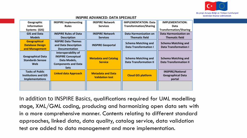
In addition to INSPIRE Basics, qualifications required for UML modelling
stage, XML/GML coding, producing and harmonizing open data sets with
in a more comprehensive manner. Contents relating to different standard
approaches, linked data, data quality, catalog service, data validation
test are added to data management and more implementation.
INSPIRE ADVANCED: DATA SPECIALIST Geographic Information
Systems (GIS)
INSPIRE Implementing Rules
INSPIRE Network Services
IMPLEMENTATION: Data Transformation/Sharing
IMPLEMENTATION: Data
Transformation/Sharing
GIS and Data Models
INSPIRE Rules of Data Description
INSPIRE Network Services
Data Harmonization on Thematic field
Data Harmonization on Thematic field
Geographical Database Design and Management
NSPIRE Data Themes and Data Description
Documentation INSPIRE Geoportal
Schema Matching and Data Transformation I
Schema Matching and Data Transformation I
Geographical Data Standards Sensoe
Web
Interoperability of INSPIRE Conceptual
Data Models, Components and Data
Sets
Metadata and Catalog Service
Schema Matching and Data Transformation II
Schema Matching and Data Transformation II
Tasks of Public Institutions and GIS
Implementations
Linked data Approach Metadata and Data Validation test
Cloud GIS platform INSPIRE/National Geographical Data
portal

Bu proje Avrupa Birliği ve Türkiye Cumhuriyeti
tarafından finanse edilmektedir.
INSPIRE ADVANCED: NETWORK SPECIALIST Geographic Information
Systems (GIS)
INSPIRE Implementing Rules
INSPIRE Network Services
IMPLEMENTATION: Data Transformation/Sharing
IMPLEMENTATION: Data
Transformation/Sharing
GIS and Data Models
INSPIRE Rules of Data Description
INSPIRE Advanced Network Services
Web map Server configuration
Data Harmonization on Thematic field
Data Quality INSPIRE Data Themes and Data Description
Documentation INSPIRE Geoportal
Web Map Server installation
Schema Matching and Data Transformation I
Geographical Database Design and Management
Interoperability of INSPIRE Conceptual
Data Models, Components and Data
Sets
Metadata and Catalog Service
Web Map Server management
Schema Matching and Data Transformation II
Geographical Data Standards Sensoe
Web
Advanced INSPIRE Metadata and Data Validation test
Implementation, development and
testing
INSPIRE/National Geographical Data
portal
In addition to INSPIRE Basics, the need to include in training contents such as configuring web map server for installing and operating web map server, displaying data sets, sharing with discovery, download, transformation and etc. map services, accessing and using portal…

Bu proje Avrupa Birliği ve Türkiye Cumhuriyeti
tarafından finanse edilmektedir.

Bu proje
Avrupa Birliği ve Türkiye Cumhuriyetitarafından finanse edilmektedir.
Bu yayın ve eğitim, Avrupa Birliği’nin desteği ile gerçekleştirilmiştir.
Yayının ve eğitimin içeriğinden sadece Yüklenici, BPR Danışmanlık, sorumludur ve hiçbir şekilde Avrupa Birliği’nin görüşlerini yansıtıcı olarak değerlendirilemez.Thanks…
Assoc.Prof. Arif Cagdas AYDINOGLU, PhD
Gebze Technical University
www.arifcagdas.com / [email protected] / [email protected]