TRAFFIC ENGINEERING STUDY Various Crosswalk ... ENGINEERING STUDY Various Crosswalk Locations...
58
TRAFFIC ENGINEERING STUDY Various Crosswalk Locations Oberlin, Ohio November 14, 2007 Prepared for: Oberlin Municipal Light & Power 289 South Professor Street Oberlin, Ohio 44074 Providing Practical Experience Technical Excellence and Client Responsiveness TMS Engineers, Inc. Transportation Management Services 4547 Hudson Drive ! Stow, Ohio 44224 Tel: (330) 686-6402 ! Fax: (330) 686-6417 Email: [email protected] Web site: http:// www.TMSEngineers.com
Transcript of TRAFFIC ENGINEERING STUDY Various Crosswalk ... ENGINEERING STUDY Various Crosswalk Locations...

TRAFFIC ENGINEERING STUDYVarious Crosswalk Locations
Oberlin, Ohio
November 14, 2007
Prepared for:Oberlin Municipal Light & Power
289 South Professor StreetOberlin, Ohio 44074
Providing Practical ExperienceTechnical Excellence and
Client Responsiveness
TMS Engineers, Inc.Transportation Management Services
4547 Hudson Drive ! Stow, Ohio 44224Tel: (330) 686-6402 ! Fax: (330) 686-6417
Email: [email protected] site: http:// www.TMSEngineers.com
Traffic Engineering Study: Various Crosswalk Locations - Oberlin, Ohio
TABLE OF CONTENTSPage
Executive Summary
1. Introduction . . . . . . . . . . . . . . . . . . . . . . . . . . . . . . . . . . . . . . . . . . . . . . . . . . . . . . . . 1-2
1.1 Purpose of the Report . . . . . . . . . . . . . . . . . . . . . . . . . . . . . . . . . . . . . . . . . . . 1
1.2 Study Objectives . . . . . . . . . . . . . . . . . . . . . . . . . . . . . . . . . . . . . . . . . . . . . . . . 1
2. Area Conditions . . . . . . . . . . . . . . . . . . . . . . . . . . . . . . . . . . . . . . . . . . . . . . . . . . . 3-12
2.1 Transportation Network Study Area . . . . . . . . . . . . . . . . . . . . . . . . . . . . . . . . 3
2.2 Crosswalks . . . . . . . . . . . . . . . . . . . . . . . . . . . . . . . . . . . . . . . . . . . . . . . . . . . . 7
2.3 Pedestrian/Vehicular Traffic . . . . . . . . . . . . . . . . . . . . . . . . . . . . . . . . . . . . . 11
3. Crosswalk Requirements & Guidelines . . . . . . . . . . . . . . . . . . . . . . . . . . . . . . . 13-23
3.1 Purpose . . . . . . . . . . . . . . . . . . . . . . . . . . . . . . . . . . . . . . . . . . . . . . . . . . . . . . 13
3.2 General Needs . . . . . . . . . . . . . . . . . . . . . . . . . . . . . . . . . . . . . . . . . . . . . . . . . 13
3.3 Ohio Manual of Uniform Traffic Control Devices . . . . . . . . . . . . . . . . . . . . . 14
3.4 Signs . . . . . . . . . . . . . . . . . . . . . . . . . . . . . . . . . . . . . . . . . . . . . . . . . . . . . . . . 17
3.5 Pavement Markings . . . . . . . . . . . . . . . . . . . . . . . . . . . . . . . . . . . . . . . . . . . . 20
4. Existing Conditions Analysis . . . . . . . . . . . . . . . . . . . . . . . . . . . . . . . . . . . . . . . 24-46
4.1 Current Pedestrian Traffic . . . . . . . . . . . . . . . . . . . . . . . . . . . . . . . . . . . . . . . 24
4.2 Crosswalk Locations . . . . . . . . . . . . . . . . . . . . . . . . . . . . . . . . . . . . . . . . . . . 25
4.3 Crosswalk Signing . . . . . . . . . . . . . . . . . . . . . . . . . . . . . . . . . . . . . . . . . . . . . 26
4.4 Crosswalk Pavement Markings . . . . . . . . . . . . . . . . . . . . . . . . . . . . . . . . . . . 32
4.5 Geometric Configurations . . . . . . . . . . . . . . . . . . . . . . . . . . . . . . . . . . . . . . . 34
4.6 Visibility / Safety . . . . . . . . . . . . . . . . . . . . . . . . . . . . . . . . . . . . . . . . . . . . . . . 35
4.7 Curb Ramps . . . . . . . . . . . . . . . . . . . . . . . . . . . . . . . . . . . . . . . . . . . . . . . . . . . 39
Traffic Engineering Study: Various Crosswalk Locations - Oberlin, Ohio
TABLE OF CONTENTS Con’tPage
4.8 Alternative Treatments . . . . . . . . . . . . . . . . . . . . . . . . . . . . . . . . . . . . . . . . . . . . . . . . 43
5. Conclusions . . . . . . . . . . . . . . . . . . . . . . . . . . . . . . . . . . . . . . . . . . . . . . . . . . . . . 47-48
APPENDICES
A. Traffic Counts
LIST OF FIGURESPage
1. Location Map . . . . . . . . . . . . . . . . . . . . . . . . . . . . . . . . . . . . . . . . . . . . . . . . . . . . . . . . . 2
2. Study Area Aerial View . . . . . . . . . . . . . . . . . . . . . . . . . . . . . . . . . . . . . . . . . . . . . . . . . 5
3. Study Area Lane Use & Traffic Control . . . . . . . . . . . . . . . . . . . . . . . . . . . . . . . . . . . . 7
4. Crosswalk Locations & Widths . . . . . . . . . . . . . . . . . . . . . . . . . . . . . . . . . . . . . . . . . 17
5. 2007 Current Traffic Volumes . . . . . . . . . . . . . . . . . . . . . . . . . . . . . . . . . . . . . . . . . . 18
6. Unsignalized Intersection Crosswalk Signs . . . . . . . . . . . . . . . . . . . . . . . . . . . . . . . 2
7. Pedestrian Crossing & Supplemental Plaque Warning Signs . . . . . . . . . . . . . . . . . 5
8. Yield Line Layouts . . . . . . . . . . . . . . . . . . . . . . . . . . . . . . . . . . . . . . . . . . . . . . . . . . . . 7
9. Example Yield Lines at Mid-Block Crossing . . . . . . . . . . . . . . . . . . . . . . . . . . . . . . 17
10. Examples of Crosswalk Markings . . . . . . . . . . . . . . . . . . . . . . . . . . . . . . . . . . . . . . . 18
11. Yield Ahead Triangle Symbol . . . . . . . . . . . . . . . . . . . . . . . . . . . . . . . . . . . . . . . . . . 18

Traffic Engineering Study: Various Crosswalk Locations - Oberlin, Ohio
1
1. INTRODUCTION
1.1 Purpose of Report
This traffic engineering study has been prepared at the request of Oberlin Municipal Light andPower for the analysis of five existing mid-block crosswalk locations in the downtown area of theCity of Oberlin, Lorain County, Ohio (see the Location Map, Figure 1, Page 2).
1.2 Study Objectives
This study is structured for the following purposes;
- to adequately assess the ability of the existing mid-block crosswalk locations tosafely and efficiently serve the traveling public and to identify the level oftraffic/pedestrian conditions,
- to provide a comprehensive study which evaluates and documents thetraffic/pedestrian impacts and any needed improvements to provide safe andefficient mid-block crosswalk locations,
- to provide a technically sound basis to identify any necessary mitigationrequirements that meet local, State and Federal codes.
This study documents the methodologies, findings and conclusions of the analysis, including thebasis for all assumptions, traffic parameters utilized and conclusions reached.
Recommendations and conclusions will be determined by comparing the existing conditions anddata collected to the criteria established by the Ohio Manual of Uniform Traffic Control Devicesand professional engineering judgment from an on-site field review.

Traffic Engineering Study: Various Crosswalk Locations - Oberlin, Ohio
3
2. AREA CONDITIONS
2.1 Transportation Network Study Area
Main Street (State Route 58) is a two laneroadway which has a north to southorientation in the study area. The speed limitalong Main Street is 25 miles per hour. Theroadway is known as North Main Street northof College Street and as South Main Streetsouth of College Street. Main Street has anaverage daily traffic (ADT) of approximately9,300 vehicles per day in the study area. It isclassified as urban principal arterial roadwayaccording to the Ohio Department ofTransportation. This classification can beseen on ODOT’s web site at:
http://www.dot.state.oh.us/planning/Functional%20Class/2004FuncClass/District03/Lorain.pdf
College Street (County Road 500) is a 2 laneroadway which has an east to west orientationin the study area. The roadway is known asWest College Street west of Main Street andas East College Street east of Main Street. Itis classified as urban collector roadwayaccording to the Ohio Department ofTransportation. This classification can beseen on ODOT’s web site at the previouslymentioned web address. The speed limitalong College Street is 25 miles per hour.College Street has an average daily traffic(ADT) of approximately 3,650 vehicles per dayin the study area.
View Looking North on North Main
View Looking South on South Main
Traffic Engineering Study: Various Crosswalk Locations - Oberlin, Ohio
4
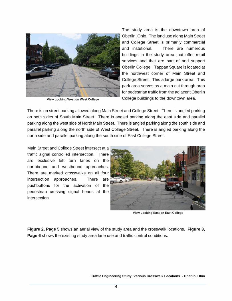
The study area is the downtown area ofOberlin, Ohio. The land use along Main Streetand College Street is primarily commercialand instutional. There are numerousbuildings in the study area that offer retailservices and that are part of and supportOberlin College. Tappan Square is located atthe northwest corner of Main Street andCollege Street. This a large park area. Thispark area serves as a main cut through areafor pedestrian traffic from the adjacent OberlinCollege buildings to the downtown area.
There is on street parking allowed along Main Street and College Street. There is angled parkingon both sides of South Main Street. There is angled parking along the east side and parallelparking along the west side of North Main Street. There is angled parking along the south side andparallel parking along the north side of West College Street. There is angled parking along thenorth side and parallel parking along the south side of East College Street.
Main Street and College Street intersect at atraffic signal controlled intersection. Thereare exclusive left turn lanes on thenorthbound and westbound approaches.There are marked crosswalks on all fourintersection approaches. There arepushbuttons for the activation of thepedestrian crossing signal heads at theintersection.
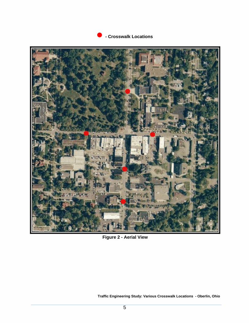
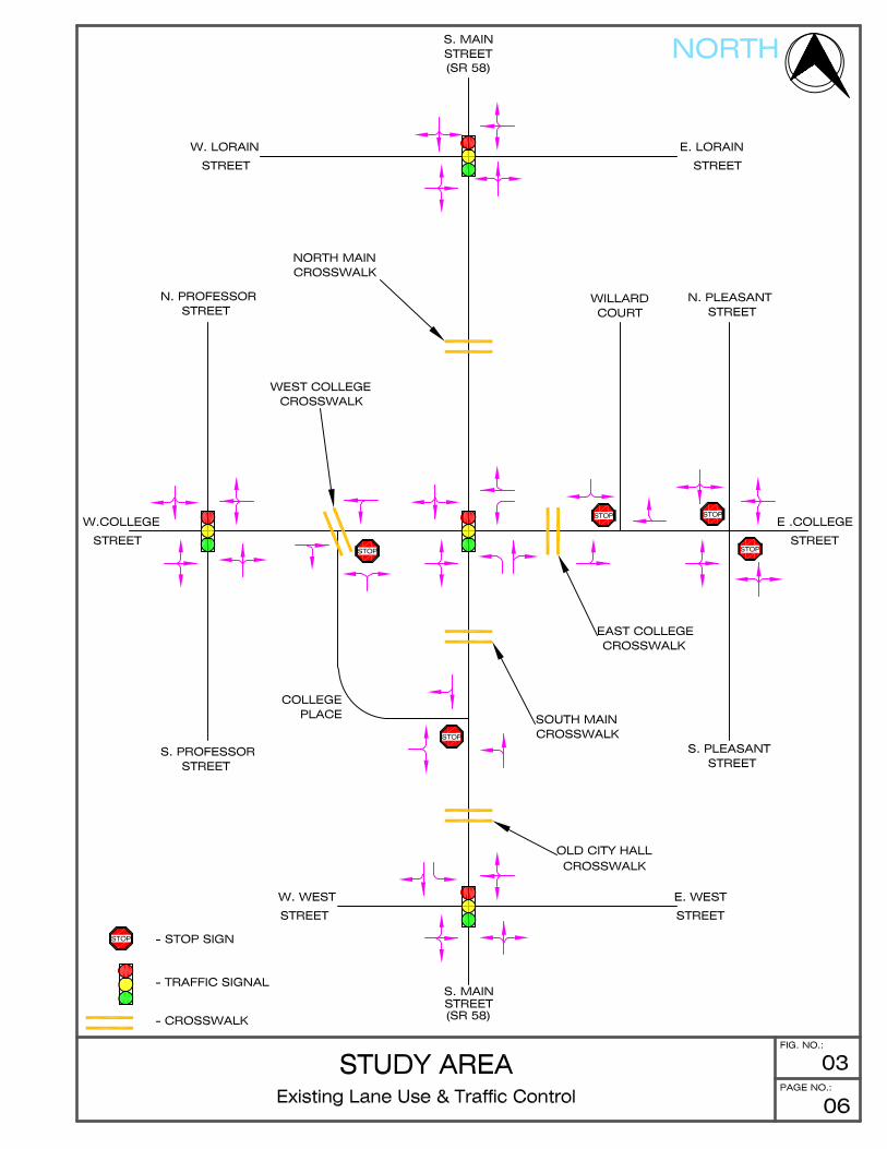
Figure 2, Page 5 shows an aerial view of the study area and the crosswalk locations. Figure 3,Page 6 shows the existing study area lane use and traffic control conditions.
View Looking West on West College
View Looking East on East College
Traffic Engineering Study: Various Crosswalk Locations - Oberlin, Ohio
5
! - Crosswalk Locations
Figure 2 - Aerial View

Traffic Engineering Study: Various Crosswalk Locations - Oberlin, Ohio
7
2.2 Crosswalks
There were five crosswalk locations identified by the City of Oberlin, Ohio for review. The followingare the five locations:
1. Crosswalk along North Main Street between College Street and Lorain Street - North Main Crosswalk
2. Crosswalk along South Main Street at 29 South Main Street- South Main Crosswalk
3. Crosswalk along South Main Street at 69 South Main Street- Old City Hall Crosswalk
4. Crosswalk along West College Street at 37 West College Street- West College Crosswalk
5. Crosswalk along East College Street at 27 East College Street- East College Crosswalk
The location and existing roadway conditions at these five locations can be seen in Figures 1 and3 , Pages 2 and 6, respectively.
North Main Crosswalk
This crosswalk is located along North MainStreet between Lorain Street to the north andCollege Street to the south. The crosswalkprovides a connection across North MainStreet from Tappan Square to the west andseveral Oberlin College buildings to the east.
North Main Crosswalk Looking West
Traffic Engineering Study: Various Crosswalk Locations - Oberlin, Ohio
8
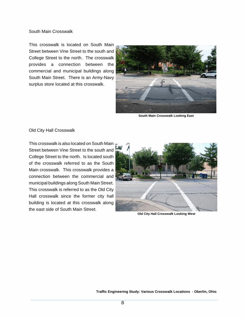
South Main Crosswalk
This crosswalk is located on South MainStreet between Vine Street to the south andCollege Street to the north. The crosswalkprovides a connection between thecommercial and municipal buildings alongSouth Main Street. There is an Army-Navysurplus store located at this crosswalk.
Old City Hall Crosswalk
This crosswalk is also located on South MainStreet between Vine Street to the south andCollege Street to the north. Is located southof the crosswalk referred to as the SouthMain crosswalk. This crosswalk provides aconnection between the commercial andmunicipal buildings along South Main Street.This crosswalk is referred to as the Old CityHall crosswalk since the former city hallbuilding is located at this crosswalk alongthe east side of South Main Street.
South Main Crosswalk Looking East
Old City Hall Crosswalk Looking West

Traffic Engineering Study: Various Crosswalk Locations - Oberlin, Ohio
9
West College Crosswalk
This crosswalk is located on West CollegeStreet between Professor Street to the westand Main Street to the east. The crosswalkis at the intersection of West College Streetand College Place. The crosswalk runsdiagonally across West College Street fromthe southeast corner of the intersection tothe northwest corner. This crosswalkprovides a connection between TappanSquare on the north side of West CollegeStreet and several storefronts including theOberlin College bookstore along the southside of College Street.
East College Crosswalk
The East College Crosswalk is located onEast College Street between Main Street tothe west and Willard Court to the east. Thiscrosswalk provides a connection betweenthe commercial and municipal buildingsalong East College Street.
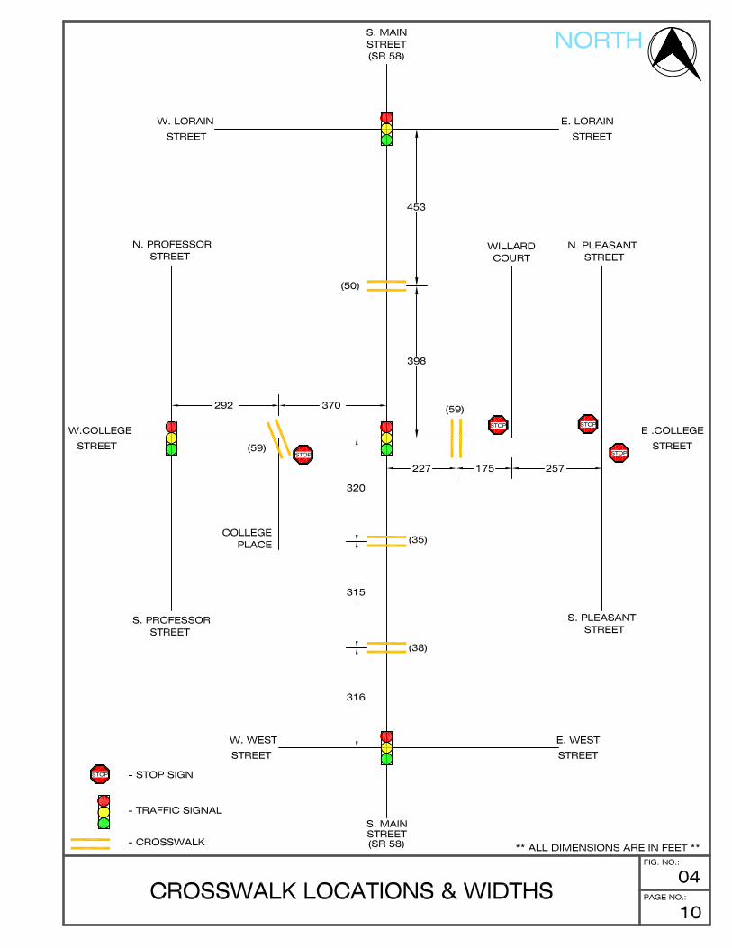
Figure 4, Page 10 shows the location of the crosswalks and the distance between them and theadjacent intersections where marked crosswalks exist as well as signalized pedestrian crossingfacilities at the signalized intersections. The curb to curb widths of the crosswalks are also shownin the drawing in parentheses next to the crosswalk indication.
West College Crosswalk Looking South
East College Crosswalk Looking North

Traffic Engineering Study: Various Crosswalk Locations - Oberlin, Ohio
11
2.3 Pedestrian/Vehicular Traffic
Nine hour, weekday traffic and pedestrian counts were performed at the locations of the five mid-block crosswalks. The following are the approximate locations of the these crosswalks and howthe various locations will be referred to in this study:
1. Crosswalk along North Main Street between College Street and Lorain Street - North Main Crosswalk
2. Crosswalk along South Main Street at 29 South Main Street- South Main Crosswalk
3. Crosswalk along South Main Street at 69 South Main Street- Old City Hall Crosswalk
4. Crosswalk along West College Street at 37 West College Street- West College Crosswalk
5. Crosswalk along East College Street at 27 East College Street- East College Crosswalk
The surveys were taken between Friday, September 14, 2007 and Thursday, September 20, 2007.The traffic surveys were conducted in fifteen (15) minute intervals between the hours of 7 AM - 10AM, 11 AM - 2 PM, and 3 PM - 6 PM, then hourly totals were calculated. Vehicle classification todetermine the extent of trucks, buses and pedestrians was also performed. Copies of theintersection turn movement counts with pedestrian volumes are included in Appendix A.
Average daily traffic was calculated for each of the study roads using expansion factors to accountfor daily and seasonal variations according to the recommendations and latest data from the OhioDepartment of Transportation.
From the data, the weekday AM peak hour of vehicular traffic was determined to be 9:00 AM to10:00 AM and the PM peak hour of vehicular traffic was determined to be 4:00 PM to 5:00 PM.The weekday peak hour of pedestrian traffic was determined to be from 12:00 PM to 1:100 PM.These three periods will be analyzed since they reflect the periods of the highest volume of trafficflow for the roadway in terms of both vehicles and pedestrians. It will provide a worst case scenariofor traffic. Current peak hour vehicular and pedestrian traffic volumes are shown in Figure 5, Page12.

Traffic Engineering Study: Various Crosswalk Locations - Oberlin, Ohio
13
3. CROSSWALK REQUIREMENTS & GUIDANCE
3.1 Purpose
Safe, convenient and well designed facilities are essential to encourage mid-block crosswalk use,as well as to provide safe and efficient operating conditions to the pedestrians and motoristsinvolved at a mid-block crosswalk.
This report will discuss recommended design criteria needed for attaining good design while beingsensitive to the needs of both the pedestrian and the motorist. It will provide recommendations forthe designation of mid-block crosswalks through the use of striping, signing and pavement markingsin advance of and at the crosswalk locations. Where necessary additional construction and the useof flashing beacons will be discussed.
3.2 General Needs
Mid-block crosswalks are normally established with the appropriate pavement markings and signingalong streets in corridors where there is significant pedestrian activity and where there are distinctneeds that can be served by them. The purpose should be to provide a safe and efficient place tocross the street for pedestrians while interacting with the motorists traveling the roadway.Crosswalks are intended to provide guidance for pedestrians who are crossing roadways bydefining and delineating paths on approaches to and within signalized intersections, and atapproaches to other intersections where traffic stops. Crosswalks also serve to alert road usersof a pedestrian crossing point across roadways not controlled by a traffic signals or stop signs. Atmid-block locations, crosswalk markings legally establish the crosswalk. A mid-block crosswalk canconcentrate or channelize multiple pedestrian crossings to a single location.

Traffic Engineering Study: Various Crosswalk Locations - Oberlin, Ohio
14
3.3 Ohio Manual of Uniform Traffic Control Devices
The Ohio Manual of Uniform Traffic Control Devices (OMUTCD) has been established toprovide a safe, uniform, and efficient system of traffic control devices on all public streets andhighways within the State of Ohio. The Manual provides requirements and guidelines for the useof these traffic control devices.
Design, placement, operation, maintenance, and uniformity are aspects that should be carefullyconsidered in order to maximize the ability of a traffic control device to meet the following the fivebasic requirements:
1. Fulfill a need;2. Command attention;3. Convey a clear, simple meaning;4. Command respect from road users; and5. Give adequate time for proper response.
Design of Traffic Control Devices
Traffic control devices should be designed so that features such as size, shape, color, composition,lighting or retro-reflection, and contrast are combined to draw attention to the devices; that size,shape, color, and simplicity of message combine to produce a clear meaning; that legibility and sizecombine with placement to permit adequate time for response; and that uniformity, size, legibility,and reasonableness of the message combine to command respect.
Traffic Engineering Study: Various Crosswalk Locations - Oberlin, Ohio
15
Placement and Operation of Traffic Control Devices
Placement of a traffic control device should be within the road user’s view so that adequate visibilityis provided. To aid in conveying the proper meaning, the traffic control devices should beappropriately positioned with respect to the location, object, or situation to which it applies. Thelocation and legibility of the traffic control device should be such that a road user has adequate timeto make the proper response in both day and night conditions.
Traffic control devices should be placed and operated in a uniform and consistent manner.Unnecessary traffic control devices should be removed. The fact that a device is in good physicalcondition should not be a basis for deferring needed removal or change.
Maintenance of Traffic Control Devices
Functional maintenance of traffic control devices should be used to determine if certain devicesneed to be changed to meet current traffic conditions. Physical maintenance of traffic controldevices should be performed to retain the legibility and visibility of the device, and to retain theproper functioning of the device. Clean, legible, properly mounted devices in good workingcondition command the respect of road users.
Uniformity of Traffic Control Devices
Uniformity of devices simplifies the task of the road user because it aids in recognition andunderstanding, thereby reducing perception/reaction time. Uniformity assists road users, lawenforcement officers, and traffic courts by giving everyone the same interpretation. Uniformityassists public highway officials through efficiency in manufacture, installation, maintenance, andadministration. Uniformity means treating similar situations in a similar way. The use of uniformtraffic control devices does not, in itself, constitute uniformity. A standard device used where it isnot appropriate is as objectionable as a nonstandard device; in fact, this might be worse, becausesuch misuse might result in disrespect at those locations where the device is needed andappropriate.

Traffic Engineering Study: Various Crosswalk Locations - Oberlin, Ohio
16
These traffic control devices as they relate to crosswalks include but are not limited to signs andpavement markings. The signs used at crosswalks typically fall into one of two sign categories.The first category is regulatory signs. Regulatory signs are used to inform road users of selectedtraffic laws or regulations and indicate the applicability of the legal requirements. These signs areto be installed at or near where the regulations apply. The signs are to clearly indicate therequirements imposed by the regulations and shall be designed to and installed to provideadequate visibility and legibility in order to obtain compliance.
The other type of sign is a warning sign. These signs call attention to unexpected conditions onor adjacent to a street and to situations that might not be readily apparent to road users. Warningsigns alert road users to conditions that might call for a reduction of speed or an action in theinterest of safety and efficient traffic operations. Regulatory and warning signs should be usedconservatively because these signs, if used to excess, tend to lose their effectiveness.
Pavement markings on roadways have important functions in providing guidance and informationfor the road user. Major marking types include pavement and curb markings, object markers,delineators, colored pavements, barricades, channelizing devices and islands. In some cases,markings are used to supplement other traffic control devices such as signs, signals and othermarkings. In other instances, markings are used alone to effectively convey regulations, guidance,or warnings in ways not obtainable by the use of other devices. Markings have limitations. Visibilityof the markings can be limited by snow, debris, and water on or adjacent to the markings. Markingdurability is affected by material characteristics, traffic volumes, weather, and location. However,under most highway conditions, markings provide important information while allowing minimaldiversion of attention from the roadway. Pavement markings can enhance roadway delineation withthe addition of audible and tactile features such as bars, differential surface profiles, raisedpavement markers, or other devices intended to alert the road user that a delineation on theroadway is being traversed.

Traffic Engineering Study: Various Crosswalk Locations - Oberlin, Ohio
17
3.4 Signs
Regulatory signs for use at mid-block crossings can be seen in Figure 6. The sign code asassigned in the OMUTCD is shown below the signs. This code is used to identify the sign and itstype.
Figure 6 - Unsignalized Intersection Crosswalk Signs
If yield lines are used in advance of a marked mid-block crosswalk, Yield Here To Pedestrians (R1-5 or R1-5a) signs shall be placed 20 to 50 ft in advance of the nearest crosswalk line. The In-StreetPedestrian Crossing (R1-6) sign may be used to remind road users of laws regarding right-of-wayat an unsignalized pedestrian crossing. The legend STATE LAW may be shown at the top of thesign. The legend YIELD TO may be used in conjunction with the appropriate symbol. If used, theIn-Street Pedestrian Crossing sign shall have a black legend (except for the red YIELD signsymbol) and border on either a white and/or fluorescent yellow-green background. If the In-StreetPedestrian Crossing sign is placed in the roadway, the sign support shall comply with thebreakaway requirements of the latest edition of AASHTO’s “Specification for Structural Supportsfor Highway Signs, Luminaires, and Traffic Signals”. The In-Street Pedestrian Crossing sign maybe used seasonably to prevent damage in winter because of plowing operations, and may beremoved at night if the pedestrian activity at night is minimal.
Traffic Engineering Study: Various Crosswalk Locations - Oberlin, Ohio
18
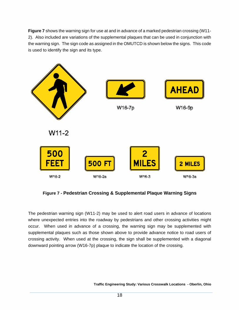
Figure 7 shows the warning sign for use at and in advance of a marked pedestrian crossing (W11-2). Also included are variations of the supplemental plaques that can be used in conjunction withthe warning sign. The sign code as assigned in the OMUTCD is shown below the signs. This codeis used to identify the sign and its type.
Figure 7 - Pedestrian Crossing & Supplemental Plaque Warning Signs
The pedestrian warning sign (W11-2) may be used to alert road users in advance of locationswhere unexpected entries into the roadway by pedestrians and other crossing activities mightoccur. When used in advance of a crossing, the warning sign may be supplemented withsupplemental plaques such as those shown above to provide advance notice to road users ofcrossing activity. When used at the crossing, the sign shall be supplemented with a diagonaldownward pointing arrow (W16-7p) plaque to indicate the location of the crossing.

Traffic Engineering Study: Various Crosswalk Locations - Oberlin, Ohio
19
Pedestrian signs and their related supplemental plaques may have a fluorescent yellow-greenbackground with a black legend and border. When a fluorescent yellow-green background is used,a systematic approach featuring one background color within a zone or area should be used. Themixing of standard yellow and fluorescent yellow-green backgrounds within a selected site areashould be avoided.

Traffic Engineering Study: Various Crosswalk Locations - Oberlin, Ohio
20
3.5 Pavement Markings
Figure 8 details the layout and use of yield lines for use at mid-block crossings. These are alsoreferred to as “sharks teeth”.
Figure 8 - Yield Line Layouts

Traffic Engineering Study: Various Crosswalk Locations - Oberlin, Ohio
21
Figure 9 - Example of Yield Lines at Mid-Block Crosswalk
Yield lines shall consist of a row of solid white isosceles triangles pointing toward approachingvehicles extending across approach lanes to indicate the point at which the yield is intended orrequired to be made. Yield lines may be used to indicate the point behind which vehicles arerequired to yield in compliance with a YIELD (R1-2) sign or a Yield Here to Pedestrians (R1-5) sign.Yield signs when used at an unsignalized mid-block crosswalk, should be placed adjacent to theYield Here to Pedestrians sign located 20 to 50 feet in advance of the nearest crosswalk line, andparking should be prohibited in the area between the yield line and the crosswalk (see Figure 9).Drivers who yield too close to crosswalks on multi-lane approaches place pedestrians at risk byblocking other drivers’ views of pedestrians.
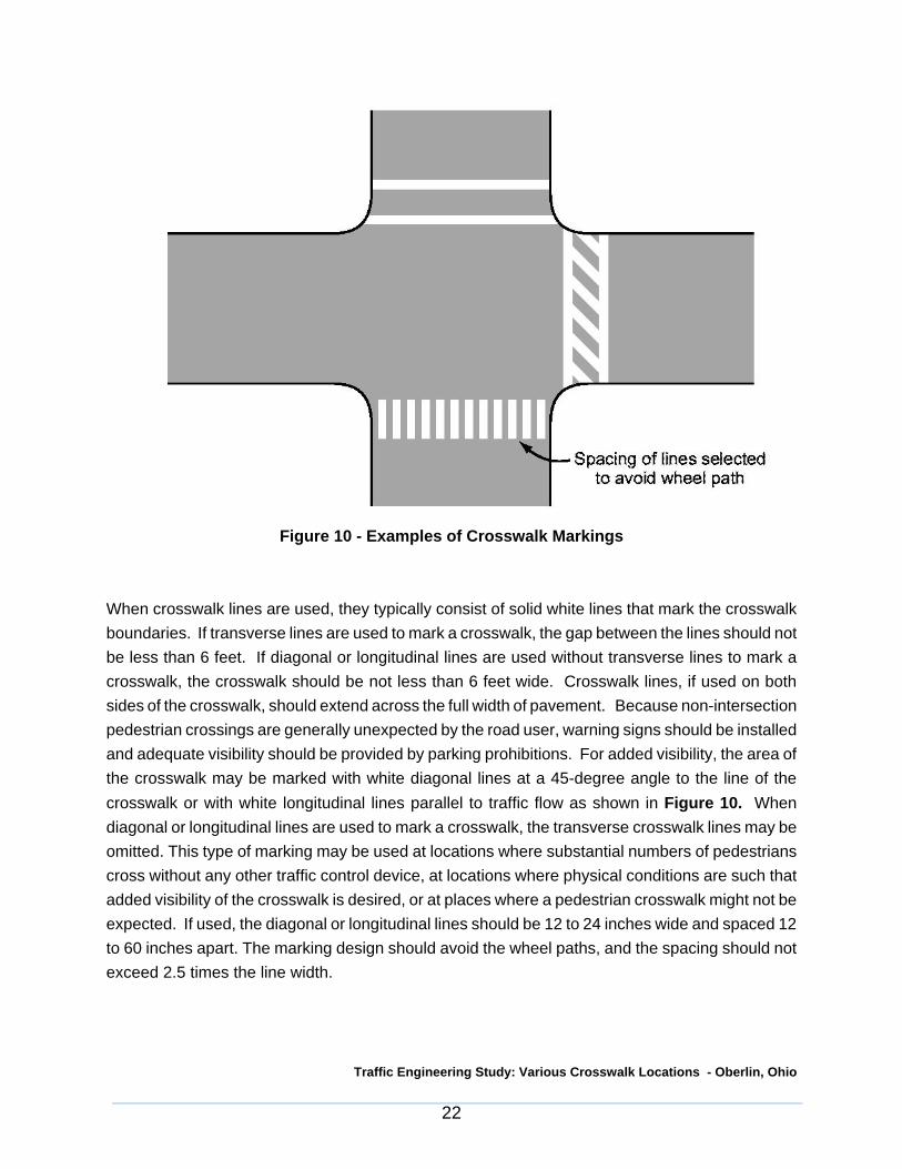
Figure 10 details the use of various types of crosswalk markings. It should be noted that while theillustration shows the markings in use at an intersection, these markings can be used at a mid-blocklocation.
Traffic Engineering Study: Various Crosswalk Locations - Oberlin, Ohio
22
Figure 10 - Examples of Crosswalk Markings
When crosswalk lines are used, they typically consist of solid white lines that mark the crosswalkboundaries. If transverse lines are used to mark a crosswalk, the gap between the lines should notbe less than 6 feet. If diagonal or longitudinal lines are used without transverse lines to mark acrosswalk, the crosswalk should be not less than 6 feet wide. Crosswalk lines, if used on bothsides of the crosswalk, should extend across the full width of pavement. Because non-intersectionpedestrian crossings are generally unexpected by the road user, warning signs should be installedand adequate visibility should be provided by parking prohibitions. For added visibility, the area ofthe crosswalk may be marked with white diagonal lines at a 45-degree angle to the line of thecrosswalk or with white longitudinal lines parallel to traffic flow as shown in Figure 10. Whendiagonal or longitudinal lines are used to mark a crosswalk, the transverse crosswalk lines may beomitted. This type of marking may be used at locations where substantial numbers of pedestrianscross without any other traffic control device, at locations where physical conditions are such thatadded visibility of the crosswalk is desired, or at places where a pedestrian crosswalk might not beexpected. If used, the diagonal or longitudinal lines should be 12 to 24 inches wide and spaced 12to 60 inches apart. The marking design should avoid the wheel paths, and the spacing should notexceed 2.5 times the line width.

Traffic Engineering Study: Various Crosswalk Locations - Oberlin, Ohio
23
Word and symbol markings on the pavement are used for the purpose of guiding, warning, orregulating traffic. Symbol messages are preferable to word messages. Letters and numeralsshould be 6 feet or more in height and should not exceed three lines of information. Pavementword and symbol markings should be no more than one lane in width. If a pavement marking wordmessage consists of more than one line of information, it should read in the direction of travel. Thefirst word of the message should be nearest to the road user. The longitudinal space between wordor symbol message markings should be at least four times the height of the characters for low-speed roads, but not more than ten times the height of the characters under any conditions. Thenumber of different word and symbol markings used should be minimized to provide effectiveguidance and avoid misunderstanding.
A yield-ahead triangle symbol or YIELD AHEAD word pavement marking may be used onapproaches to intersections where the approaching traffic will encounter a YIELD sign at theintersection. Word and symbol markings for crosswalks may include, but are not limited to, YIELDAHEAD, the YIELD AHEAD Triangle Symbol, and PED XING. A example of a yield ahead trianglesymbol can be seen below in Figure 11.
Figure 11 - Yield Ahead Triangle Symbol

Traffic Engineering Study: Various Crosswalk Locations - Oberlin, Ohio
24
4. EXISTING CONDITIONS ANALYSIS
4.1 Current Pedestrian Traffic
Pedestrian traffic was observed on a typical weekday to determine current usage of the mid-blockcrossings. The following chart shows the hourly pedestrian volumes during nine hours of the dayat the five crossing locations under review.
HOUR
VOLUME OF PEDESTRIANS AT CROSSWALK LOCATIONS
NORTHMAIN
SOUTHMAIN
OLD CITYHALL
WESTCOLLEGE
EASTCOLLEGE
7:00 AM 9 2 12 10 1
8:00 AM 30 10 9 26 9
9:00 AM 41 35 26 53 26
11:00 AM 26 42 29 102 28
12:00 N 57 81 41 117 28
1:00 PM 56 45 30 103 29
3:00 PM 30 47 28 103 28
4:00 PM 43 33 34 101 26
5:00 PM 15 48 12 94 5
Total 307 343 221 709 180
The above volumes indicate a significant amount of existing pedestrian traffic currently using thefive crossing locations on a typical weekday. It should be noted that the crosswalks are located inthe downtown area of Oberlin. There is a significant retail and commercial presence along the MainStreet and College Street corridors. Oberlin College is also located in this section of the City.These adjacent land uses near the crosswalks and the significant amount of on street parking andthe lack of direct parking for each land use contributes to a significant amount of pedestrian activityin the study area. The mid-block crossings are justified based upon the observed pedestrianvolumes, the adjacent land uses, and the layout and availability of parking spaces in the downtownarea of Oberlin.
Traffic Engineering Study: Various Crosswalk Locations - Oberlin, Ohio
25
4.2 Crosswalk Locations
The locations of the crosswalks were shown in Figures 1 and 2 . The distance between these mid-block crossings and the adjacent signalized crossing facilities were shown in Figure 4. Theshortest distance between a mid-block crossing and a signalized intersection with pedestrianfacilities was 292 feet between the West College crosswalk and the traffic signal at ProfessorStreet. It is our opinion that the existing locations and spacing of these mid-block crosswalks isjustified due to the spacing between the signalized intersections and the density of the developmentalong the Main Street and College Street corridors.
Traffic Engineering Study: Various Crosswalk Locations - Oberlin, Ohio
26
4.3 Crosswalk Signing
The crosswalk locations were reviewed to determine if the signing at each location meets therequirement and guidelines found in the OMUTCD.
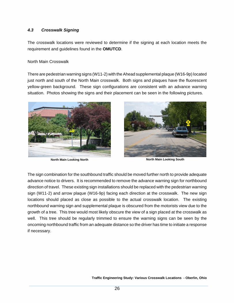
North Main Crosswalk
There are pedestrian warning signs (W11-2) with the Ahead supplemental plaque (W16-9p) locatedjust north and south of the North Main crosswalk. Both signs and plaques have the fluorescentyellow-green background. These sign configurations are consistent with an advance warningsituation. Photos showing the signs and their placement can be seen in the following pictures.
The sign combination for the southbound traffic should be moved further north to provide adequateadvance notice to drivers. It is recommended to remove the advance warning sign for northbounddirection of travel. These existing sign installations should be replaced with the pedestrian warningsign (W11-2) and arrow plaque (W16-9p) facing each direction at the crosswalk. The new signlocations should placed as close as possible to the actual crosswalk location. The existingnorthbound warning sign and supplemental plaque is obscured from the motorists view due to thegrowth of a tree. This tree would most likely obscure the view of a sign placed at the crosswalk aswell. This tree should be regularly trimmed to ensure the warning signs can be seen by theoncoming northbound traffic from an adequate distance so the driver has time to initiate a responseif necessary.
North Main Looking North North Main Looking South

Traffic Engineering Study: Various Crosswalk Locations - Oberlin, Ohio
27
South Main Crosswalk
There are pedestrian warning signs (W11-2) with the Ahead supplemental plaque (W16-9p) locatednorth and south of the South Main crosswalk. Both signs and plaques have the fluorescent yellow-green background. These sign configurations are consistent with an advance warning situation.Photos showing the signs and their placement can be seen in the following pictures.
It is recommended to remove the advance warning signs for both the northbound and southbounddirections. There is already a southbound advance warning installation recommended north of theNorth Main Crosswalk. Pedestrian warning signs (W11-2) and the arrow plaque (W16-9p) shouldbe erected at the crosswalk for the northbound and southbound directions. The signs should beplaced on the sidewalk bump out area so as to not be blocked by a parked vehicle. The bump outis the area where the sidewalk area has been extend out into the street to shorten the amount ofroadway that a pedestrian has to cross. All new signs should be of the same background color asothers used throughout the study area.
South Main Looking South South Main Looking North
Traffic Engineering Study: Various Crosswalk Locations - Oberlin, Ohio
28
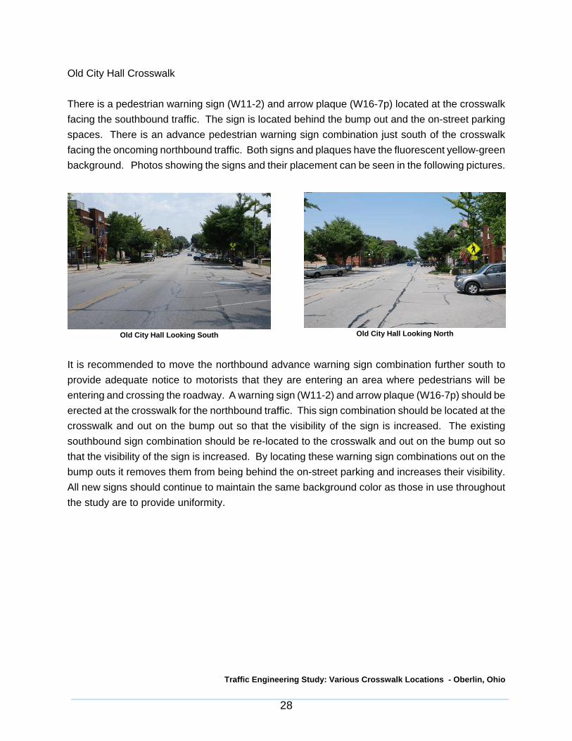
Old City Hall Crosswalk
There is a pedestrian warning sign (W11-2) and arrow plaque (W16-7p) located at the crosswalkfacing the southbound traffic. The sign is located behind the bump out and the on-street parkingspaces. There is an advance pedestrian warning sign combination just south of the crosswalkfacing the oncoming northbound traffic. Both signs and plaques have the fluorescent yellow-greenbackground. Photos showing the signs and their placement can be seen in the following pictures.
It is recommended to move the northbound advance warning sign combination further south toprovide adequate notice to motorists that they are entering an area where pedestrians will beentering and crossing the roadway. A warning sign (W11-2) and arrow plaque (W16-7p) should beerected at the crosswalk for the northbound traffic. This sign combination should be located at thecrosswalk and out on the bump out so that the visibility of the sign is increased. The existingsouthbound sign combination should be re-located to the crosswalk and out on the bump out sothat the visibility of the sign is increased. By locating these warning sign combinations out on thebump outs it removes them from being behind the on-street parking and increases their visibility.All new signs should continue to maintain the same background color as those in use throughoutthe study are to provide uniformity.
Old City Hall Looking South Old City Hall Looking North
Traffic Engineering Study: Various Crosswalk Locations - Oberlin, Ohio
29
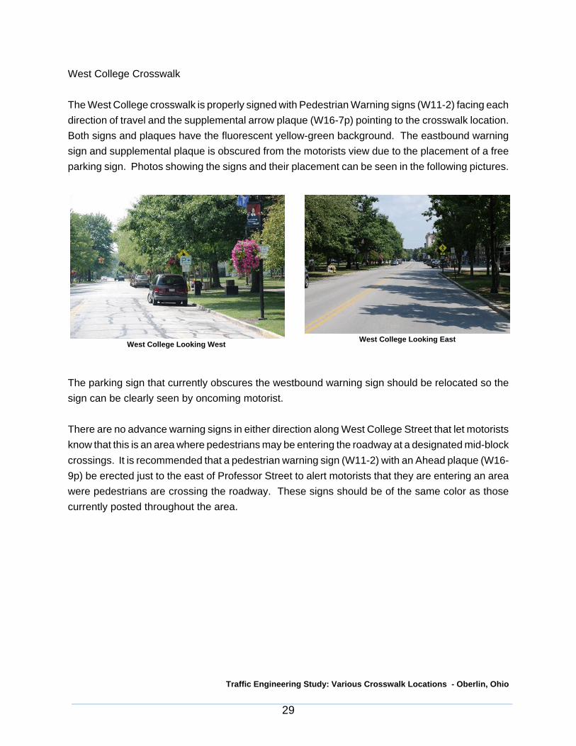
West College Crosswalk
The West College crosswalk is properly signed with Pedestrian Warning signs (W11-2) facing eachdirection of travel and the supplemental arrow plaque (W16-7p) pointing to the crosswalk location.Both signs and plaques have the fluorescent yellow-green background. The eastbound warningsign and supplemental plaque is obscured from the motorists view due to the placement of a freeparking sign. Photos showing the signs and their placement can be seen in the following pictures.
The parking sign that currently obscures the westbound warning sign should be relocated so thesign can be clearly seen by oncoming motorist.
There are no advance warning signs in either direction along West College Street that let motoristsknow that this is an area where pedestrians may be entering the roadway at a designated mid-blockcrossings. It is recommended that a pedestrian warning sign (W11-2) with an Ahead plaque (W16-9p) be erected just to the east of Professor Street to alert motorists that they are entering an areawere pedestrians are crossing the roadway. These signs should be of the same color as thosecurrently posted throughout the area.
West College Looking West West College Looking East

Traffic Engineering Study: Various Crosswalk Locations - Oberlin, Ohio
30
East College Crosswalk
There are currently no pedestrian warning signs or advance warning signs located at the EastCollege crosswalk. Photos showing the view of the crosswalk from the east and west can be seenin the following pictures.
Pedestrian warning signs (W11-2) with the arrow plaque (W16-7p) should be erected at thecrosswalk for both the eastbound and westbound traffic. An advance pedestrian warning signshould be erected east of the crosswalk consisting of the pedestrian warning sign (W11-2) and theahead plaque (W16-9p). All new signs should have the same background color as those usedthroughout the study area to provide uniformity with all the crosswalk related signs.
As mentioned earlier the removal and replacement of the advance pedestrian warning signs wasrecommended. To prevent sign clutter and overuse of the advance warning sign combination, theadvance warning combinations are only being recommended before the first crosswalk a motoristwould encounter while traveling through the College Street and Main Street corridors. For examplea northbound motorist traveling along South Main Street would encounter an advance warning signcombination shortly after Vine Street and then would see the pedestrian warning signs at thecrosswalk locations for the Old City Hall, South Main, and North Main crosswalk locations. Underthis scenario the same situations would occur for eastbound and westbound traffic along CollegeStreet and for the southbound traffic along Main Street. The advance warning signs arerecommended to located just south of Lorain Street for southbound Main Street, north of VineStreet for northbound Main Street, east of Professor Street for eastbound College Street, and westof Pleasant Street for westbound College Street.
East College Looking WestEast College Looking East
Traffic Engineering Study: Various Crosswalk Locations - Oberlin, Ohio
31
All pedestrian warning signs and plaques in the study area are currently using the fluorescentyellow-green background. To provide uniformity throughout the study area all new signs shouldcontinue to use the same color scheme.
The yield to pedestrian within crosswalk sign (R1-6) shown previously in Figure 6 can besubstituted for the pedestrian warning sign (W11-2) and arrow plaque (W16-7p) combination at thecrosswalk locations. This would put a regulatory sign in place at the crosswalk location as opposedto a warning sign. This sign would provide a specific instruction to the driver upon encounteringa pedestrian in the crosswalk.
Traffic Engineering Study: Various Crosswalk Locations - Oberlin, Ohio
32
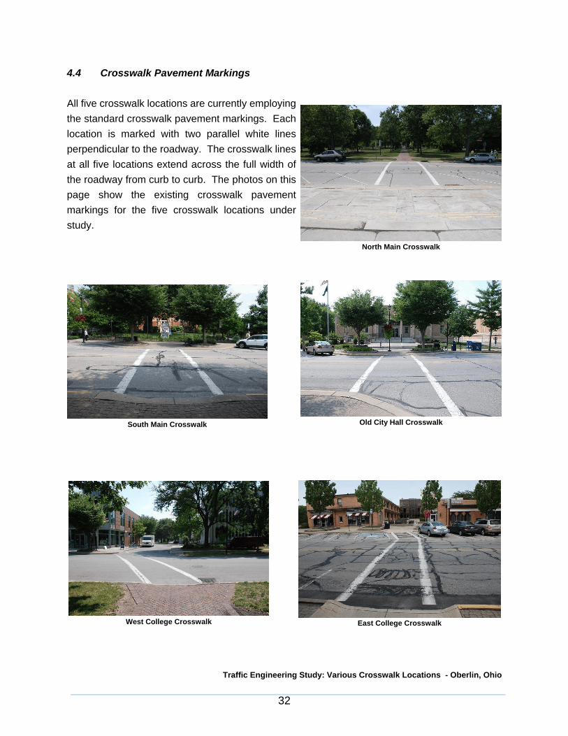
4.4 Crosswalk Pavement Markings
All five crosswalk locations are currently employingthe standard crosswalk pavement markings. Eachlocation is marked with two parallel white linesperpendicular to the roadway. The crosswalk linesat all five locations extend across the full width ofthe roadway from curb to curb. The photos on thispage show the existing crosswalk pavementmarkings for the five crosswalk locations understudy.
North Main Crosswalk
Old City Hall CrosswalkSouth Main Crosswalk
West College Crosswalk East College Crosswalk

Traffic Engineering Study: Various Crosswalk Locations - Oberlin, Ohio
33
To provide a higher degree of visibility to motorists that there is a marked mid-block crosswalk twoalternative methods of striping the crosswalks are recommended. The first method would be tocontinue to use the parallel lines that are perpendicular to the roadway with the area between thelines filled in with diagonal white lines. The transverse lines could be omitted in this scenario. Thesecond method to increase the visibility of the crosswalk would be to use longitudinal lines parallelto the traffic flow to mark the crosswalk. The marking design should avoid the wheel paths of thevehicles traveling on the roadway. Examples of these pavement markings can be seen Figure 10.
Traffic Engineering Study: Various Crosswalk Locations - Oberlin, Ohio
34
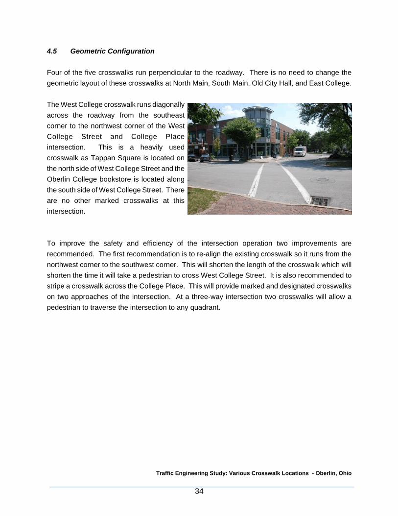
4.5 Geometric Configuration
Four of the five crosswalks run perpendicular to the roadway. There is no need to change thegeometric layout of these crosswalks at North Main, South Main, Old City Hall, and East College.
The West College crosswalk runs diagonallyacross the roadway from the southeastcorner to the northwest corner of the WestCollege Street and College Placeintersection. This is a heavily usedcrosswalk as Tappan Square is located onthe north side of West College Street and theOberlin College bookstore is located alongthe south side of West College Street. Thereare no other marked crosswalks at thisintersection.
To improve the safety and efficiency of the intersection operation two improvements arerecommended. The first recommendation is to re-align the existing crosswalk so it runs from thenorthwest corner to the southwest corner. This will shorten the length of the crosswalk which willshorten the time it will take a pedestrian to cross West College Street. It is also recommended tostripe a crosswalk across the College Place. This will provide marked and designated crosswalkson two approaches of the intersection. At a three-way intersection two crosswalks will allow apedestrian to traverse the intersection to any quadrant.

Traffic Engineering Study: Various Crosswalk Locations - Oberlin, Ohio
35
4.6 Visibility/Safety
Traffic crash reports were requested from the City of Oberlin for any crashes that occurred at or inthe vicinity of the crosswalk locations. Six reports for the years 2005-2007 were received. Twocrashes were reported in each year. Five of the crashes involved a vehicle rear-ending anothervehicle at or near a crosswalk location. In each crash report the first vehicle stopped or slowed atthe crosswalk and the trailing vehicle then rear-ended the lead vehicle. This concern was alsovoiced in discussions with officials from the City of Oberlin as they have received many notices ofthe issue where a crash did not occur but was very close to happening. These type of crashesusually occur because the second vehicle was following too closely and did not leave themselvesan adequate clear stopping distance or because the first vehicle is forced to make a sudden stopbecause they did not realize the crosswalk was in use.
In order to improve the safety and visibility for both pedestrians and motorists we are makingseveral recommendations. The first recommendation is to stripe yield lines on the roadways, oneach side of the crosswalk. These lines (shark teeth) would indicate the point in the roadway wheremotorists are supposed to yield in compliance with a Yield to Pedestrian sign (R1-5). The yield topedestrian sign (R1-5) would need to be installed at each yield line. This configuration isrecommended for each crosswalk location. The yield line with signs configuration can be seen inFigure 9.
At the North Main, West College, and East Collegecrosswalks the on-street parking is adjacent to thecrosswalks. This makes if difficult for oncomingtraffic and pedestrians waiting to cross the street tosee each other if the spaces adjacent to thecrosswalk are occupied, especially with an SUV orvan. These configurations can be seen in thefollowing photos.
North Main Crosswalk

Traffic Engineering Study: Various Crosswalk Locations - Oberlin, Ohio
36
In order to improve the visibility at these locations the adjacent parking spaces should beeliminated. The North Main crosswalk currently restricts parking near the crosswalk along the westside of North Main Street. The first parking space on each of side of the crosswalk along the eastside of North Main Street should be eliminated. The first parking space along the north side ofWest College Street on each side of the crosswalk should be eliminated. The first parking spacealong the north side of East College Street on each side of the crosswalk should be eliminated. Toensure vehicles do not park in these areas the curbs could be painted yellow like the west side ofNorth Main Street at the crosswalk. This setup can be seen in the following picture.
West College Crosswalk East College Crosswalk
Restricted Parking Area @ North Main Crosswalk

Traffic Engineering Study: Various Crosswalk Locations - Oberlin, Ohio
37
Another option to improve the visibility for both the pedestrian and motorists would be to constructbump outs (curb extensions) at the West College, North Main, and East College crosswalks. Bumpouts are already present at the South Main and Old City Hall crosswalks. These bump outsimprove the visibility of pedestrians waiting to cross by bringing them closer to the center of thedriver’s cone of vision and by minimizing the impact of parked vehicles on pedestrian visibility.Bump outs are an extension of the sidewalk area across the parking lanes to the edge of the travellanes. This feature would narrow the distance of the road that a pedestrian has to cross. A shorterdistance to cross would lessen the amount of time a pedestrian is in the roadway. The followingphotos show an example of a bump out at the South Main crosswalk. It should noted that the curbsof the bump outs are painted yellow to emphasize there is no parking allowed along the bump out.
Bump Out @ South Main Crosswalk
Bump Out @ South Main Crosswalk

Traffic Engineering Study: Various Crosswalk Locations - Oberlin, Ohio
38
Word on pavement markings can also be used to bring the presence of pedestrian crossings to adrivers attention. The use of word on pavement markings is recommended at the locations of theadvance warning signs. This will supplement and reinforce the message of the of the advancewarning signs. This would consist of PED XING being marked on the roadways at four locations.These locations are just south of Lorain Street for southbound Main Street, north of Vine Street fornorthbound Main Street, east of Professor Street for eastbound College Street, and west ofPleasant Street for westbound College Street.
Traffic Engineering Study: Various Crosswalk Locations - Oberlin, Ohio
39
4.7 Curb Ramps
The crosswalks under review should comply with the Americans with Disabilities Act (ADA) tomaximize mobility for all users. It should also be noted that curb ramps are required for all newor reconstructed curbs per Section 729.12 of the Ohio Revised Code. These curb rampsshould include a detectable warning surface.
Curb ramps should be designed to the least slope consistent with the curb height, available cornerarea and underlying topography. A level landing is necessary for turning, maneuvering orbypassing the sloped surface. Proper curb ramp design is important to users either continuingalong a sidewalk path or attempting to cross the street.
Detectable warnings are standardized surface features on walking surfaces to warn visuallyimpaired people of the transition between the sidewalk and the street. Truncated domes arespecified as the detectable warnings to be used in the ODOT Location and Design Manual,Volume 1. Truncated domes must have a visual contrast with adjoining surfaces. Many existingcurb ramps can remain in place if they were originally constructed to current ADA standards.However, these curb ramp may need to have truncated domes installed. ODOT has approvedseveral cast-in-place type of products for installation in new concrete and some surface appliedproducts specifically manufactured to be placed on existing sound concrete as a retro-fit.
The crosswalks under review currently have perpendicular curb ramps. Perpendicular ramps aregenerally perpendicular to the curb and line up directly with the crosswalk. Users will generally betraveling perpendicular to vehicular traffic when they enter the street at the bottom of the ramp. Areview of each curb ramp at the crosswalks was conducted to determine if any improvements arenecessary.

Traffic Engineering Study: Various Crosswalk Locations - Oberlin, Ohio
40
North Main Crosswalk
The curb ramps at the North Main crosswalk should be retro-fitted with a detectable warningsurfaces consisting of truncated domes.
South Main Crosswalk
The curb ramps at the South Main crosswalk should be retro-fitted with a detectable warningsurfaces consisting of truncated domes.
East Curb Ramp West Curb Ramp
East Curb Ramp West Curb Ramp

Traffic Engineering Study: Various Crosswalk Locations - Oberlin, Ohio
41
Old City Hall Crosswalk
The curb ramps at the Old City Hall crosswalk should be retro-fitted with a detectable warningsurfaces consisting of truncated domes. It should also be noted that the east curb ramp does notline up directly with the crosswalk. The curb ramp is on an angle that would discharge pedestriansinto the roadway outside of the marked crossing. A pedestrian using such a ramp may enter theintersection outside of the marked crosswalk, or a visually impaired person is aimed away from thecrosswalk and into traffic. This proves especially difficult for wheelchairs as the person would haveto redirect themselves after exiting the curb ramp to remain within the confines of the crosswalk.Future consideration should be give to re-aligning the curb ramp so that it lines up with thecrosswalk.
West College Crosswalk
West Curb RampEast Curb Ramp
North Curb Ramp South Curb Ramps

Traffic Engineering Study: Various Crosswalk Locations - Oberlin, Ohio
42
The curb ramps at the West College crosswalk should be retro-fitted with a detectable warningsurfaces consisting of truncated domes. With the relocation of the existing crosswalk to thesouthwest corner and the addition of a marked crosswalk across the College Place approach thesouthwest corner should have an adequate curb ramp design with detectable surfaces for the useof both crosswalks.
East College Crosswalk
The curb ramps at the East College crosswalk appear to have had the truncated domes stampedinto the concrete when the curb ramp was constructed. These domes have since become worndown and have lost their functionality. The curb ramps at the East College crosswalk should beretro-fitted with a detectable warning surfaces consisting of truncated domes.
North Curb Ramp South Curb Ramp

Traffic Engineering Study: Various Crosswalk Locations - Oberlin, Ohio
43
4.8 Alternative Treatments
Several other treatments are currently in use around the country that aim to increase the safety andefficiency of mid-block crossings. These items vary in terms of the necessary construction and costto install these improvements as well as future maintenance considerations. These items areprovided as recommendations for future consideration.
Pavement Legends
Similar to word pavement markings on the roadway pavement legends for pedestrians are placedon the roadway at each end of the crosswalk to be legible to pedestrians as they are waiting tocross. These markings are there to encourage the pedestrian to be observant and look in eachdirection for oncoming traffic before crossing. The cost for this improvement would be low as itcould be done as part of striping the crosswalk. It should be noted that this type of marking and itsuse on roadways is not discussed in the OMUTCD.
Overhead Mounted Signs
An option to improve the visibility of signs in areas where it is difficult to see side mounted signsalong the roadway would be to install the warning signs overhead. This is accomplished throughmounting the sign on either span wire or mast arms. This would improvement would haveconsiderable costs due to the necessary materials involved and the construction of the installation.
Textured Surfaces
Constructing crosswalks with stamped concrete or asphalt as well as brick pavers laid in a patterncan increase driver awareness of pedestrian activity by improving visibility and creating a differentaudible tone. The textured surface helps make the crossing stand out better. Textured surfacescan provide a tactile cue to people with sight impairment, but care should be taken to assure thatthere is also a tactile cue that a person is leaving the sidewalk to cross the street. This would alsobe a high cost improvement as reconstruction of the roadway would be necessary to install atextured crosswalk.
Traffic Engineering Study: Various Crosswalk Locations - Oberlin, Ohio
44
Street Lighting
Providing adequate levels of lighting that are oriented toward pedestrian activity improvesconditions for drivers to see pedestrians. Pedestrians feel safer in such environments. This is ahigh cost application with regular maintenance concerns.
In-Pavement Markers with Automated Detection
In-pavement raised markers are an option that is designed to increase the motorist’s attentivenesswhen approaching a marked crosswalk occupied by pedestrians. With this treatment the crosswalkis lined with durable encased raised pavement markers. Most treatments now use amber LEDstrobe lighting in the raised pavement markers to alert drivers that they are approaching anoccupied crosswalk. The LED’s can be activated either be pushbuttons or by an automaticdetection system. The most common automatic detection method is the use of bollards withinfrared sensors that cover the entrance to the crosswalk. Microwave and video based technologyhas also been employed to serve this purpose. Automatic detection is recommended with thistreatment as the pedestrian still needs to be alert for oncoming traffic as they enter the roadway.The pushbutton application can give a false sense of security to the pedestrian as they activate thecrosswalk and then enter the street assuming that oncoming traffic has recognized the activity inthe crosswalk and has stopped. This treatment can not be used in conjunction with any yield signcontrolled crosswalks as per the standards found in the OMUTCD. This is a high cost treatmentdue to the roadway construction for installation as well as for maintenance.
Anti-Skid Pavement Surfacing
Anti-skid pavement surfacing is a treatment of the roadway surface that improves skid resistanceespecially when the roadway is experiencing wet conditions. This treatment is aimed at reducingthe braking distances of vehicles. This would be done in advance of a crosswalk typically wherevehicles are expected to be breaking for pedestrian activity in the crosswalk.
Traffic Engineering Study: Various Crosswalk Locations - Oberlin, Ohio
45
Warning Beacons
Warning beacons can be used as a supplemental emphasis to pedestrian warning signs and as anemphasis for the presence of mid-block crosswalks. A Warning Beacon shall consist of one ormore signal sections of a standard traffic signal face with a flashing circular yellow signal indicationin each signal section. A Warning Beacon is to be used only to supplement an appropriate warningor regulatory sign. The beacon shall not be included within the border of the any sign except forschool speed limit signs. Warning beacons can be used as part of a side of the road mountedassembly or as part of an overhead assembly.
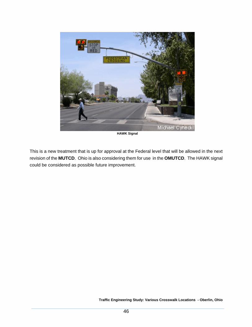
HAWK Signals
To increase pedestrian safety at school crossing locations, the City of Tucson developed a trafficsignal called the HAWK (High-intensity Activated crossWalK). The HAWK uses traditional traffic andpedestrian signal heads but in a different configuration. It includes a sign instructing motorists to“stop on red” and a “pedestrians” overhead sign. There is also a sign informing pedestrians on howto cross the street safely.
When not activated, the signal is blanked out. The HAWK signal is activated by a pedestrian pushbutton. The overhead signal begins flashing yellow and then solid yellow, advising drivers toprepare to stop. The signal then displays a solid red and shows the pedestrian a “Walk” indication.Finally, an alternating flashing red signal indicates that motorists may proceed when safe, aftercoming to a full stop. The pedestrian is shown a flashing “Don’t Walk” with a countdown indicatingthe time left to cross. The following photo shows a HAWK signal installation.
Traffic Engineering Study: Various Crosswalk Locations - Oberlin, Ohio
46
This is a new treatment that is up for approval at the Federal level that will be allowed in the nextrevision of the MUTCD. Ohio is also considering them for use in the OMUTCD. The HAWK signalcould be considered as possible future improvement.
HAWK Signal
Traffic Engineering Study: Various Crosswalk Locations - Oberlin, Ohio
47
5. CONCLUSIONS
Based on the results of the field review and analyses, we offer the following conclusions andrecommendations:
5.1 There are five mid-block crosswalks located in the downtown area of Oberlin, Ohio. Thefive locations are the North Main, South Main, Old City Hall, West College, and East Collegecrosswalks.
5.2 The weekday AM peak hour of vehicular traffic was determined to be 9:00 AM to 10:00 AMand the PM peak hour of vehicular traffic was determined to be 4:00 PM to 5:00 PM. Theweekday peak hour of pedestrian traffic was determined to be from 12:00 PM to 1:100 PM.These three periods were analyzed since they reflect the periods of the highest volume oftraffic flow for the roadway in terms of both vehicles and pedestrians.
5.3 The mid-block crossings are justified based upon the observed pedestrian volumes, theadjacent land uses, the layout and availability of parking spaces. The existing locations andspacing of these mid-block crosswalks is justified due to the spacing between the signalizedintersections and the density of the development along the Main Street and College Streetcorridors.
5.4 The sign combination of the pedestrian warning sign (W11-2) and the arrow plaque (W16-7p) is recommended to be located at all crosswalks facing each direction of travel. Theyield to pedestrian within crosswalk sign (R1-5) is an adequate alternative option to use atthese crosswalks.
5.5 To prevent sign clutter and overuse of the advance warning combination (W11-2 & W16-9p), advance warning sign combinations are only being recommended before the firstcrosswalk a motorist would encounter while traveling through the College Street and MainStreet corridors. The advance warning signs are recommended to be located just south ofLorain Street for southbound Main Street, north of Vine Street for northbound Main Street,east of Professor Street for eastbound College Street, and west of Pleasant Street forwestbound College Street. The use of word on pavement markings is recommended at thelocations of these advance warning signs. This would consist of PED XING being markedon the roadways at the four locations.

Traffic Engineering Study: Various Crosswalk Locations - Oberlin, Ohio
48
5.6 To provide a higher degree of visibility to motorists that there are marked mid-blockcrosswalks two alternative methods of striping the crosswalks are recommended. The firstmethod would be to continue to use the parallel lines that are perpendicular to the roadwaywith the area between the lines filled in with diagonal white lines. The second method towould be to use longitudinal lines parallel to the traffic flow to mark the crosswalk.
5.7 The West College crosswalk should be relocated so that it runs between the southwest andnorthwest quadrants of the West College Street and College Place intersection. Acrosswalk should also be striped across the College Place approach.
5.8 The implementation of yield lines on the roadways, on each side of the crosswalks isrecommended. These lines (shark teeth) would indicate the point in the roadway wheremotorists are supposed to yield in compliance with a Yield to Pedestrian sign (R1-5). Theyield to pedestrian sign (R1-5) would need to be installed at each yield line.
5.9 The first parking space on each of side of the crosswalk along the east side of North MainStreet should be eliminated. The first parking space along the north side of West CollegeStreet on each side of the crosswalk should be eliminated. The first parking space alongthe north side of East College Street on each side of the crosswalk should be eliminated.To ensure vehicles do not park in these areas the curbs should be painted yellow like thewest side of North Main Street at the crosswalk.
5.10 To improve the visibility for both the pedestrian and motorists bump outs (curb extensions)could be constructed at the West College, North Main, and East College crosswalks. Bumpouts are an extension of the sidewalk area across the parking lanes to the edge of the travellanes. These bump outs improve the visibility of pedestrians waiting to cross by bringingthem closer to the center of the driver’s cone of vision and by minimizing the impact ofparked vehicles on pedestrian visibility. This feature would narrow the distance of the roadthat a pedestrian has to cross. A shorter distance to cross would lessen the amount of timea pedestrian is in the roadway.
5.11 The curb ramp on the east side of the Old City Hall crosswalk should be reconfigured sothat it lines up directly with the crosswalk.
5.12 The curb ramps at all five crosswalk locations should be retro-fitted with detectable warningsurfaces consisting of truncated domes.

APPENDIX ATRAFFIC COUNTS

Mun
icip
alit
y:A
t Int
erse
ctio
n of
:an
d
Dat
e:
Day
:P
roje
ct:
Wea
ther
:
Dat
a en
try
by:
JJ
OD
ate
ente
red:
Left
Thru
Rig
htTo
tal
Trk
Bus
Left
Thru
Rig
htTo
tal
Trk
Bus
Left
Thru
Rig
htTo
tal
Trk
Bus
Left
Thru
Rig
htTo
tal
Trk
Bus
Nor
thSo
uth
East
Wes
t
06
:00
07
:00
01
94
01
94
17
40
26
10
26
11
49
45
50
90
90
09
46
40
.91
50
.77
70
.28
1
08
:00
02
77
02
77
13
60
25
60
25
62
75
53
30
30
03
00
03
05
63
0.8
24
0.8
53
0.5
00
09
:00
02
44
02
44
15
10
29
60
29
62
14
54
00
41
04
10
04
15
81
0.9
53
0.8
81
0.6
03
10
:00
11
:00
03
21
03
21
28
30
31
60
31
62
23
63
70
26
02
60
02
66
63
0.9
22
0.8
14
0.5
42
12
:00
03
41
03
41
15
20
31
00
31
01
71
65
10
57
05
70
05
77
08
0.8
97
0.8
42
0.8
38
1:0
00
27
80
27
81
84
03
50
03
50
24
26
28
05
60
56
00
56
68
40
.79
00
.91
10
.66
7
2:0
0
3:0
00
35
20
35
21
65
03
53
03
53
11
37
05
03
00
30
00
30
73
50
.90
70
.84
90
.75
0
4:0
00
39
00
39
01
82
03
86
03
86
15
57
76
04
30
43
00
43
81
90
.84
10
.85
40
.63
2
5:0
00
33
40
33
41
10
02
96
02
96
91
63
00
15
01
50
01
56
45
0.8
88
0.8
71
0.6
25
6:0
0
7:0
0
8:0
0
9:0
0
TOTA
LS0
27
31
02
73
11
51
27
02
82
40
28
24
16
03
35
55
50
30
70
30
70
03
07
58
62
AD
T0
42
28
04
22
80
43
72
04
37
28
59
90
47
50
47
54
75
90
74
H
OU
RLY
FA
CTO
R:
1
.72
MO
NTH
LY F
ACT
OR
:
0.9
0CO
MB
INED
FA
CTO
R:
1
.55
VEH
ICU
LAR
TR
AFF
IC C
OU
NT
SUM
MA
RY
07
-06
0
Rec
orde
r(s)
:
Obe
rlin
Clea
rJA
DSe
p. 2
6, 2
00
7
9/2
0/2
00
7Co
mm
ents
:
Thu.
TOTA
LA
LLD
IREC
.
PEA
K H
OU
R F
ACT
OR
N.M
ain
St b
etw
een
Lora
in S
tree
t & C
olle
g
Cros
swal
k at
Nor
th M
ain
Stre
etbe
twee
n Lo
rain
Str
eet &
Col
lege
Str
eet
FRO
M W
EST
Pag
e #
:
TMS
ENGI
NEE
RS,
INC.
45
47
Hud
son
Dri
veFi
gure
#:
Stow
, Ohi
o 4
42
24
(33
0) 6
86
-64
02
F
AX
: (3
30
) 68
6-6
41
7
6.5
%6
.8%
0.0
%
TOTA
LEA
STW
EST
FRO
M E
AST
TOTA
LN
OR
THSO
UTH
Ped
sTI
ME
BEG
INS
N. M
ain
St.
N. M
ain
St.
FRO
M N
OR
THFR
OM
SO
UTH

Mun
icip
alit
y:A
t Int
erse
ctio
n of
:an
d
Dat
e:
Day
:P
roje
ct:
Wea
ther
:
Dat
a en
try
by:
JJ
OD
ate
ente
red:
Left
Thru
Rig
htTo
tal
Trk
Bus
Left
Thru
Rig
htTo
tal
Trk
Bus
Left
Thru
Rig
htTo
tal
Trk
Bus
Left
Thru
Rig
htTo
tal
Trk
Bus
Nor
thSo
uth
East
Wes
t
06
:00
07
:00
02
13
02
13
14
50
26
80
26
81
91
34
81
02
02
00
24
83
0.8
73
0.7
70
0.5
00
08
:00
02
63
02
63
32
40
28
50
28
53
44
54
80
10
01
00
01
05
58
0.8
54
0.9
02
0.5
00
09
:00
02
61
02
61
25
30
28
61
28
73
33
54
80
35
03
50
03
55
83
0.8
70
0.8
97
0.5
83
10
:00
11
:00
03
20
03
20
29
20
29
10
29
12
24
61
10
42
04
20
04
26
53
0.8
99
0.8
66
0.7
00
12
:00
13
80
03
81
22
20
33
90
33
92
35
72
00
81
08
10
08
18
01
0.7
94
0.8
48
0.8
10
1:0
00
37
20
37
23
34
03
13
03
13
24
36
85
04
50
45
00
45
73
00
.89
40
.88
90
.75
0
2:0
0
3:0
00
42
70
42
72
32
03
00
03
00
73
72
70
47
04
70
04
77
74
0.8
82
0.9
15
0.6
18
4:0
00
46
70
46
71
88
03
44
03
44
20
88
11
03
30
33
00
33
84
40
.92
70
.85
10
.68
8
5:0
00
42
01
42
11
81
03
19
03
19
16
17
40
04
80
48
00
48
78
80
.95
70
.96
10
.70
6
6:0
0
7:0
0
8:0
0
9:0
0
TOTA
LS1
31
23
13
12
52
14
31
02
74
51
27
46
19
84
45
87
10
34
30
34
30
03
43
62
14
AD
T2
49
42
24
94
50
43
44
24
34
59
29
00
54
30
54
35
43
98
33
H
OU
RLY
FA
CTO
R:
1
.72
MO
NTH
LY F
ACT
OR
:
0.9
2CO
MB
INED
FA
CTO
R:
1
.58
VEH
ICU
LAR
TR
AFF
IC C
OU
NT
SUM
MA
RY
07
-06
0
Rec
orde
r(s)
:
Obe
rlin
Clea
rEB
SSe
p. 2
0, 2
00
7
9/1
8/2
00
7Co
mm
ents
:
Tue.
TOTA
LA
LLD
IREC
.
PEA
K H
OU
R F
ACT
OR
29
S.M
ain
St C
ross
wal
k 0
91
80
7
29
Sou
th M
ain
Stre
etCr
ossw
alk-
Arm
y/N
avy
Stor
e
FRO
M W
EST
Pag
e #
:
TMS
ENGI
NEE
RS,
INC.
45
47
Hud
son
Dri
veFi
gure
#:
Stow
, Ohi
o 4
42
24
(33
0) 6
86
-64
02
F
AX
: (3
30
) 68
6-6
41
7
7.8
%8
.8%
0.0
%
TOTA
LEA
STW
EST
FRO
M E
AST
TOTA
LN
OR
THSO
UTH
Ped
sTI
ME
BEG
INS
Sout
h M
ain
St.
Sout
h M
ain
St.
FRO
M N
OR
THFR
OM
SO
UTH
Mun
icip
alit
y:A
t Int
erse
ctio
n of
:an
d
Dat
e:
Day
:P
roje
ct:
Wea
ther
:
Dat
a en
try
by:
JJ
OD
ate
ente
red:
Left
Thru
Rig
htTo
tal
Trk
Bus
Left
Thru
Rig
htTo
tal
Trk
Bus
Left
Thru
Rig
htTo
tal
Trk
Bus
Left
Thru
Rig
htTo
tal
Trk
Bus
Nor
thSo
uth
East
Wes
t
06
:00
07
:00
02
31
02
31
15
30
31
90
31
91
31
35
50
01
20
12
00
06
06
00
18
56
80
.73
10
.88
60
.33
30
.50
0
08
:00
02
51
02
51
14
30
29
60
29
62
31
54
70
90
90
00
30
30
01
25
59
0.8
26
0.8
04
0.7
50
0.3
75
09
:00
03
12
03
12
23
10
31
70
31
73
66
62
90
26
02
60
00
10
10
02
76
56
0.8
13
0.9
43
0.6
50
0.2
50
10
:00
11
:00
03
81
03
81
25
30
34
40
34
42
73
72
50
29
02
90
02
97
54
0.9
25
0.8
04
0.5
58
12
:00
04
13
04
13
21
00
39
30
39
32
22
80
60
41
04
10
00
20
20
04
38
49
0.8
46
0.8
77
0.5
13
0.5
00
1:0
00
40
10
40
12
06
03
59
03
59
21
17
60
03
00
30
00
30
79
00
.92
80
.86
30
.75
0
2:0
0
3:0
00
47
60
47
61
86
03
82
03
82
20
48
58
02
80
28
00
28
88
60
.87
50
.90
10
.70
0
4:0
00
51
90
51
91
02
04
30
04
30
10
79
49
03
40
34
00
01
01
00
35
98
40
.87
70
.88
10
.77
30
.25
0
5:0
00
48
80
48
81
31
03
89
03
89
55
87
70
12
01
20
01
28
89
0.9
53
0.9
35
0.5
00
6:0
0
7:0
0
8:0
0
9:0
0
TOTA
LS0
34
72
03
47
21
59
25
03
22
90
32
29
17
74
26
70
10
22
10
22
10
00
13
01
30
02
34
69
35
AD
T0
51
96
05
19
60
48
32
04
83
21
00
27
03
31
03
31
01
90
19
35
01
03
78
H
OU
RLY
FA
CTO
R:
1
.72
MO
NTH
LY F
ACT
OR
:
0.8
7CO
MB
INED
FA
CTO
R:
1
.50
TIM
EB
EGIN
S
Sout
h M
ain
St.
Sout
h M
ain
St.
FRO
M N
OR
THFR
OM
SO
UTH
TOTA
LN
OR
THSO
UTH
5.3
%6
.8%
0.0
%0
.0%
TOTA
LEA
STW
EST
Stow
, Ohi
o 4
42
24
(33
0) 6
86
-64
02
F
AX
: (3
30
) 68
6-6
41
7
FRO
M E
AST
Pag
e #
:
TMS
ENGI
NEE
RS,
INC.
45
47
Hud
son
Dri
veFi
gure
#:
TOTA
LA
LLD
IREC
.
PEA
K H
OU
R F
ACT
OR
FRO
M W
EST
VEH
ICU
LAR
TR
AFF
IC C
OU
NT
SUM
MA
RY
07
-06
0
Rec
orde
r(s)
:
Obe
rlin
Clea
rEB
S &
JAD
Ped
s.P
eds.
Sep.
20
, 20
07
9/1
4/2
00
7Co
mm
ents
:
Fri.
69
S.M
ain
St C
ross
wal
k 0
91
40
7
69
Sou
th M
ain
Stre
etCr
ossw
alk-
Old
Cit
y H
all
Mun
icip
alit
y:A
t Int
erse
ctio
n of
:an
d
Dat
e:
Day
:P
roje
ct:
Wea
ther
:
Dat
a en
try
by:
JJ
OD
ate
ente
red:
Left
Thru
Rig
htTo
tal
Trk
Bus
Left
Thru
Rig
htTo
tal
Trk
Bus
Left
Thru
Rig
htTo
tal
Trk
Bus
Left
Thru
Rig
htTo
tal
Trk
Bus
Nor
thSo
uth
East
Wes
t
06
:00
07
:00
01
00
10
00
50
38
00
18
74
80
55
50
09
39
10
21
21
57
17
50
.50
00
.50
00
.49
10
.67
1
08
:00
02
60
26
00
30
47
00
33
14
10
00
11
43
30
11
26
11
83
12
32
26
50
.50
00
.35
00
.67
90
.86
8
09
:00
05
30
53
00
11
01
02
10
07
41
81
09
01
27
27
01
40
15
15
53
72
82
35
60
.57
60
.65
60
.57
70
.77
5
10
:00
11
:00
01
02
01
02
00
13
01
22
50
01
27
96
50
74
20
01
12
12
12
44
11
98
32
50
.77
30
.62
50
.66
10
.86
1
12
:00
01
17
01
17
00
23
02
95
20
01
69
16
84
01
00
20
01
28
21
14
91
32
49
41
80
.71
30
.86
70
.80
60
.82
8
1:0
00
10
30
10
30
01
40
18
32
00
13
51
79
60
11
34
00
12
71
61
43
70
25
63
91
0.7
57
0.8
00
0.8
31
0.8
31
2:0
0
3:0
00
10
30
10
30
01
60
15
31
00
13
41
51
03
01
18
32
01
53
19
17
23
12
90
42
40
.59
90
.70
50
.75
60
.91
5
4:0
00
10
10
10
10
01
60
15
31
00
13
21
71
13
01
30
12
01
59
81
67
01
29
74
29
0.8
15
0.7
75
0.7
93
0.9
28
5:0
00
94
09
40
01
00
11
21
00
11
51
19
80
10
90
00
12
21
31
35
10
24
43
59
0.6
03
0.5
83
0.8
26
0.8
88
6:0
0
7:0
0
8:0
0
9:0
0
TOTA
LS0
70
90
70
90
01
11
01
17
22
80
09
37
12
48
16
09
40
22
14
01
14
61
19
12
65
23
16
22
05
31
42
AD
T0
11
22
01
12
21
76
01
85
36
11
48
31
96
12
91
01
48
70
18
13
18
82
00
23
48
94
97
2
H
OU
RLY
FA
CTO
R:
1
.72
MO
NTH
LY F
ACT
OR
:
0.9
2CO
MB
INED
FA
CTO
R:
1
.58
VEH
ICU
LAR
TR
AFF
IC C
OU
NT
SUM
MA
RY
07
-06
0
Rec
orde
r(s)
:
Obe
rlin
Clea
rJA
DSe
p. 2
0, 2
00
7
9/1
8/2
00
7Co
mm
ents
:
Tue.
TOTA
LA
LLD
IREC
.
PEA
K H
OU
R F
ACT
OR
37
W. C
olle
ge S
t Cro
ssw
alk
37
Wes
t Col
lege
Str
eet
Cros
swal
k-O
berl
in B
ooks
tore
FRO
M W
EST
Pag
e #
:
TMS
ENGI
NEE
RS,
INC.
45
47
Hud
son
Dri
veFi
gure
#:
Stow
, Ohi
o 4
42
24
(33
0) 6
86
-64
02
F
AX
: (3
30
) 68
6-6
41
7
0.0
%0
.0%
3.1
%3
.8%
TOTA
LEA
STW
EST
FRO
M E
AST
TOTA
LN
OR
THSO
UTH
Wes
t Col
lege
St.
Wes
t Col
lege
St.
TIM
EB
EGIN
S
Ped
s.Si
de S
tree
t
FRO
M N
OR
THFR
OM
SO
UTH

Mun
icip
alit
y:A
t Int
erse
ctio
n of
:an
d
Dat
e:
Day
:P
roje
ct:
Wea
ther
:
Dat
a en
try
by:
JJ
OD
ate
ente
red:
Left
Thru
Rig
htTo
tal
Trk
Bus
Left
Thru
Rig
htTo
tal
Trk
Bus
Left
Thru
Rig
htTo
tal
Trk
Bus
Left
Thru
Rig
htTo
tal
Trk
Bus
Nor
thSo
uth
East
Wes
t
06
:00
07
:00
01
01
00
10
39
03
92
10
69
06
92
51
08
10
90
.25
00
.60
90
.71
9
08
:00
09
09
00
90
10
50
10
52
20
12
90
12
96
62
34
24
30
.45
00
.90
50
.84
9
09
:00
02
60
26
00
26
01
60
01
60
56
01
43
01
43
27
30
33
29
0.5
42
0.9
52
0.8
72
10
:00
11
:00
02
80
28
00
28
01
14
01
14
23
01
40
01
40
33
25
42
82
0.7
00
0.6
63
0.8
33
12
:00
02
80
28
00
28
01
54
01
54
20
01
64
01
64
25
31
83
46
0.7
00
0.8
02
0.8
20
1:0
00
29
02
90
02
90
12
70
12
74
10
15
70
15
73
22
84
31
30
.80
60
.73
80
.83
5
2:0
0
3:0
00
28
02
80
02
80
17
60
17
65
60
17
00
17
08
33
46
37
40
.77
80
.69
80
.85
0
4:0
00
26
02
60
02
60
16
70
16
70
10
19
40
19
44
33
61
38
70
.65
00
.92
80
.89
8
5:0
00
50
50
05
01
07
01
07
10
01
47
01
47
21
25
42
59
0.6
25
0.8
92
0.8
35
6:0
0
7:0
0
8:0
0
9:0
0
TOTA
LS0
18
00
18
00
01
80
01
14
90
11
49
23
20
01
31
30
13
13
32
35
24
62
26
42
AD
T0
27
90
27
92
79
01
77
90
17
79
02
03
30
20
33
38
11
40
90
H
OU
RLY
FA
CTO
R:
1
.72
MO
NTH
LY F
ACT
OR
:
0.9
0CO
MB
INED
FA
CTO
R:
1
.55
VEH
ICU
LAR
TR
AFF
IC C
OU
NT
SUM
MA
RY
07
-06
0
Rec
orde
r(s)
:
Obe
rlin
Clea
rEB
SSe
p. 2
6, 2
00
7
9/2
0/2
00
7Co
mm
ents
:
Thu.
TOTA
LA
LLD
IREC
.
PEA
K H
OU
R F
ACT
OR
27
E.C
olle
ge S
t & C
ross
wal
k 0
92
00
7
27
Eas
t Col
lege
Str
eet
Cros
swal
k
FRO
M W
EST
Pag
e #
:
TMS
ENGI
NEE
RS,
INC.
45
47
Hud
son
Dri
veFi
gure
#:
Stow
, Ohi
o 4
42
24
(33
0) 6
86
-64
02
F
AX
: (3
30
) 68
6-6
41
7
0.0
%5
.1%
3.7
%
TOTA
LEA
STW
EST
FRO
M E
AST
TOTA
LN
OR
THSO
UTH
27
E. C
olle
ge S
t.2
7 E
. Col
lege
St.
TIM
EB
EGIN
S
Ped
s.
FRO
M N
OR
THFR
OM
SO
UTH
TRAFFIC ENGINEERING STUDY
VARIOUS CROSSWALK LOCATIONSOBERLIN, OHIO
NOVEMBER 14, 2007
Prepared For:
OBERLIN MUNICIPAL LIGHT & POWER289 SOUTH PROFESSOR STREET
OBERLIN, OHIO 44074
Prepared By:
TMS ENGINEERS, INC.4547 HUDSON DRIVESTOW, OHIO 44224
“This document was prepared consistent with local agency requirements and/orapplicable guidelines contained in this report.”