Worksheets on Locating Places on a Map -Geography and History

Trading Places: A Historical Geography of Retailing in London,Canada
Mathew J. Novak, Jason A. Gilliland
Social Science History, Volume 35, Number 4, Winter 2011, pp. 543-570(Article)
Published by Duke University Press
For additional information about this article
Access provided by Western Ontario, Univ of (6 Aug 2013 09:36 GMT)
http://muse.jhu.edu/journals/ssh/summary/v035/35.4.novak.html

Social Science History 35:4 (Winter 2011)DOI 10.1215/01455532-1381841© 2011 by Social Science History Association
Mathew J. Novak and Jason A. Gilliland
Trading PlacesA Historical Geography of Retailing in London, Canada
The economies of modern cities are dependent on an advanced retail system; so too are the people who inhabit them. The origin and evolution of retailing in London, Canada, was studied using a historical geographic information system (GIS) to document the relationship between a city and its retail sector. Visualization and spatial- statistical techniques afforded by the historical GIS were implemented to study change over time. The locations of retailers and the types of the goods they sold were examined for four periods in the city’s early history: 1844, 1863, 1881, and 1916. The distances traveled to shop were also calculated for a variety of goods. The results indicate that the retail system was ingrained in the development of the city, showing marked locational patterns and a high degree of rationality in the shopkeepers’ business strategies. Mapping the retail landscape in each era using historical GIS allowed for the examination of the relation-ship between retail and residential development in the growing city. While the down-town area remained the primary retail district for the city, considerable retail expansion also occurred at the urban periphery during this early stage of the city’s development.
Shopping is a defining act of modern urban life. Retailers satisfy basic material needs of their customers and endeavor to stimulate their desires (Leach 1993). Stores are significant components of the built environment, typically lining and defining the character of a city’s busiest arteries. Furthermore, shop-ping districts are vital places in the public realm where people congregate and interact. Economically, retailers provide employment and serve as an essential link in the commodity chain, acting as a liaison between producer and consumer. The importance of retailing specifically, and consumption in

544 Social Science History
general, has been acknowledged in social science research (Miller 1995). Yet retail history remains fragmented along spatial and temporal lines (Glennie 1995); retail’s role in the developing city has been generally overlooked.
This article examines the origin and evolution of the retail sector in Lon-don, Canada, from its settlement in 1826 through a period of rapid urbaniza-tion to its development as a modern city in 1916. The entrenchment of retail-ing in the city is established by following the introduction and expansion of early stores. Using an innovative historical geodatabase of retailers, the spatial and functional makeup of the retail system is examined to show how retailing evolved in relation to successive waves of urban growth. A particular focus is placed on food and fashion retailers to identify how locational pref-erences changed during the study period. The journey to shop is also exam-ined for several types of stores to reveal spatial variations in market areas and the changing relationship of shopping with the general social structure of the city. Examining the urban landscape at each of the time periods reveals the changing relationship between retail and residential development, notably at the urban periphery. The article concludes with a discussion of the value of implementing a geographic information system (GIS) to create, manage, and analyze data for urban history.
Current Understanding of Retail’s Place in the City
The history of retailing is perhaps most comprehensively documented for Britain, with several volumes that reveal the business practices of early retail shopkeepers and their clientele (Cox 2000; Jefferys 1954; Mui and Mui 1989). These studies examine such characteristics as sales figures, types of goods, advertising methods, and store design. They are typically collections of studies on individual sectors or biographical sketches of the stores and their keepers; seldom do they look at the retail landscape of a city as a whole. A second stream of research looks at the types and locations of stores on either the national or the regional scale (Phillips 1992; Shaw and Wild 1979). Since British towns have a much longer history than those in North America, these studies cannot examine the origins and early evolution of a retail system in an urban area and are thus limited in their explanatory power as to the implica-tions of retail in urban development.
In North America the history of retailing has been predominantly con-

Retailing in London, Canada 545
cerned with the great American innovation in retailing, the planned shop-ping center (Cohen 1996; Gillette 1985). Victor Gruen, the “mall maker,” is the best- known mall designer, and he theorized that malls should be the new, suburban equivalents of the social downtown areas (Hardwick 2003). In response to the changes these new retail formats imparted on the estab-lished retail patterns, Berry et al. 1963 presents a typology of retail areas by examining retailing in Chicago. Studies pertaining to retailing earlier than the twentieth century are much less common. There have been only a few studies that examine the origins or evolution of early retailing, espe-cially from a historical- geographic perspective. One exception is a study by Michael Conzen and Kathleen N. Conzen (1979) that mapped the location of stores in Milwaukee in the nineteenth century, showing that a complex retail structure existed earlier than previous scholars had suggested. In Milwau-kee, decentralization of retail activities had already begun by the nineteenth century.
Retailing has a long tradition in geography, dating to the early twentieth century with Walter Christaller’s (Christaller and Baskin 1966) and August Losch’s (1967) discrete but similar central- place theories describing the locations where goods and services are provided. Retailing has been studied on the metropolitan scale, fitting it into the theories of urban development (Berry et al. 1963; Bowden 1971; Vance 1970). But these studies often look at one period and the aggregate location patterns of retailing to formulate determinist models. More recently, the geographic literature has undergone a major shift in emphasis from the traditional, economic- dominated retail geography analyses of store locations and market areas to a new retail geog-raphy that looks at how people use the sites of consumption in step with the cultural turn (Thrift 2000). Today there are theoretically informed cultural readings of retail sites due in part to the acknowledgment of consumption’s place in the social sciences (Crang and Malbon 1996; Crewe 2000; Staeheli and Mitchell 2006). Historical geographers, however, have shied away from the topic, leaving a void in the understanding of the origins and evolution of urban retailing. Neither the empirical location patterns of retailers and their markets nor the place of retailing in past societies has been properly exam-ined. This dearth is especially acute for North America.
This study attempts to address the deficit in knowledge surrounding the advent and early development of urban retailing in North America from a his-torical geography perspective. The decisions of early retailers are examined

546 Social Science History
through their location and product strategies. The routes from consumer to retailer are also examined to show a dimension of movement through the early city. By examining the history of retailing, a foundation is laid on which to base the contemporary theorizing of the activity. It also adds to the debate of the advent of the consumer society by demonstrating the degree to which retailing was occurring in the primitive beginnings of an isolated Canadian settlement.
The Establishment of Retailing in London, Canada
As in nearly every urban area, retailing in London has been present from the first stages of the community’s settlement. The city was established in 1826 with the proclamation that it would be the seat of the Western District of Upper Canada, the peninsula to the southwest of Toronto between Lake Huron and Lake Erie (Mombourquette 1992). A survey was conducted, and settlers began to occupy the lots, which were given away as long as the takers cleared the land and constructed a cabin. Although it was building the court-house that brought the first people to the village, a retail store was opened in the first years to provide for the early residents. The civil servants adminis-tering to the needs of the district had to satisfy their own needs by obtaining goods and services from local retailers.
The first store, opened in 1827 or 1828, was primitive; a board held up by two barrels fashioned the counter, and its stock was general in nature (His-tory of the County of Middlesex, Canada 1889). There was no chinking between the logs, thus “the curious settlers would spend hours observing his stock of frying- pans, griddles, spiders, baking- kettles, tinware, and a thousand other articles which make the visitor to the country store covet the whole stock” (ibid.: 216). Despite its simple physical condition, the store provided a selec-tion of imported goods for the early inhabitants to buy. With the village’s population growing, a second store opened a few years later, marking the first prominent retail business in the city’s history. The second store was a much larger enterprise, which contained a post office and a real estate office as well as the general store (Armstrong 1986). These early stores as well as the several taverns and hotels were all located in close proximity to the courthouse. This was the principal build-ing in the settlement, and retailers located near it in hopes of attracting cus-

Retailing in London, Canada 547
tomers while they were conducting their civic business. The link between the public building and the semipublic business establishments reveals the early social and business core of the city. The focus of these activities was at the intersection of Dundas and Ridout Streets. In the grid plan of London, these streets were undifferentiated from the others; rather, it was their con-nections to distant communities and London’s hinterland that made them suitable sites for retailers to locate. Dundas Street was the original connec-tion between London and the port of Dundas on the eastern shore of Lake Ontario; Ridout Street connected to the York Street Bridge and later the Blackfriar’s Street Bridge, linking London to the western farmlands and more distant settlements along the Detroit River (ibid.). The early retail-ers located along these streets to attract not just local citizens but also those coming to the village from surrounding communities and farms to conduct their business.
Even though road travel was difficult and the community isolated, the retail sector continued to develop throughout the early years of London’s history. The inhabitants required shops to provide goods that they could not generate themselves. Furthermore, the city’s shops provided a nucleus of urban activity, as shown on an 1839 map of the city.1 The surveyed lands within the village boundaries were generally evenly but sparsely developed, with two to eight structures per block. The only perturbation from this pat-tern was at the main intersection, which had continuous rows of buildings. This intersection was the center of civic life in the city, a place where people would congregate to perform their civic and business activities. Thus the retail core in the early village had already been established with a quintessen-tially urban character.
The opening of the first industries, a brewery in 1828 (it was acquired in 1847 by John Labatt, whose namesake brewery remains in London today) and a tannery in 1829, led to a surge in economic growth (ibid.; History of the County of Middlesex, Canada 1889). They employed numerous people, who in turn had to buy goods from the retailers. They also manufactured products such as beer and clothing for local consumption. Finally, the early industries secured ties with London’s hinterland as local farmers brought their hides and grains into the city to sell to the industries and used this money to obtain goods from the local shops. By 1854 London’s population had reached 10,000 people, and the following year it received city status (Miller 1992). Thus in fewer than 30 years the settlement at the Forks of the Thames had grown

548 Social Science History
from a small clearing in the woods into a thriving city. London was securely established as the center of the western district in political power, industrial production, and service provisioning.
With 10,000 citizens and many more who traveled to the city from the surrounding countryside and villages, London had by this point a well- established and complex retail system. The size of the market allowed for more stores offering a greater variety of goods. Specialization in stores was observed by 1850, with millinery and butcher shops among the 16 types listed in an early history of the city (History of the County of Middlesex, Canada 1889). The array of goods, much wider than in the founding era, came from local manufacturers, which had greatly expanded, and were also imported from elsewhere in Upper Canada as well as internationally. Necessities became easier to obtain, and luxuries began to appear in the store windows, tempting passersby. The arrival of the railroad in 1853 was especially impor-tant for opening up the once isolated London market, connecting it with the burgeoning ports to the east along Lake Ontario.
Retailers were an integral component of the first stages of settlement, providing a source of goods that could not be secured independently in the isolated community surrounded by dense Canadian wilderness. They also were a driving force in creating an urban nucleus that would remain in the same general location to the present day.
Using Historical GIS to Examine Retail Change
Four study years were chosen to examine the retail sector due to their repre-sentative characteristics of successive eras of development as well as for their availability of data sources.2 The 1844 tax assessment represents a period when London was still a small, isolated town with poor connections to the larger markets to the east. The first business directory to list all retailers was from 1863, when the city had about 11,000 citizens; the railway connecting London with its hinterland and other cities was less than a decade old by this time, and it greatly reduced the friction of travel to and from London. By 1881 the retail sector was fully established; the city was experiencing rapid industrialization; transportation had been enhanced by the introduction of the horse- powered tramway; and London’s population had nearly doubled to 20,000 residents. Finally, 1916 was chosen to represent the late industrial

Retailing in London, Canada 549
period, when automobiles were beginning to be adopted and the traditional retail patterns were at their climax.
The first comprehensive documentation of London’s population and retailers is found in the 1844 tax assessment. City directories were used to ascertain the retail landscape in each of the later periods.3 The 1881 city direc-tory was chosen to represent this period, since a corresponding fire insurance plan is available, which facilitates mapping the directory and provides useful information on the built environment, such as structural characteristics and land uses. The 1916 city directory was selected to represent the late industrial period, since a fire insurance plan and digital database of the tax assessment roll is available for this year. The foundation of the historical GIS was a series of digitally scanned historical cartographic sources (e.g., fire insurance plans). Cartographic rep-resentations of the city in successive eras of development were spatially ref-erenced to their proper geographic coordinates using known control points, such as extant buildings and lot lines (Gilliland and Novak 2006).4 These maps were used to locate individual records in spatially referenced databases created from a historical time series of nominal sources, such as the city directories, which provide details on residents and businesses present in the city for a given year.5 Finally, supplemental graphic and textual sources were linked in the system to enhance the story, notably photographs and news-paper articles. Each of the data records had both a spatial and a temporal marker. Thus all the retailers in a given time period could be identified by location. The retailers were classified by the type of goods sold, as listed in the busi-ness directories. Three groups were used: those selling foodstuffs (bakers, butchers, grocers, and produce merchants), those purveying fashions (dry goods retailers, dressmakers, tailors, milliners, and jewelers), and all other types. The food retailers represent convenience goods, which were needed on a regular basis without much comparison, while the fashion retailers sold comparison goods, which were purchased less frequently but with greater attention to differences. The different nature of the goods results in different location strategies, which are examined in the following sections ( Jones and Simmons 1987; Scott 1970).
550 Social Science History
Store Type and Location in the Growing City
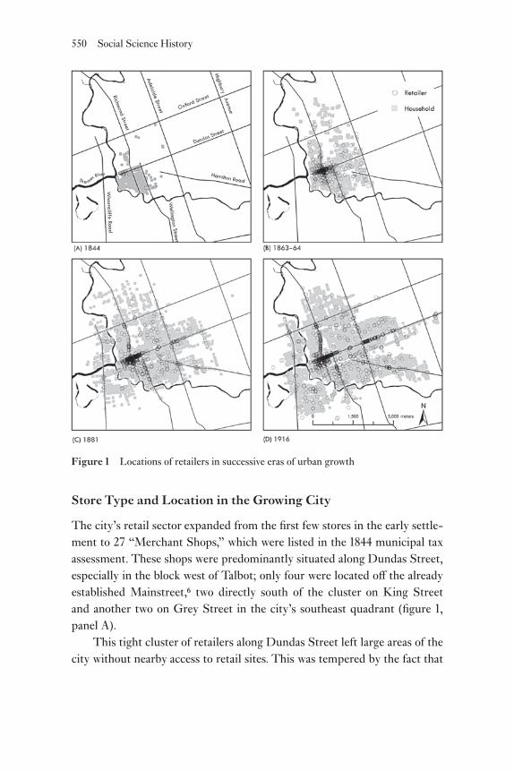
The city’s retail sector expanded from the first few stores in the early settle-ment to 27 “Merchant Shops,” which were listed in the 1844 municipal tax assessment. These shops were predominantly situated along Dundas Street, especially in the block west of Talbot; only four were located off the already established Mainstreet,6 two directly south of the cluster on King Street and another two on Grey Street in the city’s southeast quadrant (figure 1, panel A).
This tight cluster of retailers along Dundas Street left large areas of the city without nearby access to retail sites. This was tempered by the fact that
Figure 1 Locations of retailers in successive eras of urban growth

Retailing in London, Canada 551
the city had a small spatial extent. The city’s population was highly concen-trated south of Dundas Street and west of Wellington (figure 1, panel A). The longest distance traveled to the retail core along the street network was about 2,000 meters, with most people living closer. Also, the two merchants along Grey Street would have served the needs of those living in the more peripheral areas.
The average value of the Merchant Shops in the assessment records was £198, while the mean for all the assessment was £63.7 The ability of retail-ers to occupy sites that were worth roughly three times the average rate for the city demonstrates their need to be in desirable locations and thus to out-bid other land uses, a process described by neoclassical economic theories of urban land rents (Alonso 1964). It also demonstrates that retailers built and occupied some of the most substantial buildings in the community. Unfor-tunately, the records do not indicate the building heights or construction materials of the shops, but they do for the other properties, which were all one or two stories tall. Those that were two stories high and of brick or stone construction were generally assessed higher; thus we can assume that these early retail shops were at least two stories high and were built more substan-tially than the typical structures.
By 1863 the city’s population had grown to over 12,000 and subsequently had spread out. The 1863–64 city directory shows that the city’s develop-ment had reached Adelaide Street in the east and Oxford Street to the north. There were also some inhabitants north of Oxford Street but in much lower density (figure 1, panel B). Adelaide Street marked the edge of the city’s political boundary at the time and would later serve as the line between Lon-don and the autonomous village of London East.
The 1863–64 city directory unfortunately does not provide listings for the suburbs; however, there were likely few people living outside the city limits, although industry did not develop in London East until the late 1860s (Lutman and Hives 1982). Similarly, London West, directly west of the downtown across the Thames, was recently subdivided but did not have a substantial population at the time (Stott 2007). With only a small scattering of inhabitants, it is doubtful if these areas had any substantial retail presence in the era before or during the early 1860s.
In step with the substantial growth of the city’s population between 1844 and 1863 was the city’s burgeoning retail sector. By 1863 there were 306

552 Social Science History
entries in the business directory for retailers. The locations of stores in 1863 still shows a predominant cluster along Dundas Street (figure 1, panel B), the street now firmly entrenched as the city’s main retail district. This cluster was much larger than in the previous era, having expanded to Wellington Street, three blocks east of its previous termination at Talbot Street. Other retailers began to locate along Richmond Street, which had seen no retail develop-ment in the previous era and had since become the second most important street in the city, as measured by number of retail sites. A clear central busi-ness district was established by this era, encompassing other retailers located along the lesser streets around the now main intersection of Richmond and Dundas.
Retail growth was not limited to the downtown core. Areas that pre-viously had no shops were serviced by 1863. Other areas that had not even been developed in 1844, such as north of Dundas Street, had become highly populated and were also well serviced by stores (figure 1, panel B). Thus as the city grew in population and area, retailers moved in to satisfy the needs of the expanding market as well as their desire to turn a profit, setting up shop in areas that had not been settled just 20 years earlier.
By 1881 development of the city had expanded across the physical bar-rier of the Thames to the south and west of downtown, creating the autono-mous suburbs of London South and London West. A third suburb, the most populous of the three, was located east of Adelaide Street and was referred to as London East. This area was home to many of the city’s early industries, especially its oil refining and train- car sectors (Lutman and Hives 1982; Stott 2007). Dundas Street extended through the heart of this community, form-ing its principal retail corridor from Adelaide to Rectory Streets, with few retailers located elsewhere in the suburb (figure 1, panel C). Thus Dundas served as the Mainstreet for the city of London proper and for the neighbor-ing town of London East.
In the community of London West, Blackfriar’s Street formed the com-mercial center. This was likely due to its connection to the main city via the Blackfriar’s Street Bridge. This vital connection filtered traffic along the street, thus drawing many retailers. A second bridge was located in the southern section of the community to connect with Dundas Street. This area was populated similarly to the northern area and was also connected to the city, but it lacked a retail cluster. This was likely due to competition from London’s core, which was located close by; those living in the southern area

Retailing in London, Canada 553
of London West would probably have traveled the short distance across the bridge to the city proper to do their shopping.
London South also had a cluster of retailers by 1881. These serviced the community along the Wharncliffe Highway. This site was developed first as a retail center for its connections to London West via a bridge across the main branch of the Thames and its connections to points south, servicing the sur-rounding rural settlers as a first point of entry to the urban area.
By 1881 there were 719 retailers listed in the business directory, with another 763 other listings, such as service and industrial proprietors. The variety of retail types was diverse by this stage, with 88 categorical listings, from dry goods to butchers to wine merchants and booksellers. Many of the stores were listed in several categories; for example, A & J G McIntosh was listed under the clothing, carpets and oil cloths, and dry goods cate-gories. These were complementary goods in one store. Other types, such as butchers, were generally only listed under one category.
By 1916 the city had not appreciably expanded in spatial extent, but the population had risen substantially to 60,000 citizens. As such, the popula-tion density was much greater than in the previous era. The increased popu-lation was accompanied by a rise in the number of retail stores, both in the urban core and in more peripheral locations (figure 1, panel D). A predomi-nant characteristic of the location of stores in this era is their servicing of areas that had previously lacked stores. Retailers moved into areas that were becoming more densely populated. This is demonstrated by the concentra-tion of 19 retailers north of Dundas Street in London East by 1916; the area had only 2 in 1881.
Retailers also located along the major streets in the city; they dotted the extents of Adelaide Street, Wellington Street, Oxford Street, Wharn-cliffe Highway, and Hamilton Road. In all areas of the city, retailers tended to locate in linear fashion along the principal arteries rather than along side streets. The focus of these linear concentrations was at the intersections of two primary arteries. Of the 1,117 listings in the 1916 business directory, 722, or 65 percent, were located along these seven streets. Despite the growth along the streets leading to the peripheral locations, Dundas Street remained the site of the greatest retail activity. Here were the large department stores as well as a major cluster of fashion retailers.
Due to its popularity, space along the frontages of Dundas Street was nearly completely occupied by existing stores. While there was additional

554 Social Science History
space in the upper floors or at the rear of buildings, these spaces were not preferred, since they were less visible and less accessible to the customers passing by on the sidewalk. Thus new retailers were forced to locate else-where once the main retail district along Dundas Street had become com-pletely occupied. A few located east of Wellington Street, but this area was over 500 meters from the main intersection at Richmond and Dundas and 900 meters from the well- established western extent of the retail district at the courthouse. These distances were likely too far for pedestrians to com-fortably stroll along the street and compare goods from one end to the other. Many thus began to locate along Richmond Street once frontages along Dun-das Street were fully occupied. Here they found available space at lower rents but within reach of the large numbers of shoppers along Dundas Street.
Richmond Street also became a desirable location for retail activities, since it was a principal artery for northbound and southbound traffic to the core. In 1875 horsecars, and in 1895 electric streetcars, traveled along Rich-mond Street (Armstrong 1986). A second line traveled along Dundas Street in the east- west direction. The streetcars brought workers and customers to the downtown from more distant residential areas. In addition, those wait-ing for a connection with another line would also be exposed to the offerings of the retail district. The increased accessibility of the central retail district made possible by these lines ensured that the peak value intersection would remain at the crossing of Richmond and Dundas Streets. There were 106 unique retail categories in the 1916 business directory listings, an addition of 18 over the 1881 directory. This is an increase of 69 over the 37 unique types in the 1863 directory. New retail types, such as those selling bicycles and phonographs, arose to offer new technologies in special-ized shops. Notable additions were the stores offering automobiles and the supplies to keep them in operation. Thus in the half century between 1863 and 1916, there was a threefold increase in the categories of retail offerings. There likely was an even greater difference in the types of goods offered in each category, for example, a greater variety of fruits and vegetables sold at the produce shops. With increases in the market, industrial production, and transportation linkages, there were accompanying increases in the quantity and quality of goods for consumers.

Retailing in London, Canada 555
Changes in the Functional Composition by District
The historical GIS allowed for the differentiation of the growth of the retail sector by area of the city. Queries were implemented to count the number of stores located in each of three areas: the main streets (Dundas from Ridout to Wellington and Richmond from York to Carling), the urban core (the area bounded by Adelaide Street to the east, Oxford Street to the north, and the river to the south and west but excluding the aforementioned Mainstreet corridor), and the urban periphery (areas outside the core). Furthermore, the retailers were categorized by the type of goods sold: food, apparel, and all other goods. The number of retailers in each area was tallied by category for the years 1863, 1881, and 1916 (figure 2).
The number of retailers increased in each location and for each type of good sold; however, the rates of change were not consistent (figure 2). In 1863 the greatest number of retailers, 161, was located along Richmond and Dun-das, but by 1881 the greatest number, 304, was located in the core area. The core continued to have the greatest number in 1916. More striking than the growth in the inner core was the retail growth at the periphery. Only 3 retail-ers were located beyond the boundary of the core area in 1863, but by 1881 there were 117. In 1916 there were 327 retailers in London’s periphery, nearly equaling the number located along its Mainstreet.
As previously discussed, little growth was experienced in the Mainstreet district, since the area was already heavily developed by 1863 and there was little room to locate a new store. That is not to say that changes in the Main-street retail landscape did not exist; rather, little net gain occurred. Growth was most explicit in the urban periphery. As the city grew, its peripheral areas became more populated, and retailers quickly moved in to service these areas.
The types of retailers, characterized by the goods they sold, also changed substantially between 1863 and 1916. In 1863, 43 percent of retailers sold fashion goods, 23 percent sold food, and 23 percent sold all other goods. In 1881 the greatest numbers of retailers sold food (41 percent), while only 23 percent sold fashion goods. In 1916 the greatest numbers of retailers sold all of the other types of goods (45 percent), while fashion remained at 23 per-cent, and food dropped to 31 percent. It is interesting that the earliest stores were most concerned with fashion, perhaps because food was obtained from the civic market or grown by oneself.8 The rapid growth in the number of

Figure 2 Retail types (fashion, food, and other) found in the Mainstreet district, in the inner core, and in the urban periphery of London, Canada, 1863, 1881, and 1916

Retailing in London, Canada 557
stores selling neither food nor fashion by 1916 indicates not that these goods were no longer widely marketed but that markets for other types of goods were growing in London.
The functional composition of each area also changed, with the down-town increasingly specialized as a fashion center (figure 2). By 1916 most food retailers had left Richmond and Dundas Streets, likely due to their high rental rates. The peripheral zone, comprising mostly food stores, still had few fashion retailers by 1916. The inner core in 1916 was where most retailers sell-ing other types of goods located due to their need for accessibility that prox-imity to the main intersection gave but their inability to pay the high rents that fashion shops could afford.
The changing location of food and apparel retailers is demonstrated by locating the butchers and dry goods stores in each period. These quintes-sential retailers for the food and apparel categories, respectively, have very different locational strategies. Dry goods stores offer the latest fashions, and their customers usually do much comparison shopping and browsing, while butchers compete little for their customers, since the product is generally uniform and required in frequent intervals. By 1863 the spatial structures of the two sectors were explicitly visible, each demonstrating a distinctive loca-tion preference that would remain through 1916 (figure 3).
In each period butchers were widely dispersed throughout the residen-tial areas of the city, whereas dry goods retailers primarily situated in the downtown retail district (figure 3). The 1863 city directories showed that butchers scattered in the residential districts primarily to the southeast of the core; none were located along the main streets or elsewhere in the core. People patronized their local butchers on a regular basis, especially in the era before refrigeration was available to the average home owner. As such, butchers were typically located close to the residential areas to allow short, frequent trips for their customers. Although the city directories do not list butchers in the core, numerous stalls in the public market sold meat. So the downtown area was not exclusive of butchers; rather, they were housed in the public market and not in the expensive retail district along the main shop-ping streets, where they typically could not afford the high rents on their slim profit margins. Nor did they require the high accessibility of these sites to attract customers while browsing the window displays. The owners of dry goods stores exhibited an opposite retail location strategy to that of butchers, especially in the earliest period. In 1863 all of the dry goods retailers were

Figure 3 Butcher shops dispersed throughout the urban area as the city grew between 1863–64 and 1916. Dry goods stores were located only in the core along Dundas Street in 1863–64; however, by 1881 two were found in the new retail area in the east, and by 1916 they were located in each sector of the city.

Retailing in London, Canada 559
tightly concentrated along Dundas Street (figure 3). The business of selling clothing and textiles requires high profit margins to cover the expenses of carrying a large stock and maintaining up- to- date shops. More important, customers browsed among stores to satisfy their unique preferences for fash-ionable materials and styles. Thus the dry goods stores located in a tight clus-ter in the core to attract the many customers who passed along these streets, paying the high rents for the privileged locations. In so doing, they created a critical mass of options. None could provide such selection independently, but together these stores offered a great variety of goods, drawing customers to the area to browse their various offerings. Over time the locational patterns remained relatively the same. With populations growing outward, especially to the north and the east, butchers moved to these once- undeveloped areas to serve the new residential districts, while still no butchers located in the central retailing district except for those in the public market (figure 3). Dry goods retailers remained clustered in the core throughout the period, however, no longer exclusively. By 1881 two dry goods stores were located along Dundas Street just east of Adelaide Street. These two stores were part of the establishment of a secondary retail district in this area that served the community of London East. In 1916 additional dry goods stores set up shop in the east, confirming this location as London’s second retail core (figure 3). Others located in areas not traditionally occupied by stores. Dry goods stores were found along some of the major arteries traversing through the residential areas. These stores were likely smaller enterprises than those in the retail core, unable to afford the high land rents there. Rather than rely on the large number of customers browsing between stores in the core, these stores would have catered to the more domestic needs of local inhabitants, offering less fashionable goods than their downtown counterparts. Spatial- analytic tests were applied to the locations of the butchers and dry goods stores to quantify and visualize the degree of clustering over time. Directional ellipses were created using the address points of each retail type and the residential population in general in each of the eras. Each ellipsis contains all the points within one standard deviation of the mean center fea-ture, calculated for both the x- and the y- coordinates of each point. The sec-ondary or shorter axis reveals more clustering in that direction. For example, if the points have a more narrow distribution in the y- coordinate, then this becomes the minor axis of the ellipsis.

560 Social Science History
The ellipses that represent butchers and dry goods retailers expanded in size in each successive era; thus both types of retailers became more dis-persed over time (figure 4, panels A–C). The ellipses for the population also grew in size as the city expanded. The butcher shops and dry goods stores both became less centralized to react to the expanding market. These increases were not consistent. The ellipsis representing butchers in 1863 had an area of 50 hectares, while that of 1916 had an area of 540 hectares. The ellipsis for dry goods in 1863 was only 1 hectare, while that of 1916 was 450 hectares. Dry goods stores became much more dispersed over this period, with many proprietors locating throughout the city as butchers did. The dense cluster of dry goods stores along Dundas Street was still present by 1916; however, many others located in more peripheral locales. Like the pre-vious analysis, these ellipses demonstrate the expansion of the peripheral retail outlets, not at the expense of the core but in addition to the traditional Mainstreet locations.
The change in size and orientation of the ellipses representing butchers reveals how this type moved to fill in gaps in service provision. The early city, as shown by the map of inhabitants from 1844, was predominantly located south of Dundas Street (figure 1, panel A). Butchers occupied these areas to service the market. As the population rose, the land became more developed north of Dundas Street, as represented by the ellipses of residents in 1863 (figure 4, panel A). This area was underserviced by butchers, as they had not yet moved in to service this new market. By 1881 this shortcoming in market satiation was rectified, as reflected in the changes in the orientation and size of the ellipsis representing the butchers; it became similar to the ellipsis of the population (figure 4, panel B).
The Journey to Shop
The minimum distance traveled between residences and the nearest store of various types (butcher shops, bakeries, groceries, dry goods stores, and milli-nery stores), as well as the peak value intersection, were calculated using GIS. These distance measures followed the street network rather than the Euclidean distance between the two points, thereby providing a more accurate represen-tation of potential journeys than distances measured “as the crow flies.”
As the city grew in size, the distance between the average citizen and the downtown core increased, nearly doubling between 1863 and 1916 (table 1).

Figure 4 Directional ellipses indicate the locations of butchers, dry goods retailers, and city residents within one standard deviation of the mean center.

562 Social Science History
The distance traveled to reach a dry goods store remained relatively constant for each era at approximately 900 meters (table 1). This distance, about a 10- minute walk, could be the critical distance one is willing to travel to obtain dry goods. As previously shown, dry goods retailers began to locate out-side the central retail district as the city grew. With market growth at the periphery and a maximum distance that customers were willing to travel, dry goods retailers moved into newly developed but underserviced areas in their search for profits. Milliners were the only retailers that experienced a dramatic increase in the distance customers traveled, nearly doubling over 50 years and paralleling the average distance to the peak value intersection (table 1). Milliners remained in the core, neglecting the peripheral areas. Buying hats was a less frequent but more trying task for customers, who con-tinued to travel to the shops along the main streets to secure the latest fash-ions. Even when dry goods stores had begun to locate in the periphery, mil-liners required the critical mass of customers that the core area provided.
The journey to obtain groceries and meats decreased for the average person between 1863 and 1916 (table 1). This trend was a result of the move-ment of food stores from their original locations along Dundas Street to dis-persed locations throughout the city’s residential neighborhoods. The food retailers left the core to be closer to their customers, who lived farther from the core, and also to avoid the high rents there. Bakers were increasingly dis-tant in each period, with the closest bakery three times as far away as the closest grocery in 1916. This could indicate the expanding scope of the gro-cery enterprises in the early twentieth century, which might include baked goods and butchers as the stores grew larger, foreshadowing the arrival of the first “supermarkets” in the 1930s (Wrigley and Lowe 2002).
Table 1 The average minimum distance (meters) between residents and closest retailer by type in successive eras of development
Year Grocers Butchers Bakers MillinersDry
goodsAll
retail PVI n
1863 320 653 511 525 928 143 1,026 5941881 172 385 659 678 920 129 1,304 8,9821916 174 381 575 854 708 137 1,951 12,418
Sources: 1863, 1881, 1916 city directories; 1916 City of London Tax Assessment Abstract.Note: In 1863 grocers included provision dealers, and milliners included dressmakers. The 1863 residents sample included all households with a surname beginning with A, B, C, or D, roughly a 25 percent sample of the city. Samples for 1881 and 1916 are 100 percent of households.

Retailing in London, Canada 563
In each era the distances to convenience goods, the grocers, butchers, and bakers, were much less than those traveled to obtain other higher- order goods, such as millinery and dry goods. The average distance to a grocer in 1916 was 286 meters, while a butcher was 544 meters and a baker 742 meters (table 1). Grocers were the most accessible of the retail types, signi-fying the need for this type of store to be close to its customers who made frequent purchases. Meanwhile, the distance to the nearest dry goods store was on average three times the distance to the nearest grocery. One would travel farther to obtain fashions from the dry goods stores, since they were purchased less often than food. The clustering of many fashion stores along Dundas and Richmond Streets, a strategy that drew customers to compare the offerings of many stores, also led to the greater average distances traveled, since they were not evenly dispersed throughout the city.
Several tentative speculations arise as to the social implications of the journey to shop. The nature of the trips to obtain food were likely quite dif-ferent from those taken to obtain fashions or other higher- order goods. The distances traveled to obtain food products were short, and the trips were made frequently. Thus they were probably routine parts of life, needing less preparation. These trips would take the customer into familiar territory, since the stores at which foodstuffs were secured were close to home. Mean-while, the journey to shop for higher- order goods, such as fashion items, were very different events, being less frequent and over greater distances. These trips would likely take more preparation and last longer. In traveling longer distances, usually to areas more heavily traversed, the shopper would encounter a wider swath of the city. While browsing for a hat along Dundas Street, the shopper would be in the midst of the city’s vibrant retail core, with many other people, most of whom were strangers, crowding the streets in similar pursuits.
Discussion
There is obviously a link between urban development in general and the retail sector specifically. But what is the link between retail and residential development in specific areas of the city? Did residential areas develop first, and retailers only moved in to satiate demand once it became sufficient? Or were the retailers first to locate in new areas with the intention of establish-ing themselves and cornering the market that would later develop with resi-dential growth?

564 Social Science History
In the early city nearly all retailers were located in the central core (figure 1, panel A). In 1844, roughly 20 years after settlement began, large areas of residential development lacked proximal retail establishments. New residences were being built in areas without retailers. During this early era the distance from homes to the city core was limited, typically less than two kilometers along the street network. The core was where one had to travel to procure most goods. Outside the Mainstreet area, development was sparse, with a low density of residential structures. Residential expansion came first in the early city, with little retail activity outside the core, since the neighbor-hoods did not have the density to warrant local stores, and most residences were close enough to the core to travel there quickly to procure goods.
The city had appreciably expanded 20 years later, especially to the north (figure 1, panel B). Retailers, particularly those selling foodstuffs, began to leave the core and locate in the neighborhoods, following the residential growth. Areas remained that were still poorly serviced, mostly to the north of the core, but in most neighborhoods retailers began to integrate with the established residential development.
By 1881 retail and residential growth were linked (figure 1, panel C). No residential areas excluded a retail establishment, and no retailers were located in isolated areas. Although the retailers locating at the periphery pri-marily sold convenience goods, such as meats and produce, others selling comparison goods, such as dry goods, were beginning to locate outside the core. During this time growth was occurring not only at the edges of the urban area but also in existing areas, through intensification of their retail and residential land uses.
After roughly half a century of residential- led growth, a new, iterative process of development was occurring between residential and retail that would continue until the end of World War II. Some houses would be built at the edge of the city, followed by a retail store. The store in turn spurred more houses to be built due to the availability of goods and services in the area. In other instances, retailers were the first to locate in an area at the very edge of development, spurring residences to follow. Retail was linked with residential development. Nearly all residences were only a short journey from their local groceries.
The iterative process occurred also in the earlier periods, when retailers followed residential development. Although retail lagged residential devel-opment for the first 50 years, retailers, once established, functioned as a

Retailing in London, Canada 565
stimulus to the neighborhood. When retailers began operating in established neighborhoods, new growth occurred as people chose them for their prox-imity to the retail outlets they relied on for their quotidian needs. In turn, the new residents created a larger market, which drew even more retailers.
This iterative process is a result of the piecemeal development process occurring at the time. Throughout the nineteenth century no large tracts of housing were developed in London. Rather, homes were built in small numbers, either by the owner directly or in small developments by indepen-dent builders. Homes were built at the edge of the city, perhaps a block or two beyond the existing developments, but not in clusters isolated from the city. Other new homes were built on vacant lots in existing areas of the city, increasing their density. Moving outward toward the periphery, there was not a sharp cutoff but a gradual decrease in the number of developed lots. The city directory listings for Adelaide Street between 1881 and 1891 show a mixture of residential, commercial, and other uses along the street but in decreasing densities as one traveled away from the central city. Looking at the entire city in both 1881 and 1916, grocers and other retailers located along the streets very near the developed area of the city. They never were on iso-lated blocks, but some were in the last blocks developed, sharing them with only a couple of residences.
Today the iterative process of contiguous urban growth has largely been superseded. In its place are examples of retail both leading and lagging growth. Some areas of the city have large retail developments with no proxi-mal residential areas. Others areas have massive housing subdivisions with no retail provisioning in the neighborhood. The automobile is a major fac-tor for this new development process. No longer do stores need to be close to the residential areas, since one can typically travel much more quickly and farther by automobile than by earlier methods. In fact, many residential areas are built specifically without shopping, since the noise and traffic it produces are seen as nuisances.
Thus there is a three- stage model of the link between retail and resi-dential development. In the early stages of settlement most stores clustered in the downtown core, and residential growth expanded the city; new resi-dences were built at the edge of the city, with no accompanying retail growth. After roughly 50 years of this residential- led growth process, stores began to appear in the residential areas, locating in the newly established residential neighborhoods to access these new markets. Once retailers started to locate

566 Social Science History
in residential areas, an iterative process of growth occurred between these two types of land use. Stores followed new residential developments at the urban fringes, which in turn drew more residences to the area, since they were accessible to the stores. In other areas a store would open at the edge of the city, followed later by housing around it. The final stage is found after World War II, when isolated retail and commercial clusters developed. The mobility afforded by the automobile has allowed retailers to locate outside new residential developments.
Expanding Retail History with GIS
Historical GIS offers a platform on which to piece together the various data sources pertaining to a city’s history and to examine the spatial dimension of urban change. In this article historical GIS was used to examine the devel-opment of London’s retail sector, from its first European settlement in 1826, through its incorporation as a city of 10,000 residents in 1855, to its estab-lishment as a regional center of 60,000 inhabitants in 1916. The databases, constructed from tax assessment records and city directories, were spatially referenced and integrated into the GIS. Knowing where each record was situated in space allowed analysis of the relationships between it and the other records in the geodatabase. Examining the aggregate of these relation-ships and following them through time demonstrated retail’s changing place in the urban landscape.
Four years (1844, 1863, 1881, and 1916) were selected for this study for their representative nature. These specific years were selected because of their complementary data sources. They also fit with the mandate of the Imag(in)ing London historical GIS, which is being used to study other aspects of the city’s development.9 Creating a historical GIS is a large under-taking and is recommended as a collaborative project to share the effort and to answer a greater number of research questions. Now that these layers have been created, intermediate years can be entered into the system. Filling in the gaps between the eras should allow for a more accurate estimation of the timing of the changes and trends. Entering directories on an annual basis for a short stretch of time would allow discernment of the annual changes in business start- ups, failures, and relocations.
A series of maps was produced using the visualization faculties of the GIS software, documenting retail locations over time. These maps revealed

Retailing in London, Canada 567
the spatial patterns of retail locations and their changes over time as the city grew. They provided a powerful first step in analyzing the data, which, once mapped, expressed patterns that could then be more fully explored using more advanced tools in the GIS. Even before statistical methods were applied, it was very obvious, for instance, that retailers were highly clustered along Dundas Street in each era.
The automated processing capabilities of the GIS software were imple-mented to determine the average distances between residents and varying types of stores.10 The routes were calculated from the actual street network rather than from straight- line (“as the crow flies”) distances. Although the city was basically a grid during this era, the river and other impedances create discrepancies between network and Euclidian measures of distance (Larsen and Gilliland 2008). GIS was essential for this analysis, since manually pro-ducing the tens of thousands of measurements instantaneously computed by the software was not feasible. GIS provides powerful tools that pay dividends on the initial investments made in creating the databases.
The ability to conduct spatial- statistical tests on the data improves the character and credibility of the story. Much like traditional statistics, spatial statistics allow the data to be more easily comprehended. The tools can be used to elucidate patterns in the data and test for their significance. Follow-ing the patterns over time reveals changes in the magnitude of the clustering or dispersion. Comparing the size and orientation of the ellipses created for butchers, dry goods retailers, and the general population quantifies the mag-nitude of their changing locations over time. The findings of this study reveal retail’s changing place in the develop-ing city. The location of each store is the result of rational decisions by the owner to maximize profit. As the city grew, the retailers had to adopt their locational strategies to continue to maximize their profits, filling in gaps in the market and expanding into new, previously undeveloped areas. Even dur-ing the early stages of its development, London had a complex retail system. A social dimension of these measures is also present. As the city expanded, people had to travel longer distances to obtain goods. Thus residents’ terri-tories or “daily ranges” expanded, exposing the citizenry to larger areas of the city. Since shopping is an important social activity, the mixing in the core involved ever greater numbers of shoppers. Meanwhile, local services, such as butchers and grocers, remained relatively unchanged in accessibility over time. This finding reveals the short distances that customers were willing to

568 Social Science History
travel to obtain perishables; it was likely that trips were commonly made by foot and, in an era before advanced home refrigeration technology, they were made frequently throughout the week.
Using historical GIS has allowed for the expansion of our knowledge of retail’s place in the North American city. The system created for studying the development of London, Canada, was tasked with visually and statistically exploring data pertaining to the city’s retail history. In general, the findings suggest that the locations of retailers were logically selected to best serve the changing market and thus secure a profit. The implications of these decisions were entwined with the general growth of the city as well as with the daily activities of its citizens. With the continued application of historical GIS in the social sciences, it is hoped that the retail histories of other cities will be studied to question or confirm our findings. Implementing the technology may finally begin to fill the gaps in our knowledge of this important compo-nent of the urban landscape.
Notes
We are indebted to many research assistants on the Imag(in)ing London Historical GIS project, notably Paul Dydula, Bart Jarocki, Don Lafreniere, and Kevin Van Lierop. We are also grateful for ongoing assistance from Barry Arnott, John Lutman, and Theresa Regnier of the University of Western Ontario (UWO) Archives and Research Collections Centre. Imag(in)ing London has been funded by grants to Gilliland from the UWO Aca-demic Development Fund and the Social Sciences and Humanities Research Council of Canada.1 This map, “Sketch of the Position of London, Upper Canada,” by William Eyre, is
housed in the UWO Archives and Research Collections Centre.2 Because this study is one part of a larger historical geographic information systems
(GIS) project, data considerations were important for adding to the general goal of studying London’s urban development, not solely for their retail characteristics.
3 An 1855 directory exists, but it is classified only and does not list specific addresses.4 See Gregory and Ell 2007 for a discussion of theoretically structuring and practically
implementing a historical GIS. We used ArcGIS 9.3 software (Environmental Sys-tems Research Institute, Redlands, California).
5 Using a similar method, Donald A. DeBats (2008) mapped the tax records of two American cities using GIS to study their demographic histories.
6 Although London had no official Main Street, the vernacular “Mainstreet” is used to refer to Dundas Street from Ridout to Wellington and Richmond Street from Carling to York.
7 The British pound was used, since a local currency was not yet in place.

Retailing in London, Canada 569
8 See Gouglas 1996 for an account of the public market in London.9 For more information, see www.imagininglondon.ca.10 We used the Network Analyst extension for ArcGIS 9.3 to calculate automatically
the distances traveled along the street network to the various types of retailers.
References
Alonso, W. (1964) Location and Land Use. Cambridge, MA: Harvard University Press.Armstrong, F. H. (1986) The Forest City: An Illustrated History. Northridge, CA:
Windsor.Berry, B. J. L., R. J. Tennant, B. J. Garner, and J. Simmons (1963) Commercial Structure
and Commercial Blight. Chicago: Department of Geography, University of Chicago.Bowden, M. J. (1971) “Downtown through time: Delimitation, expansion, and internal
growth.” Economic Geography 47 (2): 121–35.Christaller, W., and C. W. Baskin (1966) Central Places in Southern Germany. Englewood
Cliffs, NJ: Prentice- Hall.Cohen, L. (1996) “From town center to shopping center: The reconfiguration of com-
munity marketplaces in postwar America.” American Historical Review 101 (4): 1050–81.
Conzen, M., and K. N. Conzen (1979) “Geographical structure in nineteenth- century urban retailing: Milwaukee, 1836–90.” Journal of Historical Geography 5 (1): 45–66.
Cox, N. C. (2000) The Complete Tradesman: A Study of Retailing, 1550–1820. Alder-shot: Ashgate.
Crang, P., and B. Malbon (1996) “Consuming geographies: A review essay.” Transactions of the Institute of British Geographers 21 (4): 704–11.
Crewe, L. (2000) “Geographies of retailing and consumption.” Progress in Human Geog-raphy 24 (3): 275–90.
DeBats, D. A. (2008) “A tale of two cities: Using tax records to develop GIS files for map-ping and understanding nineteenth- century U.S. cities.” Historical Methods 41 (1): 17–38.
Gillette, H., Jr. (1985) “The evolution of the planned shopping center in suburb and city.” Journal of the American Planning Association 51 (4): 449–60.
Gilliland, J. A., and M. Novak (2006) “On positioning the past with the present: The use of fire insurance plans and GIS for urban environmental history.” Environmental History 11 (1): 136–39.
Glennie, P. (1995) “Consumption within historical studies,” in D. Miller (ed.) Acknowl-edging Consumption: A Review of New Studies. London: Routledge: 164–203.
Gouglas, S. (1996) “Produce and promotion: Covent Garden Market, the socioeco-nomic elite, and the downtown core in London, Ontario, 1843–1915.” Urban History Review/Revue d’histoire urbaine 25 (1): 17.
Gregory, I., and P. Ell (2007) Historical GIS: Technologies, Methodologies, and Scholar-ship. Cambridge: Cambridge University Press.
570 Social Science History
Hardwick, M. J. (2003) Mall Maker: Victor Gruen, Architect of an American Dream. Philadelphia: University of Pennsylvania Press.
History of the County of Middlesex, Canada (1889) Toronto: Goodspeed.Jefferys, J. B. (1954) Retail Trading in Britain, 1850–1950: A Study of Trends in Retail-
ing with Special Reference to the Development of Co- operative, Multiple Shop, and Department Store Methods of Trading. Cambridge: Cambridge University Press.
Jones, K., and J. Simmons (1987) Location, Location, Location: Analyzing the Retail Environment. Toronto: Methuen.
Larsen, K., and J. Gilliland (2008) “Mapping the evolution of ‘food deserts’ in a Canadian city: Supermarket accessibility in London, Ontario, 1961–2005.” International Jour-nal of Health Geographics 7 (1), doi:10.1186/1476- 072X- 7- 16.
Leach, W. (1993) Land of Desire: Merchants, Power, and the Rise of a New American Culture. New York: Vintage.
Losch, A. (1967) The Economics of Location. New Haven, CT: Yale University Press.Lutman, J. H., and C. Hives (1982) The North and the East of London: An Historical and
Architectural Guide. London, ON: City of London.Miller, D. (1995) Acknowledging Consumption: A Review of New Studies. New York:
Routledge.Miller, O. (1992) London 200: An Illustrated History. London, ON: London Chamber
of Commerce.Mombourquette, J. (1992) “London postponed: John Graves Simcoe and his capital in
the wilderness,” in G. St.- Denis (ed.) Simcoe’s Choice. Toronto: Dundurn: 1–30.Mui, H.-C., and L. H. Mui (1989) Shops and Shopkeeping in Eighteenth Century
Eng land. Kingston, ON: McGill- Queen’s University Press.Phillips, M. (1992) “The evolution of markets and shops in Britain,” in J. Benson and
G. Shaw (eds.) The Evolution of Retail Systems, c. 1800–1914. Leicester: Leicester University Press: 53–76.
Scott, P. (1970) Geography and Retailing. London: Hutchinson.Shaw, G., and M. T. Wild (1979) “Retail patterns in the Victorian city.” Transactions of
the Institute of British Geographers 4 (2): 278–91.Staeheli, L. A., and D. Mitchell (2006) “USA’s destiny? Regulating space and creating
community in American shopping malls.” Urban Studies 43 (5): 977–92.Stott, G. (2007) “Enhancing status through incorporation: Suburban municipalities in
nineteenth- century Ontario.” Journal of Urban History 33 (6): 885–910.Thrift, N. (2000) “The geography of retailing,” in R. J. Johnston, D. Gregory, G. Pratt,
and M. Watts (eds.) The Dictionary of Human Geography, 4th ed. Malden, MA: Blackwell: 713–15.
Vance, J. E., Jr. (1970) “Emerging patterns of commercial structure in American cities,” in R. G. Putnam, F. J. Taylor, and P. G. Kettle (eds.) Geography of Urban Places: Selected Readings. Toronto: Methuen: 215–39.
Wrigley, N., and M. Lowe (2002) Reading Retail: A Geographical Perspective on Retail-ing and Consumption Spaces. New York: Oxford University Press.