Tracing Tramways - the Application of Geographic ... 9B - SIM Best Practice Applications Alexandra...
14
TS 9B - SIM Best Practice Applications Alexandra Lyle and Samsung Lim Tracing Tramways – the Application of Geographic Information Systems in Transport Archaeology FIG Congress 2010 Facing the Challenges – Building the Capacity Sydney, Australia, 11-16 April 2010 1/14 Tracing Tramways - the Application of Geographic Information Systems in Transport Archaeology Alexandra LYLE and Samsung LIM, Australia Key words: Tram network, Sydney, Roads and Traffic Authority, Historical Geodatabase SUMMARY The popularity and scale of Sydney's public tram system helped to define the urban landscape of the city. Fifty years since its ‘removal’, relics of this infrastructure remain buried within the road system. The Roads and Traffic Authority (RTA) maintains the main roads of New South Wales (NSW), Australia, and consequently has inherited this tram infrastructure. Though some of this infrastructure, such as cable conduits, is still useful today, the majority of it has proven to be a burden. Its the hidden existence of this network has had ramifications on work undertaken by the RTA, local Councils and public utility organisations - costing both time and money. This paper discuses a solution that has been sought to identify the location of the historical tram network, in space and time, in the form of a Geographic Information Systems (GIS) database. The database, conceived and developed by the Utility Locations Unit (ULU) within the RTA Surveying Section, models where tram tracks are located in relation to the road system today. Thereby fulfilling the unit’s role of locating, and surveying, subterranean features for RTA construction work. The research has resulted in a geodatabase which contains spatial features of the tram network from the period 1921 to 1954, defining changes not only in the tram network but also the road formation of Sydney. The benefits of this database will not only be for the RTA - with urban studies of Sydney e.g. urban planning able to make use of this database in re-designing a city that is suffering from long-term infrastructural decay.
Transcript of Tracing Tramways - the Application of Geographic ... 9B - SIM Best Practice Applications Alexandra...

TS 9B - SIM Best Practice Applications
Alexandra Lyle and Samsung Lim Tracing Tramways – the Application of Geographic Information Systems in Transport Archaeology FIG Congress 2010 Facing the Challenges – Building the Capacity Sydney, Australia, 11-16 April 2010
1/14
Tracing Tramways - the Application of Geographic Information
Systems in Transport Archaeology
Alexandra LYLE and Samsung LIM, Australia
Key words: Tram network, Sydney, Roads and Traffic Authority, Historical Geodatabase SUMMARY
The popularity and scale of Sydney's public tram system helped to define the urban landscape of the city. Fifty years since its ‘removal’, relics of this infrastructure remain buried within the road system. The Roads and Traffic Authority (RTA) maintains the main roads of New South Wales (NSW), Australia, and consequently has inherited this tram infrastructure. Though some of this infrastructure, such as cable conduits, is still useful today, the majority of it has proven to be a burden. Its the hidden existence of this network has had ramifications on work undertaken by the RTA, local Councils and public utility organisations - costing both time and money. This paper discuses a solution that has been sought to identify the location of the historical tram network, in space and time, in the form of a Geographic Information Systems (GIS) database. The database, conceived and developed by the Utility Locations Unit (ULU) within the RTA Surveying Section, models where tram tracks are located in relation to the road system today. Thereby fulfilling the unit’s role of locating, and surveying, subterranean features for RTA construction work. The research has resulted in a geodatabase which contains spatial features of the tram network from the period 1921 to 1954, defining changes not only in the tram network but also the road formation of Sydney. The benefits of this database will not only be for the RTA - with urban studies of Sydney e.g. urban planning able to make use of this database in re-designing a city that is suffering from long-term infrastructural decay.

TS 9B - SIM Best Practice Applications
Alexandra Lyle and Samsung Lim Tracing Tramways – the Application of Geographic Information Systems in Transport Archaeology FIG Congress 2010 Facing the Challenges – Building the Capacity Sydney, Australia, 11-16 April 2010
2/14
Tracing Tramways - the Application of Geographic Information
Systems in Transport Archaeology
Alexandra LYLE and Samsung LIM, Australia
1. INTRODUCTION
The tramways system of Sydney in its “hey day” was a major form of transport with patronage of over 400 million in 1945 (Worthspoon, 1983; ABC, 2006). The network was established under the New South Wales (NSW) 1880 Tramways Extension Act
and was one of the most extensive publicly-owned tramway networks in the world (Worthspoon, 1983). It had the ability to move people at such a capacity and speed that it had direct influence on the settlement pattern and development of Sydney (Hoadley, 1999; DPNSW, 2004; ABC, 2006). The network, centred on a main city tram system, linked many isolated tram lines to railway stations and ferries creating a transport system that was integrated and accessible to the public of Sydney. However, the increasing popularity of the motor vehicle, and the associated costs of maintenance of a poorly maintained tram infrastructure post World War II (Worthspoon, 1983; ABC, 2006; Hoadley, 1999), proved to be fatal for Sydney’s trams with the final tram line closed in Sydney in 1961 (ABC, 2006). The tram infrastructure, though no longer in use by trams, remains under the streets of Sydney today creating havoc on road construction equipment. The Roads and Traffic Authority (RTA) maintains responsibly for both the tram infrastructure and roads. One of the challenging problems with this historical network is that the current knowledge of its existence within the road system has been privy to those who stumble across it in the field or those with personal interest. As such data for this historical remnant has been ad-hoc or non-existent with no geodatabase providing a reference of the infrastructure locations. Responsibility for locating subterranean features for the RTA lies with the Utility Locations Unit (ULU), within the RTA Surveying Section. The unit proposed in 2009 to develop a geodatabase for its use in the investigative stages of work which is to help define the location of the historical network - both in time and space. This would also result in a geodatabase that connects the past, present and future of Sydney by the location of tram infrastructure. This paper is the realisation of the ULU proposal. 2. PROBLEM AND SOLUTION
Today there exist visible remnants of Sydney’s trams that remain as a memento of the bygone era. Buildings, such as the historical Narrabeen Tramshed, and tracks that protrude through the road surface, as in Todman Ave in Waterloo, stand as a testament to the existence of a historical and efficient public transport network that once connected the surrounding suburbs to the Sydney Central Business District (CBD). But there are more remains of this network than meets the eye. Hidden under the road surface the tram infrastructure is often inadvertently discovered during reconstruction work being undertaken by the RTA. The redesign and significant

TS 9B - SIM Best Practice Applications
Alexandra Lyle and Samsung Lim Tracing Tramways – the Application of Geographic Information Systems in Transport Archaeology FIG Congress 2010 Facing the Challenges – Building the Capacity Sydney, Australia, 11-16 April 2010
3/14
delays in reconstruction works, resultant from the unexpected discoveries, has proven to be expensive, both in time and money. In attempt to address this issue, a geodatabase was deemed an integral part of the solution to determine location of the historical tram network. Today Geographic Information System (GIS) plays a larger role in historical research and civil engineering (Gregory & Healey, 2007, Han et al, 2003) and most importantly its use is expanding within the RTA for management of its $75 billion assets (RTA, 2008). GIS in historical applications has many advantages, specifically the ability to represent data spatially in both space and time (Gregory et al, 2001). By providing historical researchers the capacity to combine and integrate data from different and varying sources GIS has connected the seemingly unconnected onto a spatial platform (Bernhardsen, 2002; Gregory et al, 2001). Investigations were made by the ULU to locate a GIS historical database containing Sydney tram data – but this was unsuccessful. This was not unexpected, since costs associated with development of geodatabases often outweigh the perceived benefits (Bernhardsen, 2002; Gregory & Healey, 2007). Nevertheless it was the current costs of redesign and delays in reconstruction caused by tram infrastructure found during
construction work that outweighed the investment by the RTA for the development of a Sydney tram geodatabase – making this a feasible investigation and solution.
2.1 Study Area
The study area for the project is Sydney, the capital of state New South Wales (NSW), Australia. Sydney is a Australia’s largest metropolitan city with a population of 4.4 million people in 2008 (ABS, 2009).
The area of focus for the project covers the regions from the northern suburb of Narrabeen, the southern suburb of Cronulla, and the eastern suburb beaches of Sydney to the western region of Sydney up to Castle Hill. The area was defined by the Sydney
Tramways Map circa 19211.
The trams covered a extenstive 306,105 metres of Sydney’s road network2 and connected the surrounding suburbs of central Sydney. 2.2 Needs
The tram goedatabase, proposed and developed by the ULU, will address the ULU specific requirements and work practices. Currently the unit has a methodolgy for locating potential subterranean features proir to a field survey - a combination of ‘Dial Before You Dig’, external investigative work and an in-house geodatabase containing subterranean features (road tunnels, rail tunnels and such). A requirement of the of a
1 Map was obtained from the Loftus Tram Museum, Loftus NSW. 2 Data calculated from Spatial Database

TS 9B - SIM Best Practice Applications
Alexandra Lyle and Samsung Lim Tracing Tramways – the Application of Geographic Information Systems in Transport Archaeology FIG Congress 2010 Facing the Challenges – Building the Capacity Sydney, Australia, 11-16 April 2010
4/14
tram geodatabase was required to fit within the current work methodology of the ULU in its intial investigation stages of work. The question that the tram geodatabase will need to address for the ULU is ‘when and where were the historical tram tracks located in Sydney?’ Upon investigation it was found that Sydney’s historical tram network coverage had been modified many times over the period of the networks existence – with some changes that have had lasting ramifications on the condition and state of the infrastructure today.3 Hence the geodatabase would need to identify not only network changes but also structural changes that were made in the early 1950s. Accuracy and attributes were next considered, and as before, needed to be compatible with the investigations completed by the ULU. The current working practice of the ULU stipulated that the Sydney tram network only needs to be highlighted at the investigative stage. This is due to the field survey, that follows the initial investigation stage, that locates whether the network infrastructure does in fact still remain, and if so, its location. Therefore the accuracy of the tramline data needs only to be within the road form, which subsequently with the data limitations (see 2.3 Data) was the only level of accuracy achievable. With regards to the attributes, details such as the destination the tram were required for the ULU, with other attributes, such as tram route number, number of tracks per line etc, not needed. During the proposal stage it also became clear that interest in a tram geodatabase was occurring in other sections of the RTA, for example the Road Design Engineering Section. This has subsequently proven to be the case, and means were taken to ensure that the database would be appropriate, more so in its attributes, for other sections within the RTA.
2.3 Data Data sources for the tram geodatabase proved to limited in range, accuracy and attributes – a common feature of historical sources (Gregory & Healey, 2007). The source maps for the database were obtained from the RTA Surveying Section (Parramatta), Loftus Tram Museum and Mitchell State Library (NSW). Majority of the data sources were limited in spatial or attribute data due to the graphic representations of the network which was common for such tram and railway maps
3 The ULU, utilising a Ground Penetrating Radar (GPR) in 2009 on Oxford Street, Sydney, located indications of tram infrastructure that did not fit the normal ‘rail’ form expected. What had been located by the GPR was the concrete formations that had surrounded the tram rails – a historical remnant of preparations pre-1954 to ‘pretty up the streets of Sydney’ for the Queen’s visit (Loftus, 2009).
Figure 1. Sydney Tramways 1921

TS 9B - SIM Best Practice Applications
Alexandra Lyle and Samsung Lim Tracing Tramways – the Application of Geographic Information Systems in Transport Archaeology FIG Congress 2010 Facing the Challenges – Building the Capacity Sydney, Australia, 11-16 April 2010
5/14
today in Sydney thus proving to be unusable for the database. Fortunately six sources proved to contain sufficient data for development of a database which spanned the years 1921 to 1954 covering the period of the network expansion and contraction within the Sydney region. Of particular note, one of the main source maps for the database, a historical Sydney tramway user map the Sydney Tramways 1921
4, which can be seen in part in Figure 1,
though graphic in nature had the added attributes of side street and tram stop locations or the 1921 network. This map proved to be valuable and the base for the geo database. This map as well used in conjunction with four street directories, such as a circa 1930s The premier Street Directory of Sydney and Environs (10th Edition)5 and a 1937 Gregory’s Street Directory of Sydney & Suburbs
6, all of which defined the network sufficiently. Finally a 1943 orthorectified map of Sydney region7 in 1943 was sourced from within the RTA and was used to help align the tram data within the 1943 road and bridge network. This range of sources provided adequate information for the various stages of the network and gives a comprehensive representation of the trams location within the road network of Sydney today. As mentioned previously, accuracy of the data was not only limited by the needs of the ULU and other sections with the RTA but also the data limitations. With majority of the data sources graphical in nature the accuracy achievable for the geodatabase was limited within the road form and required various data sources to ensure that the road selected was correct. The schema was developed, with the aid of the Road Information & Asset Management Technology Section8, to ensure that it would fit the RTA requirements for adoption not only the ULU by other sections.
2.4 Methodology
Data capturing was dictated, as with the accuracy, by the data sources limitations. Again, the graphical nature of the Sydney Tramways 1921 map and the multiple pages of the street directories, required a methodology of ‘On-screen digitizing’ (ESRI, 2007a) the data into ArcGIS. The geodatabase was developed in two stages – first as a point feature class which was then converted to a line feature class . The process for the geodatabase development can be seen in Figure 1.2 The point feature class Tram_Point_Data (Figure 1.3) was developed with the source data Sydney Tramways 1921, c.1930s The premier Street Directory of Sydney and
Environs (10th Edition) and the 1937 Gregory’s Street Directory of Sydney &
Suburbs. The data and attributes digitised into ArcGIS was, where possible, tram stop
4 Complied: Unknown. Source: Loftus Tram Museum 5 Tenth edition, The Premier Street Directory of Sydney and Environs, H.E.C Robinson Pty. Ltd. 6 Provided kindly by Bruce Tompson, RTA, from his personal collection 7 Developed by Brian Myers for the RTA. Can be viewed at http://home.rta.nsw.gov.au/org/directoratesandbranches/cserv/ccom/cpserv/mom/downloads/2005/june2005.pdf 8 The authors would like to thank Richelle Spry for her work on this.

TS 9B - SIM Best Practice Applications
Alexandra Lyle and Samsung Lim Tracing Tramways – the Application of Geographic Information Systems in Transport Archaeology FIG Congress 2010 Facing the Challenges – Building the Capacity Sydney, Australia, 11-16 April 2010
6/14
locations of 1921 (see the dots in Figure 1), line data from the street directories and depots locations (1921 and street directories) which can be seen in Figure 1.3.
Tram Database development
Figure 1.2 Model of the Historical Tram Database development starting with the ULU
requirements and finishing with the meta data development.
Figure 1.3. Screenshot of the Tram_Point_Data which represents such information as
tram stop and tram depot locations as defined by the Sydney Tramways 1921, c.1930s
The premier Street Directory of Sydney and Environs (10th
Edition) and the 1937
Gregory’s Street Directory of Sydney & Suburbs
From the Tram_Point_Data a line feature class, Tram_Line_Data (Figure 1.4) was developed. At this stage the data represented in the database reflected the Sydney tram network in 1921, c.1930 and 1937. Hence with data sourced from the Mitchell State Library (NSW), the 1951 and 1954 Gregory’s Street Directory of Sydney & Suburbs , and the 1943 Orthorectified photo of the Sydney defined the network for the later period of the tramway existence and the road form/tram and bridge relationship. Of note the 1943 Orthorectified photo of Sydney highlighted the changes in the Sydney
Utility Location Unit
Requirements
Data Sources Located
Line Feature
Class
Point Feature
Class
1943 Road and Bridge
Alignment
Validation of
Topology
Meta Data

TS 9B - SIM Best Practice Applications
Alexandra Lyle and Samsung Lim Tracing Tramways – the Application of Geographic Information Systems in Transport Archaeology FIG Congress 2010 Facing the Challenges – Building the Capacity Sydney, Australia, 11-16 April 2010
7/14
road network, and as a result the locations of the tram network. An example is discussed in Box 1 which goes through the changes that resulted from this data. Post data acquisition it was recommended by the Road Information & Asset Management Technology Section to validate the topology, a function within ArcGIS that locates and cleans up topological errors resultant from changes made to the data (See Box 1 for example of change of data and Figure 1.5 for validation image). To complete the tram database for use by the RTA the metadata was completed, which provides description of the database development process, sources and limitation.
Figure 1.4. Screenshot of the final ‘Tram_Line_Data’. The line data extracted from the
Tram_Point_Data
and referenced with three street directories and 1943 orthophoto of Sydney
Figure 1.5. Validation of topology –the lines in red carried topology
errors that need to be fixed
In reviewing the project the ‘On-screen digitizing’ for the feature class Tram_Point_Data took up a greater amount of time relative the rest of the geodatabase development – which reflects the difficulty of reading and translating data from historical maps (See Figure 1). This was expected as it has been found to be

TS 9B - SIM Best Practice Applications
Alexandra Lyle and Samsung Lim Tracing Tramways – the Application of Geographic Information Systems in Transport Archaeology FIG Congress 2010 Facing the Challenges – Building the Capacity Sydney, Australia, 11-16 April 2010
8/14
the case with not only Historical and current databases (Bernhardsen, 2002; Gregory & Healey, 2007).
BOX 1 Fivedock Example
A Example of the- Relocation of Bridge and Road . Location Fivedock, Sydney
Screen shots Left to Right: Current 2009 bridge and road location with initial Tram_Line_Data; 1943 bridge and road location with 2009 road data formation data; 1943 tram (bridge and road) data digitased
into line data; final situation with 2009 bridge/road location with 1943 tram/bridge/road location.
What has resulted is a database that contains attributes of tram stops, line and depots as well time attribute data relating the sources year (EXISTS_1921, EXISTS_1937 etc). The final accuracy achieved is approximately +/-20m (approx. width of a road) and therefore the line data should be treated as a representation of the network within the Sydney region. 3. RESULTS
The geodatabase that resulted from this project contains geographical and time references to the Tram network in Sydney for the years 1921, c. 1930, 1937, 1951 and 1954, as well shows 1943 road/bridge/tram relationship. The geodatabase meets the specific needs of the ULU for the highlighting of the network while working within
The Orthorectified photo of Sydney highlighted the changes in the road and bridge locations of Sydney since 1943. Fivedock, provides a common situation found at this stage of the database development. Huntleys Point and Drummoyne across the Parramatta River have been modified dramatically since 1943 (Top left – Current situation, Top right – 1943 bridge and road location). The Tram point and line data was adjusted to reflect the 1943 situation.
TS 9B - SIM Best Practice Applications
Alexandra Lyle and Samsung Lim Tracing Tramways – the Application of Geographic Information Systems in Transport Archaeology FIG Congress 2010 Facing the Challenges – Building the Capacity Sydney, Australia, 11-16 April 2010
9/14
the constraints of the source data’s capacity. What more the tram database since its development has been used by other sections with the RTA.
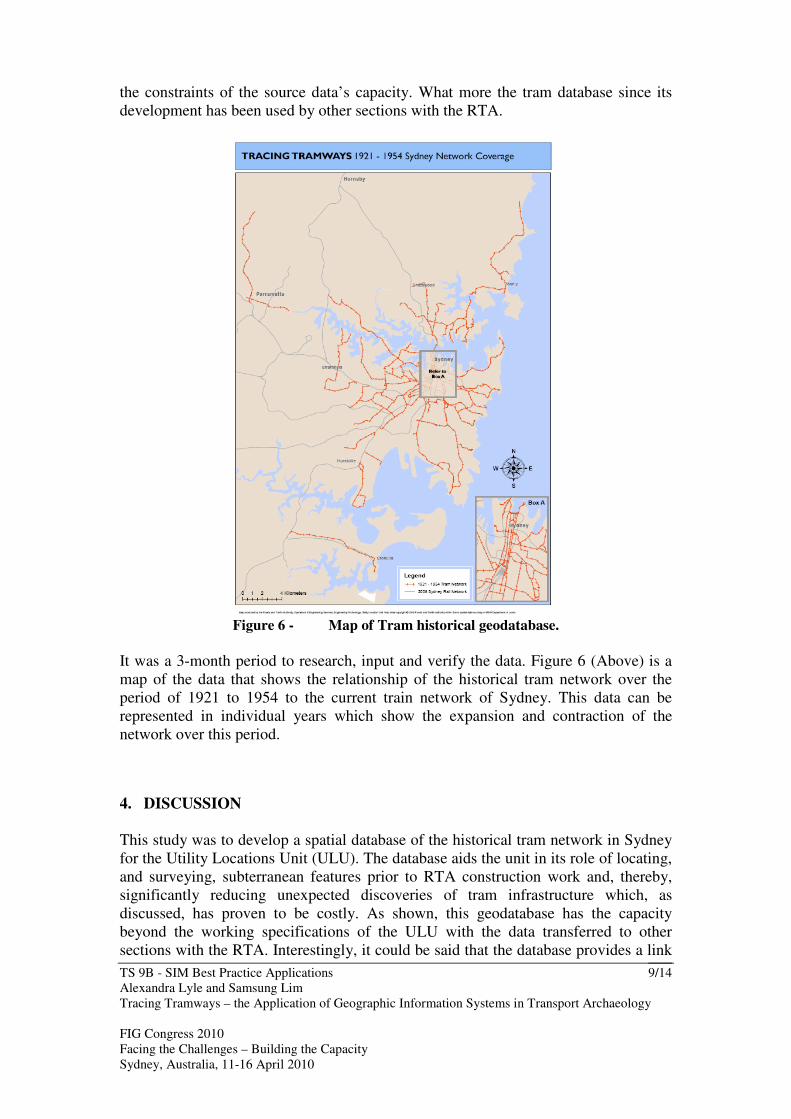
Figure 6 - Map of Tram historical geodatabase.
It was a 3-month period to research, input and verify the data. Figure 6 (Above) is a map of the data that shows the relationship of the historical tram network over the period of 1921 to 1954 to the current train network of Sydney. This data can be represented in individual years which show the expansion and contraction of the network over this period.
4. DISCUSSION
This study was to develop a spatial database of the historical tram network in Sydney for the Utility Locations Unit (ULU). The database aids the unit in its role of locating, and surveying, subterranean features prior to RTA construction work and, thereby, significantly reducing unexpected discoveries of tram infrastructure which, as discussed, has proven to be costly. As shown, this geodatabase has the capacity beyond the working specifications of the ULU with the data transferred to other sections with the RTA. Interestingly, it could be said that the database provides a link

TS 9B - SIM Best Practice Applications
Alexandra Lyle and Samsung Lim Tracing Tramways – the Application of Geographic Information Systems in Transport Archaeology FIG Congress 2010 Facing the Challenges – Building the Capacity Sydney, Australia, 11-16 April 2010
10/14
between historical, present and future Sydney, Australia not just for the RTA but also academically and socially. However, for the geodatabase to be used in this context (that is other purposes not defined by the RTA and ULU) a consideration of the accuracy and further expansion of the attributes needs to be reviewed. Accuracy of the geodatabase, as discussed, was limited more specifically by the historical data sources than the ULU needs, and therefore is unlikely to improve from the current +/- 20m. The only way in which this accuracy could be improved is by field surveys, with such technology as GPR, a costly process. It is recommended that when such surveys are completed, be it by the RTA, council, academia or public, the existence of the tram line (that is - does it still exists under the road form) and its exact location (within +/- 0.5m) is added to the geodatabase. For example the location of the tracks within Oxford Street by the ULU could be incorporated into the data. Approaching the addition of accurate data in this manner would not be too costly in time or monetary terms and would enhance the geodatabase for future use. As the geodatabase stands, the attributes contained are minimal and specific to the ULU and the RTA (See 2.2 Needs). For implementation of the geodatabase, such as particular use by the RTA or externally, the geodatabase will need to be expanded with attributes specific to the users’ needs incorporated. It is more than feasible that the database could contain more attributes - be it historical (number of tracks, historical capacity of the network), present (where it still exists, current condition and use of the infrastructure) and future (type of trams that could use the infrastructure again and capacity of a future network). It is recommended that this be investigated; as though it would take time and considerable research (dependant on the data, particularly historical) it would enhance the tram geodatabase and expand its accessibility and most importantly, its usability. For the RTA the tram geodatabase goes beyond the capacity to highlight the existences of trams prior to roadwork design and construction. The database can be used at a far greater level to protect, maintain and use this historical asset. As mentioned the RTA currently uses sections of the tram conduit system to carry optic fibre for the traffic signals – locations which are kept in disjointed paper maps. Today, with the increased use of GIS within the RTA, the incorporation of the maps containing the tram conduit system into a geodatabase enable this data to tie in with the current tram geodatabase allowing for the management of this specific, and important, asset. Trams for Sydney have become iconic of a bygone era (Worthspoon, 1983, ABC, 2006) and today have a strong community and academic interest (Worthspoon, 1983; DPNSW, 2004; Hoadley, 2005; ABC, 2006; Historical House Trust, 2009; Loftus, 2009). Sydney’s trams, it seems, have integrated themselves into the greater psyche of Sydney and this geodatabase of the network could provide the link for past, present and future identity of Sydney. On the community level the capacity of social mapping programs, such as Google Earth, and as museums become more hands on and interactive (ABC, 2010) this

TS 9B - SIM Best Practice Applications
Alexandra Lyle and Samsung Lim Tracing Tramways – the Application of Geographic Information Systems in Transport Archaeology FIG Congress 2010 Facing the Challenges – Building the Capacity Sydney, Australia, 11-16 April 2010
11/14
database could provide the spatial link that is often missing with regards to Sydney’s trams. Hopefully this would allow the current and future generations of ‘Sydneysiders’ to regain ownership of the tram network that defined how Sydney moved and lived (Worthspoon, 1983; DPNSW, 2004) On the academic and government perspective Sydney’s historical trams have a created an interest - be in history, the impact of trams on the urban form today and possible future re-introduction of the network. As mentioned, Sydney’s historical tram network has had a recognisable impact on the development of the urban form that can be even seen today (Worthspoon, 1983, DPNSW, 2004). At the removal of trams, buses replaced the public network (Worthspoon, 1983, ABC, 2006) and areas that were once serviced by a tram system, such as the Randwick Race Course, today have a large public transport population – though now superseded by the transport needs of the adjacent University of New South Wales. The university relies heavily on buses to transport its student population and the re-introduction of trams is attractive to the student body and public (West, 2009b). The question that needs to be asked, and on that needs to addressed, is - if there would be any benefit to re-introduce the tram network into Sydney? Such talks as the Historical House Trust “Nostalgia vs reality: are trams the answer” and authors, such as Worthspoon (1983) questions the more often than not nostalgic calls for a re-introduction. At a time when internationally there has been a re-introduction of trams into the urban environment (Topp, 1999) and requests by the Sydney Lord Mayor for funding to be used for a re-introduction of trams into the inner city suburb of Zetland (West, 2009) in conjunction and a public push for a more sustainable transport system (CoS, 2009) - there is not a better time to answer this question. With current Geographic Information Systems – Transportation (GIS-T) applications the modelling the tram network, within its historical context, would aid transport planners, and academics, in projecting the impacts, both positive and negative, of a re-introduction of the historical network (Hensher & Button, 2008) into twenty first century Sydney. Hence the tram database goes beyond the intial needs of the ULU and can serve a greater audience.
5. CONCLUDING REMARKS AND FUTURE WORK
The needs of the Utility Locations Unit (ULU) resulted in a geodatabase of the historical tram network of Sydney. Though it is the capability of this geodatabase to be expanded upon makes it invaluable in the management tram infrastructure used by the RTA and in the discussion in the Sydney community of a re-introduction of trams to the Sydney road network. For something that has been long gone, there remains a strong interest in the community about Sydney’s trams. Pushes by sections within government and the community for re-introduction of the network never seem to pass (DIPNR, 2004; AAP, 2004; West, 2009; CoS, 2009) – the modelling of the historical system would aid this discussion and help answer the question – are trams the solution for Sydney? It is hoped that future work with this database will investigate this question and review the tram network not only in its future context, but also in a 4-D nature in reflection of its historical aspect.

TS 9B - SIM Best Practice Applications
Alexandra Lyle and Samsung Lim Tracing Tramways – the Application of Geographic Information Systems in Transport Archaeology FIG Congress 2010 Facing the Challenges – Building the Capacity Sydney, Australia, 11-16 April 2010
12/14
REFERENCES
AAP, 2004. Sydney 'needs trams, not trains', Sydney Morning Herald, Accessed 4 September 2009, <http://www.smh.com.au/news/National/Sydney-needs-trams-not-trains/2004/12/15/1102787130044.html> ABC, 2006. Rear Vision - Trams: Australia, ABC Radio, Presented by Annabelle Quince and Keri Phillips, 8 October 2006, Transcript accessed 4 August 2009 <http://www.abc.net.au/rn/rearvision/stories/2006/1755249.htm> ABC, 2010. Future Tense – The Future of Museums, ABC Radio, Presented by Antony Funnell, 14 January 2010, Transcript accessed 18 January 2010 <http://www.abc.net.au/rn/futuretense/stories/2010/2720158.htm> Bernhardsen, T. 2002, Geographic Information Systems – An Introduction, 3rd edition, John Wiley & Sons, New York City of Sydney (CoS), 2009. Sustainable Sydney 2030, Website, Accessed 4 August 2009 <http://cityofsydney.nsw.gov.au/2030/theplan/>
Dept. Planning NSW Government (DPNSW), 2004. Sydney Metropolitan Strategy:
History of Sydney’s Growth, Website, Accessed 4 August 2009, <http://www.metrostrategy.nsw.gov.au/dev/uploads/paper/introduction/BACKGROUND%20ANALYSIS-8.html>
DIPNR, 2004, Minister announces further investigation of modern trams for Sydney CBD, Released 4 May 2004, Sydney Metropolitan Strategy, Website, NSW Government, Accessed 4 August 2009 <http://www.metrostrategy.nsw.gov.au/dev/viewpage.action?sitenodeid=59&languageid=1&contentid=234>
ESRI, 2007b, ArcGIS 9.2 Desktop Help Digitizing features on a paper map, Environmental Systems Research Institute, Accessed 6 September 2009, <http://webhelp.esri.com/arcgisdesktop/9.2/index.cfm?id=553&pid=549&topicname=Digitizing_features_on_a_paper_map>
ESRI, 2007c. ArcGIS 9.2 Desktop Help Topology validation, Environmental Systems
Research Institute, Accessed 6 September 2009, <http://webhelp.esri.com/arcgisdesktop/9.2/index.cfm?id=570&pid=562&topicname=Topology_validation> Gregory, I. & Healey, R. 2007. Historical GIS: structuring, mapping and analysing geographies of the past, Progress in Human Geography, Vol. 31, Issue 5. pp. 638–653

TS 9B - SIM Best Practice Applications
Alexandra Lyle and Samsung Lim Tracing Tramways – the Application of Geographic Information Systems in Transport Archaeology FIG Congress 2010 Facing the Challenges – Building the Capacity Sydney, Australia, 11-16 April 2010
13/14
Han, K., Minty, S. & Clayton, A. 2003, Developing geographic information systems platforms for multijurisdictional transportation analyses: framework and techniques for spatial data sharing, Canadian Journal of Civil Engineering, Vol. 30, pp. 807-818 Hoadley, D. 1995, Trams of Australia: Sydney's Tram History. Website. Accessed 30 August 2009 <http://www.railpage.org.au/tram/sydhist.html> Hensher, D., Button, K. 2008, Handbook of Transport Modelling, Second edition, Elsevier, Amsterdam Historic House Trust (HHT), 2009a. Shooting through: Sydney by Tram, Exhibition, Website, Accessed 2 September 2009
<http://www.hht.net.au/whats_on/exhibitions/exhibitions/sydney_by_tram>
Historic House Trust (HHT), 2009, “Nostalgia vs reality - are trams the answer?” Talk
at Historic House Trust 25 September 2009, Accessed 15 September 2009 <http://shop.hht.net.au/site/Home/Event.aspx?eventid=70c9c58600fe0b84>
Loftus Tram Museum Staff, 2009. Location: Cnr Rawson Avenue (Old Princes Highway) and Pitt Street, Loftus, New South Wales 2232. AUSTRALIA Roads and Traffic Authority (RTA), 2008. 2008 to 2012 – RTA Corporate Plan, Roads and Traffic Authority, Accessed 2 September 2009 <http://home.rta.nsw.gov.au/org/directoratesandbranches/fin/cpp/docs/blueprint_corporate_plan_2008_12.pdf>
Topp, H (1999).Renaissance of trams in Germany--five case studies,
Proceedings of the Institution of Mechanical Engineers; ProQuest Science Journals Vol. 212, Issue 3; pg. 227 West, A. 2009, Moore bypasses NSW on rail funds, Sydney Morning Herald, Published 27 August 2009, Accessed 30 August 2009 <http://www.smh.com.au/opinion/a-sustainable-sydney-needs-bikes-and-trams-20090416-a8ns.html?page=-1> West, A. 2009b, Rail link essential to attract students, says UNSW head, Sydney
Morning Herald, Published 21 September 2009, Accessed 30 August 2009 < <http://www.smh.com.au/national/rail-link-essential-to-attract-students-says-unsw-head-20090920-fwsx.html?skin=text-only> Worthspoon, G. 1983, Sydney’s Transport: Studies in Urban History, Hale & Iremonger Pty Ltd., Sydney

TS 9B - SIM Best Practice Applications
Alexandra Lyle and Samsung Lim Tracing Tramways – the Application of Geographic Information Systems in Transport Archaeology FIG Congress 2010 Facing the Challenges – Building the Capacity Sydney, Australia, 11-16 April 2010
14/14
BIOGRAPHICAL NOTES
Alexandra Lyle is on the Roads and Traffic Authority graduate program with the Surveying Section and has just completed the fast-track masters program with the School of Surveying and Spatial Information Systems, UNSW. For the last five years Alexandra has been a student with the School of Surveying and Spatial Information Systems and has had an active interest in sustainable development. While at university Alexandra was active in the surveying student community and represented the students on The Cumberland Group of Surveyors Executive from 2006 to 2008. Samsung Lim is teaching GIS and advanced estimation theory in the School of Surveying and Spatial Information Systems, UNSW. For the past fifteen years Samsung has been researching GNSS and GIS, especially network-based RTK and geo-information technologies to solve real-world problems. Samsung received his B.A. and M.A. in Mathematics from Seoul National University and his Ph.D. in Aerospace Engineering and Engineering Mechanics from the University of Texas at Austin.
CONTACTS Ms Alexandra Lyle Roads and Traffic Authority New South Wales 99 Philip Street Parramatta NSW AUSTRALIA Tel. + 61 2 8837 0897 Fax + 61 2 8837 0042 Email: [email protected] Dr Samsung Lim School of Surveying & Spatial Information Systems University of New South Wales Sydney AUSTRALIA