Traces of Ancient Earthquakes in Medieval Cities Along the Silk
21
Turkish Journal of Earth Sciences (Turkish J. Earth Sci.), Vol. 12, 2003, pp. 241-261. Copyright ©TÜB‹TAK 241 Traces of Ancient Earthquakes in Medieval Cities Along the Silk Road, Northern Tien Shan and Dzhungaria ANDREY KORJENKOV 1 , KARL BAIPAKOV 2 , CLAUDIA CHANG 3 , YURY PESHKOV 2 & TAMARA SAVELIEVA 2 1 Institute of Seismology NAS, Asanbay 52/1, Bishkek 720060, Kyrghyzstan (e-mail: [email protected]) 2 Institute of Archaeology, Prospekt Dostyk 44, 480100, Almaty, Kazakhstan 3 Sweet Briar College, Sweet Briar, Virginia 24595, USA Abstract: The evidence for earthquake destruction at medieval cities along the Silk Road from 800 A.D. to 1500 A.D. was examined using techniques of archaeoseismological mapping of architectural components at three currently excavated sites in southern Kazakhstan: Koylyk (Antonovka), Talgar (Talkhir) and Akyrtash, located on the northern branch of the Silk Road, Kazakhstan. This study revealed the following features of seismic activity at all three sites: (a) fractures cutting through a few adjacent bricks; (b) wall-tilts and collapses; (c) horizontal shift of bricks and stones; (d) rotation of stones and bricks. These types of destruction occurred at or very near the epicentres of ancient earthquakes. In some cases it was possible to determine the degree (seismic intensity), the direction of seismic-wave generation, and also the repetition of major seismic events. Since this portion of the Silk Route is along the northern edge of the Tien Shan mountain chain, one of the most active seismic areas of the Eurasian Continent, it is possible that abandonment of these cities was due to natural disasters and not just to the repeated Mongol invasions of the 13–14 th centuries. These data may be used for more precise estimation of earthquake hazards in this region of southern Kazakhstan. Key Words: archaeoseismology, earthquake damage, medieval cities, Silk Road, Tien Shan, Dzhungaria, Kazakhstan ‹pek Yolu Üzerindeki Ortaça¤ Kentlerinde Eski Depremlerin ‹zleri, Kuzey Tien Shan ve Dzhungaria Özet: Güney Kazakistan’daki ‹pek Yolu üzerinde yer alan Ortaça¤ kentlerinde 800– 1500 y›llar› aras›nda meydana gelen depremlerin yol açt›¤› tahribatlara ait veriler araflt›r›lm›flt›r. Üç bölgede yap›lan kaz› çal›flmalar›nda mimari unsurlar›n arkeosismolojik haritalanmas› tekni¤iyle eski depremler incelenmifltir: ‹pek Yolu’nun kuzey kolunda yeralan Koylyk (Antonovka), Talgar (Talkhir) ve Akyrtash civar›nda gerçeklefltirilen bu çal›flma afla¤›daki sismik deformasyon özelliklerini meydana ç›kartm›flt›r: (a) birkaç komflu tu¤lay› kesen çatlaklar; (b) duvarlarda çökme ve düfleyden sapma; (c) tu¤lalarda ve tafllarda yatay oynama; (d) tu¤lalarda ve tafllarda dönme. Bu tip tahribat eski depremlerin merkezüstü ve yak›n çevresinde geliflir. Baz› durumlarda deprem fliddetini, sismik dalga hareketinin yönünü ve ayn› zamanda kuvvetli deprem olaylar›n›n tekrarlanmas›n› belirlemek mümkündür. ‹pek Yolu’nun bu kesimi Avrasya K›tas›’n›n en aktif deprem bölgelerinden olan Tien Shan da¤ s›ras›n›n kuzey ucu boyunca uzan›r. Bu nedenle bölgedeki kentlerin terkedilme nedeni sadece 13–14 yy daki Mo¤ol istilalar› de¤il ayn› zamanda do¤al afetler nedeniyle de olmal›d›r. Burada sunulan veriler ayn› zamanda Güney Kazakistan bölgesindeki deprem tehlikesi ve deprem riskinin daha do¤ru tahmin edilmesinde de kullan›labilir. Anahtar Sözcükler: arkeosismoloji, deprem hasar›, ortaça¤ kentleri, ‹pek Yolu, Tien Shan, Dzhungaria, Kazakistan Introduction The objective of this work is to test the hypothesis that the periodic “catastrophic” burning and other types of architectural destruction at medieval centres along the Silk Road in southern Kazakhstan, in the 13 th through 15 th centuries A.D., could have been due to earthquake activity and not only to Mongol invasions. In Kazakhstan, the Silk Road (Figure 1) followed the northern foothills of the great mountain systems of Central Asia – the Dzhungar and Tien Shan mountains (Figure 2). These young mountains formed during the last 30 million years (the neotectonic period) via the collision of the Indian and Eurasian plates. This fault line has been the location of much intense tectonic movement over many millions of years. It is known from historical
Transcript of Traces of Ancient Earthquakes in Medieval Cities Along the Silk

Turkish Journal of Earth Sciences (Turkish J. Earth Sci.), Vol. 12, 2003, pp. 241-261. Copyright ©TÜB‹TAK
241
Traces of Ancient Earthquakes in Medieval Cities Alongthe Silk Road, Northern Tien Shan and Dzhungaria
ANDREY KORJENKOV1, KARL BAIPAKOV2, CLAUDIA CHANG3, YURY PESHKOV2 & TAMARA SAVELIEVA2
1 Institute of Seismology NAS, Asanbay 52/1, Bishkek 720060, Kyrghyzstan(e-mail: [email protected])
2 Institute of Archaeology, Prospekt Dostyk 44, 480100, Almaty, Kazakhstan3 Sweet Briar College, Sweet Briar, Virginia 24595, USA
Abstract: The evidence for earthquake destruction at medieval cities along the Silk Road from 800 A.D. to 1500A.D. was examined using techniques of archaeoseismological mapping of architectural components at threecurrently excavated sites in southern Kazakhstan: Koylyk (Antonovka), Talgar (Talkhir) and Akyrtash, located onthe northern branch of the Silk Road, Kazakhstan. This study revealed the following features of seismic activity atall three sites: (a) fractures cutting through a few adjacent bricks; (b) wall-tilts and collapses; (c) horizontal shiftof bricks and stones; (d) rotation of stones and bricks. These types of destruction occurred at or very near theepicentres of ancient earthquakes. In some cases it was possible to determine the degree (seismic intensity), thedirection of seismic-wave generation, and also the repetition of major seismic events. Since this portion of the SilkRoute is along the northern edge of the Tien Shan mountain chain, one of the most active seismic areas of theEurasian Continent, it is possible that abandonment of these cities was due to natural disasters and not just to therepeated Mongol invasions of the 13–14th centuries. These data may be used for more precise estimation ofearthquake hazards in this region of southern Kazakhstan.
Key Words: archaeoseismology, earthquake damage, medieval cities, Silk Road, Tien Shan, Dzhungaria,Kazakhstan
‹pek Yolu Üzerindeki Ortaça¤ Kentlerinde Eski Depremlerin ‹zleri,Kuzey Tien Shan ve Dzhungaria
Özet: Güney Kazakistan’daki ‹pek Yolu üzerinde yer alan Ortaça¤ kentlerinde 800–1500 y›llar› aras›nda meydanagelen depremlerin yol açt›¤› tahribatlara ait veriler araflt›r›lm›flt›r. Üç bölgede yap›lan kaz› çal›flmalar›nda mimariunsurlar›n arkeosismolojik haritalanmas› tekni¤iyle eski depremler incelenmifltir: ‹pek Yolu’nun kuzey kolundayeralan Koylyk (Antonovka), Talgar (Talkhir) ve Akyrtash civar›nda gerçeklefltirilen bu çal›flma afla¤›daki sismikdeformasyon özelliklerini meydana ç›kartm›flt›r: (a) birkaç komflu tu¤lay› kesen çatlaklar; (b) duvarlarda çökme vedüfleyden sapma; (c) tu¤lalarda ve tafllarda yatay oynama; (d) tu¤lalarda ve tafllarda dönme. Bu tip tahribat eskidepremlerin merkezüstü ve yak›n çevresinde geliflir. Baz› durumlarda deprem fliddetini, sismik dalga hareketininyönünü ve ayn› zamanda kuvvetli deprem olaylar›n›n tekrarlanmas›n› belirlemek mümkündür. ‹pek Yolu’nun bukesimi Avrasya K›tas›’n›n en aktif deprem bölgelerinden olan Tien Shan da¤ s›ras›n›n kuzey ucu boyunca uzan›r. Bunedenle bölgedeki kentlerin terkedilme nedeni sadece 13–14 yy daki Mo¤ol istilalar› de¤il ayn› zamanda do¤alafetler nedeniyle de olmal›d›r. Burada sunulan veriler ayn› zamanda Güney Kazakistan bölgesindeki deprem tehlikesive deprem riskinin daha do¤ru tahmin edilmesinde de kullan›labilir.
Anahtar Sözcükler: arkeosismoloji, deprem hasar›, ortaça¤ kentleri, ‹pek Yolu, Tien Shan, Dzhungaria, Kazakistan
Introduction
The objective of this work is to test the hypothesis thatthe periodic “catastrophic” burning and other types ofarchitectural destruction at medieval centres along theSilk Road in southern Kazakhstan, in the 13th through15th centuries A.D., could have been due to earthquakeactivity and not only to Mongol invasions.
In Kazakhstan, the Silk Road (Figure 1) followed thenorthern foothills of the great mountain systems ofCentral Asia – the Dzhungar and Tien Shan mountains(Figure 2). These young mountains formed during thelast 30 million years (the neotectonic period) via thecollision of the Indian and Eurasian plates. This fault linehas been the location of much intense tectonic movementover many millions of years. It is known from historical

ANCIENT EARTHQUAKES ALONG THE SILK ROAD
242
Chu River
Ili River
Lepsi
Taldykurgan
Pokatilovka
Kopak
Panfilov
Karakol
Balykchi
Chu
BolovodskoeBishkekTR
AT
KapchagayAT – AkyrtashTR – TalgarKK – Koylyk
northern branches ofthe Silk Road
state boundaries
rivers
lakes
archaeological site
KK
Issuk-Kul LakeTaraz
Almaty
Saryagan
Figure 1. Administrative map of southern Kazakhstan and surrounding area.
BBBaaa
lll kkk
hhh aaassshhhLLL aaakkk eee
Ili River
KK
1000Ili Depression
TRAT
Chue Depression
Lake Issyk Kut
Lake Issyk Kut
Lake Issyk Kut
69º 72º 75º 78º 81º 84º
46º
D z h u n g a r A l a t a u
D z h u n g a r A l a t a u
D z h u n g a r A l a t a u
1000
main thrust faults
strike-slip faults
unknown fault type
inferred faultarea with altitude inthe range of 0-2000 maltitude of 2000-4000 m
altitude higher than 4000 m
rivers
lakes
Figure 2. Active tectonics and topography of southern Kazakhstan and surrounding area (after Avouac et al. 1993, with additions andmodifications).

accounts from the last hundred years that destructiveearthquakes caused major damage (Figure 3).
Reliable earthquake data has been collected as farback as the second half of the 19th century, during theperiod when Russian military fortresses were constructedin this region. Scientific data recording the earthquakes ofsouthern Kazakhstan were collected during the late 19th
and early 20th century. Mushketov (1888, 1890a, b),Bogdanovich (1911), Bogdanovich et al. (1914) studiedthe strong Verny earthquake of 1887 and Kebinearthquake of 1911. In the succeeding years, a numberof seismic stations were built along the edge of thenorthern Tien Shan and Dzhungaria ranges.
Before the 19th century, there are only sparsereferences to earthquakes: there was an I0=IX destructiveearthquake in 1475 in the vicinity of Burana village –near the modern town of Tokmak (Figures 1–3); and anI0=VIII earthquake in 1770 at Belovodskoe village(Mushketov 1891, 1899; Chedia et al. 1998). In 1807,on the Almaty river, “a terrible catastrophe” took place;in 1865, there was an earthquake at Merke village; in1867, an earthquake at Tokmak; in 1873, an earthquakein the Chu River valley; and in 1880, one at the Verny(Almaty) (Mushketov & Orlov 1893). On August 2, 1885,the Belovodskoe earthquake occurred in the Chudepression (M=6.9, I0=IX–X) (Ignatiev 1886). Townsthat were completely destroyed along the Kyrgyz side ofthe Tian Shan range include Belovodskoe, Sokuluk, andPishpek (Bishkek). Two years later, on June 8, 1887, theVerny earthquake (M=7.3, I0=IX-X) occurred; itsepicentre was located near modern Almaty (Mushketov1888; Vershinin 1889). In July 11, 1889, thecatastrophic Chilik earthquake (M=8.4; I0=X) occurred;its epicentre was located 120 km east of modern Almaty,at the eastern end of Trans-Ili Alatau range. Thisepicentre was located in the fault zone separating theKungey and Trans-Ili ranges (Figures 2 & 3). In Verny(Almaty), the seismic intensity was I0=VII–VIII of theMSK-64 scale. The epicentre of the Kebin earthquake ofJanuary 3, 1911, was located south of modern Almaty. Ithad a seismic intensity of I0=X–XI within the first tenkilometres (Bogdanovich 1911; Velitzky 1911;Bogdanovich et al. 1914). Gutenberg & Richter (1954)estimated that the earthquake was one of the strongestcatastrophes of the world with a magnitude of M>8 onthe Richter scale. The area of maximum tremors wasabout 10,000 km2 in size in the vicinity of the Kungey
and Trans-Ili Alatau ranges. The earthquake left ruptures,some as long as 200 km. The tremors were recordedthroughout an area of 4,000,000 km2. The Kemin-Chuearthquake took place on June 20, 1938, and itsepicentre was located at the junction of the Kyrgyz andKungey Alatoo ranges (Vilgelmzon 1947). The last strongseismic event in the northern Tien Shan was theSuusamyr earthquake of August 18, 1992 (M=7.3,I0=IX–X) (Korjenkov & Omuraliev 1993; Bogachkin et al.1997; Ghose et al. 1997).
The locations of the epicentres of the majorearthquakes of this region were all situated in the centralpart of the Trans-Ili and Kungey Alatao ranges. This is anarea along the Silk Road. Thus, we can postulate that thistrading route would have experienced considerableeffects of major earthquakes during the medieval period.The acceleration rate of the tremors (more than g duringsome seismic events) led to severe or completedestruction of ancient cities that were typically built ofmud brick (saman).
The earliest accounts of earthquakes in Dzhungaria(Figures 1–3) have been described by Mushketov & Orlov(1893). The oldest recorded earthquake occurred in1716. However, systematic data are only available as farback as the second half of the 19th century. Thus, one cannote the earthquakes of 1866 at the Kopal settlementand of 1874 at Lepsinsk town. Significant destruction ofall types of buildings in the Dzhungaria region was causedby the transference of seismic waves that originated fromearthquakes in China during the years 1906, 1958, 1962and 1973 (Massarsky & Gorbunova 1964; Urazaev et al.1974).
A number of major tremors are listed in the“Earthquakes of USSR,” a catalogue by Gorshkov et al.(1941). This includes, for example, an earthquake of May2, 1915 felt in the Lepsinsk region, that had a seismicintensity of I0=VI. The epicentre of the August 20, 1967earthquake was located on the northern slope ofDzhungar Alatau. In Pokatilovka village, nearest theepicentre, the earthquake was felt with a seismic intensityof I0=VII (in: ‘Earthquakes in USSR in 1967’ (1970)).
Thus, we have at our disposal, a series of historicalobservations of earthquake activity that date back only asfar as the last 100–200 years. However, to trace trendsin seismic activity, we would need data for centuries andeven millennia that could be used to: (a) estimate the
A. KORJENKOV ET AL.
243

ANCIENT EARTHQUAKES ALONG THE SILK ROAD
244
1992
1992
1992
1992
1992
1992
1949
1928
1946
1770
1885
1933
1888
1889
1948
1865
189319
38
1868
1935
1475
1934
500
1925
1910
1886
1887
1809
1889
1800
1911
1916
1874 19
821945
1990
1890
1946
193219
28
1975
1889
1930
1978
1933
1970
1937
1939 19
39 1939
1959
1967
1979
1915
1716 19
46
KR
T
US
P
KS
TMT
BM
ED
TS
H KN
G
BO
M
UR
V
BIS
MN
S
TR
K19
46K
DS
KN
S
PR
1972
1913
1786
SAT
TS
H
AA
RE
RS
44º
43º
42º
80º
78º
76º
74º
72º
42º
43º
44º
80º
78º
76º
74º
72º
M >
5.0
5.5
6.0
6.5
7.0
8.0
AN
1992
Figu
re 3
. Ep
icen
tres
map
of
sout
hern
Kaz
akhs
tan
and
surr
ound
ing
area
. Dat
a w
as k
indl
y pr
ovid
ed b
y M
rs. S
adir
a M
oldo
beko
va (
Inst
itute
of
Seis
mol
ogy
NAS
, Kyr
ghyz
stan
).Bl
ack
tria
ngle
s ar
e K
yrgh
yz s
eism
ic s
tatio
ns,
squa
res
– K
azak
h se
ism
ic s
tatio
ns.
recurrence of earthquakes over time; (b) locate theancient epicentres of these earthquakes; and (c) measurethe intensity of these tremors and earthquakes. Methodsof archaeoseismology (Hancock & Altunel 1997; Altunel1998; Korjenkov & Mazor 1999a, c; Akyüz & Altunel2001; Mazor & Korjenkov 2001 and many others) andseismogeology (e.g., McCalpin 1996) may be used toelucidate the occurrence of seismic events in the past.
We have conducted preliminary studies on threearchaeological sites located on the northern branch of theSilk Road (Figure 1): (a) Koylyk, on the eastern outskirtsof Koylyk (Antonovka) village in Dzhungaria, in thesteppe region near the Dzhungar Alatau range, about 460km northeast of Almaty; (b) medieval Talgar (Talkhir), onthe southern outskirts of the modern regional centre ofTalgar, at the base of the steppe zone below the foothillsof the Trans-Ili Alatau, about 25 km east of Almaty; (c)Akyrtash, in southern Kazakhstan near the modern city ofTaraz (Dzhambul), in the steppe region north of theKirghiz range, about 480 km west of Almaty.
Each site is near active fault zones of the Tien Shanand Dzhungaria mountain ranges (Figure 2), but thesediffer in their construction types. Historical records ofearthquakes in the Almaty area have registered M>8 onthe Richter scale. Hence, seismic activity probably tookplace during the 400 to 600 year occupations of thesemedieval cities.
Description of Peculiarities of the SeismicDestruction at Archaeological Sites
Koylyk Site
The Koylyk (Antonovka) settlement is located 420 kmnortheast of the city of Almaty, in the Dzhungaria regionin the eastern outskirts of the village of Antonovka, onthe bank of the Ashchibulak River. In 1998, extensiveexcavations under the sponsorship of INTAS (EU- fundedprojects) were conducted at Koylyk (Antonovka). AtAntonovka, the largest medieval period site along the IliValley, the city consists of a large fortress wallconstructed of mud bricks, irregular in form but generallyrectangular in shape. The archaeological evidence of mudbrick buildings at Antonovka appears as a series ofmounds or tells; the most concentrated area is in theeastern section of the site. The northeast city wall isabout 1200 m long, while the southwest wall isapproximately 750 m long. The city wall ranges from 3.5
to 4.5 metres in height. There is no south wall, since theancient town is protected by the mountains. Every 30–45m along the wall there are round towers. The height ofsome towers is 6–8 m. Not far from the western cornerthere is a rectangular mound, 120x150 m and 5.5 mhigh. Entrances to the settlement are located on the NWand SE sides of the mound (Baipakov & Korjenkov 2000).
This site has three occupation levels. Archaeologicalmaterials from the excavations, such as ceramics, glasses,or belt buckles, date the occupation of the settlement tobetween the 8th century and 14th centuries A.D. (Baipakovet al. 1999; Baipakov & Korjenkov 2000).
The first block excavations were placed on a square30x30 m mound, about 4 m in height, found in theeastern part of the settlement. A wealthy farmstead wasdiscovered in this mound, and dates to the 12–13th
centuries A.D. Remnants of the dwellings and farmbuildings, Chinese and Iranian ceramics, and bronzewares were also found (Baipakov & Korjenkov 2000).
Other excavations were conducted 200 metres fromthe north entrance of the fortress wall. The 1998excavation covered an area of 25 by 25 metres. Thisexcavation uncovered a central room (12 m by 12 m) andan attached corridor. The central room may be a part ofa temple, perhaps even one identified in historical recordsas a Buddhist temple. The walls of this central room areabout 1.5 metres high and are built of mud bricks(Baipakov et al. 1999).
There were two periods of occupation at the temple,apparently from two different construction sequences.The second construction period is characterised by wallremodelling and filling-in of the NE and NW galleries withgravel and pebble fill – some as thick as 1.5 m. Thisconstruction fill probably was used to stabilize thenorthern part of the temple which was partially destroyedby an earthquake. The temple functioned from the 12th
century A.D. to the middle of the 13th century A.D. Thereis also evidence of destruction by fire in this excavationunit (Baipakov et al. 1999; Baipakov & Korjenkov 2000).
The present study was conducted at both excavations:wealthy farmstead and Buddhist temple.
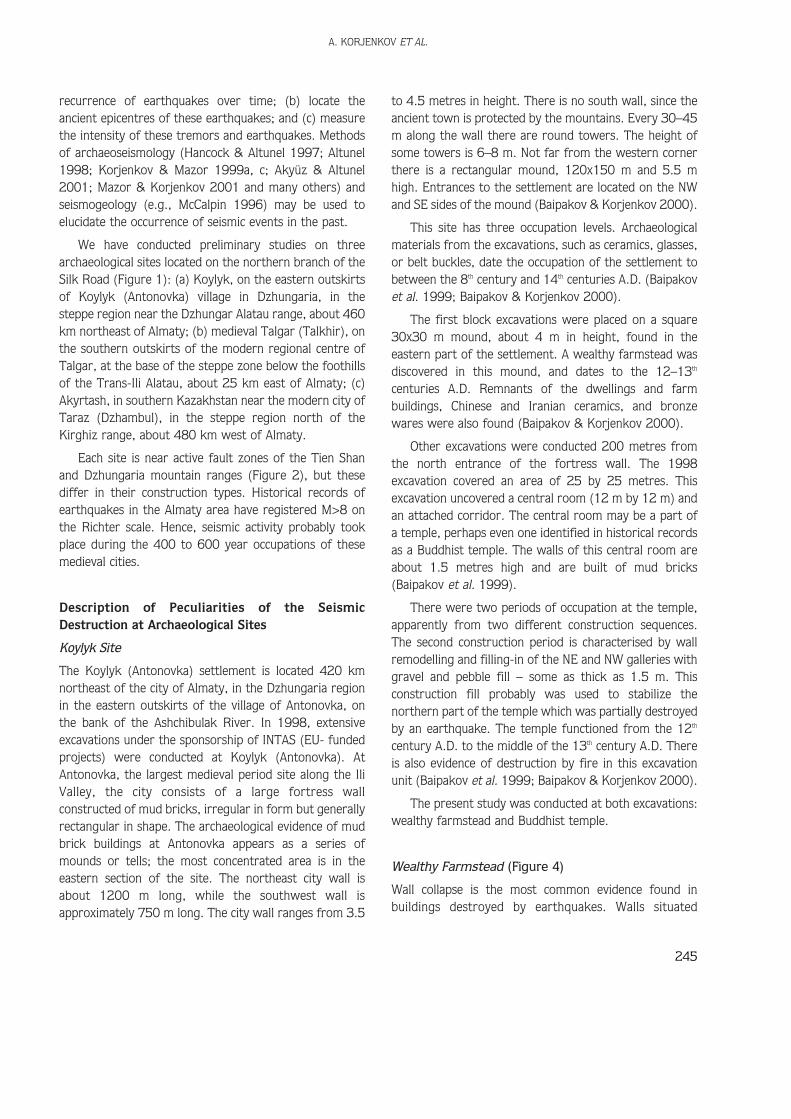
Wealthy Farmstead (Figure 4)
Wall collapse is the most common evidence found inbuildings destroyed by earthquakes. Walls situated
A. KORJENKOV ET AL.
245
perpendicularly to the direction of the seismic waveusually have a single direction of collapse. At the sametime, walls oriented parallel to the place where seismicwaves are generated fall in a random manner (Korjenkov& Mazor 1999a–c).
The SE external saman (unfired brick) wall with astrike of 155º (IV Quadrat) collapsed inside the buildingin a NE direction along the compass bearing of 65º. Wallfragments were thrown a distance of up to 2 m (Figure5a). This type of wall-fall is evidence for the seismic originof collapse. The entire wall collapsed. The floor plaster
was not damaged (Figure 5b), and fragments of thedisintegrated wall lie on the floor. This suggests that thewall fell during a single event. The wall lacks indicationsof gradual disintegration of the saman due to theweathering effects of rain and snow after theabandonment of the building.
The systematic tilts of the walls are observable whenthe direction of seismic wave generation is perpendicularto wall trend (Korjenkov & Mazor 1999a–c). At room No.10 (III Quadrat) a heating box-like pipe (khan) composedof fired bricks was tilted to the NE (dip azimuth 230º, dip
ANCIENT EARTHQUAKES ALONG THE SILK ROAD
246
0 4m
7
6 45
8 5
1
3 2
6
16
7
9 10
4
11 13 14
12
17 3a 3b
15
K-II K-I
K-III K-IV tilt and shift of the wallsN
tilt and collapse of walls,arrow shows the direction of tiltor collapse
Figure 4. A scheme of an excavation of wealthy farmstead at the Koylyk site (modified from Baipakov &Korjenkov 2000). Numbers in squares correspond to the numbers of figures in given paper.

angle 68º), as is seen in Figure 6. A saman wall situatedabove the heating pipe also collapsed in a NE direction. Inthis case, the bricks were thrown a distance of 3.2 m(Figure 6).
The foundation stones supporting the heating pipe inroom No. 4 (II Quadrat) showed a similar pattern ofcollapse. The bearing of the pipe is 145º. The stones aretilted in a northeasterly direction, at angles 54°–75°(Figure 7a). The present-day position of the foundationstones is 20 cm higher than the fragments of preservedpipe in the southern corner of the room (Figure 7b).Thus, it appears that these stones were thrown up andfell in a tilted position relative to their original placement.
Shifts in the location of building components may alsobe indicative of seismic activity at a settlement, in muchthe same way that tilting and wall collapse can be used todocument earthquake damage. The shift of part of a wall
indicates that the seismic waves were generatedperpendicular to the wall (Korjenkov & Mazor 1999a–c).
Such phenomena were discovered at the excavation ofthe farmstead at the Koylyk site. Mud brick or samanmasonry of the NE wall of room No. 16 (Quadrat IV)shifted so as to fall towards each other in a NE directionat a distance of 10 cm (Figure 8). The bearing of the wallis 146°, while the bricks shifted along an angle of 56°.The wall fragment is slightly tilted in the same direction.
The data, given above, indicate the systematicdestruction of the farmstead buildings. This systematicdestruction and consequent evidence of wall collapse aredue to earthquake damage. All observed types ofdestruction – tilts, collapses, and shifts in buildingcomponents – show that the generation of seismic wavestook place along a NE–SW axis. The systematic characterof the destruction also indicates that there was apredominantly horizontal aspect to the seismicmovements (Korjenkov & Mazor 1999a–c). Suchhorizontal movements are more typical of earthquakesthat may have occurred some distance (30 km or more)from the original epicentre of the earthquake. Thecomplete destruction of the saman buildings (observed inthe farmstead) indicates an intensity of seismicoscillations of I0=VII–VIII.
The ancient people may have recognized the problemof wall collapse due to seismic activity and tried toprevent wall damage; there is a method of construction inwhich a so-called “seismic buffer” is placed between themasonry walls of the farmstead. This “buffer” can be a
A. KORJENKOV ET AL.
247
a
b
Figure 5. Collapse of saman walls in the wealthy farmstead at theKoylyk site. (a) SW external wall of the farmsteadcollapsed in NW direction. Bricks were thrown a distanceof up to 2 m. (b) Preserved piece of a plaster from theinside wall.
Figure 6. Tilt of the heating box pipe (kan) in a NW direction (roomNo. 10). A wall built above the pipe collapsed in the samedirection. Bricks were thrown a distance of up to 3.2 m(shown by the arrow).

wooden log (Figure 9a) or reed layer (Figure 9b). We areof the opinion that the ancient builders used thisconstruction technique to buttress their buildings againstthe frequent earthquake activity in this region of thenorthern Dzhungarian range.
Buddhist Temple
In the temple building, there are two constructionsequences: the lowest 10 rows of clay bricks areattributed to the first building period, and two rows ofburned bricks above belong to the foundation of thesecond building period.
ANCIENT EARTHQUAKES ALONG THE SILK ROAD
248
b
a
Figure 7. (a) Tilt of foundation stones (dip angle is 54°–75°) in NEdirection in room No. 4; (b) uplifted modern position ofstone surfaces (dashed line 1), as compared with theiroriginal position (dashed line 0).
Figure 8. Shift and tilt in a northeast direction of lower course ofmasonry of saman bricks in room No. 16. Angle ofdeclination of deformed wall is between the solid line(modern wall inclination) and the dashed line (originallyvertical wall).
a
bFigure 9. “Anti-seismic buffer” in the walls of the wealthy
farmstead: (a) wooden log, (b) reed layer.

Why did the ancient inhabitants remodel the temple?And why at a later period was the upper part of the walldismantled?
The temple is located near the seismic zone, and wasconsequently subject to seismic activity. Indeed, these twoconstruction sequences might testify to the occurrence ofseismic activity during the time the prehistoric inhabitantsused this temple. That is, the collapsed walls of thetemple may document two separate episodes of collapsedue to seismic activity. However, it is difficult todocument the exact direction of wall collapse and seismicwave generation since the wall collapses from the twoevents are jumbled together.
The nature of the wall collapse episodes for thetemple walls are examined below (Figure 10) in order toreveal the causes of the destruction sequences at thetemple.
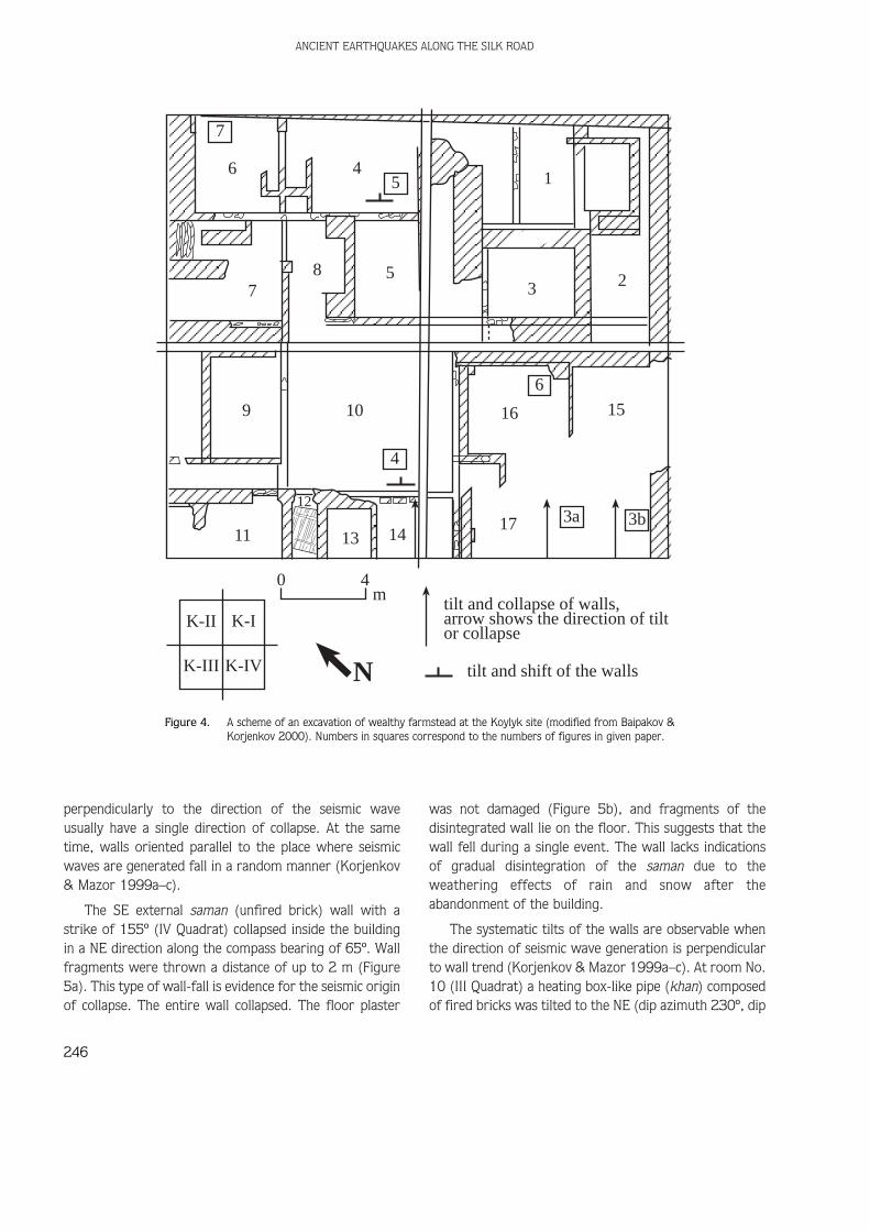
The fracture lines or cracks found in the walls ofancient buildings are a common feature of ancientbuildings. However, there can be several causes for theoccurrence of such cracks or fractures, such as: (1) thenatural processes of weathering, that is, alternatingheating during the day and cooling at night; or (2)tectonic (seismic) movements. However, if the fracturescut through two or more adjacent bricks or stones, thenthey were the result of major stressors placed upon thewall. These disjunctures or cracks are formed when ahigh amount of energy is applied to exposed surfaces ofadjacent bricks or stones (Fisher et al. 1995; Engelder &Fisher 1996; Becker & Gross 1996). Thus, the existenceof cracks or fissures through two or more blocks cannotbe attributed to weathering processes.
At the NW corner of the eastern entrance into thetemple (see Figure 10), part of the upright support of thedoorway was destroyed and partly collapsed. A collapsedpiece ruptured the central part of the upright supportpiercing the heating pipe in the structure and creating anair hole or pocket in the central part of the upright post.Here there are a series of cracks and fissures that runthrough 10 bricks (Figure 11a). The same deformation isobservable also at the NE corner of the western sectionof the doorway – a significant part of the cornercollapsed. It exposed the heating duct and internalstructure of the wall. We can observe numerous fissuresthat cut through two or more bricks as well as opencracks splitting the standing wall into different fragments
(Figure 11b). The most remarkable cracks or fissuresseparate the vertical rows of the bricks in the entryway,causing them to collapse onto the floor.
Another example of a fissure that cuts through severalbricks can be observed at the entrance to the temple inthe NW corner of the eastern wall (Figure 10) in a lowsection of the wall (Figure 11c). Here a fissure, 50 cm inlength, cut through six bricks.
These three examples were probably caused byearthquake tremors.
The eastern pier of the entrance to the main premisesof the temple (see Figure 10) is tilted (Figure 12) at anangle of 80° (dip azimuth is 43°). The height of thepreserved part of the upright support is 2.5 m.
A step at the entrance to the main premises of thetemple is constructed of four saman bricks in height. Thelower courses of the bricks have shifted toward the SW(221°), forming a crack 11 cm (maximum) in length,when compared to the upper brick courses (Figure 13).The height of the step above the bottom of the excavatedsurface is 32 cm, and the azimuth for the horizontalplacement of the original step is 131°. Since this step didnot bear any load from above, the shift of the lowercourses of bricks away from the upper courses must bedue to seismic tremors of the ground below the building.
There are other examples of seismic destruction; forexample, the warping of the upper part of the wall of thecentral premises of the temple (directional azimuth is132°) toward the NE (see Figure 10).
The three described patterns of seismic destruction ofthe walls (tilting, shifting, and warping) can be explainedby seismic waves generated along a SW–NE axis.
There is serious damage found on the NE wall ofcentral section of the temple: practically all the externallayers of the wall (1 brick thick) have collapsed (seeFigure 10). The same wall, along the buttressed insidecorridor, is also seriously damaged (the directionalazimuth of the wall is 41°). Significant parts of itsinternal wall (about 1 brick thick) have fallen toward theSE. In addition, the upper part of the wall appears to bewarped towards the southeast.
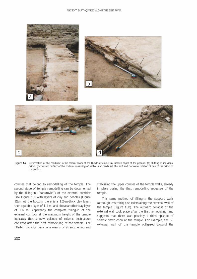
The “podium” in the centre of the main premises ofthe temple shows evidence of destruction: its edges arenot straight (Figure 14a) and individual bricks from lowercourses have fallen inwards (Figure 14b). Since the
A. KORJENKOV ET AL.
249

podium itself probably did not bear any significant weightand load, the most probable reason for its collapse is theseismic acceleration of the ground. The foundation of thepodium is constructed of a layer of pebbles covered withreeds (Figure 14c). This layer could have served as an“anti-seismic buffer”, similar to the reed layers and
wooden logs found at the farmstead described earlier.Why was this gravel and reed layer part of the podium’sfoundation, especially if the podium did not bear heavyloads? Along with the shift of the lower course of bricksof the podium (7 cm in displacement) (see Figure 14b),there is evidence of displacement of the bricks up to a 10°
ANCIENT EARTHQUAKES ALONG THE SILK ROAD
250
13a
11
10
9c
13b
tilt and collapse of the walls, withthe arrow showing the direction
tilt and shift of building elementsfissures that cut through a fewadjacent bricks
rotations of individual bricks
0 5m
N
12a
12c
12d
9b9a
12b
11
Figure 10. The scheme of an excavation of the Buddhist temple at the Koylyk site (modified from Baipakov & Korjenkov 2000). Numbers in thefigure correspond to the numbers of the figures of given paper.
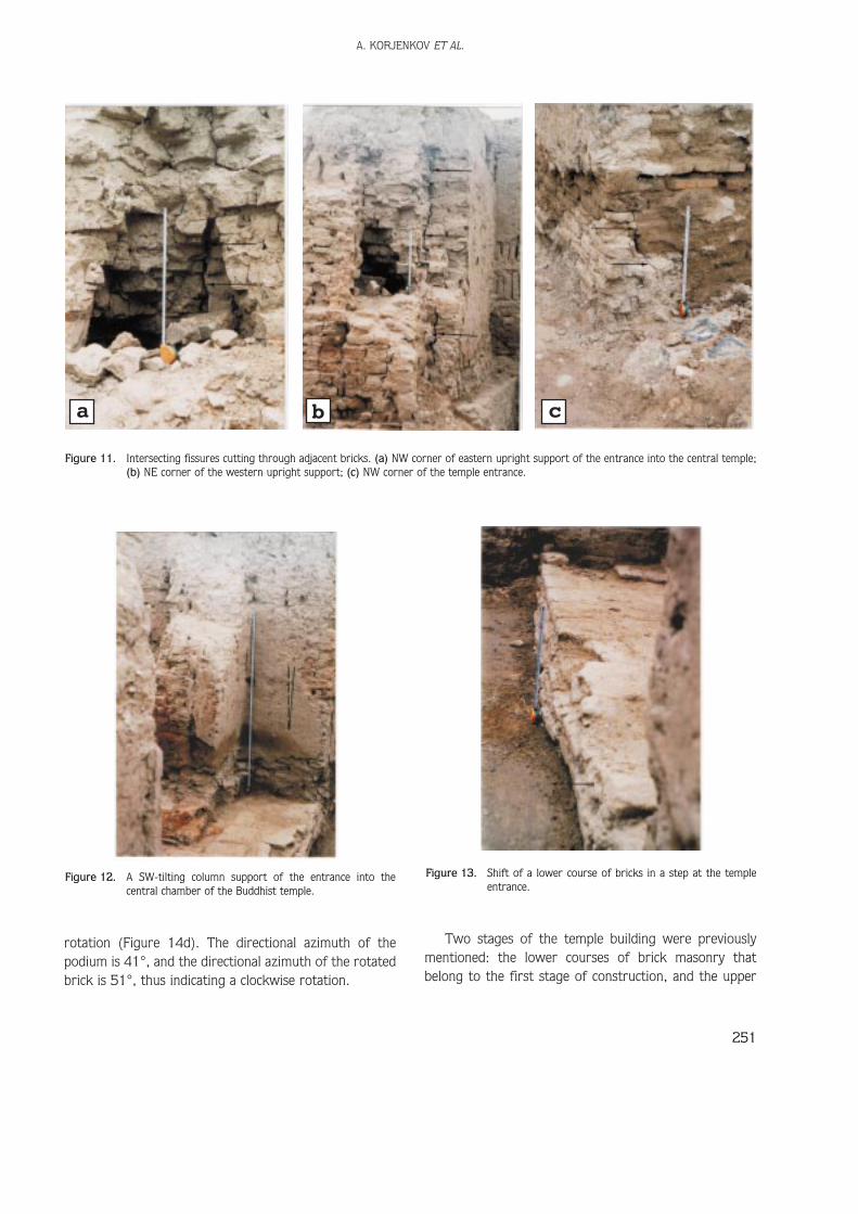
rotation (Figure 14d). The directional azimuth of thepodium is 41°, and the directional azimuth of the rotatedbrick is 51°, thus indicating a clockwise rotation.
Two stages of the temple building were previouslymentioned: the lower courses of brick masonry thatbelong to the first stage of construction, and the upper
A. KORJENKOV ET AL.
251
a b c
Figure 11. Intersecting fissures cutting through adjacent bricks. (a) NW corner of eastern upright support of the entrance into the central temple;(b) NE corner of the western upright support; (c) NW corner of the temple entrance.
Figure 12. A SW-tilting column support of the entrance into thecentral chamber of the Buddhist temple.
Figure 13. Shift of a lower course of bricks in a step at the templeentrance.
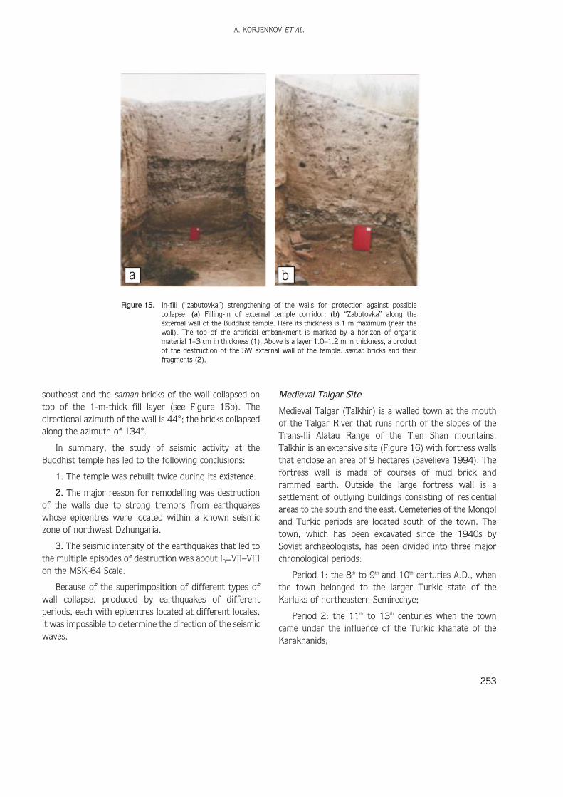
courses that belong to remodelling of the temple. Thesecond stage of temple remodelling can be documentedby the filling-in (“zabutovka”) of the external corridor(see Figure 10) with layers of clay and pebbles (Figure15a). At the bottom there is a 1.2-m-thick clay layer,then a pebble layer of 1.1 m, and above another clay layerof 1.6 m. Apparently the complete filling-in of theexternal corridor at the maximum height of the templeindicates that a new episode of seismic destructionoccurred after the first remodelling of the temple. Thefilled-in corridor became a means of strengthening and
stabilizing the upper courses of the temple walls, alreadyin place during the first remodelling sequence of thetemple.
This same method of filling-in the support walls(although less thick) also exists along the external wall ofthe temple (Figure 15b). The outward collapse of theexternal wall took place after the first remodelling, andsuggests that there was possibly a third episode ofseismic destruction at the temple. For example, the SEexternal wall of the temple collapsed toward the
ANCIENT EARTHQUAKES ALONG THE SILK ROAD
252
a
b
c d
Figure 14. Deformation of the “podium” in the central room of the Buddhist temple: (a) uneven edges of the podium; (b) shifting of individualbricks; (c) “seismic buffer” of the podium, consisting of pebbles and reeds; (d) the shift and clockwise rotation of one of the bricks ofthe podium.
southeast and the saman bricks of the wall collapsed ontop of the 1-m-thick fill layer (see Figure 15b). Thedirectional azimuth of the wall is 44°; the bricks collapsedalong the azimuth of 134°.
In summary, the study of seismic activity at theBuddhist temple has led to the following conclusions:
1. The temple was rebuilt twice during its existence.
2. The major reason for remodelling was destructionof the walls due to strong tremors from earthquakeswhose epicentres were located within a known seismiczone of northwest Dzhungaria.
3. The seismic intensity of the earthquakes that led tothe multiple episodes of destruction was about I0=VII–VIIIon the MSK-64 Scale.
Because of the superimposition of different types ofwall collapse, produced by earthquakes of differentperiods, each with epicentres located at different locales,it was impossible to determine the direction of the seismicwaves.
Medieval Talgar Site
Medieval Talgar (Talkhir) is a walled town at the mouthof the Talgar River that runs north of the slopes of theTrans-Ili Alatau Range of the Tien Shan mountains.Talkhir is an extensive site (Figure 16) with fortress wallsthat enclose an area of 9 hectares (Savelieva 1994). Thefortress wall is made of courses of mud brick andrammed earth. Outside the large fortress wall is asettlement of outlying buildings consisting of residentialareas to the south and the east. Cemeteries of the Mongoland Turkic periods are located south of the town. Thetown, which has been excavated since the 1940s bySoviet archaeologists, has been divided into three majorchronological periods:
Period 1: the 8th to 9th and 10th centuries A.D., whenthe town belonged to the larger Turkic state of theKarluks of northeastern Semirechye;
Period 2: the 11th to 13th centuries when the towncame under the influence of the Turkic khanate of theKarakhanids;
A. KORJENKOV ET AL.
253
a b
Figure 15. In-fill (“zabutovka”) strengthening of the walls for protection against possiblecollapse. (a) Filling-in of external temple corridor; (b) “Zabutovka” along theexternal wall of the Buddhist temple. Here its thickness is 1 m maximum (near thewall). The top of the artificial embankment is marked by a horizon of organicmaterial 1–3 cm in thickness (1). Above is a layer 1.0–1.2 m in thickness, a productof the destruction of the SW external wall of the temple: saman bricks and theirfragments (2).

Period 3: the second half of the 13th and beginning ofthe 14th century to the 15th century, when Talgar declinedin size and regional importance. The town was conqueredby the Mongols and, although settlement continuedthrough the 15th century, it was no longer a magnet forcaravan trade (Savelieva 1994).
The city has four main gates and two main cobbledroutes: one running east-west and the other north–south(Kopielov 1984). On the west side of the Talgar River isa twin settlement known as Tunk. Tunk is only 6 ha inarea (Kopielov & Kerekesha 1993). The main settlementof Talgar includes large buildings, craft-production areas(kilns, pottery-making areas, metal-working areas), and
residential areas. Some of the residential areas to thesouthwest outside the walled enclosure appear to be largeenclosed yards surrounding round yurt-like structuresand animal corrals.
Talgar is along an important caravan routerepresenting a northern branch of the Silk Road thatconnected the Ili River Basin to the Tarim Basin (currentlypart of western China). This route would have been lesspreferred than the main branch that connected theFergana Valley of Uzbekistan and Kyrgyzstan to Kashgarin the Tarim Basin. Overland travel between Talgar andthe Ili River or to points to the west probably took placewhen rivers such as the Talgar could have easily been
ANCIENT EARTHQUAKES ALONG THE SILK ROAD
254
0 20m
Rupturewall
Talg
ar R
iver N
Figure 16. A plan of Talgar settlement (modified from Korjenkov et al. 2000).
crossed (before the snow melts in the early summer andafter the August rains in the late summer).
Historical and archaeological records show that theprimary trading sphere was southern and western infocus (Central Asian and Indian). Although Chineseimports did occur in the second and third time periods,the majority of trade items were Sogdian and Indian inorigin. Major religions such as Buddhism, NestorianChristianity, and Islam also were spread along these traderoutes. In the latter two periods, material itemsrepresenting peoples such as the Uigari, Kidani, Kereita,Merkita, and the Mongols have been found at Talgar.
Earlier local archaeologists believed that Talkhir,located right against the foothills of the Trans-Ili Alatau,was subject to heavy rains and snows that would havedestroyed mud brick architecture. However, inSavelieva’s 1998 excavations, the long buildings – majortrade houses or caravansaries along the east–west wallinside the fortress, had stone and wood-beam sillfoundations (Baipakov et al. 1999). Thus, the stone andwood-beam sill foundations could have been a kind ofarchitectural strategy used by inhabitants who alreadyunderstood the possible threat of earthquake activity.
Archaeoseismological study of the site can beimplemented in order to discover the possible causes ofthe destruction of these ancient buildings. MedievalTalgar is located in one of the most seismically dangerouszones of Kazakhstan: at the crossing of the Alma-Atathrust and the Talgar strike-slip fault. Here, strongearthquakes with magnitudes of M=7–8 (according toRichter Scale) and with seismic intensities of I0=IX(Urazaev 1979) have been reported during historicperiods.
We carried out preliminary work in the separate areasof the Talgar region of Kazakhstan with the purpose ofrevealing seismic deformation of the relief and thearchaeological sites (Korjenkov et al. 2000). A pilotsurvey was made at an ancient settlement – Talgar – oneof the largest towns of Middle Centuries along this faultline (Savelieva 1994).
Seismic activity was revealed at the western wall ofthe fort (Figure 17). The wall, built from clay bricks(saman), has a trend of 340°. The nature of the fissurefound on the wall is complex: it consists of two cracks,the space between which is filled by a brown, clayeymaterial a few centimetres thick. The zone of break
extends downward. The wall consists of grey-yellowloess-like loam. The crack shows the displacement of a11-cm-thick layer of dark-brown clay. The offset area ofthe fissure is 2.5–3.0 cm, and the southern block ofsaman below the fissure is thrust upward with a dipazimuth of 167°and a dip angle of 76°.
It is very important to note that the Talgar settlementis in a zone of dynamic earthquake activity, which islocated just 0.5 km south of the archaeological site. Theadyr fault belongs to a highly active seismic zone with ahistory of recurrent earthquakes (M=7–8 on the Richterscale, I0=IX–X) – one event every few hundred of years;for example, one strong earthquake every 250 years forthe Issyk-Ata (adyr) fault in Kyrghyzstan (Chedia et al.1997). The described fissure at medieval Talgar followsin the same direction as one of the branches of the mainfault of the Alma-Ata fault-line.
The excavations of the Talgar archaeological site weremade in the 1970s and 1980s. Currently, the samanwalls of the site, preserved after the excavations, arecovered by a layer of loamy material. The cleaning of thefortress walls will probably reveal additional evidence ofseismic activity and wall collapse at medieval Talgar.
Akyrtash Site
The Akyrtash (Kasribas) site is located at the foot of thenorthern slopes of the Kyrgyz range, 40 km east of thetown of Taraz (Dzhambul). It has a unique medievalconstruction type for the Semirechye region: its walls arecomposed of huge blocks of bedrock – red Palaeozoicsandstone. The uniqueness of the site is also due to thefact that the building activity was not completed. Itsconstruction was in its initial stage. Currently, it ispossible to document only coursed stone walls composedof massive stone blocks up to 1–1.5 m high (Baipakov &Northedge 1997).
In 1998, extensive excavations under the sponsorshipof INTAS were conducted at Akyrtash. At Akyrtash, anapproximately 180 x 120 m site in the Talas River valley,the excavations reveal the use of large bedrock blocks forbuilding construction. An extensive mapping projectcurrently conducted by a Kazakh-French team under thedirection of Dr. Baipakov, has revealed sandstone-blockarchitecture of dwelling areas, a palace complex, andextensive courtyards. However, this mapping team didnot study in great detail the causes of wall-fall, block
A. KORJENKOV ET AL.
255

rotation, and other evidence for architectural destructionor displacement (Figure 18). There is one constructionperiod in the second half of the 8th century. It isinterpreted as an unfinished palace complex built byArabian architects by order of the Karluk Khaganate.However, the building was not completed and the wallsare only one to three blocks high. The archaeologistsbelieve that the site was abandoned due to political oreconomic factors (Baipakov et al. 1999). The observedwall deformation could be due to natural wall-fall, post-
abandonment factors, or earthquake damage.
The preliminary study of the site has shown theexistence of seismic destruction, for example, in thenorthern wall of corridor No. 103 (Figure 19a) there isevidence for the tilt and shift of the upper (second) blockof the wall. The height of the preserved fragment of thewall is 115 cm. The size of displaced block is 85x70x50cm. The block shifted and tilted northward (dip azimuthis 156°, dip angle is 60°) along an edge that is 12 cm inlength. A bit eastward along the same wall another block
ANCIENT EARTHQUAKES ALONG THE SILK ROAD
256
11 cm
Dip Azimuth: 167ºDip Angle: 76º
3cm
2.5 - 3.0 cm
S N
grey-yellow loess-like loam
dark-brown clay
brown clay material
fault
a
b
Figure 17. Field sketch (a) and photograph (b) of a seismic fracture in the western wall of the Talgar fortress.

tilts in the same direction.
The block from this wall collapsed toward the NNW.The directional azimuth of the wall is 66°. At the foot ofthe southern side of the wall there are few blocks, buttheir quantity is six times less than those blocks on the
northern side of the wall (2/12). These blocks werethrown a distance of 4 m northward from the base of thewall. Such a distance for wall tumble suggests thatseismic activity was responsible for their location.
The same type of destruction can be observed in the
A. KORJENKOV ET AL.
257
9 22 15
21
20 19 18 1716 23
28
10
11 12 1314
87
3
4 5
61
18b
18a19
103
17a 17b0 25
mtilt and collapse of stoneblocks, with arrow showingtheir direction
tilt and shift of them rotations of blocks
N
Figure 18. Seismogenic deformation in the northern part of the Akyrtash site (modified from Baipakov & Northedge 1997). Numbers in rectanglescorrespond to the numbers of the figures in the article.
a b
Figure 19. Tilt and shift of upper blocks in the walls, with arrows showing their directions. (a)northern wall of corridor No. 103 to the north; (b) southern wall of courtyard No. 6.
external southern wall of courtyard No. 6 (Figure 18).Here, the upper block (100x70x50 cm) shifted towardthe NNW along an edge 26 cm long, and at a tilt of 70°(dip azimuth is 165°) (Figure 19b). Here, fallen blockswere thrown northward a distance of 3.2 m, and theremaining height of the wall is 118 cm.
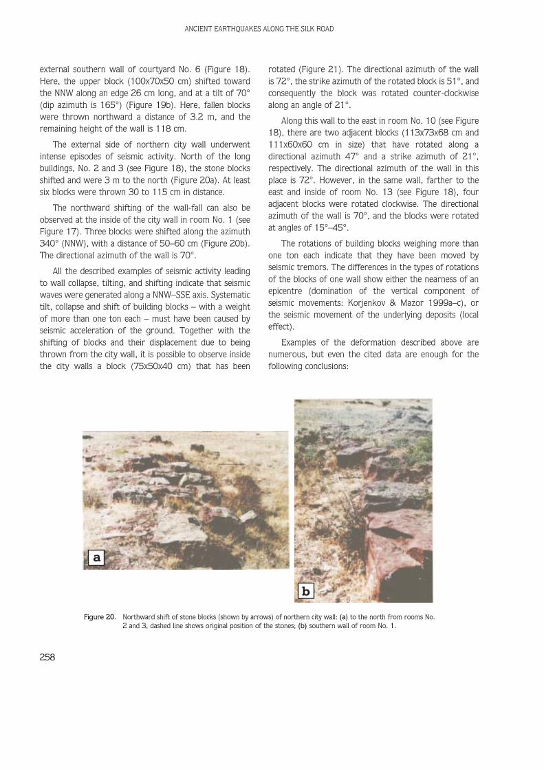
The external side of northern city wall underwentintense episodes of seismic activity. North of the longbuildings, No. 2 and 3 (see Figure 18), the stone blocksshifted and were 3 m to the north (Figure 20a). At leastsix blocks were thrown 30 to 115 cm in distance.
The northward shifting of the wall-fall can also beobserved at the inside of the city wall in room No. 1 (seeFigure 17). Three blocks were shifted along the azimuth340° (NNW), with a distance of 50–60 cm (Figure 20b).The directional azimuth of the wall is 70°.
All the described examples of seismic activity leadingto wall collapse, tilting, and shifting indicate that seismicwaves were generated along a NNW–SSE axis. Systematictilt, collapse and shift of building blocks – with a weightof more than one ton each – must have been caused byseismic acceleration of the ground. Together with theshifting of blocks and their displacement due to beingthrown from the city wall, it is possible to observe insidethe city walls a block (75x50x40 cm) that has been
rotated (Figure 21). The directional azimuth of the wallis 72°, the strike azimuth of the rotated block is 51°, andconsequently the block was rotated counter-clockwisealong an angle of 21°.
Along this wall to the east in room No. 10 (see Figure18), there are two adjacent blocks (113x73x68 cm and111x60x60 cm in size) that have rotated along adirectional azimuth 47° and a strike azimuth of 21°,respectively. The directional azimuth of the wall in thisplace is 72°. However, in the same wall, farther to theeast and inside of room No. 13 (see Figure 18), fouradjacent blocks were rotated clockwise. The directionalazimuth of the wall is 70°, and the blocks were rotatedat angles of 15°–45°.
The rotations of building blocks weighing more thanone ton each indicate that they have been moved byseismic tremors. The differences in the types of rotationsof the blocks of one wall show either the nearness of anepicentre (domination of the vertical component ofseismic movements: Korjenkov & Mazor 1999a–c), orthe seismic movement of the underlying deposits (localeffect).
Examples of the deformation described above arenumerous, but even the cited data are enough for thefollowing conclusions:
ANCIENT EARTHQUAKES ALONG THE SILK ROAD
258
a
b
Figure 20. Northward shift of stone blocks (shown by arrows) of northern city wall: (a) to the north from rooms No.2 and 3, dashed line shows original position of the stones; (b) southern wall of room No. 1.

1. The building activity at the Akyrtash archaeologicalsite was stopped due to an earthquake.
2. The seismic intensity characterizing the observeddeformation is estimated as I0=IX–X.
3. The direction of seismic-wave propagation isestimated to follow a NNW–SSE direction.
4. The significant seismic intensity and the absence ofa systematic picture in the rotations of the building blocksappear to suggest that the epicentre of the earthquakewas near the site.
Conclusions
1. This archaeoseismological study was conducted atthree medieval sites along the northern branch of theSilk Road: Koylyk, Talgar and Akyrtash, located alonga 700 km stretch of mountain ranges. The evidence ofseismic destruction (deformation) was discovered atall three sites: systematic collapse, tilting, shifting ofwall fragments, and also brick and stone rotations andfissures that intersect several courses of brick.
2. The intensity of the seismic destruction has beenestimated as I0 = (VII) – VIII for the Koylyk site,I0=(VIII)–IX for medieval Talgar, and I0=IX–X for theAkyrtash archaeological site.
3. At the ruins of the Buddhist temple, there is evidencefor multiple instances of earthquake activity, whichled to remodelling and eventual abandonment of thetemple.
4. It has been possible to determine the directions ofseismic-wave propagation for these sites: NE–SW forKoylyk site (for the earthquake that affected thewealthy farmstead); the epicentre of the earthquakethat destroyed medieval Talgar was located in theimmediate vicinity of the town; seismic waves that ledto destruction at the Akyrtash site propagated along aNNW–SSE axis and the seismic epicentre was near thesite.
5. For more exact locations of the ancient epicentres, itwill be necessary to study other medieval sites usingthe “azimuthal method”.
6. The archaeoseismological study described above alsohas modern application with regard to developing amore precise set of causes for the destruction ofmedieval towns in the Semirechye region ofKazakhstan. This should be considered for modern-day construction along the foothills of the northernTien Shan and northern Dzhungaria ranges.
7. Finally, the described archaeoseismological work callsfor regional and international cooperation incompiling an archive of past seismic activity over themillennia.
Acknowledgements
The field investigations of this study were supported bythe National Geographic Society of the United States ofAmerica (Grant No. 6524-99). A.K.’s scientific stay andwork on this article in Germany was supported by theDeutscher Akademischer Austaschdienst (DAAD) and theAlexander von Humboldt Foundation. The authors thankMr. Perry Tourtellotte for fruitful discussions and for hishelp during the field season. Thanks also to Mrs. SadiraMoldobekova and Dr. Zoya A. Kalmetieva for their helpwith the seismological data.
A. KORJENKOV ET AL.
259
Figure 21. Counter-clockwise rotation of a stone block measuring75x50x40 cm. Blocks 1–3 were preserved in their originalpositions. Block 4 was rotated.
ANCIENT EARTHQUAKES ALONG THE SILK ROAD
260
AKYÜZ, H.S. & ALTUNEL, E. 2001. Geological and archeological evidencefor post-Roman earthquake surface faulting at Cibyra, SWTurkey. Geodinamica Acta 14, 95–101.
ALTUNEL, E. 1998. Evidence for damaging historical earthquakes atPriene, western Turkey. Turkish Journal of Earth Sciences 7,25–35.
AVOUAC, J.P., TAPPONIER, P, BAI, M., YOU, H. & WANG, G. 1993. Activethrusting and folding along the Northern Tien Shan and LateCenozoic rotation of the Tarim relative to Dzungaria andKazakhstan. Journal of Geophysical Research 98 (B4),6755–6804.
BAIPAKOV, K. M. & NORTHEDGE, A. 1997. New data about Akyrtash.Proceedings of Ministry of Education and Science , Academy ofSciences of Republic Kazakhstan. Series of Social Sciences. No. 1,83–93 [in Russian].
BAIPAKOV, K.M. & KORJENKOV, A.M. 2000. Archeo-seismological study ofMedieval monuments of Zhetisu (Semirechie) on Great Silk Route.Proceeding of Ministry of Education and Science, NationalAcademy of Sciences of Republic Kazakhstan. Series of SocialSciences, No. 1, 109–124 [in Russian].
BAIPAKOV, K.M., CHANG, C., KORJENKOV, A.M., PESHKOV, Y.M. & SAVELIEVA,T.V. 1999. Earthquake Destruction at Medieval Silk Route Citiesin Kazakhstan. USA National Geographic Society ScientificResearch Grant #6524-99, 13 p.
BECKER, A. & GROSS, M.R. 1996. Mechanism for joint saturation inmechanically layered rocks: An example from the southern Israel.Tectonophysics 257, 223–237.
BOGACHKIN, B.M., KORZHENKOV, A.M., MAMYROV, E., NECHAEV, YU.V.,OMURALIEV, M., PETROSYAN, A.E., PLETNYOV, K.G., ROGOZHIN, E.A. &CHARIMOV, T.A. 1997. The Structure of 1992 SusamyrEarthquake Source Based on its Geological and SeismologicalManifestations. Izvestiya Physics of the Solid Earth 33, 867–882.
BOGDANOVICH, K.I. 1911. An earthquake of December 22, 1910(January 4, 1911) in northern chains of the Tien Shan betweenVerny and Issyk-Kul. Proceedings of Geological Committee 30(4),329–419 [in Russian].
BOGDANOVICH, K.I., KARK, I.M., KOROLKOV, B.YA. & MUSHKETOV, I.V. 1914.Earthquake in the northern chains of the Tien Shan, December 221910 (January 4, 1911). Transactions of Geological Committee89, 270 p [in Russian].
CHEDIA, O.K., ABDRAKHMATOV, K.E., LEMZIN, I.N., MIHEL, G. & MICHAYLYOV,V. 1997. Seismotectonic characteristic of Issykaty boundary fault.In: Collection of Scientific Transactions of KyrgyzSRIP Building(1996-1997). Bishkek: Ilim Publishers, 58–69 [in Russian].
CHEDIA, O.K., ABDRAKHMATOV, K.E., KORZHENKOV, A.M. & LEMZIN, I.N.1998. Seismotectonic position of the Balasogun, north Tien Shanearthquake of the 15th century. Journal of Earthquake PredictionResearch 7, 289–299.
EARTHQUAKES IN USSR IN 1967, 1970. Moscow, Nauka Publishers [inRussian]
ENGELDER, T. & FISHER, M.P. 1996. Loading configurations and drivingmechanisms for joint based on the Griffith energy-balancedconcept. Tectonophysics 256, 253–277.
FISHER, M.P., GROSS, M.R., ENGELDER, T. & GREENFIELD, R.J. 1995. Finite-element analysis of the stress-distribution around pressurizedcrack in a layered elastic medium: implication for the spacing offluid-driven joint in bedded sedimentary rocks. Tectonophysics247, 49–64.
GHOSE, S., MELLORS, R.J., KORJENKOV, A.M., HAMBURGER, M.W., PAVLIS,T.L., PAVLIS, G.L., OMURALIEV, M., MAMYROV, E. & MURALIEV, A.R.1997. The Ms = 7.3 1992 Suusamyr, Kyrgyzstan, earthquake inthe Tien Shan: 2. Aftershock focal mechanisms and surfacedeformation. Seismological Society of America Bulletin 87,23–38.
GORSHKOV, G.P., SPESIVTZEVA, V.P. & POPOV, V.V. 1941. Catalogue of theearthquakes on the USSR territory. Issue 3: Caucus and MiddleAsia. Transactions of Seismological Institute of Academy ofSciences USSR 95. Moscow: Publishing House of Academy ofSciences USSR, 74 p [in Russian].
GUTENBERG, B. & RICHTER, C.F. 1954. Seismicity of the Earth andAssociated Phenomena. 2nd Edition, Princeton: University Press,310 p.
HANCOCK, P.L. & ALTUNEL, E. 1997. Faulted archaeological relics atHierapolis (Pamukkale), Turkey. Journal of Geodynamics 24,21–36
IGNATIEV, I.V. 1886. Earthquake in Tokmak Uezd (Region) in 1885 (inRussian). Proceedings of Emperor Russian Geographical Society22, 150–164.
KOPIELOV, I.I. 1984. Pavement street of ancient Talgar (end of XI -beginning of XII centuries) (in Russian). In: Monuments of Historyand Culture of Kazakhstan. Tner Press, Alma-Ata, 67–70.
KOPIELOV, I.I. & KEREKESHA, L.I. 1993. Talkir (ancient Talgar) - a cross-road on the Great Silk Route. In: Archeological Monuments on theGreat Silk Route. Almaty: Margelan Institute of Archeology andAbay State University in Almaty, 122–136 [in Russian].
KORJENKOV, A.M. & MAZOR, E. 1999a. Earthquake characteristicsreconstructed from archeological damage patterns: Shivta, theNegev Desert, Israel. Israel Journal of Earth Sciences 48,265–282.
KORJENKOV, A.M. & MAZOR, E. 1999b. Seismogenic origin of the ancientAvdat ruins, Negev desert, Israel. Natural Hazards 18, 193–226.
KORJENKOV, A.M. & MAZOR, E. 1999c. Structural reconstruction of theseismic events: Ruins of ancient cities as fossil seismographs.Science and New Technologies 1, 62–74.
KORJENKOV, A.M. & OMURALIEV, M. 1993. Forms of relief (surface)formed during strong Suusamyr earthquake of 1992 in thenorthern Tien Shan. In: Geomorphologic risk. II LecturesDedicated to a Memory of N. A. Florensov. IrkutskGeomorphologic Seminar. (Abstracts), 105–106 [in Russian].
References
KORJENKOV, A.M., SAVELIEVA, T.V. & CHANG, C. 2000. Geomorphologicand archeo-seismologic study of Talgar alluvial fan. In: Proceedingof Ministry of Education and Science, National Academy ofSciences of Republic Kazakhstan. Series of Social Sciences, No. 1,101–109 [in Russian].
MASSARSKY, S.I. & GORBUNOVA, I.V. 1964. Seismicity of Dzhungar andAltay-Sayan zones. Transactions of Institute of Earth Physics,Academy of Sciences USSR. No. 32, 199 p [in Russian].
MAZOR, E. & KORJENKOV, A. M. 2001. Applied archeoseimology:Decoding earthquake parameters recorded in archeological ruins.In: KRASNOV, B. & MAZOR, E. (eds.), The Makhteshim Country: ALaboratory of Nature. Geological and Ecological Studies in theDesert Region of Israel. Pensoft Publishers, Sofia-Moscow,123–153.
MCCALPIN, J.P. (Ed). 1996. Paleoseismology. San Diego, AcademicPress, 588 p.
MUSHKETOV, I.V. & ORLOV, A.N. 1893. Earthquake catalogue of RussianEmpire. Notes of Russian Geographical Society 26, Saint-Petersburg, 582 p [in Russian].
MUSHKETOV, I.V. 1888. An earthquake of May 28, 1887 in Verny town.Proceedings of Russian Geographical Society 24, 65–90 [inRussian].
MUSHKETOV, I.V. 1890a. Verny earthquake of May 28 (June 9), 1887.Transactions of Geolkom (Geological Committee), No. 1 [inRussian].
MUSHKETOV, I.V. 1890b. Additional data about Belovodsk earthquake ofJuly 22, 1885. Transactions of Geolkom (Geological Committee),No. 1 [in Russian].
MUSHKETOV, I.V. 1891. Materials for study of earthquakes in Russia:issue 1. Proceedings of Russian Geographical Society, 62 p [inRussian].
MUSHKETOV, I.V. 1899. Materials for study of earthquakes in Russia:issue 2. Proceedings of Russian Geographical Society, 106 p [inRussian].
SAVELIEVA, T.V. 1994. Settled Culture of Northern Slopes of the Trans-Ili Alatau Range in VIII-XIII Centuries (Due to Materials ofExcavations of the Talgar Archaeological Site and Monuments ofits Periphery). Almaty: Gylym Publishers, 216 p [in Russian].
URAZAEV, B.M. (Ed.) 1979. Seismic Zoning of Kazakhstan. Alma-Ata,Publishing House "Science" of Kazakh SSR, 140 p [in Russian].
URAZAEV, B.M., NURMAGAMBETOV, A. & DOSYMOV, A. 1974. Strongearthquakes of the south and southeast of Kazakhstan during1972–1974. Proceedings of Academy of Sciences, Kazakh SSR.Geological Series, No. 4 [in Russian].
VELITZKY, S.N. 1911. An earthquake in Verny town and Semirech’eOblast (Region) of December 22, 1910 and January 1, 1911.Proceedings of Emperor Russian Geographical Society 47, IssueI/IV, 113–163 [in Russian].
VERSHININ, P. 1889. An earthquake in Verny town of Semirechie Oblast(Region). Notes of Western Siberian Division of Emperor RussianGeographical Society. Omsk. Book 10. 1–23 [in Russian].
VILGELMZON, P.M. 1947. Kemin-Chue earthquake of June 21, 1938.Alma-Ata. Publishing House of the Academy of Sciences of KazakhSSR, 40 p [in Russian].
A. KORJENKOV ET AL.
261
Received 08 July 2002; revised typescript accepted 05 February 2003