Township of Mount Olive 9-3… · · 2011-09-30Township of Mount Olive Morris County, New Jersey...
17
Township of Mount Olive Morris County, New Jersey AMENDMENT TO THE MASTER PLAN LAND USE PLAN ELEMENT of the 2003 MASTER PLAN ADOPTED: October 14, 2010 Prepared by the Mount Olive Planning Board With assistance from: Banisch Associates, Inc. 111 Main Street Flemington, NJ 08822 Prepared By: __________________________ Charles T. McGroarty, PP, AICP License No. 4145 The original of this document has been signed and sealed pursuant to N.J.A.C. 13:41-1.3
Transcript of Township of Mount Olive 9-3… · · 2011-09-30Township of Mount Olive Morris County, New Jersey...

Township of Mount Olive
Morris County, New Jersey
AMENDMENT TO THE MASTER PLAN LAND USE PLAN ELEMENT of the 2003
MASTER PLAN
ADOPTED:
October 14, 2010
Prepared by the Mount Olive Planning Board
With assistance from:
Banisch Associates, Inc. 111 Main Street
Flemington, NJ 08822
Prepared By:
__________________________ Charles T. McGroarty, PP, AICP
License No. 4145
The original of this document has been signed and sealed pursuant to N.J.A.C. 13:41-1.3

Mount Olive Township Master Plan Amendment Land Use Plan Element
October 14, 2010 ______________________________________________________________________________
2
Mount Olive Planning Board
Howie Weiss, Chairman
Joseph Fleischner, Vice Chairman
Mayor David Scapicchio
John Mania, Township Council Member
Rene Gadelha
James Staszak
Nelson Russell
John Cavanaugh
Scott Van Ness
Dan Nelsen
Steve Bedell
Edward Buzak, Esq.
Eugene Buczynski, P.E., P.P., C.M.E.
Chuck McGroarty, P.P., A.I.C.P.
Catherine Natafalusy, Planning Administrator / Planning Board Secretary

Mount Olive Township Master Plan Amendment Land Use Plan Element
October 14, 2010 ______________________________________________________________________________
3
Table of Contents
I. INTRODUCTION ...................................................................................................... 4
II. AREAS IN QUESTION............................................................................................... 4
A. Block 4400, Lots 2, 3 ..................................................................................... 4
B. Block 4500, Lot 8........................................................................................... 7
C. Block 8500, Lots 19, 20, 21............................................................................. 7
III. HIGHLANDS ............................................................................................................ 8
EXHIBIT 1 .................................................................................................................. 12
EXHIBIT 2.................................................................................................................. 13
EXHIBIT 3.................................................................................................................. 14

Mount Olive Township Master Plan Amendment Land Use Plan Element
October 14, 2010 ______________________________________________________________________________
4
I. INTRODUCTION The Mount Olive Planning Board adopted a Reexamination Report of the Township’s Master Plan and development regulations pursuant to N.J.S. 40:55D-89 on June 17, 2010 with an amended version on July 15, 2010. The Reexamination Report recommends the rezoning of three distinct areas notwithstanding the anticipated changes resulting from the Highlands Water Protection and Planning Act (P.L. 2004, c.120) and the new land use policies established in the Highlands Regional Master Plan. Not only will the revised zoning better reflect actual site conditions, it will advance the purposes of the Municipal Land Use Law as set forth in N.J.S. 40:55D-2 particularly
a. To encourage municipal action to guide the appropriate use or development of all lands in this State, in a manner which will promote the public health, safety, morals, and general welfare; g. To provide sufficient space in appropriate locations for a variety of agricultural, residential, recreational, commercial and industrial uses and open space, both public and private, according to their respective environmental requirements in order to meet the needs of all New Jersey citizens; j. To promote the conservation of historic sites and districts, open space, energy resources and valuable natural resources in the State and to prevent urban sprawl and degradation of the environment through improper use of land;
One area will shift from a one-acre lot residential district to a Public land use classification consistent with its future use as municipally-owned soccer fields. A second area likewise eliminates the one-acre lot residential district in favor of a new zone district to enhance the continued utilization and improvements to a node of recreational facilities that have been in place for almost 40 years serving the residents of Mount Olive and neighboring communities. The third location, situate along Route 46, changes a half-acre lot residential district to a new zone designed to accommodate a limited range of commercial and office functions better suited to its highway frontage and zoning in the two adjacent municipalities. This amendment to the Land Use Plan as set forth in Chapter 5.1 of the Mount Olive Township 2003 Master Plan will modify Map No. 11 entitled Land Use Plan in the Land Use Plan Element to reflect the new land use categories and shall serve as the basis for requisite modifications to the Mount Olive Zoning Map and development regulations as contained in Chapter 400, entitled Land Use of the Township Code. II. AREAS IN QUESTION The following locations are recommended for reclassification and rezoning: A. Block 4400, Lots 2, 3 Current zoning: R-1 / Residential Proposed zoning: Active Recreational

Mount Olive Township Master Plan Amendment Land Use Plan Element
October 14, 2010 ______________________________________________________________________________
5
Lots 2 and 3, comprising approximately 15 acres, constitute the northwest intersection of Flanders Road and Flanders Netcong Road where a mix of recreational facilities have been in place for almost 40 years. In the early 1970’s the properties in question, then known as lots 1, 1.1, and 1.2 in Block 144 were located in the ‘E’ Zone District which also incorporated the uses permitted in what was known as the AAA Zone District. These included a category known as “Special Exception Uses”. It was under this category, which included “semi-public” facilities that the Solar Swim Club was approved. Township records indicate that the Solar Swim Club existed prior to a May 1975 minor subdivision to establish a separate lot to construct indoor tennis courts. Later, a separate building was constructed on what is now Lot 2 as a fitness center as seen in the photo below and on Exhibit 1.
Block 4400, Lots 2 and 3
Fitness center (small building – foreground)), Tennis club (large building – center), pool (top)
This area has been an active recreational center for almost four decades and predates much of the residential development which emerged to the southeast in the late 1980s. In the Township’s 1975 Master Plan, the area in question was identified as “commercial-recreation or predominantly open” on the Existing [1974] Land Use Map. Properties contiguous to this site along Flanders Road were identified as single-family residential as were some dozen lots on the opposite side of Flanders Netcong Road. Much of the area to the southeast was vacant and the land adjacent to the swim club to the northwest was (and remains) “wooded” (see photo, above). The same 1975 Master Plan proposed that this area be slated for “medium density residential” at 2-to-4 units per acre.
The tennis facility and swim club continued to be identified as “commercial” on the Existing Land Use Map of the 1986 Master Plan reflecting their continued operations yet the Master

Mount Olive Township Master Plan Amendment Land Use Plan Element
October 14, 2010 ______________________________________________________________________________
6
Plan still proposed this area be designated for residential zoning at a slightly reduced density of one unit per acre on the Land Use and Housing Plan Map. The tennis facility, swim club and fitness center continued to exist at the time of the December 2003 Master Plan/Master Plan Reexamination Report as evidenced on the Existing Land Use Map showing this area to be “commercial”. Again the new Land Use Plan called for a conversion to residential one acre zoning while at the same time recognizing the pool, fitness center and indoor tennis courts as part of the overall recreational facilities serving the Township.1 The current R-1 zone district allows for a number of Conditional uses including the following: “Club pools and associated recreation areas with minimum five-acre lots”. An active, vibrant concentration of recreational facilities such as exists on lots 2 and 3 are certainly in the public interest and despite calls dating back to the 1975 Master Plan to see this area developed with residential dwellings, the swim club, indoor tennis courts and fitness center have remained part of the community. At this point the Township finds it appropriate to move away from residential zoning here and elevate the Conditional use status to the Principal use of the area. Although the new zone will be distinct from the Public/Conservation zone district that includes much of the surrounding area (Turkey Brook Park Block 7600, Lot 71/267 acres), the former B&H tract (Block 4400, Lot 26/103 acres), and the former Blue Atlas Nursery tract, now owned by the Township and recommended for rezoning to the Public/Conservation Zone District in this Report (Block 4500, Lot 8/31 acres), it blends well with the concept of establishing a center of active and passive recreational facilities for Township residents. This recreational node also includes the Jewish Community Center – Deeney Ribeck Day Camp (Block 7600, lots 84, 85/25 acres) which is also zoned R-1 but has long existed as a summer day camp with an assortment of active recreation facilities. The purpose in creating a zone district to encompass this recreational complex is to recognize the importance of this community resource which has served the residents of Mount Olive and neighboring communities for many years and to encourage reinvestment in the facilities which might otherwise be inhibited by its present preexisting, nonconforming use status. Not only is it unlikely that the buildings and related site improvements in place on lots 2 and 3 would be removed to allow for the construction of one single family dwelling on each lot – Highlands Preservation Area restrictions would impose such a limit, local zoning notwithstanding – the power lines that traverse the rear of each lot and the proximity of the JCP&L power substation on Lot 1 (as seen to the right of the larger buildings in the photo, above) further argue against the wisdom of keeping these properties in a residential district. The Principal Permitted Uses for the new “Active Recreation” zone district should include the current functions i.e. swimming pools, health and fitness centers, indoor and outdoor tennis courts with some opportunity for alternative recreational activities such as skateboarding, roller blade skating, basketball, racquetball courts, martial arts schools, and baseball and softball practice and training facilities. With the exception of the existing outdoor tennis courts and of course, the swimming pool, all activities should be confined within an enclosed building(s) and a evening time limit should be considered. This Land Use
1 Mount Olive Township 2003 Master Plan and Master Plan Reexamination, Chapter 3, page 42

Mount Olive Township Master Plan Amendment Land Use Plan Element
October 14, 2010 ______________________________________________________________________________
7
Plan amendment does not recommend ice hockey be included as a permitted principal use at this location. Accessory uses including showers, retail sales limited to no more than 1,000 square feet and party areas limited to no more than 50 participants should be considered. No Conditional uses are proposed for this zone district. It is the intention in establishing the “Active Recreation” zone district to permit facilities that are compatible with the adjacent residential areas and the current conditions, which have existed for decades, has worked quite well in this regard, hence a minimum lot area of five acres with a maximum floor area ratio (FAR) of 0.06 is recommended. Appropriate parking requirements, setbacks, and bulk standards will be finalized with the preparation of the implementation ordinance. B. Block 4500, Lot 8 Current zoning: R-1 / Residential Proposed zoning: Public/Conservation Lot 8 is located along the easterly side of Flanders Netcong Road, north of the intersection with Drakedale Road (Exhibit 2). The 31-acre parcel, formerly the location of the Blue Atlas Nursery, was slated for development of a 22 lot residential subdivision in accordance with a 2004 preliminary major subdivision approval. Subsequent to said approval, Mount Olive Township sought Green Acres funding to purchase the entire tract with the intention of improving portions of the site for lacrosse fields. As such the R-1 Residential zoning is no longer appropriate and should be rezoned to the Public/Conservation zone district. This tract is coterminous with Lot 29 to the south, an undeveloped 27 acre parcel owned by the Morris County Board of Education which is also located in the Public/Conservation zone district.
Block 4500, Lot 8 (Flanders Netcong Road – left)

Mount Olive Township Master Plan Amendment Land Use Plan Element
October 14, 2010 ______________________________________________________________________________
8
C. Block 8500, lots 19, 20, 21 Current zoning: R-2/Residential Proposed zoning: Professional/Commercial – 2 Lots 19, 20 and 21 are located along the west-bound lane of Route 46 at the municipal borders of Washington Township (Morris County) and Hackettstown (Warren County). The zoning and actual land uses in the adjacent areas of Washington Township and Hackettstown are commercial in nature. Currently zoned R-2 (Residential) lots 19, 20 and 21 are to be reclassified as “commercial” and rezoned Professional/Commercial – 2, a variation on the existing Professional/Business zone district along a segment of Route 46 in the Budd Lake section of the Township. The purpose of the Professional/Commercial/2 Zone District is to allow for development and redevelopment of the properties situate along the westbound lane of U.S. Highway 46 west of the intersection with Mine Hill Road. The Professional/Commercial – 2 Zone District is designed to promote appropriate development and redevelopment opportunities within this area compatible with commercial zoning to the south in Washington Township and to the west in Hackettstown. This District likewise recognizes the constraints associated with the Musconetcong River along the District’s northerly boundary and the restrictions imposed by the Highlands Regional Master Plan for lands within the Preservation Area. In the late 1950s this area was located in the ‘C – Retail Business’ zone district. Lot 21 is improved with a restaurant known as the Pump House, converted from a bank approximately 36 years ago. Lot 20 is improved with a single family dwelling which is maintained in excellent condition. Lot 19 likewise contained a residential dwelling although the dwelling and several nonconforming structures eventually deteriorated to the point that the Township initiated property maintenance and zoning enforcement actions some years ago. The current owner has undertaken efforts to clean up the property and restore it to productive use. The new zone is designed to accommodate a limited range of uses including detached single family dwellings, offices for professional, scientific and technical services, medical offices, child care centers (per N.J.S. 40:55D-66.6), retail sales of goods and services, and restaurants. Development standards should limit residential dwellings to a minimum of one acre and two acres for non-residential development. A maximum Floor Area Ratio (FAR) of 0.06 is recommended. Appropriate parking requirements, setbacks, and bulk standards will be finalized with the preparation of the implementation ordinance. III. HIGHLANDS Each of the areas identified in this Land Use Plan amendment fall within what is known as the Preservation Area of the New Jersey Highlands Region thus a brief overview of this subject is in order. The New Jersey Legislature enacted the Highlands Water Protection and Planning Act (P.L. 2004 c.120) on August 10, 2004 designating 88 municipalities, including Mount Olive Township, as the Highlands Region. Consisting of 859,358 acres in northwest New Jersey the Highlands Region is divided between the Planning Area (444,399 acres) and

Mount Olive Township Master Plan Amendment Land Use Plan Element
October 14, 2010 ______________________________________________________________________________
9
the Preservation Area (414,959 acres). The Highlands Act in turn created the Highlands Water and Planning Protection Council (Highlands Council) and that body approved the 2008 Highlands Regional Master Plan in August 2008 leading to its formal adoption on September 8, 2008. Municipalities located within the Preservation Area of the Highlands Region are required by the Highlands Act to “…submit to the council such revisions of the municipal master plan and development regulations, as applicable to the development and use of land in the preservation area, as may be necessary in order to conform them with the goals, requirements, and provisions of the regional master plan.” Mount Olive Township has complied with this requirement, known as “basic plan conformance” and, as of this Land Use Plan amendment, is engaged in the continuing process with the Highlands Council to review drafts of the various documents which will eventually be adopted by the Township to cover the Preservation Area portion of the municipality. Seventy-nine percent (15,865 acres) of Mount Olive Township lies within the Preservation Area, including the areas addressed in this Land Use Plan amendment. The Preservation Area portion of Mount Olive encompasses the forested areas of the State park lands to the north, the developed commercial corridors along State highways 46 and 206 and virtually all of the western and southern portions of the municipality. The remaining twenty-one percent of the Township (4,131 acres) are situate in the Planning Area within two distinct areas: the northerly portion of Budd Lake including the R-4 residential district east of the lake, the Village Green shopping center and apartment complex, the International Trade Center and the retail mall known as ITC Crossings, and the Clover Hill area of Flanders encompassing the lands east of Route 206 including Clover Hill, Sutton Plaza shopping center, Flanders Crossing and most of Old Flanders. The Highlands Regional Master Plan includes what is known as the Land Use Capability Zone Map which is designed to “…address the requirements of the Highlands Act and provide regional guidance for the implementation of the policies contained in the Regional Master Plan.”2 This Map creates what are known as “overlay zones” each having a number of policy objectives that will affect how the Township addresses the issue of consistency. Two of the “overlay zones” namely the Protection Zone and the Existing Community Zone affect the areas in question. By virtue of the Preservation Area classification, the properties cited herein are also subject to the regulatory jurisdiction of the Highlands Water Protection and Planning Act Rules (N.J.A.C. 7:38) including prescribed acreage for on-site septic systems, limits on impervious coverage and many other controls that supersede local zoning. Certain exemptions are provided in the Highlands Act and, to the extent new or expanded development occurs within the rezoned parcels exemption number 4 which allows for the “…reconstruction of any building or structure for any reason within 125% of the footprint of the lawfully existing impervious surfaces on the site, provided that the reconstruction does not increase the lawfully existing impervious surface by one-quarter acre or more” will most likely be invoked. Eventually the Township will enact an ordinance based upon the model provided by the Highlands Council to regulate development within the Preservation Area which will be similar or even identical to the current NJDEP provisions in
2 Highlands Regional Master Plan 2008, page 110.

Mount Olive Township Master Plan Amendment Land Use Plan Element
October 14, 2010 ______________________________________________________________________________
10
7:38 but will also continue to provide certain exemptions including the 125% standard, cited above. A summary of the overlay zones as applied to the three areas of concern here is presented below. 1. Block 4400, Lots 2, 3 The concept of the proposed “Active Recreation” zone district is entirely consistent with the goals, policies and objectives of the Existing Community Zone that covers the entire 15 acres. The ECZ is defined in the Highlands Regional Master Plan as follows:
The Existing Community Zone consists of areas with regionally significant concentrated development signifying existing communities. These areas tend to have limited environmental constraints due to previous development patterns, and may have existing infrastructure that can support development and redevelopment provided that such development is compatible with the protection and character of the Highlands environment, at levels that are appropriate to maintain the character of established communities.3
2. Block 4500, Lot 8 The rezoning from R-2 to Public/Conservation for Lot 8 which had a 2004 approval for a preliminary major subdivision consisting of a 22 residential lot development to the Public use category is certainly more in line with the purposes of the Protection Zone which is calls for land acquisition as a “high priority” as indicated in the definition, below:
The Protection Zone consists of high natural resource value lands that are important to maintaining water quality, water quantity and sensitive ecological resources and processes. Land acquisition is a high priority in the Protection Zone and development activities will be extremely limited; any development will be subject to stringent limitations on consumptive and depletive water use, degradation of water quality, and impacts to environmentally sensitive lands.4
3. Block 8500, Lots 19, 20, 21 The Protection Zone covers lots 19 and 20 in their entirety and the rear (northerly) portion of Lot 21. The front (southerly) portion of Lot 21 is located in the Existing Community Zone conterminous to the restaurant building and paved parking area proximate to Route 46. In creating this new Professional/Commercial – 2 zone district Mount Olive Township realizes that new development and redevelopment activities will be subject to the limitations imposed within the Preservation Area yet also this new zone may have the potential for a
3 Ibid. Page 111. 4 Ibid. Page 4.

Mount Olive Township Master Plan Amendment Land Use Plan Element
October 14, 2010 ______________________________________________________________________________
11
future Highlands Redevelopment Area designation with the ECZ portion of Lot 21 as its nucleus.

Mount Olive Township Master Plan Amendment Land Use Plan Element
October 14, 2010 ______________________________________________________________________________
12
EXHIBIT 1

FLAN
DERS
NETC
ONG
ROAD
VACCARO RD
MORRIS COUNTY 613
MORRIS COUNTY 667
Mount Olive Township, Morris County, New JerseyBlock 4500, Lots 2 and 3 Proposed "Active Recreation" Zone District
B A N I S C H A S S O C I A T E S, I N C.
Planning and Design
Data Sources: NJDEP,Morris County
October 2010
²0 100 200 30050 Feet
EXHIBIT 1
Lot 2
Lot 3

Mount Olive Township Master Plan Amendment Land Use Plan Element
October 14, 2010 ______________________________________________________________________________
13
EXHIBIT 2

Mount Olive Township, Morris County, New JerseyBlock 4500, Lot 8 Proposed "Public/Conservation" Zone District
B A N I S C H A S S O C I A T E S, I N C.
Planning and Design
Data Sources: NJDEP,Morris County
October 2010
²0 100 200 300 40050 Feet
EXHIBIT 2
FLAN
DERS
NET
CONG
ROA
D

Mount Olive Township Master Plan Amendment Land Use Plan Element
October 14, 2010 ______________________________________________________________________________
14
EXHIBIT 3
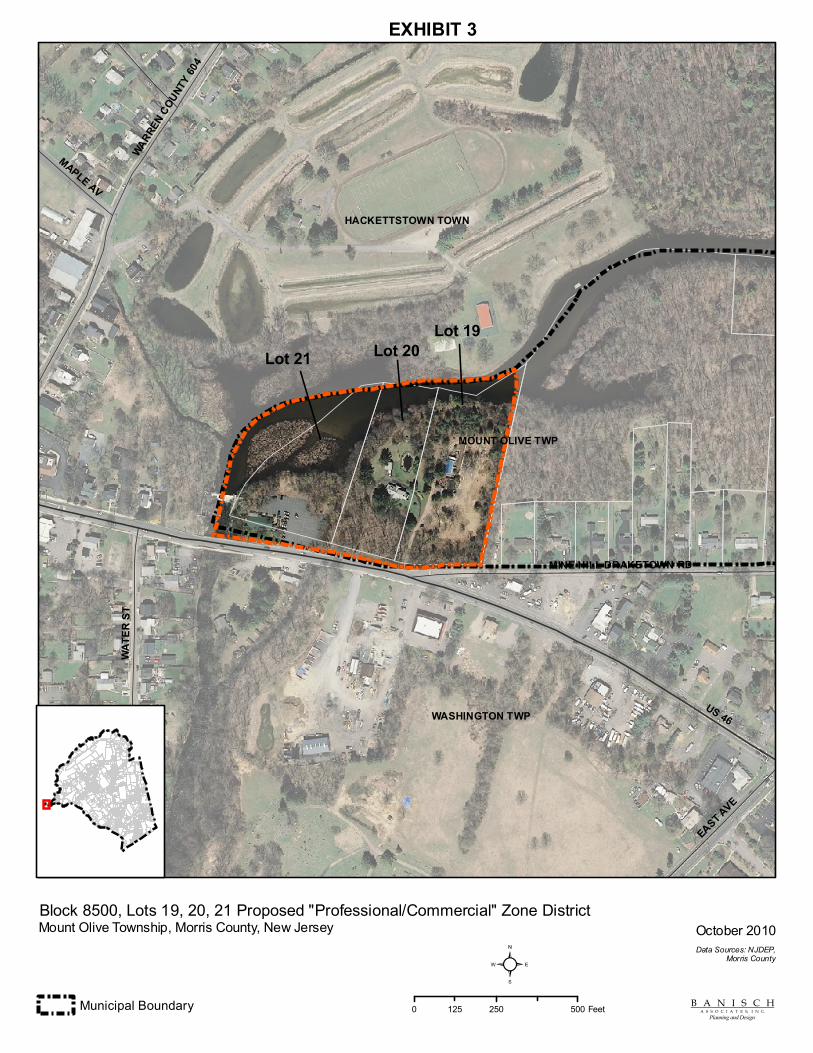
HACKETTSTOWN TOWN
WASHINGTON TWP
MOUNT OLIVE TWP
US 46
WATE
R ST
WARREN COUNT
Y 604
EAST AVE
MINE HILL DRAKETOWN RD
MAPLE AV
Mount Olive Township, Morris County, New Jersey
Municipal Boundary
Block 8500, Lots 19, 20, 21 Proposed "Professional/Commercial" Zone District
B A N I S C H A S S O C I A T E S, I N C.
Planning and Design
Data Sources: NJDEP,Morris County
October 2010
²0 250 500125 Feet
Lot 19Lot 20Lot 21
EXHIBIT 3