Town Planning Report - Noxious Offensive or Hazardous ... · Town Planning Report - Noxious...
82
Town Planning Report - Noxious Offensive or Hazardous Industry – Explosives Storage & Ancillary Offices & Vehicle Storage Prepared for Paulette Maree Caruana and Francis Paul Caruana July 2013 Town Planning Report - Noxious Offensive or Hazardous Industry – Explosives Storage & Ancillary Offices & Vehicle Storage 167 Barren Creek Road, Calen HRP12256
Transcript of Town Planning Report - Noxious Offensive or Hazardous ... · Town Planning Report - Noxious...
Town Planning Report - Noxious Offensive or Hazardous Industry – Explosives Storage & Ancillary Offices & Vehicle Storage
167 Barren Creek Road, Calen HRP12256
Prepared for Paulette Maree Caruana and Francis Paul Caruana
July 2013
Town Planning Report - Noxious Offensive or Hazardous Industry – Explosives Storage & Ancillary Offices & Vehicle Storage
167 Barren Creek Road, Calen HRP12256
tracyh
Received (Manual Date)


Town Planning Report - Noxious Offensive or Hazardous Industry – Explosives Storage & Ancillary Offices & Vehicle Storage 167 Barren Creek Road, Calen
July 2013 HRP12256 iii
Executive Summary
1.1 Site Details
Table 1 Site Details
Site Details
Address 167 Barren Creek Road, Calen
RPD Lot 26 CI581
Owner Paulette Maree Caruana and Francis Paul Caruana
Locality Hinterland
Precinct O’Connell River and Northern Streams
Zoning Rural
1.2 Application Details
Table 2 Application Details
Application Details
Development Type Development Permit for a Material Change of Use
Level of Assessment Impact
Proposal Summary Establish a Noxious Offensive or Hazardous Industry – Explosives Storage & Ancillary Offices & Vehicle Storage
Defined Land Use Noxious Offensive or Hazardous Industry
Referral – Concurrence N/A
Referral – Advice N/A
Applicant Paulette Maree Caruana and Francis Paul Caruana
Applicant’s Representative
Michael Jewell
Reference HRP12256

Town Planning Report - Noxious Offensive or Hazardous Industry – Explosives Storage & Ancillary Offices & Vehicle Storage 167 Barren Creek Road, Calen
July 2013 HRP12256 iv
Table of Contents
Executive Summary iii
1.1 Site Details iii
1.2 Application Details iii
2 Introduction 6
3 Site Details and Characteristics 7
3.1 Site Details 7
3.1.1 Location 7
3.2 Site Characteristics 7
3.2.1 Current Use of the Site 7
3.2.2 Road Frontages 7
3.2.3 Existing Significant Vegetation and Waterway Values 7
3.2.4 Ownership 7
3.2.5 Easements 7
3.2.6 Surrounding Land Uses and Zoning 7
3.2.7 Existing Infrastructure and Services 8
3.2.8 Site Contamination 8
3.2.9 Topography 8
3.2.10 Overlay Mapping 9
4 Proposed Development 11
4.1 Application Particulars 11
4.2 Proposal Description 11
4.3 Planning Scheme Definition 12
4.4 Built Form 12
4.5 Community Safety 14
4.6 Traffic & Movement 15
4.7 Infrastructure Services 15
4.8 Stormwater 15
4.9 Adopted Infrastructure Charges 15
5 Statutory Town Planning Framework 17
5.1 Introduction 17
5.2 Sustainable Planning Act 2009 17
5.2.1 Impact Assessment 17
5.2.2 Referral 19
5.2.3 Public Notification 19
5.2.4 State Planning Regulatory Provisions 19
5.2.5 State Planning Policies 20
5.3 MIW Regional Plan 22
5.4 Consolidated Mackay City Planning Scheme 2009 22
5.4.1 Defined Land use 22
5.4.2 Area Classification 22
5.4.3 Applicable Development Codes 22
6 Compliance Summary 23
6.1 Introduction 23
Town Planning Report - Noxious Offensive or Hazardous Industry – Explosives Storage & Ancillary Offices & Vehicle Storage 167 Barren Creek Road, Calen
July 2013 HRP12256 v
6.2 State Planning Regulatory Provisions 23
6.3 State Planning Policies 23
6.4 Consolidated Mackay City Planning Scheme 2009 23
6.5 Compliance with Applicable Codes 23
6.5.1 Mackay Hinterland Locality Code 23
6.5.2 Industrial Code 26
6.5.3 Environment and Infrastructure Code 26
6.5.4 Bushfire Management Overlay Code 26
6.5.5 Good Quality Agricultural Land Overlay Code 26
6.5.6 Development on Steep Land Overlay Code 26
7 Conclusions and Recommendations 27
Appendices
A Statement of Code Compliance B Proposal Plans C Owner’s Consent D Current Title Search E Registered Survey Plan and Smartmap F Searches: CLR & EMR G Vegetation, SCL and Wetland Searches
Town Planning Report - Noxious Offensive or Hazardous Industry – Explosives Storage & Ancillary Offices & Vehicle Storage 167 Barren Creek Road, Calen
July 2013 Cardno HRP – HRP12256 6
2 Introduction
This Town Planning Report accompanies a development application over land located at 167 Barren Creek
Road, Calen (refer to Figure 7.1 – Location Plan).
Paulette Maree Caruana and Francis Paul Caruana seek (‘the Applicant’) a Development Permit for a
Material Change of Use – Noxious Offensive or Hazardous Industry to undertake the proposed development.
The Applicant proposes to develop the site to provide for the storage of explosives and ancillary offices and
vehicle storage.
Section 4 – The Proposed Development of this report together with Appendix B – Proposal Plans
contains detailed information with regard to the design of the proposed development.
The proposal is assessable development under the Consolidated Mackay City Planning Scheme 2009
(including amendments 1 of 2009, and 1, 3, & 4 of 2010). The planning scheme requires an impact
assessable development application to be made in this instance.
Section 314 of the Sustainable Planning Act 2009 (“the SPA”) prescribes the requirements for impact
assessment.
Section 6 – Summary of Compliance of this report provides a summary of the proposed development’s
compliance with the applicable provisions of the relevant planning framework. Appendix A – Statement of
Code Compliance to this report contains the complete assessment of the proposed development against
the applicable criteria of the relevant codes of the Consolidated Mackay City Planning Scheme 2009.

Town Planning Report - Noxious Offensive or Hazardous Industry – Explosives Storage & Ancillary Offices & Vehicle Storage 167 Barren Creek Road, Calen
July 2013 Cardno HRP – HRP12256 7
3 Site Details and Characteristics
3.1 Site Details
3.1.1 Location
The subject site is situated at 167 Barren Creek Road, Calen and is located with the Rural zone in the
Mackay Hinterland Planning Locality, O’Connell River and Northern Streams approximately 50km north-west
of the Mackay CBD. The site is accessed from the Bruce Highway via 7km of sealed road along McIntyre
Street, Calen Mount Charlton Road and Barren Creek Road.
3.2 Site Characteristics
3.2.1 Current Use of the Site
The majority of the subject site is currently under cane cultivation, whilst additional uses include two
dwellings, a rural shed and an existing Rural Industry.
3.2.2 Road Frontages
The subject site has direct frontage to Barren Creek Road and Barron Pocket Road, both of which are
Council controlled Access Roads constructed to a rural standard. Barren Creek Road bisects the premises
north-south and is sealed up to the access point of the southern dwelling on the site. Barren Creek Road is
unsealed north from this point, while Barron Pocket Road is unsealed for the length of the site frontage.
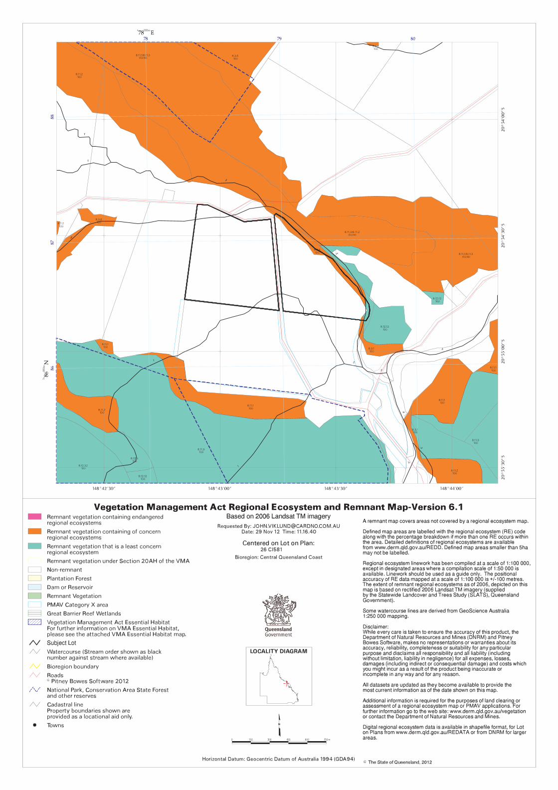
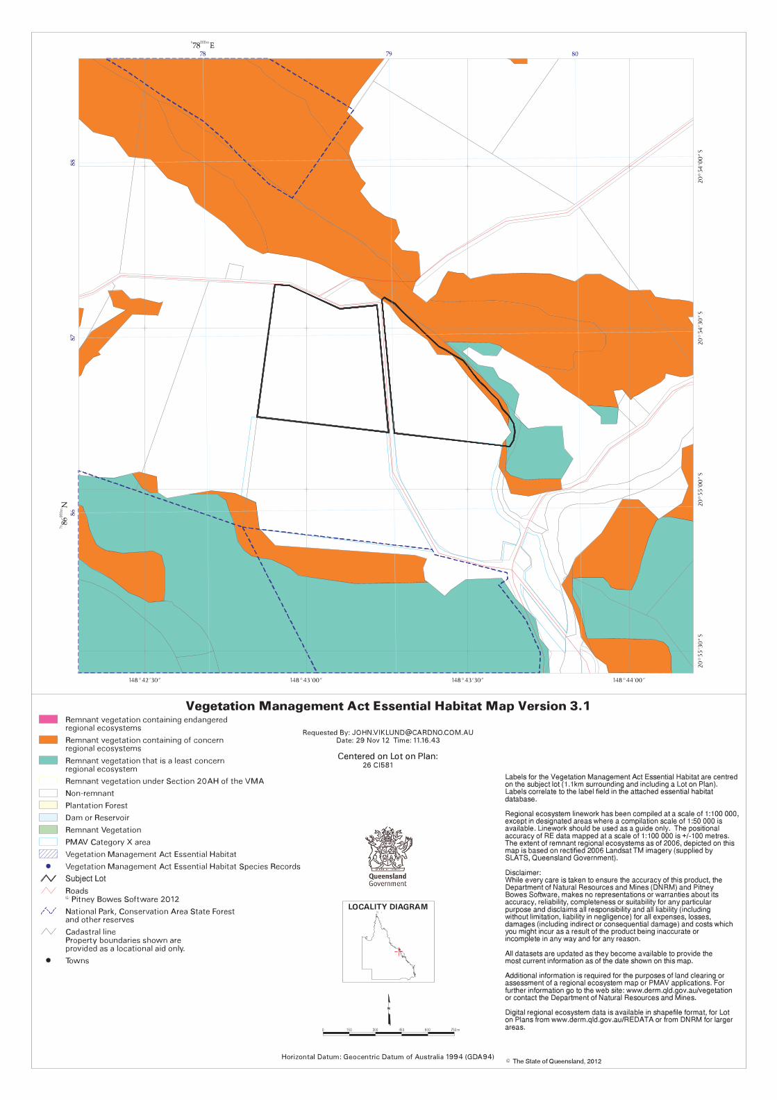
3.2.3 Existing Significant Vegetation and Waterway Values
A limited extent of mapped remnant vegetation remains on the site, located along the north eastern
boundary of the allotment, away from the proposed use areas. The premises also has a riparian boundary
with Barren Creek through the north of the premises and along the eastern boundary (refer to Appendix G –
Vegetation and Coastal Searches).
3.2.4 Ownership
The registered owners of the subject site are Paulette Maree Caruana and Francis Paul Caruana. Refer to
Appendix D – Current Title Search for details
3.2.5 Easements
There are no easements on the subject site. Refer to Appendix D – Current Title Search and Appendix E
– Registered Survey Plan and Smart Map for details.
3.2.6 Surrounding Land Uses and Zoning
Table 3 below outlines the various land uses and zones of the properties surrounding the subject lot (refer to
Figure 7.2).
Table 3 Surrounding land uses and zoning
Direction Zoning Land use
North Rural Open space, cane production
East Rural
Barren Creek, open space, cane production
South Rural
Cane production, dwelling house
West Rural
Grazing, dwelling house
Town Planning Report - Noxious Offensive or Hazardous Industry – Explosives Storage & Ancillary Offices & Vehicle Storage 167 Barren Creek Road, Calen
July 2013 Cardno HRP – HRP12256 8
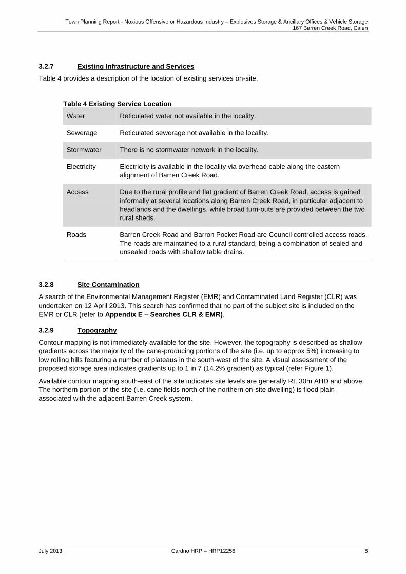
3.2.7 Existing Infrastructure and Services
Table 4 provides a description of the location of existing services on-site.
Table 4 Existing Service Location
Water Reticulated water not available in the locality.
Sewerage Reticulated sewerage not available in the locality.
Stormwater There is no stormwater network in the locality.
Electricity Electricity is available in the locality via overhead cable along the eastern
alignment of Barren Creek Road.
Access Due to the rural profile and flat gradient of Barren Creek Road, access is gained
informally at several locations along Barren Creek Road, in particular adjacent to
headlands and the dwellings, while broad turn-outs are provided between the two
rural sheds.
Roads Barren Creek Road and Barron Pocket Road are Council controlled access roads.
The roads are maintained to a rural standard, being a combination of sealed and
unsealed roads with shallow table drains.
3.2.8 Site Contamination
A search of the Environmental Management Register (EMR) and Contaminated Land Register (CLR) was
undertaken on 12 April 2013. This search has confirmed that no part of the subject site is included on the
EMR or CLR (refer to Appendix E – Searches CLR & EMR).
3.2.9 Topography
Contour mapping is not immediately available for the site. However, the topography is described as shallow
gradients across the majority of the cane-producing portions of the site (i.e. up to approx 5%) increasing to
low rolling hills featuring a number of plateaus in the south-west of the site. A visual assessment of the
proposed storage area indicates gradients up to 1 in 7 (14.2% gradient) as typical (refer Figure 1).
Available contour mapping south-east of the site indicates site levels are generally RL 30m AHD and above.
The northern portion of the site (i.e. cane fields north of the northern on-site dwelling) is flood plain
associated with the adjacent Barren Creek system.

Town Planning Report - Noxious Offensive or Hazardous Industry – Explosives Storage & Ancillary Offices & Vehicle Storage 167 Barren Creek Road, Calen
July 2013 Cardno HRP – HRP12256 9
Figure 1 Site topography (top left: view from farm shed south-west across Barren Creek Road towards storage area; top right: view along southern site boundary westwards across Barren Creek Road towards storage area; south-west view towards storage area; northwards view from storage area across farm track
3.2.10 Overlay Mapping
The site is affected by a number of Planning Scheme Overlay maps, chief of which are GQAL, Steep Land
and Bushfire. Figures 2-4 below demonstrate the relationship of the proposed storage site to the overlay
mapping.
Steep Land Overlay
The whole of the storage area is mapped as “steep land”. However, a visual assessment of the site indicates
that gradients are generally under 15% and that hills are of a low, rolling profile with frequent plateaus.
Figure 2 Steep Land Overlay
Town Planning Report - Noxious Offensive or Hazardous Industry – Explosives Storage & Ancillary Offices & Vehicle Storage 167 Barren Creek Road, Calen
July 2013 Cardno HRP – HRP12256 10
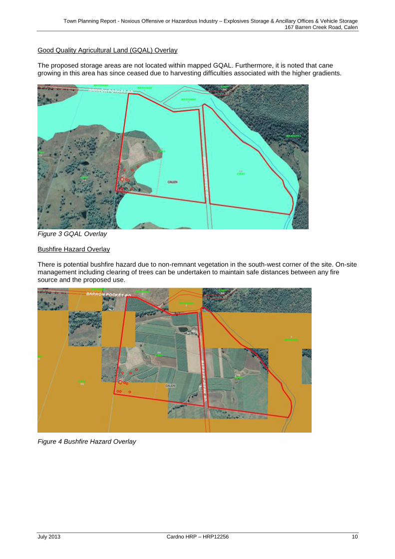
Good Quality Agricultural Land (GQAL) Overlay The proposed storage areas are not located within mapped GQAL. Furthermore, it is noted that cane growing in this area has since ceased due to harvesting difficulties associated with the higher gradients.
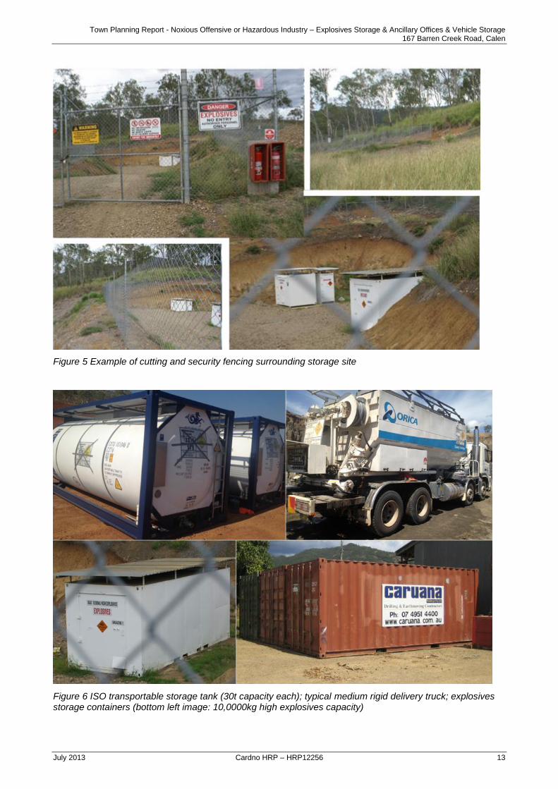
Figure 3 GQAL Overlay Bushfire Hazard Overlay There is potential bushfire hazard due to non-remnant vegetation in the south-west corner of the site. On-site management including clearing of trees can be undertaken to maintain safe distances between any fire source and the proposed use.
Figure 4 Bushfire Hazard Overlay

Town Planning Report - Noxious Offensive or Hazardous Industry – Explosives Storage & Ancillary Offices & Vehicle Storage 167 Barren Creek Road, Calen
July 2013 Cardno HRP – HRP12256 11
4 Proposed Development
4.1 Application Particulars
Table 5 Application Particulars
Application Particulars
Development Type Development Permit for a Material Change of Use
Level of Assessment Impact
Proposal Summary Establish a Noxious Offensive or Hazardous Industry – Explosives Storage & Ancillary Offices & Vehicle Storage
Defined Land Use Noxious Offensive or Hazardous Industry
Referral – Concurrence Nil
Referral – Advice N/A
4.2 Proposal Description
The Applicant proposes to formalise the existing use of part of the premises for the storage of dangerous
goods and explosives (collectively described as “explosives”), besides the use of two small demountable
structures for ancillary records keeping plus secure lock-up of explosives site keys and covered vehicle
storage. Table 6 below sets out the proposed volume and quantity of on-site storage.
Table 6 Existing and proposed explosives storage
Structures Detonators Ammonium Nitrate (AN) – granular
Ammonium Nitrate Emulsion (ANE) –
liquid
SITE M
3 containers (existing explosives magazines) (12m
2)
10,000 10t HE
SITE B
Proposed ISO tank & shed / container (15m
2)
Proposed 10 tonne equivalent HE
(30t) (14t)
SITE C
Proposed shed for truck storage (120m
2) / ISO tank &
2 containers (30m2)
Proposed 15 tonne equivalent HE
(45t) (21t)
SITE D Proposed ISO tank & shed / container (120m
2)
Proposed 20 tonne equivalent HE
(60t) (28t)
SITE E
Proposed ISO tank & shed / container (30m
2)
Proposed 15 tonne equivalent HE
(45t) (21t)
SITE F
2 containers (30m2) 50,000 10t HE
SITE G
2 containers (30m2) 50,000 10t HE
OFFICE 2 demountable buildings (36m
2)
Summary:
Dangerous Goods Total AN = 180t
Total ANE = 84t
Explosives Total HE = 30t
Total IE = 110,000 detonators
Total GFA = 423m
2 – 120m
2 truck storage = 303m
2 assessable GFA

Town Planning Report - Noxious Offensive or Hazardous Industry – Explosives Storage & Ancillary Offices & Vehicle Storage 167 Barren Creek Road, Calen
July 2013 Cardno HRP – HRP12256 12
Background Information:
AS2187.1-1998 Explosives – Storage, transport and use – Storage
Ammonium Nitrate (AN) and Ammonium Nitrate Emulsion (ANE) are Class 5.1 oxidising agents
classed as dangerous goods and are not explosive in their current form. However, a licence to store
under the Qld Explosives Dept Regulations is required.
Storage licences are based on TNT – a high explosive. However, as these agents are less of a risk
the storage licence requirement is less than that which can be legally stored, being 33% of AN plus
70% of ANE.
Ammonium nitrate, while being an oxidising agent used in explosives, is commonly used on farms as
a fertiliser. In this regard, it is noted that ammonium nitrate storage, where for farm purposes would
be subject to a dangerous goods storage licence but for planning and land use considerations would
be ancillary to the predominant use of the premises for Agriculture. There is no hazard associated
with ANE beyond that of ordinary combustible material, and it will not burn under typical fire
conditions.
As the use involves storage and ancillary offices for record keeping etc. no on-site staff or hours of operation
are associated with the use.
4.3 Planning Scheme Definition
The activity is classed as an “Industrial Activity” by means of the storage, whether for sale or not, of any
solid, liquid or gaseous fuel or other dangerous goods referred in the Australian Code for the Transport of
Dangerous Goods (Mackay City Planning Scheme Schedule 1 Dictionary 12.3 Administrative Terms).
The use definition is best described as a Noxious, Offensive or Hazardous Industry:
Any premises used for the handling, processing, treatment, or storage of any materials, whether or
not such materials are considered to be hazardous, where such activity typically gives rise to
noxious, offensive or hazardous effects including excessive smoke, fumes, odours, large quantities
of liquid or solid wastes and the like, all of which require special management.
Such uses, by their nature, are offensive to the general public, and may involve an element of public
risk in their conduct or, when not adequately managed, involve detrimental effects on land beyond
the premises. Examples of noxious, offensive or hazardous industry include abattoirs, bulk fuel
storage in tank farms, cement and lime works, chemical works, food processing works, oil refineries,
rendering works and the like.
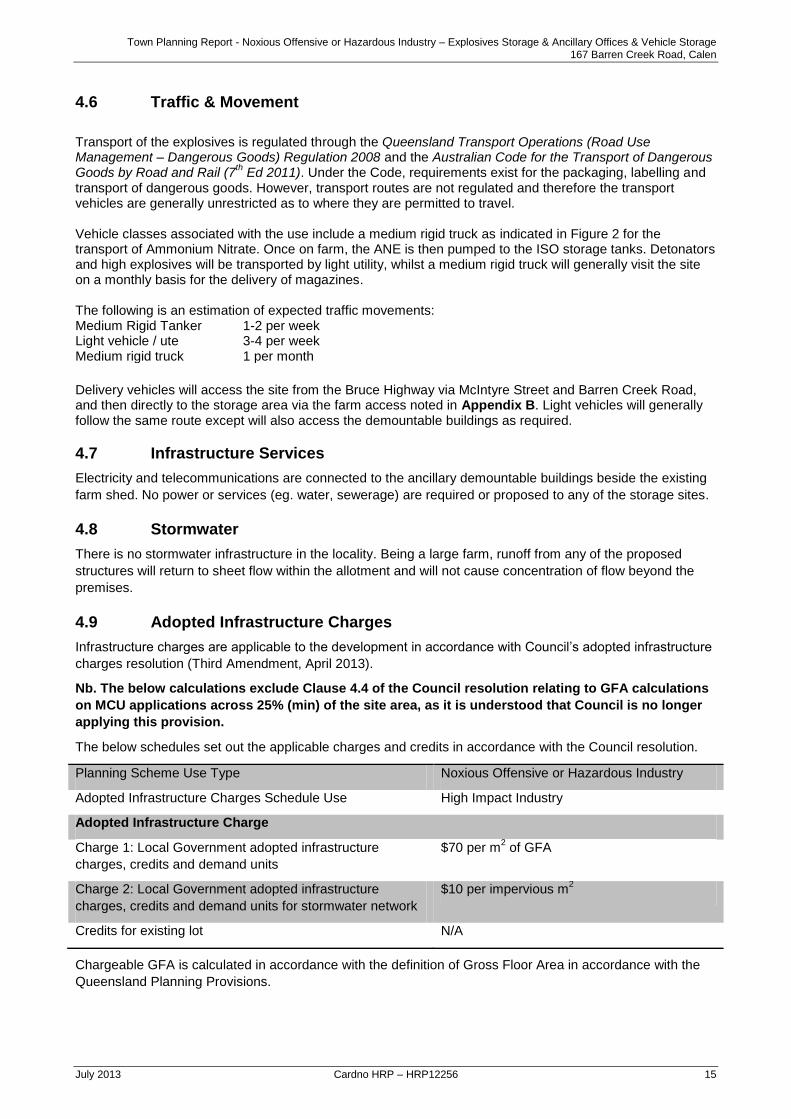
4.4 Built Form
The storage facility will consist primarily of tanks and shipping containers located in fenced compounds per
the below images. Two farm sheds are proposed, one of which will be used for chemical storage and the
other for tuck storage. The proponent also proposes to utilise the on-site demountable buildings beside the
existing farm shed east of Barren Creek Road for incidental first aid, office and records (refer to Appendix
B).
The truck storage is not regarded as assessable GFA for the purposes of DA fee calculation or Infrastructure
Charging. Accordingly, the Applicant would be agreeable to a condition of approval restricting use of the
shed from other than vehicle storage.
Minimal earthworks will be undertaken for each storage site to provide a level area for the safe and secure
placement and fencing of the associated tanks, containers and sheds, and existing natural plateaus will be
utilised wherever practicable. The below figures provides examples of the cutting and security fencing
surrounding a typical storage site, plus the nature of the proposed ISO tanks, freight containers, and medium
rigid truck associated with the proposal.
Besides the on-farm storage, the main office is located in Shakespeare Street Mackay (not part of this
application).
Town Planning Report - Noxious Offensive or Hazardous Industry – Explosives Storage & Ancillary Offices & Vehicle Storage 167 Barren Creek Road, Calen
July 2013 Cardno HRP – HRP12256 13
Figure 5 Example of cutting and security fencing surrounding storage site
Figure 6 ISO transportable storage tank (30t capacity each); typical medium rigid delivery truck; explosives storage containers (bottom left image: 10,0000kg high explosives capacity)

Town Planning Report - Noxious Offensive or Hazardous Industry – Explosives Storage & Ancillary Offices & Vehicle Storage 167 Barren Creek Road, Calen
July 2013 Cardno HRP – HRP12256 14
Figure 7 Demountable buildings beside existing farm shed (left image: southern elevation; right image: north-western elevation)
4.5 Community Safety
The storage and transport of explosives is regulated through AS2187.1-1998 Explosives – Storage, transport
and use – Storage and the Australian Code for the Transport of Explosives by Road and Rail. The applicant
holds relevant licences for the storage, transport and sale explosives, which can be produced if required.
The location and proposed capacity of each of the storage sites has been determined through examination
of the site and available separation distances to roads and dwellings in the locality, as indicated in Appendix
B and Table 7 below (definitions and setback requirements per AS2187.1-1998).
Class A: Public street, road or thoroughfare, railway, navigable waterway, dock, wharf, pier or jetty, marketplace,
public recreation and sports ground or other open place where the public is accustomed to assemble, open place of work
in another occupancy, river-wall, seawall, reservoir, water main (above ground), radio or television transmitter, main
electrical substation, private road which is the principal means of access to a church, chapel, college, school, hospital or
factory.
Class B: Dwelling house, public building, church, chapel, college, school, hospital, theatre, cinema or other building or
structure where the public is accustomed to assemble, shop, factory, warehouse, store, building in which any person is
employed in any trade or business, depot for the keeping of flammable or dangerous goods, major dam.
Table 7 Storage sites - proposed capacity and separation distances
Site NEQ stored kg
Protected works Class A Protected Works Class B
Required Available Required Available
SITE M 10,000kg 320m 641m 480m 616m
SITE B 10,000kg 320m 558m 480m 480m
SITE C 15,000kg 370m 552m 550m 550m
SITE D 20,000kg 405m 640m 610m 625m
SITE E 15,000kg 370m 575m 550m 550m
SITE F 10,000kg 320m 558m 480m 550m
SITE G 10,000kg 320m 506m 480m 494m
The site is particularly suited to the storage of explosives due to the available distance to any protected works – in this instance dwellings and roads. In the siting and design of explosives storage it is also relevant to consider the potential for future works. In this regard it is noted that dwellings are already established on both adjoining allotments and the subject allotment, meaning that there is very low risk for the potential of future encroaching works.
Town Planning Report - Noxious Offensive or Hazardous Industry – Explosives Storage & Ancillary Offices & Vehicle Storage 167 Barren Creek Road, Calen
July 2013 Cardno HRP – HRP12256 15
4.6 Traffic & Movement
Transport of the explosives is regulated through the Queensland Transport Operations (Road Use Management – Dangerous Goods) Regulation 2008 and the Australian Code for the Transport of Dangerous Goods by Road and Rail (7
th Ed 2011). Under the Code, requirements exist for the packaging, labelling and
transport of dangerous goods. However, transport routes are not regulated and therefore the transport vehicles are generally unrestricted as to where they are permitted to travel. Vehicle classes associated with the use include a medium rigid truck as indicated in Figure 2 for the transport of Ammonium Nitrate. Once on farm, the ANE is then pumped to the ISO storage tanks. Detonators and high explosives will be transported by light utility, whilst a medium rigid truck will generally visit the site on a monthly basis for the delivery of magazines. The following is an estimation of expected traffic movements: Medium Rigid Tanker 1-2 per week Light vehicle / ute 3-4 per week Medium rigid truck 1 per month
Delivery vehicles will access the site from the Bruce Highway via McIntyre Street and Barren Creek Road, and then directly to the storage area via the farm access noted in Appendix B. Light vehicles will generally follow the same route except will also access the demountable buildings as required.
4.7 Infrastructure Services
Electricity and telecommunications are connected to the ancillary demountable buildings beside the existing
farm shed. No power or services (eg. water, sewerage) are required or proposed to any of the storage sites.
4.8 Stormwater
There is no stormwater infrastructure in the locality. Being a large farm, runoff from any of the proposed
structures will return to sheet flow within the allotment and will not cause concentration of flow beyond the
premises.
4.9 Adopted Infrastructure Charges
Infrastructure charges are applicable to the development in accordance with Council’s adopted infrastructure
charges resolution (Third Amendment, April 2013).
Nb. The below calculations exclude Clause 4.4 of the Council resolution relating to GFA calculations
on MCU applications across 25% (min) of the site area, as it is understood that Council is no longer
applying this provision.
The below schedules set out the applicable charges and credits in accordance with the Council resolution.
Planning Scheme Use Type Noxious Offensive or Hazardous Industry
Adopted Infrastructure Charges Schedule Use High Impact Industry
Adopted Infrastructure Charge
Charge 1: Local Government adopted infrastructure
charges, credits and demand units
$70 per m2 of GFA
Charge 2: Local Government adopted infrastructure
charges, credits and demand units for stormwater network
$10 per impervious m2
Credits for existing lot N/A
Chargeable GFA is calculated in accordance with the definition of Gross Floor Area in accordance with the
Queensland Planning Provisions.

Town Planning Report - Noxious Offensive or Hazardous Industry – Explosives Storage & Ancillary Offices & Vehicle Storage 167 Barren Creek Road, Calen
July 2013 Cardno HRP – HRP12256 16
Gross floor area – The total floor area of all storeys of the building, including any mezzanines, (measured from the outside of the external walls and the centre of any common walls of the building), other than areas used for:
building services; or
a ground floor public lobby; or
a public mall in a shopping complex; or
parking, loading or manoeuvring of vehicles; or
balconies, whether roofed or not. Draft Queensland Planning Provisions version 3.0 (October 2011)
The below schedule sets out the applicable charge rates, units and credits for the development.
Proposed GFA (Chargeable) / Impervious 303 m2
Proposed non-chargeable GFA / Impervious 120 m2
TOTAL GFA / Impervious 423 m2
Category Adopted Charge Demand Units No. of units Charge Amount
Industry (High
Impact)
$70 / m2 m
2 GFA 303 $21,210.00
$10 / m2 m
2 Impervious area 423 $4,230.00
Credits $ 0 $0.00
Net charge Amount $25,440.00
Nb. In consideration of the location of the premises in the rural locality and the absence of any existing or
planned urban services, the adopted rate for a High Impact Industry is not considered appropriate in this
instance. However, the applicable rate for a High Impact Rural activity – i.e. generating road impacts only –
is recommended for adoption as an appropriate rate for Infrastructure Charges. The adopted rate for a High
Impact Rural activity is $20/sqm GFA and nil charge for impervious area.

Town Planning Report - Noxious Offensive or Hazardous Industry – Explosives Storage & Ancillary Offices & Vehicle Storage 167 Barren Creek Road, Calen
July 2013 Cardno HRP – HRP12256 17
5 Statutory Town Planning Framework
5.1 Introduction
This section of the Town Planning Report explains the applicable components of the statutory town planning framework and their relevance to the proposed development.
5.2 Sustainable Planning Act 2009
The Sustainable Planning Act 2009 (the SPA) is the statutory instrument for the State of Queensland under which, amongst other matters, development applications are assessed by local governments.
The SPA replaced the now repealed Integrated Planning Act 1997.
The SPA delivers an Integrated Development Assessment System (IDAS) for integrating State and local government assessment and approval processes for development. Relevant stages in the IDAS process including referral and public notification are addressed below.
5.2.1 Impact Assessment
The planning framework relevant to assessing the development application at the time of lodgement
comprises the SPA and the Consolidated Mackay City Planning Scheme 2009.
Section 238 of the SPA prescribes that a development permit is necessary for assessable development, as
declared under the relevant planning scheme.
In this instance, an Impact Assessable development application is required to be made to the assessment
manager to acquire the necessary development permit (refer to Section 5.4 – Consolidated Mackay City
Planning Scheme 2009 of this report).
Section 314 of SPA set out the provisions for assessment managers to assess impact assessable
applications as follows:
“(2) The assessment manager must assess the part of the application against each
of the following matters or things to the extent the matter or thing is relevant to
the development—
(a) the State planning regulatory provisions;
(b) the regional plan for a designated region, to the extent it is not identified
in the planning scheme as being appropriately reflected in the planning
scheme;
(c) if the assessment manager is not a local government—the laws that are
administered by, and the policies that are reasonably identifiable as
policies applied by, the assessment manager and that are relevant to the
application;
(d) State planning policies, to the extent the policies are not identified in—
(i) any relevant regional plan as being appropriately reflected in the
regional plan; or
(ii) the planning scheme as being appropriately reflected in the
planning scheme;
(e) a structure plan;
(f) for development in a declared mater planned area – all mater plans for
the area;
(g) a temporary local planning instrument;

Town Planning Report - Noxious Offensive or Hazardous Industry – Explosives Storage & Ancillary Offices & Vehicle Storage 167 Barren Creek Road, Calen
July 2013 Cardno HRP – HRP12256 18
(h) a preliminary approval to which section 242 applies;
(i) a planning scheme;
(j) for development not in a planning scheme area – any planning scheme or
temporary local planning instrument for a planning scheme area that may
be materially affected by the development;
(k) if the assessment manager is an infrastructure provider – an adopted
infrastructure charges resolution or the priority infrastructure plan.
(3) In addition to the matters or things against which the assessment manager must
assess the application under subsection (2), the assessment manager must
assess the part of the application having regard to the following—
(a) the common material;
(b) any development approval for, and any lawful use of, premises the
subject of the application or adjacent premises;
(c) any referral agency’s response for the application."
According to Section 326 of the SPA:
“(1) The assessment manager’s decision must not conflict with a relevant instrument
unless—
(a) the conflict is necessary to ensure the decision complies with a State
planning regulatory provision; or
(b) there are sufficient grounds to justify the decision, despite the conflict; or
(c) the conflict arises because of a conflict between—
(i) 2 or more relevant instruments of the same type, and the decision
best achieves the purposes of the instruments; or
(ii) 2 or more aspects of any 1 relevant instrument, and the decision
best achieves the purposes of the instrument.”
At the time of the lodgement of the development application, the common material comprises the application
material only. The application material includes an assessment of the proposed development against the
relevant planning documents and the assessment criteria of the SPA. However, information arising from the
subsequent Information and Referral Stage will also form part of the common material to be assessed by
Council.
Town Planning Report - Noxious Offensive or Hazardous Industry – Explosives Storage & Ancillary Offices & Vehicle Storage 167 Barren Creek Road, Calen
July 2013 Cardno HRP – HRP12256 19
5.2.2 Referral
Section 254 of the SPA states that:
A referral agency has, for assessing and responding to the part of an application giving
rise to the referral, the jurisdiction or jurisdictions prescribed under a regulation.”
Section 13 of the Sustainable Planning Regulation 2009 (“SPR”) explains that:
For sections 250(a), 251(a) and 254(1) of the Act —
(a) schedule 7, column 2 states the referral agency, and whether it is an advice
agency or a concurrence agency, for the development application mentioned in
column 1; and
(b) schedule 7, column 3 states the jurisdiction of the referral agency mentioned in
column 2.”
The proposed development does not require referral to any agency.
5.2.3 Public Notification
According to Section 295 of the SPA, the notification stage of the IDAS process applies to an application if
either of the following applies –
(a) any part of the application requires impact assessment;
(b) the application is an application to which section 242 applies.”
The proposal requires impact assessment and therefore public notification will be required as part of the
development application process.
Public Notification will be carried out for a minimum of 15 business days as per Section 298 of SPA.
5.2.4 State Planning Regulatory Provisions
A State Planning Regulatory Provision is an instrument made under Division 2 and Part 6 of the SPA for an
area to advance the purpose of the Act by—
(a) providing regulatory support for regional planning or master planning; or
(b) providing for a charge for the supply of infrastructure; or
(c) protecting planning scheme areas from adverse impacts.
A State Planning Regulatory Provision includes a draft State Planning Regulatory Provision.
Section 313(2)(a) of the SPA requires an assessment manager to assess an application against a State
Planning Regulatory Provision to the extent the State Planning Regulatory Provision is relevant to the
development.
At the time of lodgement, the following relevant State Planning Regulatory Provisions were in force:
State Planning Regulatory Provision (Adopted Charges) – July 2012
The draft State Planning Regulatory Provision (Adopted Charges) establishes a maximum adopted
charge for trunk infrastructure, identifies for certain local government areas, priority infrastructure
areas to facilitate some aspects of development sequencing in relation to the charging framework
while those local governments complete their priority infrastructure plans, and provides a default
proportional split that may be levied by a distributor retailer and relevant local government, until 30
June 2013. These State Planning Regulatory Provisions are relevant to the proposed development
as the subject site is located within a local government area to which the State Planning Regulatory
Provisions apply.
Draft Coastal Protection State Planning Regulatory Provision – October 2012
The draft Coastal Protection State Planning Regulatory Provision applies to the assessment of
development applications and master plan applications that are properly made under the period in
which the State Planning Regulatory Provision has effect.

Town Planning Report - Noxious Offensive or Hazardous Industry – Explosives Storage & Ancillary Offices & Vehicle Storage 167 Barren Creek Road, Calen
July 2013 Cardno HRP – HRP12256 20
The draft Coastal Protection State Planning Regulatory Provision applies to all local government
areas in Queensland that contain areas within the coastal zone and has effect for 12 months from
the date of implementation, i.e. until 8 October 2013.
As a result of the Draft State Planning Regulatory Provision, the State Planning Policy 3/11: Coastal
Protection is suspended from operation (as outlined in section 5.2.5).
The Draft Coastal Protection State Planning Regulatory Provision does not affect the proposed
development. The site is not identified as being subject to coastal hazards due to projected climate
change impacts to 2100.
5.2.5 State Planning Policies
A State Planning Policy is an instrument made by the Minister about matters of State interest. As prescribed
by Section 314(2)(d) of the SPA, an assessment manager must have regard to State Planning Policies, if
they are not identified in the planning scheme as being appropriately reflected in the planning scheme.
At the time of lodgement, the following State Planning Policies were in force:
SPP 1/02 Development in the Vicinity of Certain Airports and Aviation Facilities
Queensland Government policy, which sets out broad principles for protecting airports and
associated aviation facilities from encroachment by incompatible developments in the interests of
maintaining operational efficiency and community safety;
SPP 2/02: Planning and Managing Development Involving Acid Sulfate Soils
This State Planning Policy aims to ensure that development involving acid sulfate soils is planned
and managed to avoid the release of potentially harmful contaminants into the environment;
SPP 1/03: Mitigating the Adverse Impacts of Flood, Bushfire and Landslide
This State Planning Policy aims to minimise the potential adverse impacts of flood, bushfire and
landslide on people, property, economic activity and the environment;
SPP 1/07: Housing and Residential Development
This State Planning Policy seeks to ensure that large, higher growth local governments identify their
community’s housing needs and analyse, and modify if necessary, their planning schemes to
remove barriers and provide opportunities for housing options that respond to identified needs;
SPP 2/07: Protection of Extractive Resources
This State Planning Policy identifies those extractive resources of State or regional significance
where extractive industry development is appropriate in principle, and aims to protect those
resources from developments that might prevent or severely constrain current or future extraction
when the need for utilization of the resource arises;
SPP 2/10: Koala Conservation in South East Queensland
This State Planning Policy seeks to ensure koala habitat conservation is taken into account in the
planning process, contributing to a net increase in koala habitat in South East Queensland, and
assist in the long term retention of viable koala populations in South East Queensland;
SPP 3/10: Acceleration of Compliance Assessment
This State Planning Policy provides a standard code for reconfiguring a lot (subdividing one into two)
and associated operational works that require compliance assessment.

Town Planning Report - Noxious Offensive or Hazardous Industry – Explosives Storage & Ancillary Offices & Vehicle Storage 167 Barren Creek Road, Calen
July 2013 Cardno HRP – HRP12256 21
SPP 4/10: State Planning Policy for Healthy Waters
The SPP will ensure that development for urban purposes under the Sustainable Planning Act 2009,
including community infrastructure, is planned, designed, constructed and operated to manage
stormwater and waste water in ways that protect the environmental values prescribed in the
Environmental Protection (Water) Policy 2009.
SPP 5/10: Air, Noise and Hazardous Materials
This State Planning Policy complements the existing management framework by providing a more
strategic focus on the location of industrial land uses. The policy will ensure that planning
instruments provide strategic direction about where industrial land uses should be located to protect
communities and individuals from the impacts of air, noise and odour emissions, and the impacts
from hazardous materials and how land for industrial land uses will be protected from unreasonable
encroachment by incompatible land uses.
Temporary SPP 2/11: Planning for Stronger, More Resilient Floodplains
This State Planning Policy seeks to ensure that development is planned, designed and constructed
to minimise potential flood damage to towns and cities and to improve safety of individuals and
communities.
SPP 3/11 Coastal Protection
This State Planning Policy protects the coastal resources of the coastal zone by setting out criteria
for land-use planning, coastal activities and development assessment, enabling Queensland to
manage development within the coastal zone, including within coastal waters. This aims to satisfy,
in part, the object of the Coastal Protection and Management Act 1995.
The State Planning Policy was suspended on 8 October 2012 pending a full review. The Draft Coastal Protection State Planning Regulatory Provision manages development in the coastal zone.
SPP 4/11: Protecting wetlands of high ecological significance in Great Barrier Reef
catchments
This State Planning Policy seeks to ensure that development in or adjacent to wetlands of high
ecological significance in Great Barrier Reef catchments is planned, designed, constructed and
operated to prevent the loss or degradation of wetlands and their environmental values, or enhances
these values.
SPP 1/12: Protection of Queensland’s strategic cropping land
This State Planning Policy seeks to protect Strategic cropping land (SCL) by ensuring development
impacts on SCL or potential SCL are managed to preserve the productive capacity of the land for
future generations through assessment under this SPP and through imposing conditions on the
development.
SPP2/12 Planning for Prosperity
The purpose of this Temporary SPP is to ensure that economic growth is facilitated by local and
state plans and is not adversely impacted by planning processes. This policy is to be reflected in
State and local government decision making.
The Consolidated Mackay City Planning Scheme 2009 is the relevant planning scheme in this instance (see
Section 5.4 –Consolidated Mackay City Planning Scheme 2009 below). The planning scheme explicitly
identifies that the following abovementioned State Planning Policies are appropriately reflected in the
planning scheme:
SPP 1/02 – Development in the Vicinity of Certain Airport and Aviation Facilities;
SPP 2/02 – Planning and Managing Development Involving Acid Sulfate Soils; and
SPP 1/03 – Mitigating the Adverse Impacts of Flood, Bushfire and Landslide.

Town Planning Report - Noxious Offensive or Hazardous Industry – Explosives Storage & Ancillary Offices & Vehicle Storage 167 Barren Creek Road, Calen
July 2013 Cardno HRP – HRP12256 22
5.3 MIW Regional Plan
The Mackay Isaac Whitsunday Regional Plan (‘MIW) came into full effect on 8 February 2012. Its primary
purpose is to provide a sustainable growth management strategy for the region that articulates strategic
direction and certainty that will accommodate a significant increase in population in MIW to 2031.
5.4 Consolidated Mackay City Planning Scheme 2009
The Consolidated Mackay City Planning Scheme 2009 (effective 19 December 2011) and is the relevant
planning scheme for the assessment of development proposals within the city of Mackay.
5.4.1 Defined Land use
The proposed development is defined as “Noxious Offensive or Hazardous Industry”, as per Schedule 1 of
the Consolidated Mackay City Planning Scheme 2009 and as described in Section 4.3 of this report.
5.4.2 Area Classification
The site is located within the Rural zone, O’Connell River and Northern Streams Planning Precinct,
Hinterland Locality of the Consolidated Mackay City Planning Scheme 2009.
5.4.3 Applicable Development Codes
The proposal is assessable against the following Planning Scheme codes as identified in Table 6-1 –
Assessment Categories and Relevant Assessment Criteria for Making a Material Change of Use – Mackay
Hinterland Locality.
Codes
Primary Codes
Mackay Hinterland Locality Code
Industrial Code
Environment and Infrastructure Code
Secondary Codes
Bushfire Management Overlay Code
Development on Steep Land Overlay Code
Good Quality Agricultural Land Overlay Code
A summary of compliance is set out in Section 6 of this report. A detailed assessment against the all of the
relevant provisions of the abovementioned codes is provided at Appendix A – Statement of Code
Compliance.

Town Planning Report - Noxious Offensive or Hazardous Industry – Explosives Storage & Ancillary Offices & Vehicle Storage 167 Barren Creek Road, Calen
July 2013 Cardno HRP – HRP12256 23
6 Compliance Summary
6.1 Introduction
The following sections comprise a summary of compliance against the relevant provisions of the planning
framework as they apply to the proposed development, identified in Section 5 of this report.
More detailed information and responses to the Consolidated Mackay City Planning Scheme 2009 provisions
are included in the Appendices to the Town Planning. Appendix A – Statement of Code Compliance is
particularly relevant in this regard, as it contains an assessment of the proposed development against the
relevant codes of the Planning Scheme.
6.2 State Planning Regulatory Provisions
A list of current State Planning Regulatory Provisions is provided in Section 5.2.4 of this report.
State Planning Regulatory Provisions (Adopted Charges) 2012, which commenced on 1 July 2012, are
relevant to the proposed development. The purpose of the SPRP (Adopted Charges) includes to state the
maximum charge which can be applied for trunk infrastructure and state development for which the charge
may be applied under Chapter 8, Part 1, Division 5A of the SPA.
In accordance with Section 648D of the SPA, by resolution effective 16 April 2012 (the Second Amendment
AICR) the Mackay Regional Council has adopted the maximum charge under the SPRP (Adopted Charges).
A statement about applicable charges in accordance with the Adopted Charges and Council’s resolution is
provided in Section 4.8 of this report.
6.3 State Planning Policies
The development application must have regard to all relevant and applicable State Planning Policies, which
are not incorporated or reflected Consolidated Mackay City Planning Scheme 2009.
The State Planning Policies in force at the time of lodgement, and those which are identified in Consolidated
Mackay City Planning Scheme 2009 as being appropriately reflected in the planning scheme are listed in
Section 5.2.5 of this Report.
No State Planning Policies not reflected within the Mackay City Planning Scheme 2009 have been identified
as being relevant to the proposal.
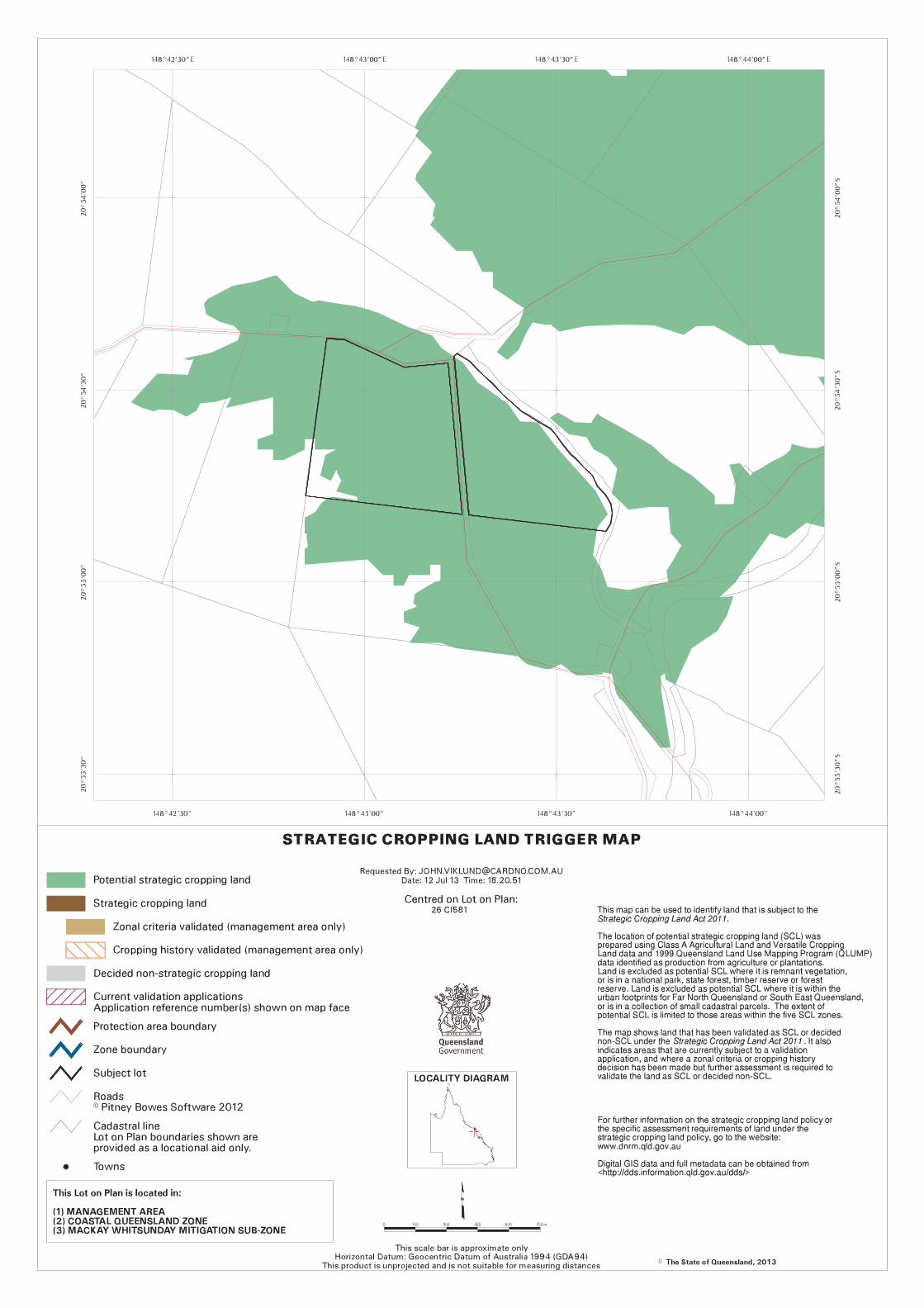
Nb. The trigger for referral for the purposes of Strategic Cropping Land does not apply as the total GFA
proposed is less than 750m2.
6.4 Consolidated Mackay City Planning Scheme 2009
A comprehensive assessment of the development’s compliance with the relevant criteria in the Consolidated
Mackay City Planning Scheme 2009 has been undertaken below.
6.5 Compliance with Applicable Codes
A comprehensive assessment of the development compliance with the relevant Codes of Consolidated
Mackay City Planning Scheme 2009 is included as Appendix A - Statement of Code Compliance of this
Town Planning Report. Compliance with the Codes is summarised below.
6.5.1 Mackay Hinterland Locality Code
Compliance with the Mackay Hinterland Locality Code is achieved when the development achieves each of
the relevant Specific Outcomes in the Code.
A Statement of Compliance for the Mackay Hinterland Locality Code, including Division 13 for the Rural
zone, is attached in Appendix A.
Town Planning Report - Noxious Offensive or Hazardous Industry – Explosives Storage & Ancillary Offices & Vehicle Storage 167 Barren Creek Road, Calen
July 2013 Cardno HRP – HRP12256 24
The proposal does not comply with P4 of Division 7 Specific Outcomes and Probable and Acceptable
Solutions for the Mackay Hinterland Locality and P6 of Division 13 Overall & Specific Outcomes and
Probable & Acceptable Solutions for the Rural Zone in the Mackay Hinterland Locality, which state:
“Industrial activities are located within the zoned industrial areas of the City”; and
“Non-rural activities do not occur on land included in the Rural Zone”.
The explosives storage is associated with and necessarily ancillary to extractive industry, which has
specifically been included in the definition of a Rural Activity in Schedule 1 “Administrative Definitions” of the
Planning Scheme:
“Rural activity” means the use of land for agriculture, animal husbandry, aquaculture, extractive industries,
forestry, intensive animal husbandry, kennels or a rural industry.
Therefore there the use of the land for explosives storage may be more appropriately regarded as a Rural
Activity than an Urban Activity.
Due to the conflict with the Specific Outcomes, the proposal must be assessed with regards to the intent of
the Code, being the Overall Outcomes of the Mackay Hinterland Locality. The following Overall Outcomes
have been identified as relevant to the proposal.
Industrial uses which are relatively small scale and have low impact are located within the Industry
(Low Impact) zone whilst those industrial uses which are larger in terms of site requirements,
infrastructure requirements or impact, are situated in the Industry (High Impact) zone.
Due to the separation distances required from the explosives storage to a public road, there is no industrial
zoned land – either low impact or high impact – which would satisfy the licence requirements for the storage
of dangerous goods. Therefore there is no industrial land available which is suitable for the proposed use.
Non-rural activities in rural areas are limited to activities which specifically require the particular rural
location and do not adversely affect the operation of rural uses, or the rural landscape and character
of the area.
Whilst the site has characteristics which make it suitable for the storage of explosives (i.e. constructed road
access, available separation distances), the use is not a location specific use.
The use is demonstrated as capable of existing without impacting on the rural activities and rural landscape
by consideration that:
o The proposed storage areas are not located on GQAL and do not alienate any GQAL from
ongoing production;
o The proposed storage areas are relatively small and will not interfere with normal farm
operations;
o The storage of ANE is otherwise consistent with normal farm operations where associated
with use as a fertiliser; and
o The storage areas are set well back from the road reserve and can take advantage of
existing non-remnant vegetation for screening and integration within the rural landscape.
By nature of the separation distances required for the storage of explosives, the only area in which the use
can locate within Mackay is the rural locality.
In this instance it is also appropriate to consider the Desired Environmental Outcomes in Part 3 of the
Planning Scheme. The following DEO’s have been identified as relevant to the proposal:
(a) Biodiversity and Habitat/ Natural Features:
(i) significant natural features1 are conserved and their values are not compromised in order to sustain
ecological processes and maintain biodiversity in the City for present and future generations.
1 The significant natural features which contribute to the City's biodiversity include: the Clarke and Connors Ranges and the low coastal ranges and hills which support remnant bushland and important wildlife
corridors and refuges;

Town Planning Report - Noxious Offensive or Hazardous Industry – Explosives Storage & Ancillary Offices & Vehicle Storage 167 Barren Creek Road, Calen
July 2013 Cardno HRP – HRP12256 25
(vi) a balance is achieved between the conservation and use of natural resources in order to achieve
sustainable economic, social and ecological outcomes.
The development will have a small footprint and will not impact on natural or ecological processes.
(c) Economic Development
(i) economic resources such as good quality agricultural land, forests, fisheries, extractive materials, water and land resources are protected from the adverse or limiting effects of proximate, incompatible activity for future ongoing use. Good quality agricultural land is made available for urban uses only with a demonstration of overriding community need.
2
It is demonstrated throughout this report that the use is proposed outside of any area of Good Quality Agricultural Land, and will not conflict with or impact on agricultural production within the site or on adjoining land. Therefore, no GQAL will be lost or alienated, whether temporarily or permanently, as a result of this proposal.
1. Rural land:
(A) is protected from incompatible land uses, particularly urban (including but not limited to residential, industrial and commercial) uses;
(B) is maintained in agricultural use, where possible, in order to ensure the viability of the sugar industry in the City; and
(C) provides opportunities for use for a wide range of rural activities (including
agriculture, animal husbandry, aquaculture, extractive industries, forestry, intensive
animal husbandry, kennels or a rural industry) and water supply development.
Whilst the DEO identifies industrial activities as incompatible with rural land, it is noted that the nature of the
particular is not inconsistent with that of rural uses:
The predominant form of activity is storage of chemicals, which is also typical of common agricultural
use and is ancillary to extractive industries.
The use does not involve any on-site staff as it is a storage facility only, whereas staff will only be
present during deliveries and for general monitoring and maintenance.
Traffic generation associated with the use will be very low, comprising on average one light vehicle
movement per day and one heavy vehicle (medium rigid) movement per week.
Further to the above considerations, reference is made to Statutory Guideline 05/09 Sufficient Grounds for
Decisions That Conflict with a Relevant Instrument (Queensland Government 11 December 2009). In
particular:
The relevant instrument inadequately addresses development; and
The relevant instrument does not anticipate specific or particular development.
The type of development proposed is not adequately addressed by the Planning Scheme as the Specific
Outcomes, Overall Outcomes and Desired Environmental Outcomes do not adequately address this
particular form of development which has setback requirements which make it unsuitable for location within
the identified preferred industrial areas or any urban locality. Therefore it is impossible to identify a site which
meets both the outcomes of the Planning Scheme and the safe storage requirements of the dangerous
goods codes.
the drainage systems, such as the O'Connell River, Pioneer River and the smaller coastal streams, which provide wildlife corridors
and nourishment for the City's ecosystems; the riparian vegetation along the City's waterways; the coastal wetlands, beaches and bays which either abut or lie adjacent to the Great Barrier Reef Marine Park and the Great
Barrier Reef World Heritage Area; and
the Cumberland Islands which sit within the Great Barrier Reef World Heritage Area. 2 As required by State Planning Policy 1/92 ‘Development and the Conservation of Good Quality Agricultural
Land’.
Town Planning Report - Noxious Offensive or Hazardous Industry – Explosives Storage & Ancillary Offices & Vehicle Storage 167 Barren Creek Road, Calen
July 2013 Cardno HRP – HRP12256 26
Whilst the Planning Scheme identifies Noxious Offensive or Hazardous Industry, it fails to provide any
guidance as to where such industry may occur beyond that of the Region’s sugar mills.
6.5.2 Industrial Code
Compliance with the Industrial Code is achieved when the development achieves each of the relevant
Specific Outcomes in the Code.
A Statement of Compliance for the Industrial Code is attached in Appendix A.
In summary, the development complies with each of the relevant Specific Outcomes and is therefore
consistent with the Industrial Code.
6.5.3 Environment and Infrastructure Code
Compliance with the Environment and Infrastructure Code is achieved when the development achieves each
of the relevant Specific Outcomes in the Code.
A Statement of Compliance for the Environment and Infrastructure Code is attached in Appendix A.
In summary, the development complies with each of the relevant Specific Outcomes and is therefore
consistent with the Environment and Infrastructure Code.
6.5.4 Bushfire Management Overlay Code
Compliance with the Bushfire Management Overlay Code is achieved when the development achieves each
of the relevant Specific Outcomes in the Code.
A Statement of Compliance for the Bushfire Management Overlay Code is attached in Appendix A.
In summary, the development complies with each of the relevant Specific Outcomes and is therefore
consistent with the Bushfire Management Overlay Code.
6.5.5 Good Quality Agricultural Land Overlay Code
Figure 3 above demonstrates that the proposed storage sites are located outside the mapped areas of Good
Quality Agricultural Land. The ancillary demountable buildings, whilst being located within a mapped area of
GQAL, are located within the curtilage of the existing farm buildings and therefore do not create any impact
on GQAL. Therefore, the Good Quality Agricultural Land Overlay Code has not been further addressed.
6.5.6 Development on Steep Land Overlay Code
Notwithstanding that the south-west portion of the site is mapped as Steep Land, a visual assessment
indicates the area only contains low rolling hills with gradients under 15%. As no steep land is present and
the proposal only involves the placement of storage containers and two sheds within this area, the Steep
Land Overlay Code has not been further addressed.


Town Planning Report - Noxious Offensive or Hazardous Industry – Explosives Storage & Ancillary Offices & Vehicle Storage 167 Barren Creek Road, Calen
July 2013 Cardno HRP – HRP12256 28

Town Planning Report - Noxious Offensive or Hazardous Industry – Explosives Storage & Ancillary Offices & Vehicle Storage 167 Barren Creek Road, Calen
July 2013 Cardno HRP – HRP12256 29
167 Barren Creek Road, Calen
FIGURES
Figure 7-1 Location Map
Figure 7-2 Zoning Map

167 BARREN CREEK ROAD, CALENLOT 26 CI581
AMENDED >
FILENAME >
JOB NO. >
SCALE >
SOURCE >
LOCATION MAP
HRP12256
1:20,000
DATE >
VERSION >
APRIL 2012
N/A
1.0
FIGURE 1111
GOOGLE MAPS: IMAGE DATED 24/4/13
Location MapSUBJECT SITE
LEGEND
400 600 800metres0 200
1:20,000N
FIGU
RE1111
SUBJECT SITESUBJECT SITESUBJECT SITE

167 BARREN CREEK ROAD, CALENLOT 26 CI581
AMENDED >
FILENAME >
JOB NO. >
SCALE >
SOURCE >
ZONING MAP
HRP12256
1:20,000
DATE >
VERSION >
APRIL 2012
N/A
1.0
FIGURE 2222
MACKAY CITY COUNCIL PLANNING SCHEME: ZONE MAP
HINTERLAND NW: FEB 24, 2006
Zoning MapSUBJECT SITE
RURAL
OPEN SPACE
LEGEND
400 600 800metres0 200
1:20,000N
FIGU
RE2222
SUBJECT SITESUBJECT SITESUBJECT SITE
Town Planning Report - Noxious Offensive or Hazardous Industry – Explosives Storage & Ancillary Offices & Vehicle Storage 167 Barren Creek Road, Calen
July 2013 Cardno HRP – HRP12256 30
167 Barren Creek Road, Calen
APPENDIX
A STATEMENT OF CODE COMPLIANCE

Town Planning Report - Noxious Offensive or Hazardous Industry – Explosives Storage & Ancillary Offices & Vehicle Storage 167 Barren Creek Road, Calen
July 2013 Cardno HRP – HRP12256 31
Statement of Code Compliance
Consolidated Mackay City Planning Scheme 2009
Primary Codes
Mackay Hinterland Locality Code
Industrial Code
Environment and Infrastructure Code
Secondary Codes
Bushfire Management Overlay Code
Good Quality Agricultural Land Overlay Code – N/A – refer section 6.5.5
Steep Land Overlay Code – N/A – refer section 6.5.6
Town Planning Report - Noxious Offensive or Hazardous Industry – Explosives Storage & Ancillary Offices & Vehicle Storage 167 Barren Creek Road, Calen
July 2013 Cardno HRP 32
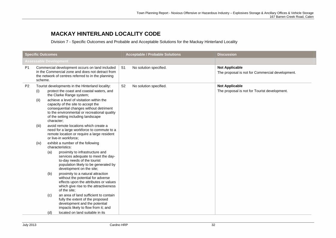
MACKAY HINTERLAND LOCALITY CODE
Division 7 - Specific Outcomes and Probable and Acceptable Solutions for the Mackay Hinterland Locality
Specific Outcomes Acceptable / Probable Solutions Discussion
Assessable Development
P1 Commercial development occurs on land included in the Commercial zone and does not detract from the network of centres referred to in the planning scheme.
S1 No solution specified. Not Applicable
The proposal is not for Commercial development.
P2 Tourist developments in the Hinterland locality:
(i) protect the coast and coastal waters, and the Clarke Range system;
(ii) achieve a level of visitation within the capacity of the site to accept the consequential changes without detriment to the environmental or recreational quality of the setting including landscape character;
(iii) avoid remote locations which create a need for a large workforce to commute to a remote location or require a large resident or live-in workforce;
(iv) exhibit a number of the following characteristics:
(a) proximity to infrastructure and services adequate to meet the day-to-day needs of the tourist population likely to be generated by development on the site;
(b) proximity to a natural attraction without the potential for adverse effects upon the attributes or values which give rise to the attractiveness of the site;
(c) an area of land sufficient to contain fully the extent of the proposed development and the potential impacts likely to flow from it; and
(d) located on land suitable in its
S2 No solution specified. Not Applicable
The proposal is not for Tourist development.

Town Planning Report - Noxious Offensive or Hazardous Industry – Explosives Storage & Ancillary Offices & Vehicle Storage 167 Barren Creek Road, Calen
July 2013 Cardno HRP 33
Specific Outcomes Acceptable / Probable Solutions Discussion
physical characteristics to accommodate the form, scale and intensity of development proposed without imposing unnecessary or unacceptable impacts upon the surrounding area, including:
(A) clearing of extensive areas of natural vegetation or marine plants .
P3 Land uses establishing adjacent to industrial areas and key extractive resources areas which are incompatible with those areas include a buffer which mitigates any adverse impacts from the industrial use on the new use.
S3 No solution specified. Not Applicable
The site does not adjoin an industrial area.
P4 Industrial Activities are located within the zoned industrial areas of the City.
S4 No solution specified. Does Not Comply
The development is for an industrial use in the rural locality. Refer to Section 6.5.1 for discussion.
P5 Rail infrastructure corridors are protected from the constraining effects of proximate, sensitive land uses by establishment of buffers, acoustic screens or other forms of physical separation. Where development occurs in close proximity to a rail corridor, mitigation measures in the design and siting of buildings and recreation space are provided.
S5 No solution specified. Not Applicable
The site does not adjoin a rail infrastructure corridor.
P6 The establishment of activities within the rail corridor
3, including rail freight yards, stations and
shunting yards, has regard for the environmental impacts upon adjacent and adjoining properties.
S6 No solution specified. Not Applicable
P7 The network of cane tramways is protected from the effects of incompatible development. New estate development for urban residential, rural residential or village purposes is planned to minimise the potential for tramway traffic to conflict with vehicular, bicycle or pedestrian traffic through a combination of careful design and
S7 No solution specified. Not Applicable
There is no cane tramway within the vicinity of the site.
3 Development within the rail corridor generally is not governed by the Planning Scheme, except for development undertaken by a private entity on non Crown land
Town Planning Report - Noxious Offensive or Hazardous Industry – Explosives Storage & Ancillary Offices & Vehicle Storage 167 Barren Creek Road, Calen
July 2013 Cardno HRP 34
Specific Outcomes Acceptable / Probable Solutions Discussion
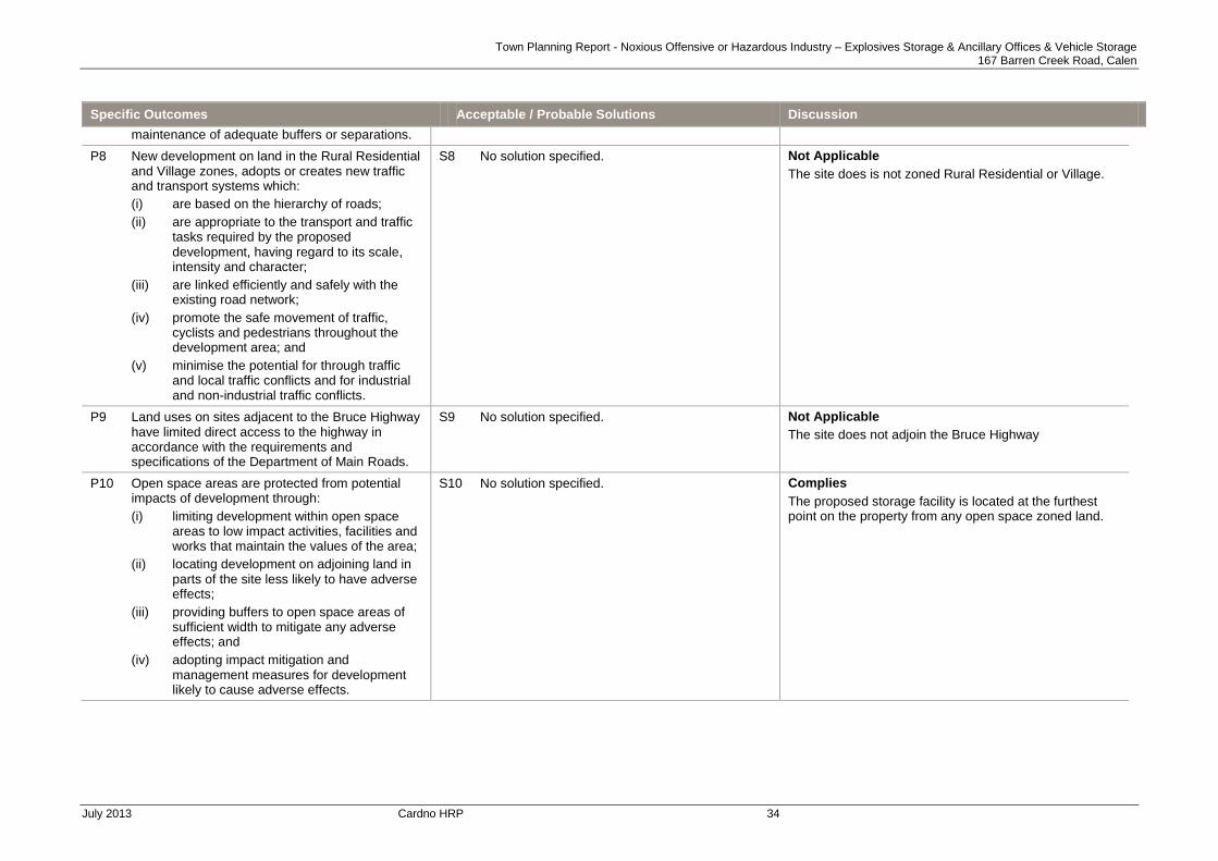
maintenance of adequate buffers or separations.
P8 New development on land in the Rural Residential and Village zones, adopts or creates new traffic and transport systems which:
(i) are based on the hierarchy of roads;
(ii) are appropriate to the transport and traffic tasks required by the proposed development, having regard to its scale, intensity and character;
(iii) are linked efficiently and safely with the existing road network;
(iv) promote the safe movement of traffic, cyclists and pedestrians throughout the development area; and
(v) minimise the potential for through traffic and local traffic conflicts and for industrial and non-industrial traffic conflicts.
S8 No solution specified. Not Applicable
The site does is not zoned Rural Residential or Village.
P9 Land uses on sites adjacent to the Bruce Highway have limited direct access to the highway in accordance with the requirements and specifications of the Department of Main Roads.
S9 No solution specified. Not Applicable
The site does not adjoin the Bruce Highway
P10 Open space areas are protected from potential impacts of development through:
(i) limiting development within open space areas to low impact activities, facilities and works that maintain the values of the area;
(ii) locating development on adjoining land in parts of the site less likely to have adverse effects;
(iii) providing buffers to open space areas of sufficient width to mitigate any adverse effects; and
(iv) adopting impact mitigation and management measures for development likely to cause adverse effects.
S10 No solution specified. Complies
The proposed storage facility is located at the furthest point on the property from any open space zoned land.
Town Planning Report - Noxious Offensive or Hazardous Industry – Explosives Storage & Ancillary Offices & Vehicle Storage 167 Barren Creek Road, Calen
July 2013 Cardno HRP 35
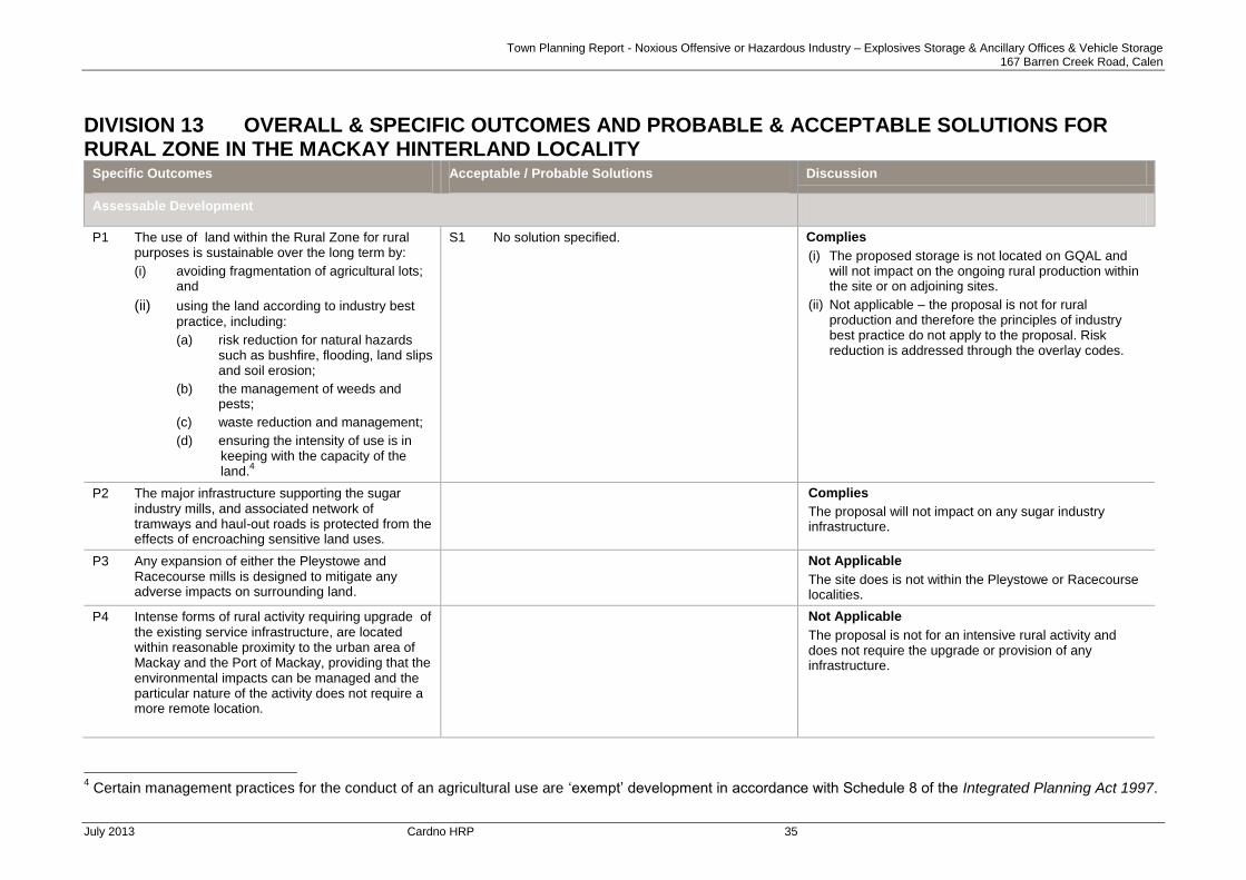
DIVISION 13 OVERALL & SPECIFIC OUTCOMES AND PROBABLE & ACCEPTABLE SOLUTIONS FOR RURAL ZONE IN THE MACKAY HINTERLAND LOCALITY
Specific Outcomes Acceptable / Probable Solutions Discussion
Assessable Development
P1 The use of land within the Rural Zone for rural purposes is sustainable over the long term by:
(i) avoiding fragmentation of agricultural lots; and
(ii) using the land according to industry best
practice, including:
(a) risk reduction for natural hazards such as bushfire, flooding, land slips and soil erosion;
(b) the management of weeds and pests;
(c) waste reduction and management;
(d) ensuring the intensity of use is in keeping with the capacity of the land.
4
S1 No solution specified. Complies
(i) The proposed storage is not located on GQAL and will not impact on the ongoing rural production within the site or on adjoining sites.
(ii) Not applicable – the proposal is not for rural production and therefore the principles of industry best practice do not apply to the proposal. Risk reduction is addressed through the overlay codes.
P2 The major infrastructure supporting the sugar industry mills, and associated network of tramways and haul-out roads is protected from the effects of encroaching sensitive land uses.
Complies
The proposal will not impact on any sugar industry infrastructure.
P3 Any expansion of either the Pleystowe and Racecourse mills is designed to mitigate any adverse impacts on surrounding land.
Not Applicable
The site does is not within the Pleystowe or Racecourse localities.
P4 Intense forms of rural activity requiring upgrade of the existing service infrastructure, are located within reasonable proximity to the urban area of Mackay and the Port of Mackay, providing that the environmental impacts can be managed and the particular nature of the activity does not require a more remote location.
Not Applicable
The proposal is not for an intensive rural activity and does not require the upgrade or provision of any infrastructure.
4 Certain management practices for the conduct of an agricultural use are ‘exempt’ development in accordance with Schedule 8 of the Integrated Planning Act 1997.

Town Planning Report - Noxious Offensive or Hazardous Industry – Explosives Storage & Ancillary Offices & Vehicle Storage 167 Barren Creek Road, Calen
July 2013 Cardno HRP 36
Specific Outcomes Acceptable / Probable Solutions Discussion
P5 Non-rural activities do not occur on land included in the Rural Zone.
Does Not Comply
The proposal is for an Industrial activity – refer to Section 6.5.1 for discussion.
P6 Rural residential development does not occur. Not Applicable
The proposal is not for Rural Residential development.
Town Planning Report - Noxious Offensive or Hazardous Industry – Explosives Storage & Ancillary Offices & Vehicle Storage 167 Barren Creek Road, Calen
July 2013 Cardno HRP 37
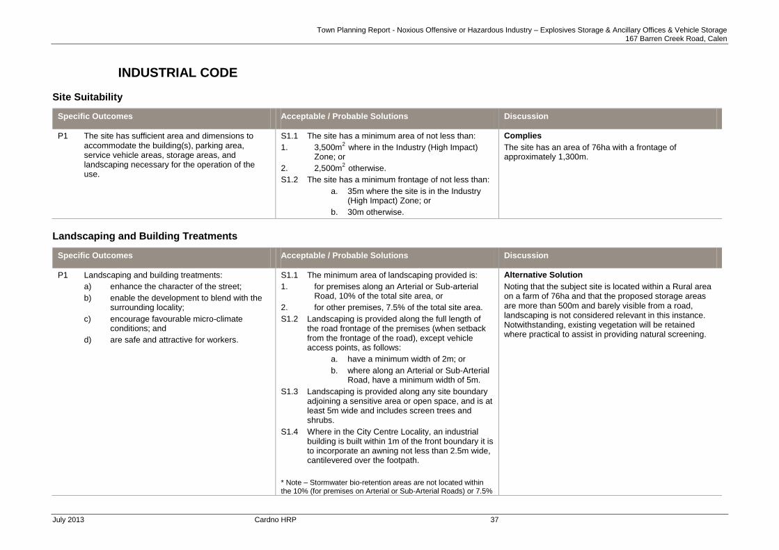
INDUSTRIAL CODE
Site Suitability
Specific Outcomes Acceptable / Probable Solutions Discussion
P1 The site has sufficient area and dimensions to accommodate the building(s), parking area, service vehicle areas, storage areas, and landscaping necessary for the operation of the use.
S1.1 The site has a minimum area of not less than:
1. 3,500m2
where in the Industry (High Impact) Zone; or
2. 2,500m2
otherwise.
S1.2 The site has a minimum frontage of not less than:
a. 35m where the site is in the Industry (High Impact) Zone; or
b. 30m otherwise.
Complies
The site has an area of 76ha with a frontage of approximately 1,300m.
Landscaping and Building Treatments
Specific Outcomes Acceptable / Probable Solutions Discussion
P1 Landscaping and building treatments:
a) enhance the character of the street;
b) enable the development to blend with the surrounding locality;
c) encourage favourable micro-climate conditions; and
d) are safe and attractive for workers.
S1.1 The minimum area of landscaping provided is:
1. for premises along an Arterial or Sub-arterial Road, 10% of the total site area, or
2. for other premises, 7.5% of the total site area.
S1.2 Landscaping is provided along the full length of the road frontage of the premises (when setback from the frontage of the road), except vehicle access points, as follows:
a. have a minimum width of 2m; or
b. where along an Arterial or Sub-Arterial Road, have a minimum width of 5m.
S1.3 Landscaping is provided along any site boundary adjoining a sensitive area or open space, and is at least 5m wide and includes screen trees and shrubs.
S1.4 Where in the City Centre Locality, an industrial building is built within 1m of the front boundary it is to incorporate an awning not less than 2.5m wide, cantilevered over the footpath.
* Note – Stormwater bio-retention areas are not located within the 10% (for premises on Arterial or Sub-Arterial Roads) or 7.5%
Alternative Solution
Noting that the subject site is located within a Rural area on a farm of 76ha and that the proposed storage areas are more than 500m and barely visible from a road, landscaping is not considered relevant in this instance. Notwithstanding, existing vegetation will be retained where practical to assist in providing natural screening.

Town Planning Report - Noxious Offensive or Hazardous Industry – Explosives Storage & Ancillary Offices & Vehicle Storage 167 Barren Creek Road, Calen
July 2013 Cardno HRP 38
Specific Outcomes Acceptable / Probable Solutions Discussion
(for other premises) total site area landscape provision or within the 5m (Arterial and Sub-Arterial Roads) or 2m (other roads) front landscape strip.
Building Setbacks
Specific Outcomes Acceptable / Probable Solutions Discussion
P1 The building is set back from the road frontage in a way that allows:
(i) efficient use of the site;
(ii) visitor car-parking to be provided at an easily visible location at or near the front of the premises;
(iii) the building to contribute to an attractive streetscape character; and
(iv) the location of utility services and drainage paths to be taken into account.
S1 The building is set back not less than:
(i) 10m from an Arterial or Sub-Arterial Road, or Major Collector Street;
(ii) 6m from any other road; or
(iii) where in the City Centre Locality, buildings may be built up to the frontage if a footpath awning of not less than 3m wide is provided for the full frontage of the site.
Complies
Barren Creek Road is an Access Street. Therefore the required setback of the demountable buildings is 6m. The existing demountable buildings are estimated to be approximately 6m from the Barren Creek Road reserve. The storage areas are not located within the vicinity of any roads.
P2 The building is sited in relation to side and rear boundaries in a way that:
(i) allows for efficient use of the site;
(ii) permits the location of utility services and drainage paths to be taken into account; and
(iii) existing or likely future use of adjoining land is not adversely affected.
S2 The building is set back:
(i) not less than 10m to any boundary adjoining land in the Open Space Zone; or
(ii) otherwise in accordance with the Building Act 1975.
Complies
The demountable buildings and storage areas do not restrict movement around the site.
Building Scale and Appearance
Specific Outcomes Acceptable / Probable Solutions Discussion
P1 The building has a height and bulk consistent with the streetscape.
S1 Buildings:
(i) have a height of not more than 6.5m where located on land included in the Industry (Low impact) Zone and not more than 15m where located on land included in the Industry (High impact) Zone;
(ii) occupy not more than 60% of the area of the site; and
Complies
The structures are all small scale buildings / containers within a rural locality.

Town Planning Report - Noxious Offensive or Hazardous Industry – Explosives Storage & Ancillary Offices & Vehicle Storage 167 Barren Creek Road, Calen
July 2013 Cardno HRP 39
Specific Outcomes Acceptable / Probable Solutions Discussion
(iii) have a gross floor area not greater than the area of the site.
P2 The front of the building is designed and sited to address the road frontage.
S2.1 The main entry to the building is easily identifiable from the street and directly accessible through the front of the building.
S2.2 The office space of each building is sited and oriented towards the road frontage.
Complies
The demountable buildings are directly accessible from the road frontage.
P3 The building is designed and finished to have a high quality, modern appearance.
S3 A building with materials, colours and architectural details of a high standard, and in accordance with the following:
(i) materials - brick, masonry, glass, steel; and
(ii) external walls – having a modern / high quality appearance with low reflectivity.
Not Applicable
The buildings are sheet metal finish typical of structures in a rural locality.
Town Planning Report - Noxious Offensive or Hazardous Industry – Explosives Storage & Ancillary Offices & Vehicle Storage 167 Barren Creek Road, Calen
July 2013 Cardno HRP 40
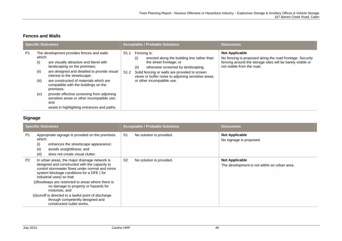
Fences and Walls
Specific Outcomes Acceptable / Probable Solutions Discussion
P1 The development provides fences and walls which:
(i) are visually attractive and blend with landscaping on the premises;
(ii) are designed and detailed to provide visual interest to the streetscape;
(iii) are constructed of materials which are compatible with the buildings on the premises;
(iv) provide effective screening from adjoining sensitive areas or other incompatible use; and
assist in highlighting entrances and paths.
S1.1 Fencing is:
(i) erected along the building line rather than the street frontage; or
(ii) otherwise screened by landscaping.
S1.2 Solid fencing or walls are provided to screen views or buffer noise to adjoining sensitive areas or other incompatible use.
Not Applicable
No fencing is proposed along the road frontage. Security fencing around the storage sites will be barely visible or not visible from the road.
Signage
Specific Outcomes Acceptable / Probable Solutions Discussion
P1 Appropriate signage is provided on the premises which:
(i) enhances the streetscape appearance;
(ii) avoids unsightliness; and
(iii) does not create visual clutter.
S1 No solution is provided.
Not Applicable
No signage is proposed.
P2 In urban areas, the major drainage network is designed and constructed with the capacity to control stormwater flows under normal and minor system blockage conditions for a DFE ( for industrial uses) so that:
(i)floodways are restricted to areas where there is no damage to property or hazards for motorists, and
(ii)runoff is directed to a lawful point of discharge through competently designed and constructed outlet works.
S2 No solution is provided. Not Applicable
The development is not within an urban area.

Town Planning Report - Noxious Offensive or Hazardous Industry – Explosives Storage & Ancillary Offices & Vehicle Storage 167 Barren Creek Road, Calen
July 2013 Cardno HRP 41
ENVIRONMENT AND INFRASTRUCTURE CODE
Infrastructure
Specific Outcomes Acceptable / Probable Solutions Discussion
Infrastructure Provision
P1 Adequate infrastructure is provided in time to meet the needs of the development.
S1 The timing for provision of infrastructure for development complies with the standards and contribution requirements detailed in the Engineering Design Guidelines Planning Scheme Policy .
Complies
Electricity and telecommunications are connected to the demountable structures. Barren creek Road is sealed for its full length up to the service vehicle access to the storage sites.
P2 Premises are provided with appropriate areas of private and public open space.
Note: Guidance in regards to the design and provision of
open space is provided in the Open Space Planning Scheme Policy and the Contributions Planning Scheme Policy.
S2 The provision of open space complies with the standards and requirements detailed in the Open Space Planning Scheme Policy and the Contributions Planning Scheme Policy.
Not applicable
There is no requirement for public / private open space.
P3 Premises have
(i) an adequate, safe and reliable supply of water, including potable water, and is connected, where possible, to an existing reticulated water supply.
(ii) the planning and design of potable water infrastructure considers Water Sensitive Urban Design (WSUD) such as water conservation initiatives.
S3.1 Premises are connected to Council’s reticulated water supply system.
S3.2 If connection to Council’s reticulated water supply system is not possible, a potable water supply is provided in accordance with the standards detailed in the Engineering Design guidelines Planning Scheme Policy).
Not Applicable
The development does not require a water supply.
P4 Treatment and disposal of waste water ensures:
1. no adverse ecological impacts on the environment, particularly nearby receiving environments including surface waters and ground water; and
2. the cumulative impacts of on-site waste water treatment will not cause deterioration of environmental conditions;
3. the planning and design of wastewater infrastructure considers Water Sensitive Urban
S4.1 Connection to Council’s reticulated sewerage treatment system; or
S4.2 Where connection to Council reticulated sewerage system is not possible, and where 20 people or less, Council will refer to the requirements of the Environmental Protection (Water) Policy 1997 and the On Site Sewerage Code (NR&M July 2002) and AS 1547. to ensure the premises are suitable for effluent disposal.
S4.3 Where more than 20 people, no solution specified.
Not Applicable
The development does not require liquid waste disposal.
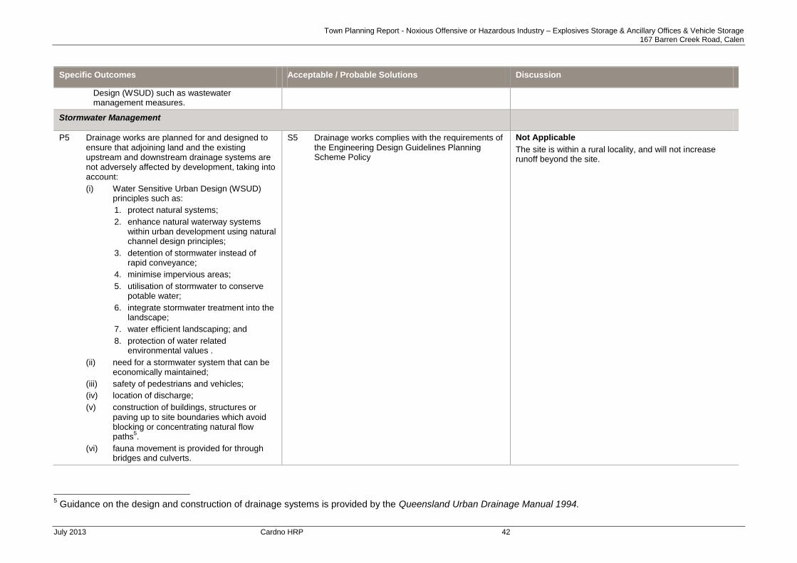
Town Planning Report - Noxious Offensive or Hazardous Industry – Explosives Storage & Ancillary Offices & Vehicle Storage 167 Barren Creek Road, Calen
July 2013 Cardno HRP 42
Specific Outcomes Acceptable / Probable Solutions Discussion
Design (WSUD) such as wastewater management measures.
Stormwater Management
P5 Drainage works are planned for and designed to ensure that adjoining land and the existing upstream and downstream drainage systems are not adversely affected by development, taking into account:
(i) Water Sensitive Urban Design (WSUD) principles such as:
1. protect natural systems;
2. enhance natural waterway systems within urban development using natural channel design principles;
3. detention of stormwater instead of rapid conveyance;
4. minimise impervious areas;
5. utilisation of stormwater to conserve potable water;
6. integrate stormwater treatment into the landscape;
7. water efficient landscaping; and
8. protection of water related environmental values .
(ii) need for a stormwater system that can be economically maintained;
(iii) safety of pedestrians and vehicles;
(iv) location of discharge;
(v) construction of buildings, structures or paving up to site boundaries which avoid blocking or concentrating natural flow paths
5.
(vi) fauna movement is provided for through bridges and culverts.
S5 Drainage works complies with the requirements of the Engineering Design Guidelines Planning Scheme Policy
Not Applicable
The site is within a rural locality, and will not increase runoff beyond the site.
5 Guidance on the design and construction of drainage systems is provided by the Queensland Urban Drainage Manual 1994.
Town Planning Report - Noxious Offensive or Hazardous Industry – Explosives Storage & Ancillary Offices & Vehicle Storage 167 Barren Creek Road, Calen
July 2013 Cardno HRP 43
Specific Outcomes Acceptable / Probable Solutions Discussion
External Works
P6 Kerb and channelling is provided to a satisfactory standard and constructed to:
(i) prevent edge fretting;
(ii) perform required drainage functions;
(iii) provide the appropriate level of control for vehicle movement;
(iv) allow ready access to abutting properties at suitable locations; and
(v) contribute to the desired streetscape character of the locality.
S6 Premises are provided with kerb and channel in accordance with the Engineering Design Guidelines Planning Scheme Policy.
Not Applicable
Barren Creek Road is constructed to a rural standard.
Roads
P7 All proposed road pavement surfaces:
(i) are of a quality and durability suitable to the intended traffic volumes and loads;
(ii) provide all-weather access;
(iii) allow the discharge of rainfall;
(iv) provide the safe passage of vehicles and pedestrians; and
(v) provide a reasonable, comfortable riding quality.
S7 Roads are provided in accordance with the Engineering Design Guidelines Planning Scheme Policy ‘.
Not Applicable
No new roads are proposed.
Drainage networks
P8 In urban areas, the major drainage network is designed and constructed with the capacity to control stormwater flows under normal and minor system blockage conditions for the DFE applicable to drainage so that:
floodways are restricted to areas where there is no damage to property or hazards for motorists, and
runoff is directed to a lawful point of discharge through competently designed and constructed outlet works.
S8 Design requirements of the Engineering Design Guidelines Planning Scheme Policy.
Not Applicable
The site is not within an urban area.

Town Planning Report - Noxious Offensive or Hazardous Industry – Explosives Storage & Ancillary Offices & Vehicle Storage 167 Barren Creek Road, Calen
July 2013 Cardno HRP 44
Specific Outcomes Acceptable / Probable Solutions Discussion
Public Utilities
P9 Street lighting and signs are provided to ensure the safety of both vehicles and pedestrians, and to facilitate access and movement.
6
S9 Street lighting and signage comply with the requirements of the Engineering Design Guidelines Planning Scheme Policy.
Not Applicable
Street lighting is generally not required in a rural area and is not proposed.
Infrastructure Payments
P10 The cost of providing infrastructure is funded by the development giving rise to the need for the infrastructure.
S10 The funding of infrastructure complies with the requirements of the Contributions Planning Scheme Policy.
Complies
Infrastructure charges will be applicable to this development. Refer to section 4.9 of the Town Planning Report for further discussion.
Car Parking and Access
P11 Premises are provided with:
(i) adequate vehicle parking spaces to satisfy the anticipated requirements of the activity;
(ii) safe and efficient access and manoeuvring areas to meet the anticipated volume and type of traffic;
(iii) large vehicles are able to enter and leave the site without prejudicing the safety and efficiency of the road;
(iv) access driveways are located and designed to minimise conflicts with traffic and pedestrians; and
(v) vehicle crossings from the carriageway to the frontage of the site are constructed and finished to appropriate standards for the expected volume and type of traffic generated by activities on the site.
S11.1 Vehicle parking on the site is in accordance with the rates specified in Schedule 2.
S11.2 Vehicles are able to enter and exit the site (with the exception of dwelling house and duplex) in a forward gear.
S11.3 The design of car parking and access complies with the requirements detailed in the Engineering Design Guidelines Planning Scheme Policy.
Complies
S11.1 – The applicable rate for car parking is 1 space per
200m2 GFA for all types of Industry on a site greater than
5,000m2. The equivalent number of spaces for the
development is two (2) per the assessable GFA of 303m
2. While formal parking has not been indicated on
the proposal plan, it is noted that there the development site is a farm and there is generally no restriction to available area for the parking of cars.
S11.2 – There is a large pan area adjacent to the
demountable buildings for the manoeuvring and parking of vehicles.
S11.3 – The unsealed surface is appropriate for the rural environment and no changes are proposed.
6 ‘Australian Standards and Manual for Uniform Traffic Control Devices’ provides guidance in relation to these matters.

Town Planning Report - Noxious Offensive or Hazardous Industry – Explosives Storage & Ancillary Offices & Vehicle Storage 167 Barren Creek Road, Calen
July 2013 Cardno HRP 45
Environmental Amenity
Specific Outcomes Acceptable / Probable Solutions Discussion
Lighting Management
P1 Outdoor lighting does not cause a loss of amenity to adjacent premises or adversely impact on native fauna as a result of the light it emits either directly or by reflection.
Note: Council will refer to the provisions of AS4282 – Control of the Obtrusive Effects of Outdoor Lighting
S1 No solution specified. Not Applicable
No outdoor lighting is proposed.
Overshadowing
P2 The amenity of adjacent residential land is not adversely affected by shadows cast by adjoining building or structures.
S2 Buildings do not cast a shadow over more than 30% of an adjoining residential lot at any time between the hours of 9am and 3pm on 22 June.
Not Applicable
There will be no impact to adjoining premises.
Building Setbacks
P3 Residential buildings are sited to minimise loss of amenity for residents’ adjacent to cane tram lines.
S3 Residential buildings are set back a minimum of:
(a) 50m from cane tram lines; and
(b) 100m from cane tram line level crossings and sidings.
Not Applicable
The proposal is not for residential development.
P4 Buildings are set back from a road frontage to:
(i) complement the existing built form; and
(ii) preserve the safety of vehicle movement along adjoining roads.
S4 No solution specified. Complies
Building setback to the street frontage is addressed via the Industrial Code. It is noted that a minimum setback of 6m is provided from the demountable buildings to Barren Creek Road.
Noise and Vibration Management
Specific Outcomes Acceptable / Probable Solutions Discussion
P1 Noise and vibration do not detract from the amenity of residents or employees of any adjacent premises.
S1 No solution specified.
Complies
There will be no noise or vibration associated with the use, except for the movement of vehicles.
P2 Premises accommodating uses which are likely to generate noise are designed and constructed with noise attenuation measures to avoid noise nuisance to nearby uses.
S2 No solution specified.
Not Applicable
The proposal is not for a noise generating use.

Town Planning Report - Noxious Offensive or Hazardous Industry – Explosives Storage & Ancillary Offices & Vehicle Storage 167 Barren Creek Road, Calen
July 2013 Cardno HRP 46
Specific Outcomes Acceptable / Probable Solutions Discussion
P3 Noise sensitive uses locating adjacent to State controlled transport infrastructure incorporate attenuation, building design and orientation measures.
Note: Development adjacent to State controlled roads
complies with the Department of Main Roads – Road Traffic Noise Management Code of Practice.
S3 No solution specified.
Not Applicable
The development is not for a noise sensitive use.
Air Quality
Specific Outcomes Acceptable / Probable Solutions Discussion
P1 Premises used for purposes likely to generate emissions such as air pollutants, heat and odours incorporate:
(i) physical measures for removing pollutants from emissions prior to discharge to the atmosphere;
(ii) physical measures for reducing the temperature gradient between emissions and the atmosphere prior to discharge; and
(iii) operational systems, including monitoring systems for major industry and major infrastructure, which maintain emissions within ANZECC guideline standards.
S1 No solution specified.
Not Applicable
The proposed use will not generate heat, odour or other air pollutants.

Town Planning Report - Noxious Offensive or Hazardous Industry – Explosives Storage & Ancillary Offices & Vehicle Storage 167 Barren Creek Road, Calen
July 2013 Cardno HRP 47
Flooding
Specific Outcomes Acceptable / Probable Solutions Discussion
Assessable Development
P1 Premises subject to risk of inundation or damage through flood are provided with immunity to that risk in order to reduce potential property damage and to ensure public safety.
S1.1 Development is sited on land that would not be subject to flooding during a DFE; or
S1.2 For development comprising a residential element, the floors of all habitable rooms are located 300mm above the DFE; or
S1.3 For non-residential development or development involving temporary or moveable residential structures (e.g. caravan parks):
(i) buildings are located and designed so that floor levels (except areas used for car parking) are 300mm above the DFE; or
(ii) there is at least one evacuation route that remains passable for emergency evacuations during all floods up to and including the DFE.
Not applicable
The site is not identified to be at risk of flooding either by Council mapping or as a result of the predicted long term effects of climate change.
Assessable Development
P2 There is no increase in the number of people living or working on a flood prone site, except where the premises are occupied on a short term or intermittent basis.
S2 No solution specified.
Not applicable
The site is not identified as flood prone.

Town Planning Report - Noxious Offensive or Hazardous Industry – Explosives Storage & Ancillary Offices & Vehicle Storage 167 Barren Creek Road, Calen
July 2013 Cardno HRP 48
Specific Outcomes Acceptable / Probable Solutions Discussion
P3 Development does not result in adverse impacts for the safety of people or the capacity to use land within a floodplain and does not involve:
(i) Any physical alteration to a watercourse; or
(ii) Net filling of 50 cubic metres; or
(iii) The proposed works either:
(A) avoid any reductions of on-site flood storage capacity and contain within the subject site any changes in depth/duration/velocity in flood waters of all floods up to and including the DFE; or
(B) do not change the flood characteristics at the DFE outside the subject site in ways that result in:
- loss of flood storage;
- loss of / changes to flow paths;
- acceleration or retardation of flows; or
- any reduction of flood warning times elsewhere on the floodplain.
S3 No solution specified.
Not Applicable
The storage area is elevated and is not within a floodplain or within proximity of a watercourse.
P4 Storage and handling of hazardous substances on sites that are subject to risk of inundation or damage through flood, ensures that persons and property are not placed at unreasonable risk.
S4 Storage or handling of substances that may be a hazard to the environment or human safety by the risk of contamination due to flooding:
(i) is undertaken in accordance with a risk assessment; and
(ii) provides for the storage of any hazardous substances above or securely isolated from the DFE level.
Complies
The premises is not mapped as subject to flood and inundation. Notwithstanding, it is noted that two creek / gully systems intersect the property. The proposed storage area is located on the highest part of the land, separated from both systems. Therefore, the storage area is not at risk from flooding and inundation and does not place people or property at risk.
P5 The use is designed to minimise the impact of Cyclonic Hazards
S5 No solution specified. Complies
All structures will be designed and constructed to the appropriate cyclonic standards.
Undefined Flood and Inundation Areas
P6 Where flood limits are not identified, development is undertaken such that there are no adverse effects on flood levels or flows on the site or up-stream and down-stream of the site
S6 No solution specified. Complies
The proposed storage site is not located in an area affected by flood levels.

Town Planning Report - Noxious Offensive or Hazardous Industry – Explosives Storage & Ancillary Offices & Vehicle Storage 167 Barren Creek Road, Calen
July 2013 Cardno HRP 49
Water Quality
Specific Outcomes Acceptable / Probable Solutions Proposal
P1 Development does not detract from the maintenance of water quality in the City’s watercourses and bulk water storages, in particular its:
(i) environmental values; and
(ii) where applicable, potability of the water supply.
S1 No solution specified. Complies
The development is classified as low risk stormwater management. All chemicals will be securely stored and will not impact on the surrounding environment.
P2 Premises incorporate:
1. physical measures for intercepting and treating surface water drainage and spilled substances prior to their release to the watercourses; and
2. bunding of sites or areas within sites or integrated drainage systems which include waste water treatment measures, where chemicals, fuels, lubricants or other soluble pollutants are being handled or stored.
Note: Council will refer to the Environmental Protection Policy (Water) 1997
S2 No solution specified. Complies
Storage sites will include diversion of overland stormwater flow around each compound.
Bunding is not required no soluble liquids will be kept within the storage sites. ANE is an emulsion and is not a soluble liquid.
P3 The City’s groundwater resources and surface waters are maintained by:
(i) providing a stormwater system that manages stormwater quantity and quality prior to discharging into receiving waters;
(ii) providing non-structural source control measures;
(iii) providing structural source control measures;
(iv) retaining or rehabilitating natural waterway corridors such as natural channels, wetlands and riparian vegetation;
(v) providing storage of waste water in secure and sealed storage facilities;
(vi) ensuring efficient disposal areas and ground and surface water retrieval areas are buffered from each other;
(vii) ensuring that contaminants do not enter the groundwater resources; and
S3 No solution specified.
Complies
Surface water will be protected by diversion of overland flow around the storage sites. No impact to ground waters will occur.

Town Planning Report - Noxious Offensive or Hazardous Industry – Explosives Storage & Ancillary Offices & Vehicle Storage 167 Barren Creek Road, Calen
July 2013 Cardno HRP 50
Specific Outcomes Acceptable / Probable Solutions Proposal
(viii) with reuse of reclaimed water, ensuring safe treatment and disposal of contaminated water.
P4 The biodiversity and habitat values of coastal areas and associated estuarine systems are protected from:
(i) increased nutrient or sediment levels; or
(ii) changed flow, inhibited passage, or hydrologic regimes of the natural coastal and marine margins,
which may result from development.7
S4 No solution specified.
Not Applicable
The site is not in a coastal area.
P5 Sediment and nutrient loadings into a watercourse are minimised through:
(i) treated on-site effluent;
(ii) adequate stormwater run-off controls; and
(iii) on-site and off-site erosion and sediment controls.
S5 No solution specified.
Not Applicable
The development will not impact on any watercourse.
Erosion and Sediment Control
Specific Outcomes Acceptable / Probable Solutions Proposal
P1 Minimisation of the risk of erosion and sedimentation either on-site or elsewhere, by a comprehensive approach to soil erosion control and sedimentation management, including:
(i) the minimisation of:
(ii) earthworks;
(i) clearing of land;
(ii) long term stockpiling of excavated materials;
a. use of appropriate construction management techniques;
b. diverting surface water drainage around disturbed areas; and
c. treating and removing sediments from
S1 The control of Erosion and Sedimentation complies with Planning Scheme Policy 15.07 - Engineering Design Guideline D7 Soil and Water Quality Management.
Complies
Erosion impacts will be minimal due to the limited areas of disturbance, however will be managed through implementation of the following:
Minimal disturbance of existing vegetation around the storage areas.
Diversion of overland flow around the storage areas.
Stabilisation and revegetation of disturbed areas following construction.
7 See ANZECC Australian and New Zealand Guidelines for Fresh and Marine Water Quality, 2000.

Town Planning Report - Noxious Offensive or Hazardous Industry – Explosives Storage & Ancillary Offices & Vehicle Storage 167 Barren Creek Road, Calen
July 2013 Cardno HRP 51
Specific Outcomes Acceptable / Probable Solutions Proposal
stormwater over disturbed areas prior to release from the site.
P2 Progressive rehabilitation of disturbed areas occurs within the site through a comprehensive rehabilitation program including:
a. the grading and reshaping of the disturbed areas to provide controlled and stable drainage flow paths;
b. the construction of drainage paths which divert high velocity flows away from disturbed areas;
c. the re-spreading of stored top soil stripped from the site; and
d. the planting of the disturbed area with native species of grasses, ground covers and trees.
S2 No solution specified.
Complies
Refer to comments above.
Coastal Management
Not applicable – The subject site is not located in a Coastal Management Area
High Impact Activity Areas8
Not Applicable – The subject site does not adjoin a High Impact Activity Area.
Landscaping and Fencing
Specific Outcomes Acceptable / Probable Solutions Proposal
P1 Development is provided with adequate and suitable landscaping and screening on the site which ensures:
(i) an attractive streetscape appearance; and
(ii) the privacy and amenity of any adjoining residences.
S1 Landscaping is provided in accordance with the Landscaping Planning Scheme Policy
Complies
Existing vegetation will be maintained where possible to maintain natural screening between the storage areas and Barren Creek Road. It is noted that the storage areas are more than 500m from the road.
P2 Landscaping is designed to prevent encroachment upon electricity infrastructure.
S2.1 Landscaping near electricity lines or substations, are designed and developed so that any
Not Applicable
There is no electricity infrastructure in the vicinity of the
8 Refer to High Impact Activities Information Map
Town Planning Report - Noxious Offensive or Hazardous Industry – Explosives Storage & Ancillary Offices & Vehicle Storage 167 Barren Creek Road, Calen
July 2013 Cardno HRP 52
Specific Outcomes Acceptable / Probable Solutions Proposal
vegetation at maturity or landscaping structures or works will not exceed 4.0m in height on land:
(i) in an electric line shadow9; or
(ii) within 5m of an electric line shadow; or
(iii) within 5m of a substation boundary.
S2.2 Elsewhere, vegetation is planted in a position that is further from the nearest edge of an electric line shadow or substation boundary than the expected maximum height at maturity of vegetation.
S2.3 On land adjoining an electricity substation boundary, the vegetation foliage at maturity will not be within 3m of the substation boundary. However, where a substation has a solid wall along any part of its boundary, foliage may extend to, but not above or beyond, that solid wall.
storage areas.
P3 Landscaping provides a 2m wide landscaped strip adjacent to the road frontage incorporating existing vegetation wherever possible.
S3 No solution specified.
Not Applicable
Cane cultivation adjoins the road frontage.
P4 A landscape strip is provided comprising either a 1.8m high solid fence or 2m wide planted screen adjacent to all side and rear boundaries of a site which adjoins any residential area.
S4 No solution specified.
Not applicable
The site does not adjoin any residential area.
P5 Landscaping around buildings is designed to maximise shade and redirect cooling breezes in summer and to provide a windbreak in winter.
S5 No solution specified.
Not Applicable
No landscaping is proposed.
P6 Landscaping incorporates planting for shading summer sun, including:
a. tall shade trees to the west and east of the building; and
b. trellises or pergolas adjacent to windows to the north of the building.
S6 No solution specified.
Not Applicable
Refer to P5 response.
P7 Landscaping is designed to maximise the outdoor shade areas and minimise use of hard reflective surfaces around the building.
S7 No solution specified.
.
Not Applicable
Refer to P5 response.
9 Electric Line Shadow is defined in Schedule 1

Town Planning Report - Noxious Offensive or Hazardous Industry – Explosives Storage & Ancillary Offices & Vehicle Storage 167 Barren Creek Road, Calen
July 2013 Cardno HRP 53
Landscaping for Outdoor Vehicle Parking Areas
P8 Landscaping for outdoor vehicle parking areas, where development is for the purposes of Accommodation units, multiple dwelling units, Sport and recreation, indoor entertainment, outdoor entertainment, child care centre, service station, motel, Industrial uses and retail or commercial uses, will:
(i) visually enhance the area along any road frontage;
(ii) screen the area from any adjoining residential or other sensitive uses;
(iii) provide visual relief and shade throughout the area; and
(iv) be compatible with local native species.
S8.1 Landscaping of outdoor vehicle parking areas provides planting of trees and shrubs:
(i) in a strip 2m wide along any primary road frontage at a density and a scale appropriate to the size of the vehicle parking area and the function of the adjoining road; and
(ii) in median areas throughout the vehicle parking area at a rate of 1 shade tree for every 6 parking spaces.
S8.2 Provide a wall, fence or continuous screen planting, to a height of at least 1.8m along any boundary to land used or likely to be used for residential or other sensitive use.
Not Applicable
No formal parking areas are proposed.

Town Planning Report - Noxious Offensive or Hazardous Industry – Explosives Storage & Ancillary Offices & Vehicle Storage 167 Barren Creek Road, Calen
July 2013 Cardno HRP 54
Landscaping - General Requirements
P9 Landscaping is designed and established to:
(i) an appropriate scale relative to both the street reserve width and to the size and nature of the development;
(ii) incorporate remnant vegetation, where possible;
(iii) provide summer shade and shelter for pedestrian comfort and energy efficiency of buildings;
(iv) maximise areas suitable for on-site infiltration of stormwater;
(v) allow for pedestrian and vehicle safety;
(vi) generate a cohesive and distinct visual character for the streetscape and locality;
(vii) be suitable to the tropical climate;
(viii) provides planting, paving and other landscape treatment according to a Landscaping Plan; and
(ix) minimise irrigation requirements through appropriate plant selection, mulching and water efficient irrigation systems.
Note: The Landscape Planning Scheme Policy should
be referred to for information that may be required by Council to assist in assessment of an application.
S9 No solution specified.
Not Applicable
Refer to P5 response.
Vegetation Management
P10 Natural vegetation is maintained wherever possible.
Note: Assessable development being operational work
that is clearing of native vegetation of freehold land consistent with Schedule 8, Part 1, 3A of IPA will be assessed under the provisions of the Vegetation Management Act 1999 and the State code for clearing of vegetation on freehold land.
S10 No solution specified. Complies
Refer to P1 response.

Town Planning Report - Noxious Offensive or Hazardous Industry – Explosives Storage & Ancillary Offices & Vehicle Storage 167 Barren Creek Road, Calen
July 2013 Cardno HRP 55
Community Safety Design Principles
Not Applicable – The development is located in a rural environment and only involves secured storage areas and small site offices for incidental record keeping etc purposes.
Therefore the development does not impact on the principles of community safety and this section has not been further addressed.
Constructed Lakes
Not Applicable – No constructed lakes are proposed.
BUSHFIRE MANAGEMENT OVERLAY CODE
Infrastructure
Specific Outcomes Acceptable / Probable Solutions Discussion
P1 Development maintains the safety of people and property by:
(i) avoiding the areas of High or Medium bushfire hazard as indicated on the Bushfire Management Overlay Map; or
(ii) mitigating the risk through:
allotment design and the appropriate siting of building; and
including firebreaks that provide adequate setback between buildings / structures and hazardous vegetation and access for fire fighting and other emergency vehicles; and
providing adequate road access for fire fighting and other emergency vehicles and safe evacuations; and
providing an adequate and accessible water supply for firefighting purposes.
S1.1 Development is located on land that is not subject to High or Medium bushfire hazard as indicated on the Bushfire Management Overlay Map; or
S1.2 For all development:
(1) buildings and structures on lots greater than 2,500m²;
achieve setbacks from vegetation of 1.5 times the predominant mature canopy tree height or 10 m, whichever is greater; or
10 m from any retained vegetation strips or small areas of vegetation;
(2) buildings and structures on lots 2,500m² or less are serviced by the following:
a reticulated water supply that has sufficient flow and pressure characteristics for fire fighting purposes at all times (minimum pressure flow of 10 litres a second at 200 KPA); or
Complies
It is noted that the proposed storage areas are located within areas identified as medium risk bushfire hazard. An inspection of the site and review of RE mapping (Appendix G) indicates the area contains bushland that
is not subject to assessment for clearing under the Vegetation Protection Act.
The probable solutions in S1.2 and S1.3 will be met through implementation of the following:
clearing of trees immediately surrounding the storage compounds as required for batter slope works associated with providing the level storage areas.
Maintenance of the storage areas free of combustible material.
Location of the tanks / containers within the compounds so as to maintain a minimum separation distance greater than 10m form any potential fire source.
The farm access provides an immediate

Town Planning Report - Noxious Offensive or Hazardous Industry – Explosives Storage & Ancillary Offices & Vehicle Storage 167 Barren Creek Road, Calen
July 2013 Cardno HRP 56
Specific Outcomes Acceptable / Probable Solutions Discussion
Note: To assist Council in assessing an application for
Assessable Development in a bushfire hazard area information should be provided as detailed in the Bushfire Management Planning Scheme Policy.
an o- site storage of not less than 5,000 litres (e.g. accessible dam or tank with fire brigade fittings, or swimming pool).
S1.3 Firebreaks are provided by:
(a) a perimeter road that separates lots from areas of bushfire hazard and that road has:
a. a minimum cleared width of 20m; and
b. a constructed road width and all weather standard in accordance with Engineering Standards Planning Scheme Policy or
(b) fire maintenance trails which:
have a minimum cleared width of 6m;
have vehicular access at each end;
provide passing bays and turning areas for firefighting appliances;
are either located on public land, or within an access easement that is granted in favour of Council and QFRS; and
cleared breaks of 6m minimum width are provided within retained bushland within the site (e.g. creek corridors and other retained vegetation) to allow burning of sections and access for bushfire response.
evacuation route away from the vegetated area, and access for fire fighting purposes.
As no habitable buildings are proposed, no water supply for fire fighting purposes is required. However, fire fighting equipment will be maintained at each storage site as required under the licence requirements of the dangerous goods storage codes (refer Figure 5).
P2 For development that will result in multiple buildings or lots (being Community Title Lots):
(1) buildings and structures are sited on lots that are designed so that their size and shape allow for:
(a) efficient emergency access to buildings for firefighting appliances (e.g. by avoiding long narrow lots with long access drive to buildings);
(b) setbacks and buildings siting in accordance with 1.2 above.
S2 No solution specified. Not Applicable
Town Planning Report - Noxious Offensive or Hazardous Industry – Explosives Storage & Ancillary Offices & Vehicle Storage 167 Barren Creek Road, Calen
July 2013 Cardno HRP 57
Specific Outcomes Acceptable / Probable Solutions Discussion
P3 Roads have:
(1) a maximum gradient of 12.5%;
(2) exclude cul de sacs, except where a perimeter road isolates the development from hazardous vegetation or the cul de sac is provided with an alternative access linking the cul de sac to other through roads.
S3 No solution specified. Not Applicable
No new roads are proposed.
Hazardous Materials
P4 Public safety and the environment are not adversely affected by the detrimental impacts of bushfire on hazardous materials manufactured or stored in bulk.
S4 No solution specified. Complies
Refer to P1 response.
Town Planning Report - Noxious Offensive or Hazardous Industry – Explosives Storage & Ancillary Offices & Vehicle Storage 167 Barren Creek Road, Calen
July 2013 Cardno HRP 58
167 Barren Creek Road, Calen
APPENDIX
B PROPOSAL PLANS

Lot 2 RP722444
Lot 2 RP722444
Lot 7 RP899761
Lot 25 C13100
Lot 25 C13100
Lot 28 C1581
250m
INSET 1 - OFFICE & RECORDS
DWELLING
DWELLING
DWELLING
DWELLING Sealed road Unsealed road Access track Natural watercourse
N
550m
SITE PLAN (Source: MRC MiMaps 2013)
B F G
M C
D E
Sealed road Unsealed road Access track Natural watercourse
167 BARREN CREEK ROAD, CALENLOT 26 CI581
AMENDED >
FILENAME >
JOB NO. >
SCALE >
SOURCE >
POD
HRP12256
1:8,500
DATE >
VERSION >
JUNE 2013
N/A
1.0
APPENDIX BBBBB
MRC MiMaps 2013
Plan of DevelopmentSUBJECT SITE
LEGEND
170 255 340metres0 85
1:8,500N
APP
ENDI
XBBBBB

OFFICE & RECORDS
DWELLING
25 37.5 50metres0 12.5
1:1,250N
167 BARREN CREEK ROAD, CALENLOT 26 CI581
AMENDED >
FILENAME >
JOB NO. >
SCALE >
SOURCE >
INSET 1
HRP12256
1:1,250
DATE >
VERSION >
JUNE 2013
N/A
1.0
APPENDIX BBBBB
MRC MiMaps 2013
Inset 1:Office and Records
SUBJECT SITE
LEGEND
APP
ENDI
XBBBBB

G F B
M C
E D
167 BARREN CREEK ROAD, CALENLOT 26 CI581
AMENDED >
FILENAME >
JOB NO. >
SCALE >
SOURCE >
INSET 2
HRP12256
DATE >
VERSION >
JUNE 2013
N/A
1.0
APPENDIX BBBBB
MRC Draft Mackay Region Planning Scheme online mapping 2013
Inset 2:Explosives Storage
APP
ENDI
XBBBBB
Access Road B 10 tonne storage C Truck Storage + 15 tonne storage D 120m2 shed & 20 tonne storage E 15 tonne storage F 10 tonne storage G 10 tonne storage M Magazine & detonator storage
N
100m

ISO Tanks (30t capacity ea.) Container Storage (6.1m x 2.44m x 2.59m)
Office & Records (6m x 3m x 2.6m ea.)
Explosives Storage (6.1m x 2.44m x 2.6m) Detonator Storage (6m x 2m x 2.6m)
Offices and Storage (Source: Cardno HRP & Caruana photos 2013)
167 BARREN CREEK ROAD, CALENLOT 26 CI581
AMENDED >
FILENAME >
JOB NO. >
SCALE >
SOURCE >
OFFICES & STORAGE
HRP12256
DATE >
VERSION >
JUNE 2013
N/A
1.0
APPENDIX BBBBB
Cardno HRP & Caruana photos 2013
Offices and Storage
APP
ENDI
XBBBBB

167 BARREN CREEK ROAD, CALENLOT 26 CI581
AMENDED >
FILENAME >
JOB NO. >
SCALE >
SOURCE >
OPEN SHED
HRP12256
DATE >
VERSION >
JUNE 2013
N/A
1.0
APPENDIX BBBBB
Wide Span Sheds Building Layout Ref #GM11120141 21/09/12
Open Shed andTruck Storage
APP
ENDI
XBBBBB
Town Planning Report - Noxious Offensive or Hazardous Industry – Explosives Storage & Ancillary Offices & Vehicle Storage 167 Barren Creek Road, Calen
July 2013 Cardno HRP 59
167 Barren Creek Road, Calen
APPENDIX
C OWNER’S CONSENT


Town Planning Report - Noxious Offensive or Hazardous Industry – Explosives Storage & Ancillary Offices & Vehicle Storage 167 Barren Creek Road, Calen
July 2013 Cardno HRP 60
167 Barren Creek Road, Calen
APPENDIX
D CURRENT TITLE SEACH
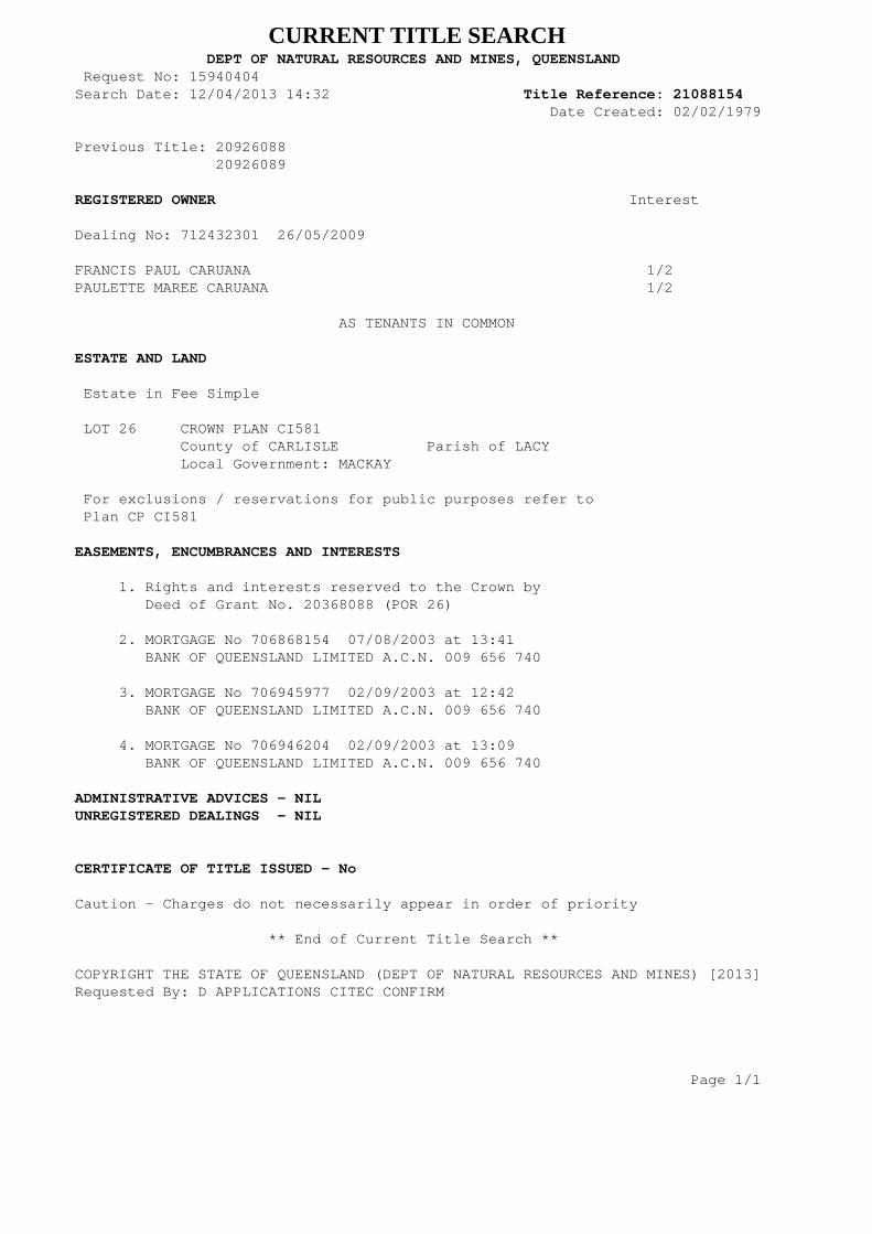
CURRENT TITLE SEARCH DEPT OF NATURAL RESOURCES AND MINES, QUEENSLAND Request No: 15940404Search Date: 12/04/2013 14:32 Title Reference: 21088154 Date Created: 02/02/1979 Previous Title: 20926088 20926089 REGISTERED OWNER Interest Dealing No: 712432301 26/05/2009
FRANCIS PAUL CARUANA 1/2PAULETTE MAREE CARUANA 1/2 AS TENANTS IN COMMON ESTATE AND LAND Estate in Fee Simple LOT 26 CROWN PLAN CI581 County of CARLISLE Parish of LACY Local Government: MACKAY For exclusions / reservations for public purposes refer to Plan CP CI581 EASEMENTS, ENCUMBRANCES AND INTERESTS 1. Rights and interests reserved to the Crown by Deed of Grant No. 20368088 (POR 26) 2. MORTGAGE No 706868154 07/08/2003 at 13:41 BANK OF QUEENSLAND LIMITED A.C.N. 009 656 740 3. MORTGAGE No 706945977 02/09/2003 at 12:42 BANK OF QUEENSLAND LIMITED A.C.N. 009 656 740 4. MORTGAGE No 706946204 02/09/2003 at 13:09 BANK OF QUEENSLAND LIMITED A.C.N. 009 656 740 ADMINISTRATIVE ADVICES - NILUNREGISTERED DEALINGS - NIL CERTIFICATE OF TITLE ISSUED - No
Caution - Charges do not necessarily appear in order of priority
** End of Current Title Search **
COPYRIGHT THE STATE OF QUEENSLAND (DEPT OF NATURAL RESOURCES AND MINES) [2013]Requested By: D APPLICATIONS CITEC CONFIRM Page 1/1

Town Planning Report - Noxious Offensive or Hazardous Industry – Explosives Storage & Ancillary Offices & Vehicle Storage 167 Barren Creek Road, Calen
July 2013 Cardno HRP 61
167 Barren Creek Road, Calen
APPENDIX
E REGISTERED SURVEY PLAN AND SMART MAP


83CI577
FH
80.76ha
82CI577
FH
81.089ha
201CI2230
LL
206.39ha
84CI577
FH
80.937ha
2RP722444
FH
90.303ha1
RP
722444
33CI581
FH
128.581ha
434FTY1485
SF
192ha65
CI2559
LL
127.974ha
7RP899761
FH
155.264ha
2
RP722444
FH
90.303ha
26CI581
FH
76.367ha
25CI3100
FH
93.318ha 100
CI
2264
62CI711
FH
68.544ha
7
RP899761
FH
155.264ha
25
CI3100
FH
93.318ha
100
CI2264
99
CP858236
LL
8.16ha
8
RP899761
FH
1.692ha
59SP220916
FH
70.3741ha
59
SP
220916
2SP230934
FH
209.3892ha
6RP742143
FH
65.553ha
74CI2868
LL
83.327ha
75
CI577
LL
80.937ha
31NPW947
NP
59800ha
94
CI927
SL
34.378ha
29CI581
FH
64.603ha
28CI581
FH
62.979ha
26CI581
FH
76.367ha
25CI3100
FH
93.318ha
7
USL
33722
20CI2692
FH
60.703ha
658FTY1807
SF
11320ha
RO
AD
ON
RLT
AC
HM
OU
NT
ALE
NC
RO
AD
CR
EE
KB
AR
RE
N
TOO
NS
RO
AD
TOO
NS
RO
AD
ROADPOCKET
BARRON
ROADPOCKETBARRON
RO
AD
LTO
N
ARCH
MOUNT
CALEN
TOO
NSR
OA
D
ROAD
LMINE
OAC
RD
ONS
CAMER
EK
RE
CS
NE
LH
ET
S
DCDB
Lot/Plan 26/CI581
Area/Volume 76.367ha
Tenure FREEHOLD
Local Government MACKAY REGIONAL
Locality CALEN
Parish LACY
County CARLISLE
Segment/Parcel 33719/6
SUBJECT PARCEL DESCRIPTION
SCALE 1 : 15000HORIZONTAL DATUM:GDA94 ZONE:55
m
300 600 900 1200 15000
8656-32124
STANDARD MAP NUMBER
148°43'14".806
20°54'37".012
CALEN
5.71 KM
MAP WINDOW POSITION &NEAREST LOCATION
PRINTED (dd/mm/yyyy) 17/04/2013
DCDB 16/04/2013 (Lots with an area less than 1500m² are not shown)
Users of the information recorded in this document (the Information) accept all responsibility andrisk associated with the use of the Information and should seek independent professional advice inrelation to dealings with property.
Despite Department of Natural Resources and Mines(DNRM)'s best efforts, DNRM makesno representations or warranties in relation to the Information, and, to the extent permitted by law,exclude or limit all warranties relating to correctness, accuracy, reliability, completeness orcurrency and all liability for any direct, indirect and consequential costs, losses, damages andexpenses incurred in any way (including but not limited to that arising from negligence) inconnection with any use of or reliance on the Information
For further information on SmartMap products visit http://nrw.qld.gov.au/property/mapping/blinmap
CLIENT SERVICE STANDARDS
SmartMapAn External Product of
SmartMap Information Services
Based upon an extraction from the
Digital Cadastral Data Base
(c) The State of Queensland,(Department of NaturalResources and Mines) 2013.
6 78 000m E
78
79
79
6 80
6 80
1
76 85 000 m N85
2
8686
3
8787
4
8888
5
8989
GDA
Queensland Government
20°55'49".289
148°42'15".608 148°44'14".004
20°55'49".289
20°55'00"
20°53'24".736
148°44'14".004
20°53'24".736
148°42'15".608
20°55'00"

Town Planning Report - Noxious Offensive or Hazardous Industry – Explosives Storage & Ancillary Offices & Vehicle Storage 167 Barren Creek Road, Calen
July 2013 Cardno HRP 62
167 Barren Creek Road, Calen
APPENDIX
F SEARCHES: CLR AND EMR
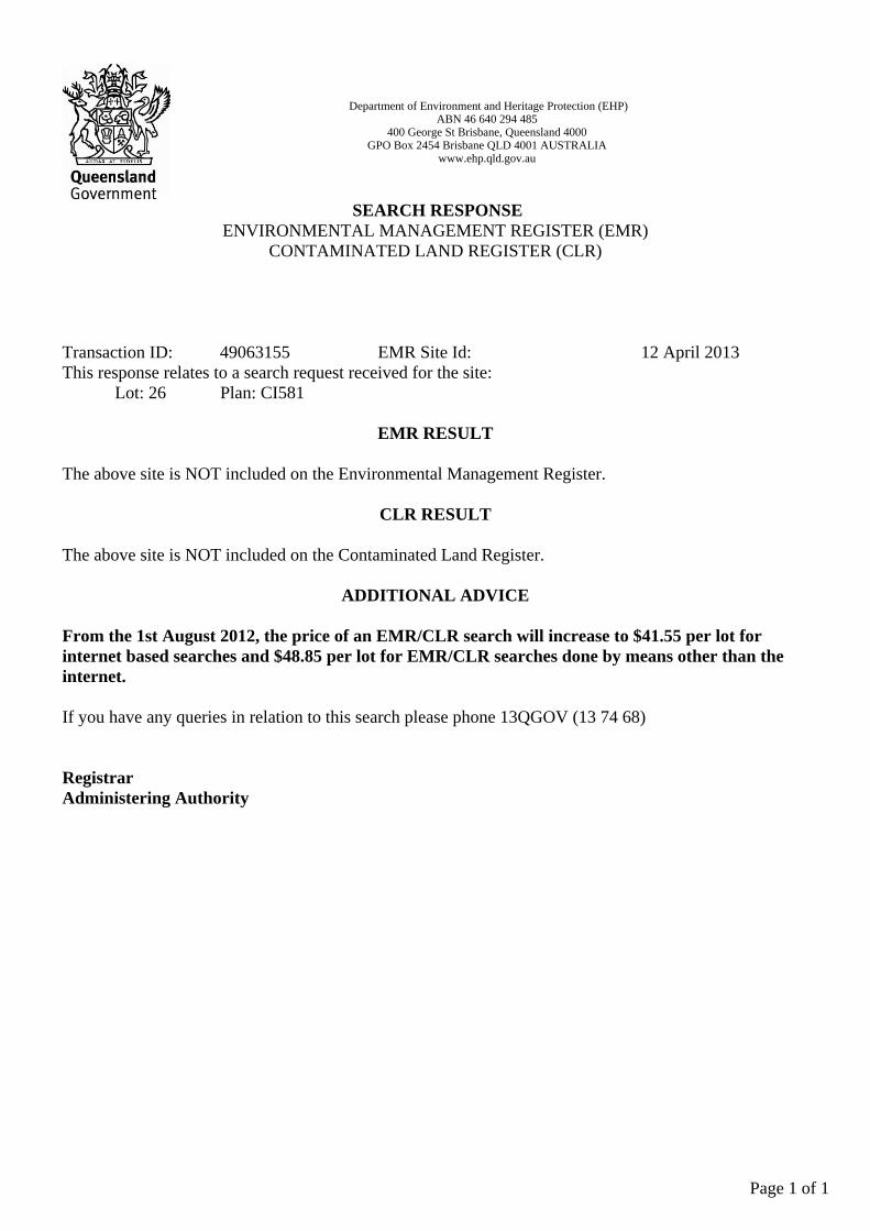
Department of Environment and Heritage Protection (EHP)ABN 46 640 294 485
400 George St Brisbane, Queensland 4000GPO Box 2454 Brisbane QLD 4001 AUSTRALIA
www.ehp.qld.gov.au
SEARCH RESPONSEENVIRONMENTAL MANAGEMENT REGISTER (EMR)
CONTAMINATED LAND REGISTER (CLR)
Transaction ID: 49063155 EMR Site Id: 12 April 2013This response relates to a search request received for the site:
Lot: 26 Plan: CI581
EMR RESULT
The above site is NOT included on the Environmental Management Register.
CLR RESULT
The above site is NOT included on the Contaminated Land Register.
ADDITIONAL ADVICE
From the 1st August 2012, the price of an EMR/CLR search will increase to $41.55 per lot forinternet based searches and $48.85 per lot for EMR/CLR searches done by means other than theinternet.
If you have any queries in relation to this search please phone 13QGOV (13 74 68)
RegistrarAdministering Authority
Page 1 of 1

Town Planning Report - Noxious Offensive or Hazardous Industry – Explosives Storage & Ancillary Offices & Vehicle Storage 167 Barren Creek Road, Calen
July 2013 Cardno HRP 63
167 Barren Creek Road, Calen
APPENDIX
G VEGETATION, SCL AND WETLAND SEARCHES