Town of Raymond New Hampshire - Welcome | NH ... · Web viewTown of Raymond, New Hampshire Open...
138
TOWN OF RAYMOND, NEW HAMPSHIRE Open Space Plan
Transcript of Town of Raymond New Hampshire - Welcome | NH ... · Web viewTown of Raymond, New Hampshire Open...

TOWN OF RAYMOND, NEW HAMPSHIRE
Open Space Plan

Raymond Open Space Plan January 2003
Town of Raymond, New Hampshire
Open Space Plan
Prepared by the Southern New Hampshire Planning Commission
January 2003
Adopted May 15, 2003
This project was funded in part by a grant from the New Hampshire Department of Environmental Services under the Regional Environmental Planning Program.

Acknowledgements
The Board of Selectmen of the Town of Raymond wishes to thank the following individuals for volunteering their time and energy to complete the Raymond Open Space Plan:
Raymond Open Space Plan Committee
Jan Kent, Conservation Commission
Jonathan Wood, Board of Selectmen, Conservation Commission, Planning Board, Historic District Commission
Cheryl Killam, Conservation Commission
Jim Kent, Planning Board
Gretchen Gott, Planning Board, Zoning Board
Chuck Grassie, Town Planner
Raymond Planning Board
Raymond Conservation Commission
Raymond Historic District Commission
Raymond Zoning Board of Adjustment
Raymond Capital Improvements Committee
Residents of Raymond
The public should make no assumptions, based solely on this plan, that lands described or shown are open to public use without the explicit permission of the landowner. It is the intention of the Conservation
Page i

Commission that acquisition of land for the purposes of implementing this plan be made only from willing sellers or those willing to negotiate a conservation easement.
Cover photos courtesy Valerie Picco and the Town of Raymond
Page ii

Raymond Open Space PlanTable of Contents
PageAcknowledgements........................................................................................................iiTable of Contents..........................................................................................................iiiExecutive Summary......................................................................................................viGoals and Key Actions.................................................................................................xi
Section 1: Introduction Raymond’s Regional Setting......................................................................................2 A Brief History of Raymond.......................................................................................2 Funding for Open Space Acquisition and Protection.................................................3 Open Space Protection: Regulation vs. Voluntary Options........................................4 Tax Benefits From Donating Conservation Easements..............................................4 Questions on Easement Tax Benefits.........................................................................5 Open Space Ranking System......................................................................................7
Section 2: Existing Plans and Programs Existing Plans and Maps Related to Open Space in Raymond...................................8 Regional Environmental Planning Program Natural and Cultural Resources Inventory.......8 Maps, Build-Out Analysis, and Raymond Conservation Commission Annual Reports.......9 Raymond Forest Stewardship Plan...........................................................................10 Forest Legacy Program.............................................................................................11 Open Woodlands.......................................................................................................11 Raymond Water Resource Management and Protection Plan..................................12 Lakes and Ponds in Raymond...................................................................................12 FEMA Flood Insurance Study..................................................................................12 Town of Raymond Master Plan................................................................................12 Changes in Land Use, 1953-1982.............................................................................13 Raymond Zoning Ordinance.....................................................................................13 Open Space Protection Levels..................................................................................14 Government-Owned Lands in Raymond..................................................................16
Page iii
Section 3: Population Growth, Sprawl and Smart Growth Choices: How They Affect Open Space Protection
Population Growth in New Hampshire and Raymond.............................................17 Sprawl: The Number One Enemy of Open Space....................................................17 Smart Growth............................................................................................................18 Does Open Space Pay?.............................................................................................19
Section 4: Continuous Open Space and Land Fragmentation Connecting Resource Lands.....................................................................................20 The Lamprey River...................................................................................................21 Bear-Paw Regional Greenways................................................................................21 Open Space and Recreation......................................................................................22 Existing and Proposed Bicycle and Pedestrian Trails...............................................22
Section 5: Soil Types and Open Space Prime and Unique Farmland.....................................................................................23 Farmland of Statewide Importance...........................................................................23 Steep Slopes..............................................................................................................24 Sand and Gravel Operations.....................................................................................24
Section 6: Habitat Features The Importance of Biodiversity................................................................................25 Land Fragmentation and Greenways........................................................................25 Rare Species and Natural Communities...................................................................26 Lamprey River Management Plan: The Regional Context.......................................28
Section 7: Hydrological Features Watershed Boundaries..............................................................................................29 Floodplains................................................................................................................29 Wetlands...................................................................................................................30 Aquifers.....................................................................................................................31 Potential Nonpoint Pollution Sources.......................................................................33 EPA Superfund Sites.................................................................................................33
Section 8: Priority Open Space Areas
Page iv

Town of Raymond Priority Open Space Areas.........................................................34 Highest, Medium and Low Priorities........................................................................35 Criteria for Acquisition and Protection of Open Space............................................35 Implementation.........................................................................................................36
Appendices
A. Community GIS Open Space Maps – Raymond, New HampshireB. Population Growth Rates in Southern New Hampshire, 1980-2000C. Open Space Implementation MethodsD. State and Federal Grant OpportunitiesE. Selected New Hampshire Statutes Related to Open SpaceF. Bio-Timber InventoryG. Transfer of Development RightsH. Open Space Planning That Works LocallyI. Raymond Open Space Public Planning ProcessJ. Glossary of Common Open Space TermsK. Land Trust Agencies
Bibliography
Page v

Raymond Open Space Plan January 2003
Executive SummaryCommunities across southern New Hampshire have grown rapidly in population during the past 20 years. Much of this growth has resulted in sprawling patterns of development that cost more money to service than compact development. The Town of Raymond is no exception. Between 1980 and 2000, the Town has grown from a population of 5,453 to 9,674, an increase of more than 75%. Most of this growth has occurred along the Town’s existing road system, away from the developed village area in Raymond.
Open space in Raymond
An open space plan is an inventory and analysis of a town’s natural features and the built environment. The Raymond Open Space Plan contains policies and actions that will assist the Town with future development while also encouraging civic leaders to protect open space. The plan will help control sprawling development with so-called “smart-growth” policies that require a developer to review the open space he or she is creating, to determine if it fits into a more continuous open space pattern for the entire community.
The plan is also an inventory of the environment, including water, soils, habitat, forests, and a number of other
elements. When these elements are layered on each other using maps, the areas with the highest potential for open space protection will become evident.
The Raymond Open Space Plan can be viewed as a guide for the community to recognize the need for preservation of open lands. Cities and towns across the country have voted to spend many millions of dollars to accomplish this. Several neighboring communities, including North Hampton, Stratham, Newfields, and Newmarket, have already each bonded several million dollars for land protection. The primary goals in these communities are to preserve key open space areas in order to manage development, protect natural resources, and maintain the community’s character while managing growth and stabilizing the tax rate.
Many New Hampshire communities have completed open space plans, mainly through the work of their conservation commissions, and have adopted the plans either as a new element to the master plan or as a stand-alone document.
The Raymond Open Space Plan will help to identify, prioritize and protect the community’s remaining open spaces. The Raymond Conservation Commission will explore options for protecting key properties possessing qualities that define the character of the community: well-managed forests and tree farms, unique habitats that provide shelter for rare plants and exemplary animal communities, and groundwater protection areas.
Page vi

Raymond Open Space Plan January 2003
Open space is a financial benefit for any community. However, the aesthetic benefits and improvements to the quality of life cannot be surpassed, nor can the ecological benefits for wildlife and their habitat.
The plan describes in detail those elements of the environment that might best be suited for conservation, and establishes opportunities for development patterns that shape Raymond’s landscape in the future.
Raymond Open Space Mapping Analysis A series of Geographic Information Systems (GIS) maps indicate the general locations of open space resources. The pattern of resources, particularly where several resource characteristics overlap, forms the basis of this plan. Areas having a concentration of open space values represent resource lands that should remain in their natural condition to preserve water quality, wildlife habitat, recreation opportunities, sustainable timber resources, historic settings, potential greenways, and the scenic quality of the Town. Protecting these resources from land use change contributes to the quality of life in Raymond and helps to protect the tax base.
The following natural areas within Raymond should be considered for protection from development:
Hydric Soils and Wetlands. These features are found in valley areas throughout the Town of Raymond. Wetlands play an important role within
the natural environment, for both habitat and flood control.
Aquifers. Although most of the Town is classified as glacial till with modest undergroundwater reserves, four locations are identified where the transmissivity of the aquifers exceeds 1,000 cubic feet per day or 7,480 gallons per day per foot.1 Only one of these four aquifers is currently being used by the municipal water system. Aquifer yields were estimated for the West Epping and Newmarket Plains deltaic aquifers only. These aquifer areas and their immediate contributing watersheds are important water resources worthy of protection.
Steep Slopes. Much of Raymond is gently rolling land forming gradual ridges and lower wetland valleys. Limited areas having steep slopes (25% or greater) are generally located in the Rattlesnake, Long, Flint, and Dumplington hills areas. Other steep slopes are south of the Town center between Manchester Road, Batchelder Road and Main Street, and an area east of Dudley Brook. If cleared of vegetation, the steep slopes would be prone to erosion, would cause more rapid and deeper flooding of the runoff streams and would reduce the appeal of views throughout the community. Greater runoff and sedimentation within water bodies would result in a reduction in water quality and an increase in surface flooding potential in areas adjacent to streams by raising their water level. The problems of vegetation loss, increased runoff, soil erosion, and degradation of water quality often associated with steep slope development
1 Geohydrology and Water Quality of Stratified Drift-Aquifers in the Exeter, Lamprey, and Oyster River Basins, Southeastern New Hampshire. U.S. Geological Survey Water Resources Investigations Report 88-4128, prepared in cooperation with the State of New Hampshire Department of Environmental Services Water Resources Division, 1990.
Page vii

Raymond Open Space Plan January 2003
can destroy some of the natural and attractive features of any community. Steep slopes should be protected from development and should be managed for wildlife habitat and sustainable timber production.
Floodplains. Raymond contains approximately 2,200 acres of flood hazard areas identified throughout the Town in proximity to brooks, rivers and ponds. The largest of the special flood hazard areas have been identified within the watersheds of Fordway Brook (740 acres), Dudley Brook (300 acres), Onway Lake (300 acres), and Lamprey River (350 acres).
The floodplains should remain in their natural condition to accommodate runoff water during snowmelt and rainstorm periods and to provide wildlife habitat.
Floodplain areas can become important greenway corridors for recreation trails linking historic sites, natural areas and recreation features in the community. Flood insurance regulations, which are administered by the Town as a requirement for flood insurance availability, mandate that the central channel of the floodplain, called the floodway, be kept free of development to allow the flow of floodwaters without damage to man-made structures.
Forested Lands. Existing developed land in Raymond generally parallels the Town road system and has not expanded into the interior. A limited area of broader development is located near the village area in the east-central section of the Town, along with several other scattered developments. The relatively small area of land dedicated to development results in a very large
expanse of forested landscape. Forested areas surround wetlands and ponds and border the watercourse network. They are valuable for the habitat they provide for both local and migrating species.
Wildlife Habitat Areas. Much of the land base in Raymond can be identified as wildlife habitat for a number of spe-cies. The biggest threat to New Hamp-shire’s biodiversity is loss of habitat. Loss of habitat occurs when land is de-veloped, or when invasive plant and non-native animal species out-compete and overwhelm native species.
The Natural Heritage Inventory has compiled a list of natural communities, including terrestrial, plants, vertebrates (birds and reptiles), and invertebrates (mollusks). These inventories identify sites that contain habitat of rare, endangered and threatened natural species. This inventory for Raymond can be found within Section 6 of this document.
High Quality Agricultural Lands. Normally floodplains contain the most productive soils in a community. However, since floodplains are limited in area and closely associated with hydric soils adjacent to wetlands, ponds and stream areas, productive agricultural lands in Raymond are located near the older farmsteads where field and crop management have been practiced for many years. Existing productive agricultural lands are limited in Raymond and should be protected because of their special value and rarity.
Historic and Cultural Resources. The fields, yards and woodlands surrounding historic and cultural resources are important elements in the open space
Page viii

Raymond Open Space Plan January 2003
protection plan. These sites are distributed across the Town: along the road system, in the downtown village and along the stream and river networks. Preserving the settings of these features enhances their appearance and their contribution toward creating a “sense of place” for Raymond.
Development and Growth Focus AreasResidential growth in Raymond has continued to spread out and encroach upon woodland and open space areas. Currently, the Town has no specific regulations to prevent this type of growth. For the purpose of open space planning, future development should be discouraged from following this pattern.
Raymond can preserve its rural character and high visual quality by discouraging strip development and focusing new construction in and adjacent to the village center and in the existing commercial development area. The long-range growth plan for Raymond should depict higher density growth areas surrounded by low-density open space lands. With this type of growth, timber management and protected lands containing the historic and cultural resources in Town can be preserved.
Overlay patterns indicate multiple open space resource valuesWhen the maps of open space resources are overlaid, they reveal a pattern of priorities for land protection. GIS maps indicate areas where open space resources coincide. These areas are distributed across the community, with a higher concentration in the lowland and aquifer sections of the Town. Priority protection efforts should focus on these areas of concentrated open space values.
Open Space for Raymond, New HampshireThe opportunity exists for Raymond to remain a visually rural community with a village center surrounded by open space (timber management, wetlands, steep slopes, and habitat areas). Since Raymond supports the goal of pre-serving the rural character and current visual quality of the landscape, a concept plan describing the desired open space pattern would consist of seven recommendations:
1. Make it a community priority to protect the downtown village center as clustered buildings with an open space setting or buffer around the structure groups. Preserve the individuality of the village and its settings; focus on maintaining a recognizable edge between the village and open lands.
2. Prevent strip development, as this type of growth would deteriorate the scenic appeal of Raymond’s roads and reduce the quality settings of the village building clusters.
3. Discourage sprawl development. The Town has been consuming open space at its fastest rate ever during the past ten years. Instead, encourage smart growth with sustainable development that will allow the Town to grow at a steady pace while keeping its mix of residential types throughout the community.
4. Contain the light industrial and commercial area where it already exists. This area would become the only focus of future commercial and light industrial activity.
Page ix

Raymond Open Space Plan January 2003
5. Preserve land that currently contains wetlands, floodplains, steep slopes, woodlands, and wildlife habitat.
6. Blend growth with the residential, rural character of the community. Some selected uses could be carefully placed to minimize visual and functional conflicts with the character and lifestyle of a small community. Added structures in and near the village center would strengthen the pleasing contrast between open space and building clusters. Contemporary development should be hidden from view in rural areas, and fields should be preserved as open land.
7. Continue to protect the existing historic resources within Raymond. Update any historic inventories, and look for opportunities to have struc-tures or districts placed on historic registers.
Raymond Open Space
Concept Statement
Maintain the existing rural, woodland and village character by preserving the undeveloped natural landscape, and encourage new growth to blend with traditional, early land use patterns. Protect the individuality of Raymond’s developed areas by preserving a surrounding open space buffer as the landscape setting for homes, businesses and outbuildings. Encourage smart growth by modifying existing regulations to allow for more compact development, closer to schools and existing development. Avoid the creation of sprawl and strip development that dilutes the contrast between countryside and the village center. Raymond must take action to protect key parcels in order to meet the open space and recreation needs of the community.
Page x

Goals and Key Actions for Raymond’s Open Space Plan
The Raymond Conservation Commission and Raymond Planning Board adopt the following goals and key actions for this open space plan. The goals in this plan serve as a vision for open space planning in the Town of Raymond. These items should be reviewed on an annual basis in order to keep them current with the Town’s strategies for open space planning. Although goals are rarely fully attainable, they provide overall direction for future planning efforts.
Key actions are more precisely defined statements indicating various courses of action, aimed at the achievement of the broader goal. Generally, the key actions are capable of both attainment and measurement. They identify the types of things that should be done by local officials, boards, Town departments, and the voters to help bring about the changes needed in order to produce the desired results. They are subject to change as the Town’s circumstances change, and as experience is gained with their implementation. Active citizen participation is a key element of this plan, and it will be essential in order to achieve the results of open space conservation and protection.
Goal 1: Ensure that the residents of Raymond continue to be fully involved in the open space planning activities for the Town.
Key Actions: Invite all Raymond residents to participate in the development and
updates of the open space plan. Hold special forums, roundtable discussions and other meetings
during future years for plan updates.
Goal 2: Preserve and protect Raymond’s natural environment, open spaces and resource base through sound management practices.
Key Actions: Protection of open space requires continued vigilance for every land
use decision. For this reason, the Town should ask the following questions for each proposed development: Does any land within the development proposal lie within an existing or potential interconnected open space area? How will this development add to the existing open space network? What is the quality of the open space: is it passive or active, is it accessible to residents, does it include trails for walking, biking or other recreation? How does the development fit with other criteria listed in this plan?
Additionally, the Town should begin working with landowners to identify parcels that could be purchased or conserved via conservation easements, before the landowner(s) decide to sell to a private party.
Goal 3: Encourage new development to occur in a logical manner, consistent with smart growth principals, and discourage development that will result in sprawl and unsustainable growth patterns.
Page xi

Key Actions: Strengthen guidelines in the zoning and subdivision ordinances that
will permit density bonuses for smart growth design. Encourage innovative techniques in subdivision design, such as
development of brownfields and utilization of New Hampshire’s Smart Growth Toolkit, by integrating the built infrastructure with both the green infrastructure that retains rural character and the social infrastructure that supports vibrant community life.
Goal 4: Sustain the scenic vistas, visual character and the quality of life in Raymond.Key Actions: Scenic vistas and other appealing aspects of the landscape in Raymond serve an important purpose for residents and visitors alike. The Conservation Commission should establish an ongoing task force to identify important scenic qualities in Raymond and rank them according to the need or desirability for preservation. This will have an important impact on the quality of life.
Goal 5: Protect the Town’s historic sites and archeological resources.Key Actions: In cooperation with the Raymond Historic District Commission, the Town should continue to maintain its historic inventory and should consider applying for designation of its two structures that are eligible for the National Register of Historic Places. Continue to maintain the Historic District Ordinance adopted in 1997 to preserve structures within this district.
Goal 6: Maintain the designation by the State of New Hampshire of Route 27 as a bicycle path, as well as the designation of the Boston & Maine railway as a trail for walking, horseback riding, snowmobiling, cross country skiing, and mountain biking.Key Actions:
Work with local and regional trail groups to support and enhance these designated trails for recreational use.
Form a local committee that will oversee all trails and potential greenways in order to develop these facilities with the needs of the user as a priority.
Goal 7: Promote the permanent preservation and appropriate management of woodlands and forests.Key Actions: Conduct a Forestland Evaluation and Site Assessment (FLESA) study to establish a community management program for the wooded lands in Raymond. Contact the Southern New Hampshire Resource Conservation and Development Council or the UNH Cooperative Extension Service for assistance in undertaking this process. The coordination of this study and the
Page xii
implementation of its recommendations are generally the responsibility of the Conservation Commission. See: http://www.nh.nrcs.usda.gov/Other/FLESA/FLESA.htm
Goal 8: Promote awareness of the relationship between the appropriate use of land and structures and the need to preserve open space.Key Actions: Education is an extremely important part of any attempt to develop and implement an open space program. For residents to be fully aware of the incremental impacts that structures have on the land, they must be aware of the alternatives that are available that will help conserve open spaces. Establish an education program that will alert residents to this open space plan, help make them fully aware of the consequences that land development has on their community, and show how they can work to preserve open land corridors.
Goal 9: Ensure that new development is accomplished in a manner that is appropriate and consistent with Raymond’s small town and rural character.Key Actions: Areas prioritized for development and growth should be those that show suitability for supporting residential development based on an analysis of slope, soil characteristics, habitat suitability, septic system limitations, risk to water supplies, and proximity to existing infrastructure and other residential development.
Goal 10: Protect natural areas such as wetlands, aquifers, aquifer recharge areas, groundwater, wildlife habitat, water quality, ponds, streams, timber resources, mineral deposits, and steep slopes.Key Actions:
The Town of Raymond should present a clear vision for the future, limit growth areas prioritized for development, and minimize the impact of residential development to preserve the natural landscape. Appropriate regulations should be developed or modified to indicate where these areas are located.
Designate areas that would be considered prime construction locations for residential development.
Goal 11: Design preserved open space within proposed developments, whenever possible, to be contiguous and interconnecting with adjacent open space.Key Actions:
Include regulations in appropriate ordinances that encourage developers to designate open space contiguous to other existing or planned open space areas if the potential exists for connection.
Require that open space be left in the hands of a local land trust or local neighborhood or residential homeowner’s association.
Page xiii

Goal 12: Promote the development of a linked open space network including pedestrian, equestrian and off-highway recreational vehicle trails for use by the community.Key Actions:
Linked open space is a bonus for a community since it allows wildlife to survive and roam within their typical ranges. Open space that is well isolated from development, when linked to other open space areas, may allow for the re-introduction of wildlife to that area. Linked open space will also allow for pedestrian access and the possible formation of greenways, trails and pathways. Look for opportunities to develop linked open space and greenways within the community, especially along established linear pathways, such as rail right-of-ways and river systems.
Incorporate language within appropriate ordinances that specifies what a developer should be encouraged to do when his or her proposed development lies within a potential area that could be linked with other open space areas. This may include dedication of open space that will link these areas together.
Goal 13: Increase the public’s awareness of their role in protecting natural resources. Key Actions:
Educate landowners about various land protection options, as well as the financial and personal benefits that can be enjoyed from such protection. Invite conservation agencies that have knowledgeable staff available to educate the public about these issues. Distribution of informational brochures is an appropriate first step.
Educate residents to encourage the preservation of public access and natural buffers for rivers and wetlands whenever possible.
Educate residents about plants that are most invasive and encourage the use of native shrubs and flowers in gardens. Although exotic plants like purple loosestrife look beautiful, they can disturb the native environment since they have no native predators. Once these invasive plants become firmly entrenched in a wetland, meadow or forest, they can be very expensive and difficult to eradicate. Joan Iverson Nassauer, Brady Halverson and Steve Ross wrote an excellent guide titled Bringing Garden Amenities into Your Neighborhood: Infrastructure for Ecological Quality that illustrates how typical neighborhood gardens can use native plants to enhance the beauty of the area and manage stormwater. A great source of information about invasive plants is the New England Wild Flower Society.
The Town could convert trails to interpretive nature trails that display informative signs about the natural history, plants and animals native to the area.
Page xiv

Goal 14: Encourage the cooperation and coordination of groups having interests and concerns associated with outdoor recreation. Key Actions:
The Town should encourage sportsmen’s clubs and other private recreational organizations to place conservation restrictions on their properties so that these lands can be retained in their current use. The Raymond Conservation Commission could coordinate this activity.
The Town should recruit volunteers, such as the Boy Scouts, to clear and maintain existing trails on an annual basis, preferably in the spring. These volunteers can also enhance the trail network by constructing new trails and extending existing ones.
Encourage schools to incorporate an adopt-a-pond or stream program as part of the science curriculum. This would broaden public awareness of water quality issues.
Goal 15: Acquire, develop and maintain additional land for the open space and active recreational needs of Raymond’s population.
Key Actions: To fulfill its open space plan goals and key actions, the Town could
submit proposals for grants through state and federal grant programs. The Town should review municipal land holdings and place
conservation restrictions on those properties that are of scenic, historic, cultural, ecological, or recreational significance and that are seen as a priority. This will ensure that these properties are permanently protected.
The Raymond capital improvement program should include provisions for the acquisition of priority open land and important natural resources. The penalty payments for taking land out of current use should continue to be used to help fund this activity.
Goal 16: Work with area land trusts and non-profit conservation organizations such as the Society for Protection of New Hampshire Forests, the Audubon Society of New Hampshire, the Trust for Public Land, and other agencies whenever possible when purchasing and/or protecting open space land in Raymond. (See Appendix K for land trust organizations active in New Hampshire.)
Goal 17: Continue to support Raymond’s Community Development Advisory Board in its decisions regarding community investment, while keeping the Board advised on open space decisions made by the Conservation Commission.
Goal 18: Continue to work with Bear-Paw Regional Greenways to conserve unfragmented areas, and work to conserve greenway areas for protection via easements or fee-simple purchase of land.
Page xv

Section 1: IntroductionThe Town of Raymond has a history of appreciation for the protection of open space within its community. A number of plans have been developed that have begun to point the Town in the direction of land conservation. The recently com-pleted Raymond Master Plan (2002) contains a section on Open Space and Recreation, and includes an inventory of several important features of open space. This section states that the next step would be to develop an open space management plan to “allow for a com-prehensive strategy for preservation so that land is not acquired in a piece-meal fashion with little relation to other par-cels and not part of a town-wide open space system.”2
Open space in Raymond, New Hampshire
This open space plan will attempt to define those areas that should be pro-tected from development, with the assis-tance of the Conservation Commission and other residents of the Town of Ray-mond through the recently formed Open Space Committee. Time is critical when a community wishes to protect key areas
from development. Both the use of land and the protection of land do not happen overnight; they are incremental in nature and require a number of decisions before final action, and sometimes those parcels that are worthy of protection are acquired for other uses.
This document does not presume that properties indicated on the enclosed maps, except those that are owned by the Town or a land trust, will ever be avail-able to the Town or any other protection agency for conservation. However, the maps do indicate those areas that might lend themselves to a protection scheme, with the agreement of the current prop-erty owner.
The Raymond Master Plan also states: “This Plan is a starting point for prioritizing parcels for acquisition and protection. However, a detailed acquisition plan that clearly defines the qualities and general areas for open space acquisition should be created and utilized in future decision making.”
Once this plan is completed, the Com-mittee should continue to monitor open space protection and acquisition, while striving to balance it with new develop-ment.
“…protection can be obtained by guiding development to appropriate locations while avoiding sensitive resource areas.”
2 Raymond Master Plan, 2002: 98.
Page 1

—Raymond Master Plan, page 93
Raymond’s Regional Setting Located in the west central portion of Rockingham County, Raymond is bounded by Candia, Deerfield, Nottingham, Epping, Fremont, and Chester. Raymond consists of 29.3 square miles, and is linked to other parts of the region by NH routes 107 and 101. Much of Raymond’s development is located along major and minor roadways, as well as the Lamprey River. Raymond is member of the Southern New Hampshire Planning Commission, which is composed of 13 communities, containing approximately 500 square miles in portions of Hillsborough, Merrimack and Rockingham counties. The map on the following page shows the location of Raymond in relation to its neighboring towns.
A Brief History of Raymond The origins of Raymond can be traced back to the 1630 settlement of the Massachusetts Bay area by Capt. John Winthrop, who sailed from England with a group of settlers. By 1643, settlers began migrating northerly into the coastal area of New Hampshire when the Massachusetts population needed more room for growth. From 455 residents in 1764, Raymond grew to 808 by the year 1800 and 1,256 by 1850. With the increase in population came an increase in services. Although farming was still the mainstay of existence, the presence of the Lamprey River provided power for the first expansion of the lumber and gristmills, which became the Town’s economic base. During the 1850’s, a stagecoach line ran from Portsmouth to Concord on an overnight schedule stopping at the Raymond Relay Station on what is now Route 101. In addition, in 1850, the railroad from Portsmouth was completed to Raymond and in 1851, the line was extended to Concord. The growing influence and importance of the City of Manchester as a trade center became evident by 1861 when the tracks were re-routed from Raymond to Manchester before going on to the capital. During the 1800’s, the Town developed a recognizable business center that included taverns, boarding houses, stores, a post office, and hotel. A major fire during 1892 destroyed much of the business district, but the Town redeveloped the district and established a fire department and a water company to provide for future protection of the area. Through the middle 1900’s, Raymond’s population and economic base remained somewhat stale in a period when other areas also experienced some decline due to the effects of the “westward movement” and the industrial revolution that drew many workers and their families to the larger cities. The greatest changes in Raymond’s population base and economic atmosphere have occurred since the late 1950’s. The rapid growth of the southern part of the state, coupled with major improvements to the state’s highway system, contributed to Raymond’s growing importance as an economic center serving its neighboring communities. Currently, Town limit signs reading “Preserving Our Past, Preparing Our Future,” are indicative of Raymond’s effort to grow economically, while keeping a healthy percentage of open space undeveloped. The Wal-Mart Distribution Center on Freetown Road, the community’s largest employer, is evidence of recent business growth. Meanwhile, Onway Lake, Governors Lake, Norton Pond, and the Lamprey River are an important part of Raymond’s natural and recreational landscape.
Page 2

Similarly, Riverside Park and Pawtuckaway State Park offer a host of activities for outdoor enthusiasts, ranging from swimming to cross country skiing. Raymond’s veterans’ memorials, tracing back to the Civil War, and the Raymond Historical Society Headquarters, including the WWII Civil Defense Building, serve as the Town’s centerpieces, playing tribute to its proud ancestry.
Location map of Raymond, New Hampshire
Funding for Open Space Acquisition and Protection One of the key elements in any open space plan is funding: How will Raymond pay for the open space preservation that is outlined in this doc-ument? A number of state and federal funding sources are available; they are listed in Appendix D.
During 2002, New Hampshire, along with a number of communities, has been overwhelmingly in support of funding programs that will preserve open space: Stratham passed a bond to purchase
$5 million worth of open space over a 15-year period. This will perma-nently protect 750 acres, or roughly one-third of the Town’s remaining buildable land, in an effort to preserve rural character, conserve wildlife habitat and protect groundwater.
Eight-eight percent of the voters said yes, demonstrating a deep commitment to preserving land and fulfilling the open space mission of its master plan.
Merrimack voted to raise $4.2 million to purchase of approximately 563 acres of land to be used for conservation, open space and recreational facilities. The results of the vote were 2-1 in favor of desig-nating money for open space conser-vation.
Newfields voted in favor of raising $2 million in 2002 to purchase land, con-servation easements and development rights. The action will cost taxpayers about $1.50 per $1,000 of assessed valuation. The vote was over 80% in favor of raising funds for open space protection.
Page 3

The Dunbarton Conservation Com-mission and the Trust for Public Land have pulled together to fund $1 million to conserve Kimball Pond, which is totally undeveloped. The property and surrounding con-servation land serve as an important wildlife and recreation corridor, as well as provide habitat for rare wildlife species.
Bow voted at the town meeting in 1998 to bond $1 million to purchase 761 acres of open space to protect wildlife habitat and an aquifer, and to act as a buffer against the costs of further residential development.
New Hampshire will expand the Lake Umbagog National Wildlife Refuge, New England’s prime habitat for various threatened species. The U.S. Fish and Wildlife Service concluded a $3.2 million purchase of 6,218 acres in the adjacent Town of Errol to link together many breeding and wetland sites and secure significantly improved public access. The Trust for Public Land collaborated with all involved agencies to help protect this natural and scenic jewel.
Raymond recently changed its tax on converting current use land, from de-positing 25% of the tax into the Conservation Fund to depositing 100%, so more money will be available in the future to fund open space protection.
The Town of Rye is placing a $5 million land conservation bond on the ballot at its town meeting during 2003.
These are but a few of the actions taken during the past two years by New Hampshire residents who are deeply concerned about saving open space within their communities. Many more will also vote yes during the coming years.
Open Space Protection: Regulation vs. Voluntary OptionsGood zoning regulations are normally the basis for guiding development patterns, including open space protection, within a community. For example, Raymond requires not less than 50% of land in a subdivision be set aside for open space protection.
But regulatory controls alone cannot be expected to protect the natural resources. Voluntary land protection is one of the most effective ways to protect natural resources, typically resulting in more permanent protection than regulatory techniques.
A number of communities, such as Deering, actively solicit gifts of easements from private landowners. Open space planning emphasizes the opportunities that exist for voluntary land protection, and education and outreach programs let people know that land conservation is a worthwhile effort for the community.
Planning is an ongoing process. When new data or policies related to open space protection become available, they should be incorporated into this plan. It is only with this continued effort that Raymond will grow in a manner that is both acceptable and desirable to the community.
“It is becoming increasingly clear that government regulation of private property is a questionable way to supply large numbers of people with large quantities of attractive, useable open space.”
—Alexander Garvin, president, Lower
Page 4

Manhattan Development Corporation
Tax Benefits From Donating Conservation Easements A conservation easement is a legally recorded agreement by which landowners may voluntarily restrict the use of their land. A conservation easement protects important land resources and can be held by a qualified conservation organization (such as the Trust for Public Land) or local unit of government. If certain conditions are met, donors of easements may be eligible for income, estate and/or property tax benefits. One condition is that there must be an established, recognizable public benefit, such as protecting rare species, public water supplies, or scenic vistas visible from roads. Public access is not always a requirement.Although the duration of a conservation easement can vary depending on the desires of the landowner, tax benefits are available only for perpetual easements. Many land trusts will only accept perpe-tual easements, since they provide per-manent protection by subjecting all future landowners to the same restric-tions.
Any type of undeveloped or sparsely developed property can be protected with a conservation easement. Conser-vation easements can be used to protect agricultural land, forested land, wildlife areas, wetlands, and other scenic or na-tural lands.
A landowner who conveys a conserva-tion easement retains all rights to use the land for any purposes that do not inter-fere with the conservation of the pro-perty as stated in the terms of the ease-
ment. The landowner retains the title to the property, the right to sell it, the right to restrict public access, and the right to donate it to whomever he or she chooses. However, most or all of the rights to de-velop are restricted or eliminated. The terms of a conservation easement are individually tailored to reflect each land-owner’s particular needs, situation and property. For example, one landowner may want to prevent any future develop-ment. Another may want to retain the right to construct an additional barn or shed. The easement can be written to apply to the entire property, or to only a portion of it.
Land ownership can be viewed as own-ing a variety of separate rights on the property. These rights include but are not limited to the right to farm the land, the right to build on the land, and the right to exclude the public. When a conservation easement limits any of these rights, the value of the land is affected. The value is determined by having a “before” and “after” appraisal completed by a qualified appraiser who meets IRS requirements. First, the land is appraised in light of its full develop-ment potential. Then the land is ap-praised again, taking into account the easement restrictions that limit some or all of the property’s development rights. The difference between these two fig-ures is the value of the easement.In instances where the easement is do-nated and qualifies under IRS regula-tions, this amount also is the value of a charitable contribution that can be taken as an income tax deduction. Appraisal costs are the responsibility of the land-owner considering donating a conserva-tion easement.
Questions on Easement Tax Benefits:
Page 5

1. What are the tax benefits of adonated conservation easement?Federal Income Tax Benefits—Under the IRS code, the donation of a qualified conservation easement may be treated as a charitable contribution. The value of the contribution can be deducted at an amount up to 30 percent of the donor’s adjusted gross income in the year of the gift. If the easement’s value exceeds 30% of the donor’s income, the excess can be carried forward and deducted (a-gain, subjected to the 30% limit) over the next five years, if needed.
Estate Tax Benefits—Donation of easements, whether during the land-owner’s life or by bequest, can reduce the value of the land upon which estate taxes are calculated. This can greatly be-nefit the landowner wishing to transfer land to relatives. The estate tax benefits of a conservation easement can often mean the difference between heirs hav-ing to sell property to pay estate taxes or being able to keep the property in the family.
Property Tax Benefits—The conveyance of a conservation easement may reduce a landowner’s property taxes. This de-pends on current zoning and land use, current assessed value, and whether the owner participates in a current use assessment program. The exact terms of each individual easement also have a bearing on its effect on property taxes.
2. What criteria must be satisfied?To be eligible for most of the above tax benefits, the agreement must be entered into with a qualified conservation organ-ization or a local unit of government. In addition, the terms of the easement must be perpetual and they must meet other IRS requirements.
3. What rights does the easement holder have to the land?If a qualified organization accepts an easement on your land, it is obligated to oversee and enforce the easement’s terms and conditions. For example, an organization has the right to enter and inspect the property (usually once a year) to ensure that the terms of the agreement are being upheld. Except in unusual circumstances, these visits are scheduled with the landowner. The organization does not have the right to use your property, nor does the easement allow public access to the property since it remains privately owned.
Page 6

Open Space Ranking SystemAs an example of a system that can be used to score land for potential purchase or conservation, the following chart may be used or modified when ranking properties for protection in Raymond.
Larger parcels score higher since the development potential of these parcels is greater. However, smaller parcels should also be considered since they may also contain important features for protection.
Open Space Project Ranking Point System
Number of points awarded
Criteria 0 1 2 3Potential to offset
impact of development, in
potential housing units
0 1 - 10 11 - 20 > 20
Size of parcel <5 Acres 5 - 15 Acres 16 - 30 Acres > 30 Acres
Groundwater protection
No impact
Groundwater recharge area or sole source
aquifer
Non-community wellhead
protection area
Groundwater reservoir or community wellhead
protection area
Ecologically significant habitat
Degraded habitat
Average habitat
Above average habitat
Prime habitat
Proximity to other protected land or to surface water bodies
> ½ mile away ¼ to ½ mile < ¼ mile Abutting or in
linkage area
Farmland preservation No Inactive farm Active farm
< 10 acresActive farm 10 acres or more
Historic value Minimal or no
Low value Medium value
High value
Page 7

value
Scenic valueMinimal
or no value
Low value Medium value High value
Section 2: Existing Plans and Programs
Existing Plans and Maps Related to Open Space in RaymondDuring the past few years, a number of plans and maps have been created to assist Raymond with the task of open space planning. The following is a list of these plans, strategies and maps, with a brief summary of each item.
REPP Natural And Cultural Resources Inventory, 1998, Revised 1999In 1998, with funding provided by the New Hampshire Department of Environmental Services (DES) under the Regional Environmental Planning Program (REPP), the Southern New Hampshire Planning Commission produced a document called Natural and Cultural Resources Inventory, which identified the natural and cultural resources that each member municipality had selected as being worthy of protection under the REPP program.
A map of each SNHPC community, showing the location of the selected resources as well as existing protected lands and undeveloped town-owned lands, was included in the Appendix of the Natural and Cultural Resources Inventory. This document is available for viewing at the SNHPC offices. On page 52, under the heading “Recommendations for Future Action,” (Item No. 4) it states:
“The current data and community contacts can be used as the beginning inventory/framework for an effort in each community to establish priorities for natural and cultural resource protection. This initially abbreviated process for identifying land preservation parcels can lead to a comprehensive recreation and open space plan for each community. The complete plan can then become an element of the community Master Plan.”
Under the REPP program, six specific resource “site types” (as well as “other”) could be considered for protection. The town of Raymond identified ten un-prioritized sites totaling 1,013.3 acres in only three of those categories, i.e., Water; Land and Forestry; and Geologic and Topographic. The general character of these sites was described as “predominantly wetland and lake shoreland areas."
Seven sites totaling 703.6 acres fall under the category “Water Resources,” of which 493 acres were designated for wetland protection and 210.6 acres for shoreland protection. Two watershed protection sites totaling 274.5 acres were listed in the category of “Land and Forestry Resources,” and one site (Chandler’s Mine) consisting of
Page 8

35.2 acres was placed in the “Geologic and Topographic Resources” category as being a prominent natural feature of the town.
Maps:1. Raymond Open Space and Recreation, REPP, 1998Features information on 11 recreation areas within the Town of Raymond, as well as lands in current use, natural areas, cemeteries, sports fields, and other recreation areas.
2. Raymond Natural and Cultural Resources Identified for Protection, REPP, 1999Features ten areas of natural and cultural resources identified for protection and identifies protected land.
3. Raymond Historic Sites, 1997Features information on 29 historic sites in Raymond identified by location and National Historic Register status.
Build-Out Analysis, 1997 Maximum build-
out population: 20,194 Available
buildable residential acreage: 7,735 Total dwelling
units possible: 3,920 Current (2000)
Raymond population: 9,674 Conservation
lands from 1997 build-out study: 656 acres
Water: 516 acres
Raymond Conservation Commission Annual Reports, 1995-2001 1995: Recreation Bridge resurfaced
and repaired
1996 to 1998: No closure on any projects reported
1999: Several conservation easements; Barbara J. Haglind, chairman, Raymond Conservation Commission, noted the following about the acquisitions: “The land preserved will help protect our water supply, provide valuable open space, and increase the town’s property values while lowering town taxes. Open space does not require police, fire, schools, and town administration while homes require all of these, typically at a cost greater than the taxes levied on the homeowner’s property. Therefore, the open space preserved today pro-vides a win for all of the taxpayers in this town.”
2000: Conservation Commission and the Board of Selectmen hired a licensed forester to help develop a stewardship plan for Town-owned lands.
2001: Two important conservation easements acquired for subdivision approval; Town forester reports that over-cutting in Raymond means 30-50 years for Town forest to become marketable; long-term goal to place large Town-owned parcels (Dearborn and Cassier) under permanent protection through conservation easements, and to work with private property owners to accomplish same goal.
Raymond Forest Stewardship Plan
Page 9
John Elsden, 01/03/-1,
What follows is my effort to replace the section on page 13 of the Raymond Open Space Plan that Karen Marzloff has marked as “confusing,” i.e., the material in the first column under the title “Lakes and Ponds in Raymond.” I’m checking to make sure it fits with no other changes in the page. – The information comes from the Raymond Water Resource Management and Protection Plan, page II�1. Muriel
A forest stewardship plan addresses fish and wildlife habitat, water resources,recreation, forest protection, soils, tim-ber, wetlands, aesthetic values, cultural features, and endangered species.Besides giving management direction, a plan is necessary for certain current use assessment categories and for certifiedtree farm status.
During 2001, the Raymond Conser-vation Commission hired a licensed forester to develop a Forest Stewardship Plan. Raymond has three certified tree farms totaling 476 acres, or 3.8% of the open lands, that are part of the New Hampshire Tree Farm Program.
The forester reported in some instances that much of the older mature stands of trees had been cut, and it would take ap-proximately 40 to 50 years for the younger trees to be ready for harvest. However, this could mean that the Town forest would be best suited for wildlife habitat or recreation since it will not be economically productive to harvest wood for a number of years.
The following is a brief summary of the forester’s report for the Town of Raymond:
1. Dearborn lot, 304 acres: Walking access is available to this lot, which makes it easier to utilize from an outdoor recreationist’s point of view. Extensive sections are inaccessible for forest management, which represents a large block of public open space. This lot has excellent potential for backcountry recreational use.
2. Town ballfield and well, 104 acres: This area contains mediocre forest growth, along with an abundance of invasive species. The best use of this
property would be as a conservation and recreation area.
3. Lamprey River Elementary School, town beach, and scenic forest area, 38 acres: The best use for this property would be as an educational opportunity for students.
4. Industrial Drive lots, 42 acres: Timber quality is high, with enough vol-ume to manage with periodic improve-ment cuts. Preservation of these and adjacent parcels from development will help retain the integrity of the green space block. The town should consider purchasing or negotiating conservation easements on the adjacent properties to the east if possible.
5. Cassier lot, 371 acres: This lot holds considerable open space value and is an integral parcel in one of the largest open space blocks remaining in Town. A mi-nor commercial harvest may be possible in 40-50 years.
6. Bald Hill Road lot, 50 acres: As part of a reasonably large block of open land, the parcel is worth protecting. Explore the possibility of working with land-owners south and west of this parcel to establish conservation easements to pro-tect lands in the Marden Brook area.
7. Chetague/Lane roads, four parcels (two large), 156 acres: This area has good long-term potential for forest management, has extensive wetland habitats, and is a highly valuable area to wildlife. These parcels represent a large block of open space that lies contiguous to an even larger open space area in Candia and Chester.
Page 10

Thus, many of the forested areas are either: a number of years away from commercial management; contain good habitat for local and migrating wildlife; and serve well for recreation and scenic value. Adjacent areas may be considered for either purchase or conservation easements to enhance the existing natural resource.
Page 11

Forested area near a stream in Raymond
Forest Legacy ProgramThe Forest Legacy Program (FLP), oper-ated by the Land Trust Alliance, is a voluntary program of the U.S. Department of Agriculture Forest Service providing grants to states for the purchase of conservation easements and fee acquisition of environmentally sensitive or threatened forestlands. The program provides federal funding for up to 75% of the cost of conservation easements or fee acquisition of forest-lands threatened with conversion to non-forest uses.
The FLP also provides federal funds for surveys, title work and other activities to facilitate donations of land or easements for FLP purposes, as well as state FLP planning and administration.
Most FLP conservation easements restrict development, require sustainable forestry practices, and protect other values. The conservation easements are legally binding agreements transferring a negotiated set of property rights from one party to another, without removing the property from private ownership. In this way, the land can remain in use by loggers and others who generate income for both private and public entities. FLP supports efforts to acquire donated con-servation easements.
Participation in FLP is limited to private forest landowners. To qualify, landowners are required to prepare a multiple resource management plan as part of the conservation easement acqui-sition. While the federal government may fund up to 75% of program costs, at least 25% must come from private, state or local sources. In addition to gains associated with the sale or donation of property rights, many landowners also benefit from reduced taxes associated with limits placed on land use.
The Forest Service administers the FLP in cooperation with state foresters. Their state grants option allows states a greater role in implementing the program. FLP also encourages partnerships with local governments and land trusts, recognizing the important contributions landowners, communities and private organizations make to conservation efforts.
Open WoodlandsOf the Town’s 18,940 acres, 11,777 are classified as undeveloped open and woodland areas, by far the largest land use, comprising over 62% of the area. The largest undisturbed areasof open land are in the northwestern area, north of Route 27 to the Nottingham and Deerfield borders, and in the south central area of Raymond south of Route 101 to the Chester border. This area is comprised of woodlands, forest and fields, and protected lands, such aswetlands. Currently, the Town of Ray-mond has only one parcel of land (the Stillbach property) located along the Nottingham border that is under theprotection of the Society for the Protection of New Hampshire Forests.
Page 12

Raymond Water Resource Management and Protection Plan, 1993 Approximately one-third of the
acreage in Raymond is defined as a wetland or within the flood hazard area—6,460 acres out of 18,940;
The flood hazard area is 2,200 acres;
There are no large surface water discharges or withdrawals;
50% of residents are served by Raymond/other water providers, and 50% are served by individual wells.
Lakes and Ponds:Using as a source various U.S. Geo-logical Survey topographic maps, the SNHPC staff found nineteen (19) lakes and ponds with a surface area of one acre or more totaling approx-imately 399 acres in the town of Raymond. Surface areas were com-puted by the Geographic Information System (GIS) and rounded to the nearest whole acre.
These lakes and ponds are located in seven different watershed areas—eight in the Fordway Brook water-shed; three in the Dudley Brook watershed, two each in the Flint Hill, Onway Lake and Lamprey River “B” watersheds; and one each in the Paw-tuckaway River and Little Rattle-snake Hill watersheds.
Only three of these 19 water bodies—Governors Lake, Norton Pond and Onway Lake—are named.
New Hampshire’s Changing Landscape, 1999A report, New Hampshire’s Changing Landscape: Population Growth, Land Use Conversion, and Resource
Fragmentation in the Granite State from the Society for the Protection of New Hampshire Forests and the New Hamp-shire Chapter of the Nature Conser-vancy, published in October 1999, notes that New Hampshire is now 83% forested; the state was second only to Maine during the 1980’s (87% forested); and is projected to be 80% forested by 2020 due to new development. The document estimates Raymond will lose 5% to 10% of its forested land cover and 1,000 to 2,000 acres in forestland area by 2020.
FEMA Flood Insurance StudyA number of Conservation Commissions in other communities have begun to pur-chase land that is frequently flooded, which will help reduce the repetitive losses due to flooding in these areas. The Federal Emergency Management Agency Flood Insurance Study written during 1990 for Raymond indicates that portions of Prescott Road have flooded nearly every year. Additionally, low-lying areas of Raymond are subject to periodic flooding cause by the overflow of the Lamprey River. For example, during the April 1987 flood, up to two feet of water covered portions of Harriman Road. Old Manchester Road and Main Street were also affected. The Conservation Commission may wish to consider a review of lands that have had problems with frequent flooding.
Town of Raymond Master PlanRaymond’s pattern of land use is the result of several historical and more recent trends that have resulted in the encroachment of single-family residential homes and subdivisions into areas of open space; strip commercial development along major roadways such as Routes 27 and 107; and large areas of
Page 13

second growth woodlands that were formerly in agricultural use.
In the Open Space chapter of the Raymond Master Plan, several areas of recreation needs were noted, including recreation programs for younger children, a community center for all age groups, a boating and swimming pro-gram, places for more parent-child based activities, more soccer fields, areas for more self-directed recreation, picnic areas, lighted ballfields, a hockey/ice skating rink, a town gym, recreation pro-grams for the disabled, and an informa-tion book/map that lists recreational activities and their locations. It will be helpful to keep these needs in mind during the development of this open space plan.
Changes in Land Use, 1953-1982During the past 50 years, there has been a dramatic change in the use of Ray-mond’s land as documented in a
New Hampshire is now 83% forested; the state was second only to Maine during 1980’s (87% forested); and is projected to be 80% forested by 2020 due to new development…
study by the New Hampshire Agricul-tural Research Station in 1987, Land Use Change: Rockingham County, New Hampshire: 1953-1982. Based upon aerial photographic analysis, Raymond agricultural land decreased from 950 acres in 1953 to 280 in 1982. Today ag-riculture in Raymond is almost non-existent. Forestlands decreased from 15,675 acres in 1953 to 11,765 acres in 1982, a loss of 33%. On the other hand,
developed land increased from 1,335 acres in 1953 to approximately 6,300 acres in 2001, an increase of nearly 500%.3 The study did not break devel-oped land down into different uses, but most of this developed land is in residen-tial use. The scattering of residential areas into the more rural sections of Raymond is the major land use trend in the community. In addition, there has been significant conversion of seasonal homes into year-round residences, espe-cially along lake shorelines. The sub-stantial growth in residential use has implications for impacts on community services, such as fire, police, roadway maintenance, and schools.
Raymond Zoning OrdinanceThe Raymond Zoning Ordinance was last updated during March 2002. The Zoning Ordinance contains several sec-tions pertinent to open space protection, including the Conservation District Overlay Zone, Groundwater Conser-vation District Overlay Zone, Ground-water Protection District, Conservation Development Overlay District, and Open Space Requirements.
Overlay zones and districts can be used to apply special regulations to a number of resources with definable characteristics that can be delineated on a map. They are superimposed over existing zoning.
1. The Conservation District Overlay Zone was developed to:a) Preserve sensitive wetlands, shoreland and other water bodies thatprovide flood protection, augment stream flow during dry periods,
3 Land Use Update 2001 for the Southern New Hampshire Planning Commission Region, May 2002: 26.
Page 14

absorb nutrients, and contribute to the viability of the Town’s groundwater;b) Protect the wetlands and water bodies that are close to high intensitydevelopment through restrictions such as limitations of certain land uses and buffering;c) Protect wildlife habitat and maintain the ecological values referenced in NH RSA 483-A;d) Limit development in areas where the natural features are not favorable for development;e) Encourage those low-intensity uses that can be harmoniously and safely located in the wetland areas;f) Preserve and enhance aesthetic values associated with our lakes, ponds, river systems and wetlands.
The Conservation District Overlay District is defined as the shoreland protection areas, steep slopes (any land 25% or greater slope for 100 feet), and poorly drained and very poorly drained soils.
2. The purpose of the Groundwater Conservation District Overlay Zone is to preserve, maintain, and protect from contamination existing and potential groundwater supply areas and to protect surface waters that are fed by ground-water.
3. The Groundwater Protection District includes within its boundaries the wellhead protection areas identified in the Town’s Wellhead Protection Program, dated May 1992.
4. The purpose of the Conservation Development Overlay District is to provide a method of development forland that permits variation in lot sizes and housing placement, and provides for
the protection of natural, environmental and historic land features. This allows subdivisions with varying lot sizes to provide homebuyers a choice of lot sizes and homes according to their needs,and preserves open space, tree cover, scenic vistas, natural drainage ways, and outstanding natural topography. Such measures prevent adverse impacts to the land by permitting development accord-ing to the natural features of the site; provide larger open areas with greater utility for recreation; encourage the development of more attractive and economic site design; and increase value and quality of the community.
5. Open Space Requirements require 50% of the total parcel in a subdivision be set aside as open space. Density bonuses are allowed for conservation areas dedicated as tree conservancies that meet certain criteria. Land shall be provided so that it is useable for a landscaped park or recreation space, and is accessible to all residents.
Thus, a number of zoning regulations are already in place that will help Raymond to conserve open space. It may also be helpful to work with developers to encourage them to provide open space that connects with other existing or future open space areas within the Town.
Open Space Protection LevelsFor the purposes of open space planning, it is important to be aware of the degree of protection that is available for each parcel. This helps to identify those areas where preservation or acquisition efforts should be targeted. The following cate-gories are a useful way to look at the degree of protection:
Page 15

Highly Protected Conservation and Recreation Land. This includes all land that is held in fee simple ownership by a municipal, state or federal agency expressly for preservation or recreation purposes or by a non-profit conservation agency. These lands are owned and managed specifically for the purpose of conservation and/or recreation and may not be developed (as opposed to land owned by a municipality that may use it for a future school site, for example).
Restricted Open Land. This category consists primarily of privately owned land from which development is restricted through a conservation easement or restriction in perpetuity, or an agricultural preservation restriction. A conservation restriction placed on a property allows the development rights to be held by the state, a municipality or a non-profit agency. It ensures that the land will remain in its natural, open state.
Moderately Restricted Open Land. This includes private land that is taxed as forest, farm or recreation land under the current use category for tax assessment or land on which development is restricted through a short-term (five to 30 years) conservation restriction. These tax programs are often used to lower taxes until development or sale is economically feasible or desirable
and are seldom used on a long-term basis. The purpose of the current use assessment program is to encourage the preservation of open space. A penalty of 10% of market value is paid to the Town on lands that are being converted from open space to commercial or residential use. However, in spite of the intent of this program and the financial penalty imposed on lands that are removed from this tax classification, the lands are quite vulnerable to development. In the year 2000, there were 5,299 acres of land taxed under the current use assessment in Raymond.
Unprotected Land. This includes all vacant land that is zoned for residential, commercial or industrial development that has not yet been developed. In addition, this category includes open land associated with major institutions (public or private) where the open space use is secondary to a non-conservation use. Examples include schools, cemeteries, and hospitals. It also includes commercial recreational facilities such as golf courses. These lands are often perceived as being a secure part of the open space network of a community because of the length of time they have existed as such but most often they are not protected from potential development.
Page 16

Government-Owned Lands in RaymondThe largest concentration of Town-owned land in Raymond is in the central area, adjacent to Onway Lake. The three most significant sites are the Dearborn Estate easement (314 acres), the Norris Farm/Flint Hill parcel (237 acres), and the Cassier-Eames property (370 acres).
The following is a list of government-owned lands in Raymond, some of which may be considered for open space protection in the future.
Name Owner Source AcresCassier-Eames Town of Raymond Tax Map 8-41 370Dearborn Estate Town of Raymond Tax Map 4/48 314Manchester-Portsmouth RR Bed NHDOT USGS, DRED Tax Map Various Parcels 258Norris Farms/Flint Hill Town of Raymond Tax Map 9/20-4 237Muriel Church #5 Town of Chester Tax Map Various Parcels 78Cammet Recreation Area Town of Raymond Tax Map 5/37 56Muriel Church #6 Town of Chester Tax Map Various Parcels 17Lane Road Lot Town of Chester Tax Map 12 16Raymond Water Department Land Town of Raymond Tax Maps Various Parcels 13Town of Raymond Land Town of Raymond Tax Map 6/3 11Town of Raymond Land Town of Raymond Tax Map 6/24-20 8Town of Raymond Land Town of Raymond Tax Map 9/20a 6Town of Raymond Land Town of Raymond Tax Map 5/16-8 6Town of Raymond Land Town of Raymond Tax Map 9/53 5Town of Raymond Land Town of Raymond Tax Map 41/33 5Town of Raymond Land Town of Raymond Tax Map 26/7 4Town of Raymond Land Town of Raymond Tax Map 7/54-4 4Town of Raymond Land Town of Raymond Tax Map 5/(2-9, 63)
Source: Raymond Master Plan, 2002
Page 17

Section 3: Population Growth, Sprawl and Smart Growth Choices: How They Affect Open Space Protection
Population Growth in New Hampshire and RaymondSince 1950, the population of New Hampshire has grown from 533,110 persons to 1,228,794 (2000), an increase of over 100%. Raymond’s population growth during this same period has
grown from 1,428 persons to 9,674, an increase of over 550%.4 The Office of State Planning has projected additional
population increases for Raymond of approximately 29% from 2000 to 2010, and 21% from 2010 to 2020, with expected populations of 12,490 and 15,059 respectively during those years.
Since the population build-out analysis for Raymond completed during 1997 indicates a maximum population of approximately 20,000, at some point in the near future there will not be enough land to put new houses and people in Town, if housing construction continues at its existing pace and density.
The housing stock in Raymond is approximately 20% rental and 20% manufactured housing. This is good for open space planning; if these units were all site-built single-family homes, they would occupy considerably more open space.
So what does all this mean? Planning for future growth is not an easy task, since open space conservation must be balanced with inevitable population increases. Changes in allowable population densities, zoning and sub-division regulations may be needed in order to allow for growth that will be here in the future.
Sprawl: The Number One Enemy of Open SpaceIn a document titled Sprawl and Smart Growth Choices for Southern New Hampshire Communities, produced by SNHPC, it is estimated that the con-sumption of residential land within the 13 communities in the SNHPC region exceeded what was needed for popula-tion growth. From 1986 to 2000, residential acreage was consumed at twice the population growth rate, and commercial acreage was consumed at three times the population growth rate. In 1982, New Hampshire had 0.41 developed acres per person, and by 1997, that figure had increased to
4 U.S. Census, 1950-2000.
Page 18

0.55 developed acres per person. These figures are higher than those for New England as well as those for the United States as a whole.5
During the past 20 years, many communities in New England required larger lots in their zoning ordinances for single family homes than were really necessary. They felt that, if larger lots were required, fewer homes would be built, which would decrease sprawl and its accompanying traffic problems.
However, large lot zoning resulted in the development of tracts of land that would never again be useful for open space or other common public areas.
Sprawl has been and will continue to be a problem for most communities. Many towns have developed both regulatory and non-regulatory answers to encourage more compact, less sprawling development. Please see the above document at the SNHPC Web site, www.snhpc.org, for more information on this topic.
Smart GrowthDuring the past ten years, a number of books and articles have been written on the topic of “smart growth.” Many communities throughout New Hamp-shire have begun to embrace this concept, with promising results.Since Raymond will continue to grow, the community can manage this growth by directing it to areas that can sustain development. Large open space areas do not always work best for urban growth; a better place to direct it may be into the village area and other existing growth areas.
Getting to Smart Growth: 100 Policies for Implementation presents a series of ten smart growth principles along with ten policies for each principle. While some of these principles and policies may not yet work for Raymond, several can work and have been tried in other communities in this area with great success. The following are a few that could work in Raymond:
Principle 1: Mix land uses. This principle has worked for a number of years in the village area, with residential, commercial and government uses working together. Places that are ac-cessible by bike and foot can create vibrant and diverse communities. Sep-arate uses tend to exact social costs by fundamentally changing the character of communities and undermining the via-bility of opportunities for people who walk to shops or work, and to meet and chat with their neighbors on the way. Smart growth supports the integration of mixed land uses into communities as a critical component of achieving better places to live.
Principle 3: Create a range of housing opportunities and choices. Raymond has a good head start in this area with its mix of lower-income units within the community. By creating a wider range of housing choices, communities can begin to use their infrastructure resources more efficiently, better accommodate the housing needs of all residents, and help aging residents remain in their homes. Zoning codes can be revised to permit a wider variety of housing types.
Principle 5: Foster distinctive, attractive communities with a strong sense of place. Raymond has a strong
5 State of New Hampshire, Environment 2000.
Page 19

history of preserving its community character. Smart growth seeks to foster the type of physical environment that creates a sense of civic pride, and sup-ports a more cohesive community fabric. For example, planting trees is a simple yet fundamental way of adding to the beauty, distinctiveness and material value of an area by incorporating the natural environment into the built envi-ronment.
Principle 6: Preserve open space, farmland, natural beauty and critical environmental areas. Raymond is already doing this through the devel-opment of this open space plan. Open space supports smart growth goals by bolstering local economies, preserving critical environmental areas, providing recreational opportunities, and guiding new growth into existing villages. Networks of preserved open space and waterways can shape and direct urban form while preventing haphazard conservation (conservation that is reactive and small in scale). Open space can increase local property values, provide tourism dollars, and reduce the need for local tax increases.
Principle 9: Make development decisions predictable, fair and cost effective. Most conventional zoning codes offer relatively broad guidelines to define the size and use of buildings. A point-based performance evaluation system helps communities to evaluate projects in terms of the smart growth benefits they provide. Projects that fail to meet a desired point level can be redesigned during negotiations with planning staff to achieve a higher score. Reduction of development fees, support for infrastructure financing, or density
bonuses may be used as incentives to encourage smart growth projects.Does Open Space Pay?A study conducted during the mid 1990’s by Philip A. Auger, extension educator, Forest Resources, University of New Hampshire Cooperative Exten-sion, looked at the cost of community service for residential, commercial, industrial and open space land uses within the communities of Stratham, Dover, Fremont, and Deerfield. In each community, residential land use revenues were exceeded by expenditures by an average of approximately 12%. Conversely, for open space land use, revenues exceeded expenditures.
While each town in New Hampshire has a unique blend of land uses, revenues and expenditures, these studies point out some fiscal consistencies that are likely to apply in most circumstances. One of these is that residential land use very often costs communities more than it generates in revenues. Traditional resi-dential housing brings with it a tremen-dous cost load in the way of community services, roads, landfills, and schools.
Open space lands are often a net asset to New Hampshire communities and con-tribute to the stability of community tax rates. If land is taken out of open space and converted to housing, it will often cost far more than it generates in taxes. This has been supported by other well-documented fiscal impact studies in New Hampshire communities, including Milford and Londonderry.
Page 20
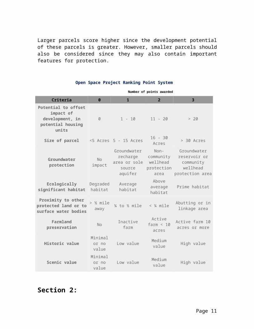
Section 4: Continuous Open Space and Land Fragmentation
Connecting Resource LandsA key component in any open space plan is connecting existing or potential future open space to form corridors for habitat that will allow them to survive and thrive throughout their natural range. Typically, many lands within a community are worthy of protection from development, but examining which of these lands might connect to form a continuous thread will allow the Town to properly host these species.
If an organism’s habitat is destroyed, one of three actions usually occurs: the organism will adapt, migrate, or become extinct. When a habitat (typically woodlands) is fragmented, the amount of exposed habitat edge. With this increase brings an increase in predators, and many will hunt along this edge.
Fragmentation reduces habitat for wildlife requiring interior forest, and promotes the spread of invasive plant and animal species. Parcelization, reflecting the subdivision and change in ownership of large blocks of land, is correlated with forest fragmentation. Small parcels of forestland are more likely to be converted to non-forest uses, such as residential development. Many species cannot breed in forest tracts smaller than 500 acres. Assessing the causes, consequences and patterns of fragmentation and parcelization is critical to developing management plans that maximize economic and ecological benefits.
Fragmentation of land also occurs as a town develops roadways for the
convenience of its residents. Adding roadways during the subdivision process further complicates the ability of a town to preserve open spaces. Fragmented lands then become smaller, and many times, it is difficult to develop a plan that will properly allow habitat to survive. Keeping these portions of land from being further subdivided and fragmented should be a priority for the Town.
A number of other communities have developed open space plans looking especially at fragmentation and ways to connect fragile ecosystems. The following are some of the key values found within these plans:
Creation of greenways, particularly along rivers and streams, is a priority for preservation of water quality and wildlife habitat, as well as for public access.
Preservation of key parcels. Communities want to preserve key parcels near water bodies and adjacent to existing protected land.
Opportunities to walk, hike and bike. Pedestrian and bicycle paths get high priority.
Preserving roadside scenery. The visual amenity provided by open space is also important, especially as development pressures transform communities in the region.
Expanding public access. Most rivers, streams, and ponds provide limited public access because most shorelines are privately owned. Expanding public access is a high priority.
Page 21

Stewardship and maintenance of existing open space can be difficult where funding and staff are limited. Many communities must depend on volunteers for a range of services, from trail construction and maintenance to upkeep of athletic fields.
Additionally, two key strategies are fundamental to creating a regional open space network. First, residents need to be better informed about the open space resources that already exist and about the potential for new regional connections. Second, a coordinating and management entity is needed to forge continuing connections and enhance information exchange, harmonize local plans, build consensus on priorities, and help to fund specific projects.
If we are to protect the irreplaceable biological diversity, we must reduce fragmentation and restore the health and vitality of our forest communities.
The Lamprey RiverWithin the past several years, stretches of the Lamprey River upstream and downstream of Raymond have been designated as part of the federal Wild and Scenic Rivers System, becoming only the second river in New Hampshire to receive such designation.
Currently, Raymond is considering several approaches to treating wastewater within the community. Since designation as a Wild and Scenic River along the Raymond stretch of the Lamprey River would potentially make it more difficult to develop a wastewater system for the Town, it may be several years before official designation takes place.
However, the lands adjacent to the Lamprey River still offer some excellent opportunities. In many communities, the river system makes an excellent choice for a greenway system. The land adjacent to the river corridors provides an opportunity to create a linear open space system that assists in protecting water quality and provides access to the river where appropriate. In addition, the river links several other communities to Raymond and therefore provides an opportunity to address open space preservation at an inter-municipal level. Joint protection efforts among communities will help to protect drinking water supplies and important wildlife habitat.
Bear-Paw Regional GreenwaysThe Town of Raymond is located within the planning area of the Bear-Paw Regional Greenways organization. Bear-Paw is a land trust established by resi-dent volunteers concerned with protecting open space lands. Bear-Paw has proposed a greenway that connects private or public lands with large areas of conservation land in a seven-town region including Candia, Deerfield, Epsom, Northwood, Nottingham, Ray-mond, and Strafford. This network of voluntarily protected lands provides important wildlife habitat and protects rivers, wetlands and recreational oppor-tunities. To date, Bear-Paw has helped protect 1,370 acres and has been in discussions with landowners about an additional 5,800 acres.
Page 22

The Lamprey River in Raymond
Bear-Paw is currently working with the Society for the Protection of New Hamp-shire Forests to develop a co-occurrence study for all seven of its communities. Any findings that may be relevant to open space protection will be incorporated into this plan. Maps produced under this study include aerial photography, water resources, wildlife habitat, natural resource co-occurrence, and a transparent tax map overlay.
This and other opportunities currently exist within Raymond to coordinate open space planning with work being done by SPNHF and Bear-Paw. While development is occurring in some areas of Town, other areas may be available for protection. The Town may be able to coordinate land protection to help develop greenways in the coming years.
Open Space and RecreationResidents and visitors alike enjoy outdoor recreation, from the solitary enjoyment of a wildflower to a group hike, during all seasons of the year.
Lands that offer personal or socially interactive recreation, or active or passive recreation, are essential elements of the open space system. Universal access should be provided at a variety of appropriate places where development of
such access will not compromise the character of the area.
The Town of Raymond recognizes its responsibility to provide recreational opportunities for all types of trail users— walkers, skiers, showshoers, people with strollers or wheelchairs, horseback riders, and mountain bikers. This report does not address appropriate uses for trails in general or for the specific trails discussed in the narrative or shown on the maps. Further study is needed to evaluate trail use and to suggest a recreational network to serve the spectrum of trail users. Not all open space land is appropriate for trail use and/or public access.
Existing and Proposed Bicycle and Pedestrian TrailsThe Regional Transportation Plan and Transportation Improvement Program (August 2002), developed by SNHPC, includes information on bicycle and pedestrian trails in the region. Some of the goals and objectives for bikeways and pedestrian facilities that would assist the Town of Raymond are as follows: Increase the use of bicycles for
people movement throughout the region;
Provide pedestrian-ways and encourage their use;
Provide bicycle/bicyclist facilities associated with routes;
Establish a local greenway/pedestrian corridor task force/committee in each municipality to oversee a pedestrian-way development program.
In 2002, the 1993 version of the Bicycle and Pedestrian Plan was updated by SNHPC (still in draft form as of January 2003).
Page 23
Section 5:Soil Types and Open SpaceSo how do soil types affect the use and designation of open space? Wetlands are a great selection for open space, since they are a prime area to preserve for the community. Floodplains are another area to preserve, since they should not be considered a prime area for develop-ment. Other areas include steep slopes, woodlands, prime farmlands, aquifers, and other lands that support wildlife and their habitat.
According to a study by the American Farmland Trust, one million acres ofirreplaceable agricultural lands are lost to sprawl each year in this country. Developers will often purchase and build on farmland that provides the “perfect” conditions for the development of housing: well-drained soils, low slopes, and ease of topsoil removal.
With the U.S. population expected to grow 23% by 2020, some landcurrently being farmed will likely be needed for housing—but how much?
Although the remaining amount of farmland in Raymond is quite small, this section contains a brief discussion of prime farmlands and farmlands of statewide importance, followed by a look at other soil types that indicate areas that should be considered for open space protection.
Prime and Unique Farmland6 Prime farmland is land best suited for producing food, feed, forage, fiber and oilseed crops, and is available for these uses. The land could be cropland, pastureland, forestland, or other land but not urban built-up land or water. It has
the soil quality, growing season, and moisture supply needed to produce sustained high yields of crops economically when treated and managed.
Unique farmland is land other than prime farmland that is used for the production of specific high-value food and fiber crops. It has the special combination of soil quality, location, growing season, and moisture supply needed to produce sustained high quality and/or high yields of a specific crop when treated and properly managed. Rockingham County examples of such crops are apple orchards and vegetable gardens.
Raymond has only small areas of primefarmland soils, and in general has only limited agricultural activity. Still, the encroachment of development on agricultural soils or lands that are currently in agricultural use is an issue of concern for the long-term use of land in Raymond.
Farmland of Statewide Importance Criteria for defining and delineating this land were determined by state and local agencies in New Hampshire. The soils in this category are important to agriculture in New Hampshire, yet they exhibit some properties that exclude them from prime farmland. Examples of such properties are erodibility or droughti-ness. These soils can be farmed satisfactorily by greater inputs of fertilizer, soil amendments and erosion control practices. They produce fair to good crop yields when managed properly.
6 Soil Survey of Rockingham County, New Hampshire, issued October 1994.
Page 24

Farmlands may include pastures, sheep and horse farms, and “pick-your-own” operations as well as dairy farms. The protection of agricultural land represents a substantial challenge—balance must be achieved between the rights of landowners, the need for development, and the preference among many residents for a rural lifestyle.
As a farmland protection policy, the Town could consider designating prime agricultural areas. Farmers within such areas might be encouraged to participate in New Hampshire’s Natural Resource Protection Service Farmland Protection Program, which allows farmers to agree to keep their land in agricultural use in exchange for a payment from the state. Conservation easements and deed restrictions for farmland protection might also be considered, along with a Transfer of Development Rights (TDR) program. Appendix G contains information on TDR programs that may be helpful to the community.
Steep SlopesMuch of Raymond is gently rolling land forming gradual ridges and lower wetland valleys. Many areas having steep slopes, greater than 15%, are generally located in association with the hilly topography, and can be seen on the Wetlands Composite Map. The steeper topography provides a visual background to views of the farm and village landscapes.
If cleared of vegetation, the steep slopes would be prone to erosion, would cause more rapid and deeper flooding of the runoff streams and would reduce the
appeal of views throughout the community. Thus, the slope of the land has important implications for future land use choices. If development of steep slope areas is carried out without designing and installing adequate waste disposal systems and implementing ero-sion control measures, problems will likely result.
Areas with slopes in excess of 25% should be carefully monitored in order to prevent uses that would result in nega-tive environmental impacts. Steep slopes should be protected from development and should be managed for wildlife habitat and sustainable timber production.
Sand and Gravel OperationsCurrently there are ten active gravel pits in Raymond. These are generally asso-ciated with the sand and gravel deposits that are in the Lamprey/North Branch (off Route 27) area in the northwest corner of the Town. There is also a large 271-acre bedrock quarry off Route 27 in southeastern Raymond. These ten operations comprise approximately 665 acres or 3.6% of the land.
Sand and gravel operations take advantage of the natural resources associated with rivers. Oftentimes the pits that were excavated for sand and gravel will be filled with water, and can be used for recreation purposes. These areas can also become a part of the open space inventory of the town if they fit with the overall intent and purpose of the open space plan. The Active Excavation Areas Map can be seen in the Raymond Master Plan.
Page 25
Section 6: Habitat Features The Importance of Biodiversity7
Biodiversity is the variety of all living things, and includes the diversity of plants, animals, fungi, algae, bacteria, and other microorganisms, their genetic variability, and the natural communities where they live. Biodiversity also includes the processes and interactions that weave the biological and physical elements of the planet into a complex web. As part of the biological community, humanity depends on natural systems for survival. Living organisms enrich the soil that grows our food, generate the oxygen we breathe, and purify the water we drink. The diversity of life forms and interactions between them are the reason earth’s systems function so efficiently and effectively. The integrity of these systems is a function of biodiversity. In essence, biodiversity supports life.
Loss of habitat poses the biggest threat to New Hampshire’s biodiversity. Loss of habitat occurs when land is developed, or when invasive plant and non-native animal species out-compete and overwhelm native species.
The reasons for maintaining biodiversity are varied and often difficult to measure, yet all contribute to a greater quality of life. Biodiversity is an economic resource: plants are sources of vegetables, fruits, grains, spices, herbs, oils, beverages, drugs, fuels, fibers, timber, and much more. A diversity of living things performs a variety of services for us, including pollination of fruit and vegetable crops, and control of pests, at no cost to society.
The link between biodiversity and our own health is clear. Most medicines used today originate from studies of wild species. Aspirin comes from a willow tree and penicillin from a common fruit mold. In addition to agricultural and medicinal values, biodiversity adds to a region’s appeal to tourists. Each year millions of people take trips primarily to view, photograph, hunt, or study nature. In New Hampshire, 88% of the population participates in wildlife-related activities. Retail sales for bird watching and bird feeding in the state total $62 million. Hunting and fishing bring in millions of dollars more to local communities.
Humans have lived in New Hampshire for many years. In the last two hundred years, at least six species of mammals and birds that once occurred here have disappeared forever. Humans have played a role in these extinctions. As humans change habitats and affect biodiversity, we are faced with many questions. How will the loss of species affect the ecological systems they inhabit? Conserving biodiversity is part of our obligation to future generations.
Land Fragmentation and Greenwayshttp://www.bear-paw.org/images/map501.gifIn order to avoid fragmentation and isolation of plant and animal populations, as well as to maintain the continuity of natural landscapes, it is necessary to provide wildlife corridors for plant and animal species. It is 7 From Wildlife Habitats, University of New Hampshire Cooperative Extension, Fall 1996.
Page 26

also essential to protect critical or threatened habitats, with an emphasis on those areas identified in New Hampshire’s Natural Heritage Inventory (NHI). The Unfragmented Lands Map displays contiguous unfragmented forest blocks. Most fragmentation occurs when lands are divided by roads that are class V or higher. The Lands of Special Importance Map displays locations of rare, threatened and endangered species and natural plant communities, water bodies and watercourses, soils of statewide importance, conservation land, and the roadway classification system. Together, these two maps may help to plan for natural corridors and greenways that may be used by the natural habitat as well as researchers and others who wish to enjoy these open spaces that may be preserved by the community.
Rare Species and Natural CommunitiesFor the Town of Raymond, the NHI has compiled a list of natural communities: terrestrial, plants, vertebrates (birds and reptiles), and invertebrates (mollusks). These inventories identify sites that contain habitat of rare, endangered and threatened natural species. The NHI was used to identify rare species and natural community areas on the Lands of Special Importance Map.
Unfortunately, the natural attractiveness and appeal of these sites has led to their harm and destruction in many areas. As a result, specific site information is not released for public distribution. The locations of these sites are usually characterized by a circular distribution that represents a one-mile-diameter radius that indicates the general location of rare, endangered, and important natural habitat.
In Raymond, several regions have been identified by the NHI as containing some important aspects of rare and natural habitat. According to the January 2001 New Hampshire Natural Heritage Inventory of Rare Plants, Rare Animals, and Exemplary Natural Communities in New Hampshire Towns, the following were noted to be located in Raymond:
Natural Communities – Terrestrial:o Acidic Rocky Summit/Rock Outcrop Community
Number reported last 20 years in town: 1 Number reported last 20 years in state: 18 Importance8: Extremely High State Listing: None noted
o Dry Central Hardwood Forest on Acidic Bedrock or Till Number reported last 20 years in town: 1 Number reported last 20 years in state: 15 Importance: High State Listing: None noted
Plants:8 The importance is based on a combination of (1) how rare the species or community is and (2) how large or healthy its examples are in the town. Extremely high: a good example of a global rarity or an excellent example of a state rarity; Very high: a marginal example of a global rarity or a good example of a state rarity; high: a marginal example of a state rarity. Please contact Natural Heritage Inventory at (603) 271-3623 to learn more about this and other ways of setting priorities.
Page 27

o Climbing Hempweed (Milkania scandens) Number reported last 20 years in town: 1 Number reported last 20 years in state: 12 Importance: Very High State Listing: Threatened
o Prostrate Tick-Trefoil (Desmodium rotundifolium) Number reported last 20 years in town: 1 Number reported last 20 years in state: 9 Importance: Extremely High State Listing: Threatened
o Slender Crab-Grass (Digitaria filiformis) Number reported last 20 years in town: Historical9
Number reported last 20 years in state: 4 Importance: None noted State Listing: None noted
o Tubular Thoroughwort (Eupatorium fistulosum) Number reported last 20 years in town: Historical Number reported last 20 years in state: 6 Importance: None noted State Listing: Endangered
Vertebrates – Birds:o Sedge Wren (Cistothorus platensis)
Number reported last 20 years in town: 1 Number reported last 20 years in state: 1 Importance: High State Listing: Endangered
Vertebrates – Reptiles:o Blanding’s Turtle (Emydiodea blandingii)
Number reported last 20 years in town: 1 Number reported last 20 years in state: 58 Importance: High State Listing: None noted
Invertebrates – Mollusks:o Brook Floater (Alasmidonta varicosa):
Number reported last 20 years in town: Historical Number reported last 20 years in state: 30 Importance: None noted State Listing: Endangered
9 Populations that have not been reported in 20 years; these populations may still be present, but field surveys are necessary to confirm their survival.
Page 28

Also noted in Identifying and Protecting New Hampshire’s Significant Wildlife Habitat: A Guide for Towns and Conservations Groups is the dwarf wedge mussel, Alasmidonata heterodon, which is federally and state endangered.
Lamprey River Management Plan: The Regional ContextThe Lamprey River Management Plan was developed over the past several years to help manage the natural environment of the Lamprey River for the towns of Durham, Epping, Lee, and Newmarket. The part of the Lamprey River designated under the New Hampshire Rivers Management and Protection Program during June 1990 is limited to the segment of the river that flows through the towns of Lee and Durham.
A large percentage of the land in the river’s corridor is undeveloped, creating extensive wildlife habitat, offering picturesque scenery, and yielding water of sufficient quality to be used as a reserve water supply for Durham. The river is one of the best examples in New Hampshire of sustainable habitat for anadromous fish, and has been designated as a Wild and Scenic River by the National Park Service during 1998 and again during 2000, east of the Raymond Town line. Rivers are commonly used to develop greenways along their paths, especially for the use and enjoyment of individuals wishing to recreate in these natural areas.
Section 7: Hydrological FeaturesIt is important to protect surface water for public access as well as groundwater quality, and sites that protect surface and subsurface water resources are an important aspect of any open space plan. The Drinking Water Resources and Potential Contamination Sources Map displays layers containing the locations of watershed boundaries, floodplains, wetlands and aquifers, hydric soils, and water bodies.
Watershed BoundariesWatersheds are natural drainage basins that allow water to flow to the lowest point within the basin. Watersheds within Raymond include the Lamprey and Exeter River basins. The northerly two-thirds of the Town lies within the Lamprey River basin, with the remainder
within the Exeter River basin. Municipalities usually share a number of watersheds, and in fact, all 13 community watersheds include areas located outside of Raymond.
Numerous perennial streams and 19 ponds and lakes are located within Raymond. The largest surface water bodies in Raymond are Onway Lake (179 acres) and Governors Lake (61 acres).
The largest river is the Lamprey River, which originates in Northwood, New Hampshire, and travels 60 miles through six towns before becoming tidal in Newmarket and emptying into the coastal estuary known as Great Bay.
Streams and tributaries are generally at the lowest point of a watershed. A
Page 29

certain percentage of the precipitation that falls in the watershed will flow into the streams and then travel downstream to its major outlet, which in many cases is the ocean. Characteristics of a watershed generally include soil, vegetation and habitat, and the man-made environment of roads, utilities and structures.
Much of the following information in this section related to the natural environment reflects the watershed boundaries. Further information regarding the watersheds within Raymond can be found in the Water Resource Management and Protection Plan produced by the SNHPC for the Town of Raymond during 1993.
FloodplainsFloodplains or flood hazard areas are adjacent to rivers and tributaries, and can provide one of the best habitats for a number of species. They can also provide a continuous and unbroken habitat that allows species to travel throughout their range. Typically, floodplain areas will contain a significant amount of vegetative cover, including trees, brush, grasses and shrubs. These areas provide both food and water for the species that are found here. The FEMA floodplains can be seen on the Base Map.
Raymond contains approximately 2,200 acres of flood hazard areas. Such areas have been identified throughout the Town in proximity to brooks, rivers and ponds. The largest of the special flood hazard areas have been identified within the watersheds of Fordway Brook (740 acres), Dudley Brook (300 acres), Onway Lake (300 acres), and Lamprey River (350 acres). The flood study
conducted by FEMA during 1990 concentrated on the areas of Fordway Brook, Dudley Brook, the Exeter River, and several unnamed streams.
Since these areas are frequently flooded, an attempt should be made to discourage persons from building in the floodplain. The floodplain should remain in its natural condition to accommodate runoff water during snowmelt and rainstorm periods and to provide wildlife habitat. Any construction within these areas may result in higher water levels during flood events, as well as disrupt habitat features.
WetlandsThe State of New Hampshire Wetlands Board defines wetlands as: “…those areas that are inundated or saturated by surface or groundwater at a frequency and duration sufficient to support, and that under normal conditions do support, a prevalence of vegetation typically adapted for life in saturated soil condition.” This type of vegetation is termed “hydrophytic” vegetation. Due to their saturated state, wetland soils are often termed either “very poorly drained” or “poorly drained” soils. Many communities in New Hampshire base their wetland definitions on soil drainage classification alone, since in disturbed areas hydrophytic vegetation may have been removed or destroyed.
Primary wetlands are those areas designated as “prime wetlands” in accordance with RSA 483-A:7 (State wetland law). When a wetland falls into several classifications, the regulations pertinent to the most restrictive apply. Critical wetlands include waterbodies, watercourses, and their associated wetlands.
Page 30
Wetlands are known to be an extremely valuable resource. Wetlands act principally as flood control areas where water is stored during periods of high runoff. They slowly release excess water downstream, which subsequently pre-vents hazardous flooding. In addition, wetlands also may be used for: flooding peak reductions; settling basins for sediment
generated by erosion; pollution filters (wetland vegetation
utilizes some pollutants as nutrients); areas of water supplies, by
recharging groundwater and streams; wildlife habitats, providing food,
cover, and nesting and breeding sites;
educational and recreational resources; and
groundwater recharge zones.
Wetlands are usually found in close proximity to rivers, streams, and ponds or in isolated upland depressions. Wetlands are generally ranked as having the lowest development potential of any land type. Their disturbance quite often disrupts the other valuable roles they serve. Instead, wetlands should be desig-nated for use by compatible activities such as those that do not require the construction of buildings or structures, or those that will not necessitate altera-tion of the natural surface configuration by the addition of fill or by dredging.
National Wetlands Inventory (NWI) wetland areas have been identified on the Wetlands Composite Map. Ideally, wetlands and floodplains should remain in their natural state for many reasons, including water resources protection, habitat preservation and flood damage reduction.
The New Hampshire Wetlands Bureau administers regulations that require permits for wetland alterations. FEMA requires local regulations that respect the flooding cycles of all water bodies. It is in the Town’s interest to consider these factors when planning future development and protection of open space preservation areas.
“America’s wetlands provide something for everyone. Wetlands protect us all in many ways—they filter pollutants from our drinking water, protect our homes by storing floodwater, and provide homes for fish, shellfish, and wildlife. Wetlands are crucial for clean water, serving as a natural filter,
absorbing water-borne pollutants and damaging contaminants before the water enters our rivers, lakes, and streams.
Despite the fact that wetlands are of unique value to our society, a 1997 survey by the U.S. Fish and Wildlife Service reports that roughly 58,500
acres of wetlands are being destroyed annually. Sierra Club is fighting for
the restoration and protection of wetlands all across America, for our
families and for our future.”
—The Sierra Club
The 1993 Water Resource Management and Protection Plan for Raymond delineates poorly drained, very poorly
Page 31

drained, and muck and peat soils that generally are described as wetland areas. On a Town-wide basis, poorly drained soils comprise approximately 1,500 acres, and very poorly drained soils, which includes muck and peat soils, comprise about 2,700 acres.10 Areas of large concentrations of wetlands are found in the Fordway Brook, Lamprey River, Flint Hill, Dudley Brook, and Onway Lake watershed areas. The Wetlands Composite Map indicates that wetlands are scattered throughout Raymond.
Regulations related to wetlands found within the Town’s zoning, site plan and subdivision ordinances should be re-viewed regularly in order to assure that these areas are adequately protected from unnecessary development, except for those uses that do not contribute to the degradation of a wetland area.
Raymond has yet to designate any prime wetland areas, but has discussed this at their Conservation Commission meet-ings during 2002.
AquifersAn aquifer consists of underground soil or rock that groundwater is easily able to move through. Aquifers typically consist of gravel, sand, sandstone, or fractured rock. Water from fractured bedrock pro-vides 25% of New Hampshire’s drinking water and 85% of the water for private domestic wells. A majority of Raymond depend upon aquifers to supply them with drinking water. During years of drought, some wells dry up and homeowners are forced to drill new wells for domestic water.
It is important to protect groundwater within existing or potential public drink-ing water supply aquifers. Aquifers, like wetlands, serve as a place of storage for water.
Because of the role aquifers play in contributing abundant clean water, as well as their interconnections with wetlands and rivers, land planning in and around these sites should favor low-impact, low-intensity uses that do not have a high degree of probability for groundwater contamination. Development of land that overlies aquifers can have negative, often irreversible impacts.
The Drinking Water Resources and Potential Contamination Sources Map indicates those areas that could be highly susceptible to groundwater contami-nation. This map also shows the location of aquifers within the Town.
The U.S. Geological Survey has identified several extensive potential high-yield aquifers within the Town. A potentially very productive aquifer lies within northwest Raymond, and the report titled “Groundwater Resources of the Lamprey River Basin, Southeastern New Hampshire,” states that the aquifer in northwest Raymond may yield 1.7 Mgal/day. This may indicate that this aquifer would be ideal for production of drinking water for the Town. Other aquifers are: West Epping and Newmarket Plains aquifers; an esker11 aquifer in the general area easterly of the intersection of Routes 102 and 107, northerly of Prescott Road; and a kame terrace12 in western Raymond, along the North Branch Lamprey River extending
10 Water Resource Management and Protection Plan for Raymond, 1993.11 Long ridges of sand and gravel deposited by water flowing in tunnels within or beneath glacial ice.
Page 32

into the Town of Candia. Several relatively large potential medium-yield aquifers have also been identified in proximity to these locations.
There seems to be little if any detailed hydrologic data available to provide an accurate indication of the potential for bedrock to serve as a major source of water supply. However, the results of well reports generally suggest that the extent of fracturing, which creates repositories in Raymond’s bedrock, appears to be sufficient to produce reasonably dependable domestic supplies, and possibly adequate supplies for relatively small community water systems.
On the basis of preliminary determina-tions made by the U.S. Geological Survey, the high- and medium-yield aquifers also must be considered to be potential sources capable of meeting future requirements for municipal water supplies. It appears that this would be particularly true of the potential high-yield aquifers located in Raymond. Serious consideration should be given to means of protecting the identified aqui-fers for possible future use. Faulty septic systems above aquifers can cause wide-spread groundwater contamination. Excessive paving and other forms of land covering could inhibit the replen-ishment of groundwater supplies. Auto-motive service stations are another pos-sible pollution threat due to leaking underground storage tanks. Any indus-trial operation producing hazardous by-products has the potential to damage water quality, and activities such as sand and gravel excavation remove the
overburden that can filter out many potential pollutants.
The location of aquifers should be a prime consideration of this open space planning effort. Raymond has made a commitment to protecting groundwater by including groundwater protection and the protection of wellhead areas in its zoning ordinance. Future non-regulatory provisions, such as land purchase or easements, should be given to areas containing aquifers. These aquifer areas and their immediate contributing water-sheds are important water resources worthy of protection.
Potential Nonpoint Pollution SourcesNonpoint pollution is diffuse in nature and discharges pollutants over an area of the environment. Examples of nonpoint pollutant sources are sanitary waste disposal systems, sanitary landfills, road salt storage sites, roads, snow dumping sites, urban runoff, pesticide application, and erosion sites. For further information on this subject, please see the Nonpoint Education for Municipal Officials Web site at http://nemo.uconn.edu/about.htm.
EPA Superfund SitesTwo sites are currently either listed as a superfund site or under investigation. The Mottolo Pig Farm is on EPA’s National Priorities List and is currently the only superfund site in Raymond. The 50-acre site is an abandoned pig farm lo-cated in an undeveloped wooded area on Blueberry Hill Road. From 1975 to 1979, over 1,600 drums and pails of wastes were disposed of on this site. Studies by the State of NH showed that groundwater beneath the site was
12 A terrace-like ridge consisting of stratified sand and gravel formed as a glaciofluvial deposit between a melting glacier or stagnant ice lobe and a higher valley wall, and left standing after the disappearance of the ice.
Page 33

contaminated and that contaminants were seeping into a brook that empties into the Exeter River. An estimated 1,600 people depend on groundwater within three miles of the site as a source of drinking water. Residential areas border the site property on three sides.
The selected remedies included installing a groundwater interceptor trench; sealing the ground surface in both the former drum disposal area and the southern boundary area with temporary caps; and installing and operating a vacuum extraction system to remove volatile organic compounds from the soils. The area of groundwater contamination continues to shrink and the level of contamination is diminishing.
The Regis Tannery property, not a superfund site but under investigation, is located on Old Manchester Road. The property is bordered to the southwest by a gravel pit, to the southeast by undevel-oped land, to the east by Wright Street, Raymond Center, and a residential area, and to the north and northwest by resi-dences, commercial properties, and Old Manchester Road. The Regis Tannery property is currently an active site listed with the New Hampshire Department of Environmental Services, and an investigation of contaminated ground-water, surface water, soils, and sludge is ongoing under their direct supervision. According to EPA, this site is still awai-ting a national priorities listing.
These Superfund Sites may eventually be recycled for other uses, such as redevelopment, retirement facilities, light industrial uses, recreation, and historic preservation. Raymond may eventually wish to consider including
these properties in their open space priorities list, unless other uses would be more beneficial to the Town.
Page 34

Section 8:Priority Open Space Areas
Town of Raymond Priority Open Space AreasA number of areas within Raymond are currently noted as desirable locations for open space preservation. The Open Space Plan Committee has determined that the following areas, listed here for planning purposes, should be considered for open space protection in the future: Name: Norris Farms/Flint Hill Owner: Town of Raymond Tax Map: 9/20-4 Acres: 237.9
Name: Dearborn Estates Owner: Town of Raymond Tax Map: 4/48 Acres: 314.8
Name: Manchester-Portsmouth RR Bed Owner: NHDOT USGS, DRED Acres: 258.3
Name: Cassier-Eames Owner: Town of Raymond Tax Map: 8-41 Acres: 370
Name: Chandler’s Mine Acres: 10 Resource: REPP 1998 Inventory
Name: Watershed ProtectionAcres: 335Resource: REPP 1998 Inventory
Name: Onway LakeAcres: 175Resource: REPP 1998 Inventory
Name: Map ID# 1,2,3,5,6,8,9Acres: 800 (approximate)
Source: REPP 1998 Inventory Others (if any):
Other areas to consider for protection might include the following from the Town fores-ter’s report of 2001 and 2002, noted in Sec-tion 1 of this document:
Town ballfield and well, 104 acres; Lamprey River Elementary School,
town beach, and scenic forest area, 38 acres;
Industrial Drive lots, 42 acres;
Page 35

Bald Hill Road lot, 50 acres; Chetague/Lane roads, 156 acres.
Remember that all open space protection should take place between a willing landowner and a conservation/land trust agency or municipality.
Highest, Medium and Low PrioritiesThe following priorities should be kept in mind when deciding which open space areas should be protected:
Highest Priority Steep slopes greater than 15% Wetlands Wetland Buffers Floodplains Aquifers Hydric soils (very poorly and
poorly drained soils) Surface waters (ponds, streams,
lakes, etc.) Riparian corridors Forest blocks (unfragmented land
areas) greater than 2,000 acres Prime/high quality agricultural
land Historic properties/Sites (mill
and dam sites, villages, buildings, parks, farmsteads, fields, cemeteries)
Greenways Recreational resource lands in
close proximity to village Wildlife habitat areas
Medium Priority: Land that provides an access or
link to a proposed greenway Forested blocks (unfragmented
land areas) 500 to 2,000 acres
Lowest Priority: Forested blocks
(unfragmented land areas) 250 to 500 acres
Criteria for Acquisition and Protection of Open Space Potential linkages to existing open
space, to recreation facilities, and to similar areas in adjacent communities.
Environmental sensitivity and importance of the parcel, such as the presence of aquifers, rivers, wetlands, wildlife, and scenic qualities. This includes wildlife corridors, unique habitat, and endangered, threatened and rare species.
Location in areas that do not have enough public open space or are threatened by continued development. Will the acquisition of the parcel provide additional recreational opportunities in an area of the Town that is in need of such facilities? Does the purchase of the parcel encourage Town-wide distribution of open space and recreation?
Town-wide versus special group benefit. Would the acquisition of this parcel benefit the community as a whole or a select group of residents in need of additional opportunities? The importance of addressing each need will depend on the specific goals of the town.
Outdoor recreation potential. This is related to providing additional athletic fields as well as providing areas for greenways and trails that provide opportunities for hiking, walking, running, skiing, and biking.
Cost and availability of the parcel. This should account for the amount residents are willing to pay to purchase open space (in the form of increased taxes) and the availability
Page 36

of funding sources that would be available if a particular property were targeted for acquisition.
The financial impact that removing the parcel from development will have on the Town. For example, a residential parcel may cost the Town in services while a commercial property may be a positive contribution to the tax base (see previous summary detailing cost of residential service versus open space costs and benefits).
Aesthetic benefits to the general public and the preservation of the Town character.
It should be noted here that certain lands may become available that are not listed on the preceding priorities list. When this occurs, the town may wish to consider placing these properties on the list for potential purchase or for purchasing a conservation easement if these actions will enhance the Town’s open space resources.
Implementation: Open Space Committee The Raymond Board of Selectmen should create a standing Open Space Committee, as proposed by the Raymond Conservation Commission. Such a committee would establish broad goals and coordinate the activities of smaller working groups pursuing open space protection on behalf of the Town. It is recommended that the committee be made up of representatives from the Conservation Commission, Planning Board, Board of Selectmen, and others with specific areas of relevant expertise in open space planning to perform the following:
Identify and evaluate parcels for acquisition and protection;
Develop an overall management plan for existing Town-owned property;
Amend the Town’s subdivision regulations and adopt other mechanisms that give the Town more authority to create permanent, useable open space in and near new subdivisions, if appropriate.
Page 37

APPENDIX A
RAYMOND OPEN SPACE GIS MAPS
Page 38

APPENDIX BPOPULATION GROWTH RATES
IN SOUTHERN NEW HAMPSHIRE, 1980-2000
Population growth rates were substantial in southern New Hampshire from 1980 to 2000. The data below indicate an average growth rate of 13% in the Southern New Hampshire Planning Commission region using U.S. Census population information from 1980, 1990 and 2000.
1980 1990 2000 Growth 1990-2000Amount Percent
Auburn 2,883 4,085 4,682 597 14%
Bedford 9,481 12,563 18,274 5,711 31%
Candia 2,989 3,557 3,911 354 10%
Chester 2,006 2,691 3,792 1,101 29%
Deerfield 1,979 3,124 3,678 554 15%
Derry 18,875 29,603 34,021 4,418 13%
Goffstown 11,315 14,621 16,929 2,308 14%
Hooksett 7,303 9,002 11,721 2,719 13%
Londonderry 13,598 19,781 23,236 3,445 15%
Manchester 90,936 99,332 107,006 7,674 7%
New Boston 1,928 3,214 4,138 924 12%
Raymond 5,453 8,713 9,674 961 10%
Weare 3,232 6,193 7,776 1,583 20%
Totals 171,978 216,479 248,838 32,359 13%
Page 39

APPENDIX COPEN SPACE IMPLEMENTATION METHODS
To help fulfill the Town of Raymond’s open space goals, the following list provides examples of the variety of tools and techniques that communities throughout New Hampshire have used for land protection. Dorothy Tripp Taylor describes many of these tools and techniques in more detail in the handbook “Open Space for New Hampshire: A Toolbook of Techniques for the New Millennium.” The handbook also refers to associated state laws and regulations, sample communities that have used these methods, and where to acquire technical assistance and additional written documents on each method.
Agricultural District Laws: Agricul-tural district laws allow farmers to form special areas where commercial agriculture is encouraged and protected. Programs are authorized by state legislatures and implemented at the local level. Common benefits of enrollment in a district include automatic eligibility for differential assessment, protection from eminent domain and municipal annexation, enhanced right-to-farm protection, exemption from special local tax assessments, and eligibility for state PACE programs.
Bargain Sales: This option involves purchasing a piece of property at areduced rate. The difference between the full market rate and the reduced rate provides a federal tax break to the seller.
Buffers: Planning Boards are advised to consider a buffering requirement on uses adjacent to a farm when reviewing plans for subdivisions.
Circuit Breaker Tax Relief Credits: Circuit breaker tax programs offer tax credits to offset farmers’ property tax bills. Like differential assessment laws, circuit breaker tax relief credits reduce the amount farmers are required to pay in taxes.
Cooperative Purchases with Conservation Groups (e.g., New England Forestry Foundation, The Nature Conservancy, Corporate Con-servation Council, Trust for Public Land): Various local, regional and national land trusts and conservation groups can provide a tremendous amount of assistance to landowners wishing to keep their property unde-veloped. Once land is accepted by a trust, stewardship of the property tends to be excellent. The Trust for Public Land, a national land trust, is able to move quickly with willing landowners, and can provide the necessary legal assistance to complete the transaction. TPL is particularly helpful with larger, more expensive pieces of property that are threatened by development.
Conservation Easements: A voluntary legal instrument between the town and a landowner that can be used to preserve unique features of a property by restricting the type and amount of development, or even to prevent the property from being developed at all.
Current Use Program: The current use program is voluntary for landowners, but it is required under state statute for municipalities. Land under New Hampshire’s current use program is based upon the value of the land as it is
Page 40

being used now (usually farmland, forest and wetlands) as opposed to its potential use that would result in the property being taxed at a significantly higher rate.
Density Bonuses: Developers are allowed some reduction in regulations, such as approval for a limited number of additional units (higher densities) on a site with reduced road width or set-back requirements, in exchange for providing something else that the community desires, such as open space.
Designating Forests: A town or the state, through the Department of Resources and Economic Development (DRED), can purchase, manage and improve forestlands. The forest designation can encourage landowners to donate their forestland because the donation can be accompanied by conditions restricting its use. The town also benefits from the forest designation. It can receive money from the state in lieu of taxes it would have gotten if the land were privately owned.
Designating Scenic Roads: The Planning Board, Conservation Commission, or Historical Commission can request that a particular road be designated as “scenic.” The entire road does not have to be designated as scenic; portions of road are acceptable. Voters can decide at a town meeting whether to officially approve the road(s). Prior to acceptance of a road as “scenic,” abutters must be contacted and informed of the designation. Once the road is officially designated as “scenic” any repair, maintenance, reconstruction, or paving work done to that road cannot involve the removal of trees or any portion of a stone wall except with the written permission of the Planning Board after a public hearing is held.
Growth Impact Tools: Under certain circumstances, a town may adopt regulations to control the rate of development. In New Hampshire, a town must have both a master plan and a capital improvement plan before it can adopt any ordinances controlling the timing of development. In certain rapid growth situations, slowing the rate of development can give a community time to update its master plan, develop infrastructure, and consider ways to conserve open space. Methods include limiting the number of building permits, or an interim growth moratorium allowing the Planning Board to halt development for up to one year.
Impact Fees: Towns that have capital improvements programs are allowed to charge developers impact fees to help cover the costs of the development on specific municipal facilities. While the statute specifies that the fees cannot be used for public open space, fees can be
Page 41

used to direct new development to desired areas.
Management Agreements: Management agreements can be made with willing landowners through verbal or written agreements or contract agreements to help protect natural resources.
On-Farm Retail Sales: Flexibility in site plan review regulations can be used to exempt farm stands from inappropriate commercial regulation, or to allow a community to develop a tiered approach to the regulating of farm stands. Communities are encouraged to exempt seasonal farm stands from municipal regulations other than proof of safe site access. Year-round operations warrant review by the local authorities to address the safe operation of the site. However, the review should be modified to provide for reduced standards from those applied to commercial and industrial uses.
Overlay Districts: Overlay districts can be used by communities to apply special regulations to a number of resources with definable site-specific characterization that can be delineated on a map. There are several types of overlay districts, such as drinking water, wetlands, steep slopes, mountain, agricultural, village, historic, species of concern, and scenic overlay districts.
Purchase of Agricultural Conservation Easement Programs (PACE): Purchase of Agricultural Conservation Easement Programs pay farmers to protect their land from development. Landowners sell agricultural conservation easements to a government agency or private
conservation organization. The agency or organization usually pays them the difference between the value of land for agriculture and the value of the land for its “highest and best use,” which is generally residential or commercial development. Easement value is most often determined by professional appraisals, but may be established through the use of a numerical scoring system that evaluates the suitability for agriculture of a piece of property.
PACE programs allow farmers to cash in a fair percentage of the equity in their land, thus creating a financially competitive alternative to selling land for non-agricultural uses. Permanent easements prevent development that would effectively foreclose the possibility of farming. Removing the development potential from farmland generally reduces its future market value. This may help facilitate farm transfer to the children of farmers and make land more affordable to beginning farmers and others who want to buy it for agricultural purposes. PACE provides landowners with liquid capital that can enhance the economic viability of individual farming operations and help perpetuate family tenure on the land. Finally, PACE gives communities a way to share the costs of protecting agricultural land with farmers.
Performance and Design Standards: Performance and design standards can include aesthetic and natural characteristics-based land use regulations and flexible zoning.
Purchase of Development Rights or Transfer of Development Rights (PDR or TDR): The purchase of development rights is essentially the purchase of a
Page 42

conservation easement. Instead of donating easements, farmers can sell them to the state, concurrently placing permanent agricultural preservation restrictions on their farms. Similarly, a community or local group may purchase development rights on farmland or other land. Instead of a tax deduction for the gift of an easement, the landowner receives cash for the value of the easement.
Transfer of development rights operates under the same theory as a purchase program. This program transfers development from one area to another, and preserves open space in the sending area. Development rights are transferred from conservation land, such as farmland, to land slated for develop-ment. A developer purchases develop-ment rights from the owner of land in a conservation zone in order to accrue development “points.” He or she can apply points toward development of property in a zone where development is encouraged, and develop that land at a greater density than would otherwise be permitted.
Purchase of Land: The town can acquire land through donation or purchase with or without various restrictions including deed restrictions, conservation easements, or for tax benefit to the donor.
Although purchasing property is an obvious method that a town can use to preserve open space, this method can often times be cost prohibitive to a community. However, there are a variety of methods that a town can use to appropriate funds to purchase land for conservation purposes.
A town can appropriate money through a conservation fund. These funds can be utilized after a vote of the town legislative body. The town can use capital reserve funds as long as they are specified for a particular purpose such as purchasing land or an easement. Dollars have been raised through managing town property in some communities, usually through timber harvesting. Surplus funds from previous years can be used after a town meeting vote. If a proposal passes town meeting by a two-thirds vote, the town can borrow money through a municipal bond. A property that the town acquires through a tax lien could be used for conservation purposes. If the town decides to sell the particular property, a conservation easement or deed restriction could be placed on the property. Finally, land use change tax can be used for conservation purposes when a property is withdrawn from the current use program.
Right-of-first-refusal: A right acquired or donated to the town, where the town would have the first option to purchase a piece of property when an owner decides to sell. The Town would not be obligated to purchase the property, but would have a limited amount of time to decide if there was interest in purchasing the land.
Tax Abatement: Tax abatement is the exemption or deferment of taxes under certain conditions, either for a specified period or until the conditions are no longer met. Taxes can be abated in New Hampshire for providing shade trees adjacent to highways and for not cutting timber. Any person can apply to the selectmen to have their taxes abated if they plant and protect shade trees along a highway adjoining their land. In contrast, a person who owns and cuts woodlands as a business has to file a
Page 43

notice of intent to cut with the proper assessing officials in the town where such cutting is to take place. This notice includes, among other things, the person’s name, residence, and an estimate of the amount and species to be cut. This procedure enables tax officials to tax an owner for the wood that is cut.
Tax Deduction: The federal government provides some incentives to encourage people to donate land or a conservation restriction on their land to the public either during their lifetime or in their wills. A person can deduct, on their federal income tax return, the amount of the value of the property or conservation restriction donated, subject to a ceiling on the allowance for charitable gifts in any one-year period.
Urban Growth Districts: An urban growth district allows a community to define one or more areas where growth
and development will be concentrated. Typically, this includes downtown areas and perhaps existing areas with higher concentrations of development. Open space can be conserved outside the urban growth by concentrating desired growth inside the urban growth district.
Page 44

Page 45

APPENDIX DSTATE AND FEDERAL GRANT OPPORTUNITIES
There are numerous State and Federal grant programs available that can be used to promote open space protection. The status of grant programs is subject to change. However, the following include some current programs that could be used by the Town to further the open space plan goals, objectives and recommendations.
STATE PROGRAMS:
Community Conservation Assistance Program. UNH Cooperative Extension. Assistance for project guidance and training for community projects through municipalities and non-profit conservation groups. Contact Amanda Stone at (603) 364-5324.
Community Foundation Grant Program. The Greater Piscataqua Community Foundation. Provides funding to non-profit and public agencies in the fields of environment, arts and humanities, education, and health and social and community services. Contact www.nhcf.org or (603) 430-9182.
Conservation License Plate Grant Program. NH State Conservation Committee. To promote natural resource related programs throughout the state. Conservation districts, Cooperative Extension, conservation commissions, schools, groups, and other non-profits can apply for funding. Contact Joanna Pellerin at (603) 679-2790 or www.mooseplate.com.
Fisheries Habitat Conservation Program. NH Fish and Game Department. To conserve fisheries habitat through a watershed approach. Landowners wishing to protect/enhance fisheries habitat can apply for funding. Contact Scott Decker (603) 271-2744 or [email protected].
Forest Legacy Program. NH Department of Resources and Economic Development. Provides up to 75% of the purchase price for development rights to forestlands from willing sellers. Streamside land is among program priorities. Rights are held by the state in perpetuity, while the landowner retains all other rights, including the right to harvest timber. Contact NH DRED at (603) 271-2411.
Land and Community Heritage Investment Program. This is a grant program for conserving and preserving New Hampshire’s most valuable natural, cultural and historical resources. Grant applications for the purchase of land/buildings or restoration of structures are accepted from tax-exempt organizations, municipalities or other political subdivisions of the State. Contact SNHPC or visit www.lchip.org.
Land and Water Conservation Fund Program. NH Department of Resources and Economic Development. Provides grants to state and municipal agencies for outdoor
Page 46
recreation and conservation projects. Contact Allison McLean, at theDivision of Parks and Recreation, (603) 271-3556.
Local Water Protection Grants. NH Department of Environmental Services. To protect public drinking water sources. Water suppliers, municipalities, conservation districts, and non-profits can apply. For more information, call (603) 271-7017.
New Hampshire Drinking Water Source Protection Program. NH Department of Environmental Services. This grant is available to public water suppliers for source water protection. The program, which began in 1997, has a total of $200,000 available to disburse every year to eligible municipalities. Grant amounts vary from $2,000 to $50,000. Past grants have been used to fund a watershed assessment and protection plan; erect perimeter fencing to protect a wellhead area; and monitor wells for groundwater evaluation. Past recipients include: Conway, Lebanon, Manchester, Rochester, Dover, Keene and Portsmouth. For further information contact Sarah Pillsbury at (603) 271-1168 or e-mail [email protected].
Nonpoint Source Local Initiatives Grants (Section 319 Grants). NH Department of Environmental Services. For watershed management efforts. Grants given to associations, organizations, agencies to help fund all aspects of watershed management including organization, building, planning, and assessment. Each year, a total of approximately $160,000 is made available to about 15 eligible local projects aimed at protecting water quality. Call (603) 271-2358 or www.des.state.nh.us/wmb/was/grants.htm.
Transportation Enhancement Program. New Hampshire Department of Transportation provides funding for scenic highway projects and mitigation of water pollution due to highway runoff. Contact (603) 271-3734.
Watershed Restoration Grants (Section 319 Restoration Grants). NH Department of Environmental Services. Grants can be given to farmers, watershed associations, conservation districts, non-profit organizations, regional planning agencies, and municipalities to implement practices that help restore impaired waters. Call (603) 271-2358 or www.des.state.nh.us/wmb/was/grants.htm.
Wildlife Habitat – Small Grants Program. NH Fish and Game Department. For restoring, sustaining, or enhancing wildlife habitat on privately owned land. Owners of private, municipal, corporate, or other non-governmental lands can apply for funds to implement habitat-improving practices. Contact your regional F&G office or Charlie Bridges at (603) 271-2461.
FEDERAL SOURCES:
Coastal America Corporate Wetlands Restoration Partnership. U.S. Army Corps of Engineers. Voluntary public-private partnership in which corporations join forces with
Page 47

federal and state agencies to restore wetlands and other aquatic habitats. Contact (978) 318-8238.
Conservation Reserve Program. USDA Farm Service Agency. For converting highly erodible land to vegetative cover. Annual rental or other incentive payments for certain activities are offered. Cropland owners and operators who have owned or leased the land for at least one year can apply for funds. Contact your local USDA Service Center or www.fsa.usda.gov for more information.
Environmental Quality Incentives Program. USDA Natural Resources Conservation Service. Provides technical expertise and field experience on a voluntary basis to private landowners in developing environmentally beneficial and cost effective conservation practices. The program assists rural and urban communities to reduce erosion, conserve and protect water and solve other resource problems. Eligibility is limited to persons engaged in livestock or agricultural production. Priority areas are identified through a locally led conservation process that requires completion of a natural resources needs assessment and develops proposals. Activities must be carried out according to site-specific conservation plans subject to NRCS technical standards. Contact Michael J. Kaczor, National Cultural Resources Specialist, Federal Preservation Officer, Natural Resource Conservation Service, Ecological Sciences Division, PO Box 2890, Washington, DC 20013. Phone: 202-720-4912; Fax: 202-720-1814. Or visit www.nh.nrcs.usda.gov or call (603) 868-7581 to find your local contact.
Farmland Protection Program. USDA Natural Resources Conservation Service. Provides matching funds to help slow the conversion of farmland to non-agricultural uses. An entity holds the conservation easement deed. To be eligible for the FPP, the land must be: part of a pending offer from a non-governmental organization, state tribe, or local farm protection program; on prime, unique, or other important farmland soil; covered by a conservation plan developed with/through the NRCS; privately owned; large enough to sustain agricultural production; accessible to markets for what the land produces and surrounded by parcels of land that can support long-term agricultural production. The easements are for 30 years, but priority is given to perpetual easements. Visit www.nh.nrcs.usda.gov or contact the NRCS state office in Durham at (603) 868-7581.
North American Wetlands Conservation Fund. U.S. Fish and Wildlife Service. Provides grants under the North American Wetlands Conservation Act (NAWCA) to conserve North American wetland ecosystems and waterfowl and the other migratory birds and fish and wildlife that depend upon such habitats. A one-to-one non-federal match is required. Projects are subjected to a scoring process and site visits, if needed. Projects rank higher if they contain long-term acquisition or restoration, high migratory bird values, a high match grant ratio and many diverse partners. Grant instruction booklets and local contact information are available by contacting the Fish and Wildlife Service’s North American Waterfowl and Wetlands Office at Room 110, 4401 North Fairfax Drive, Arlington, VA 22203. Phone: 703-358-1784; E-mail:
Page 48
[email protected]; Web site: www.fws.gov/~r9nawwo/nawcahp.html.
Partners For Fish and Wildlife. U.S. Fish and Wildlife Service. To restore, improve, and protect fish and wildlife habitat on private lands, private landowners, private organizations, towns and municipalities can apply for cost-sharing funds. Contact Robert Scheirer at (603) 223-2541 or [email protected].
Scenic and Cultural Byways Program. Roads designated under the New Hampshire Scenic and Cultural Byways Program may be eligible for federal grant money for purchase of conservation easements for scenic values along designated byways. Such funds may be used to ensure the long-term protection of open spaces along the byways. Contact www.state.nh.us/osp/scenicbyways.
Wetlands Reserve Program. USDA Natural Resources Conservation Service. Voluntary program to restore and protect wetlands on private property. WRP offers three options: permanent easements; 30-year easements; and restoration cost-share agreements with minimum 10-year duration. Some easements may be eligible for tax credits. Land must be restorable and suitable for wildlife benefits. To offer conservation easement, landowner must have owned land for at least one year before program enrollment unless land was inherited or not obtained for purpose of enrolling it in the program. Contact Michael J. Kaczor, National Cultural Resources Specialist, Federal Preservation Officer, Natural Resource Conservation Service, Ecological Sciences Division, PO Box 2890, Washington, DC 20013. Phone: 202-720-4912; Fax: 202-720-1814. Local contact: Alan Ammann at (603) 868-9931, ext. 103, or [email protected].
Wildlife Habitat Incentives Program. USDA Natural Resources Conservation Service. Voluntary conservation program for those wanting to develop and improve wildlife habitat on private lands. The program offers three options: permanent easements; 30-year easements; and restoration cost-share agreements with minimum 10-year duration. Some easements may be eligible for tax credits. Individuals must own or have control of land under consideration. There is no minimum acreage requirement. WHIP may also be used to restore riparian habitat. Land is not eligible if it is currently enrolled in similar USDA programs, used for mitigation, owned by the federal government, or if the USDA determines that on-site or off-site conditions would reduce the benefits of habitat development. Contact Michael J. Kaczor, National Cultural Resources Specialist, Federal Preservation Officer, Natural Resource Conservation Service, Ecological Sciences Division, PO Box 2890, Washington, DC 20013. Phone: 202-720-4912. Fax: 202-720-1814. Local contact: Alan Ammann at (603) 868-9931, ext. 103, or [email protected]..
Page 49

APPENDIX ESELECTED NEW HAMPSHIRE STATUTES
RELATED TO OPEN SPACE
TITLE 5 Taxation CHAPTER 79A Current Use Taxation§ 79-A:1 Declaration of Public Interest. – It is hereby declared to be in the public interest to encourage the preservation of open space, thus providing a healthful and attractive outdoor environment for work and recreation of the state's citizens, maintaining the character of the state's landscape, and conserving the land, water, forest, agricultural and wildlife resources. It is further declared to be in the public interest to prevent the loss of open space due to property taxation at values incompatible with open space usage. Open space land imposes few if any costs on local government and is therefore an economic benefit to its citizens. The means for encouraging preservation of open space authorized by this chapter is the assessment of land value for property taxation on the basis of current use. It is the intent of this chapter to encourage but not to require management practices on open space lands under current use assessment. Source. 1973, 372:1. 1991, 281:2, eff. Aug. 17, 1991. 1996, 176:2, eff. Aug. 2, 1996.
TITLE 5 Taxation CHAPTER 79A Current Use Taxation§ 79-A:4 Powers and Duties of Board; Rulemaking. – The board shall have the following powers and duties: I. It shall meet at least annually, after July 1, to establish a schedule of criteria and current use values to be used for the succeeding year. It shall have the power to establish minimum acreage requirements of 10 acres or less. It shall also review all past current use values and criteria for open space land established by past boards. The board shall make such changes and improvements in the administration of this chapter as experience and public reaction may recommend. II. The board shall reduce by 20 percent the current use value of land that is open 12 months a year to public recreational use, without entrance fee, and that also qualifies for current use assessment under an open space category. There shall be no prohibition of skiing, snowshoeing, fishing, hunting, hiking or nature observation on such open space land, unless these activities would be detrimental to a specific agricultural or forest crop or activity. The owner of land who opens his land to public recreational use as provided in this paragraph shall not be liable for personal injury or property damage to any person, and shall be subject to the same duty of care as provided in RSA 212:34. III. The board shall annually determine, vote upon and recommend to the chairman of the board the schedule of criteria and current use values for use in the forthcoming tax year. The board shall hold a series of at least 3 public forums throughout the state to receive general comment through verbal and written testimony on the current use law. After the public forums are concluded and the board has made its recommended changes, the chairman shall proceed to adopt any proposed rules, in accordance with paragraph IV. IV. The chairman of the board shall adopt rules, pursuant to RSA 541-A, for the schedule of criteria and current use values as recommended by the board, and for other forms and procedures as are needed to implement this chapter consistent with board
Page 50
recommendations and to assure a fair opportunity for owners to qualify under this chapter and to assure compliance of land uses on classified lands. Source. 1973, 372:1. 1974, 7:4. 1977, 326:3. 1982, 33:2. 1986, 62:1. 1988, 5:3. 1991, 281:7. 1993, 205:1. 1995, 137:3, eff. May 24, 1995.
TITLE 5 Taxation CHAPTER 79A Current Use Taxation§ 79-A:25 Disposition of Revenues. – I. Except as provided in paragraph II, all money received by the tax collector pursuant to the provisions of this chapter shall be for the use of the Town or city. II. The legislative body of the Town or city may, by majority vote, elect to place the whole or a specified percentage, amount, or any combination of percentage and amount, of the revenues of all future payments collected pursuant to this chapter in a conservation fund in accordance with RSA 36-A:5, III. The whole or specified percentage or amount, or percentage and amount, of such revenues shall be deposited in the conservation fund at the time of collection. III. If adopted by a Town or city, the provisions of RSA 79-A:25, II shall take effect in the tax year beginning on April 1 following the vote and shall remain in effect until altered or rescinded pursuant to RSA 79-A:25, IV. IV. In any Town or city that has adopted the provisions of paragraph II, the legislative body may vote to rescind its action or change the percentage or amount, or percentage and amount, of revenues to be placed in the conservation fund. Any such action to rescind or change the percentage or amount, or percentage and amount, shall not take effect before the tax year beginning April 1 following the vote. Source. 1973, 372:1. 1988, 120:2. 1991, 281:19, 20, eff. Aug. 17, 1991.
TITLE 5 Taxation CHAPTER 79A Current Use Taxation§ 79-A:25-a Land Use Change Tax Fund. – I. Towns and cities may, pursuant to RSA 79-A:25-b, vote to account for all revenues collected pursuant to this chapter in a land use change tax fund separate from the general fund. After a vote pursuant to RSA 79-A:25-b, no land use change tax revenue collected under this chapter shall be recognized as general fund revenue for the fiscal year in which it is received, except to the extent that such revenue is appropriated pursuant to paragraph II of this section. Any land use change tax revenue collected pursuant to this chapter which is to be placed in a conservation fund in accordance with RSA 79-A:25, II, shall first be accounted for as revenue to the land use change tax fund before being transferred to the conservation fund at the time of collection. II. After any transfer to the conservation fund required under the provisions of RSA 79-A:25, II, the surplus remaining in the land use change tax fund shall not be deemed part of the general fund nor shall any surplus be expended for any purpose or transferred to any appropriation until such time as the legislative body shall have had the opportunity at an annual meeting to appropriate a specific amount from said fund for any purpose not prohibited by the laws or by the constitution of this state. At the end of an annual meeting, any unappropriated balance of land use change tax revenue received during the prior fiscal year shall be recognized as general fund revenue for the current fiscal year. Source. 1991, 156:1. 1992, 122:1, eff. June 30, 1992.
Page 51

TITLE 2 Transportation CHAPTER 231A Municipal Trails§ 231-A:2 Reclassification of Highways; Damages. – I. Any class V or VI highway may be reclassified as a class A or class B trail, and any class A trail may be reclassified as a class B trail, by vote of the local legislative body. II. In accordance with RSA 231:43, no highway of any class which provides the sole access to any land shall be reclassified as a class B trail without the written consent of the owner of that land. III. Whenever a reclassification is made under this section, any aggrieved landowner may appeal, or may petition for the assessment of damages, in the same manner as in the discontinuance of highways pursuant to RSA 231:48 and 231:49, and the amount of damages, if any, shall reflect the landowner use provisions set forth in RSA 231-A:1. Source. 1993, 60:2, eff. Jan. 1, 1994.
TITLE 20 Transportation CHAPTER 231A Municipal Trails§ 231-A:4 Public Trail Use Restrictions. – In this chapter, "public trail use restrictions" means any restrictions upon use of a trail by the general public. Such restrictions may be imposed by a landowner as a condition of grant or dedication of a trail acquired under RSA 231-A:5, or by vote of the local legislative body or its designee at or subsequent to the time the trail is established, or by the local governing body under RSA 41:11. Such restrictions may include, but are not limited to, prohibition of motor vehicles, prohibition of wheeled vehicles, prohibition of off highway recreational vehicles, or restriction to specified modes of travel such as horse, bicycle, or foot. Such restrictions, if posted using legible signs at entrances to the trail from public highways, or at any property boundaries where new or different restrictions become applicable, shall be enforceable in the same manner as traffic violations as set forth in RSA 265. Any person violating such restrictions shall be guilty of a violation. Source. 1993, 60:2, eff. Jan. 1, 1994.
TITLE 20 Transportation CHAPTER 231A Municipal Trails§ 231-A:5 Acquisition of New Trails. – I. Municipalities shall not use the power of eminent domain to establish trails. II. A class A or B trail may be established by the local legislative body or its designee over any land previously acquired by the municipality, including land acquired by the conservation commission pursuant to RSA 36-A:4, or Town forests established pursuant to RSA 31:110, unless the establishment of such trail would violate any right or interest reserved or retained by a prior grantor or held by a third party. III. The local legislative body or its designee may acquire, by dedication and acceptance or by gift, purchase, grant or devise: (a) Any class A or B trail, subject to such public trail use restrictions as may be imposed by deed by the owner or grantor; or (b) Any lesser interest in land for trail purposes, including but not limited to a revocable easement, revocable license, lease or easement of finite duration, or conservation restriction, subject to such public trail use restrictions and such reserved rights as may be imposed by or agreed upon with the owner or grantor.
Page 52

IV. A properly established conservation commission may utilize RSA 36-A:4 for the acquisition of trails. Source. 1993, 60:2, eff. Jan. 1, 1994.
TITLE 20 Transportation CHAPTER 231A Municipal Trails§ 231-A:8 Liability Limited. – I. All trails established under this chapter shall be deemed to constitute land open without charge for recreational or outdoor educational purposes pursuant to RSA 212:34 and RSA 508:14, I, and the liability of owners, lessees or occupants of land affected by a trail, and of the municipality establishing the trail, shall be limited as set forth in those statutes. II. The liability of any person performing volunteer management or maintenance activities for or upon any trail established under this chapter, with the prior written approval of the body or organization with supervision over trail management pursuant to RSA 231-A:7, shall be limited as set forth in RSA 508:17, and such management shall not be deemed "care of the organization's premises" under RSA 508:17, IV. Source. 1993, 60:2, eff. Jan. 1, 1994.
TITLE 52 Actions, Process, And Service Of Process CHAPTER 508 Limitation of Actions§ 508:14 Landowner Liability Limited. – I. An owner, occupant, or lessee of land, including the state or any political subdivision, who without charge permits any person to use land for recreational purposes or as a spectator of recreational activity, shall not be liable for personal injury or property damage in the absence of intentionally caused injury or damage. II. An owner of land who permits another person to gather the produce of the land under pick-your-own or cut-your-own arrangements, provided said person is not an employee of the landowner and notwithstanding that the person picking or cutting the produce may make remuneration for the produce to the landowner, shall not be liable for personal injury or property damage to any person in the absence of willful, wanton, or reckless conduct by such owner. Source. 1975, 231:1. 1979, 439:1. 1981, 293:2. 1985, 193:2, eff. July 30, 1985.
TITLE 64 Planning And Zoning CHAPTER 674 Local Land Use Planning And Regulatory Powers Master Plan§ 674:2 Master Plan Purpose and Description VIII. A conservation and preservation section which may provide for the preservation, conservation, and use of natural and man-made resources. The conservation and preservation section of the master plan should include a local water resources management and protection plan as specified in RSA 4-C:22. This plan should be reviewed and revised as necessary at intervals not to exceed 5 years. Source. 1983, 447:1. 1986, 167:2. 1988, 270:1. 1989, 339:28, eff. Jan. 1, 1990; 363:15, eff. Aug. 4, 1989.
Page 53

§ 674:21 Innovative Land Use Controls VI. (a) In this section, ‘village plan alternative’ means an optional land use control and subdivision regulation to provide a means of promoting a more efficient and cost effective method of land development. The village plan alternative's purpose is to encourage the preservation of open space wherever possible. The village plan alternative subdivision is meant to encourage beneficial consolidation of land development to permit the efficient layout of less costly to maintain roads, utilities, and other public and private infrastructures; to improve the ability of political subdivisions to provide more rapid and efficient delivery of public safety and school transportation services as community growth occurs; and finally, to provide owners of private property with a method for realizing the inherent development value of their real property in a manner conducive to the creation of substantial benefit to the environment and to the political subdivision's property tax base. (b) An owner of record wishing to utilize the village plan alternative in the subdivision and development of a parcel of land, by locating the entire density permitted by the existing land use regulations of the political subdivision within which the property is located, on 20 percent or less of the entire parcel available for development, shall provide to the political subdivision within which the property is located, as a condition of approval, a recorded easement reserving the remaining land area of the entire, original lot, solely for agriculture, forestry, and conservation, or for public recreation. The recorded easement shall limit any new construction on the remainder lot to structures associated with farming operations, forest management operations, and conservation uses. Public recreational uses shall be subject to the written approval of those abutters whose property lies within the village plan alternative subdivision portion of the project at the time when such a public use is proposed. (c) The village plan alternative shall permit the developer or owner to have an expedited subdivision application and approval process wherever land use and subdivision regulations may apply. The submission and approval procedure for a village plan alternative subdivision shall be the same as that for a conventional subdivision. Existing zoning and subdivision regulations relating to emergency access, fire prevention, and public health and safety concerns including any setback requirement for wells, septic systems, or wetland requirement imposed by the department of environmental services shall apply to the developed portion of a village plan alternative subdivision, but lot size regulations and dimensional requirements having to do with frontage and setbacks measured from all new property lot lines, and lot size regulations, as well as density regulations, shall not apply. The total density of development within a village plan alternate subdivision shall not exceed the total potential development density permitted a conventional subdivision of the entire original lot unless provisions contained within the political subdivision's land use regulations provide a basis for increasing the permitted density of development within a village plan alternative subdivision. In no case shall a political subdivision impose lesser density requirements upon a village plan alternative subdivision than the density requirements imposed on a conventional subdivision. (d) Within a village plan alternative subdivision, the exterior wall construction of buildings shall meet or exceed the requirements for fire-rated construction described by the fire prevention and building codes being enforced by the state of New Hampshire at the date and time the property owner of record files a formal application for subdivision
Page 54

approval with the political subdivision having jurisdiction of the project. Exterior walls and openings of new buildings shall also conform to fire protective provisions of all other building codes in force in the political subdivision. Wherever building code or fire prevention code requirements for exterior wall construction appear to be in conflict, the more stringent building or fire prevention code requirements shall apply. (e) If the total area of a proposed village plan alternative subdivision including all roadways and improvements does not exceed 20 percent of the total land area of the undeveloped lot, and if the proposed subdivision incorporates the total sum of all proposed development as permitted by local regulation on the undeveloped lot, all existing and future dimensional requirements imposed by local regulation, including lot size, shall not apply to the development.
Source. Effective July 16, 2002.
Page 55

APPENDIX FBIO-TIMBER INVENTORY
The Society for the Protection of New Hampshire Forest’s Bio-Timber Inventory is a complete land management system, designed to give foresters and land managers the tools they need to practice eco-system-based forest management. The product of more than six years of research and development, the BTI has benefited greatly from the input and ideas of many natural resource professionals, including foresters, ecologists, wildlife biologists, botanists, statisticians, and computer programmers.
In the field, the BTI augments established timber cruising practices with targeted ecological data collection, providing foresters with a practical way of performing comprehensive inventories. In the office, a suite of new software programs is used to process BTI field data, automatically converting it into a variety of powerful tables, graphs, queries, and ArcView (GIS) maps. Property features that are not sampled in the field (such as deeds, taxes, bound status, gates, signs, trails, soils, stratified drift aquifers, etc.) are also automatically converted into tables and maps by the software. All told, the software automates the production of more than 60 reports (tables, graphs, queries, and maps) from both field and non-field sources. Users then have the option of automatically exporting any or all of these reports directly into a management plan template, greatly expediting the often-tedious job of forest management plan production. The end result is a comprehensive forest management plan that integrates timber information with ecological attributes and processes (in keeping with Green Certification guidelines) for a fraction of the time that a “regular” plan would have taken to produce.
Ecological elements sampled and processed by the BTI system include: Vertical profiles of vegetation layers and their respective densities, facilitating
wildlife habitat modeling Disturbance mapping, whether biotic (animals, insects and/or diseases), abiotic (ice
damage, blowdown, etc.), or human (prior forest management activities and/or other land uses)
Age class distribution (even or uneven-aged classification of stands) Aspect and slope Maps of landscape-scale features, such as stratified drift aquifers, watersheds, surface
waters, wellhead protection areas, land type associations, etc. Extensive New Hampshire soils information (derived from published soils manuals
and other sources), including soil attribute tables and maps. For users outside of New Hampshire, the system will support the substitution of NH soils data with soils information for other states.
Per acre estimates of snags (dead standing trees) and downed logs, important habitat features for wildlife
Hydrologic features, including seeps, streams, etc. Locative maps of wildlife sign and special habitats, including tracks, scat, bear-
clawed trees, vernal pools, deer yards, etc. Probable natural forested plant communities (as interpreted from the New Hampshire
Natural Heritage Inventory classification system)
Page 56

Unusual, rare, threatened, endangered, and/or invasive alien plant occurrences, both woody and non-woody (herbaceous)
A master list of all woody and non-woody plant species identified during the inventory
Maps of recreational and cultural features, such as trails, vistas, stone walls, wells, cellar holes, orchards, old roads, etc.
Silvicultural information of value in forest management includes: Stand delineation and mapping Per-acre timber volumes (board-foot, cord, ton, or cubic-foot) by user-assigned
product class (e.g., veneer, sawlog, pulpwood, etc.), listed by species, by stand, and property-wide
Stand and stock tables, listed by species, diameter and trees per acre Quantified and proportional estimates of overstory vs. understory and acceptable vs.
unacceptable growing stock trees—by species, by stand and property-wide Relative densities by species and by stand Cut and leave basal area and board foot estimates Proportional estimates of damaged trees by stand (also of use in wildlife habitat
assessments) Regeneration stocking estimates by species and by stand Silvicultural prescriptions, by sample point and by stand Operability maps showing the types and locations of areas with operating limitations
(slope, terrain, wet, etc.) User-defined value estimates of cut/leave and/or all standing timber, by species and
by stand Site index tables (derived from published soil manuals) Soil maps showing relative timber productivity (derived from published soil manuals
and other sources) Statistical confidence limits, associated to a variety of quantifiable estimates (both
commercial and non-commercial)
For more information on the BTI Land Management System, please contact Andrea Alderman of SPNHF at (603) 224-9945 or [email protected].
Page 57

APPENDIX GTRANSFER OF DEVELOPMENT RIGHTS
Transfer of development rights is a market-based technique with little governmental intervention that encourages the voluntary transfer of growth from places where a community would like to see less development (called sending areas) to places where a community would like to see more development (called receiving areas). The sending areas can be environmentally sensitive properties, open space, agricultural land, wildlife habitat, historic landmarks, or any other places that are important to a community. The receiving areas should be places that the general public has agreed are appropriate for extra development because they are close to jobs, shopping, schools, transportation and other urban services.
TDR is driven by the profit motive. Sending site owners permanently deed-restrict their properties because the TDR program makes it more profitable for them to sell their unused development rights than develop their land. Developers buy the development rights and use them to increase the density of receiving site projects, making them more profitable than the smaller projects that would otherwise be allowed if development rights were not transferred. In addition to making property owners and developers happy, TDR solves a seemingly intractable dilemma for communities: it gives them a way to achieve critical land use goals using little or no public funding.
The author provided case studies of 112 TDR programs in the 436-page book Saved By Development: Preserving Environmental Areas, Farmland and Historic Landmarks With Transfer Of Development Rights. Since that book was published in November 1997, 12 additional TDR programs have been identified. None of the 12 TDR programs are as successful as those of Montgomery County, Maryland, The New Jersey Pinelands, the Tahoe Regional Planning Agency or many of the other 107 communities discussed in Saved By Development. Neither of the first two communities listed below have had a transaction for TDR. Nevertheless, all 12 case studies reconfirm the components needed to create a successful TDR program.
Lee, New Hampshire, has a TDR ordinance to preserve farmland, open space, forests, watershed, and other significant natural resources as well as the Town’s rural character. The sending sites and receiving sites must be contiguous. The amount of density that can be transferred from a sending site is equal to the development rights allowed to that site under baseline zoning, a one-to-one transfer ratio. The amount of development allowed on the receiving site through TDR is the total density permitted on both the sending and receiving sites under the baseline zoning. The Planning Board has the right to decide transfer applications on a case-by-case basis, taking into consideration the specific natural characteristics and resource values of the two sites.
Dover, New Hampshire, includes in its zoning ordinance the ability to transfer development rights within overlay districts. The purpose of TDR in Dover is to allow receiving areas to be certain business and industrial zones since the amount of land within these areas is limited. Sending areas include all wetlands and wetland buffers. At the
Page 58

discretion of the Planning Board, an applicant for development approval within the receiving area of the defined TDR district may apply the performance standards specified in the zoning ordinance in return for the acquisition of land or development rights from the sending area within the same TDR district.
Townsend Township, Massachusetts, population 1,200, is on the New Hampshire border 40 miles northwest of Boston. Its TDR program, adopted in 1991, is designed to preserve the banks of the Squannacook River, an aquifer recharge area, and open space in general. Transferable development credits are assigned to the sending sites at the rate of 1.2 credits for each buildable lot, or a transfer rate of 1.2 to 1. Receiving site projects incorporating TDCs must be approved in conjunction with a subdivision plan and a rezoning to a zoning district that allows exemptions from density, minimum lot frontage and minimum lot area as long as a substantial portion of the site is preserved as open space.
Windsor, Connecticut, population 28,000, was one of the 107 communities studied in Saved By Development. The Town has experienced its first transfer, a 4.5-acre parcel of land along the Connecticut River, that the Town will use for a future riverfront walking trail and other recreation. In return for this transfer, the owners of an existing industry were allowed to exceed the density limits normally allowed on their receiving site.
Montgomery County, Maryland, has the most successful TDR program in the country. In 1997, Saved By Development noted that the County had permanently preserved 29,000 acres of farmland using TDR. The County has now preserved more than 38,000 acres.
TDR has been used across the country for many years, but is still not in widespread use in New Hampshire. As communities gain additional experience with this open-space zoning tool, it may become an important way to preserve open space in this state.
Page 59

APPENDIX HOPEN SPACE PLANNING THAT WORKS LOCALLY
The following case studies provide examples of approaches to open space planning and preservation, as well as conservation initiatives, adopted by nearby communities.
Stratham Case Study: $5,000,000 for Open Space …Are You Crazy? April 2002By Caroline Robinson of Stratham and Roger Stephenson of Exeter
People attracted to our lovely seacoast town see that we live in an ideal setting. While only ten minutes from the ocean, we enjoy easy access to three major cities. New Hampshire’s mountain ranges and clear, deep lakes are close by. Stratham is an attractive place to call home. It is no wonder that people want to move here.
Our Conservation Commission has been trying for years to compete for local developers for the purchase of land and easements, with little success. Because town meeting comes only once a year and landowners cannot always delay sale of their property until that time, we’ve missed opportunities to protect land.
Fueled by the knowledge that other New Hampshire towns had funded major land conservation initiatives, the Conservation Commission decided in November to embark on a major campaign to permanently protect 750 acres, roughly 1/3 of our remaining buildable land. We named the campaign “Stratham, Our Town,” and decided to ask the voters at Town Meeting to approve a $5 million bond to be paid back over 15 years. The amount and term would keep the residential tax increase at or just under $1 per $1,000 of assessed valuation and would give Stratham the flexibility to save significant parcels of open space.
An eight-member subcommittee was appointed to carry out the major tasks of program design and public education. Three members were on the Conservation Commission, three grew up in Stratham and two were active farmers. The others brought vital skills to the team.
Perhaps the most significant strategic decision at the beginning was go around the media by communicating directly with the voters. We did not want to engage in a debate in the newspaper. We wanted to increase awareness about our land protection campaign, and did so through a series of five newsletters mailed to each Stratham household over a period of ten weeks. We drafted a list of people whose opinions we knew were trusted by fellow members of the Stratham community. We spoke with Selectmen, members of the volunteer fire department, school board members, the Heritage Commission, librarians, Rotarians, retirees and farmers—testing our messages and listening for areas of concern, objections or questions. Among them:
Why do we need to conserve land? Which parcels need protection? What will it cost us? How will it affect us? Will this hurt our tax base? Why is this good for Stratham? Who will decide how the money is spent? What does it mean for landowners?
Page 60

The newsletters were funded by donations held by the local land trust. The Selectmen offered significant input into the formation of the plan. The Town Manager took full responsibility for the negotiation of the bonding and wording of the warrant article (these two tasks are monumental and require a thorough understanding of state law and bonding procedures.)
Additional volunteers led a walking tour of protected land, wrote letters to the editor and tracked supporters. We held two public forums on opposite sides of Town on two different nights. We communicated our proposal using PowerPoint and walked the audience through the tax implications of land protection. We incorporated financial data (from our 2001 Town Report) and school census data into our illustrations. Early on, this presentation and its tax message was especially important to the Board of Selectmen their approval would be required if the campaign was to move forward to Town Meeting.
The tax message that residential development costs the Town money was presented in scrupulous fashion. We learned that too many numbers and calculations can cause confusion, suspicion and loss of interest. Opponents questioned the accuracy of our numbers; we came close to losing control of the debate. Fortunately, the presentation also emphasized our main message: open space preserves rural character, conserves wildlife habitat and protects groundwater. “Figures may lie and liars figure,” but few could dispute the ill effects of sprawl in our small rural Town.
New Hampshire Public Radio sent a reporter to Stratham and produced a balanced story that aired a week before the vote. The Union Leader called for an interview as part of a larger statewide story. Foster’s Daily Democrat covered our walking tour and the Exeter Newsletter reported on each public meeting. We did not solicit the media’s attention but we managed our responses to media inquiries, making sure our message stayed clear and consistent.
On voting day, three days before town meeting, we stationed ourselves at the polls to speak with more residents and hand out flyers. We made telephone calls to remind supporters to attend town meeting. We canvassed targeted neighborhoods. E-mail proved very helpful.
It worked. At town meeting, more than 600 people packed the Municipal Center, spilling over into two overflow zones. Citizen debate lasted an hour. Supporters voiced the key messages we had delivered throughout the previous three months, and 462 out of 525 registered voters—88%—voted yes. Conservation Commission chairman Gordon Barker called the positive response a defining moment for Stratham, demonstrating that the Town is deeply committed to preserving land and fulfilling the open space mission of the Stratham Master Plan.
Newfields, New Hampshire, Votes in Favor of Open Space, March 2002Residents of Newfields voted in favor of raising $2 million to purchase land,
conservation easements and development rights on March 12. The money will come from the Selectmen’s authorization to sue and negotiate bonds, which will cost taxpayers about $1.50 per $1,000 of assessed valuation, or about $300 annually for a house and property assessed at $200,000. More than 80% of those who voted were in favor of raising funds for open space protection. The Planning Board and Conservation Commission must review and recommend plans for purchase. The Town completed a survey to determine
Page 61
how much open space there is in Newfields. The land use change tax has only produced $127,000 during the past nine years, so this move is appropriate.
Wilmington, Massachusetts, Open Space Plan Backed, March 2002The Board of Selectmen voted to back a plan to preserve open space, as well as
plan for recreational use. The Town’s plan comes as a final report of the Wilmington Open Space and Recreation Committee. A main objective is to protect Silver Lake by acquiring property along the shoreline, increasing access, and eliminating the use of gas-powered vehicles on the lake. Also encouraged are development of walking, running, hiking, and bicycling trails to connect open space along the Shawsheen River in Andover with Wilmington Town Forest and Water Department lands.
Dunbarton, New Hampshire, Kimball Pond Protected, March 2002The Dunbarton Conservation Commission and the Trust for Public Land pulled
together to fund $1 million to conserve Kimball Pond, which is totally undeveloped. The pond provides outstanding opportunities for fishing and canoeing, and is publicly accessible by means of a state-maintained boat launch. The property and surrounding conservation land serve as an important wildlife and recreation corridor, as well as provide habitat for rare wildlife species, including the American bittern, Blanding’s turtle, blue-gray gnatcatcher, common loon, Cooper’s hawk, New England cottontail, Northern harrier, pied-billed grebe, sedge wren, spotted turtle, and wood turtle. An additional $50,000 is needed to complete the conservation of this area.
Land Purchase in New Hampshire Links Wetlands in Wildlife Refuge, 2002A year-long drive by the state, its Congressional delegation, local leaders and
conservationists to expand the Lake Umbagog National Wildlife Refuge, New England’s prime habitat for various threatened species, helped the U.S. Fish and Wildlife Service conclude a $3.2 million purchase of 6,218 acres in the adjacent Town of Errol from the Boston-based Hancock Timber Resource Group. The purchase links together many breeding and wetland sites and secures significantly improved public access. The refuge draws kayakers and fishermen in the summer and snowmobilers and cross-country skiers in the winter. The Trust for Public Land collaborated with all involved agencies to help protect this natural and scenic jewel.
Town of Merrimack Votes for Open Space, March 2002The Town of Merrimack voted to raise the sum of $4.2 million for the purchase of
approximately 563 acres of land to be used for conservation, open space and recreational facilities. The results of the vote were 2-1 in favor of designating money for open space conservation. The vote authorizes the Board of Selectmen to “issue, negotiate, sell, and deliver said bonds and notes and to determine the rate of interest, the maturity, and other terms pertaining thereto; … to apply for and accept said grants of federal, state, and private aid; … to take any other action or to pass any other vote relative to said purpose and financing, including subdividing the land and imposing separate and distinct conservation limitations on portions of the land if so required by any financing agency; and to raise and appropriate the sum of $96,188 for the purpose of 2002-03 interest on said bonds or serial notes.”
Page 62

APPENDIX IRAYMOND OPEN SPACE PUBLIC PLANNING PROCESS
During the development of the Raymond Open Space Plan, a process was followed to encourage community participation in open space decisions and recommendations through a series of public meetings. SNHPC staff first met with the Planning Board and the Conservation Commission at a joint meeting of the Planning Board, Conservation Commission, Board of Selectmen, and Zoning Board open to the public on September 12, 2002, at 7:30 p.m. at the Raymond Town Office Complex. The purpose of the meeting was to discuss the scope of services for the project, and define the roles and responsibilities of the SNHPC and the Raymond Planning Board and Conservation Commission with tasks such as publicizing meetings and data collection.
The second meeting was held on October 22, 2002, to present draft maps and text for the Plan. SNHPC presented the Open Space Plan Committee (OSPC) with the text and maps for review to determine inaccuracies and/or omissions, and to forward comments back to SNHPC. Dave McGraw from the Society for the Protection of New Hampshire Forests also attended to explain his role in developing co-occurrence data for the seven Bear-Paw communities, including Raymond, as part of his project with the Society for the Protection of New Hampshire Forests.
The third meeting was held on December 10, 2002. This meeting was held by the OSPC in order to allow them to focus more fully on the plan. It was determined at this meeting that the Town would soon begin to focus on providing sanitary sewer service in the developed areas, which should help preserve open space since areas with domestic sewer are more likely to develop than areas that do not have it.
The fourth meeting was held on January 16, 2003. This meeting was held by the Raymond Planning Board at its regular time scheduled for a public meeting. At this meeting, SNHPC presented a draft of the Raymond Open Space Plan. The OSPC made a number of comments on the plan, and scheduled their next meeting.
At the meeting held on April 30, 2003, final adjustments were made to the plan, and the Conservation Commission decided to present the plan to Raymond’s Planning Board for adoption on May 15, 2003.
The Raymond Open Space Plan was adopted by unanimous vote of the Raymond Planning Board on May 15, 2003
Page 63
Page 64

APPENDIX JGLOSSARY OF COMMON OPEN SPACE TERMS
Assessed Valuation: The value of property as determined for property tax purposes. The assessed valuation is not necessarily the true market value of property, and it is not usually accepted by the IRS for federal tax purposes.
Conservation Easement: This easement consists of a deed conveying perpetual restrictions on real property. These restrictions include limitations on the future use or development of the property. Rights may include access to the easement grantee for monitoring.
Conservation Gift: A donation in an interest in land for conservation purposes, including easements, gifts, bargain sales, and other types of gifts.
Conservation Restriction Assessment: Land permanently subject to a conservation easement is assessed at the low current use assessment rates.
Current Use Assessment: When undeveloped land is taxed at a low rate rather than actual assessed value. A land use change tax will be assessed if the land is later developed.
Fragmentation: Land that is fragmented mainly by roads, but could also be fragmented by development.
Greenway: A natural or man-made corridor or trail through one or more natural areas that links areas to form a recreational opportunity, usually supported and maintained by a local non-profit organization.
Habitat: An area that contains all the resources—food, water, cover and space—essential for the survival of a wildlife population.
Land Trusts: A private or public group formed for land conservation and protection, usually municipal subdivisions or private voluntary corporations.
Land Use Change Tax: A penalty tax imposed when land under the current use assessment program is developed, also known as change of use penalty tax.
Monitoring: Periodic inspection of property under a conservation easement to ensure the restrictions have not been violated.
Reserved Area: A portion of a tract of land not subject to the terms of the conservation easement.
Tax Lien Properties: Tax lien properties have been and will be taken by the Town of Raymond to help with land conservation purposes.
Wildlife Corridors: These corridors have been developed to assist wildlife to roam freely within their range as well as to provide habitat and cover.
Page 65
APPENDIX KLAND TRUST AGENCIES
The following is an alphabetical list of agencies to contact regarding stewardship of conservation properties. Several are members of the Land Trust Alliance (LTA); of those that are, some have adopted LTA’s Standards & Practices, guidelines for responsible and ethical operation of a land trust. All operate within the State of New Hampshire. Web sites and e-mail addresses are included where available.
Bear-Paw Regional GreenwaysLTA Member, adopted S&PPO Box 19 Deerfield, NH 03037-0019Phone: (603) 679-5616, Fax: (603) 463-9400 Area of Operation: A seven-town region in southeastern New Hampshire Founded: 1995 E-mail: [email protected], Web: www.bear-paw.org Beaver Brook Association117 Ridge RoadHollis, NH 03049-6425Phone: (603) 465-7787, Fax: (603) 465-9546 Area of Operation: Southern New Hampshire, neighboring Massachusetts Founded: 1964 E-mail: [email protected], Web: www.beaverbrook.org Earth Bridge Community Land Trust1221 Bonnyvale Road Brattleboro, VT 05301-2578Phone: (802) 254-2490 Area of Operation: Southern Vermont, Southern New Hampshire Founded: 1976 Environmental Design GroupLTA Member 212 Elm Street Somerville, MA 02144-2958Phone: (617) 623-5555, Fax: (617) 623-5111 Area of Operation: New England Founded: 1969 New England Forestry FoundationLTA Member, adopted S&PPO Box 1099 Groton, MA 01450-3099Phone: (978) 448-8380, Fax: (978) 448-8379 Area of Operation: Forests E-mail: [email protected], Web: www.neforestry.org
Page 66

New England Wild Flower Society 180 Hemenway RoadFramingham, MA 01701-2636Phone: (508) 877-7603, Fax: (508) 877-3658 Area of Operation: New England Founded: 1900 E-mail: [email protected], Web: www.newfs.org Nichols-Smith Land TrustPO Box 266 Hollis, NH 03049-0266 Area of Operation: South-central New Hampshire and north-central Massachusetts Founded: 1997 E-mail: [email protected] Land TrustLTA Member, adopted S&P14 Center Street, Floor 2 Exeter, NH 03833-2419Phone: (603) 778-0885, Fax: (603) 778-9183 Area of Operation: Rockingham County Founded: 1980 E-mail: [email protected], Web: www.rockinghamlandtrust.org Society for the Protection of New Hampshire ForestsLTA Member, adopted S&P54 Portsmouth StreetConcord, NH 03301-5486Phone: (603) 224-9945, Fax: (603) 228-0423 Area of Operation: New Hampshire Founded: 1901 E-mail: [email protected], Web: www.spnhf.org The Nature Conservancy, New Hampshire Field Office 22 Bridge Street, 4th Floor Concord, NH 03301-4987Phone: (603) 224-5853, Fax: (603) 228-2459 www.nature.org
Page 67

BIBLIOGRAPHY
Auger, Phil and Jeanie McIntyre. Natural Resources: An Inventory Guide for NH Communities. Prepared by the Upper Valley Land Trust and University of New Hampshire Cooperative Extension. July 1992.
Chase, Vicki, Audubon Society of New Hampshire, L. Deming, Audubon Society of New Hampshire, and F. Latawiec, New Hampshire Office of State Planning. Buffers for Wetlands and Surface Waters: A Guidebook for New Hampshire Municipalities. 1997.
City of Concord, Conservation Commission and Planning Board. Open Space Master Plan Year 2010. 1993.
Diehl, Janet and T.S. Barrett. The Conservation Easement Handbook. 1988.
Dyke, Carter van, Carter van Dyke Associates, Inc. Delaware Township Open Space Preservation and Recreation Master Plan Components. 1998.
Exeter River Local Advisory Committee. Exeter River Corridor and Watershed Management Plan. 1999.
Federal Emergency Management Agency. Flood Insurance Study, Town of Raymond, New Hampshire. 1990.
Garvin, Alexander. Parks, Recreation and Open Space: A Twenty-First Century Agenda. American Planning Association, Planning Advisory Service, Report Number 497/498. December 2000.
Kline, Elizabeth. Protecting Open Space: A Guide to Selected Protection Techniques. 1975.
Land Trust Alliance. Conservation Options: A Landowner’s Guide. 1999.
McClure, Jan W. Land Protection for New Hampshire Communities & Organizations. 1984.
McClure, Jan W. Land Protection & the Tax Advantages for New Hampshire Landowners. 1984.
Master Plan for the Town of Raymond. February 2002.
New Hampshire Coalition of Sustaining Agriculture. Preserving Rural Character Through Agriculture: A Resource Kit for Planners. 2000.
New Hampshire Fish and Game Department and New Hampshire Office of State Planning, under a grant from the U.S. Environmental Protection Agency. Identifying and Protecting New Hampshire’s Significant Wildlife Habitat: A Guide for Towns and Conservation Groups. 2001.
Page 68

New Hampshire Office of State Planning. New Hampshire Outdoors 1994-1999. State Comprehensive Outdoor Recreation Plan. January 1996.
New Hampshire Office of State Planning. New Hampshire Planning and Land Use Regulations. 2000-2001 Edition. 2000.
New Hampshire State Conservation Committee. Riparian Conservation: A Professional’s Practical Guide to Financial Assistance and Program Support. March 2001.
New Hampshire Municipal Association. Conservation Easements and Other Land Protection Techniques. August 1994.
North Country and Southern New Hampshire Resource Conservation and Development Councils. Planning for the Future of New Hampshire’s Forest: A Forest Resource Planning Guide. 2001.
Society for the Protection of New Hampshire Forests. New Hampshire’s Vanishing Forests: Conversion, Fragmentation and Parcelization of Forests in the Granite State. April 2001.
Southern New Hampshire Planning Commission. Sprawl and Smart Growth in Southern New Hampshire Communities. June 2002.
Southern New Hampshire Planning Commission. Land Use Plan 2015. January 1999.
Southern New Hampshire Planning Commission. Natural and Cultural Resources Inventory. June 1998.
Southern New Hampshire Planning Commission. Sprawl and Smart Growth Choices for Southern New Hampshire Communities. June 2002.
Sundquist, Dan, Society for the Protection of New Hampshire Forests and M. Stevens, New Hampshire Chapter of the Nature Conservancy. New Hampshire’s Changing Landscape. October 1999.
Taylor, Dorothy Tripp. Open Space for New Hampshire: A Toolbook of Techniques for the New Millennium. 2000.
The Brookings Institution Center on Urban and Metropolitan Policy. Open Space Protection: Conservation Meets Growth Management. April 2002.
Town of Raymond, New Hampshire. Water Resource Management and Protection Plan. 1993.
University of Connecticut, College of Agriculture and Natural Resources. Cooperative Extension System. Municipal Open Space: How to Identify it, How to Characterize it, How to Prioritize it, How to Acquire it, and How to Fund it. 2000.
Page 69