TOWN OF POUGHKEEPSIE TOWN BOARD …townofpoughkeepsie.com/clerk/2018/TownBoard20180606.pdf ·...
182
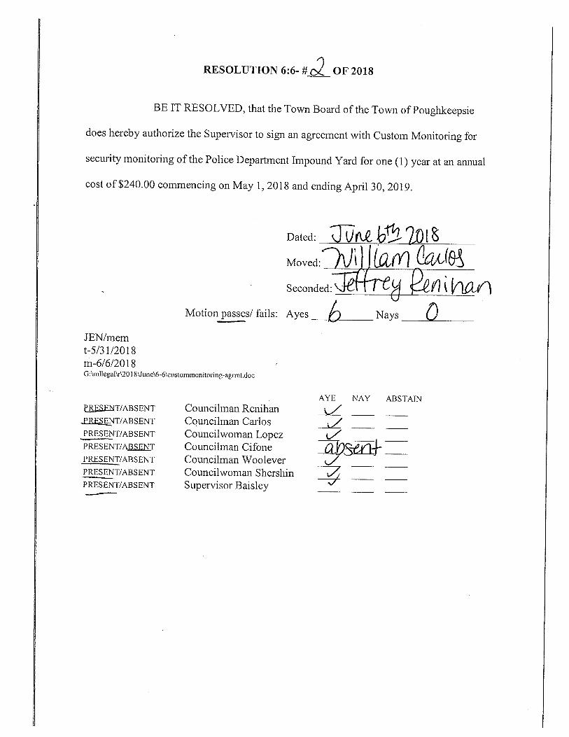
TOWN OF POUGHKEEPSIE TOWN BOARD MEETING JUNE 6, 2018 7:00 P. M. SUMMARY CALL TO ORDER SALUTE TO THE FLAG ROLL CALL OF TOWN BOARD: PRESENT: Supervisor Baisley ABSENT: Councilman Cifone Councilman Renihan Councilman Carlos Councilwoman Lopez Councilman Woolever Councilwoman Shershin Town Clerk Salvatore Town Attorney Nelson 06:06-01 Authorize Supervisor to Sign Dutchess County Drug Task Force Agreement (Chief Spero) CARRIED 6-0 06:06-02 Authorize Supervisor to Sign Custom Monitoring Agreement-Police Impound (Chief Spero) Yard CARRIED 6-0 06:06-03 Assignment Police Officer Wayne D. Ferrine To Detective (Chief Spero) CARRIED 6-0 06:06-04 Resolution Justice Court Amnesty and Compliance (Comptroller Emberger) Project-2018 CARRIED 6-0 06:06-05 Reappoint Phyllis Capone-Zoning Board Alternate (Councilwoman Shershin) CARRIED 6-0 06:06-06 Accept Certificate of Attendance-Carl H. Whitehead (Director Welti) CARRIED 6-0 06:06-07 Accept Resignation of Sarah Taylor-Town Court (Town Clerk Salvatore) CARRIED 6-0 06:06-08 Accept/Authorize Execution Relinquishment and Surrender of Rights/ (Legal) Contract of Sale-VanSiclen Drive CARRIED 6-0
Transcript of TOWN OF POUGHKEEPSIE TOWN BOARD …townofpoughkeepsie.com/clerk/2018/TownBoard20180606.pdf ·...

TOWN OF POUGHKEEPSIE TOWN BOARD MEETING
JUNE 6, 2018 7:00 P. M. SUMMARY
CALL TO ORDER SALUTE TO THE FLAG ROLL CALL OF TOWN BOARD: PRESENT: Supervisor Baisley ABSENT: Councilman Cifone Councilman Renihan
Councilman Carlos Councilwoman Lopez Councilman Woolever Councilwoman Shershin Town Clerk Salvatore Town Attorney Nelson
06:06-01 Authorize Supervisor to Sign Dutchess County Drug Task Force Agreement (Chief Spero) CARRIED 6-0 06:06-02 Authorize Supervisor to Sign Custom Monitoring Agreement-Police Impound (Chief Spero) Yard CARRIED 6-0 06:06-03 Assignment Police Officer Wayne D. Ferrine To Detective (Chief Spero) CARRIED 6-0 06:06-04 Resolution Justice Court Amnesty and Compliance (Comptroller Emberger) Project-2018 CARRIED 6-0 06:06-05 Reappoint Phyllis Capone-Zoning Board Alternate (Councilwoman Shershin) CARRIED 6-0 06:06-06 Accept Certificate of Attendance-Carl H. Whitehead (Director Welti) CARRIED 6-0 06:06-07 Accept Resignation of Sarah Taylor-Town Court (Town Clerk Salvatore) CARRIED 6-0 06:06-08 Accept/Authorize Execution Relinquishment and Surrender of Rights/ (Legal) Contract of Sale-VanSiclen Drive CARRIED 6-0

06:06-09 Set Date for Public Hearing Zoning Map Amendment-Forsons Apartments (Director Welti) Sheafe Road CARRIED 6-0 PUBLIC HEARING TO BE HELD JULY 11, 2018 06:06-10 Establish Open Development Area re Eastdale Project (Attorney Blass) CARRIED 6-0 06:06-11 Set Date for Public Hearing Code Amendment – MacDonnnell Heights (Director Welti) District CARRIED 6-0 PUBLIC HEARING TO BE HELD JULY 11, 2018 06:06-12 Resolution Parkland Dedication-Eastdale -Recommendation (Director Welti) To Planning Board CARRIED 6-0 06:06-13 Declare Lead Agency-Raymond Avenue School (Attorney Blass) CARRIED 6-0 06:06-14 Notification The Following Claims Have Been Referred
(Town Clerk Salvatore) to Legal: 1. Hubbard v. Town REFERRED TO LEGAL
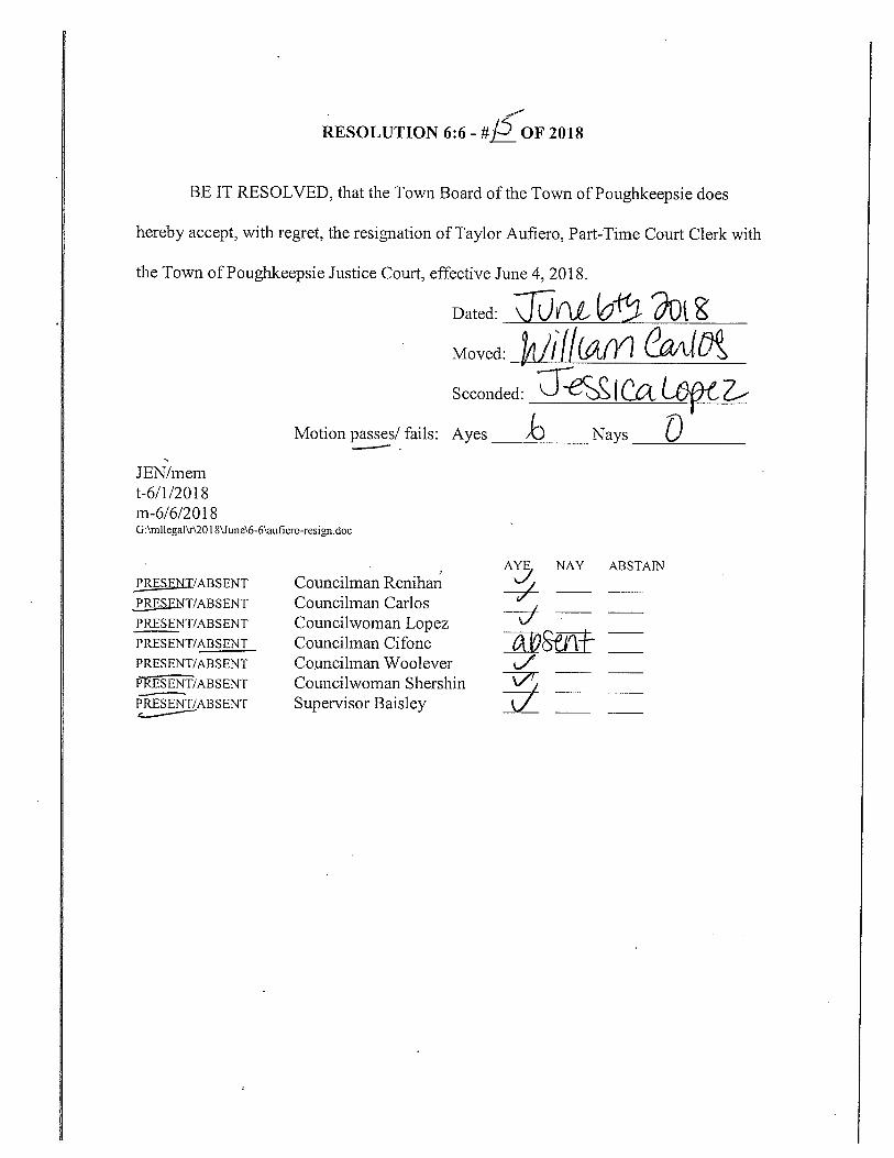
06:06-15 Accept Resignation of Taylor Aufiero-Town Court (Town Clerk Salvatore) CARRIED 6-0 06:06-16 Accept Resignation of Ed LaPerche-Planning Board (Town Clerk Salvatore) CARRIED 6-0 06:06-17 Appoint Brian Powers-Planning Board (Councilman Renihan) CARRIED 6-0 06:06-18 Authorize Special Consents SC1, SC2
(Legal) CARRIED 6-0
PROPOSED ITEMS FOR CONSIDERATION UPON SPECIAL CONSENT 06:06-SC1 Authorize Supervisor to Sign Central Hudson Gas & Electric Street Lighting (Highway Department) Authority Order- N. Grand Avenue CARRIED 6-0 06:06-SC2 Reinstate Darrell Honkala as Detective With The Town Of (Chief Spero) Poughkeepsie police Department CARRIED 6-0

TOWN BOARD ENTERED INTO EXECUTIVE SESSION AT 7:45 P.M.
06:06-ES ADJOURN TO To Enter Executive Session To EXECUTIVE SESSION Consider Following Matters:
1. Matters Subject To Attorney/Client Privilege
TOWN BOARD RETURNED FROM EXECUTIVE SESSION AT 8:50 P.M. TOWN BOARD MEETING ADJOURNED AT 8:51 P.M.


HUDSON VALLEY OFFICE 21 Fox Street
Poughkeepsie, NY 12601 P: 845.454.3980 or 888.539.9073
www.chazencompanies.com
HUDSON VALLEY • CAPITAL DISTRICT • NORTH COUNTRY • WESTCHESTER • NASHVILLE, TN Chazen Engineering, Land Surveying & Landscape Architecture Co., D.P.C. (New York)
Chazen Engineering Consultants, LLC (Tennessee)
May 29, 2018 Chairman Weisman and Planning Board members Town of Poughkeepsie Planning Board 1 Overocker Road Poughkeepsie, New York 12603 Re: Petition of PAZ Management for Zoning Text and Map Amendment at the Former Arthur May School
Located at 25 Raymond Avenue, Town of Poughkeepsie Chazen Project #51657.00
Dear Chairman Weisman and Planning Board Members: On behalf of the Applicant, Arthur May Redevelopment, LLC., please find attached our conceptual plans for the Arthur May School Anchor project. This application is being submitted in parallel with an application to the Town Board to create a new Anchor Project use within the Arlington Town Center Zoning District as it pertains to the subject property.
The current layout has been modified since the Boards last reviewed it. The current layout is now comprised of:
• Two, three-story buildings would be constructed fronting on Raymond Avenue featuring 6,696+/- square feet (discounts 10% for residential access) of ground-floor commercial with 16+/- residential apartments above (“Building A” on the Site Plan) and 6,696+/- square feet (discounts 10% for residential access) of ground-floor commercial with 16+/- residential apartments above (“Building B” on the Site Plan);
• Two, four-story buildings (Buildings C-1 and C-2 on the Site Plan) would be constructed in the southwest corner of the project site. Each 61,920+/- square-foot building would feature 68+/- residential apartments;
• A five-story, 110+/- room hotel building (“Building D” on the Site Plan) would be constructed behind Buildings A and B, in the general footprint of the school, within the central portion of the project site;
• A one-story building featuring 4,950 square feet of commercial space would also front on Raymond Avenue, and would be located in the southeast corner of the project site (“Building E”);
• A two-story clubhouse building would be located at the back of the project site along the western boundary to serve as an amenity to the residents. The first floor would be clubhouse and the second-floor offices.
At this time, we are submitting the Conceptual Site Plan to the Planning Board to introduce the revised layout and discuss the proposed development at the June 21 meeting. We are concurrently submitting to the Town Board and asking the Town Board to recirculate for Lead Agency. After receiving the Planning Board’s feedback

Chairman Weisman May 28, 2018 Page 2 of 2
Z:\projects\51600-51699\51657 Reckess\Correspondence\Letters\20180523PB.docx
on the conceptual plans, it is our intent to make a full site plan submission on June 25 for the July 19 Planning Board meeting.
Please find the following included with this submission:
• Fourteen (14) copies of the proposed conceptual site plan full size • Fourteen (14) copies of the proposed conceptual site plan 11*17 • Fourteen (14) copies of the Zoning Text Amendment • Fourteen (14) copies of the Full EAF
Thank you for your attention to this matter.
Sincerely,
Stuart F. Mesinger, AICP Vice President, Land Development
cc: Supervisor Baisley Town of Poughkeepsie Town Board Ron Blass Eric Hollman Arthur May Redevelopment, LLC File

HUDSON VALLEY OFFICE 21 Fox Street
Poughkeepsie, NY 12601 P: 845.454.3980 or 888.539.9073
www.chazencompanies.com
HUDSON VALLEY • CAPITAL DISTRICT • NORTH COUNTRY • WESTCHESTER • NASHVILLE, TN Chazen Engineering, Land Surveying & Landscape Architecture Co., D.P.C. (New York)
Chazen Engineering Consultants, LLC (Tennessee)
May 29, 2018 Supervisor Baisley and Town Board members Town of Poughkeepsie Town Board 1 Overocker Road Poughkeepsie, New York 12603 Re: Petition of PAZ Management for Zoning Text and Map Amendment at the Former Arthur May School
Located at 25 Raymond Avenue, Town of Poughkeepsie Chazen Project #51657.00
Dear Supervisor Baisley and Town Board Members: On behalf of the Applicant, Arthur May Redevelopment, LLC., please find included with this submission: • Three (3) copies of the proposed conceptual site plan • Three (3) copies of the Zoning Text Amendment • Three (3) copies of the Full EAF We are submitting to the Town Board to be placed on the June 6 agenda. We are requesting the Town Board declare their intent to serve as Lead Agency and circulate to the interested and involved agencies. This material is being submitted in parallel with an application to the Planning Board to be placed on the June 21 Planning Board agenda.
The current layout has been modified since the Boards last reviewed it. The current layout is now comprised of:
• Two, three-story buildings would be constructed fronting on Raymond Avenue featuring 6,696+/- square feet (discounts 10% for residential access) of ground-floor commercial with 16+/- residential apartments above (“Building A” on the Site Plan) and 6,696+/- square feet (discounts 10% for residential access) of ground-floor commercial with 16+/- residential apartments above (“Building B” on the Site Plan);
• Two, four-story buildings (Buildings C-1 and C-2 on the Site Plan) would be constructed in the southwest corner of the project site. Each 61,920+/- square-foot building would feature 68+/- residential apartments;
• A five-story, 110+/- room hotel building (“Building D” on the Site Plan) would be constructed behind Buildings A and B, in the general footprint of the school, within the central portion of the project site;
• A one-story building featuring 4,950 square feet of commercial space would also front on Raymond Avenue, and would be located in the southeast corner of the project site (“Building E”);

Supervisor Baisley May 29, 2018 Page 2 of 2
Z:\projects\51600-51699\51657 Reckess\Correspondence\Letters\20180523TB.docx
• A two-story clubhouse building would be located at the back of the project site along the western boundary to serve as an amenity to the residents. The first floor would be clubhouse and the second-floor offices.
We look forward to discussing this revised site plan with the Board at their upcoming meeting.
Thank you for your attention to this matter.
Sincerely,
Stuart F. Mesinger, AICP Vice President, Land Development
cc: Town of Poughkeepsie Town Board Ron Blass Eric Hollman Arthur May Redevelopment, LLC File

©2018 The Chazen Companies
Anchor Project Zoning Text Amendment
and Arthur May School Property Redevelopment
Full Environmental Assessment Form Town of Poughkeepsie
Dutchess County, New York
August 16, 2017
Revised May 29, 2018
Applicant: Arthur May Redevelopment LLC


Anchor Project Zoning Text Amendment and Arthur May School Property Redevelopment Full Environmental Assessment Form Part 1 Page i
The Chazen Companies August 16, 2017
Revised May 29, 2018
TABLE OF CONTENTS
1.0 PROJECT DESCRIPTION ........................................................................................................................ 2
1.1 Introduction .............................................................................................................................. 2
1.2 Zoning Text Amendment ........................................................................................................... 4
1.3 Amendment Procedure ............................................................................................................. 5
1.4 Site Plan, Special Use Permit and Subdivision Review Approval .............................................. 6
1.5 Additional Approvals ................................................................................................................. 6
2.0 LAND USE, ZONING AND PUBLIC POLICY ............................................................................................ 6
2.1 Land Use .................................................................................................................................... 6
2.2 Zoning ........................................................................................................................................ 8
2.3 Public Policy ............................................................................................................................ 16
3.0 COMMUNITY SERVICES ..................................................................................................................... 20
3.1 Recreational Resources ........................................................................................................... 20
3.2 Educational Resources ............................................................................................................ 20
3.3 Library Resources .................................................................................................................... 21
3.4 Day Care Centers ..................................................................................................................... 22
3.5 Transit Facilities ....................................................................................................................... 22
3.6 Emergency and Police Services ............................................................................................... 23
4.0 UTILITIES ............................................................................................................................................ 23
5.0 TRAFFIC AND TRANSPORTATION ...................................................................................................... 25
5.1 Scope of Study ......................................................................................................................... 25
6.0 SOLID WASTE .................................................................................................................................... 25
7.0 HAZARDOUS MATERIALS .................................................................................................................. 28
8.0 SOILS, WATER RESOURCES, AND STORMWATER .............................................................................. 29
8.1 Soils ......................................................................................................................................... 29
8.2 Water Resources ..................................................................................................................... 30
8.3 Stormwater ............................................................................................................................. 30
9.0 VEGETATION AND WILDLIFE ............................................................................................................. 30
10.0 HISTORIC AND ARCHEOLOGICAL RESOURCES .................................................................................. 30
LIST OF TABLES
Table 1: Proposed Project Details ................................................................................................................. 3 Table 2: Development Scenarios under Zoning ............................................................................................ 7 Table 3: Zoning Comparison Table .............................................................................................................. 11 Table 4: Project Site – Residential Buildout under Zoning .......................................................................... 14

Anchor Project Zoning Text Amendment and Arthur May School Property Redevelopment Full Environmental Assessment Form Part 1 Page ii
The Chazen Companies August 16, 2017
Revised May 29, 2018
Table 5: Minimum Required Off‐Street Parking Spaces – Anchor Projects ................................................ 14 Table 6: Minimum Required Off‐Street Parking Spaces per Zoning ........................................................... 16 Table 7: School‐Age Children in Public Schools .......................................................................................... 21 Table 8: Water Usage and Wastewater Generation ................................................................................... 24 Table 9: Residential Demographics ............................................................................................................. 26 Table 10: Solid Waste .................................................................................................................................. 28 Table 11: Characteristics of Soil Types within Project Area ........................................................................ 29
FULL ENVIRONMENTAL ASSESSMENT FORM PART 1 FORM FIGURES
Figure 1: USGS Location Map Figure 2: Orthophoto Tax Map Figure 3: Zoning Map Figure 4: Land Use Map Figure 5: Soils Map Figure 6: Wetland and Stream Map Figure 7: NYSDEC Environmental Resource Map Figure 8: NYSOPRHP Cultural Resource Information System (CRIS) Map Figure 9: Scenic and Aesthetic Resources Map
ATTACHMENTS
Attachment A: Draft Zoning Text Amendment Attachment B: New York State Department of Environmental Conservation Spills Data Attachment C: New York State Department of Environmental Conservation, New York Natural
Heritage Program Letter dated August 16, 2017 Attachment D: New York State Office of Parks, Recreation and Historic Preservation
Determination of Eligibility for the former Arthur May School Building

Anchor Project Zoning Text Amendment and Arthur May School Property Redevelopment Full Environmental Assessment Form Part 1
The Chazen Companies August 16, 2017
Revised May 29, 2018
PROJECT NARRATIVE


Anchor Project Zoning Text Amendment and Arthur May School Property Redevelopment Full Environmental Assessment Form Part 1 Page 2
The Chazen Companies August 16, 2017
Revised May 29, 2018
1.0 PROJECT DESCRIPTION
1.1 Introduction
The Applicant, Arthur May Redevelopment LLC, seeks Town Board approval for a Town of Poughkeepsie Zoning Ordinance amendment that would result in designation of a new Anchor Project use in the Arlington Town Center (ATC) District. The amendment is proposed to allow "Anchor Projects" that can serve as a catalyst for increased investment in the Town of Poughkeepsie in the ATC District. An Anchor Project contributes to the economic development of the immediate neighborhood and greater community by adding goods, services, and residences within a walkable community environment thus supporting the economic development goals of the Comprehensive Plan. Upon the designation of the Anchor Project on tax lots 134689‐6161‐12‐755735 and 134689‐6161‐12‐784726 (located at 25 and 31 Raymond Avenue, respectively) in the ATC Zone, the Applicant seeks site plan approval to develop a mixed‐use development project including 168+/‐ apartments with clubhouse amenities, 86,592+/‐ square feet of commercial space (110 room hotel and specialty retail and restaurants), open area (including an outdoor seating), and 279 parking spaces ("Arthur May School Property Redevelopment") at this location (see Figures 1, 2 and 3). The apartments are proposed to include a mix of sizes, including approximately 24 studio units, 104 one‐bedroom units, and 40 two‐bedroom units. The development is anticipated to include seven buildings, ranging from three‐to‐five stories, and featuring aesthetically pleasing and contextual architecture as described as follows:
Two, three‐story buildings would be constructed fronting on Raymond Avenue featuring 6,696+/‐ square feet of ground‐floor commercial with 16+/‐ residential apartments above (“Building A” on the Site Plan) and 6,696 +/‐ square feet of ground‐floor commercial with 16+/‐ residential apartments above (“Building B” on the Site Plan);
Two, four‐story buildings (Buildings C‐1 and C‐2 on the Site Plan) would be constructed in the southwest corner of the project site. Each 61,920‐square‐foot building would feature 68 residential apartments;
A five‐story, 110+/‐ room hotel building (“Building D” on the Site Plan) would be constructed behind Buildings A and B within the central portion of the project site;
A one‐story building featuring 4,950 square feet of commercial space would also front on Raymond Avenue, and would be located in the southeast corner of the project site (“Building E”);
A 5,000 square‐foot clubhouse, including leasing and maintenance office space, would be located at the back of the project site along the western boundary to serve as an amenity to the residents;
In addition, 279+/‐ surface parking spaces would be provided;
Access to the site would be via an existing access entry located opposite Davis Avenue on Raymond Avenue; and
The former school would be demolished as part of the proposed action.

Anchor Project Zoning Text Amendment and Arthur May School Property Redevelopment Full Environmental Assessment Form Part 1 Page 3
The Chazen Companies August 16, 2017
Revised May 29, 2018
Table 1 summarizes the elements of the proposed development:
Table 1: Proposed Project Details
Arthur May School Property Redevelopment
Proposed Development
Building Height
Land Use Total Commercial Square Feet
Total Number of Dwelling Units
Total Accessory Square Feet
Total Number of Parking Spaces
Building A 3 stories
Residential N/A 16 N/A N/A
Commercial 6,696 N/A N/A N/A
Building B 3 stories
Residential N/A 16 N/A N/A
Commercial 6,696 N/A N/A N/A
Building C ‐ 1 4 stories
Residential N/A 68 N/A N/A
Building C ‐ 2 4 stories
Residential N/A 68 N/A N/A
Building D 5 stories
Commercial (110‐room Hotel)
68,250 N/A N/A N/A
Building E 1 story Commercial 4,950 N/A N/A N/A
Clubhouse 2 stories
Accessory Clubhouse and Maintenance Office
N/A N/A 5,000 N/A
Stand‐alone Parking
N/A Surface Parking
N/A N/A N/A 279
Totals 1 ‐ 5 stories
Mixed Residential and Commercial Development
86,592 168 2,500 279
The 6.8‐acre, Raymond Avenue site is currently owned by the Arlington Central School District and is occupied by the former Arthur May School, which would be demolished as part of the proposed action.
The Arthur May School Property Redevelopment is located in the Arlington Town Center area of the Town of Poughkeepsie at the intersection of Raymond Avenue (NYS Route 376) and Haight Avenue (US Route 44). This area is home to Vassar College and a mixed‐use community that offers business, cultural and community uses combined with residential and institutional uses. Raymond Avenue has recently undergone design improvements by the New York State Department of Transportation (NYSDOT) that have enhanced the pedestrian accessibility to the area, and made parking easier for visitors arriving by vehicle. The area located within 500 feet of the project site is generally surrounded by commercial development to the east and residential development to the west. Collegeview Towers, a nine‐story residential building, is located immediately south of the former Arthur May Elementary School, and Vassar
Anchor Project Zoning Text Amendment and Arthur May School Property Redevelopment Full Environmental Assessment Form Part 1 Page 4
The Chazen Companies August 16, 2017
Revised May 29, 2018
College is located nearby. Raymond Avenue is largely characterized by commercial and institutional uses. The site is currently zoned as part of the Arlington Town Center (ATC) Zoning District.
The project site is located within the Arlington Business Improvement District (ABID) which states as its vision for Arlington, “to continue creating a vibrant business district steeped in history. The fundamental goal of our thriving commercial district is to attract a wide variety of retail shops, restaurants, and convenience‐related businesses to be enjoyed by community members in a safe, beautiful environment.”1
The Town of Poughkeepsie conducted a reconnaissance‐level historic resource survey update in September 2011. The project site was identified in the survey as appearing eligible for designation on the State and National Registers of Historic Places. Initially, the building was found not eligible for designation by New York State Office of Parks, Recreation and Historic Preservation (NYSOPRHP); however, subsequently NYSOPRHP determined that the building is eligible for designation (see Attachment D). The building remains eligible to date, and has not been listed on the National or State Register for Historic Places.
The Town of Poughkeepsie Comprehensive Plan, adopted in 2007, examines Arlington Town Center in Section III, Centers and Greenspace Plan. The Plan describes the Raymond Avenue area between Vassar College and Main Street as the, “historic heart of Poughkeepsie’s Town Center, by far the best place in Town to reinforce a walkable neighborhood and main street business district, integrated with the college and featuring smaller‐scale shops, restaurants with outdoor dining, and into‐the‐evening activities.”2 A discussion of Arlington Town Center states that the Arlington core has “little or no room to grow”, which is described as necessary to maintain a stronger base of commercial and residential diversity.3 As a solution, the Plan recommends infill development, “that is compatible with the existing neighborhood, but also provides a more diverse and energetic commercial core with opportunities for new buildings and businesses.”4
The proposed zoning text amendment proposes to designate the Anchor Project use as part of the ATC District to allow for transformative mixed‐use developments that may act as a catalyst for economic development in the Town of Poughkeepsie. The Arthur May School Property Redevelopment is proposed to bring 168+/‐ apartments with clubhouse amenities, a 110‐room hotel, and 18,342+/‐ square feet of commercial space, which alongside the existing residences and specialty and boutique stores already occupying Raymond Avenue would invigorate development along and near the Raymond Avenue corridor. New landscaping would be added to enhance the aesthetics of the site. The Arthur May School Property Redevelopment would revitalize Arlington Town Center with a new mixed residential and commercial development featuring high‐quality architecture.
1.2 Zoning Text Amendment
The proposed zoning text amendment (see Attachment A) would:
a. Add a definition for “Anchor Project” at §210‐9 of the Zoning Ordinance.
1 Arlington Business Improvement District. http://arlingtonhasit.org/about/mission‐vision/. 2 Poughkeepsie Town Plan, September 26, 2007, page 61. 3 Poughkeepsie Town Plan, September 26, 2007, page 62. 4 Poughkeepsie Town Plan, September 26, 2007, page 62.

Anchor Project Zoning Text Amendment and Arthur May School Property Redevelopment Full Environmental Assessment Form Part 1 Page 5
The Chazen Companies August 16, 2017
Revised May 29, 2018
b. Amend §210‐22(B), Arlington Town Center (ATC) District to add Anchor Projects as a permitted use, subject to §210‐51.1.
c. Add a new section, §210‐51.1, providing special provisions, as well as use and bulk regulations, for Anchor Projects.
An Anchor Project is defined as: A project comprised of a mix of uses that may include but is not limited to commercial, residential and institutional uses. Anchor Projects contain sufficient residential density and supporting commercial uses to promote business activity both on and off‐site, and that may act as a catalyst for increased investment on adjoining and nearby properties that may be underutilized or blighted. Anchor uses include provisions for plazas and/or green spaces and promote a walkable environment.
Anchor Projects allow residential, commercial, institutional, and mixed‐uses similar to those currently allowed in the ATC District. The proposed Anchor Project amendment will allow as‐of‐right some new uses and uses that are currently allowed by special permit only under existing zoning. In addition, some requirements of permitted uses would be modified. Finally, not all of the permitted uses allowed in the ATC District would be allowed in an Anchor Project use. To support their ability to serve as a catalyst for increased investment in the Town of Poughkeepsie, the proposed Anchor Project use allows an increased residential density, lot coverage, lot width, lot frontage and building height; and reduces the required front and rear yards and the maximum impervious surface compared to the rest of the ATC District. During site plan and subdivision review, and at the discretion of the Planning Board, design standards will be applied for Anchor Project uses as proposed in § 210‐51.1.
Shared parking is allowed for Anchor Projects and cumulative parking requirements may be reduced at the discretion of the Planning Board where it can be determined that the peak requirements of the different land uses requiring parking occur at different times. In the event a lower parking total is approved by the Planning Board, no future change in use at the project site would be allowed without further evidence that the available parking will adequately provide enough parking for all uses.
The proposed Arthur May School Property Redevelopment would be consistent with the purpose of the amendments. The project is proposed to include a mixed‐use development project including 168+/‐ apartments, 18,342+/‐ square feet of commercial space, a 110‐room hotel, open area, and 279 parking spaces on a 6.8‐acre site. As such, the project would introduce new goods and services to the Arlington Town Center area, while introducing new residential development to support such uses.
1.3 Amendment Procedure
Following receipt of the petition and other required information, including the FEAF Part 1, the Town Board will refer the application to the Planning Board and to the County Planning Department for review and recommendation. Within 90 days of receipt of the application from the Town Board, the Planning Board will make a recommendation to the Town Board as to whether, in the opinion of the Planning Board, the Zoning Ordinance should be amended to allow Anchor Projects. Within 62 days of receipt of the Planning Board's recommendation, the Town Board will hold a public hearing on the proposed amendment. Within 62 days of the close of the public hearing, the Town Board will act to approve or disapprove the proposed amendment.

Anchor Project Zoning Text Amendment and Arthur May School Property Redevelopment Full Environmental Assessment Form Part 1 Page 6
The Chazen Companies August 16, 2017
Revised May 29, 2018
1.4 Site Plan, Special Use Permit and Subdivision Review Approval
Anchor Project uses are required to undergo site plan and may undergo special use permit and subdivision review. During these reviews, the Planning Board may apply additional terms and conditions on the project.
The proposed Arthur May School Property Redevelopment would undergo site plan review upon approval of the zoning text amendment. No subdivision or special permit approval is currently proposed, but subdivision and special permit approval may be sought in the future.
1.5 Additional Approvals
The project site is proposed to be served by municipal water and sewer, and the Arthur May School Property Redevelopment is required to obtain approval from the Town of Poughkeepsie Sewer and Water Department and the Dutchess County Department of Health. Utility work will require approval from the Town of Poughkeepsie Highway Department and NYSDOT for a Highway Work Permit. The project development will require ground disturbance in excess of one acre; therefore, a Stormwater Pollution Prevention Plan will be prepared pursuant to New York State Department of Environmental Coordination (NYSDEC) State Pollutant Discharge Elimination System (SPDES) General Permit for Stormwater Discharges from Construction Activity (GP‐0‐15‐002). NYSOPRHP will be consulted for their determination of the proposed project’s potential to affect historic and cultural resources. There are no wetlands or streams located on site.
2.0 LAND USE, ZONING AND PUBLIC POLICY
2.1 Land Use
The project site is occupied by the former Arthur May School, which has remained vacant since 2014. The project site is currently zoned as part of the ATC Zoning District.
The existing land use within 500 feet of the project site is generally comprised of a mix of residential and commercial uses, with some institutional uses, notably Vassar College, a post office, and Arlington Reformed Church (see Figure 4). Raymond Avenue is generally developed with one‐to‐two‐story buildings containing small boutique or specialty stores, with some residences located above ground‐floor uses. Collegeview Towers, a nine‐story residential building, is located immediately south of the former Arthur May Elementary School, and Vassar College is located nearby. The Arlington Town Center area extends north across Haight Avenue to Main Street, which is a developed commercial corridor.
The Poughkeepsie train station is located on Main Street in the City of Poughkeepsie, and is served by both Amtrak and Metro‐North providing service to Grand Central Station in New York City. The proposed Arthur May School Property Redevelopment would have access to the City of Poughkeepsie Main Street and Shopper’s Special Bus Routes, which travel along Raymond Avenue providing access to and from the site. The Dutchess County Department of Mass Transit operates the Dutchess County LOOP Bus System that provides a variety of bus services throughout Dutchess County, including the L Bus Route that has stops on Raymond Avenue at Fulton and Raymond Avenue at Main Street.
The Dutchess Rail Trail and several Town of Poughkeepsie facilities (Carriage Hill Park, Crestwood Park, Overocker Park, and Red Oaks Mill Park) are located within a mile. The Walkway Over the Hudson and privately‐owned Vassar Golf Course and Vassar Farm and Ecological Preserve are also located nearby.

Anchor Project Zoning Text Amendment and Arthur May School Property Redevelopment Full Environmental Assessment Form Part 1 Page 7
The Chazen Companies August 16, 2017
Revised May 29, 2018
The existing ATC Zoning District allows mixed‐use development on medium and large‐sized parcels (greater than 5,000 square feet) in buildings of five stories or less. Residential density may be no greater than eight units per acre, except when dwelling units are developed above a non‐residential use. Commercial uses are meant to complement the existing residential neighborhood in the form of general goods and services. Under existing ATC Zoning, the project site could be redeveloped into a mixed‐use development featuring mixed residential and commercial buildings facing onto Raymond Avenue, with more residential development behind. Based on the zoning, approximately 71 dwelling units (approximately 126 new residents) and approximately 14,413 square feet of commercial development could be developed in buildings reaching up to five stories or 75 feet by special permit. Based on the number of units, a typical development scenario would likely include a mix of studios, one‐bedroom and two‐bedroom units (see Table 2). Commercial development would likely be comprised of retail featuring typical goods and services.
Pursuant to the proposed zoning text amendment, the Arthur May School Property Redevelopment would include 168+/‐ apartments, 18,342+/‐ square feet of commercial space, a 110‐room hotel, open area, and 279 parking spaces (see Table 2). The apartments are proposed to include a mix of studios, one‐bedroom and two‐bedroom units. The commercial development is anticipated to include specialty retail and restaurants. The development will consist of seven buildings (including three buildings fronting on Raymond Avenue), ranging one‐to‐five stories, and featuring aesthetically pleasing and contextual architecture.
Table 2: Development Scenarios under Zoning
Zoning Development Scenario
Arlington Town Center (ATC) Zoning District – Typical Development
71 Dwelling Units
126 New Residents
14,413 SF Commercial
Up to 5 stories tall
Arthur May School Property Redevelopment
168* Dwelling Units
313 New Residents
18,342 SF Commercial
110 Hotel Rooms
Up to 5 stories tall * Each hotel unit counts as 1/10th of a dwelling unit for the purposes of the overall residential density calculation. Therefore, for density purposes, the total dwelling units proposed is 179. This incremental increase does not impact the parking as parking for hotels is stipulated separately from residential dwelling units.
Under the proposed zoning text amendment, the proposed Arthur May School Property Redevelopment would include approximately 97 more dwelling units with approximately 187 additional new residents; more than what is permitted under current zoning. The proposed zoning allows greater commercial development on the project site. In addition, the zoning text amendment allows an increased lot coverage, lot width, lot frontage, and reduces the required rear yard and maximum impervious surface. Similar to the ATC District, the Planning Board will apply design standards during site plan, special use permit and subdivision review process as stipulated in § 210‐51.1.
Shared parking is encouraged in the proposed zoning text amendment similar to the ATC District. Shared and cumulative parking requirements may be reduced at the discretion of the Planning Board where it can be determined that the peak requirements of the different land uses requiring parking occur at different times. In the event a lower parking total is approved by the Planning Board, no future change in

Anchor Project Zoning Text Amendment and Arthur May School Property Redevelopment Full Environmental Assessment Form Part 1 Page 8
The Chazen Companies August 16, 2017
Revised May 29, 2018
uses at the project site would be allowed without further evidence that the available parking will adequately provide enough parking for all uses.
The proposed zoning text amendment and the Arthur May School Property Redevelopment would revitalize Arlington Town Center by transforming the landscape with a new mixed residential and commercial development. The proposed Arthur May School Property Redevelopment would include approximately 97 more dwelling units with approximately 187 additional new residents above what is currently allowed under current zoning within a mixed‐use development that features specialty retail and restaurants. The proposed zoning text amendment and the Arthur May School Property Redevelopment are not anticipated to negatively impact the land use character of the neighborhood as the addition of new residents and proposed commercial uses are not substantially different than what would be permitted under existing zoning.
2.2 Zoning
Purpose of Amendment
The ATC District’s purpose is to promote the following:
(1) Promote a mix of commercial and residential uses. (2) Promote the prominent positioning of civic buildings and central green spaces in order to
enhance community identity and public interaction. (3) Promote pedestrian activity through a safe and walkable environment. (4) Minimize the visual impact of the automobile by managing the placement and
screening/landscaping of parking areas. (5) Create an interconnected street system for both pedestrian and vehicular traffic. (6) Encourage the development of both on‐street parking and shared parking areas between
nearby uses. (7) Protect important natural and historic features. (8) Encourage the redevelopment and reuse of existing structures.
The purpose of the proposed amendment is to allow Anchor Projects in the ATC District. Anchor Projects are defined as:
A project comprised of a mix of uses that may include but is not limited to commercial, residential and institutional uses. Anchor Projects contain sufficient residential density and supporting commercial uses to promote business activity both on and off‐site, and that may act as a catalyst for increased investment on adjoining and nearby properties that may be underutilized or blighted. Anchor uses include provisions for plazas and/or green spaces and promote a walkable environment.
The purpose of Anchor Projects is stated in the proposed zoning text as follows:
The center districts (e.g. ATC, FC. SHC, MHC, and SPC) typically contain a unique blend of business and complementary residential land uses. The center districts also have access to existing municipal water supply and sewage collection and treatment facilities, and a dependable road network capable of supporting high volume uses and densities. Within the center districts an Anchor Project can serve as a catalyst for increased investment on adjoining and nearby properties that may be underutilized or blighted, especially along and near the major roads serving the area.

Anchor Project Zoning Text Amendment and Arthur May School Property Redevelopment Full Environmental Assessment Form Part 1 Page 9
The Chazen Companies August 16, 2017
Revised May 29, 2018
An Anchor Project contributes to the economic development of the neighborhood and greater community by adding goods, services, and housing. An Anchor Project includes provisions for plazas and/or green spaces, a walkable environment, thus supporting the economic development goals of the Town Plan.
Anchor Projects are consistent with the goals of the ATC District. Anchor Projects allow development at a higher residential density than the ATC in order to invigorate and catalyze development along and near the Raymond Avenue corridor. Anchor Projects promote development that places a critical mass of new residents in close proximity to existing and future commercial uses thereby promoting pedestrian activity. Anchor Projects encourage shared parking and require landscaping to reduce the visual impact of large surface parking areas. The proposed Arthur May School Property Redevelopment is consistent with the purposes of the ATC District as it introduces a mixed development that includes open areas and attractive architecture thereby enhancing community identity and public interaction while contributing to the economic development of the Arlington Town Center neighborhood. Allowable Uses As shown in Table 3, Anchor Projects would allow residential, commercial, institutional, and mixed‐uses similar to those currently allowed under existing zoning in the ATC District. The proposed Anchor Project amendment will allow as‐of‐right some new uses and uses that are currently allowed by special permit only under existing zoning. In addition, some requirements of permitted uses would be modified. Finally, not all of the permitted uses allowed in the ATC District would be allowed in an Anchor Project use. The new uses that would be allowed as‐of‐right or by special permit in an Anchor Project are presented below. Anchor Project – Additional Permitted As‐Of‐Right Uses:
Anchor Projects, which are defined as a mix of uses identified in § 210‐51.1, including but not limited to residential, institutional, and commercial uses.
Cabaret, nightclub.
Club, health and fitness.
Day care, subject to § 210‐65, which establishes supplementary regulations for day‐care facilities.
Hotels and motels. Subject to § 210‐75, which establishes supplementary regulations for hotels and motels.
Indoor recreation.
Inns. Subject to § 210‐77, except § 210‐77 (A), (B) and (H) shall not apply. (A) established minimum required lot area, which will be superseded by the requirements of § 210‐51.1. (B) establishes a maximum number of guest rooms, which will be superseded by the bulk and dimensional requirements of § 210‐51.1. (H) establishes parking requirements for inns. The parking requirements for Anchor Projects are regulated according to § 210‐51.1, which will require two spaces per 1,000 SF of floor area contained within an inn. Therefore, § 210‐77 (H) will not apply to these uses in an Anchor Project.
Multi‐family dwellings within multi‐story structures, and mixed residential and non‐residential uses within multi‐story structures.
Anchor Project – Additional Special Permitted Uses:
No additional special permitted uses.

Anchor Project Zoning Text Amendment and Arthur May School Property Redevelopment Full Environmental Assessment Form Part 1 Page 10
The Chazen Companies August 16, 2017
Revised May 29, 2018
Anchor Project – Additional Accessory Uses:
Facilities for outdoor recreation
Outdoor restaurant dining facilities, subject to § 210‐102, except § 210‐102(B)(5) and (B)(7) shall
not apply. § 210‐102 establishes supplementary regulations for Outdoor restaurant dining
facilities. § 210‐102 (B)(5) and (B)(7) establishes parking and bulk and dimensional requirements
for this use. Parking requirements will be regulated by § 210‐51.1, which will require two spaces
per 1,000 SF of floor area contained within outdoor restaurant dining facilities. The bulk and
dimensional requirements for this use will be regulated by § 210‐51.1.


Anchor Project Zoning Text Amendment and Arthur May School Property Redevelopment Full Environmental Assessment Form Part 1 Page 11
The Chazen Companies August 16, 2017
Revised May 29, 2018
Table 3: Zoning Comparison Table
Arlington Town Center (ATC) Zoning District Proposed Anchor Project Use
Purpose The ATC district recognizes the Arlington area as a unique blend of residential and business land uses in close proximity to Vassar College. Land uses include established single‐family, two‐family, and multifamily development in close proximity to neighborhood‐scale service and retail businesses within the Arlington area. An appropriate mixture of land uses is permitted; nonresidential uses that complement residential uses are encouraged. In addition, this district serves the following specific purposes:
(1) Promote a mix of commercial and residential uses.
(2) Promote the prominent positioning of civic buildings and central green spaces in order to enhance community identity and public interaction.
(3) Promote pedestrian activity through a safe and walkable environment.
(4) Minimize the visual impact of the automobile by managing the placement and screening/landscaping of parking areas.
(5) Create an interconnected street system for both pedestrian and vehicular traffic.
(6) Encourage the development of both on‐street parking and shared parking areas between nearby uses.
(7) Protect important natural and historic features.
(8) Encourage the redevelopment and reuse of existing structures.
The center districts (e.g. ATC, FC. SHC, MHC, and SPC) typically contain a unique blend of business and complementary residential land uses. The center districts also have access to existing municipal water supply and sewage collection and treatment facilities, and a dependable road network capable of supporting high volume uses and densities. Within the center districts an Anchor Project can serve as a catalyst for increased investment on adjoining and nearby properties that may be underutilized or blighted, especially along and near the major roads serving the area. An Anchor Project contributes to the economic development of the neighborhood and greater community by adding goods, services, and housing and includes provisions for plazas and/or green spaces, a walkable environment, thus supporting the economic development goals of the Town Plan.
Permitted Uses1 Permitted Uses: Anchor Projects 2,3, Art galleries, Bank and financial services, Bakeries, Bed‐and‐breakfasts, Boutiques, Delicatessens, Dwellings (two‐family), Dwellings (single‐family), Family day‐care homes, Laundries, Laundromats, Libraries, Museums, Offices, Personal service businesses (no drive in or drive through), Places of religious worship, Retail business (no drive in or drive through), Service business (no drive in or drive through), Restaurants (no drive in or drive through), Supermarkets, Theaters
Special Permitted Uses: Accessory apartment within a single‐family dwelling; Adaptive reuse of existing residential structure for nonresidential use; Bed‐and‐Breakfast, Clinics, Day‐care, nursery school, school‐age child‐care facilities, Funeral home, Home occupations, Hotel and motel, Inn, Multifamily dwellings, new construction, and mixed residential and nonresidential uses within multistory structures as part of a unified development on a single lot, Motor vehicle accessory sales
Accessory Uses: Accessory buildings and structures, Outdoor restaurant dining areas, Swimming pool, Temporary Buildings for construction purposes; Sidewalk seating and tables for patrons
Additional or Modified Permitted Uses: Cabaret/nightclub, Health and fitness club, Day care4, Hotel and motel5, Indoor recreation, Inns6, Multi‐family dwellings within multi‐story structures, and mixed residential and non‐residential uses within multi‐story structures Deleted Permitted Uses: Dwellings (two‐family), Dwellings (single‐family)
Additional or Modified Special Permitted Uses: None
Additional or Modified Accessory Uses: Facilities for outdoor recreation, Outdoor restaurant dining facilities7

Anchor Project Zoning Text Amendment and Arthur May School Property Redevelopment Full Environmental Assessment Form Part 1 Page 12
The Chazen Companies August 16, 2017
Revised May 29, 2018
Arlington Town Center (ATC) Zoning District Proposed Anchor Project Use
Minimum Lot Area
5,000 SF 5 acres
Maximum Permitted Density
Maximum Lot Coverage: 60%;
Maximum Residential Density: 6 dwelling units/acre; 8 dwelling units/acre by Special Permit; dwelling units located above nonresidential uses not counted in some circumstances8
Maximum Lot Coverage: 80%;
Maximum Residential Density: 40 dwelling units/acre9
Bulk and Dimensional Requirements
Minimum Lot Frontage: 30 FT
Minimum Lot Width: 30 FT
Minimum Front Yard: 5 FT10
Minimum Side Yard: 0 FT
Minimum Rear Yard: 20 FT
Maximum Impervious Surface: 95%
Minimum Lot Frontage: 300 FT
Minimum Lot Width: 300 FT
Minimum Front Yard: 0 FT
Minimum Side Yard: 0 FT
Minimum Rear Yard: 0 FT
Maximum Impervious Surface: 90%
Maximum Height Permitted
45 FT or 3 stories, and up to 75 FT or 5 stories by special use permit 105 FT or 7 Stories
Minimum Parking Required
The number of off‐street parking spaces provided shall be the minimum necessary to adequately serve the intended use.
Hotel Rooms: 1.0 space/hotel room
Studios: 1.0 spaces per bedroom; All other residential uses: 0.75 space per bedroom; All other uses: 2.0 spaces/1,000 SF of floor area
1 Some uses subject to supplementary regulations. 2 Anchor Projects would be added to § 210‐22(B) as a permitted use in the ATC District. 3 An Anchor Project is defined as a mix of uses identified in § 210‐51.1, including but not limited to residential, institutional, and commercial uses. 4 § 210‐65 establishes supplementary regulations for day‐care facilities. 5 § 210‐75 establishes supplementary regulations for hotels and motels. 6 § 210‐77 establishes supplementary regulations for inns, except § 210‐77 (A), (B) and (H) shall not apply. (A) established minimum required lot area, which will be superseded by the requirements of § 210‐51.1. (B) establishes a maximum number of guest rooms, which will be superseded by the bulk and dimensional requirements of § 210‐51.1. (H) establishes parking requirements for inns. The parking requirements for Anchor Projects are regulated according to § 210‐51.1, which will require two spaces per 1,000 SF of floor area contained within an inn. Therefore, § 210‐77 (H) will not apply to these uses in an Anchor Project. 7 § 210‐102 establishes supplementary regulations for Outdoor restaurant dining facilities. § 210‐102 (B)(5) and (B)(7) establishes parking and bulk and dimensional requirements for this use. Parking requirements will be regulated by § 210‐51.1, which will require two spaces per 1,000 SF of floor area contained within outdoor restaurant dining facilities. The bulk and dimensional requirements for this use will be regulated by § 210‐51.1. 8 Maximum residential dwelling unit density. Residential density shall not exceed six dwelling units per acre. Notwithstanding, a residential density of up to eight units per acre may be constructed subject to special permit approval by the Planning Board. In addition, residential dwelling units located immediately above a ground‐floor, second‐floor, or third‐floor nonresidential use shall not be counted against the maximum residential dwelling unit density, provided the building meets applicable coverage and open space requirements, sufficient parking for the residential uses is provided, and open space is set aside for the dwelling units as provided herein. 9 For purposes of density calculation, each room in a hotel, motel, bed and breakfast or inn shall count as one tenth of a dwelling unit. 10 Front yard exceptions. In an area where the average existing front yard setback for structures along the street is less than five feet, a structure may be erected less than five feet from the street line, provided that no building or part thereof shall be erected nearer to any street line than the average alignment of existing buildings within 200 feet on each side of the lot.

Anchor Project Zoning Text Amendment and Arthur May School Property Redevelopment Full Environmental Assessment Form Part 1 Page 13
The Chazen Companies August 16, 2017
Revised May 29, 2018
Density, Bulk and Dimensional Requirements
Anchor Projects would require a minimum lot size of 5 acres compared to the minimum lot size in the ATC District, which is 5,000 square feet. The larger lot size is needed to allow for the type of transformative projects that will encourage economic development along and near the Raymond Avenue corridor. Anchor Projects would be allowed to have an 80% lot coverage and no front or rear yard, while the existing zoning of the ATC allows 60% lot coverage and a minimum of a 5‐foot front yard and 20‐foot rear yard. An Anchor Project would be required to provide a 300‐foot lot width and 300 feet of lot frontage. The dimensional modifications are reasonable to allow for design flexibility in projects that meet the purpose of Anchor Projects. Anchor Projects would decrease the maximum permitted impervious coverage from 95% allowed in the ATC District to 90%.
Adding residences, goods, and services within a walkable community environment is critical to the purpose of Anchor Projects; therefore, the maximum permitted residential density allowed is 35 dwelling units per acre. For purposes of density calculation, each room in a hotel, motel, bed and breakfast or inn counts as one tenth of a dwelling unit. Under existing zoning, the ATC District allows a maximum residential dwelling unit density of six dwelling units per acre, but eight units per acre may be constructed subject to special permit approval by the Planning Board. However, residential dwelling units located immediately above a ground‐floor, second‐floor, or third‐floor nonresidential are not counted against the maximum residential dwelling unit density, provided the building meets applicable coverage and open space requirements, sufficient parking for the residential uses is provided, and open space is set aside for the dwelling units as provided herein. Table 4 presents a typical mixed residential and commercial development scenario that would be allowed under the current ATC zoning, which would yield approximately 71 dwelling units, or 126 new residents as compared to the 168 dwelling units, or 313 new residents proposed as part of the Anchor May School Property Redevelopment.
Consistent with ATC District regulations, no single retail use in an Anchor Project may occupy ground floor space in excess of 8,000 square feet. The continuous ground level frontage of a single commercial use building in excess of 40 feet in length along any frontage exposed to a street, public space or parking area and ground level commercial uses larger than 4,000 square feet should be contained in a mixed‐use.
The maximum permitted height would be 105 feet or seven stories. The greater height allowance is needed to allow for the type of transformative projects that will encourage economic development in the Town of Poughkeepsie, and infill development in the Arlington Town Center sufficient to allow residential and commercial growth. The neighborhood is currently home to Collegeview Towers, a nine‐story residential building; therefore, seven stories is not out of character. The ATC District allows a maximum permitted height of 45 feet or three stories, and up to 75 feet or five stories by special use permit.
The design guidelines for Anchor Projects are consistent with those of the ATC Zoning District. The Planning Board may waive the design guidelines where it determines that doing so results in a better and more functional layout, or physical design.

Anchor Project Zoning Text Amendment and Arthur May School Property Redevelopment Full Environmental Assessment Form Part 1 Page 14
The Chazen Companies August 16, 2017
Revised May 29, 2018
Table 4: Project Site – Residential Buildout under Zoning
Zoning Permitted Maximum Residential Density
Acreage Potential Residential Buildout
Arlington Town Center (ATC) Zoning District – Typical Development
Maximum Residential Density:
6 dwelling units/acre;
8 dwelling units/acre by Special Permit;
Dwelling units located above nonresidential uses not counted in some circumstances1
6.8 acres
71 Dwelling Units, which is 10.4 dwelling units/acre
Arthur May School Property Redevelopment
Maximum Residential Density: 35 dwelling units/acre
6.8 acres
168 Dwelling Units + 11 dwelling units (110 hotel rooms x .10 = 11) = 179 Dwelling Units, which is 26 dwelling units/acre2
1 Maximum residential dwelling unit density. Residential density shall not exceed six dwelling units per acre. Notwithstanding, a residential density of up to eight units per acre may be constructed subject to special permit approval by the Planning Board. In addition, residential dwelling units located immediately above a ground‐floor, second‐floor, or third‐floor nonresidential use shall not be counted against the maximum residential dwelling unit density, provided the building meets applicable coverage and open space requirements, sufficient parking for the residential uses is provided, and open space is set aside for the dwelling units as provided herein. 2 Each hotel unit counts as 1/10th of a dwelling unit for the purposes of the overall residential density calculation. Therefore, for density purposes, the total dwelling units proposed is 179. This incremental increase does not impact the parking as parking for hotels is stipulated separately from residential dwelling units.
Parking
The minimum required off‐street parking spaces for Anchor Projects would be as follows:
Table 5: Minimum Required Off‐Street Parking Spaces – Anchor Projects
Use Minimum Required Off‐Street Parking Spaces
Hotel rooms 1.0 space/hotel room
Studios 1.0 space/bedroom
All other residential dwellings 0.75 space/bedroom
All other non‐residential uses 2.0 spaces/1,000 square feet of floor area
In addition, cumulative parking requirements for Anchor Projects may be reduced by the Planning Board where it can be determined that the peak requirements of the several occupancies occur at different times. If a lower parking total is approved by the Planning Board, no change in any use will thereafter be permitted without further evidence that the parking will remain adequate in the future. The Planning Board may approve off‐site parking within 500 feet of an Anchor Project where it is demonstrated to the Board’s satisfaction that such spaces can be made permanently available to uses in the Anchor Project and that safe pedestrian access to the Anchor Project is provided.

Anchor Project Zoning Text Amendment and Arthur May School Property Redevelopment Full Environmental Assessment Form Part 1 Page 15
The Chazen Companies August 16, 2017
Revised May 29, 2018
Certain allowed uses in an Anchor Project have supplemental regulations that would be superceded by the minimum required off‐street parking spaces stipulated in § 210‐51.1 of the proposed text amendment. These uses are as follows:
Day‐care, nursery school, school‐age child‐care facilities. § 210‐65 establishes the following parking requirements for day‐care, nursery school, school‐age child‐care facilities:
o Provide adequate parking facilities for the day‐care center or nursery school, at least one space for every nonresident employee, plus one for every ten children, and provide an off‐street pickup and dropoff area either on the driveway or an approved parking area.
The parking requirements for Anchor Projects are regulated according to § 210‐51.1, which for places of worship, categorized as all other uses in § 210‐51.1, will require two spaces per 1,000 SF of floor area contained within day‐care, nursery school, school‐age child‐care facilities.
Inns. § 210‐77 (H) establishes the following parking requirements for inns. o Overnight accommodations: not less than one parking space per guest room. o Restaurant: not less than one parking space for each three seats, or one for each 75
square feet of gross floor area, whichever is greater. o Conference facility: not less than one parking space for each 75 square feet of gross floor
area. o Employees: not less than one parking space for every three employees.
The parking requirements for Anchor Projects are regulated according to § 210‐51.1, which for inns, categorized as all other uses in § 210‐51.1, will require two spaces per 1,000 SF of floor area contained within an Inn.
Currently, the ATC District requires that the number of off‐street parking spaces provided shall be the minimum necessary to adequately serve the intended use. The Planning Board may approve the joint use of a parking facility and allow a reduction in the parking requirement of up to 50% for two or more principal buildings or uses, either on the same, adjacent, or nearby parcels, where it is clearly demonstrated that the reduction in spaces and shared use of the parking facility will substantially meet the intent of the parking requirements by reason of variation in time of use by patrons or employees among such establishments (offset peak parking demand). There shall be a covenant on the separate parcel or lot guaranteeing the maintenance of the required off‐street parking facilities during the existence of the principal use.
Shared parking is encouraged for Anchor Projects. Parking in the ATC District is planned so as to provide the minimum required thereby reducing the prominence of large parking areas. The Anchor Project amendment takes a similar approach to the provision of parking, and supersedes supplemental regulations affecting certain uses and implements detailed parking design requirements to affect a more attractive parking landscape.
As presented in Table 6, the required parking for a typical development under the existing ATC Zoning District would be approximately 136 parking spaces. The required parking for the proposed Arthur May School Property Redevelopment is 320 parking spaces. The proposed project features 279 parking spaces, which includes shared parking. The shared parking is justified for this development because the peak period for use of retail and residential differs; therefore, approximately 41 spaces will be shared.

Anchor Project Zoning Text Amendment and Arthur May School Property Redevelopment Full Environmental Assessment Form Part 1 Page 16
The Chazen Companies August 16, 2017
Revised May 29, 2018
Table 6: Minimum Required Off‐Street Parking Spaces per Zoning
Use ATC Zoning District
ATC Typical Development Scenario
ATC Zoning District with Anchor Use
Arthur May School Property Redevelopment
Studio Units
1.5 space/unit 18 studio units = 27 spaces
1.00 space/bedroom 24 studio units = 24 spaces
One Bedroom Units
1.5 space/unit 43 one bedroom units = 65 spaces
0.75 space/bedroom 104 one bedroom units = 78 spaces
Two Bedroom Units
1.5 space/unit 10 two bedroom units = 15 spaces
0.75 space/bedroom 40 two bedroom units = 60 spaces
Hotel Rooms
1.0 space/hotel room without restaurant
N/A 1.0 space/hotel room 110‐room hotel (+/‐ 13,650 SF) = 110 spaces
All other non‐residential uses
4 spaces/2,000 SF of non‐residential use
14,413 SF of commercial use = 29 spaces
2.0 spaces/1,000 square feet of floor area
+/‐ 18,342* SF of commercial use + 5,000 SF of residential accessory clubhouse and office = 48 spaces
Totals
ATC Typical Development
Scenario Required
Parking Total
136 parking spaces
Arthur May School Property
Redevelopment Required Parking
Total
320 parking spaces
* Approximately 10% of the ground floor space in Buildings A and B will be used for residential access area; therefore, this area is not included in the calculation for parking as it applies to commercial space in these buildings.
2.3 Public Policy
Poughkeepsie Town Plan, 2007
In 2007, the Town of Poughkeepsie adopted the Poughkeepsie Town Plan (Plan). The Plan, Section III, Centers and Greenspace, describes the Raymond Avenue area between Vassar College and Main Street as the, “historic heart of Poughkeepsie’s Town Center, by far the best place in Town to reinforce a walkable neighborhood and main street business district, integrated with the college and featuring smaller‐scale shops, restaurants with outdoor dining, and into‐the‐evening activities.”5 A discussion of Arlington Town Center states that the Arlington core has “little or no room to grow”, which is described as necessary to maintain a stronger base of commercial and residential diversity.6 As a solution, the Plan recommends infill development, “that is compatible with the existing neighborhood, but also provides a more diverse and energetic commercial core with opportunities for new buildings and businesses.”7 The revitalization efforts are also aimed at the articulation of Raymond Avenue as a pedestrian‐ and bicycle‐
5 Poughkeepsie Town Plan, September 26, 2007, page 61. 6 Poughkeepsie Town Plan, September 26, 2007, page 62. 7 Poughkeepsie Town Plan, September 26, 2007, page 62.

Anchor Project Zoning Text Amendment and Arthur May School Property Redevelopment Full Environmental Assessment Form Part 1 Page 17
The Chazen Companies August 16, 2017
Revised May 29, 2018
friendly boulevard. Shared parking is discussed as ‘coordinated parking’ and is suggested to reduce auto‐dominated landscape.8
The proposed Anchor Project text amendment is consistent with the Plan. Anchor Projects will facilitate economic transformation through infill development that will result in a diverse and energetic commercial core with opportunities for new businesses in the area. The amendment allows Anchor Projects, which are defined as a mix of uses identified in § 210‐51.1, including but not limited to residential, institutional, and commercial uses. The proposed Anchor Project zoning amendment would enable mixed‐use redevelopment at a higher residential density, with a focus on business uses typical of centers such as those found along Raymond Avenue in the Arlington area. The higher residential density addresses the changing demand for more rental homes for a range of household types and age groups. The success of infill development in an existing business area depends on a critical mass of residents frequenting existing and new stores, services and eateries. Furthermore, the uses, bulk and dimensional requirements, parking requirements, and design guidelines for Anchor Projects are consistent with those of the ATC Zoning District.
Both the ATC district and the proposed Anchor Project use focus on walkability, including pedestrian‐oriented design. The intent is to create redevelopment with more pedestrian spaces, bringing more pedestrian activity to create a more vibrant, inviting neighborhood. As the core area near an Anchor Project becomes more attractive, residents and employees from surrounding neighborhoods will be more likely to shop and dine in and near Arlington’s Raymond Avenue corridor. A desired secondary effect would be that nearby properties will be enhanced or expanded.
The proposed Arthur May School Property Redevelopment will be a transformative project that will assist in bringing a critical mass of commercial and residential uses to the area. As such, the project will encourage economic development in the Town of Poughkeepsie. Therefore, the proposed Anchor Project text amendment and the proposed Arthur May School Property Redevelopment are consistent with the Town’s Plan.
Arlington District: A Vision for Revitalization, 2000
In 1999, Project for Public Spaces was hired by the Arlington Revitalization Committee (a committee formed by the business community, Vassar College, the Town, Dutchess County, and area residents) to study the area’s “potential to become a vibrant town center, an asset for Vassar College, and a ‘community place,’” which culminated in the Arlington District: A Vision for Revitalization report (Report).9 In regard to the project site, the report recommended that the lawn in front of the former school (which was still in operation at the time this report was written) presented an opportunity to create a town green or square for public activities, which would be surrounded by major institutions.10 Despite this recommendation, the Arlington Central School District closed the school in 2014, and offered the site for sale in 2015. The Applicant is the Contract Vendee. The report also contained numerous
8 Poughkeepsie Town Plan, September 26, 2007, page 62. 9 Arlington District: A Vision for Revitalization, Pg. 1. 10 Arlington District: A Vision for Revitalization, Pg. 22.

Anchor Project Zoning Text Amendment and Arthur May School Property Redevelopment Full Environmental Assessment Form Part 1 Page 18
The Chazen Companies August 16, 2017
Revised May 29, 2018
recommendations on how development may be undertaken in the area, several of which pertain to the project site.
On retail and institutional development, the Report notes that the area does not offer a wide enough variety of shops or nighttime uses, and that despite the high population density in and near Arlington, the business district does not get its normative share of local spending.11,12 The Report recommends that additional development and conversion of Raymond Avenue spaces to retail uses should be pursued to create the needed critical mass for the development of a specialty shopping district.13 In 2000, the Report noted that the area presented approximately 50,000 square feet of retail space while a specialty shopping district requires a minimum of 100,000 square feet. The Report states that, “such businesses should not be allowed to generate traffic, noise, smells, or other infringements on the quality of life of blocks that are ultimately residential in character.”14
The Report recommends the creation of shared parking areas in high‐use areas to reduce unsightly parking lots in important retail areas, and notes that common reactions to the appearance of the area indicate that it is dilapidated and disheveled. 15,16 Several other recommendations in the Report have since been realized, including the creation of the Arlington Town Center (ATC) Zoning District, the founding of the Arlington Business Improvement District, and New York State Department of Transportation design improvements to Raymond Avenue to enhance the pedestrian character.
This proposed amendment will allow Anchor Projects that can serve as a catalyst for increased investment in the Arlington Town Center. An Anchor Project contributes to the economic development of the neighborhood and greater community by adding goods, services, and higher density residential development within a walkable community environment thus supporting the goals of the Report.
Hudson River Valley Compact Greenway Community
In 2000, the Town of Poughkeepsie adopted the statement of land use policies, principles and guides entitled "Greenway Connections: Greenway Compact Program and Guides for Dutchess County Communities," by which action the Town of Poughkeepsie became a participating community Greenway Compact (the Compact). The Priority Growth Areas Greenway Guide discusses strengthening ‘centers’ by focusing development in growth areas through infill development located in or around existing centers. The proposed amendment will allow Anchor Projects that can serve as a catalyst for increased investment in the Arlington Town Center, thereby strengthening the area consistent with Compact Greenway Guide. Through redevelopment of the former Arthur May Elementary School the Arthur May School Property Redevelopment would be consistent with the Priority Growth Areas Greenway Guide that states, “Gaps in the streetscape, including empty parcels, derelict buildings, and especially oversized parking lots, break the traditional row of storefronts along the main streets and need infill repair, just like a missing tooth in
11 Arlington District: A Vision for Revitalization, Pg. 16. 12 Arlington District: A Vision for Revitalization, Pg. 18. 13 Arlington District: A Vision for Revitalization, Pg. 21. 14 Arlington District: A Vision for Revitalization, Pg. 24. 15 Arlington District: A Vision for Revitalization, Pg. 13. 16 Arlington District: A Vision for Revitalization, Pg. 26.

Anchor Project Zoning Text Amendment and Arthur May School Property Redevelopment Full Environmental Assessment Form Part 1 Page 19
The Chazen Companies August 16, 2017
Revised May 29, 2018
a smile.”17 The existing Arthur May Elementary School property, located in the Arlington Town Center district, consists of the unused school building, extensive surface parking area visible from Raymond Avenue, recreational, lawn and wooded areas. The Anchor Project use would create the opportunity to: construct seven new buildings, including two mixed residential and commercial buildings incorporating streetscape improvements with a plaza and allowing views of the new hotel from Raymond Avenue amongst other multifamily buildings. Adding the Anchor Project use to the ATC zoning district thus creates a viable option for redevelopment of this infill site and improving the streetscape (“filling the gap”) along Raymond Avenue. Therefore, the proposed amendment and the proposed Arthur May School Property Redevelopment will be consistent with the Compact.
Poughkeepsie‐Dutchess County Transportation Council (PDCTC) – Arlington Town Center Pedestrian Plan
The PDCTC made a presentation on the Arlington Town Center Pedestrian Plan to the Arlington Business Improvement District on September 27, 2016. The presentation included three objectives:
Improve pedestrian access to the Town Center;
Enhance the pedestrian experience in Arlington; and
Establish a vision for what the Town Center could look like. To further implement these goals, the PDCTC established a work program that included organizing a pedestrian task force, conducting a sidewalk inventory, reviewing the Town Plan, other plans and zoning, developing a pedestrian plan, and soliciting public input. Several intersections in close vicinity of the proposed Arthur May School Property Redevelopment development site were identified as key intersections, and recommendations for improving pedestrian, bicycle and transit access, safety, public space, and parking are identified. No improvements were outlined for the project intersection.
Anchor Project uses18 are required to undergo site plan and may undergo special use permit and subdivision review. During these reviews, the Planning Board may apply additional terms and conditions on a project and will review the project to ensure that it will be consistent with the goals for connectivity and the transportation network on a whole. The conceptual plan submitted for review by the Town of Poughkeepsie Town Board and Planning Board includes: redevelopment of the former school building; the construction of two mixed use buildings incorporating streetscape improvements with a plaza allowing views of the new hotel from Raymond Avenue; and extensive pedestrian pathways from Raymond Avenue to the proposed mixed use and multifamily buildings and improvements. The proposed on‐site pedestrian ways will connect new residents with this part of the Arlington Town Center area; and the proposed streetscape improvements and plaza will enhance the pedestrian amenities available to residents and businesses located along this part of Raymond Avenue. The proposed Arthur May School Property Redevelopment will undergo further site plan review during which access and connectivity with the adjoining streets and parcels will ensure that current goals and standards; and proposed zoning design guidelines will be met. For these reasons, the proposed amendment and the proposed Arthur May School Property Redevelopment are consistent with the PDCTC Plan.
Town of Poughkeepsie Local Waterfront Revitalization Program, 1999
17 Greenway Connections: Greenway Compact Program and Guides for Dutchess County Communities. Priority Growth Area Greenway Guide, B1. 18 Dwellings, single‐family, home occupations, and some accessory uses do not require site plan approval.

Anchor Project Zoning Text Amendment and Arthur May School Property Redevelopment Full Environmental Assessment Form Part 1 Page 20
The Chazen Companies August 16, 2017
Revised May 29, 2018
As indicated in the Full Environmental Assessment Form, the project site is located within a community with an approved Local Waterfront Revitalization Program (LWRP). The Town of Poughkeepsie adopted an LWRP in 1999, which is a planning document and implementation plan prepared by a community to provide direction with regard to future development within the waterfront area and upland areas near to the waterfront as defined by a coastal zone boundary. The project site is not located within the Town of Poughkeepsie Coastal Zone Boundary. Therefore, the objectives of the LWRP do not apply to the project and consistency with these objectives is not required.
3.0 COMMUNITY SERVICES
3.1 Recreational Resources
The project site was formerly a school, and contains an athletic field and playground. The Dutchess Rail Trail and several Town of Poughkeepsie facilities (Carriage Hill Park, Crestwood Park, Overocker Park, and Red Oaks Mill Park) are located within a mile. Within two miles of the site are the following Hudson River shoreline recreational and cultural amenities: the Walkway Over the Hudson, a New York State Historic Park; City waterfront parks (Waryas and Upper Landing parks); and the Mid‐Hudson’s Children’s museum. The waterfront area, adjacent to the Poughkeepsie train station, would be accessible with a brief transit ride. The privately‐owned Vassar Golf Course and Vassar Farm and Ecological Preserve are also located nearby.
The proposed amendment would allow Anchor Projects including, but not limited to a mix of residential, commercial and institutional uses. As indicated above, ample recreational resources exist for new residents, workers, and visitors associated with the development of an Anchor Project.
The proposed Arthur May School Property Redevelopment will include 168+/‐ apartments (approximately 313 new residents), 86,592 +/‐ square feet of commercial space (including a 110‐room hotel) and open area, including an outdoor seating area located between Buildings A and B. A typical development under the existing zoning would result in approximately 71 dwelling units (approximately 126 new residents) and 14,413 square feet of commercial space. As noted above, the proposed on‐site pedestrian ways will connect new residents who enjoy walking with Arlington Town Center neighborhood areas; and the proposed streetscape improvements and plaza will enhance the pedestrian experience for those frequenting this stretch of Raymond Avenue. It is anticipated that the development offers suitable area for recreation for the additional 187 residents that would result from the proposed development, and that any needs not met will be met by nearby resources, and that any impact to these resources would be negligible.
3.2 Educational Resources
The project site is located within the Arlington Central School District. There are eight elementary schools, two middle schools and one high school serving the district. The project site would be served by the Arthur S. May Elementary School located at 601 Dutchess Turnpike, Poughkeepsie, the LaGrange Middle School located at 110 Stringham Road, LaGrangeville, and the Arlington High School located at 1157 Route 55 in LaGrangeville. The School District has a current enrollment of 8,500 students, according to the District’s website. The Arlington School District serves most of the Towns of LaGrange, Pleasant Valley, Beekman, and Union Vale, as well as significant portions of the Town of Poughkeepsie and East Fishkill, and small areas within Hyde Park, Wappinger, and Pawling.

Anchor Project Zoning Text Amendment and Arthur May School Property Redevelopment Full Environmental Assessment Form Part 1 Page 21
The Chazen Companies August 16, 2017
Revised May 29, 2018
A negligible increase (41 school age children or 0.5%) in the demand on schools may occur as a result of the proposed 168 apartment units.19 The proposed residential units will include 24 studio apartments, 104 one‐bedroom apartments, and 40 two‐bedroom apartments. Table 7 provides the number of additional children expected to be enrolled in public schools as a result of the proposed project.
Table 7: School‐Age Children in Public Schools
Unit Type # of Units
Multiplier for School‐Age
Children in Public Schools*
Number of School Age Children
Project Site – Arlington Town Center (ATC) Zoning District – Typical Development
Studio 18 0.16 3
One‐Bedroom Apartments
43 0.16 7
Two‐Bedroom Apartments
10 0.49 5
Total 15
Project Site ‐ Arthur May School Property Redevelopment
Studio 24 0.16 4
One‐Bedroom Apartments
104 0.16 17
Two‐Bedroom Apartments
40 0.49 20
Total 41
* Rutgers University, Center for Urban Policy Research, Residential Demographic Multipliers, June 2006.
Thus, the proposed project is expected to add approximately 26 more school‐age children to the public school system across all grades than a typical development under the existing zoning which would add 15 school age children. This increment is not considered significant based on a total enrollment of 8,500 students.
3.3 Library Resources
The Poughkeepsie Public Library District encompasses the Town and City of Poughkeepsie. There are two libraries in the district:
Adriance Memorial Library – 93 Market Street, City of Poughkeepsie
Boardman Road Branch Library – 141 Boardman Road, Town of Poughkeepsie
Construction of the new Boardman Road Branch was completed in 2015, and replaced the Arlington Branch on Haight Avenue.
19 Each hotel unit counts as 1/10th of a dwelling unit for the purposes of the overall residential density calculation. Therefore, for
density purposes, the total dwelling units proposed is 179. This incremental increase does not impact the calculation of schoolchildren as hotel units are temporary domiciles.

Anchor Project Zoning Text Amendment and Arthur May School Property Redevelopment Full Environmental Assessment Form Part 1 Page 22
The Chazen Companies August 16, 2017
Revised May 29, 2018
A free Poughkeepsie Public Library District card is available to all people who live, work, own property, or attend school in the City or Town. Cardholders may borrow materials from either district library or from any other library within the Mid‐Hudson Library System, which serves Columbia, Dutchess, Greene, Putnam, and Ulster counties.
As indicated above, it is anticipated that ample library resources exist for the approximately 187 additional residents that would result from the proposed development.
3.4 Day Care Centers
There are numerous private day care operators within the Town, including 59 establishments identified by NAICS code 624410 – Child Day Care Services. The largest operators include Mid‐Hudson Regional Hospital and the Child Care Council of Dutchess and Putnam.
The proposed amendment would allow Anchor Projects including, but not limited to a mix of residential, commercial and institutional uses, including day care centers. As indicated above, day care resources exist for new residents and workers associated with the development of an Anchor Project.
The development is not currently proposed to include day care centers. However, it is anticipated that existing establishments would be able to serve potential day care populations.
3.5 Transit Facilities
The Poughkeepsie train station located at 41 Main Street, City of Poughkeepsie, is served by both Amtrak and Metro‐North. Amtrak provides regular train service to Poughkeepsie through the following routes: • Ethan Allen Express – service between New York City and Rutland, Vermont • Lake Shore Limited – service between New York City and Chicago • Empire Service – service between New York City and Albany/Buffalo • Maple Leaf – service between New York City and Toronto • Adirondack – service between New York City and Montreal
Poughkeepsie is the northern terminus of the Hudson Line of the Metro‐North commuter railroad, providing service to Grand Central Station in New York City.
The proposed Arthur May School Property Redevelopment would have access to the City of Poughkeepsie Main Street and Shopper’s Special Bus Routes, which travel along Raymond Avenue providing access to and from the site. The Dutchess County Department of Mass Transit operates the Dutchess County LOOP Bus System that provides a variety of bus services throughout Dutchess County, including the L Bus Route that has stops on Raymond Avenue at Fulton and Raymond Avenue at Main Street. It is anticipated that the bus routes currently have the capacity to support additional passengers.
The proposed amendment would allow Anchor Projects including, but not limited to a mix of residential, commercial and institutional uses. The proposed Arthur May School Property Redevelopment will include 168+/‐ apartments, 86,592 +/‐ square feet of commercial space (including a 110‐room hotel), open area, and 279 parking spaces. It is anticipated that nearby transit resources will suitably address the needs of residents, workers and visitors, and that any impact to these resources would be negligible.

Anchor Project Zoning Text Amendment and Arthur May School Property Redevelopment Full Environmental Assessment Form Part 1 Page 23
The Chazen Companies August 16, 2017
Revised May 29, 2018
3.6 Emergency and Police Services
Police
The Town of Poughkeepsie Police Department has jurisdiction over the entire Town. The Town of Poughkeepsie Police Department main station is located at 19 Tucker Drive, Poughkeepsie, NY 12603. County and State police do not routinely patrol within the Town. These forces provide assistance when so requested by the Police Department.
Arlington Fire District
The Arlington Fire District provides fire protection and emergency medical services for the Arlington section of the Town of Poughkeepsie. The project site would be served by Engine Company #1 located at 11 Burnett Boulevard in the Town of Poughkeepsie.
The Applicant met with the Arlington Fire District in October 2017 to discuss the project. Suggestions to improve access on the site were proposed. These suggestions will be addressed later in the site planning process, and a connection to Fulton Avenue from the site is being pursued. Ongoing consultation with the Arlington Fire Department will address site water supply to meet fire department fire flow requirements.
The proposed amendment would allow Anchor Projects including, but not limited to a mix of residential, commercial and institutional uses. The proposed Arthur May School Property Redevelopment will include 168+/‐ apartments and 86,592 +/‐ square feet of commercial space (including a 110‐room hotel). The incremental increase in demand on emergency and police services from the proposed development pursuant to the proposed zoning text amendment will be approximately 97 dwelling units or 187 residents. The Applicant intends to include a parking space reserved for use by the Police at all times, and has established an access point to the adjoining property owner’s parking area (see southwest corner of the project site on site plan) for potential future emergency access. It is anticipated that nearby emergency and police services will have capacity to address the needs of residents, workers and visitors, and that any impact to these resources would be negligible.
4.0 UTILITIES
The project site is located in the Poughkeepsie Town‐wide Water District and Arlington Sewer District. Table 8 presents the projected water usage and wastewater generation anticipated to occur under existing zoning and as a result of the Arthur May School Property Redevelopment pursuant to the zoning text amendment, according to the NYS Design Standards for Intermediate Sized Wastewater Treatment Systems, March 5, 2014.

Anchor Project Zoning Text Amendment and Arthur May School Property Redevelopment Full Environmental Assessment Form Part 1 Page 24
The Chazen Companies August 16, 2017
Revised May 29, 2018
Table 8: Water Usage and Wastewater Generation
USE # UNITS RATE WATER USAGE/ WASTEWATER GENERATION
ATC Zoning District – Typical Development Scenario
Commercial 10,413 SF (estimated 27 employees1); 4,000 SF (approximately 92 seats) Restaurant
0.1 gpd per SF plus 15 gpd per employee per shift for shopping center; 35 gpd per seat for ordinary restaurant
1,041 gpd (0.1 gpd x 10,413 SF) + 405 gpd (15 gpd x 27 employees) = 1,446 gpd + 3,220 gpd (35 gpd x 92 seats)
= 4,666 gpd – 20% reduction for water saving plumbing fixtures
= 3,733 gpd
Apartments 71 dwelling units (18 studio + 43 1BR + 10 2BR = 81 BR’s)
110 gpd per bedroom
8,910 gpd
Total 12,643 gpd
Arthur May School Property Redevelopment
Commercial 11,439 SF specialty retail (estimated 30 employees1); 6,903 SF restaurant and coffee shop (approximately 159 seats)
0.1 gpd per SF plus 15 gpd per employee per shift for shopping center; 35 gpd per seat for ordinary restaurant;
1,144 gpd (0.1 gpd x 11,439 SF) + 450 gpd (15 gpd x 30 employees) = 1,594 gpd + 5,565 gpd (35 gpd x 159 seats)
= 7,159 gpd – 20% reduction for water saving plumbing fixtures
= 5,727gpd
Hotel 110 hotel rooms 110 per hotel room 12,100 gpd
Apartments 168 dwelling units (24 studio + 104 1BR + 40 2BR = 208 BR’s)
110 gpd per bedroom
22,880 gpd
Clubhouse 2,500 SF clubhouse (58 seats)
10 gpd per seat for banquet
580 gpd (banquet type events are anticipated to occur once per week)
2,500 SF leasing and maintenance office
15 gpd per employee2
38 gpd
Total 41,325 gpd 1. The Urban Land Institute Employment and Parking in Suburban Business Parks: A Pilot Study,
1986, Table 15, estimates an average of 381 SF per employee for a commercial retail center. 2. The Development Impact Assessment Handbook, Urban Land Institute, 1994: an office use
employs an average of 3 persons per 1,000 SF.

Anchor Project Zoning Text Amendment and Arthur May School Property Redevelopment Full Environmental Assessment Form Part 1 Page 25
The Chazen Companies August 16, 2017
Revised May 29, 2018
Thus, the proposed project may result in 41,325 gpd water usage and wastewater generation, which is 28,682 gpd above what may be generated under the existing zoning. The Applicant confirmed with the Arlington Sewer District in November 2016 that there is adequate capacity to accommodate the additional demand caused by the proposed project. In addition, the Town of Poughkeepsie Town Wide Water Improvement District in November 2016 confirmed that there is adequate supply of water to serve the proposed project.
5.0 TRAFFIC AND TRANSPORTATION
The proposed amendment would allow Anchor Projects including, but not limited to a mix of residential, commercial and institutional uses. An upcoming traffic impact study will assess the potential for impacts to the traffic and transportation system from the proposed project, which would include a mixed‐use development consisting of approximately 168 apartment units, 110 hotel rooms, approximately 18,342 square feet of commercial space, including 6,903 square feet of restaurant space (4,903 square‐foot high‐turnover/ sit‐down restaurant and 2,000 square‐foot coffee/donut shop). Access for this development will be from the existing driveway opposite Davis Avenue.
The upcoming study’s scope is anticipated to include, but not be limited to, the following:
5.1 Scope of Study
Eleven (11) strategic intersections in vicinity of the site will be studied in the weekday Peak AM and PM Highway Hour as well as the Peak Saturday Hour.
A generalized non‐development‐specific growth factor will be applied to the Existing volumes to yield the No‐Build traffic volumes.
Trips anticipated to be generated by the proposed mixed‐use development will be calculated using the latest published standards of the ITE.
The Project‐Generated trips will be assigned to the area roadways based on a review of surrounding roadway network, current traffic patterns and NYSDOT traffic volume data. The assigned Project‐Generated trips will be added to the No‐Build traffic volumes to determine the Build traffic volumes.
The Existing, No‐Build and Build traffic volumes will be analyzed with respect to current roadway capacities to determine operating conditions.
Lastly, the available accident data from the NYSDOT Accident Location Information System (ALIS) for the most recent three years on Raymond Avenue will be reviewed.
6.0 SOLID WASTE
Solid waste generated in Dutchess County is handled by the Dutchess County Resource Recovery Facility (DCRRF) located at 96 Sand Dock Road in the Town of Poughkeepsie. The DCRRF is a waste‐to‐energy facility that combusts most of the garbage that is collected in Dutchess County. According to the DCRRF website, the DCRRF has a capacity of processing 164,000 tons of post‐recycled waste per year and converts waste to energy, which is then sold to Central Hudson Gas & Electric. The facility converts 450 tons of waste into 9.3 megawatts (MW) of renewable power every day, enough to power over 9,000 homes. The facility also recovers 10 to 14 million pounds of ferrous metals from the waste for recycling each year.

Anchor Project Zoning Text Amendment and Arthur May School Property Redevelopment Full Environmental Assessment Form Part 1 Page 26
The Chazen Companies August 16, 2017
Revised May 29, 2018
According to Environmental Engineering by Joseph A. Salvat, 4th Edition, 1992, solid waste generation is estimated at 4 lbs per capita per day for an apartment use, 1.5 per room for a medium class hotel, 13 lbs per 1,000 SF per day for a retail and service facility, 2 lbs per meal per day for a restaurant use, 1.5 lbs per worker in an office, and 1 lb per person for a cafeteria (used for Clubhouse).
The Rutgers University Center for Urban Policy Research Residential Demographic Multipliers, Estimates of the Occupants of New Housing, 2006, estimates 1.66 residents per one‐bedroom rental unit and 2.51 residents per two‐bedroom rental unit in New York State. The reference does not provide a rate for a studio apartment; therefore, the rate for a one‐bedroom apartment is utilized for the studio apartments. Table 9 identifies the number of new residents anticipated under a typical development scenario pursuant to existing zoning, and for the proposed Arthur May School Property Development pursuant to the zoning text amendment. Under existing zoning, the typical development scenario is anticipated to include approximately 71 dwelling units and 14,413 square feet of commercial space (including 4,000 square feet of restaurant space). Therefore, the apartments with 126 residents would be expected to generate 504 lbs per day. The restaurant use20 providing 814 meals per day is expected to generate 1,628 lbs per day and 10,413 SF of commercial space is expected to generate 135 lbs per day. Therefore, the total solid waste generation would be 2,267 lbs per day or 1.1 tons per day (see Table 10).
Table 9: Residential Demographics
Unit Type # of Units
Residential Demographic Multiplier*
Number of New Residents
Arlington Town Center (ATC) Zoning District – Typical Development
Studio 18 1.66 29
One‐Bedroom Apartments
43 1.66 72
Two‐Bedroom Apartments
10 2.51 25
Total 126
Project Site ‐ Arthur May School Property Redevelopment
Studio 24 1.66 40
One‐Bedroom Apartments
104 1.66 173
Two‐Bedroom Apartments
40 2.51 100
Total 313
* Rutgers University, Center for Urban Policy Research, Residential Demographic Multipliers, June 2006.
20 Assume 4 meals per day for breakfast (3 hour duration at 45 minutes per meal); assume 2.667 meals per day for lunch (3 hour duration at 60 minutes per meal); assume 4 meals per day for dinner (6 hour duration at 90 minutes per meal). Therefore, for a total of 11 meals per day per seat multiplied times 74 seats (80% occupancy of 92 seats) the restaurant use is expected to generate 814 meals per day.

Anchor Project Zoning Text Amendment and Arthur May School Property Redevelopment Full Environmental Assessment Form Part 1 Page 27
The Chazen Companies August 16, 2017
Revised May 29, 2018
The proposed Arthur May School Property Redevelopment will include 168+/‐ apartments, 110 hotel rooms, and approximately 18,342 square feet of commercial space, including 6,903 square feet of restaurant space (4,903 square‐foot high‐turnover/ sit‐down restaurant and 2,000 square‐foot coffee/donut shop). Therefore, the apartments with 313 residents would be expected to generate 1,252 lbs per day. The hotel use with 110 rooms would generate 149 lbs per day. The 6,903 SF of restaurant space21 providing 1,397 meals per day is expected to generate 2,794 lbs per day and 11,439 SF of commercial space is expected to generate 149 lbs per day. The office portion22 of the clubhouse is expected to generate 3.75 lbs per day, and the remaining clubhouse area is expected to generate 58 lbs per day; however, banquet type events are anticipated to occur once a week only. Therefore, the total solid waste generation would be 4,422 lbs per day or 2.2 tons per day (see Table 10).
The waste generated is assumed to be typical municipal solid waste, as well as recyclable materials. Recycling bins will be available on the site and the practice of recycling materials will be required in order to reduce overall solid waste going to landfills.
The development will have designated garbage disposal areas on‐site for residents to dispose of their household waste and recyclable materials. Separate areas will be designated for commercial uses. Depending on the agreement that is reached with the private waste collection provider(s), the hauler will likely transport the waste/recyclables to the Town Transfer Station from where it will then be transported to the DCRRF. Waste accepted by the DCRRF will likely be transported to the Seneca Meadows landfill in Waterloo, New York.
Construction and demolition waste will be sorted so that materials can be salvaged as desired. Materials that are not salvageable will be transported off‐site.
Project demolition and construction‐generated waste will not be processed on‐site, and will likely be transported to the following three landfills: High Acres Landfill 425 Perinton Pkwy Fairport, NY 14450 Seneca Meadows 1786 Salcman Rd Waterloo, NY 13165 Recycle Depot 230 Van Wagner Rd Poughkeepsie, NY 12603
21 Assume 4 meals per day for breakfast (3 hour duration at 45 minutes per meal); assume 2.667 meals per day for lunch (3 hour duration at 60 minutes per meal); assume 4 meals per day for dinner (6 hour duration at 90 minutes per meal). Therefore, for a total of 11 meals per day per seat multiplied times 127 seats (80% occupancy of 159 seats) the restaurant use is expected to generate 1,397 meals per day. 22 The Development Impact Assessment Handbook, Urban Land Institute, 1994: an office use employs an average of 3 persons per 1,000 SF.

Anchor Project Zoning Text Amendment and Arthur May School Property Redevelopment Full Environmental Assessment Form Part 1 Page 28
The Chazen Companies August 16, 2017
Revised May 29, 2018
Table 10: Solid Waste
Zoning Land Uses Quantity Solid Waste Multiplier in Pounds (lbs)*
Pounds (lbs) per Day
Tons per Day
Arlington Town Center (ATC) Zoning District – Typical Development
Residential Use 126 new residents
4 lbs per capita
504 lbs 0.25 tons
General Commercial Use
10,413 SF 13 lbs per 1,000 SF
135 lbs 0.07 tons
Commercial Restaurant Use
4,000 SF 2 lbs per meal
1,628 lbs 0.8 tons
Total 2,267 lbs 1.1 tons
Project Site ‐ Arthur May School Property Redevelopment
Residential Use 313 new residents
4 lbs per capita
1,252 lbs 0.6 tons
Hotel Use 110 room 1.5 lbs per room
165 lbs 0.08 tons
General Commercial Use
11,439 SF 13 lbs per 1,000 SF
149 lbs 0.07 tons
Commercial Restaurant Use
6,903 SF 2 lbs per meal
2,794 lbs 1.4 tons
Clubhouse Use
2,500 SF clubhouse (58 seats)
1 lb per capita
58 lbs 0.03 tons
2,500 SF leasing and
maintenance office
1.5 lb per worker
4 lbs 0.00
Total 4,422 lbs 2.2 tons
* Environmental Engineering by Joseph A. Salvat, 4th Edition, 1992.
7.0 HAZARDOUS MATERIALS
The project site is not listed in the NYSDEC Environmental Site Remediation Database. The NYSDEC Spills Incidents Database indicates that several spills have occurred on the project site, identified as Spill ID 151047, 1005154, and 0604944. All three spill cases were closed by NYSDEC (see Attachment B).
Spill ID 1510147 occurred on January 12, 2016 and consisted of unknown petroleum product which affected the soil. This spill case was closed by NYSDEC on January 15, 2016. Spill ID 1005154 occurred on August 6, 2010, and consisted of an unknown quantity of #2 fuel oil as a result of tank test failure, in regard to Petroleum Bulk Storage (PBS) # 3‐176273. This spill case was closed by NYSDEC on September 17, 2010. Spill ID 0604944 occurred on July 31, 2006, and consisted of 10 gallons of transformer oil into the soil as a result of equipment failure. This spill case was closed on July 31, 2006. The PBS #3‐176273 record indicates that the site contains two PBS tanks, #1 and #19, for the storage of #2 fuel oil. Tank #1 is

Anchor Project Zoning Text Amendment and Arthur May School Property Redevelopment Full Environmental Assessment Form Part 1 Page 29
The Chazen Companies August 16, 2017
Revised May 29, 2018
a 5,000‐gallon tank and was closed in place on September 1, 1998. The PBS record indicates that Tank #19 is a 4,000‐gallon tank and is still in service under NYSDEC permit.
The NYSDEC spill information indicates that spill cases are closed when either the records and data submitted indicate that the necessary cleanup and removal actions were completed and no further remedial activities are necessary, or for administrative reasons such as multiple reports of a single spill consolidated into a single spill number. Therefore, these spills are not expected to result in any impacts to future development with the proposed amendment or the Arthur May School Property Redevelopment.
8.0 SOILS, WATER RESOURCES, AND STORMWATER
The proposed amendment would allow Anchor Projects including, but not limited to a mix of residential, commercial and institutional uses. The proposed Arthur May School Property Redevelopment will include 168+/‐ apartments, 86,592 +/‐ square feet of commercial space (including a 110‐room hotel), open area, and 279 parking spaces.
8.1 Soils
The project site is almost completely developed with buildings, pavement and sidewalks, and lawn/landscaping. Figure 5 shows the soil types that are expected to be present on the project site, and Table 11 provides characteristics of these soil types, according to Dutchess County Soil Survey information available in GIS and the Natural Resource Conservation Service website.
Table 11: Characteristics of Soil Types within Project Area
SOIL SYMBOL
SOIL TYPE
DRAINAGE
DEPTH TO WATER TABLE (FT)
DEPTH TO
BEDROCK (INCHES)
KuA Knickerbocker‐Urban Land complex, nearly level, 0 to 2% slopes
Knickerbocker (40%)
somewhat excessively
>6 >60
Urban Land (35%)
n/a >2 >10
Ur Urban Land, 0 to 8% slopes well >2 >10
Much of the site consists of Urban land (Ur), described as areas covered by buildings, streets, parking lots and other impervious surfaces which obscure soil identification, so that the actual identification of the soil is not determined for this portion of the site. These areas are considered to be well drained since stormwater drainage from them is controlled.
There is existing rock outcropping on the western edge of the site. No blasting is anticipated, but mechanical ripping may be required during site improvement activities.
As indicated, soil conditions are expected to be typical for the urban landscape, and no blasting is anticipated. A SWPPP, including an erosion control and sediment plan, has been provided to the Town. Accordingly, no adverse impacts related to soil conditions are anticipated to occur.

Anchor Project Zoning Text Amendment and Arthur May School Property Redevelopment Full Environmental Assessment Form Part 1 Page 30
The Chazen Companies August 16, 2017
Revised May 29, 2018
8.2 Water Resources
The project site does not contain nor does it adjoin any wetlands or waterbodies (see Figure 6). The project site is not located in a designated floodway or floodplain, and is not located over a primary, principal or sole source aquifer. Therefore, no impact to water resources will occur.
8.3 Stormwater
The project development will require ground disturbance in excess of one acre; therefore, a SWPPP is being prepared pursuant to NYSDEC SPDES General Permit for Stormwater Discharges from Construction Activity (GP‐0‐15‐002). Stormwater quality will be enhanced through the implementation of temporary and permanent erosion and sediment control measures, the proposed stormwater management facilities, and other construction‐phase pollution controls. Porous pavement, infiltration basin(s), and a hydrodynamic separator will be used to manage and treat stormwater runoff generated by the proposed redevelopment. Pre‐ and post‐development surface runoff rates have been evaluated for the 1‐, 2‐, 10‐, 25‐, and 100‐year 24‐hour storm events, and comparison of pre‐ and post‐development watershed conditions demonstrates that the peak rate of runoff from the project site will not be increased. A SWPPP will be submitted to the Town. With the implementation of the SWPPP, no adverse impacts related to stormwater will occur.
9.0 VEGETATION AND WILDLIFE
The proposed amendment would allow Anchor Projects including, but not limited to a mix of residential, commercial and institutional uses. The proposed Arthur May School Property Redevelopment will include 168+/‐ apartments, 86,592 +/‐ square feet of commercial space (including a 110‐room hotel), open area, and 279 parking spaces. The NYSDEC Environmental Resource Map (Figure 7) indicates that there are known occurrences of endangered, threatened, or rare (ETR) species in the vicinity of the project site. The United States Fish and Wildlife Service (USFWS) reports the potential for Dwarf Wedgemussel, Indiana Bat, and Northern Long‐eared Bat in the vicinity of the site.
The NYSDEC Natural Heritage Program stated in a letter dated August 16, 2017 (Attachment C) that they have no records of rare or state‐listed animals or plants, or significant natural communities directly on the project site. The letter also stated that “about two miles from the project site is a documented maternity roost of Indiana bat (Myotis sodalis, state and federally listed as Endangered). These bats may travel 2.5 miles or more from documented locations. The main impact of concern for bats is the cutting or removal of potential roost trees.”
The project site, which is developed with the Arthur May School, consists of impervious surface, lawn and fragmented wooded areas. The surrounding area is developed with the intensity of a Town center. Clearing on the site would be restricted to occur between October 1 and March 31 to avoid impacts to Indiana Bat. Therefore, no adverse impacts to ETR species or significant habitat are anticipated.
10.0 HISTORIC AND ARCHEOLOGICAL RESOURCES
The proposed amendment would allow Anchor Projects including, but not limited to a mix of residential, commercial and institutional uses. The proposed Arthur May School Property Redevelopment will include

Anchor Project Zoning Text Amendment and Arthur May School Property Redevelopment Full Environmental Assessment Form Part 1 Page 31
The Chazen Companies August 16, 2017
Revised May 29, 2018
168+/‐ apartments, 86,592 +/‐ square feet of commercial space (including a 110‐room hotel), open area, and 279 parking spaces.
The Arthur May School (Arthur May School Property Redevelopment site) was built circa 1920. In 2010, the Arlington Central School District decided to close the school and it was subsequently listed for sale in 2014. In 2011, the Town of Poughkeepsie Historical Commission had a reconnaissance‐level historic resource survey update performed. The Arthur May School was identified as a historic education building that appeared eligible for designation on the State and National Register of Historic Places.
The former school (USN Number: 02740.000875) was initially found to be ineligible by the NYSOPRHP for designation on the National and State Historic Registers. However, the NYSOPRHP subsequently determined that the building is eligible for designation under Criteria A due to the building’s association with events that have made a significant contribution to the broad patterns of our history (see Attachment C). To date, the former school building remains eligible for designation, but is not listed on the National or State Register of Historic Places.
According to the NYSOPRHP Cultural Resource Information System (CRIS), the site is not considered to be sensitive for archaeological resources.
A submittal to NYSOPRHP using the CRIS system will be made.


Anchor Project Zoning Text Amendment and Arthur May School Property Redevelopment Full Environmental Assessment Form Part 1
Proposed Zoning Amendments Permitting Anchor Projects August 16, 2017
Revised May 29, 2018
FULL ENVIRONMENTAL ASSESSMENT FORM (FEAF) PART 1 FORM


Page 1 of 13
Full Environmental Assessment Form Part 1 - Project and Setting
Instructions for Completing Part 1
Part 1 is to be completed by the applicant or project sponsor. Responses become part of the application for approval or funding, are subject to public review, and may be subject to further verification.
Complete Part 1 based on information currently available. If additional research or investigation would be needed to fully respond to any item, please answer as thoroughly as possible based on current information; indicate whether missing information does not exist, or is not reasonably available to the sponsor; and, when possible, generally describe work or studies which would be necessary to update or fully develop that information.
Applicants/sponsors must complete all items in Sections A & B. In Sections C, D & E, most items contain an initial question that must be answered either “Yes” or “No”. If the answer to the initial question is “Yes”, complete the sub-questions that follow. If the answer to the initial question is “No”, proceed to the next question. Section F allows the project sponsor to identify and attach any additional information. Section G requires the name and signature of the project sponsor to verify that the information contained in Part 1is accurate and complete.
A. Project and Sponsor Information.
Name of Action or Project:
Project Location (describe, and attach a general location map):
Brief Description of Proposed Action (include purpose or need):
Name of Applicant/Sponsor: Telephone:
E-Mail:
Address:
City/PO: State: Zip Code:
Project Contact (if not same as sponsor; give name and title/role): Telephone:
E-Mail:
Address:
City/PO: State: Zip Code:
Property Owner (if not same as sponsor): Telephone: E-Mail:
Address:
City/PO: State: Zip Code:
Anchor Project Zoning Text Amendment and Arthur May School Property Redevelopment
25 and 31 Raymond Avenue, Poughkeepsie, NY 12603 (Tax ID 134689-6161-12-755735 and 134689-6161-12-784726)
The Applicant, Arthur May Redevelopment LLC., seeks Town Board approval for a Town of Poughkeepsie Zoning Ordinance amendment that would result in designation of the new Anchor Project use in the Arlington Town Center (ATC) Zoning District. The amendment is proposed to allow "anchor" projects that can serve as a catalyst for increased investment in the Town of Poughkeepsie in the ATC District. An Anchor Project contributes to the economic development of the immediate neighborhood and greater community by adding goods, services, and residences within a walkable community environment thus supporting the economic development goals of the Comprehensive Plan. Upon the designation of the Anchor Project on tax lots 134689-6161-12-755735 and 134689-6161-12-784726 (located at 25 and 31 Raymond Avenue, respectively), the Applicant seeks site plan approval to develop a mixed-use development project including 168+/- apartments with pool and clubhouse amenities, 86,592+/- square feet of commercial space (110 room hotel and specialty retail and restaurants), open area (including an outdoor seating), and 279 parking spaces ("Arthur May Anchor Project") at this location. The 6.8-acre Raymond Avenue site is owned by the Arlington Central School District, and is occupied by the former Arthur May School, which would be demolished as part of the proposed action. Access to the site would be via an existing entrance located across from Davis Avenue.
Arthur May Redevelopment, LLC (Jacob Reckess)
845-797-8578
32 Pine Tree Drive
Poughkeepsie NY 12603
Same as Applicant
Arlington Central School District
845-486-4460
144 Todd Hill Road
Lagrangeville NY 12540

Page 2 of 13
B. Government Approvals
B. Government Approvals, Funding, or Sponsorship. (“Funding” includes grants, loans, tax relief, and any other forms of financial assistance.)
Government Entity If Yes: Identify Agency and Approval(s) Required
Application Date (Actual or projected)
a. City Council, Town Board, 9 Yes 9 Noor Village Board of Trustees
b. City, Town or Village 9 Yes 9 No Planning Board or Commission
c. City Council, Town or 9 Yes 9 No Village Zoning Board of Appeals
d. Other local agencies 9 Yes 9 No
e. County agencies 9 Yes 9 No
f. Regional agencies 9 Yes 9 No
g. State agencies 9 Yes 9 No
h. Federal agencies 9 Yes 9 No
i. Coastal Resources.i. Is the project site within a Coastal Area, or the waterfront area of a Designated Inland Waterway? 9 Yes 9 No
ii. Is the project site located in a community with an approved Local Waterfront Revitalization Program? 9 Yes 9 No iii. Is the project site within a Coastal Erosion Hazard Area? 9 Yes 9 No
C. Planning and Zoning
C.1. Planning and zoning actions. Will administrative or legislative adoption, or amendment of a plan, local law, ordinance, rule or regulation be the 9 Yes 9 No only approval(s) which must be granted to enable the proposed action to proceed?
• If Yes, complete sections C, F and G.• If No, proceed to question C.2 and complete all remaining sections and questions in Part 1
C.2. Adopted land use plans.
a. Do any municipally- adopted (city, town, village or county) comprehensive land use plan(s) include the site 9 Yes 9 No where the proposed action would be located?
If Yes, does the comprehensive plan include specific recommendations for the site where the proposed action 9 Yes 9 No would be located? b. Is the site of the proposed action within any local or regional special planning district (for example: Greenway 9 Yes 9 No
Brownfield Opportunity Area (BOA); designated State or Federal heritage area; watershed management plan;or other?)
If Yes, identify the plan(s): _______________________________________________________________________________________________________
________________________________________________________________________________________________________ ________________________________________________________________________________________________________
c. Is the proposed action located wholly or partially within an area listed in an adopted municipal open space plan, 9 Yes 9 Noor an adopted municipal farmland protection plan?
If Yes, identify the plan(s): ________________________________________________________________________________________________________ ________________________________________________________________________________________________________ ________________________________________________________________________________________________________
Site is adjacent to Town of Poughkeepsie LWRP, but is not located within the LWRP. See Section 2.0.
See Section 2.0
See Section 2.0
✔ Town of Poughkeepsie Town Board Zoning Text Amendment
Spring/Summer 2018
✔ Town of Poughkeepsie Planning Board Site Plan Approval; Advisory Zoning Opinion
Spring/Summer 2018
✔
✔ Town of Poughkeepsie Sewer and Water Connections; Highway Work Permit (HWP)
Spring/Summer 2018
✔ Dutchess County Department of Health Water and Sewer, GML 239m Review
Spring/Summer 2018
✔
✔ NYSDOT HWP; NYSOPRHP Consultation; NYSDEC GP-0-15-002; NYSCFA funding
Spring/Summer 2018
✔
✔
✔
✔
✔
✔
✔
✔
Hudson River Valley National Heritage Area; Hudson River Valley Compact Greenway Community; The Arlington District: A Vision for Revitalization; Poughkeepsie-Dutchess County Transportation Council (PDCTC); Arlington Town Center Pedestrian Plan; Town of Poughkeepsie Historic Resource Survey; Arlington Business Improvement District
✔

Page 3 of 13
C.3. Zoning
a. Is the site of the proposed action located in a municipality with an adopted zoning law or ordinance. 9 Yes 9 NoIf Yes, what is the zoning classification(s) including any applicable overlay district?
__________________________________________________________________________________________________________________________________________________________________________________________________________________
b. Is the use permitted or allowed by a special or conditional use permit? 9 Yes 9 No
c. Is a zoning change requested as part of the proposed action? 9 Yes 9 No If Yes,
i. What is the proposed new zoning for the site? ___________________________________________________________________
C.4. Existing community services.
a. In what school district is the project site located? ________________________________________________________________
b. What police or other public protection forces serve the project site? _________________________________________________________________________________________________________
c. Which fire protection and emergency medical services serve the project site?__________________________________________________________________________________________________________
d. What parks serve the project site?____________________________________________________________________________________________________________________________________________________________________________________________________________________
D. Project Details
D.1. Proposed and Potential Development
a. What is the general nature of the proposed action (e.g., residential, industrial, commercial, recreational; if mixed, include allcomponents)?_________________________________________________________________________________________________________
b. a. Total acreage of the site of the proposed action? _____________ acres b. Total acreage to be physically disturbed? _____________ acres c. Total acreage (project site and any contiguous properties) owned
or controlled by the applicant or project sponsor? _____________ acres
c. Is the proposed action an expansion of an existing project or use? 9 Yes 9 No i. If Yes, what is the approximate percentage of the proposed expansion and identify the units (e.g., acres, miles, housing units,
square feet)? % ____________________ Units: ____________________d. Is the proposed action a subdivision, or does it include a subdivision? 9 Yes 9 No If Yes,
i. Purpose or type of subdivision? (e.g., residential, industrial, commercial; if mixed, specify types) ________________________________________________________________________________________________________
ii. Is a cluster/conservation layout proposed? 9 Yes 9 No iii. Number of lots proposed? ________iv. Minimum and maximum proposed lot sizes? Minimum __________ Maximum __________
e. Will proposed action be constructed in multiple phases? 9 Yes 9 No i. If No, anticipated period of construction: _____ months
ii. If Yes:• Total number of phases anticipated _____ • Anticipated commencement date of phase 1 (including demolition) _____ month _____ year • Anticipated completion date of final phase _____ month _____year • Generally describe connections or relationships among phases, including any contingencies where progress of one phase may
determine timing or duration of future phases: _______________________________________________________________ ____________________________________________________________________________________________________ ____________________________________________________________________________________________________
See Section 2.0
See Section 3.0
✔
Arlington Town Center (ATC) Zoning District
✔
✔
Site would be designated as an anchor project within the Arlington Town Center (ATC) District.
Arlington School District
Town of Poughkeepsie Police Department
Arlington Fire District
Crestwood Park
6.8+/-
6.8+/-
6.8+/-
✔
✔
✔12
Mixed Residential and Commercial.

Page 4 of 13
f. Does the project include new residential uses? 9 Yes 9 No If Yes, show numbers of units proposed.
One Family Two Family Three Family Multiple Family (four or more)
Initial Phase ___________ ___________ ____________ ________________________ At completion of all phases ___________ ___________ ____________ ________________________
g. Does the proposed action include new non-residential construction (including expansions)? 9 Yes 9 No If Yes,
i. Total number of structures ___________ii. Dimensions (in feet) of largest proposed structure: ________height; ________width; and _______ length
iii. Approximate extent of building space to be heated or cooled: ______________________ square feet
h. Does the proposed action include construction or other activities that will result in the impoundment of any 9 Yes 9 No liquids, such as creation of a water supply, reservoir, pond, lake, waste lagoon or other storage?
If Yes, i. Purpose of the impoundment: ________________________________________________________________________________
ii. If a water impoundment, the principal source of the water: 9 Ground water 9 Surface water streams 9 Other specify:_________________________________________________________________________________________________________
iii. If other than water, identify the type of impounded/contained liquids and their source._________________________________________________________________________________________________________
iv. Approximate size of the proposed impoundment. Volume: ____________ million gallons; surface area: ____________ acres v. Dimensions of the proposed dam or impounding structure: ________ height; _______ length
vi. Construction method/materials for the proposed dam or impounding structure (e.g., earth fill, rock, wood, concrete):________________________________________________________________________________________________________
D.2. Project Operations a. Does the proposed action include any excavation, mining, or dredging, during construction, operations, or both? 9 Yes 9 No
(Not including general site preparation, grading or installation of utilities or foundations where all excavatedmaterials will remain onsite)
If Yes: i .What is the purpose of the excavation or dredging? _______________________________________________________________ ii. How much material (including rock, earth, sediments, etc.) is proposed to be removed from the site?
• Volume (specify tons or cubic yards): ____________________________________________• Over what duration of time? ____________________________________________________
iii. Describe nature and characteristics of materials to be excavated or dredged, and plans to use, manage or dispose of them. ________________________________________________________________________________________________________ ________________________________________________________________________________________________________
iv. Will there be onsite dewatering or processing of excavated materials? 9 Yes 9 No If yes, describe. ___________________________________________________________________________________________ ________________________________________________________________________________________________________
v. What is the total area to be dredged or excavated? _____________________________________acresvi. What is the maximum area to be worked at any one time? _______________________________ acres
vii. What would be the maximum depth of excavation or dredging? __________________________ feetviii. Will the excavation require blasting? 9 Yes 9 No ix. Summarize site reclamation goals and plan: _____________________________________________________________________
________________________________________________________________________________________________________ ________________________________________________________________________________________________________
b. Would the proposed action cause or result in alteration of, increase or decrease in size of, or encroachment 9 Yes 9 No into any existing wetland, waterbody, shoreline, beach or adjacent area?
If Yes: i. Identify the wetland or waterbody which would be affected (by name, water index number, wetland map number or geographic
description): _______________________________________________________________________________________________________________________________________________________________________________________________________
✔
192+/- apartments
192+/- apartments
✔
45 stories 65 feet 210 feet
246,860+/-
✔
✔
✔

Page 5 of 13
ii. Describe how the proposed action would affect that waterbody or wetland, e.g. excavation, fill, placement of structures, oralteration of channels, banks and shorelines. Indicate extent of activities, alterations and additions in square feet or acres:____________________________________________________________________________________________________________________________________________________________________________________________________________________________________________________________________________________________________________________________________________________________________________________________________________________________________
iii. Will proposed action cause or result in disturbance to bottom sediments? 9 Yes 9 NoIf Yes, describe: __________________________________________________________________________________________
iv. Will proposed action cause or result in the destruction or removal of aquatic vegetation? 9 Yes 9 No If Yes:• acres of aquatic vegetation proposed to be removed: ___________________________________________________________• expected acreage of aquatic vegetation remaining after project completion:________________________________________• purpose of proposed removal (e.g. beach clearing, invasive species control, boat access): ____________________________
____________________________________________________________________________________________________• proposed method of plant removal: ________________________________________________________________________• if chemical/herbicide treatment will be used, specify product(s): _________________________________________________
v. Describe any proposed reclamation/mitigation following disturbance: __________________________________________________________________________________________________________________________________________________________
c. Will the proposed action use, or create a new demand for water? 9 Yes 9 No If Yes:
i. Total anticipated water usage/demand per day: __________________________ gallons/dayii. Will the proposed action obtain water from an existing public water supply? 9 Yes 9 No
If Yes: • Name of district or service area: _________________________________________________________________________• Does the existing public water supply have capacity to serve the proposal? 9 Yes 9 No • Is the project site in the existing district? 9 Yes 9 No • Is expansion of the district needed? 9 Yes 9 No • Do existing lines serve the project site? 9 Yes 9 No
iii. Will line extension within an existing district be necessary to supply the project? 9 Yes 9 No If Yes:
• Describe extensions or capacity expansions proposed to serve this project: ____________________________________________________________________________________________________________________________________________
• Source(s) of supply for the district: ________________________________________________________________________iv. Is a new water supply district or service area proposed to be formed to serve the project site? 9 Yes 9 No
If, Yes: • Applicant/sponsor for new district: ________________________________________________________________________• Date application submitted or anticipated: __________________________________________________________________• Proposed source(s) of supply for new district: _______________________________________________________________
v. If a public water supply will not be used, describe plans to provide water supply for the project: ____________________________________________________________________________________________________________________________________
vi. If water supply will be from wells (public or private), maximum pumping capacity: _______ gallons/minute.
d. Will the proposed action generate liquid wastes? 9 Yes 9 No If Yes:
i. Total anticipated liquid waste generation per day: _______________ gallons/dayii. Nature of liquid wastes to be generated (e.g., sanitary wastewater, industrial; if combination, describe all components and
approximate volumes or proportions of each): ____________________________________________________________________________________________________________________________________________________________________________________________________________________________________________________________________________________
iii. Will the proposed action use any existing public wastewater treatment facilities? 9 Yes 9 No If Yes:• Name of wastewater treatment plant to be used: _____________________________________________________________• Name of district: ______________________________________________________________________________________• Does the existing wastewater treatment plant have capacity to serve the project? 9 Yes 9 No • Is the project site in the existing district? 9 Yes 9 No • Is expansion of the district needed? 9 Yes 9 No
See Section 4.0
See Section 4.0
✔
41,325+/-✔
Poughkeepsie Town-wide Water District
✔
✔
✔
✔
✔
✔
✔
41,325+/-
Sanitary Wastewater
✔
Poughkeepsie Wastewater Treatment Plant
Arlington Sewer District
✔
✔
✔
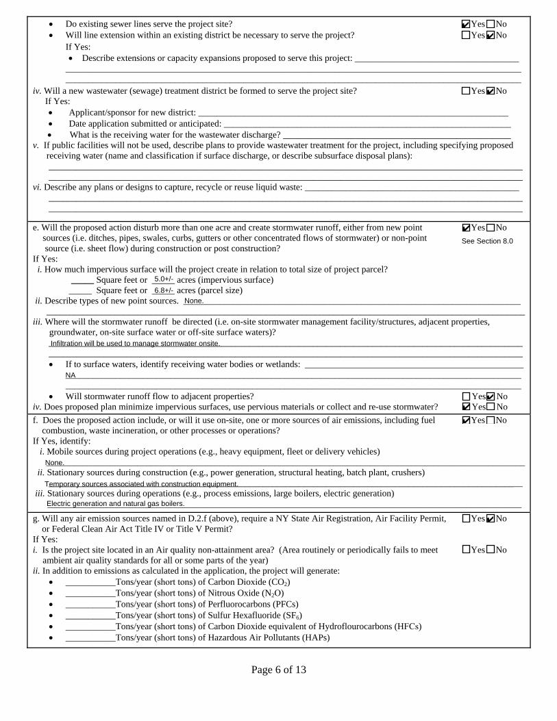
Page 6 of 13
• Do existing sewer lines serve the project site? 9 Yes 9 No • Will line extension within an existing district be necessary to serve the project? 9 Yes 9 No
If Yes: • Describe extensions or capacity expansions proposed to serve this project: ____________________________________
____________________________________________________________________________________________________ ____________________________________________________________________________________________________
iv. Will a new wastewater (sewage) treatment district be formed to serve the project site? 9 Yes 9 No If Yes:• Applicant/sponsor for new district: ____________________________________________________________________• Date application submitted or anticipated: _______________________________________________________________• What is the receiving water for the wastewater discharge? __________________________________________________
v. If public facilities will not be used, describe plans to provide wastewater treatment for the project, including specifying proposed receiving water (name and classification if surface discharge, or describe subsurface disposal plans): ________________________________________________________________________________________________________ ________________________________________________________________________________________________________
vi. Describe any plans or designs to capture, recycle or reuse liquid waste: _______________________________________________ ________________________________________________________________________________________________________ ________________________________________________________________________________________________________
e. Will the proposed action disturb more than one acre and create stormwater runoff, either from new point 9 Yes 9 No sources (i.e. ditches, pipes, swales, curbs, gutters or other concentrated flows of stormwater) or non-point
source (i.e. sheet flow) during construction or post construction? If Yes:
i. How much impervious surface will the project create in relation to total size of project parcel? _____ Square feet or _____ acres (impervious surface) _____ Square feet or _____ acres (parcel size)
ii. Describe types of new point sources. ___________________________________________________________________________________________________________________________________________________________________________________
iii. Where will the stormwater runoff be directed (i.e. on-site stormwater management facility/structures, adjacent properties,groundwater, on-site surface water or off-site surface waters)?
________________________________________________________________________________________________________ ________________________________________________________________________________________________________ • If to surface waters, identify receiving water bodies or wetlands: ________________________________________________
________________________________________________________________________________________________________________________________________________________________________________________________________
• Will stormwater runoff flow to adjacent properties? 9 Yes 9 No iv. Does proposed plan minimize impervious surfaces, use pervious materials or collect and re-use stormwater? 9 Yes 9 No f. Does the proposed action include, or will it use on-site, one or more sources of air emissions, including fuel 9 Yes 9 No
combustion, waste incineration, or other processes or operations?If Yes, identify:
i. Mobile sources during project operations (e.g., heavy equipment, fleet or delivery vehicles)_________________________________________________________________________________________________________
ii. Stationary sources during construction (e.g., power generation, structural heating, batch plant, crushers)________________________________________________________________________________________________________
iii. Stationary sources during operations (e.g., process emissions, large boilers, electric generation)________________________________________________________________________________________________________
g. Will any air emission sources named in D.2.f (above), require a NY State Air Registration, Air Facility Permit, 9 Yes 9 No or Federal Clean Air Act Title IV or Title V Permit?
If Yes: i. Is the project site located in an Air quality non-attainment area? (Area routinely or periodically fails to meet 9 Yes 9 No
ambient air quality standards for all or some parts of the year)ii. In addition to emissions as calculated in the application, the project will generate:
• ___________Tons/year (short tons) of Carbon Dioxide (CO2)• ___________Tons/year (short tons) of Nitrous Oxide (N2O)• ___________Tons/year (short tons) of Perfluorocarbons (PFCs)• ___________Tons/year (short tons) of Sulfur Hexafluoride (SF6)• ___________Tons/year (short tons) of Carbon Dioxide equivalent of Hydroflourocarbons (HFCs)• ___________Tons/year (short tons) of Hazardous Air Pollutants (HAPs)
See Section 8.0
✔
✔
✔
✔
5.0+/-
6.8+/- None.
Infiltration will be used to manage stormwater onsite.
NA
✔✔
✔
None.
Temporary sources associated with construction equipment.
Electric generation and natural gas boilers.
✔

Page 7 of 13
h. Will the proposed action generate or emit methane (including, but not limited to, sewage treatment plants, 9 Yes 9 No landfills, composting facilities)?
If Yes: i. Estimate methane generation in tons/year (metric): ________________________________________________________________
ii. Describe any methane capture, control or elimination measures included in project design (e.g., combustion to generate heat orelectricity, flaring): _________________________________________________________________________________________________________________________________________________________________________________________________
i. Will the proposed action result in the release of air pollutants from open-air operations or processes, such as 9 Yes 9 No quarry or landfill operations?
If Yes: Describe operations and nature of emissions (e.g., diesel exhaust, rock particulates/dust): _________________________________________________________________________________________________________ _________________________________________________________________________________________________________
j. Will the proposed action result in a substantial increase in traffic above present levels or generate substantial 9 Yes 9 No new demand for transportation facilities or services?
If Yes: i. When is the peak traffic expected (Check all that apply): Morning Evening Weekend
Randomly between hours of __________ to ________.ii. For commercial activities only, projected number of semi-trailer truck trips/day: _______________________
iii. Parking spaces: Existing _____________ Proposed ___________ Net increase/decrease _____________ iv. Does the proposed action include any shared use parking? 9 Yes 9 No v. If the proposed action includes any modification of existing roads, creation of new roads or change in existing access, describe:
________________________________________________________________________________________________________________________________________________________________________________________________________________________________________________________________________________________________________________________
vi. Are public/private transportation service(s) or facilities available within ½ mile of the proposed site? 9 Yes 9 No vii Will the proposed action include access to public transportation or accommodations for use of hybrid, electric 9 Yes 9 No
or other alternative fueled vehicles? viii. Will the proposed action include plans for pedestrian or bicycle accommodations for connections to existing 9 Yes 9 No
pedestrian or bicycle routes?
k. Will the proposed action (for commercial or industrial projects only) generate new or additional demand 9 Yes 9 No for energy?
If Yes: i. Estimate annual electricity demand during operation of the proposed action: ____________________________________________
_________________________________________________________________________________________________________ii. Anticipated sources/suppliers of electricity for the project (e.g., on-site combustion, on-site renewable, via grid/local utility, or
other):________________________________________________________________________________________________________
iii. Will the proposed action require a new, or an upgrade to, an existing substation? 9 Yes 9 No
l. Hours of operation. Answer all items which apply.i. During Construction: ii. During Operations:• Monday - Friday: _________________________ • Monday - Friday: ____________________________• Saturday: ________________________________ • Saturday: ___________________________________• Sunday: _________________________________ • Sunday: ____________________________________• Holidays: ________________________________ • Holidays: ___________________________________
See Section 5.0
(including parking garage)
Residential Uses: 24 hours
✔
✔
✔
✔ ✔ ✔
1 - 2 trips per day
70+/- 279+/- + 209+/-
✔
Access to the site would be via an existing access entry located opposite Davis Avenue on Raymond Avenue.
✔✔
✔
✔
To be determined. New construction will be energy efficient.
Central Hudson Gas and Electric Corporation
✔
max 7:00 am to 10:00 PM
max 7:00 am to 10:00 PM
NA
NA
Commercial: max 7 AM - 4 AM
Commercial: max 7 AM - 4 AM
Commercial: max 7 AM - 4 AM
Commercial: max 7 AM - 4 AM

Page 8 of 13
m. Will the proposed action produce noise that will exceed existing ambient noise levels during construction, 9 Yes 9 No operation, or both?
If yes: i. Provide details including sources, time of day and duration:
_______________________________________________________________________________________________________ _______________________________________________________________________________________________________
ii. Will proposed action remove existing natural barriers that could act as a noise barrier or screen? 9 Yes 9 No Describe: _________________________________________________________________________________________________ _________________________________________________________________________________________________________
n.. Will the proposed action have outdoor lighting? 9 Yes 9 No If yes: i. Describe source(s), location(s), height of fixture(s), direction/aim, and proximity to nearest occupied structures:
_________________________________________________________________________________________________________ _________________________________________________________________________________________________________
ii. Will proposed action remove existing natural barriers that could act as a light barrier or screen? 9 Yes 9 No Describe: _________________________________________________________________________________________________ _________________________________________________________________________________________________________
o. Does the proposed action have the potential to produce odors for more than one hour per day? 9 Yes 9 No If Yes, describe possible sources, potential frequency and duration of odor emissions, and proximity to nearest occupied structures: ______________________________________________________________________________________
________________________________________________________________________________________________________ ________________________________________________________________________________________________________
p. 9 Yes 9 No Will the proposed action include any bulk storage of petroleum (combined capacity of over 1,100 gallons) or chemical products 185 gallons in above ground storage or any amount in underground storage?
If Yes: i. Product(s) to be stored ______________________________________________________________________________________
ii. Volume(s) ______ per unit time ___________ (e.g., month, year)iii. Generally describe proposed storage facilities: ___________________________________________________________________
________________________________________________________________________________________________________
q. Will the proposed action (commercial, industrial and recreational projects only) use pesticides (i.e., herbicides, 9 Yes 9 No insecticides) during construction or operation?
If Yes: i. Describe proposed treatment(s):
________________________________________________________________________________________________________________________________________________________________________________________________________________________________________________________________________________________________________________________________________________________________________________________________________________________________
ii. Will the proposed action use Integrated Pest Management Practices? 9 Yes 9 No r. Will the proposed action (commercial or industrial projects only) involve or require the management or disposal 9 Yes 9 No
of solid waste (excluding hazardous materials)?If Yes:
i. Describe any solid waste(s) to be generated during construction or operation of the facility:• Construction: ____________________ tons per ________________ (unit of time)• Operation : ____________________ tons per ________________ (unit of time)
ii. Describe any proposals for on-site minimization, recycling or reuse of materials to avoid disposal as solid waste:• Construction: ________________________________________________________________________________________
____________________________________________________________________________________________________• Operation: __________________________________________________________________________________________
____________________________________________________________________________________________________iii. Proposed disposal methods/facilities for solid waste generated on-site:
• Construction: ____________________________________________________________________________________________________________________________________________________________________________________________
• Operation: ______________________________________________________________________________________________________________________________________________________________________________________________
See Section 6.0
✔
Temporary noise generated during construction activities will be limited to a maximum of 7:00 am to 10:00 pm on weekdays and Saturdays in accordance with Section 139-4.B of the Poughkeepsie Town Code.
✔
Some trees will be removed for the proposed project. Some trees along the western portion of the site will be preserved.
✔
Lighting will utilize decorative, down-shielded and cut-off light fixtures to prevent glare. Nearest residence is approximately 40 feet from project site.
✔
Some trees will be removed for the proposed project. Some trees along the western portion of the site will be preserved.
✔
✔
✔
Pest control will be required after occupation of the building. Application would be by licensed applicators using minimal levels of application required.
✔
✔
To be determined
66+/-
one-time
month
Recyclables may be separated and transported to the Dutchess County Resource Recovery Agency Facility for recycling.
Separation of recyclables will be encouraged, for transport to the Dutchess County Resource Recovery Agency Facility for recycling.
Solid waste will be transported to off-site facilities as needed throughout the duration of construction.
Solid waste will be transported by a licensed waste hauler to the Dutchess County Resource Recovery Agency Facility.

Page 9 of 13
s. Does the proposed action include construction or modification of a solid waste management facility? 9 Yes 9 No If Yes:
i. Type of management or handling of waste proposed for the site (e.g., recycling or transfer station, composting, landfill, orother disposal activities): ___________________________________________________________________________________
ii. Anticipated rate of disposal/processing:• ________ Tons/month, if transfer or other non-combustion/thermal treatment, or• ________ Tons/hour, if combustion or thermal treatment
iii. If landfill, anticipated site life: ________________________________ years
t. Will proposed action at the site involve the commercial generation, treatment, storage, or disposal of hazardous 9 Yes 9 No waste?
If Yes: i. Name(s) of all hazardous wastes or constituents to be generated, handled or managed at facility: ___________________________
__________________________________________________________________________________________________________________________________________________________________________________________________________________
ii. Generally describe processes or activities involving hazardous wastes or constituents: ____________________________________________________________________________________________________________________________________________________________________________________________________________________________________________________
iii. Specify amount to be handled or generated _____ tons/monthiv. Describe any proposals for on-site minimization, recycling or reuse of hazardous constituents: ____________________________
________________________________________________________________________________________________________________________________________________________________________________________________________________
v. Will any hazardous wastes be disposed at an existing offsite hazardous waste facility? 9 Yes 9 No If Yes: provide name and location of facility: _______________________________________________________________________ ________________________________________________________________________________________________________ If No: describe proposed management of any hazardous wastes which will not be sent to a hazardous waste facility:
________________________________________________________________________________________________________ ________________________________________________________________________________________________________
E. Site and Setting of Proposed Action
E.1. Land uses on and surrounding the project site
a. Existing land uses.i. Check all uses that occur on, adjoining and near the project site.
9 Urban 9 Industrial 9 Commercial 9 Residential (suburban) 9 Rural (non-farm) 9 Forest 9 Agriculture 9 Aquatic 9 Other (specify): ____________________________________
ii. If mix of uses, generally describe:__________________________________________________________________________________________________________ __________________________________________________________________________________________________________
b. Land uses and covertypes on the project site.Land use or Covertype
Current Acreage
Acreage After Project Completion
Change (Acres +/-)
• Roads, buildings, and other paved or impervioussurfaces
• Forested• Meadows, grasslands or brushlands (non-
agricultural, including abandoned agricultural)• Agricultural
(includes active orchards, field, greenhouse etc.) • Surface water features
(lakes, ponds, streams, rivers, etc.) • Wetlands (freshwater or tidal)• Non-vegetated (bare rock, earth or fill)
• OtherDescribe: _______________________________ ________________________________________
* Impact quantities to rock, including areas underground, are unknown at this time.
✔
✔
✔ ✔ ✔
✔ residential, apartments, community services, vacant
Commercial, residential, community services
2.37+/- 5.0+/- +2.63
1.18+/- 0.8+/- -0.38
0.02+/- (surface rock outcrop) Unknown* Unknown*
lawn/landscaped area and children's playscape
3.09+/- 0.99+/- -2.1

Page 10 of 13
c. Is the project site presently used by members of the community for public recreation? 9 Yes 9 No i. If Yes: explain: __________________________________________________________________________________________
d. Are there any facilities serving children, the elderly, people with disabilities (e.g., schools, hospitals, licensed 9 Yes 9 No day care centers, or group homes) within 1500 feet of the project site?
If Yes, i. Identify Facilities:
________________________________________________________________________________________________________________________________________________________________________________________________________________
e. Does the project site contain an existing dam? 9 Yes 9 No If Yes:
i. Dimensions of the dam and impoundment:• Dam height: _________________________________ feet • Dam length: _________________________________ feet • Surface area: _________________________________ acres • Volume impounded: _______________________________ gallons OR acre-feet
ii. Dam=s existing hazard classification: _________________________________________________________________________iii. Provide date and summarize results of last inspection:
_______________________________________________________________________________________________________ _______________________________________________________________________________________________________
f. Has the project site ever been used as a municipal, commercial or industrial solid waste management facility, 9 Yes 9 No or does the project site adjoin property which is now, or was at one time, used as a solid waste management facility?
If Yes: i. Has the facility been formally closed? 9 Yes 9 No • If yes, cite sources/documentation: _______________________________________________________________________
ii. Describe the location of the project site relative to the boundaries of the solid waste management facility:______________________________________________________________________________________________________________________________________________________________________________________________________________
iii. Describe any development constraints due to the prior solid waste activities: _________________________________________________________________________________________________________________________________________________
g. Have hazardous wastes been generated, treated and/or disposed of at the site, or does the project site adjoin 9 Yes 9 No property which is now or was at one time used to commercially treat, store and/or dispose of hazardous waste?
If Yes: i. Describe waste(s) handled and waste management activities, including approximate time when activities occurred:
_______________________________________________________________________________________________________ _______________________________________________________________________________________________________
h. Potential contamination history. Has there been a reported spill at the proposed project site, or have any 9 Yes 9 No remedial actions been conducted at or adjacent to the proposed site?
If Yes: i. Is any portion of the site listed on the NYSDEC Spills Incidents database or Environmental Site 9 Yes 9 No
Remediation database? Check all that apply:9 Yes – Spills Incidents database Provide DEC ID number(s): ________________________________ 9 Yes – Environmental Site Remediation database Provide DEC ID number(s): ________________________________ 9 Neither database
ii. If site has been subject of RCRA corrective activities, describe control measures:_______________________________________________________________________________________________________________________________________________________________________________________________________________________________________________________
iii. Is the project within 2000 feet of any site in the NYSDEC Environmental Site Remediation database? 9 Yes 9 No If yes, provide DEC ID number(s): ______________________________________________________________________________ iv. If yes to (i), (ii) or (iii) above, describe current status of site(s):
_______________________________________________________________________________________________________ _______________________________________________________________________________________________________
See Section 7.0
✔
✔
Site is the former Arthur May School which is currently vacant and will be demolished. The new Arthur May School and Holy Trinity School are also located within 1,500 feet.
✔
✔
✔
✔
✔ 151047; 1005154; 0604944
✔
Spill No. 151047 at 25 Raymond Avenue. Petroleum and unknown substance. Closed 01/15/2016. Spill No. 1005154 at 25 Raymond Avenue. Unknown substance. Closed 09/17/2010. Spill No. 0604944. at Raymond and Haight Avenues. Transformer oil. Closed 07/31/2006.

Page 11 of 13
v. Is the project site subject to an institutional control limiting property uses? 9 Yes 9 No • If yes, DEC site ID number: ____________________________________________________________________________• Describe the type of institutional control (e.g., deed restriction or easement): ____________________________________• Describe any use limitations: ___________________________________________________________________________• Describe any engineering controls: _______________________________________________________________________• Will the project affect the institutional or engineering controls in place? 9 Yes 9 No • Explain: ____________________________________________________________________________________________
___________________________________________________________________________________________________ ___________________________________________________________________________________________________
E.2. Natural Resources On or Near Project Site a. What is the average depth to bedrock on the project site? ________________ feet
b. Are there bedrock outcroppings on the project site? 9 Yes 9 No If Yes, what proportion of the site is comprised of bedrock outcroppings? __________________%
c. Predominant soil type(s) present on project site: ___________________________ __________% ___________________________ __________% ____________________________ __________%
d. What is the average depth to the water table on the project site? Average: _________ feet
e. Drainage status of project site soils: 9 Well Drained: _____% of site 9 Moderately Well Drained: _____% of site 9 Poorly Drained _____% of site
f. Approximate proportion of proposed action site with slopes: 9 0-10%: _____% of site 9 10-15%: _____% of site 9 15% or greater: _____% of site
g. Are there any unique geologic features on the project site? 9 Yes 9 No If Yes, describe: _____________________________________________________________________________________________
________________________________________________________________________________________________________
h. Surface water features.i. Does any portion of the project site contain wetlands or other waterbodies (including streams, rivers, 9 Yes 9 No
ponds or lakes)?ii. Do any wetlands or other waterbodies adjoin the project site? 9 Yes 9 No
If Yes to either i or ii, continue. If No, skip to E.2.i. iii. Are any of the wetlands or waterbodies within or adjoining the project site regulated by any federal, 9 Yes 9 No
state or local agency? iv. For each identified regulated wetland and waterbody on the project site, provide the following information:
• Streams: Name ____________________________________________ Classification _______________________ • Lakes or Ponds: Name ____________________________________________ Classification _______________________• Wetlands: Name ____________________________________________ Approximate Size ___________________ • Wetland No. (if regulated by DEC) _____________________________
v. Are any of the above water bodies listed in the most recent compilation of NYS water quality-impaired 9 Yes 9 No waterbodies?
If yes, name of impaired water body/bodies and basis for listing as impaired: _____________________________________________ ___________________________________________________________________________________________________________
i. Is the project site in a designated Floodway? 9 Yes 9 No
j. Is the project site in the 100 year Floodplain? 9 Yes 9 No
k. Is the project site in the 500 year Floodplain? 9 Yes 9 No
l. Is the project site located over, or immediately adjoining, a primary, principal or sole source aquifer? 9 Yes 9 No If Yes:
i. Name of aquifer: _________________________________________________________________________________________
KuA
See Section 8.0
See Section 8.0
✔
KuA > 6.6
✔0.25
KuA Knickerbocker Urban Land 55
Ur Urban Land 45
KuA > 6.6
✔ 100
✔ 80
✔ 15
✔ 5
✔
✔
✔
✔
✔
✔
✔
✔
✔

Page 12 of 13
m. Identify the predominant wildlife species that occupy or use the project site: ______________________________ ______________________________ _______________________________ ______________________________ ______________________________ _______________________________ ______________________________
n. Does the project site contain a designated significant natural community? 9 Yes 9 No If Yes:
i. Describe the habitat/community (composition, function, and basis for designation): _____________________________________ ________________________________________________________________________________________________________
ii. Source(s) of description or evaluation: ________________________________________________________________________iii. Extent of community/habitat:
• Currently: ______________________ acres • Following completion of project as proposed: _____________________ acres• Gain or loss (indicate + or -): ______________________ acres
o. Does project site contain any species of plant or animal that is listed by the federal government or NYS as 9 Yes 9 No endangered or threatened, or does it contain any areas identified as habitat for an endangered or threatened species?
p. Does the project site contain any species of plant or animal that is listed by NYS as rare, or as a species of 9 Yes 9 No
special concern?
q. Is the project site or adjoining area currently used for hunting, trapping, fishing or shell fishing? 9 Yes 9 No If yes, give a brief description of how the proposed action may affect that use: ___________________________________________
________________________________________________________________________________________________________
E.3. Designated Public Resources On or Near Project Site a. Is the project site, or any portion of it, located in a designated agricultural district certified pursuant to 9 Yes 9 No
Agriculture and Markets Law, Article 25-AA, Section 303 and 304?If Yes, provide county plus district name/number: _________________________________________________________________
b. Are agricultural lands consisting of highly productive soils present? 9 Yes 9 No i. If Yes: acreage(s) on project site? ___________________________________________________________________________
ii. Source(s) of soil rating(s): _________________________________________________________________________________
c. Does the project site contain all or part of, or is it substantially contiguous to, a registered National 9 Yes 9 No Natural Landmark?
If Yes: i. Nature of the natural landmark: 9 Biological Community 9 Geological Featureii. Provide brief description of landmark, including values behind designation and approximate size/extent: ___________________
________________________________________________________________________________________________________ ________________________________________________________________________________________________________
d. Is the project site located in or does it adjoin a state listed Critical Environmental Area? 9 Yes 9 No If Yes:
i. CEA name: _____________________________________________________________________________________________ii. Basis for designation: _____________________________________________________________________________________
iii. Designating agency and date: ______________________________________________________________________________
See Section 9.0
Common urban animals and birds.
✔
✔
✔
✔
✔
✔
✔
✔

Page 13 of 13
e. Does the project site contain, or is it substantially contiguous to, a building, archaeological site, or district 9 Yes 9 No which is listed on, or has been nominated by the NYS Board of Historic Preservation for inclusion on, theState or National Register of Historic Places?
If Yes: i. Nature of historic/archaeological resource: 9 Archaeological Site 9 Historic Building or District
ii. Name: _________________________________________________________________________________________________iii. Brief description of attributes on which listing is based:
_______________________________________________________________________________________________________
f. Is the project site, or any portion of it, located in or adjacent to an area designated as sensitive for 9 Yes 9 No archaeological sites on the NY State Historic Preservation Office (SHPO) archaeological site inventory?
g. Have additional archaeological or historic site(s) or resources been identified on the project site? 9 Yes 9 No If Yes:
i. Describe possible resource(s): _______________________________________________________________________________ii. Basis for identification: ___________________________________________________________________________________
h. 9 Yes 9 No Is the project site within fives miles of any officially designated and publicly accessible federal, state, or localscenic or aesthetic resource?
If Yes: i. Identify resource: _________________________________________________________________________________________
ii. Nature of, or basis for, designation (e.g., established highway overlook, state or local park, state historic trail or scenic byway,etc.): ___________________________________________________________________________________________________
iii. Distance between project and resource: _____________________ miles.i. Is the project site located within a designated river corridor under the Wild, Scenic and Recreational Rivers 9 Yes 9 No
Program 6 NYCRR 666?If Yes:
i. Identify the name of the river and its designation: ________________________________________________________________ii. Is the activity consistent with development restrictions contained in 6NYCRR Part 666? 9 Yes 9 No
F. Additional InformationAttach any additional information which may be needed to clarify your project.
If you have identified any adverse impacts which could be associated with your proposal, please describe those impacts plus any measures which you propose to avoid or minimize them.
G. VerificationI certify that the information provided is true to the best of my knowledge.
Applicant/Sponsor Name ___________________________________ Date_______________________________________
Signature________________________________________________ Title_______________________________________
The former Arthur May School is eligible for listing under Criteria A, but has not been nominated for listing on the State or National Register of Historic Places. See Section 10.0.
Caren LoBrutto, Chazen Companies, Agent for Applicant
✔
✔
✔
✔
See Figure 8
See Figure 8See Figure 8
✔
Arthur May Redevelopment LLC May 29, 2018
PRINT FORM
Senior Planner

EAF Mapper Summary Report Thursday, February 02, 2017 3:36 PM
Disclaimer: The EAF Mapper is a screening tool intended to assist project sponsors and reviewing agencies in preparing an environmental assessment form (EAF). Not all questions asked in the EAF are answered by the EAF Mapper. Additional information on any EAF question can be obtained by consulting the EAF Workbooks. Although the EAF Mapper provides the most up-to-date digital data available to DEC, you may also need to contact local or other data sources in order to obtain data not provided by the Mapper. Digital data is not a substitute for agency determinations.
B.i.i [Coastal or Waterfront Area] No
B.i.ii [Local Waterfront Revitalization Area] Yes
C.2.b. [Special Planning District] Digital mapping data are not available or are incomplete. Refer to EAF Workbook.
E.1.h [DEC Spills or Remediation Site - Potential Contamination History]
Digital mapping data are not available or are incomplete. Refer to EAF Workbook.
E.1.h.i [DEC Spills or Remediation Site - Listed]
Digital mapping data are not available or are incomplete. Refer to EAF Workbook.
E.1.h.i [DEC Spills or Remediation Site - Environmental Site Remediation Database]
Digital mapping data are not available or are incomplete. Refer to EAF Workbook.
E.1.h.iii [Within 2,000' of DEC Remediation Site]
No
E.2.g [Unique Geologic Features] No
E.2.h.i [Surface Water Features] No
E.2.h.ii [Surface Water Features] No
E.2.h.iii [Surface Water Features] No
E.2.h.v [Impaired Water Bodies] No
E.2.i. [Floodway] No
E.2.j. [100 Year Floodplain] No
E.2.k. [500 Year Floodplain] No
E.2.l. [Aquifers] No
E.2.n. [Natural Communities] No
E.2.o. [Endangered or Threatened Species] Yes
E.2.p. [Rare Plants or Animals] No
E.3.a. [Agricultural District] No
1Full Environmental Assessment Form - EAF Mapper Summary Report

E.3.c. [National Natural Landmark] No
E.3.d [Critical Environmental Area] No
E.3.e. [National Register of Historic Places] Digital mapping data are not available or are incomplete. Refer to EAF Workbook.
E.3.f. [Archeological Sites] No
E.3.i. [Designated River Corridor] No
2Full Environmental Assessment Form - EAF Mapper Summary Report


Anchor Project Zoning Text Amendment and Arthur May School Property Redevelopment Full Environmental Assessment Form Part 1 Page 1
Proposed Zoning Amendments Permitting Anchor Projects August 16, 2017
Revised May 29, 2018
FIGURES


Service Layer Credits: Copyright:© 2013National Geographic Society, i-cubed
Date:
Scale:
Project:
Figure:
Drawn:
Town ofPoughkeepsie
Town ofLa Grange
City ofPoughkeepsie
0 2,000 4,0001,000
Feet
1:24,000
RL-B
02/06/2017
51657.00
1
Anchor Project Zoning Text Amendment and Arthur May Anchor Project
USGS Location Map
25 Raymond Ave, Town of Poughkeepsie - Dutchess County, NY
ENGINEERSLAND SURVEYORS
PLANNERSENVIRONMENTAL & SAFETY PROFESSIONALS
LANDSCAPE ARCHITECTS
Capital District Office:547 River Street, Troy, NY 12180Phone: (518) 273-0055
Dutchess County Office:21 Fox Street, Poughkeepsie, NY 12601Phone: (845) 454-3980
North Country Office:375 Bay Road, Queensbury, NY 12804Phone: (518) 812-0513
LegendProject Site

Service Layer Credits:
Date:
Scale:
Project:
Figure:
Drawn:
6161-08-796786
6161
-08-80
4782
6161-07-7157756161-07-736778
6161-07-716779
6161-07-717783
6161
-08-81
47836161-07-718787
6161
-11-71
4692
6161-07-713768
6161-08-796777
6161-12-787714
6161-12-784726
6161-12-796690
6161-12-785720
6161-11-742688
6161-12-793702
6161-12-804737
6161-07-740782
6161
-08-80
7760
6161-08-798761
6161-12-800675
6161-12-778686
6161-12-813743
6161-12-800747
6161-12-755735
6161-11-705730
6161-11-729748
6161-07-736769
6161-12-804723
6161-08-770792
6161-12-803727
6161-08-767775
6161
-12-81
2719
6161
-12-81
7693
6161-12-814699
6161-07-736774
6161-07-732765
6161
-12-81
0726
6161-07-748770
6161-07-741786
Davis Avenue
Lewi
s Av
enue
Haight Avenue
Raymond Avenue
376
44
0 120 24060
Feet
1 inch = 120 feet
RL-B
02/06/2017
51657.00
2
ENGINEERSLAND SURVEYORS
PLANNERSENVIRONMENTAL & SAFETY PROFESSIONALS
LANDSCAPE ARCHITECTS
Capital District Office:547 River Street, Troy, NY 12180Phone: (518) 273-0055
Dutchess County Office:21 Fox Street, Poughkeepsie, NY 12601Phone: (845) 454-3980
North Country Office:375 Bay Road, Queensbury, NY 12804Phone: (518) 812-0513
LegendProject Site
Tax Parcels
Anchor Project Zoning Text Amendment and Arthur May Anchor Project
Orthophoto Tax Map
25 Raymond Ave, Town of Poughkeepsie - Dutchess County, NY

Service Layer Credits:
Date:
Scale:
Project:
Figure:
Drawn:
Pr attLoop
R hobel la D rive
Pond
Street
Maple S treet
Fulton Avenue
Olympic
Wa y
Muss
elman
Driv
eZi
egle
r n
Congress Court
Stre
it Av
enue
Lewi
s Av
enue
Brewers Lane
Fow lerAv enue
Arli ngton Av enue
Sout
h Gr
and
Aven
ue
FreedomPlains Road
Boulev
ard
Knol l s
Fulton Avenue
Seitz
Terr
ace
Park
Aven
ue
Van
Wagn e rRo
ad
Evelyn
Way
W o odcl
if f
AvenueNorth Cam
pus Drive
Col legeview Avenue
Main Street
Lagrange Avenue
Fairm
ont
Aven
ue
Friendly Lane
Kenyon Drive
College Avenue
North
Gran
dAv
enue
Du tch e ss Turnpike
West Haight AvenueManchester Road
Davis AvenueRaym
ond Avenue
Taf tAve nue
Springsi d e Avenue
East West Arterial
Main Street
Haight Avenue
456738
4567114
Æ·55
Æ·376£¤44
³
0 600 1,200300
Feet
1 inch = 600 feet
RL-B
08/10/2017
51657.00
3
ENGINEERSLAND SURVEYORS
PLANNERSENVIRONMENTAL & SAFETY PROFESSIONALS
LANDSCAPE ARCHITECTS
Capital District Office:547 River Street, Troy, NY 12180Phone: (518) 273-0055
Dutchess County Office:21 Fox Street, Poughkeepsie, NY 12601Phone: (845) 454-3980
North Country Office:375 Bay Road, Queensbury, NY 12804Phone: (518) 812-0513
LegendPro
u
j
e
ect Site
Anchor Project ATC Zoning DistrictTax Parcels
Anchor Project Zoning Text Amendment and Arthur May Anchor Project
ATC Zoning District
25 Raymond Ave, Town of Poughkeepsie - Dutchess County, NY

Service Layer Credits:
Date:
Scale:
Project:
Figure:
Drawn:
Park
Ave
nue
Fulton Avenue
St reit Av enue
Collegeview Avenue
Raym
ondAv e
Fulto
n Co
urt
Stre
it Av
enue
Lagrange Avenue
Davis Avenue
Lewi
sAv
enue
Fow le rA venue
Main Street
College Avenue
Fulton Avenue
Raymond Avenue
Haig ht Avenue
114
376
44
0 250 500125
Feet
1 inch = 250 feet
RL-B
02/06/2017
51657.00
4
ENGINEERSLAND SURVEYORS
PLANNERSENVIRONMENTAL & SAFETY PROFESSIONALS
LANDSCAPE ARCHITECTS
Capital District Office:547 River Street, Troy, NY 12180Phone: (518) 273-0055
Dutchess County Office:21 Fox Street, Poughkeepsie, NY 12601Phone: (845) 454-3980
North Country Office:375 Bay Road, Queensbury, NY 12804Phone: (518) 812-0513
LegendProject Site500' Buffer
Land UseResidentialApartments
CommercialCommunity ServicesVacantOther Tax Parcels
Anchor Project Zoning Text Amendment and Arthur May Anchor Project
Land Use Map
25 Raymond Ave, Town of Poughkeepsie - Dutchess County, NY

Service Layer Credits:
Date:
Scale:
Project:
Figure:
Drawn:
Davis Avenue
Lewi
s Av
enue
Haight Ave nue
Raymond Avenue
376
44
KuA
Ur
0 120 24060
Feet
1 inch = 120 feet
RL-B
02/06/2017
51657.00
5
ENGINEERSLAND SURVEYORS
PLANNERSENVIRONMENTAL & SAFETY PROFESSIONALS
LANDSCAPE ARCHITECTS
Capital District Office:547 River Street, Troy, NY 12180Phone: (518) 273-0055
Dutchess County Office:21 Fox Street, Poughkeepsie, NY 12601Phone: (845) 454-3980
North Country Office:375 Bay Road, Queensbury, NY 12804Phone: (518) 812-0513
LegendProject Site
SoilsKuA : Knickerbocker-Urban land complex, nearly levelUr : Urban landTax Parcels
Anchor Project Zoning Text Amendment and Arthur May Anchor Project
Soils Map
25 Raymond Ave, Town of Poughkeepsie - Dutchess County, NY

Service Layer Credits:
Date:
Scale:
Project:
Figure:
Drawn:
Main Street
Main Street
DeansL ane
JonesStree t
Br
ewers Lane
Pa rkview Terrace
Zieg
ler
Aven
ue
Main Street
VanWagner
Road
Hoffm
anAv
enue
Stre
it Av
enue
Lewi
s Av
enueW
orra
l l Av
enue
Fo wlerAvenu e
Baker Street
Arlin gton Avenue
Inni
s Av
enue
Grubb Street
Fulton Avenue
North
G ran
dAv
enu e
W oodc
li ffA
venue
Park
Aven
ue
North Campus Drive
Maple St reet
Fulton Avenue
Collegeview Avenue
Taft
Aven
ue
Lagrange Avenue
Davis Avenue
Fairm
ont
Aven
ue
Sout
h Gr
and
Aven
ue
Raym
ond Avenue
College Avenue
Springside Avenue
East West Arterial
Main Street
Haight Avenue
38
11455
115
37644
PSS1/EM1E
8 62 -387 : C lass C
0 500 1,000250
Feet
1 inch = 500 feet
RL-B
02/06/2017
51657.00
6
ENGINEERSLAND SURVEYORS
PLANNERSENVIRONMENTAL & SAFETY PROFESSIONALS
LANDSCAPE ARCHITECTS
Capital District Office:547 River Street, Troy, NY 12180Phone: (518) 273-0055
Dutchess County Office:21 Fox Street, Poughkeepsie, NY 12601Phone: (845) 454-3980
North Country Office:375 Bay Road, Queensbury, NY 12804Phone: (518) 812-0513
LegendProject Site
USFWS NWI Wetlands
NYSDEC Streams
Tax Parcels
Anchor Project Zoning Text Amendment and Arthur May Anchor Project
Wetland and Streams Map
25 Raymond Ave, Town of Poughkeepsie - Dutchess County, NY

Figure 7 NYSDEC Environmental Resource Map
Anchor Project Zoning Text Amendment and Arthur May Anchor Project
SITE

Figure 8 NYS Office of Parks, Recreation, & Historic Preservation (NYSOPRHP)
Cultural Resource Information System (CRIS) Map
Anchor Project Zoning Text Amendment and Arthur May Anchor Project

Service Layer Credits: Esri, HERE, DeLorme,MapmyIndia, © OpenStreetMap contributors,and the GIS user community
Date:
Scale:
Project:
Figure:
Drawn:
1
1.
3.4.
2.
5.
St. Andrew's Novitiate
Poughkeepsie Meeting House (Hooker Avenue)Yelverton, Anthony, House
Glebe House
Ethol House
10.
8.7.
9.
6.
Chapel Hill Bible Church
Stone Street Historic DistrictUnion Free School
Brower, Adolph, House
Freer House
PoughkeepsieRailroad Bridge
Union StreetHistoric District
Hudson River StateHospital, Main
Building
Wheeler HillHistoric District
RosenlundEstate
Buildings
Morse, Samuel F. B.,House (Locust Grove)
Home of FranklinD. Roosevelt
National Historic Site Roosevelt, Eleanor,National
Historic Site
Academy StreetHistoric District
Vassar,Matthew, Estate
Mill House
Top Cottage
MainBuilding, Vassar
College
Balding AvenueHistoric District
ClarkHouse
Moore House
RomboutHouse
Horton,Joseph,House
Booth, O. H.,Hose Company
Roosevelt PointCottage andBoathouse
"MapleGrove"
Kimlin CiderMill
TaconicState
Parkway
Titus,Elias,House
CosmanFamily
Cemetery
MiltonRailroadStation
McComb,Peter and
Karen, House
LattingtonBaptistChurch
Shady Brook Farm
La GrangeDistrict
School No. 3
VioletAvenueSchool
8
5
6
2
488
9 7888
3
8
108888
FrannyReese
Preserve
JamesBaird
Walkway overthe Hudson
Eleanor RooseveltNational Historic Site
JamesBaird
State Park
HillisPark
SunnysidePark
RobinsonLanePark
StanleyStill Sr TownSport Park
MartzField
Red WingParkReese Park
HopewellCommunity
Center
Greenfields Park
BowerPark
BeckPark Cady
RecreationParkTony
WilliamsTown Park
BereanPark College
Hill Park
Greenvale Park
Spratt Park
Cluett SchantzMemorial
Park
MacGheePark
88888
77
29
11
72
47
93
39
15
33104
94
10
12
46
49
21
299
113
1159G
82
55
376
Town ofMarlborough
Town ofPlattekill
Town ofEast
Fishkill
Town ofNewburgh
Town ofPoughkeepsie
Town ofWappinger
Town ofHydePark Town of
PleasantValley
Town ofLloyd
Town ofLa Grange
44
9
9W
BIKE PATH
City ofPoughkeepsie
Mid-Hudson Bridge
FallkillCounty
Park (undeveloped)
Bowdoin County Park
Bowdoin County Park
Bowdoin County Park
1 in = 1.5 miles
RL-B
9
ENGINEERSLAND SURVEYORS
PLANNERSENVIRONMENTAL & SAFETY PROFESSIONALS
LANDSCAPE ARCHITECTS
Capital District Office:547 River Street, Troy, NY 12180Phone: (518) 273-0055
Dutchess County Office:21 Fox Street, Poughkeepsie, NY 12601Phone: (845) 454-3980
North Country Office:375 Bay Road, Queensbury, NY 12804Phone: (518) 812-0513
Legend5-mile Buffer1-mile BuffersProject SiteNYS scenic bywaysScenic TrailsScenic Areas of Statewide Significance
Municipal RecreationCounty RecreationFederal RecreationState Parks And Historic SitesState RecreationState And National Register Listed 0 1.5 30.75
Miles
02/06/2017
51657.00
Anchor Project Zoning Text Amendment and Arthur May Anchor Project
Publicly AccessibleFederal, State, or Local Scenic or Aesthetic
Resources within 5 Miles25 Raymond Ave, Town of Poughkeepsie - Dutchess County, NY


Anchor Project Zoning Text Amendment and Arthur May School Property Redevelopment Full Environmental Assessment Form Part 1 Page 2
Proposed Zoning Amendments Permitting Anchor Projects August 16, 2017
Revised May 29, 2018
ATTACHMENT A Draft Zoning Text Amendment


DRAFT FOR TOWN BOARD REVIEW November 9, 2017
Proposed Zoning Amendments Permitting Anchor Projects
1. Amend Section 210-9, “Definitions”, as follows:
Add the following definition:
Anchor Project - A project comprised of a mix of uses that may include but is not limited to commercial, residential and institutional uses. Anchor Projects contain sufficient residential density and supporting commercial uses to promote business activity both on and off-site, and that may act as a catalyst for increased investment on adjoining and nearby properties that may be underutilized or blighted. Anchor uses include provisions for plazas and/or green spaces and promote a walkable environment.
2. Amend Section 210-22(B) as follows:
B. Permitted uses. Permitted uses shall be as follows (Note: "*" designates a use which is subject to site plan approval by the Planning Board):
(1) *Anchor Projects, subject to §210-51.1.
(1)(2) *Art galleries.
(2)(3) *Bank and financial services.
(3)(4) *Bakeries.
(4)(5) *Bed-and-breakfasts.
(5)(6) *Boutiques with or without goods processed or assembled on site, subject to § 210-57.
(6)(7) *Delicatessens.
(7)(8) *Dwellings, two-family.
(8)(9) Dwellings, single-family.
(9)(10) *Family day-care homes, subject to § 210-65.
(10)(11) *Laundries, laundromats.
(11)(12) *Libraries.
(12)(13) *Museums.
(13)(14) *Offices.
(14)(15) *Personal service businesses, no drive-in or drive-through
(15)(16) *Places of religious worship, subject to § 210-95.
(16)(17) *Retail businesses, no drive-in or drive-through.
(17)(18) *Service businesses, no drive-in or drive-through.

Proposed Zoning Amendments Permitting Anchor Projects
DRAFT FOR TOWN BOARD REVIEW November 9, 2017
(18)(19) *Restaurants, no drive-in or drive-through.
(19)(20) *Supermarkets.
(20)(21) *Theaters.
3. Add a new Section 210-51.1, “Anchor Projects”, as follows:
210-51.1. Anchor Projects
A. Purpose. The center districts (e.g. ATC, FC. SHC, MHC, and SPC) typically contain a unique blend of business and complementary residential land uses. The center districts also have access to existing municipal water supply and sewage collection and treatment facilities, and a dependable road network capable of supporting high volume uses and densities. Within the center districts an Anchor Project can serve as a catalyst for increased investment on adjoining and nearby properties that may be underutilized or blighted, especially along and near the major roads serving the area. An Anchor Project contributes to the economic development of the neighborhood and greater community by adding goods, services, and housing. An Anchor Project includes provisions for plazas and/or green spaces, a walkable environment, thus supporting the economic development goals of the Town Plan.
B. Permitted Uses.
Anchor Projects may consist of a mix of any of the following uses. (Note: "*" designates a use which is subject to site plan approval by the Planning Board):
1. *Art galleries.
2. *Bank and financial services.
3. *Bakeries.
4. *Cabaret, nightclub.
5. *Club, health and fitness.
6. *Day care, subject to §210-65.
7. *Delicatessens.
8. *Hotel, motel, subject to §210-75.
9. *Indoor Recreation.
10. *Inn, subject to §210-77 except §210-77 (A), (B) and (H) shall not apply.
11. *Laundries, laundromats.
12. *Libraries.
13. *Multi-family dwellings within multi-story structures, and mixed residential and non-residential uses within multi-story structures.

Proposed Zoning Amendments Permitting Anchor Projects
DRAFT FOR TOWN BOARD REVIEW November 9, 2017
14. *Museums.
15. *Offices.
16. *Personal service businesses, no drive-in or drive-through
17. *Restaurants or cafes no drive-in or drive-through.
18. *Retail businesses, no drive-in or drive-through.
19. *Service businesses, no drive-in or drive-through.
20. *Supermarkets or grocery stores.
21. *Theaters
C. Special Permitted Uses. Special permitted uses, as approved by the Planning Board, shall be as follows (Note: "*" designates a use which is also subject to site plan approval by the Planning Board):
1. *Clinics.
2. *Home occupations, subject to §210-74.
D. Accessory uses shall be as follows:
1. Accessory buildings and structures, subject to §210-48.
2. *Facilities for outdoor recreation.
3. *Outdoor restaurant dining facilities subject to § 210-102, except that § 210-102 (B)(5) and (B)(7) shall not apply.
4. Temporary buildings for construction purposes, subject to §210-109.
5. Sidewalk seating and tables for patrons, subject to §210-104.1.
E. Area and Bulk Regulations
Minimum Lot Area+
Minimum Lot
Frontage+
Minimum Lot
Width+
Minimum Front Yard
Minimum Side Yard
Minimum Rear Yard
Maximum Lot
Coverage
Maximum Impervious
Surface
Maximum Height
5 acres 300 Feet 300 Feet 0 Feet 0 Feet 0 Feet 80% 90% 7 stories or 105 feet
+ Parent Parcel.
1. An Anchor Project shall include a mix of residential and non-residential uses, as determined by the Planning Board, qualifying it as an Anchor Project. An application for a single use shall not qualify for Anchor Project designation.
2. Lots shall not be required to have frontage on a public street, provided that appropriate reciprocal easements, to the satisfaction of the Planning Board, are provided for access

Proposed Zoning Amendments Permitting Anchor Projects
DRAFT FOR TOWN BOARD REVIEW November 9, 2017
between such lots and public streets over common internal roadways and driveways to be constructed in accordance with the approved site plan. For purposes of this section, an Anchor Project shall be an open development area in accordance with the Town Law §280-a.
3. The Planning Board may waive the design guidelines in sub-section H below where it determines that doing so results in a better and more functional layout, or physical design or other considerations preclude the strict application of the guidelines, or the Board determines that the application of such guidelines are not relevant to the Anchor Project. Any such waivers shall be in writing and shall explain the Board’s rationale for such waiver(s).
4. On a lot, no single retail use shall occupy ground floor space in excess of 8,000 square feet. The continuous ground level frontage of a single commercial use building in excess of 40 feet in length along any frontage exposed to a street, public space or parking area and ground level commercial uses larger than 4,000 square feet shall be contained in a mixed-use structure or be architecturally designed to appear as a streetscape composed of a variety of small buildings that helps to further prevent the visual dominance or appearance of a single, large commercial use.
5. Maximum residential dwelling unit density shall not exceed 35 units/acre. For purposes of density calculation, each room in a hotel, motel, or inn shall count as one tenth of a dwelling unit.
6. Ingress and egress. Locations for ingress and egress to the lot(s) of an Anchor Project shall be approved by the Planning Board and shall be so arranged as to connect with existing State, County or Town highways, or to a proposed Town highway that has been approved by the Town Board.
F. Parking Requirements.
1. The off-street parking requirements of Section 210-92 of this chapter shall not apply to Anchor Projects. The following parking requirements apply to Anchor Projects:
Use Minimum Required Off-Street Parking Spaces
Hotel 1.0 space/hotel room
Studio apartment dwellings 1.0 space/bedroom
All other residential dwellings 0.75 space/bedroom
All other non-residential uses 2.0 spaces/1,000 SF of gross floor area
2. The minimum parking requirements may be waived where the Planning Board determines that the spaces provided are sufficient to meet the demands of the project.
3. Any change in use or site plan revision of an existing lot or structure may, at the discretion of the Planning Board, require a complete review of parking facilities. Applicants for change of use or site plan revision shall provide or make provisions for adequate parking facilities according to the standards of this section.

Proposed Zoning Amendments Permitting Anchor Projects
DRAFT FOR TOWN BOARD REVIEW November 9, 2017
4. Unless waived by the Planning Board where two or more different uses occur on a single lot, the total amount of parking to be provided shall be the sum of the requirements for each individual use.
5. Required off-street parking facilities shall be provided on the same lot or premises with the structure or land use they serve, except off-street parking and loading spaces required for structures or land uses on two or more adjacent lots may be provided in a single common facility on one or more of said lots, provided that the total amount of parking and loading facilities shall be the sum of the requirements of each individual use unless waived by the Planning Board. A Reciprocal Easement Agreement (REA) approved by the Planning Board and the Planning Board attorney shall be required to ensure that common use of the parking lot(s), loading area(s), and access aisles and driveways amongst the various uses and lots of the Anchor Project is maintained.
6. Unobstructed access to and from a public street, so designed as to not require the backing of any vehicle across a sidewalk or a traffic lane, shall be provided for all parking and loading spaces. Such access driveway width shall be consistent with the aisle width of the required parking. In general, such driveways shall be at least 24 feet in width, except where the Planning Board determines that a lesser width is sufficient.
7. The Planning Board may require the interconnection of parking areas, now or in the future, via access drives, service roads or pedestrian accessways within and between adjacent lots. The Board shall require written assurance and/or deed restrictions, satisfactory to the Town Attorney, binding the owner and its heirs and assignees to permit and maintain such internal access and circulation and common use of parking facilities.
8. The maximum slope within a parking area shall not exceed five (5%) percent.
9. Each parking space shall be at least nine feet wide and 18 feet long if unenclosed and at least 10 feet wide and 18 feet long if bordered by walls or columns on one or more sides. Each parking space shall be clearly delineated and so maintained.
10. Unless waived by the Planning Board backup and maneuvering aisles between rows of standard 90 degree angle parking spaces shall be no less than 24 feet wide. Angled parking spaces of less than 90 degrees may be allowed by the Planning Board, and the Board may, in its discretion, allow for aisle widths of less than 24 feet for such angled parking where the Board finds that the public safety, health and welfare would be continue to be protected.
11. Required off-street parking facilities shall be maintained as long as the use or structure which the facilities are designed to serve is in existence.
12. Off-street loading and unloading facilities. Unless waived by the Planning Board all loading and unloading shall take place entirely on the lot.
13. Parking or storage of motor vehicles in the front yard of any property is prohibited, unless where said front yard is crossed by a duly constructed driveway extending through the front yard to a garage, carport, or properly surfaced parking area located beyond the front yard line.

Proposed Zoning Amendments Permitting Anchor Projects
DRAFT FOR TOWN BOARD REVIEW November 9, 2017
14. If the Planning Board finds that compliance with the off-street parking requirements herein would have an adverse impact upon the physical environment or visual character of the area, and if the Board also finds that all of the parking otherwise required as set forth above will not be necessary for the anticipated use of the site, the Planning Board may reduce the amount of parking required to be constructed. The Planning Board may also require that sufficient usable land be set aside to satisfy the parking requirements in the future should the need for such additional parking arise. In such event the Planning Board shall, as a condition of any approval granted, retain the right to require the owner of the property to construct such additional parking whenever the Board determines that that such additional parking is needed.
15. Shared Parking.
a. Notwithstanding the provisions of Section 210-92(F), cumulative parking requirements for uses in an Anchor Project may be reduced where it can be determined that the peak requirements of the several occupancies occur at different times. The amount of any such reduction shall be at the discretion of the Planning Board based on evidence acceptable to the Planning Board.
b. If a lower parking total is approved by the Planning Board, no change in any use shall thereafter be permitted without further evidence that the amount of parking will be adequate for, and if such evidence is not satisfactory, then additional parking shall be provided before a change in use may be authorized.
c. The Planning Board may approve off-site parking within 500 feet of an Anchor Project where it is demonstrated to the Board’s satisfaction that such spaces can be made permanently available to uses in the Anchor Project and that safe pedestrian access to the Anchor Project is provided.
G. Development Master Plan.
In lieu of the procedures set forth in this section, neither the Planning Board, nor the Zoning Board of Appeals, nor any other administrative agency, board, body or officer of the Town of Poughkeepsie may receive, process, and determine applications for subdivision approval, site plan approval, special use permit approval, use variance approval, area variance approval, aquatic resource permits or any other land use approvals for an Anchor Project without the prior approval of the Town Board. Such approval, if adopted, is a determination only that the subject matter of a proposed application or applications for an Anchor Project is/are in technical compliance with the stated purposes of these regulations, the stated permitted and accessory uses for the Anchor Project, and the density requirements of the Anchor Project as such purposes, uses and densities are set forth in subsections B and E of this section. Town Board approval does not direct approval or limit or modify the authority otherwise existing under law for the receipt, processing and approval of one or more land use approval applications by any agency, board, body or officer of the Town. Authorization granted by the Town Board pursuant to this section does not commit or direct any agency, board, body or officer of the Town of Poughkeepsie to any course of future decisions. All obligations under the New York State Environmental Quality Review Act (ECL Article 8 and the accompanying regulations in 6 NYCRRR Part 617, as the same may be amended from time to time) shall be carried out by the agency, boards, body or officer authorized to receive, process and determine applications for approvals. Approval by the Town Board pursuant to Section 210-60 is a Type II Action pursuant

Proposed Zoning Amendments Permitting Anchor Projects
DRAFT FOR TOWN BOARD REVIEW November 9, 2017
to 6 NYCRR 617.5(28), to wit, engaging in the review of any part of an application to determine compliance with technical requirements, provided that no such determination entitles or permits a project sponsor to commence an action unless and until all requirements of Part 617 have been fulfilled, and accordingly such Town Board review is no subject to review under Part 617.
H. Design Guidelines
The following guidelines shall be applied during the site plan and subdivision review of any Anchor Project. The Planning Board may use its discretion as to the applicability of these guidelines for all projects.
1. Larger-scale facilities should occur behind smaller-scale buildings or storefronts with pedestrian orientation.
2. The establishment of mixed-use, multistory buildings is the preferred form of use.
3. Shrubbery shall be no higher than three feet above existing street grades, nor should any tree with foliage extend below 10 feet above the established street grades. All landscaping (trees, shrubs, planted beds) should be maintained within 20 feet of any street intersection or 10 feet of driveway/street intersections. This restriction is for purposes of maintaining visibility at all times.
4. Parking should be to the side or rear of buildings where practical.
5. Where parking lots and drives abut a landscaped strip along the street right-of-way, evergreen shrubs and/or a three-foot stone wall, as approved by the Planning Board, should be provided for screening. The screening should be a plant species that is a minimum of three feet high and a maximum of six feet high, and extends along the entire street frontage of the parking lot, exclusive of driveways and visibility lines.
6. Sidewalks are to be provided as a design element of all new and redeveloped streets. Street trees should be provided, and all street trees should be tolerant of urban condition, especially salt and sand deposited with snow removal. The owner shall have responsibility for planting and maintaining trees along the street frontage(s) within the Town's right-of-way. Sidewalks should be not less than five feet in width as determined by the Planning Board, and shall be concrete. In approving sidewalks, the Planning Board shall ensure that a recorded instrument sets forth the responsibility of the applicant and the future owners of the lots for maintenance and repair of the new sidewalks and landscaping.
7. The construction of any blank, windowless facade facing a corridor that provides frontage for the lot on which the building is located is prohibited. All facades that face a street, parking lot or public area should have windows.
8. Any large building facade and the sides visible from the street corridor should incorporate changes in plane or other architectural features that give the appearance of several common-wall buildings.
9. The utilization of ribbon or continuous strip glazing in any building facade is prohibited.

Proposed Zoning Amendments Permitting Anchor Projects
DRAFT FOR TOWN BOARD REVIEW November 9, 2017
10. In order to facilitate fewer curb cuts, shared driveways shall be used for access to parking lots behind buildings. The Planning Board shall ensure that appropriate cross easements for use and ingress and egress to shared parking facilities are filed with the County Clerk as part of development plan approval. On-street parking is encouraged, provided the street width is adequate to safely accommodate on-street parking. Service alleys should access practicable, off-street parking spaces for residential uses. Use landscaping, such as hedges, shrubs, or low walls of stone, brick, wood, wrought iron, or an acceptable substitute, to screen parking and create an edge along the sidewalk.
11. Off-street parking lots and loading areas, accessory use structures or storage other than sheds should be screened from walkways and streets utilizing vegetation and/or fencing.
12. Residential rear access lanes should be used for access to garages and parking lots behind buildings.
13. Where there are existing buildings on the street frontage of an Anchor Project, and where deemed desirable by the Planning Board, new or in-fill buildings should be located approximately in line with existing buildings to maintain the integrity of the existing building setback line of the street.
14. Subject to Town Board approval, new public streets should connect to existing streets and use a block system to avoid dead-ends whenever practicable.
15. Restaurants may be permitted to operate outdoor cafes in front of and on public sidewalks as long as at least seven feet between the seating area and the curb are maintained free for sidewalk passage.
16. A retail business may be permitted to have a temporary sidewalk display of store merchandise of up to 25% of its sidewalk frontage.
17. The standards of §210-81, “Lighting” of the Town Code shall apply, and the Planning Board is authorized to waive or modify these standards for an Anchor Project where the Board finds that the public safety, health and welfare would be continue to be protected.
18. Loading and delivery areas may be shared between nearby uses, and shall be determined by the Planning Board on a case-by-case basis.
19. In the event of any inconsistencies between the guidelines contained in § 210-51.1 and any other provisions of this chapter, the provisions of § 210-51.1 shall control and shall supersede such inconsistent provisions.

Anchor Project Zoning Text Amendment and Arthur May School Property Redevelopment Full Environmental Assessment Form Part 1 Page 3
Proposed Zoning Amendments Permitting Anchor Projects August 16, 2017
Revised May 29, 2018
ATTACHMENT B New York State Department of
Environmental Conservation – Spills Data


Spill Incidents Database Search Details
Spill RecordAdministrative InformationDEC Region: 3Spill Number: 1510147Spill Date/TimeSpill Date: 01/12/2016 Spill Time: 04:50:00 PM Call Received Date: 01/12/2016 Call Received Time: 05:16:00 PM LocationSpill Name: SOILAddress: 25 RAYMOND AVECity: POUGHKEEPSIE County: DutchessSpill Description
Material Spilled Amount Spilled Resource Affectedunknown petroleum UNKNOWN Soil Cause: UnknownSource: Commercial/IndustrialWaterbody:PBS #: 3-176273
Record CloseDate Spill Closed: 01/15/2016 "Date Spill Closed" means the date the spill case was closed by the case manager in the Department of Environmental Conservation (the Department). The spill case was closed because either; a) the records and data submitted indicate that the necessary cleanup and removal actions have been completed and no further remedial activities are necessary, or b) the case was closed for administrative reasons (e.g., multiple reports of a single spill consolidated into a single spill number). The Department however reserves the right to require additional remedial work in relation to the spill, if in the future it determines that further action is necessary.
If you have questions about this reported incident, please contact the Regional Office where the incident occurred.
Return To Results
Page 1 of 2Spill Incidents Database Search
2/8/2017http://www.dec.ny.gov/cfmx/extapps/derexternal/spills/details.cfm

Spill Incidents Database Search Details
Spill RecordAdministrative InformationDEC Region: 3Spill Number: 1005154Spill Date/TimeSpill Date: 08/06/2010 Spill Time: 02:50:00 PM Call Received Date: 08/06/2010 Call Received Time: 03:08:00 PM LocationSpill Name: AUTHER S. MAY ELEMENTARYAddress: 25 RAYMOND AVECity: POUGHKEEPSIE County: DutchessSpill DescriptionMaterial Spilled Amount Spilled Resource Affected#2 fuel oil UNKNOWN UnknownCause: Tank Test FailureSource: Institutional, Educational, Gov., OtherWaterbody:PBS #: 3-176273
Record CloseDate Spill Closed: 09/17/2010 "Date Spill Closed" means the date the spill case was closed by the case manager in the Department of Environmental Conservation (the Department). The spill case was closed because either; a) the records and data submitted indicate that the necessary cleanup and removal actions have been completed and no further remedial activities are necessary, or b) the case was closed for administrative reasons (e.g., multiple reports of a single spill consolidated into a single spill number). The Department however reserves the right to require additional remedial work in relation to the spill, if in the future it determines that further action is necessary.
If you have questions about this reported incident, please contact the Regional Office where the incident occurred.
Return To Results
Page 1 of 2Spill Incidents Database Search
2/8/2017http://www.dec.ny.gov/cfmx/extapps/derexternal/spills/details.cfm

Bulk Storage Database Search DetailsFacility InformationSite No.: 3-176273Status: ActiveExpiration Date: 06/30/2017Site Type: PBSSite Name: 25 RAYMOND AVENUEAddress: 25 RAYMOND AVE Locality: POUGHKEEPSIEState: NY Zipcode: 12603 County: Dutchess
Owner(s) Information Facility Owner: ARLINGTON CENTRAL SCHOOL DIST 144 TODD HILL ROAD . LAGRANGEVILLE, NY. 12540 Mail Contact: ARLINGTON CENTRAL SD 601 DUTCHESS TPKE . POUGHKEEPSIE, NY. 12603
Tank Information2 Tanks Found
Tank No Tank Location Status Capacity
(Gal.)
1 Underground including vaulted with no access for inspection
Closed - In Place 5000
19 Underground including vaulted with no access for inspection In Service 4000
Return To Results
Refine This Search
Page 1 of 1
2/8/2017http://www.dec.ny.gov/cfmx/extapps/derexternal/abs/details.cfm

Spill Incidents Database Search Details
Spill RecordAdministrative InformationDEC Region: 3Spill Number: 0604944Spill Date/TimeSpill Date: 07/31/2006 Spill Time: 09:15:00 PM Call Received Date: 07/31/2006 Call Received Time: 10:19:00 PM LocationSpill Name: TRANSFORMER OILAddress: RAYMOND & HAIGHTCity: POUGHKEEPSIE County: DutchessSpill DescriptionMaterial Spilled Amount Spilled Resource Affectedtransformer oil 10 Gal. Soil Cause: Equipment FailureSource: Commercial/IndustrialWaterbody:Record CloseDate Spill Closed: 07/31/2006 "Date Spill Closed" means the date the spill case was closed by the case manager in the Department of Environmental Conservation (the Department). The spill case was closed because either; a) the records and data submitted indicate that the necessary cleanup and removal actions have been completed and no further remedial activities are necessary, or b) the case was closed for administrative reasons (e.g., multiple reports of a single spill consolidated into a single spill number). The Department however reserves the right to require additional remedial work in relation to the spill, if in the future it determines that further action is necessary.
If you have questions about this reported incident, please contact the Regional Office where the incident occurred.
Return To Results
Refine This Search
Page 1 of 1Spill Incidents Database Search
2/8/2017http://www.dec.ny.gov/cfmx/extapps/derexternal/spills/details.cfm

Bulk Storage Database Search DetailsTank Information
Next Tank Last Tank
Site No: 3-176273Site Name: 25 RAYMOND AVENUETank No: 1Tank Location: Underground including vaulted with no access for inspectionTank Status: Closed - In PlaceTank Install Date: 08/01/1924Tank Closed Date: 09/01/1998Tank Capacity: 5000 gal.Product Stored: #2 fuel oil (on-site consumption)Percentage: 100%Tank Type: 01 - Steel/Carbon Steel/IronTank Internal Protection: NoneTank External Protection: NoneTank Secondary Containment: NoneTank Leak Detection: NoneOverfill: Product Level Gauge (A/G)Spill Prevention: Catch BasinDispenser: Suction DispenserPipe Location: Underground/On-groundPipe Type: Steel/Carbon Steel/IronPipe External Protection: NonePiping Secondary Containment: NonePiping Leak Detection: NoneTank Next Test Due:Tank Last Test: 08/01/1997Tank Test Method: AES System II
Refine This Search
Return To Facility
Page 1 of 1Bulk Storage Database Search
2/8/2017http://www.dec.ny.gov/cfmx/extapps/derexternal/abs/tankdata.cfm

Bulk Storage Database Search DetailsTank Information
First Tank Previous Tank
Site No: 3-176273Site Name: 25 RAYMOND AVENUETank No: 19Tank Location: Underground including vaulted with no access for inspectionTank Status: In ServiceTank Install Date: 09/01/1998Tank Closed Date: Tank Capacity: 4000 gal.Product Stored: #2 fuel oil (on-site consumption)Percentage: 100%Tank Type: 06 - Fiberglass Reinforced Plastic (FRP)Tank Internal Protection: NoneTank External Protection: FiberglassTank Secondary Containment: Double-Walled (Underground)Tank Leak Detection: Interstitial - Electronic MonitoringTank Leak Detection: In-Tank System (ATG)Overfill: Float Vent ValveOverfill: High Level AlarmSpill Prevention: Catch BasinDispenser: Suction DispenserPipe Location: Underground/On-groundPipe Type: Flexible PipingPipe External Protection: FiberglassPipe External Protection: UrethanePiping Secondary Containment: Double walled UGPiping Leak Detection: Interstitial - Manual MonitoringPiping Leak Detection: Exempt Suction PipingTank Next Test Due: * Tank Last Test: Tank Test Method: Unknown
* Information on when the next tank and/or line test is due is temporarily unavailable. The computer program is being updated to reflect the requirements of new Part 613. Please see 613-2.3 and 613-3.3 for details on when tank and line tests are required.
Refine This Search
Return To Facility
Page 1 of 1Bulk Storage Database Search
2/8/2017http://www.dec.ny.gov/cfmx/extapps/derexternal/abs/tankdata.cfm

Anchor Project Zoning Text Amendment and Arthur May School Property Redevelopment Full Environmental Assessment Form Part 1
Proposed Zoning Amendments Permitting Anchor Projects August 16, 2017
Revised May 29, 2018
ATTACHMENT C New York State Department of
Environmental Conservation, New York Natural Heritage Program
August 16, 2017 Letter


Caren LoBruttoChazen Companies21 Fox StreetPoughkeepsie, NY 12601
Arthur May Anchor ProjectRe:County: Dutchess Town/City: Poughkeepsie
Caren LoBrutto:Dear
999
Colleen LutzAssistant BiologistNew York Natural Heritage Program
Sincerely,
August 16, 2017
In response to your recent request, we have reviewed the New York Natural Heritage Program database with respect to the above project.
We have no records of rare or state-listed animals or plants, or significant natural communities directly on the project site.
About two miles from the project site is a documented maternity roost of Indiana bat (Myotis sodalis, state and federally listed as Endangered). These bats may travel 2.5 miles or more from documented locations. The main impact of concern for bats is the cutting or removal of potential roost trees. For information about any permit considerations for your project, contact the Permits staff at the NYSDEC Region 3 Office at [email protected], (845) 256-3054. For information about potential impacts of your project on this species and how to avoid, minimize, or mitigate any impacts, contact the Region 3 Wildlife staff at [email protected], (845) 256-3098.
For most sites, comprehensive field surveys have not been conducted. We cannot provide a definitive statement on the presence or absence of all rare or state-listed species or significant natural communities. Depending on the nature of the project and the conditions at the project site, further information from on-site surveys or other resources may be required to fully assess impacts on biological resources.
For information regarding other permits that may be required under state law forregulated areas or activities (e.g., regulated wetlands), please contact the Permits staff at the NYSDEC Region 3 Office as described above.


Anchor Project Zoning Text Amendment and Arthur May School Property Redevelopment Full Environmental Assessment Form Part 1
Proposed Zoning Amendments Permitting Anchor Projects August 16, 2017
Revised May 29, 2018
ATTACHMENT D New York State Office of Parks, Recreation
and Historic Preservation Determination of Eligibility
Former Arthur May School Building


TAX MAP INFORMATION:
SITE CIVIL ENGINEER AND LANDSCAPE ARCHITECT:RECORD OWNER:
DEVELOPER / APPLICANT:
AREA:
LOCATION MAP
LAST REVISED: DECEMBER 21, 2017
TOWN OF POUGHKEEPSIE, DUTCHESS COUNTY, NYPROJECT
SITE
BULK TABLE
ZONING REQUIREMENTS:
ZONING DISTRICT: PROPOSED ANCHOR PROJECT DISTRICT (APD)
REQUIRED
TITLE SHEET
G001
“ ”
Office Locations:
Proud to be Employee Owned
Hudson Valley Office:
North Country Office:
Capital District Office:
Central NY Office:
Tennessee Office:
CHAZEN ENGINEERING, LAND SURVEYING LANDSCAPE ARCHITECTURE, CO., D.P.C.
Westchester NY Office:Civil Engineers
Land Surveyors
Planners
Environmental & Safety Professionals
Landscape Architects
Transportation Planners & Engineers
ARTHUR MAY SCHOOL PROPERTY REDEVELOPMENT
TOWN OF POUGHKEEPSIE, DUTCHESS COUNTY, NEW YORK
Call Before You DigWait The Required TimeConfirm Utility ResponseRespect The MarksDig With Care
800-962-7962www.digsafelynewyork.com
Dig Safely.New York
NYSDOT PIN: AW08.03.70R
SITE PLAN
ABUTTING PARCELS
VICINITY MAP
PROJECT
SITE
PROPOSED
DENSITY CALCULATION
PARKING SPACE REQUIREMENT CALCULATIONS
1.
2. ’
’
3.
“ ”
’“ ”
TOWN OF POUGHKEEPSIE PLANNING BOARD -PLANNING DEPARTMENT NOTES
TOWN OF POUGHKEEPSIE PLANNING BOARD
PLAN APPROVAL
TOWN OF POUGHKEEPSIE PLANNING BOARD APPROVAL
OWNER/APPLICANT SIGNATURES
TOWN OF POUGHKEEPSIE DEPARTMENT SIGNATURES
**
ARTHUR MAY SCHOOLPROPERTY REDEVELOPMENT
DESCRIPTION
INDEX OF DRAWINGS
TITLE SHEETG001
SHEET NO.PAGE NO. REV DATE
1
2
05/22/18
C130 SITE PLAN
05/22/18

10
13
11
11
8
8
10
10
10
9
10
8
5
7
10
7
7
10
9
10
8
8
6
10
6
7
8
6
6
6
10
9
6
BU
ILD
ING
D
PR
OP
OS
ED
HO
TE
L
BU
ILD
ING
E
CO
MM
ER
CIA
L
BU
ILD
ING
C-1
4 S
TO
RIE
S
BU
ILD
ING
A
BU
ILD
ING
B
BU
ILD
ING
C-2
4 S
TO
RIE
S
CL
UB
HO
US
E
C130
“ ”
Office Locations:
Proud to be Employee Owned
Hudson Valley Office:
North Country Office:
Capital District Office:
Central NY Office:
Tennessee Office:
CHAZEN ENGINEERING, LAND SURVEYING LANDSCAPE ARCHITECTURE, CO., D.P.C.
Westchester NY Office:Civil Engineers
Land Surveyors
Planners
Environmental & Safety Professionals
Landscape Architects
Transportation Planners & Engineers
ARTHUR MAY SCHOOL PROPERTY REDEVELOPMENT
TOWN OF POUGHKEEPSIE, DUTCHESS COUNTY, NEW YORK
Call Before You DigWait The Required TimeConfirm Utility ResponseRespect The MarksDig With Care
800-962-7962www.digsafelynewyork.com
Dig Safely.New York
NYSDOT PIN: AW08.03.70R
CONCEPTUAL SITE PLAN
LEGEND:
25