Towards the Registration of Defined Property Boundaries … · Towards the Registration of Defined...
103
Towards the Registration of Defined Property Boundaries in Ireland Report of the Inter-Professional Task Force on Property Boundaries April 2014 I P T F P B INTER-PROFESSIONAL TASK FORCE ON PROPERTY BOUNDARIES
Transcript of Towards the Registration of Defined Property Boundaries … · Towards the Registration of Defined...

Towards the Registration of Defined Property Boundaries in Ireland
Report of the
Inter-Professional Task Force on Property Boundaries
April 2014
IPTFPB
INTER-PROFESSIONAL TASK FORCE ON PROPERTY BOUNDARIES

Inter-Professional Task Force on Property Boundaries
Page i
Published by the Inter-Professional Task Force on Property Boundaries, 2014
ISBN 0-9533154-4-6
Copies are available from:
Electronic copies - The Inter-Professional Task Force on Property Boundaries website:
www.tfpb.ie
Printed copies - Secretary, Irish Institution of Surveyors, 149 Baggot Street, Dublin 2
Tel/Fax: + 353 (0)1 6618040; Email: [email protected]
This report is sold subject to the condition that it shall not, by way of trade or
otherwise, be lent, re-sold, hired out, or otherwise circulated without the publisher’s
prior consent in any form of binding or cover other than that in which it is published
and without similar condition including this condition being imposed on the
subsequent purchaser
Edited by
Muiris S. de Buitléir & W. P. Prendergast,
The IPTFPB wishes to thank Ordnance Survey Ireland and the Property Registration
Authority of Ireland for their permission to use the diagrams and maps included on
pages H1, K2 and M2 in the Appendices.
Printed in Ireland by Bridge Print Ltd
Unit E3, South City Business Centre, Whitestown Way, Tallaght, Dublin 24

Inter-Professional Task Force on Property Boundaries
Page ii
Table of Contents
1 Executive Summary ........................................................................................................ 1
2 Introduction ..................................................................................................................... 4
3 Problems relating to Non-conclusive Boundaries and OSi Mapping ................... 8
4 Assumptions Regarding the Level of Accuracy Required for Title Mapping .... 8
5 Comparison of OSi Mapping and Mapping Derived from Precise Surveying
against the Assumed Criteria........................................................................................ 9
6 The Definition of a Title Boundary on the Ground ............................................... 10
7 Recommended Solutions ............................................................................................. 11
7.1 The Parcel Index Map .......................................................................................... 12
7.2 The Title Boundary Map ...................................................................................... 12
7.3 Levels of Accuracy in Title Boundary Mapping .............................................. 12
7.4 Circumstances where precise survey and owner agreement should
occur ....................................................................................................................... 13
7.5 Precedence of Mapping derived from Precise Surveying ............................... 13
7.6 The Continued Use of Title Boundary Delineation Related to OSi
Topographic Detail ............................................................................................... 14
7.7 Title Boundary Map - Page Size and Format .................................................... 14
7.8 A Simplified Form of Owner Agreement of Title Boundaries ....................... 15
7.9 Surveying issues regarding Sub-division .......................................................... 15
7.10 Property Boundaries in Multiple Unit Developments .................................... 17
7.11 A Formalised Process for Boundary Rectification ........................................... 17
8 Conclusions .................................................................................................................... 18
9 References ...................................................................................................................... 20
10 Appendices ..................................................................................................................... 22
A Methodology of Survey and Analysis ............................................................. A1
B Quantitative Results ............................................................................................ B1
C Summary of Qualitative Results ........................................................................ C1
D Access to PRAI Digital Map Data ..................................................................... D1
E Indicative Boundaries versus Defined Boundaries ......................................... E1

Inter-Professional Task Force on Property Boundaries
Page iii
F Ordnance Survey Ireland Mapping .................................................................. F1
G PRAI Mapping – Accuracy .................................................................................G1
H PRAI Mapping - Scale and Page Format ......................................................... H1
I PRAI Mapping – General .................................................................................... I1
J PRAI Mapping – Issues Completed with Digital Mapping System .............. J1
K Extent/Area of Parcels and Properties .............................................................. K1
L Rectification of Mapped Title Boundaries ........................................................ L1
M Property Boundaries Associated with Dynamic Features ............................ M1
N Property Boundaries to the Centre of Public Roads ...................................... N1
O Property Boundaries used for Land Use Zoning and Planning................... O1
P Property Boundaries in Multi-Unit Developments ........................................ P1
Q Additional Information ...................................................................................... Q1
R Coordinates, Measurements and Monuments ................................................ R1
S Declarations of Identity ...................................................................................... S1
T Registration and Regulation of Professionals Preparing and Submitting
Maps to the PRAI ................................................................................................. T1
U Draft Boundary agreement ................................................................................ U1

Inter-Professional Task Force on Property Boundaries
Page iv
Glossary of Terms
Explanatory note: - All references to land surveyors or other mapping professionals in
this report and in the appendices should be read to mean the newly defined registered
boundary surveyor to indicate a qualified professional (surveyors, engineers, architects
or others) competent to carry out precise surveys of property boundaries for title
registration to the level of precision required by the adopted standards.
Accuracy and Precision – Precision is the fineness or resolution to which
measurements can be made with reliable repeatability. Accuracy is the closeness of
measurements to actual reality. It should be noted that measurements of a particular
point location may by accurate but imprecise – generally in the correct position,
relative to reality, but varying considerably in position around that theoretically correct
location, or they can be precise but inaccurate – all points very close together but in
offset relative to the theoretically correct position. The following graphic from the
world of target shooting provides an excellent illustration of the two concepts and the
difference between them.
Attribute Data – database information, normally stored in tabular form in a computer
system, usually a relational database management system, which can be associated
with particular mapped locations, thus allowing the data to be analysed and viewed
spatially, by means of a geographical information system or geo-browser, as well as
being analysed using conventional relational database methods.
Bar Council of Ireland – is the regulatory and representative body for barristers in
Ireland.
Boundary Segment – As used in this report, a boundary segment is the line of part of a
legal property boundary which is shared between two specific adjoining owners and
which has a uniform description. For instance, a length of concrete wall between two
properties, the centre of which constitutes the legal boundary, would be a boundary
segment. If at some point, the legal boundary changes to become offset from the wall,
Not Accurate Not Accurate Accurate Accurate
Not Precise Precise Not Precise Precise

Inter-Professional Task Force on Property Boundaries
Page v
or if the boundary changes from a wall to a hedge, then the attributes or the
coordinates of the boundary segment can change.
Coordinates – coordinates, in the present context, define positions on the earth’s
surface in terms of distances east and north from a defined origin, plus height above a
defined datum. Coordinate systems used in mapping will relate to a specific map
projection and ellipsoid, q.v. In an Irish context four different coordinate systems may
be encountered:
1. Cassini County coordinates – Defined with a central meridian for each county,
resulting in inaccuracies at the borders of counties, if it is attempted to join
more than one county into a single map. This coordinate system underpins 19th
and early 20th century mapping, used for land registration, such as the County
Series 6” to 1 mile, 25” to 1 mile. The survey technology used – triangulation by
theodolite from an accurately constructed and observed base line, with detail
being in-filled by the use of chainage. Large scale mapping using this system,
may have high relative accuracy, i.e. when dimensions are scaled from the
paper map in a localised area, but poor absolute accuracy (coordinate
accuracy), particularly when the paper maps have been scanned and rectified
into a geographic information system.
2. Irish Grid, also known as Irish National Grid, or more precisely as IG75 (since
the third realisation in 1975 was the one eventually adopted) - This was an all-
island grid, based on the transverse Mercator projection, which was in use
during the second half of the 20th century. It suffered from anomalies (estimated
at less than 0.4m), which became apparent with the introduction of GPS
surveying technology, causing it to be replaced by ITM. However, it is still
widely used by practitioners and other agencies and authorities, and
conversion algorithms are available to convert coordinates in this system to
ITM.
3. ITM – Irish Transverse Mercator. This is the current standard coordinate
reference system for all national mapping. It is accurate (estimated at less than
0.02m) and fully compatible with GPS surveying methods and the WGS84
coordinate system. It is the standard used by the PRAI and all mapping
submitted for property registration purposes much be based on ITM mapping.
4. WGS84 – This is a worldwide ellipsoid (earth model) used by GPS satellite
navigation and surveying systems from which coordinates in latitude and
longitude can be supplied.

Inter-Professional Task Force on Property Boundaries
Page vi
CPD – Continuing Professional Development – is the means by which people maintain
their knowledge and skills related to their professional practice. It is a structured
approach to learning to help ensure competence to practice, taking in knowledge, skills
and practical experience.
CPO - Compulsory Purchase Order – is a legal entitlement that allows certain State
bodies which need to obtain land or property to do so without the consent of the
owner. It may be enforced if a proposed development is considered in the public
interest, for example when building railways or motorways where a land owner does
not want to sell.
eConveyancing – Conveyancing is the process of transferring rights, restrictions and
responsibilities relating to land. It is a complex process for which care and attention to
detail is required. The conversion of this process into an electronic form called
eConveyancing, is to reduce the time and cost required to complete the process and to
improve the quality of the result by standardising and validating the information
required.
Ellipsoid – The curvature of the Earth is not uniform around the globe and some
mathematical shapes provide a better fit to the underlying shape of the earth in certain
regions. In the case of Ireland, earlier mapping, including the County Series mapping
and the Irish Grid mapping was based on the Airy Modified ellipsoid. Current ITM
mapping is based on the European GRS80 ellipsoid, which bears a very close
relationship to the GPS WGS84 ellipsoid, thus allowing compatibility between GPS
position fixing and ITM mapping.
EI - Engineers Ireland – The professional body for engineers and engineering in
Ireland.
GI (Geographic Information) - Also referred to, sometimes, as spatial information or
spatial data. Any data or information which has a location component, such as a street
address, a map reference or coordinates, which allows the data to be viewed,
manipulated or analysed in map form.
GIS (Geographical Information System) – A computer software system, which
facilitates the input, storage, manipulation, analysis, retrieval and display of
Geographic Information
GPS (Global Positioning System) - A US space based satellite navigation system from
which precise survey grade GPS receivers allow coordinates of any point on the earth’s
surface to be derived to sub-centimetre accuracy. Used extensively for aircraft, car and
ship navigation, it is also the mainstay of modern surveying methods. There are four

Inter-Professional Task Force on Property Boundaries
Page vii
systems in operation or development: Navstar GPS (USA), GLONASS (Russia), Galileo
(Europe) and Compass (China).
IIS - The Irish Institution of Surveyors – a professional body representing Geomatic
surveyors active in the areas of geodetic surveying, acquisition & processing of spatial
data, creation & management of geographic information, and its use for the
management of land.
INSPIRE – Infrastructure for Spatial Information in Europe - is a European Union
Directive to ensure that the spatial data infrastructures of the Member States are
compatible and usable in a European Community and trans-boundary context.
IPI – Irish Planning Institute – is the independent professional body representing the
majority of professional planners engaged in spatial and environmental planning in
Ireland
IPTFPB – Inter-Professional Task Force on Property Boundaries – A group established
by the Irish Institution of Surveyors and Law Society of Ireland in 2009 to research and
identify issues related to boundary identification, definition, recording and
dissemination of this data and its related information in Ireland. The group includes
solicitors, barristers, engineers, architects, surveyors and planners.
ISDI - Irish Spatial Data Infrastructure (See also SDI below) - The Department of
Environment, Community and Local Government (DECLG) is responsible for the
implementation of the INSPIRE Directive (European SDI) in Ireland and is also
charged with organizing, delivering and monitoring an INSPIRE compliant Irish
Spatial Data Infrastructure (ISDI). To date this includes the development of a national
portal for exchanging Irish spatial data, the development of data and service sharing
agreements, and the monitoring and reporting of INSPIRE implementation in Ireland
to the European Commission.
Land Register - is a public register operated by most countries to provide evidence of
title, facilitate transactions and to prevent unlawful disposal of land. It normally
consists of two parts, a) a title register which provides the name of the owner and a
description of the rights, restrictions and responsibilities attaching to the land owned
by them, and b) a mapping register which identifies the location of the land and
describes its boundaries and extent.
Land Parcel - A land parcel or lot is a single contiguous area of land confined within
property boundaries normally under one ownership

Inter-Professional Task Force on Property Boundaries
Page viii
LR - Land Registry - Founded in Ireland in 1892, there has been a gradual and
continuous programme of movement away from the older and limited system of
recording Deeds (in the Registry of Deeds), to the more modern, flexible and
comprehensive ‘title registration’ system provided through the Land Registry.
Law Society of Ireland – The professional body representing and regulating solicitors
in Ireland
Legal Boundary – A legal boundary is the line on the ground where one owner’s
property rights end and the adjoining owner’s property rights begin. It is not
necessarily co-terminus with any physical or topographic boundary.
Map Projection – The curvature of the Earth prevents any extensive area of land from
being represented accurately on a flat surface such as a map. To achieve a flat
representation a map projection must be used. There are very many map projections in
use, each with different qualities and different advantages and disadvantages,
depending on what they are required to portray. In modern Irish large scale mapping
only the Transverse Mercator projection need be considered, in conjunction with the
Airy modified ellipsoid and the old national grid for the Irish Grid 1975, and with the
GRS80 ellipsoid and the new national grid for the new ITM coordinate reference
system
Node – a node is a point where two or more digital line segments intersect at a
coordinate.
Ortho-Image – Usually an aerial photographic image or a satellite image in raster
format, where the pixels have been manipulated to remove the inherent distortions
due to satellite or aircraft attitude, perspective and the varying height of ground
features, so as to provide a map image which is geometrically correct and to scale
within the limitations of the process used.
OSI - Ordnance Survey Ireland - The national mapping agency of Ireland.
Parcel - A parcel or lot is a single contiguous area of land confined within property
boundaries normally under one ownership
pdf – Portable Document Format – is a digital file format used to represent documents
independent of application, software, hardware and operating systems.
Photogrammetry – A surveying technology which allows aerial photographic images
to be viewed in stereo and measurements of visible features to be made from the
images. Photogrammetry is the main survey methodology used currently by Ordnance

Inter-Professional Task Force on Property Boundaries
Page ix
Survey Ireland for surveying its map products. The accuracy of photogrammetric
measurements is limited by two major factors:
1. The photo scale of the original photography – the higher the aircraft flies when
taking the imagery, and the focal length of the lens of the camera, the smaller
will be the photo scale and lesser will be the precision with which features can
be measured (see the entry on scale). Photo scale will also limit the precision
with which features can be identified and coordinates recorded for them.
2. Photo images depend on visual interpretation. Shadow may often make it
difficult for the photogrammetrist to interpret where precisely the centre line of
a hedge, wall, tree line or other feature lies, leading to errors in location of the
feature so mapped.
PRAI – The Property Registration Authority of Ireland – The official state authority
established in 2006 and charged with the registration of property title in Ireland. It
includes the Land Registry and the Registry of Deeds.
Precise Survey – A survey carried out using modern technology, such as GPS and/or
total stations, giving coordinate point locations to sub-centimetre precision.
PRIME2 - is a new spatial data model developed by OSi for storing its large scale
mapping databases. The new data model will ensure consistent and unique referencing
of official topological information, both in terms of location and for ID tag referencing.
OSi is currently migrating its entire large scale mapping to this new data model which
includes a quality enhancement of the spatial information and is expected to be
available to OSi customers during 2014.
Ransom Strip - is a small piece of land retained by the seller when the land is sold, as a
mechanism for retaining control over the future use and/or development of the land.
Commonly the ransom strip is a piece of land between the boundary of a property and
the public road, thereby controlling access to the property. It can be quite small in
width, circa 150 mm wide, sufficient only to be able to show it on a plan. However, the
inaccuracy of mapping under the general boundaries rule and the snapping of
boundaries by the PRAI to OSi detail, can lead to particular difficulties with this
practice.
Raster – One of the two primary formats for storing and displaying map information.
The map image is made up of a grid of pixels or cells (think of a TV screen picture)
each of which can have attribute data or values associated with them and which can
display map patterns or images when the cells or pixels are given a particular colour
relating to the attribute or value.

Inter-Professional Task Force on Property Boundaries
Page x
Register of Boundary Surveyors – The establishment of an official registration board is
recommended to list registered boundary surveyors capable of carrying out boundary
surveys and submission of mapping for registration to the PRAI to a required
standard. This registration board should operate independently of the PRAI and the
various professional bodies, although the cooperation and assistance of these
institutions should be sought and received regarding its composition and operation.
Registered Boundary Surveyor – (please see explanatory note at beginning of
glossary) - Registration would be open to competent and qualified professionals
(surveyors, engineers, architects and others) who could demonstrably meet the
standards of competence required. They will most likely be professional members of
the Royal Institute of Architects of Ireland, Engineers Ireland, the Irish Institution of
Surveyors or the Society of Chartered Surveyors Ireland.
RoD – Registry of Deeds – was established in 1707 to provide a system of voluntary
registration for deeds and conveyances affecting land and to give priority to registered
deeds over unregistered registerable deeds. This registration system was superseded
by the establishment of the Land Registry in 1892, and compulsory registration was
extended to all Counties in June 2011 to advance the registration of titles in the Land
Registry.
Relational Database – Large software and hardware computer systems which allow
the input storage and rapid retrieval of large amounts of tabular data. The fields in
these tables can contain numeric, text or image data and many geographic information
systems are now based on relational database technology.
RIAI - The Royal Institute of Architects of Ireland – a professional body representing
the architectural profession in Ireland.
RMSE - Root mean square error [√ M((x – x1)2)] - is a frequently used measure in the GI
sector to quantify the positional accuracy of geographic information. It computes the
difference between mapped locations (map coordinates) and actual locations on the
ground (now normally defined by accurate GPS measurements). Multiple
measurements are collected and used to compute a single quality estimate.
Scale – map scale is a ratio between the actual dimensions of features on the ground
and their representation on a paper map. For instance, a linear feature that measured
15 metres long on the ground would be represented at a scale of 1:2,500 by a line on
paper which was 0.006m (6 millimetres) in length. If paper mapping is to be used to
relocate the position of mapped features on the ground, scale is critical in determining
the precision with which this can be achieved. In general, a line and its location on

Inter-Professional Task Force on Property Boundaries
Page xi
paper cannot be comfortably perceived or measured if it is drawn thinner than 0.2mm.
At a scale of 1:5,000 a line of this thickness on paper represents 1 metre thickness on the
ground, so mapping at this scale cannot be used to determine location to greater
precision than this. It should be noted that modern surveying technology measures
features to actual 1:1 scale and can store the coordinates of points so measured as full
size real world coordinates, and not as scaled down map representations.
SCSI – The Society of Chartered Surveyors Ireland – a professional body representing
many areas of surveying in Ireland, including geomatics and mineral surveying,
building surveying, quantity surveying, hydrographic surveying and valuation
surveying. SCSI has institutional links with the Royal Institute of Chartered Surveyors
in the UK.
Sliver polygon – a sliver polygon occurs in digital mapping when the same
topographic feature is digitised separately on to different layers. If these layers are
subsequently combined for analysis purposes, the lines which purport to represent the
same feature will not coincide and many small polygons (gaps or overlaps) will be
created where these lines cross and re-cross each other.
Snapping – This is a facility provided by many GIS systems which allows newly
digitised points to be snapped onto existing points recorded in the mapping database if
they fall within a specified distance from the existing point, such that subsequently
both points have the exact same coordinate. Its purpose is to ensure that lines or
features from a map correspond exactly with the lines representing the same feature in
the mapping database, so that when analysis is carried out no spurious sliver polygons
are created.
SDI - Spatial Data Infrastructure - is a network based solution of policies, standards
and technologies to enable easy, consistent and effective sharing of public spatial
information.
Title Boundary – See also Legal Boundary above. Title boundary is the boundary line
registered with the PRAI which provides a visual representation of the registered title.
This may or may not coincide with the legal boundary of the property on the ground.
Title Plans - are issued by LR in hard copy format based on OSi map scales (1:5000,
1:2500 and 1:1000). For enhanced clarity, Special Registration Maps are also available
from LR in hard copy format at the next largest scale published by OSi, i.e. 1:5000 maps
available at 1:2500 scale, and 1:2500 maps available at 1:1000 scale. Only certified copies
of these plans and maps will be accepted for registration purposes. Both Title Plans
and Special Registration Maps are derived from the PRAI digital parcel index map.

Inter-Professional Task Force on Property Boundaries
Page xii
Title Register - is a part of a public land register, which provides the name and
address of the owner, and a description of the rights, restrictions and responsibilities
attaching to the land owned. In Ireland, the Title Register is the LR database of folios.
Topographic feature – A physical feature in the landscape, such as a wall or a hedge.
In topographic mapping, such as that produced by OSi, topography features are
mapped and their location indicated by point, line or polygon on the map. The nature
and precision of these representations will vary with the scale of the map – the smaller
the map scale, the more generalised the representation becomes. With larger scales the
representation can become more realistic and precise.
Total Station – A tripod mounted surveying instrument which measures angles and
distances and can compute the coordinates for surveyed points to centimetre precision.
Vector – An alternative format for storing and displaying map information. In this case
the map image is made up of individual coordinate points, which can be strung
together to make lines, which in turn can be assembled to make polygons. Attribute
data can be associated with any of the points, lines or polygons to comprise a layer,
theme or coverage in a Geographical Information System capable of carrying out
complex analysis on the data and displaying it in map form.
CAVEAT:
The language in this glossary of terms has been simplified in order to facilitate
meaning across professional groups and the general public.

Inter-Professional Task Force on Property Boundaries
Page xiii
The report was approved for publication by each of the professional bodies as follows:
3rd October 2013 Council of the Irish Planning Institute
16th October 2013 Standing Committee of the Bar Council
8th October 2013 Conveyancing Committee of the Law Society of Ireland
22nd October 2013 Council of the Irish Institution of Surveyors
6th December 2013 Engineers Ireland on the recommendation of the Civil Division
13th December 2013 Council of the Royal Institute of the Architects of Ireland
The approval of the Law Society is subject to the following amendment:
“The Law Society Conveyancing Committee has approved this report on the basis that
the costs of implementing its recommendations be kept to a minimum and in particular
those costs should be mitigated for property owners in so far as this is feasible.”

Inter-Professional Task Force on Property Boundaries
Page 1
1 Executive Summary
From its inception in the 1890s, as the Land Registry (LR), through to its current
identity as the Property Registration Authority of Ireland (PRAI), the PRAI has
accepted mapping for title registration based on an up-to-date large scale Ordnance
Survey Ireland (OSi) map. The mapping of new sub-divisions of property was the
responsibility of the applicants, and such new boundaries could either coincide with
topographic detail shown on the OSi map or, be delineated without reference to OSi
map detail. Such survey and delineation may or may not have been carried out by
competent or qualified professionals. In a not inconsiderable number of cases the
boundaries mapped without reference to OSi detail were inaccurately placed and, in
the case of the boundaries outlined in coincidence with OSi detail, there was a lack of
precision as to their location and nature on the ground due to the methods by which
OSi mapping was produced, the scale at which it was published and the lack of clear
definition regarding what topographic features were actually represented. The LR
dealt with these inadequacies by guaranteeing title to registered land only, and
providing no guarantee as to the precise location of the boundaries and extent of such
land.
Two major technical advances in recent times have rendered this approach flawed:
1. The advent of digital OSi mapping prompted a campaign of digitisation of
registered title boundaries, previously shown on archival paper mapping, to
coincide with the new OSi mapping, which PRAI adopted as their standard base
mapping. Various anomalies arose from this process as follows:
a) It was now possible to zoom in on the digital mapping to scales much
larger than the original paper maps, which exposed errors and inaccuracies
which might have passed unnoticed on the original.
b) Although many small inaccuracies were correctly rectified, the acceptance
criteria which PRAI adopted for snapping title boundary detail to the new
OSi topographic detail has led to circumstances where title boundaries
were moved into coincidence where they should not have been, and
conversely not moved in cases where they should have been, without
notification to the registered property owners.
c) These circumstances are exacerbated by the fact that the OSi mapping, by
nature of its derivation, provides positional precision which is inadequate
in terms of the degree of positional certainty which property owners
require. This shortcoming is highlighted by digital mapping which can
zoom to larger scales than the original map scale, thus showing
inaccuracies that might have passed without notice at smaller scale.

Inter-Professional Task Force on Property Boundaries
Page 2
2. It is now possible to survey to the accuracy of a coin using modern surveying
methods, high precision GPS and total station equipment coupled with the new
Irish Transverse Mercator (ITM) coordinate reference system; which can expose
errors in precision and accuracy in both the underlying OSi mapping and the
PRAI title boundary mapping.
PRAI have been unwilling to accept the evidence of such surveys and have continued
to maintain their records on the basis of less precise OSi mapping and often flawed
delineation based on previous submissions by applicants lacking surveying and
mapping competence. Additionally there have been cases where title boundaries do
not actually coincide with OSi mapped topographic features, but are erroneously
shown on PRAI title mapping as so coinciding. These, together with a range of other
issues have been detailed in full in the accompanying report.
In 2009 a group, composed of practitioners from professional bodies whose members -
architects, engineers, surveyors, solicitors, spatial planners and barristers - are involved
in the PRAI title mapping process, either as providers or users of mapping, came
together to examine these issues. This group, known as the Inter-Professional Task
Force on Property Boundaries (IPTFPB), organised a comprehensive survey of
property professionals engaged in surveying or the use of mapping for property title
registration, in the interest of providing a solid evidence base to their deliberations.
This survey, by questionnaire, was followed by a series of workshops to further
elucidate the issues.
This document provides a consolidation of the issues raised by this survey under the
various relevant headings. These themes are presented in a series of appendices which
set out the issues and solutions in an integrated and balanced way. The survey findings
have been resubmitted to the participants in the original survey to ensure that the
contents correctly represent their views on the issues raised. This report was further
submitted to each of the professional bodies for their endorsement. The key findings;
and it should be emphasised that these are only the most important recommendations
from a long and very detailed report (full list is available in Appendix C), are as
follows:
1. PRAI mapping should distinguish clearly between the accuracy of parcel index
maps and title boundary maps.
2. The PRAI should introduce a system of colour coding on its mapping, to
distinguish the levels of accuracy of title boundary lines and other annotation,
based on the precision of their derivation.

Inter-Professional Task Force on Property Boundaries
Page 3
3. More precise surveying should be promoted by the PRAI and such precision
should take precedence in the PRAI mapping, over that which is known by the
PRAI to be less precise.
4. That a system of registration be introduced which requires that registered
boundary surveyors, who submit mapping for property registration, meet the
required standards of qualifications and competence to ensure the precision and
accuracy of mapping incorporated into the PRAI record meets the adopted
standards.
5. That surveying and mapping to this standard be an obligatory requirement for
all registrations which create new boundaries, sub-divisions and registrations
subsequent to compulsory purchase, court orders or other statutory or
administrative procedures.
6. That a simplified form of boundary agreement be introduced to allow adjoining
property owners to agree the definition and location of their common title
boundaries in a simple and inexpensive way.
7. That the description of “defined boundary” be introduced to refer to those
boundaries which have been defined and surveyed by high precision methods, to
defined standards, by registered boundary surveyors and for which adjoining
owner agreements have been obtained regarding the definition and location of
such boundaries.
8. That OSi be encouraged to produce its mapping to formally adopted national
standards of accuracy and precision, and that topographic features shown on OSi
mapping should be defined as to their physical identity, coordinate location, and
the degree of precision to which they have been mapped. The advent of PRIME2
from OSi may address some of this issue.
9. A formal rectification procedure should be established by the PRAI and an
appeals process or ombudsman be appointed to examine contested results of the
rectification procedure.
10. Further research is required to produce a cost benefit analysis of the solutions
proposed in this report.

Inter-Professional Task Force on Property Boundaries
Page 4
2 Introduction
In 2001 under its second programme of law reform 2000-2007, the Law Reform
Commission began a review of its work on reform of land law and conveyancing law
in Ireland. This led to the launch of its eConveyancing project in 2003. There were three
strands to this project; reform and modernisation of substantive law, an examination of
the administrative aspects and an examination of the procedural aspects of
conveyancing law. The first strand led to the enactment of the Land and Conveyancing
Law Reform Act (Oireachtas, 2009) while the other two strands resulted in the
publication of a Report on Modelling the Irish Conveyancing System (Law Reform
Commission, 2006).
As part of the overall development of eGoverment services, public funding was made
available to drive reform to make key government services available electronically and
the Land Registry benefitted from these initiatives. As a result, all of the Land Registry
folios and maps were converted to digital form in preparation for the introduction of
eRegistration and eConveyancing.
In 2008 the Law Society’s eConveyancing Task Force published their e-Vision (2008)
which also proposed a number of radical changes to current policy and procedure. The
primary recommendation was that the conveyance process be pared back to the basics
of simply transferring title. Another key recommendation was that title to all land in
the State, and any interests in land must be registered in the Land Registry. Currently a
number of registration exemptions are provided for under section 72 of the
Registration of Title Act 1964. The recommendation proposed that all of these
exemptions should be removed to ensure that the Title Register is definitive, conclusive
and all encompassing.
One of the main aims of the e-Vision is to ensure that property professionals can be
confident in the reliability of information being supplied by an eConveyancing system,
so there is a need for:
a) Quality assurance (validation of electronic information);
b) Standardisation (of data definitions and forms), and;
c) Enhanced professionalisation (better understanding of the different roles
played by each of the property professionals).
Also in 2008 the Irish Institution of Surveyors (IIS) published a paper which stated that
the PRAI non-conclusive boundaries are not reliable enough for eConveyancing, and
proposed reform of boundary surveying as a necessary step for the introduction of an
eConveyancing system. They proposed that title boundaries would first need to be
defined on the ground and then surveyed to a high standard to supply reliable

Inter-Professional Task Force on Property Boundaries
Page 5
mapping information for eConveyancing. They recommended the adoption of new
standards and procedures for boundary surveys to enhance the quality of PRAI
boundary mapping.
The IIS considered their paper and the Law Society’s e-Vision to be complementary in
that both were recommending change in Land Registry’s procedures for their mapping
and folios in preparation for the introduction of eConveyancing, so they met with
representatives of the Law Society’s eConveyancing Task Force and proposed the
establishment of an inter-professional group with the following aims:
a) Analyse how the current system operates and identify its strengths and
weaknesses;
b) Carry out a scoping exercise to identify issues related to boundary
identification, definition, recording and dissemination of this data and its
related information in Ireland;
c) Evaluate the significance of the issues identified and develop best practice
approaches which are comprehensive and sustainable;
d) Prepare a cost benefit analysis for the solutions developed;
e) Determine and promote final recommendations dealing with policy,
administration & service delivery levels.
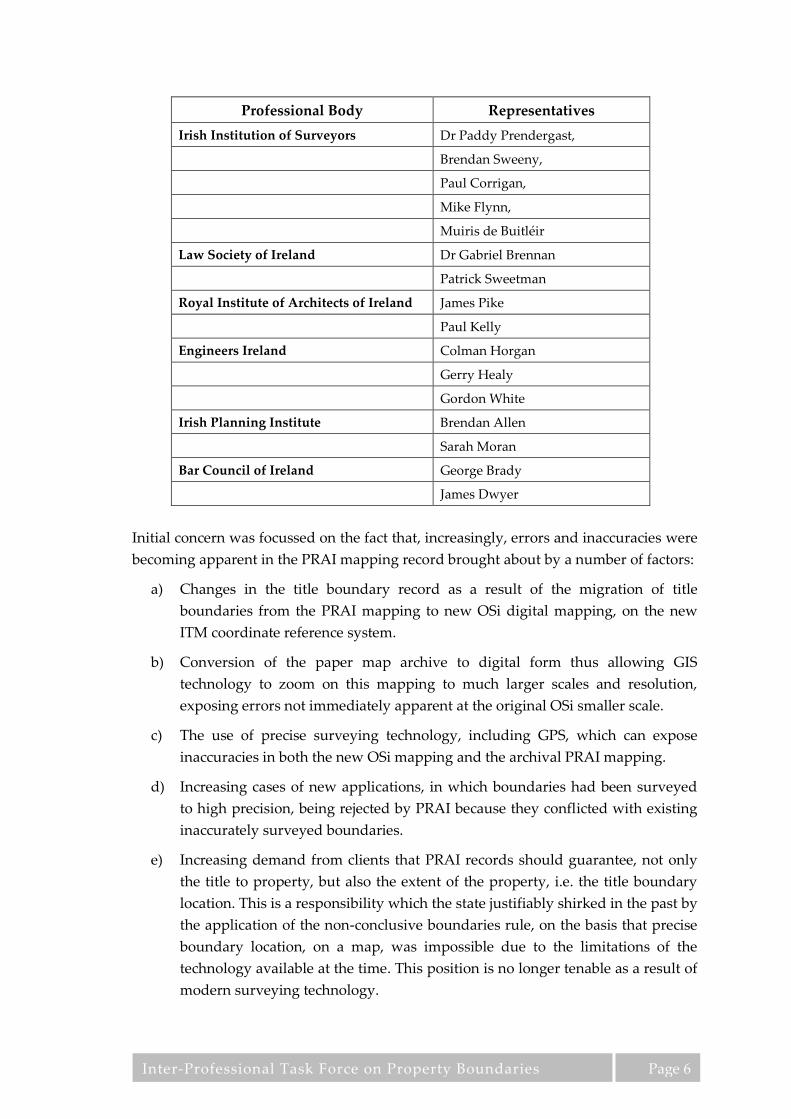
Representatives from the following professional organisations and institutions, whose
members are involved in submitting applications and mapping to the PRAI for
registration, on behalf of clients, came together to discuss issues of mutual concern.
The representative group met under the title of the Inter-Professional Task Force on
Property Boundaries (IPTFPB) and the following list outlines the members of the group
and the professional bodies they represent:
Inter-Professional Task Force on Property Boundaries
Page 6
Initial concern was focussed on the fact that, increasingly, errors and inaccuracies were
becoming apparent in the PRAI mapping record brought about by a number of factors:
a) Changes in the title boundary record as a result of the migration of title
boundaries from the PRAI mapping to new OSi digital mapping, on the new
ITM coordinate reference system.
b) Conversion of the paper map archive to digital form thus allowing GIS
technology to zoom on this mapping to much larger scales and resolution,
exposing errors not immediately apparent at the original OSi smaller scale.
c) The use of precise surveying technology, including GPS, which can expose
inaccuracies in both the new OSi mapping and the archival PRAI mapping.
d) Increasing cases of new applications, in which boundaries had been surveyed
to high precision, being rejected by PRAI because they conflicted with existing
inaccurately surveyed boundaries.
e) Increasing demand from clients that PRAI records should guarantee, not only
the title to property, but also the extent of the property, i.e. the title boundary
location. This is a responsibility which the state justifiably shirked in the past by
the application of the non-conclusive boundaries rule, on the basis that precise
boundary location, on a map, was impossible due to the limitations of the
technology available at the time. This position is no longer tenable as a result of
modern surveying technology.
Professional Body Representatives
Irish Institution of Surveyors Dr Paddy Prendergast,
Brendan Sweeny,
Paul Corrigan,
Mike Flynn,
Muiris de Buitléir
Law Society of Ireland Dr Gabriel Brennan
Patrick Sweetman
Royal Institute of Architects of Ireland James Pike
Paul Kelly
Engineers Ireland Colman Horgan
Gerry Healy
Gordon White
Irish Planning Institute Brendan Allen
Sarah Moran
Bar Council of Ireland George Brady
James Dwyer

Inter-Professional Task Force on Property Boundaries
Page 7
As a result of the group’s deliberations it was decided to carry out an extensive survey
among members of the professional bodies, who were involved in the preparation of
title boundary mapping for property registration, or who were users of such mapping,
to ascertain the full extent and nature of the issues. This survey, carried out by
questionnaire and by discussion groups was divided into a range of themes or topics to
ensure that a full spectrum of issues was covered. It was conducted between January
2010 and March 2011 and the results were analysed, consolidated and are presented in
full in the appendices to this report. These results were further validated by a series of
workshops with each professional group and the re-circulation of the survey results in
spring 2013. (See Appendix A for exact details of the methodology adopted).
The focus of the surveys and the feed-back from these surveys was primarily
concerned with the problems of boundary definition and boundary location, so before
addressing the specific areas of interest it would be useful to provide a brief
introduction to the context of title boundary mapping and present the key issues raised
in the survey together with recommended solutions, which if adopted by the PRAI
would eliminate the great majority of the problems which affect the current property
title mapping system in Ireland.

Inter-Professional Task Force on Property Boundaries
Page 8
3 Problems relating to Non-conclusive
Boundaries and OSi Mapping
It is accepted that, as regards the registration of title, the PRAI systems function well.
However, in the context of recording and guaranteeing the boundaries of the land
parcels to which that title applies, the PRAI system is deficient. The system of non-
conclusive boundaries means that PRAI provides no guarantee as to the location of
boundaries, merely that a boundary exists somewhere in the approximate location
indicated on a relatively small scale, and often inaccurate, map. Equally, it provides no
information on the physical nature of that boundary or where the legal boundary lies
in relation to such physical features. This deficiency and lack of clarity has caused
difficulties in the past, but until the advent of modern surveying methods there was
little that could be done to improve the situation. Today, with the proliferation of such
technology, glaring discrepancies are emerging between the accurately mapped
location of physical boundary features and the mapping of these features using the less
precise methods operated by OSi and the PRAI. It should be stated that this is no
criticism of OSi, as their remit is to provide general mapping for the state, suitable for a
very wide range of functions, and not specifically to provide mapping suitable for title
boundary recording. However, it is unacceptable that, in the current digital age, less
accurate official mapping is given precedence over precise and accurate survey and
mapping, and that such flawed mapping is perpetuated in circumstances where high
quality replacement mapping is available, but is rejected by the PRAI.
Secondly, in the absence of a clear definition of the nature of the features being
mapped, the lines on the current PRAI title maps are ambiguous as to what
topographical feature they represent and the relationship of the legal boundary to such
topographical features is also undefined and ambiguous. In many cases a line on an
OSi or a PRAI map may represent multiple features on the ground, or a feature of
significant width, without specifying which feature is represented. This is an issue that
will become increasingly problematical over time and current OSi and PRAI policy
does not address the issue. The primary problem is that the mapping used by the PRAI
to record title boundaries is based on OSi mapping, which is published at a scale, and
derived by a methodology which lacks the accuracy and precision required for title
boundary mapping.
4 Assumptions Regarding the Level of Accuracy
Required for Title Mapping
For the purposes of examining the suitability of surveying and mapping methodology
for title boundary determination, the following assumptions can be made:

Inter-Professional Task Force on Property Boundaries
Page 9
a) Errors greater than 1m would be of a magnitude which could spark a
boundary dispute if ownership of a strip of this width were to become an
issue.
b) Errors of less that 0.1m are sufficiently small as to be unlikely to spark dispute
except in exceptional circumstances, especially if the nature of the features and
the location of the title boundary with regards to the features are described.
c) That precision for mapped boundaries should lie somewhere within these
ranges, and preferably nearer the lower limit. Such mapping must be of a scale
capable of representing that degree of precision.
5 Comparison of OSi Mapping and Mapping
Derived from Precise Surveying against the
Assumed Criteria
If the above assumptions are accepted then a survey methodology, capable of defining
location to a precision of +/- 0.1m in terms of coordinates, could quite easily be
implemented. For modern surveying technology using precise GPS positioning and
total station surveying instruments, this is not an issue as most systems in current use
achieve considerably higher levels of accuracy.
OSi mapping, on the other hand, is derived primarily from photogrammetry based on
1:40,000 photo scale imagery for 1:5,000 scale mapping, a process which is not capable
of providing survey data to the required minimum precision (See Appendix F for a full
discussion of this issue).
If, in addition to digital survey coordinates, paper mapping were to be derived from
survey data and if this mapping was to be acceptable as an authoritative basis for
defining boundaries on the ground, this mapping would need to be at a scale which
would allow dimensions at the required resolution of around 0.1m to be measured. A
scale of 1:500 is the minimum scale that fulfils this requirement. The map would also
need a grid overlay of 20 m, or so, to facilitate accurate assessment of scale across the
area of the map, allowing for the varying expansion of paper.
OSi mapping is produced at a maximum scale of 1:1,000 in urban areas, reducing to a
scale of 1:5,000 in rural areas and no grid overlay is provided. Such mapping does not
meet the standards necessary for accurate title boundary mapping, where a precision
of +/- 0.1m is required. The accuracy of OSi mapping was quantified by Greenway and
Curran (2005) as:
a) 1:1000 maps of urban areas with an accuracy of ±0.60m

Inter-Professional Task Force on Property Boundaries
Page 10
b) 1:2500 maps or sub-urban and peri-urban areas with an accuracy of ±0.69m
c) 1:5000 maps or rural areas with an accuracy of ±1.22m
6 The Definition of a Title Boundary on the
Ground
The primary reality of what constitutes a legal boundary is not a mapping issue at all.
What exists physically on the ground and the acceptance of these features by the
property owners involved constitutes the actual definition of a title boundary. A line
on a map or a string of coordinates can symbolise the location of a physical boundary
feature to high levels of accuracy, but two additional attributes are necessary before
such a line can be interpreted in the context of a title boundary:
a) The specific physical feature, or the part of the physical feature, which the line
represents must be specified. For instance:
i. Concrete block wall - 230mm thick and 1.2m high
ii. Earthen bank topped by hedge
iii. Concrete post and wire fence.
iv. Wooden super lap fence supported on timber uprights
v. Drainage channel – 2m wide
vi. Undefined line across open land
vii. Specific boundary marks or monumentation
viii. etc...
b) The relationship of the title boundary to these physical features must also be
defined i.e.
i. The concrete wall is a party wall and the title boundary runs through its
centre.
ii. The title boundary is off-set 4.5 metres to the east of the centre of the
bank. The bank and hedge is entirely within the ownership of Folio X.
iii. The title boundary follows a line joining the centre of each concrete post
to the centre of the adjoining post.
iv. The title boundary lies 50mm from the face of the super lap fencing on
the side opposite the timber supports. The supports and fencing are
entirely within the ownership of folio X.

Inter-Professional Task Force on Property Boundaries
Page 11
v. The title boundary follows the eastern rim of the 2.0m wide drainage
channel.
vi. The title boundary runs across open land and is defined by the
following ITM coordinates. Buried boundary markers have been
inserted at the following coordinate points.
vii. etc...
From the analysis so far it is clear that PRAI mapping falls between two stools. It is
based on OSi mapping which is inadequate in scale and precision, and inadequate in
the definition of the topographical features being represented, for acceptable title
boundary recording. However, at the same time, this OSi mapping provides a degree
of detail and a level of precision which gives the erroneous appearance that it is in fact
recording accurate title boundaries thus leading to the problems outlined in the rest of
this document and particularly in the detailed appendices outlining the problems
being experienced by practitioners.
7 Recommended Solutions
To resolve this difficulty it is recommended that the PRAI introduce a number of
reforms to their mapping procedures as follows:
a) Make a clear and absolute distinction between the PRAI parcel index map and
the title boundary map (map submitted for registration).
b) Standards, of a higher level than those pertaining at present, relating to the
precision of mapping being accepted for title registration purposes, would
need to be adopted. This should involve registration of competent and
suitably qualified registered boundary surveyors and their regulation to
correctly implement a set of standards relating to surveying and mapping
procedures and accuracies.
c) A system of identifying boundaries shown on title boundary mapping with
regard to the different levels of precision and accuracy involved in their
derivation is required. A system of colour coding of boundary lines,
representative of the 5 different levels of precision as set out in section 7.3 is
recommended.
d) A protocol that ensures that surveying and mapping of a higher level of
precision will always take precedence, in the PRAI database, over mapping of
less precision and accuracy.
e) A simple and inexpensive procedure for the agreement and definition of title
boundaries between adjoining property owners is required.

Inter-Professional Task Force on Property Boundaries
Page 12
The following suggests the basis of these new mapping procedures:
7.1 The Parcel Index Map
The purpose of the parcel index map is to allow the PRAI, the property owners, or
members of the public to identity the approximate location of registered land parcels
and their general relationship with each other. This index map need only be sufficient,
in terms of accuracy and detail, to allow such an unambiguous identification of the
land parcel. It should have no pretensions to defining the title boundaries to these
parcels in any way and this declaration of its unsuitability for boundary definition
should be emphasised in the strongest terms possible. This index map should, of
course, continue to use the OSi background mapping, as is currently the practice. Also
it should remain in continued use to define boundaries for parcels where better quality
title boundary maps have not yet been registered (See Appendix E for a fuller
exposition of this matter).
7.2 The Title Boundary Map
Title boundary maps should be related to each parcel on the PRAI parcel index map.
This title boundary map would consist of title boundary definition at a precision
commensurate with the survey methodology and mapping on which it is based. It
would be quite separate from the PRAI parcel index map. These title boundary maps
should be attached to each folio (where available) and there should be sufficient
information on each map to allow the parcel to be reliably identified and re-established
on the ground (See Appendix E for a fuller exposition of this matter).
7.3 Levels of Accuracy in Title Boundary Mapping
Five levels of mapping accuracy can be identified and they are listed here in order of
increasing precision:
1. A title boundary line annotated on an OSi or PRAI map, which is not coincident
with any pre-existing topographic detail shown on the maps and where the
delineation is carried out using unknown and unspecified methods.
2. A title boundary delineated as coincident with a line representing topographic
detail on OSi mapping at a scale of 1:5,000
3. A title boundary delineated as coincident with a line representing topographic
detail on OSi mapping at a scale of 1:2,500
4. A title boundary delineated as coincident with a line representing topographic
detail on OSi mapping at a scale of 1:1,000
5. A title boundary delineation that is derived from precision survey, to defined
standards, by a qualified and registered boundary surveyor, where the physical
features constituting the boundary and the relationship of the title boundary to

Inter-Professional Task Force on Property Boundaries
Page 13
these features are specified in a schedule and the location of the physical
boundary features are defined in terms of ITM coordinates and depicted on a
map at 1:500 scale, or larger, as appropriate. The agreement of the adjoining
land owners to such a title boundary definition would also be formally
obtained.
As explained earlier in this section, maps at levels 1-4 are of a scale and precision
incapable of providing evidence of accurate title boundaries. Maps at level 5, on the
other hand can provide such evidence and the data contained in this map and its
associated documentation would allow the reliable re-establishment of boundaries on
the ground to the defined precision (See Appendix G for a fuller exposition of this
matter).
7.4 Circumstances where precise survey and owner agreement
should occur
It is suggested that PRAI should insist that mapping submitted for title boundary
registration should be to the standard of maps at level 5 in all of the following
circumstances (See Appendices E and U for a fuller exposition of this matter).
a) In the case of all boundaries created by a new sub-division, where an existing
physical boundary mapped by OSi, or a PRAI mapped title boundary, does not
exist.
b) In the case of boundaries resulting from the execution of a compulsory
purchase order.
c) In the case of boundaries defined as the result of a court order.
d) In the case of the resolution of boundary disputes.
e) At the request of property owners, where adjoining owners formally agree the
boundary definition schedules and precision mapping.
7.5 Precedence of Mapping derived from Precise Surveying
It is recommended that, for all the above circumstances, the delineation of such
boundaries, resulting from precision surveying, on the PRAI title boundary map
should take precedence over, and replace, all of the other forms of boundary
delineation, and the lines of such boundaries should be colour coded on PRAI
mapping (parcel index map and title boundary map) to distinguish them from other
registered boundaries. The documentation (boundary features schedule, title boundary
schedule, ITM coordinate list, 1:500 title boundary map, survey validation data, owner
agreements and registered boundary surveyor’s certification) should be registered as
an integral part of the property title. Such precise boundary delineation should not be
subject to the acceptance criteria used by PRAI for snapping title boundaries to OSi

Inter-Professional Task Force on Property Boundaries
Page 14
topographic features i.e. the accuracy of their derivation should not be degraded on
PRAI title mapping to inferior levels of accuracy (See Appendices G and L for a fuller
exposition of this matter).
7.6 The Continued Use of Title Boundary Delineation Related to
OSi Topographic Detail
Title mapping based on existing OSi background should continue for the present for all
cases other than the five circumstances stated in section 7.4 above i.e. where entire
parcels are being transferred and no newly defined boundaries or boundary change is
involved, or where no issues have arisen between adjoining property owners, or
between a property owner and the PRAI, regarding the nature or location of the title
boundary, or a CPO or court order is not involved. It is suggested that this mapping,
based on OSi topographical detail, should have clear warnings that the precision and
accuracy of such maps is solely commensurate with the surveying and cartographic
standards of the underlying OSi mapping and the methods by which previously
registered title boundaries were mapped for registration and that there is every
likelihood that errors, inaccuracies and imprecision are inherent in the delineation of
the boundaries (See Appendix F for a fuller exposition of this matter).
It is recommended that colour coding of line work on PRAI maps (parcel index map
and title boundary maps) should cover the 5 levels of mapping accuracy, so that
anyone using PRAI title mapping can immediately be aware of the level of accuracy
and reliability of any delineated boundary line.
The current policy of requiring the submission of precision maps that identify errors in
the PRAI record, firstly to the OSi to rectify their mapping before correction of the
PRAI record, is unacceptable. As already stated, if such a procedure were to be
followed, the corrected boundary would be depicted by OSi at a scale and level of
generalisation commensurate with their standard map scales and photogrammetric
methodology, which are below the standard of accuracy required for title boundary
definition. In effect the accuracy of the precise survey would be discarded, together
with the definition of the features mapped leaving no documentary certainty as to the
location of the boundary, despite the execution of a precise survey establishing that
certainty.
7.7 Title Boundary Map - Page Size and Format
It is suggested that all title boundary maps should be to a default scale of 1:500, where
possible. However, it is accepted that larger scales may be required in certain
circumstances and these should be implemented and accepted where appropriate. It is
also accepted that smaller scales may be appropriate where the underlying precision of
the surveying methods does not warrant the larger scale, particularly where depiction

Inter-Professional Task Force on Property Boundaries
Page 15
at such a larger scale might lead to higher levels of accuracy being imputed to the
mapping than might actually be the case. A standard design format should also be
followed, for reasons of homogeneity and consistency. Appendix H outlines the page
formats and property areas related to a scale of 1:500. It is also recommended that map
page format should be standardised at A3 and for larger extents a system of small scale
index map and a standard map grid should be used to relate the individual A3 sheets
to each other.
7.8 A Simplified Form of Owner Agreement of Title Boundaries
A simplified form of standard owner agreement to defined boundaries is required. The
recommendation is:
a) That the property owners agree that the boundary, as viewed on the ground
and as described in the relevant schedules, is their agreed boundary.
b) Those features, as scheduled, would be surveyed and mapped by the registered
boundary surveyor to the appropriate precision and would be certified by the
surveyor as an accurate depiction of the boundary so agreed.
c) The accuracy of the title boundary map would be the surveyor’s legal liability
in the event of dispute.
d) Coordinates and survey validation would be submitted in conjunction with the
title boundary map and boundary feature schedule and would form part of the
legal boundary definition.
A draft of such a boundary agreement is shown in Appendix U.
In this context it is recommended that boundaries, surveyed to high precision by
registered boundary surveyors, meeting specified standards, and where contiguous
owners agreement has been obtained, should be registered as defined boundaries. The
term conclusive, already in use in this general context, has over the years acquired
layers of meaning which would render its continued use, in this particular context,
ambiguous and potentially misleading. It is therefore recommended that a new term be
adopted to describe registered boundaries, which have been defined as set out above.
7.9 Surveying issues regarding Sub-division
Specific difficulties exist in connection with the precise mapping of sub-divisions.
Surveying and mapping can take place at three distinct stages:
a) At design stage – for instance, when a housing estate scheme map is prepared.
b) At setting out stage – when the plot, or plots, to be sub-divided are physically
marked on the ground.

Inter-Professional Task Force on Property Boundaries
Page 16
c) At “as built” stage – when finished boundary walls, fences, hedges etc. are in
place.
It is recommended that, when surveying and mapping precise boundaries, two
schedules should be completed, prior to surveying and mapping, and the obtaining of
owner agreement –
a) A schedule describing the topographical or physical boundary features,
together with coordinates should first be prepared.
b) A schedule defining the title boundary in relation to these physical features
should then be set out.
In the case of subdivision the logical process is often reversed, in that the title
boundary is set out first and the physical boundary is built subsequently. The
problems that arise from this reversal of procedure are particularly acute in the case of
scheme maps for housing estates.
Given the PRAI’s recommendation that boundaries should be defined on the ground
prior to surveying and mapping and the legal assumption that the boundaries between
properties are those which physically exists on the ground, the definition of boundaries
by means of precision survey and owner agreement, should only take place subsequent
to the construction of a permanent physical boundary and not prior to such
construction. This would require a suspension of the completion of boundary
registration until final boundary features had been constructed, and the necessary
schedules of physical boundary features and title boundary relationships completed,
together with the precise surveying, mapping and signature of owner agreements.
However, houses on new housing estates are often sold off the plans, and these plans,
in the form of scheme maps, are lodged with PRAI to form the basis for registration.
This places a heavy duty on the developer to ensure that the design plan is based on an
accurate survey of the external boundaries of the total land parcel being developed and
that the scheme depicted fits within these precisely surveyed and mapped boundaries.
It would also be a requirement that the developer ensure that the parcel boundaries, as
delineated on this plan, are accurate. Furthermore it requires that when boundary
walls or fences for the house plots are ultimately constructed at the end of the building
process, they are located accurately in relation to the original design boundaries and
scheme map. This does not necessarily happen under current circumstances. It would
be advisable that registration, based on scheme maps in particular, should be
designated as provisional only until the submission of the precise survey based on
permanent boundary features is carried out and a document signed between adjoining
owners or the developer indicating their agreement to these boundaries is completed
(See Appendices G, L and T for a fuller exposition of this matter).

Inter-Professional Task Force on Property Boundaries
Page 17
7.10 Property Boundaries in Multiple Unit Developments
Title boundaries within multi-unit developments pose particular problems. In this case
the issues are:
a) Insufficiently large scale to represent the detail required to delineate title
boundary in a building environment.
b) In the absence of alternatives, acceptance of inadequate and inaccurate plans,
such as photographs of outline emergency escape plans, for title registration.
c) The difficulties of mapping complex three dimensional spaces.
The recommended solution to these problems is, in the first instance, an increase in the
scale of title boundary maps used for the registration of individual units, to 1:50, which
is the minimum scale that will allow architectural detail to the required resolution to be
displayed. The use of index mapping at a scale of 1:200, or an appropriate small scale,
to indicate the interrelationship of individual units is also recommended. Such an
arrangement parallels the separate generalised index map and precision title boundary
map recommended in the case of land and non-multiple unit developments (See
Appendix P for a fuller discussion of this matter).
7.11 A Formalised Process for Boundary Rectification
A final major issue raised was the need for a two staged process including a) a
formalised process for boundary rectification and b) an independent system of appeal
against decisions of the PRAI relating to the rectification of mapping errors. Currently
if a professional brings an error in PRAI mapping to the notice of the PRAI, the
decision rests with the PRAI as to whether the error should be rectified or not. PRAI
may consider the error trivial in the context of the general boundaries rule or for other
reasons relevant to the PRAI. It can be the case that the rectification of a single error in
the boundary of one property may trigger a cascade of anomalies in the mapped
boundaries of adjoining properties, a sequence of events which, perhaps, the PRAI are
loath to set in motion. However, the error may be far from trivial to the property
owners involved and may urgently need to be set right. At present there is no formal
procedure to request a boundary rectification and no appeal of the initial decision. If
the PRAI refuse to rectify the error, that is the end of the matter and there is no further
means of redress, other than the courts. It should be noted that the question at issue
here does not concern boundary disputes or disagreement between adjoining property
owners regarding the location of a boundary, but simply a straightforward error
between the actual location of a boundary on the ground and its recorded location on
PRAI mapping.
Thus it is recommended that a formalised process be established to request rectification
of boundaries and that a process of appeal also be instituted to adjudicate on issues

Inter-Professional Task Force on Property Boundaries
Page 18
where there is a difference of opinion between a property owner and the PRAI
regarding the mapped location of a property boundary on PRAI mapping (See
Appendix L for a fuller discussion of this matter).
8 Conclusions
In concluding, it should be noted that this report is not an academic exercise. It has
been generated directly from the experiences of professionals across a wide range of
disciplines, based on their dealings with the PRAI on matters of mapping for property
registration. The issues raised are all substantial problems which the practitioners have
encountered in their day to day work.
It should also be noted that the solutions, which have been recommended in the report
do not call for root and branch reform of the PRAI, which might cost large sums of
money at a time when the public purse is severely strained. The solutions are all
relatively simple improvements to current procedures, whose implementation would
smooth the operation of property registration and could conceivably involve cost
saving, by removing causes of ambiguity and misunderstanding.
The major recommendation of instigating a system of registration and standards for
registered boundary surveyors, and using their high quality boundary surveys to
incrementally improve the accuracy and precision of the PRAI title mapping record,
provides a means by which the PRAI can substantially improve the quality of its
record over time at little or no cost to itself. Other recommendations, such as, the clear
separation of parcel index mapping and title boundary mapping, colour coding to
indicate the degree of precision which can be expected of any particular title boundary
line, the clear differentiation between topographic features as shown on OSi mapping,
which are the responsibility of OSi, and registered title boundaries, which are the remit
of PRAI and, the principle of giving precedence to mapping of higher precision over
mapping which is of lesser precision, are equally important and their implementation
would generate a very considerable increase in the value and usefulness of the PRAI
mapping record. Many other anomalies have been noted and solutions recommended
in the appendices, and a resolution of each issue, although small in itself, would lead to
a cumulative improvement in the operation of the PRAI.
Additionally, these recommendations if implemented, will significantly contribute
towards the future development of an Irish Spatial Data Infra-structure (ISDI). Parcel
boundaries properly defined in this manner constitute a fundamental data theme
supported by robust legal evidence upon which other layers of spatial data can be
associated with certainty. Conversely, the current association of higher layers to non-
conclusive boundaries which have little evidence to support them, considerably
weakens the whole ISDI and leads to many delays, uncertainty and waste of resources.

Inter-Professional Task Force on Property Boundaries
Page 19
In the separate sections in the appendices that follow, based on practitioner feedback,
this principle will be reiterated again and again as the issue of mapping precision is at
the core of current title boundary mapping problems.
It is hoped that the PRAI and OSi will accept the findings of this report in the spirit in
which they are offered, as a genuine and cooperative attempt by the expert property
professionals who do business with the PRAI, to improve the quality of title
registration mapping for the benefit of the PRAI itself and also, and most importantly,
to improve the quality of service which the PRAI can offer to its ultimate customers –
Irish landowners.

Inter-Professional Task Force on Property Boundaries
Page 20
9 References
CLGE - Comité de Liaison des Géomètres Européens, 2012, Measurement Code for the
Floor Area of Buildings, CLGE, Brussels, pp 1-20
http://www.eureal.eu/static/doc/booklet_EN.pdf
Department of Justice (DoJ), 2012, Land Registration Rules, Statutory Instrument
Number 483 of 2012, Stationary Office, Dublin,
http://www.irishstatutebook.ie/2012/en/si/0483.html
Greenway I. & Curran S., 2005, Ordnance Survey Ireland – Life After New Mapping,
IRLOGI Conference, Dublin, pp1-13
Greenway I., 2006, Developing Ireland’s National Mapping: A Progress Report, Ordnance
Survey Ireland, Dublin, pp1-9
INSPIRE Thematic Working Group Buildings, 2013, D2.8.III.2 INSPIRE Data
Specification on Buildings v3.0rc3, European Commission, Brussels, PP 1-309
http://inspire.jrc.ec.europa.eu/documents/Data_Specifications/INSPIRE_DataSpecificati
on_BU_v3.0rc3.pdf
INSPIRE Thematic Working Group for Cadastral Parcels, 2010, D2.8.1.6 INSPIRE Data
Specification for the spatial data theme Cadastral Parcels v3.0.1, European Commission,
Brussels, PP 1-124
http://inspire.jrc.ec.europa.eu/documents/Data_Specifications/INSPIRE_DataSpecificati
on_CP_v3.0.1.pdf
Law Reform Commission, 2006, eConveyancing: Modelling the Irish Conveyancing
System, Law Reform Commission, Dublin, LRC 79 – 2006, pp 1-56
http://www.lawreform.ie/_fileupload/Reports/Report%20eConveyancing.pdf
Law Society eConveyancing Task Force, 2008, eConveyancing: Back to Basics – Vision of
an Electronic System of Conveyancing (eVision), Law Society of Ireland, Dublin, pp 1-4,
http://www.tfpb.ie/Publication%20of%20eVision.pdf
Oireachtas, 2009, Land and Conveyancing Law Reform Act, Number 27 of 2009,
Stationary Office, Dublin, pp1-143
http://www.irishstatutebook.ie/2009/en/act/pub/0027/index.html
Oireachtas, 2005, Safety, Health & Welfare at Work Act, Number 10 of 2005, Stationary
Office, Dublin, pp1-95 http://www.irishstatutebook.ie/2005/en/act/pub/0010/index.html
Oireachtas, 1964, Registration of Title Act, Number 16 of 1964, Stationary Office, Dublin
http://www.irishstatutebook.ie/1964/en/act/pub/0016/index.html
Prendergast, W.P., Flynn, M., Corrigan, P., Sweeny, B.F.S., Martin, Á. & Moran, P.,
(2008), Green Paper Proposing Reform of Boundary Surveys in Ireland, Irish Institution of
Surveyors, Dublin, pp 1-109.

Inter-Professional Task Force on Property Boundaries
Page 21
http://www.irish-
surveyors.ie/downloads/best_practice_guidelines_for_boundary_surveys_final_2.pdf
Property Registration Authority, (2013), Mapping Practice (first published 1st Nov 2010,
updated 1st Feb 2013), Property Registration Authority, Dublin,
http://www.landirect.ie/eng/Legal_Professional_Customers/Legal_Practices_Procedure
s/Practice_Directions/12_Mapping_Practice/
Property Registration Authority, (2012), Practitioner’s Guide 2012: Mapping Procedures for
First Registration of a Property, Sub-divisions of Registered Property and Rights over
Registered Property, Property Registration Authority, Dublin,
http://www.landirect.ie/eng/Legal_Professional_Customers/Mapping%20Guidelines/P
ractitioner's_Guide_2012_Mapping_Procedures_for_FRs,_subdivisions_and_rights.pdf
Property Registration Authority, (2007), Digital Mapping Project - Digitisation Protocol
(Version 1.3), Property Registration Authority, Dublin, pp 1-46
http://www.landirect.ie/eng/Legal_Professional_Customers/Mapping%20Guidelines/D
igital_Mapping_-_Digitisation_Protocol/Digitisation_Protocol.pdf

Inter-Professional Task Force on Property Boundaries
Page 22
10 Appendices
Explanatory note: In editing the responses to the survey of practitioners every effort
was made to keep as closely as possible to the structure of the survey and the replies of
the participants. A degree of repetition across the different themes is therefore to be
expected.

Inter-Professional Task Force on Property Boundaries
A 1
A Methodology of Survey and Analysis
The IPTFPB conducted an electronic survey of professionals involved in the property
sector on the issues related to boundary mapping in Ireland from June 2010 to March
2011 to determine:
a) The scale of the issues being experienced by property professionals
b) An explanation of the detail of the issues involved, and;
c) Suggestions on how these issues might be resolved.
323 valid responses were received in a stratified sample of the property professions
(Table 1). The sample sizes from both solicitors and land surveyors were large enough
to have margins of error less than ± 10% and the sample sizes for engineers, architects
and spatial planners have margins of error slightly above ± 10% for their responses.
Therefore the responses for the survey have a 90% confidence level with a margin of
error or circa +/- 10%.
Table 1 – Validity of the sample sizes achieved for the Survey
The qualitative information gathered in the survey was processed, analysed and
validated in a number of stages (table 2). Stage one involved abstracting all the
quantitative data and creating charts, tables and maps. Stage two necessitated creating
individual reports for each of the professional groups involved, abstracting the
qualitative responses, colour coding them and then collating them into one document.
Stages 3, 4 and 5 were carried out by the analysis team including an engineer, a
solicitor and a surveyor. Stage 3 and 4 involved classifying these responses into main
categories, and then stage 5 identified the main issues from the responses within each
category and then developed preliminary proposals on how each of these issues might
be resolved. Stage 6 required the drafting of one page summaries for each issue
identified setting out a) the Current procedures, b) Difficulties being experienced, and
c) Proposed solutions.
Profession Population
Size
Required sample for
+/-10% Error Margin
Responses
Received
Sampling Error
Achieved
Completion
Rate
Land Surveyors 375 57 65 ± 9.3% 17.3%
Solicitors 7,500 67 105 ± 8.0% 1.4%
Engineers* 400 58 46 ± 11.5% 11.5%
Architects 2,415 66 55 ± 11.1% 2.3%
Planners 700 62 39 ± 13.0% 5.6%
Barristers 2000 65 1 ∞ 0.05%
GIS Analysts ? ? 2
Others ? ? 10
Total 323

Inter-Professional Task Force on Property Boundaries
A 2
The replies, in many cases, were cryptic, idiomatic and not always couched in
diplomatic language. To bring the results to a publishable standard considerable
editing was required. In carrying out this editing process every effort was made to
ensure that all comments and points of importance were included and the edited text
was re-circulated to the participants for review to ensure that what follows, represents
their views, and that nothing of substance has been added or omitted.
Table 2 - Stages of Analysis of the Qualitative Results collected in the Survey
Stage 7 involved a series of four CPD workshops held in spring 2011 (Table 3) to
inform the members of the professional bodies of the survey results, and to discuss the
feasibility and practicability of solutions proposed for the core issues identified.
Table 3 – Attendance at series of CPD Workshops on the Preliminary Survey Results
RIAI
30th March 2011
EI
7th April 2011
IIS
14th April 2011
Law Society
28th April 2011
Attendance 23 37 53 52
Stage Tasks Performed
1 Create a report from www.surveygizmo.com of the all the responses which included tables
and charts of the quantitative results.
2
Create reports from www.surveygizmo.com for each profession using filters available, extract
qualitative responses into word, colour code for each professional group, and combine groups
into one document.
3 Initial classification of answers into a) Advocating Change, b) Neutral to Change, or c) Not
Advocating Change
4
Secondary classification of qualitative data into main categories, such as:
a) OSi Mapping
b) PRAI Map - Issues already completed
c) PRAI map - Accuracy Issues
d) PRAI Map - Rectification
e) Declarations of Identity
5 Identification of issues from within each main category
6
Formulation of preliminary proposals to resolve main issues identified and prepare a 1 page
summary for each issue setting out a) Current Procedure, b) Difficulties being experienced, and
c) Proposed Solutions
7 Host a series of CPD workshops to inform, discuss and collect feedback on the preliminary
survey results and the solutions proposed.
8
Circulate the final results to the 70 property professionals who indicated in the survey their
wish to participate to ensure the results a) properly captured the concerns they raised and the
solutions they proposed and b) were still valid in 2013

Inter-Professional Task Force on Property Boundaries
A 3
The analysis of the survey data took far longer to complete than anticipated, so the
final results were further validated in spring 2013 by circulating 70 of the survey
respondents who indicated their wish to participate further to ensure a) the results
property captured the concerns voiced in the survey and b) that these results were still
valid in 2013.
The summaries of the qualitative data follow a standard format:
a) The current procedures are outlined.
b) The difficulties being experienced by those who replied to the survey are
outlined.
c) Solutions, to resolve these difficulties, are proposed.
In some instances, where the theme may be complex, an introductory section outlining
the background to the topic is included. It should also be noted that the summaries of
the questionnaires contain duplication, as many of the same issues arose under
different thematic headings. No effort was made to edit out this duplication, as it was
felt that the text should keep to the content of the replies as closely as possible. It
should also be noted that, even in cases where it is not explicitly stated, or it is not clear
from the context, the text is based robustly on the contents of the survey.

Inter-Professional Task Force on Property Boundaries
B 1
B Quantitative Results
The first surprising, even alarming result was that over a quarter of professionals
(27.7%) were not aware that property boundaries registered in the Land Registry or in
the Registry of Deeds are non-conclusive and are not guaranteed by the State. Non-
conclusive boundaries were defined in the survey as “The Register does not contain
sufficient information to define the boundary either legally or geometrically.
Consequently, the boundary is open to challenge, and is not guaranteed by the State.”
Another striking finding was the high percentage of respondents (78%) who recorded
having difficulties with existing boundary mapping (Table 4). Prior to the survey a
figure of 25% to 30% would have been considered as high, but an average of 78%
suggested a much deeper problem.
Table 4 - Incidence of boundary mapping issues encountered by property
professionals
65% of professionals stated that they were concerned with certifying Declarations of
Identity for title maps which are based on non-conclusive boundaries. If the State
Agencies supplying these official maps do not accept the risk relating to them, why
should property professionals be required to accept this risk? Essentially, it was felt
that property professionals are using their professional indemnity insurance to
mitigate the additional risks involved.
Finally, the results indicate a significant appetite for change (Table 5). Professionals
indicated a wide range of extra information they would like to be included on
boundary/Title maps. If the recommendations are that the title and the mapping
registers should be more definitive, and all encompassing to prepare for the
introduction of eConveyancing, then this extra information should be considered for
inclusion.
Have you encountered any of the following boundary mapping issues? Yes No N/A
a) Boundary disputes resulting from mapping issues? 87.3% 11.7% 0.9%
b) Difficulty establishing a boundary on the ground using a Title map? 90.8% 6.7% 2.5%
c) Difficulty resolving a boundary survey with a Title map? 83.7% 12.8% 3.5%
d) Inconsistency between areas on Title maps and areas as measured on
the ground? 91.7% 5.4% 2.9%
e) Difficulty resolving Rights of Way and/or Easements on Title maps
and Rights of Way and/or Easements on the ground? 67.8% 25.7% 6.5%
f) Differences between two adjoining Title maps? (gaps or overlaps) 72.8% 24.3% 2.9%
g) Differences between two Title maps for the same property? 52.4% 45.0% 2.6%
Total 78.2% 18.7% 3.1%

Inter-Professional Task Force on Property Boundaries
B 2
Table 5 - Additional information requested for inclusion on boundary/title maps
What information is currently not included in this map that you
like to be included?
Yes No N/A
a) Title boundaries (line of registered boundaries)? 87.4% 3.9% 8.7%
b) Physical features (including annotation of type)? 85.0% 5.1% 9.8%
c) Occupation line (current limit of occupation)? 67.2% 18.6% 14.1%
d) Legal boundary (the intentions of the parties) 89.4% 4.3% 6.4%
e) Land area (extent) of property? 86.6% 6.9% 6.5%
f) Dimensions and coordinates? 91.4% 4.1% 4.5%
g) Rights of way and easements? 94.2% 2.1% 3.7%
h) Other? (please specify below) 32.3% 9.2% 58.5%
Overall Result 84.5% 6.1% 9.4%

Inter-Professional Task Force on Property Boundaries
C 1
C Summary of Qualitative Results
This table provides a full list of all the solutions proposed under each of the themes examined in the written comments received from the 323
respondents during the survey. These solutions are then classified under the five columns on the right-hand-side (Professional Bodies, PRAI,
OSi, Other State Agencies and new legislation) to specify where the responsibility for implementing the solutions lies.
Rel
evan
t A
pp
end
ix
Qualitative Data
Dev
elo
p &
Im
ple
men
t G
oo
d
Pra
ctic
e G
uid
es b
y
Pro
fess
ion
al B
od
ies
Co
lla
bo
rate
wit
h P
RA
I to
rev
iew
& i
mp
lem
ent
new
map
pin
g p
roce
du
res
Co
lla
bo
rate
wit
h O
Si
to
rev
iew
& i
mp
lem
ent
new
map
pin
g p
roce
du
res
Co
lla
bo
rate
wit
h O
ther
s to
rev
iew
& i
mp
lem
ent
new
map
pin
g p
roce
du
res
Co
mm
un
icat
e p
rop
osa
ls f
or
new
leg
isla
tio
n t
o
go
ver
nm
ent
D Access to PRAI Digital Map Data
PRAI to provide access to digital vector mapping (relevant parcel only available at present)
Include
adjoining
parcels
Access to specified scanned copies of historical title maps to be made available to surveying & mapping
professionals to allow evolution of boundaries over time to be analysed
E Indicative Boundaries versus Definitive Boundaries
PRAI to encourage registration of defined boundaries to improve accuracy of PRAI mapping
PRAI to encourage submission of precision survey of all mapping for first registrations
Surveying & mapping methodologies and standards to be developed for precision survey & mapping of
boundaries.
Develop & introduce a simplified form of boundary agreement Draft in

Inter-Professional Task Force on Property Boundaries
C 2
Appendix
U
PRAI to develop & implement a protocol which outlines:
a) a hierarchy of reliability of boundaries based on the precision of their derivation - 5 levels are
proposed as follows:
boundaries surveyed by registered surveying & mapping professionals using modern
survey methods to adopted standards with an accuracy attribute of < +/- 0.1m
Boundaries associated with features on 1:1000 OSI maps with an accuracy attribute of +/-
0.60m (should this be improved by OSi?)
boundaries associated with features on 1:2500 OSI maps with an accuracy attribute of +/-
0.69m
boundaries associated with features on 1:1000 OSI maps with an accuracy attribute of +/-
1.22m
registered boundaries not associated with OSi features and of unknown accuracy
b) a boundary labelling method (tagging & colour coding) is implemented on mapping to ensure the
boundary accuracy level is clear to property professionals
Should
accuracy
of 1:1000
mapping
be
improved?
Acceptance of annotated boundaries on PRAI or OSi maps by unskilled applicants should be
discontinued - competence of surveying & mapping professionals to be checked by the PRAI
F Ordnance Survey Ireland Mapping
OSi to improve their mapping such that:
a) topographic features on OSi maps to contain attributes as to their nature & extent
b) an improvement in the positional accuracy of topographic features to meet a new defined set of
national standards (based on international norms) to be promulgated by the NSAI
c) Quality assessments to be conducted in accordance with ISO standards for quality evaluation for
spatial data and results published
OSi should make efforts to overcome interpretational shortcomings of aerial photogrammetry by more
rigorous field checking on the ground
High quality mapping information from defined boundaries could be used by OSi if surveying &
mapping standards were correctly implemented. This would represent a significant new source of high
quality information from hundreds of survey & mapping professionals around the country for OSi
G PRAI Mapping - Accuracy

Inter-Professional Task Force on Property Boundaries
C 3
Reliability attribute required for registered defined boundaries to record one of 5 levels of accuracy
PRAI to manage accuracy of registered boundaries in the digital mapping (landowners to remain
responsible for accuracy standard submitted)
Land Registration Rules to be reviewed to make them more appropriate to modern surveying methods
and digital mapping
Snapping of registered boundaries to OSi features to be switched off when a defined boundary has been
registered
Parcels containing defined boundaries would have a title boundary map attached to the folio
High quality surveys used to gradually update accuracy of LR parcel index map
H PRAI Mapping - Scale and Page Format
PRAI title maps to be issued at standard scale of 1:500. Larger scales may be necessary in certain
circumstances, so possibility to specify larger scale to be provided. Where land parcels cover an extended
area requiring multiple A3 maps, an index map at a smaller scale should also be provided
Boundaries on title maps to be colour coded to indicate their reliability (based on the precision of their
derivation). Map legend to include colour coding
PRAI to supply all title maps at A3 format, or A4 if preferred
20m ITM grid (grid spacing may change for other scales) to be overprinted on all PRAI title maps at 1:500
and ITM values to centimetre precision to be stated for all four corners of the map. A scale bar to be
included on all title maps
I PRAI Mapping - General
A critical review of www.landdirect.ie website to be carried out to improve reliability:
a) interruptions during transactions resulting in double charging
b) warning before completion of transactions of any lacunae in the information being provided
before committing to paying a fee
J PRAI Mapping - Issues Completed with Digital Mapping System
K Extent/Area of Parcels and Properties
A protocol needs to be implemented setting out a hierarchy of land parcel area values based on the
precision of their derivation, and area values on folios and title maps should include a label identifying

Inter-Professional Task Force on Property Boundaries
C 4
the level of precision. Three levels can be inferred:
a) Boundary survey by registered boundary surveyor to an adopted standard & methodology
b) Areas derived from improved OSi maps where boundaries for published areas are indicated using
area braces (re-introduced) or in black compared to other features in grey. This measure should be
in association with improvements in the positional accuracy of topographic features on OSi maps
c) Existing areas from OSi maps & PRAI title maps where coincidence of title boundaries and OSi
features (from which these areas are computed) is not explicitly defined
Where a boundary survey has been carried out by a registered surveying & mapping professional to an
adopted standard & methodology, the resulting area value should take precedence over previous values
for the same parcel (in map & in folio).
Areas derived from the PRAI digital map should take precedence over areas quoted in folios
Area values published by the PRAI should be colour coded to indicate their source
L Rectification of Mapped Title Boundaries
Mechanism required to set aside the PRAI adoption criteria for associating registered boundaries with
OSi features in certain circumstances:
a) Where the precision & accuracy of OSi mapping is demonstrably lower standard than existing
registered boundaries or new boundaries submitted for registration
b) Where the offset of a title boundary from a topographic feature is deliberate
c) Where the title boundary in the PRAI archive is coincident on the ground with a topographical
feature delineated on the OSi map, but where the distance between the lines portraying this
feature on the old and new mapping exceeds the adoption criteria
Introduce a simple boundary agreement form to allow adjacent owners correct title boundaries
incorrectly located on the PRAI digital map (& switch off snapping)
PRAI to implement a system of accuracy/reliability attributes for registered boundaries - see 7.3 above
where 5 levels are proposed. PRAI to accept mapping submitted for registration only where the accuracy
level of the mapping submitted is higher than or equal to the accuracy level of the existing registered
boundaries.
Development and implementation of a standard schema for the description and classification of
topographical features
Development of standards, specification and guidelines for precision boundary surveys & mapping

Inter-Professional Task Force on Property Boundaries
C 5
Registration and regulation of surveying & mapping professionals for carrying out boundary surveys,
and submitting mapping to the PRA
PRAI to be proactive in approach to resolving known discrepancies in its digital mapping. Co-operation
of landowners should be sought by the PRAI to resolve issues
Establish an independent Appeals Authority (with representatives from professional bodies and PRAI) to
resolve discrepancies in the PRAI mapping where there is disagreement between the landowner and the
PRAI
M Property Boundaries Associated with Dynamic Features
A detailed clarification on the current legal realities, PRAI requirements and procedures with regards to:
a) Changes to courses of streams & rivers
b) Changes to the High Water Mark in coastal areas due to erosion or accretion
c) Sudden natural horizontal movements of land due to landslide, subsidence, earthquake or
flooding
A simple procedure is required for rectifying boundaries in the case of watercourse changes due to
natural causes
Wider access to historical data in the PRAI archive by legal and surveying & mapping professionals in
certain circumstances would assist in proposing logical solutions
N Property Boundaries to the Centre of Public Roads
A detailed clarification of the current legal status of land parcel areas computed to the road centreline is
required. In particular, the issue of land physically ceded by a property owner (under planning
regulations) but not yet taken in charge by the road authority requires clarification
The definition of what physically constitutes the centre of a public road for title mapping purposes needs
to be defined, and procedures specified for surveying and mapping this feature. The use of OSI road
centrelines is considered inappropriate
O Property Boundaries used for Land-Use Zoning and Planning
A clarification is required defining the exact nature and legal status of the boundaries which planning
authorities use on their land-use zoning maps
A clarification is required with regard to the legal definition of boundaries of parcels for which planning
applications are granted.

Inter-Professional Task Force on Property Boundaries
C 6
PRAI title boundaries should be accepted by planning authorities as the most suitable boundary for both
land-use zoning and grants of planning permission
All State bodies should use the same base map rather than different map bases to improve integration
between public databases. This should be based on the PRAI database of title boundaries, rather than the
large scale OSi map base
P Property Boundaries in Multi-Unit Developments
PRAI should increase the standard required for mapping Multi-Unit Developments. A minimum scale of
1:50 for individual units and 1:200 for floor plans of individual buildings is proposed
Recommended that the Measurement Code for floor area of Buildings published by CLGE (2012) and
adopted by INSPIRE should be adopted for Multi-Unit Developments in Ireland
Recommended that plans for Multi-Unit Developments be prepared and certified by competent
professionals (architects & building surveyors)
Q Additional Information
Recommend a review of section 72 of the Act to significantly reduce registration exclusions for
eConveyancing so that the titles register is definitive, conclusive and all encompassing. Recommend
registration as burdens on the folio, such as the following:
a) Designation as a protected structure
b) Designation as a National monument
c) Inclusion in the Sites & Monuments Register/Record of Monuments & Places
d) Inclusion in Special Areas of Conservation (SACs)
e) Inclusion in Special Protected Areas (SPAs)
f) Inclusion in Natural Heritage Areas (NHAs)
Improved standards of surveying and mapping accuracy, and annotation already recommended for
boundaries should also apply to all easements to improve clarity
PRAI should review issuing title maps with and without special features. A single map showing all
information is preferable
R Coordinates, Measurements and Monuments
Develop standards and procedures using modern surveying methods to survey and supply high quality
(+/- 0.1m) coordinates to the PRAI for registration of boundaries

Inter-Professional Task Force on Property Boundaries
C 7
S Declarations of Identity
Establish a working group representing the Law Society, Engineers Ireland, Irish Institution of Surveyors,
Society of Chartered Surveyors and the Royal Institute of Architects of Ireland to develop a standardised
good practice procedure based on international practice for submission to the professional bodies
involved for adoption and implementation by their members. The new procedure should:
a) Include a mandatory site visit to check that title boundaries on the PRAI map corresponds to
boundaries on the ground
b) Identify and document the physical features on the ground with which the title boundary is
associated
c) Identify and rectify any discrepancies and ‘ransom strips’
Consider if the registration of Declarations of Identity in the PRAI was desirable
T Registration and Regulation of Professionals preparing and submitting maps to the PRAI
PRAI to only accept mapping submitted and certified by registered survey & mapping professionals in
following circumstances, i.e.
a) Sub-divisions
b) First registrations
c) Rectification of errors
Ultimately in all transfers of property
Insurance bonding of registered boundary surveyors to be required
Good practice guidelines for precise surveying & mapping of boundaries (jointly developed between
professional bodies and the PRAI) and issued by the PRAI
Develop a course(s) at level 9 (masters, or post-graduate diploma) in boundary surveying and land
registration for existing surveying & mapping professionals

Inter-Professional Task Force on Property Boundaries
D 1
D Access to PRAI Digital Map Data
a) Current Procedures
Since December 2012 copies of the digital polygon is supplied at a cost of €120.
However, for these to be used, background OSi digital mapping, at a cost of a further
€100, is required. PRAI supply paper copies of Title Plans of properties to landowners
and professionals and copies of title plans for individual and multiple properties are
supplied in digital form to public bodies. It is likely this facility was provided to
comply with the requirements of “data and service sharing” under the EU INSPIRE
Directive.
Paper copies of maps originally submitted for registration are only supplied to the
landowner or their solicitor.
Currently, OSi supply A4 copies (or larger) of their digital data for purchase by the
general public.
Digital submission of maps is permitted as long as it is accompanied with an exact
paper copy (for lodgement in the instrument) - rules for digital submissions are
outlined in pages 106 to 109 in the IIS green paper proposing reform of property
boundaries
b) Difficulties being experienced
Most surveyors, engineers and architects capture and manipulate mapping
information in digital form rather that working with paper, in order to:
i Significantly improve the accuracy of their work.
ii To improve the efficiency of their work process.
iii To effect cost savings for clients.
The lack of access to PRAI mapping information in digital form requires paper copies
to be scanned, geo-rectified and in some cases re-digitised which:
i Necessitates additional costs for clients though this is unlikely in the current
commercial climate so profits margins reduce instead.
ii Has additional cost due to duplication where information is re-digitised. This
re-digitisation also degrades accuracy by introducing small human and
technical errors when trying to re-create the same line digitally.
iii Increases opportunity for inaccuracy to creep into the work from scanning and
geo-rectification. In most mapping systems geo-rectification requires a
minimum of 4 coordinates. Only 2 coordinates are quoted on PRAI Title Maps
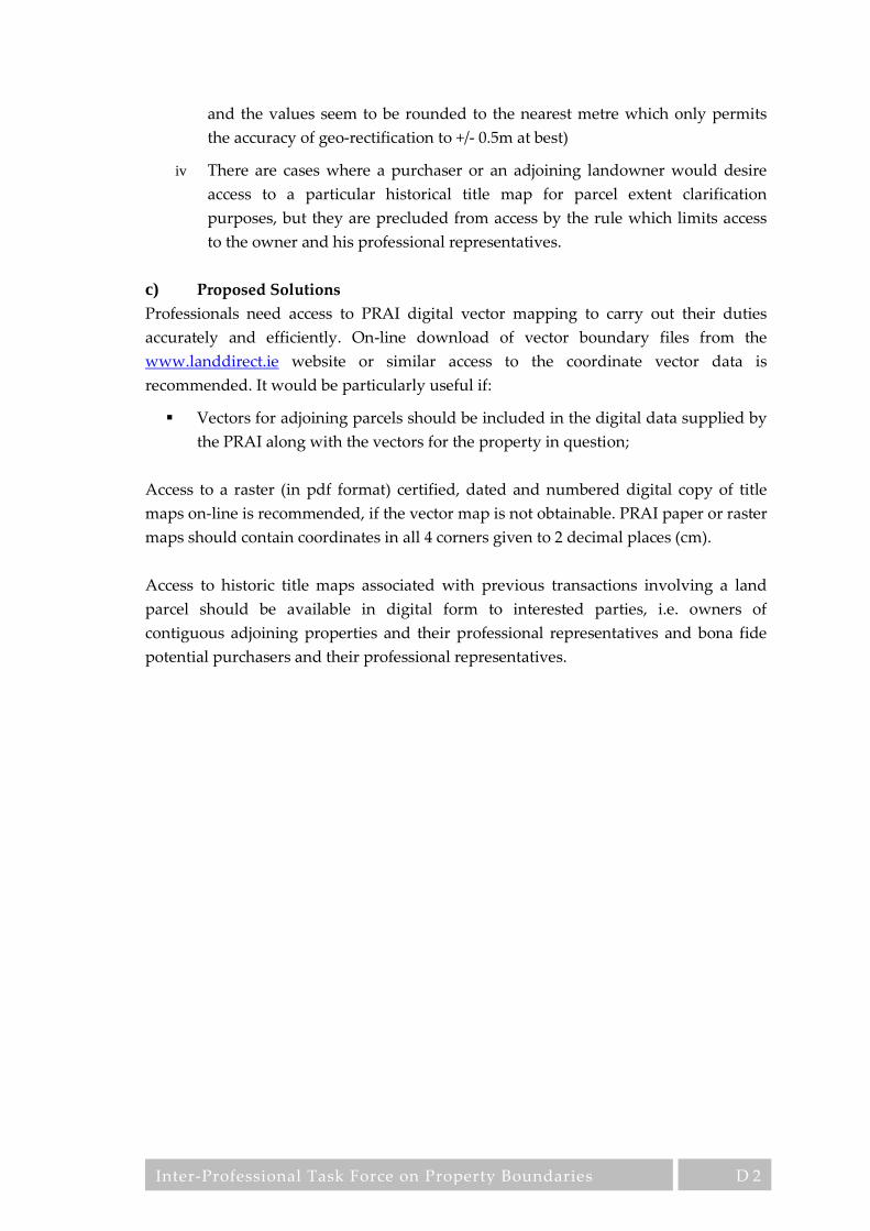
Inter-Professional Task Force on Property Boundaries
D 2
and the values seem to be rounded to the nearest metre which only permits
the accuracy of geo-rectification to +/- 0.5m at best)
iv There are cases where a purchaser or an adjoining landowner would desire
access to a particular historical title map for parcel extent clarification
purposes, but they are precluded from access by the rule which limits access
to the owner and his professional representatives.
c) Proposed Solutions
Professionals need access to PRAI digital vector mapping to carry out their duties
accurately and efficiently. On-line download of vector boundary files from the
www.landdirect.ie website or similar access to the coordinate vector data is
recommended. It would be particularly useful if:
Vectors for adjoining parcels should be included in the digital data supplied by
the PRAI along with the vectors for the property in question;
Access to a raster (in pdf format) certified, dated and numbered digital copy of title
maps on-line is recommended, if the vector map is not obtainable. PRAI paper or raster
maps should contain coordinates in all 4 corners given to 2 decimal places (cm).
Access to historic title maps associated with previous transactions involving a land
parcel should be available in digital form to interested parties, i.e. owners of
contiguous adjoining properties and their professional representatives and bona fide
potential purchasers and their professional representatives.

Inter-Professional Task Force on Property Boundaries
E 1
E Indicative Boundaries versus Defined Boundaries
It is possible for property boundaries in a land registration system to have a number of
major attributes. For instance:
i Definition – The physical nature of the boundary can be accurately described
and defined.
ii Location – The position of the boundary is capable of being located, in terms
of its dimensioned relationship to permanent or semi-permanent features in
the landscape or special survey monumentation, or in terms of coordinates
based on a defined coordinate system which are capable of reliable
repositioning on the ground.
iii Agreement – Defined boundaries can be formally agreed between the
adjoining landowners as constituting the accepted boundary between their
two properties. Once such an agreement has been arrived at, it should be
possible to register these agreed boundaries with the PRAI.
It should be noted that current legislation (sections 86 to 88 of the Land Registry Act
1964) allows for boundaries to be registered as conclusive.
i Section 86 permits boundaries determined by the courts to be registered as
conclusive.
ii Section 87 permits boundaries to be registered as conclusive if adjoining
neighbours agree.
iii Section 88 permits the registration of all new boundaries as conclusive.
Of course it is equally possible for registered boundaries to have none of the
characteristics specified above, as is the case with the current system of non-conclusive
boundaries. In the context of land registration boundary mapping, the term
“conclusive” is considered to be misleading, as it has intimations of absoluteness and
perfection, which are often qualities difficult to associate with surveying and mapping.
Degrees of precision or accuracy are concepts which are much more applicable. It is a
reasonable principle that, when surveying property boundaries, where considerable
monetary sums are at issue, that more precise and more accurate mapping should take
precedence over mapping which is less precise and less accurate. This is a principle
which should find common acceptance across the spectrum of government agencies,
property professionals and property owners and it is the principle which underpins
the following discussion and recommendations.
When Land Registry mapping was instituted at the end of the nineteenth century a
decision was taken to base the mapping of land parcel boundaries on the existing
Ordnance Survey, 25 inch and 6 inch, Cassini projection, County Series, mapping. This

Inter-Professional Task Force on Property Boundaries
E 2
mapping lacked sufficient precision and accuracy to allow the precise definition of the
location of boundaries. It also mapped topographic rather than legal boundaries and
the two did not always coincide. Perhaps for these or other reasons, the decision was
taken to adopt a system of non-conclusive mapped boundaries. Under this system, the
delineated boundary line on the Land Registry map is an indication only that a
boundary exists somewhere in the general vicinity of this line but offers no evidence as
to its exact nature or location. The fundamental problem with this system is that it is, at
the same time, both too precise and not precise enough, for its purpose (see the main
report for a full elucidation of this paradox). It should be noted in passing that, in
contradistinction to the PRAI system, many European countries operate a system of
cadastre, in which boundaries are accurately surveyed, monumented and definitively
recorded for property valuation and taxation purposes, but also for property
registration.
a) Current Procedures
Mapping for the registration of the sub-division of land parcels must be submitted on
the most current and largest scale version of the OSi map available, or on a certified
copy of the PRAI map. The boundary lines are delineated by the applicant and are
accepted provided they do not conflict with previously registered boundaries.
Although PRAI recommend the use of competent surveyors, no level of qualification or
competence is actually required of those submitting such mapping and no checks are
carried out by PRAI to verify the accuracy of the submitted boundaries.
As already stated, the boundary line on the map offers no evidence as to the nature of
the boundary feature, nor does it offer evidence of the exact location of the legal
boundary on the ground.
All boundaries shown on submitted mapping and incorporated into the PRAI records
are non-conclusive boundaries, unless specific and relatively difficult procedures are
carried out to register them as conclusive.
b) Difficulties being Experienced
There is a lack of understanding among the public regarding the current non-
conclusive system and this creates much confusion for clients and often leads to the
apportioning of blame for difficulties and errors to the professional advisor rather than
to the shortcomings of the system.
Non-conclusive boundaries can lead to misunderstandings between different
professionals involved in the registration process. Certain professionals may put
ultimate trust in the written word and may be unaware of the accuracy limitations of
survey technology and the application of the general boundaries rule.

Inter-Professional Task Force on Property Boundaries
E 3
Mapped boundaries, which are defined as non-conclusive provide no reliable evidence
in situations where it is necessary to establish a boundary on the ground.
Non-conclusive boundaries can be the cause of boundary disputes because challenges
are more easily issued due to lack of clarity in the PRAI records.
Non-conclusive boundaries place surveying and other land and property professionals
in the invidious position of being approached by clients to resolve seemingly
straightforward technical problems but being unable to assist because of the non-
conclusive nature of the official state mapping.
Non-conclusive boundaries remain non-conclusive even in cases where considerable
effort and expense may have been expended to resolve a boundary issue to the
satisfaction of the land owners concerned. The same issues may arise at a future date,
requiring the process to be repeated again unnecessarily.
It can be argued that an integral part of guaranteeing title is guaranteeing the precise
land area to which that title applies. Non-conclusive boundaries fail in this respect.
In the absence of conclusive, or defined, boundaries, resort to the courts is the only
option available in the event of a boundary dispute, if negotiation, mediation or
arbitration fails. This is an extremely costly and wasteful procedure.
The inaccuracy of mapping, made acceptable by the state’s use of the disclaimer of
non-conclusive boundaries, allows conflicts of boundary location to occur on the PRAI
index map, where no such conflict occurs on the ground. Conversely, conflicts can also
occur on the ground, which do not appear on the PRAI map.
Surveying technology is now so advanced that boundary definition and surveying to
very high levels of precision is possible. It is inefficient and wasteful to degrade
mapping provided by such advanced systems to the level of data acquired by older or
less accurate methods, simply to conform to the non-conclusive boundaries system.
The primary reason for declaring title boundaries non-conclusive, i.e. the inability to
define and survey them to sufficient levels of precision, now no longer exists, due to
modern surveying technology.
As set out in the principle enunciated in the preamble to this section and in the main
report, more precise and more accurate survey and mapping should always take
precedence over that which is less so. It is wrong, as is currently the case, to give
mapped data, acquired by out of date or inaccurate methods and often by unqualified
and incompetent persons, precedence over high quality survey data, acquired using

Inter-Professional Task Force on Property Boundaries
E 4
precision equipment, by highly qualified professionals. However, there is, of course, a
need to ensure that such high quality data conforms to a defined set of standards.
c) Proposed Solutions
It is proposed that improvement of the accuracy and completeness of the boundary
record should be one of the principal aims of the PRAI in relation to its title mapping.
It is accepted that the current system based on OSi mapping with the disclaimer
regarding non-conclusive boundaries is the reality, but due to the serious inadequacies
of this mapping for the purpose of title boundary registration, this should not preclude
the possibility of incremental improvement over time by using modern methods.
It is recommended that modern surveying and mapping methods have removed many
of the reasons which made conclusive boundaries unfeasible in the past, and that as a
result, PRAI should now instigate a policy of encouraging the declaration of defined
boundaries, in the interest of their customers right to clarity and state guarantee, not
alone to their title of their property but also to the boundaries and extent of that
property.
It is recommended that PRAI should encourage the use of precision survey in all
mapping submitted for title registration. To this end, title boundary mapping
submitted in cases of first registrations, sub-divisions, error correction and boundary
dispute resolution, should be to required standards and carried out by expert and
registered practitioners. This coupled with a simplified form of property owner
agreement would make such boundaries capable of being rendered defined.
It is recommended that PRAI introduce a simplified form of boundary agreement,
allowing property owners, only in the circumstances where a precision survey is being
carried out, to agree the description and definition of the title boundaries, thus
allowing the four components of a defined boundary to be registered, namely – a) clear
description of the physical features constituting the boundary, b) clear definition of the
location of the title boundary relative to these physical features, c) precise surveying
and mapping of these features to a level of accuracy and precision which allows their
subsequent verification and re-establishment on the ground and d) a formal agreement
by the adjoining property owners of their acceptance of the boundaries so defined (see
Appendix U for a full exposition of a simplified form of boundary agreement between
adjoining property owners).
In proposing a solution cognisance should be taken of the principles outlined in the
introduction to this section and in the main report regarding levels of precision. A
protocol should be implemented which identifies a clear hierarchy regarding title map
boundaries, based on the precision of their derivation. A method of labelling such

Inter-Professional Task Force on Property Boundaries
E 5
mapped boundaries, so that this method of derivation is clear, is also necessary. Five
levels of precision can be inferred (see 7.3 above):
i Survey of a specific land parcel by a competent and registered surveyor using
precision equipment, for the express purpose of determining and mapping the
title boundaries of a land parcel. For this data to become part of a publicly
accessible and guaranteed data set, it would be necessary for strict rules
regarding qualification and registration of practitioners to be in place and also
strict guidelines as to the methodology and standards to be used in carrying
out the survey. This process of precision survey would embrace all attributes
of a title boundary, namely description and definition of its physical features,
the definition of the title boundary relative to these features and its accurate
location by means of ITM coordinates and accurate mapping. In circumstances
where a precision survey would be required, the obtaining of agreement of the
common boundary between adjoining land owners, so defined and so located,
as the boundary of their properties would not pose a major problem
particularly if a simplified and inexpensive form of agreement was instigated
(see section 4 on basic assumptions above). This mapped boundary, which
incorporates the higher level of precision and accuracy, should replace
boundary lines on the PRAI title boundary mapping which have been
surveyed to a lesser degree of precision. In effect a title boundary determined
to this higher level of precision coupled with boundary definition and
boundary agreement, would constitute a defined boundary.
ii An improved OSi map, in which topographical features, which are indicated
by lines on the maps, are identified as to their nature. This should be coupled
with an improved level of accuracy of topographical feature coordinates in the
OSi maps to meet a new defined set of national standards. Although it is
recommended that precision boundary survey should become the norm in the
longer term, because of the inability of OSi mapping to meet the necessary
standards due to its scale and lack of sufficient precision, the improvement of
the accuracy of the OSi mapping in the meantime would be beneficial, since so
many existing registered boundaries are associated with the OSi features.
Three distinct levels of precision can be associated with OSi mapping, related
to their published scale.
The acceptance of annotated boundary lines on a PRAI certified copy map or an OSi
map sheet by an unskilled and unqualified applicant should be discontinued.

Inter-Professional Task Force on Property Boundaries
F 1
F Ordnance Survey Ireland Mapping
a) Current Procedures
Many properties were registered using the 19th century OSi mapping at scales 6” and
25” to 1 mile on separate Cassini projections for each County. This mapping was
primarily produced for taxation and land registration purposes. The positional
accuracy of this mapping does not meet 21st century accuracy needs due to projection
inconsistency along County boundaries and inaccuracy of 19th century survey methods,
compared to modern methods.
OSi replaced this old mapping with new surveys at scales of:
i 1:1,000 of urban areas surveyed from 1967 to circa 1993
ii 1:2,500 of sub-urban & peri-urban areas surveyed from 1992 to 2004
iii 1:5,000 of rural areas, surveyed from 2001 to 2005
However, these three surveys used different specifications, so a harmonisation
programme (PRIME1) was executed before delivery of the new mapping on the ITM
coordinate reference system to the PRAI to digitise their boundaries (OSi are currently
implementing a quality enhancement programme (PRIME2) for this mapping, which is
due for completion in summer 2013). Registered boundaries on the old Land Registry
paper maps were moved during the PRAI digital mapping project to be associated
with features on the new OSi digital maps. Section 73 of the Registration of Deeds and
Title Act 2006 gives precedent to the new digital boundaries over their positions on
older paper maps.
If professionals discover appreciable positional discrepancies in OSi features, they can
report the error to the OSi via [email protected] and documents clarifying the
discrepancy should be attached. OSi will examine the feature and correct it if the
discrepancy is confirmed. However, the corrected feature is currently supplied to the
PRAI in updates of OSi mapping at agreed intervals, which are not publicly known.
b) Difficulties being experienced
As stated and demonstrated in the main body of this report, OSi mapping, at the scales
at which it is provided and the methods by which it is surveyed, is inadequate for the
recording of accurate title boundaries. In addition to this basic failing, professional
respondents to the survey itemised a series of shortcomings which are listed below:
i Complete properties have been omitted on OSi maps because of
misinterpretation of aerial photographic data.
ii Houses, in particular are depicted as being larger than they actually are, due
to roof lines being digitised rather than walls at ground level.

Inter-Professional Task Force on Property Boundaries
F 2
iii There are inconsistencies between line detail where two OSi maps meet.
iv Old ditch lines under heavy overgrowth are often misinterpreted when
surveyed using aerial photography, due to difficulties identifying features
under shadows and the indistinct nature of the physical feature.
v The OSi map provides no indication of the nature of the feature surveyed and
depicted nor, in the case of an amorphous feature, does it indicate which part
of the feature is being depicted.
vi Detail surveyed by modern precision methods often misaligns with OSi detail
when the maps are overlaid, indicating uncertainty and inaccuracy in the OSi
map.
vii The accuracy of features on OSi maps has in cases been found to exceed the
stated accuracies claimed by OSi. In many cases the old 25-inch County Series
mapping is more reliable than the digital 1:1000 mapping.
viii Many respondents considered OSi mapping to be over-priced.
c) Proposed Solutions
The main body of this report has argued cogently for a hierarchy of surveying and
mapping accuracy to be incorporated into the mapping used by PRAI, with detail at
different levels of precision being tagged and colour coded accordingly. If such a
system were implemented it would greatly reduce the impact of the errors and flaws in
OSi mapping as it affects PRAI mapping. This is not to say that OSi mapping should
not be considerably improved from its current standard.
It is recommended that OSi mapping specification should be improved in the
following areas:
i Topographical features delineated on OSi mapping should be defined as to
their nature and extent.
ii Detailed survey and mapping standards should be published, based on
international norms, to be promulgated as national standards by the National
Standards Agency of Ireland, to which OSi mapping would be required to
conform. Validation statements should be compiled and published for
tranches of mapping, covering the OSi national coverage, indicating how such
mapping conforms to the stated standards.
iii Efforts should be made to overcome the interpretational shortcomings of
aerial photography, by more rigorous field checking on the ground.

Inter-Professional Task Force on Property Boundaries
G 1
G PRAI Mapping – Accuracy
a) Current Procedures
The PRAI digital mapping project and the www.landdirect.ie portal for access to the
PRAI mapping database has significantly improved the service for delivering PRAI
maps to property professionals. Property boundaries are now shown on the new PRAI
maps using thin red lines rather than outlined in red using thick markers as in the past.
Also the extension of compulsory first registration to all counties to speed up
completion of registration of all land in the State is an important step forward to ensure
one comprehensive system will be available to manage all land within the State.
The fact that this new PRAI digital mapping is on the ITM coordinate reference system
for Ireland is significant because it provides mapping professionals with the ability to
survey boundaries using GPS equipment to centimetre accuracy. Information from
new boundary surveys can now define locations far more accurately than the PRAI
maps and the OSi maps upon which they are based. There is now a need to adopt
modern standards for regulating new surveys and using these standards to integrate
this high quality information into the PRAI digital mapping.
The OSi digital maps on which these new PRAI maps are based were produced using
modern surveying methods, but not to any defined standard (organisational, national,
or international). The OSi has published a number of accuracy statements for their
mapping. The first statement published in 2005 (Greenway & Curran) supplied the
information in RMSE format (root mean square error), which is the most common
method used internationally for quoting map accuracy and is also used by the EU
INSPIRE Directive. However, the points tested to quantify this accuracy were points of
hard detail (buildings, walls, corners of kerbstones, etc) and not a random sample
which should also include soft detail (bushy features along property boundaries) in
order to provide a true statistical result. Therefore, these results are statistically
skewed, and overstate the case with regard to accuracy of PRAI property boundaries.
Currently, the PRAI does not accept responsibility for accuracy of boundaries
registered in their digital mapping. Currently the landowner is responsible for the
accuracy of boundaries submitted for registration, and other than a conflict check with
previously registered boundaries (which may itself be incorrect), no accuracy checks
are carried out by the PRAI on data submitted and no defined accuracy standards
OSi Map
Scales
OSi Accuracy
Statement 2005
International Norm for Accuracy
= 0.2mm x map scale
1:1000 RMSE = ± 0.60m RMSE = ± 0.20m
1:2500 RMSE = ± 0.69m RMSE = ± 0.50m
1:5000 RMSE = ± 1.22m RMSE = ± 1.00m
Inter-Professional Task Force on Property Boundaries
G 2
apply. If a LR boundary is identified as being incorrect, PRAI recommend the
landowner to contact OSi to correct it, or get the adjoining owner’s agreement, or go to
court to resolve the issue.
b) Difficulties being Experienced
In some cases, the old, paper based LR maps can be more accurate than the new digital
maps. Changes made during the digital mapping project has led to mapping errors,
which may have been based on incorrect assumptions, or interpretations of OSi
mapping of inadequate precision. In many cases the new PRAI digital mapping is
significantly in error when compared to boundary surveys carried out by property
professionals using modern surveying equipment, or previous correct representations
on paper folio maps. The current practice of unilaterally amending boundaries with
regard to OSI maps (during the digital mapping project and on receipt of revised OSi
maps) is not appropriate without formalised accuracy checks and results in
perpetuating discrepancies in the new PRAI digital mapping.
The new PRAI digital mapping suffers from a range of problems which include:
i Registered boundaries obviously in error - drawn through buildings on
adjoining properties.
ii In cases, where new housing is contiguous along a road frontage, the
boundary locations of all parcels can be in error, having been offset by an
error in the boundary location of the first sub-division. In some cases this has
been corrected in the digital mapping project using the adoption criteria, but
in many more cases, the error was larger than the adoption criteria and the
problems remain.
iii OSi maps regularly show one line when there are multiple features in close
proximity on the ground. Two issues arise here a) the OSi digital map does
not contain attributes for the line on the map to distinguish which feature has
been surveyed (although property professionals can make assumptions on the
basis of the survey techniques OSi employ), and b) PRAI adopt the OSi line if
within the PRAI adoption criteria, even where the title boundary is coincident
with a different feature than the one shown on the OSi map.
iv The PRAI operate adoption criteria to allow them to alter (snap) a registered
boundary onto an OSi feature. Three issues arise here a) in many cases small
errors in the paper maps were corrected by associating the registered
boundary with the positions of features on the new OSI maps, and b) the
snapping of title boundaries to OSi features in some cases has introduced
errors that previously did not exist, and c) in many cases the errors involved
were larger than the adoption criteria used, so these issues were not corrected,
even though the correction may have been warranted.
v There are cases, where title boundaries have been registered offset from
features not yet constructed. However, the use of the adoption criteria during
Inter-Professional Task Force on Property Boundaries
G 3
the digital mapping project and on receipt of revised OSi maps has snapped
these title boundaries to new OSi features when they should more correctly be
offset from them.
vi If a boundary submitted for registration conflicts with an existing registered
boundary, the PRAI will reject the new registration. The PRAI will accept any
boundary if it is not in conflict with an existing registered boundary and in
many cases in the past incorrect boundaries have been adopted under this
rule. This rule should now be replaced with a rule which compares the
accuracy standard of the submitted boundary with the accuracy standard of
the existing boundary. A number of levels of accuracy will be necessary to
manage the PRAI digital mapping databases and registration should proceed
when the accuracy of the boundary submitted for registration is at a higher
level than the existing registered boundary.
vii Buildings shown on the new digital title mapping are regularly 10 to 15%
larger in area than they are in reality because OSi surveys its maps using aerial
photography which gives a building roof-line rather than the building
footprint. This is an OSI issue rather than a PRAI issue, but it should be
possible to attach an attribute to buildings in the PRAI digital mapping to
distinguish which category it is. This information would be very useful to
clarify critical clearances between buildings and property boundaries in
certain situations.
The primary issue is that OSi mapping (in its current form) on which the PRAI digital
map is based is only good enough to identify the location of properties. It is not reliable
enough for recording title boundaries because of:
Uncertainty of what feature on the ground the OSi line represents (no attributes);
Uncertainty on the positional accuracy of OSi features due to the lack of defined
accuracy standards;
The scales of OSi maps are not large enough to secure clarity and accuracy in
many instances, especially in urban areas.
The second main issue is that the current PRAI mapping procedures do not help to
identify and resolve problems in the PRAI digital mapping. In some cases the PRAI has
refused to correct mapping accuracy issues of less than 1 to 2 meters, even though high
quality survey information was available, because they consider that high accuracy is
not required in their non-conclusive mapping system.
The third main issue is the need to ensure PRAI maps are consistent over time when
property boundaries on the ground have not changed. The lack of defined accuracy
standards for the revision of OSi maps and the adoption of the features in these OSi
maps by the PRAI using only their adoption criteria has the potential for property
Inter-Professional Task Force on Property Boundaries
G 4
boundaries to be inconsistent over time. The PRAI mapping procedures should ensure
registered boundaries are consistent over time.
c) Proposed Solutions
The PRAI must take on the responsibility of managing the accuracy definitions of the
property boundaries in its mapping database (the landowner retains the responsibility
for the accuracy of information submitted). The benefits of this policy change far
outweigh the cost of developing and implementing new standards for surveys and
mapping within a revised version of the Land Registration Rules 2012 more
appropriate to modern surveying methods and digital mapping.
It should be possible to switch off the snapping of certain registered boundaries to OSi
features in circumstances where the boundaries have been properly defined.
Two options are proposed:
Option 1: Boundaries are defined on the ground between adjoining neighbours
using boundary agreements and then they are surveyed at an
appropriate high standard of accuracy (scale 1:500 and at a precision of
+/- 0.1m), so that the map is capable of reliably identifying the
boundaries and the extent of the property involved. The detailed map
from this boundary survey is used in the contract for transfer and is
submitted to the PRAI and attached to the folio (only boundaries
defined in this way would have a map attached to the folio). The PRAI
index map remains as an index map and is not updated using the more
detailed information. This option requires significant procedural
changes and the adoption of standards externally by property
professionals and minimal changes within the PRAI.
Option 2: Similarly boundaries are defined on the ground between neighbours
and a high quality detailed map of the boundaries is prepared along
with the boundary agreements. When this information is submitted to
the PRAI, the detailed map is again attached to the folio, but in this case
the high quality survey information is used to correct and update the
PRAI index map. This will need a system of reliability tags to be
introduced to allow the high quality information be integrated into the
PRAI mapping database and it will also require the PRAI to manage the
accuracy of registered boundaries. These reliability tags would allow
property professionals have confidence in using PRAI mapping, rather
than the opposite with the current non-conclusive disclaimers. The
benefit of this approach is that the PRAI mapping database would be
continually upgraded with high quality information into the future and
would over time become a reliable national mapping database.

Inter-Professional Task Force on Property Boundaries
G 5
This high quality information could also be used by OSi to update their mapping if
appropriate defined surveying & mapping standards were used and validated. This
means that surveys from hundreds of property professionals around the country could
be used as a significant new source of high quality data by the OSi. Significant benefits
would also accrue to OSi mapping in the long term.
Circumstances under which such a survey would be required should be set out,
initially involving all sub-divisions, error rectifications and boundary dispute
resolutions but ultimately involving all transfers including first registrations.
Finally, the accreditation of competent and qualified property professionals in the form
of a register is required, together with clear standards for surveying and mapping to
manage the collection and validation of this high quality information for the State.

Inter-Professional Task Force on Property Boundaries
H 1
H PRAI Mapping - Scale and Page Format
a) Current Procedures
The PRAI is obliged to use the latest version of the OSi’s mapping as the base mapping
for their boundary database. Currently the OSi supply their maps at three different
scales - 1:1,000, 1:2,500 and 1:5,000. Each of these scales relate to a different degree of
precision and accuracy. The international norm for this relationship is 0.2mm (width of
finest line on the map) multiplied by the map scale. The OSi published the accuracy of
their maps in 2005 (Greenway & Curran) as: (*RMSE = Root mean square error = √ M[(x
– x1)2].
The mapping of urban areas is at the larger scale of 1:1000 to provide more detail and a
higher accuracy for areas with higher land values and more complex topographic
detail. Correspondingly, the 1:5000 maps of rural areas have less detail and are less
accurate, and the mapping of suburban and peri-urban areas at 1:2,500 falls between
these two extremes. The following index map of Co. Waterford illustrates the typical
distribution of OSi mapping at the different scales:
b) Difficulties being Experienced
OSi Map
Scales
OSi Accuracy
Statement 2005
International Norm for Accuracy =
0.2mm x map scale
1:1000 RMSE* = ± 0.60m RMSE = ± 0.20m
1:2500 RMSE = ± 0.69m RMSE = ± 0.50m
1:5000 RMSE = ± 1.22m RMSE = ± 1.00m
© Ordnance Survey Ireland/Government of Ireland,
Copyright Permit Number MP 0004613

Inter-Professional Task Force on Property Boundaries
H 2
In most urban areas these new OSi scales are larger than the scales used for the older
paper maps – 1:1,000 replacing 1:2,500 and 1:1,250. In rural areas, however, the process
has been reversed. The official scale has been reduced from 1:2500 (25” to 1 mile
approx.) to 1:5000. This has led to degradation in the precision of title boundaries,
originally delineated on old County Series 1:2,500 mapping, but now transferred to the
less precise 1:5,000 mapping.
Currently the PRAI only supply their maps on A3 paper which in some cases can mean
multiple maps for one folio. This is a valid procedure, provided that these maps are
overlaid with a grid so that adjoining A3 sheets can be accurately related and a small
scale index map is provided. Neither of the latter two requirements are currently
provided.
PRAI regularly issue the new ITM Title plans at scales larger than the original OSi
scales available for the specific area. Enlarging mapping from its original design scale
can be misleading. As already mentioned above, the scale at which a map is published
is an implicit statement of its precision. When such a map is enlarged, either
photographically or by plotting the coordinates at a larger scale, the inherent accuracy
does not change, but the larger scale gives the false impression that the mapping
precision is commensurate with the larger scale. A clear statement of the original
design scale and the map precision is necessary on all enlarged mapping and should be
integrated with the map sheet. This is not current PRAI procedure.
Title plans, Special Registration maps, PRAI compliant OSi mapping and other
mapping issued by PRAI as a result of official map searches are, in many cases, at too
small a scale to allow the clear intention of the property owners to be ascertained. As
clearly set out in section 5 above, a map scale of 1:500 is the minimum scale which
allows boundaries to be delineated to an acceptable accuracy and clarity.
The facility with which PRAI mapping can be scanned, geo-registered, rectified and
enlarged, or the base OSi digital mapping zoomed for viewing at ever larger scales,
effectively breaks the link between paper map scale and precision inherent in the
mapping. Inconsistencies and errors can now become apparent, which went unnoticed
on the original paper map.
The adoption criteria currently used by the PRAI (2007) are as follows:
Scale of PRAI
Paper Map
Distance on paper map
in mm (pen width =
1mm)
Rural Agricultural Land
(individual plots of 0.4
hectare or more)
Urban, per-urban, rural &
commercial (individual plots
of less than 0.4 hectares)
1:10560 1mm = 10.56m ± 20.00m
1:2500 1mm = 2.50m ± 5.00m ± 3.00m
1:1250 1mm = 1.13m ± 2.50m ±2.50m
1:1056 1mm = 1.06m ± 2.00m ± 2.00m
1:1000 1mm = 1.00m ± 2.00m ± 1.00m

Inter-Professional Task Force on Property Boundaries
H 3
These criteria only take cognisance of original OSi map scales and provide no guidance
for dealing with mapping supplied to PRAI at larger scale and at much higher
precision, in the form of precise surveys carried out by competent professionals.
The coordinates on corners of PRAI maps (Title Plans, Special Registration Maps, and
Official Map Searches) are stated as integers in metres. It is unclear whether these
values have been rounded to the nearest metre or whether they represent the precise
value of the corner. This should be explicit.
c) Proposed Solutions
It is recommended that all PRAI paper mapping involving title boundaries should be
issued at a standard scale of, at least, 1:500, which is the minimum scale at which title
boundaries and topographic detail can be delineated to an acceptable level of precision
and accuracy (see the main report for a full elucidation of this matter). It is understood
that larger scales may be required in certain circumstances.
Boundaries shown on such PRAI mapping should be clearly colour coded to indicate
the scale of map from which they were derived, or the precision with which they were
surveyed (again see the main report for fuller details). Details of this colour coding
should be printed on all maps issued together with caveats regarding the relationships
between precision, accuracy, scale and survey methods.
It is recommended that PRAI should standardise on paper map formats of A4 and A3
for most paper mapping issued. In the context of map format, the PRAI produce title
maps at a maximum format size of A3. In relation to map formats the following should
be borne in mind: at a scale of 1:500, DIN paper formats would cover the following
land areas allowing a page margin of approximately 15mm:
Format Paper Size Map Area Size Ground Dimension Area
A4 297 x 210 mm 260 x 180 mm 130m x 90m 1.17 Ha
A3 420 x 297 mm 290 x 260 mm 195m x 130m 2.54 Ha
A2 596 x 420 mm 520 x 290 mm 280m x 195m 5.46 Ha
A1 840 x 596 mm 580 x 520 mm 405m x 280m 11.34 Ha
Map reproduction costs increase as the page format increases. There is an economic
imperative to keep map format to a maximum of A3 if possible. There is also an issue
of handling convenience. The A3 format giving a map area of 195 metres by 130 metres
is more than adequate to cover both urban and rural house parcels on a single sheet.
Larger land parcels could be catered for by a small scale index map with sectional A3
sheets.
A 20m ITM coordinate grid (40mm at scale of 1:500) should be overprinted on all PRAI
issued maps to allow distortions of scale due to variability in paper expansion or map

Inter-Professional Task Force on Property Boundaries
H 4
reproduction methods to be checked and corrected. ITM coordinate values, to
centimetre precision, should be stated for 2 grid intersection points at opposite corners
of the map sheet. A scale bar should also be included on all maps.
Where land parcels cover an extended area, requiring multiple A3 sheets at 1:500 scale,
or larger, an index map at smaller scale should be provided.

Inter-Professional Task Force on Property Boundaries
I 1
I PRAI Mapping – General
This section covers general mapping issues together with administrative difficulties
and difficulties associated with accessing the PRAI’s www.landdirect.ie website, not
covered in other appendices.
a) Current Procedures
Currently PRAI only supply paper copies of the title plans of properties to landowners
and professionals. Digital boundaries, for individual properties, are available at a cost
of €120. Copies of Title Plans for individual and multiple properties are supplied in
digital form to public bodies. It is likely this facility was provided to comply with the
requirements of the EU INSPIRE directive. Paper copies of maps originally submitted
for registration are only supplied to the landowner or their solicitor.
Digital submission of maps is permitted so long as it is accompanied with an exact
paper copy (for lodgement in the instrument) - rules for digital submissions are
outlined in pages 106 to 109 in the IIS Green Paper
PRAI folio and mapping data may be accessed and downloaded via the
www.landdirect.ie website for a fee. This data comprises raster data and there is only
very limited access to digital vector data.
b) Difficulties being experienced
Most surveyors, engineers and architects capture and manipulate mapping
information in digital form rather that working on paper:
i To significantly improve the accuracy of their work.
ii To improve the efficiency of their work process.
iii To effect cost savings for clients.
The lack of access to PRAI mapping information in digital form requires paper copies
to be scanned, geo-rectified and in some cases re-digitised which:
i Imposes additional cost due to duplication where information is re-digitised.
This re-digitisation also degrades accuracy.
ii Increases opportunity for inaccuracy to creep into the work from scanning and
geo-rectification.
A number of problems have been encountered in accessing the PRAI
www.landdirect.ie interface.
i Difficulty in carrying out a map based search as opposed to searching by
owner name or folio number.

Inter-Professional Task Force on Property Boundaries
I 2
ii Lack of pre-warning that no map may be attached to the folio being
purchased, i.e. the applicant seeking a map may only become aware that there
is no map available after he has paid the fee.
iii The absence of adjoining parcel boundaries on down-loaded title maps.
iv Long delays in providing special features mapping.
v Interruption in the www.landdirect.ie interface, often occurring in the middle
of a transaction, causing the customer to forfeit a fee.
c) Proposed Solutions
Professionals need access to PRAI digital vector mapping to carry out their duties
accurately and efficiently. On-line download of vector boundary files from the
www.landdirect.ie website is recommended.
It is also recommended that:
i Access to earlier versions, in the form of scanned copies of title mapping, is
made available to allow professionals to analyse the evolution of boundaries
and parcels over time.
ii A critical review of the Land Direct website is carried out to improve
reliability. In particular to ensure that service is not interrupted during a
transaction, or if it is, that the customer is not charged and secondly, that the
customer is warned prior to the completion of a transaction of any lacunae in
the information being provided, before he has committed and paid a fee.

Inter-Professional Task Force on Property Boundaries
J 1
J PRAI Mapping – Issues Completed with Digital Mapping
System
a) Background
This section has been included because the issues mentioned here were raised by the
respondents to the survey. It is acknowledged that these problems have already been
dealt with effectively by PRAI and they are to be commended for the following:
i. The provision of the www.landdirect.ie portal is considered to be a worthwhile
initiative and comparable to similar systems in Europe;
ii. The adoption of the new ITM coordinate reference system by the PRAI for their
digital mapping was an excellent choice for the future;
iii. The completion of the digital mapping project on time;
iv. The extension of compulsory first registration to all Counties to speed up the
completion of registration of all land in the State.
This section has been included for reasons of completeness.
b) Difficulties being experienced
There is some lack of awareness on the “in-lining/out-lining” issue with regards to
PRAI mapping. Boundaries were outlined in a thick red line in the old paper mapping
system, but in-lining or outlining is not used in the new digital mapping system, where
the centreline of the relevant boundaries are plotted using a thin red line.
PRAI maps having a mixture of imperial and metric scales can lead to confusion and
has the potential to cause confusion to by users. The migration of all base mapping to
metric scales is proposed.
All PRAI mapping should be standardised and tied into using one national mapping
system. Ireland’s new coordinate reference system (ITM) is the preferred choice rather
than the older Irish Grid (IG75) because it is more modern, more accurate and is GPS
compatible. This permits the PRAI to define boundaries using ITM coordinates.
The conversion of PRAI mapping to digital form should be completed quickly to
facilitate the adoption of digital methods by practitioners and users as soon as possible.
The conversion was completed by the PRAI in July 2011 in a 5 year period.
The Land Register should be completed by introducing compulsory registration for all
Counties with the eventual closure of the Registry of Deeds. Compulsory registration
was extended to the last two Counties (Dublin & Cork) on 1st June 2011 for all property
transfers. It is estimated that between 2 to 300,000 properties are still registered in the

Inter-Professional Task Force on Property Boundaries
J 2
Registry of Deeds, so this migration to Land Registry will take some considerable time
still.
Some maps attached to deeds in the Registry of Deeds are more than one hundred
years old and can be very difficult to relate to an up to date map of the same area, and
sometimes title maps are not available for unregistered properties. The move towards
registration of all properties in Land Registry should be fast tracked. Additional
triggers will also be needed to complete this migration to Land Registry for the
migration of properties which would not normally be transferred.
c) Proposed Solutions
Most of these issues have already been resolved by the PRAI digital mapping system
and no further action is required.

Inter-Professional Task Force on Property Boundaries
K 1
K Extent/Area of Parcels and Properties
The area of any given parcel of land is its actual area on the ground. Measurement of
this area involves surveying and the closeness of the measurement to the reality
depends entirely on the precision of the surveying method. A map is merely the
graphical representation of a survey and its accuracy is similarly dependent on the
precision of the surveying method, and additionally the scale at which the map is
printed or displayed. For the area of a land parcel to be defined accurately two
conditions must be fulfilled:
i The boundaries must be clear and obvious on the ground and defined degrees
of tolerance must be specified to match the precision with which the boundary
features, by their nature, can be identified for measurement.
ii The technology and methodology used to carry out the measurement must be
specified and agreed degrees of tolerance specified to conform to that
precision.
It follows that no absolute value for area is possible and that area values can only be
defined in terms of a computed value +/- a given tolerance.
The above reality has special relevance where parcel or property area may be the basis
for valuation, potential property tax assessment, as a trigger for social housing on
development land or as a basis for calculating agricultural aid or subsidies or any other
procedures where land area bears a relationship to monetary value. Clear rules need to
be defined to ensure a fair and agreed area value in all such cases.
A map of a land parcel is a graphical representation of that land parcel. The
characteristics of such a map, for instance scale, the degree of generalisation involved,
coordinate values of boundary change points, identification of boundary features
mapped, etc. are related to the processes by which a map is produced, and the
judgements made, and decisions taken in its production. Areas measured from the
map, either by scaling from a paper product or by coordinate computation from a
digital product, may differ considerably from the reality. However, area values shown
as labels on title maps are independent of the cartographic geometry of the map on
which they appear and their derivation must be indicated explicitly, either in the
general description of the characteristics of a particular map series, or in the legend or
footnotes of a particular map.
It would seem clear that in all cases where monetary value is involved (sale and
purchase, taxation, provision of subsidies or social housing imposition etc.) the area of
a land parcel should be that which is computed to the highest degree of boundary
definition and the highest degree of technical precision available and relevant to the

Inter-Professional Task Force on Property Boundaries
K 2
circumstances. What these processes should be would vary from case to case. For
instance, the degree of accuracy required for the fair valuation of agricultural land
would be considerably lower than that required for high value urban land. Equally, in
the absence of precision parcel surveys, the values indicated by OSi or PRAI would
stand, unless land owners felt the need for higher precision in certain circumstances.
However, the rule should still be - the higher precision definition of parcel area
should take precedence, in all cases, over a lower precision definition.
With this principle in mind we can examine the current reality regarding the parcel
areas displayed on the OSi and the PRAI documentation.
a) Current Situation (Procedures)
Areas on Land Registry maps
are non-conclusive from a
legal perspective. Land
Registry folios contain a note
that neither the description
nor the title plan is conclusive
as to the extent of the area of
the property. In the recent
past Land Registry have
adopted a practice of not
including the area on new
folios being opened, and no
reasons have been given for
adopting this new practice.
The area of the property is
now supplied (since autumn
2010) by picking the seedpoint
of the property in www.landdirect.ie. (In the case of older folios, this value may not
match the value shown on the folio). This new procedure was introduced to ensure
compliance with the requirements of the specifications for cadastral parcels under the
EU INSPIRE Directive. The size displayed is computed using the coordinates of the
property boundaries in the PRAI digital mapping database. The size is displayed to 3
decimal places of a hectare (accuracy = 10 sqm). This is anomalous as the OSi mapping
from which the PRAI map is derived only give values to 2 decimal places (100 sqm).
b) Difficulties being Experienced
Purchasers and vendors of property are most interested in the land area of the
property because it gives them a measure of the value of property in relation to its area.
The purchase price in many contracts may be based on a price per hectare or per

Inter-Professional Task Force on Property Boundaries
K 3
square metre. In all cases where an assessment of value related to area is required,
there is a need for a reliable and definitive source of parcel area information.
Areas stated on folios and areas on Land Registry maps often do not match each other,
nor do they match the areas stated on OSi maps and in many cases, they do not
correspond with areas computed from a precision site survey. None of these areas
currently complies with any identifiable standard. This situation is exacerbated further
in those cases where boundaries are dynamic in nature (streams, rivers, high water
mark, etc.).
c) Proposed Solutions
In proposing a solution cognisance must be taken of the principles outlined in the
introduction to this section. A protocol needs to be implemented which identifies a
clear hierarchy regarding land parcel area values, based on the precision of their
derivation. A method of labelling such values so that this method of derivation is clear
for each value is also necessary. Three levels of precision can be inferred:
i Survey of a specific land parcel by a competent and registered land surveyor
using precision equipment, for the express purpose of defining and mapping
the boundaries of the land parcel and defining its area to an adopted standard.
For this data to become part of a publicly accessible and certified data set, it
would be necessary for strict rules regarding qualification and registration of
practitioners to be in place and also strict guidelines on the methodology to be
used in carrying out the survey.
ii An improved OSi map, in which topographical features, which are indicated
by lines on the maps, are identified as to their exact nature together with a
clear indication of which of these are bounding lines, indicating the land area
for which an area value is given. This could involve the reintroduction of
areas braces, and/or the highlighting of features bounding the area for which
an area value is indicated, in contradistinction to other features, i.e. area
boundary features could be shown in black and other features in grey. This
should be coupled with an improved level of accuracy of topographical
feature coordinates in the OSi maps to meet a new defined set of national
standards. Parcel areas derived from this new mapping should indicate a
precision commensurate with the standards achieved by the number of
decimal places used.
iii In terms of PRAI mapping it should be borne in mind that topographic
features, as indicated on OSi mapping, are not necessarily identical with legal
boundaries. Where such boundaries do coincide in terms of definition and
location, the PRAI should use the land parcel area value supplied by the OSi.
To comply with INSPIRE requirements trailing zeros could be added to the

Inter-Professional Task Force on Property Boundaries
K 4
decimal, provided it was clearly stated that the number of decimal places was
not an indication of the precision of the measurement.
Where there is a difference between the registered legal boundary and the OSi
topographical feature, the PRAI area should be computed using PRAI land parcel
boundary coordinates.
In cases where parcel surveys are carried out by suitably qualified and registered
persons (as suggested in “i” above - see Appendix T for a fuller exposition of this
matter) and are submitted to PRAI as part of an agreed registration procedure, the area
value derived from such survey should be displayed on the PRAI parcel index map in
preference to either the OSi or PRAI derived value.
It is suggested that colour coding could be used in displaying these three different
types of area values. This would provide users with a clear indication of the relative
reliability of each area value type and the standard to which it has been derived.
Areas displayed on the PRAI digital map should take precedence over the areas quoted
on the folio, since the mapping should contain the most current and most accurate
survey information for the parcel.

Inter-Professional Task Force on Property Boundaries
L 1
L Rectification of Mapped Title Boundaries
a) Current Procedures
What follows relates to the rectification of the map record of title boundaries. The PRAI
map record requires rectification on two main grounds:
i To correct errors or anomalies introduced by the process of aligning title
boundaries shown on existing title maps in the PRAI archive, to topographic
boundaries shown on the new OSi ITM mapping.
ii To correct errors due to inaccurate mapping, submitted in the past by
applicants for first registration or sub-division and to improve positional
accuracy of registered boundaries.
The PRAI are required by statute to use the OSi large scale maps (at 1:1000, 1:2500 &
1:5000 scales) as their map base and under the non-conclusive boundary system the
PRAI associate registered boundaries with features on these OSi maps. To manage this
association process the PRAI have formalised their adoption criteria (Table 1, section 5,
Digitising Protocol, PRAI, 2007).
This means that PRAI boundaries are snapped to (moved into association with) OSi
features if the distance between the registered PRAI boundary and the OSi feature is
less than the adoption criteria at the relevant map scale. Many registered PRAI
boundaries were snapped to OSi features during the PRAI digital mapping project, and
in many cases the PRAI digital boundaries so derived, successfully corrected small
mapping irregularities due to inaccuracies, scale and projection issues.
These adoption criteria are still in operation to cater for updates of OSi mapping into
the future. Although many of these paper map scales are no longer used, the adoption
criteria are still applied related to the scale of the map on which the first registration
occurred. Therefore a folio originally registered on a 6 inches to 1 mile map (1:10560)
and now registered on the new OSi 1:5000 map of rural areas will continue to use the
adoption criteria of ±20.00m. Similarly a folio originally registered on a 1:2500 scale
map and now registered on the new OSi 1:5000 map will use adoption criteria relating
to 1:2,500 mapping.
Scale of PRAI
Paper Map
Distance on paper map
in mm (pen width =
1mm)
Rural Agricultural Land
(individual plots of 0.4
hectare or more)
Urban, per-urban, rural &
commercial (individual plots
of less than 0.4 hectares)
1:10560 1mm = 10.56m ± 20.00m
1:2500 1mm = 2.50m ± 5.00m ± 3.00m
1:1250 1mm = 1.13m ± 2.50m ±2.50m
1:1056 1mm = 1.06m ± 2.00m ± 2.00m
1:1000 1mm = 1.00m ± 2.00m ± 1.00m

Inter-Professional Task Force on Property Boundaries
L 2
Current PRAI procedure allows mapping for first registration and sub-division to be
submitted by incompetent and unqualified persons, without any checks on the
accuracy of such mapping. The practice of rejecting boundaries, mapped subsequently,
which are accurate and which have been surveyed by qualified professionals using
high precision equipment, where they conflict with previously registered inaccurate
boundaries is illogical and leads to errors being perpetuated in the PRAI record.
Registered PRAI boundaries, as delineated on title mapping, can be changed at the
moment using a variety of means. The following is an outline of the principle means of
changing existing boundaries on PRAI maps:
1 A court order after the Court has defined a particular location of a property
boundary. [Section 32/Rule 95]
2 A deed of rectification can be submitted to correct a registered boundary.
3 The PRAI may change a registered boundary in the following circumstances:
i. Clerical errors [Section 32/Rule 7];
ii. Adjustment to maps to reflect OSi data [Section 61/Rule 146].
iii. Entry of boundaries by agreement [Section 87/Rule 141]
iv. Settlement of boundaries on transfer [Section 88/Rule 142]
v. Entry of boundaries in certain cases [Section 86/Rule 140]
There is also a need to distinguish between deeds of transfer and deeds of rectification.
Stamp duty applies to land transfers involving a consideration whereas stamp duty
does not apply to rectifications which are correcting the location of registered PRAI
boundaries, i.e. to ensure the PRAI map record records the situation on the ground
more accurately.
b) Difficulties being Experienced
Movement in the position of registered boundaries during the digital mapping project
has highlighted inconsistencies between digital registered boundaries in the new
system and registered boundaries on older paper copies of Land Registry maps.
Landowners have been informed that the new digital registered boundaries take
precedence, unless an error is identified, and this has stimulated an examination of
whether the new registered digital boundaries correctly record the boundaries on the
ground.
PRAI regularly rectify their parcel index map unilaterally where adjoining landowners
are not informed. In other cases where errors have been identified, the PRAI have
refused to rectify the error, even though the new PRAI map does not conform to maps
submitted for the original registration. The current means of rectifying mapping errors

Inter-Professional Task Force on Property Boundaries
L 3
involves a lack of rigour, because the procedure is not transparent. The present system
lacks a procedure for the speedy rectification of errors and as a result problems
continue unresolved.
Deeds of rectification are expensive, time consuming and complicated especially if
adjoining neighbours cannot agree on the location of the boundary on the ground. The
rectification of mapping errors involve considerable effort and as a result are rarely
resolved but are more commonly put to one side. Consequently, the mechanism to
ensure that the national database of registered PRAI boundaries is updated to
correspond to actual boundaries on the ground is not effective, thereby causing the
PRAI’s mapping to remain in error and in many instances to continually degrade.
The snapping (movement and association) of PRAI boundaries to topographic features
on the new OSi digital maps during the digital mapping project gave rise to a number
of difficulties:
i There may be multiple topographic features on the ground and the OSi survey
the dominant feature which may not be the property boundary. Therefore
when the PRAI snap the registered boundary to the feature on the OSi map,
the PRAI map records an incorrect location for the registered boundary. This
is quite a regular occurrence.
ii The distance between the OSi feature and the registered PRAI boundary may
be greater than the adoption criteria thus not permitting PRAI to make the
association to the OSi feature, even when the property boundary and the OSi
detail are one and the same on the ground. PRAI will normally refuse to
amend the registered PRAI boundary even when requested to do so by an
affected landowner, thus leaving the PRAI map record in error. This can be
very difficult to resolve in practice.
iii If a registered PRAI boundary runs parallel to, but is offset by a distance from
an OSi feature, then the PRAI registered boundary is regularly snapped to the
OSi topographic feature, so that the PRAI map records an incorrect location
for the registered boundary.
PRAI recommend the following procedure for offsetting a boundary from a feature:
i A note should be inserted into the supporting information distinguishing the
title boundary, the feature used for the offset and the dimension of the offset.
ii A clarification note should also be included on the map which specifies the title
boundary, the feature used for offset and the dimension of the offset.
For offset boundaries the PRAI will append an attribute on the title boundary (radius =
zero tolerance) to ensure that it is not snapped to an OSi feature. However, this

Inter-Professional Task Force on Property Boundaries
L 4
procedure can only apply to new applications for registration and has no effect on
boundaries already recorded in the PRAI system.
The snapping of registered PRAI boundaries to features on OSi maps using the same
adoption criteria is expected to continue into the future as new editions of OSi maps
are supplied to the PRAI. It should be noted that when new OSi mapping updates
become available, it is unclear whether the topographic features in the new OSi maps
are compared with the current PRAI title boundaries or with the original PRAI record.
This could mean in certain circumstances that the title boundary would move
incrementally to follow changes in the OSi map which were within the adoption
criteria, whereas the overall shift from the original mapped position may exceed the
adoption criteria. This can and will give rise to inconsistency in PRAI maps over time
where the current shape and size of a parcel may be different from the historical shape
and size of the same parcel.
The question of whether the boundary line being moved is more accurate or less
accurate than the line surveyed by OSi has not been addressed and no acceptable
standards are in place against which such decisions can be measured.
Giving precedence to inaccurately surveyed and registered boundaries over accurately
mapped precise boundaries, simply because they were submitted earlier in time,
perpetuates inaccuracy, and is unfair to the applicant supplying accurate and correct
mapping.
It is especially difficult to rectify boundaries in housing developments where many
boundaries need rectification for the above reason. This problem has been continually
flagged by the PRAI over the years as their biggest mapping issue. Additionally
neighbours can hold people to ransom using ‘ransom strips’ and the PRAI mapping is
not sufficiently accurate to clarify the situation reliably. It is understood that the
process of aligning boundaries with new OSi topographic detail, under the PRAI
adoption criteria, will eliminate many of these anomalies. However, it will not
eliminate all such problems.
Finally, farmers may lose money due to them from the EU Area Aid program because
inaccurate parcel boundaries are being used to calculate the area of their fields and
plots.
There is a new procedure to report mapping errors to OSi via [email protected] for which
there is no cost to clients. Delays have, however, been recorded for the correction of
OSi mapping and the supply of these corrected OSi maps to the PRAI seem only to
occur during planned mapping updates, so clients can wait significant periods to have
erroneously mapped title boundaries corrected. Such delays can lead to mapping

Inter-Professional Task Force on Property Boundaries
L 5
conflicts between the approved map that a land owner has received from OSi and the
mapping on the PRAI system.
Although this procedure is useful and resolves certain problems, the major issue, as
stated elsewhere in this report, is that the OSi mapping, because of lack of a sufficiently
large scale and imprecision due to its method of derivation, is inherently unsuitable for
the accurate recording of title boundaries.
Many respondents expressed the strong opinion that there was a need for a system of
appeal, to an independent arbiter, in circumstances where PRAI refused to correct
errors in their mapping, despite being presented with incontrovertible evidence that
such errors existed. At present the PRAI’s decision is final and the property owner is
left with no means of redress other than recourse to the courts.
c) Proposed Solutions
The PRAI adoption criteria for associating registered title boundaries with OSi features
can cause serious problems. A mechanism is required to allow the adoption criteria to
be set aside in certain circumstances:
i Where the precision and accuracy of the OSi mapping is demonstrably of a
lower standard than title boundary mapping, either in the PRAI archive
already, or newly submitted for title registration.
ii Where the offset of a title boundary from a mapped topographical feature is
deliberate.
iii Where title mapping already in the PRAI archive, indicate clearly that the title
boundary shown on such a map is coincident on the ground with the
topographical feature delineated in the new OSi mapping, but where the
separation of the lines delineating this feature on the new and old mapping
exceed the adoption criteria.
iv In each of these cases the application of the adoption criteria causes
inaccuracies to be introduced into the PRAI mapping. Such changes involve
interference with the rights of property owners and the non-conclusive
boundaries rule does not dispel the confusion and potential for dispute which
arises when boundaries are indicated on title mapping which clearly do not
conform to the reality on the ground.
It is recommended that a simple and inexpensive form of boundary agreement be
introduced, which would allow property owners, whose title boundaries are
incorrectly indicated on PRAI mapping, due to the operation of the adoption criteria, to
have the error rectified.
i Such agreements need not relate solely to rectifications relating to the
adoption criteria. It is also recommended that the simple form of agreement

Inter-Professional Task Force on Property Boundaries
L 6
should allow the adjustment of mapped title boundaries where the error,
regardless of its cause, is being corrected against OSi detail, or where the
properties owners define their boundary on the ground and record it by
means of a precise survey.
ii A system of accuracy attributes for boundaries should be implemented and
boundaries should be disassociated from an OSi feature if the method of
surveying and mapping the boundary was more accurate than the means used
to survey the corresponding OSi feature. A hierarchy of accuracy attributes
can be suggested:
a) Boundaries precisely surveying by registered surveyors using precision
instrumentation and operating to defined standards and procedures,
with an accuracy attribute of ± 0.10m
b) OSi 1:1000 maps with an accuracy attribute of ±0.60m
c) OSi 1:2500 maps with an accuracy attribute of ±0.69m
d) OSi 1:5000 maps with an accuracy attribute of ±1.22m
e) Registered PRAI boundaries not coincident with OSi features and of
unknown quality
It is recommended that a number of other initiatives be introduced also. These are
discussed more fully in other sections of this document but they are mentioned here
because they are relevant to the matter of mapped boundary rectification:
i The development of a standard schema for the description and classification
of topographical boundary features. This should include a definition of the
precision with which title boundaries can be associated with such features,
based on their physical nature. It should be noted that this variation in the
precision, with which a title boundary can be ascertained relative to an
amorphous feature like a hedge in comparison with a hard feature such as a
concrete wall, is unrelated to the precision with which a title boundary
location can be pinpointed by means of coordinates derived from appropriate
surveying equipment and procedures.
ii The development of standards, specifications and guidelines to be applied to
precision survey to render it acceptable to PRAI for title boundary mapping.
iii The registration and regulation of registered boundary surveyors deemed
qualified by PRAI to produce precise title boundary survey and mapping to
the required standards. Currently members of a number of professional
bodies – architects, engineer and surveyors – are active in this area. It should
be a matter of negotiation and agreement between the PRAI and the relevant
professional bodies to designate acceptable levels of education, qualification,
knowledge, experience, competence, expertise, certification and registration
Inter-Professional Task Force on Property Boundaries
L 7
which would allow specified members of the relevant professional bodies,
duly certified, to operate as registered boundary surveyors.
iv Most importantly, the hierarchy of accuracy outlined above should be
adhered to and the PRAI should accept title boundary surveys carried out to
higher standards of accuracy than OSi mapping, which has been agreed by
affected landowners, and amend the title boundary record accordingly.
v The PRAI should be proactive in its approach to inconsistencies which arise
regarding its title mapping, both during the process of transferring to the OSi
ITM map base, and where conflicts arise between previously submitted
inaccurate mapping and newly submitted accurate mapping. In particular,
where current procedures, such as the acceptance criteria rules, or the
modifications suggested in this document are insufficient to resolve
discrepancies, the affected landowners should be consulted and their
cooperation sought in resolving the issue.
vi Finally, a formal procedure should be established to rectify the location of title
boundaries on PRAI mapping, and an appeals procedure/authority should
also be instituted which could rule on mapped boundary issues, where there
is disagreement between an individual property owner and the PRAI. Such an
appeals process would be specifically to deal with cases where a property
owner demonstrates that the boundary of his property is erroneously shown
on PRAI mapping, but where currently the PRAI is unwilling to rectify the
matter and in the absence of the possibility of appeal, the owner is faced with
recourse to the courts to seek correction of the error in PRAI mapping.

Inter-Professional Task Force on Property Boundaries
M 1
M Property Boundaries Associated with Dynamic Features
a) Current Procedure
The position of some features can move gradually over time due to natural forces such
as erosion and deposition along streams, rivers and the coastline, and others can also
move quite quickly due to natural forces such as flooding, landslides, subsidence and
earthquake. Boundaries on the ground can therefore move out of correspondence with
the title boundary.
There are 3 separate situations involved:
i Course change by rivers and streams.
ii Movement of the High Water Mark (HWM) due to coastal erosion or
accretion.
iii Sudden movements of land due to flooding, landslide, subsidence or
earthquake.
In the case of the natural movement of stream and river courses, adverse possession or
boundary agreements can be used to bring boundaries on the ground and registered
boundaries back into correspondence. Changes to the registered title boundary map
would require an application to be made to the PRAI. It is unclear whether the PRAI
adoption criteria for moving registered boundaries to conform to OSi boundaries
within given tolerances would be used to rectify the boundary location change in such
cases. Different rules apply where watercourse change is as a result of human
intervention rather than natural causes, and in these cases the registered boundary
should remain unchanged.
Because of the nature of the survey methods used by the OSi (direct survey at 6 inch
scale, presumably using chainage and accepting the seaweed line as the high water
mark and by interpretation of the extent of vegetation from aerial photography in the
1:50,000 mapping) the HWM must be accepted as a particularly vague boundary and
the rule of non-conclusive boundaries would also apply. Attempts to define it
conclusively would be fraught with difficulty, if not impossible.
Land lost to the sea due to coastal erosion remains registered to the landowner, but
occupation rights beyond the high water mark cannot be exercised. Coastal defences
may be carried out by the landowner above the high water mark, or below the high
water mark when in collaboration with the relevant local authority, planning
permission having been obtained. However, it would appear from recent case law, that
once natural erosion has taken place the owner, as an individual, may not carry out
coastal defence work below the high water mark. The same can apply to banks of
rivers which are tidal, and are portrayed as tidal by the OSi mapping showing the high
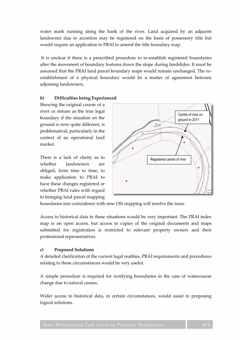
Inter-Professional Task Force on Property Boundaries
M 2
water mark running along the bank of the river. Land acquired by an adjacent
landowner due to accretion may be registered on the basis of possessory title but
would require an application to PRAI to amend the title boundary map.
It is unclear if there is a prescribed procedure to re-establish registered boundaries
after the movement of boundary features down the slope during landslides. It must be
assumed that the PRAI land parcel boundary maps would remain unchanged. The re-
establishment of a physical boundary would be a matter of agreement between
adjoining landowners.
b) Difficulties being Experienced
Showing the original course of a
river or stream as the true legal
boundary if the situation on the
ground is now quite different, is
problematical, particularly in the
context of an operational land
market.
There is a lack of clarity as to
whether landowners are
obliged, from time to time, to
make application to PRAI to
have these changes registered or
whether PRAI rules with regard
to bringing land parcel mapping
boundaries into coincidence with new OSi mapping will resolve the issue.
Access to historical data in these situations would be very important. The PRAI index
map is on open access, but access to copies of the original documents and maps
submitted for registration is restricted to relevant property owners and their
professional representatives.
c) Proposed Solutions
A detailed clarification of the current legal realities, PRAI requirements and procedures
relating to these circumstances would be very useful.
A simple procedure is required for rectifying boundaries in the case of watercourse
change due to natural causes.
Wider access to historical data, in certain circumstances, would assist in proposing
logical solutions.
Centre of river on
ground in 2011
Registered centre of river

Inter-Professional Task Force on Property Boundaries
N 1
N Property Boundaries to the Centre of Public Roads
a) Current Procedure
The practice of mapping land parcel boundaries to the centreline of adjoining public
roads causes a number of unresolved issues. The PRAI states in its Mapping Practice
(2013), that “Where registration is made to the centre of a road or stream, the map is
not to be taken as conclusive evidence that such, portion of same is included in the
property” which confuses rather than clarifies the situation.
There are two possible legal options with regard to ownership of a public road:
i A public road where the road authority is responsible for maintaining it, but
ownership of the soil underneath and air above rests with the adjoining
landowners.
ii A public road where the road authority is responsible for maintaining it and
ownership also rests with the authority (by virtue of a CPO or transfer by the
prior owner).
In both instances it can be said that the road is ‘in charge’ but ownership exists
independently of the responsibility of the road authority to maintain the road.
b) Difficulties being Experienced
When a planning permission requires a physical boundary wall of a property to be set
back a problem of responsibility ensues. The property owner still has legal
responsibility for this land but has no right to use or occupy it. The area released is no
longer within the control of the owner, i.e. it is outside his boundary wall and therefore
publicly accessible. However, it still remains in his ownership and until the roads
authority take it in charge, by paving it and incorporating it into the public road the
land owner is liable for any occurrences which happen on that land.
Defining the centre of the road can be difficult. A number of different definitions are
possible and the location of the road centre changes with reference to each definition.
For instance, should road centres be defined with reference to:
i Boundary features on either side of the road? Where walls or fences are
involved, this can be reasonably straightforward, but it can be difficult where
the boundary is indicated by the centre of overgrown banks or ditches. These
can take time to define and the result can be open to interpretation.
ii The edges of the metalled road? This is far simpler to ascertain, but these
edges can change due to re-alignments or road re-surfacing, causing
movements of the defined centre over time and thereby making it difficult to
confirm previous centrelines during ground surveys.
Inter-Professional Task Force on Property Boundaries
N 2
iii The road centreline on OSi maps? This latter option is the option chosen by
PRAI as the definition of the road centre. It should be noted that this line was
mapped by OSi for purposes other than the definition of legal boundaries, or
indeed for the mapping of the topographic centre of a road feature and its
suitability as a legal boundary definition must be questioned.
iv By agreement with the property owner on the opposite side of the road.
c) Proposed Solutions
A clarification of the current legal status of land parcel areas, mapped to the road
centre is required. In particular, the issue of land physically ceded by a property
owner, but not yet taken in charge by the road authority requires clarification.
The definition of what, physically, constitutes the centre of a public road, for title
mapping purposes needs to be defined and procedures specified for measuring and
mapping this feature. The use of the OSi road centre feature, which was not designed
for the purpose of legal or topographical boundary definition, needs to be reconsidered
and a suitable alternative definition put in place.

Inter-Professional Task Force on Property Boundaries
O 1
O Property Boundaries used for Land Use Zoning and
Planning
a) Current Procedure
Local Authority planners use features on OSi maps rather than registered boundaries
on PRAI maps to define the boundaries of land-use zones. The zoning applies to the
land, and not to the owner, i.e. if the land is transferred, the zoning transfers with the
land.
Grants of planning permission provide development rights for land but these grants
apply to the site, not to the individual, who is assumed by the planning authority to be
the legal owner. Some city or county development plans may include requirements
which restrict the provision and exercise of development rights to locals, so
developments rights in some circumstances may not transfer with the land.
Planners accept the validity of mapping information supplied with planning
applications which is used for location purposes only. Sites are digitised onto the
planning register and the coincidence of the planning site boundary with the PRAI
registered boundary is currently assumed, though not checked.
b) Difficulties being Experienced
Planning drawings are accepted in good faith. It is assumed that they are accurate and
representative of the property/site extent. As with application to PRAI for registration,
drawings submitted for planning application need follow no standards with regard to
accuracy and may be prepared by unqualified persons. The applicant for planning
permission must declare his ownership interest in the plot which is the subject of a
planning application, but the planning authorities normally do not check either the
nature of the title nor do they check the exact boundary or the land parcel to which the
title applies. On the other hand, there have been cases where some planning authorities
have been known to make title checks and refuse permission if they are not satisfied
with the applicant’s title to the land. Disputes between adjoining neighbours may arise
over title to property arising from a planning decision, which can ultimately lead to
litigation.
Zoning of land is delineated by lines which do not necessarily coincide with any
particular, clearly defined, and described topographic feature or title boundary. This
can later cause problems if disagreement arises regarding precisely what area is subject
to specific zoning restrictions or other planning restriction.
c) Proposed Solutions
A clarification is required defining the exact nature of the boundaries which the
planning authorities use on their land use zoning maps.

Inter-Professional Task Force on Property Boundaries
O 2
A clarification is also required with regard to the legal definition of the boundaries of
parcels for which planning applications are granted.
In general principle the PRAI title boundary should be accepted by the planning
authorities as the most suitable boundary for both land use zoning and grant of
planning permission. It is accepted that different planning requirements may exist
within the boundaries of larger land parcels and that such areas may be subject to
different planning constraints, although contained within a single title boundary. It is,
however, confusing and inappropriate, to have small areas of land, so called sliver
polygons, which are created due to misalignment of boundaries from different data
sets, subject to differing planning constraints, as the differences of designation are due
to mapping inconsistencies only, and not to any reality.
All state bodies should use the same base map and not operate different map bases.
This would allow the better integration of specialist overlay themes relative to a
unified base map and therefore facilitate the integration of such thematic data sets,
particularly with regard to common boundaries. In this context every effort should be
made by the relevant data holder, to implement the provisions of the INSPIRE
directive, as fully and as soon as possible.

Inter-Professional Task Force on Property Boundaries
P 1
P Property Boundaries in Multi-Unit Developments
a) General Background
In Appendix 5a of the Practitioner’s Guide (PRAI, 2012) a number of key stipulations
are made:
i That the plan for registration should be based on the developer’s design
drawing i.e. an architectural floor plan, to a standard metric scale - building
floor plans in such circumstances will normally be at a scale of 1:50, 1:100 or
1:200 depending on the amount of detail to be shown.
ii That the drawing should be contained within an A3 page size.
But at:
i At 1:50 A3 will measure just under 20m x 15m
ii At 1:100 A3 will measure just under 40m x 30m
iii At 1:200 A3 will measure just under 80m x 60m
The following table shows map dimensions, in millimetres, for a number of common
construction features at these three scales:
As 0.2mm is the accepted minimum line thickness possible on drawings and in the case
of the construction features listed above, a double line with a space between is required
to portray the features, the scale of 1:200 is inadequate to represent the smaller features.
A scale of 1:100 is required if major composite construction features are to be
represented i.e. a 230mm concrete wall with battening and dry-lining to either side
and, if distinction is required between the various components, a minimum scale of
1:50 is necessary.
On this basis, if accurate delineation of units in multiple developments is required, a
scale of 1:50 is necessary to represent each individual housing unit. It is noted that title
documents relating to multi-unit developments describe title boundaries in very great
detail. The plan accompanying such documents must be at least in sufficient detail, to
Construction feature Scale of 1:50 Scale of 1:100 Scale of 1:200
230mm concrete block wall 4.6mm 2.3mm 1.2mm
115 mm single thickness brick or concrete block wall 2.3mm 1.2mm 0.6mm
150 mm mass concrete wall 3.0mm 1.5mm 0.8mm
Dry-lining on 50mmX25mm battens 0.8mm 0.4mm 0.2mm
Dry-lining on plaster dabs 0.5mm 0.3mm 0.1mm
Plaster skim and finish coat 0.2mm 0.1mm 0.05mm
Timber framed stud partition 2.5mm 1.3mm 0.6mm

Inter-Professional Task Force on Property Boundaries
P 2
compliment the textual descriptions and not overtly conflict with these descriptions. It
should be clearly stated on such plans, however, that in case of conflict, the textual
description will take precedence over the plan delineation. It should also be noted on
these plans that detail shown, and areas computed are for property registration
purposes only. In cases of usable floor area measurement for rental, valuation of
taxation purposes, it is recommended that the Measurement Code for the Floor Area of
Buildings (CLGE, 2012) should be followed.
Drawing at 1:200 would be acceptable as an index map only, as at this scale individual
construction features cannot be distinguished.
For external features, such as the boundaries of landscaped common areas, mapping at
a scale of 1:500 is recommended, as for normal land boundaries.
b) Current Procedures
Design and layout plans are normally prepared and submitted to the Land Registry in
advance of any sales of units within a multi unit development and registrations are
documented in relation to these plans. Occasionally, property maps outlining common
areas are completed later to permit occupation of some units before some mapping
issues have been resolved.
c) Difficulties being Experienced
It is unclear where to put the title boundary lines relative to construction features in
apartment blocks. Much of the PRAI guidelines are contradictory. Sections of these
guidelines stipulate minimum paper weight and dpi resolution for plans, together with
instructions for the use of a thin red line outlining each apartment unit, all of which
indicate a requirement for a considerable level of precision. On the other hand one
section of the guidelines suggests that a digital photo with a hand held digital camera,
taken through glass, without proper orientation, of a wall-mounted “Emergency
Evacuation Plan”, a plan which in many cases is diagrammatic rather than accurate,
would suffice for registration purposes.
Registration from “as planned” rather than from “as built” drawings, can lead to
considerable error in the registered title plan.
It is the practice to define title boundaries within apartment blocks to considerable
levels of detail, because this is necessary to deal with the management and
maintenance of these buildings, and to ensure that the individual apartment unit
owners have clarity about what they may remove, modify or interfere with. This high
level of specificity conflicts with the non-conclusive boundaries rule and the inaccuracy
of the mapping accepted by PRAI, leading potentially to confusion and dispute.

Inter-Professional Task Force on Property Boundaries
P 3
The type of mapping or plans accepted by PRAI in certain cases falls well below
acceptable standards. The use of photographs of evacuation plans, mentioned above, is
a case in point.
Transfer of common areas and structural features to a management company is fraught
with risk in the absence of accurate plans at a suitable scale.
There is considerable difficulty in defining and mapping complex three dimensional
spaces.
d) Proposed Solutions
It is recommended that PRAI should increase the standard required for title mapping
in multi-unit development. It is suggested that this should a least be commensurate
with the degree of precision with which the title boundary features are specified in the
verbal description of title. It is also recommended that this plan be sufficiently detailed
to show the components which constitute title boundaries and major structural
features. A minimum scale of 1:50 is recommended for each individual unit, with the
larger development indicated in index form at 1:200.
It is recommended that the Measurement Code for the Floor Area of Buildings (CLGE
2012) adopted by the INSPIRE Thematic Working Group on Buildings and now part of
version 3.0 of the INSPIRE data specifications on Buildings (INSPIRE, 2013), should be
followed, wherever relevant.
It is recommended that plans should be prepared by competent professionals in the
relevant areas of expertise. Submitted plans should be certified, as to their accuracy, by
the relevant professional, in the case of buildings by an architect or building surveyor.

Inter-Professional Task Force on Property Boundaries
Q 1
Q Additional Information
a) Current Procedure
The PRAI used to supply title maps and special registration maps at a cost of €25, on
which burdens, rights of way, way-leaves and pipelines were not included. To access
this additional information a certified title map with ‘special features’ was required at a
cost of €50. However, since September 2012, all title maps and special registration maps
cost €40 on which these additional features are now included.
Section 72 of the Act lists many items which do not require registration, so information
from the PRAI is often incomplete, and this additional information is difficult and
sometimes impossible to acquire.
b) Difficulties being Experienced
To minimise expense most people opt to purchase the cheaper title map, but this map
gives only a partial view of the situation, and even if the ‘special features’ map is
purchased, it may not reflect all the issues affecting title due to the fact that many such
matters have been exempt from registration in the past.
Property professionals currently find it difficult to establish rights of way, way-leaves
and easements on the ground from the PRAI title map. The width of such easements is
rarely recorded.
The lack of adequate accuracy and precision in the title maps issued and the absence of
mapping of a sufficient scale to support such precision and accuracy is a major
problem. The absence of a boundary description schedule adds to this lack of clarity.
c) Proposed Solutions
The PRAI register should provide a comprehensive source of data relating to title.
Matters which are currently excluded, such as listed building status, designation as a
national monument, inclusion in the Sites and Monuments Register/Record of
Monuments and Places, Special Areas of Conservation (SACs), Special Protection
Areas (SPAs), Natural Heritage Areas (NHAs), and other similar statutory, and EU
directive burdens, should be included as a burden on the property folio. A review of
Section 72 of the Act should be carried out to significantly reduce registration
exclusions to prepare for the introduction of eConveyancing. The Law Society eVision
recommended that no interest should affect title unless it is registered to ensure the
title register is definitive, conclusive and all encompassing.
The issues relating to the accuracy, precision and scale of the map have been covered
thoroughly in other parts of this document, as also has the requirement for a detailed
boundary description schedule. It is recommended that, in addition to title boundaries,

Inter-Professional Task Force on Property Boundaries
Q 2
the standards and criteria indicated should also be applied to all mapping matters,
including rights of way and other easements. The assumed, or documented, widths of
rights of way should be reviewed in the light of modern farm vehicles and machinery.
PRAI should review the practice of issuing separate title maps with and without
special features. A single title map showing all information would be preferable.

Inter-Professional Task Force on Property Boundaries
R 1
R Coordinates, Measurements and Monuments
a) Current Procedure
The new PRAI digital map is based on ITM coordinates derived from OSi maps.
Copies of the OSi digital maps can be purchased to access these coordinates and copies
of the PRAI digital maps can now be purchased also. Measurements can be directly
extracted from digital maps. It should be borne in mind that the precision of OSi
mapping is not of a quality that would render it suitable for positioning boundaries on
the ground.
Positioning monuments along boundaries, such as boundary stones, was regularly
carried out in Ireland during the 18th century and many examples of these monuments
are still in existence today. The practice died out during the late 19th and early 20th
centuries when Land Registry started using OSi mapping to reflect land parcels.
b) Difficulties being Experienced
As PRAI boundary mapping is derived from OSi mapping, the accuracy of the PRAI
map cannot be higher than the original OSi mapping which is of a scale and a precision
unsuitable for title boundary mapping. OSi maps in many instances provide a single
line on the map which regularly represents multiple features on the ground as the
feature which the line represents is not stated. This ambiguity is transferred to the
PRAI mapping. Consequently, folio maps are open to interpretation, even if their
coordinates were available. Coordinates derived from PRAI mapping would suffer
from a lack of precision due to the methodology used in the production of the OSi
mapping on which the coordinates are based. Such coordinates would be of little use in
attempting to re-locate a boundary on the ground even if the disclaimer inherent in the
non-conclusive boundaries rule was set aside. Dimensions relative to permanent
features on the ground could be of assistance in locating boundaries on the ground
from documentary records.
However, coordinates for change points, i.e. points where the boundary line changes
direction, would be the most useful and precise, for this purpose, as all other
dimensional information (area, dimensions, length of perimeter etc.) can be derived
from coordinate data. The new ITM coordinate reference system adopted by the PRAI
is both accurate and GPS compatible, so is ideally suited for coordinating boundaries
far more accurately than heretofore. It should be borne in mind that although the
coordinate system incorporates the necessary precision for accurate and repeatable re-
positioning of boundaries, it must be coupled with a methodology encompassing
suitable instrumentation, procedures and competence to achieve acceptable results.
Although physical boundary monuments are common in many European cadastral
systems, their use can be problematical. In rural areas, where boundary features are

Inter-Professional Task Force on Property Boundaries
R 2
often soft and impermanent (hedges, ditches, drainage channels, timber or post and
wire fences) finding a suitable location on a boundary to locate a marker can be
difficult. Ensuring that such a marker remains permanently in place and is not
interfered with, or does not impede necessary changes to the land, can be even more
challenging. It is arguable whether such monumentation is really necessary if the
coordinate system and current survey instrumentation allow the positioning of a point
on the ground to centimetre accuracy. Survey markers in urban areas, where
permanent and hard surfaces are available to allow the insertions of survey markers, is
a more viable proposition.
c) Proposed Solutions
For coordinates to be acceptable for boundary location they must be derived to certain
levels of precision. Such precision is not inherent in the OSi map base or the PRAI land
parcel boundary mapping. It is proposed that procedures should be put in place to
allow boundary coordinates, derived from high precision surveys, by registered and
qualified professionals, to be included as part of the registration process and that
mapped boundary lines derived from this process be integrated with the PRAI parcel
index map (see Appendix E for a full exposition of this matter).

Inter-Professional Task Force on Property Boundaries
S 1
S Declarations of Identity
a) Current Procedures
Financial institutions providing mortgages for property purchases need to minimise
the risk to their investments and purchasers also need certainty that they can access
and enjoy ownership of their new property and all its associated services. A legal
document known as a declaration of identity is required to meet these needs. In
passing, it should be noted that declarations of identity will still be necessary in
situations where boundaries are registered as defined boundaries because such
declarations cover more than just ownership.
Solicitors and financial institutions do not physically inspect properties, but instead
delegate this necessary task to mapping professionals such as surveyors, engineers or
architects. These professionals are required to carry out the physical inspection of the
site and prepare and sign a declaration of identity.
The content of the declaration depends on the nature of the property. Different forms
of declaration are required because of varying circumstances and the degree of
complexity depends on the nature of the property.
The declaration should provide the purchaser with assurance that the property:
i is the vendor’s to sell;
ii is not cut off from public roads or services;
iii that buildings and its services are wholly confined within the registered title
boundary;
iv that the existence and location of easements and rights of ways, etc. are
confirmed.
A declaration should not be made without stating the assumption on which the
declaration is based, one of which should be that the property boundaries on the
mapping supplied by the PRAI are non-conclusive. Declarations may subsequently be
used as evidence to redefine a boundary.
Declarations of identity are onerous documents to complete. It is important, therefore,
to distinguish between what is required for the legal process and other interesting
information which the purchaser may require. Vendor disclosure was recommended
by the Law Society of Ireland in their e-Vision for eConveyancing and it has already
been introduced in the UK. The UK experience of disclosure is that it covers possibly
too much information and there is, as yet, no standard adopted for the content of a
vendor’s declaration.

Inter-Professional Task Force on Property Boundaries
S 2
b) Difficulties being Experienced
Many respondents (solicitors, architects, engineers and surveyors) commented that it is
an unrealistic expectation that a conclusive opinion can be based on non-conclusive
data which is open to interpretation and has not been certified by a mapping
professional. Therefore the consensus was that no meaningful declaration can be based
on non-conclusive data alone.
i The current procedure for completing a declaration of identity is not
standardised.
ii Thorough site inspections are not always conducted – simply walking the site
may not be sufficient to identify and quantify boundary discrepancies
correctly.
iii Resurveys are rare so discrepancies in PRAI mapping are perpetuated because
they are not identified or corrected.
Declarations of identity operate by transferring the risk associated with non-conclusive
boundaries from the PRAI (and indirectly OSi) to property professionals’ professional
indemnity insurance. Such declarations are open to challenge after they are issued, so
care is needed if professional reputation is not to be damaged. It should be noted
however, that a declaration involves personal liability, so they should not be signed by
a mapping professional in the absence of professional indemnity insurance.
c) Proposed Solutions
It is recommended that a working group be established, to include representatives of
the Law Society, Engineers Ireland, the Irish Institution of Surveyors and the Royal
Institute of Architects of Ireland, to develop a standardised good practice procedure for
such declarations, based on the best international practice, for submission to the
professional bodies involved, for adoption and implementation by their members.
This new procedure should:
i Ensure that the declaration always includes a check that boundaries on PRAI
mapping corresponds to the boundaries on the ground, therefore site visits
should be mandatory.
ii Identify and document the physical features on the ground with which the
boundary is associated.
iii Identify and rectify any ‘ransom strips’ – small areas of lands that are either
included in two adjoining properties or alternatively are excluded from both
properties.
iv Consider if the registration of declarations of identity in the PRAI would be
feasible and/or desirable.

Inter-Professional Task Force on Property Boundaries
S 3
Issues which are dealt with extensively in other parts of this report also impinge on the
declaration of identity. These matters include:
i The enhancement of the accuracy of OSi / PRAI mapping.
ii The availability of boundary definition information relating the legal
boundary to topographic boundary detail on the ground.
Inter-Professional Task Force on Property Boundaries
T 1
T Registration and Regulation of Professionals Preparing and
Submitting Maps to the PRAI
a) Current Situation (Procedures)
PRAI Practitioner’s Guide (2012) state that the applicant is responsible for the accuracy
of the areas and boundaries given in documents lodged. Currently there is no
requirement to follow any formally adopted standards. To ensure that the mapped
locations of boundaries and rights submitted for registration reflect the applicant's
intentions, it is recommended that:
i The locations of boundary corners, rights of way, pipelines etc. be
unambiguously defined and clearly marked on the ground before survey for
registration is carried out.
ii Maps submitted for registration be prepared and certified by competent land
surveyors.
Although the PRAI recommend that the preparation of maps should be carried out by
certified and competent surveyors, this is merely a recommendation and not a
requirement. No indication is given as to what PRAI consider competence or what
kind of certification would be acceptable.
A competent person is defined in the Safety, Health and Welfare at Work Act (2005) as
a person who possesses sufficient training, experience and knowledge appropriate to
the nature of the work to be undertaken. Competence could be checked by the PRAI
with reference to these criteria.
b) Difficulties being Experienced
It would appear that many practitioners with no surveying or mapping experience and
no formal qualifications are, in the eyes of the state, deemed qualified to certify
mapping for land registration purposes. Neither certification nor competence of land
surveyors are checked by the PRAI.
An inordinate amount of time is wasted by PRAI (and indeed by applicants) because of
the need to reject maps submitted for registration purposes, which contain errors or are
incompatible with pre-existing boundaries shown on PRAI mapping. This is
attributable to two causes:
a) that those preparing maps for registration purposes often have no formal
training and therefore cannot be relied on to produce accurate survey and
mapping.

Inter-Professional Task Force on Property Boundaries
T 2
b) that there are inaccuracies in the PRAI mapping which result in
incompatibility between such PRAI mapping and newly submitted mapping
which is correct and accurate.
With modern, accurate surveying techniques it is possible to precisely survey
boundary location and represent it on a map. Carrying out such a precision survey is,
in fact, the most accurate way to define a boundary. However, a major difficulty is that
PRAI will not accept better quality mapping which conflicts with pre-existing parcel
boundaries surveyed to a less precise specification by OSi, or that conflict with pre-
existing boundary lines delineated by previous, often unskilled and unqualified,
applicants. This is a situation that ensures inaccurate boundary mapping is
perpetuated and that accurate mapping which would improve the overall quality of
the PRAI boundaries database is discarded.
c) Proposed Solutions
PRAI should only accept mapping submitted for sub-divisions, first registrations, error
rectification, boundary dispute resolution and ultimately for all properties on transfer
in cases where such boundaries were not previously precisely surveyed, which are
prepared and certified by appropriately qualified and registered professionals.
Insurance bonding for such professionals should be considered as a necessary
requirement, to protect both the PRAI and the applicant from negligence or error on
the part of the professional.
To this end it is recommended that a register of Registered Boundary Surveyors be
established to be overseen by an independent registration board which would validate
the competence of those submitting mapping for title registration purposes.
All surveying submitted to the PRAI should be:
i Carried out using best practice guidelines (jointly developed between
professional bodies and the PRAI) to be issued by the PRAI.
ii Based on the use of modern surveying techniques using GPS and total
stations.
iii Referenced to the new ITM coordinate reference system.
Boundaries surveyed and mapped by registered professionals to best practice
standards, should be certified and take precedence over less accurate boundary
mapping in the PRAI database.
Precision title boundary surveys, OSi derived boundaries and unskilled applicant
delineated boundaries should be colour coded to facilitate users in understanding the

Inter-Professional Task Force on Property Boundaries
T 3
different levels of precision and accuracy involved (see Appendix E for a fuller
exposition of this issue).
Develop a course, or courses, for surveying & mapping of property boundaries at level
9 (masters or post-graduate diploma) aimed at existing professional stakeholders.
Develop and publish best practice guidelines for the survey and mapping of property
boundaries.

Inter-Professional Task Force on Property Boundaries
U 1
U Draft Boundary agreement
The following is a proposed draft for a simple title boundary agreement between
adjoining property owners:
Boundary Agreement
We, the undersigned, the freehold owners of the two properties defined below, hereby agree the
description and location of the common boundary between these two properties, as set out in the
schedules below is the agreed title boundary between these properties.
Property 1 - Land in the townland of ................................................., County...............................................
part of PRAI Folio No: ........................................, of which I, ..........................................................................
am the freehold owner, as indicated on the map attached.
Property 2 - Land in the townland of ................................................, County................................................
part of PRAI Folio No: ........................................, of which I, ..........................................................................
am the freehold owner, as indicated on the map attached.
Schedule of Boundary Features:
Segment 1........................................................................................................................................................
.........................................................................................................................................................................
.........................................................................................................................................................................
Segment 2........................................................................................................................................................
.........................................................................................................................................................................
.........................................................................................................................................................................
Segment 3........................................................................................................................................................
.........................................................................................................................................................................
.........................................................................................................................................................................
etc…………
Note: Each segment should consist of a length of boundary which is of the same construction, i.e. where
the entire length of the segment is homogenous and conforms to the description of the physical
construction of that segment. A separate segment description should be given for each different
construction. In addition to the description of the physical construction of the boundary, the location of the
title boundary relative to the physical boundary should also be supplied.

Inter-Professional Task Force on Property Boundaries
U 2
Schedule of Coordinates (ITM coordinate reference system)
.........................................................................................................................................................................
.........................................................................................................................................................................
.........................................................................................................................................................................
.........................................................................................................................................................................
.........................................................................................................................................................................
.........................................................................................................................................................................
Certification by Registered Boundary Surveyor:
I, .............................................................. being a registered boundary surveyor, licence number:
................................. hereby certify that I have inspected the above boundary in the company of the two
landowners, and that the description of the agreed boundary as outlined in the schedules listed above and
the map attached are an accurate description of the boundary in compliance with the standards set out in
the Irish Institution of Surveyors guidelines for Boundary Surveys and in accordance with the requirements
of PRAI Mapping Procedures.
Signed: ................................................................... Registered Boundary Surveyor
Address: …………………………………………………………………………………………..…………………....
Email: ……………………………………………………………………. @ …………………………………………
Telephone Numbers: ………………………………………………………………………………………………….
Signed:.....................................................,…………. (Insert home address of landowner here)
(freehold owner of Property 1)
Signed:.....................................................,…………. (Insert home address of landowner here)
(freehold owner of Property 2)

The Bar Council James Dwyer SC George Brady SC Engineers Ireland Gerry Healy Colman Horgan Gordon White Irish Institution of Surveyors Dr Paddy Prendergast Brendan Sweeny Paul Corrigan Mike Flynn Muiris de Buitléir
Irish Planning Institute Sarah Moran Brendan Allen The Law Society of Ireland Dr Gabriel Brennan Patrick Sweetman The Royal Institute of the Architects of Ireland James Pike Paul Kelly