Total Solar Eclipse of 1995 October 24 - NASA · Eye Safety During Solar Eclipses ... The Eclipse...
82
NASA Reference Publication 1344 1994 National Aeronautics and Space Administration Scientific and Technical Information Branch Total Solar Eclipse of 1995 October 24 Fred Espenak Goddard Space Flight Center Greenbelt, Maryland Jay Anderson Environment Canada Winnipeg, Manitoba CANADA https://ntrs.nasa.gov/search.jsp?R=19950005025 2019-03-25T11:00:43+00:00Z
Transcript of Total Solar Eclipse of 1995 October 24 - NASA · Eye Safety During Solar Eclipses ... The Eclipse...
NASAReferencePublication1344
1994
National Aeronautics andSpace Administration
Scientific and TechnicalInformation Branch
Total Solar Eclipseof 1995 October 24
Fred Espenak
Goddard Space Flight Center
Greenbelt, Maryland
Jay AndersonEnvironment Canada
Winnipeg, ManitobaCANADA
https://ntrs.nasa.gov/search.jsp?R=19950005025 2019-03-25T11:00:43+00:00Z

PREFACE
This is the third in a series of NASA Eclipse Bulletins containing detailed predictions, maps andmeteorological data for future central solar eclipses of interest. Published as part of NASA's ReferencePublication (RP) series, the bulletins are prepared in cooperation with the Working Group on Eclipses ofthe International Astronomical Union and are provided as a public service to both the professional and lay
communities, including educators and the media. In order to allow a reasonable lead time for planningpurposes, subsequent bulletins will be published 24 months or more before each event. A tentativeschedule for future eclipse bulletins and projected publication dates appears at the end of the Preface.
Response to the first two eclipse bulletins was overwhelming. When the January 1994 issue ofSky and Telescope announced their availability, as many as 160 requests per week were received for them.Since requests for the May bulletin outnumbered the November bulletin by four to one, an additional 600copies of RP1301 were reprinted in late January. Nevertheless, the demand quickly exceeded the supply forboth bulletins and funding sources did not permit more printings to fill all requests. It also became clearthat the requests were consuming a great deal of time, secretarial work and postage. To conserve resourcesand to make responses faster and more efficient, the proceedure for requesting eclipse bulletins has beenmodified as follows.
Single copies of the bulletins are available at no cost and may be ordered by sending a 9 x 12 inchSASE (self addressed stamped envelope) with sufficient postage (11 oz. or 310 g.). Use stamps only; cashor checks cannot be accepted. Requests within the U. S. may use the Postal Service's Priority Mail for$2.90. Please print either the NASA RP number or the eclipse date (year & month) of the bulletin orderedin the lower left corner of the SASE. Requests from outside the U.S. and Canada may use international
postal coupons sufficient to cover postage. Exceptions to the postage requirements will be made forinternational requests where political or economic restraints prevent the transfer of funds to other countries.Finally, all requests should be accompanied by a copy of the request form on page 73. Bulletin requestsmay be made to either of the authors. Comments, suggestions, criticisms and corrections are solicited toimprove the content and layout in subsequent editions of this publication series, and may be sent to
Espenak.Since we are now entering the age of the 'Information Highway', it seems fitting that the eclipse
bulletins should be served electronically. Thanks to the initiative and expertise of Dr. Joe Gurman(GSFC/Solar Physics Branch), the first three eclipse bulletins are all available over the Internet. Formatsinclude a BinHex-encoded version of the original MS Word file + PICT + GIF (scanned GNC maps), aswell as a hypertext version. They can be read or downloaded via the World-Wide Web server with a mosaicclient from the SDAC (Solar Data Analysis Center) home page: http://umbra.gsfc.nasa.gov/sdac.html.Most of the files are also available via anonymous tip. In addition, path data for all central eclipses through
the year 2000 are available via http://umbra.gsfc.nasa.gov/eclipse/predictions/eclipse-paths.html. For moredetails, please see pages 17 and 18. Naturally, all future eclipse bulletins will also be available via Internet.
RP 1344 marks a milestone as the first eclipse bulletin to be generated entirely on a Macintosh
computer (excluding the GNC maps). As such, it represents the culmination of a two year project tomigrate a great deal of eclipse prediction and mapping software from mainframe (DEC VAX 11/785) topersonal computer (Macintosh IIfx) and from one programming language (FORTRAN IV) to another(THINK Pascal). This bulletin is also the first to be printed on a 600 dpi laser printer. The contrast,
resolution and readability is a noticeable improvement. The authors have also adopted the internationalconvention of presenting date and time in descending order (i.e. year, month, day, hour, minute, second).Word processing and page layout for the publication were done using Microsoft Word vS.1. Figureannotation was done with Claris MacDraw Pro 1.5. Meteorological diagrams were prepared using WindowsDraw 3.0 and converted to Macintosh compatible files.
We would like to acknowledge the valued contrbutions of a number of individuals that wereessential to the success of this publication. The format and content of the NASA eclipse bulletins hasdrawn heavily upon over 40 years of eclipse Circulars published by the U. S. Naval Observatory. We owea debt of gratitude to past and present staff; of that institution who have performed this service for so manyyears. In particular, we would like to recognize the work of Julena S. Duncombe, Alan D. Fiala, Marie R.Lukac, John A. Bangert and William T. Harris. The many publications and algorithms of Dr. Jean Meeushave served to inspire a life-long interest in eclipse prediction. We thank Francis Reddy, who helpeddevelop the data base of geographic coordinates for major cities used in the local circumstances predictions.Dr. Wayne Warren graciously provided a draft copy of the IOTA Observer's Manual for use in describing
.°.
111 •PAG£ Bt.ANIK NOT FN..MF._
contact timings near the path limits. Dr. Jay M. Pasachoff kindly reviewed the manuscript and offered anumber of valuable suggestions. The availability of the eclipse bulletins via the Internet is due entirely tothe efforts of Dr. Joeseph B. Gurman. The support of Environment Canada is acknowledged in theacquisition and arrangement of the weather data. Finally, the authors thank Goddard's Laboratory forExtraterrestrial Physics for several minutes of CPU time on the LEPVX2 computer. The time was used forverifying predictions generated with the Macintosh.
Permission is freely granted to reproduce any portion of this Reference Publication, including data,figures, maps, tables and text (except for material noted as having been published elsewhere, or by personsother than the authors). All uses and/or publication of this material should be accompanied by anappropriate acknowledgment of the source (e.g. - "Reprinted from Total Solar Eclipse of 1995 October 24,Espenak and Anderson, 1994"). The names and spellings of countries, cities and other geopolitical regionsare not authoritative, nor do they imply any official recognition in status. Corrections to names,geographic coordinates and elevations are actively solicited in order to update the data base for futureeclipses. All calculations, diagrams and opinions presented in this publication are those of the authors andthey assume full responsibility for their accuracy.
Fax"
Intemet:
Fred EspenakNASAJGoddard Space Flight CenterPlanetary Systems Branch, Code 693Greenbelt, MD 20771USA
(301) 286-0212u32fe @lepvax.gsfc.nasa.gov
Jay AndersonEnvironment Canada900-266 Graham Avenue
Winnipeg, MB,CANADA R3C 3V4
Fax: (204) 983-0109Bitnet: jander @ cc.umanitoba.ca
Current and Future NASA Solar Eclipse Bulletins
NASA Eclipse Bulletin RP # _ll]2]_¢,gt_2KI_
Annular Solar Eclipse of 1994 May 10 1301Total Solar Eclipse of 1994 November 3 1318Total Solar Eclipse of 1995 October 24 1344
........... future ...........
Total Solar Eclipse of l997 March 9Total Solar Eclipse of 1998 February 26Total Solar Eclipse of 1999 August 11
April 1993October 1993
July 1994
Spring 1995Fall-Winter 1995Fall 1996
TOTAL SOLAR ECLIPSE OF 1995 OCTOBER 24
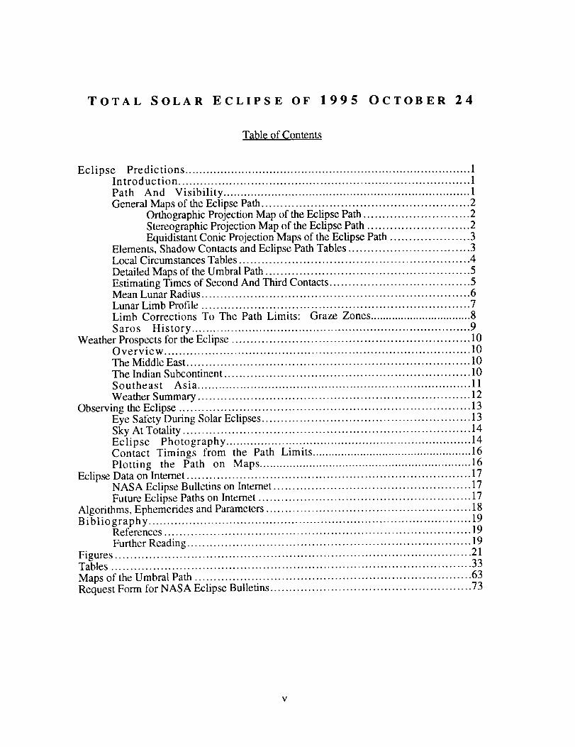
Table of Contents
Eclipse Predictions ................................................................................. 1Introduction ................................................................................ 1
Path And Visibility ........................................................................ 1General Maps of the Eclipse Path ....................................................... 2
Orthographic Projection Map of the Eclipse Path ............................ 2Stereographic Projection Map of the Eclipse Path ........................... 2Equidistant Conic Projection Maps of the Eclipse Path ..................... 3
Elements, Shadow Contacts and Eclipse Path Tables ................................ 3Local Circumstances Tables ............................................................. 4
Detailed Maps of the Umbral Path ...................................................... 5Estimating Times of Second And Third Contacts ..................................... 5Mean Lunar Radius ....................................................................... 6Lunar Limb Profile ....................................................................... 7Limb Corrections To The Path Limits: Graze Zones ................................. 8
Saros History .............................................................................. 9Weather Prospects for the Eclipse ............................................................... 10
Overview ................................................................................... 10
The Middle East ........................................................................... 10The Indian Subcontinent ................................................................. 10Southeast Asia ............................................................................. 11
Weather Summary ........................................................................ 12Observing the Eclipse ............................................................................. 13
Eye Safety During Solar Eclipses ....................................................... 13Sky At Totality ............................................................................ 14Eclipse Photography ...................................................................... 14Contact Timings from the Path Limits .................................................. 16Plotting the Path on Maps ................................................................ 16
Eclipse Data on Intemet ........................................................................... 17NASA Eclipse Bulletins on Intemet .................................................... 17Future Eclipse Paths on Internet ........................................................ 17
Algorithms, Ephemerides and Parameters ...................................................... 18Bibliography ........................................................................................ 19
References ................................................................................. 19
Further Reading ........................................................................... 19
Figures .............................................................................................. 21Tables ............................................................................................... 33
Maps of the Umbral Path ......................................................................... 63Request Form for NASA Eclipse Bulletins ..................................................... 73
TOTAL SOLAR ECLIPSE OF 1995 OCTOBER 24
Figures, Tables and Maps
FigureFigure 1:Figure 2:Figure 3:Figure 4:Figure 5:Figure 6:Figure 7:Figure 8:Figure 9:Figure 10:
S ............................................................................................... 21
Orthographic Projection Map of the Eclipse Path .................................. 23Stereographic Projection Map of the Eclipse Path ................................. 24The Eclipse Path in Asia .............................................................. 25The Eclipse Path in India ............................................................. 26The Eclipse Path in Southeast Asia .................................................. 27
The Eclipse Path in South China Sea and Celebes Sea ............................ 28The Lunar Limb Prof'lle At 03:30 UT ............................................... 29
Mean Cloud Cover in October Along the Eclipse Path ............................ 30
Frequency of Highly Reflective Clouds in October Along the Path ............. 30Mean Number of Hours of Sunshine in October for India ...................... 31
Figure 11: The Sky During Totality As Seen From Center Line At 03:30 UT ............. 32Tables ................................................................................................ 33
Table 1: Elements of the Total Solar Eclipse of 1995 October 24 ........................... 35Table 2: Shadow Contacts and Circumstances ................................................ 36Table 3: Path of the Umbral Shadow ........................................................... 37Table 4: Physical Ephemeris of the Umbral Shadow ......................................... 38Table 5: Local Circumstances on the Center Line ............................................. 39Table 6: Topocentric Data and Path Corrections Due To Lunar Limb Profile .............. 40Table 7: Mapping Coordinates for the Umbral Path .......................................... 41Table 8: Maximum Eclipse and Circumstances for Africa, Middle East and Russia ..... 44
Table 9: Maximum Eclipse and Circumstances for Afghanistan and Pakistan ............ 46Table 10: Maximum Eclipse and Circumstances for Indian Asia - I ....................... 48Table 11: Maximum Eclipse and Circumstances for Indian Asia - II ...................... 50Table 12: Maximum Eclipse and Circumstances for Southeast Asia ....................... 52Table 13: Maximum Eclipse and Circumstances for the Orient ............................. 54Table 14: Maximum Eclipse and Circumstances for Indonesia, Japan and
Malaysia ............................................................................... 56Table 15: Maximum Eclipse and Circumstances for Australia, Philippines and
Pacific .................................................................................. 58
Table 16: Climatological Statistics Along the Eclipse Path .................................. 60Table 17: Solar Eclipse Exposure Guide ...................................................... 61
Maps of the Urnbral Path ...................................................................... 63Map 1: Iran and Afghanistan ..................................................................... 65Map 2: Afghanistan, Pakistan and India ........................................................ 66Map 3: India ....................................................................................... 67
Map 4: India, Bangladesh and Myanmar ....................................................... 68Map 5: Myanmar, Thailand and Cambodia .................................................... 69Map 6: Cambodia and Viet Nam ................................................................ 70Map 7: Borneo ..................................................................................... 71Map 8: Celebes Sea ............................................................................... 72
vi
ECLIPSE PREDICTIONS
INTRODUCTION
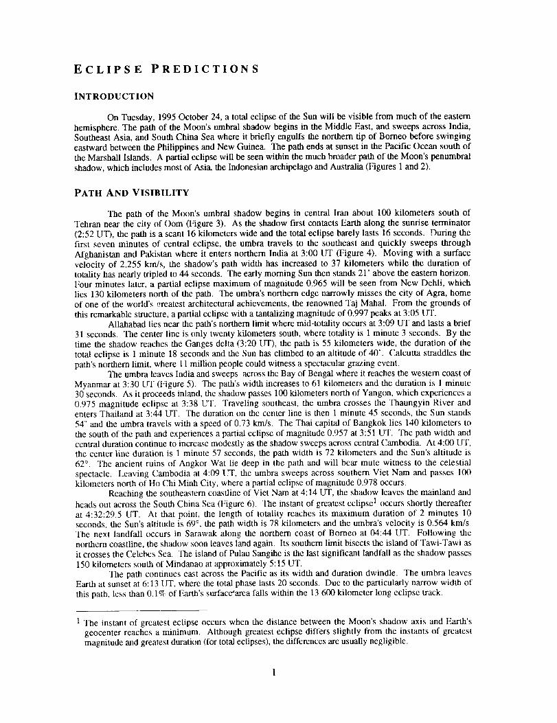
On Tuesday, 1995 October 24, a total eclipse of the Sun will be visible from much of the easternhemisphere. The path of the Moon's umbral shadow begins in the Middle East, and sweeps across India,Southeast Asia, and South China Sea where it briefly engulfs the northern tip of Borneo before swinging
eastward between the Philippines and New Guinea. The path ends at sunset in the Pacific Ocean south ofthe Marshall Islands. A partial eclipse will be seen within the much broader path of the Moon's penumbralshadow, which includes most of Asia, the Indonesian archipelago and Australia (Figures 1 and 2).
PATH AND VISIBILITY
The path of the Moon's umbral shadow begins in central Iran about 100 kilometers south ofTehran near the city of tom (Figure 3). As the shadow first contacts Earth along the sunrise terminator(2:52 UT), the path is a scant 16 kilometers wide and the total eclipse barely lasts 16 seconds. During thefirst seven minutes of central eclipse, the umbra travels to the southeast and quickly sweeps through
Afghanistan and Pakistan where it enters northern India at 3:00 UT (Figure 4). Moving with a surfacevelocity of 2.255 kin/s, the shadow's path width has increased to 37 kilometers while the duration oftotality has nearly tripled to 44 seconds. The early morning Sun then stands 21 ° above the eastern horizon.Four minutes later, a partial eclipse maximum of magnitude 0.965 will be seen from New Dehli, whichlies 130 kilometers north of the path. The umbra's northern edge narrowly misses the city of Agra, homeof one of the world's !:reatest architectural achievements, the renowned Taj Mahal. From the grounds of
this remarkable structure, a partial eclipse with a tantalizing magnitude of 0.997 peaks at 3:05 UT.Allahabad lies near the path's northern limit where mid-totality occurs at 3:09 LIT and lasts a brief
31 seconds. The center line is only twenty kilometers south, where totality is 1 minute 3 seconds. By thetime the shadow reaches the Ganges delta (3:20 UT), the path is 55 kilometers wide, the duration of thetotal eclipse is 1 minute 18 seconds and the Sun has climbed to an altitude of 40 °. Calcutta straddles the
path's northern limit, where 11 million people could witness a spectacular grazing event.The umbra leaves India and sweeps across the Bay of Bengal where it reaches the western coast of
Myanmar at 3:30 UT (Figure 5). The path's width increases to 61 kilometers and the duration is 1 minutc30 seconds. As it proceeds inland, the shadow passes 100 kilometers north of Yangon, which experiences a0.975 magnitude eclipse at 3:38 UT. Traveling southeast, the umbra crosses the Thaungyin River andenters Thailand at 3:44 UT. The duration on the center line is then 1 minute 45 seconds, the Sun stands54 ° and the umbra travels with a speed of 0.73 km/s. The Thai capital of Bangkok lies 140 kilometers to
the south of the path and experiences a partial eclipse of magnitude 0.957 at 3:51 UT. The path width andcentral duration continue to increase modestly as the shadow sweeps across central Cambodia. At 4:00 UT,the center line duration is 1 minute 57 seconds, the path width is 72 kilometers and the Sun's altitude is62 °. The ancient ruins of Angkor Wat lie deep in the path and will bear mute witness to the celestialspectacle. Leaving Cambodia at 4:09 UT, the umbra sweeps across southern Viet Nam and passes 100kilometers north of Ho Chi Minh City, where a partial eclipse of magnitude 0.978 occurs.
Reaching the southeastern coastline of Viet Nam at 4:14 UT, the shadow leaves the mainland andheads out across the South China Sea (Figure 6). The instant of greatest eclipse 1 occurs shortly thereafter
at 4:32:29.5 tIT. At that point, the length of totality reaches its maximum duration of 2 minutes 10seconds, the Sun's altitude is 69 °, the path width is 78 kilometers and the umbra's velocity is 0.564 krn/s.The next landfall occurs in Sarawak along the northern coast of Borneo at 04:44 UT. Following thenorthern coastline, the shadow soon leaves land again. Its southern limit bisects the island of Tawi-Tawi asit crosses the Celebes Sea. The island of Pulau Sangihe is the last significant landfall as the shadow passes150 kilometers south of Mindanao at approximately 5:15 UT.
The path continues east across the Pacific as its width and duration dwindle. The umbra leavesEarth at sunset at 6:13 LIT, where the total phase lasts 20 seconds. Due to the particularly narrow width of
this path, less than 0.1% of Farth's surface'area falls within the 13 600 kilometer long eclipse track.
1 The instant of greatest eclipse occurs when the distance between the Moon's shadow axis and Earth'sgeocenter reaches a minimum. Although greatest eclipse differs slightly from the instants of greatestmagnitude and greatest duration (for total eclipses), the differences are usually negligible.
GENERAL MAPS OF THE ECLIPSE PATH
ORTHOGRAPHIC PRO_ MAP OF THE ECLIPSE PATH
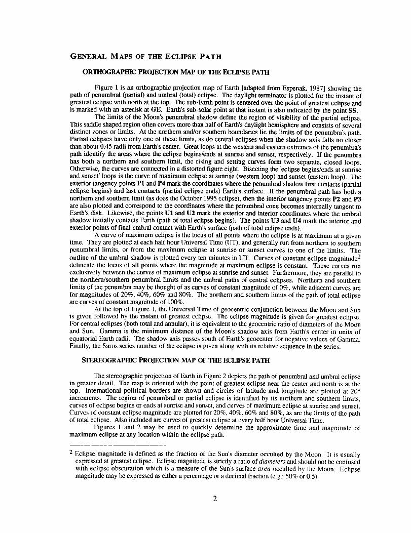
Figure 1 is an orthographic projection map of Earth [adapted from Espenak, 1987] showing thepath of penumbral (partial) and umbra/(total) eclipse. The daylight terminator is plotted for the instant ofgreatest eclipse with north at the top. The sub-Earth point is centered over the point of greatest eclipse andis marked with an asterisk at GE. Earth's sub-solar point at that instant is also indicated by the point SS.
The limits of the Moon's penumbral shadow define the region of visibility of the partial eclipse.This saddle shaped region often covers more than half of Earth's daylight hemisphere and consists of several
distinct zones or limits. At the northern and/or southern boundaries lie the limits of the penumbra's path.Partial eclipses have only one of these limits, as do central eclipses when the shadow axis falls no closerthan about 0.45 radii from Earth's center. Great loops at the western and eastern extremes of the penumbra's
path identify the areas where the eclipse begins/ends at sunrise and sunset, respectively. If the penumbrahas both a northern and southern limit, the rising and setting curves form two separate, closed loops.Otherwise, the curves are connected in a distorted figure eight. Bisecting the 'eclipse begins/ends at sunriseand sunset' loops is the curve of maximum eclipse at sunrise (western loop) and sunset (eastern loop). Theexterior tangency points P1 and P4 mark the coordinates where the penumbral shadow first contacts (partialeclipse begins) and last contacts (partial eclipse ends) Earth's surface. If the penumbral path has both anorthern and southern limit (as does the October 1995 eclipse), then the interior tangency points P2 and P3are also plotted and correspond to the coordinates where the penumbral cone becomes internally tangent toEarth's disk. Likewise, the points U1 and U2 mark the exterior and interior coordinates where the umbralshadow initially contacts Earth (path of total eclipse begins). The points U3 and U4 mark the interior andexterior points of final umbral contact with Earth's surface (path of total eclipse ends).
A curve of maximum eclipse is the locus of all points where the eclipse is at maximum at a giventime. They are plotted at each half hour Universal Time (UT), and generally run from northern to southernpenumbral limits, or from the maximum eclipse at sunrise or sunset curves to one of the limits. The
outline of the umbral shadow is plotted every ten minutes in UT. Curves of constant eclipse magnitude 2delineate the locus of all points where the magnitude at maximum eclipse is constant. These curves runexclusively between the curves of maximum eclipse at sunrise and sunset. Furthermore, they are parallel tothe northern/southern penumbral limits and the umbra/paths of central eclipses. Northern and southernlimits of the penumbra may be thought of as curves of constant magnitude of 0%, while adjacent curves arefor magnitudes of 20%, 40%, 60% and 80%. The northern and southern limits of the path of total eclipseare curves of constant magnitude of 100%.
At the top of Figure 1, the Universal Time of geocentric conjunction between the Moon and Sun
is given followed by the instant of greatest eclipse. The eclipse magnitude is given for greatest eclipse.For central eclipses (both total and annular), it is equivalent to the geocentric ratio of diameters of the Moonand Sun. Gamma is the minimum distance of the Moon's shadow axis from Earth's center in units of
equatorial Earth radii. The shadow axis passes south of Earth's geocenter for negative values of Gamma.Finally, the Saros series number of the eclipse is given along with its relative sequence in the series.
SrEREOGRAPHIC PROJE, C'NON MAP OF THE ECIJPSE PATH
The stereographic projection of Earth in Figure 2 depicts the path of penumbral and umbral eclipsein greater detail. The map is oriented with the point of greatest eclipse near the center and north is at the
top. International political borders are shown and circles of latitude and longitude are plotted at 20 °increments. The region of penumbral or partial eclipse is identified by its northern and southern limits,curves of eclipse begins or ends at sunrise and sunset, and curves of maximum eclipse at sunrise and sunset.
Curves of constant eclipse magnitude are plotted for 20%, 40%, 60% and 80%, as are the limits of the pathof total eclipse. Also included are curves of greatest eclipse at every half hour Universal Time.
Figures 1 and 2 may be used to quickly determine the approximate time and magnitude ofmaximum eclipse at any location within the eclipse path.
2 Eclipse magnitude is defined as the fraction of the Sun's diameter occulted by the Moon. It is usuallyexpressed at greatest eclipse. Eclipse magnitude is strictly a ratio of diameters and should not be confused
with eclipse obscuration which is a measure of the Sun's surface area occulted by the Moon. Eclipsemagnitude may be expressed as either a percentage or a decimal fraction (e.g.: 50% or 0.5).
EQUIDISTANT CONIC PR_ON MAPS OF THE ECLIPSE PATH
Figures 3, 4, 5 and 6 are equidistant conic projection maps that isolate specific regions of theeclipse path. The projection was selected to minimize distortion over the regions depicted. Once again,curves of maximum eclipse and constant eclipse magnitude are plotted and labeled. A linear scale isincluded for estimating approximate distances (kilometers) in each figure. Within the nolthem and southernlimits of the path of totality, the outline of the umbral shadow is plotted at five minute intervals. Thecenter line duration of totality appears near the umbra at various points along the path.
Figure 3 is drawn at a scale of -1:11,060,000, while Figures 4, 5 and 6 are drawn at a scale of-1:3,250,000. All four figures include the positions of many of the larger cities or metropolitan areas inand near the central path. The size of each city is logarithmically proportional to its population accordingto 1990 census data (Rand McNally, 1991).
ELEMENTS, SHADOW CONTACTS AND ECLIPSE PATH TABLES
The geocentric ephemeris for the Moon and Sun, various parameters and constants used in thepredictions, and the Besselian elements (polynomial form) are given in Table 1. The eclipse elements andpredictions were derived from the DE200 and LE200 ephemeridos (solar and lunar, respectively) developedjointly by the Jet Propulsion Laboratory and the U. S. Naval Observatory for use in the AstronomicalAlmanac for 1984 and thereafter. Unless otherwise stated, all predictions are based on center of mass
positions for the Moon and Sun with no corrections made foi center of'figure, lunar limb profile oratmospheric refraction. The predictions depart from normal IAU convention through the use of a smallerconstant for the mean lunar radius k for all umbral contacts (see: LUNAR LIMB PROFILE). Times are
expressed in either Terrestrial Dynamical Time (TDT) or in Universal Time (UT), where the best value of
AT 3 available at the time of preparation is used.Table 2 lists all external and internal contacts of penumbral and umbral shadows with Earth. They
include TDT times and geodetic coordinates with and without corrections for AT. The contacts are defined:
P1 - Instant of first external tangency of penumbral shadow cone with Earth's limb.
(partial eclipse begins)P2 - Instant of first internal tangency of penumbral shadow cone with Earth's limb.P2 - Instant of last internal tangency of penumbral shadow cone with Earth's limb.P4 - Instant of last external tangency of penumbral shadow cone with Earth's limb.
(partial eclipse ends)
U1 - Instant of first external tangency of umbral shadow cone with Earth's limb.(umbral eclipse begins)
U2 - Instant of first internal tangency of umbral shadow cone with Earth's limb.U2 - Instant of last internal tangency of umbral shadow cone with Earth's limb.U4 - Instant of last external tangency of umbral shadow cone with Earth's limb.
(umbral eclipse ends)
Similarly, the northern and southern extremes of the penumbral and umbral paths, and extreme limits of theumbral center line are given. The IAU longitude convention is used throughout this publication (i.e. -eastern longitudes are positive; western longitudes are negative; negative latitudes are south of the Equator).
The path of the umbral shadow is delineated at five minute intervals in Universal Time in Table 3.Coordinates of the northern limit, the southern limit and the center line are listed to the nearest tenth of an
arc-minute (~ 185 m at the Equator). The path azimuth, path width and umbral duration are calculated forthe center line position. The path azimuth is the direction of the umbral shadow's motion projected ontothe surface of the Earth. Table 4 presents a physical ephemeris for the umbral shadow at five minuteintervals in [.IT. The center line coordinates are followed by the topocentric ratio of the apparent diameters
of the Moon and Sun, the eclipse obscuration 4, and the Sun's altitude and azimuth at that instant. Thecentral path width, the umbral shadow's major and minor axes and its instantaneous velocity with respect toEarth's surface are included. Finally, the center line duration of the umbral phase is given.
3 AT is the difference between Terrestrial Dynamical Time and Universal Time
4 Eclipse obscuration is defined as the fraction of the Sun's surface area occulted by the Moon.
3
Local circumstances for each center line position listed in Tables 3 and 4 are presented in Table 5.The first three columns give the Universal Time of maximum eclipse, the center line duration of totalityand the altitude of the Sun at that instant. The following columns list each of the four eclipse contacttimes followed by their related contact position angles and the corresponding altitude of the Sun. The fourcontacts identify significant stages in the progress of the eclipse. They are defined as follows:
First Contact -
Second Contact -
Third Contact -
Fourth Contact -
Instant of first external tangency between the Moon and Sun.(partial eclipse begins)
Instant of ftrst internal tangency between the Moon and Sun.(central or umbral eclipse begins; total or annular eclipse begins)
Instant of last internal tangency between the Moon and Sun.(central or umbral eclipse ends; total or annular eclipse ends)
Instant of last external tangency between the Moon and Sun.(partial eclipse ends)
The position angles P and V identify the point along the Sun's disk where each contact occurs 5. Thealtitude of the Sun at second and third contact is omitted since it is always within 1° of the altitude atmaximum eclipse (column 3).
Table 6 presents topocentric values from the central path at maximum eclipse for the Moon'shorizontal parallax, semi-diameter, relative angular velocity with respect to the Sun, and libration inlongitude. The altitude and azimuth of the Sun are given along with the azimuth of the umbral path. Thenorthern limit position angle identifies the point on the lunar disk defining the umbral path's northernlimit. It is measured counter-clockwise from the north point of the Moon. In addition, corrections to thepath limits due to the lunar limb profile are listed. The irregular profile of the Moon results in a zone of'grazing eclipse' at each limit that is delineated by interior and exterior contacts of lunar features with theSun's limb. This geometry is described in greater detail in the section LIMB CORRECTIONS TO THE PATHLIMITS: GRAZE ZONES. Corrections to center line durations due to the lunar limb profile are also included.When added to the durations in Tables 3, 4, 5 and 7, a slightly shorter central total phase is predicted.
To aid and assist in the plotting of the umbral path on large scale maps, the path coordinates arealso tabulated at 1° intervals in longitude in Table 7. The latitude of the northern limit, southern limit andcenter line for each longitude is tabulated along with the Universal Time of maximum eclipse at eachposition. Finally, local circumstances on the center line at maximum eclipse are listed and include theSun's altitude and azimuth, the umbral path width and the central duration of totality.
LOCAL CIRCUMSTANCES TABLES
Local circumstances from approximately 400 cities, metropolitan areas and places in Africa, Asia,the Indonesian archipelago and Australia are presented in Tables 8 through 15. Each table is broken down
into two parts. The first part, labeled a, appears on even numbered pages and gives circumstances atmaximum eclipse 6 for each location. The coordinates are listed along with the location's elevation (meters)above sea-level, if known. If the elevation is unknown (i.e. - not in the data base), then the localcircumstances for that location are calculated at sea-level. In any case, the elevation does not play asignificant role in the predictions unless the location is near the umbral path limits and the Sun's altitude isrelatively small (<15°). The Universal Time of maximum eclipse (either partial or total) is listed to an
accuracy of 0.1 seconds. If the eclipse is total, then the umbral duration and the path width are given.Next, the altitude and azimuth of the Sun at maximum eclipse are listed along with the position angles Pand V of the Moon's disk with respect to the Sun. Finally, the magnitude and obscuration are listed at theinstant of maximum eclipse. Note that for umbral eclipses (annular and total), the eclipse magnitude isidentical to the topocentric ratio of the Moon's and Sun's apparent diameters. Furthermore, the eclipsemagnitude is always less than 1 for annular eclipses and equal to or greater than 1 for total eclipses.
The second part of each table, labeled b, is found on odd numbered pages. It gives localcircumstances at each eclipse contact for every location listed in part a. The Universal Time of each contact
5 p is defined as the contact angle measured counter-clockwise from the north point of the Sun's disk.V is defined as the contact angle measured counter-clockwise from the zenith point of the Sun's disk.
6 For partial eclipses, maximum eclipse is the instant when the greatest fraction of the Sun's diameter isocculted. For umbral eclipses (total or annular), maximum eclipse is the instant of mid-totality or mid-annularity.
4
isgivenalongwiththealtitudeoftheSun,followedbypositionanglesP and V. These angles identify thepoint along the Sun's disk where each contact occurs and are measured counter-clockwise from the north andzenith points, respectively. Locations outside the umbral path miss the umbral eclipse and only witnessfirst and fourth contacts. The effects of refraction have not been included in these calculations, nor have
there been corrections for center of figure or the lunar limb profile.Since the track of this eclipse is especially narrow (<80 km), few cities actually fall within the
path. Locations were chosen based on general geographic distribution, population, and proximity near orwithin the central path. The primary source for geographic coordinates is The New International Atlas(Rand McNally, 1991). Elevations for major cities were taken from Climates of the World (U. S. Dept. ofCommerce, 1972). In this rapidly changing political world, it is often difficult to ascertain the correct name
or spelling for a given location. Therefore, the information presented here is for location purposes only andis not meant to be authoritative. Furthermore, it does not imply recognition of status of any location bythe United States Government. Corrections to names, spellings, coordinates and elevations is solicited in
order to update the geographic data base for future eclipse predictions.
DETAILED MAPS OF THE UMBRAL PATH
The path of totality has been plotted by hand on a set of eight detailed maps appearing in the lastsection of this publication. The maps are Global Navigation and Planning Charts or GNC's from theDefense Mapping Agency, which use a Lambert conformal conic projection. More specifically, GNC-12covers the Middle East and Indian section of the path while GNC-13 covers Southeast Asia and Indonesia.GNC's have a scale of 1:5,000,000 (1 inch ~ 69 nautical miles), which is adequate for showing major
cities, highways, airports, rivers, bodies of water and basic topography required for eclipse expeditionplanning including site selection, transportation logistics and weather contingency strategies.
Northern and southern limits as well as the center line of the path are plotted using Table 7.
Although no corrections have been made for center of figure or lunar limb profile, they have little or noeffect at this scale. Atmospheric refraction has not been included as its effects play a significant role only atlow solar altitudes (<15°). In any case, refraction corrections to the path are uncertain since they depend onthe atmospheric temperature-pressure profile, which cannot be predicted in advance. If observations from
the graze zones are planned, then the path must be plotted on higher scale maps using limb corrections inTable 6. See PLO'IqTNG TIlE PATII ON MAPS for sources and more information. The GNC paths also
depict the curve of maximum eclipse at five minute increments in Universal Time from Table 3.
ESTIMATING TIMES OF SECOND AND THIRD CONTACTS
The times of second and third contact for any location not listed in this publication can be
estimated using the detailed maps found in the final section. Alternatively, the contact times can beestimated from maps on which the umbral path has been plotted. Table 7 lists the path coordinatesconveniently arranged in 1° increments of longitude to assist plotting by hand. The path coordinates inTable 3 define a line of maximum eclipse at five minute increments in time. These lines of maximum
eclipse each represent the projection diameter of the umbral shadow at the given time. Thus, any point onone of these lines will wimess maximum eclipse (i.e.: mid-totality) at the same instant. The coordinates in
Table 3 should be added to the map in order to construct lines of maximum eclipse.The estimation of contact times for any one point begins with an interpolation for the time of
maximum eclipse at that location. The time of maximum eclipse is proportional to a point's distancebetween two adjacent lines of maximum eclipse, measured along a line parallel to the center line. Thisrelationship is valid along most of the path with the exception of the extreme ends, where the shadowexperiences its largest acceleration. The center line duration of totality D and the path width W aresimilarly interpolated from the values of the adjacent lines of maximum eclipse as listed in Table 3. Sincethe location of interest probably does not lie on the center line, it is useful to have an expression forcalculating the duration of totality d as a function of its perpendicular distance a from the center line:
d = D,(1 - (2 a/W)-_) l/2 seconds
where: d = duration of totality at desired location (seconds)D = duration of totality on the center line (seconds)
a = perpendicular distance from the center line (kilometers)W = width of the path (kilometers)
[11
If tm is the interpolated time of maximum eclipse for the location, then the approximate times of second
and third contacts (t 2 and ta, respectively) are:
Second Contact: t 2 = t= - d/2 [2]
Third Contact: t 3 = t= + d/2 [3]
The position angles of second and third contact (either P or V) for any location off the center lineare also useful in some applications. First, linearly interpolate the center line position angles of second and
third contacts from the values of the adjacent lines of maximum eclipse as listed in Table 5. If X 2 and X 3
are the interpolated center line position angles of second and third contacts, then the position angles x 2 andx3 of those contacts for an observer located a kilometers from the center line are:
Second Contact: x2 = X 2 - ArcSin (2 a/W) [4]
Third Contact: x3 = X 3 + ArcSin (2 a/W) [5]
where: xn = the interpolated position angle (either P or V) of contact n at location
X. = the interpolated position angle (either P or V) of contact n on center line
a = perpendicular distance from the center line (kilometers)(use negative values for locations south of the center line)
W = width of the path (kilometers)
MEAN LUNAR RADIUS
A fundamental parameter used in the prediction of solar eclipses is the Moon's mean radius k,expressed in units of Earth's equatorial radius. The actual radius of the Moon varies as a function of
position angle and libration due to the irregularity of the lunar limb profile. From 1968 through 1980, theNautical Almanac Office used two separate values for k in their eclipse predictions. The larger value(k=0.2724880), representing a mean over lunar topographic features, was used for all penumbral (i.e. -exterior) contacts and for annular eclipses. A smaller value (k=0.272281), representing a mean minimumradius, was reserved exclusively for umbral (i.e. - interior) contact calculations of total eclipses [ExplanatorySupplement, 1974]. Unfortunately, the use of two different values of k for umbral eclipses introduces adiscontinuity in the case of hybrid or annular-total eclipses.
In August 1982, the IAU General Assembly adopted a value of k=0.2725076 for the mean lunar
radius. This value is currently used by the Nautical Almanac Office for all solar eclipse predictions [Fialaand Lukac, 1983] and is currently the best mean radius, averaging mountain peaks and low valleys along theMoon's rugged limb. In general, the adoption of one single value for k is commendable because iteliminates the discontinuity in the case of annular-total eclipses and ends confusion arising from the use oftwo different values. However, the use of even the best 'mean' value for the Moon's radius introduces a
problem in predicting the true character and duration of umbral eclipses, particularly total eclipses. A totaleclipse can be defined as an eclipse in which the Sun's disk is completely occulted by the Moon. Thiscannot occur so long as any photospheric rays are visible through deep valleys along the Moon's limb[Meeus, Grosjean and Vanderleen, 1966]. But the use of the IAU's mean k guarantees that some annular orannular-total eclipses will be misidentified as total. A case in point is the eclipse of 3 October 1986. TheAstronomical Almanac identified this event as a total eclipse of 3 seconds duration when it was, in fact, a
beaded annular eclipse. Clearly, a smaller value of k is needed since it is more representative of the deeperlunar valley floors, hence the minimum solid disk radius and helps ensure that an eclipse is truly total.
Of primary interest to most observers are the times when central eclipse begins and ends (secondand third contacts, respectively) and the duration of the central phase. When the IAU's mean value for k is
used to calculate these times, they must be corrected to accommodate low valleys (total) or high mountains(annular) along the Moon's limb. The calculation of these corrections is not trivial but must be performed,especially if one plans to observe near the path limits [Herald, 1983]. For observers near the center line of atotal eclipse, the limb corrections can be more closely approximated by using a smaller value of k whichaccounts for the valleys along the profile.
This publication uses the IAU's accepted value of k (k=0.2725076) for all penumbral (exterior)contacts. In order to avoid eclipse type misidentification and to predict central durations which are closer to
the actual durations for at total eclipses, we depart from convention by adopting the smaller value for k
6
(k=0.272281) for all umbral (interior) contacts. This is consistent with predictions in Fifty Year Canon ofSolar Eclipses: 1986 - 2035 [Espenak, 1987]. Consequently, the smaller k produces shorter umbraldurations and narrower paths for total eclipses when compared with calculations using the IAU k value.Similarly, the smaller k predicts longer umbral durations and wider paths for annular eclipses than does theIAU k.
LUNAR LIMB PROFILE
Eclipse contact times, the magnitude and the duration of totality all ultimately depend on theangular diameters and relative velocities of the Moon and Sun. Unfortunately, these calculations are limited
in accuracy by the departure of the Moon's limb from a perfectly circular figure. The Moon's surfaceexhibits a rather dramatic topography, that manifests itself as an irregular limb when seen in profile. Most
eclipse calculations assume some mean lunar radius that averages high mountain peaks and low valleysalong the Moon's rugged limb. Such an approximation is acceptable for many applications, but if higheraccuracy is needed, the Moon's actual limb profile must be considered. Fortunately, an extensive body ofknowledge exists on this subject in the form of Watts' limb charts [Watts, 1963]. These data are the
product of a photographic survey of the marginal zone of the Moon and give limb profile heights withrespect to an adopted smooth reference surface (or datum). Analyses of lunar occultations of stars by VanFlandern [1970] and Morrison [1979] have shown that the average cross-section of Watts' datum is slightly
elliptical rather than circular. Furthermore, the implicit center of the datum (i.e. - the center of figure) isdisplaced from the Moon's center of mass. In a follow-up analysis of 66000 occultations, Morrison andAppleby [1981] have found that the radius of the datum appears to vary with libration. These variationsproduce systematic errors in Watts' original limb profile heights that attain 0.4 arc-seconds at some positionangles. Thus, corrections to Watts' limb profile data are necessary to ensure that the reference datum is asphere with its center at the center of mass.
The Watts charts have been digitized by Her Majesty's Nautical Almanac Office in Herstmonceux,
England, and transformed to grid-profile format at the U. S. Naval Observatory. In this computer readableform, the Watts limb charts lend themselves to the generation of limb profiles for any lunar libration.
Ellipticity and libration corrections may be applied to refer the profile to the Moon's center of mass. Sucha profile can then be used to correct eclipse predictions which have been generated using a mean lunar limb.
Along the 1995 eclipse path, the Moon's topocentric libration (physical + optical libration) inlongitude ranges from 1=-3.2 ° to 1=-4.9 °. Thus, a limb profile with the appropriate libration is required inany detailed analysis of contact times, central durations, etc.. Nevertheless, a profile with an intermediatelibration is valuable for general planning purposes. The lunar limb profile presented in Figure 7 includescorrections for center of mass and elipticity [Morrison and Appleby, 1981]. It is generated for is for 3:30
LIT, which corresponds to the western coast of Myanmar. The Moon's topocentric libration in longitude is1=-3.52 °, and the topocentric semi-diameters of the Sun and Moon are 964.7 and 981.4 arc-seconds,
respectively. The Moon's angular velocity with respect to the Sun is 0.370 arc-seconds per second.The radial scale of the limb profile in Figure 7 (at bottom) is greatly exaggerated so that the true
limb's departure from the mean lunar limb is readily apparent. The mean limb with respect to the center offigure of Watts' original data is shown (dashed) along with the mean limb with respect to the center of mass(solid). Note that all the predictions presented in this publication are calculated with respect to the latterlimb unless otherwise noted. Position angles of various lunar features can be read using the protractor in
the center of the diagram. The position angles of second and third contact are clearly marked along with thenorth pole of the Moon's axis of rotation and the observer's zenith at mid-totality. The dashed line arrowsidentify the points on the limb which define the northern and southern limits of the path. To the upper leftof the profile are the Sun's topocentric coordinates at maximum eclipse. They include the right ascensionR.A._ declination Dec., semi-diameter S.D. and horizontal parallax H.P.. The corresponding
topocentric coordinates for the Moon are to the upper right. Below and left of the profile are the geographiccoordinates of the center line at 3:30 UT while the times of the four eclipse contacts at that location appear
to the lower right. Directly below the profile are the local circumstances at maximum eclipse. Theyinclude the Sun's altitude and azimuth, the path width, and central duration. The position angle of the
path's northern/southern limit axis is PA(N,Limit) and the angular velocity of the Moon with respect tothe Sun is A.VeI.(M:S). At the bottom left are a number of parameters used in the predictions, and the
topocentric lunar librations appear at the lower right.In investigations where accurate contact times are needed, the lunar limb profile can be used to
correct the nominal or mean limb predictions. For any given position angle, there will be a high mountain
(annular eclipses) or a low valley (total eclipses) in the vicinity that ultimately determines the true instant
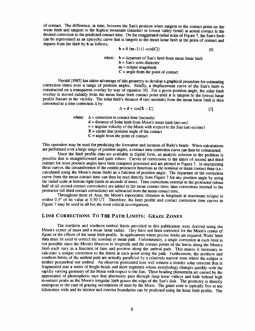
of contact. The difference, in time, between the Sun's position when tangent to the contact point on themean limb and tangent to the highest mountain (annular) or lowest valley (total) at actual contact is thedesired correction to the predicted contact time. On the exaggerated radial scale of Figure 7, the Sun's limbcan be represented as an epicyclic curve that is tangent to the mean lunar limb at the point of contact anddeparts from the limb by h as follows:
h = S (m-l) (1--cos[C]) [6]
where: h = departure of Sun's limb from mean lunar limbS = Sun's semi-diameter
m = eclipse magnitudeC = angle from the point of contact
Herald [1983] has taken advantage of this geometry to develop a graphical procedure for estimatingcorrection times over a range of position angles. Briefly, a displacement curve of the Sun's limb isconstructed on a transparent overlay by way of equation [6]. For a given position angle, the solar limboverlay is moved radially from the mean lunar limb contact point until it is tangent to the lowest lunarprofile feature in the vicinity. The solar limb's distance d (arc-seconds) from the mean lunar limb is thenconverted to a time correction A by:
A = d v cos[X - C] [7]
where: A = correction to contact time (seconds)d = distance of Solar limb from Moon's mean limb (arc-sec)
v = angular velocity of the Moon with respect to the Sun (arc-sec/sec)X = center line position angle of the contactC = angle from the point of contact
This operation may be used for predicting the formation and location of Baily's beads. When calculationsare performed over a large range of position angles, a contact time correction curve can then be constructed.
Since the limb profile data are available in digital form, an analytic solution to the problem ispossible that is straightforward and quite robust. Curves of corrections to the times of second and third
contact for most position angles have been computer generated and are plotted in Figure 7. In interpretingthese curves, the circumference of the central protractor functions as the nominal or mean contact time (i.e.:calculated using the Moon's mean limb) as a function of position angle. The departure of the correction
curve from the mean contact time can then be read directly from Figure 7 for any position angle by usingthe radial scale at bottom right (units in seconds of time). Time corrections external to the protractor (abouthalf of all second contact corrections) are added to the mean contact time; time corrections internal to theprotractor (all third contact corrections) are subtracted from the mean contact time.
Throughout most of Asia, the Moon's topocentric libration in longitude at maximum eclipse iswithin 0.3 ° of its value at 3:30 UT. Therefore, the limb profile and contact correction time curves inFigure 7 ma)_ be used in all but the most critical investigations.
LIMB CORRECTIONS TO THE PATH LIMITS: GRAZE ZONES
The northern and southern umbral limits provided in this publication were derived using theMoon's center of mass and a mean lunar radius. They have not been corrected for the Moon's center offigure or the effects of the lunar limb profile. In applications where precise limits are required, Watts' limbdata must be used to correct the nominal or mean path. Unfortunately, a single correction at each limit is
not possible since the Moon's libration in longitude and the contact points of the limits along the Moon'slimb each vary as a function of time and position along the umbral path. This makes it necessary tocalculate a unique correction to the limits at each point along the path. Furthermore, the northern and
southern limits of the umbral path are actually paralleled by a relatively narrow zone where the eclipse isneither penumbral nor umbral. An observer positioned here will witness a slender solar crescent that is
fragmented into a series of bright beads and short segments whose morphology changes quickly with therapidly varying geometry of the Moon with respect to the Sun. These beading phenomena are caused by the
appearance of photospheric rays that alternately pass through deep lunar valleys and hide behind highmountain peaks as the Moon's irregular limb grazes the edge of the Sun's disk. The geometry is directlyanalogous to the case of grazing occultations of stars by the Moon. The graze zone is typically five to tenkilometers wide and its interior and exterior boundaries can be predicted using the lunar limb profile. The
interiorboundariesdefine the actual limits of the umbral eclipse (both total and annular) while the exteriorboundaries set the outer limits of the grazing eclipse zone.
Table 6 provides topocentric data and corrections to the path limits due to the true lunar limbprofile. At five minute intervals, the table lists the Moon's topocentric horizontal parallax, semi-diameter,relative angular velocity of the Moon with respect to the Sun and lunar libration in longitude. The Sun'scenter line altitude and azimuth is given, followed by the azimuth of the umbral path. The position angleof the point on the Moon's limb which defines the northern limit of the path is measured counter-clockwise(i.e. - eastward) from the north point on the limb. The path corrections to the northern and southern limitsare listed as interior and exterior components in order to define the graze zone. Positive corrections are in thenorthem sense while negative shifts are in the southern sense. These corrections (minutes of arc in latitude)may be added directly to the path coordinates listed in Table 3. Corrections to the center line umbraldurations due to the lunar limb profile are also included and they are all negative. Thus, when added to thecentral durations given in Tables 3, 4, 5 and 7, a slightly shorter central total phase is predicted.
SAROS HISTORY
The total eclipse of 1995 October 24 is the twenty-second member of Saros series 143, as defined
by van den Bergh [1955]. All eclipses in the series occur at the Moon's ascending node and gamma 7decreases with each member in the series. The family began on 1617 Mar 2 with a partial eclipse at high
latitudes in the northern hemisphere. During the first one and a half centuries, ten partial eclipses occurredwith the eclipse magnitude of each succeeding event gradually increasing. Finally, the first umbral eclipseoccurred on 1797 Jun 24. The event was a total eclipse visible from the Arctic Ocean and eastern Siberia.
Perhaps the most remarkable characteristic of this eclipse was its unusual umbral path nearly 1000kilometers wide. During the 1800's, the series continued producing total eclipses whose maximumdurations gradually increasing to nearly four minutes.
Some of the eclipses of Saros 143 have contributed significantly to our understanding of the Sun.For instance, during the total eclipse of 1851 July 28, Airy described the Sun's chromosphere in detail,while Grant, Swan and von Littrow determined that prominences were a physical part of the Sun, ratherthan the Moon. The first photograph of the corona, a daguerreotype, was made in Prussia at this event.The following eclipse of 1869 Aug 7 passed centrally through the United States and is notable for the majorscientific expeditions organized to study it. Young and Harkness independently discovered a mysterious,
bright green line in the corona's spectrum. It wasn't until 1941 that Edl6n identified the line as iron thathas lost 13 electrons (Fe XIV). In Russia, Mendeleev used a balloon to ascend above the clouds to observe
the total eclipse of 1887 Aug 19. One saros period later, the umbra's path crossed through Spain during thewell observed eclipse of 1905 Aug 30.
Although each succeeding path was shifting south towards the equator, the duration of totalitybegan dropping. This was due to the Moon's progressively increasing distance from Earth as each eclipseoccurred nearer to apogee. By 1977 Oct 12, the duration had dropped below three minutes. The 1995 Oct24 event is the twelfth and last total eclipse of Saros 143. The next event of 2013 Nov 3 is a hybrideclipse since it is total along most of its path but becomes annular near the sunrise and sunset portions ofthe track. The following three events are each annular/total as the path of totality grows progressivelynarrower and shorter. Finally, the series produces its first entirely annular eclipse on 2085 Dec 16.
During the next two and a half centuries, the duration of annularity gradually increases as the pathsregress northward. The trend north is due to the passage of Earth through the vernal equinox which shiftsthe northern hemisphere southward with respect to the geocenter. The paths resume their southernmigration with the eclipse of 2338 May 20. The duration of annularity now exceeds two minutes. Theremaining eleven annular members of the series possess paths that shift progressively south while theduration gradually rises above four minutes. The final annular eclipse occurs on 2536 Sep 16 with aduration of 4 minutes 48 seconds. As the series winds down, it produces twenty more partial eclipses at
high southern latitudes. Saros 143 finally ends with its seventy-second event on 2897 Apr 23.In summary, Saros series 143 includes 72 eclipses with the following distribution:
Saros 143 _ Annular Ann�Total Total
Non-Central 30 0 0 0Central -- 26 4 12
7 Gamma is measured in Earth radii and is the minimum distance of the Moon's shadow axis from Earth's
center during an eclipse. This occurs at and defines the instant of greatest eclipse. Gamma takes on
negative values when the shadow axis is south of the Earth's center.
WEATHER PROSPECTS FOR THE ECLIPSE
OVERVIEW
This eclipse begins at moderate latitudes over Iran, heading steadily southeastward toward theequator for most of its length. At its beginning, weather patterns are influenced by high and low pressuresystems moving in the upper westerly flow, just as in North America and Europe. Through India andSoutheast Asia, the upper westerlies lose their importance, and the track moves into a region wherenortherly monsoon and trade winds dominate. Continuing past Borneo the path encounters the IntertropicalConvergence Zone (ITCZ), the Earth's "weather equator," where northerly and southerly monsoons convergeand thunderstorms hold court. Finally, leaving Indonesia and the last island sites, the eclipse track heads outinto the Pacific, moving into the variable southerlies along the equator.
Each of these wind and weather regimes has its own peculiarities. However, it is safe to generalizethat the eclipse path begins with good prospects of sunshine and ends with cloudier skies. This eclipse is ashort one, offering barely two minutes of totality at best, and only one minute in areas with the sunniest
weather prospects. Eclipse observers will have to make a difficult choice between eclipse duration andweather when they pick their viewing sites.
THE MIDDLE EAST
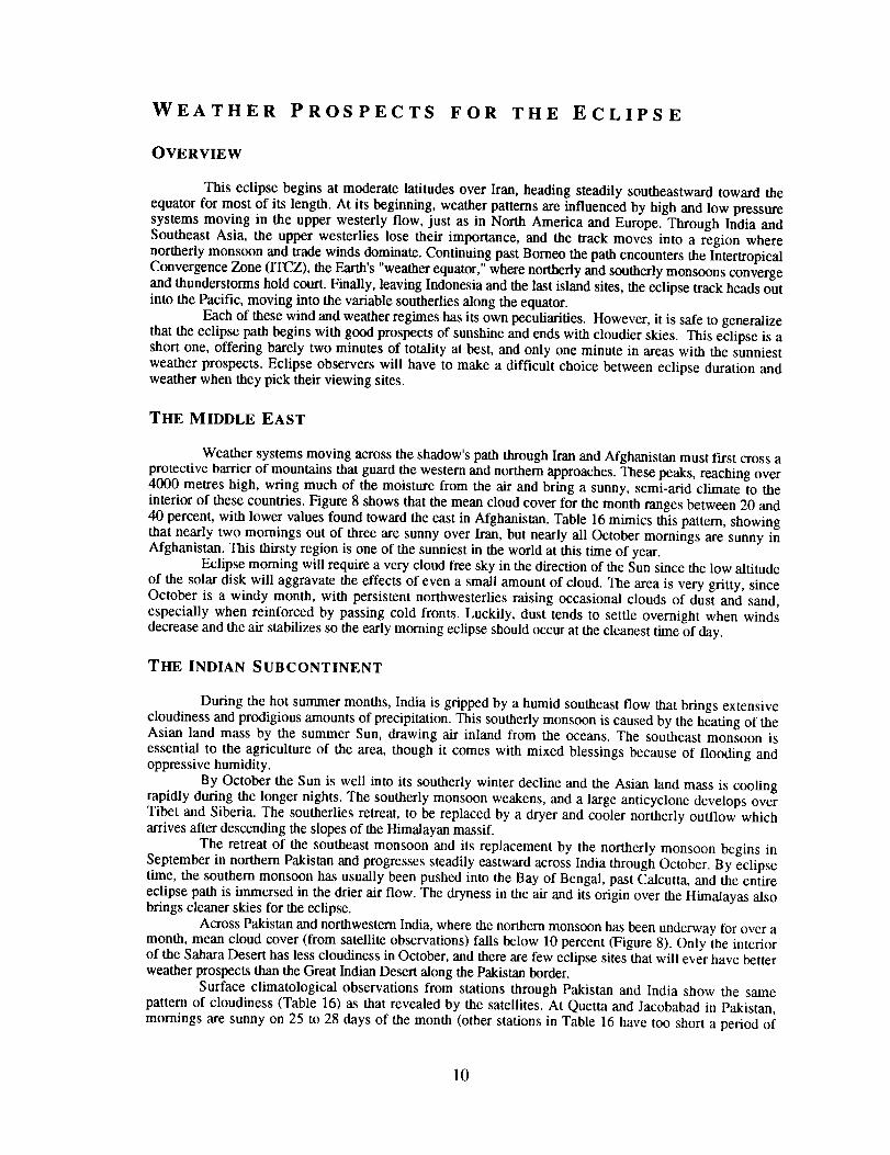
Weather systems moving across the shadow's path through Iran and Afghanistan must first cross aprotective barrier of mountains that guard the western and northern approaches. These peaks, reaching over4000 metres high, wring much of the moisture from the air and bring a sunny, semi-arid climate to theinterior of these countries. Figure 8 shows that the mean cloud cover for the month ranges between 20 and
40 percent, with lower values found toward the east in Afghanistan. Table 16 mimics this pattern, showingthat nearly two mornings out of three are sunny over Iran, but nearly all October mornings are sunny inAfghanistan. This thirsty region is one of the sunniest in the world at this time of year.
Eclipse rooming will require a very cloud free sky in the direction of the Sun since the low altitudeof the solar disk will aggravate the effects of even a small amount of cloud. The area is very gritty, sinceOctober is a windy month, with persistent northwesterlies raising occasional clouds of dust and sand,especially when reinforced by passing cold fronts. Luckily, dust tends to settle overnight when windsdecrease and the air stabilizes so the early morning eclipse should occur at the cleanest time of day.
THE INDIAN SUBCONTINENT
During the hot summer months, India is gripped by a humid southeast flow that brings extensivecloudiness and prodigious amounts of precipitation. This southerly monsoon is caused by the heating of theAsian land mass by the summer Sun, drawing air inland from the oceans. The southeast monsoon isessential to the agriculture of the area, though it comes with mixed blessings because of flooding andoppressive humidity.
By October the Sun is well into its southerly winter decline and the Asian land mass is coolingrapidly during the longer nights. The southerly monsoon weakens, and a large anticyclone develops overTibet and Siberia. The southerlies retreat, to be replaced by a dryer and cooler northerly outflow whicharrives after descending the slopes of the Himalayan massif.
The retreat of the southeast monsoon and its replacement by the northerly monsoon begins inSeptember in northern Pakistan and progresses steadily eastward across India through October. By eclipsetime, the southern monsoon has usually been pushed into the Bay of Bengal, past Calcutta, and the entireeclipse path is immersed in the drier air flow. The dryness in the air and its origin over the Himalayas alsobrings cleaner skies for the eclipse.
Across Pakistan and northwestern India, where the northern monsoon has been underway for over amonth, mean cloud cover (from satellite observations) falls below 10 percent (Figure 8). Only the interiorof the Sahara Desert has less cloudiness in October, and there are few eclipse sites that will ever have betterweather prospects than the Great Indian Desert along the Pakistan border.
Surface climatological observations from stations through Pakistan and India show the samepattern of cloudiness (Table 16) as that revealed by the satellites. At Quetta and Jacobabad in Pakistan,mornings are sunny on 25 to 28 days of the month (other stations in Table 16 have too short a period of
10
record to be reliable). This sunny record continues across northwest India, past Delhi and Agra, beforedeclining beyond Allahabad toward Calcutta. Figure 10 shows that mean daily sunshine ranges between 9and 10 hours over northwest India (out of about 11 possible), and then declines sharply to 7 hours atCalcutta. This pattern is also evident in the October statistics in Table 16.
Since these measurements in the figures and tables are gathered for the whole month of October,and the eclipse occurs close to the end of the month, the numbers favor those areas in the northwest whichhave been sunny for most or all of the 31 days. The cloudy southwest monsoon tends to withdraw from theCalcutta area during the latter half of October, so statistics for the city represent conditions which are partlycharacterized by the sooth monsoon and partly by the north. Thus, Calcutta will appear to be too cloudy inthe statistics because of its late change to the northwest monsoon. The November figures might provide abetter idea of the cloud prospects.
November sunshine statistics, which represent conditions entirely within the northwest monsoonseason, show that sunshine in the Calcutta area increases to about 8.5 hours per day, while northwest Indiadeclines slightly to 9.5 hours. Thus the difference between the Calcutta area and the Delhi area at the end of
October is not as large as the tables and figures indicate. Sunshine hours are probably about 15 percenthigher in the northwest of India than along the Bay of Bengal. Of course all of this depends on thesouthwest monsoon having left the Calcutta area by eclipse time, a likely but not certain event.
Those in quest of the longest possible eclipse, without sacrificing too much of the good weather,might prefer the Calcutta area to Delhi and Agra. In the latter cities the eclipse duration is less than aminute; a site near Calcutta will see over 20 seconds more of totality. But monsoons are notoriously ficklecreatures, and the eclipse date is barely a week after the normal withdrawal of the southerly monsoon at
Calcutta. Observers who wish to take a position near the Bay of Bengal should rely on local weather reportsand the 1995 status of the northwest monsoon to adjust their viewing plans.
At the infrequent times (15 to 25%) when the path through India is cloudy, the clouds comemostly from high level disturbances caught in the upper atmospheric winds. During summer months, thejet stream resides on the north side of the Himalayas carrying disturbances across Tibet and China. InOctober, as the continent cools, the jet makes a sudden shift southward, moving to the equatorial side of themountains. Disturbances which were formerly carried into Tibet now move across northern Pakistan, India
and Southeast Asia. Each of these can bring greater or lesser amounts of cloud according to their intensity.These westerly disturbances are characterized by low pressure systems which move over northern
Pakistan and head east northeastward into India. There are about seven or eight of these a month at theirpeak in January, but there are far fewer in October. The abundance of sunshine provides ample evidence thatthese systems are not particularly common in the fall.
Morning fog patches are rare across northern India, but increase in frequency toward the coast atCalcutta. Thunderstorms, mostly an afternoon phenomenon, are also more common toward Calcutta. Duststorms are an occasional hazard near the Pakistan border, but rare or unknown elsewhere. Since the
northwest monsoon is in its early stages, winds are generally light everywhere and dust is most likely to beraised by the occasional thunderstorm or front.
The Bay of Bengal is famous for its cyclonic storms which occasionally strike the low lying coastof Bangladesh with great loss of life. These storms are not as common as their newspaper reputation wouldsuggest, occurring with a frequency of less than once per month in October. About 30% grow to becomesevere storms with winds in excess of 90 km/h. Their normal path is to follow the east coast of India,curving to move inland across Bangladesh or northern Myanmar. However, a substantial fraction are notcontent to follow the common path, and instead head northwestward past Calcutta and into the center of theIndian sub-continent. While they weaken rapidly once they leave their ocean source, the extensivecloudiness thrown up by these storms has the potential to affect eclipse observing as far west as Allahabad,or even a little beyond. Similar cyclonic storms develop in the Arabian Sea, but are very unlikely to reachthe eclipse track south of Delhi.
SOUTHEAST ASIA
Across continental Southeast Asia, October is a transitional month with the retreating southerlymonsoon being replaced by a light northerly flow. Unfortunately, these northerlies are a part of the tradewind flow from the Pacific and not a piece of the drier air masses which are building over Asia (that willcome later in the winter). They carry much more moisture as a result of their trajectory over the warmocean. These moist winds bring weather patterns which are varied and changeable, and in much ofCambodia, Thailand and Vietnam, October is the wettest month of the year.
The trade wind flow is very light and readily deflected by the many mountain chains and valleys
which charactcrize continental Southeast Asia. Precipitation and cloudiness is highest on the exposed
11
windwardsideoftheterrain,particularly on the east slopes of the coastal mountains of Vietnam, that firstintercept the ocean wind flow. The mountain chain that extends the length of Myanmar and forms thebackbone of the Malay Peninsula is affected in the same way. In the protected interior of Cambodia andThailand, however, sunshine is a little more abundant.
Air masses across Southeast Asia are very unsettled and showers and thundershowers grow at theleast provocation. It may take little more than two wind flows that collide, a dark surface that collects a
little more heat from the Sun, or a range of hills, to set off the buildups. Nearly every afternoon is dottedwith clouds, and nights are humid. As in India, the westerly jet also carries upper disturbances intoSoutheast Asia, each bringing its own retinue of cloud and rain. These systems tend to pass to the north ofthe eclipse track, except over Myanmar, but are variable enough that they contribute substantially to thecloud cover along the shadow's path.
Heading southeastward past Vietnam, the track encounters the Intertropical Convergence Zone(ITCZ), where the winds from the northerly trades converge with those of the retreating southerly monsoon.This boundary is usually found lurking over the Malay Peninsula, past the northern tip of Borneo and intothe Pacific along the 8th parallel. It is not a well-defined boundary, but rather a diffuse area of showers andthunderstorms that wonders about its average position. The land masses of Indochina distort the wind flowsthat create the ITCZ, and it becomes very broad and undefined between the Bay of Bengal and New Guinea.
Many of the thunderstorms that develop along the ITCZ are part of organized clusters (Figure 9)that throw up large and solid cloud umbrellas. They will almost certainly make eclipse viewing impossibleshould they arrive on the critical day, and because of their size, will be difficult to outrun. Over the Bay ofBengal, about 2 to 3 of these weather systems can be expected during the month. This grows to 4 to 6 permonth off the coast of Vietnam and to 8 along the west coast of Borneo.
Past Borneo and the islands of the Celebes Sea, the path moves into the light southerly flowsfound on the south side of the ITCZ. Cloud cover decreases slightly north and east of the island of Sulawesi
(Celebes), in most part because thunderstorm clusters avoid the area. From a climatological point of view,this is probably the best location for observing from a ship, but a timely weather forecast for other areaswould probably give more advantage.
October is in the midst of the typhoon season, a particularly vicious type of storm that isessentially a Pacific hurricane. They have every bit of the nasty personality, and then some, of their North
American cousins. Typhoons approach the coasts of Indochina from the east, passing over the Philippineson their way toward Vietnam. They weaken rapidly once they cross onto land, but leave large areas of cloudto plague eclipse-viewing. Luckily, they are quite rare at the latitude of the eclipse track, affecting it perhapsone year in five.
Beyond the Celebes Sea, the eclipse track moves into quieter and slightly sunnier weather of thePacific equator, where the path ends at sunset in Micronesia. It is a region of cumulus cloudiness, with
plenty of blue sky between the convective buildups. Occasional thunderstorm clusters may spoil this idyllicpattern, but they are not as common as farther north toward the ITCZ. Unfortunately, because the eclipsedSun will be low in the sky, even a little cloudiness will go a long way to obscuring the view.
Shipboard observers will find compatible wave heights along much of the eclipse track, unless arecent typhoon or cyclone sends a large swell into the eclipse area. From the coast of Vietnam to New
Guinea wave heights average between one-half and one metre. Beyond New Guinea, and on the Bay ofBengal, waves average a little over one metre in height.
WEATHER SUMMARY
With all of these weather demons converging on Southeast Asia and the islands of Indonesia, theprospects for eclipse observing would seem to be quite dismal. Figure 8 shows that the mean cloudiness
ranges from 60 to 80 percent through the area, four to five times higher than over western India. Figure 9hints at the disadvantage of the close proximity of the ITCZ and its thunderstorm clusters. Table 16, derived
from actual observations along the path, also provides a pessimistic outlook with a very low frequency ofsunny skies. So what are the actual prospects for clear skies at eclipse time? The best statistic,unfortunately collected at only a few locations, is the actual number of hours of sunshine. Figure 10promises between 7 and 10 hours at Indian sites. Phnom Penh and Kratie, both in Cambodia, average 6hours per day in October, and Ho Chi Minh City (Saigon) reports 4.5 (Table 16).
By dividing the number of sunny hours by the number of hours between sunrise and sunset we can
calculate the percent of possible sunshine for each site. Such a statistic allows the various locations alongthe track to be compared directly, and it provides a good estimate of the actual probability of seeing theeclipse except for morning/afternoon differences. It also corrects for the different lengths of the day at thevarious locations.
12
An eclipse site in Cambodia or Thailand would have about a 50% probability of seeing the eclipse,in Vietnam about 40%, and locations in western India 85 to 90%. Other values, where available, are given
in Table 16. Mobility would normally raise the likelihood by a few percentage points for most eclipses, but
the very narrow track for this eclipse limits the distance that can be explored for holes in the cloud. Theadvantage gained is probably not more than 5%.
One exception is for those who observe at sea where a ship is free to range along the track. Shipsare limited by a relatively slow speed, but are not constrained by orographic barriers (islands, perhaps) or theneed for roads. Knowing where to sail will be critical, so the advantage to be gained will be determined byforecast accuracy and lead time. There are many variables to consider, but a rough estimate might be that a
shipboard chase would confer a 10% advantage.Unfortunately, sunshine statistics are not available for Indonesian and Philippine islands along the
track, and in any event land-based measurements do not accurately reflect conditions on the ocean. We areleft with the need to accept substitutes, for which the cloud cover data of Figure 8 will have to suffice. A
comparison between locations with similar cloud statistics forces the conclusion that sunshine hours on theSouth China Sea between Borneo and Vietnam are comparable to conditions at Ho Chi Minh City, and theCelebes Sea near Sulawesi is comparable to the sheltered interior of Cambodia and Thailand. Add 10% for
mobility, and shipboard observers have a 50 to 60% probability of suitable skies for the shadow passage.
OBSERVING THE ECLIPSE
EYE SAFETY DURING SOLAR ECLIPSES
The Sun can be viewed safely with the naked eye only during the few brief seconds or minutes of a
total solar eclipse. Partial and annular solar eclipses are never safe to watch without taking specialprecautions. Even when 99% of the Sun's surface is obscured during the partial phases, the remainingphotospheric crescent is intensely bright and cannot be viewed safely without eye protection [Chou, 1981;Marsh, 1982]. Do not attempt to observe the partial or annular phases of any eclipse
with the naked eye. Failure to use appropriate filtration may result in permanent eyedamage or blindness!
Generally, the same equipment, techniques and precautions used to observe the Sun outside of
eclipse are required [Pasachoff & Covington, 1993; Pasachoff & Menzel, 1992; Sherrod, 1981]. There areseveral safe methods that may be used to watch the partial phases. The safest of these is projection, inwhich a pinhole or small opening is used to cast the image of the Sun on a screen placed a half-meter ormore beyond the opening. Projected images of the Sun may even be seen on the ground in the smallopenings created by interlacing fingers, or in the dappled sunlight beneath a leafy tree. Binoculars can alsobe used to project a magnified image of the Sun on a white card, but you must avoid the temptation of
using these instruments for direct viewing.Direct viewing of the Sun should only be done using filters specifically designed for this purpose
Such filters usually have a thin layer of aluminum, chromium or silver deposited on their surfaces thatattenuates both the visible and the infrared energy. Experienced amateur and professional astronomers may
use one or two layers of completely exposed and fully developed black-and-white film, provided the filmcontains a silver emulsion. Since developed color films lack silver, they are unsafe for use in solar
viewing. A widely available alternative for safe eclipse viewing is a number 14 welder's glass. However,only mylar or glass filters specifically designed for the purpose should used with telescopes or binoculars.
Unsafe filters include color film, some non-silver black and white film, smoked glass,
photographic neutral density filters and polarizing filters. Solar filters designed to thread into eyepieces andoften sold with inexpensive telescopes are also dangerous. They should not be used for viewing the Sun atany time since they often crack from overheating. Do not experiment with other filters unless you arecertain that they are safe. Damage to the eyes comes predominantly from invisible infrared wavelengths.The fact that the Sun appears dark in a filter or that you feel no discomfort does not guarantee that your eyesare safe. Avoid all unnecessary risks. Your local planetarium or amateur astronomy club is a good sourcefor additional information.
13

SKY AT TOTALITY
The total phase of an eclipse is accompanied by the onset of a rapidly darkening sky whoseappearance resembles evening twilight about 30 or 40 minutes after sunset. The effect presents an excellentopportunity to view planets and bright stars in the daytime sky. Aside from the sheer novelty of it, suchobservations are useful in gauging the apparent sky brightness and transparency during totality. The Sun isin Virgo and a number of planets and bright stars will be above the horizon for observers within the umbral
path. Figure 11 depicts the appearance of the sky during totality as seen from the center line at 3:30 UT,which corresponds to the western coast of Myanmar. Venus is the brightest planet and can actually beobserved in broad daylight provided that the sky is cloud free and of high transparency (i.e. - no dust or
particulates). During the 1995 eclipse, Venus is located 17 ° east of the Sun, having recently passed throughsuperior conjunction in mid-August. Look for the planet during the partial phases by first covering thecrescent Sun with an extended hand. During totality, it will be virtually impossible to miss Venus since it
shines at a magnitude of mv=--3.3. Although two magnitudes fainter, Jupiter will also be well placed 42 °
east of the Sun and shining at mv=-l.4. Under good conditions, it may be possible to spot Jupiter 5 to 10
minutes before totality. Since this is a morning eclipse for observers along the Asian path, Jupiter will below in the southeastern sky and will be below the horizon during totality from Iran through India. Onlyfour days past greatest western elongation, Mercury is 18 ° west of the Sun at my=-0.3 and should also be
an easy target provided skies are clear. The most difficult of the naked eye planets will be Mars (mv=+l.3),
appearing 32 ° east of the Sun between Venus and Jupiter. Saturn is near opposition 138 ° east of the Sunand will be below the horizon for all observers. Among the brighter stars visible during totality, Spica(mv=+0.7) is located 7 ° west of the Sun. Other stars to look for include Regulus (mv=+l.35), Arcturus
(mv=-0.04) Capella (mv=+0.08) and Procyon (mv=+0.38). East of India, watch for Acrux (mv=+l.33),
Gacrux (mv=+l.63v), Alpha and Beta Centauri (mv=-0.01 & mv=+0.6v ) all low in the south while
Antares (mv=+0.9v) stands low in the east 7 ° from Jupiter. Sirius (mv=-l.46) may be seen setting in thesouthwestern sky for observers along the Iran-India segment of the path.
The following ephemeris [using Bretagnon and Simon, 1986] gives the positions of the naked eyeplanets during the eclipse. Delta is the distance of the planet from Earth (A.U.'s), V is the apparent visualmagnitude of the planet, and Elong gives the solar elongation or angle between the Sun and planet. Notethat Saturn is near opposition and will be below the horizon for all observers during the eclipse.
Planetary Ephemeris: 1995 Oct 24 5:00 UT Equinox = Mean Dete
Planet RA Dec Delta V Size Phase Elongh m s o , ,, , o
Sun 13 52 50 -11-34-47 0.99476 -26.7 1929.4 -
Mercury 12 50 26 -3 -9-41 1.07410 -0.6 6.3 0.69 17.6W
Venus 14 59 26 -16-50-37 1.61647 -3.3 10.3 0.96 17.0EMars 16 0 43 -21-18-40 2.21358 1.6 4.2 0.97 32.1E
Jupiter 16 52 51 -22-10-18 5.96082 -1.4 33.0 1.00 44.2E
Saturn 23 22 2 -6-36-26 8.83178 0.i 18.7 1.00 138.3E
ECLIPSE PHOTOGRAPHY
The eclipse may be safely photographed provided that the above precautions are followed. Almostany kind of camera with manual controls can be used to capture this rare event. However, a lens with afairly long focal length is recommended to produce as large an image of the Sun as possible. A standard 50
mm lens yields a minuscule 0.5 mm image, while a 200 mm telephoto or zoom produces a 1.9 mm image.A better choice would be one of the small, compact catadioptic or mirror lenses that have become widelyavailable in the past ten years. The focal length of 500 mm is most common among such mirror lensesand yields a solar image of 4.6 mm. Adding 2x tele-converter will produce a 1000 nun focal length, whichdoubles the Sun's size to 9.2 mm. Focal lengths in excess of 1000 mm usually fall within the realm ofamateur telescopes. If full disk photography of partial phases on 35 mm format is planned, the focal lengthof the telescope or lens must be 2600 mm or less. Longer focal lengths will only permit photography of a
14
portionof the Sun's disk. Furthermore, in order to photograph the Sun's corona during totality, the focallength should be no longer than 1500 mm to 1800 mm (for 35 mm equipment). For any particular focallength, the diameter of the Sun's image is approximately equal to the focal length divided by 109.
A mylar or glass solar filter must be used on the lens throughout the partial phases for bothphotography and safe viewing. Such filters are most easily obtained through manufacturers and dealerslisted in Sky & Telescope and Astronomy magazines. These filters typically attenuate the Sun's visible andinfrared energy by a factor of 100,000. However, the actual filter factor and choice of ISO film speed willplay critical roles in determining the correct photographic exposure. A low to medium speed film isrecommended (ISO 50 to 100) since the Sun gives off abundant light. The easiest method for determining
the correct exposure is accomplished by running a calibration test on the uneclipsed Sun. Shoot a roll offilm of the mid-day Sun at a fixed aperture (f/8 to f/16) using every shutter speed between 1/1000 and 1/4second. After the film is developed, note the best exposures and use them to photograph all the partial
phases since the Sun's surface brightness remains constant throughout the eclipse. The exposure should alsobe increased by one or two stops for narrow crescent phases to compensate for limb darkening. Bracketingof two or more stops may be necessary if hazy skies or clouds interfere on eclipse day.
Certainly the most spectacular and awe inspiring phase of the eclipse is totality. For a few briefminutes or seconds, the Sun's pearly white corona, red prominences and chromosphere are visible. The
great challenge is to obtain a set of photographs which capture some aspect of these fleeting phenomena.The most important point to remember is that during the total phase, all solar filters must be removed!The corona has a surface brightness a million times fainter than the photosphere, so photographs of thecorona are made without a filter. Furthermore, it is completely safe to view the totally eclipsed Sun
directly with the naked eye. No filters are needed and they will only hinder your view. The averagebrightness of the corona varies inversely with the distance from the Sun's limb. The inner corona is farbrighter than the outer corona. Thus, no one exposure can capture its the full dynamic range. The beststrategy is to choose one aperture or f/number and bracket the exposures over a range of shutter speeds (i.e. -1/1000 down to 1 second). Rehearsing this sequence is highly recommended since great excitement
accompanies totality and there is little time to think.Exposure times for various combinations of film speeds (ISO), apertures (f/number) and solar
features (chromosphere, prominences, inner, middle and outer corona) are summarized in Table 17. Thetable was developed from eclipse photographs made by Espenak as well as from photographs published in
Sky and Telescope. To use the table, first select the ISO film speed in the upper left column. Next, moveto the right to the desired aperture or f/number for the chosen ISO. The shutter speeds in that column maybe used as starting points for photographing various features and phenomena tabulated in the 'Subject'column at the far left. For example, to photograph prominences using ISO 100 at f/ll, the tablerecommends an exposure of 1/500. Alternatively, you can calculate the recommended shutter speed using
the 'Q' factors tabulated along with the exposure formula at the bottom of Table 17. Keep in mind thatthese exposures are based on a clear sky and an average corona. You should bracket your exposures one ormore stops to take into account the actual sky conditions and the variable nature of these phenomena.
Another interesting way to photograph the eclipse is to record its various phases all on one frame.This is accomplished by using a stationary camera capable of making multiple exposures (check the camerainstruction manual). Since the Sun moves through the sky at the rate of 15 degrees per hour, it slowly
drifts through the field of view of any camera equipped with a normal focal length lens (i.e. - 35 to 50 mm).If the camera is oriented so that the Sun drifts along the frame's diagonal, it will take over three hours forthe Sun to cross the field of a 50 mm lens. The proper camera orientation can be determined through trial
and error several days before the eclipse. This will also insure that no trees or buildings obscure the camera'sview during the eclipse. The Sun should be positioned along the eastern (right in southern hemisphere)edge or comer of the viewfinder shortly before the eclipse begins. Exposures are then made throughout theeclipse at five minute intervals. The camera must remain perfectly rigid during this period and may beclamped to a wall or fence post since tripods are easily bumped. The final photograph will consist of a
string of Suns, each showing a different phase of the eclipse.Finally, an eclipse effect that is easily captured with point-and-shoot or automatic cameras should
not be overlooked. During the eclipse, the ground under nearby shade trees is covered with small images ofthe crescent Sun. The gaps between the tree leaves act like pinhole cameras and each one projects its own
tiny image of the Sun. The effect can be duplicated by forming a small aperture with one's hands andwatching the ground below. The pinhole camera effect becomes more prominent with increasing eclipsemagnitude. Virtually any camera can be used to photograph the phenomenon, but automatic cameras musthave their flashes turned off since this would otherwise obliterate the pinhole images.
For more information on eclipse photography, observations and eye safety, see FURTHER
READING in the BIBLIOGRAPItY.
15
CONTACT TIMINGS FROM THE PATH LIMITS
Precise timings of beading phenomena made near the northern and southern limits of the umbralpath (i.e. - the graze zones), are of value in determining the diameter of the Sun relative to the Moon at the
time of the eclipse. Such measurements are essential to an ongoing project to monitor changes in the solardiameter. Due to the conspicuous nature of the eclipse phenomena and their strong dependence ongeographical location, scientifically useful observations can be made with relatively modest equipment. Asmall telescope, short wave radio and portable camcorder are usually used to make such measurements.
Time signals are broadcast via short wave stations WWV and CHU, and are recorded simultaneously as theeclipse is videotaped. If a video camera is not available, a tape recorder can be used to record time signalswith verbal timings of each event. Inexperienced observers are cautioned to use great care in making suchobservations. The safest timing technique consists of observing a projection of the Sun rather than directlyimaging the solar disk itself. The observer's geodetic coordinates are required and can be measured from
USGS or other large scale maps. If a map is unavailable, then a detailed description of the observing siteshould be included which provides information such as distance and directions of the nearesttowns/settlements, nearby landmarks, identif'mble buildings and road intersections. The method of contact
timing should be described in detail, along with an estimate of the error. The precisional requirements ofthese observations are _+0.5 seconds in time, 1" (-30 meters) in latitude and longitude, and +20 meters (-60
feet) in elevation. Although GPS's (Global Positioning Satellite receivers) are commercially available(-$500 US), their positional accuracy of +100 meters is about three times larger than the minimumaccuracy required by grazing eclipse measurements. The International Occultation Timing Association(IOTA) coordinates observers world-wide during each eclipse. For more information, contact:
Dr. David W. Dunham, IOTA
7006 Megan LaneGreenbelt, MD 20770-3012U.S.A.
Phone: (301) 474.4722
Intemet: David_Dunham @jhuapl.edu
Send reports containing graze observations, eclipse contact and Baily's bead timings, including those madeanywhere near or in the path of totality or annularity to:
Dr. Alan D. Fiala
Orbital Mechanics Dept.U. S. Naval Observatory3450 Massachusetts Ave., NWWashington, DC 20392-5420
PLOTTING THE PATH ON MAPS
If high resolution maps of the umbral path are needed, the coordinates listed in Table 7 are
conveniently provided at 10 increments of longitude to assist plotting by hand. The path coordinates inTable 3 define a line of maximum eclipse at five minute increments in Universal Time. It is also advisable
to include lunar limb corrections to the northern and southern limits listed in Table 6, especially ifobservations are planned from the graze zones. Global Navigation Charts (1:5,000,000), OperationalNavigation Charts (scale 1:1,000,000) and Tactical Pilotage Charts (1:500,000) of many parts of the worldare published by the Defense Mapping Agency. In October 1992, the DMA discontinued selling mapsdirectly to the general public. This service has been transferred to the National Ocean Service (NOS). Forspecific information about map availability, purchase prices, and ordering instructions, contact the NOS at:
National Ocean ServiceDistribution BranchN/GC33
6501 Lafayette AvenueRiverdale, MD 20737, USA Phone: 1-301-436-6990
It is also advisable to check the telephone directory for any map specialty stores in your city ormetropolitan area. They often have large inventories of many maps available for immediate delivery.
16
ECLIPSE DATA ON INTERNET
NASA ECLIPSE BULLETINS ON INTERNET
Response to the first two NASA solar eclipse bulletins RP1301 (Annular Solar Eclipse of 10 May1994) and RP1318 (Total Solar Eclipse of 3 Nov 1994) was overwhelming. Unfortunately, the demandexceeded the supply and current funding sources did not permit additional printings to fill all requests. Toaddress this problem as well as allowing greater access to them, these eclipse bulletins were both madeavailable via the Internet in April 1994. This was due entirely through the kind efforts and expertise of Dr.Joe Gurman (GSFC/Solar Physics Branch). The 1995 bulletin is also being made available via Intemet.
Formats include BinHex-encoded versions of the original Microsoft Word (for Macintosh) text filesand those figures generated in PICT format, GW versions of all the figures, and JPEG scans of the GNCmaps of the eclipse path, as well as hypertext versions. They can be read or downloaded via the World-WideWeb server with a mosaic client from the SDAC (Solar Data Analysis Center) home page:
http://umbra.gsfc.nasa.gov/sdac.html
The top-level URL for the eclipse bulletins themselves are:
http://umbra.gsfc.nasa.gov/eclipse/940510/rp.htmlhttp://umbra, gsfc.nasa.gov/eclipse/941103/rp.htmlhttp://umbra.gs fc.nasa.gov/eclipse/951024/rp.html
(1994 May 10)(1994 Nov 3)(1995 Oct 24)
BinHex-encoded, Stuffh Lite-compressed version of the original Word and PlCT files are available viaanonymous ftp at:
http://umbra.gsfc.nasa.gov/eclipse/940510 (1994 May 10)http://umbra.gsfc.nasa.gov/eclipse/941103 (1994 Nov 3)http://umbra.gsfc.nasa.gov/eclipse/951024 (1995 Oct 24)
Directories of GIF figures, ASCII tables, and JPEG maps are also accessible through the Web.Current plans call for making all future NASA eclipse bulletins available over the Internet, at or
before publication of each. It should be noted that this is a first attempt to make the bulletins availableelectronically. The primary goal has been to make the bulletins available to as large an audience aspossible. Thus, some figures or maps may not be at their optimum resolution or format. Comments andsuggestions are actively solicited to fix problems and improve on compatibility and formats.
FUTURE ECLIPSE PATHS ON INTERNET
Presently, the NASA eclipse bulletins are published 12 to 18 months before each eclipse. Thiswill soon be increased to 24 months or more. However, there have been a growing number of requests foreclipse path data with an even greater lead time. To accommodate the demand, predictions have beengenerated for all central solar eclipses from 1995 through 2000 using the JPL DE/LE 200 ephemerides. Allpredictions use the Moon's the center of mass; no corrections have been made to adjust for center of figure.The value used for the Moon's mean radius is k=0.272281. The umbral path characteristics have beenpredicted at 2 minute intervals of time compared to the 6 minute interval used in Fifty Year Canon of SolarEclipses: 1986-2035 [Espenak, 1987]. This should provide enough detail for making preliminary plots ofthe path on larger scale maps. Note that positive latitudes are north and positive longitudes are west.
The paths for the following seven eclipses are currently available via the Internet:
29 Apr 199524 Oct 19059 Mar 1997
26 Feb 1998
22 Aug 199816 Feb 1999
11 Aug 1999
- Annular Solar Eclipse- Total Solar Eclipse- Total Solar Eclipse- Total Solar Eclipse- Annular Solar Eclipse- Annular Solar Eclipse- Total Solar 'Eclipse
17
Thetables can be accessed with Mosaic through SDAC home page, or directly at URL:
http://umbra.gsfc.nasa.gov/eclipse/predictions/eclipse-paths.html
Comments, corrections or suggestions should be sent to Fred Espenak either via regular or e-mail("[email protected]"). For Internet related problems, please contact Joe Gurman
("[email protected]"). Either one of us can also be contacted for more detailed descriptions offormats and directories or instructions for downloading files using Mosaic or ftp.
ALGORITHMS, EPHEMERIDES AND PARAMETERS
Algorithms for the eclipse predictions were developed by Espenak primarily from the ExplanatorySupplement [1974] with additional algorithms from Meeus, Grosjean and Vanderleen [1966] and Meeus
[1982]. The solar and lunar ephemerides were generated from the JPL DE200 and LE200, respectively. Alleclipse calculations were made using a value for the Moon's radius of k=0.2722810 for umbral contacts, and
k=0.2725076 (adopted IAU value) for penumbral contacts. Center of mass coordinates were used exceptwhere noted. An extrapolated value for AT of 61.0 seconds was used to convert the predictions fromTerrestrial Dynamical Time to Universal Time.
The primary source for geographic coordinates used in the local circumstances tables is The New
International Atlas (Rand McNally, 1991). Elevations for major cities were taken from Climates of theWorld (U. S. Dept. of Commerce, 1972).
All eclipse predictions presented in this publication were generated on a Macintosh computer. Assuch, it represents the culmination of a two year project to migrate a great deal of eclipse software frommainframe (DEC VAX 11/785) to personal computer (Macintosh IIfx) and from one programming language(FORTRAN IV) to another (THINK Pascal). Word processing and page layout for the publication weredone using Microsoft Word v5.1. Figure annotation was done with Claris MacDraw Pro 1.5. Allmeteorological diagrams were prepared using Windows Draw 3.0 and converted to Macintosh format.
The names and spellings of countries, cities and other geopolitical regions are not authoritative,nor do they imply any official recognition in status. Corrections to names, geographic coordinates andelevations are actively solicited in order to update the data base for future eclipses. All calculations,diagrams and opinions presented in this publication are those of the authors and they assume fullresponsibility for their accuracy.
18
BIBLIOGRAPHY
REFERENCES
Bretagnon, P., and Simon, J. L., Planetary Programs and Tables from -4000 to +2800, Willmann-Bell,Richmond, Virginia, 1986.
Chou, B. R., "Safe Solar Filters," Sky & Telescope, August 1981, p. 119.
Climates of the WorM, U. S. Dept. of Commerce, Washington DC, 1972.Dunham, J. B, Dunham, D. W. and Warren, W. H., IOTA Observer's Manual (draft copy), 1992.
Espenak, F., Fifty Year Canon of Solar Eclipses: 1986-2035, NASA RP-1178, Greenbelt, MD, 1987.Explanatory Supplement to the Astronomical Ephemeris and the American Ephemeris and Nautical
Almanac, Her Majesty's Nautical Almanac Office, London, 1974.tlerald, D., "Correcting Predictions of Solar Eclipse Contact Times for the Effects of Lunar Limb
Irregularities," J. Brit. Ast. Assoc., 1983, 93, 6.Marsh, J. C. D., "Observing the Sun in Safety," J. Brit. Ast. Assoc., 1982, 92, 6.Meeus, J., Astronomical Formulae for Calculators, Willmann-Bell, Inc., Richmond, 1982.
Meeus, J., Grosjean, C., and Vanderleen, W., Canon of Solar Eclipses, Pergamon Press, New York, 1966.Morrison, L. V., "Analysis of lunar occultations in the years 1943-1974 .... " Astr. J., 1979, 75, 744.
Morrison, L.V., and Appleby, G.M., "Analysis of lunar occultations - III. Systematic corrections to Watts'limb-profiles for the Moon," Mort. Not. R. Astron. Soc., 1981, 196, 1013.
The New International Atlas, Rand McNally, Chicago/New York/San Francisco, 1991.
van den Bergh, G., Periodici_' and Variation of Solar (and Lunar) Eclipses, Tjeenk Willink, Haarlem,Netherlands, 1955.
Watts, C. B., "The Marginal Zone of the Moon," Astron. Papers Amer. Ephem., 1963, 17, 1-951.
FURTHER READING
Allen, D., and Allen, C., Eclipse, Allen & Unwin, Sydney, 1987.
Astrophotography Basics, Kodak Customer Service Pamphlet P150, Eastman Kodak, Rochester, 1988.Brewer, B., Eclipse. Earth View, Seattle, 1991.Covington, M., Astrophotographyfor the Amateur, Cambridge University Press, Cambridge, 1988.Espenak, F., "Total Eclipse of the Sun," Petersen's PhotoGraphic, June 1991, p. 32.Fiala, A. D., DeYoung, J. A., and Lukac, M. R., Solar Eclipses, 1991-2000, USNO Circular No. 170,
U. S. Naval Observatory, Washington, DC, 1986.tlarris, J., and Talcott, R.,Chasing the Shadow, Kalmbach Pub., Waukesha, 1994.Littmann, M., and Willcox, K., Totality, Eclipses of the Sun, University of Hawaii Press, Honolulu, 1991.Lowenthal, J., The Hidden Sun: Solar Eclipses and Astrophotography, Avon, New York, 1984.Mucke, II., and Meeus, J., Canon of Solar Eclipses: -2003 to +2526, Astronomisches Biiro, Vienna, 1983.North, G., Advanced Amateur Astronomy, Edinburgh University Press, 1991.Oppolzer, T. R. von, Canon of Eclipses, Dover Publications, New York, 1962.Ottewell, G., The Under-Standing of Eclipses, Astronomical Workshop, Greenville, NC, 1991.Pasachoff, J. M., and Covington, M., Cambridge Guide to Eclipse Photography, Cambridge University
Press, Cambridge and New York, 1993.Pasachoff, J. M., and Menzel, D. 1t., FieM Guide to the Stars and Planets, 3rd edition, Houghton Mifflin,
Boston, 1992.Sherrod; P. C., A Complete Manual of Amateur Astrononzy, Prentice-Hall, 1981.Sweetsir, R., and Reynolds, M., Observe: Eclipses, Astronomical League, Washington, DC, 1979.Zirker, J. B., Total Eclipses of the Sun, Van Nostrand Reinhold, New York, 1984.
19

TOTAL SOLAR ECLIPSE OF 1995 OCTOBER 24
FIGURES
21PAC,_ _ f_ FN.MF_

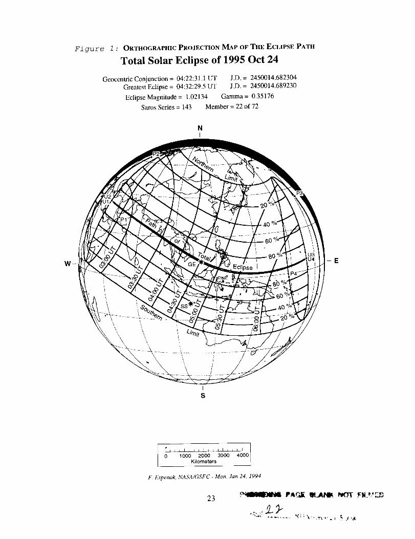
Figure 1 : ORTHOGRAPHIC PROJECTION MAP OF THE ECLIPSE PATH
Total Solar Eclipse of 1995 Oct 24
Geocentric Conjunction = 04:22:31.1 I.YF J.D. = 2450014.682304
Greatest Eclipse = 04:32:29.5 UT J.D. = 2450014.689230
Eclipse Magnitude = 1.02134 Gamma = 0.35176
Saros Series = 143 Member = 22 of 72
NL
W__, E
Is
I_l I t I J t I I i _ I I L i J I
0 1000 2000 3000 4000Kilometers
F. Espenak, NASA/GSFC -Mon, Jan 24, 1994
23
................ ' '3_'._.t ._' u _ ._'r_
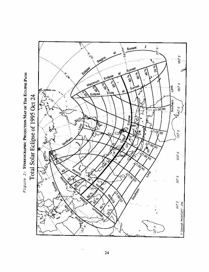
I=
O
_u
\
\
SunSel
\ ..............".............._0............-.'""....
24
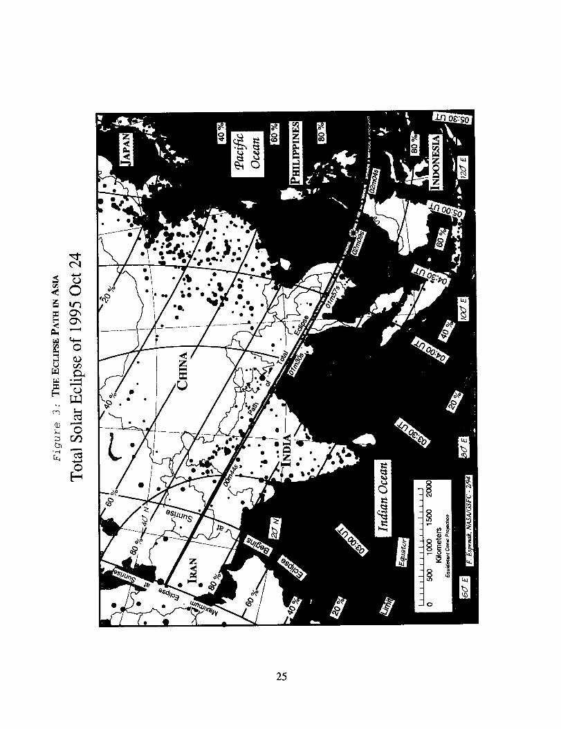
or._
-,--I
0°
b_
O
25
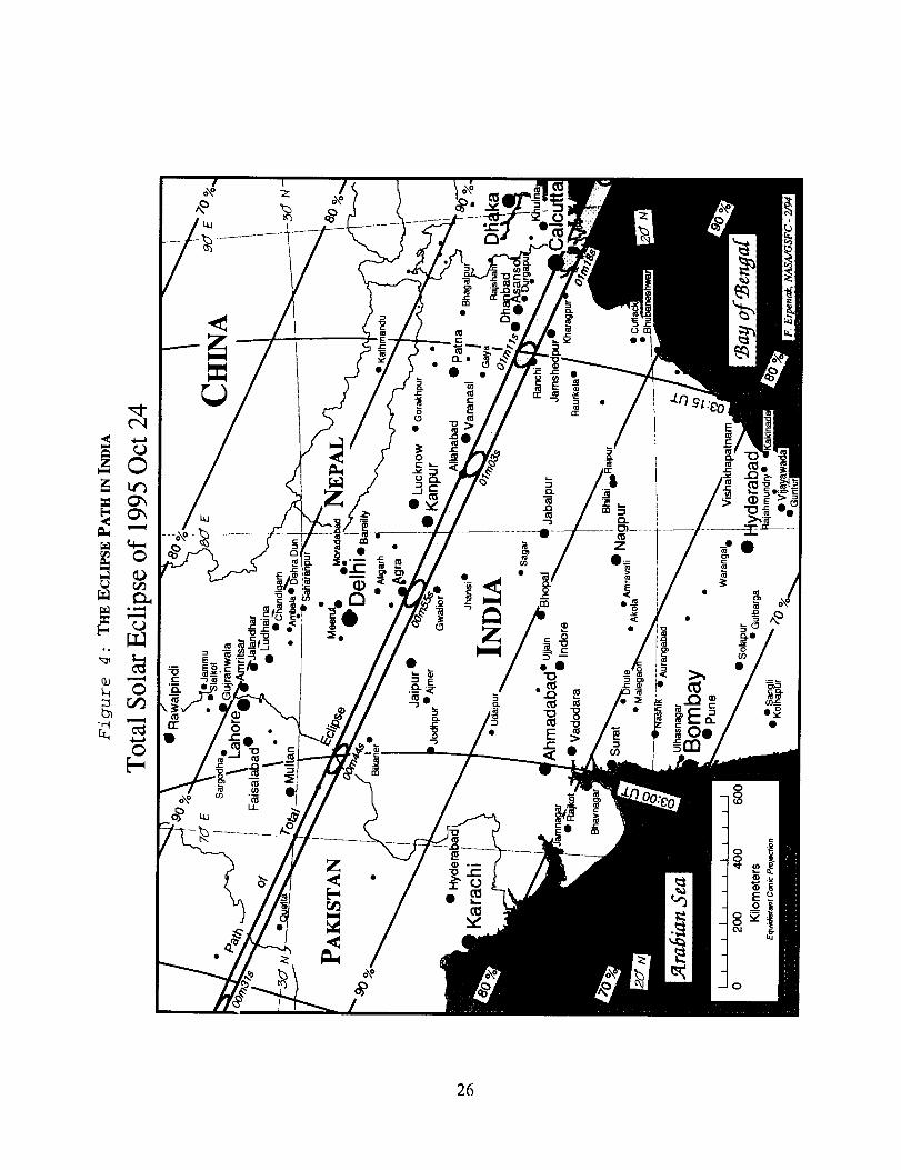
0
0
26
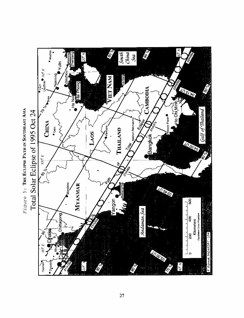
z
"+""I
)0
2?

ra_
r_
r_
r_
i
28
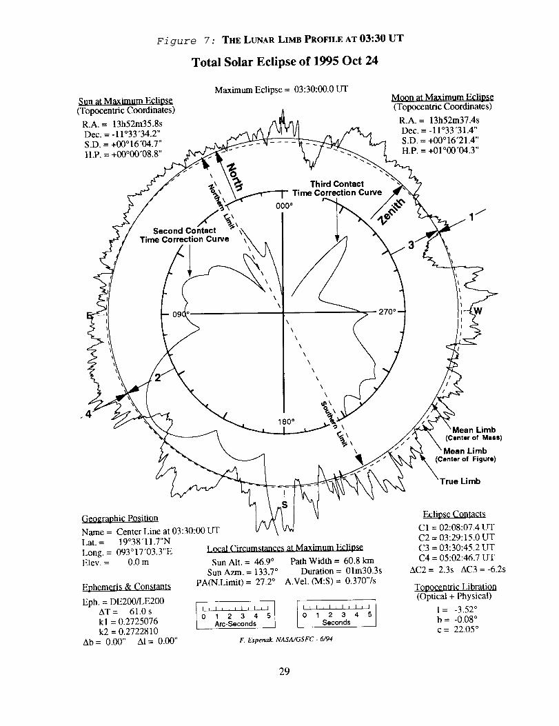
Figure 7 : THE LUNAR LIMB PROFILE AT 03:30 UT
Total Solar Eclipse of 1995 Oct 24
Maximum Eclipse = 03:30:00.0 LITSun at Maximum Eclipse(Topocentric Coordinates)
R.A. = 13h52m35.8s
Dec. = -11°33 "34.2"S.D. = +00016"04.7 ''H.P. = +00°00"08.8 ''
Moon at Maximum Eclipse(Topocentric Coordinates)
R.A. = 13h52m37.4sDec. = - 11 °33"31.4"S.D. = +00°16"21.4 ''H.P. = +01°00"04.3 ''
Second ContactTime Correction Curve
Third ContactTime Correction Curve
000 °
\\
\
\
\
\
\
\
\
\
\
\
180°\
\
\
Limbof Mass)
Limbof Figure)
Limb
Geographic Position
Name = Center Line at 03:30:00 LITLat. = 19°38"11.7"N
Long. = 093°17"03.3"EElev. = 0.0 m
Ephcmgri_ & Constants
Eph. = DE200/LE200AT = 61.0 skl = 0.2725076k2 = 0.2722810
Ab= 0.00" AI= 0.00"
Local Circumstances at Maximum Eclipse
Sun Alt. = 46.9 ° Path Width = 60.8 kmSun Azm. = 133.7 ° Duration = 01m30.3s
PA(N.Limit) = 27.2 ° A.Vel. (M:S)= 0.370"/s
1 LL l0 1 2 3 4 5 0 1 2 3 4 5Arc-Seconds Seconds
F. Espenak, NASA/GSFC - 6/94
Eclipse Contacts
C1 = 02:08:07.4 UTC2 = 03:29:15.0 UTC3 = 03:30:45.2 UTC4 = 05:02:46.7 UT
AC2 = 2.3s AC3 = -6.2s
Topocentric Libration(Optical + Physical)
l = -3.52 °b = -0.08 °c = 22.05 °
29
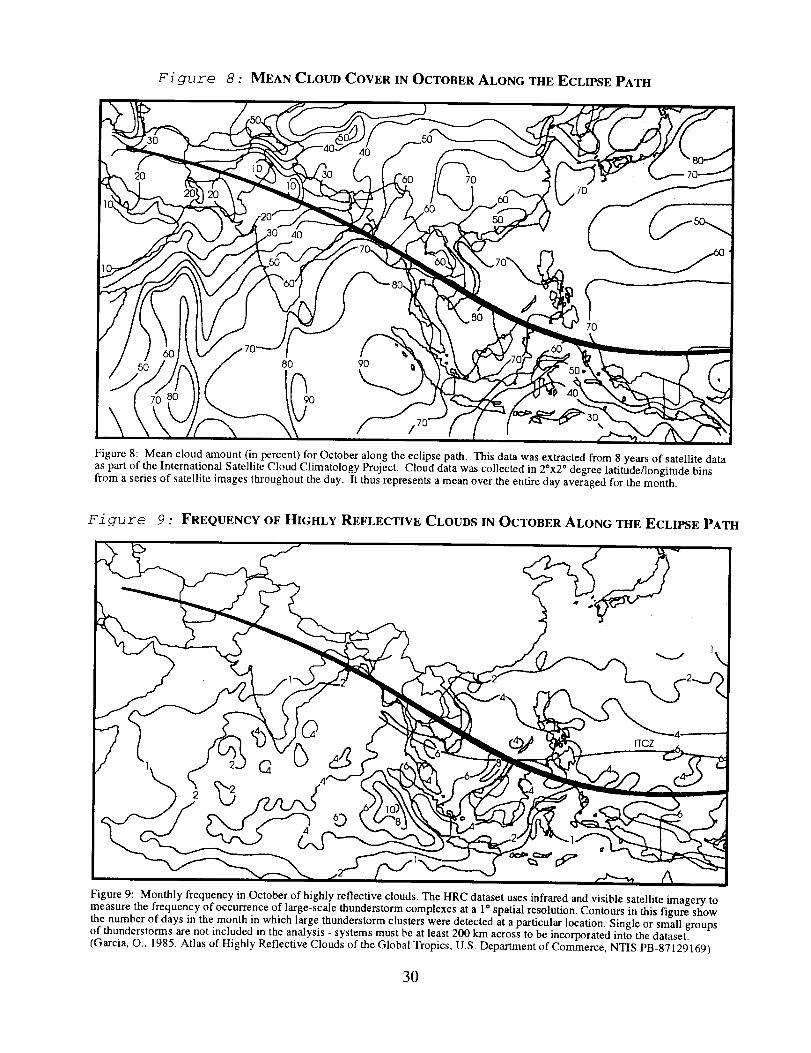
Figure 8 : MEAN CLOUD COVER IN OCTOBER ALONG THE ECLIPSE PATH
Figure 8: Mean cloud amount (in percent) for October along the eclipse path. This data was extracted from 8 years of satellite dataas part of the International Sate]lite Cloud Climatology Project. Cloud data was collected in 20x2 ° degree latitude/longitude binsfrom a series of satellite images throughout the day. It thus represents a mean over the entire day averaged for the month.
Figure 9 : FREQUENCY OF HIGHLY REFLECTIVE CLOUDS IN OCTOBER ALONG THE ECLIPSE PATH
©
ITCZ
Figure 9: Monthly frequency in October of highly reflective clouds. The HRC dataset uses infrared and visible satellite imagery tomeasure the frequency of occurrence of large-scale thunderstorm complexes at a 1° spatial resolution. Contours in this figure show
the number of days in the month in which large thunderstorm clusters were detected at a particular location. Single or small groupsof thunderstorms are not included in the analysis - systems must be at least 200 km across to be incorporated into the dataset.
(Garcia, O., 1985, Atlas of Highly Reflective Clouds of the Global Tropics, U.S. Department of Commerce, NTIS PB-87129169)
30
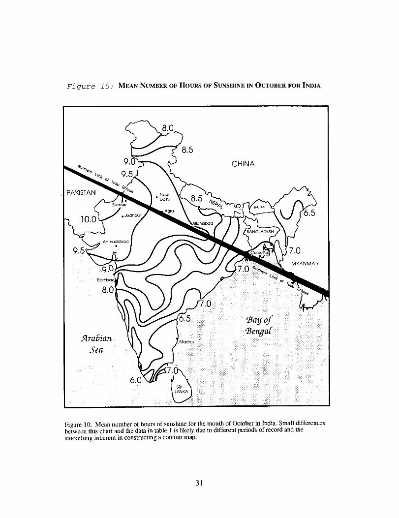
Figure 1 0 : MEAN NUMBER OF HOURS OF SUNSHINE IN OCTOBER FOR INDIA
CHINA
PAKISTAN
10,0
Bikaner
• Jodhpur
Ahmadabad
New
• Delhi
BANGLADESH
7.0
MYANMAR
Arabian
SeaMadras
Bengal
Figure 10: Mean number of hours of sunshine for the month of October in India. Small differencesbetween this chart and the data in table 1 is likely due to different periods of record and the
smoothing inherent in constructing a contour map.
31
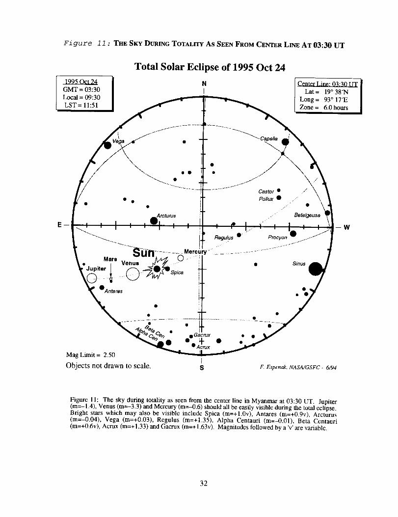
Figure 11 : THE SKY DURING TOTALITY AS SEEN FROM CENTER LINE AT 03:30 UT
GMT = 03:30
Local = 09:30
LST = 11:51
Total Solar Eclipse of 1995 Oct 24
NI
Center Line: 03:30 UT
Lat = 19 ° 38"N
Long = 93 ° 17"E
Zone = 6.0 hours
Arcturus
Castor • /
Pollux • ,.
,e
• Betelgeuse
Regulus 0
-_u-n ........... Mercury "-i'- - -
• Mars Ven=-- _ Q .......
•Antares
Mag Limit = 2.50
Objects not drawn to scale.
• Gacrux• ÷
• Acrux
s
Procyon
• Sidus
F. Espenak, NASA/GSFC- 6/'94
W
Figure 11: The sky during totality as seen from the center line in Myanmar at 03:30 UT. Jupiter(m=-l.4), Venus (m=-3.3) and Mercury (m=-0.6) should all be easily visible during the total eclipse.
Bright stars which may also be visible include Spica (m=+l.0v), Antares (m=+0.9v), Arcturus
(m=-0.04), Vega (m=+0.03), Regulus (m=+1.35), Alpha Centauri (m=-0.01), Beta Centauri
(m=+0.6v), Acrux (m=+1.33) and Gacrux (m=+1.63v). Magnitudes followed by a 'v' are variable.
32
TOTAL SOLAR ECLIPSE OF 1995 OCTOBER 24
TABLES
33

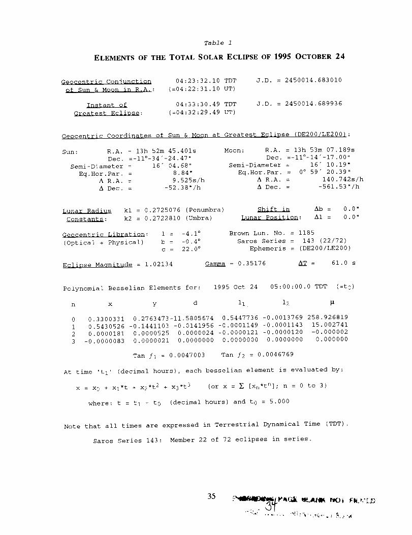
Table 1
ELEMENTS OF THE TOTAL SOLAR ECLIPSE OF 1995 OCTOBER 24
G_Qcentric Conjunction
of Sun & Moon in R.A. :
lam_mm_QiGreatest Eclipse:
04:23:32.10 TDT
(=04:22:31.10 UT)
04:33:30.49 TDT
(=04:32:29.49 UT)
J.D. = 2450014.683010
J.D. = 2450014.689936
Geocentric Coordinates of Sun & Moon at Greatest Eclipse (DE200/LE200):
Sun: R.A. = 13h 52m 45.401s
Dec. =-11°-34"-24.47 "
Semi-Diameter = 16" 04.68"
Eq. Hor. Par. = 8.84"
A R.A. = 9.525s/h
A Dec. = -52.38"/h
Moon: R.A. = 13h 53m 07.189s
Dec. =-11°-14"-17.00 ''
Semi-Diameter = 16" 10.19"
Eq.Hor. Par. = 0° 59" 20.39"
A R.A. = 140.742s/h
A Dec. = -561.53"/h
Cgnstants :
kl = 0.2725076 (Penumbra)
k2 = 0.2722810 (Umbra)
Shift in Ab = 0.0"
Lunar Position: A1 = 0.0"
Geocentric Libration: 1 = -4.1 °
(Optical + Physical) b = -0.4 °c = 22.0 °
Brown Lun. No. = 1185
Saros Series = 143 (22/72)
Ephemeris = (DE200/LE200)
Eclipse Maqnitude = 1.02134 _Gamma = 0.35176 A__T = 61.0 s
Polynomial Besselian Elements for: 1995 Oct 24 05:00:00.0 TDT (=t O )
n x y d ii 12
0 0.3300331 0.2763473-11.5805674 0.5447736 -0.0013769 258.926819
1 0.5430526 -0.1441103 -0.0141956 -0.0001149 -0.0001143 15.002741
2 0.0000181 0.0000525 0.0000024 -0.0000121 -0.0000120 -0.000002
3 -0.0000083 0.0000021 0.0000000 0.0000000 0.0000000 0.000000
Tan /i = 0.0047003 Tan /2 = 0.0046769
At time 't I' (decimal hours), each besselian element is evaluated by:
x = x 0 + xl*t + x2 *t2 + x3 *t3 (or x = _ [xn*tn]; n = 0 to 3)
where: t = t I - to (decimal hours) and t O = 5.000
Note that all times are expressed in Terrestrial Dynamical Time (TDT) .
Saros Series 143: Member 22 of 72 eclipses in series.
35
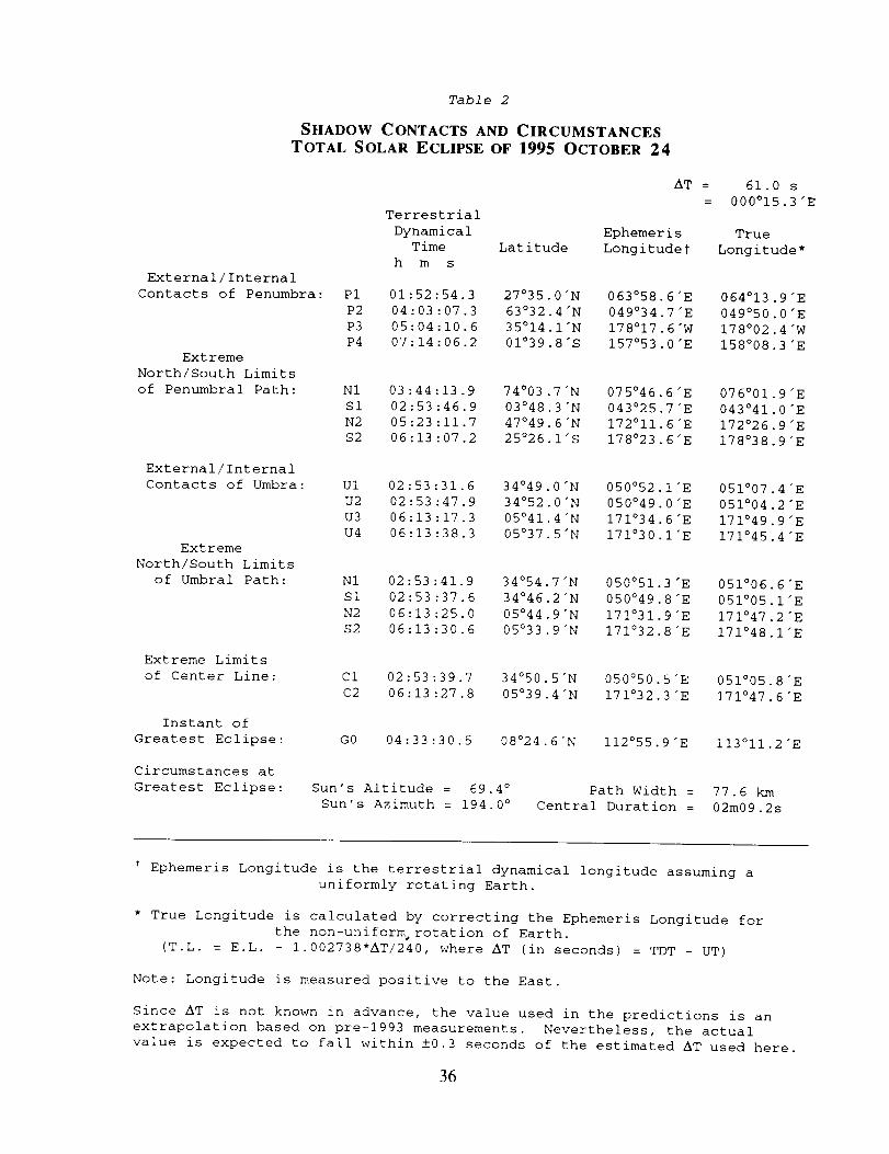
Table 2
SHADOW CONTACTS AND CIRCUMSTANCESTOTAL SOLAR ECLIPSE OF 1995 OCTOBER 24
External/Internal
Contacts of Penumbra:
Extreme
North/South Limits
of Penumbral Path:
AT =
Terrestrial
Dynamical Ephemeris
Time Latitude Longitude%
h m s
61.0 s
000015.3 "E
True
Longitude*
External/Internal
Contacts of Umbra:
Extreme
North/South Limits
of Umbral Path:
P1 01:52:54.3 27°35.0"N 063°58.6"E 064°13.9"E
P2 04:03:07.3 63°32.4"N 049°34.7"E 049°50.0"E
P3 05:04:10.6 35°14.1"N 178°17.6"W 178°02.4"W
P4 07:14:06.2 01°39.8"S 157°53.0"E 158008.3 "E
N1 03:44:13.9 74o03 .7"N 075°46.6"E 076°01.9"E
S1 02:53:46.9 03°48.3"N 043°25.7"E 043°41.0"E
N2 05:23:11.7 47°49.6"N 172°ii.6"E 172°26.9"E
$2 06:13:07.2 25°26.1"S 178°23.6"E 178°38.9"E
Extreme Limits
of Center Line:
U1 02:53:31.6 34°49.0"N 050°52.1"E 051°07.4"E
U2 02:53:47.9 34°52.0"N 050°49.0"E 051°04.2"E
U3 06:13:17.3 05°41.4"N 171°34.6"E 171°49.9"E
U4 06:13:38.3 05°37.5"N 171°30.I'E 171°45.4"E
Instant of
Greatest Eclipse:
N1 02:53:41.9 34°54.7"N 050°51.3"E 051°06.6"E
S1 02:53:37.6 34°46.2"N 050°49.8"E 051°05.1"E
N2 06:13:25.0 05°44.9"N 171°31.9"E 171°47.2"E
$2 06:13:30.6 05°33.9"N 171°32.8"E 171°48.1"E
Circumstances at
Greatest Eclipse:
C1 02:53:39.7 34°50.5"N 050°50.5"E 051°05.8"E
C2 06:13:27.8 05°39.4"N 171°32.3"E 171°47.6"E
GO 04:33:30.5 08°24.6"N i12°55.9"E I13°II.2"E
Sun's Altitude = 69.4 °
Sun's Azimuth : 194.0 °
Path Width =
Central Duration =
77.6 km
02m09.2s
Ephemeris Longitude is the terrestrial dynamical longitude assuming a
uniformly rotating Earth.
* True Longitude is calculated by correcting the Ephemeris Longitude for
the non-unifor_ rotation of Earth.
(T.L. = E.L. - 1.002738"AT/240, where AT (in seconds) = TDT - UT)
Note: Longitude is measured positive to the East.
Since AT is not known in advance, the value used in the predictions is an
extrapolation based on pre-1993 measurements. Nevertheless, the actual
value is expected to fall within ±0.3 seconds of the estimated AT used here.
36
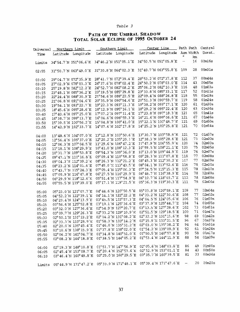
Table 3
PATH OF THE UMBRAL SHADOW
TOTAL SOLAR ECLIPSE OF 1995 OCTOBER 24
Universal NozThern Limit Southern Limi_ Center LiDe Path Path Central
Time Imtitude Longitude Latitude Longitude Latitude Longitude AzmWidth Durat.
o km
Limits 34°54.7"N 05_06.6"E 34°46.2"N 051°05.1"E 34°50.5"N 051°05.8"E -- 16 00ml6s
02:55 31°50.7"N 063°49.0"E 31°30.8"N 064°02.3"E 31°40.7"N 063°55.8"E 109 28 00m31s
03:00 29°04.7"N 072°35.9"E 28°41.7"N 072°39.4"E 28°53.2"N 072°37.8"E 112 37 00m44s
03:05 27°02.9"N 078°03.3"E 26°37.6"N 078°02.4"E 26°50.2"N 078°03.0"E 114 43 00m55s
03:10 25°19.8"N 082°12.2"E 24°52.7"N 082°08.2"E 25°06.2"N 082°I0.3"E 116 48 01m03s
03:15 23°48.1"N 085°36.2"E 23°19.5"N 085°29.8"E 23°33.8"N 085°33.1"E 117 52 01rolls
03-20 22°24.4"N 088°30.9"E 21°54.6"N 088°22.5"E 22°09.4"N 088°26.8"E 118 55 01ml8s
03:25 21°06.8"N 091°04.6"E 20°35.9"N 090°54.6"E 20°51.3"N 090°59.7"E 119 58 01m24s
03:30 19°54.1"N 093°22.7"E 19°22.3"N 093°II.3"E 19°38.2"N 093°17.1"E 120 61 01m30s
03:35 18°45.6"N 095°28.6"E 18°12.9"N 095°16.1"E 18°29.2"N 095°22.4"E 120 63 01m36s
03:40 17°40.6"N 097°25.0"E 17°07.2"N 097°II.4"E 17°23.8"N 097°18.3"E 121 65 01m41s
03:45 16°38.7"N 099°13.7"E 16°04.6"N 098°59.3"E 16°21.6"N 099°06.6"E 121 67 01m46s
03:50 15°39.5"N i00°56.2"E 15°04.8"N 100°41.0"E 15°22.1"N I00°48.7"E 121 69 01m50s
03:55 14°42.9"N i02°33.7"E 14°07.6"N I02°17.8"E 14°25.2"N i02°25.8"E 121 70 01m54s
04:00 13°48.6"N i04°07.0"E 13°12.8"N i03°50.6"E 13°30.7"N i03°58.8"E 121 72 01m57s
04:05 12°56.4"N i05°37.0"E 12°20.2"N i05°20.i'E 12°38.3"N I05°28.6"E 121 73 02m00s
04:10 12°06.3"N I07°04.5"E ii°29.6"N i06°47.2"E ii°47.9"N I06°55.9"E 120 74 02m03s
04:15 II°I8.1"N I08°29.9"E 10°41.0"N I08°12.3"E I0°59.5"N I08°21.I'E 120 75 02m05s
04:20 i0°31.7"N i09°53.8"E 09°54.3"N 109°36.0"E 10°13.0"N I09°44.9"E 119 76 02m07s
04:25 09°47.1"N iii°16.8"E 09°09.4"N ii0°58.8"E 09°28.3"N Iii°07.8"E 118 77 02m08s
04:30 09°04.3"N i12°39.2"E 08°26.3"N i12°21.2"E 08°45.3"N I12°30.2"E 117 77 02m09s
04:35 08°23.2"N i14°01.6"E 07°45.0"N i13°43.5"E 08°04.1"N I13°52.6"E 116 78 02ml0s
04:40 07°43.7"N I15°24.3"E 07°05.4"N i15°06.3"E 07°24.5"N i15°15.3"E 115 78 02ml0s
04:45 07°05.9"N i16°47.8"E 06°27.5"N i16°29.9"E 06°46.7"N I16°38.9"E 114 78 02m09s
04:50 06°29.9"N i18°12.6"E 05°51.4"N i17°54.9"E 06°i0.7"N I18°03.7"E 112 78 02m08s
04:55 05°55.5"N i19°39.0"E 05°17.1"N I19°21.5"E 05°36.3"N i19°30.3"E iii 78 02m06s
05:00 05°23.0"N
05:05 04° 52.2"N
05:10 04° 23.4"N
05 :15 03° 56.6"N
05:20 03°32.0"N
05:25 03°09.7"N
05:30 02° 50.1"N
05:35 02°33.3"N
05:40 02°20.0"N
05:45 02° 10.6"N
05:50 02° 06.2"N
05:55 02°08.2"N
121 ° 07.7 "E
122 °39 I'E
124 ° 13 9"E
125 ° 52 8"E
127 ° 36 6"E
129 °26 3 "E
131°23 2"E
133°28 9"E
135 ° 45 4"E
138 °15.9 "E
141 °04.7 "E
144 ° 18.8 "E
04°44.6"N 120°50.5"E 05°03.8"N 120°59.1"E 109 77 02m04s
04°14.1"N 122°22.2"E 04°33.2"N 122°30.6"E 108 77 02m02s
03°45.5"N 123°57.3"E 04°04.5"N 124°05.6"E 106 76 01m59s
03°19.1"N 125°36.6"E 03°37.9"N 125°44.7"E 104 74 01m55s
02°54.9"N 127°20.7"E 03°13.5"N 127°2B.6"E 102 73 01m51s
02°33.2"N 129°i0.9"E 02°51.5"N 129°18.5"E i00 71 01m47s
02°14.2"N 131°08.2"E 02°32.2"N 131°15.6"E 98 69 01m42s
01°58.3"N 133°14.2"E 02°15.9"N 133°21.5"E 96 67 01m37s
01°46.0"N 135°31.2"E 02°03.0"N 135°38.2"E 94 64 01m31s
01°37.8"N 138°02.0"E 01°54.2"N 138°08.9"E 92 61 01m24s
01°34.8"N 140°51.0"E 01°50.5"N 140°57.8"E 90 58 01ml7s
01°38.5"N 144°05.2"E 01°53.4"N 144°Ii.9"E 88 54 01m09s
06:00 02°19.3"N 148°I0.8"E 01°51.7"N 147°56.9"E
06:05 02°45.4"N 153°08.7"E 02°20.4"N 152°53.6"E
06:10 03°46.4"N 160°49.8"E 03°25.0"N 160°29.5"E
02°05.6"N 148°03.8"E 86 49 01m00s
02°32.9 "N 153° 01.1"E 84 43 00m50s
03°35.7"N 160° 39.5"E 81 33 00m36s
Limits 05°44.9"N 171°47.2"E 05°33.9"N 171°48.1"E 05°39.4"N 171°47.6"E -- 20 00m20s
37
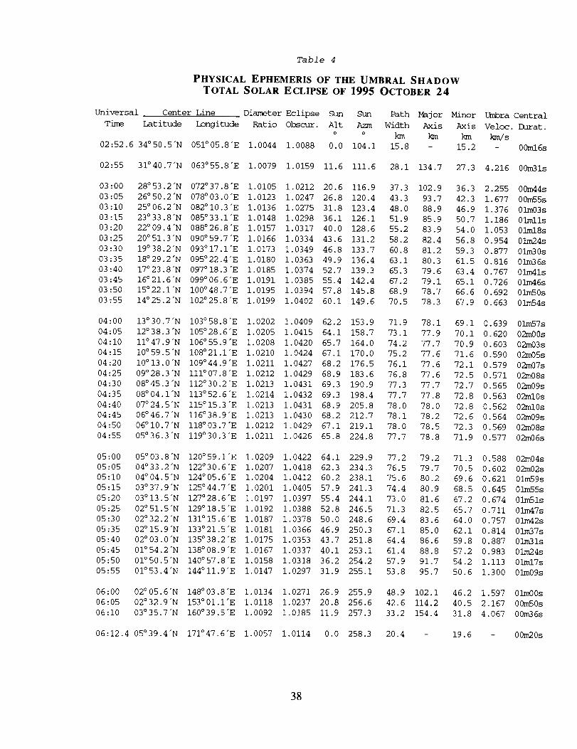
Uni_rsal
Time
02:52.6
02 :55
Table 4
PHYSICAL EPHEMERIS OF THE UMBRAL SHADOW
TOTAL SOLAR ECLIPSE OF 1995 OCTOBER 24
Center Line Diameter Eclipse Sun Sun Path Major Minor
Latitude Longitude Ratio Obscur. Alt Azm Width Axis Axis
o o km km km
34°50.5"N 051°05.8"E 1.0044 1.0088 0.0 104.1 15.8 - 15.2
Umbra Central
Veloc. Durat.
km/s
- 00ml6s
31°40.7"N 063°55.8"E 1.0079 1.0159 11.6 111.6 28.1 134.7 27.3 4.216 00m31s
03:00 28°53.2"N 072°37.8"E 1.0105 1.0212 20.6 116.9 37.3 102.9
03:05 26°50.2"N 078°03.0"E 1.0123 1.0247 26.8 120.4 43.3 93.7
03:10 25°06.2"N 082°I0.3"E 1.0136 1.0275 31.8 123.4 48.0 88.9
03:15 23°33.8"N 085°33.1"E 1.0148 1.0298 36.1 126.1 51.9 85.9
03:20 22°09.4"N 088°26.8"E 1.0157 1.0317 40.0 128.6 55.2 83.9
03:25 20°51.3"N 090°59.7"E 1.0166 1.0334 43.6 131.2 58.2 82.4
03:30 19°38.2"N 093°17.1"E 1.0173 1.0349 46.8 133.7 60.8 81.2
03:35 18°29.2"N 095°22.4"E 1.0180 1.0363 49.9 136.4 63.1 80.3
03:40 17°23.8"N 097°18.3"E 1.0185 1.0374 52.7 139.3 65.3 79.6
03:45 16°21.6"N 099°06.6"E 1.0191 1.0385 55.4 142.4 67.2 79.1
03:50 15°22.1"N I00°48.7"E 1.0195 1.0394 57.8 145.8 68.9 78.7
03:55 14°25.2"N I02°25.8"E 1.0199 1.0402 60.1 149.6 70.5 78.3
04:00
04:05
04:10
04:15
04:20
04:25
04:30
04:35
04:40
04:45
04:50
04:55
36.3
42.3
46.9
50.7
54.0
56.8
59 3
61 5
63 4
65 1
66 6
67 9
2.255 00m44s
1.677 00m55s
1.376 01m03s
1.186 01rolls
1.053 01ml8s
0.954 01m24s
0.877 01m30s
0.816 01m36s
0.767 01m41s
0.726 01m46s
0.692 01m50s
0.663 0]n64s
13°30.7"N I03°58.8"E 1.0202 1.0409 62.2 153.9 71.9 78.1 69.1 0.639 01m57s
12°38.3"N I05°28.6"E 1.0205 1.0415 64.1 158.7 73.1 77.9 70.1 0.620 02m00s
II°47.9"N 106°55.9"E 1.0208 1.0420 65.7 164.0 74.2 77.7 70.9 0.603 02m03s
I0°59.51N I08°21.I'E 1.0210 1.0424 67.1 170.0 75.2 77.6 71.6 0.590 02m05s
I0°13.01N I09°44.9"E 1.0211 1.0427 68.2 176.5 76.1 77.6 72.1 0.579 02m07s
09°28.3"N III°07.8"E 1.0212 1.0429 68.9 183.6 76.8 77.6 72.5 0.571 02m08s
08°45.3"N I12°30.2"E 1.0213 1.0431 69.3 190.9 77.3 77.7 72.7 0.565 02m09s
08°04.1"N I13°52.6"E 1.0214 1.0432 69.3 198.4 77.7 77.8 72.8 0.563 02ml0s
07°24.5"N I15°15.3"E 1.0213 1.0431 68.9 205.8 78.0 78.0 72.8 0.562 02ml0s
06°46.7"N I16°38.9"E 1.0213 1.0430 68.2 212.7 78.1 78.2 72.6 0.564 02m09s
06°I0.7"N I18°03.7"E 1.0212 1.0429 67.1 219.1 78.0 78.5 72.3 0.569 02m08s
05°36.3"N 119°30.3"E 1.0211 1.0426 65.8 224.8 77.7 78.8 71.9 0.577 02m06s
77.2
76.5
75.6
74.4
73 0
71 3
69 4
67 1
64 4
61 4
57 9
53.8
79.2 71.3 0.588 02m04s
79.7 70.5 0.602 02m02s
80.2 69.6 0.621 01m59s
80.9 68.5 0.645 01m55s
81.6 67.2 0.674 01m51s
82.5 65.7 0.711 01m47s
83.6 64.0 0.757 01m42s
85.0 62.1 0.814 01m37s
86.6 59.8 0.887 01m31s
88.8 57.2 0.983 01m24s
91.7 54.2 I. 113 0iml7s
95.7 50.6 1.300 01m09s
05:00
05:05
05:10
05:15
05:20
05:25
05:30
05:35
05:40
05:45
05:50
05:55
05°03.8"N 120°59.1"E 1.0209 1.0422 64.1 229.9
04°33.2"N 122°30.6"E 1.0207 1.0418 62.3 234.3
04°04.5"N 124°05.6"E 1.0204 1.0412 60.2 238.1
03°37.9"N 125°44.7"E 1.0201 1.0405 57.9 241.3
03 _13.5"N 127 ° 28.6"E 1.0197 1.0397 55.4 244.1
02°51.5_N 129°18.5"E 1.0192 1.0388 52.8 246.5
02°32.2"N 131°15.6"E 1.0187 1.0378 50.0 248.6
02°15.9"N 133°21.5"E 1.0181 1.0366 46.9 250.3
02°03.0"N 135°38.2"E 1.0175 1.0353 43.7 251.8
01°54.2"N 138°08.9"E 1.0167 1.0337 40.1 253.1
01°50.5"N 140°57.8"E 1.0158 1.0318 36.2 254.2
01°53.4"N 144°II.9"E 1.0147 1.0297 31.9 255.1
06:00 02°05.6"N 148°03.8"E 1.0134 1.0271 26.9 255.9 48.9 102.1 46.2 1.597 01m00s
06:05 02°32.9"N 153°01.I'E 1.0118 1.0237 20.8 256.6 42.6 114.2 40.5 2.167 00m50s
06:10 03°35.7"N 160°39.5"E 1.0092 1.0185 11.9 257.3 33.2 154.4 31.8 4.067 00m36s
06:12.4 05°39.4"N 171°47.6"E 1.0057 1.0114 0.0 258.3 20.4 - 19.6 - 00m20s
38
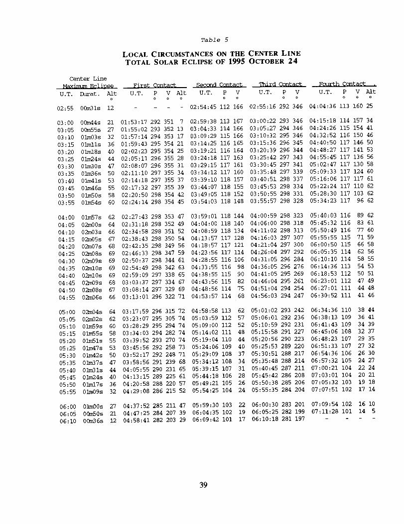
Center Line
_axir_um EqliDs@
U.T. Durat. AftO
02:55 00m31s 12
03:00 00m44s 21
03:05 00m55s 27
03:10 01m03s 32
03:15 01mlls 36
03:20 01ml8s 40
03:25 01m24s 44
03:30 01m30s 47
03:35 01m36s 50
03:40 01m41s 53
03:45 0]/n46s 55
03:50 01mS0s 58
03:55 01m54s 60
04:00 01m57s 62
04:05 02m00s 64
04:10 02m03s 66
04:15 02m05s 67
04:20 02m07s 68
04:25 0_n08s 69
04:30 02m09s 69
04:35 02ml0s 69
04:40 02m10s 69
04:45 02m09s 68
04:50 02m08s 67
04:55 02m06s 66
05:00 02m04s 64
05:05 0_n02s 62
05:10 01m59s 60
05:15 01m55s 58
05:20 01m51s 55
05:25 01m47s 53
05:30 01m42s 50
05:35 01m37s 47
05:40 01m31s 44
05:45 01m24s 40
05:50 01ml7s 36
05:55 01m09s 32
06:00 01m00s 27
06:05 00m50s 21
06:10 00m36s 12
Table 5
LOCAL CIRCUMSTANCES ON THE CENTER LINE
TOTAL SOLAR ECLIPSE OF 1995 OCTOBER 24
First Contact Second Contact qhird Contact
U.T. P V Aft U.T. P V U.T. P VO O O O O O O
- - - 02:54:45 112 166 02:55:16 292 346
01:53:17 292 351 7 02:59:38 113 167 03:00:22 293 346
01:55:02 293 352 13 03:04:33 114 166 03:05:27 294 346
01:57:14 294 353 17 03:09:29 115 166 03:10:32 295 346
01:59:43 295 354 21 03:14:25 116 165 03:15:36 296 345
02:02:23 295 354 25 03:19:21 116 164 03:20:39 296 344
02:05:11 296 355 28 03:24:18 117 163 03:25:42 297 343
02:08:07 296 355 31 03:29:15 117 161 03:30:45 297 341
02:11:10 297 355 34 03:34:12 117 160 03:35:48 297 339
02:14:18 297 355 37 03:39:10 118 157 03:40:51 298 337
02:17:32 297 355 39 03:44:07 118 155 03:45:53 298 334
02:20:50 298 354 42 03:49:05 118 152 03:50:55 298 331
02:24:14 298 354 45 03:54:03 118 148 03:55:57 298 328
02:27:43 298 353 47 03:59:01 118 144 04:00:59 298 323
02:31:18 298 352 49 04:04:00 118 140 04:06:00 298 318
02:34:58 298 351 52 04:08:59 118 134 04:11:02 298 313
02:38:43 298 350 54 04:13:57 117 128 04:16:03 297 307
02:42:35 298 349 56 04:18:57 117 121 04:21:04 297 300
02:46:33 298 347 59 04:23:56 117 114 04:26:04 297 292
02:50:37 298 344 61 04:28:55 116 106 04:31:05 296 284
02:54:49 298 342 63 04:33:55 116 98 04:36:05 296 276
02:59:09 297 338 65 04:38:55 115 90 04:41:05 295 269
03:03:37 297 334 67 04:43:56 115 82 04:46:04 295 261
03:08:14 297 329 69 04:48:56 114 75 04:51:04 294 254
03:13:01 296 322 71 04:53:57 114 68 04:56:03 294 247
03:17:59 296 315 72
03:23:07 295 305 74
03:28:29 295 294 74
03:34:03 294 282 74
03:39:52 293 270 74
03:45:56 292 258 73
03:52:17 292 248 71
03:58:56 291 239 68
04:05:55 290 231 65
04:13:15 289 225 61
04:20:58 288 220 57
04:29:08 286 215 52
04:58:58 113 62 05:01:02 293 242
05:03:59 112 57 05:06:01 292 236
05:09:00 112 52 05:10:59 292 231
05:14:02 iii 48 05:15:58 291 227
05:19:04 ii0 44 05:20:56 290 223
05:24:06 109 40 05:25:53 289 220
05:29:09 108 37 05:30:51 288 217
05:34:12 108 34 05:35:48 288 214
05:39:15 107 31 05:40:45 287 211
05:44:18 106 28 05:45:42 286 208
05:49:21 105 26 05:50:38 285 206
05:54:25 104 24 05:55:35 284 204
04:37:52 285 211 47 05:59:30 103 22
04:47:25 284 207 39 06:04:35 102 19
04:58:41 282 203 29 06:09:42 I01 17
Fourth Contact .
U.T. P V AftO O O
04:04:36 113 160 25
04:15:18 114 157 34
04:24:26 115 154 41
04:32:52 116 150 46
04:40:50 117 146 50
04:48:27 117 141 53
04:55:45 117 136 56
05:02:47 117 130 58
05:09:33 117 124 60
05:16:06 117 117 61
05:22:24 117 Ii0 62
05:28:30 117 103 62
05:34:23 117 96 62
05:40:03 116 89 62
05:45:32 116 83 61
05:50:49 116 77 60
05:55:55 115 71 59
06:00:50 115 66 58
06:05:35 114 62 56
06:10:10 114 58 55
06:14:36 113 54 53
06:18:53 112 50 51
06:23:01 112 47 49
06:27:01 iii 44 48
06:30:52 iii 41 46
06:34:36 Ii0 38 44
06:38:13 109 36 41
06:41:43 109 34 39
06:45:06 108 32 37
06:48:23 107 29 35
06:51:33 107 27 32
06:54:36 106 26 30
06:57:32 105 24 27
07:00:21 104 22 24
07:03:01 104 20 21
07:05:32 103 19 18
07:07:51 102 17 14
06:00:30 283 201 07:09:54 102 16 I0
06:05:25 282 199 07:11:28 I01 14 5
06:10:18 281 197 - -
39

Table 6
TOPOCENTRIC DATA AND PATH CORRECTIONS DUE TO LUNAR LIMB PROFILE
North South
Moon Moon Moon Topo North Limit Limit Central
Universal Topo Topo Rel. Lib. Sun Sun Path Limit Durat.
Time H.P. S.D. Ang.V Long Alt. Az. Az. P.A. Int. Ext. Int. Ext. Cor.
tJ " " / S 0 O O O O t i i i S
02:55 3570.6 972.3 0.491 -3.22 11.6 111.6 108.7 22.0 -0.3 0.6 i.i -1.9 -6.5
03:00 3580.0 974.8 0.457 -3.26 20.6 116.9 112.1 23.5 -0.3 0.6 0.4 -2.3 -6.8
03:05 3586.2 976.5 0.435 -3.30 26.8 120.4 114.2 24.5 -0.2 0.7 0.4 -2.7 -7.5
03:10 3591.1 977.9 0.417 -3.35 31.8 123.4 115.9 25.2 -0.2 0.6 0.4 -2.8 -7.7
03:15 3595.2 978.9 0.403 -3.39 36.1 126.1 117.2 25.9 -0.2 0.5 0.4 -2.7 -8.0
03:20 3598.6 979.9 0.390 -3.43 40.0 128.6 118.3 26.4 -0.2 0.6 0.4 -2.6 -8.2
03:25 3601.6 980.7 0.380 -3.47 43.6 131.2 119.2 26.8 -0.I 0.7 0.3 -2.5 -8.4
03:30 3604.3 981.4 0.370 -3.52 46.8 133.7 119.9 27.2 -0.i 0.8 0.3 -2.3 -8.4
03:35 3606.6 982.0 0.362 -3.56 49.9 136.4 120.5 27.4 -0.i 0.8 0.3 -2.3 -8.6
03:40 3608.7 982.6 0.354 -3.60 52.7 139.3 120.9 27.7 -0.0 0.9 0.3 -2.4 -8.7
03:45 3610.6 983.1 0.348 -3.64 55.4 142.4 121.1 27.8 -0.0 0.9 0.3 -2.5 -8.9
03:50 3612.2 983.5 0.342 -3.69 57.8 145.8 121.2 27.9 -0.0 0.9 0.3 -2.6 -9.0
03:55 3613.6 983.9 0.337 -3.73 60.1 149.6 121.2 27.9 0.0 0.9 0.3 -2.6 -9.2
-3.77
-3.81
-3.86
-3 90
-3 94
-3 98
-4 03
-4 07
-4 ii
-4 15
-4.20
-4.24
62.2 153.9 121.1 27.8 0.0 0.9 0.3 -2.6 -9.3
64.1 158.7 120.8 27.7 0.0 0.8 0.3 -2.5 -9.4
65.7 164.0 120.3 27.5 0.0 0.8 0.3 -2.4 -9.4
67.1 170.0 119.8 27.3 -0.0 0.8 0.3 -2.3 -9.5
68.2 176.5 119.1 27.0 -0.0 0.8 0.3 -2.4 -9.5
68.9 183.6 118.3 26.7 -0.i 0.8 0.4 -2.6 -9.5
69.3 190.9 117.4 26.3 -0.I 0.7 0.4 -2.7 -9.5
69.3 198.4 116.3 25.9 -0.I 0.5 0.4 -2.9 -9.4
68.9 205.8 115.1 25.4 -0.I 0.7 0.4 -2.9 -8.9
68.2 212.7 113.9 24.9 -0.I 0.8 0.5 -2.9 -8.7
67.1 219.1 112.5 24.3 -0.2 0.9 0.5 -2.8 -8.6
65.8 224.8 iii.0 23.7 -0.2 0.8 0.5 -2.6 -8.4
04:00 3614.8 984.2 0.333
04:05 3615.9 984.5 0.329
04:10 3616.8 984.8 0.326
04:15 3617.5 984.9 0.323
04:20 3618.1 985.1 0.321
04:25 3618.5 985.2 0.319
04:30 3618.8 985.3 0.318
04:35 3618.9 985.3 0.318
04:40 3618.9 985.3 0.318
04:45 3618.7 985.3 0.319
04:50 3618.4 985.2 0.320
04:55 3617.9 985.0 0.322
05:00 3617.2 984.9 0.324 -4.28 64.1 229.9 109.4 23.0 -0.2 0.6 0.5 -2.2 -8.1
05:05 3616.4 984.7 0.327 -4.32 62.3 234.3 107.7 22.3 -0.2 0.6 1.2 -1.9 -8.0
05:10 3615.4 984.4 0.331 -4.37 60.2 238.1 106.0 21.6 -0.2 0.8 1.2 -1.9 -7.7
05:15 3614.3 984.1 0.335 -4.41 57.9 241.3 104.2 20.9 -0.2 0.7 1.2 -1.7 -7.4
05:20 3612.9 983.7 0.341 -4.45 55.4 244.1 102.3 20.1 -0.2 0.5 1.3 -1.4 -7.0
05:25 3611.3 983.3 0.347 -4.49 52.8 246.5 100.4 19.3 -0.2 0.6 1.3 -1.2 -6.7
05:30 3609.5 982.8 0.354 -4.54 50.0 248.6 98.4 18.5 -0.2 0.5 1.3 -1.4 -6.3
05:35 3607.4 982.2 0.362 -4.58 46.9 250.3 96.4 17.6 -0.2 0.5 1.4 -1.5 -6.0
05:40 3604.9 981.6 0.372 -4.62 43.7 251.8 94.4 16.7 -0.i 0.6 1.4 -1.5 -5.7
05:45 3602.2 980.8 0.383 -4.66 40.1 253.1 92.3 15.9 -0.1 0.7 1.4 -1.6 -5.4
05:50 3598.9 980.0 0.396 -4.71 36.2 254.2 90.2 15.0 -0.i 0.6 1.4 -1.3 -4.8
05:55 3595.1 978.9 0.411 -4.75 31.9 255.1 88.1 14.0 -0.3 0.6 1.4 -0.9 -4.6
06:00 3590.5 977.7 0.429 -4.79 26.9 255.9 85.9 13.1 -0.4 0.8 1.4 -0.6 -4.5
06:05 3584.5 976.1 0.453 -4.83 20.8 256.6 83.6 12.1 -0.4 0.7 1.4 -1.5 -4.5
06:10 3575.4 973.6 0.489 -4.88 11.9 257.3 80.9 10.8 -0.4 0.7 1.4 -2.4 -4.9
40
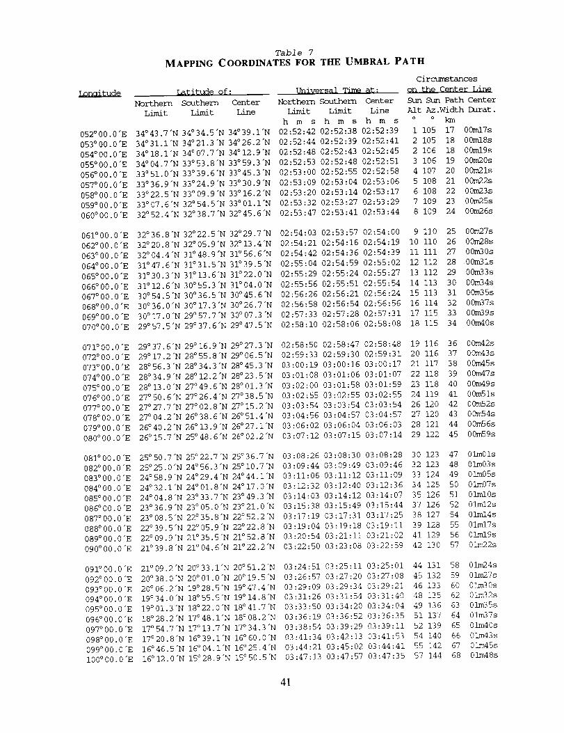
052 ° 00.0 "E
053 ° 00.0 "E
054 ° 00.0 "E
055 °00.0 "E
056 ° 00.0 "E
057 °00.0 "E
058 ° 00.0 "E
059 °00,0 "E
060 °00.0 "E
061 °00.0 "E
062 °00.0 "E
063°00.0"E
064 °00.0 "E
065 °00.0 "E
066 ° 00.0 "E
067 °00.0 "E
068 ° 00.0 "E
069°00.0"E
070 ° 00.0 "E
071 ° 00.0 "E
072 °00.0 "E
073 ° 00.0 "E
074 ° 00.0 "E
075 ° 00.0 "E
076°00.0"E
077 ° 00.0 "E
078 °00.0 "E
079 ° 00.0 "E
080 ° 00.0 "E
081 ° 00.0 "E
082 °00.0 "E
083 ° 00.0 "E
084 ° 00.0 "E
085 ° 00.0 "E
086 °00.0 "E
087 °00.0 "E
088 °00.0 "E
089 ° 00.0 "E
090 °00.0 "E
091 °00.0 "E
092°00.0"E
093°00.0"E
094 ° 00.0 "E
095 ° 00.0 "E
096 ° 00.0 "E
097 °00.0 "E
098 °00.0 "E
099 °00.0 "E
100 °00.0 "E
Table 7
MAPPING COORDINATES FOR THE UMBRAL PATH
Northern
Lir_t
Latitude of: Universal Time a%;
Southern Center Northern Southern Center
Limit Line Limit
h m s
34°43.7"N 34°34.5"N 34°39.1"N 02:52:42
34°31.i'N 34°21.3"N 34°26.2"N 02:52:44
34°18.1"N 34°07.7"N 34°12.9"N 02:52:48
34°04.7"N 33°53.8"N 33°59.3"N 02:52:53
33°51.0"N 33°39.6"N 33°45.3"N 02:53:00
33°36.9"N 33°24.9"N 33°30,9"N 02:53:09
33°22.5"N 33°09.9"N 33°16.2"N 02:53:20
33°07,6"N 32°54.5"N 33°01.I'N 02:53:32
32°52.4"N 32°38.7"N 32°45.6"N 02:53:47
Circumstances
on the Center Line
Sun Sun Path Center
Limit Line Alt Az.WidthDurat.
h m s h m s o o km
02:52:38 02:52:39 1 105 17 00ml7s
02:52:39 02:52:41 2 105 18 00ml8s
02:52:43 02:52:45 2 106 18 00ml9s
02:52:48 02:52:51 3 106 19 00m20s
02:52:55 02:52:58 4 107 20 00m21s
02:53:04 02:53:06 5 108 21 00m22s
02:53:14 02:53:17 6 108 22 00m23s
02:53:27 02:53:29 7 109 23 00m25s
02:53:41 02:53:44 8 109 24 00m26s
32°36.8"N 32°22.5"N 32°29.7"N
32 °20.8"N 32 ° 05.9"N 32 °13.4"N
32°04.4"N 31°48.9"N 31°56.6"N
31°47.6"N 31°31.5"N 31°39.5"N
31°30.3"N 31°13.6"N 31°22.0"N
31 ° 12.6"N 30°55.3"N 31°04,0"N
30°54.5"N 30°36.5"N 30°45,6"N
30°36.0"N 30°17.3"N 30°26.7"N
30°17.0"N 29°57.7"N 30°07.3"N
29 °57.5"N 29 °37.6"N 29 °47.5"N
02:54:03 02:53:57 02:54:00 9 ii0 25 00m27s
02:54:21 02:54:16 02:54:19 I0 Ii0 26 00m28s
02:54:42 02:54:36 02:54:39 II iii 27 00m30s
02:55:04 02:54:59 02:55:02 12 112 28 00m31s
02:55:29 02:55:24 02:55:27 13 112 29 00m33s
02:55:56 02:55:51 02:55:54 14 113 30 00m34s
02:56:26 02:56:21 02:56:24 15 113 31 00m35s
02:56:58 02:56:54 02:56:56 16 114 32 00m37s
02:57:33 02:57:28 02:57:31 17 115 33 00m39s
02:58:10 02:58:06 02:58:08 18 115 34 00m40s
29°37.6"N 29°16.9"N 29°27.3"N
29 °17.2"N 28 ° 55,8"N 29 °06.5"N
28 °56.3 "N 28 °34.3"N 28 °45.3 "N
28 °34.9"N 28 ° 12.2"N 28 °23.5"N
28°13.0"N 27°49.6"N 28°01.3"N
27 °50.6"N 27 °26.4"N 27 °38.5"N
27 °27.7 "N 27 °02.8"N 27 °15,2"N
27°04.2"N 26°38.6"N 26°51.4"N
26 °40.2"N 26 ° 13.9"N 26 °27.1"N
26°15.7"N 25°48.6"N 26°02.2"N
02:58:50 02:58:47 02:58:48 19 116 36 00m42s
02:59:33 02:59:30 02:59:31 20 116 37 00m43s
03:00:19 03:00:16 03:00:17 21 117 38 00m45s
03:01:08 03:01:06 03:01:07 22 118 39 00m47s
03:02:00 03:01:58 03:01:59 23 118 40 00m49s
03:02:55 03:02:55 03:02:55 24 119 41 00mSls
03:03:54 03:03:54 03:03:54 26 120 42 00m52s
03:04:56 03:04:57 03:04:57 27 120 43 00m54s
03:06:02 03:06:04 03:06:03 28 121 44 00m56s
03:07:12 03:07:15 03:07:14 29 122 45 00m59s
25°50.7"N 25°22.7"N 25°36.7"N 03:08:26
25°25.0"N 24°56.3"N 25°i0.7"N 03:09:44
24°58.9"N 24°29.4"N 24°44.1"N 03:11:06
24°32.1"N 24°01.8"N 24°17.0"N 03:12:32
24°04.8"N 23°33.7"N 23°49.3"N 03:14:03
23°36.9"N 23°05.0"N 23°21.0"N 03:15:38
23°08.5"N 22°35.8"N 22°52.2"N 03:17:19
22°39.5"N 22°05.9"N 22°22.8"N 03:19:04
22°09.9"N 21°35.5"N 21°52.8"N 03:20:54
21°39.8"N 21°04.6"N 21°22.2"N 03:22:50
03:08:30 03:08:28 30 123 47 01m01s
03:09:49 03:09:46 32 123 48 01m03s
03:11:12 03:11:09 33 124 49 01m05s
03:12:40 03:12:36 34 125 50 01m07s
03:14:12 03:14:07 35 126 51 01ml0s
03:15:49 03:15:44 37 126 52 01ml2s
03:17:31 03:17:25 38 127 54 01ml4s
03:19:18 03:19:11 39 128 55 01mlTs
03:21:11 03:21:02 41 129 56 01ml9s
03:23:08 03:22:59 42 130 57 01m22s
21°09.2"N 20°33.1"N 20°51.2"N
20 °38.0"N 20 ° 01.0"N 20 ° 19,5"N
20 °06.2"N 19°28.5"N 19°47.4"N
19 °34.0"N 18° 55.5"N 19° 14.8"N
19°01.3"N 18°22.0"N 18°41.7"N
18°28,2"N 17°48.1"N 18°08.2"N
17° 54.7"N 17° 13.7"N 17°34,3"N
17°20.8"N 16°39.1"N 16°60.0"N
16°46.5"N 16° 04.1"N 16°25.4"N
16° 12.0"N 15° 28.9"N 15° 50.5"N
03:24:51
03:26:57
03:29:09
03:31:26
03:33:50
03:36:19
03:38:54
03:41:34
03:44:21
03:47:13
03:25:11 03:25:01 44 131 58 O]m24s
03:27:20 03:27:08 45 132 59 Olm27s
03:29:34 03:29:21 46 133 60 O]_m30s
03:31:54 03:31:40 48 135 62 Olm32s
03:34:20 03:34:04 49 136 63 Olm35s
03:36:52 03:36:35 51 137 64 Olm37s
03:39:29 03:39:11 52 139 65 Olm40s
03:42:13 03:41:53 54 140 66 Olm43s
03:45:02 03:44:41 55 142 67 Olm45s
03:47:57 03:47:35 57 144 68 OLm48s
41
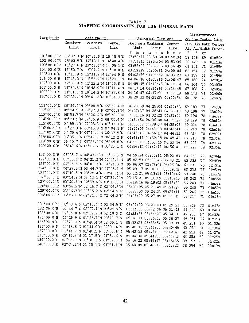
i01 °00.0 "E
102 °00.0 "E
103°00.0"E
104 °00.0 "E
105 ° 00.0 "E
106 °00.0 "E
I07 ° 00.0 "E
108 ° 00.0 "E
109 ° 00.0 "E
110°00.0"E
iii ° 00.0 "E
112°00.0"E
113°00.0"E
114 ° 00.0 "E
115 ° 00.0 "E
116°00.0 "E
117 ° 00.0 "E
IIS°00.0"E
119000.0 "E
120 °00.0 "E
121 °00.0 "E
122 °00.0 "E
123 °00.0 "E
124 °00.0 "E
125 °00.0 "E
126 °00.0 "E
127 °00.0 "E
128 °00.0 "E
129 °00.0 "E
130°00.0"E
131 °00.0 "E
132 °00 0 "E
133°00 0"E
134 ° 00 0 "E
135°00 0"E
136 ° 00 0"E
137 ° 00 0 "E
138°00 0"E
139o00 0"E
140 ° 00 0 "E
Table 7
MAPPING COORDINATES FOR THE UMBRAL PATH
Latitude of: Universal Time at:
Southern Center Northern Southern Center
Limit Line Limit Limit Line
h m s h m s h m s
03:50:11 03:50:58 03:50:34
03:53:15 03:54:04 03:53:39
03:56:23 03:57:15 03:56:49
03:59:37 04:00:31 04:00:04
04:02:55 04:03:52 04:03:23
04:06:18 04:07:16 04:06:47
04:09:45 04:10:45 04:10:14
04:13:14 04:14:16 04:13:45
04:16:47 04:17:50 04:17:19
04:20:22 04:21:27 04:20:54
15 °37.3"N 14° 53.6"N 15° 15.5"N
15 °02.5"N 14° 18.1"N 14° 40.4"N
14 °27.6"N 13° 42.6"N 14° 05.1"N
13 °52.7"N 13° 07.2"N 13° 30.0"N
13 °17.8"N 12° 31.9"N 12° 54.9"N
12 °43.2"N Ii° 56.9"N 12° 20.1"N
12 °08.8"N 11°22.2"N 11° 45.6"N
II °34.8"N I0 °48.0"N II°ll.4"N
ll°01.3"N I0°14.2"N 10°37.8"N
I0°28.4"N 09°41.2"N I0°04.8"N
Circumstances
on the Center Line
Sun Sun Path Center
Alt Az.WidthDurat.
o o km
58 146 69 01m50s
60 149 70 0]xn53s
61 151 71 01m55s
62 154 72 03m57s
63 157 73 01m59s
65 160 74 02m01s
66 164 74 02m03s
67 168 75 02m05s
68 173 76 02m06s
68 178 76 02m07s
09° 56.0"N 09 °08.8"N 09°32.4"N
09° 24.5"N 08 °37.3"N 09 ° 00.9"N
08°53.7"N 08°06.6"N 08°30.2"N
08°23.9"N 07°36.9"N 08°00.4"N
07°55.1"N 07°08.3"N 07°31.7"N
07 ° 27.3 "N 06° 40.8"N 07 °04.1"N
07°00.6"N 06 °14.4"N 06 °37.5"N
06 ° 35.1"N 05° 49.3"N 06 ° 12.2"N
06 ° 10.7"N 05°25.4"N 05°48.0"N
05°47.6"N 05°02.7"N 05°25.1"N
04:23:59 04:25:04 04:24:32
04:27:37 04:28:43 04:28:10
04:31:16 04:32:22 04:31:49
04:34:54 04:36:00 04:35:27
04:38:32 04:39:37 04:39:05
04:42:09 04:43:13 04:42:41
04:45:43 04:46:47 04:46:15
04:49:16 04:50:18 04:49:47
04:52:45 04:53:46 04:53:16
04:56:12 04:57:11 04:56:41
69 183 77 02m08s
69 188 77 02m09s
69 194 78 02m09s
69 199 78 02ml0s
69 204 78 02ml0s
69 210 78 02m09s
68 214 78 02m09s
67 219 78 02m08s
66 223 78 02m07s
65 227 78 02m06s
05°25.7"N 04°41.3"N 05°03
05°05.0"N 04°21.2"N 04°43
04 ° 45.6"N 04° 02.3 "N 04 °24
04 °27.5"N 03° 44.7"N 04 °06
04 ° 10.5"N 03°28.4"N 03°49
03°54.8"N 03°13.3"N 03°34
03 °40.3 "N 02° 59.4"N 03° 19.8"N
03°26.9"N 02°46.7"N 03°06.8"N
03°14.7"N 02°35.2"N 02°54.9"N
03 °03.6"N 02° 24.7"N 02° 44.2"N
5"N 04:59:34 05:00:32 05:00:03
I'N 05:02:53 05:03:48 05:03:21
0"N 05:06:07 05:07:01 05:06:34
I'N 05:09:17 05:10:08 05:09:43
4"N 05:12:21 05:13:11 05:12:46
0"N 05:15:21 05:16:09 05:15:45
05:18:16 05:19:02 05:18:39
05:21:05 05:21:49 05:21:27
05:23:50 05:24:31 05:24:11
05:26:29 05:27:08 05:26:49
64 230 77 02m04s
63 233 77 02m03s
62 236 76 02m01s
60 238 76 01m59s
59 240 75 01m57s
58 242 74 01m55s
56 243 73 01m53s
55 245 73 01m50s
53 246 72 01m48s
52 247 71 01m45s
02 ° 53.6"N 02° 15.4"N 02° 34.5"N
02°44.7"N 02°07.1"N 02°25.9"N
02°36.8"N 01°59.9"N 02°18.3"N
02°29.9"N 01°53.7"N 02°II.7"N
02°23.9"N 01°48.4"N 02°06.1"N
02 °18.8"N 01 °44.0"N 02°01.4"N
02°14.7"N 01°40.5"N 01°57.6"N
02° Ii.3 "N 01 °37.9"N 01° 54.6"N
02° 08.9 "N 01 °36.1"N 01° 52.5"N
02°07.2"N 01°35.1"N 01°51.1"N
05:29:02 05:29:40 05:29:21
05:31:30 05:32:06 05:31:48
05:33:53 05:34:27 05:34:10
05:36:11 05:36:43 05:36:27
05:38:23 05:38:54 05:38:39
05:40:30 05:41:00 05:40:45
05:42:33 05:43:00 05:42:47
05:44:30 05:44:56 05:44:43
05:46:22 05:46:47 05:46:35
05:48:09 05:48:33 05:48:22
50 248 70 01m43s
49 249 69 01m40s
47 250 67 01m38s
46 251 66 01m35s
45 251 65 01m32s
43 252 64 01m30s
42 253 63 01m27s
40 253 62 01m25s
39 253 60 01m22s
38 254 59 01mlgs
42
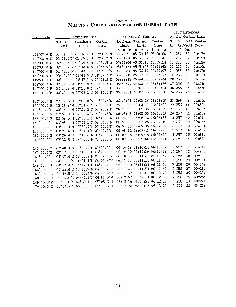
Lonaitude
141 ° 00.0 "E
142 °00.0 "E
143 °00.0 "E
144 °00.0 "E
145 °00.0 "E
146 °00.0 "E
147 °00.0 "E
148 °00.0 "E
149 °00.0 "E
150 ° 00.0 "E
151 ° 00.0 "E
152 ° 00.0 "E
153 ° 00.0 "E
154 ° 00.0 "E
155 ° 00.0 "E
156 ° 00.0 "E
157 ° 00.0 "E
158 ° 00.0 "E
159 ° 00.0 "E
160 °00.0 "E
161°00.0"E
162°00 0"E
163o00 0"E
164°00 0"E
165°00 0"E
166°00 0"E
167°00 0"E
168°00 0"E
169°00 0"E
170°00.0"E
Table 7
MAPPING COORDINATES FOR THE UMBRAL PATH
Northern
Limit
Latitude of: Qniversal Time at:
Southern Center Northern Southern Center
Limit Line Limit Limit Line
h m s h m s h m s
05:49:52 05:50:15 05:50:04
05:51:30 05:51:52 05:51:41
05:53:04 05:53:24 05:53:14
05:54:33 05:54:53 05:54:43
05:55:58 05:56:17 05:56:07
05:57:18 05:57:36 05:57:27
05:58:35 05:58:52 05:58:44
05:59:47 06:00:04 05:59:56
06:00:56 06:01:11 06:01:04
06:02:01 06:02:15 06:02:08
02°06.2"N 01°34.8"N 01°50.5"N
02°06.0"N 01°35.3"N 01°50.7"N
02°06.5"N 01°36.5"N 01°51.5"N
02°07.7"N 01°38.4"N 01°53.0"N
02°09.5"N 01°40.9"N 01°55.2"N
02° 12.0"N 01°44.0"N 01°58.0"N
02°15.0"N 01°47.7"N 02°01.3"N
02°18.6"N 01°52.0"N 02°05.3"N
02°22.8"N 01°56.8"N 02°09.8"N
02°27.4"N 02 °02.2"N 02° 14.8"N
Circumstances
Qn the Center Line
Sun Sun Path Center
Alt Az.WidthDurat.
o o km
36 254 58 01ml7s
35 254 57 01ml5s
33 255 55 01ml2s
32 255 54 01ml0s
31 255 53 01m07s
30 255 51 01m05s
28 256 50 01m03s
27 256 49 01m01s
26 256 48 00m58s
24 256 46 00m56s
02°32.6"N 02°08.0"N 02°20.3"N
02°38.3"N 02°14.4"N 02°26.3"N
02°44.4"N 02°21.2"N 02°32.8"N
02°51.0"N 02°28.4"N 02°39.7"N
02°58.0"N 02°36.1"N 02°47.0"N
03 ° 05.4"N 02 °44.1"N 02°54.8"N
03 ° 13.2"N 02° 52.6"N 03°02.9"N
03°21.4"N 03°01.4"N 03°II.4"N
03°29.9"N 03°I0.6"N 03°20.3"N
03°38.8"N 03°20.1"N 03°29.5"N
06:03:01 06:03:16 06:03:09
06:03:59 06:04:12 06:04:06
06:04:53 06:05:05 06:04:59
06:05:43 06:05:55 06:05:49
06:06:30 06:06:42 06:06:36
06:07:13 06:07:25 06:07:19
06:07:54 06:08:05 06:07:59
06:08:31 06:08:41 06:08:36
06:09:05 06:09:15 06:09:10
06:09:36 06:09:46 06:09:41
23 256 45 00m54s
22 256 44 00m52s
21 257 43 00m50s
20 257 41 00m48s
18 257 40 00m46s
17 257 39 00m44s
16 257 38 00m43s
15 257 36 00m41s
14 257 35 00m39s
13 257 34 00m37s
03°48.0"N 03°30.0"N 03°39.0"N
03°57.5"N 03°40.2"N 03°48.9"N
04° 07.4"N 03° 50.6"N 03° 59.0"N
04°17.5"N 04°01.4"N 04°09.5"N
04°27.9"N 04° 12.4"N 04°20.2"N
04o38.6"N 04°23.7"N 04°31.2"N
04°49.5"N 04°35.3"N 04°42.4"N
05 ° 00.6"N 04 °47.1"N 04 °53.9"N
05 ° 12.0"N 04° 59.1"N 05 °05.6"N
05°23.7"N 05° 11.3 "N 05 ° 17.5"N
06:10:05 06:10:14 06:10:09
06:10:30 06:10:39 06:10:35
06:10:53 06:11:01 06:10:57
06:11:13 06:11:21 06:11:17
06:11:30 06:11:38 06:11:34
06:11:45 06:11:53 06:11:49
06:11:57 06:.12:05 06:12:01
06:12:07 06:12:14 06:12:11
06:12:15 06:12:21 06:12:18
06:12:20 06:12:26 06:12:23
ii 257 33 00m36s
i0 257 32 00m34s
9 258 30 00m33s
8 258 29 00m31s
7 258 28 00m30s
6 258 27 00m28s
5 258 26 00m27s
4 258 25 00m25s
3 258 23 00m24s
2 258 22 00m23s
43
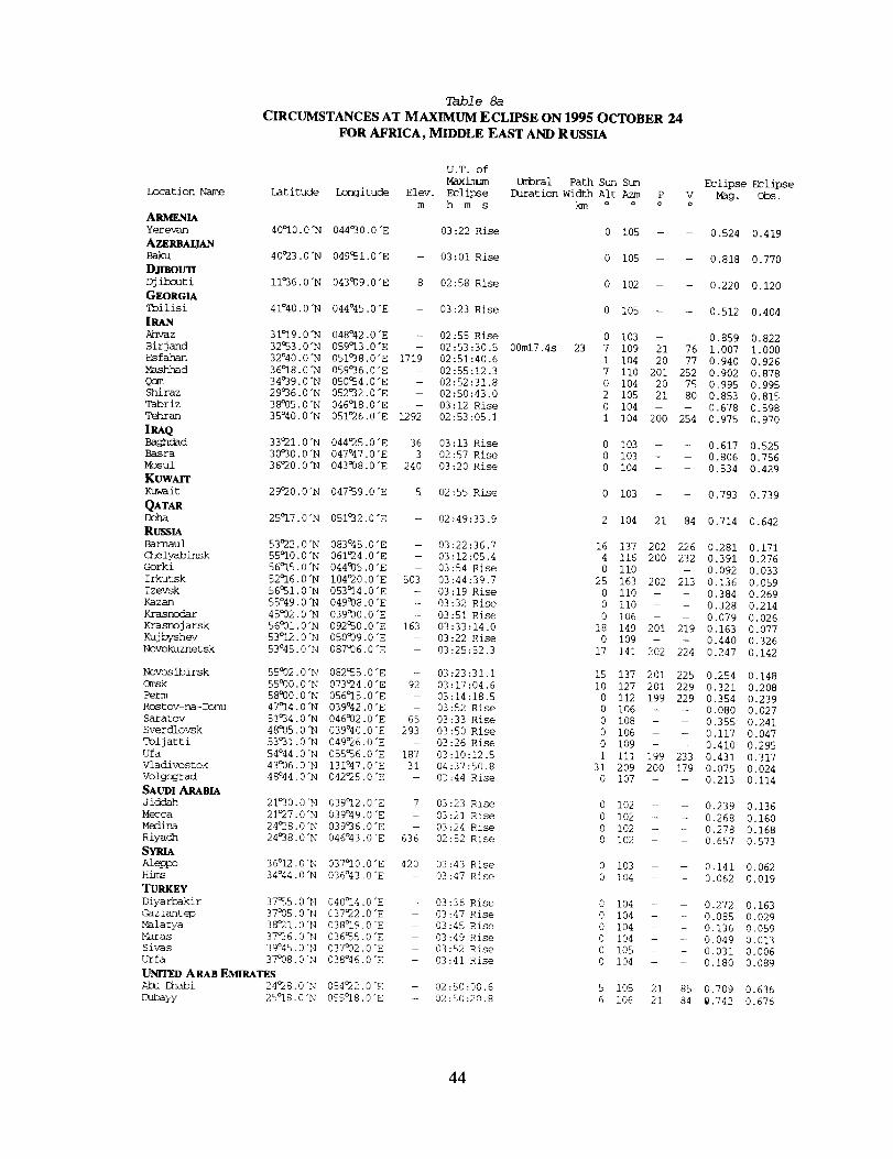
Table 8a
CIRCUMSTANCES AT MAXIMUM ECLIPSE ON 1995 OCTOBER 24
FOR AFRICA, MIDDLE EAST AND R USSIA
U.T. of
Maximum
Location Name Latitude Longitude Elev. Eclipse
m h m s
A_Yerevan 40_i0.0"N 044030.0 "E
AZERBALIAN
Baku 40O23.0"N 049Q51.0 "E
DJfl_OUT_Djibouti Ii°36.0 "N 043009.0 "E
GEORGIA
Tbil isi 41°40.0"N 044°45.0"E
Ahvaz 31°19.0 "N 048°42.0 "E
Birjand
Esfahan
Mashhad
QomShiraz
Tabriz
Tehran
IRAQBaghdad 33O21.0"N 044°25.0"E 36 03:13 Rise
Basra 30°30.0"N 047°47.0"E 3 02:57 Rise
Mosul 36°20.0"N 043938.0 "E 240 03:20 Rise
KUWAITKuwait 29°20.0"N 047a59.0 "E 5 02:55 Rise
QATARDCg_ 25°17.0"N 051°32.0"E -- 02:49:33.9
RussiaBarnaul 53O22.0"N 083°45.0"E - 03:22:36.7
Chelyabinsk 55°10.0 "N 061°24.0 "E - 03:12:05.4
Gorki 56°15.0"N 044935.0 "E - 03:54 Rise
Irkutsk 52°16.0"N I04O20.0"E 503 03:44:39.7
Izevsk 56_51.0"N 053°14.0"E - 03:19 Rise
Kazan 55°49.0"N 049°08.0 "E - 03:32 Rise
K_ras_ 45°02.0"N 039°00.0 "E - 03:51 Rise
Krasnojarsk 56°01.0 "N 092a50.0 "E 163 03:33:14.0
Kujbyshev 53°12.0 "N 050939.0 "E - 03:22 Rise
Novokuznetsk 53°45.0"N 087°06.0 "E - 03:25:52.3
Novosibirsk 55%32.0 "N 082_55.0 "E - 03:23:31.1
Omsk 55930.0 "N 073024.0 "E 92 03 :17:04.6
Perm 58000.0 "N 056°15.0 "E - 03:14:18.5
Rc_stov-na-Donu 47°14.0"N 039°42.0"E - 03:52 Rise
Saratov 51_34.0"N 046932.0"E 65 03:33 Rise
Sverdlovsk 48°05.0"N 039°40.0 "E 293 03:50 Rise
Toljatti 53°31.0"N 049°26.0 "E - 03:26 Rise
Ufa 54°44.0 "N 055a56.0 "E 187 03:10:12.5
Vladivostok 43006.0"N 131°47.0"E 31 04:37:50.8
Volgograd 48°44-0"N 042°25.0"E - 03:44 Rise
SAUDI ARABIA
Jiddah 21°30.0"N 039°12.0"E 7 03:23 Rise
Mecca 21°27.0"N 039°49.0"E - 03:21 Rise
Med_ 24°28,0"N 039°36.0"E - 03:24 Rise
Riyach 24a98.0"N 046°43.0"E 636 02:52 Rise
S_Aleppo 36°12.0"N 037°I0.0"E 420 03:43 Rise
Hires 34°44.0"N 036°43.0"E - 03:47 Rise
TURKEY
Diyarbakir 37_5.0"N 040°14.0"E
Gaziantep 37°05.0"N 037°22.0 "E
Malatya 38°21.0"N 038°19.0"E
Maras 37°36.0 "N 036_5.0 "E
Sivas 39°45.0 "N 037932.0 "E
Urfa 37°08.0"N 038°46.0"E
UNITED ARAB EMIRATES
Abu Dhabi 24O28.0"N 054°22.0"E
Duba_%/ 25°18.0"N 055°18.0"E
-- 03:22 Rise
-- 03:01 Rise
8 02:58 Rise
- 03:23 Rise
-- 02:55 Rise
Umbral Path Sun Sun Eclipse Eclipse
Daration Width Alt Azm P V Mag, Obs.
o o a o
0 105 - - 0.524 0.419
0 105 -- - 0.818 0.770
0 102 - -- 0.220 0.120
0 105 - - 0.512 0.404
0 103 - - 0.859 0.822
32°53.0"N 059°13.0"E - 02:53:30.5 00m17.4s 23 7 109 21 76 1.007 1.000
32°40.0"N 051°38.0"E 1719 02:51:40.6 1 104 20 77 0.940 0.926
36°18.0"N 059°36.0"E - 02:55:12.3 7 ii0 201 252 0.902 0.878
34°39.0"N 050°54.0"E - 02:52:31.8 0 104 20 75 0.995 0.995
29°36.0"N 052°32.0"E -- 02:50:43.0 2 105 21 80 0.853 0.815
38005.0"N 046°18.0"E -- 03:12 Rise 0 104 -- -- 0.678 0.598
35°40.0"N 051O26.0"E 1292 02:53:05.1 1 104 200 254 0.975 0.970
0 103 -- -- 0.617 0.525
0 103 -- -- 0.806 0.756
0 104 -- -- 0.534 0.429
0 103 -- - 0.793 0.739
2 104 21 84 0.714 0.642
16 137 202 226 0.281 0.171
4 116 200 232 0.391 0.276
0 ii0 -- -- 0.092 0.033
25 163 202 213 0.136 0.059
0 110 -- - 0.384 0.269
0 ii0 -- -- 0.328 0.214
0 106 -- -- 0.079 0.026
18 149 201 219 0.163 0.077
0 109 -- -- 0.440 0.326
17 141 202 224 0.247 0.142
15 137 201 225 0.254 0.148
i0 127 201 229 0.321 0.208
0 112 199 229 0.354 0.239
0 106 -- -- 0.080 0.027
0 108 - -- 0.355 0.241
0 106 -- -- 0.117 0.047
0 109 -- -- 0.410 0.295
1 Iii 199 233 0.431 0.317
31 209 200 179 0.075 0.024
0 107 - -- 0.213 0.114
0 102 -- -- 0.239 0.136
0 102 -- - 0.268 0.160
0 102 - - 0.278 0.168
0 102 - - 0.657 0.573
0 103 -- 0.141 0.062
0 104 - - 0.062 0.019
-- 03:36 Rise
-- 03:47 Rise
- 03:45 Rise
- 03:49 Rise
- 03:52 Rise
- 03:41 Rise
0 104 - - 0.272 0.163
0 104 - - 0.085 0.029
0 104 - - 0.136 0.059
0 104 - - 0.049 0.013
0 105 -- - 0.031 0.006
0 104 -- - 0.180 0.089
- 02:50:00.6
- 02:50:20.85 105 21 85 0.709 0.636
6 106 21 84 Q.742 0.676
44
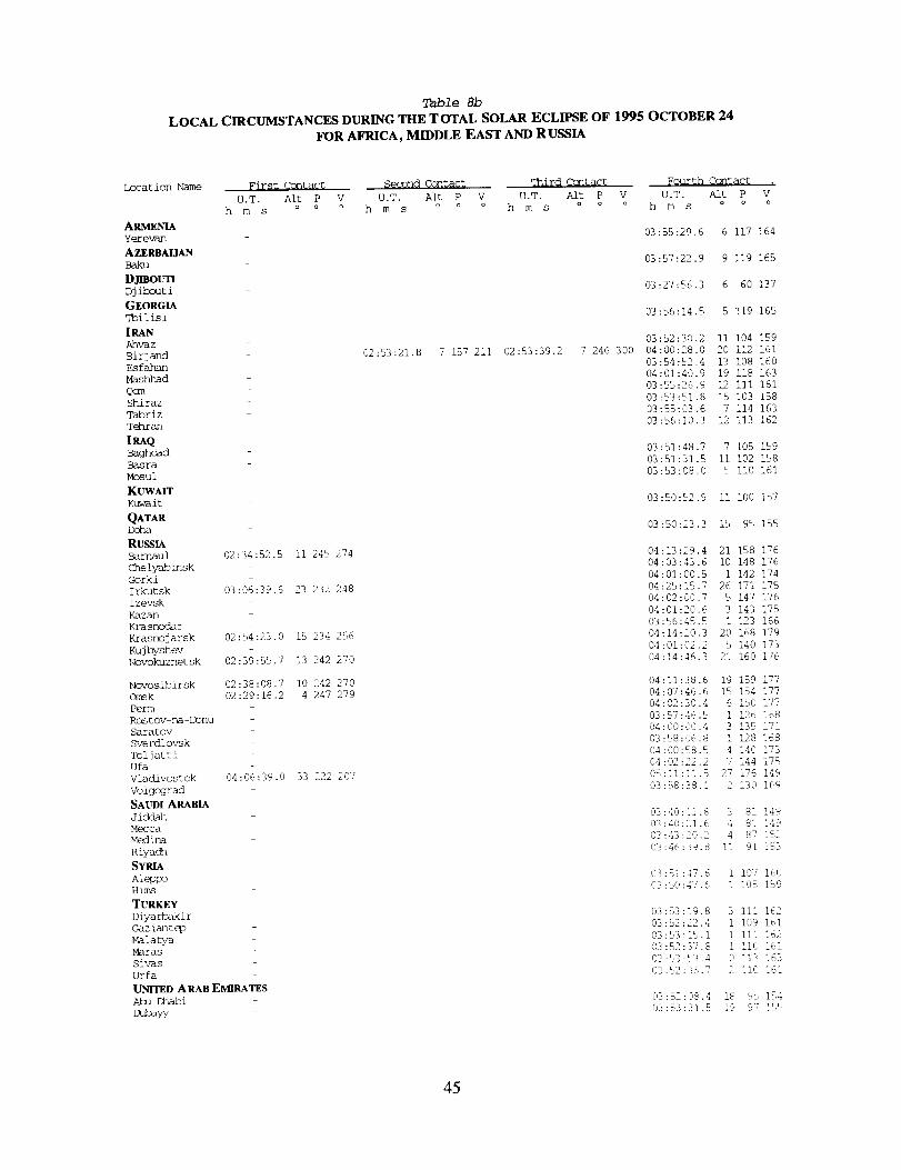
Table 8b
LOCAL CIRCUMSTANCES DURING THE T OTAL SOLAR ECLIPSE OF 1995 OCTOBER 24
FOR AFRICA, MIDDLE EAST AND RUSSIA
Location Name First Contact Seggnd Contact _hird Cc_tact _Qurth Contact .
U.T. Aft P V U.T. Aft P V U.T. Alt P V U.T. Alt P Vo o oh m s o o o h m s o o o h m s o o o h m s
ARMENIA
Yerevan
AZERBAIJAN
Baku
DJmOUTIDjibouti
GEORGIA
_ilisi
Ahvaz
Birjand
Esfabmn
Mashhad
Qomshiraz
Tabriz
T_hran
;RAQBaghdad
Basra
Mosul
K_A_
Kuwait
QATARDoha
RUSStABarnaul 02:34:52.5
Chelyabinsk
Gorki
Irkutsk 03 :06 :39.6
Iz evs k
Kazan
Krasnodar
Krasnoj arsk 02 :54:23.0
Kuj byshev
Novokuznet sk 02:39:55.7
Novosibirsk 02:38:08.7
Omsk 02:29 :16.2
Perm
Rostov na-Donu
Saratov
Sverdlovsk
Toljatti
Ufa
Vladivostok 04 :06 :39.0
Volgograd
SAUDI ARABIA
Mecca
Medina
Riyach
SYRIAAleppo
Hims
TURKEY
Diya rhak i r
Gaz iant_p
Malatya
Maras
Sivas
Urfa
UNITED ARAB EMIRATES
ii 245 274
23 232 248
15 234 256
13 242 270
I0 242 270
4 247 279
33 222 207
02:53:21.8 7 157 211 02:53:39.2 7 246 300
03:55:29.6 6 117 164
03:57:22.9 9 119 165
03:27:56.3 6 60 137
03:56:14.5 5 119 165
03:52:30.2 ii 104 159
04:00:28.0 20 112 161
03:54:52.4 13 108 160
04:01:40.9 19 i18 163
03:55:26.9 12 111 161
03:53:51.8 15 103 158
03:55:03.6 7 114 163
03:56:10.3 12 113 162
03:51:48.7 7 105 159
03:51:31.5 ii 102 158
03:53:08.0 5 ii0 161
03:50:52.9 Ii I00 157
03:50:23.3 15 95 155
04:13:29.4 21 158 176
04:03:43.6 i0 148 176
04:01:00.5 1 142 174
04:25:15.7 26 171 175
04:02:00.7 5 147 176
04:01:20.6 3 143 175
03:56:45.5 1 123 166
04:14:20.3 20 168 179
04:01:02.2 5 140 173
04:14:46.3 21 160 176
04:11:38.6 19 159 177
04:07:46.6 15 154 177
04:02:30.4 6 150 177
03:57:46.5 1 126 168
04:00:00.4 3 135 171
03:58:06.8 ! 128 168
04:00:58.5 4 140 173
04:02:22.2 7 144 175
05:]]:11.5 27 176 149
03:R8:38.1 _ !30 169
03:40:11.8 3 81 !49
03:40:21.6 4 81 149
03:43:20.2 4 87 lC2
03:46:3'9.8 !1 91 !_3
03:51:47.6 I 137 160
03:50:47.6 1 1(35 159
03:53:19.8 3 ili 162
03:52:22.4 1 109 161
03:53:15.1 i iii ]62
03:52:37.8 i Ii _' 161
03:53:53.4 0 113 163
03:52:36.7 2 110 161
03:%2:08.4 18 95 1_,4
di3:[3:_i.5 !9 97 155
45
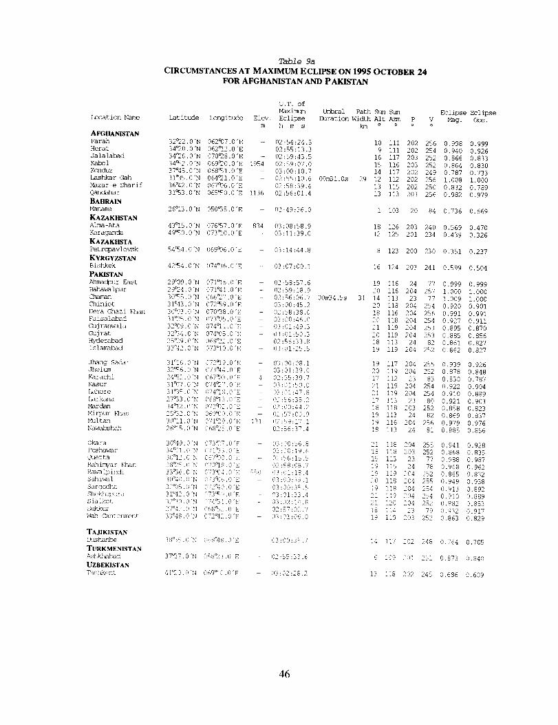
_ation
AFGIIANISTAN
Farah
Hera t
Jalalabad
Kabol
Konduz
Lashka r Gah
Mazar-e Shari f
Qandahar
BAIIRAIN
KAZAKHSTAN
ALma-Ata
Kara_c_
KAZAKIISTA
Pet ropavl o_k
KYRGYZSTAN
Bishkek
_c]pur East
Baha_ ipur
Chiniot
L_ra Ghazi Kh_
Faisalabad
_j ranwala
GMj rat
Hyderabad
Is lamabad
J_g Sa_r
Jhel_
Karachi
Kasur
[mhore
_rk_a
_r_
Mirp_ k_as
_it_
Na_hah
Okara
P_ha'_r
_etta
Rah imya r _n
Ra_ ipindi
Sah i_) 1
Sarg_dha
She k@_.upura
Sialkot
Wah ¢_]to_t
TAJIKISTAN
_h_
TURKMENISTAN
Ashk_d
UZBEKISTAN
Tasb_.ent
Table 9a
CIRCUMSTANCES AT MAXIMUM ECLIPSE ON 1995 OCTOBER 24FOR AFGHANISTAN AND PAKISTAN
Lat i rude
32°22,0 "N
34°20.0 "N
34_26,0"N
34_32.0 "N
37°45.0"N
31°35.0"N
36°42.0 "N
3 I°53.0 "N
2 6°13.0 "N
43°15.0 "N
49%0.0 "N
54_34.0 "N
42_4.0 "N
29°09,0 "N
29_4.0"N
3O%5,0"N
31°43,0"N
30°03.0 "N
31_-5,0 "N
32°09.0 "N
32_34.0 "N
25_9.0 "N
33°42.0"N
3 I°I 6.0 "N
32_6.0 "N
24_52.0 "N
31°07.0 "N
31°35.0 "N
27°33.0 "N
34c12.0 "N
25°32.0 "N
30°Ii .0"N
26°15.0 "N
30°49.0 "N
34°01.0 "N
30°12.0 "N
28_25.0 "N
33%6.0 "N
30°40.0 "N
32°05.0 "N
] 1°42. C}"N
32_0.0 "N
2/°42. O "N
33°48.0 "N
38%5.0 "N
37°37. @"N
4 I_2Cl. 0 "N
U.T. of
_imum Umbral Path Sun
Longitude Elev, Ecli_e Duration Width Alt Azm P
m h m s km o o o
Eclipse _lipse
Mag. O_.
062°07.0"E - 02:54:24.5 i0 III 202 256 0.998 0.999
062°12.0"E - 02:55:13.3 9 iii 202 254 0.940 0.926
070c28.0"E - 02:59:43,5 16 117 203 252 0.866 0.833
069_0.0"E 1954 02:59:07,0 15 116 203 252 0.864 0,830
068a51,0"E - 03:00:10.7 14 117 202 249 0.787 0.733
064_21.0"E - 02:55:10,6 00m31.0s 29 12 112 202 256 1.008 1.000
067°06,0"E 02:58:39.4 13 115 202 250 0.832 0,789
065_0,0"E 1136 02:56:01.4 13 113 203 256 0,982 0.979
050_5.0"E - 02:49:36.0 1 103 20 84 0.736 0.669
076_7.0"E 834 03:08:58.9 18 126 203 240 0.569 0.470
073_0.0"E - 03:11:39.0 12 125 201 234 0.439 0.326
069_6,0"E - 03:14:44.8 8 123 200 230 0.351 0.237
074_6.0"E - 03:07:00.1 16 124 203 241 0,599 0.504
071_16.0 "E - 02:58:57.6 19 116 24
071°41.0"E 02:59:18.9 20 116 204
066_7.0"E 02:56:06.7 00m34.5s 31 14 113 23
072c59.0 "E 03:00:45.2 20 118 204
070°38,0"E - 02:58:38.0 18 116 204
073_]5.0"E - 03:00:46.0 20 118 204
074c11.0"E 03:01:49.3 21 119 204
074c05.0 "E - 03:01:50.3 20 119 204
068_2.0 "E 02:56:33.8 18 113 24
073_I0.0"E - 03:01:25.5 19 119 204
072_]9.0 "E 03:00:08,1 19 117 204
073°44.0"E - 03:01:39.0 20 119 204
067933,0 "E 4 02:55:39.7 17 112 23
074_7.0"E 03:01:50.0 21 119 204
074°18,0"E - 03:01:47.8 21 119 204
068_3.0"E - 02:56:35.2 17 113 23
072°02.0"E 03:00:44.2 18 118 203
069930.0 "E 02:57:00.9 19 113 24
071_9.0"E 131 02 :q9:17.1 19 116 204
068_5.0"E - 0!:56:37.4 18 113 24
77
257
77
254
256
254
253
253
82
252
255
252
83
254
254
80
252
82
256
81
255
252
77
78
252
255
254
254
252
79
252
073°27.0"E 03:3'0:56,8 21 118 204
071_33,0"E 03:00:19.6 18 118 203
0679._0.0 "E - 02:56:15.5 15 113 23
070°18.0 "E 02:<8:08.7 19 115 24
073_4.0 "E 550 03:01:18.4 19 119 204
073_16.0'E 03:00:38.1 20 118 204
072°40.0"E !3:00:35.5 19 118 204
073_9.0"E 03:01:33.4 21 119 204
074=B].O'E - '33:02:10.8 21 120 204
068_2.0 "E 02:57:02.7 18 114 23
072°42.0 "E 613:0!:06.0 19 119 203
0.999 0.999
1.000 1.000
1.009 1.000
0.920 0.901
0.991 0.991
0.927 0.911
0.895 0.870
0,885 0.856
0.861 0.827
0.862 0.827
0.939 0.926
0.878 0.848
0.830 0.787
0.922 0.904
0,910 0,889
0,921 0.903
0.858 0.823
0.869 0.837
0.979 0.976
0.885 0.856
0.941 0.928
0.868 0,835
0.988 0.987
0.968 0.962
0.865 0.832
0.949 0.938
0.913 0.892
0.910 0.889
0.882 0.853
0.932 0.917
0.863 0.829
%_8°48.0"E 03:00:35.7 14 117 202 248 0.764 0,705
058_3.0"E - 02:_5:33.6 6 109 201 251 0.873 0.840
069t0.0"E - 03:02:28,2 13 118 202 245 0,686 0.609
46
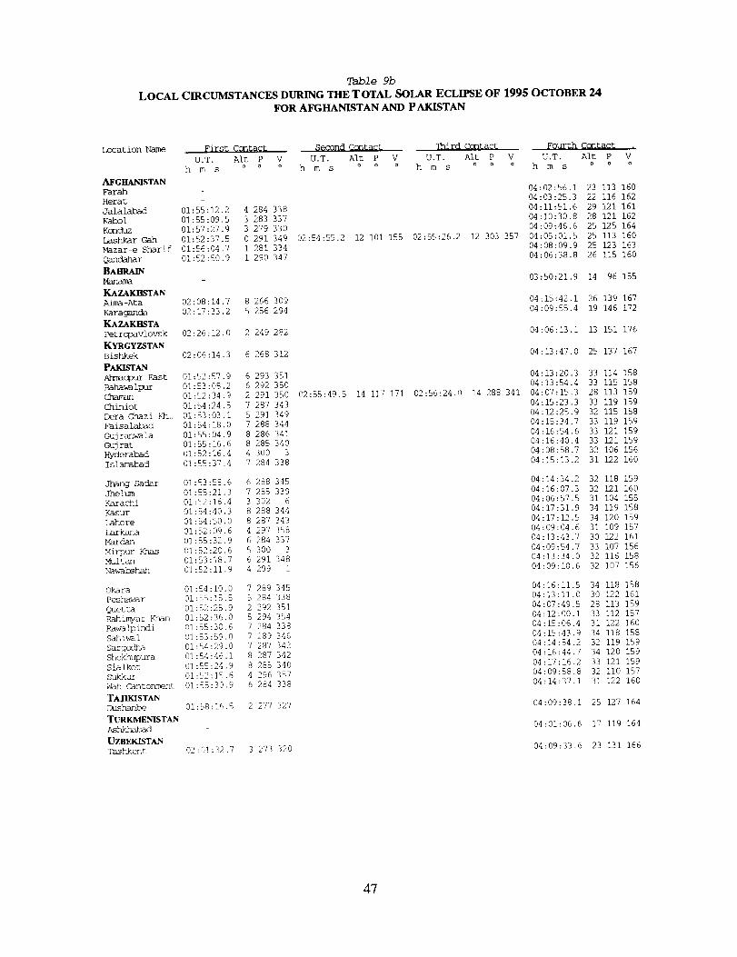
Table 9b
LOCAL CIRCUMSTANCES DURING THE TOTAL SOLAR ECLIPSE OF 1995 OCTOBER 24FOR AFGHANISTAN AND P AKISTAN
Location Name First Contact Second Contact qhird Contact Fourth Contact .
U.T. Alt P V U.T. Alt P V U.T. Alt P V U.T. Alt P V
hms °° ° hms °° ° hms °° ° hms oo o
AFGHANISTAN
Farah - 04:02:56.1 23 113 16004:03:25.3 22 116 162
Herat
Jalalabad 01:55:12.2 4 284 338 04:11:51.6 29 121 161
Kabol 01:55:09.5 3 283 337 04:10:30.8 28 121 162
Konduz 01:57:27.9 3 279 330 04:09:46.6 25 125 164
Lashkar Gah 01:52:37.5 0 291 349 02:54:55.2 12 i01 155 02:55:26.2 12 303 357 04:05:01.5 25 113 160
Mazar-e Sharif 01:56:04.7 1 281 334 04:08:09.9 25 123 163
Qandahar 01:52:50.9 1 290 347 04:06:38.8 26 115 160
BAHRAIN 03:50:21.9 14 96 155Manama
KAZAK_STAN
Alma-Ata 02:08:14.7 8 266 309 04:15:42.1 26 139 167
Karaganda 02:17:33.2 5 256 294 04:09:55.4 19 146 172
KAZAKHSTA
Petropavlovsk 02:26:12.0 2 249 282 04:06:13.1 13 151 176
KYRGYZSTANBishkek 02:06:14.3 6 268 312 04:13:47.0 25 137 167
PAKISTANAhmac_our East 01:52:57.9 6 293 351 04:13:20.3 33 114 158
Bahawalpur 01:53:08.2 6 292 350 04:13:54.4 33 115 158
Chaman 01:52:34.9 2 291 350 02:55:49.5 14 117 171 02:56:24.0 14 288 341 04:07:15.3 28 113 159
Chiniot 01:54:24.5 7 287 343 04:15:23.3 33 119 159
Dera Ghazi Kh.. 01:53:03.1 5 291 349 04:12:25.9 32 115 158
Faisalabad 01:54:18.0 7 288 344 04:15:34.7 33 119 159
Gujranw-ala 01:55:04.9 8 286 341 04:16:54.6 33 121 159
Gujrat 01:55:16.6 8 285 340 04:16:40.4 33 121 159
Hyderabad 01:52:16.4 4 300 3 04:08:58.7 32 106 156
Islarrek_d 01:55:37.4 7 284 338 04:15:13.2 31 122 160
dTmng Sadar 01:53:58.6 6 288 345 04:14:34.2 32 118 159
Jheltm 01:55:21.3 7 285 339 04:16:07.3 32 121 160
Karachi 01:52:16.4 3 302 6 04:06:57.5 31 104 155
Kasur 01:54:40.3 8 288 344 04:17:31.9 34 119 158
Lahore 01:54:50.0 8 287 343 04:17:12.5 34 120 159
Larkana 01:52:09.6 4 297 358 04:09:04.6 31 109 157
Marc]an 01:55:32.9 6 284 337 04:13:43.7 30 122 161
Mirpur Hnas 01:52:20.6 5 300 3 04:09:54.7 33 107 156
Multan 01:53:18.7 6 291 348 04:13:34.0 32 116 158
Nawahshah 01:52:11.9 4 299 1 04:09:10.6 32 107 156
Okara 01:54:10.0 7 289 345 04:16:11.5 34 118 158
Peshawar 01:55:15.5 5 284 338 04:13:11.0 30 122 161
Quetta 01:52:25.9 2 292 351 04:07:49.5 28 113 ]59
Rahimyar Khan 01:52:36.0 5 294 354 04:12:00.1 33 112 157
pa_alpindi 01:55:30.6 7 284 338 04:15:06.4 31 122 160
sahiwal 01:53:59.0 7 289 346 04:15:43.9 34 118 158
SargodPm 01:54:29.0 7 287 342 04:14:54.2 32 119 159
Shekhupura 01:54:46.1 8 287 342 04:16:44.7 34 120 159
Sialkot 01:55:24.9 8 285 340 04:17:16.2 33 121 159
Sh/kkqz 01:52:15.6 4 296 357 04:09:58.8 32 110 157
Wah Cantonment 01:55:30.9 6 284 338 04:14:37.1 31 122 160
TAJIKISTAN
Dushanbe 01:58:16.5 2 277 327 04:09:38.1 25 127 164
TURKMENISTAN 04:01:06.6 17 119 164Ashkbmbad
UZBEKISTAN
Tashkent ,32:01:32.7 3 273 320 04:09:33.6 23 131 166
47
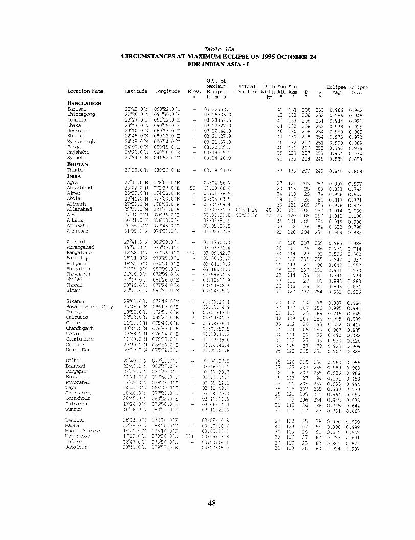
Location Name
BANGLADESH
Chittagong
Comilla
Dhaka
Jessore
Khulna
_m_nsinghPabnaRajshahiSylhet
B_T__imtu
IND_Agra
Ahmadabad
Ajmer
Akola
A1 igarh
A1 lahabad
Alw-ar
Ant_la
Amravat i
Amritsar
Asansol
Aurangabad
Bangalore
Bareilly
Belgaum
Bhagalpur
Bhavnagar
Bhilai
BhopalBihar
Bikaner
Bokaro Steel City
Bombay
Calcutta
Calicut
Chandigarh
Cochin
Cohnbatore
Cuttack
D_hra [Am
Delhi
DhanJ_ad
Durgapur
Erode
Firoz_d
Caya
Gha z iabad
Gorak_hpur
Gulbarga
Guntur
_,qal ior
_{aora
Hubl i-Dham_ r
}_/derabad
Indore
Jaba ipur
Table 10a
CIRCUMSTANCES AT MAXIMUM ECLIPSE ON 1995 OCTOBER 24FOR INDIAN ASIA - I
Latitude Longitude
22°42.0"N 090°22.0"E
22°20.0"N 091:50.0 "E
23°27.0"N 091°12.0"E
23°43.0"N 090°25.0"E
23O10.0"N 089°13.0"E
22°48.0"N 089°33.0"E
24°45.0"N 090°24.0"E
24°00.0"N 089°15.0"E
24°22.0"N 088°36.0"E
24054.0"N 091052.0"E
27O28.0"N 089_39.0 "E
27°11.0"N 078a01.0"E
23°02.0"N 072_37.0"E
26°27.0"N 074°38.0"E
20°44.0"N 077°00.0"E
27053.0"N 078°05.0"E
25O27.0"N 081051.0"E
27°34.0"N 076°36.0"E
30_21.0"N 076050.0"E
20056.0"N 077°45.0"E
31_35.0"N 074053.0 "E
23°41.0 "N 086_39.0"E
19053.0"N 075c20.0"E
12058.0"N 077°36.0"E
28°21.0"N 079°25.0"E
15052.0 "N 074°31.0"E
25°15.0"N 087°00.0"E
21°46.0"N 072919.0 "E
21°13.0"N 081°26.0"E
23O16.0"N 077°24.0"E
25O11. O'N 085°31.0"E
28911,0"N 073°18.0"E
23°45.0"N 086917.0"E
18°_J8.0 "N 072050.0 "E
22°32.0"N 088°22.0"E
11°15.0"N 075°46.0"E
30°44.0"N 076%5.0"E
09°58.0"N 076°14.0"E
I!°00.0"N 6176058.0"E
20°30.0"N 085_0.0"E
30°19.0"N 078912.0"E
28°40.0"N 077°13.0"E
23°48.0"N 086c27.0"E
23O29.0"N 087O20.0"E
11°21.0"N 077°'44.0"E
27%%9.0"N 078O25.0"E
24=47.0"N 085990.0"E
28°40.0"N 077°26.0"E
26°45.0"N 083°22.0"E
17°2_0.0"N 076050.0"E
16_8.0 "N 080%7.0 "E
26°13.0"N 078°10.0"E
22°35.0"N 088%0.0"E
15_!.@'N 075°10.0"E
17_29.0"N 079°28.0"E
22°43.0"N :975_0.0"E
23°10.0"N 079057.0"E
U.T. of
Maximum Umbral Path Sun Sun
Elev. Eclipse Duration Width Alt Azm P V
m h rn s kln o o o o
- 03:22:52.1
- 03:25:35.0
03:23:53.5
03:22:27.0
- 03:20:44.9
- 03:21:27.9
- 03:21:57.8
- 03:20:25.7
- 03:19:15.2
- 03:24:20.0
59
964
9
7
5v!
03:19:51.0
03:04:56.7
03:00:06.4
03:01:38.5
03:05:03.5
03:04:59.4
03:09:31.7
03:03:29.8
03:03:51.9
03:05:50.5
03:02:17.5
03:17:03.3
03:03:31.4
03:09:42.7
03:06:23,7
03:04:18.6
03:16:31.5
02:59:54.5
03:10:14.9
03:04:48.6
03:14:25.3
02:00:29.1
03:15:44.9
03:01:17.0
03:19:4].3
03:08:36.1
:93:03:59.5
03:!0:10.2
03:10:19.6
03:16:46.4
03:05:01.8
03:04:07.0
03:16:]3.1
03:17:39.7
03:11:04.7
03:05:22.1
,99:13:49.1
03:04:20.0
03:11:11.6
03:06:14.0
03:11:22.6
03:05:10.5
03:19:36.7
03:05:18.3
03:09:23.8
03:03:16.1
03:07:45.0
00m31.2s
00m33.3s
48
42
42 131 208 253
43 133 208 252
42 133 208 251
41 132 208 252
40 130 208 254
41 130 208 254
40 132 207 251
40 131 207 253
39 130 207 253
41 135 208 249
37 133 207 249
27 121 205 257
23 115 25 83
24 118 25 79
29 117 26 84
26 121 205 256
31 123 206 257
25 120 205 257
24 121 205 254
30 118 26 84
22 120 204 253
38 128 207 255
28 115 25 86
34 114 27 92
27 122 205 255
29 113 26 90
36 129 207 253
23 I]4 25 85
33 121 27 81
28 I]8 26 81
35 127 207 254
22 117 24 78
37 127 207 256
25 113 25 88
40 129 207 255
33 112 26 95
24 121 205 253
34 III 27 96
34 112 27 95
38 125 27 79
25 122 205 253
25 120 205 256
37 127 207 255
38 128 207 255
35 113 27 94
27 121 205 257
35 126 207 255
25 121 205 255
32 125 206 254
31 115 26 88
35 ]17 27 87
27 ]20 25 78
40 129 207 255
30 113 26 91
33 117 27 87
27 117 25 82
31 120 26 80
Eclipse Eclipse
Mag. obs.
0.966 0.962
0.956 0.948
0.934 0.921
0.938 0.925
0.969 0.965
0.975 0.972
0.909 0.889
0.946 0.936
0.944 0.934
0.885 0.859
0.846 0.808
0.997 0.997
0.833 0.792
0.956 0.947
0.817 0.771
0.976 0.973
1.014 1.000
1.012 1.000
0.919 0.900
0.832 0.790
0.904 0.882
0.985 0.985
0.771 0.714
0.596 0.502
0.947 0.937
0.643 0.557
0.941 0.930
0.791 0.738
0.886 0.860
0.895 0.871
0.962 0.956
0.987 0.986
0.995 0.996
0.715 0.645
0.998 0.999
0.522 0,417
0.907 0.885
0.490 0.382
0.530 0.426
0.925 0.909
0.907 0.885
0.963 0.956
0.989 0.989
0.986 0.986
0.551 0.450
0.993 0.994
0.980 0.979
0.961 0.953
0.945 0.935
0.715 0.644
0.731 0.665
0.990 0.990
0.998 0.999
0.635 0.549
0.753 0.691
0.861 0.827
0.924 0.907
48
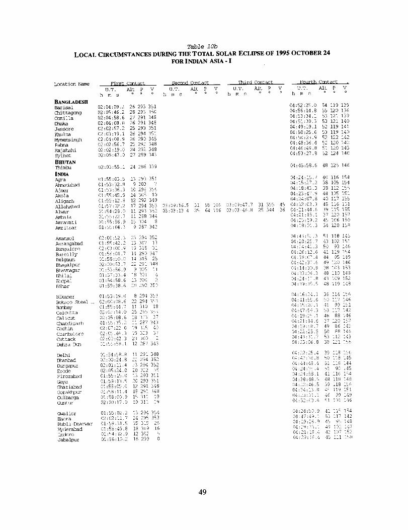
Table 10b
LOCAL CIRCUMSTANCES DURING THE TOTAL SOLAR ECLIPSE OF 1995 OCTOBER 24
FOR INDIAN ASIA - I
Location Name First Ccntact
U.T. Aft P V
h m s o o o
BANGLADESH
Barisal 02:04:09.2 26 293 351
Chittagong 02:05:46.2 28 293 350
Camilla 02:04:58.6 27 291 348
Ehaka 02:04:08.0 26 291 348
Jessore 02:02:57.2 25 293 351
}_ulna 02:03:19.1 26 294 351
Mymensingh 02:04:08.9 26 290 345
Pahna 02:02:56.7 25 292 348
Rajshahi 02:02:19.0 24 292 348
sylhet 02:05:47.0 27 289 343
BHUTAN
Thimba 02:03:55.i 24 286 339
INDIAAgra 01:55:03.5 13 293 351
Ahmadah_d 01:53:32.8 9 303 7
Ajmer 01:53:36.3 I0 296 356
Akola 01:55:45.9 14 305 I0
A/igarh 01:55:12.8 12 292 349
Allahah_d 01:57:02.2 17 294 353
Alwar 01:54:28.0 ii 293 352
Ambala 01:55:22.7 ]i 288 344
Amravati 01:55:56.9 15 304 8
Amritsar 01:55:04.3 9 287 342
Asansol 02:00:82.3 23 294 352
Aurangabad 01:54:42.2 13 307 13
Bangalore 02:03:00.9 19 318 31
Bareilly 01:56:01.7 14 290 347
Belgaum 01:58:50.0 14 3]5 25
Bhagalpur 02:00:53.7 22 291 348
Bhavnagar 01:53:56.9 9 305 Ii
Bhilai 01:87:33,4 18 301 4
Bhopal 01:54:58.6 13 300 2
Bihar 01:59:38.6 20 292 350
Bikaner 01:53:19.0 8 294 353
Bokaro Steel ... 02:00:08.6 22 294 353
B<m%_y 01:55:44.7 ii 310 18
Calcutta 02:02:14.0 25 295 353
Calicut 02:05:08.6, 18 323 37
Chandigarh 01:55:35.2 ii 287 343
cochin 02:07:22,0 19 325 40
Coimhatore 02:05:46.3 19 323 37
Cuttack 02:00:42.3 23 300 2
Dehra Dun 01:55:58.1 12 287 343
Delhi 01:54:58.8 Ii 291 348
Dhamk_d 02:00:24.8 22 294 352
Durgapur 02:01:11.4 23 294 352Erode 02:05:24.0 20 322 35
Firozabad 01:55:15.0 13 293 351
Gaya 01:59:13.8 20 293 351
Ghaziabad 01:58:05.0 12 291 348
Gorakhpur 01:58:11.4 18 291 348
Gulbarga 01:58:00.9 15 311 19
Guntur 02:00:17.0 19 311 19
Gwalior 01:55:02.2 13 294 354
Haora 02:02:11.7 24 295 353
Hubli-Dharwar 01:59:31.5 15 315 26
Hyderabad 01:58:49.8 18 309 16
Indore 01:54:32.9 12 302 5
Jabalpur 01:56:10.2 16 299 0
Second Ccntact qhird Ccntact Fourth Contact .
U.T. AlE P V U.T. Aft P V U.T. Aft P V
h m s o o o h m s o o o h m s o o o
03:09:16.5 31 55 106 03:09:47.7 31 355 45
03:03:13.4 25 64 116 03:03:46.8 25 344 36
04:52:25.0 54 119 139
04:56:14.8 55 120 136
04:53:34.1 53 121 139
04:51:30.3 53 121 140
04:49:19.1 52 119 141
04:50:25.6 53 119 140
04:50:23.9 52 122 142
04:48:36.4 52 120 142
04:46:49.8 51 120 143
04:53:27.8 52 124 140
04:45:58.6 48 125 146
04:24:15.7 40 116 154
04:15:27.2 38 105 154
04:18:43.3 38 112 155
04:23:47.9 44 105 151
04:24:0?.8 40 117 155
04:32:03.3 45 116 151
04:21:44.6 39 115 155
04:21:15.1 37 120 157
04:25:19.2 45 106 150
04:18:01.3 34 120 158
04:43:82.3 51 118 145
04:20:28.7 43 102 151
04:24:42.3 50 93 146
04:26:12.6 41 119 154
04:18:07.4 44 95 149
04:42:37.6 49 120 146
(34:14:30.9 38 i03 153
04:33:06.3 48 ii0 !48
04:24:]2.8 43 109 152
04:39:35.5 48 119 148
04:16:24.1 36 114 156
04:41:55.6 50 117 146
04:15:20.1 41 99 151
04:47:56.3 53 117 142
04:i9:25.I 48 88 146
04:2]:14.6 37 120 157
04:19:58.7 49 86 ]45
04:22:25.5 50 88 146
04:43:31.7 53 112 143
04:23:06.8 38 121 156
04:22:25.4 39 118 156
04:42:36.8 80 118 145
04:44:48.4 51 1!8 144
134:24:35.4 5,1 90 i48
04:24:58.1 41 116 154
@4:38:48.5 48 118 148
04:22:46.5 39 118 i_6
04:34:13.8 45 119 151
04:23:31.1 46 99 149
04:32:03.6 51 i01 146
04:24:50.9 41 liE, 184
04:47:49.i 53 117 142
04:19:26.9 45 95 148
04:29:33.1 49 102 147
04:21:18.4 42 107 152
04:29:_6.4 45 !II i50
49
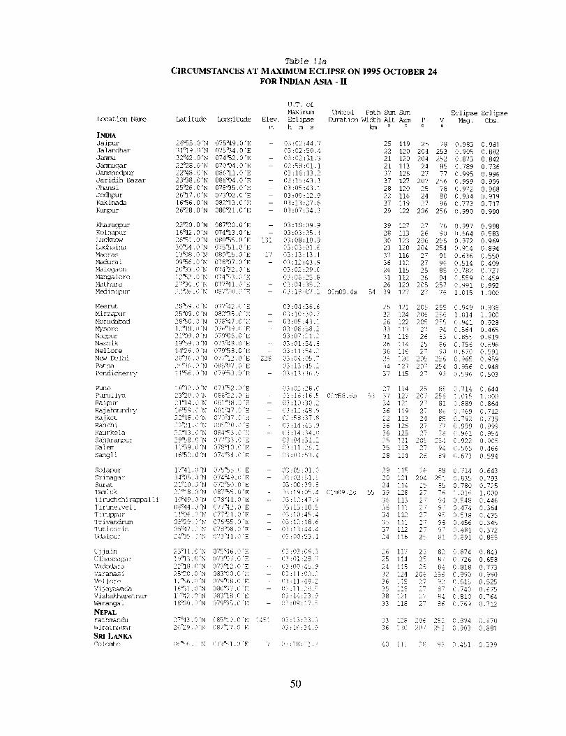
Location Name
INDIA
Jaipur
Jalandhar
Jammu
Jan_nagar
Jamshec}pu r
Jaridih Bazar
Jhansi
Jodhpur
Kakinada
Kanpur
Kharagpur
Kolhapur
Lucknow
Ludha ina
Madras
Madu ra i
Malegaon
Mangalore
Mathura
Medinipur
Meerut
Mirzapur
Moradabad
Mysore
Nagpur
Nashik
Nel lore
New Delhi
Patna
Pondicher i%,
Rune
Ruru I iya
Raipur
Ra jahmundi%,
Raj kot
Ranchi
Raurkela
Saharanpur
Salem
Sangli
Solapur
Srinagar
Sh/ra t
T_uh_
Tiruchchi rappa ] ] i
Tirune ive i i
Tiruppur
Tr ivandrum
qMt icor in
Udaipur
Ujjain
U ]hasnaga r
Vadoda ra
Varanasi
Vel ]ore
vi j ak_w-ada
V ishak_hapa tnm_
Wa ranga 1
NEPAL
7at hmand_
W ira tnaga r
SRt LANKACo iom_wo
Table lla
CIRCUMSTANCES AT MAXIMUM ECLIPSE ON 1995 OCTOBER 24
FOR INDIAN ASIA - !I
U.T. of
Maximam
Latitude Longitude Elev. Eclipse
m h m s
26%5.0"N 075°49.0"E 03:02:44.7
31°19.0"N 075a34.0"E 03:02:50.4
32°42.0"N 074%2.0"E 03:02:11.3
22°28.0"N 070°04.0 "E -- 02:58:01.1
22°48.0"N 086°i1.0 "E -- 03:16:13.2
23°38.0"N 086a04.0 "E - 03:15:43.1
25°26.0"N 078_35.0 "E 03:05:43.1
26°17.0 "N 073992.0 "E - 03:00:12.9
16%6.0"N 082°13.0 "E - 03:13:27.6
26°28.0"N 080°21.0 "E -- 03:07:34.3
22_0.0"N 087_20.0 "E -- 03:18:09.9
16°42.0"N 074_13.0 "E - 03:03:35.3
26%1.0"N 080%5.0"E 131 03:08:10.9
30%4.0"N 075%1.0"E 03:03:01.6
13°08.0"N 080_15.0"E 17 03:13:13.1
09%6.0"N 078Q07.0"E 03:12:43.9
20_33.0 "N 074_32.0 "E 03:02:29.0
12%2.0 "N 074_%3.0 "E 03:06:25.8
27°30.0 "N 077°41.0 "E - 03:04:35.2
22_6.0"N 087_0.0"E 03:18:07.1
28%9.0"N 077°42.0 "E 03:04:36.6
25°09.0 "N 082°35.0 "E - 03:]0:30.7
28_0.0 "N 078°47.0 "E 03:05:43.1
12°18.0 "N 076°39.0 "E - 03:08:58.2
21°09.0 "N 079c06.0 "E 03:07:21.2
19%9.0"N 073°48.0 "E -- 03:01:54.8
14_6.0 "N 079%8.0 "E - 03:11:54.2
28°36.0"N 077°12.0"E 228 03:04:05.7
2q_36.0"N 085997.0"E 03:13:45.2
11_,6.0"N 079%3.0 'E 03:13:36.5
18°32.0 "N 073%2.0 "E - 03:02:28.0
23_0.0"N 086_2.0"E - 03:16:16.5
21°14.0 "N 081_38.0"E - 03:10:30.2
16%9.0"N 081°47.0"E - 03:12:48.9
22°18.0"N 070°47.0 "E 02:58:37.8
23_I.0"N 085_0.0 "E - 03:14:45.9
22_13.0 "N 084%3.0"E - 03:14:34.0
29%8.0"N 077_33.0 "E 33:04:31.2
II_39.0"N 078°10.0"E - 03:11:26.1
16%2.0"N 074_4.0 'E 03:03:53.4
17°41.0 "N 075%5.0 "E - 03:05:01.0
34935.0"N 074°49.0 'E 03:02:51.5
21°I0.0"N 072%0.0 "E 03:00:39.8
2218.0"N 087%5.0"E 03:19:05.4
I0°49.0"N 078_41.0 'E -- 03:12:47.9
08°44.0"N 077°42.0"E 03:13:10.5
1 i°06.0"N 077_I .0"E 03:10:45.4
08_9.0"N 076%5.0"E - 03:12:18.6
08°47.0 "N 078_8.0"E - 03:13:44.4
24035. O'N 073°41.0 "E 03:00:53.1
23°II.0"N 075°46.0"E 03:03:06.3
19_13.0 "N 073_07.0 "E - 03:01:28.7
22°18.0"N 073_12.0 "E - 03:00:45.9
25_0.0"N 083°00.0 "E 03:11:00.2
12_6.0"N 079%38.0"E 03:11:48.2
16°31.0"N 080_3"/. 0 "E 193:11:28.5
17%:2.0"N 083_8.0 "E 03:14:33.9
18°00.0"N 079_35.0 "E - 03:09:17.5
27°43.0"N 08%_19.0"E 145] (113:13:33.3
26_29.0"N 087_17.0 'E 03:16:34.9
06_6.(9'N 079%1.0"E 7 03:]8:01.3
t_bral Path Sun Sun
Duration Width A]t Azm P
km o o o
00m09.4s 54
25 119 25
22 120 204
21 120 204
21 113 24
37 126 27
37 127 207
28 120 25
22 116 24
37 119 27
29 122 206
39 127
28 113
30 123
23 120
37 116
36 112
26 115
31 112
26 120
39 127
27
26
206
204
27
27
25
26
2O5
27
78
253
252
85
77
256
78
80
86
256
76
9O
256
254
91
96
85
94
257
76
Eclipse Eclipse
Mag. obs.
0.983 0.981
0.905 0.882
0.873 0.842
0.789 0.736
0.995 0.996
0.999 0.999
0.972 0.968
0.934 0.919
0.773 0.717
0.990 0.990
0.997 0.998
0.664 0.583
0.972 0.969
0.914 0.894
0.636 0.550
0.514 0.409
0.782 0.727
0.559 0.459
0.991 0.992
1.018 1.000
25 121 205 255 0.949 0.938
32 124 206 256 1.014 1.000
26 122 205 255 0.941 0.928
33 113 27 94 0.564 0.465
31 119 26 83 0.855 0.8]9
26 114 25 86 0.756 0.696
36 116 27 90 0.670 0.591
25 120 205 256 0.965 0.959
34 127 207 254 0.956 0.948
37 115 27 93 0.596 0.503
27 114 25 88 0.714 0.644
00m58.6s 53 37 127 207 256 1.015 1.000
34 121 27 81 0.889 0.864
36 119 27 86 0.769 0.712
22 113 24 85 0.792 0.739
36 126 27 77 0.999 0.999
36 125 27 78 0.961 0.954
25 121 205 254 0.922 0.905
35 113 27 94 0.565 0.466
28 114 26 89 0.673 0.594
29 115 26 88 0.714 0.643
20 121 204 251 0.835 0.793
24 114 25 85 0.780 0.725
01_9.2s 55 39 128 27 76 1.016 1.000
36 113 27 94 0.548 0.446
36 111 27 97 0.474 0.364
34 112 27 95 0.538 0.435
35 111 27 98 0.456 0.345
37 112 27 97 0.481 0.372
24 116 25 81 0.891 0.865
26 117 25 82 0.874 0.843
25 114 25 87 0.726 0.658
24 i15 25 84 0.818 0.773
32 124 206 256 0.990 0.990
36 115 27 92 0.615 0.525
35 I18 27 87 0.740 0.675
38 121 27 84 0.810 0.764
33 118 27 86 13.769 0.712
33 128 206 252 0.894 0.870
36 13,3 207 2%2 0.903 0.881
40 iii 28 98 0.451 0.339
5O

Table 1/b
LOCAL CIRCUMSTANCES DURING THE TOTAL SOLAR ECLIPSE OF 1995 OCTOBER 24FOR INDIAN ASIA - II
Location Name First Ccntact Second Ccntac% Third COntact Fourth Contac% ,
U.T. Alt P V U.T. Aft P V U.T. Aft P V U.T. Aft P V
h m s o o o h m s o o a h m s o o o h m s o o o
|NDIA
Jaipur 01:54:03.9 II 294 354
Jala/zdhar 01:55:14.0 9 287 342
Jafmqu 01:55:41.0 8 285 339
Jarmlagar 01:53:18.7 7 305 i0
Jamshedpur 02:00:18.9 22 296 355
Jarid£h Bazar 02:00:06.8 22 294 353
Ohan_i 01:55:13.4 14 296 356
Jodhpur 01:53:06.6 8 297 358
Kakirmda 02:00:35.2 21 308 15
Kanpur 01:56:12.2 15 293 351
Kharagpur 02:01:21.3 24 296 355
Kolhapur 01:57:56.0 13 313 23
Lucknow 01:56:35.0 15 292 350
Ludhaina 01:55:09.8 I0 287 343
Nmdras 02:03:41.0 21 316 27
Madurai 02:07:48.1 21 324 39
M_alegaon 01:55:05.9 12 306 12
Mar]galore 02:02:34.6 16 320 33
Mathura 01:54:56.8 12 292 351
Medinipur 02:01:20.2 23 296 355
Meerut 01:55:18.3 12 290 347
Mirzapur 01:57:30.2 18 294 353
Moradabad 01:55:49.2 13 290 346
Mysore 02:03:43.6 18 320 33
Nagpur 01:56:25.0 16 303 7
Nashik 01:55:15.1 II 308 14
Nellore 02:02:00.1 20 314 24
New Delhi 01:54:57.1 ii 291 348
Patna 01:59:21.3 20 292 349
Pondicherry 02:05:10.6 21 319 31
?une 01:56:16.4 12 310 18
Puruliya 02:00:23.3 22 295 354
Raipur 01:57:39.7 18 301 4
Rajah_ 02:00:19.2 20 309 15
Rajkot 01:53:28.9 8 305 I0
Ranchi 01:59:34.0 21 295 355
Raurkela 01:59:26.5 21 298 358
saharanpur 01:55:34.5 ii 288 344
Salem 02:05:03.4 20 321 34
Sangli 01:57:50.8 13 313 22
Solapur 01:57:27.1 14 311 19
srinagar 01:56:34.8 8 283 335
Surat 01:54:22.5 i0 306 12
Tamluk 02:01:52.3 24 295 355
TiruchchiragTp... 02:06:29.2 21 322 36
Tirunelveli 02:09:52.5 21 327 49
Tiruzpnr 02:05:41.9 19 322 36
Triv-andln/m 02:10:13.0 21 328 44
Tdticorin 02:09:52.2 22 326 42
udaipur 01:53:26.2 9 299 2
Ujjain 01:54:23.3 12 301 4
ulhasrmgar 01:55:37.0 ii 309 17
Vadodara 01:53:56.7 I0 304 9
Vararmsi 01:57:47.1 18 293 352
Vellore 02:03:32.5 20 318 29
Vijayawada 02:00:09.7 20 310 18
vishakkuNoatnam 02:00:35.7 22 306 12
Warangal 01:58:29.2 18 308 15
NEPAL
_tbinanch 01:59:53.7 19 288 343
WiratnacFar 02:01:19.5 22 289 344
SPa LANKAColombo 02:13:56.0 25 329 46
03:18:01.8 39 199 248 03:18:11.2 39 213 262
03:15:47.7 37 80 129 03:16:46.3 37 332 21
03:18:30.6 39 142 190 03:19:39.7 40 271 319
04:20:36.0 39 114 iSS
04:19:04.0 35 120 158
04:17:41.2 34 122 159
04:11:02.8 36 102 154
04:42:46.3 51 116 145
04:41:54.3 50 117 146
04:25:51.8 42 114 153
04:16:08.5 36 iii 155
04:36:19.2 52 104 145
04:28:42.9 43 117 153
04:45:43.7 52 116 143
04:17:40.6 43 96 149
04:29:34.4 43 118 152
04:19:36.2 36 120 158
04:31:38.8 53 95 145
04:25:05.2 52 88 145
04:18:51.7 42 103 151
04:17:57.1 46 90 147
04:23:35.1 40 116 155
04:45:38.9 52 116 143
04:23:05.8 39 118 156
04:33:39.7 46 116 150
04:24:56.1 40 119 155
04:22:06.3 49 91 146
04:28:06.1 46 108 150
04:17:23.1 41 i01 151
04:30:57.1 52 97 145
04:22:24.9 39 117 156
04:38:28.0 47 119 148
04:30:31.5 $3 93 144
04:17:18.9 42 99 151
04:42:47.1 50 117 145
04:33:32.3 48 Ii0 148
04:35:13.9 52 103 145
04:12:13.0 37 103 153
04:40:30.5 50 116 146
04:40:15.4 50 114 146
04:22:29.7 38 120 156
04:25:50.3 51 91 145
04:18:28.1 44 97 149
04:21:31.2 45 99 149
04:17:12.4 32 124 160
04:15:41.0 39 102 152
04:47:05.8 53 117 142
04:26:58.6 52 90 145
04:23:19.9 52 85 144
04:23:28.9 50 89 146
04:20:58.4 51 84 145
04:24:35.4 52 86 144
04:17:18.3 38 109 154
04:21:07.9 41 108 153
04:15:56.3 41 99 151
04:16:26.8 39 104 153
04:34:23.1 46 117 150
04:28:40.5 52 94 145
04:32:26.6 51 I01 146
04:38:46.4 53 106 144
04:29:46.0 49 103 148
04:37:14.7 46 122 150
04:42:09.2 48 122 147
04:28:40.6 56 84 143
51
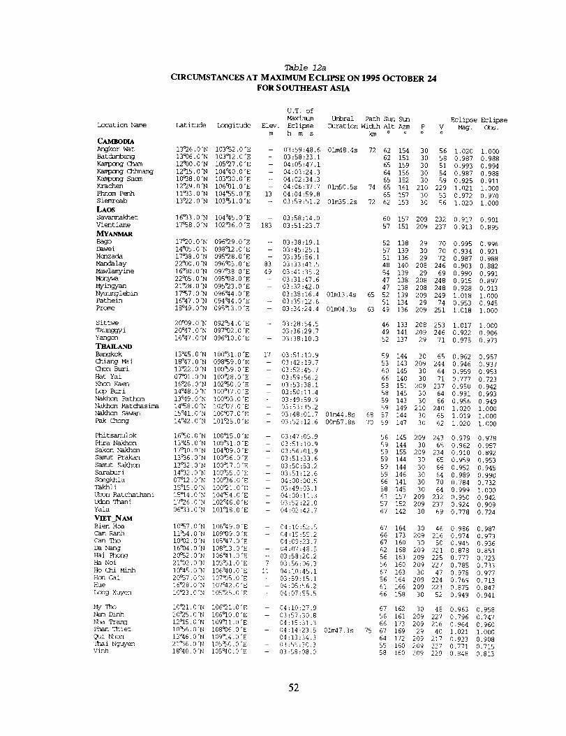
Location Name
C_4SOD_Ar_kor _t
Batdambang
Kampong C]mmK_mono eenangKa_xmg Sacra
Krachen
Phnom P_lh
Si_mreab
LAOS
Savannakhet
Vientiane
MYANMAR
Bago
Dawei
H_nzada
Mandalay
Mawlamyine
Mzny_a
My_ngyan
Nyaung I ebin
Pathein
Prome
Sit twe
q'aunggyi
Yangon
TSm_ANDBangkok
Chiang Mai
Chon Buri
Hat Yai
Khon Kaem
Lop Buri
Nakhcn Fathom
Nakhon Ratchasima
Nakhon Saw-an
pak <ihong
Phit sanulok
Phra Nakhon
Sakon Nakhon
Samut Prakan
Samut Sakhon
Sarah_ i
Scngkhla
Takhli
Ubon Hatchathani
Ucbn qhani
Yala
Vn_T_NAMBien Hoa
Cam Ranh
Can qho
Da Nang
Hai Phong
Ha Noi
HoChi Minh
Hon Gai
Hue
Long Xuyen
MyqhoNam Dinh
Nha Trang
Phan Thiet
Qui hhon
Thai Nguyen
Vinh
Table 12a
CIRCUMSTANCES AT MAXIMUM ECLIPSE ON 1995 OCTOBER 24FOR S OUTHEAST ASIA
U.T. of
Maximum Umbral Path Sun Sun Eclipse Eclipse
Latitude Longitude Elev. Eclipse Duration width Alt Azm P V Mag. Ohs.
m h m s km o o o o
13°26.0"N 103052.0"E
13006.0"N 103°12.0"E
12000.0"N I05O27.0 "E
12°15.0"N i04°40.0"E
10°38.0"N 103030.0"E
12O29.0"N 106°01.0"E
I1033 .0"N i04055.0 "E
13o22 .0 "N i03051.0 "E
- 03:59:48.6 01m48.4s 72 62 154 30 56 1,020 1.000
- 03:58:33.1 62 151 30 58 0.987 0,988
- 04:05:47,1 65 159 30 51 0,993 0.994
- 04:03:24.3 64 156 30 54 0.987 0,988
-- 04:02:34.3 65 152 30 59 0.925 0.911
- 04:06:37.7 01mS0.Ss 74 65 161 210 229 1.021 1.000
13 04:04:59.8 65 157 30 53 0.972 0.970
- 03:59:51.2 01m35,2s 72 62 153 30 56 1.020 1.000
16O33.0"N i04°45.0"E -- 03:58:14.0
17°58.0"N I02036.0"E 183 03:51:23,7
17O20.0"N 096O29.0 "E - 03:38:19.1
14005.0"N 098O12.0 "E - 03:45:25.1
17038.0"N 095°28.0 "E - 03:35:56.1
22°00.0"N 096005.0"E 83 03:33:41.5
16O30.0"N 097°38.0 "E 49 03:41:35.2
22005.0"N 095008.0"E - 03:31:47,6
21O28.0"N 095O23.0"E - 03:32:42.0
60 157 209 232 0.917 0.901
57 151 209 237 0.913 0.895
52 138 29 70 0.995 0,996
57 139 30 70 0.934 0.921
51 136 29 72 0.987 0.988
48 140 208 246 0.903 0.882
54 139 29 69 0.990 0.991
17057.0"N 096°44.0 "E
16o47.0"N 094°44.0 "E
18°49.0"N 095°13.0"E
20°09.0"N 092054.0"E
20°47 .0"N 097002.0 "E
16°47.0"N 096O10.0"E
13°45 •0"N 100O31,0"E
18°47 ,0 "N 098059.0 "E
13O22 ,0"N i00059.0 "E
07001.0"N 100°28.0 "E
16o26 .0"N 102050.0 "E
14°48.0"N 100°37.0"E
13°49.0"N 100003.0"E
14058.0"N 102°07.0 "E
15°41.0"N 100°07.0"E
14°42 .0"N I01O25.0"E
16°50.0"N i00=15.0 "E
13°45.0"N 100031.0"E
17°10.0"N 104939.0"E
13O36.0"N I00036.0"E
13°32.0"N 100°17.0 "E
14°32.0"N 100055.0"E
07°12.0"N 100°36.0"E
15°15.0"N 100°21.0 "E
15°14.0"N I04054.0"E
17O26.0 "N I02°46.0"E
06033.0"N 101O18.0"E
47 138 208 248 0.915 0.897
47 138 208 248 0,928 0.913
-- 03:38:16.4 01m13.4s 65 52 139 209 249 1.018 1.000
-- 03:35:12.6 51 134 29 74 0.953 0.945
- 03:34:24.4 01m04.3s 63 49 136 209 251 1.018 1.000
- 03:28:54.5
- 03:36:29.7
-- 03:38:10.3
46 133 208 253 1.017 1.000
49 141 209 246 0.922 0.906
52 137 29 71 0.975 0.973
17 03:51:10.9 59 144 30 65 0.962 0.957
- 03:42:19.7 53 143 209 244 0.946 0.937
- 03:52:45.7 60 145 30 64 0.959 0,953
- 03:59:56.2 66 140 30 71 0.777 0.723
- 03:53:38.1 58 151 209 237 0.950 0.942
- 03:50:11.4 58 145 30 64 0.991 0.993
- 03:49:59.9 59 143 30 66 0.956 0.949
- 03:53:35.2 59 149 210 240 1.020 1.000
- 03:48:01.7 01m44.8s 68 57 144 30 65 1.019 1.000
- 03:52:12.6 00m57.Ss 70 59 147 30 62 1.020 1.000
- 03:47:05.9
- 03:51:i0.9
- 03:56:01.9
- 03:51:33.6
- 03:50:53.2
- 03:51:12.6
- 04:00:00.5
- 03:49:03.1
- 04:00:11.3
- 03:52:22.0
- 04:02:42.7
56 145 209 243 0.979 0.978
59 144 30 65 0.962 0.957
59 155 209 234 0.910 0.892
59 144 30 65 0.959 0.953
59 144 30 66 0.952 0.945
59 146 30 64 0.989 0.990
66 141 30 70 0.784 0.732
58 145 30 64 0.999 1.000
61 157 209 232 0.950 0.942
57 152 209 237 0.924 0.909
67 142 30 69 0.778 0.724
i0057 .0"N i06°49.0"E
11054.0"N 109939.0"E
10932.0"N 105°47.0"E
16004 .0"N 108=13.0 "E
20052 .0 "N 106°4 I. 0 "E
21°02.0"N 105051.0"E
10°45.0"N 106°40.0"E
20°57.0"N 107938.0"E
16O28.0"N 107°42.0"E
I0O23.0"N I05O25.0"E
I0O21 .0"N I06O21.0"E
20O25.0"N 106°10.0"E
12O15 .0 "N I09=11.0 "E
10056.0 "N 108006.0 "E
13°46 .0"N 109014.0 "E
21°36.0"N 105050.0"E
18°40.0"N I05°40.0"E
- 04:10:52.5
04:15:55.2
- 04:09:23.7
-- 04:07:48.5
-- 03:58:20.2
7 03:56:06.3
Ii 04:10:45.1
-- 03:59:15.1
- 04:05:56.2
-- 04:07:55.5
67 164 30 46 0.986 0.987
66 173 209 216 0.974 0.973
67 160 30 50 0.945 0.936
62 168 209 221 0.878 0,851
56 163 209 225 0.777 0,723
56 160 209 227 0.785 0.733
67 163 30 47 0,978 0.977
56 164 209 224 0.769 0.713
61 166 209 223 0.875 0.847
66 158 30 52 0.949 0.941
-- 04:10:27.9 67 162 30 48 0.963 0.958
-- 03:57:30.8 56 161 209 227 0.796 0.747
-- 04:15:31.3 66 173 209 216 0.964 0.960
-- 04:14:23.5 01m47.3s 75 67 169 29 40 1.021 1.000
-- 04:13:34.3 64 172 209 217 0.923 0.908
-- 03:55:30.3 55 160 209 227 0.771 0.715
- 03:S8:08.0 58 160 209 229 0.848 0.813
52
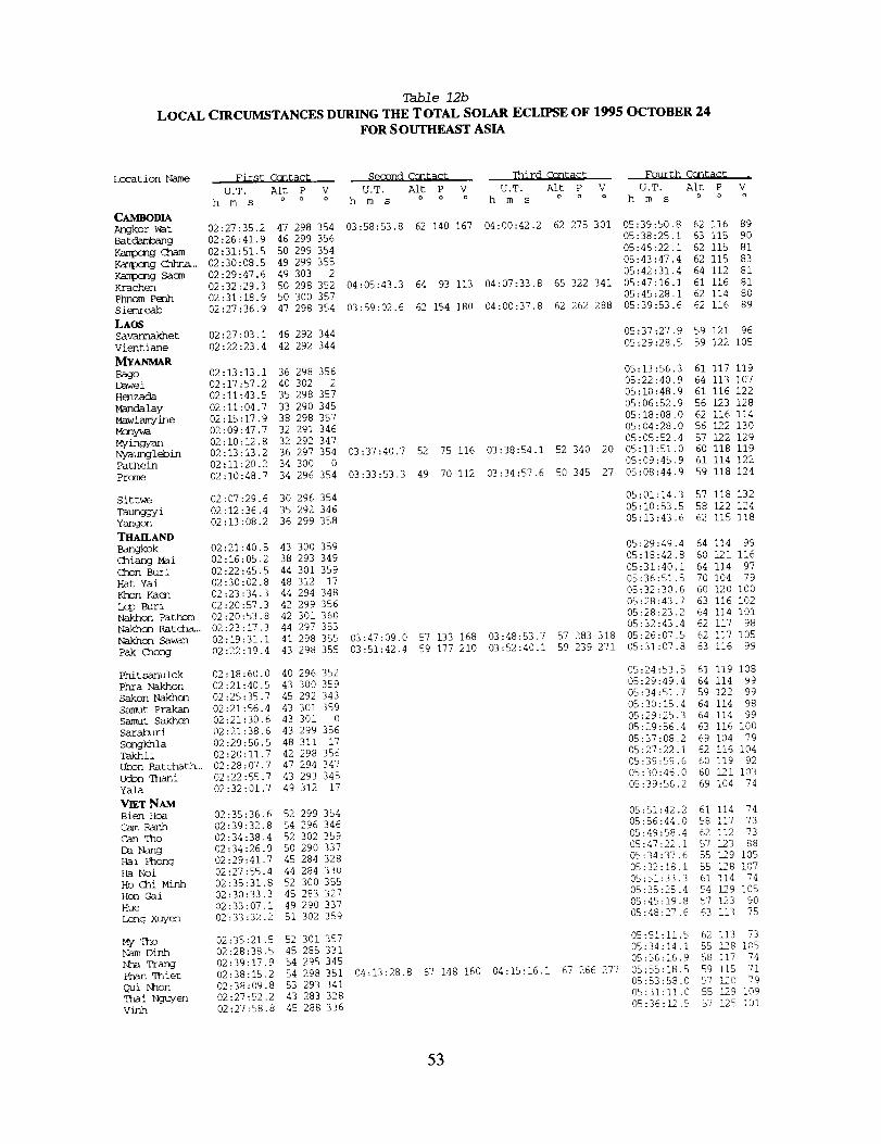
Table 12b
LOCAL CIRCUMSTANCES DURING THE TOTAL SOLAR ECLIPSE OF 1995 OCTOBER 24
FOR S OUTHEAST ASIA
Location Name
CAMBODIA
Angkor War
Batdambang
Kampang _hamKa_xnq _..Kampcng Sacra
Krachen
Phnom P_mh
S iemreab
LAG
Savannakhet
Vientiane
MYANMARBago
[]awe i
Henzada
Mandalay
Mawlamyine
Mcny%_
Myingyan
Nvaunglebin
Pathein
Prome
Sittw_
Taunggyi
Yangon
THAILAND
Bangkok
(ihiang M_i
Chon Buri
Hat Yai
Khan Kaen
L_ Buri
Nakhon Fathom
Nakhon Rat ch_..
Nakhcn Sawan
Pak thong
Phi t sanul ok
Phra Nakhon
Sakon Nakhcn
Samut Prakan
Samut Sakhon
Saraburi
Songkhla
Takhli
Ubon Ratchath..
Udmn Thani
Yala
VIET NAM
Bien Hoa
cam RanhCan Tho
De Nang
Hal Phong
Ha Noi
Ho Chi Minh
Hon Gai
Hue
[/D_g Xuyen
My_hoNam Dinh
Nha Trang
Phan qhiet
Qui hhon
Thai NguyenVinh
First Ccntac_ Second Ccntact qhird C(xlt_gy Fourth Contac t ,
U.T. Alt P V U.T. Alt P V U.T. Alt P V U.T. Alt P V
h m s o o o h m s o o o h m s o o o h m s o o o
02:27:35.2 47 298 354 03:58:53.8 62 140 167 04:00:42.2 62 275 301 05:39:50.8 62 116 89
02:26:41.9 46 299 356 05:38:25.1 63 115 90
02:31:51.5 50 299 354 05:46:22.1 62 115 81
02:30:08.5 49 299 355 05:43:47.4 62 115 83
02:29:47.6 49 309 2 05:42:31.4 64 112 81
02:32:29.3 50 298 352 04:05:43.3 64 93 113 04:07:33.8 65 322 341 05:47:16.1 61 116 81
02:31:18.9 50 300 357 05:45:28.1 62 114 80
02:27:36.9 47 298 354 03:59:02.6 62 154 180 04:00:37.8 62 262 288 05:39:53.6 62 116 89
02:27:03.1 46 292 344 05:37:27.9 59 121 96
02:22:23.4 42 292 344 05:29:28.5 59 122 105
02:13:13.1 36 298 356 05:13:56.3 61 117 119
02:17:57.2 40 302 2 05:22:40.9 64 113 107
02:11:43.5 35 298 357 05:10:48.9 61 116 122
02:11:04.7 33 290 345 05:06:52.9 56 123 128
02:15:17.9 38 298 357 05:18:08.0 62 116 114
02:09:47.7 32 291 346 05:04:28.0 56 122 130
02:10:12.8 32 292 347 05:05:52.4 57 122 129
02:13:13.2 36 297 354 03:37:40.7 52 75 116 03:3@:54.1 52 340 20 05:13:51.0 60 118 119
02:11:20.2 34 300 0 05:09:45.9 61 114 122
02:10:48.7 34 296 354 03:33:53.3 49 70 112 03:34:57.6 50 345 27 05:08:44.9 59 118 124
02:07:29.6 30 296 354 05:01:14.3 57 118 132
02:12:36.4 35 292 346 05:10:53.5 58 122 124
02:13:08.2 36 299 358 05:13:43.6 62 115 118
02:21:40.5 43 300 359 05:29:49.4 64 114 99
02:16:05.2 38 293 349 05:18:42.8 60 121 116
02:22:45.5 44 301 359 05:31:40.1 64 114 97
02:30:02.8 48 312 17 05:36:51.5 70 104 79
02:23:34.3 44 294 348 05:32:30.6 60 120 I00
02:20:57.3 42 299 356 05:28:43.7 63 116 102
02:20:53.8 42 301 360 05:28:23.2 64 114 i01
02:23:17.3 44 297 353 05:32:43.4 62 117 98
02:19:31.1 41 298 355 03:47:09.0 57 133 168 03:48:53.7 57 283 318 05:26:07.5 62 117 105
02:22:19.4 43 298 355 03:51:42.4 59 177 210 03:52:40.1 59 239 271 05:31:07.8 63 116 99
02:18:60.0 40 296 352 05:24:53.5 61 119 108
02:21:40.5 43 300 359 05:29:49.4 64 114 99
02:25:35.7 45 292 343 05:34:51.7 59 122 99
02:21:56.4 43 301 359 05:30:15.4 64 114 98
02:21:30.6 43 301 0 05:29:25.3 64 114 99
02:21:38.6 43 299 356 05:29:56.4 63 116 I00
02:29:56.5 48 311 17 05:37:08.2 69 104 79
02:20:11.7 42 298 356 05:27:22.1 62 116 104
02:28:07.7 47 294 347 05:39:59.6 60 119 92
02:22:55.7 43 293 345 05:30:46.0 60 121 103
02:32:01.7 49 312 17 05:39:56.2 69 104 74
02:35:36.6 52 299 354 05:51:42.2 61 114 74
02:39:]2.8 54 296 346 05:56:44.0 58 117 73
02:34:38.4 52 302 359 05:49:58.4 62 112 73
02:34:26.9 50 290 337 05:47:22.1 57 123 88
02:29:41.7 45 284 328 05:34:37.6 55 129 105
02:27:55.4 44 284 330 05:32:18.1 55 128 107
02:35:31.8 52 300 355 05:51:33.3 61 114 74
02:30:33.3 45 283 327 05:35:25.4 54 129 105
02:33:07.1 49 290 337 05:49:19.8 57 123 90
02:33:32.2 51 302 359 05:48:27.6 63 113 75
02:35:21.5 52 301 357 05:51:Ii.5 62 113 73
02:28:38.5 45 285 331 05:34:14.1 55 128 105
02:39:17.9 54 295 345 05:56:16.9 58 117 74
02:38:15.2 54 298 351 04:13:28.8 67 148 160 04:15:16.1 67 266 277 05:55:18.5 59 115 71
02:38:09.8 53 293 341 05:53:58.0 57 120 79
02:27:52.2 43 283 328 05:31:11.0 55 129 109
02:27:58.8 45 288 336 05:36:12.5 57 125 I01
53
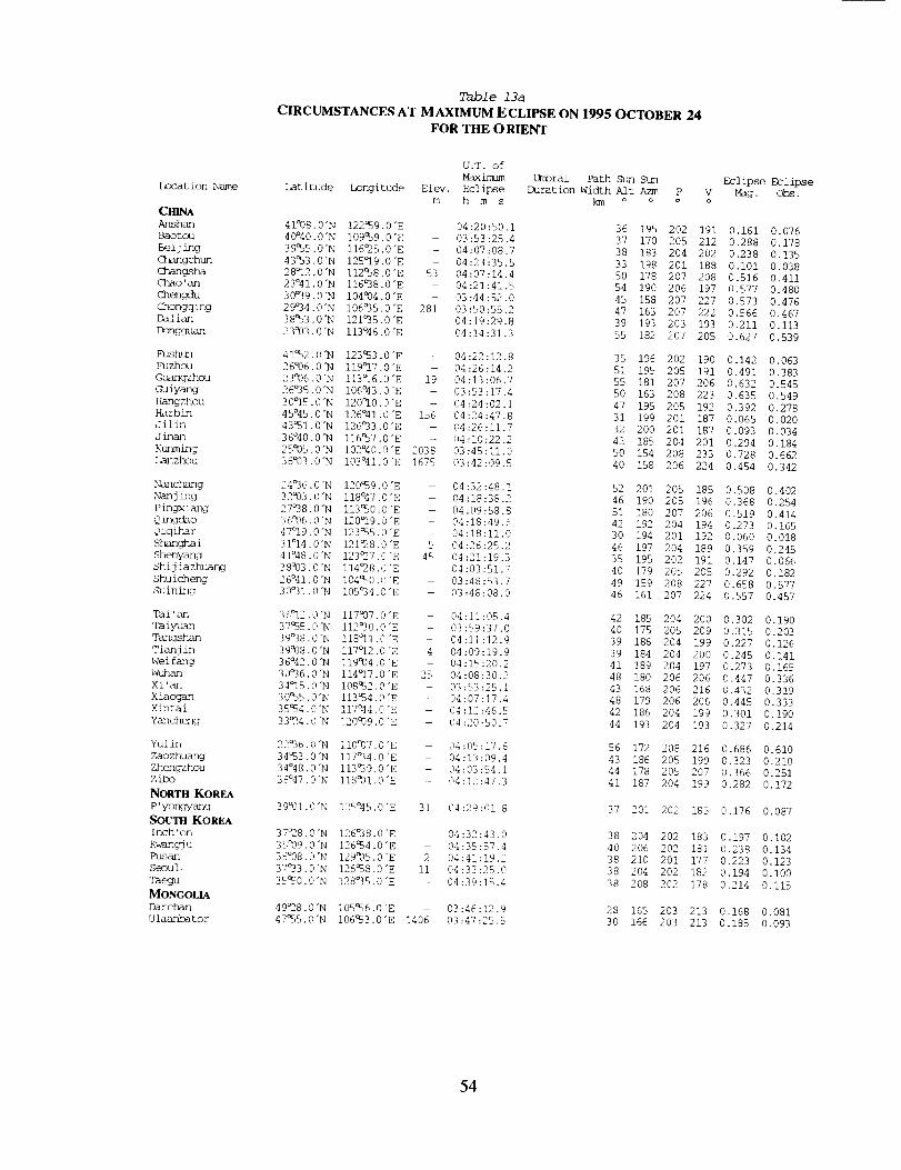
Location Name
CHINAAnshan
Baotou
Bei j ing
Changchun
C_gsha
Chao 'an
Chengdu
Chongqing
Dalian
Dongguan
Fushun
Fuzhou
Guangzhou
Guiyang
Hangzhou
Harbin
Jilin
J inan
Kunming
Lanzhou
Nanchang
Nanj ing
P ingxiang
Q ingcho
Qiqihar
S han c_ha i
Shenyang
Shij ia zhuang
Shu i cheng
Suining
Tai 'an
Taiyuan
Tangshan
Tianj in
Wei fang
Wuhan
Xi'an
Xiac_
Xintai
Yancheng
Yul in
Zaozhuang
Zhengzhouzibo
NORTH KOREA
P' yongyang
SOUTII KOREA
Inch' on
Kw_ngj u
Pusan
Seou i
Taegu
MONGOLIA
Darc_
Ulaanbator
Table 13a
CIRCUMSTANCES AT MAXIMUM ECLIPSE ON 1995 OCTOBER 24
FOR THE O RIENT
U.T. of
Maximum Umbral Path Sun Sun
Latitude Longitude Elev. Eclipse Duration width Alt Azm P V
m h m s km o o o o
41°08.0"N 122¢59.0"E 04:20:50.1 36 195 202 191
40°40.0"N i09c59.0"E 03:53:25.4 37 170 205 212
39_5.0"N I16°25.0"E - 04:07:08.7 38 183 204 202
43Q53.0"N 125°19.0"E - 04:23':35.5 33 198 201 188
28°12.0"N I12_38.0"E 53 04:07:14.4 50 178 207 208
23°41.0"N I16°38.0"E - 04:21:41.5 54 190 206 197
30°39.0"N I04_04.0"E - 03:44:52.0 45 158 207 227
29°34.0"N I06°35.0"E 281 03:50:55.2 47 163 207 222
38%3.0"N 121°35.0"E - 04:19:29.8 39 193 203 193
23993.0"N 113°46.0"E 04:14:31.3 55 182 207 205
41%2.0"N 12353.0"E -- 04:22:12.8 35 196 202 190
26°06.0"N I19°17.0"E -- 04:26:14.2 51 195 205 191
23°06.0"N I13°16.0"E 19 04:13:06.7 55 181 207 206
26°35.0"N I06°43.0"E 03:53:17.4 50 163 208 223
30°15.0"N 120°I0.0"E -- 04:24:02.1 47 195 205 192
45°45.0"N 126°41.0"E 156 04:24:47.8 31 199 201 187
43%1.0"N 126°33.0"E - 04:26:11.7 32 200 201 187
36°40.0"N I1657.0"E -- 04:10:22.2 42 189 204 201
25°05.0"N I02°40.0"E 2038 03:45:11.0 50 154 208 233
36°03.0"N I03°41.0"E 1675 03:42:09.5 40 158 206 224
24°36.0"N 120%9.0"E - 04:32:48.1 52 201 205 185
329}3.0"N I18°47.0"E - 04:18:38.2 46 190 205 196
27°38.0"N 11350.0"E 04:09:58.8 51 180 207 206
36°06.0 "N 120_19.0 "E - 04:18:49.6 42 192 204 194
47°19.0"N 12355.0'E - 04:18:11.0 30 194 201 192
31°14.0"N 121_8.0"E 5 04:26:25.2 46 197 204 189
41°48.0"N 123_7.0"E 45 04:21:19.3 35 195 202 191
38°03.0"N I14_8.0"E 04:03:51.7 40 179 205 205
26°41.0"N I0450.0"E -- 03:48:53.7 49 159 208 227
30°31.0"N I05°34.0"E - 03:48:08.0 46 161 207 224
36°12.0"N I17937.0"E - 04:11:05.4 42 185 204 200
37%5.0"N I12°30.0"E - 03:59:37.0 40 175 205 209
39°38.0"N IIS°II.0"E - 04:11:12.9 39 186 204 199
39938.0"N I17°12.0"E 4 04:09:19.9 39 184 204 200
36°42.0"N I199}4.0"E - 04:15:20.2 41 189 204 197
30°36.0"N I14_17.0"E 25 04:08:30.2 48 180 206 206
34°15.0"N 108_2,0"E 03:53:25.1 43 168 206 216
30_35.0"N 113%4.0"E - 04:07:17.4 48 179 206 206
3554.0"N 117°44.0 "E 04:12:46.5 42 186 204 199
33_4.0"N 120°09.0"E - 04:20:50.7 44 193 204 193
22°36.0"N II0997.0"E 04:05:17.6 56 172 208 216
34%3.0"N I17°34.0"E - 04:13:09.4 43 186 205 199
34°48.0"N I13_39.0"E - 04:03:54.1 44 178 205 207
36°47.0"N 118931.0"E - 04:12:47.3 41 187 204 199
39°01.0"N 125°45.0"E 31 04:29:01.8 37 201 202 185
37_8.0"N 126°38.0"E - 04:32:43.0 38 204 202 183
359}9.0"N 12654.0"E - 04:35:R7.4 40 206 202 181
35°08.0"N 129°05.0"E 2 04:41:19.2 38 210 201 177
37°33.0"N 12658.0"E II 04:33:25.0 38 204 202 182
3550.0"N 128°35.0"E - 04:39:15.4 38 208 202 178
49_8.0"N I0556.0"E -- 03:46:12.9 28 165 203 213
47%5.0"N 106a53.0"E 1406 03:47:25.5 30 166 203 213
Eclipse Eclipse
Mag. Obs.
0.161 0.076
0.288 0.178
0.238 0.135
0.i01 0.038
0.516 0.411
0.577 0.480
0.573 0.476
0.566 0.467
0.211 0.113
0.627 0.539
0.142 0.063
0.491 0.383
0.632 0.545
0.635 0.549
0.392 0.278
0.065 0.020
0.093 0.034
0.294 0.184
0.728 0.662
0.454 0.342
0.508 0.402
0.368 0.254
0.519 0.414
0.273 0.165
0.060 0.018
0.359 0.245
0.147 0.066
0.292 0.182
0.658 0.577
0.557 0.457
0.302 0.190
0.315 0.203
0.227 0.126
0.245 0.141
0.273 0.165
0.447 0.336
0.432 0.319
0.445 0.333
0.301 0.190
0.327 0.214
0.686 0.610
0.323 0.210
0.366 0.251
0.282 0.172
0.176 0.087
0.197 0.102
0.238 0.134
0.223 0.123
0.194 0.i00
0.214 0.115
0.168 0.081
0.185 0.093
54
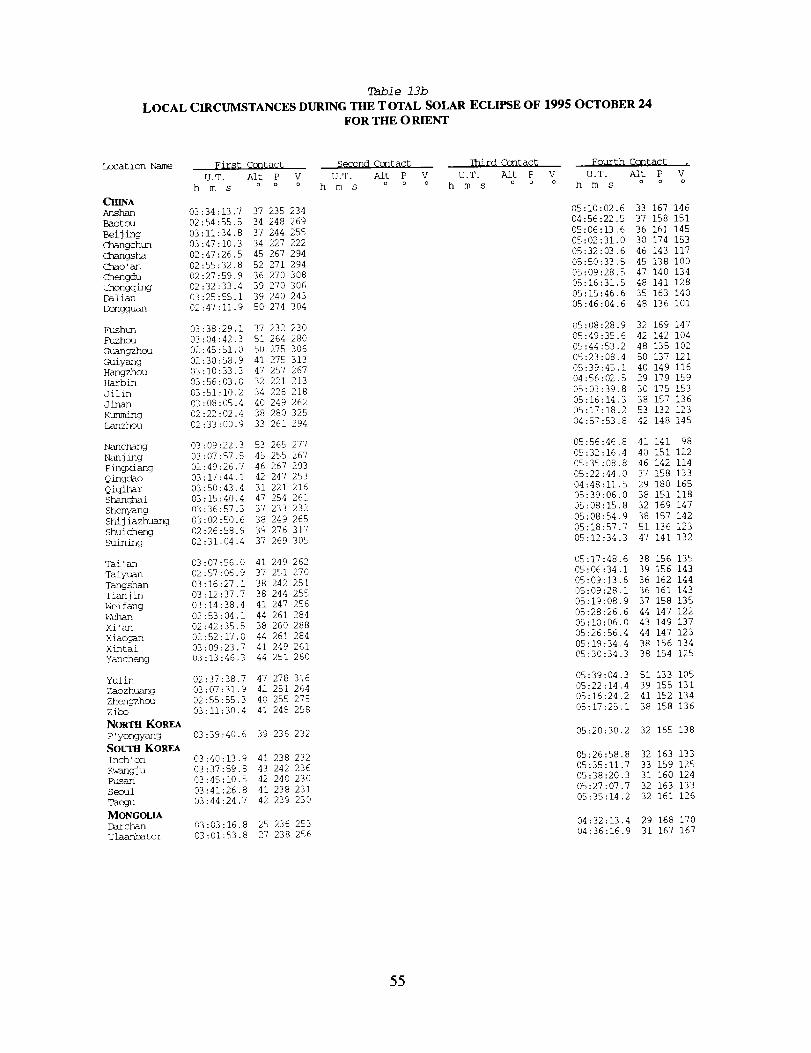
Table 13b
LOCAL CIRCUMSTANCES DURING THE TOTAL SOLAR ECLIPSE OF 1995 OCTOBER 24FOR THE O RIENT
Location Name First Contact Second Contact qhird Ccntac_ Fourth Contag_ ,
U.T. Alt P V U.T. Aft P V U.T. Alt P V U.T. Alt P V
h m s o o o h m s o o o h m s o o o h m s o o o
CHINA
Anshan 03:34:13.7 37 235 234 05:10:02.6 33 167 146
Baotcu 02:54:55.5 34 248 269 04:56:22.5 37 158 151
Beijing 03:11:34.8 37 244 255 05:06:13.6 36 161 145
Changchun 03:47:10.3 34 227 222 05:02:31.0 30 174 153
Changsha 02:47:26.5 45 267 294 05:32:03.6 46 143 117
Chao'an 02:55:32.8 52 271 294 05:50:33.S 45 138 i00
Chengdu 02:27:59.9 36 270 308 05:09:28.5 47 140 134
Chongqing 02:32:33.4 39 270 306 05:16:31.5 48 141 128
Dalian 03:25:55.1 39 240 243 05:15:46.6 35 163 140
Dongguan 02:47:11.9 50 274 304 05:46:04.6 48 136 i01
Fushun 03:38:29.1 37 232 230 05:08:28.9 32 169 147
Fuzhou 03:04:42.3 51 264 280 05:49:35.6 42 142 104
Guangzhou 02:45:51.0 50 275 306 05:44:53.2 48 135 102
Guiyang 02:30:58.9 41 275 313 05:23:08.4 50 137 121
Hangzhou 03:10:33.3 47 257 267 05:39:45.1 40 149 116
Harbin 03:56:03.0 32 221 213 04:56:02.5 29 179 159
Jilin 03:51:I0.2 34 226 218 05:03:39.8 30 175 153
Jinan 03:08:05.4 40 249 262 05:16:14.3 38 157 136
Kunming 02:22:02.4 38 280 325 05:17:18.2 53 132 123
Lanzhou 02:33:00.9 33 261 294 04:57:53.8 42 148 145
Nanchang 03:09:22.3 53 265 277 05:56:46.8 41 141 98
Nanjing 03:07:57.5 45 255 267 05:32:16.4 40 151 122
Pingxiang 02:49:26.7 46 267 293 05:35:08.8 46 142 114
Qingdao 03:17:44.1 42 247 253 05:22:44.0 37 158 133
Qiqihar 03:50:43.4 31 221 216 04:48:11.5 29 180 165
Shanghai 03:15:40.4 47 254 261 05:39:06.0 38 151 118
shenyang 03:36:57.3 37 233 232 05:08:15.8 32 169 147
sh/jiazhuang 03:02:50.6 38 249 265 05:08:54.9 38 157 142
Shuicheng 02:26:58.9 39 276 317 05:18:57.7 51 136 123
Suining 02:31:04.4 37 269 305 05:12:34.3 47 141 132
Tai'an 03:07:56.0 41 249 262 05:17:48.6 38 156 135
Taiyuan 02:57:06.9 37 251 270 05:06:34.1 39 156 143
Tangshan 03:16:27.1 38 242 251 05:09:13.6 36 162 144
Tianjin 03:12:37.7 38 244 255 05:09:28.1 36 161 143
Weifang 03:14:38.4 41 247 256 05:19:08.9 37 158 135
_A/nan 02:53:04.1 44 261 284 05:28:26.6 44 147 122
Xi'an 02:42:35.5 38 260 288 05:10:06.0 43 149 137
Xiaogan 02:52:17.0 44 261 284 05:26:56.4 44 147 123
xintai 03:09:23.7 41 249 261 05:19:34.4 38 156 134
Yancheng 03:13:46.3 44 251 260 05:30:34.3 38 154 125
Yulin 02:37:38.7 47 278 316 05:39:04.3 51 133 105
Zaozhuang 03:07:31.9 42 281 264 05:22:14.4 39 155 131
Zhengzhou 02:55:55.3 40 255 275 05:16:24.2 41 192 134
zibo 03:11:30.4 41 248 258 05:17:25.1 38 158 136
NORTH KOREA
P'yongyang 03:39:40.6 39 236 232 05:20:30.2 32 165 138
SOUTBKoREA
Inch'on 03:40:13.9 41 238 232 05:26:58.8 32 163 133
K_tngju 03:37:59.8 43 242 236 05:35:11.7 33 159 125
Pusan 03:45:10.5 42 240 230 05:38:20.3 31 160 124
Seoul 03:41:26.8 41 238 231 05:27:07.7 32 163 133
Taegu 03:44:24.7 42 239 230 05:35:14.2 32 161 126
MONGOLIADarchan 03:03:16.8 25 236 253 04:32:13.4 29 168 170
Ulaanbator 03:01:53.8 27 238 256 04:36:16.9 31 167 167
55
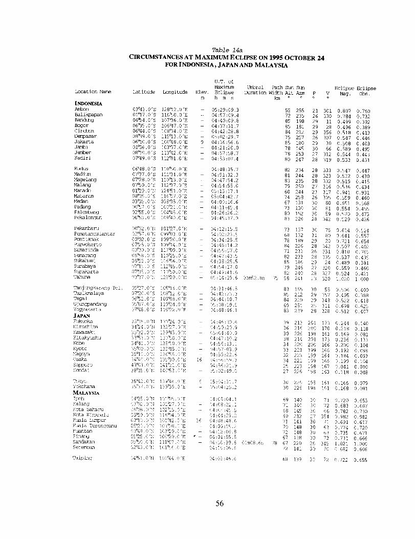
Location Name
INDONESIA
Ambon
Balikpapan
Bandung
Bogor
Cirebon
Denpasar
Jakarta
Jambi
Jember
Kediri
K1_us
Madiun
Mage fang
Malang
Manacb
Mataram
Medan
Padang
Palem_
Peka longan
Pekanbaru
Pematangs iantar
Pont ianak
l_kerto
Samarinda
Semarang
Sukakumi
Surabaya
Surakarta
Tmhuna
Tanj ungka rang Tel.
Tas ikma laya
Tega 1
U j ungpandang
Ycgyak_rt a
JAPAN
_kuoka
Hiroshima
Kaw-asaki
Kit ako_/ushu
Kobe
Kyoto
Nagoya
Osaka
Sapporo
Sendal
Tokyo
Yokobm_ma
_LAYS[A
!poh
Kelang
Fota Bakm ru
Fota Kinm_ba i u
Kuala Ltmlour
Kuala Ter enggar_u
Kusu_tsu_1
Pinang
Sandakaun
Set e_n
Taiping
Table 14a
CIRCUMSTANCES AT MAXIMUM ECLIPSE ON 1995 OCTOBER 24
FOR INDONESIA, JAPAN AND MALAYSIA
U.T. of
Maximum
Latitude Longitude Elev. Eclipse
m h m s
03°43.0"S 128°12.0 "E - 05:29:09.3
01°]7 •0"S I16C50.0 "E - 04:57:09.4
06Q54.0"S i07°36.0 "E - 04:40:09.8
06°35.0"S I06°47.0 "E - 04:37:31.7
06°44.0"S I08O34.0"E - 04:42:28.8
08°39.0"S I15°13.0"E -- 05:02:29.7
06°I0.0"S i06°48.0 "E 9 04:36:56.6
01O36.0"S 103O37.0 "E -- 04:21:20.0
08°i0.0"S 113°42.0"E - 04 ;57:58.7
07°49.0 "S 112991.0 "E - 04:53:07.4
06°48.0"S l10aS0.0 "E - 04:48:35.7
07O37.0"S IIIO31.0 "E -- 04:51:32.3
07°28.0"S ii0°]3.0 "E -- 04:47:54.2
07°59.0 "S I12O37.0"E - 04:54:55.0
01°29.0"N 124_I.0"E - 05:15:17.1
08°35.0"S 116937.0"E - 05:04:42.7
03°35.0"N 098°35.0"E -- 04:00:16.6
00_7.0"S I00_I.0"E - 04:11:45.4
02°_5.0"S 104°45.0"E - 04:26:26.2
06°53 -0"S 109°40.0"E - 04:45:37.0
00°32 •0 "H ]01°27.0 "E - 04:12:15.5
02°57.0 "N 099933.0 "E 04:02:23.5
00°02.0"S I09C20.0 "E - 04:34:25.5
07°25.0"S I09°14.0 "E - 04:45:14.2
00O30.0"S I17939.0"E 04:56:57.0
06_8.0"S ii0°25.0 "E - 04:47:43.5
06_,5.0"S 106_6.0"E 04:38:25.5
07°15 •0"S i12°45.0 "E 04:54:17.0
07°35.0"S II0_0.0"E - 04:49:41.6
03_37.0"_J 125_29.0"E 05;14:19.6
05°27 -0"S I05°16.0"E 04:31:46.5
07°20.0 "S i08c12.0 "E - 04:42:23.3
06°_2.0"S I09°98.0 "E - 04:44:10.7
c c05°07.0 "S I19_±4 -0 "E -- 05:08:o9._
07°48.0 "S Ii0%2.0 "E - 04:48:46.1
33O35.0"N 130°24.0 "E - 04:46:30.6
34_4.0"N 132°27.0"E 04:50:20.9
35O32.0"N 139043.0"E 05:04:40.9
33°53.0"N 130_0.0"E 04:47;I0.2
34°41.0"N 135°I0.0"E 04:56:13.1
35°00.0"N 135°45.0"E - 04:57:03.9
35°I0.0"N 136%5.0"E 04:59:22.6
34°40.0"N 135_0.0"E 16 04:56:59.3
43°03.0"N !4!_I.0"E 04:56:21.9
38°IE,. O'N 140_3.0"E 05:02:49.0
35°42 -0 "b! 139°46.0 "E 6 05:04:31.7
35%7.0"r; 139O39.6"E - 05:04:25.2
04°35. ,3":_ !01W)5.0 "E 04:05:04. I
03°02.,3q_ _ _ "__3,_L., .0 E 04:08:22.1
06°08.0"_[ I02_15.0"E - 04:05:45.5
'85_9.0"[; i16_14.0"E 04:44:29.2
03°I0. C"_; I01°42.0 "E 36 04:08:48.6
05_O.O'N I03_)8.0 "E - 04:09:!5.2
03°48.0"_ I03°20.0 "E 04:12;06.8
05°25.0"N 100°20.0"E • - 04:01:55.5
05°50.0 "N 118937.0 "E - 04:50:39.6
02°43.0 "[._ 10I_6.0"E 04:10:06.6
04_I.0"N 100°44.0"E 04:03;46.6
Umbral Path Sun
Duration Width Alt Azm P v
km o o o o
55 255 21 301
72 235 26 330
85 198 29 ii
85 181 29 28
84 212 29 356
75 257 26 307
85 180 29 30
78 145 30 66
78 253 27 312
80 247 28 319
01m52.Ss 75
01m08.6s 78
Eclipse Eclipse
Mag. obs.
0.807 0.760
0.784 0.732
0.499 0.392
0.496 0.389
0.518 0.413
0.547 0.446
0.508 0.403
0.589 0.495
0.544 0.443
0.533 0.431
82 234 28 333 0.547 0.447
81 244 28 323 0.532 0.430
83 235 28 332 0.519 0.415
79 250 27 316 0.536 0.434
60 244 23 317 0.941 0.931
74 258 26 305 0.559 0.460
67 131 30 80 0.651 0.568
73 130 30 81 0.554 0.455
80 152 30 59 0.570 0.473
83 226 28 342 0.529 0.426
73 137 30 75 0.614 0.524
68 132 31 80 0.641 0.557
78 189 29 20 0.721 0.654
84 226 28 342 0.507 0.402
71 233 26 331 0.810 0.765
82 233 28 335 0.537 0.435
85 186 29 24 0.489 0.381
79 246 27 320 0.559 0.460
82 240 28 327 0.524 0.421
58 241 23 320 1.020 1.000
83 155 30 55
85 212 29 357
84 220 29 348
69 251 25 311
83 239 28 328
39 213 201 173
36 216 200 170
30 226 198 161
38 214 201 173
34 220 200 166
33 221 199 166
32 223 199 164
34 221 199 166
25 223 198 167
27 226 198 163
30 226 198 161
30 226 198 161
69 140 30 71
71 140 30 72
68 145 30 66
69 212 27 354
71 141 30 71
70 148 30 63
72 148 30 63
67 138 30 73
67 220 26 345
72 141 30 70
68 139 30 72
0.506 0.400
0.495 0.388
0.522 0.418
0.698 0.625
0.512 0.407
0.244 0.140
0.218 0.118
0.169 0.081
0.236 0.193
0.200 0.104
0.192 0.098
0.184 0.093
0.199 0.104
0.041 0.010
0.118 0.048
0.166 0.079
0.168 0.081
0.720 0.653
0.683 0.607
0.782 0.730
0.982 0.982
0.691 0.617
0.774 0.720
0.735 0.671
0.731 0.666
1.021 1.000
0.682 0.606
0.722 0.655
56
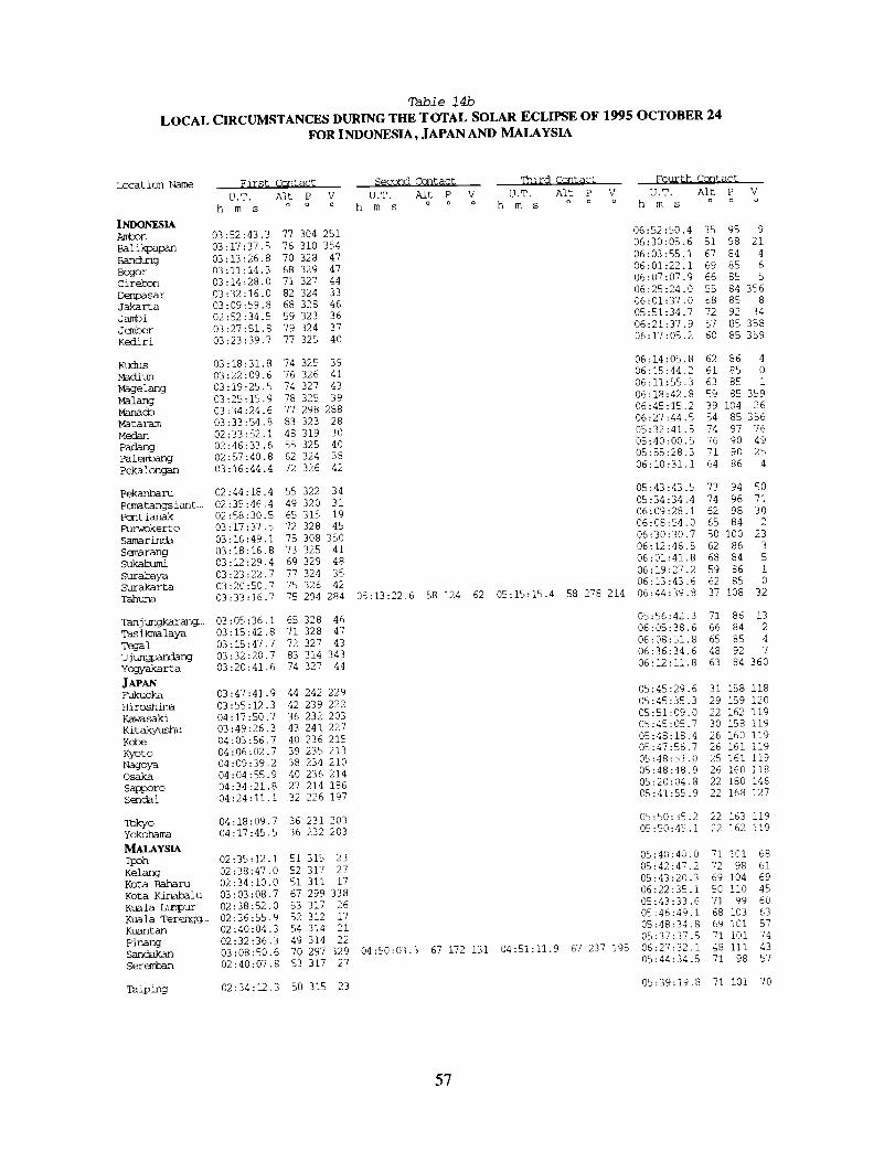
Table 14b
LOCAL CIRCUMSTANCES DURING THE TOTAL SOLAR ECLIPSE OF 1995 OCTOBER 24
FOR INDONESIA, JAPAN AND MALAYSIA
Location Name
INDONESIAA_t_n
Band_g
Cir_n
D_r_arJakarta
J_r
Kediri
Kudus
Madiun
Magelang
Ma lang
Manacb
Mat al-am
Medan
PadangPale_
Pekalongan
Pekanharu
Pematangs iant..
Pcnt ianak
Purwokerto
Samarinda
Semarang
Sukahumi
Surabava
Surakarta
Tahurm
Tanj ungkarang.,.
T-_s ikmalaya
To_alUjun_dangYcgyakarta
J_ANFukuoka
Hiroshima
Kawasaki
Kitakyushu
Kobe
Kyoto
Nagoya
Osaka
_ro
sendai
Tokyo
Yokohama
MALAYSIAIpoh
Kelang
Kota Baharu
Kota KLnal_lu
Kuala LtR_pur
Kuala Ter engg...
Kuantan
PinaroSandakan
Seremban
Taiping
First Ccxltact Second Contact ffhird Cont_g_ Fourth Contact
U.T, Alt P V U.T. Alt P V U,T. Alt P V U.T. Alt P V
hms oo o hms ao o hms oo o hms oo o
03:52:43.3 77 304 251 06:52:50.4 35 95 9
03:17:37.5 76 310 354 06:30:05.6 51 98 21
03:13:26.8 70 328 47 06:03:55.1 67 84 4
03:11:14.3 68 329 47 06:01:22.1 69 85 6
03:14:28.0 71 327 44 06:07:07.9 66 85 5
03:32:16.0 82 324 33 06:25:24.0 55 84 356
03:09:59.8 68 328 46 06:01:37.0 68 85 8
02:52:34.5 59 323 36 05:51:34.7 72 92 34
03:27:51.8 79 324 37 06:21:37.9 57 85 358
03:23:39.7 77 325 40 06:17:05.2 60 85 359
03:18:31.8 74 325 39 06:14:05.8 62 86 4
03:22:09.6 76 326 41 06:15:44.2 61 85 0
03:19:25.5 74 327 43 06:11:55.3 63 85 1
03:25:15.9 78 325 39 06:18:42.8 59 85 359
03:34:24.6 77 298 288 06:45:15.2 39 104 26
03:33:54.8 83 323 28 06:27:44.5 54 85 356
02:33:52.1 48 319 30 05:32:41.5 74 97 76
02:46:33.6 55 325 40 05:40:00.5 76 90 49
02:57:40.8 62 324 38 05:55:28.3 71 90 25
03:16:44.4 72 326 42 06:10:31.1 64 86 4
02:44:18.4 55 322 34 05:43:43.5 73 94 50
02:35:46.4 49 320 31 05:34:34.4 74 96 71
02:58:30.5 65 315 19 06:09:28.1 62 98 30
03:17:37.5 72 328 45 06:08:54.0 65 84 2
03:16:49.1 75 308 350 06:30:30.7 50 i00 23
03:18:16.8 73 325 41 06:12:46.5 62 86 3
03:12:29.4 69 329 48 06:01:41.8 68 84 5
03:23:22.7 77 324 35 06:19:27.2 59 86 1
03:20:50.7 75 326 42 06:13:43.6 62 85 0
03:33:16.7 75 294 284 05:13:22.6 58 124 62 05:15:15.4 58 278 214 06:44:39.8 37 108 32
03:05:36.1 65 328 46 05:56:42.3 71 86 13
03:15:42.8 71 328 47 06:05:38.6 66 84 2
03:15:47.7 72 327 43 06:08:51.8 65 85 4
03:32:20.7 83 314 343 06:36:34.6 48 92 7
03:20:41.6 74 327 44 06:12:11.8 63 84 360
03:47:41.9 44 242 229 05:45:29.6 31 158 118
03:55:12.3 42 239 222 05:45:35.3 29 159 120
04:17:50.7 36 232 203 05:51:09.0 22 162 119
03:49:26.3 43 241 227 05:45:05.7 30 158 119
04:03:56.7 40 236 215 05:48:18.4 26 160 119
04:06:02.7 39 235 213 05:47:56.7 26 161 119
04:09:39.2 38 234 210 05:48:53.0 25 161 119
04:04:55.9 40 236 214 05:48:48.9 26 160 118
04:34:21.8 27 214 186 05:20:04.8 22 180 146
04:24:11.1 32 226 197 05:41:55.9 22 168 127
04:18:09.7 36 231 203 05:50:35.2 22 163 119
04:17:45.5 36 232 203 05:50:45,1 22 162 119
02:35:12.1 51 315 23 05:40:40.0 71 I01 68
02:38:47.0 52 317 27 05:42:47.2 72 98 61
02:34:10.0 51 311 17 05:43:20.3 69 104 69
03:03:08.7 67 299 338 06:22:35.1 50 II0 45
02:38:52.0 53 317 26 05:43:33.6 71 99 60
02:36:55.9 52 312 17 05:46:49.1 68 103 63
02:40:04.3 54 314 21 05:48:34.8 69 i01 57
02:32:36.3 49 314 22 05:37:37.5 71 101 74
03:08:50.6 70 297 329 04:50:03.3 67 172 131 04:51:11.9 67 237 195 06:27:32.1 48 111 43
02:40:07.8 53 317 27 05:44:34.5 71 98 57
02:34:12.3 50 315 23 05:39:19,8 71 i01 70
57

Table 15a
CIRCUMSTANCES AT MAXIMUM ECLIPSE ON 1995 OCTOBER 24
FOR AUSTRALIA, THE PHILIPPINES AND PACIFIC
Location Name
AUSTRALIA
Alice Springs
Brisbane
Cairns
Darwin
Gladstone
Ipswich
Rockhan_ton
Southport
Stirling
BRUNEI DARUSSALAM
U.T. of
Maximum [knbral Path Sun Sun
Latitude Longitude Elev. Eclipse Duration width Aft Azm P
m h m s km ° ° °
23°42.0"S 133%3.0"E 588 05:48:60.0 46 278 18
27°28.0"S 153932.0"E 6 06:06:37.6 24 269 13
16%5.0"S 145°46.0"E -- 06:03:21.6 31 267 14
12°25.0"S 131930.0"E - 05:41:19.0 51 267 19
23%1.0"S 151°16.0"E - 06:06:50.7 26 268 13
27°36.0"S 152°46.0"E - 06:06:24.9 24 269 13
23°23.0"S 150°31.0"E - 06:06:27.7 26 268 13
27°58.0"S 153°25.0"E - 06:06:37,6 24 269 13
21°44.0"S 133°45.0"E - 05:48:40.9 46 276 18
27°93.0"S 15i%7,0"E - 06:05:56.9 25 270 13
I14%5.0"E 3 04:42:43.0 71 210
178°25.0"E 7 06:09 Set 0 257 --
144°47.0 "E 118 05:45:19.7 30 248
I14939.0"E 36 04:16:26.6 56 184
i13°32.0"E - 04:14:50.9 56 182
158°]3.0 "E -- 06:06:27.5 14 256
166v48.0"E 81 06:13:35.7 I0 261
147930.0"E - 06:03:02.8 29 260
147=i0.0 "E 41 06:03:59.7 29 262
120°35.0"E - 04:44:24.0 59 211
122%7.0 "E - 04:57:44.8 59 224
125c33.0 "E -- 05:07:31.2 57 232
120%8.0 "E - 04:45:03.3 59 212
124_39.0 "E - 05:05:38.6 58 231
120%5.0"E - 04:46:20.1 59 213
123%4.0"E -- 05:00:59.8 58 227
125°36.0 "E 29 05:10:11.3 57 235
125°ii .0 "E - 05:10:18.2 58 236
122034.0 "E - 04:56:35.4 60 223
121990.0 "E 16 04:46:26.2 59 213
120°16.0 "E - 04:43:55.1 60 210
121_03.0"E - 04:46:30.8 59 213
1229)4.0"E - 05:00:31.2 62 229
145°43.0 "E - 05:44:55.0 29 247
I03%1.0"E II 04:17:24.0 75 149
159%7.0"E 06:13:31.6 14 260
120°17.0"E - 04:33:18.3 54 201
120°41.0 "E - 04:32:31.0 52 201
121°30.0"E 7 04:33:41.7 51 202
168°]9.0"E 06:15:06.7 7 260
Bandar Seri Begaw_n 04%6.0"N
F_Suva 18938.0 "S
GUAM
Agana 13°28.0 "N
HONG KONG
Victoria 22°17.0 "N
MACAU
Macau 22°12.0 "N
MICRONESIA
Kolonia 06%8.0 "N
NEW CALEDONIA
22°18.0 "S
PAPUA NEW GUINEA
Lae 06°45.0 "S
Port Moresb/ 09°30.0"S
PHlUPPINES
Angeles 15939.0 "N
Bacolod 10°40.0 "N
B1ltuan 08°57,0 "N
Cahegmtuan 15_9.0 "N
Caga!ran de Oro 08_9.0 "N
Cavi te 14_9.0 "N
Cehu i0°18.0 "N
Davao 07934.0 "N
G6anera I Santos 06°07.0 "N
I loi io 10°42.0 "N
Manila 14°35.0 "N
Olongapo 14%0.0 "N
Quezon City 14°38.0 "N
Zamboanga 06°5-4.0 "N
SAIPAN
Sh/supe 15939.0 "N
SINGAPORE
S ingapo re 01°17.0 "N
SOLOMON [ S.
Honiara 09_6.0 "S
TAfWAN
Kaohsiung 22°38.0 "N
T' aichung 24°09.0 "N
T' aipei 25933.0"N
VANUATU
Port Vila 17°44.0 "S
Eclipse Eclipse
V Mag. Ohs.o
266 0.191 0.098
258 0.058 0.017
272 0.412 0.298
284 0.547 0.446
262 0.178 0.088
258 0.055 0.015
263 0.194 0.100
258 0.042 0.010
269 0.255 0.149
258 0.059 0.017
28 357 0.938 0,927
-- 0.219 0.119
195 128 0.673 0.594
207 203 0.640 0.555
207 205 0.650 0.567
192 112 0.893 0.866
ii 260 0.163 0.077
14 283 0.735 0.669
14 280 0.647 0.563
205 175 0.742 0.679
204 160 0.837 0.798
203 150 0.861 0.829
205 174 0.729 0.664
204 151 0.881 0.855
205 173 0.756 0.696
204 157 0.838 0.800
203 146 0.913 0.895
203 145 0.943 0.933
205 161 0.839 0.801
205 173 0.752 0.692
206 175 0.753 0.694
205 173 0.750 0.690
205 155 0.948 0.940
195 130 0.628 0.539
30 62 0.674 0.596
ii 274 0.603 0.510
205 185 0.561 0.462
205 186 0.521 0.417
205 184 0.492 0.385
i0 264 0.297 0.186
58
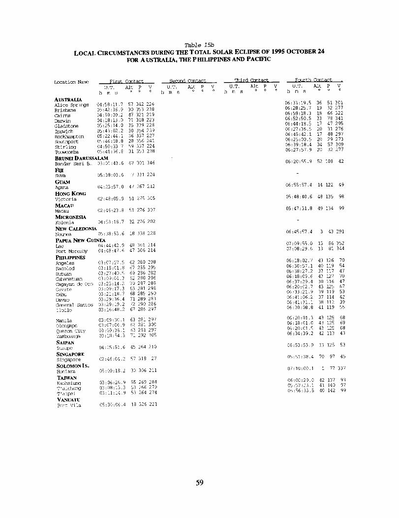
Table 15b
LOCAL CIRCUMSTANCES DURING THE TOTAL SOLAR ECLIPSE OF 1995 OCTOBER 24
FOR AUSTRALIA, THE PHILIPPINES AND PACIFIC
Location Name First Ccntact Second Ccntac_
U.T. Aft P V U.T. Alt P
h m s o o o h m s o a
AUSTRALIA
Alice Springs 04:58:11.7 57 342 226
Brisbane 05:42:36.9 30 353 238
Cairns 04:59:09.2 47 321 219
Darwin 04:18:13.0 71 318 223
Gladstone 05:25:14.0 35 339 228
Ipswich 05:43:02.2 30 354 239
Rockhampton 05:22:44.1 36 337 227
Soutbport 05:46:18.8 28 356 241
Stifling 04:50:33.7 59 337 224
05:41:36.8 31 353 238
BRUNEI DARUSSALAM
Bandar Seri 5.. 03:01:43.6 67 301 346
FmShnra 05:38:03.6 7 331 224
GUAMAgana 04:23:57.0 47 267 212
HONG KONG
Victoria 02:48:05.9 51 275 305
MACAUMacau 02:46:23.8 51 276 307
_[ICRONESIA
Kolon/a 04:53:18.7 32 276 202
NEW CALEDONIA
Noumea 05:38:53.6 18 338 228
PAPUA NEW GUINEA
Lae 04:44:42.9 48 301 214
Port Moresby 04:48:47.6 47 306 214
Angeles 03:07:57.5 62 280 298
Bacolod 03:18:01.8 67 285 295
Butuan 03:27:40.5 69 286 282
Cabanatuan 03:09:01.3 62 280 296
Cagayan de Oro 03:25:14.2 70 287 288
Cavite 03:09:17.3 63 281 298
Cebu 03:21:18.7 68 285 290
Davao 03:29:36.4 71 289 283
C_nera] Santos 03:29:19.2 72 290 286
Iloilo 03:16:48.2 67 286 297
Manila 03:09:30.i 63 281 297
Olongapo 03:07:06.9 62 281 300
Quezon city 03:09:38.1 63 281 297
Zamboanga 03:18:54.3 71 292 305
SAIPANSusupe 04:25:51.6 45 264 210
SINGAPORE
Singapore 02:46:04.2 57 318 27
SOLOMON I S.Honiara 05:09:18.2 30 306 211
TAIWANKaohsiung 03:06:26.9 55 269 284
T'aichung 03:08:13.3 53 266 279
T'aipei 03:11:14.9 53 264 274
VANUATU
Port Vila 05:30:06.4 18 326 221
q_nird Contac t Fourth Ccntac_ .
V U.T. Alt P V U.T. Aft P V
o h m s o _ o h m s o o o
06:33:19.5 36 51 301
06:28:25.7 19 32 277
06:59:18.3 18 66 322
06:52:50.5 33 78 341
06:44:18.5 17 47 295
06:27:36.5 20 31 276
06:45:42.1 17 48 297
06:25:00.5 20 29 273
06:39:18.4 34 57 309
06:27:57.9 20 32 277
06:20:55.9 52 108 42
06:55:57.4 14 122 49
05:48:40.6 48 135 98
05:47:31.8 49 134 99
06:45:57.4 3 43 291
07:09:55.0 13 86 352
07:08:29.6 13 81 344
06:18:02.7 43 126 70
06:30:57.1 40 119 54
06:38:27.2 37 117 47
06:18:09.6 43 127 70
06:37:29.4 38 116 47
06:20:02.7 43 125 67
06:33:21.9 39 119 53
06:41:06.2 37 114 42
06:41:31.1 38 112 39
06:30:08.8 41 119 55
06:20:0].3 43 125 68
06:18:01.0 43 125 69
06:20:01.5 43 125 68
06:34:39.2 42 113 43
06:53:53.9 13 125 53
05:51:38.4 70 97 45
07:10:00.1 i 77 337
06:00:29.0 42 137 93
05:57:23.1 41 140 97
05:56:33.5 40 142 99
59
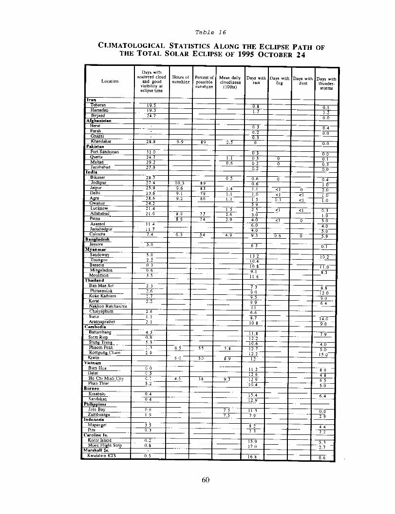
Table 16
CLIMATOLOGICAL STATISTICS ALONG THE ECLIPSE PATH OFTHE TOTAL SOLAR ECLIPSE OF 1995 OCTOBER 24
Days withscattered cloud Hours of Percent of Mean daily Days with Days with Days with Days with
Location and good sunshine possible cloudiness rain fog dust thunder-visibility at sunshine (10ths) storms
eclipse time
Iran
Teheran
Hamadan 19.3
3irjand 24,7
Ai [thanistan
Herat
Farah
Ghazni
Khandahar 2 8.8
Pakistan
Fort Sandeman 31.0
Quetta 24,7
Multan 29.2
Jacobabad 27.9
India
Bikaner 28.7
Jodhpur 27.4
Jaipur 25,9Delhi 23.6
Agra 2 8.6Gwalior 24,2
Lucknow 21,4
Allahabad 21.0
Patna
Asansol 1 1,4
Jamshedpur 11.7Calcutta 7.4
BangladeshJessore 5.0
MTanmar
____ 5.oToun[oo 2.2Bassein 0,3
Mingaladon 0.6Moulmein 3.5
Thailand
Ban Mae Sot 2,3
Phitsanulok 2.6
Koke Kathiem 1.7
Korat 2.2
Nakhon Ratchasima
Chaiyaphum 2.6Surin 1.1
Aranyaprathet 2.1Cambodia
Battambang 4.3
Siem Riep 0.9
Stun$ Tren$ 5.3Phnom Perth 1.3
Kompong Cham 2.9Ka'atie
Vietnam
Bien Hoa 0,0
Dalat 0 5
19.5 0.g 0.1
1.7 1.2
0,0
9.9 89 2,5
1.1
0.6
0.3 0.4
0.2 0.0
0.3
0 0.0
0,3 0,0
0.3 0 0,1
0.2 0 0.3
0,2 0.0
0.5 0.6 0 0,4
10.3 89 0.6 1.0
9.6 83 1,4 1.1 <1 0 2,0
9.1 79 1,1 1.0 <1 <1 1,0
9.2 80 1.1 1.5 0.1 <1 1.0
5.9
1,5 2.5 <1 <1 0.3
8.9 77 2,6 3,0 1.0
8.6 74 2.9 4.0 <1 0 5,0
6.0 4.0
4.0 5.0
6.3 54 4.9 9.3 0,6 0 5,9
6.5 55 7.8
60 50 8.9
Ho Chi Minh City 0.l 4.5 38 9,3
Phan Thiet 5.2
Borneo
Kinabalu 0.4
S andakan 0 4
6.3 0.1
13.2 10.2
10.4
10.8 II.0
9.1 85
116
7.3 8.8
90 12.0
9.5 90
9.9 64
1l
6.6
8.7 14.0
i0,8 9.0
ll,8 7.9
12.2
10.6 4.0
12.7 5.0
12.2 15.0
12
11.2 8.0
12.6 4.8
12.9 6.5
10.4 5.0
15.4 6,4
12.9
06 7,5 11,5 0.0
Zamboan_a 1,9Indonesia
Mapanget 3.5
Pitu 9, 3
Caroline Is.
Koror Island O. 2
Moen Flight Strip 0.8
Marshall Is.
Kwajalein KTS 0.5
7,5 7.9
8,2
7,3
15.9
17.0
16.8
2,9
44
7.2
53
27
0.6
6O
Table 17
SOLAR ECLIPSE EXPOSURE GUIDE
]SO f/Number
25 1.4 2 2.8 4 5.6 8 11 16 22
50 2 2_ 4 5.6 8 11 16 22 32
100 2_ 4 5.6 8 11 16 22 32 44
200 4 5.6 8 11 16 22 32 44 64
400 5.6 8 11 16 22 32 44 64 88
800 8 11 16 22 32 44 64 88 1281600 11 16 22 32 44 64 88 128 176
__ Subject Q Shutter Speed
Solar EclipsePartial I - 4.0 ND 11 -- -- -- 1/4000 1/2000 1/1000 1/500 1/250 1/125
Partial I - 5.0ND 8 1/4000 1/2000 1/1000 1/500 1/250 1/125 1/60 1/30 1/15
Baily's Beads 2 12 .... t/4000 1/2000 1/1000 1/500 1/250
Chromosphere 11 -- -- 1/4000 1/2000 1/1000 1/500 1/250 1/125
Prominences 9 -- 1/4000 1/2000 1/1000 1/500 1/250 1/125 1/60 1/30
Corona - 0.1 Rs 7 1/2000 1/1000 1/500 1/250 1/125 1/60 1/30 1/15 1/8
Corona - 0.2 Rs 3 5 1/500 1/250 1/125 1/60 1/30 1/15 1/8 1/4 1/2
Corona - 0.5 Rs 3 11125 1/60 1/30 1/15 1/8 1/4 1/2 1 sec 2 sec
Corona - 1.0 Rs 1 1/30 1/15 1/8 1/4 1/2 1 sec 2 sec 4 sec 8 sec
Corona - 2.0 Rs 0 1/15 1/8 1/4 1/2 1 sec 2 sec 4 sec 8 sec 15 sec
Corona - 4.0 Rs -1 1/8 1/4 1/2 1 sec 2 sec 4 sec 8 sec 15 sec 30 sec
Corona - 8.0 Rs -3 1/2 1 sec 2 sec 4 sec 8 sec 15 sec 30 sec 1 min 2 rain
Exposure Formula: t = f2 / (I x 2Q) where:
Abbreviations: ND = Neutral Density Filter.Rs = Solar Radii.
t = exposure time (sec)
f = f/number or focal ratio
I = ISO film speed
Q = brightness exponent
Notes: 1 Exposures for partial phases are also good for annular eclipses.
2 Baily's Beads are extremely bright and change rapidly.
3 This exposure is also recommended for the 'Diamond Ring' effect.
F. Espenak - Nov 1992
61


TOTAL SOLAR ECLIPSE OF 1995 OCTOBER 24
MAPS
OF THE
UMBRAL PATH
63
Pflll_._l[)4f_£ PAGE I_.ANK NOT FILMED

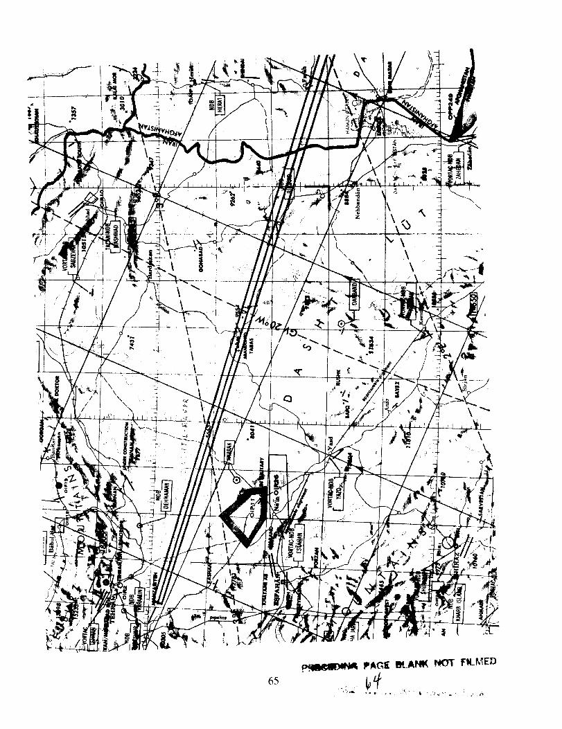
\
\\
\\
\
|
\\
\
\
65
PAGE B4_.At,IK NOT F_LkIED
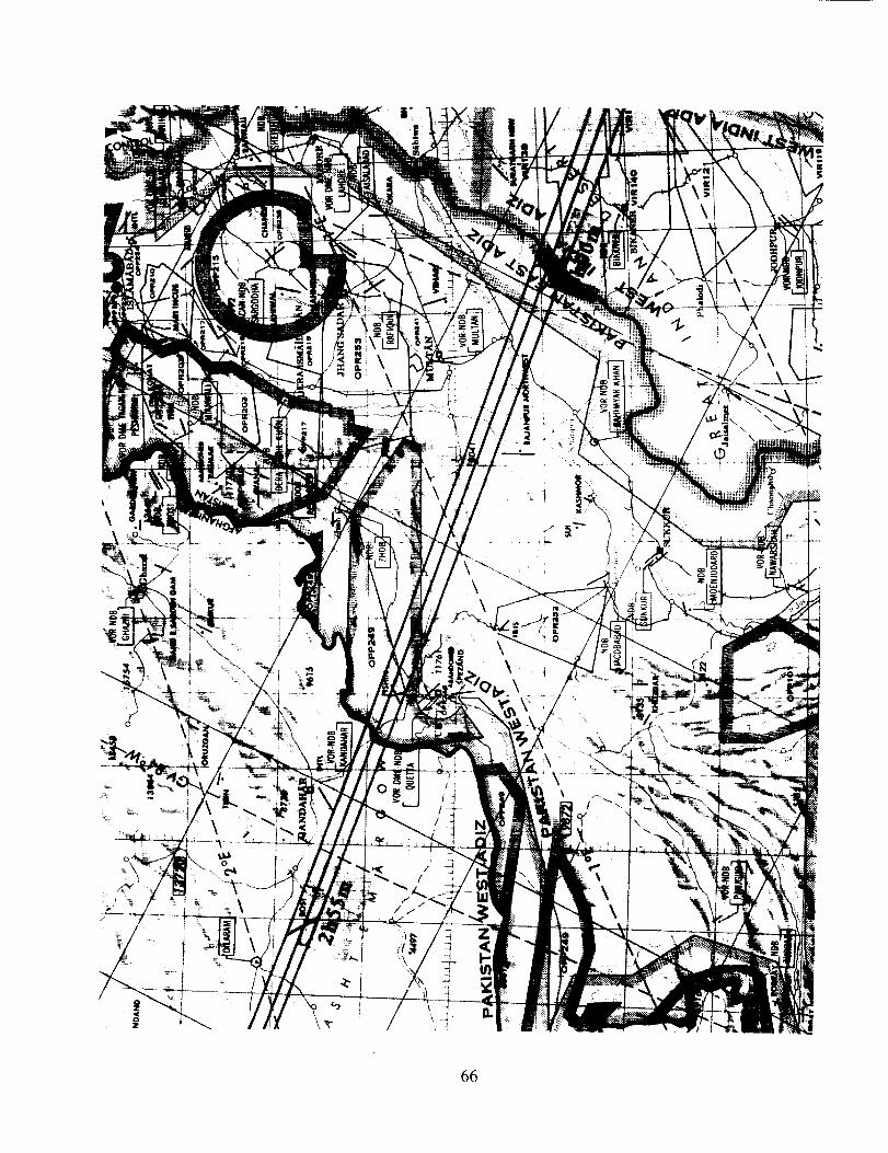
:i\\
: ? 0
\\
\\
/
!66
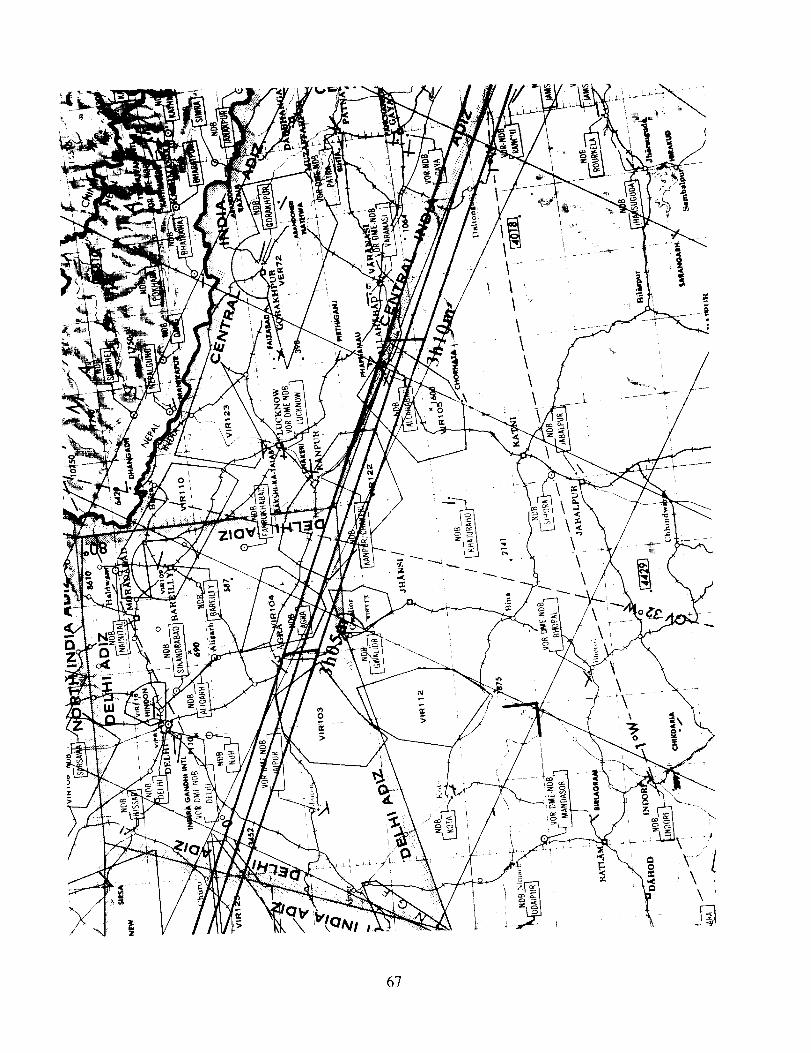
/
\\\\\
\\
\
\
\\
67
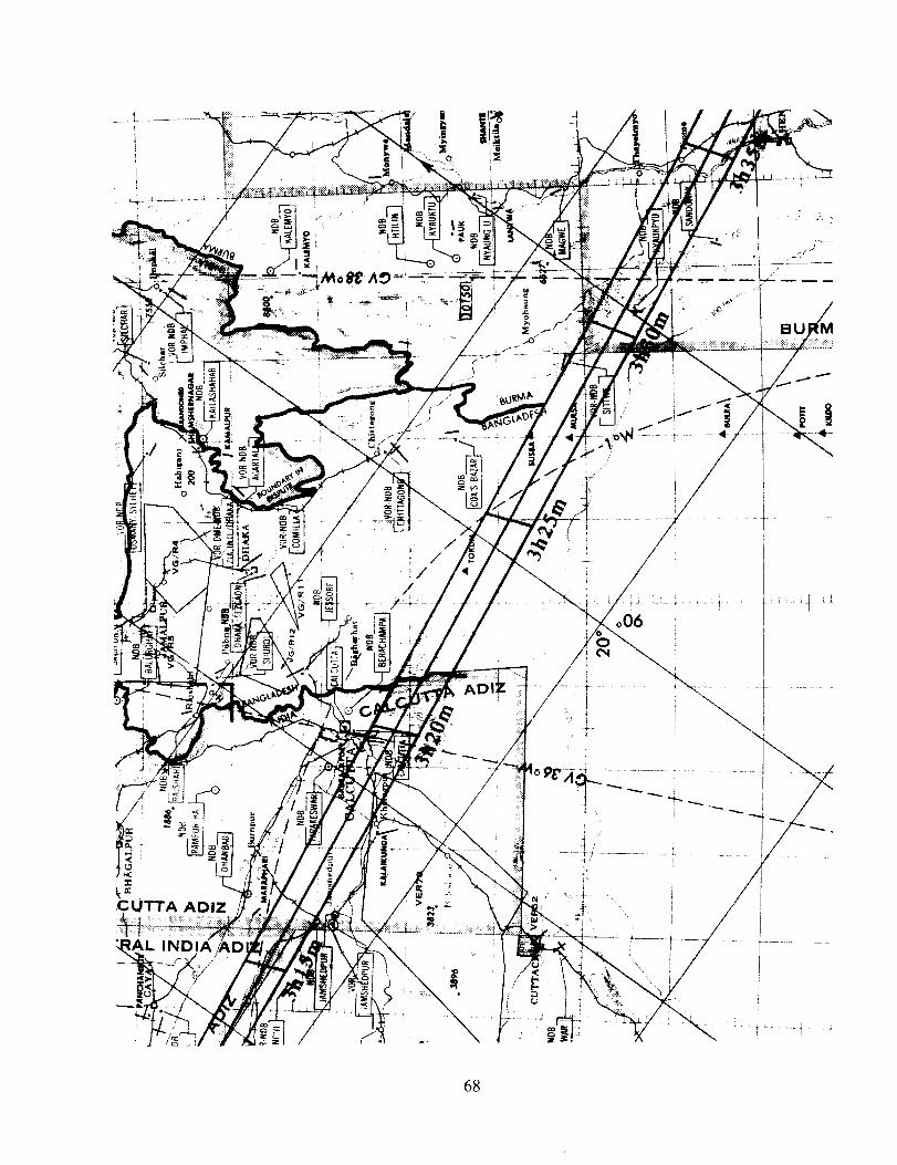
L3
,CUTTA ADIZ
IND
//
/
J /
//
//
//
68
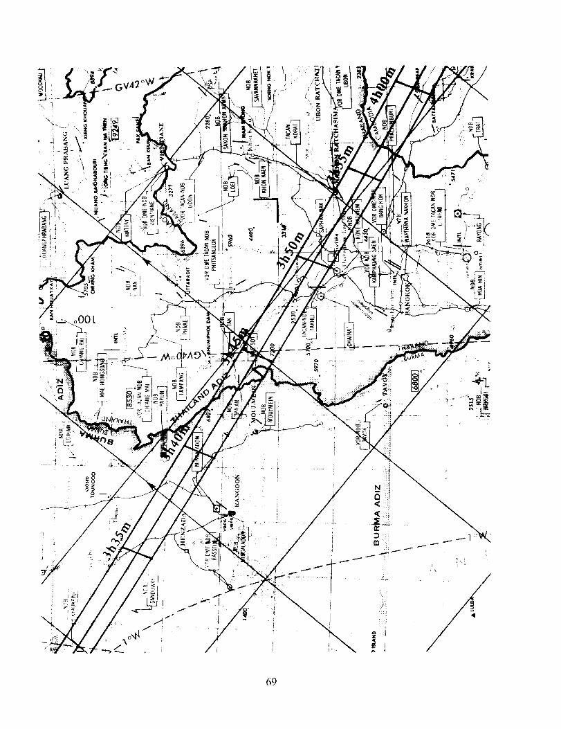
\
69
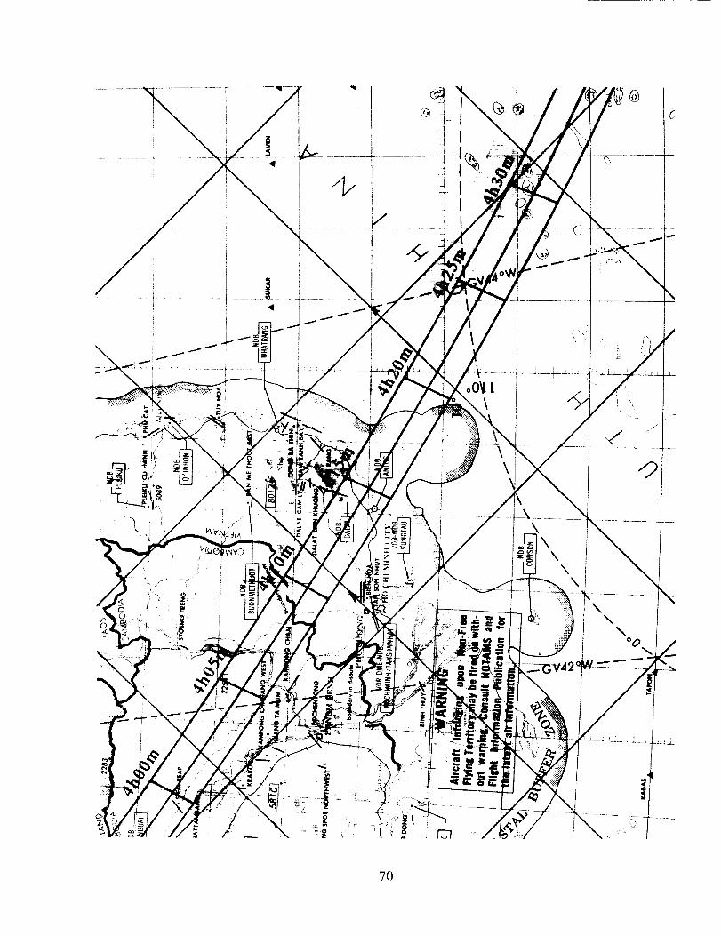
|
z
!t
o0_ L\
z
\\
\
\\
°0\
7O
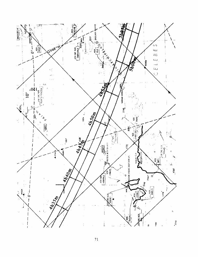
1\ °
i
/
\\
\
\
\
/
//
//
I
\\
\\
\
71
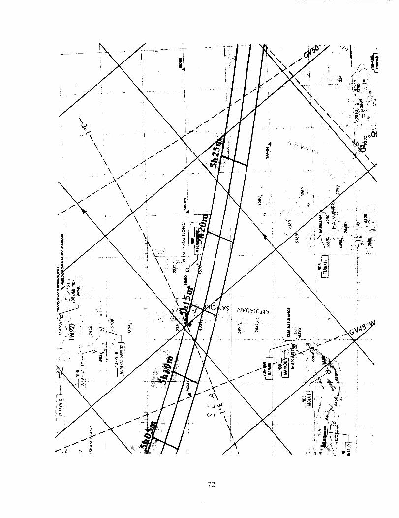
\o
\\\
\\
8
\\
7 \
f
\\
3
Lr _d
I--Z
i I
JJ
JJ
JJ
\\,
\ l\\,, \
\
fJ
f
\
/J
0 ,E:
Z0
L
I
Jf
J
\\ k ,
_i--"_z:" '
\
\
"72
REQUEST FORM FOR NASA ECLIPSE BULLETINS
NASA eclipse bulletins contain detailed predictions, maps and meteorology for future central solar eclipsesof interest. Published as part of NASA's Reference Publication (RP) series, the bulletins are prepared incooperation with the Working Group on Eclipses of the International Astronomical Union and are providedas a public service to both the professional and lay communities, including educators and the media Inorder to allow a reasonable lead time for planning purposes, subsequent bulletins will be published 24
months or more before each event. Comments, suggestions and corrections are solicited to improve thecontent and layout in subsequent editions of this publication series.
Single copies of the bulletins are available at no cost and may be ordered by sending a 9 x 12 inch SASE(self addressed stamped envelope) with sufficient postage for each bulletin (11 oz. or 310 g.). Use stampsonly since cash or checks cannot be accepted. Requests within the U. S. may use the Postal Service'sPriority Mail for $2.90. Please print either the NASA RP number or the eclipse date (year & month) of thebulletin ordered in the lower left comer of the SASE and return with this completed form to either of theauthors below. Requests from outside the U.S. and Canada may use international postal coupons to coverpostage. Exceptions to the postage requirements will be made for international requests where political oreconomic restraints prevent the transfer of funds to other countries.
Permission is freely granted to reproduce any portion of this NASA Reference Publication All uses and/orpublication of this material should be accompanied by an appropriate acknowledgment of the source.
Request for: NASA RP 1344 -- Total $01_ Eclipse of 1995 October 24
Name of Organization:
(in English, if necessary):
Name of Contact Person:
Address:
City/State/ZIP:
Country:
Type of organization:(check all that apply)
Size of Organization: __
Activities:
__ University/College __ Observatory __ Library__ Planetarium __ Publication __ Media__ Professional __ Amateur __ Individual
(Number of Members)
Return Requestsand Comments to:
Intemet:Fax:
Fred Espenak orNASAJGSFCCode 693Greenbelt, MD 20771USA
u32fe@ lepvax.gstc.nasa.gov(301) 286-0212
Bitnet:Fax:
Jay AndersonEnvironment Canada900-266 Graham Avenue
Winnipeg, MB,CANADA R3C 3V4
jander@ cc.umanitoba.ca(204) 983-0109
July 1994
73


Form Approved
REPORT DOCUMENTATION PAGE OMBNo. 0704-0188
Public reporting burden for this collection of information is estimated to average 1 hour per response, including the time for reviewing instruclions, searching existing data sources,
gathering and maintaining the data needed, and completing and reviewing the collection of information. Send comments regarding this burden estimate or any olher aspect of this
collection of information, including suggestions for reducing this burden, to Washington Headquarters Services, Directorate for Information Operations end Reports, 1215 Jefferson
Davis Highway, Suite 1204, Arlington, VA 22202-4302, and to the Office of Management and Budget, Paperwork Reduction Project (0704-0188), Washington, DC 20503.
1. AGENCY USE ONLY (Leave blank) 2. REPORT DATE
Jul_¢ 19944. TITLE AND SUBTITLE
Total Solar Eclipse of 1995 October 24
6. AUTHOR(S)
Fred Espenak and Jay Anderson
7. PERFORMING ORGANIZATION NAME(S) AND ADDRESS (ES)
Goddard Space Flight Center
Greenbelt, Maryland 20771
9. SPONSORING I MONITORING ADGENCY NAME(S) AND ADDRESS (ES)
3. REPORT TYPE AND DATES COVERED
Reference Publication
S. FUNDING NUMBERS
693
8. PEFORMING ORGANIZATIONREPORT NUMBER
94B00102
10. SPONSORING I MONITORINGADGENCY REPORT NUMBER
NASA RP- 1344National Aeronautics and Space Administration
Washington, DC 20546-0001
11. SUPPLEMENTARY NOTES
F. Espenak, Goddard Space Flight Center, Greenbelt, Maryland;
J. Anderson, Environment Canada, Winnipeg, Manitoba
12a. DISTRIBUTION I AVAILABILITY STATMENT 12b. DISTRIBUTION CODE
Unclassified - Unlimited
Subject Category 89This publication is available from the NASA Center for AeroSpaceInformation, 800 Elkridge Landing Road, Linthicum Heights, MD21090-2934, (301)621-0390.
i
13. ABSTRACT (Maximum 200 words)
A total eclipse of the Sun will be visible from Asia and the Pacific Ocean on 1995 October 24. The
path of the Moon's shadow begins in the Middle East and sweeps across India, Southeast Asia, and the
waters of the Indonesian archipelago before ending at sunset in the Pacific. Detailed predictions for
this event are presented and include besselian elements, geographic coordinates of the path of totality,
physical ephemeris of the umbra, topocentric limb profile corrections, local circumstances for 400
cities, maps of the eclipse path, weather prospects, the lunar limb profile, and the sky during totality.
14. SUBJECT TERMS
solar eclipse; celestial mechanics; ephemeris; Sun; Moon
17. SECURITY CLASSIFICATION
OF REPORT
Unclassified
NSN 7540-01-280-5500
18. SECURITY CLASSIFICATIONOF THIS PAGE
Unclassified
19. SECURITY CLASSIRCATION
OF ABSTRACT
Unclassified
15. NUMBER OF PAGES
82
16. PRICE CODE
20. LIMITATION OF ABSTRACT
UL
Standard Form 298 (Rev, 2-89)Prescribed by ANSI Std. Z39.18