Tonight - Weather Weather Details Tonight What Line of storms will have wind damage potential...
6
weather.gov/grandrapids Severe Weather Possible Tonight Click on the Image for the Most Current Day 1 Severe Weather Outlook Greater Threats: Damaging Winds, Hail Lesser Threat: Heavy Rain, Tornadoes Mainly After 8 PM High Swim Risk This Afternoon through Tuesday Event Summary Severe Weather Outlook for Tonight Created: Monday, June 30, 2014 – 1:00 PM Lesser Threat Greatest Threat
Transcript of Tonight - Weather Weather Details Tonight What Line of storms will have wind damage potential...

weather.gov/grandrapids
Severe Weather Possible Tonight
Click on the Image for the Most Current Day 1 Severe Weather Outlook
Greater Threats: Damaging Winds, Hail
Lesser Threat:
Heavy Rain, Tornadoes
Mainly After 8 PM
High Swim Risk This Afternoon through Tuesday
Event Summary Severe Weather Outlook for Tonight
Created: Monday, June 30, 2014 – 1:00 PM
Lesser Threat
Greatest Threat
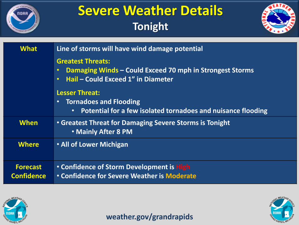
Severe Weather Details Tonight
What Line of storms will have wind damage potential
Greatest Threats: • Damaging Winds – Could Exceed 70 mph in Strongest Storms • Hail – Could Exceed 1” in Diameter
Lesser Threat: • Tornadoes and Flooding
• Potential for a few isolated tornadoes and nuisance flooding
When • Greatest Threat for Damaging Severe Storms is Tonight • Mainly After 8 PM
Where • All of Lower Michigan
Forecast Confidence
• Confidence of Storm Development is High • Confidence for Severe Weather is Moderate
weather.gov/grandrapids

Forecast Radar Tonight Line of Storms Possible
Forecast Radar 8 pm
Forecast Radar Midnight
Forecast Radar 11 pm
Storms Move in This Evening Mainly After 8 PM
weather.gov/grandrapids
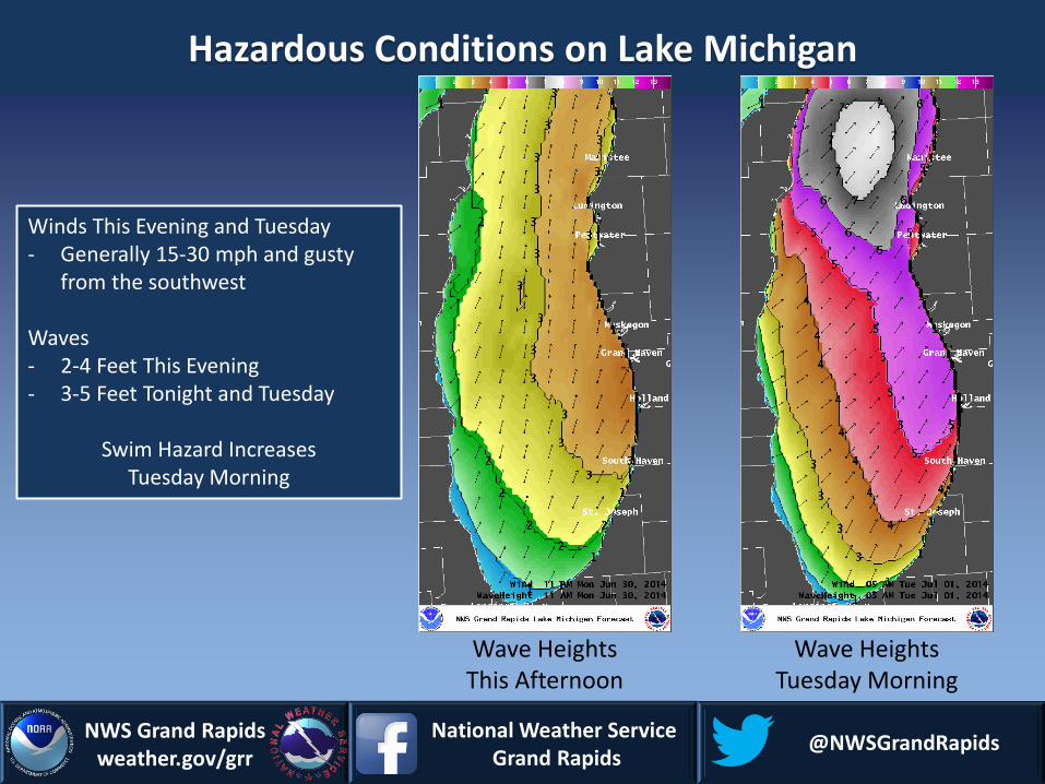
Hazardous Conditions on Lake Michigan
NWS Grand Rapids weather.gov/grr
National Weather Service Grand Rapids
@NWSGrandRapids
Winds This Evening and Tuesday - Generally 15-30 mph and gusty
from the southwest Waves - 2-4 Feet This Evening - 3-5 Feet Tonight and Tuesday
Swim Hazard Increases Tuesday Morning
Wave Heights This Afternoon
Wave Heights Tuesday Morning

Hazards Summary Review Tonight
• Storms Moving In From Wisconsin Late This Evening
• Damaging Winds, Hail are Greatest Threats
• All of Lower Michigan
• Could Have Nuisance Flooding with Thunderstorms
• Tornadoes are a Lesser Threat
• Dangerous Winds and Waves on Lake Michigan on Tuesday
weather.gov/grandrapids

Important Web Links Click the Links Below for More Information
Severe Weather Briefing Slides www.weather.gov/grr/webinars
Regional Weather Radar Loop
www.weather.gov/radar
Severe Weather Summary
www.crh.noaa.gov/hazards/grr
Storm Prediction Center
www.spc.noaa.gov
NOAA National Weather Service - Grand Rapids, Michigan
www.weather.gov/grandrapids Email: [email protected]
Phone: 616-949-0643
Weather-Ready Nation
National Weather Service Grand Rapids
@NWSGrandRapids