TMCBSU - Workover Candidates (North)
31
TMCBSU - Workover Candidates (North) Re-perforation Candidates – North East (NE) Arkanova Energy Corporation Operator: Provident Energy Associates of Montana, LLC Client Update DCS NGC Team June 4, 2010
Transcript of TMCBSU - Workover Candidates (North)

TMCBSU - Workover Candidates (North)
Re-perforation Candidates – North East (NE)Arkanova Energy CorporationOperator: Provident Energy Associates of Montana, LLC
Client UpdateDCS NGC TeamJune 4, 2010

Objective• Evaluate Active, SI and TA well in the North-East section to
identify possible unperforated pay zone. • Identify top 2 re-perforation opportunities to increase oil
production in the Two Medicine Cut Bank Sand Unit (TMCBSU).
Disclaimer NoticeThis information is presented in good faith, but no warranty is given by Schlumberger who assumes no liability for advice or recommendations made concerning results to be obtained from the use of any product or service. The results given are estimated based on calculations produced by a computer model including various assumptions on the well, reservoir and treatment parameters. The results depend on input data provided by the Operator and estimates as to unknown data and can be no more accurate than the model, the assumptions and such input data. The information presented is Schlumberger’s best estimate of the actual results that may be achieved and should be used for comparison purposes rather than absolute values. The quality of input data, and hence results, may be improved through the use of certain tests and procedures which Schlumberger can assist in selecting.
Freedom from infringement of patents of Schlumberger or others is not to be inferred.

Risk Mitigation• Schlumberger recommends running a standard suite of logs
(USI, RST, CHDT, MDT) to help determine cement integrity, water saturation, pressures and Oil Water Contact before any re-perforation campaign.
• Casing integrity test and flow assurance for surface flow lines.

AssumptionsKey assumptions in this workflow to select re-perforation candidates:
• 1960 logs are not calibrated to today’s standards, these logs were read at face value.
• In the absence of Gamma Ray curves, SP was used. SP is not a good indicator of Shaliness.
• Educated assumptions were made to determine if unperforated pay is already watered out.
• Good, Average or Poor candidates are chosen relative to each other and naming convention only indicates perforation eligibility.

Workflow• Active and SI/TA wells in the North-East section of the field were
initially selected with priority given to Active wells.• Wells with unperforated sands were selected for preliminary review.• A detailed study of available logs, well location, geology, well files and
production history data was carried out.• A comprehensive matrix decision was built to identify Good, Average
and Poor re-perforation candidates.• Candidates were identified based on a combination of factors in the
matrix (Net thickness, Cut Bank Geometry, Water Cut, Oil Cum etc.)
3534
27 26
01-0102-0303-01 03-03X
03 20
02-01 02-02 02-0403-02 03-03 03-04
22-14
26-09 26-11
26-15
27-03
27-0527-07
27-09 27-11
27-13
34-01X 34-03
34-07
34-09 34-11
34-15
35-03
35-07
35-09
35-13
35-20
36-01
36-09
35-32
34-16
34-26
34-25
34-10
34-14
34-06
35-14
5991
26-10
26-1426-16
27-01 27-02
27-0627-08
27-10 27-12
27-1427-15X27-16
27-29
34-01 34-02 34-04
34-0534-08
34-12
34-13
35-01 35-02 35-04
35-0535-0635-08
35-10 35-1135-11X35-12
35-1535-16
36-085992
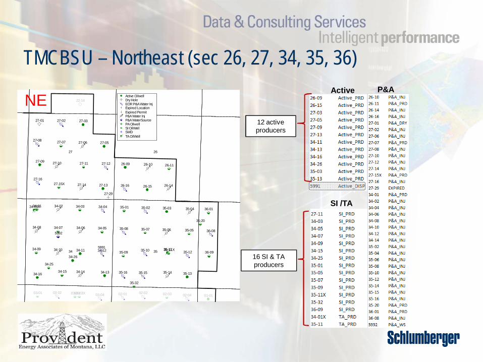
Active OilwellDry HoleEOR P&A Water InjExpired LocationExpired PermitP&A Water InjP&A WaterSourcePA OilwellSI OilWellSWDTA OilWell
TMCBSU – Northeast (sec 26, 27, 34, 35, 36)P&A
SI /TA
Active
12 active producers
16 SI & TA producers
NE
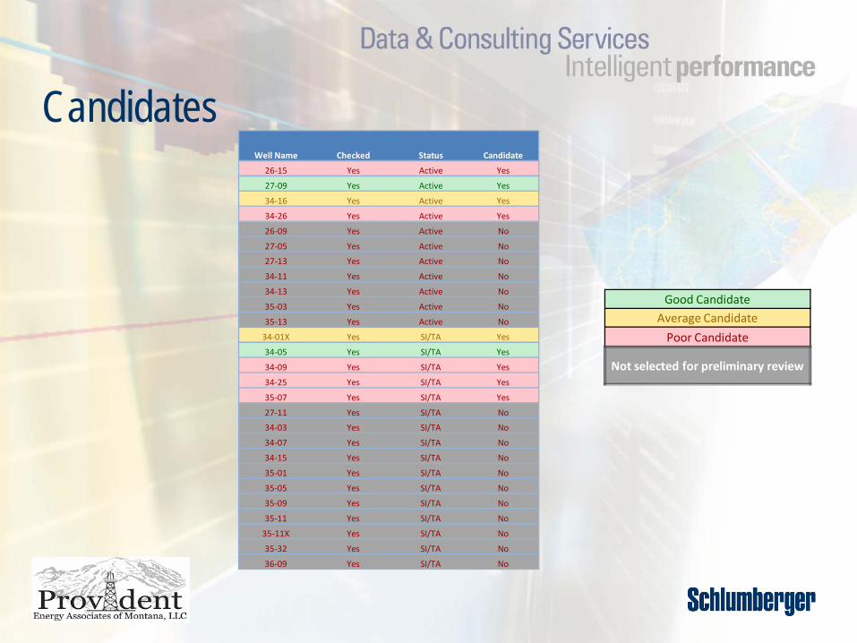
CandidatesWell Name Checked Status Candidate
26-15 Yes Active Yes
27-09 Yes Active Yes
34-16 Yes Active Yes
34-26 Yes Active Yes
26-09 Yes Active No
27-05 Yes Active No
27-13 Yes Active No
34-11 Yes Active No
34-13 Yes Active No
35-03 Yes Active No
35-13 Yes Active No
34-01X Yes SI/TA Yes
34-05 Yes SI/TA Yes
34-09 Yes SI/TA Yes
34-25 Yes SI/TA Yes
35-07 Yes SI/TA Yes
27-11 Yes SI/TA No
34-03 Yes SI/TA No
34-07 Yes SI/TA No
34-15 Yes SI/TA No
35-01 Yes SI/TA No
35-05 Yes SI/TA No
35-09 Yes SI/TA No
35-11 Yes SI/TA No
35-11X Yes SI/TA No
35-32 Yes SI/TA No
36-09 Yes SI/TA No
Good CandidateAverage Candidate
Poor Candidate
Not selected for preliminary review

Petrel Logs• Main logs used were:• SP or GR for most wells, additional logs used if available
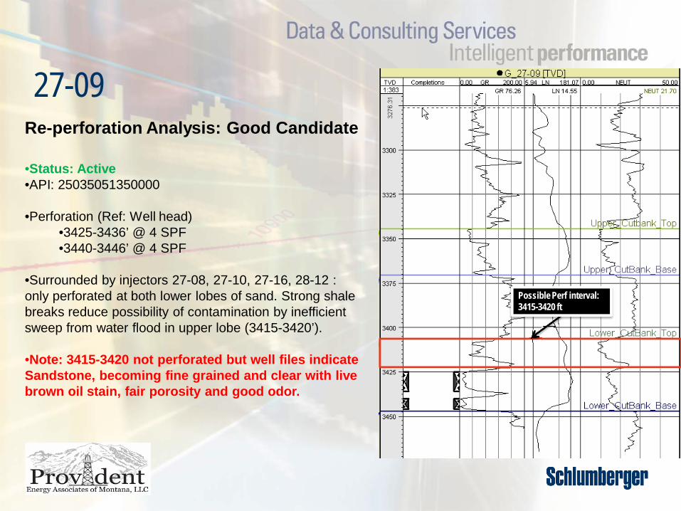
27-09Re-perforation Analysis: Good Candidate
•Status: Active•API: 25035051350000
•Perforation (Ref: Well head)•3425-3436’ @ 4 SPF•3440-3446’ @ 4 SPF
•Surrounded by injectors 27-08, 27-10, 27-16, 28-12 : only perforated at both lower lobes of sand. Strong shale breaks reduce possibility of contamination by inefficient sweep from water flood in upper lobe (3415-3420’).
•Note: 3415-3420 not perforated but well files indicate Sandstone, becoming fine grained and clear with live brown oil stain, fair porosity and good odor.
Possible Perf interval: 3415-3420 ft

27-09 flanked by Injectors on 4 sides
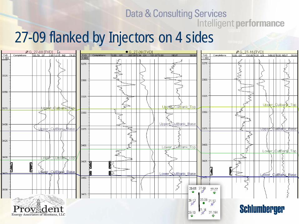
27-09 flanked by Injectors on 4 sides

27-09
1968 69 70 71 72 73 74 75 76 77 78 79 80 81 82 83 84 85 86 87 88 89 90 91 92 93 940.1
0.51
510
50
100
5001000
Date
Oil Rate (Cal. Day) ( bbl/d )Water Rate (Cal. Day) ( bbl/d )Water Injection Rate (Cal.Day) ( bbl/d )
Operator: PROVIDENT ENERGY ASSOCIATION LLCLocation: SEC 27.0 N 32.0 W 6.0
Well: TWO_MEDICINE_CBSU 27-09Upper_Perfs_(Top): 3425'
Lower_Perfs_(Base): 3446'
Oil Cum: 155.93 MBO
Gas Cum: * MMCFGWater Cum: 270.61 MBO
1968 70 72 74 76 78 80 82 84 86 88 90 92 941
5
10
50
100
500
1000
0
20
40
60
80
100
Axis 1Water Oil Ratio ( bbl/bbl )
Axis 2Water Cut ( % )
Operator: PROVIDENT ENERGY ASSOCIATION LLCLocation: SEC 27.0 N 32.0 W 6.0
Well: TWO_MEDICINE_CBSU 27-09Upper_Perfs_(Top): 3425'
Lower_Perfs_(Base): 3446'
Oil Cum: 155.93 MBO
Gas Cum: * MMCFGWater Cum: 270.61 MBO

34-05
Possible Perf interval: 3183-3197 ft
Re-perforation Analysis: Good Candidate
•Status: SI/TA•API: 25035072790000
•Perforation (Ref: Well head)•3205-3223’ @ 4 SPF
•Well TA’d - bridge plug @ 3105’ KBM with 2 sacks cement.•2004 – well files indicate well equipment not available, electrical lines down.•Unperforated zone in upper and lower end of sand:
•3183-3197ft •Water Cut 79%•Produced oil above field average (7bbl/d in Mar ‘78)•Lower zone chances of being watered out are high.•Small shale break between 3196 – 3203’ to provide reasonable separation between perforated zone below.
•Surrounded by injectors 35-08,34-12,34-06,34-04 – perforated at both upper and lower lobes of sand. Possibility of contamination by inefficient sweep from water flood in upper lobe (3185’-3197’).
•Other comments: Located adjacent to battery.
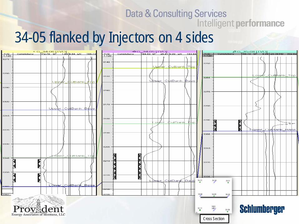
34-05 flanked by Injectors on 4 sides
Cross Section

34-05 flanked by Injectors on 4 sides
Cross Section

34-05
69 71 73 75 77 79 81 83 85 87 89 91 93 95 97 99 01 03 05 07 091
10
100
1000
10000
Date
Water Injection ( bbl )Oil Production ( bbl )Water Production ( bbl )
Operator: Provident Energy Assoc. Of Mt Llc
Location: SEC 34.0 N 32.0 W 6.0
Well: 34-05Oil Cum: 116 MBOGas Cum: * MMCFG
Water Cum: 88 MBW
69 71 73 75 77 79 81 83 85 87 89 91 93 95 97 99 01 03 05 07 090.001
0.01
0.1
1
10
0
20
40
60
80
100
Date
Axis 1Water Oil Ratio ( bbl/bbl )
Axis 2Water Cut ( % )
Operator: Provident Energy Assoc. Of Mt Llc
Location: SEC 34.0 N 32.0 W 6.0
Well: 34-05Oil Cum: 116 MBOGas Cum: * MMCFG
Water Cum: 88 MBW

34-16
Possible Perf interval: 3330-3334 ft
Possible Perf interval: 3300-3313 ftRe-perforation Analysis: Average Candidate
•Status: Active•API: 25035050230000
•Perforation (Ref: Well head)•3314-3326’ @ 4 SPF•3328-3330’ @ 4 SPF
•Well converted from Injection status to producer - Dec ’87
•Unperforated zone in upper and lower end of sand:•3300-3313ft •3330-3334ft
•High Water Cut (81%). •Water production historically higher than field average.•Lower zone chances of being watered out are high.•Upper zone closest analog is 34-25 (shows lower resistivity, porosity)

34-16
19606162636465666768697071727374757677787980818283848586878889909192939495969798992000010203040506070810-2
10-1
100
101
102
103
104
105
Date
Oil Rate (Cal. Day) ( bbl/d )Water Rate (Cal. Day) ( bbl/d )Water Injection Rate (Cal.Day) ( bbl/d )Lease Oil Rate (Cal.Day) ( bbl/d )Lease Water Rate (Cal.Day) ( bbl/d )
Operator: PROVIDENT ENERGY ASSOCIATION LLC
Location: SEC 34.0 N 32.0 W 6.0
Well: TWO_MEDICINE_CBSU 34-16
Upper_Perfs_(Top): 3314'
Lower_Perfs_(Base): 3330'
Oil Cum: 36 MBOGas Cum: * MMCFG
Water Cum: 551 MBW
Well Type: SI_PRD
19686970 71 7273 74 7576 7778 79 8081 82 8384 85 8687 88 8990 9192 93 9495 96 9798 99200001 02 0304 05 0607 080.1
1
10
100
1000
20
40
60
80
100
Date
Axis 1Water Oil Ratio ( bbl/bbl )
Axis 2Water Cut ( % )
Operator: PROVIDENT ENERGY ASSOCIATION LLC
Location: SEC 34.0 N 32.0 W 6.0
Well: TWO_MEDICINE_CBSU 34-16
Upper_Perfs_(Top): 3314'
Lower_Perfs_(Base): 3330'
Oil Cum: 36 MBOGas Cum: * MMCFG
Water Cum: 551 MBW
Well Type: SI_PRD

34-01XRe-perforation Analysis: Average Candidate
•Status: SI/TA•API: 25035214010000
•Perforation (Ref: Well head)•3435-3455’ @ 4 SPF
•Unperforated zone in upper and lower end of sand:•3422-3435ft •3455-3559ft•3492-3470ft
•Distinct shale break present between 3459-3461’.•Well files indicate live oil in sample 3460-3470’ MD•Sandstone as above: Many coarse broken black chertpebbles: Much live oil in sample
•Poor oil cum (2.17 Mbbl), water cut 84%.•Consistent porosity response (18%) throughout Lower Cut Bank.
Possible Perf interval: 3422-3435 ft3455-3559 ft3492-3470 ft

34-01X
68 69 70 71 72 73 74 75 76 77 78 79 80 81 82 83 84 85 86 87 88 89 90 91 92 93 94 95 96 97 98 99200001 02 03 04 05 06 07 08 09100
101
102
103
104
105
106
Date
Oil Production ( bbl )Water Production ( bbl )Water Injection ( bbl )Lease_Monthly_OilLease_Monthly_WaterOil Production ( bbl )Water Production ( bbl )
Operator: PROVIDENT ENERGY ASSOCIATION LLC
Location: SEC 34.0 N 32.0 W 6.0
Well: TWO_MEDICINE_CBSU 34-01XOil Cum: 2 MBOGas Cum: * MMCFG
Water Cum: 12 MBW
68 69 70 71 72 73 74 75 76 77 78 79 80 81 82 83 84 85 86 87 88 89 90 91 92 93 94 95 96 97 98 99200001 02 03 04 05 06 07 08 091
5
10
50
100
75
80
85
90
95
100
Date
Axis 1Water Oil Ratio ( bbl/bbl )
Axis 2Water Cut ( % )
Operator: PROVIDENT ENERGY ASSOCIATION LLC
Location: SEC 34.0 N 32.0 W 6.0
Well: TWO_MEDICINE_CBSU 34-01XOil Cum: 2 MBOGas Cum: * MMCFG
Water Cum: 12 MBW
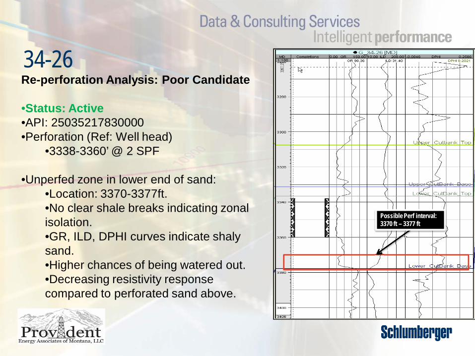
34-26Re-perforation Analysis: Poor Candidate
•Status: Active•API: 25035217830000•Perforation (Ref: Well head)
•3338-3360’ @ 2 SPF
•Unperfed zone in lower end of sand:•Location: 3370-3377ft.•No clear shale breaks indicating zonal isolation.•GR, ILD, DPHI curves indicate shalysand.•Higher chances of being watered out.•Decreasing resistivity response compared to perforated sand above.
Possible Perf interval: 3370 ft – 3377 ft

1986 87 88 89 90 91 92 93 94 95 96 97 98 99 2000 01 02 03 04 05 06 07 080.1
0.5
1
5
10
50
100
200
Date
Oil Rate (Cal. Day) ( bbl/d )Water Rate (Cal. Day) ( bbl/d )Water Injection Rate (Cal.Day) ( bbl/d )Lease Oil Rate (Cal.Day) ( bbl/d )Lease Water Rate (Cal.Day) ( bbl/d )
Operator: PROVIDENT ENERGY ASSOCIATION LLC
Location: SEC 34.0 N 32.0 W 6.0
Well: TWO_MEDICINE_CBSU 34-26
Upper_Perfs_(Top): 3338'
Lower_Perfs_(Base): 3360'
Oil Cum: 29 MBOGas Cum: * MMCFG
Water Cum: 73 MBW
Well Type: Active_PRD
1987 88 89 90 91 92 93 94 95 96 97 98 99 2000 01 02 03 04 05 06 07 080.1
0.5
1
5
10
50
100
20
40
60
80
100
Date
Axis 1Water Oil Ratio ( bbl/bbl )
Axis 2Water Cut ( % )
Operator: PROVIDENT ENERGY ASSOCIATION LLC
Location: SEC 34.0 N 32.0 W 6.0
Well: TWO_MEDICINE_CBSU 34-26
Upper_Perfs_(Top): 3338'
Lower_Perfs_(Base): 3360'
Oil Cum: 29 MBOGas Cum: * MMCFG
Water Cum: 73 MBW
Well Type: Active_PRD
34-26

26-15Re-perforation Analysis: Poor Candidate
•Status: Active•API: 25035071970000•Perforation (Ref: Well head)
•3222.5 - 3226’ @ 4 SPF•3232 – 3244’ @ 4 SPF
•Unperforated zone in upper end of sand:•3200-3221ft
•High Water Cut (88%).•Lack of clear shale break indicates higher chances of being watered out in unperforated upper zone.
•Well located next to new proposed NE infill well (between 26-15 and 35-03). Suggest not recompleting for pressure maintenance reasons.
Possible Perf interval: 3200-3221 ft

26-15
1968 69 70 71 72 73 74 75 76 77 78 79 80 81 82 83 84 85 86 87 88 89 90 91 92 93 94 95 96 97 98 99 2000 01 02 03 04 05 06 07 080.1
0.51
510
50
100
5001000
Date
Oil Rate (Cal. Day) ( bbl/d )Water Rate (Cal. Day) ( bbl/d )Water Injection Rate (Cal.Day) ( bbl/d )
Operator: PROVIDENT ENERGY ASSOCIATION LLC
Location: SEC 26.0 N 32.0 W 6.0Well: TWO_MEDICINE_CBSU 26-15
Upper_Perfs_(Top): 3222'Lower_Perfs_(Base): 3244'
Oil Cum: 102.16 MBO
Gas Cum: * MMCFGWater Cum: 356.55 MBO
1968 70 72 74 76 78 80 82 84 86 88 90 92 94 96 98 2000 02 04 06 081
5
10
50
100
500
1000
0
20
40
60
80
100
Axis 1Water Oil Ratio ( bbl/bbl )
Axis 2Water Cut ( % )
Operator: PROVIDENT ENERGY ASSOCIATION LLC
Location: SEC 26.0 N 32.0 W 6.0Well: TWO_MEDICINE_CBSU 26-15
Upper_Perfs_(Top): 3222'Lower_Perfs_(Base): 3244'
Oil Cum: 102.16 MBO
Gas Cum: * MMCFGWater Cum: 356.55 MBO

34-09Re-perforation Analysis: Poor Candidate
•Status: SI/TA•API: 25035050420000 •Perforation (Ref: Well head)
•3338-3360’ @ 4 SPF
•Unperforated zone in upper and lower end of sand:•3424-3427ft •3430-3438ft•3442-3448ft
•Dec ‘98 – Well shut in due to Uneconomical production.
•98% Water cut. No clear shale breaks indicating zonal isolation.•Higher chances of lower zone being watered out.•Resistivity response higher below perforation, fining upward above perforation.
Possible Perf interval: 3424-3427 ft3430-3438 ft3442-3448 ft

34-09
69 71 73 75 77 79 81 83 85 87 89 91 93 95 97 99 01 03 05 07 09100
101
102
103
104
105
Date
Water Injection ( bbl )Oil Production ( bbl )Water Production ( bbl )
Operator: PROVIDENT ENERGY ASSOCIATION LLC
Location: SEC 34.0 N 32.0 W 6.0
Well: TWO_MEDICINE_CBSU 34-09
Upper_Perfs_(Top): 3439'
Lower_Perfs_(Base): 3442'
Oil Cum: 74 MBOGas Cum: * MMCFG
Water Cum: 960 MBW
69 71 73 75 77 79 81 83 85 87 89 91 93 95 97 99 01 03 05 07 090.1
0.5
1
5
10
50
100
0
20
40
60
80
100
Date
Axis 1Water Oil Ratio ( bbl/bbl )
Axis 2Water Cut ( % )
Operator: PROVIDENT ENERGY ASSOCIATION LLC
Location: SEC 34.0 N 32.0 W 6.0
Well: TWO_MEDICINE_CBSU 34-09
Upper_Perfs_(Top): 3439'
Lower_Perfs_(Base): 3442'
Oil Cum: 74 MBOGas Cum: * MMCFG
Water Cum: 960 MBW

34-25
10 ft not perfed, further checks needed
Re-perforation Analysis: Poor Candidate
•Status: SI/TA•API: 25035217850000•Perforation (Ref: Well head)
•3250-3274’ @ 2 SPF
•Unperforated zone in upper and lower end of sand:•3239-3249ft •3274-3276ft
•No clear shale breaks present.•76% Water cut, low oil cum (1.40 Mbbl)•Well located adjacent to Injector (34-10) with high injection radius (1120 ft). •Higher chances of lower zone being watered out.•Upper zone logs show increasing shale trend, quality of sand average at best.
Possible Perf interval: 3239-3249 ft3274-3276 ft

34-25
69 71 73 75 77 79 81 83 85 87 89 91 93 95 97 99 01 03 05 07 091
5
10
50
100
500
1000
Date
Water Injection ( bbl )Oil Production ( bbl )Water Production ( bbl )
Operator: PROVIDENT ENERGY ASSOCIATION LLC
Location: SEC 34.0 N 32.0 W 6.0
Well: TWO_MEDICINE_CBSU 34-25
Upper_Perfs_(Top): 3250'
Lower_Perfs_(Base): 3274'
Oil Cum: 1 MBOGas Cum: * MMCFG
Water Cum: 7 MBW
69 71 73 75 77 79 81 83 85 87 89 91 93 95 97 99 01 03 05 07 090.1
0.5
1
5
10
50
100
30
45
60
75
90
105
Date
Axis 1Water Oil Ratio ( bbl/bbl )
Axis 2Water Cut ( % )
Operator: PROVIDENT ENERGY ASSOCIATION LLC
Location: SEC 34.0 N 32.0 W 6.0
Well: TWO_MEDICINE_CBSU 34-25
Upper_Perfs_(Top): 3250'
Lower_Perfs_(Base): 3274'
Oil Cum: 1 MBOGas Cum: * MMCFG
Water Cum: 7 MBW
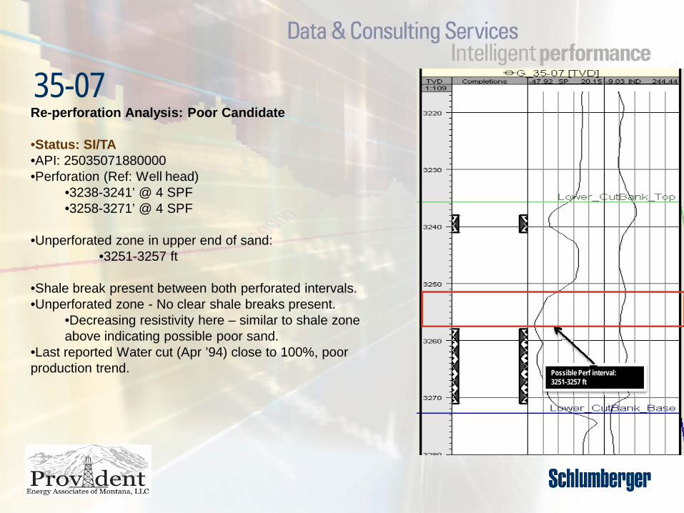
35-07
Possible Perf interval: 3251-3257 ft
Re-perforation Analysis: Poor Candidate
•Status: SI/TA•API: 25035071880000•Perforation (Ref: Well head)
•3238-3241’ @ 4 SPF•3258-3271’ @ 4 SPF
•Unperforated zone in upper end of sand:•3251-3257 ft
•Shale break present between both perforated intervals.•Unperforated zone - No clear shale breaks present.
•Decreasing resistivity here – similar to shale zone above indicating possible poor sand.
•Last reported Water cut (Apr ’94) close to 100%, poor production trend.

35-07
68 69 70 71 72 73 74 75 76 77 78 79 80 81 82 83 84 85 86 87 88 89 90 91 92 93 94 95 96 97 98 99200001 02 03 04 05 06 07 08 09100
101
102
103
104
105
106
Date
Oil Production ( bbl )Water Production ( bbl )Water Injection ( bbl )Lease_Monthly_OilLease_Monthly_WaterOil Production ( bbl )Water Production ( bbl )
Operator: PROVIDENT ENERGY ASSOCIATION LLC
Location: SEC 35.0 N 32.0 W 6.0
Well: TWO_MEDICINE_CBSU 35-07
Upper_Perfs_(Top): 3238'
Lower_Perfs_(Base): 3271'
Oil Cum: 135 MBOGas Cum: * MMCFG
Water Cum: 311 MBW
68 69 70 71 72 73 74 75 76 77 78 79 80 81 82 83 84 85 86 87 88 89 90 91 92 93 94 95 96 97 98 99200001 02 03 04 05 06 07 08 090.001
0.01
0.1
1
10
100
1000
0
20
40
60
80
100
Date
Axis 1Water Oil Ratio ( bbl/bbl )
Axis 2Water Cut ( % )
Operator: PROVIDENT ENERGY ASSOCIATION LLC
Location: SEC 35.0 N 32.0 W 6.0
Well: TWO_MEDICINE_CBSU 35-07
Upper_Perfs_(Top): 3238'
Lower_Perfs_(Base): 3271'
Oil Cum: 135 MBOGas Cum: * MMCFG
Water Cum: 311 MBW

Conclusions• Top 2 candidates were identified based on available log data.• Schlumberger recommends running a standard suite of logs
before any re-perforation campaign (particularly to obtain current water saturation)
• Agree upon final candidate selection to proceed with reactivation/re-perforation program