Titleholder Kurilpa Uranium Pty Ltd Project Operator ...
13
Kurilpa Uranium Pty Ltd ACN 135 531 341 36 North Terrace, Kent Town SA 5067 Telephone 61 8 8363 6989 Facsimile 61 8 8363 4989 Titleholder Kurilpa Uranium Pty Ltd Project Operator Renascor Resources Ltd Tenement Agent Australian Mining & Exploration Title Services Pty Ltd Titles/Tenements EL 28259 Project Name Erldunda East Report Title Annual and Final Report for period ending 2 2014 Personal Author Geoff McConachy Corporate Author Renascor Resources Ltd Target Commodity Sandstone hosted Uranium Date of Report 17 April 2014 Datum/Zone GDA94 / Zone 53 250,000K mapsheet KULGERA (SG53-05) HENBURY (SG53-01) 100,000K mapsheet HENBURY (5548) & ERLDUNDA (5547) Contact Details: G. McConachy 36 North Terrace, KENT TOWN, SA 5067 Phone: (08) 8363 6989 Fax: (08) 9363 4989 Email for further technical details [email protected] Email for expenditure [email protected]
Transcript of Titleholder Kurilpa Uranium Pty Ltd Project Operator ...
Kurilpa Uranium Pty Ltd ACN 135 531 341 36 North Terrace,
Kent Town SA 5067 Telephone 61 8 8363 6989 Facsimile 61 8 8363 4989
Titleholder Kurilpa Uranium Pty Ltd
Project Operator Renascor Resources Ltd
Tenement Agent Australian Mining & Exploration Title Services Pty Ltd
Titles/Tenements EL 28259
Project Name Erldunda East
Report Title Annual and Final Report for period ending 2м CŜō 2014
Personal Author Geoff McConachy
Corporate Author Renascor Resources Ltd
Target Commodity Sandstone hosted Uranium
Date of Report 17 April 2014
Datum/Zone GDA94 / Zone 53
250,000K mapsheet KULGERA (SG53-05) HENBURY (SG53-01)
100,000K mapsheet HENBURY (5548) & ERLDUNDA (5547)
Contact Details:
G. McConachy
36 North Terrace, KENT TOWN, SA 5067
Phone: (08) 8363 6989
Fax: (08) 9363 4989
Email for further technical details [email protected]
Email for expenditure [email protected]

EL 28259 ERLDUNDA EAST
Annual and Final Report
For the report period ending 2м CŜōNJdzŀNJȅ 2014
ABSTRACT
This report represents the third and final annual technical report for EL 28259 Erldunda East 100 %
owned by Kurilpa Uranium Pty Ltd a wholly owned subsidiary of Renascor Resources Limited.
EL 28259 Erldunda East initially covered approximately 936 km2 (301 Blocks) within the Amadeus
Basin, 200 km south-south-west of Alice Springs, Northern Territory. The tenement now is defined
by 136 Blocks with the relinquishment of 165 Blocks. The project is targeting major sandstone
hosted uranium in areas not previously recognised or thoroughly evaluated for uranium
mineralisation. Kurilpa also recognises particularly subjacent to the Pertinjara unconformity there is
potential for other styles of sediment-hosted copper and zinc mineralisation.
The current reporting period on EL 28259, Erldunda East has involved:
Pursuit of a joint venture partner to assist with funding exploration for uranium
mineralisation.
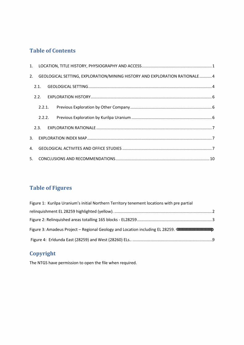
Table of Contents
1. LOCATION, TITLE HISTORY, PHYSIOGRAPHY AND ACCESS .............................................................. 1
2. GEOLOGICAL SETTING, EXPLORATION/MINING HISTORY AND EXPLORATION RATIONALE ........... 4
2.1. GEOLOGICAL SETTING ............................................................................................................. 4
2.2. EXPLORATION HISTORY ........................................................................................................... 6
2.2.1. Previous Exploration by Other Company ........................................................................ 6
2.2.2. Previous Exploration by Kurilpa Uranium ....................................................................... 6
2.3. EXPLORATION RATIONALE ...................................................................................................... 7
3. EXPLORATION INDEX MAP .............................................................................................................. 7
4. GEOLOGICAL ACTIVITES AND OFFICE STUDIES ............................................................................... 7
5. CONCLUSIONS AND RECOMMENDATIONS ................................................................................... 10
Table of Figures
Figure 1: Kurilpa Uranium’s initial Northern Territory tenement locations with pre partial
relinquishment EL 28259 highlighted (yellow). ...................................................................................... 2
Figure 2: Relinquished areas totalling 165 blocks - EL28259 .................................................................. 3
Figure 4: Erldunda East (28259) and West (28260) ELs.. ....................................................................... 9
Copyright
The NTGS have permission to open the file when required.
Figure 3: Amadeus Project – Regional Geology and Location including EL 28259. ΦΦΦΦΦΦΦΦΦΦΦΦΦΦΦΦΦΦΦΦΦΦΦΦΦΦΦΦΦΦΦр
1 | P a g e
1. LOCATION, TITLE HISTORY, PHYSIOGRAPHY AND ACCESS
EL 28259 is located within Kurilpa Uranium’s Amadeus Basin Project which comprises in
total, seven (7) exploration licences (Figure 1). The properties cover the central and
southern parts of the intracratonic Amadeus Basin, approximately 200 km south-south-west
of Alice Springs. This project area is entirely greenfields with no record of any significant
past mineral exploration. The Mount Kitty Structure however is presently being investigated
by Central Petroleum.
Kurilpa Uranium Pty Ltd. (Kurilpa) was granted EL 28259 on 24th March 2011 for a tenure
period of six (6) years. The area of the exploration licence covered approximately 936 km2.
EL 28259 is located within the Kulgera (SG53-05) & Henbury (SG53-01) 1:250 000 Map
Sheets; the Henbury (5548) & Erldunda (5547) 1:100 000 map sheets and covers native title
affected, freehold land.
The licence was surrendered on 21 February 2014.
The goal of the Amadeus Basin Project was to locate a major sandstone hosted uranium
deposit by applying hydrocarbon concepts and cutting-edge basin analysis technologies. As
part of a regional assessment of exploration opportunities in areas of uranium-enriched
sources, Kurilpa has focussed on areas not previously recognised or thoroughly evaluated for
uranium mineralisation. This has provided evidence in the Central Australian Basins of
significant remobilisation of uranium from radiogenic basement into overlying
Neoptoterozoic, Palaeozoic and younger sedimentary cover units. Kurilpa believes that the
uranium deposits at Angela (Amadeus Basin), Bigrlyi and Napperby (Ngalia Basin) are
examples of such a process.
However with the current lack of support for nuclear power and the stagnation of the
uranium price, Kurilpa acknowledges obtaining funds for uranium only exploration has been
difficult and hence no on-ground exploration has been undertaken.

2 | P a g e
and turnoff to Ayres Rock. The licence is covered by native title affected freehold land and
the land is used primarily for cattle grazing.
Physiographical nature of the land consists of generally low lying to weakly undulating land
with moderate dunes of less than 5 m height, surface cover of ferricrete and calcrete with
compact clays and low-lying shrubs.
Figure 1: Kurilpa Uranium’s initial Northern Territory tenement locations with pre partial relinquishment EL 28259 highlighted (yellow).
Access to EL 28259 is good via the Stuart Highway which runs through the exploration
licence and also serviced by several other maintained roads. The Adelaide-Darwin railway is
just east of the tenement. The identifiable landmark in the area is the Erldunda Roadhouse

3 | P a g e
Figure 2: Relinquished areas totalling 165 blocks - EL28259
4 | P a g e
2. GEOLOGICAL SETTING, EXPLORATION/MINING HISTORY AND EXPLORATION
RATIONALE
2.1. GEOLOGICAL SETTING
EL 28259 is located within the Amadeus Basin (Figure 2). The Amadeus Basin is a large
intracratonic basin extending across the southern part of the Northern Territory and into
Western Australia. It is approximately 800 km long in the east-west direction and up to
300 km wide in the north-south direction containing a thickness of up to 14 km of
sedimentary rocks of Neoproterozoic to Palaeozoic age. These are partially covered by
surficial Tertiary and Quaternary deposits. The basin has had a long-lived multi-event
tectonic history.
Palaeoproterozoic and Mesoproterozoic metamorphic rocks of the Arunta Complex
unconformably underlie the basin to the north. To the south the older rocks are the
Mesoproterozoic crystalline rocks of the Musgrave Province. Both these basement blocks
are dominated by felsic gneisses and granites which are potentially important uranium-
enriched source rocks that have repeatedly been shed into the basin during major tectonic
inversions (uplifts) of its margins.
In the Amadeus Basin, the basal sequence of Neoproterozoic strata comprises shelf,
lagoonal and continental fluvio-glacial sediments, including thick evaporates and minor
volcanics. Cambrian sediments of continental and shallow marine origin overlie
disconformably and include carbonates and evaporates. Unconformable late Cambrian-
Ordovician marine sediments or continental Devonian-Carboniferous sediments complete
the sequence.
The present day shape of the Amadeus Basin effectively results from two major orogenic
cycles. Extensive broad folding and thrusting deformed the southern margin of the basin
during the Petermann Orogeny (late Proterozoic). The Alice Springs orogeny (Devonian-
Carboniferous) similarly deformed the northern margin. These events are regarded as
important to ore forming processes.
Uranium mineralisation in the Amadeus Basin is localised at redox interfaces in the
Devonian-Carboniferous sequence, related to reduced sequences contained in oxidised red-

5 | P a g e
bed sequences. The reduced beds are grey or in places white, where oxidation of pyritic
sulphides caused bleaching.
Small sandstone-hosted uranium deposits were discovered in the 1970’s. These were the
Pamela and Angela prospects, about 100 km north of the current project. Hosted within
Late Devonian arkosic sandstones (Brewer Conglomerate) they are close to the hinge zone of
the east-west missionary Plains Syncline. Additionally in sediments of similar age and
geological setting in the Ngalia Basin (Bigryli), as well as a number of basement hosted
uranium occurrences and the Tertiary hosted Napperby uranium deposit.
Figure 3: Amadeus Project – Regional Geology and Location including EL 28259.
6 | P a g e
2.2. EXPLORATION HISTORY
2.2.1. Previous Exploration by Other Company
Uranerz Australia Pty Ltd (UAL) initiated uranium exploration in the Amadeus Basin in 1972,
targeting sandstone-hosted deposits similar to those known in the western United States.
Reconnaissance airborne radiometric surveys identified several small anomalies south of
Alice Springs, near the northern margin of the Amadeus Basin about 100 km north of the
current project. Scout drilling during 1973-74 discovered uranium mineralisation at Angela
and Pamela prospects, which were delineated by detailed drilling during 1975-79, operating
under a joint venture between UAL and MIM Exploration.
The current project area lies in the southern Amadeus Basin, 100 km to the south of the
Angela and Pamela uranium prospects. Here, minerals exploration has been active since
1988 and mainly involved evaluation of evaporate deposits. There was one uranium
exploration and also a search for diamond and/or base metals.
Nova Energy Ltd. (Nova) explored for uranium in the northern and eastern parts of the
current Project area between 2006 and 2009. Nova’s focus was to identify redox related
uranium mineralisation in sediments of the Upper Devonian Finke Group. These sediments
are considered similar to those hosting the Pamela and Angela uranium deposits, which lie in
the Amadeus Basin. Initial work included acquisition of available data and interpretation of
Landsat satellite imagery. A helicopter assisted geological reconnaissance and scintillometer
prospecting survey followed. Nova concluded that the margin of the Amadeus basin may
contain more fluvial or deltaic facies, which they considered more prospective for sediment
hosted uranium deposits associated with redox boundaries.
Toro Energy Ltd (Toro) acquired Nova in 2007. Toro proposed to carry out a drilling program
aimed at testing the redox boundaries in the sequence. However, Toro surrendered the
licences when Idracowie Station denied access. Other exploration included a program by
CRA Exploration Pty Ltd in 1991, searching for diamonds and base metals.
2.2.2. Previous Exploration by Kurilpa Uranium
Within the relinquished areas no exploration has been conducted by Kurilpa.
7 | P a g e
2.3. EXPLORATION RATIONALE
The south-eastern Amadeus Basin is largely unexplored. Knowledge of subsurface geology is
based on limited seismic data and the drilling results from only six wells. Magee-1, the last
exploration well in the basin and drilled in 1992, intersected a thin helium rich gas pay zone
and tested a petroleum system in the Neoproterozoic Heavitree Quartzite. Aeromagnetic
data and SEEBASE TM depth to basement modelling provide an understanding of the
basement structure, which is characterised by major faults and basement highs.
Amadeus Project has potential for structurally controlled, sediment hosted uranium
deposits. Seismic data show potential for focusing deep basinal brines, derived from thick
Neoproterozoic evaporates and known to be effective in remobilisation of uranium, into
high-level reduced ore-forming traps, along structurally reactivated conduits such as faults
and salt domes. Gamma logs from the gas exploration hole Magee-1 returned elevated
radiogenic signatures from Heavitree and Stairway Sandstone units. This hole also profiles
evidence of remobilisation of uranium from radiogenic basement into the overlying
Neoproterozoic, Palaeozoic and younger sedimentary cover units.
A thin regolith profile and overlying transported materials tend to mask radiometric
signatures and restrict geochemical dispersion halos, except close to bedrock mineralisation.
Kurilpa Uranium will draw on experiences from exploration in other large basins to provide
guideline for targeting structural traps beneath the masking cover.
3. EXPLORATION INDEX MAP
As no on-ground work was undertaken within the relinquished area, no specific index map
can be compiled.
4. GEOLOGICAL ACTIVITES AND OFFICE STUDIES
No on-ground exploration activities were completed.
Internal desktop based assessment of historic geological, geophysical and seismic when
available data, looking for structural and stratigraphic traps for uranium associated with
helium gas was conducted.

8 | P a g e
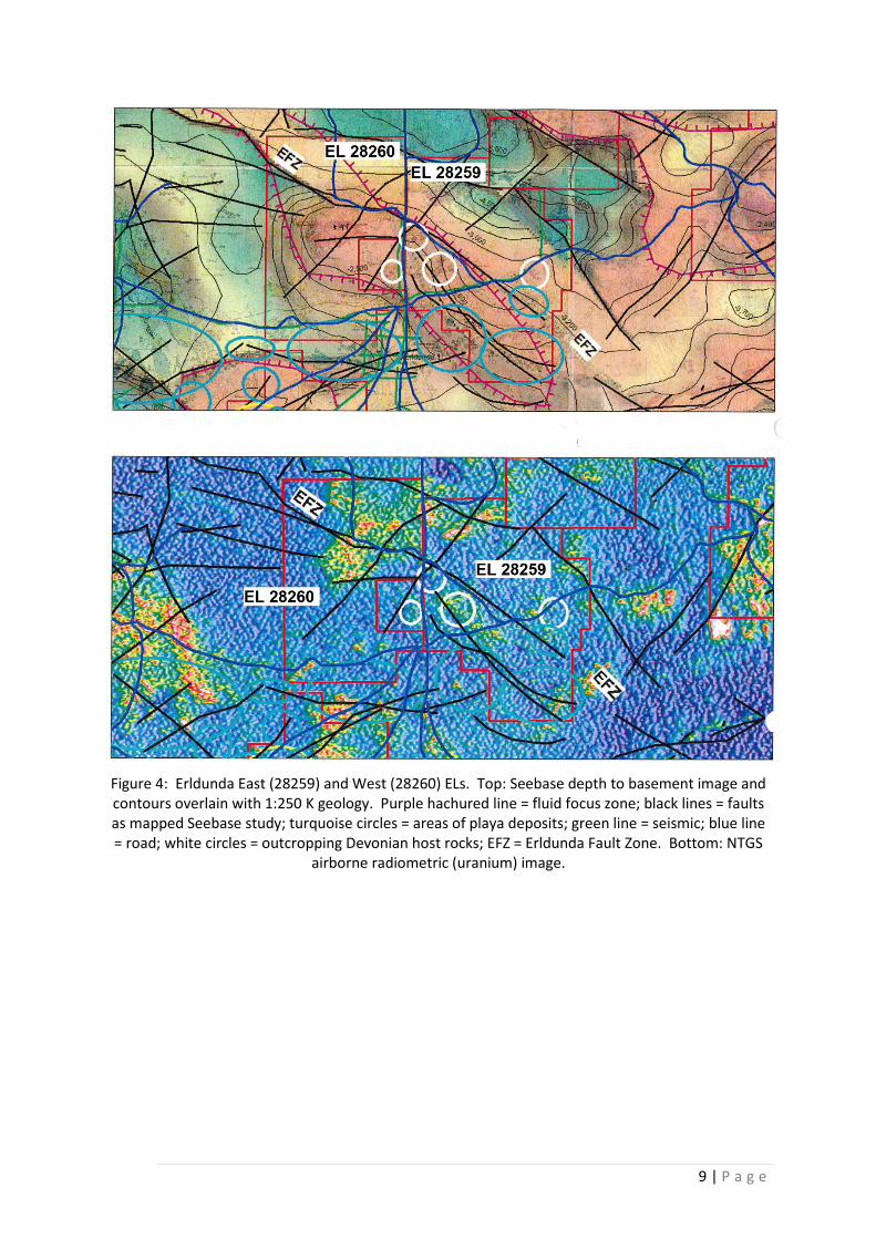
The primary objective was to identify one or more drill targets on/above the regional NW-SE
Erldunda Fault Zone and splay which control a major fluid focus high. Outcrop in the
tenement was identified – some Devonian host out/subcrop within areas of main focus.
Outcropping Palaeozoic-Neoproterozoic rocks in the north parts of the tenements are
radiometrically anomalous.
Public available seismic lines appear not in a readily available format to be retrieved and
analysed. The presence of surface salt and possibly salt solutions upwelling along the faults
would appear problematic for Airborne Electromagnetics (AEM) although the northern parts
of the tenement seem salt pan free. Detailed gravity exists for the northern parts of the EL
and covers some of the zone of main interest.
The tenement did not provide sufficient geological interest for further investment.
9 | P a g e
Figure 4: Erldunda East (28259) and West (28260) ELs. Top: Seebase depth to basement image and contours overlain with 1:250 K geology. Purple hachured line = fluid focus zone; black lines = faults as mapped Seebase study; turquoise circles = areas of playa deposits; green line = seismic; blue line = road; white circles = outcropping Devonian host rocks; EFZ = Erldunda Fault Zone. Bottom: NTGS
airborne radiometric (uranium) image.

10 | P a g e
5. CONCLUSIONS AND RECOMMENDATIONS
No on-ground exploration was conducted in the current reporting period.
Desktop based assessment of historic data looking for structural and stratigraphic traps for
uranium associated with helium gas was conducted. Data collaboration identifying features
supporting exploration rationale included depth to shallow bedrock improving viability of
proposed multi-element geochemistry and road access making it easy to undertake several
exploratory lines or reconnaissance grids to test the technique over the major fault(s).
The tenement did not provide sufficient geological interest for further investment.