TITLE OF PAPER: DISTORTIONS OF THE URBAN LAND...
30
TITLE OF PAPER: DISTORTIONS OF THE URBAN LAND MARKET IN NIGERIAN CITIES AND THE IMPLICATIONS FOR URBAN GROWTH PATTERNS: THE CASE OF ABUJA AND PORT HARCOURT. Opuenebo Owei Dr. Department of Urban and Regional Planning Rivers State University of Science and Technology PMB 5080 Nkpolu - Port Harcourt Email: [email protected] Abstract Rapid urban growth, especially in the last two decades, has put enormous pressure on land in Nigerian cities. The consequences especially for urban development are many. Struggles for access to land and conflicts, generated by this, especially between indigenous urban communities and those who acquire or purchase land for private or public development have also increased. Thus, urban expansion is taking place mostly in an unplanned manner, without services, roads and other community infrastructure especially in parts of the metropolis that are within indigenous communities. The paper examines how land enters the market, the instrumentation of public land acquisition and regulations in defining urban growth patterns. The study focuses on these processes in the Port Harcourt Metropolis and the Federal Capital Territory, Abuja. Key Words: Land, indigenous communities, public acquisition, unplanned development
Transcript of TITLE OF PAPER: DISTORTIONS OF THE URBAN LAND...

TITLE OF PAPER: DISTORTIONS OF THE URBAN LAND MARKET IN NIGERIAN CITIES
AND THE IMPLICATIONS FOR URBAN GROWTH PATTERNS: THE CASE OF ABUJA AND PORT HARCOURT.
Opuenebo Owei Dr.
Department of Urban and Regional Planning Rivers State University of Science and Technology
PMB 5080 Nkpolu - Port Harcourt
Email: [email protected]
Abstract
Rapid urban growth, especially in the last two decades, has put enormous pressure on land in Nigerian cities. The consequences especially for urban development are many. Struggles for access to land and conflicts, generated by this, especially between indigenous urban communities and those who acquire or purchase land for private or public development have also increased. Thus, urban expansion is taking place mostly in an unplanned manner, without services, roads and other community infrastructure especially in parts of the metropolis that are within indigenous communities. The paper examines how land enters the market, the instrumentation of public land acquisition and regulations in defining urban growth patterns. The study focuses on these processes in the Port Harcourt Metropolis and the Federal Capital Territory, Abuja.
Key Words: Land, indigenous communities, public acquisition, unplanned development

Distortions of the Urban Land Market in Nigerian Cities Fourth Urban Research Symposium 2007 And the Implications for Urban Growth Patterns: The Case of Abuja and Port Harcourt.
DISTORTIONS OF THE URBAN LAND MARKET IN NIGERIAN CITIES AND THE IMPLICATIONS FOR URBAN GROWTH MANAGEMENT: THE CASE OF
ABUJA AND PORT HARCOURT
I. INTRODUCTION Nigeria has one of the highest rates of urbanization in Africa (Onibokun 2004). It is
estimated that by the year 2020, the urban population would reach 68% of the total population of the country. The growth of the urban population is in two dimensions. First, there is an increase in the number of settlements with population of at least 20,000 (the official government definition of an urban centre). In 1991 there were 359 of such settlements. By 2000, this number had increased to 450. The second dimension is the number of settlements that have increased in size and now have populations of one million and more persons. Lagos metropolis is estimated to have a population of over nine million. Ibadan, Abuja and Port Harcourt all have populations in the millions. Spatially also, the spread of these settlements is increasing at a fast rate. This growth has not been matched by provision of services and infrastructure. Much of
it has also not been planned. Thus Nigeria’s urban centers are characterized by poverty, inadequate services, poor sanitation, poor housing, mobility and transportation problems and generally poor quality of urban life. Essentially, no city in the country has been able to efficiently plan or manage its growth. Urban growth has proceeded fuelled by its own dynamics, the result of interplay between social and economic factors and people’s attempt to secure their livelihoods within the urban environment. The physical manifestation of this largely unplanned urban growth is perhaps the most important evidence of what has widely been regarded as an “urban crisis”. Ogu and Adeniji (1998) suggest that the extent to which human communities both urban and rural but particularly the former are sustainable may well depend on the management of such settlements. The key issues which are considered relevant to sustainable settlement management include; land use and management, environmental management, financing, institutional and regulatory administrative issues.
Urban growth is the physical manifestation of the land use decisions made by all stake
holders in the urban system. These include; the government and its institutions, households of different socio – economic backgrounds, industries, commercial and business interests. The degree of order or chaos that characterizes a city‘s growth is a result of how these decisions have been managed over time. The role of the state or government in this process cannot be over – emphasized. Significantly, the acquisition and development of land is the basis of urban physical growth. From colonial times to the present, access to urban land is a contextual issue in Nigeria.
Since the emergence of the colonial city, government has staked its interest in land through acquisition and control of land from indigenous communities using laws and regulatory tools. The two most important laws during the colonial era were the Township
1
Distortions of the Urban Land Market in Nigerian Cities Fourth Urban Research Symposium 2007 And the Implications for Urban Growth Patterns: The Case of Abuja and Port Harcourt.
Ordinance and the Public Lands Acquisition Ordinance both of 1917. Whereas the Township Ordinance established broad physical layouts of towns and classified Nigerian towns into first, second and third class townships, the Public Lands Acquisition Ordinance provided for the compulsory acquisition of land by government as “crown land”. Olawoye (1974) argues that title to land passed from indigenous groups, where an interest in land is held under customary law to the colonial government having been converted into an interest under English law. However, land left un-acquired continued to remain under the control of indigenous groups and was held under customary laws. This transfer in land using the British imposed laws laid the foundation for legal pluralism and consequently emerging arenas of conflict over urban land in Nigeria.
It was the 1978 Land Use Act that brought all land under the control of government.
The Act strengthened the powers of compulsory acquisition by government for public purposes. Absolute ownership under this Act is vested in the Governor of each state who holds the land in trust for the people. The Governor issues the statutory Certificate of Occupancy (C of O) which together with the survey plan forms the title to land. The Land Use Act was promulgated to enhance peoples’ access to land and to remove all constraints against government‘s free access to land in the interest of the public. It empowers the governor to grant statutory rights of occupancy to any person for all purposes and the local government to grant customary rights of occupancy to any person or organization for the use of land in the local government area for agricultural, residential and other purposes. However, because the fundamental principles of the Land Use Act are contrary to customary laws over land and the cultural attachment that different groups in Nigeria have to land, the implementation has been problematic. Access to land cannot be guaranteed under the law for either government or individuals. It has been shown that the statutory Certificate of Occupancy issued under the hand of the Governor lies merely in evidencing title as opposed to conferment of title. Where title is defective, the statutory Certificate of Occupancy evidences nothing and becomes a worthless piece of paper (Kings – Amadi, 2004). The ultimate right to land obviously still lies with indigenous groups, at least in the Port Harcourt case. The C of O in Port Harcourt does not guarantee possession. Title may be sound 100% but you cannot occupy without negotiating with the natives and paying the full market value of the property. Thus access to land has become part of the larger dimension of the struggle for resource allocation. The differential access to land, moderated by state agencies through laws that are not in tune with existing customary laws and traditional attachments to land (usufruct), has impacted negatively on urban spatial morphology and housing. In the colonial and post – colonial periods up to the early 1980s, urban growth was matched by large scale public acquisition of land especially for residential development. Studies show that land delivery systems based on legal concepts and administrative systems have proved unable to cope with the demands of rapid urban growth (Oruwari & Owei, 2006; Ikpoki, 2005). Thus urban expansion across Nigerian cities is occurring mainly in an unplanned manner with the attendant lack of services and infrastructure. Whereas this phenomenon has
2
Distortions of the Urban Land Market in Nigerian Cities Fourth Urban Research Symposium 2007 And the Implications for Urban Growth Patterns: The Case of Abuja and Port Harcourt.
received attention in research studies, the fundamental issue of access to land has not. The distortions of the urban land market especially occasioned by state laws and planning regulations have also not been given the attention it deserves. The documentation in this paper is a contribution in this direction. The case study covers two cities – Port Harcourt and Abuja. Port Harcourt is a colonial city, created by the signing of the Hargrove agreement in 1911 and the acquisition of 25 sq miles of land from the indigenous communities of Ikwerre and Okirika peoples. Port Harcourt has since 1970 been the administrative capital of the Rivers State. Port Harcourt has a land supply problem especially as the southward spread of the city is constrained by the river. Urban growth has concentrated in a northwards direction. Government has reclaimed part of the swamps around Port Harcourt to develop new residential neighbourhoods and to facilitate urban renewal. Marginal settlements have sprung up all long the city’s waterfronts and provide housing to the urban poor. Presently, there is a silent battle going on between the state government, the indigenous Ikwerre and Okirika peoples over all lands acquired from them by government. The issues at stake include who controls development on these lands and who collects development fees from developers. In the context of this conflict, militant community groups called “Port Harcourt Aborigines” have emerged. Holders of statutory rights of occupancy are required by these groups to re – negotiate their titles directly with the communities. Those who fail to do so have their land allocations re – possessed or sold off to the highest bidder.
Communities and families who have land holdings not acquired by government have quickly sold them off to avoid public acquisition. A significant impact is that of escalating cost of land and difficulties in land marketing. There is also the social and spatial fragmentation of the city into planned and unplanned neighourhoods, legal and illegal developments; “formal” and “informal” land markets. Abuja, the Federal Capital Territory is an entirely modern Nigerian creation. It was planned and developed by a military Decree in 1976. The seat of the Federal Government of Nigeria was re – located to Abuja in 1991. In spite of attempts to make this a model city in Nigeria, the large scale influx of people to the city especially into the settlements surrounding the federal capital city set off the process of rapid unplanned urban growth in these settlements. It is a physical manifestation which the Federal Capital Development Agency has confronted in the last four years with large scale demolition. The reality on ground shows clearly that demolition does not adequately address the problem. Thus, the rapid expansion of unplanned neighbourhoods and settlement within Port Harcourt and the Federal Capital Territory, Abuja raises several issues for managing the nation’s urban future. These include questions on who gets access to urban land especially for housing development, and the cost of land. It also raises questions on institutional capacity including control and regulation of development on land and implementation of urban development plans. These questions fit within the context of the operations of the land market. Discussions in this paper are an attempt to address these questions in order to provide a better understanding of the urban land market in Nigeria and how it affects the pattern of growth in the nation’s cities.
3

Distortions of the Urban Land Market in Nigerian Cities Fourth Urban Research Symposium 2007 And the Implications for Urban Growth Patterns: The Case of Abuja and Port Harcourt.
1. Objectives of the Study The broad objective of this study is to analyze and explain land market distortions in Nigerian urban centers using Port Harcourt and Abuja as case studies. It will highlight the interplay of factors that account for such distortions. The attainment of this broad objective is predicated on the simultaneous achievement of three specific objectives. These are as follows.
(i) Review the formal and informal processes through which land enters the market in Port Harcourt and Abuja;
(ii) Examine how interventions in the land market through public acquisitions, and the application of laws and regulations on land define urban
growth patterns especially the incidence of unplanned developments; and (iii) Highlight the lessons for managing urban growth in Nigeria.
II. LITERATURE REVIEW Dowall (1993) states that markets provide for the exchange of goods and services between buyers and sellers and that all market transactions have three dimensions ie a product, a quantity and a price. There are many conceptualizations of the land market in Africa. Okuku (2006) suggests that in literature on African land tenure, land market is discussed as synonymous to land sales and the absence of land market is blamed for inefficient allocations of land. A land market is defined as, “a framework through which seekers of land for various uses can acquire it for its development into the required uses” (Dowall, 1991; cited in Okuku, 2006). A distinction is made between market transactions and non – market transactions. Market transactions include land – lease and land – purchase transactions in which the terms are negotiated and agreed and registered for enforcement by law. Non – market transactions include government administered land ownership transfers, rental values and sale price of land. It also includes the transfer of private land ownership and use rights by the legislative power of the state, by inheritance, and marriage. In the context of a market situation, there is supply and demand. Where cities emerge or grow, land becomes much more valuable. The pressure on land comes from both the rapid growth of urban populations and in African cities harsh economic conditions. These according to Onibokun (2004) are market – driven forces. Leduka (2000) posits that just as towns and cities are categorized, the urban land and housing markets in Africa are also thought to be divided into “legal” and “illegal” components. Those in the “legal” city perform according to market laws of demand and supply with clear and unambiguous property titles. The “illegal” city on the other hand defies official planning and building regulations. The land and housing market in this context is said to be inarticulate and informal with tenure conditions that are unclear and precarious. The land is un-serviced and thought to be predominantly occupied by the urban poor.
4
Distortions of the Urban Land Market in Nigerian Cities Fourth Urban Research Symposium 2007 And the Implications for Urban Growth Patterns: The Case of Abuja and Port Harcourt.
It has been suggested that the very categorization of “illegal”, “unplanned” or “uncontrolled”; “informal” urban settlements imply that something legalistic about the cities and their land and housing markets which are not working according to expectations, adding that contrary to what is widely believed, the so – called “illegal” city operates under the shadow of state law (Leduka, 2000). Thus, focusing on formal rules and regulations as principal determinants governing access to urban housing land in the context of cities in sub – Saharan Africa is limiting. The price and availability of land is a key determinant of housing quality and living condition in any city. Inappropriate government legislation, administration and intervention in urban land markets are considered as contributing to poor management of urban land (UNCHS, 1996) Furthermore it adds that, “the solution” to the rigidities and inefficiencies of public action and administration on land and the high proportion of city populations with very limited capacity to pay for ‘housing’ has been the development of illegal or informal land markets” (UNCHS, 1996: 239). Abdoul (2005), citing the work of Coquery – Vidrovitch (1995) suggests that informality is a category recorded in the political, economic and social history of Africa with its origins and characteristics dating back to pre – colonial Africa cities. The informal nature of urban development is expressed by the tension of the phenomena arising from what a state organ controls and what is beyond its control. There are different forces and actors that shape the dynamics of urban land markets. These include investors, original land owners, estate agents, households and even government agencies. Important questions in examining these dynamics include what the rules/laws are pertaining to land acquisition and ownership. Rakodi and Leduka (2003) argue that access to land in suitable locations, at affordable prices, having security of tenure, and entitlement to infrastructure and services is critical to both the roles of cities in economic growth and to the well – being of their populations. They identified public intervention in urban land delivery systems including land use planning, development control, and provision of land and shelter for low income residents as having failed to meet demand. Government policies in less developed countries like Nigeria have emphasized the control and regulation of land use rather than supporting and facilitating the supply and development of land to ensure demand is met as quickly and cheaply as possible (UNCHS, 1996). Much of the urban housing sector in Nigeria is within the private market. Cost is a deterrent especially to the poor accessing land in the private land market. In the public land market the number of plots available is insignificant and the procedure of allocation does not consider the low – income household (Oruwari, 2003). The private land market is also largely informal. III. METHODOLOGY The study covers the Federal Capital Territory (FTC), Abuja and the Port Harcourt Metropolitan Area in the Rivers State. Figures 1 and 2 show the study areas respectively. The study adopted the direct interview technique. 1. Data Sources and Analyses
5

Distortions of the Urban Land Market in Nigerian Cities Fourth Urban Research Symposium 2007 And the Implications for Urban Growth Patterns: The Case of Abuja and Port Harcourt.
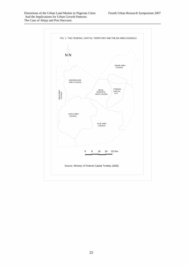
The paper utilizes data from three main sources. Secondary sources of data include government records and published researches. Primary sources of data include interview of key informants including community groups, government officials, professional groups (town planners, land surveyors, architects, estate surveyors and valuers). The third source of data includes selected allotees of government land in Port Harcourt and Abuja. The interviews sought to tease out their knowledge of, and participation in the land market in general and their perspective on the growth of unplanned settlements in and around Abuja and Port Harcourt. Data has been analyzed qualitatively. IV. DISCUSSION OF FINDINGS This is divided into three sub – sections. First sub – section discusses the situation in Abuja, the second focuses on Port Harcourt and the third sub – section is a comparison between the two cities. 1. The Case of the Federal Capital Territory, Abuja The Federal Capital Territory (FCT), Abuja was created as a new seat of the Federal Government of Nigeria by Military Decree – Decree 6 of 1976 .It also established the Federal Capital Development Agency (FCDA) to manage the development of the new capital. A portion of the FCT was designated as the Federal Capital City (FCC). The FCT covers an area of approximately 8,000 sq km while the Federal Capital City (FCC) itself occupies 25,000 Ha (See Fig 1). At creation, the FCT comprised of 845 villages, 150 of these within the FCC and up to 5km radius. The FCC has been the focus of planning and development in the territory’s thirty years of existence. Its planning is divided into four phases and several districts. For purposes of administration, the local population within the FCT was divided into 4 area councils in 1991. Since 1998, these have been increased to six. Table 1 below .shows the area councils and their sizes
Table 1: Six Area Councils in the Federal Capital Territory and their sizes Abuja Municipal Area 1351 km2 Bwari Area Council 1205 km2
Kuje Area Council 1721km2
Gwagwalada Area Council 1034 km2
Kwali Area Council 1134 km2
Abaji Area Council 1565 km2 Total Area = 8000 km2
Source: Abuja Geographic Information System. The Population of the FCT in 1976 was about 124,000. The 1991 national census gave a population figure of 371,674. The provisional population figure from the 2006 census is 1,405201. 1.1. Land Acquisition and Development in the FCT From its initial conception, the Federal government adopted a policy of moving out all the original inhabitants of the FCT and to resettle them outside the territory so that the problem of an indigenous local population claiming to be original owners of parts of the territory
6
Distortions of the Urban Land Market in Nigerian Cities Fourth Urban Research Symposium 2007 And the Implications for Urban Growth Patterns: The Case of Abuja and Port Harcourt.
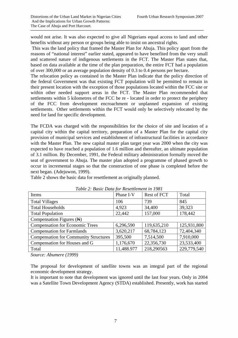
would not arise. It was also expected to give all Nigerians equal access to land and other benefits without any person or groups being able to insist on ancestral rights. This was the land policy that framed the Master Plan for Abuja. This policy apart from the reasons of “national interest” earlier stated, appeared to have benefited from the very small and scattered nature of indigenous settlements in the FCT. The Master Plan states that, based on data available at the time of the plan preparation, the entire FCT had a population of over 300,000 or an average population density of 0.3 to 0.4 persons per hectare. The relocation policy as contained in the Master Plan indicate that the policy direction of the federal Government was that existing FCT population will be permitted to remain in their present location with the exception of those populations located within the FCC site or within other needed support areas in the FCT. The Master Plan recommended that settlements within 5 kilometres of the FCC be re - located in order to protect the periphery of the FCC from development encroachment or unplanned expansion of existing settlements. Other settlements within the FCT would only be selectively relocated by the need for land for specific development. The FCDA was charged with the responsibilities for the choice of site and location of a capital city within the capital territory, preparation of a Master Plan for the capital city provision of municipal services and establishment of infrastructural facilities in accordance with the Master Plan. The new capital master plan target year was 2000 when the city was expected to have reached a population of 1.6 million and thereafter, an ultimate population of 3.1 million. By December, 1991, the Federal military administration formally moved the seat of government to Abuja. The master plan adopted a programme of phased growth to occur in incremental stages so that the construction of one phase is completed before the next began. (Adejuwon, 1999). Table 2 shows the basic data for resettlement as originally planned.
Table 2: Basic Data for Resettlement in 1981 Items Phase I-V Rest of FCT Total Total Villages 106 739 845 Total Households 4,923 34,400 39,323 Total Population 22,442 157,000 178,442 Compensation Figures (N) Compensation for Economic Trees 6,296,590 119,635,210 125,931,800Compensation for Farmlands 3,620,217 68,784,123 72,404,340 Compensation for Community Structures 395,500 7,514,500 7,910,000 Compensation for Houses and G 1,176,670 22,356,730 23,533,400 Total 11,488.977 218,290563 229,779,540Source: Abumere (1999) The proposal for development of satellite towns was an integral part of the regional economic development strategy. It is important to note that development was ignored until the last four years. Only in 2004 was a Satellite Town Development Agency (STDA) established. Presently, work has started
7

Distortions of the Urban Land Market in Nigerian Cities Fourth Urban Research Symposium 2007 And the Implications for Urban Growth Patterns: The Case of Abuja and Port Harcourt.
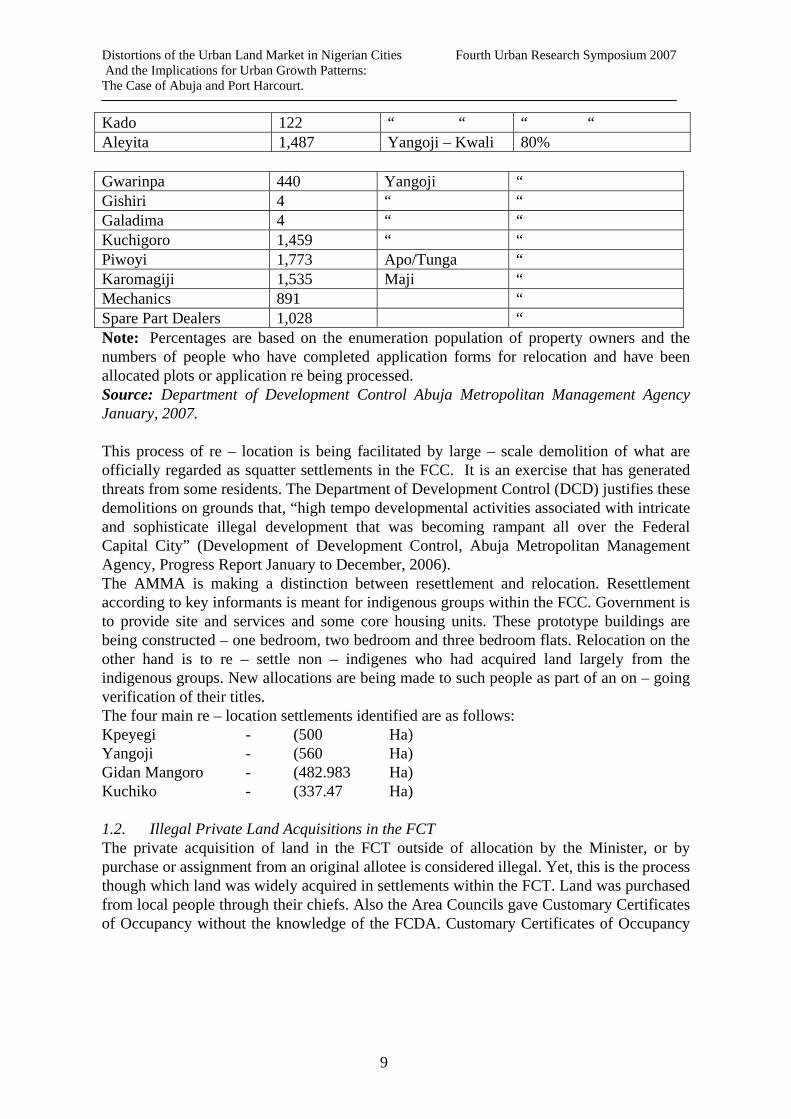
on seven satellite towns. These are: Bwari, Kubwa, Kuje, Kusaki, Yanga, Karshi, Angodi and Dobi. The main function of the STDA is infrastructure development and a strategy of public/private sector partnership has been adopted to develop these towns especially in the area of housing development. According to Abumere (1999) the total cost of compensation at the initial penned of 1976 to 1979 was in the order of 150 million naira (1). However, by 1981, the total cost of compensation had risen to 229.8 million naira. This led the federal government to rethink its resettlement policy to include only villages in the area of the FCC. A study conducted in 1983, showed that about 78.3% of all households in the FCT wished to remain, while 20.6% opted to leave. Based on these findings, the resettlement policy was once again revised to include only those who opted to leave the FCT. Whereas, those who chose to remain were not to be compensated, they were to be compulsorily moved out and resettled elsewhere in the FCT if they were in priority areas within the FCC. In 1984 however, a new policy of integration was introduced. These meant villages within the FCC did not need to be resettled elsewhere but were to be integrated with the new developments in the city. In an interview with officials of the FCDA and Abuja Metropolitan Management Agency (AMMA) some attributed this change in policy direction to the escalating cost of resettlement. Some villages were to be retained on their original sites as cultural landmarks. However other officials attributed this to the politics of ethnicity and undue sentiment. Whatever the reasons for justifying this policy shift, these villages such as Garki Village and Katampe, have become large squatter settlements through a process of private land acquisition by non – indigenes. These indigenous villages had chiefs who illegally sold land to willing buyers. For a number of reasons, successive FCT administrations did not take any steps to stop such sales until the present one. Presently the Federal Capital development Agency identifies 49 villages to be moved out of phases I and II of the FCC. Available data from the Abuja Metropolitan Management Agency show a total of 16 squatter settlements with over 32, 421 structures are at various stages of being relocated in 2006, to new locations within the FCT as shown in table 3 below.
Table 3: Level of Response from Squatter Settlements Name of Settlement No. of
Squatter Landlords who complied
Relocation Settlement
Status
Karmo – Idu 4,500 Pegi Completed 100% Anguwan Mada 3,438 Gidan Mangoro Ongoing 75% Jabi 1,075 Kuchiko – Bwari Ongoing 60% Mabushi 49 “ “ “ “ Utako 24 “ “ “ “ Durumi 97 “ “ “ “ Wuye 1 “ “ “ “
8
Distortions of the Urban Land Market in Nigerian Cities Fourth Urban Research Symposium 2007 And the Implications for Urban Growth Patterns: The Case of Abuja and Port Harcourt.
Kado 122 “ “ “ “ Aleyita 1,487 Yangoji – Kwali 80% Gwarinpa 440 Yangoji “ Gishiri 4 “ “ Galadima 4 “ “ Kuchigoro 1,459 “ “ Piwoyi 1,773 Apo/Tunga “ Karomagiji 1,535 Maji “ Mechanics 891 “ Spare Part Dealers 1,028 “ Note: Percentages are based on the enumeration population of property owners and the numbers of people who have completed application forms for relocation and have been allocated plots or application re being processed. Source: Department of Development Control Abuja Metropolitan Management Agency January, 2007. This process of re – location is being facilitated by large – scale demolition of what are officially regarded as squatter settlements in the FCC. It is an exercise that has generated threats from some residents. The Department of Development Control (DCD) justifies these demolitions on grounds that, “high tempo developmental activities associated with intricate and sophisticate illegal development that was becoming rampant all over the Federal Capital City” (Development of Development Control, Abuja Metropolitan Management Agency, Progress Report January to December, 2006). The AMMA is making a distinction between resettlement and relocation. Resettlement according to key informants is meant for indigenous groups within the FCC. Government is to provide site and services and some core housing units. These prototype buildings are being constructed – one bedroom, two bedroom and three bedroom flats. Relocation on the other hand is to re – settle non – indigenes who had acquired land largely from the indigenous groups. New allocations are being made to such people as part of an on – going verification of their titles. The four main re – location settlements identified are as follows: Kpeyegi - (500 Ha) Yangoji - (560 Ha) Gidan Mangoro - (482.983 Ha) Kuchiko - (337.47 Ha) 1.2. Illegal Private Land Acquisitions in the FCT The private acquisition of land in the FCT outside of allocation by the Minister, or by purchase or assignment from an original allotee is considered illegal. Yet, this is the process though which land was widely acquired in settlements within the FCT. Land was purchased from local people through their chiefs. Also the Area Councils gave Customary Certificates of Occupancy without the knowledge of the FCDA. Customary Certificates of Occupancy
9
Distortions of the Urban Land Market in Nigerian Cities Fourth Urban Research Symposium 2007 And the Implications for Urban Growth Patterns: The Case of Abuja and Port Harcourt.
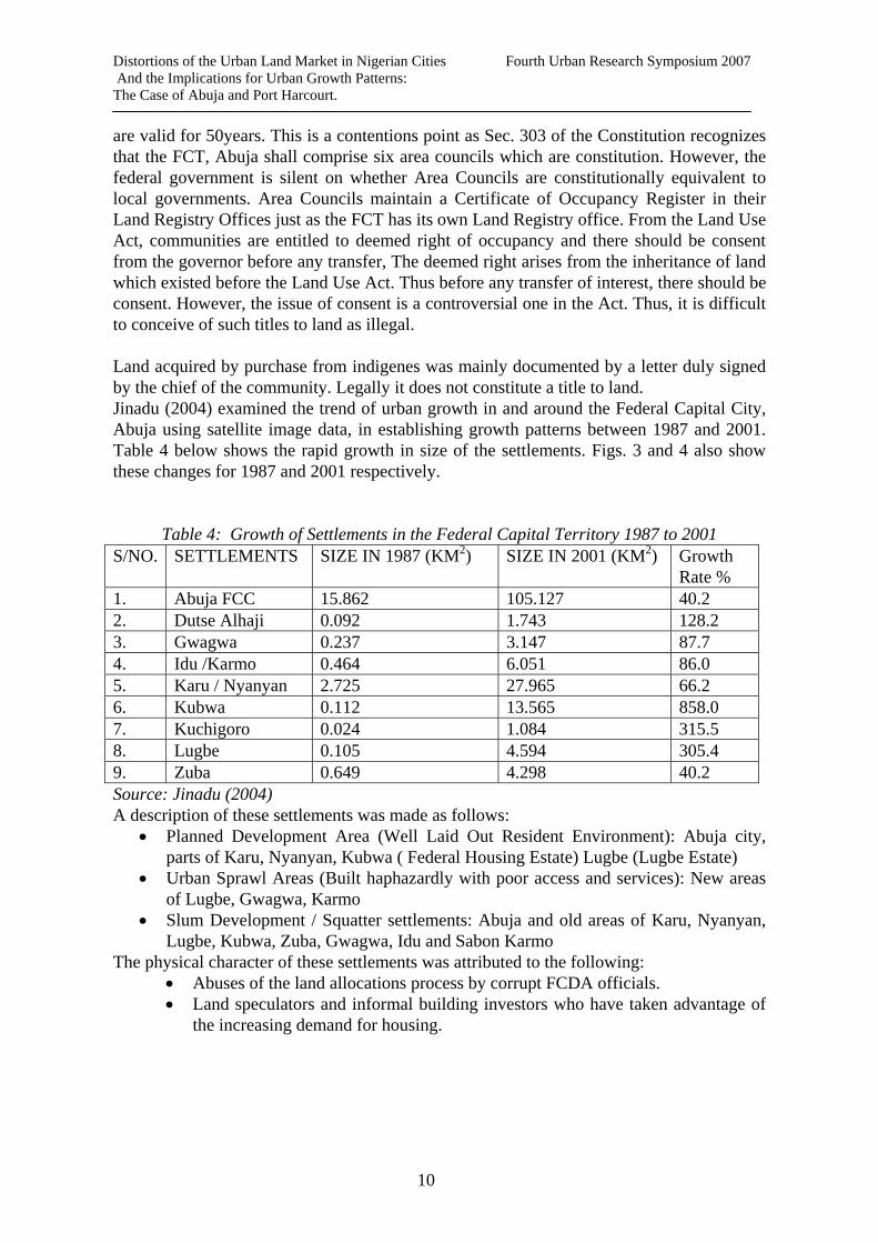
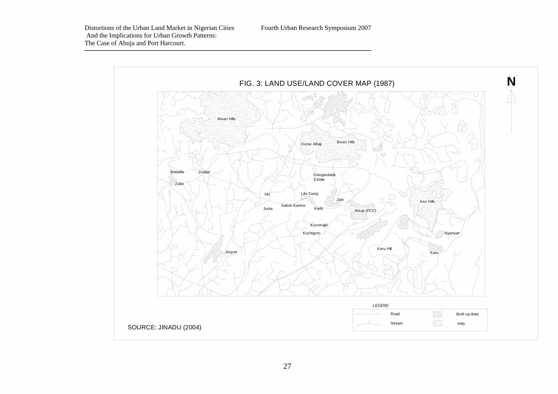
are valid for 50years. This is a contentions point as Sec. 303 of the Constitution recognizes that the FCT, Abuja shall comprise six area councils which are constitution. However, the federal government is silent on whether Area Councils are constitutionally equivalent to local governments. Area Councils maintain a Certificate of Occupancy Register in their Land Registry Offices just as the FCT has its own Land Registry office. From the Land Use Act, communities are entitled to deemed right of occupancy and there should be consent from the governor before any transfer, The deemed right arises from the inheritance of land which existed before the Land Use Act. Thus before any transfer of interest, there should be consent. However, the issue of consent is a controversial one in the Act. Thus, it is difficult to conceive of such titles to land as illegal. Land acquired by purchase from indigenes was mainly documented by a letter duly signed by the chief of the community. Legally it does not constitute a title to land. Jinadu (2004) examined the trend of urban growth in and around the Federal Capital City, Abuja using satellite image data, in establishing growth patterns between 1987 and 2001. Table 4 below shows the rapid growth in size of the settlements. Figs. 3 and 4 also show these changes for 1987 and 2001 respectively.
Table 4: Growth of Settlements in the Federal Capital Territory 1987 to 2001 S/NO. SETTLEMENTS SIZE IN 1987 (KM2) SIZE IN 2001 (KM2) Growth
Rate % 1. Abuja FCC 15.862 105.127 40.2 2. Dutse Alhaji 0.092 1.743 128.2 3. Gwagwa 0.237 3.147 87.7 4. Idu /Karmo 0.464 6.051 86.0 5. Karu / Nyanyan 2.725 27.965 66.2 6. Kubwa 0.112 13.565 858.0 7. Kuchigoro 0.024 1.084 315.5 8. Lugbe 0.105 4.594 305.4 9. Zuba 0.649 4.298 40.2 Source: Jinadu (2004) A description of these settlements was made as follows:
• Planned Development Area (Well Laid Out Resident Environment): Abuja city, parts of Karu, Nyanyan, Kubwa ( Federal Housing Estate) Lugbe (Lugbe Estate)
• Urban Sprawl Areas (Built haphazardly with poor access and services): New areas of Lugbe, Gwagwa, Karmo
• Slum Development / Squatter settlements: Abuja and old areas of Karu, Nyanyan, Lugbe, Kubwa, Zuba, Gwagwa, Idu and Sabon Karmo
The physical character of these settlements was attributed to the following: • Abuses of the land allocations process by corrupt FCDA officials. • Land speculators and informal building investors who have taken advantage of
the increasing demand for housing.
10

Distortions of the Urban Land Market in Nigerian Cities Fourth Urban Research Symposium 2007 And the Implications for Urban Growth Patterns: The Case of Abuja and Port Harcourt.
• Indiscriminate sales of land by traditional chiefs. • Ineffective institutional capacity for urban management.
An officer of the AMMA who had been involved in the planning of Katampe district in the FCC stated that at the time of planning in 1996/97 the settlement of Gichiri had only 5 households. Today, it is a sprawling slum in Maitama, one of the best developed districts within the FCC. 1.3. Institutional and Management Problems Basic issues of the institutional arrangement are principle factors for illegal and unplanned settlements in the FCC. When asked why the problem was not given attention earlier, a respondent described it as “the hangover of past neglect and the mentality that has been built in the minds of developers that they can do whatever they like and get way with it”. Generally, response from key informants can be summarized to provide the following reasons: 1) The FCDA lacked a consistent policy direction. There were policy shifts that led to the
failure to implement the Abuja Master Plan as proposed. Between 1976 and 1978, it was a policy of resettling all villages outside the FCT. By 1981, this was changed to include only villages within the FCC. From 1984, it was a policy of integration of some villages essentially out of ethnic sentiments and political exigency. While these were going on, the land market was open to large scale speculative buying as many who needed land in the FCC could not get allocations especially as it was taking a long time to develop the necessary infrastructure in a district estimated at 30 billion naira. Middle and low income people could only obtain land in the towns and villages surrounding the FCC.
2) Changes in the organizational structure for implementing the plan. The Federal Capital Territory and posed problems of control; an organizational framework for planning that lacks continuity
3) Failure to develop the designated satellite towns. Satellite Towns Development Agency was not set up until recently. Also, the Joint Planning Commission (JPC) which had responsibility to monitor developments in the boundary areas between the FCT and its adjoining states existed but has remained non - functional. The Area Councils were neither equipped in terms of human capacity nor with resolve to manage the surge of new growth. As the capital city became over – priced, many low – income workers could not afford to live in the city. These drifted to surrounding villages and developed the kind of housing they could afford leading to expansion in the squatter settlements.
4) Failure on the part of policy makers and planners to recognize the dynamics of urban growth in a less developed country i.e. that it was largely fuelled by growth in informal sector activities.
Demolitions exercises have intensified the last two years so also have problems of indigeneship in the FCT. The indigene ship factor is complicated by connivance between non – indigenes and local chiefs and also by families, hitherto compensated and moved out of the FCT, but who have now moved back and are insisting on indigeneship.
11
Distortions of the Urban Land Market in Nigerian Cities Fourth Urban Research Symposium 2007 And the Implications for Urban Growth Patterns: The Case of Abuja and Port Harcourt.
Demolition cannot constitute an acceptable policy direction in the long term and its impact is likely to be limited. It is also expensive. 2. The Case of Port Harcourt Metropolis Port Harcourt, Metropolis, capital city of the Rivers State covers an area of about 180,000 hectares with a population of about 1100600 in 2006 according to the State Statistical Agency. The city is of economic importance to Nigeria with a concentration of multi-national oil industries in it. This has resulted in high amounts of commercial and industrial activities as well as an ever-increasing multi-cultural population. Port Harcourt lies on a peninsular with its urban form governed by natural land constraints that have strong bearings on available land for physical development and cost of provision of services in the city. As a colonial “city” Port Harcourt’s land use structure and urban form has evolved with the historical, political transformation from colonial to post-colonial periods. The growth of Port Harcourt is tied to the social and economic history of Nigeria. The historical and political contexts of Port Harcourt’s growth from the onset, introduced distinct residential neighbourhoods distinguished by plot sizes, level of service provision and planning. The Government Reservation Areas (GRAs) were reserved for Europeans and Africans occupying top positions in the colonial administration. Plot sizes in GRAs were typically 1,200m2 whereas some of the African Townships (Native Area) for which planning schemes were prepared had average plot sizes of 366 m2. This differentiation in neighbourhood development has continued to the present. However, whereas the racial lines of division has long stopped, the differentiation in land development and neighbourhood quality between planned areas (usually on land acquired by government or by companies) and unplanned areas that are left under the control of customary rights to land and private ownership. There are three issues of concern in this context. One is the issue of access to land for the majority of urban dwellers who cannot benefit from land allocations from the public sector. The second issue is government land regulations and how this impacts on the land market and on urban growth. Finally, are the different arenas of conflict which exist between indigenous land owners, government and its allotees, and the implications for the state control of land use that is an important requirement for orderly urban development. 2.1. Access to Land in Port Harcourt Metropolis Access to land is through three modes of land acquisition i.e. inheritance (still existing in land held by local indigenous groups, allocations by government, purchase and land rentals. Port Harcourt’s initial physical growth was based on land obtained through the compulsory acquisition of land from local indigenous groups using the instrumentation of the Public Lands Acquisition Ordinance of 1917. In the post-independence period, national governments increased such acquisitions. Port Harcourt presently has as many as seven GRAs with average plot sizes of about 20,000m2. All of these lands were acquired between 1970 and 1999. In sharp contrast, the normal plot size in the private land market is 465 m2. Plots in the GRAs were allocated on the basis of 500,000 naira each until eight years ago, when the open market value was in excess of four million naira (now between 30 and 35 million naira).. Thus public land allocations were highly subsidized. Thus, having a plot
12
Distortions of the Urban Land Market in Nigerian Cities Fourth Urban Research Symposium 2007 And the Implications for Urban Growth Patterns: The Case of Abuja and Port Harcourt.
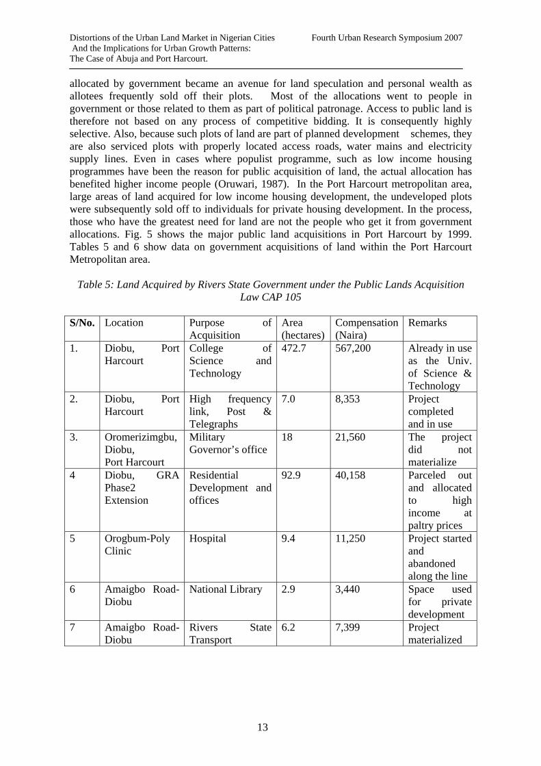
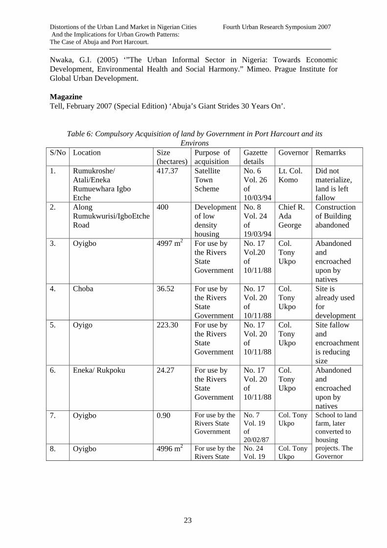
allocated by government became an avenue for land speculation and personal wealth as allotees frequently sold off their plots. Most of the allocations went to people in government or those related to them as part of political patronage. Access to public land is therefore not based on any process of competitive bidding. It is consequently highly selective. Also, because such plots of land are part of planned development schemes, they are also serviced plots with properly located access roads, water mains and electricity supply lines. Even in cases where populist programme, such as low income housing programmes have been the reason for public acquisition of land, the actual allocation has benefited higher income people (Oruwari, 1987). In the Port Harcourt metropolitan area, large areas of land acquired for low income housing development, the undeveloped plots were subsequently sold off to individuals for private housing development. In the process, those who have the greatest need for land are not the people who get it from government allocations. Fig. 5 shows the major public land acquisitions in Port Harcourt by 1999. Tables 5 and 6 show data on government acquisitions of land within the Port Harcourt Metropolitan area.
Table 5: Land Acquired by Rivers State Government under the Public Lands Acquisition Law CAP 105
S/No. Location Purpose of
Acquisition Area (hectares)
Compensation (Naira)
Remarks
1. Diobu, Port Harcourt
College of Science and Technology
472.7 567,200 Already in use as the Univ. of Science & Technology
2. Diobu, Port Harcourt
High frequency link, Post & Telegraphs
7.0 8,353 Project completed and in use
3. Oromerizimgbu, Diobu, Port Harcourt
Military Governor’s office
18 21,560 The project did not materialize
4 Diobu, GRA Phase2 Extension
Residential Development and offices
92.9 40,158 Parceled out and allocated to high income at paltry prices
5 Orogbum-Poly Clinic
Hospital 9.4 11,250 Project started and abandoned along the line
6 Amaigbo Road-Diobu
National Library 2.9 3,440 Space used for private development
7 Amaigbo Road-Diobu
Rivers State Transport
6.2 7,399 Project materialized
13
Distortions of the Urban Land Market in Nigerian Cities Fourth Urban Research Symposium 2007 And the Implications for Urban Growth Patterns: The Case of Abuja and Port Harcourt.
Corporation: Office/Workshop
and in use
8 Oroworukwo Diobu
Transmitting Station
25 30,000 Land Vacant
9 Diobu, GRA Phase 3
Residential Development
427.9 513,500 Parceled out for high income at paltry prices
10 Orominike Diobu
Children and Maternity Hospital
8.5 10,230 Project started and abandoned
11 Diobu – Port Harcourt
Housing Development at Eagle Island
1666.7 250,000 Partly occupied, invaded by natives
Source: Rivers State Ministry of Lands, 2006 In recent times, especially in the last eight years, it has become increasingly difficult for the government to acquire land for any purpose simply because of the conflict situations with indigenous groups who would rather sell off their land to private individuals. Interviews revealed that the amount of compensation paid is considered too small and is very much below what can be obtained in the open market. Also, payment of compensation takes a long time to negotiate whereas for private buyers the full price is paid before any documentation of the sale. The few plots available are either within old acquisitions or in satellite towns where acquisitions had not been developed for the intended purpose-such as the acquisition for the School – to - Land programme presently being developed as a satellite town is done. Thus, the importance of public land allocation as source of land is greatly diminished. The private land market is presently the most important source of land in Port Harcourt. It is also complex and fraught with conflict. It comprises of those who got plots on allocation by government and decide to sell or lease it; and indigenous landlords who sell directly from their inheritance and thirdly of those indigenes that forcefully re-possess land previously acquired by government and sell it off in lots to private buyers. As urban growth increases, so does the pressure on available land. It is a market where land always goes to the highest bidder. Thus land values continue to rise. Accessing land for development has become extremely stressful and expensive, way beyond the reach of the masses of poor households who are increasingly forced into marginal settlements known locally as “watersides”. These areas are characterized by extremely poor quality high density housing, most without toilets, bathrooms, kitchens, or access. The residential environment is polluted and unsafe. It is a process of progressive marginalization in the urban land market in Nigeria, where the need for land of the most vulnerable groups is not even considered. Owner occupiers of housing in these “watersides” are issued temporary occupancy license (TOL) by government which provides that the land can be taken by government within seven days of notification. The TOL is a document that has never protected their right to land.
14

Distortions of the Urban Land Market in Nigerian Cities Fourth Urban Research Symposium 2007 And the Implications for Urban Growth Patterns: The Case of Abuja and Port Harcourt.
2.2. Government Regulation of the Land Market in Port Harcourt. Government’s attempt to regulate the land market in Nigeria came by the then ruling military regime in the promulgation of the Land Use Decree of March 1978 (now drafted into the Laws of the Federation of Nigeria, 1990 as CAP 202). This law was promulgated to enhance people’s access to land and remove all constraints against government’s free access to land in the interest of the public. Two important features of the land use act are as follows: (i) First, the law vests rights on all urban lands in the state governor and rights on other
land in the local government within whose area of jurisdiction the land is situated (ii) Secondly, it empowers the governor to grant statutory rights of occupancy to any person for all purposes and the local government to grant customary rights of occupancy to any person or organization for the use of land in the local government area for agricultural, residential and other purposes. Attempts by the Rivers State Government to regulate the land market in Port Harcourt come within the framework of the Land Use Act which is a national law. There is no state land policy. By this act, absolute ownership of land is vested in the Governor of each state who holds the land in trust for the people. The governor issues the statutory Certificate of Occupancy which together with the survey plan forms the legal title of ownership to land. Thus the act strengthens the powers of compulsory acquisition by government. The experience of implementing the law in Port Harcourt and other cities across the nation is that its objectives have not been realized. Within local urban communities, there is increasing opposition to public land acquisition. Reasons for this opposition stem from the failure of government to pay compensation on time and also of the rates used for assessing what is to be paid. Although the land officers claim that the Rivers State government is the only government in Nigeria that pays compensation at open market value, communities claim government compensation valuation rates are completely outdated. Another reason for opposition is the process of allocation of public land which over the years have benefited senior government officials, the military class and their cronies especially as the distributional impact of such land when fully developed earns their owners a life time value far in excess of the cost of the land. Yet another reason for opposition is the practice by government to acquire land and refuse to develop it for long periods of time, locking it up from use even for farming by the original owners; the acquisition of land far in excess of what is needed for the particular project and the practice of changing the initial purpose for the acquisition without re-negotiation with the communities. In the process, the communities loose out on expected benefits form the transaction and have lost the land as a source of livelihood from farming forever. The failure of the Land Use Act as a regulatory instrument is also evident in the private land market. Individuals buy land, survey and register it and then apply for the statutory certificate of occupancy. Kings-Amadi (2004) has shown that there is only a 40% level of compliance with this requirement among developers. Sec. 22 of the Land Use Act also provides for prior consent of the state governor before any transfer of interest in land. It also states that proof of conclusion of transaction should be shown as proof of that transaction. This raises a legal quandary as to what the right sequence of procedure should
15

Distortions of the Urban Land Market in Nigerian Cities Fourth Urban Research Symposium 2007 And the Implications for Urban Growth Patterns: The Case of Abuja and Port Harcourt.
be. Thus there is often no “official” documentation of the existence of these developments. In another study, Ikpoki (2005) found that 85% of developments are in settlements that are unplanned. Most parts are inaccessible to vehicular traffic. As argued in Owei & Ikpoki (2006) most of the houses are owner-occupied and contrary to some thinking on informal housing are not predominantly occupied by the urban poor but middle and even high income people. Nwaka (2005) and Kings-Amadi (2004) agree that the procedure for obtaining land is excessively bureaucratized, obstructive and corrupt. Local communities anxious to sell off their land rather than have government acquire them; sell the land without survey or layout plans. Sometimes even the road access is sold off. Most development outside of the government layouts are in contravention of basic planning standards such as plot coverage and set backs with houses - built on fence - in lots before access to them are thought of. No provision is made for utility lines and most times waste water from homes are discharged through holes bored in the fences on to the road. Spaces are also not provided for public uses such as markets and open spaces. Building densities are also very high. 2.3. Land Struggles and Conflict in Port Harcourt The history of land struggles between indigenous communities and government in Port Harcourt dates back to the colonial administration. However, the struggle has intensified in the recent past as a result of public awareness due to access to global information and as land values have greatly appreciated. It has led to the appellation of Ikwerre native landlords and Okrika – Port Harcourt Aborigines. Communities are laying conflicting claims to acquisitions. The claims to the land in Port Harcourt by the indigenous Ikwerre and Okrika people have led to the various arenas of conflict in the struggle over land including those between the following: (i) Owners of public land allocations and communities where the land is located over
access. (ii) Private buyers and communities over multiple locally imposed land development
levies and sale of a plot to multiple buyers. (iii) Youths and elders within local communities over the sharing of the proceeds form
sale of land (iv) Families over ownership of land (Oruwari & Owei, 2006). The impacts of these struggles are manifest in the following land use management problems. (i) Original owners quickly sell off undeveloped plots in public acquired site and
service schemes to private buyers. (ii) Escalating cost of private land acquisitions. (iii) Promoting unplanned development of settlements, unapproved change of use,
intensification of land development, failure to comply with planning standards. (iv) Land struggles characterized by threats, aggression and litigation. Communities take
legal and illegal actions against government.
16

Distortions of the Urban Land Market in Nigerian Cities Fourth Urban Research Symposium 2007 And the Implications for Urban Growth Patterns: The Case of Abuja and Port Harcourt.
The result is the largely unplanned development of most of the Port Harcourt Metropolis. The legal and administrative framework for land management in Port Harcourt remains unclear. The Port Harcourt Master Plan (1975) was prepared under the Town and Country Planning Laws of Eastern Nigeria CAP 126 of 1948. Under this law, town planning regulations were under the control of the Port Harcourt and the Obio Planning Authorities. The Master Plan had recommended a revision of this law. However this was not done until the promulgation of the Nigerian Urban and Regional Planning Law Decree 88 of 1992. Although this law provided for the establishment of a State Planning Board, and Local Planning Authorities, in each state of the federation, the Rivers State Government failed to implement it. In 2003, the Rivers State Physical Planning and Development law was promulgated. This law also provides for the creation of a State Planning Board and Local Planning Authorities in each of the twenty-three constituent local government areas. This legislation has also not been implemented. The same lassez-faire attitude has also been taken in the implementation of the State Land Development and Land Registration Laws. Under section 4 of the Land Development (provision for Roads) Law CAP 73 dating back to 1933, there are provisions that include making of lay-out schemes prior to land being sold off in lots. These laws are being abused by government officials, communities and private buyers as the land market in Port Harcourt mostly operates outside formal governmental processes and channels. 3. Distortions of the Urban Land Market in Abuja and Port Harcourt: A Comparison The land markets in Abuja and Port Harcourt have a number of characteristics which can be compared. 3.1. Urban Land Policy Abuja’s development was based on an urban policy that stated clearly that no indigenous communities could claim ownership of land in the territory. This was to be implemented through re – settlement and compensation. Part of the failure in implementing this policy was the shift to “integrate” some settlements into the FCC. Yet another failure sterns from the inability of government to pay the full compensation at the inception of construction of the FCC and the decision to leave some settlements in place until under the phasing of implementation of the Master Plan, the land was needed. This failed to recognize the traditional attachment local people have to land. It also failed to recognize the pressure on land values brought about by speculation. In a globalizing world, people in one part of the world are quick to learn of events in other parts through international media and communication networks. This promotes land struggles. Thirdly, there was failure to grasp the typically Nigerian problem of discontinuity in public policy from one administration to another. It can be summarized that the policy environment was not sufficiently understood. Those who bought land from local communities including FCDA officials, other senior government officials and private interests knew that this was against policy. The explanation can only come from the Nigerian attitude to government policy i.e. one can get away with contraventions if one is well – connected. In a recent interview, the director of packs and recreation status thus:
In the years that followed the implementation of the master plan, a
17

Distortions of the Urban Land Market in Nigerian Cities Fourth Urban Research Symposium 2007 And the Implications for Urban Growth Patterns: The Case of Abuja and Port Harcourt.
level of rascality was displayed by both those in government and the people who increasingly moved to Abuja and embarked on uncontrolled building of houses. The result was haphazard and chaotic development. Abuja was gradually becoming a slum and even worse (Tell, 2006).
Unlike Abuja, Port Harcourt has no clearly defined urban land policy apart form that of compulsory public acquisition dating back to the colonial era. The Land Use Act of 1978 does not constitute a land policy for the state. The Act has proven inadequate in all respects. It has not increased access to land, or regulated ownership. It has essentially driven up the cost of land registration, delayed commencement of development and consequently increased the cost of construction. Also, inspite of the Act which limits one person to a plot not exceeding half an hectare in urban areas, government officials, senior military personnel and politicians are known to have multiple plots. The Land Use Act does not also constitute an effective regulatory too. Most developments occur without having a Certificate of Occupancy as proof of ownership. Developers are content with only the signed agreement between seller and buyer. In both cities, the C – of - O has become an instrument of speculation. In Abuja, it was typical of a C of O to change hands several times with an increase in the purchase price. This is a systematic privatization of public land as holders of C of O can use it as investment to raise money. For developers able to build, the cost of construction is so high that rents subsequently charged are equally high. A two – bedroom flat in the FCC costs 550,000 naira to rent for a year and a three - bedroom flat is up to 700,000 naira. Land lords typically ask for two years rent in down payment. In Port Harcourt, the rents are 800,000 naira for a two – bedroom flat and 1,500,000 naira for three – bedroom flats respectively in comparable neighbourhoods. Thus, it makes economic sense for persons in need of housing to buy land more cheaply in local communities and develop incrementally. From 2006, the FCT has embarked on a regularization exercise to revalidate all land titles in the whole of the territory. All land owners in the six areas councils of the FCT are to upgrade their deeds on the land from customary to statutory rights. Since 2006 also, under the Abuja Geographic Information System, almost 2,000 plot allocations were revoked. These fall into four categories as follows:
Plots that were not developed in the last two (2) years. Plots without approved building plans. Plots where the building did not confirm with approved plans. For reasons of overriding public interest.
Private sector investment in housing is not the housing that the ordinary Nigerian can afford. Land speculation and illegal allocations were rife. Land speculation is key ingredient of urban growth. The current certificate re – verification exercise aims to ascertain all acquired title to land in the FCT. Developers bought land from towns and villages in the FCT and built structures with temporary material such as mud and wood as a holding strategy to sell off the land as values appreciate.
18

Distortions of the Urban Land Market in Nigerian Cities Fourth Urban Research Symposium 2007 And the Implications for Urban Growth Patterns: The Case of Abuja and Port Harcourt.
3.2. Land Use Controls The FCT Abuja and Port Harcourt Metropolis, both have Master Plans. However, the implementation of both plans has been problematic contributing to the distortion of the land market in both cities. Abuja‘s Master Plan made provision for the development of satellite towns. As explained by the Director of the Satellite Towns Development Agency, the explosion of population and the pressure that was put on social services and infrastructure would not have arisen if the satellite towns had been developed along with the city as the master plan envisaged. The developments within the satellite and other surrounding towns were unplanned and unregulated. Area Councils were allowed to issue Customary Certificates of Occupancy to developers without any detailed land use plan to control such development and without reference to the FCDA. The absence of a co – ordinated framework for development control was another contributing factor, Land premium in the FCC is 2000 naira per metre2 and 600 naira per metre2 in Area Councils. The land premium is paid as part of processing fees for the C of O. Thus it is much cheaper to obtain land in satellite towns. Port Harcourt did not have the luxury of any master plan implementation framework or any development control framework. The Master Plan was simply left to rot. The framework that was first proposed in the Nigerian Urban and Regional Planning Law of 1992 and later adopted into the Rivers State Physical Development Law of 2003 has never been put in place. In Port Harcourt and in Abuja until the efforts by the present FCT administration in 2003, land use regulatory mechanisms have failed to meet the challenges of urban growth. The creation of a special unit i. e. the Abuja Metropolitan Management Agency is part of the effort to institute an efficient system of land use control. Thus far, it has engaged mostly in damage control – trying to get titles to land verified and registered, demolition of illegal structures, re – location and re – settlement of illegal settlements; and monitoring new developments in the FCC. All these still do not constitute a policy. As a respondent explained government must be sincere in making a policy and implementing it. 3.3. Land Struggles Land struggles in Abuja take the following forms.
I. Some indigenes who initially took the option of re – settlement and were paid compensation are returning to their old homes.
II. Following the demolition exercise, some persons are re – building in defiance of the FCDA and AMMA.
III. Officials on demolition and monitoring exercises are under threat and depend on the services of armed police officers.
Although the “indigenous land owners” factor has not assumed the dimension of open conflict as in Port Harcourt, indications of rumbles exist. As Abuja grows and land becomes more valuable, possibilities of escalation exist especially as some communities have already been integrated in to the FCC. Land struggles in Port Harcourt have reached open conflict marked by aggressive re – possession of publicly – acquired land, litigation,
19

Distortions of the Urban Land Market in Nigerian Cities Fourth Urban Research Symposium 2007 And the Implications for Urban Growth Patterns: The Case of Abuja and Port Harcourt.
assault and injury. The Rivers State government has no response. It has tacitly acquiesced to the local people, rather asking aggrieved allotees to either negotiate with the communities or go to court. Both are very expensive options. Community actions have made it impossible for any new land acquisition by government within the metropolitan area since 1999. V. CONCLUSIONS AND RECOMMENDATIONS The study has shown that un – planned and un – regulated developments exist in both Abuja and Port Harcourt especially on the urban periphery, The factors that have caused this include differential access to land, absence of a well – defined land policy, inadequate planning controls and land development laws, and poor implementation of the Master Plans for both cities. Unplanned developments are also manifestations of how the market tries to accommodate the need for land by different people especially these who cannot access land from the public sector. Local urban communities, developers and land speculators take advantage of policy vacuums to acquire land and dispose of same outside of plan proposals and regulations. The Land Use Act is the most important land document in Nigeria at all levels of government. Its implementation has been very problematic and it has not been reviewed because it is enshrined in the national constitution. However this study has highlighted the factor that most of the problem areas in the Act’s implementation arise from its failure to recognize the reality of customary land laws and traditional perceptions on land. Its implementation also took for granted institutional capacities that just do not exist. It also failed to recognize the ease with which the well – connected in and out of government circumvent official processes for private gains. Local indigenous urban communities in Nigeria will continue to contend for their rights of inheritance to land and also the right to determine access. Local communities are stakeholders in the urban land market. Any land policy must recognize this and even though compensation is paid, the process of engagement with them should continue. This requires good governance and trust between local people and government, which presently. Thus the initial response of the people to public acquisition is always one of resistance. Generally, urban land use management in both cities has demonstrated lack of continuity and institutional weaknesses. There has not been a systematic response to urban growth. The failure to implement the master plans shows lack of serious attention to physical planning in Nigeria in general. The Abuja experience in the last four years has shown that it is more expensive to address distortions in the master plan than to systematically implement it from the start. The study makes the following recommendations:
1. There is need to develop effective institutions backed by laws and regulations that can be implemented. For example, the Land Use Act should be revised following broad consultations with professional groups, developers, community groups and public officials.
2. Public policies should be clear without ambiguity. A case in point is the need to spell out the status of the Area Councils in the FCT.
20
Distortions of the Urban Land Market in Nigerian Cities Fourth Urban Research Symposium 2007 And the Implications for Urban Growth Patterns: The Case of Abuja and Port Harcourt.
3. Land use planning especially at local levels cannot be effective without the participation of local people through continuous dialogue. Planning controls should also be within the context of realistically helping people meet their needs.
4. Good governance is an imperative for managing urban growth. Distrust of government intentions is the foundation of resistance to public policies.
1. End Note : The current exchange rate of the Nigerian naira is 135 naira to 1 USA dollar
References Journals Jinadu, A. M. (2004) “Urban Expansion and Physical Development Problem in Abuja: Implications for the National Urban Development Policy”, in Journal of the Nigerian Institute of Town Planners, Vol. XVII, pp.15 – 29. Oruwari, Y. O. (2003) “Planners, Officials and Low Income Women and Children in Nigerian Cities: Divergent Perspectives over housing and Neighbourhoods”, in Canadian Journal of African Studies, Vol. 37, Nos 2 & 3, pp. 396 – 410. Books and Reports Federal Republic of Nigeria (1999) Constitution of the Federal Republic of Nigeria, 1999, Federal Government Press, Lagos. Federal Government of Nigeria (1978) The Land Use Decree, Lagos, Federal Government Press, Lagos. Ikpoki, M.I (2005)”Development control and the Public Interest in Obio/Akpor LGA Rivers State.” Research Report, Rivers State University of Science and Technology. Kings – Amadi, I. (2004) “An Appraisal of Land Use Plan Implementation in Rivers State: A Case Study of Port Harcourt Metropolis.” Research Report Rivers State University of Science and Technology. Onibokun, A. G. (2004) The Nigeria Urban Sector: the crisis of new wine in an old bottle, I Nigerian Institute of Social and Economic Research, Ibadan. Oruwari. Y. O. (1987) “Federal Government Low – Cost Housing Project: Elekohia Revisited”, in Makinwa, P. K. & Ozo, B. A. editors. The Urban Poor in Nigeria, Evans Brothers Nigeria Publishers, Ibadan. UNCHS (1996) An Urbanizing World: Global Report on Human Settlements, Oxford University Press, Oxford.
21
Distortions of the Urban Land Market in Nigerian Cities Fourth Urban Research Symposium 2007 And the Implications for Urban Growth Patterns: The Case of Abuja and Port Harcourt.
Okuku, J. A. (2006) “Dynamics of Land Markets in Peri – Urban Kampala, Uganda”. Draft Research Report, Council for the Development of Social Science Research in Africa (CODESRIA). Dakar, Senegal. Oruwari, Y. O. & Owei, O. B. (2006) “Urban Land and Citizenship Struggles in Nigeria: An Analysis of Access from 1979 to date”. Draft Research Report. Council for the Development of Social Science Research in Africa (CODESRIA). Dakar, Senegal. Rakodi, C. & Leduka, C. (2003) “Informal Land Delivery Processes and Access to Land for the Poor in Six African Cities: Towards a Conceptual Framework”, WPS/1SSR Project R8076 Olawoye, C. O. (1978) Title to Land in Nigeria, Evans Brothers Publishers, London. Chapters in a Book Abdoul, M. (2005) “Urban development and urban informalities: Pikine, Senegal,” in Simone, A. M; Abouhani, A; editors. Urban Africa: Changing Contours of Survival in the City. Zed Books, London & New York, pp 235 - 260 Ogu, V. & K. Adeniji (1998) “The Concept of Sustainable Physical Development in the Context of Developing Countries,” in Ogu, V. & Adeniji, K. editors. Physical Development in Nigeria, Nigerian Institute of Social and Economic Research, Ibadan, pp 1 - 15 Conference Proceedings and Symposia Abumere, S. J. (1999) “Resettlement then and Now.” Kalgo, M. S. U. & Ayileka, O. editors. Review of the Abuja Master Plan: Proceedings of an International Workshop, Fountain Publications, Ibadan, pp 27 - 41 Adejuwon, A. (1999) “Satellite Towns and the New Abuja Master Plan”. Kalgo, M. S. U. & Ayileka, O. editors Review of the Abuja Master Plan: Proceedings of an International Workshop, Fountain Publications, Ibadan., pp 19 – 25. Dowall, D. E. (1993) “The Role and Function of Urban Land Markets in Market Economics.” Workshop Paper, Kiev, Ukraine. Leduka, C. R. (2000) “The Law and Access to Urban Land for Housing in a sub – Saharan City: Experiences from Maseru, Lesotho.” Paper presented at the Conference on the Formal and Informal City, Copenhagen, Nordiska. Owei, O.B. & M.I. Ikpoki (2006) “The Growth of middle and high income Informal Settlement in Port Harcourt.” 42nd ISoCaRP Congress, Istanbul.
22
Distortions of the Urban Land Market in Nigerian Cities Fourth Urban Research Symposium 2007 And the Implications for Urban Growth Patterns: The Case of Abuja and Port Harcourt.
Nwaka, G.I. (2005) ‘”The Urban Informal Sector in Nigeria: Towards Economic Development, Environmental Health and Social Harmony.” Mimeo. Prague Institute for Global Urban Development. Magazine Tell, February 2007 (Special Edition) ‘Abuja’s Giant Strides 30 Years On’.
Table 6: Compulsory Acquisition of land by Government in Port Harcourt and its Environs
S/No Location Size (hectares)
Purpose of acquisition
Gazette details
Governor Remarrks
1. Rumukroshe/ Atali/Eneka Rumuewhara Igbo Etche
417.37 Satellite Town Scheme
No. 6 Vol. 26 of 10/03/94
Lt. Col. Komo
Did not materialize, land is left fallow
2. Along Rumukwurisi/IgboEtche Road
400 Development of low density housing
No. 8 Vol. 24 of 19/03/94
Chief R. Ada George
Construction of Building abandoned
3. Oyigbo 4997 m2 For use by the Rivers State Government
No. 17 Vol.20 of 10/11/88
Col. Tony Ukpo
Abandoned and encroached upon by natives
4. Choba 36.52 For use by the Rivers State Government
No. 17 Vol. 20 of 10/11/88
Col. Tony Ukpo
Site is already used for development
5. Oyigo 223.30 For use by the Rivers State Government
No. 17 Vol. 20 of 10/11/88
Col. Tony Ukpo
Site fallow and encroachment is reducing size
6. Eneka/ Rukpoku 24.27 For use by the Rivers State Government
No. 17 Vol. 20 of 10/11/88
Col. Tony Ukpo
Abandoned and encroached upon by natives
7. Oyigbo 0.90 For use by the Rivers State Government
No. 7 Vol. 19 of 20/02/87
Col. Tony Ukpo
8. Oyigbo 4996 m2 For use by the Rivers State
No. 24 Vol. 19
Col. Tony Ukpo
School to land farm, later converted to housing projects. The Governor
23

Distortions of the Urban Land Market in Nigerian Cities Fourth Urban Research Symposium 2007 And the Implications for Urban Growth Patterns: The Case of Abuja and Port Harcourt.
Government of 20/02/87
decides who gets the units after construction
9. Rumuodomaya Obio 12.85 For use by the Rivers State Government
No. 2 Vol. 17 of 10/01/85
Col. Tony Ukpo
Used for State Agic. Farm. Minimal activity presently
10. Rumukrushi/ Elelenwo 32.56 For use by the Rivers State Government
No. 22 Vol. 13 of 09/07/81
Chief Melford Okilo
Presently used as cattle market, some encroachment
11. Rumuolumeni 377.10 For use by the Rivers State Government
No. 22 Vol. 13 of 09/07/81
Chief Melford Okilo
Presently used as College of Education
12. Ahiamakara, Elekohia, Diobu
14.4 For use by the Rivers State Government
No. 3 Vol. 6 of 17/01/74
Lt. Com. A.P. Diete - Spiff
Site is already used by government
13. Rumukalagbor Elekahia
761.2 For use by the Rivers State Government
No. 3 Vol. 6 of 17/01/74
Lt. Com. A.P. Diete - Spiff
Left fallow and currently being used by squatters
14. Rumukalagbor Elekahia, Rumuomasi
692.4 For use by the Rivers State Government
No. 51 Vol. 6 of 12/12/74
Lt. Com. A.P. Diete - Spiff
Left fallow and sold by indigenes to private developers
15. Along Ikwerre Road, Mile 3 Diobu
16.3 For use by the Rivers State Government
No. 51, Vol. 6 of 12/12/74
Lt. Com. A.P. Diete - Spiff
Ultra modern market-already in use
16. Rumuokwuta 141 For use by the Rivers State Government
No. 18 Vol. 4 of 03/04/72
Lt. Com. A.P. Diete - Spiff
Girls Secondary School - already in use
17. Elimgbu/ Oroigwe 20.7 For use by the Rivers State Government
No. 9 Vol. 4 of 04/02/72
Lt. Com. A.P. Diete - Spiff
Ministry of Agric farm and housing for staff- now squatters
Source: Oruwari & Owei 2006
24
Distortions of the Urban Land Market in Nigerian Cities Fourth Urban Research Symposium 2007 And the Implications for Urban Growth Patterns: The Case of Abuja and Port Harcourt.
FIG. 1: THE FEDERAL CAPITAL TERRITORY AND THE SIX AREA COUNCILS
Source: Ministry of Federal Capital Territory, (2002)
AB
AJI A
REA
CO
UNC
IL
GWAGWALADAAREA COUNCIL
BWARI AREA COUNCIL
ABUJA MUNICIPAL AREA COUNCIL
KWALI AREA COUNCIL
KUJE AREA COUNCIL
0 8 16 24 32 Km.
N N
FEDERAL CAPITAL CITY
25

Distortions of the Urban Land Market in Nigerian Cities Fourth Urban Research Symposium 2007 And the Implications for Urban Growth Patterns:
The Case of Abuja and Port Harcourt.
26
Old Bakana
Rumuosara
Rumuchiolu
EnekaRumuoji
RumuoegwuRumuoluku
Rumuebule
IriebeOfori
ElelenwoRumuwoji
RumuibekweRumuogba
AkpajoAzuobieOginigba
RumuobiakaniRumuomasi
Rumuogbo
Okuru Okujagu
AbulomaAmaAmadi
Nkpogu
BorikiriOkrika Is.
Diobu
Isaka
RumuolumeniEleparawon
RumuemeRumuokuta
Ogbogoro
ChobaRumuosi
Ozuoba
Mgbuoba
Rumuopara
RumuomoiRumuigbo
RumuokwrushiRumuodara
RUMUODOMAYA
Oroigwe
Roa
d
Rumuagbaolu
PH / ABA
Express Way
Ikw
ere
Rukpoku
SCALE:- 1:200,000
FIG. 2: ADMINISTRATIVE MAP OF PORT HARCOURT METROPOLIS
4 0 4 8 12 Km.
PORTHARCOURT
RIVERS/CREEKS
OTHER ROADS
EXPRESS ROAD
LGA BOUNDARY
OTHER TOWNS & VILLAGES
LGA HEADQUARTERS
STATE CAPITAL
LEGEND
N N
Distortions of the Urban Land Market in Nigerian Cities Fourth Urban Research Symposium 2007 And the Implications for Urban Growth Patterns: The Case of Abuja and Port Harcourt.
Kuromajiri
Airport
Juma Abuja (FCC)
Aso Hills
GwugwuladaEstate
Zuba
Life Camp
Bwari Hills
Dutse Alhaji Bwari Hills
FIG. 3: LAND USE/LAND COVER MAP (1987) N
Road
Stream
LEGEND
Built-up Area
HillsSOURCE: JINADU (2004)
KadoSabon Karimo
IduJabi
Kuchigoro
DoldolMadalla
Nyanyan
KaruKaru Hill
27

Distortions of the Urban Land Market in Nigerian Cities Fourth Urban Research Symposium 2007 And the Implications for Urban Growth Patterns: The Case of Abuja and Port Harcourt.
28
Juma
Airport
Abuja (FCC)
Aso Hills
Zuba
Beidel
Bwari Hills
GwugwuladaEstate
Life Camp
Bwari HillsDutse Alhaji
FIG. 4: LAND USE/LAND COVER MAP (2001)
Hills
Built-up Area
Stream
Road
LEGEND
N
Karu Hill
Karu
Nyanyan
Lugbe Chika
Kuchigoro
Kuromajiri
Gwagwa
IduSabon Karimo
Piwoyi
SOURCE: JINADU (2004)
Kubwa
JabiKado

Distortions of the Urban Land Market in Nigerian Cities Fourth Urban Research Symposium 2007 And the Implications for Urban Growth Patterns: The Case of Abuja and Port Harcourt.
Old Bakana
Rumuosara
Rumuchiolu
EnekaRumuoji
RumuoegwuRumuoluku
Rumuebule
IriebeOfori
ElelenwoRumuwoji
RumuibekweRumuogba
AkpajoAzuobieOginigba
RumuobiakaniRumuomasi
Rumuogbo
Okuru Okujagu
AbulomaAmaAmadi
Nkpogu
BorikiriOkrika Is.
Diobu
Isaka
RumuolumeniEleparawon
RumuemeRumuokuta
Ogbogoro
ChobaRumuosi
Ozuoba
Mgbuoba
Rumuopara
RumuomoiRumuigbo
RumuokwrushiRumuodara
RUMUODOMAYA
Oroigwe
Roa
d
Rumuagbaolu
PH / ABA
Express WayIk
wer
e
Rukpoku
SCALE:- 1:200,000
FIG. 5: LAND ACQUISITION IN PORT HARCOURT METROPOLIS
4 0 4 8 12 Km.
PORTHARCOURT
RIVERS/CREEKS
OTHER ROADS
EXPRESS ROAD
LGA BOUNDARY
OTHER TOWNS & VILLAGES
LGA HEADQUARTERS
STATE CAPITAL
LEGEND
N N
LAND ACQUIRED BY 1999
29