TITLE: Fano-Maggiolo World Map DATE: AUTHOR: … · TITLE: Fano-Maggiolo World Map DATE: 1504 ......
8
Vesconte Maggiolo #307.3 1 TITLE: Fano-Maggiolo World Map DATE: 1504 AUTHOR: Vesconte Maggiolo DESCRIPTION: This hand-drawn and painted map is a planisphere on parchment (since ancient times a “planisphere” was a map or image of the spherical earth redrawn in the plane onto a flat surface; in the 17 th century it became the name for an astronomical instrument). The Fano-Maggiolo planisphere measures 139 x 92 cm/44 x 77 inches. It is oriented with north to the top. The map depicts the world from the island of Cuba at the left side of the parchment to the eastern side of the Indian peninsula on the right. There are league scale bars in both the North and South Atlantic, as well as across Africa. The central compass rose in Africa (with a miniature world map) is surrounded by a pattern of 32 rhumb-line intersections, many of which are decorated as compass roses. The mapmaker’s inscription, at the left of the parchment in the region of South America, identifies the mapmaker: Ego Vesconte de Maillo conpoxuy anc cartam de anno dñj 1· 5· 4· die viij Juny in Civitatem Janua [1, Vesconte de Maillo, composed this chart on 8 June 1504 in the city of Genoa]. Vesconte Maillo, Maiollo, Majolo, or Maggiolo, was born about 1475. He worked in Genoa and Naples. This map, his earliest extant, was produced before he was 30 years old. His family and descendants were eminent cartographers and instrument makers in the Republic of Genoa for two centuries. More than two dozen of his manuscript maps and atlases have survived (see monographs #316, #322.2, #328.2 and #340). His last work is a signed atlas dated 1549. He died before 1552. The inscription also gives us the date of the map, presumably of the completion, as 8 June 1504, and the place as Genoa. Formerly, there was some uncertainty among scholars regarding the dating of the Maggiolo map in Fano due to an apparent ambiguity in the mapmaker’s inscription. The date in the inscription, · 1· 5· 4· has a dot for the cipher zero digit. The use of dots in the lettering and numbering in an inscription is not uncommon for Vesconte Maggiolo. Similar uses of dots in place of the cipher zero or in the spaces between digits occur on some of Maggiolo’s other cartographic works. His six earliest extant works (four charts of 1504, 1512, 1513, and 1515, and two atlases of 1511 and 1512) have dots within the digits of the dates in the inscriptions: · 1· 5· 4·,· 1· 5· 11·, · 1· 5· 12·,· 1· 5· 12·,· 1· 5· 13·,· 1· 5· 15·. The depictions, place-names, illustrations, and features, in comparison with other manuscript maps of the first decade of the 16 th century, further substantiate the dating of 1504. The ancient parchment is crossed by the straight lines that are crossed in an oblique chessboard pattern, lozenges of wind from triangulations of nautical references, which depart from the Rose of the Winds. While not yet meridians and parallels, they even account for the curvature of the earth: Europe is small and Africa too extensive, Gibraltar is at the same latitude of the foce of the Nile. Light Acquerellati on sheepskin paglierina cohabit King Mori and Saints, thumbnails of the city and the tents of nomadic camps. The Red Sea is elongated and indicated in all red color. Of the several large manuscript world maps on parchment that have survived from the first decade of the 16 th century (the La Cosa #305, Cantino #306, Caverio #307, King-Hamy #307.1, Kunstmann No. 2 #309, Pesaro, etc.), the Vesconte Maggiolo map of 1504 in Fano (also Fano-Maggiolo, or F-M) appears to be the only one with a precise date. The Juan de la Cosa manuscript planisphere on parchment has an inscription giving the year of 1500, but the map is frequently assumed to be a later copy. The Cantino is known to have been commissioned in December 1501 and completed in October or early
Transcript of TITLE: Fano-Maggiolo World Map DATE: AUTHOR: … · TITLE: Fano-Maggiolo World Map DATE: 1504 ......

Vesconte Maggiolo #307.3
1
TITLE: Fano-Maggiolo World Map DATE: 1504 AUTHOR: Vesconte Maggiolo DESCRIPTION: This hand-drawn and painted map is a planisphere on parchment (since ancient times a “planisphere” was a map or image of the spherical earth redrawn in the plane onto a flat surface; in the 17th century it became the name for an astronomical instrument). The Fano-Maggiolo planisphere measures 139 x 92 cm/44 x 77 inches. It is oriented with north to the top. The map depicts the world from the island of Cuba at the left side of the parchment to the eastern side of the Indian peninsula on the right. There are league scale bars in both the North and South Atlantic, as well as across Africa. The central compass rose in Africa (with a miniature world map) is surrounded by a pattern of 32 rhumb-line intersections, many of which are decorated as compass roses.
The mapmaker’s inscription, at the left of the parchment in the region of South America, identifies the mapmaker: Ego Vesconte de Maillo conpoxuy anc cartam de anno dñj 1· 5· 4· die viij Juny in Civitatem Janua [1, Vesconte de Maillo, composed this chart on 8 June 1504 in the city of Genoa]. Vesconte Maillo, Maiollo, Majolo, or Maggiolo, was born about 1475. He worked in Genoa and Naples. This map, his earliest extant, was produced before he was 30 years old. His family and descendants were eminent cartographers and instrument makers in the Republic of Genoa for two centuries. More than two dozen of his manuscript maps and atlases have survived (see monographs #316, #322.2, #328.2 and #340). His last work is a signed atlas dated 1549. He died before 1552.
The inscription also gives us the date of the map, presumably of the completion, as 8 June 1504, and the place as Genoa. Formerly, there was some uncertainty among scholars regarding the dating of the Maggiolo map in Fano due to an apparent ambiguity in the mapmaker’s inscription. The date in the inscription, · 1· 5· 4· has a dot for the cipher zero digit. The use of dots in the lettering and numbering in an inscription is not uncommon for Vesconte Maggiolo. Similar uses of dots in place of the cipher zero or in the spaces between digits occur on some of Maggiolo’s other cartographic works. His six earliest extant works (four charts of 1504, 1512, 1513, and 1515, and two atlases of 1511 and 1512) have dots within the digits of the dates in the inscriptions: · 1· 5· 4·,· 1· 5· 11·, · 1· 5· 12·,· 1· 5· 12·,· 1· 5· 13·,· 1· 5· 15·. The depictions, place-names, illustrations, and features, in comparison with other manuscript maps of the first decade of the 16th century, further substantiate the dating of 1504.
The ancient parchment is crossed by the straight lines that are crossed in an oblique chessboard pattern, lozenges of wind from triangulations of nautical references, which depart from the Rose of the Winds. While not yet meridians and parallels, they even account for the curvature of the earth: Europe is small and Africa too extensive, Gibraltar is at the same latitude of the foce of the Nile. Light Acquerellati on sheepskin paglierina cohabit King Mori and Saints, thumbnails of the city and the tents of nomadic camps. The Red Sea is elongated and indicated in all red color.
Of the several large manuscript world maps on parchment that have survived from the first decade of the 16th century (the La Cosa #305, Cantino #306, Caverio #307, King-Hamy #307.1, Kunstmann No. 2 #309, Pesaro, etc.), the Vesconte Maggiolo map of 1504 in Fano (also Fano-Maggiolo, or F-M) appears to be the only one with a precise date. The Juan de la Cosa manuscript planisphere on parchment has an inscription giving the year of 1500, but the map is frequently assumed to be a later copy. The Cantino is known to have been commissioned in December 1501 and completed in October or early

Vesconte Maggiolo #307.3
2
November 1502. All the other large manuscript wall maps of the first decade of the 16th century are without date. This precious document is the earliest extant map from the hand of one of the most highly regarded (then as now) cartographers of the 16th century. The Fano-Maggiolo was created only two years after the Cantino planisphere, four years after the Juan de la Cosa map, five years after the return of Vasco da Gama from India, and a scant dozen years after Columbus’ first voyage to the New World. This early world map was made two years before the Contarini-Rosselli (#308), the earliest printed map of the entire world, and three years before the printed world maps of Martin Waldseemüller and Johannes Ruysch. It is very similar to the 1503-04 Caverio planisphere as can be seen below.
The Fano-Maggiolo world map, with a precise date, fills in some of our knowledge of the relationships of several contemporary maps and throws light upon the manuscript textual transmission from Lisbon to Genoa, and thence to Venice, Florence, Lorraine, and the rest of Europe, of new cartographic information about East Africa, India, and South Asia based upon the Portuguese explorations up until October 1502.
On the Fano-Maggiolo map, in the “Old World”, the oceans are labeled MARE OCCIDENTALIS [North Atlantic], MARE OCEANUS MERIDIONALIS [South Atlantic], and MARE INDICUM [Indian Ocean]. The labeled continents are AFRICHA and ASIA. In common with other planispheres developed from the portolan chart tradition, the coastlines of Europe and West Africa are crowded with hundreds of place-names. Fewer place-names line the coasts of the Indian Ocean along East Africa, Arabia, and India. Some of the larger place-names on the Fano-Maggiolo map include NORVEGA, CORSICA, SP ANI A, PORTVGAL, CA VO VERDE, BARBARIA, ETIOPIA INTERIOR, GVINEA, MINA, MEDITERANIVM, MARE ALEMANIA, MARE MAlONEM, ARMENIA MAIOR, MENGRELIA, TARTARO, MAVRITANIA, MONS LVNE, CAVO DE BONA

Vesconte Maggiolo #307.3
3
SPERANSA, LIBIA, ARABIA PET AREA, ARABIA FELIX, MARE DE PERSICOM, and MARE de BACHV. Of the almost three dozen place-names and short inscriptions written in capital letters, most are in red ink. The exceptions are in black ink and associated with images of seated kings and potentates: R. FRANCIA (in Europe) and an illegible name above a figure in Poland; in Africa are SOLDAM[?] - Sultan of Egypt (or Cairo [Babylon]), R. TVMIXI[?] - Tunisia, RETERMISEN[?], ... ESSA[?], and ATENEO[?]; in Asia is TARTARO; and in the Middle East is an image of a figure, presumably a king or a potentate, in a tent. The names ASIA and AFRICHA are also in black ink. To the northeast of the Caspian Sea in the large blank area of northern Asia is a depiction of an enthroned, crowned, and bearded king with scepter. Below the image are the partially legible words Rex Franzya. To the northeast of the Persian Gulf, a large white bird (stork? heron?) nests between two trees. A large gray bird flies in from the right. A balding man in trousers stands or walks below. He has something in his hands. Below him a dog sits and watches. These sketches may be in a hand different from the rest of the map, place-names, and illustrations.
Decorative mountains are shown in South America and Africa. Images in Europe, Africa, and Asia include enthroned kings, castellated cities, mountains, and wild beasts (an elephant, a camel, a deer, a yale, and two unicorns). The Nile River rises in three tributaries from the Mountains of the Moon (MONS LUNE) in Equatorial Africa. As seen on the left, the space in West Africa is crowded with kings and rulers, mountains, and beasts. The four kings north of the Atlas Mountains appear to be drawn by a hand more refined than that which drew the king near MINA (Elmina, Ghana). The three cities of Cairo, Jerusalem, and Damascus (or Antioch?) are painted in the
Middle East. The seated kings, cities, animals, and some of the script may be in more than one hand. Some of the images of animals in the Middle East appear to be either incomplete drawings or drawn by a hand different from that which drew the majority of images. The Scandinavian peninsula is of a distinctive type design not unlike a great bear whose gaping mouth is about to devour the Danish Peninsula. The Baltic Sea extends east-west without the Gulf of Bothnia extending to the north. To the northwest of

Vesconte Maggiolo #307.3
4
Scandinavia is an island representing Iceland or Frisland (or both), with many smaller islands between it and Norvega. The depiction of the Caspian Sea is noteworthy. In the late-medieval and early-Renaissance periods, the Caspian Sea was often depicted cartographically in one of three forms, exemplified by three well-known maps: Claudius Ptolemy, Petrus Vesconte (fl. 1301-30), and Fra Mauro (1459). According to Gregory McIntosch, the “Ptolemy design” of the Caspian Sea is an east-west oval, and it was commonly shown on maps from the 15th through 17th centuries. The “Vesconte design” of a squatty, double-lobed lake appears on maps of Petrus Vesconte (1311, #228) and Marino Sanuto (1320), and in the Medicean-Laurentian (c. 1351--c. 1450, #233) and Catalan (c. 1375-80, #235) atlases. The “Fra Mauro design” is the more realistic, apparently the result of Genoese surveys of the 14th and 15th centuries. From the 13th century, Genoese merchants built and maintained ships and trading factories on the Caspian shores. The island of Madagascar is absent in the Indian Ocean on the Fano-Maggiolo map. The innovation of identifying the recently discovered Portuguese island of Sao Lourenco with Marco Polo’s Madagascar was first made by the Portuguese on the Cantino planisphere of 1502, thus within 15 months or sooner of the return to Lisbon of
Diogo Dias on 23 June 1501 after sighting and naming the island the previous year. Also, in the Indian Ocean near Africa, positioned about where the Comoros Islands are, is an island with an inscription: queste q yzolle nasse zenzaro e sucaro [This is the island that gives forth ginger and sugar]. Shown on the left, located in the mid-Atlantic, is a figure of Saint Antonio Abate (251-356), recognizable with a white beard and long staff and a caravella in his hand, perhaps to protect seafarers. The “New World” on the Fano-Maggiolo map of 1504 is depicted as four distinct regions, each the focus of the earliest exploring and mapping. Three of the four regions are the result of the Portuguese voyages by Joao Fernandes
Lavrador, the Corte Reals, Cabral, and Coelho; the fourth region by Columbus and the Spanish:
• TERA DE LA VORADOR [Greenland]. • TERA DE CORTE REAL [Newfoundland]. • TERA dE COLONBO VOCA [TUR] ANTIGA [the Caribbean]. • TERA DE CONSALVO COIGO VOCATUR SANTA CROXE [Brazil].
Each of these is additionally labeled with a European king’s claim: R. Portugal on each of Tera de Lavorador, Tera de Corte Real, and Tera de Consalvo Coigo; and R. de Spagna on Tera de Colonbo. The inscription in Brazil - Tera de Consalvo Coigo vocatur Santa Croxe [Land of Goncalves Coelho, also called Santa Cruz] - must refer to the expedition dispatched from Lisbon to follow up on Cabral’s April 1500 discovery of the east coast of modern Brazil. This sequel expedition, headed by Goncalo Coelho (fl. 1501-04) and accompanied by Amerigo Vespucci, sailed from Lisbon in May 1501 and returned July 1502. The

Vesconte Maggiolo #307.3
5
expedition was Vespucci’s second to the New World but his first with the Portuguese. It is this expedition that gave rise to the string of geographic place-names seen on maps from 1502 until the present (Cabo de Sao Roque, Sao Miguel, Rio Sao Francisco, Porto Real, Bahia de Todos os Santos, etc.). A commensurate distinctive delineation of the Brazilian coastline on early maps also resulted from this voyage. Vespucci’s following voyage (his third) was apparently also commanded by Goncalves Coelho, but this expedition appears to have only revisited a few of the sites of the previous voyage. They returned to Lisbon on 28 June 1504, shortly after the dated inscription by Vesconte Maggiolo on his map and too late to impart this or any other new information to Maggiolo in Genoa. Maggiolo’s inscription upon South America, Tera de Consalvo Coigo vocatur Santa Croxe, therefore, must refer to the Coelho-Vespucci expedition of 10 May 1501 to 22 July 1502. Santa Cruz, an alternate name in the inscription, was an early name for the region now known as Brazil in South America. Cabral named the land, discovered by his Portuguese fleet in April 1500, Ilha de Vera Cruz [Island of the True Cross]. A year later, 29 July 1501, King Manuel of Portugal wrote about Cabral and this discovery in a letter to Ferdinand and Isabella of Spain in which the land is referred to as Santa Cruz, apparently the earliest instance of this revised name and it quickly supplanted the original in subsequent maps and books. The place-name Santa Cruz never appeared, however, on Portuguese maps. In the interior of Venezuela (toward the left edge of the parchment) appear to be three separate vignettes of New World people. In one group, a person is shooting a bow and arrow. In the second group, a couple is amorously kissing before a rock-like mountain. Franco Battistelli suggests this couple represent Adam and Eve. The vignette may, instead, be based upon the reports of supposed promiscuity of the indigenous people described in Vespucci’s Mundus Novus. In the third group, an inhabitant is running before a distant mountain range. He appears to be engaged in some activity with his hands. An associate standing nearby holds a spear or staff. In the South Atlantic is an island depicted with the inscription: Ista yzolla vocatur santa trinitade inventa fuit pro rey de portugal de anno diij .1.50.3. dje ses otobj [This island called Santa Trinitade was discovered for the King of Portugal 6 October 1503]. Note here another use of dots between digits as in the dated inscription. This early date inscribed on the map lends further support to a reading of the other inscribed date as “1504.” This island is most likely that still known today as Trindade, 1,140 km (700 miles) from the Brazilian mainland. Santa Trinitade on the Fano-Maggiolo appears to be its earliest surviving cartographic appearance. Two other islands are also shown in the South Atlantic on the Fano-Maggiolo. One appears to be labeled stalena, clearly the modem St. Helena, probably discovered by Joao da Nova during his return voyage from India in 1502. The other island lies to the northwest of stalena and appears to be labeled izola dasansion. From the name and location, this would be the modem Ascension Island, also discovered and named by the Portuguese around this time. There is also on the Fano-Maggiolo map a particularly noteworthy Brazilian place-name: abaida de tuty li santy [Abbey of All-Saints]. This is Abaia de todos sanctos [Bay of All-Saints], named by the Portuguese on or about 1 November 1501, and first seen on the Cantino planisphere. The abaida/abadia/abbatia variant is encountered in several early texts and maps, both before and after the more famous occurrence in the productions of the Vosges Gymnasium of St.-Die of 1507.
Vesconte Maggiolo #307.3
6
A miniature world map is displayed in the central compass rose in central Africa, similar to the one on the 1503-1504 Caverio manuscript world map.
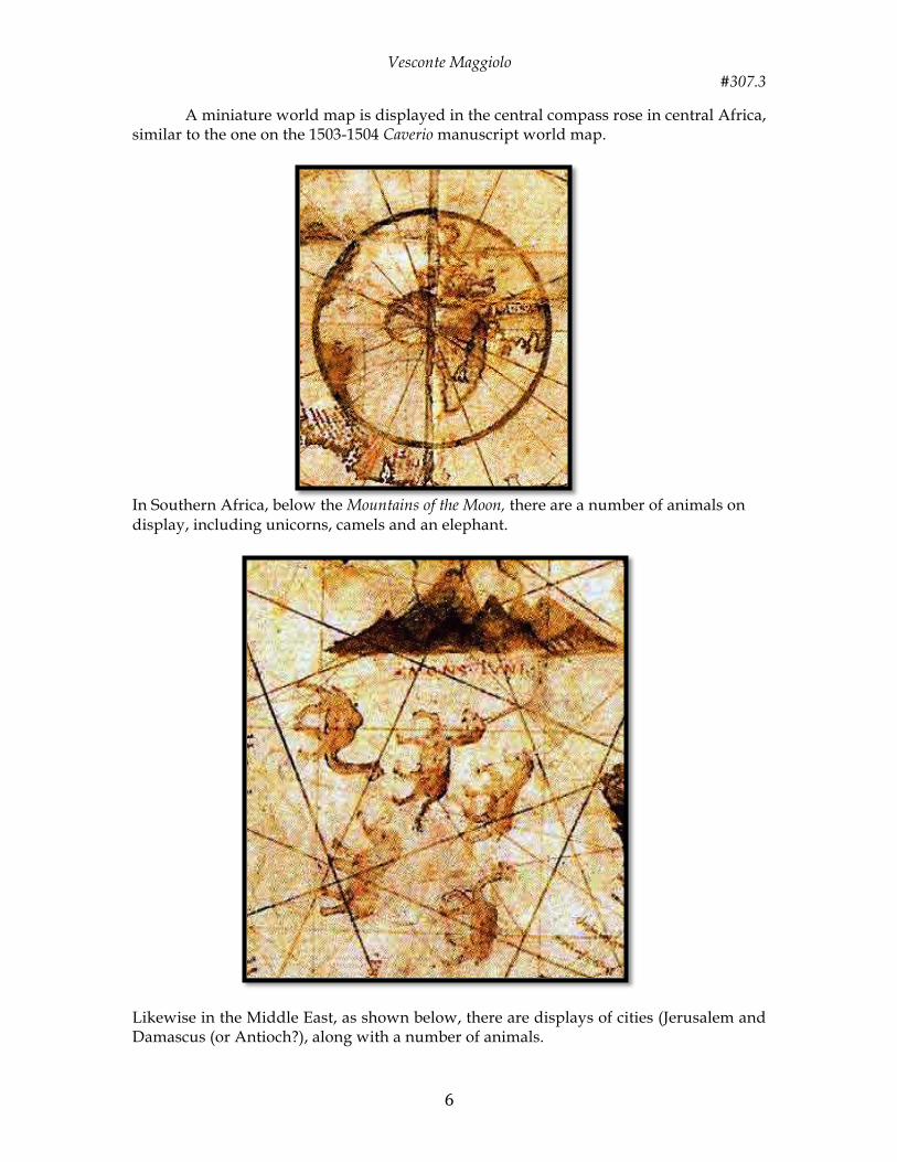
In Southern Africa, below the Mountains of the Moon, there are a number of animals on display, including unicorns, camels and an elephant.
Likewise in the Middle East, as shown below, there are displays of cities (Jerusalem and Damascus (or Antioch?), along with a number of animals.

Vesconte Maggiolo #307.3
7
Manuscript planisphere by Nicolay de Caverio, Genoa, 1503-04 (see monograph #307)

Vesconte Maggiolo #307.3
8
Vesconte Maggiolo’s portolan world chart, from eastern coasts of America to India, Naples, 1516 (#328.2)
NOTE: most of the text in this monograph is an excerpt from Gregory McIntosh’s excellent book that discusses the Fano-Maggiolo map and is relationship to other early 16th century world maps and a detailed examination of place-names and designs of these maps. References: Battistelli, Franco, Biblioteca Federiciana Fano, Fiesole, Nardini Editore, 1994. McIntosh, Gregory C., The Vesconte Maggiolo World Map of 1504 in Fano, Italy, Plus Ultra Publishing Company, 2013


![Maggiolo world map, polar #316 · Further south, we notice Terra de corte reale de rey de portugall [Land of the Corte-Real and of the King of Portugal] and terra de pescaria [fishing](https://static.fdocuments.in/doc/165x107/5e75d71014e2047ce322a725/maggiolo-world-map-polar-further-south-we-notice-terra-de-corte-reale-de-rey.jpg)