TITLE 38 LEGISLATIVE RULE DEPARTMENT OF …dep.wv.gov/dmr/codes/Documents/1. 38 CSR 2 Revised...
252
TITLE 38 LEGISLATIVE RULE DEPARTMENT OF ENVIRONMENTAL PROTECTION MINING AND RECLAMATION SERIES 2 WEST VIRGINIA SURFACE MINING RECLAMATION RULE §38-2-1. General. 1.1. Scope. -- This rule establishes general and specific rules for permit application requirements and contents; haulageways or access roads; drainage and sediment control systems; blasting; premining and postmining land use; fish and wildlife considerations; revegetation; prime farmlands; insurance and bonding; replacement, release, and forfeiture of bonds; requirements of a notice of intent to prospect; performance standards; performance standards applicable to underground mining operations; subsidence control; small operator assistance program; citizen's actions; designation of areas unsuitable for mining; inspection and enforcement; Surface Mine Board; and Coal Refuse. 1.2. Authority. -- W.Va. Code §22-1-3, 3a and 22-3-4. 1.3. Filing Date. -- June 16,2011 1.4. Effective Date. -- July 1, 2011 1.5. Applicability. 1.5.a. This rule applies to all prospecting and surface mining operations in the State of West Virginia, except the applicable subsections in W. Va. Code §22-3-26. The provisions of this subdivision do not constitute the issuance of a new permit for purposes of permit renewal or mid-term review of existing permits. 1.5.b. Permits issued after the effective date of this rule shall incorporate in the application all of the requirements of this rule. 1.5.c. The Secretary may terminate jurisdiction over a reclaimed site of a completed surface mining and reclamation operation, or increment thereof, when: 1.5.c.1. The Secretary determines in writing that under the initial program all applicable requirements imposed by the Act, this rule, and the terms and conditions of the permit have been successfully complied with; or 1.5.c.2. The Secretary determines in writing that under the permanent program, all requirements imposed under the Act, this rule, and the terms and conditions of the permit have been successfully complied with or, where a bond was required, the Secretary has made a final decision to release the bond fully. 1.5.d. Following termination under subdivision 1.5.c of this section, the Secretary shall reassert jurisdiction over a site if it is demonstrated that the bond release or written determination referred to in subdivision 1.5.c. was based upon fraud, collusion, or misrepresentation of a material fact.
Transcript of TITLE 38 LEGISLATIVE RULE DEPARTMENT OF …dep.wv.gov/dmr/codes/Documents/1. 38 CSR 2 Revised...
TITLE 38 LEGISLATIVE RULE
DEPARTMENT OF ENVIRONMENTAL PROTECTION MINING AND RECLAMATION
SERIES 2
WEST VIRGINIA SURFACE MINING RECLAMATION RULE
§38-2-1. General.
1.1. Scope. -- This rule establishes general and specific rules for permit application requirements and contents; haulageways or access roads; drainage and sediment control systems; blasting; premining and postmining land use; fish and wildlife considerations; revegetation; prime farmlands; insurance and bonding; replacement, release, and forfeiture of bonds; requirements of a notice of intent to prospect; performance standards; performance standards applicable to underground mining operations; subsidence control; small operator assistance program; citizen's actions; designation of areas unsuitable for mining; inspection and enforcement; Surface Mine Board; and Coal Refuse.
1.2. Authority. -- W.Va. Code §22-1-3, 3a and 22-3-4.
1.3. Filing Date. -- June 16,2011 1.4. Effective Date. -- July 1, 2011
1.5. Applicability.
1.5.a. This rule applies to all prospecting and surface mining operations in the State of West
Virginia, except the applicable subsections in W. Va. Code §22-3-26. The provisions of this subdivision do not constitute the issuance of a new permit for purposes of permit renewal or mid-term review of existing permits.
1.5.b. Permits issued after the effective date of this rule shall incorporate in the application all of the requirements of this rule.
1.5.c. The Secretary may terminate jurisdiction over a reclaimed site of a completed surface mining and reclamation operation, or increment thereof, when:
1.5.c.1. The Secretary determines in writing that under the initial program all applicable requirements imposed by the Act, this rule, and the terms and conditions of the permit have been successfully complied with; or
1.5.c.2. The Secretary determines in writing that under the permanent program, all requirements imposed under the Act, this rule, and the terms and conditions of the permit have been successfully complied with or, where a bond was required, the Secretary has made a final decision to release the bond fully.
1.5.d. Following termination under subdivision 1.5.c of this section, the Secretary shall reassert jurisdiction over a site if it is demonstrated that the bond release or written determination referred to in subdivision 1.5.c. was based upon fraud, collusion, or misrepresentation of a material fact.

38CSR2
All Changes except as noted were enacted 2008, 2009, and 2011 Legislative sessions and are pending OSM decision.
2
§38-2-2. Definitions.
As used in this rule unless used in a context that clearly requires a different meaning, the term:
2.1. Abandoned Coal Waste Disposal Area means any coal refuse disposal area which is not part of an active surface mining operation. This definition does not relieve any operator from his reclamation responsibility for the abandoned coal waste disposal area.
2.2. Acidity means the quantitative capacity of an aqueous medium to donate protons in a reaction with hydroxyl ions.
2.3. Acid Mine Drainage means water discharged from an active, inactive, or abandoned surface
mine and reclamation operations or from areas affected by surface mining and reclamation operations with said water having a pH of less than six (6.0) in which total acidity exceeds total alkalinity.
2.4. Acid-Producing Coal Seam means coal seams commonly associated with other minerals which create acid mine drainage. Site specific data may, on a case-by-case basis, be accepted as an affirmative demonstration that this seam is not acid producing.
2.5. Acid-Producing Overburden means overburden which upon appropriate analysis shows a potential for producing acid mine drainage.
2.6. Acid-Test Ratio means the relation of quick assets to current liabilities.
2.7. Act means the West Virginia Surface Coal Mining and Reclamation Act, W. Va. Code §22-3 et seq.
2.8. Active Surface Mining Operation means, for the purpose of permit renewal as provided in subsection 3.27 of this rule, an operation where a Phase I bond reduction has not been approved.
2.9. Administratively Complete Application means an application for permit approval or approval for prospecting, which the Secretary determines to contain information addressing each application requirement of the regulatory program and to contain all information necessary to initiate processing and public review.
2.10. Affected Area means, when used in the context of surface-mining activities, all land and water resources within the permit area which are disturbed or utilized during the term of the permit in the course of surface-mining and reclamation activities. Affected area means, when used in the context of underground mining activities, all surface land and water resources affected during the term of the permit (1) by surface operations or facilities incident to underground mining activities or (2) by underground operations. The term also includes other lands the use of which is incidental to surface coal mining and reclamation operations; all areas covered by new or existing roads used to gain access to, or for hauling coal to or from, surface coal mining and reclamation operations; any areas covered by surface excavations, workings, impoundments, dams, ventilation shafts, entryways, refuse banks, dumps, stockpiles, overburden piles, spoil banks, culm banks, tailings, holes or depressions, repair areas, storage areas, shipping areas; any areas upon which are sited structures, facilities, or other property; material on the surface resulting from, or incident to, surface coal mining and reclamation operations; and the area located above underground workings.

38CSR2
All Changes except as noted were enacted 2008, 2009, and 2011 Legislative sessions and are pending OSM decision.
3
2.11. Area Mining Operation means a mining operation where all disturbed areas are restored to approximate original contour (AOC) unless the operation is located in steep slope areas and a steep slope AOC variance in accordance with subsection 14.12 of this rule has been approved. An area mining operation may remove all or part of coal seam(s) in the upper fraction of a mountain, ridge, or hill. However, it is not classified as a mountaintop operation for one or more of the following reasons:
2.11.a. The site may be restored to AOC; or
2.11.b. The entire coal seam may not be removed.
2.12. Asset Ratio means the relation of total assets to total liabilities.
2.13. Auger Mining means a method of mining coal at the surface by drilling or cutting horizontally
into an exposed coal seam at the highwall.
2.14. Bearing Capacity means a measure, as determined by standard engineering evaluation, of the ability of a foundation material to carry loads imposed by an embankment or other structure.
2.15. Best Technology Currently Available means equipment, devices, systems, methods or
techniques which will:
2.15.a. Prevent, to the extent possible, additional contributions of suspended solids to stream flow or runoff outside the permit area, but in no event result in contributions of suspended solids in excess of requirements set by applicable State or Federal laws and rules and regulations; and
2.15.b. Minimize, to the extent possible, disturbances and adverse impacts on fish, wildlife, and related environmental values and achieve enhancement of those resources where practicable.
2.16. Buffer Zone means an undisturbed border along or around an intermittent or perennial stream.
2.17. Capital Assets means those assets such as land, buildings and equipment held for use in the production or sale of other assets or services.
2.18. Cash means:
2.18.a. all cash items except cash (1) restricted by an agreement, or (2) described as earmarked
for a particular purpose; and
2.18.b. short-term investment such as stocks, bonds, notes, and certificates of deposit, where the intent and ability to sell them in the near future is established by the operator.
2.19. Cemetery means any area of land where human bodies are interred.
2.20. Channel Protection means any measures taken to prevent or control erosion, scouring, or other deteriorating processes in channels such as diversion ditches and spillways.
2.21. Chemical Treatment means the treatment of water from a surface coal mining operation using chemical reagents such as but not limited to sodium hydroxide, calcium carbonate, or anhydrous ammonia for purposes of meeting applicable state and federal effluent limitations. Chemical treatment does not

38CSR2
All Changes except as noted were enacted 2008, 2009, and 2011 Legislative sessions and are pending OSM decision.
4
include passive treatment systems such as but not limited to limestone drains, wetlands, alkaline addition, application of fly ash, agricultural lime, or injection of fly ash, limestone, or other minerals into underground coal operations.
2.22. Coal Preparation means chemical or physical processing and the cleaning, concentrating, or other processing or preparation of coal.
2.23. Coal Preparation Plant means a facility operated in connection with a mine where coal is
subjected to chemical or physical processing or cleaning, crushing (by any means) concentrating, screening or sizing, or other processing or preparation. It includes facilities associated with coal preparation activities, including, but not limited to the following: loading facilities; storage and stockpile facilities; sheds; shops, and other buildings; water-treatment and water-storage facilities; settling basins and impoundments; and coal processing and other waste disposal areas.
2.24. Coal Processing Waste means materials which are separated and wasted from the product coal during its physical or chemical processing, cleaning or concentrating.
2.25. Coal Refuse Site means a deposit of coal processing waste or underground development waste.
2.26. Coal Remining Operation means a coal mining operation on lands which would be eligible for expenditures under section 4, Article 2 of Chapter 22.
2.27. Coarse Coal Refuse means coal processing waste predominantly within a size range greater
than the number twenty-eight (#28) sieve size.
2.28. Collateral Bond means an indemnity agreement in sum certain executed by the permittee and supported by one or more of the following:
2.28.a. The deposit of cash in one or more federally insured accounts, payable only to the Secretary upon demand;
2.28.b. Negotiable bonds of the United States, a State, or a municipality, endorsed to the order of, and in the possession of, the Secretary;
2.28.c. Negotiable certificates of deposit, payable only to the Secretary, and in his possession;
2.28.d. An irrevocable letter of credit of any bank organized or authorized to transact business in the State of West Virginia, payable only upon presentation by the Secretary;
2.28.e. A perfected, first-lien security interest in real property, in favor of the Secretary; 2.28.f. Investment-grade rated securities, having the highest rating issued by a nationally
recognized securities rating service, endorsed to the order of, and in the possession of, the Secretary, excluding all issues of the type traded on a commodity exchange such as contracts for future delivery of goods; or
2.28.g. A whole life insurance policy assigned to the Department of Environmental Protection and in the possession of the Secretary, said policy having been issued by only those companies with an independent financial rating of A+, Aaa, or the equivalent authorized to do business in the State of West Virginia and are member insurers of the West Virginia Life and Health Insurance Guaranty Association.

38CSR2
All Changes except as noted were enacted 2008, 2009, and 2011 Legislative sessions and are pending OSM decision.
5
2.29. Combined Coal Refuse means a mixture of coarse coal refuse and dewatered fine coal refuse.
2.30. Combustible Materials means organic materials that are capable of burning by fire or through
oxidation, accompanied by the evolution of heat and a significant temperature rise. 2.31. Commercial Forestry and Forestry.
2.31.a. Commercial Forestry, as used in subsection 7.4 of this rule, means a long-term
postmining land use designed to accomplish the following:
2.31.a.1. Achieve greater forest productivity than that found on the mine site before mining;
2.31.a.2. Minimize erosion and/or sediment yield and serve the hydrologic functions of infiltrating, holding, and yielding water commonly found in undisturbed forests;
2.31.a.3. Result in biodiversity by facilitating rapid recruitment of native species of plants and animals via the process of natural succession;
2.31.a.4. Result in a premium forest that will thrive under stressful conditions; and
2.31.a.5. Result in landscape, vegetation and water resources that create habitat for forest-dwelling wildlife.
2.31.b. Forestry, as used in subsection 7.4 of this rule, means a long-term postmining land use
designed to accomplish the following:
2.31.b.1. Forestry, as used in subsection 7.4 of this rule, means a long-term postmining land use for the production of wood or wood products designed to accomplish the following:
2.31.b.1.A. Achieve forest productivity equal to that found on the mine site before mining;
2.31.b.1.B. Minimize erosion and/or sediment yield and serve the hydrologic functions of infiltrating, holding, and yielding water commonly found in undisturbed forests;
2.31.1.C. Result in biodiversity by facilitating rapid recruitment of native species of plants and animals via the process of natural succession; and
2.31.1.D. Result in landscape, vegetation and water resources that create habitat for forest-
dwelling wildlife.
2.32. Common Size Comparative Balance Sheet means item amounts from a number of the permittees or applicant's successive yearly balance sheets arranged side-by-side in a single statement followed by common size percentages whereby:
2.32.a. The asset total is assigned a value of one hundred percent (100%);
2.32.b. The total of liabilities and owner equity is also assigned a value of one hundred percent (100%); and

38CSR2
All Changes except as noted were enacted 2008, 2009, and 2011 Legislative sessions and are pending OSM decision.
6
2.32.c. Each individual asset, liability, and owner equity item is shown as a fraction of one of the one hundred percent (100%) totals.
2.33. Common Size Comparative Income Statement means an operator's income statement amounts for a number of successive yearly periods arranged side by side in a single statement followed by common size percentages whereby net sales are assigned a one hundred percent (100%) value, and then each statement item is shown as a percentage of net sales.
2.34. Community or Institutional Building means any structure, other than a public building or an
occupied dwelling, which is used primarily for meetings, gatherings or functions of local civic organizations or other community groups; functions as an educational, cultural, historic, religious, scientific, correctional, mental health or physical health care facility; or is used for public services, including, but not limited to, water supply, power generation or sewage treatment.
2.35. Compaction means the densification of a soil or soil-like material by means of mechanical manipulation.
2.36. Complete and Accurate Application means an application for a surface mining permit or prospecting approval which, immediately prior to issuance, contains all maps, plans, designs and other application materials required by the Act and this rule, excluding bond, which are necessary for the Secretary to make a decision on approval or denial. 2.37. Completion of Reclamation means that all terms and conditions of the permit have been satisfied, the final inspection report has been approved by the Secretary, that all applicable effluent and applicable water quality standards are met, and the total bond has been released.
2.38. Construction Pore Pressures means water pressures generated in foundation soils or embankments due to compression by loads imposed by construction of an embankment or other structure.
2.39. Cumulative Impact Area means the area, including the permit area, within which impacts resulting from the proposed operation may interact with the impacts of all anticipated mining on surface and groundwater systems. Anticipated mining shall include the entire projected lives through bond releases of:
2.39.a. The proposed operation;
2.39.b. All existing operations;
2.39.c. Any operation for which a permit application has been submitted to the Secretary, and; 2.39.d. All operations required to meet diligent development requirements for leased Federal coal
for which there is actual mine development information available.
2.40. Current Ratio means the relation of current assets to current liabilities.
2.41. Density means the weight of soil or soil-like solids per unit of total volume of soil or similar mass.
2.42. Design Storm means predicted precipitation of given intensity, frequency and duration based on
United States Weather Bureau data.

38CSR2
All Changes except as noted were enacted 2008, 2009, and 2011 Legislative sessions and are pending OSM decision.
7
2.43. Downslope means the land surface between the projected outcrop of the lowest coal seam being
mined along each highwall or any mining-related construction, and the valley floor.
2.44. Embankment means a man made deposit of earth or waste materials, usually exhibiting at least one sloping face, that is raised above the natural surface of the land.
2.45. Embankment Stability means the degree of safety relative to a structural failure of the embankment.
2.46. Emergency Spillway means a hydraulic structure designed to pass water in excess of that which an impoundment is designed to store or which cannot be passed through a principal spillway.
2.47. Excess Spoil means overburden material disposed of in a location other than the pit.
2.48. Existing Coal Refuse Area means a refuse disposal area that is part of an active surface mining operation.
2. 49. Existing Structure means a structure or facility used with or to facilitate surface coal mining and reclamation operations for which construction began prior to January 18, 1981.
2.50. Face-Up means the result of an excavation where a vertical or near vertical highwall is created
that exposes the overburden and the mineral face. 2.51. Fine Coal Refuse means coal processing waste which may be disposed of in a slurry form or in
a dewatered or treated state. 2.52. Foundation means soil, bedrock, or other earth material on or against which an embankment or
other structure is placed. 2.53. Fragile Lands means geographic areas containing natural, ecologic, scientific or aesthetic
resources that could be significantly damaged or destroyed by surface coal mining operations. Examples of fragile lands include valuable habitats for fish or wildlife, critical habitats for endangered or threatened species of animals or plants, uncommon geologic formations, national natural landmark sites, areas where mining may result in flooding, environmental corridors containing a concentration of ecologic and aesthetic features, and areas of recreational value due to high environmental quality.
2.54. Freeboard means:
2.54.a. The vertical distance between the lowest point of the crest of the embankment and the reservoir water surface; or
2.54.b. The vertical distance between the top of a ditch or channel and the water surface during the design flow.
2.55. Gravity Discharge means, with respect to underground mining activities, mine drainage that flows freely down gradient in an open channel. Mine drainage that occurs as a result of flooding a mine to the level of the discharge is not gravity discharge.
2.56. Groundwater means subsurface water in the zone of saturation.

38CSR2
All Changes except as noted were enacted 2008, 2009, and 2011 Legislative sessions and are pending OSM decision.
8
2.57. Growing Season means one (1) year. 2.58. Handbook means the Technical Handbook of Standards and Specifications for Mining
Operations in West Virginia.
2.59. Haulageway Road or Access Road means a surface right-of-way for purposes of travel by land vehicles used in surface mining and reclamation or prospecting operations. A road consists of the entire area within the right-of-way, including the roadbed, shoulders, parking and side areas, approaches, ditches, and other related structures. The term includes access and haulroads constructed, used, reconstructed, improved, or maintained for use in surface mining and reclamation or prospecting operations, including use by coal hauling vehicles to and from transfer, processing, or storage areas. The term does not include ramps and routes of travel within the immediate mining area or within spoil or coal mine waste disposal areas.
2.60. Hazard Potential means a classification rating assigned to a structure based on engineering evaluations and judgment predicting the potential damage to human life, property and environment should a failure of the structure occur.
2.61. Highwall means the face of exposed overburden or coal in an open cut of a surface mining operation or for entry to an underground mining operation.
2.62. Historic Lands means historic, archaeological, cultural, and scientific areas. Examples of historic lands include archaeological sites, sites listed on or eligible for listing on a state or national register of historic places, national historic landmarks, sites having cultural significance to native Americans, or religious significance to religious groups, and sites for which historic designation is pending.
2.63. Hydrologic Balance means the relationship between the quality and quantity of water inflow to, water outflow from a hydrologic unit including water stored in the unit. It encompasses the dynamic relationships among precipitation, runoff, evaporation and changes in ground and surface water levels and storage capacity.
2.64. Hydrological Isolated Operations means a surface mining operation where hydrologic impacts are negligible or are dissipated before reaching points in the system where they are additive to hydrologic impacts of other surface mining operations.
2.65. Hydrologic Regime means the entire state of water movement in a given area. 2.66. Impoundment or Impounding Structure means a basin either naturally formed or artificially
built for the retention of water, sediment, slurry, or other liquid or semi-liquid material.
2.67. Infiltration means the flow or movement of water through the surface of soil or soil like material into the ground.
2.68. Inspection means a visual review of prospecting, surface or other mining operations to assure compliance with applicable laws, rules, regulations or permit conditions under jurisdiction of the Secretary.

38CSR2
All Changes except as noted were enacted 2008, 2009, and 2011 Legislative sessions and are pending OSM decision.
9
2.69. Intermittent Stream means:
2. 69.a. A stream or reach of a stream that drains a watershed of at least one square mile; or
2. 69.b. A stream or reach of a stream that is below the local water table for at least some part of the year, and obtains its flow from both surface runoff and ground water discharge.
2.70. Irreparable Damage to the Environment means any damage to the environment in violation of the Act and this rule which cannot be corrected by activities of the responsible person.
2.71. Knowingly means that an individual knew or had reason to know in authorizing, ordering or carrying out an act or omission on the part of a corporate permittee that such act or omission constituted a violation, failure or refusal.
2.72. Leachate means a liquid that has percolated through soil, rock or waste and has extracted
dissolved or suspended materials. 2.73. Lightly Buffered Stream means any stream or its tributaries that contains less than fifteen (15)
PPM methyl orange alkalinity (to pH 4.5) and a conductivity of less than fifty (50) micro MHO.
2.74. Liquefaction means a phenomenon wherein a saturated granular soil or soil like material loses strength and flows in a manner resembling a liquid.
2.75. Liquidity Ratio means the relation of cash to current liabilities. 2.76. Mineral Face means the exposed vertical cross section of the natural coal seam or mineral
deposit.
2.77. Mountaintop Mining Operation means a mining operation that removes an entire coal seam or seam(s) in an upper fraction of a mountain, ridge, or hill and creating a level plateau or a gently rolling contour with no highwalls. The approved postmining land use must be in accordance with §22-3-13(c)(3).
2.78. Natural Drainway means any natural water course which may carry water to the tributaries and rivers of the watershed.
2.79. Natural Hazard Lands means geographic areas in which natural conditions exist which pose or, as a result of surface coal mining operations, may pose a threat to the health, safety or welfare of people, property or the environment, including areas subject to landslides, cave-ins, severe wind or soil erosion, frequent flooding and areas of unstable geology.
2.80. Net Profit means the bottom line of the income statement after taxes, including taxes based on income, adjustments, all extraordinary income and expense, but before preferred and common stock dividends.
2.81. Occupied Dwelling means any building that is currently being used on a regular or temporary
basis for human habitation. 2.82. Operator means any person who is granted or who should obtain a permit to engage in any
activity covered by the Act or this rule, or anyone who engages in surface mining and/or surface mining

38CSR2
All Changes except as noted were enacted 2008, 2009, and 2011 Legislative sessions and are pending OSM decision.
10
and reclamation operations. Further, the term shall be construed in a manner consistent with the federal program pursuant to Public Law 95-87.
2.83. Outer Spoil or Outer Slope means a disturbed area extending from the outer point of the bench to the extreme lower limit of the disturbed land.
2.84. Overburden means consolidated or unconsolidated material of any nature which overlies a mineral deposit, excluding topsoil.
2.85. Owned or Controlled and Owns or Controls means any one or a combination of the relationships specified in subdivisions 85.a through d of this subsection:
2.85.a. Being a permittee of a surface coal mining operation;
2.85.b. Based on instrument of ownership or voting securities, owning of record in excess of fifty (50) percent of an entity; or
2.85.c. Having any other relationship which gives one person authority directly or indirectly to determine the manner in which an applicant, an operator, or other entity conducts surface mining operations.
2.85.d. The following relationships are presumed to constitute ownership or control unless a person can demonstrate that the person subject to the presumption does not in fact have the authority directly or indirectly to determine the manner in which the relevant surface mining operation is conducted:
2.85.d.1. Being an officer or director of an entity;
2.85.d.2. Being the operator of a surface mining operation;
2.85.d.3. Having the ability to commit the financial or real property assets or working resources of an entity;
2.85.d.4. Being a general partner in a partnership;
2.85.d.5. Based on the instruments of ownership or the voting securities of a corporate entity,
owning of record ten (10) through fifty (50) percent of the entity; or
2.85.d.6. Owning or controlling coal to be mined by another person under a lease, sublease or other contract and having the right to receive such coal after mining or having authority to determine the manner in which that person or another person conducts a surface mining operation.
2.86. Peak Runoff means the maximum flow in a specified geographic location resulting from a given design storm.
2.87. Perennial Stream means a stream or portion of a stream that flows continuously.
2.88. Person having an interest which is or may be adversely affected or person with a valid legal interest means any person:

38CSR2
All Changes except as noted were enacted 2008, 2009, and 2011 Legislative sessions and are pending OSM decision.
11
2.88.a. Who uses any resource of economic, recreational, aesthetic, or environmental value that may be adversely affected by prospecting or surface mining and reclamation operations or any related action of the Secretary; or
2.88.b. Whose property is or may be adversely affected by prospecting or surface mining and reclamation operations or any related action of the Secretary.
2.89. Piping means a process of internal erosion which occurs when water transports soil or soil like
materials through unprotected exits, developing unseen channels or pipes through an embankment or its foundation.
2.90. Pit means that part of the surface mining operation from which the mineral is being actively removed or where the mineral has been removed and the area has not been backfilled.
2.91. Pre-Existing Discharge means any water discharge from the proposed disturbed area prior to disturbance as approved in a permit or a prospecting approval. 2.92 Previously mined areas means land affected by surface mining operations prior to August 3, 1977, that has not been reclaimed to the standards of this rule.
2.93. Preplan means the total application submitted to the Secretary including the application forms, mining and reclamation plan, drainage plan, blasting plan, planting plan, maps, drawings, data, cross-sections, bonds and other information as may be required to obtain a permit.
2.94. Principal Shareholder means any person who is the record or beneficial owner of ten percent
(10%) or more of any class of voting stock. 2.95. Principal Spillway means a hydraulic structure which passes water at levels between normal
pool and the emergency spillway invert elevations. 2.96. Probable Maximum Precipitation means the depth-duration-area rainfall for a particular area
that represents the maximizing of meteorological conditions.
2.97. Prospecting means the field gathering of surface or subsurface geologic, physical, or chemical data by trenching, drilling, geophysical, or other techniques necessary to determine the quality and quantity of overburden and coal of an area; or the gathering of environmental data to establish the conditions of an area before beginning surface mining and reclamation operations, where such activity may cause any disturbance of the land surface or may cause any appreciable effect on land, air, water, or other environmental resources. Regardless of whether or not any disturbance is anticipated, the gathering of environmental data on lands designated unsuitable pursuant to section 22 of the Act shall be considered prospecting and subject to the requirements of section 13 of this rule.
2.98. Protected Structures means for purposes of blasting, dwellings, public buildings, schools, churches, or community or institutional buildings.
2.99. Public Building means any structure that is owned or leased by a public agency or used primarily for public business or meetings.
2.100. Quick Assets means cash and current assets that can be quickly turned into cash.

38CSR2
All Changes except as noted were enacted 2008, 2009, and 2011 Legislative sessions and are pending OSM decision.
12
2.101. Reasonably Available Spoil means spoil and suitable coal mine waste material generated by the remining operation or other spoil or suitable coal mine waste material located in the permit area that is accessible and available for use and that when rehandled will not cause a hazard to public safety or significant damage to the environment.
2.102. Recharge Capacity means the ability of the soils and underlying materials to allow precipitation to infiltrate and reach the zone of saturation.
2.103. Reclamation means those actions taken to restore mined land to the approved post mining land use.
2.104. Remined Area means only that area of any coal remining operation.
2.105. Renewable Resource Lands means aquifers and areas for the recharge of aquifers and other underground waters, areas for agricultural or silvicultural production of food and fiber, and grazing lands.
2.106. Retained Earnings means stockholder's equity that has arisen from retained assets from earnings in the business. This shall include only earnings from normal operations and not gains from such transactions as the sale of plant assets or investments.
2.107. Return On Investment means the relation of net profit for the last yearly period to ending net worth.
2.108. Safety Factor means the ratio of the sum of the resisting forces to the sum of the loading or driving forces.
2.109. Secretary means the Secretary of the Department of Environmental Protection or his authorized agent.
2.110. Sediment means solid material that is either in suspension, is being transported, or has been moved from its site of origin and has come to rest on the earth's surface.
2.111. Sediment Control or Other Water Retention Structure, Sediment Control or Other Water Retention System, or Sediment Pond means an impoundment designed, constructed, and maintained in accordance with this rule for the purpose of removing solids from water in order to meet applicable water quality standards or effluent limitations before the water is discharged into the receiving stream. Examples include wildlife ponds, settling basins and all ponds and facilities or structures used for water treatment.
2.112. Self-Bond means an indemnity agreement in a sum certain payable to the Secretary, executed by the permittee and by each individual and business organization capable of influencing or controlling the investment or financial practices of the permittee by virtue of his authority as an officer or ownership of all or a significant part of the permittee, and supported by agreements granting the Secretary a security interest in real or personal property pledged to secure performance by the permittee.
2.113. Significant Aquifer means a stratum or group of strata that can store and transmit water in significant quantities for a specific use.
2.114. Slope Protection means measures taken to control erosion on slopes.

38CSR2
All Changes except as noted were enacted 2008, 2009, and 2011 Legislative sessions and are pending OSM decision.
13
2.115. Slope Stability means the relative degree of safety from the development of a landslide in a slope, as defined by one or more standard engineering methods of analysis.
2.116. Spoil means overburden that has been removed during surface mining operations.
2.117. Stabilize means to control movement of soil, spoil piles or areas of disturbed earth.
2.118. Strength Parameters mean those engineering values obtained from standard engineering shear strength tests of soil or soil like material.
2.119. Structure means, except as used in the context of subsection 3.8 of this rule, any man-made structures within or outside the permit areas which include, but is not limited to: dwellings, outbuildings, commercial buildings, public buildings, community buildings, institutional buildings, gas lines, water lines, towers, airports, underground mines, tunnels and dams. The term does not include structures built and/or utilized for the purpose of carrying out the surface mining operation.
2.120. Sub-Drainage System means a designed and constructed system provided for the conveyance of subsurface water.
2.121. Subsidence means, as it relates to underground mining operations or auger mining, a sinking, collapsing or cracking of a portion of the earth's surface caused by voids beneath the surface created by mining.
2.122. Substantial Legal and Financial Commitments in a Surface Coal Mining Operation means that
significant investments and legal commitments have been made in activities and facilities such as power plants, railroads, coal handling, preparation, extraction or storage facilities and other capital-intensive activities on the basis of a long term coal contract.
2.123. Substantially Disturb means, for purposes of prospecting, to significantly impact land or water resources by blasting; by removal of vegetation, topsoil, or overburden; by construction of roads or other access routes; by placement of excavated earth or waste material on the natural land surface or by other such activities; or to remove more than 250 tons of coal.
2.124. Successor in Interest means any person who succeeds to rights granted under a permit by transfer, assignment or sale of those rights.
2.125. Surety Bond means an indemnity agreement in a sum certain payable to the Secretary executed by the permittee which is supported by the performance guarantee of a corporation licensed to do business as a surety in the State of West Virginia.
2.126. Surface Mining and Reclamation Operation means surface coal mining operations and all activities necessary or incidental to the reclamation of such operations.
2.127. Surface Water means water on the surface of the earth.
2.128. Topsoil means the A and E-horizon soil layer of the four (4) major soil horizons.
2.129. Toxic-Forming Materials means earth materials or wastes which, if acted upon by air, water, weathering or microbiological processes, are likely to produce chemical or physical conditions in soils, air or water that are detrimental to the environment.

38CSR2
All Changes except as noted were enacted 2008, 2009, and 2011 Legislative sessions and are pending OSM decision.
14
2.130. Toxic Mine Drainage means water that is discharged from active or abandoned mines or other
areas affected by surface mining operations, reclamation operations, or prospecting operations which contains a substance which through chemical action or physical effects, is likely to kill, injure or impair biota commonly present in the area that might be exposed to it.
2.131. Transfer, Assignment or Sale of Rights means a change in ownership pursuant to subsection 2.85 or other effective control over the right granted in a permit or approval to conduct surface mining operations.
2.132. Underground Development Waste means waste rock mixtures of coal, shale, claystone, siltstone or other related materials that are brought to the surface for disposal.
2.133. Valid Existing Rights exists, except for haulroads, in each case in which a person demonstrates that the limitation provided for in the Act would result in the unconstitutional taking of that person's rights. For haulroads, valid existing rights means a road or recorded right-of-way or easement for a road which was in existence prior to August 3, 1977. A person possesses valid existing rights if he can demonstrate that the coal is immediately adjacent to an ongoing mining operation which existed on August 3, 1977 and is needed to make the operation as a whole economically viable. Valid existing rights shall also be found for an area where a person can demonstrate that an SMA number had been issued prior to the time when the structure, road, cemetery or other entity came into existence.
2.134. Valley or Head-of-Hollow Fill means a fill structure consisting of any material, other than organic material, placed in a valley where side slopes of the existing valley measured at the steepest point are greater than twenty (20) degrees or the average slope of the profile of the hollow from the toe of the fill to the top of the fill is greater than ten (10) degrees. In head-of-hollow fills the top surface of the fill, when completed, is at approximately the same elevation as the adjacent ridge line, and no significant area of natural drainage occurs above the fill draining into the fill area.
2.135. Violation, Failure or Refusal means a violation of a condition of a permit issued pursuant to the Act or this rule; or a failure or refusal to comply with any order issued under Sections 15, 16, or 17 of the Act, or any order incorporated in a final decision issued by the Secretary under the Act, except an order incorporated in a decision issued under paragraph (1), subsection (d), section 17 of the Act.
2.136. Willfully means that an individual acted:
2.136.a. Either intentionally, voluntarily or consciously; and
2.136.b. With intentional disregard or plain indifference to legal requirements in authorizing, ordering or carrying out a corporate permittees action or omission that constituted a violation, failure or refusal.
2.137. Working Capital means the excess of the operator's current assets over its current liabilities.
2.138. Zone of Saturation means the zone below the piezometric surface in which all voids are filled with groundwater.

38CSR2
All Changes except as noted were enacted 2008, 2009, and 2011 Legislative sessions and are pending OSM decision.
15
§38-2-3. Permit Application Requirements and Contents.
3.1. Applicant Information. All information provided by an applicant in an application for a surface mining permit shall be clear and concise and shall be provided in a format prescribed by the Secretary and/or a format required by the Federal Office of Surface Mining Reclamation and Enforcement. In addition to the information requirements of section 9 of the Act, each application for a permit shall contain the following information except that submittal of a social security number is at the option of the applicant:
3.1.a. A statement as to whether the applicant is a corporation, partnership, sole proprietorship, association, or other business entity.
3.1.b. The name, address, telephone number and, as applicable, social security number and employer identification number of the:
3.1.b.1. Applicant;
3.1.b.2. Applicant's resident agent; and
3.1.b.3. Person who will pay the abandoned mine land reclamation fee.
3.1.c. List, for each person who owns or controls the applicant under the definition of "owned or controlled" and "owns and controls" in subsection 2.85 of this rule (as applicable):
3.1.c.1. The person's name, address, social security number, and employer identification number;
3.1.c.2. The person's ownership or control relationship to the applicant, including percentage of ownership and location in organizational structure;
3.1.c.3. The title of the person's position, date position was assumed, and when submitted
under subdivision 3.33.h of this rule, date of departure from the position;
3.1.c.4. Each additional name and identifying number, including employer identification number, federal or state permit number, and, if available, MSHA number with date of issuance, under which the person owns or controls, or previously owned or controlled, a surface coal mining and reclamation operation in the United States within the five (5) years preceding the date of the application; and
3.1.c.5. The application number or other identifier of, and the regulatory authority for, any
other pending surface coal mining operation permit application filed by the person in any state in the United States.
3.1.d. List, either in the application or in an electronic database accessible to the agency which has been updated within three months of submittal, for any surface coal mining operation owned or controlled by either the applicant or by any person who owns or controls the applicant under the definition of "owned or controlled" and "owns or controls" in subsection 2.875 of this rule, the operation's:
3.1.d.1. Name, address, identifying numbers, including employer identification number, Federal or State permit number and MSHA number, the date of issuance of the MSHA number, and the

38CSR2
All Changes except as noted were enacted 2008, 2009, and 2011 Legislative sessions and are pending OSM decision.
16
regulatory authority; and
3.1.d.2. Ownership or control relationship to the applicant, including percentage of ownership and location in organizational structure.
3.1.e. The name and address of each legal or equitable owner of record of the surface and mineral property to be mined, each holder of record of any leasehold interest in the property to be mined, and any purchaser of record under a real estate contract for the property to be mined.
3.1.f. The name and address of each owner of record of all property (surface and subsurface)
within one hundred (100) feet of any part of the proposed permit area.
3.1.g. The Mine Safety and Health Administration (MSHA) numbers for all mine-associated structures identified in the permit that require MSHA approval.
3.1.h. A statement of all lands, interest in lands, options, or pending bids on interests held or made by the applicant for lands contiguous to the area described in the permit application. If requested by the applicant, any information required by this paragraph which is not on public file pursuant to the Act shall be held in confidence.
3.1.i. A statement of whether the applicant or any subsidiary, affiliate, or persons owned or controlled or under control or ownership with the applicant has:
3.1.i.1. Had a Federal or State coal mining permit suspended or revoked in the five (5) years
preceding the date of submission of the application; or
3.1.i.2. Forfeited a bond or similar security deposited in lieu of bond.
3.1.j. A brief explanation of the facts involved if any such suspension, revocation, or forfeiture referred to in paragraphs 3.1.i.1 and 3.1.i.2 of this subdivision has occurred, including:
3.1.j.1. Identification number and date of issuance of the permit, and the date and amount of bond or similar security;
3.1.j.2. Identification of the authority that suspended or revoked the permit or forfeited the bond and the stated reasons for the action;
3.1.j.3. The current status of the permit and bond, or similar security involved; 3.1.j.4. The date, location, and type of any administrative or judicial proceedings initiated
concerning the suspension, revocation, or forfeiture; and
3.1.j.5. The current status of any administrative or judicial proceedings.
3.1.k. A list either in the application or in an electronic database accessible to the agency which has been updated within three months of submittal, for any violation of a provision of the Act or this rule and any other Federal or State laws, rules and regulations pertaining to air or water environmental protection incurred in connection with any surface mining operation received by the applicant during the
three (3) year period preceding the application date, and a list of all unabated cessation orders, and unabated air and water quality violation notices received prior to the date of the application by any
38CSR2
All Changes except as noted were enacted 2008, 2009, and 2011 Legislative sessions and are pending OSM decision.
17
surface mining and reclamation operation owned or controlled by either the applicant or by any person who owns or controls the applicant For each violation notice or cessation order reported, the lists shall include the following information as applicable:
3.1.k.1. Any identifying numbers for the operation, including the Federal or State permit
number and MSHA number, the dates of issuance of the violation notice and MSHA number, the name of the person to whom the violation notice was issued, and the name of the issuing regulatory authority, department or agency;
3.1.k.2. A brief description of the violation alleged in the notice;
3.1.k.3. The date, location, and type of any administrative or judicial proceedings initiated concerning the violation, including, but not limited to, proceedings initiated by any person to obtain administrative or judicial review of the violation;
3.1.k.4. The current status of both the proceedings and the violation notice; and
3.1.k.5. The actions, if any, taken by any person to abate the violation.
3.1.l. Each application for a permit shall contain a sworn statement as follows: "The information contained in this application is true and correct to the best of my knowledge and belief." Such statement shall be signed by an accountable official of the applicant and shall be notarized.
3.1.m. The applicant for a permit or a revision of a permit shall have the burden of establishing that his application is in compliance with all the requirements of the Act and this rule.
3.1.n. After an applicant is notified that the application is approved, but before the permit is issued, the applicant shall update and correct the information previously submitted under this subsection or indicate that no change in such information has occurred.
3.1.o. Upon request by one or more permittees related through ownership and control, and with the approval of the Secretary, a permittee, or permittees related through ownership and control, may submit and maintain a centralized ownership and control file.
Any permit application which references an approved centralized ownership and control file may be determined to be complete and accurate for the purposes of this subsection. Each centralized ownership and control file shall at a minimum:
3.1.o.1. Contain the information required by subdivisions 3.1.a, 3.1.c, 3.1.d, and 3.1.l of this subsection on such forms, or in the format, as may be required by the Secretary;
3.1.o.2. Provide a procedure for the file to be updated at least quarterly, although this requirement does not relieve an applicant from having complete and accurate information in the centralized ownership and control file during the time it has an application pending; and
3.1.o.3. Provide that the applicant maintain a copy or copies of the file in any required courthouses, regional offices, and other public offices, during any required public notice period, when referenced in an application that is otherwise required to be made available in such offices.

38CSR2
All Changes except as noted were enacted 2008, 2009, and 2011 Legislative sessions and are pending OSM decision.
18
3.2. Advertisement.
3.2.a. SMA File Number. Prior to the publication of an advertisement for a surface mining permit in accordance with paragraph (6), subsection (a), section 9 of the Act, the applicant shall submit an administratively complete surface mining permit application and obtain a surface mining application (SMA) file number. Each SMA number shall be valid for one year; provided, that the Secretary may extend an SMA number beyond one year, if the application has been diligently pursued by the applicant throughout the life of the SMA number. In order for an SMA number to be extended, the applicant must submit to the Secretary a written request, which shall state the reason(s) and which shall demonstrate good cause for the extension.
3.2.b. Advertisement Information. Each advertisement will contain at a minimum:
3.2.b.1. The surface mining application (SMA) file number;
3.2.b.2. A clear and accurate location map of a scale and detail found in the West Virginia General Highway Map. The map size will be at a minimum four inches (4") x four inches (4"). Longitude and latitude lines and north arrow will be indicated on the map and such lines will cross at or near the center of the proposed permit area;
3.2.b.3. The names and business address of the applicant to include a street address or route number;
3.2.b.4. A narrative description clearly describing the location of the proposed permit area;
3.2.b.5. The name(s) of the coal seam(s) to be mined;
3.2.b.6. The name(s) of the receiving stream(s) into which drainage from the permit area will be discharged;
3.2.b.7. The location where a copy of the application is available for public review; 3.2.b.8. The name and address of the Department of Environmental Protection Office where
written comments or requests for informal conferences on the application may be submitted; 3.2.b.9. The type of operation;
3.2.b.10. Surface and mineral ownership of the tract(s) to be permitted;
3.2.b.11. Surface and mineral ownership of property within one hundred (100) feet of the
permit area;
3.2.b.12. Where the permit application reflects that mining will occur within one-hundred feet (100') of the outside right-of-way of a public road (except where mine access roads or haulage roads join such right-of-way), the applicant may choose one of the following procedures to satisfy the additional public notice requirement:
3.2.b.12.A. Include in the advertisement required in this section a concise statement:
3.2.b.12.A.1. Identifying the road to be affected;

38CSR2
All Changes except as noted were enacted 2008, 2009, and 2011 Legislative sessions and are pending OSM decision.
19
3.2.b.12.A.2. Identifying the affected segment; and
3.2.b.12.A.3. Advising that a public hearing may be requested; or
3.2.b.12.B. A separate public notice may be published, prior to issuance of a permit,
which:
3.2.b.12.B.1. Identifies the road to be affected;
3.2.b.12.B.2. Identifies the affected segment; and
3.2.b.12.B.3. Advises that a public hearing may be requested.
3.2.b.13. Where the permit applicant proposes to relocate or close a public road, the advertisement shall include a concise statement which:
3.2.b.13.A. Describes the identification number and geographic location of the road;
3.2.b.13.B. Describes the particular segment to be relocated or closed;
3.2.b.13.C. Describes where the relocated segment is to be sited; 3.2.b.13.D. Describes the approximate time and duration of the relocation or closure; and
3.2.b.13.E. Advises that a public hearing may be requested.
3.2.b.14. Where an alternative land use is proposed, indicate the premining land use and the
proposed postmining land use; and
3.2.b.15. Where an experimental practice is proposed, the advertisement shall contain a statement indicating such and identifying applicable provisions for which a variance is requested.
3.2.c. Notice to Governmental Agencies. Upon receipt of an administratively complete application for a surface mining and reclamation permit, a permit revision or a permit renewal, the Secretary shall notify all Federal or State government agencies with authority to issue permits and licenses applicable to the proposed surface mining and reclamation operation or those agencies with an interest in the proposed operation, including the U. S. Department of Agriculture Natural Resources Conservation Service district office, the local U. S. Army Corps of Engineers district engineer, the National Park Service, State and Federal fish and wildlife agencies, and the historic preservation officer.
3.2.d. Availability of Comments. The Secretary shall place on file at the regional office in which a permit, permit revision or renewal of a permit is filed, a copy of all public comments received as a result of the advertisement and shall provide the applicant with such comments. When a permit, permit revision or renewal of a permit is issued or approved, the Secretary shall notify within ten (10) days each person who filed comments or objections to the application, each party to an informal conference, and the appropriate local governmental agencies including the clerk of the county commission. The Secretary shall also cause to be published at least monthly a listing of all permits issued, which listing shall include a description of the location of the land to be affected. The listing shall also be forwarded to the Clerk of the County Commission.

38CSR2
All Changes except as noted were enacted 2008, 2009, and 2011 Legislative sessions and are pending OSM decision.
20
3.2.e. Readvertisement. After a Surface Mine Application (SMA) has been advertised once a
week for four successive weeks, and is determined by the Secretary to have had a limited number of minor changes that do not significantly affect the health, safety or welfare of the public and which do not significantly affect the method of operation, the reclamation plan, and/or the original advertisement, he may require one (1) additional advertisement to be published with a ten (10) day public comment period.
3.2.f. Renotification. A renotification letter shall be sent to all commenters of a surface mine application (SMA) when a determination has been made by the Secretary that readvertisement is required in accordance with subdivision 3.2.e of this subsection.
3.2.g. Notice of Technical Completeness. After the Secretary deems a Surface Mine Application
technically complete, the Secretary shall cause the applicant to advertise that the application is technically complete. The one time notice shall state that the application has been deemed technically complete by the Secretary and include a fifteen (15) day public review period: Provided, that , Notice of Technical Completeness is not necessary if the application was technically complete prior to the end of the comment period of the original advertisement or a decision is made within ninety (90) days of the end of the comment period or informal conference.
3.2.i. Certification of Publication. The advertisement and publication dates for all permit
applications, permit renewal applications, applications for revision of a permit, and transfer assignment and sale of permits, shall be certified and notarized by the publishing newspaper. The certificate of publication shall be made a part of the approved application no later than four (4) weeks after the last date of publication.
3.3. Occupied Dwellings.
3.3.a. Valid Existing Rights. Where the proposed surface coal mining operations would be conducted within three hundred (300) feet, measured horizontally, of any occupied dwelling, the permit applicant shall submit with the application a notarized written waiver by lease, deed, or other conveyance from the owner of the dwelling, clarifying that the owner and signator had the legal right to deny mining and knowingly waived that right. The waiver shall act as consent to such operations within a closer distance of the dwelling as specified.
3.3.b. Waiver. Where the applicant for a permit had obtained a valid waiver prior to August 3, 1977, from the owner of an occupied dwelling to mine within three hundred (300) feet of such dwelling, a new waiver shall not be required:
3.3.b.1. Where the applicant for a permit had obtained a valid waiver from the owner of an occupied dwelling, that waiver shall remain effective against subsequent purchasers who had actual or constructive knowledge of the existing waiver at the time of purchase.
3.3.b.2. A subsequent purchaser shall be deemed to have constructive knowledge if the waiver has been properly filed in public property records pursuant to state laws or if the mining has proceeded to within the three hundred (300) feet limit prior to the date of purchase.
3.4. Maps.
3.4.a. Scale for Maps. Except as otherwise noted in this rule, the scale required for all maps shall
38CSR2
All Changes except as noted were enacted 2008, 2009, and 2011 Legislative sessions and are pending OSM decision.
21
be as follows:
3.4.a.1. The preferred scale of maps prepared from United States Geological Survey topographic maps on 7.5 minute quadrangle shall be five hundred feet (500') to the inch;
3.4.a.2. The preferred scale for maps associated with underground coal mining operations and facilities incidental to coal mining shall be two hundred feet (200') to the inch; and
3.4.a.3. Other scales may be used where improved clarity and accuracy are achieved.
3.4.b. Map Size. All maps and plans shall be submitted in a format proscribed by the Secretary and either be on print paper, thirty inches (30") by forty-two inches (42") or less. or, if electronic, be capable of being printed on paper of this size. If supplementary maps or plans are attached, match lines shall be used.
3.4.c. Color Code. A color code shall be used in preparing all maps to indicate critical features of the permit area as follows; provided, that drafted or computer generated graphic symbols or shading may be used in place of a color code, if a separate, uniquely identifiable, and clearly discernible symbol or shading is provided in place of each color as specified below, and if the symbols or shading are clearly defined on map legends and used consistently throughout the permit application, and in any subsequent permit revisions, progress maps, or other submittals relating to the permit:
3.4.c.1. Red shall indicate mineral to be removed;
3.4.c.2. Blue shall indicate water and drainage patterns;
3.4.c.3. Green shall indicate areas regraded;
3.4.c.4. Yellow shall indicate all other areas within the permit boundary; and
3.4.c.5. Purple shall be used to outline adjacent mining permits.
3.4.d. Preplan. In addition to the requirements of paragraphs (12) and (13) of subsection (a) section 9 of the Act and section 10 of the Act, the application shall include as applicable the following information:
3.4.d.1. The location and current use of all structures within one thousand feet (1000') of the proposed permit area;
3.4.d.2. All public roads located on or within one hundred feet (100') of the proposed permit
area;
3.4.d.3. The boundaries of any public park or historic lands within or adjacent to the permit area;
3.4.d.4. All cemeteries located on or within one hundred feet (100') of the proposed permit area;
3.4.d.5. Any portion of a unit of the National System of Trails or the Wild and Scenic River System, including study rivers designated under section 5(a) of the Wild and Scenic Rivers Act which are

38CSR2
All Changes except as noted were enacted 2008, 2009, and 2011 Legislative sessions and are pending OSM decision.
22
located within or adjacent to the proposed permit area; 3.4.d.6. The current use and land use classifications of the area of land and adjacent lands
upon which the permit is sited and adjacent lands;
3.4.d.7. The location of all existing structures to be used for surface mining operations which are to be exempt from design standards;
3.4.d.8. The date the map was prepared, a north arrow, quadrangle name and location map; 3.4.d.9. Where the natural slope of the land below the coal outcrop is less than twenty (20)
degrees and downslope placement of overburden or spoil is proposed, the map shall indicate percent slope of the land at two hundred foot (200') intervals along the cropline;
3.4.d.10. The location of each facility to be used to protect or enhance fish and wildlife and
related environmental values;
3.4.d.11. Where the proposed permit area has been previously mined and to the extent that such information is available, list the type of mining used, the coal seam or other mineral mined, the extent of mineral removed, and the approximate date of mining;
3.4.d.12. Extent of proposed auger operations;
3.4.d.13. Surface and mineral owners and property lines within the permit area and within
one hundred (100) feet of any point of the permit area; 3.4.d.14. Location of water supply intakes for current users of surface water;
3.4.d.15. Location and identification of sub-areas if incremental bonding is to be used; 3.4.d.16. Location and extent of subsurface water, if encountered, within the proposed permit
or adjacent areas, including, but not limited to, aerial and vertical distribution of aquifers, and portrayal of seasonal differences of head in different aquifers on cross sections and contour maps;
3.4.d.17. The location of all oil and gas wells and other utilities within the proposed permit
area are to be shown;
3.4.d.18. The location and extent of topsoil borrow areas, and the location of topsoil storage areas;
3.4.d.19. Air pollution monitoring and control facility and subsidence monitoring location;
3.4.d.20. Any permanent facility to remain after mining;
3.4.d.21. All coal storage, cleaning, loading, and refuse disposal areas; 3.4.d.22. The location of any non-coal waste storage areas;
3.4.d.23. The location of any explosive storage and handling facility; which will remain in
place for an extended period of time during the life of the operation and

38CSR2
All Changes except as noted were enacted 2008, 2009, and 2011 Legislative sessions and are pending OSM decision.
23
3.4.d.24. The area of land to be affected within the proposed permit area according to the
sequence of mining and reclamation.
3.4.e. Drainage Map. Unless the information required by this subdivision can be shown on the preplan map in a clear and legible fashion, a separate drainage map of the same size scale and detail of the preplan map shall be made a part of the permit application and shall contain the following:
3.4.e.1. The directional flow of water on and away from the permit area;
3.4.e.2. Location of all monitoring sites used to develop surface and groundwater base line
information;
3.4.e.3. Location of all surface and ground water monitoring sites to be used for satisfying reporting requirements during the mining operation;
3.4.e.4. Location of all erosion and sedimentation control structures; and
3.4.e.5. The extent and boundaries of each component drainage area.
3.4.f. Supplemental maps for underground coal mining permit applications. In addition to other maps required in this section, each permit application for underground mining operations shall include supplemental maps as follows:
3.4.f.1. A U.S.G.S. topographic map of the area extending beyond the proposed mining limits and showing the following:
3.4.f.1.A. Name and series of the sheet;
3.4.f.1.B. Scale, latitude, and longitude;
3.4.f.1.C. Limits of underground mining operation proposed;
3.4.f.1.D. Surface area to be permitted;
3.4.f.1.E. Cropline of the coal seam to be mined;
3.4.f.1.F. Location and identification of all mine openings for the proposed mine including shafts, slopes, drifts, boreholes, etc; and
3.4.f.1.G. Location of all surface structures not owned by the applicant over the area to be mined.
3.4.f.2. A mine development map drawn to scale showing:
3.4.f.2.A. Boundaries of underground mining operation and any adjacent active or
abandoned mines in the same seam;
3.4.f.2.B. All owners of property and all residents within the area above the proposed underground workings. The area above the underground works shall mean within the angle of critical
38CSR2
All Changes except as noted were enacted 2008, 2009, and 2011 Legislative sessions and are pending OSM decision.
24
deformation but at least 15o from any coal removal;
3.4.f.2.C. Present extent of underground mining as well as projected headings;
3.4.f.2.D. Date, scale, north arrow, dip, strike, and average dip of the coal seam to be mined;
3.4.f.2.E. All gas wells, oil wells, water wells, and test drill holes; 3.4.f.2.F. Location of all known faults;
3.4.f.2.G. Area and extent of previous or proposed auger or strip mining in the same
seam;
3.4.f.2.H. Location and thickness of outcrop barriers; and 3.4.f.2.I. Elevation of all entries, fanways and boreholes.
3.5. Cross Sections and Profiles. The application shall contain cross-sections and/or profiles which accurately depict:
3.5.a. The existing premining surface configuration and the final surface configuration that will be achieved. Cross sections shall be developed from sufficient slope measurements to adequately represent the existing land surface configuration of the proposed permit area. Slope measurements shall take into account natural variations in slope, to provide accurate representation of the range of natural slopes and reflect geomorphic differences of the area to be disturbed. The Secretary may require additional slope measurements at specified intervals and locations on a site-by-site basis;
3.5.b. The vertical distribution of aquifers showing seasonal differences in head, if available, for the proposed permit area;
3.5.c. Cross sectional area and profiles of excess spoil disposal areas with all appurtenances shown including rock cores, subsurface drains, surface drainage structures, foundations, etc;
3.5.d. Cross sectional areas and profiles of all drainage and sediment control structures including ponds, impoundments, diversions, sumps, etc; and
3.5.e. Cross sectional areas and profiles of all roads.
3.6. Operation Plans and Specifications. Each application shall contain in addition to other plans,
specifications, and descriptions required by the Act and this rule, a description of the mining operations proposed to be conducted during the life of the mine within the proposed permit area, including, at a minimum, the following:
3.6.a. A narrative description of the type and method of coal mining procedures and proposed engineering techniques, anticipated annual and total production of coal, by tonnage, and the major equipment to be used for all aspects of those operations; and
3.6.b. A narrative explaining the construction, modification, use, maintenance, and unless retention of such facilities is necessary for postmining land use, removal of the following facilities:

38CSR2
All Changes except as noted were enacted 2008, 2009, and 2011 Legislative sessions and are pending OSM decision.
25
3.6.b.1. Dams, embankments, and other impoundments;
3.6.b.2. Overburden and topsoil handling and storage areas and structures;
3.6.b.3. Coal removal, handling, storage, cleaning, and transportation areas and structures;
3.6.b.4. Spoil, coal processing waste, and non-coal waste removal, handling, storage,
transportation, and disposal areas and structures;
3.6.b.5. Mine facilities; and
3.6.b.6. Water and air pollution control facilities.
3.6.c. A description of how the applicant will case, seal or otherwise manage auger holes, boreholes, shafts, wells and other openings;
3.6.d. A description of how the applicant will remove, store and redistribute topsoil, subsoil or topsoil substitutes, and other materials. When topsoil substitutes are proposed, the suitability determination, analytical data, and laboratory certification required in subdivision 14.3.c of this rule shall be made a part of the permit application;
3.6.e. Where topsoil borrow areas are proposed, the applicant shall submit a reclamation plan for such areas;
3.6.f. A description of how the applicant will handle acid forming and toxic forming materials and materials constituting a fire hazard;
3.6.g. The design and construction of excess spoil disposal areas; and
3.6.h. The design and construction of a drainage and sediment control system to include:
3.6.h.1. A description, map, and cross section of the structure and its location;
3.6.h.2. Preliminary hydrologic and geologic information required to assess the hydrologic impact of the structure;
3.6.h.3. A survey describing the potential effect on the structure from subsidence of the subsurface strata resulting from past underground mining operation if underground mining has occurred;
3.6.h.4. A certification statement which includes a schedule for the submission of any detailed design plans for structures that are not submitted with the general plan. The Secretary shall have approved, in writing, the detailed design plan for a structure before construction begins;
3.6.h.5. Each structure design plan that is of such size or storage capacity that it is a dam as defined in W. Va. Code §22-14 et seq., shall be prepared by, or under direction of, and certified by a qualified registered professional engineer;
3.6.h.6. The design shall include any geotechnical investigation and construction requirements for the structure;

38CSR2
All Changes except as noted were enacted 2008, 2009, and 2011 Legislative sessions and are pending OSM decision.
26
3.6.h.7. A description of the operation and maintenance requirements for each structure;
3.6.h.8. A timetable and plans to remove each structure, if appropriate;
3.6.i. The design and construction of all roads; 3.6.j. A vegetation plan.
3.6.k. A plan for fugitive dust control practices as required in subsection 14.16 of this rule and
comply with 45 CSR 17; and
3.6.l. For area mining operations, as referenced in paragraph 14.15.b.4 of this subsection, mountaintop removal operations as referenced in paragraph 14.15.b.5 of this subsection, and for multiple seam mining operations, the applicant shall include a site specific and detailed plan showing the sequence and schedule for backfilling and regrading.
3.7. Disposal of Excess Spoil.
3.7.a. Each application shall contain descriptions, including appropriate maps, cross sections, drawings, and design of the excess spoil disposal structures which will comply with the standards of subsection 14.14 of this rule. These plans shall describe the design, construction, operation, maintenance, and if appropriate, removal of the site and structures.
3.7.b. Each application shall contain the results of a geotechnical investigation of the proposed disposal site, including the following:
3.7.b.1. The character of bedrock and any adverse geologic conditions in the disposal area;
3.7.b.2. A survey identifying all springs, seepage, and ground water flow observed or anticipated during wet periods in the area of the disposal site;
3.7.b.3. A survey of the potential effects of subsidence of the subsurface strata due to past and future mining operations;
3.7.b.4. A technical description of the rock materials to be utilized in the construction of those disposal structures containing rock chimney cores or underlain using a rock drainage blanket;
3.7.b.5. A stability analysis including, but not limited to, strength parameters, pore pressures and long-term seepage conditions. These data shall be accompanied by a description of all engineering design assumptions and calculations and the alternatives considered in selecting the specific design specifications and methods; and
3.7.b.6. An explicit identification, by narrative and by mapping, of the critical foundation area(s) for the structure, as the term is applied in subsection 14.14. The selection of the critical foundation area(s) shall be based on the results of the geotechnical investigation, shall be certified as a part of the design by a registered professional engineer, and shall be subject to review and approval by the Secretary.
3.7.c. If rock-toe buttresses or key-way cuts are required, the application shall include the following:

38CSR2
All Changes except as noted were enacted 2008, 2009, and 2011 Legislative sessions and are pending OSM decision.
27
3.7.c.1. The number, location, and depth of borings or test pits which shall be determined with respect to the size of the spoil disposal structure and subsurface conditions; and
3.7.c.2. Engineering specifications utilized to design the rock-toe buttresses or key-way cuts which shall be determined in accordance with paragraph 3.7.b.5 of this subsection.
3.7.d. A survey of the watershed identifying all man made structures and residents in
proximity to the disposal area to determine potential storm runoff impacts. At least thirty (30) days prior to any beginning of placement of material, the accuracy of the survey shall be field verified. Any changes shall be documented and brought to the attention of the Secretary to determine if there is a need to revise the permit.
3.8. New and Existing Structures and Support Facilities:
3.8.a. Each application for a permit will contain a description, plans, and drawings for each support facility to be constructed, used, or maintained within the proposed permit area. The plans and drawings shall include a map, appropriate cross sections, design drawings, and specifications sufficient to demonstrate compliance with subsection 4.11 of this rule.
3.8.b. Each application shall contain a description of each existing structure or facility proposed to be used in connection with or to facilitate the surface mining and reclamation operation. The description shall include:
3.8.b.1. Location;
3.8.b.2. Plans of the structure which describe its current condition;
3.8.b.3. Approximate dates on which construction of the existing structure was begun and completed;
3.8.b.4. A showing, including relevant monitoring data or other evidence, as to whether or not the structure meets the performance standards of the Act and this rule; and
3.8.b.5. A compliance plan for each existing structure proposed to be modified or
reconstructed for use in connection with or to facilitate the surface coal mining and reclamation operation. The compliance plan shall include:
3.8.b.5.A. Design specifications required for the modification or reconstruction of the structure to bring it into compliance with current design requirements and performance standards of the Act and this rule.
3.8.b.5.B. A construction schedule which shows dates for beginning and completing interim steps and final construction.
3.8.b.5.C. Provisions for monitoring the structure during and after modification or reconstruction to ensure that the performance standards of the Act and this rule are met.
3.8.b.5.D. A showing that the risk of harm to the environment or to public health or safety is not significant during the period of modification or reconstruction.

38CSR2
All Changes except as noted were enacted 2008, 2009, and 2011 Legislative sessions and are pending OSM decision.
28
3.8.c. Structures and facilities designed, constructed or in use pursuant to an approved surface
mining permit or prospecting approval prior to the effective date of this rule may be subject to revision or reconstruction where the Secretary determines that such revision or reconstruction is necessary to comply with the performance standards set forth in the Act and this rule; provided, that the Secretary will notify the permittee that such revision or reconstruction is necessary and shall provide a reasonable time for compliance. Provided, that those structures and facilities, where it can be demonstrated that reconstruction or revision would result in greater environmental harm and the performance standards set forth in the Act and this rule can otherwise be met, may be exempt from revision or reconstruction. This exemption shall not apply to new and existing coal waste facilities.
3.8.d. The plans of a facility or structure that is to be shared by two or more separately permitted mining operations may be included in one permit application and referenced in the other application. Each permittee shall bond the facility or structure unless the permittees sharing it agree to another arrangement for assuming their respective responsibilities. If such agreement is reached, then the application shall include a copy of the agreement between or among the parties setting forth the respective bonding responsibilities of each party for the facility or structure. The agreement shall demonstrate to the satisfaction of the Secretary that all responsibilities under the Act for the facility or structure will be met.
3.9. Operation(s) Near Public Road.
3.9.a. Where the proposed mining operation is to be conducted within one hundred feet (100') (measured horizontally) of the outside right-of-way of any public road (except where mine access roads or haulage roads join such right-of-way) or where the applicant proposes to relocate or close any public road, the Secretary shall:
3.9.a.1. Where the public road is to be closed or relocated, require the applicant to obtain necessary permission from the authority with jurisdiction over the public road.
3.9.a.2. Provide an opportunity for a public hearing in the locality of the proposed mining
operation for the purpose of determining that the interests of the public and affected landowners will be protected.
3.9.a.3. Upon request for a public hearing by any person, require the applicant to hold a public hearing and give notice of the date, time, and place of the hearing in a newspaper of general circulation in the area of the proposed mining operation at least two (2) weeks in advance of the hearing date.
3.9.a.4. Make a written finding within thirty (30) days following the hearing or after the close of the comment period as to whether or not the interests of the public and the affected landowners will be protected. Each participant of record at the public hearing shall be notified of the Secretary's findings.
3.10. Experimental Practices.
3.10.a. Each permit application or permit revision shall contain plans and specifications of any proposed experimental practices to be employed as a part of the mining and reclamation operation. All experimental practices shall have prior approval of the Secretary and the director of the Federal Office of Surface Mining Reclamation and Enforcement before a permit or revision can be issued. An application for an experimental practice shall contain descriptions, maps, plans, and data which show:
38CSR2
All Changes except as noted were enacted 2008, 2009, and 2011 Legislative sessions and are pending OSM decision.
29
3.10.a.1. The nature of the experimental practice, including a description of any performance
standards for which variances are requested, the duration of the experimental practice, and any special monitoring which will be conducted;
3.10.a.2. How use of the experimental practice encourages advances in mining and reclamation technology or allows a postmining land use for industrial, commercial, residential, or public use (including recreation facilities) on an experimental basis;
3.10.a.3. The experimental practice:
3.10.a.3.A. Is potentially more, or at least as, environmentally protective, during and
after mining operations, as would otherwise be required by the Act and this rule.
3.10.a.3.B. Will not reduce the protection afforded public health and safety below that provided by the requirements of the rules.
3.10.a.4. That the applicant will conduct monitoring of the effects of the experimental practice. The monitoring program shall ensure the collection, analysis, and reporting of reliable data that are sufficient to enable the Secretary and the director of the Federal Office of Surface Mining Reclamation and Enforcement to:
3.10.a.4.A. Evaluate the effectiveness of the experimental practice; and
3.10.a.4.B. Identify, at the earliest possible time, potential risk to the environment and public health and safety which may be caused by the experimental practice during and after mining.
3.10.a.5. That the applications for experimental practice under this section will comply with the public notice requirements of the Act and this rule.
3.10.b. Each permit approved for experimental practices shall be reviewed by the Secretary at least annually following date of issuance. The Secretary may, on the basis of this review, require modifications to the experimental practice.
3.11. In Situ Mining. Any application for a permit for operations covered by this subsection shall be
made according to all requirements of this section applicable to underground mining activities. In addition, the mining and reclamation operations plan for operations involving in situ processing activities shall contain information establishing how those operations will be conducted in compliance with the requirements of section 15 of this rule, including:
3.11.a. Delineation of proposed holes and wells and production zone for approval of the
Secretary;
3.11.b. Specifications of drill holes and casings proposed to be used; 3.11.c. A plan for treatment, confinement or disposal of all acid-forming, toxic-forming or
radioactive gases, solids, or liquids constituting a fire, health, safety or environmental hazard caused by the mining and recovery process; and
3.11.d. Plans for monitoring surface and ground water and air quality, as required by the

38CSR2
All Changes except as noted were enacted 2008, 2009, and 2011 Legislative sessions and are pending OSM decision.
30
Secretary.
3.12. Subsidence Control Plan.
3.12.a. Each application for an underground coal mining permit shall contain a subsidence control plan which includes the following:
3.12.a.1. A survey that identifies, on a topographic map of a scale of 1" = 1,000' more, structures, perennial and intermittent streams, or renewable resource lands and a narrative indicating whether or not subsidence could cause material damage or diminution of value or use of such structures, or renewable resource lands both on the permit area and adjacent areas within an angle of draw of at least 30o unless a greater area is specified by the Secretary. Provided; however, an angle of draw less than 30o can be requested by the applicant based upon results of site specific analyses and demonstration that a different angle of draw is justified. Computer program packages predicting surface movement and deformation caused by underground coal extraction can be utilized. A survey that identifies, on a topographic map of a scale of 1” = 1,000’ , larger, location and type of water supplies and a narrative indicating whether or not subsidence could contaminate, diminish or interrupt water supplies both on the permit area and adjacent areas;
3.12.a.2. A survey of the quality and quantity of water supplies that could be contaminated, diminished or interrupted by subsidence within the permit area and adjacent areas.
A survey of the condition of all non-commercial building or residential dwellings and structures related thereto that may be materially damaged or for which the foreseeable use may be diminished by subsidence within the area encompassed by the applicable angle of draw, Provided; however:
3.12.a.2.A. For areas of extraction that is less than or equal to 60 percent, a pre-
subsidence structural survey exemption may be requested by the permittee; provided, it is demonstrated to the satisfaction of the Secretary that damage to the structure(s) will not occur.
3.12.a.2.B. In areas of developmental mining (less than or equal to 60 percent
extraction), a postponement of the pre-subsidence structural survey may be requested by the permittee; provided, it is demonstrated that damage to the structure(s) will not occur. No mining (extraction greater than 60 percent) within the applicable angle of draw shall occur until the pre-subsidence structural survey is completed.
In areas for which a pre-subsidence structure survey exemption and/or postponement is granted and the percent extraction exceeds 60 percent, the exemption and/or postponement for the structural survey is voided for the entire underground mining operation. In addition, the presumption of causation will apply to any damage to structure(s) as a result of earth movement within a 30 o angle of draw from any underground extraction.
If the permittee was denied access to the land or property for the purpose of conducting the pre-subsidence survey, the permittee will notify the owner, in writing, no presumption of causation will exist.
At the cost of the applicant, a written report of the survey containing any technical assessments and engineering evaluation used in the survey shall be prepared and signed by the person or persons who conducted the survey. Copies of the report shall be provided to the property owner and to the Secretary.
Non-commercial building as used in this section means any building, other than an occupied

38CSR2
All Changes except as noted were enacted 2008, 2009, and 2011 Legislative sessions and are pending OSM decision.
31
residential dwelling, that the time subsidence occurs, is used on a regular basis as a public building or community or institutional building as those terms are defined in 2.34 of this rule. Any building used only for commercial agricultural, industrial, retail or other commercial enterprises is excluded.
All surveys of the condition of all non-commercial buildings or residential dwellings and structures
related thereto shall be confidential and only used for evaluating damage relating to subsidence. The Secretary shall develop a procedure for assuring surveys shall remain confidential.
3.12.a.3. A general description of the technique of coal removal, such as longwall, room and pillar, pillar removal, hydraulic mining or other extraction methods and the size, sequence, and timing of underground development of the mine;
3.12.a.4. An isopach map or other map showing surface contours and bottom of coal contours and the location and extent of areas in which planned subsidence is projected, including anticipated effects, and all areas in which measures described in paragraphs 3.12.a.7 and 3.12.a.8. of this subdivision will be taken to prevent or minimize subsidence and related damage and where appropriate to correct subsidence related damage;
3.12.a.5. A description of the physical conditions, such as depth of cover, seam thickness, strike and dip, lithology, and other geologic and hydrologic conditions, which affect the likelihood or extent of subsidence and subsidence-related damage;
3.12.a.6. A description of the measures to be taken, in accordance with subdivisions 16.2.a, 16.2.c, and 16.2.d of this rule, to mitigate or remedy any material damage or diminution in value or foreseeable use that may occur to surface lands, structures, or facilities due to subsidence;
3.12.a.7. An acknowledgment that if subsidence causes material damage or reduces the value or reasonably foreseeable use of the surface lands, then the operator shall restore the land to a condition capable of supporting uses it was capable of supporting before subsidence regardless of the right to subside;
3.12.a.8. Except for those areas where planned subsidence is projected to be used, a detailed description of the subsidence control measures that will be taken to prevent or minimize subsidence and subsidence-related damage, including, but not limited to:
3.12.a.8.A. Backstowing or backfilling of voids;
3.12.a.8.B. Leaving support pillars of coal;
3.12.a.8.C. Leaving areas in which no coal is removed, including a description of the overlying area to be protected by leaving the coal in place; and
3.12.a.8.D. Taking measures on the surface to prevent material damage or lessening of the value or reasonably foreseeable use of the surface
3.12.a.9. A description of monitoring plans, if any, to determine the commencement and degree of subsidence so that other appropriate measures can be taken to prevent, reduce, or correct material damage.

38CSR2
All Changes except as noted were enacted 2008, 2009, and 2011 Legislative sessions and are pending OSM decision.
32
3.12.b. The Secretary may waive the remainder of the requirements for a subsidence control plan
if the survey required by paragraph 3.12.a.1. of this subsection demonstrates, and the Secretary determines, that no material damage or diminution of value or foreseeable use of the land or structures could be caused by subsidence.
3.12.c. When an applicant feels it has the right to subside, it will provide adequate documentation of same.
3.12.d. Where longwall mining or room and pillar mining with 80% recovery or greater is proposed, the following information shall be made a part of the plan:
3.12.d.1. Typical predicted subsidence profile(s) for areas of planned subsidence. Specify from what source information was obtained to develop the predicted profile(s) including an explanation of the method and calculations used to develop prediction.
3.12.d.2. For all areas identified by the survey, indicate what measures will be taken to minimize material damage or reduction in value or reasonably foreseeable use. Indicate those areas in which measures are to be taken. Such measures may include, but not be limited to, relocating panels, mining without interruption, exposing gas lines, supporting foundations of structures, and insuring that any damage is repaired.
3.12.d.3. Specify anticipated effects of planned subsidence.
3.12.e. Where room and pillar mining with less than 80% coal extraction is proposed, the
following information shall be made a part of the plan: 3.12.e.1. On the development map, show all first mining and areas of planned pillar
extraction. 3.12.e.2. Describe anticipated secondary mining plans including percent extraction.
3.12.e.3. Under all structures and renewable resource lands, demonstrate what methods will
be used to protect that structure or lands (i.e., leaving solid coal or limited extraction). Under structures and perennial streams, the area addressed must extend to the angle of critical deformation, but not less than 15o unless otherwise approved. If mining is planned under or adjacent to a structure or perennial stream (for structures this need not be addressed when the applicant demonstrates the right to subside), it must be demonstrated to the extent technologically and economically feasible that the pillar design will support the overburden. If it is not technologically and economically feasible, a detailed explanation must be included.
3.13. Underground Mine Abandonment Plan. Each application for an underground coal mine operation shall contain an abandonment plan which complies with the requirements of Federal Mine Health Administration regulations at 30 CFR 75.1711. The abandonment plan shall also contain the following specifications:
3.13.a. The width of outcrop barriers;
3.13.b. The type and number of permanent seals proposed, their design details, and the proposed materials to be used for construction;

38CSR2
All Changes except as noted were enacted 2008, 2009, and 2011 Legislative sessions and are pending OSM decision.
33
3.13.c. The maximum head of water expected on the outcrop barriers and mine seals; and
3.13.d. The type and design details of seals for boreholes.
3.14. Removal of Abandoned Coal Refuse Disposal Piles.
3.14.a. In accordance with subsection (d) section 28 of the Act, the Secretary may, when not in conflict with the purposes and findings of the Act, issue a reclamation contract solely for the removal of existing abandoned coal processing waste piles; provided that, if the average quality of the refuse material meets the minimum BTU value standards to be classified as coal, as set forth in ASTM standard D 388-99, and if not AML eligible, a permit application which meets all applicable requirements of this rule shall be required. The criteria for issuing such reclamation contract are as follows:
3.14.a.1. The removal of the existing abandoned coal processing waste pile will bring about a more desirable land use or;
3.14.a.2. The removal of the existing abandoned coal processing waste pile will result in greater protection of the safety and welfare of the public; or
3.14.a.3. The removal of the existing abandoned coal processing waste pile will result in greater protection of the environment.
3.14.b. A request for a reclamation contract for the removal of existing abandoned coal processing waste piles shall be submitted on forms prescribed by the Secretary containing the following information:
3.14.b.1. All information required by subsection 3.1 of this rule except subdivisions 3.1.c, 3.1.d, 3.1.k, 3.1.n, and 3.1.o of this section.
3.14.b.2. A public notice containing the same information required by subdivision 3.2.b of this rule, excluding paragraph 3.2.b.5. The notice shall be published in a newspaper of general circulation in the county in which the removal operation is located. The notice shall be published once and provide for a ten (10) day comment period. A certification of publication will be made a part of the permit application;
3.14.b.3. A statement in accordance with paragraph (9), subsection (a), section 9 of the Act;
3.14.b.4. A project narrative which describes:
3.14.b.4.A. Existing site conditions; 3.14.b.4.B. How the removal operation will meet the criteria of subdivision 3.14.a of this
rule;
3.14.b.4.C. The design life of the operation;
3.14.b.4.D. Type and quantity of material to be removed; and
3.14.b.4.E. Permits or approvals as necessary from the appropriate environmental
38CSR2
All Changes except as noted were enacted 2008, 2009, and 2011 Legislative sessions and are pending OSM decision.
34
agencies or other agencies.
3.14.b.5. A plan for emergency procedures as required in subdivision 22.4.e of this rule.
3.14.b.6. A description and results of sampling and analysis procedures used to develop a representative assay of the physical and chemical properties of the existing abandoned coal processing material;
3.14.b.7. A revegetation plan which conforms to the requirements of subdivision 14.16.m of this rule;
3.14.b.8. A fire control plan which conforms to the requirements of subdivision 22.5.m. of this rule;
3.14.b.9. A procedure for inspections and certifications which conforms to the applicable
requirements of subsection 22.6 of this rule; 3.14.b.10. A map of the scale, size and color code as described in subdivisions 3,4,a, 3.4.b,
and 3.4.c of this rule which contains the following information:
3.14.b.10.A. All types of information set forth on topographical maps of the United States Geological Survey including all manmade features;
3.14.b.10.B. The area of land to be affected by the removal operation, including any coal storage and topsoil borrow and storage areas;
3.14.b.10.C. The property boundaries of all surface owners within one hundred (100)
feet of any part of the proposed permit area;
3.14.b.10.D. The location and direction of flow of the drainage patterns both within and outside the proposed permit area and the outline of each component drainage area;
3.14.b.10.E. The location of all drainage and sediment control structures and monitoring sites for water sampling and analysis;
3.14.b.10.F. A location map; and
3.14.b.10.G. A signed, notarized, and dated statement as follows: "The information contained herein is true and correct to the best of my knowledge and belief."
3.14.b.11. Cross sections plans and specifications prepared by or under the direction of a registered professional engineer as follows:
3.14.b.11.A. Cross sections and profile of the existing surface configuration and the final surface configuration of all areas to be affected by the removal operation;
3.14.b.11.B. Cross sections, plans, and specifications for all drainage and sediment
control structures;
3.14.b.11.C. Cross sections, profiles and design specifications for any roads to be

38CSR2
All Changes except as noted were enacted 2008, 2009, and 2011 Legislative sessions and are pending OSM decision.
35
utilized for the removal operation;
3.14.b.11.D. Specifications for the removal of the existing coal processing refuse by either excavating the material in successive horizontal lifts with a maximum elevation differential between working benches of twelve (12) feet or excavation down the face of the existing slope from top to toe, provided that the slope is no steeper than 2H:1V, provided further that no material will be removed from the toe in advance of upper level material in a manner which reduces stability of the working face; and
3.14.b.11.E. If requested by the Secretary, a stability analysis of the existing abandoned coal processing waste pile.
3.14.b.12. Where the existing coal processing refuse pile will only be partially removed, the request will contain additional information and specifications which include:
3.14.b.12.A. Design and configuration of the final graded area which reflects that no water will be impounded above the remaining material and that final graded slopes are no steeper than 2H:1V;
3.14.b.12.B. Surface water must be diverted around or over the material by properly designed and stabilized diversion channels which have been designed using the best current technology to provide protection to the environment or the health, welfare and safety of the public. The channel shall be designed and constructed to ensure stability of the remaining material, control erosion, and minimize water infiltration into the remaining material;
3.14.b.12.C. Procedure for performing stability analysis of the remaining material to assure mass stability;
3.14.b.12.D. A plan for long range prevention of combustion of the remaining material;
and
3.14.b.12.E. Baseline water quality data.
3.14.b.13. Where the existing coal processing refuse pile does impound water, or has the capacity to impound water, the application will contain the additional plans, design data, and specifications:
3.14.b.13.A. A plan for drawing down the water behind the impoundment to a level and
in a manner which assures the protection of the environment and the safety of operation personnel and the public prior to any removal operations;
3.14.b.13.B. Plans, design data and specifications for the construction of a spillway which will pass the peak runoff from a 100 year, 24 hour precipitation event and how such structure will be functionally maintained throughout the life of the operation;
3.14.b.13.C. A description of how the existing coal processing material will be removed maintaining a five (5) foot elevation differential between the breach invert elevation of the excavated embankment and the elevation of any slurry which may be impounded behind the embankment; and
3.14.b.13.D. Provide plans, design data, and specifications for the regrading of any remaining refuse material such that the regraded area blends into the surrounding drainage pattern and

38CSR2
All Changes except as noted were enacted 2008, 2009, and 2011 Legislative sessions and are pending OSM decision.
36
will not impound water.
3.14.b.14. A reclamation plan which conforms to the requirements of subdivisions 3.6.d, 3.6.e, 3.6.f, 3.6.h, 3.6.i, and 3.6.j of this rule.
3.14.c. Where a coal reprocessing operation involves disposal of coal processing refuse generated either on site or off site, the design, construction, and maintenance of the new structure will be subject to all the requirements of section 22 of this rule and will be subject to all the permitting requirements of the Act and this rule.
3.14.d. Insurance and filing fee in accordance with subsection b, section 28, of the Act. 3.14.e. Removal operations permitted under this subsection shall be subject to subdivision 22.5.l
of this rule and all other applicable performance standards of the Act and the reclamation contract. 3.14.f. All persons conducting removal of abandoned coal disposal piles under a reclamation
contract shall have on site, a copy of the written approval for such activities issued by the Secretary.
3.15. Approved Persons.
3.15.a. Any person approved by the Secretary, unless otherwise provided in the Act and this rule, may prepare, sign, or certify permit applications, maps, plans, and design specifications or other similar materials necessary to complete an application; provided, however, that for purposes of Sections 9(a)(13) and 13(b)(10)(C) of the Act an approved person shall be a registered professional engineer or licensed land professional surveyor.
3.15.b. The Secretary's approval shall be in writing and subject to be renewed on an annual basis.
and approvals and renewals shall be granted on the basis of the following:
3.15.b.1. A resume of the persons prior experience and training relating to the preparation of permit application materials and certification of associated facilities; provided, that registered professional engineers, registered mining or civil engineers and licensed land professional surveyors currently registered or licensed in the State of West Virginia shall submit a copy of their registration or license in addition to a resume; and
3.15.b.2. Any person seeking an approval must demonstrate that he possesses adequate knowledge of the Act and rules and regulations and possess such other skills and qualifications as may be necessary to prepare an application and certify facilities by successfully passing an examination administered by the Secretary. Examinations will be given upon request.
3.15.b.3. Any person seeking an approval must obtain a digital signature approved by the
Secretary and maintain the capability of submitting documents bearing digital signatures to the Secretary. A digital signature shall have the same effect when affixed to documents submitted to the Secretary as a signature affixed by other means. . Furthermore, any person seeking an approval must be capable and maintain the capability of submitting maps, plans and all other technical data in an electronic format proscribed by the Secretary.
3.15.c. All technical data in the application shall bear the name of the person collecting and analyzing the data, dates of collection and analysis, and description of the methodology used to collect

38CSR2
All Changes except as noted were enacted 2008, 2009, and 2011 Legislative sessions and are pending OSM decision.
37
and analyze the data. Any referenced materials not included in the application shall be made available to the Secretary upon request.
3.15.d. Technical analysis shall be planned by, or under the direction of, a professional person qualified in the subject to be analyzed.
3.15.e. Disciplinary action and Procedures.
3.15.e.1. The Secretary may:
3.15.e.1.A . Revoke an approved person authorization; 3.15.e.1.B. Suspend an approved person authorization for a period of time, not exceeding
two years, subject to such conditions as the Secretary may specify or 3.15.e.1.C. Make the continuation of a person’s approved person status subject to such
conditions as the Secretary may specify. 3.15.e.2. The Secretary may suspend or revoke a person’s approved person status, or refuse to approve, restore, or renew any continuation of a person’s approved person status, or impose conditions upon approval, restoration, or renewal, or may reprimand any approved person who has:
3.15.e.2.A. Engaged or has caused others to engage in fraud or deceit in obtaining or renewing his or her approved person status;
3.15.e.2.B. Been negligent, incompetent or committed an act of misconduct as an
approved person; 3.15.e.2.C. Failed to comply with any of the provisions of Chapter 22 Article 3 of the
Code of West Virginia or any of the rules promulgated thereunder; 3.15.e.2.D. Been disciplined by a professional or occupational licensing body, or by any
state or federal agency; 3.15.e.2.E. Made false statements or signed false statements, certificates or affidavits; or 3.15.e.2.F. Aided or assisted another person in violating any provision of Chapter 22
Article 3 of the Code of West Virginia or any of the rules promulgated thereunder;
3.15.f. Imposition of Conditions, Suspension and Revocation.
3.15.f.1. If the Secretary takes one or more of the actions specified in subsection 3.15.e., the person adversely affected shall be notified.
3.15.f.2. Such notice shall inform the person of the conditions or provisions violated and his or
her right to request a hearing for the purpose of showing cause why his or her approved person status should not be revoked, suspended, made subject to conditions, or otherwise abridged.

38CSR2
All Changes except as noted were enacted 2008, 2009, and 2011 Legislative sessions and are pending OSM decision.
38
3.15.f.3. Upon request made in writing within fifteen days of service of the notice, the person shall be granted a hearing before the Secretary to show cause why his or her approved person status should not be suspended, revoked, made subject to conditions, or otherwise abridged.
3.15.f.4. If the approved person requests a hearing, a hearing shall be held within thirty (30)
days. Within sixty (60) days following the hearing, the Secretary shall determine whether cause exists, and furnish to the approved person a written decision or order setting forth the reasons therefore.
3.16. Fish and Wildlife Resources Information.
3.16.a. Each application shall include fish and wildlife resource information for the permit area and adjacent area.
3.16.a.1. The scope and level of detail for such information shall be determined by the Secretary in consultation with State and Federal agencies with responsibilities for fish and wildlife resources and shall be sufficient to develop the protection and enhancement plan required under subdivision 3.16.b. of this subsection.
3.16.a.2. The Secretary shall provide for coordination of review of surface mining and reclamation permits where such coordination is appropriate pursuant to the Fish and Wildlife Coordination Act (16 U.S.C. 661 et seq.).
3.16.a.3. Site-specific resource information necessary to address the respective species or habitats shall be required when the permit area or adjacent area is likely to include:
3.16.a.3.A. Listed or proposed endangered or threatened species of plants or animals or their critical habitats listed by the Secretary under the Endangered Species Act of 1973, as amended (16 U.S.C. 1531 et seq.), or those species or habitats protected by similar state statutes;
3.16.a.3.B. Habitats of unusually high value for fish and wildlife such as important streams, wetlands, riparian areas, cliffs supporting raptors, areas offering special shelter or protection, migration routes, or reproduction and wintering areas; or
3.16.a.3.C. Other species or habitats identified through agency consultation as requiring
special protection under State or Federal Law to include the Migratory Bird Treaty Act of 1918 (16 U.S.C. 703 et seq. and the Bald Eagle Protection Act (16 U.S.C. 668 et seq.).
3.16.b. Each application shall include a description of how, to the extent possible using the best technology currently available, the operator will minimize disturbances and adverse impacts on fish and wildlife and related environmental values, including compliance with the Endangered Species Act, during the surface mining and reclamation operations and how enhancement of these resources will be achieved where practicable. This description shall:
3.16.b.1. Be consistent with the requirements of section 8 of this rule;
3.16.b.2. Apply, at a minimum, to species and habitats identified under subdivision 3.16.a. of this subsection; and
3.16.b.3. Include:

38CSR2
All Changes except as noted were enacted 2008, 2009, and 2011 Legislative sessions and are pending OSM decision.
39
3.16.b.3.A. Protective measures that will be used during the active mining phase of
operation. Such measures may include the establishment of buffer zones, the selective location and special design of haul roads and power lines, and the monitoring of surface water quality and quantity; and
3.16.b.3.B. Enhancement measures that will be used during the reclamation and postmining phase of operation to develop aquatic and terrestrial habitat. Such measures may include restoration of streams and other wetlands, retention of ponds and impoundments, establishment of vegetation for wildlife food and cover, and the replacement of perches and nest boxes. Where the plan does not include enhancement measures, a statement shall be given explaining why enhancement is not practicable.
3.16.c. Upon request, the Secretary shall provide the resource information required under subdivision 3.16.a of this subsection and the protection and enhancement plan required under subdivision 3.16.b of this subsection to the appropriate State and/or Federal Fish and Wildlife agencies for their review. This information shall be provided within ten (10) days of receipt of the request.
3.17. Parks and Historic Lands.
3.17.a. Each permit application shall contain a description of the nature of cultural, historic and archaeological resources listed or eligible for listing on the National Register of Historic Places and known archaeological sites within the proposed permit and adjacent areas. The description shall be based on all available information, including, but not limited to, information from the State Historic Preservation Officer and from local archaeological, historical, and cultural preservation agencies.
3.17.b. The Secretary may require the applicant to identify and evaluate important historic and archaeological resources within the proposed permit and adjacent areas that may be eligible for listing on the National Register of Historic Places, through the collection of additional information by conducting field investigations or other appropriate analysis.
3.17.c. Adverse impacts to any publicly owned park and any place listed on the National Register of Historic Places shall be prohibited unless the permit applicant has valid existing rights or unless joint agency approval is obtained in accordance with subsection 3.19 of this section. In either case all adverse impacts must be minimized.
3.17.d. The Secretary may require the applicant to protect historic or archaeological properties
listed on or eligible for listing on the National Register of Historic Places through appropriate mitigation and treatment measures. Appropriate mitigation and treatment measures may be required to be taken after permit issuance provided that the required measures are completed before the properties are affected by any mining operation.
3.18. Endangered Species. When the proposed mining operation will affect threatened or endangered species of plants or animals or their critical habitats, the application shall describe control measures, management techniques, and monitoring methods to be employed in order to protect or enhance such species and habitats. Endangered or threatened species are as listed by the Director of Interior under the Endangered Species Act of 1973 (16 U.S.C. 1521 et seq.).
3.19. Effect on Historic Places and Archaeological Sites. Where the proposed surface coal mining operation will adversely affect any publicly owned park, any place listed on the national Register of

38CSR2
All Changes except as noted were enacted 2008, 2009, and 2011 Legislative sessions and are pending OSM decision.
40
Historic Places or archaeological sites, the Secretary shall transmit to the Federal, State or local agencies with jurisdiction over the park or historic place the applicable parts of the permit application, together with a request for the agency's approval or disapproval of the operation. Consideration and coordination of the permit review shall be in accordance with the National Historic Preservation Act of 1966 (16 U.S.C. 470 et seq.) and the Archaeological Resource Protection Act of 1979 (16 U.S.C. 470 et seq.). The agency shall have thirty (30) days from receipt of the request within which to respond unless an additional thirty (30) day extension is requested and granted by the Secretary. A permit for such operation shall have joint approval of all affected agencies. Failure of the agency to respond to the Secretary's request within the prescribed time period shall constitute approval.
3.20. Prime Farmlands. Prior to issuing a permit which involves prime farmland, the Secretary shall
consult with the U.S. Natural Resources Conservation Service. On the basis of this consultation and other information available to him, the Secretary shall make a written finding that:
3.20.a. The approved postmining land use will be cropland;
3.20.b. The permit incorporates the prime farmland reconstruction plan as a permit condition;
3.20.c. The applicant has the technological capability to restore the land within a reasonable time
period to conditions capable of producing levels of yield equivalent to or higher than those of non-mined prime farmland in the surrounding area under equivalent levels of management; and
3.20.d. Mining will be conducted in accordance with prime farmland performance standards and all other applicable environmental protection performance standards of the Act and this rule.
3.21. Prohibitions and Limitations on Mining. Upon receipt of a complete application for a surface mining permit, the Secretary shall review the application to determine whether the surface coal mining operation is limited or prohibited under section 22 of the Act including any study rivers or corridors thereof as established in any official guidelines issued pursuant to the Wild and Scenic Rivers Act.
3.21.a. If the Secretary is unable to determine whether the proposed operation is located within the boundaries of any of the lands described in paragraph (1), subsection (d), section 22 of the Act, or closer than the limits provided in paragraph (4), subsection (d), section 22 of the Act, the Secretary shall transmit a copy of the relevant portions of the permit application to the appropriate Federal, State or local government agency for a determination or clarification of the relevant boundaries or distances. The agency shall make such determinations within thirty (30) days of receipt of the Secretary's request. The Secretary may extend the response period by thirty (30) days upon written request.
3.21.b. When the Secretary receives any request for determination of valid existing rights on
lands within the area of jurisdiction of the National Park Service or the U. S. Fish and Wildlife Service, a notification shall be made to the appropriate agency, and they shall have thirty (30) days in which to respond. The Secretary may, upon written request, extend the response period by an additional thirty (30) days.
3.21.c. Where the proposed operation would include Federal lands within the boundaries of any national forest when the applicant seeks a determination that mining is permissible under paragraph (5), subsection (d), section 22 of the Act, the applicant shall submit a permit application to the field office of the Federal Office of Surface Mine Reclamation and Enforcement with a request that such determinations be made.
3.22. Hydrologic Information.

38CSR2
All Changes except as noted were enacted 2008, 2009, and 2011 Legislative sessions and are pending OSM decision.
41
3.22.a. PHC. Each permit application shall, in addition to the requirements of the Act, contain a
statement describing the probable hydrologic consequences (PHC) of the proposed mining operation, with respect to the hydrologic balance, on both the permit area and adjacent areas. The statement shall be based on base line information developed from sampling and analysis of surface and groundwater at monitoring sites established both on the permit area and adjacent areas. Sampling and analysis shall be performed in accordance with methods approved by the Office of Surface Mining Reclamation and Enforcement. The longitude, latitude and elevation shall be given for each of the monitoring sites. Mathematical modeling techniques may be used to aid in the development of the required information. The PHC determination shall include findings on: whether adverse impacts may occur to the hydrologic balance; whether acid-forming or toxic-forming materials are present that could result in the contamination of surface or ground-water, and whether the proposed operation may proximately result in contamination, diminution or interruption of an underground or surface source of water within the proposed permit or adjacent areas which is used for domestic, agricultural, industrial, or other legitimate purpose; and what impact the proposed operation will have on:
3.22.a.1. Sediment yield from the disturbed area;
3.22.a.2. Acidity, total suspended and dissolved solids, and other important water quality parameters;
3.22.a.3. Flooding or stream flow alteration;
3.22.a.4. Ground-water and surface-water availability; and
3.22.a.5. Other characteristics as required by the Secretary.
3.22.b. Base Line Ground Water Information. Each application for a permit shall contain:
3.22.b.1. The location, ownership, and use (if any) of known existing wells, springs, and other groundwater resources including discharges from other active or abandoned mines on the proposed permit area and adjacent areas in sufficient numbers to allow the applicant to make a reasonable approximation of the base line groundwater conditions and use;
3.22.b.2. Water quality analysis including, at a minimum, total dissolved solids, alkalinity, acidity, sulfates, specific conductance, pH, total iron and total manganese. Correlation data from other monitoring sites within the general area of the proposed mining operations may be accepted; provided, that a limited number of validation samples from the permit area may be required; provided further, that in areas where prior mining experience has shown acid production to be a possibility, or in acid producing seams in areas with no prior mining history, site specific water sampling and analysis data shall be required;
3.22.b.3. For significant aquifers, groundwater quantity descriptions including discharge rates or usage and depth to water under seasonal conditions in each water-bearing stratum above the coal seam and each potentially impacted stratum below the coal seam. Where deemed appropriate and feasible by the Secretary the operator may calculate water usage for water status discharge determinations; and
3.22.b.4. If the determination of the probable hydrologic consequences (PHC) indicates that a currently used or significant groundwater resources is likely to be contaminated, diminished, or interrupted, additional information shall be provided as necessary to fully evaluate such probable

38CSR2
All Changes except as noted were enacted 2008, 2009, and 2011 Legislative sessions and are pending OSM decision.
42
hydrologic consequences as water availability and suitability for both the premining and postmining land use in order to plan remedial and reclamation activities such as alternative water sources.
3.22.c. Base Line Surface Water Information. Each application for a permit shall contain:
3.22.c.1. The name, location, ownership, and description of all surface water bodies on the permit area and adjacent areas;
3.22.c.2. Water quality descriptions including information on total suspended solids, total dissolved solids, specific conductance, pH, acidity, alkalinity, sulfates, total iron and total manganese sufficient to demonstrate seasonal variations; provided, that correlation data from other monitoring which does not include one or more of the above parameters may be accepted; provided further, that a limited number of validation samples may be required. In areas where prior mining experience has shown acid production to be a possibility, or in acid producing seams in areas with no prior mining history, site specific water sampling and analysis data shall be required;
3.22.c.3. Water quantity descriptions including information on seasonal flow rates, variation, and usage; and
3.22.c.4. If the determination of the probable hydrologic consequences (PHC) indicates that a currently used or significant surface water resource (including all lightly buffered streams) is likely to be contaminated, diminished, or interrupted, additional information shall be provided on the flood flows, base flows, and other characteristics or information as necessary to fully evaluate such probable hydrologic consequences as water availability and suitability for both the premining and postmining land use in order to plan remedial and reclamation activities such as alternative water sources.
3.22.d. The applicant shall submit with the application all available data and analysis described in subdivisions 3.22.b and 3.22.c of this subsection for use in preparing the cumulative hydrologic impact assessment (CHIA).
3.22.e. The Secretary shall perform a separate CHIA for the cumulative impact area of each permit application. This evaluation shall be sufficient to determine whether the proposed operation has been designed to prevent material damage to the hydrologic balance outside the permit area. Material damage to the hydrologic balance outside the permit areas means any long term or permanent change in the hydrologic balance caused by surface mining operation(s), which has a significant adverse impact on the capability of the affected water resource(s) to support existing conditions and uses.
3.22.f. Each permit application shall contain a hydrologic reclamation plan. The plan shall be specific to the local hydrologic conditions. It shall contain in the form of maps and descriptions the steps to be taken during mining and reclamation through bond release to minimize disturbances to the hydrologic balance within the permit and adjacent areas; to prevent material damage outside the permit area; to meet applicable Federal and State water quality laws and regulations; and to protect the rights of present water users. The plan shall include the measures to be taken to:
3.22.f.1. Avoid acid or toxic drainage;
3.22.f.2. Prevent, to the extent possible using the best technology currently available, additional contributions of suspended solids to streamflow;
3.22.f.3. Provide water treatment facilities when needed;

38CSR2
All Changes except as noted were enacted 2008, 2009, and 2011 Legislative sessions and are pending OSM decision.
43
3.22.f.4. Control drainage;
3.22.f.5. Restore, protect, or replace water supply of present water users in accordance with
section 24 of the Act. The plan shall specifically address the potential adverse hydrologic consequences identified in the PHC determination and shall include preventive and remedial measures;
3.22.f.5.A. The plan shall contain a description of the measures, which will be taken to
replace water supplies that are contaminated, diminished, or interrupted to include; 3.22.f.5.A.1. Identification of the water replacement, which includes quantity and
quality descriptions including discharge rates, or usage and depth to water; 3.22.f.5.A.2. Documentation that the development of identified water replacement is
feasible and that the financial resources necessary to replace the affected water supply are available; and
3.22.f.6. Restore approximate premining recharge capacity provided that underground mining operations are exempt from this requirement.
3.22.g. Each application for a permit shall contain a surface water monitoring plans based on the PHC determination and base line hydrologic and geologic information. These plans shall identify monitoring site locations, quantity and quality parameters, sampling frequency, and describe how the data will be used to determine the impact of the operation on the hydrologic balance both on the permit area and adjacent areas. Monitoring sites shall be located in the surface water bodies such as streams, lakes, and impoundments that are potentially impacted or into which water will be discharged at both upstream and downstream locations from the discharge. Monitoring parameters shall include but are not limited to total dissolved solids or specific conductance corrected at 25oC, total suspended solids, flow measurements, pH, acidity, alkalinity, total iron and total manganese. The selection of these parameters must be based on current and approved postmining land uses and all hydrologic balance protection objectives.
3.22.h. Each application for a permit shall contain a ground water monitoring plan for all significant groundwater resources provided that monitoring shall not be required if the applicant can demonstrate that the aquifer is not one which significantly ensures the hydrologic balance within the cumulative impact area as provided in subdivision 14.7.c of this rule. The decision of need will be based on the PHC determination and base line hydrologic and geologic information gathered both on and off the mine site. These plans shall identify monitoring site locations (latitude, longitude, and ground level elevations), quantity and quality parameters to be monitored, sampling frequency and duration, and describe how the data will be used to determine the impact of the operation on the hydrologic balance both on and off the mine site. Monitoring parameters shall include, but are not limited to, total dissolved solids or specific conductance corrected at 25oC, pH, acidity, alkalinity, total iron, total manganese, and water levels or discharge rates. The selection of these parameters must be based on current and approved postmining land uses and all hydrologic balance protection objectives.
3.22.i. If the PHC indicates that adverse impact may occur to the hydrologic balance or that acid
forming or toxic forming material is present that may result in contamination of surface or groundwater supplies, then additional information supplemental to that required in subdivisions 3.22.b and 3.22.c. of this subsection shall be provided to evaluate such probable hydrologic consequences and to plan remedial and reclamation activities.

38CSR2
All Changes except as noted were enacted 2008, 2009, and 2011 Legislative sessions and are pending OSM decision.
44
3.23. Geology. Each application for a permit shall contain the following geologic and related information:
3.23.a. Geologic cross sections, maps or plans of the proposed permit area and adjacent areas, prepared by or under the direction of and certified by a person approved by the Secretary. When required by the Secretary, test borings or core samplings shall be analyzed to determine the following information:
3.23.a.1. The locations (latitude and longitude) and elevations of all bore holes;
3.23.a.2. The nature and depth of the various strata or overburden including geologic formation names and/or geologic members;
3.23.a.3. The elevation location of subsurface water, if encountered, and its quality;
3.23.a.4. The nature and thickness of any coal or rider seams above the seam to be mined; 3.23.a.5. The nature of the stratum immediately beneath the coal seam to be mined;
3.23.a.6. All mineral crop lines and the strike and dip of the coal to be mined, within the area
of land to be affected;
3.23.a.7. Existing or previous surface mining limits; and
3.23.a.8. The location and extent of known workings of any underground mines, including mine openings to the surface.
3.23.b. Information concerning the areal and structural geology of both the proposed permit and adjacent areas, down to the deeper of either the stratum immediately below the lowest coal seam to be mined or any aquifer which may be adversely impacted below the lowest coal seam to be mined. Areal geology may include information such as mapped outcrop locations shown on a 7½ minute United State Geological Survey (U.S.G.S.) topographic map, aerial photographs, and published geologic reports for the area of concern. Structural geology may include mapped lineament traces from aerial photography or topographic maps and any published structural geologic reports for the area of concern;
3.23.c. Areal and vertical distribution of aquifers with seasonal differences in head and the name(s) of the stratum (or strata) in which the water is found;
3.23.d. Location and depth of all oil and gas wells within the proposed permit area for both surface and underground mines;
3.23.e. For underground mining operations, indicate whether or not there will be a gravity discharge; and
3.23.f. A statement of the result of test borings or core samples from the permit and adjacent areas including:
3.23.f.1. The results of test borings including the lithologic logs of the drill holes displaying the physical properties and thickness of each stratum encountered which the applicant has made at the area to be covered by the permit, or other equivalent information and data in a form satisfactory to the Secretary including the structural geology, thickness of the coal seam to be mined, location of subsurface

38CSR2
All Changes except as noted were enacted 2008, 2009, and 2011 Legislative sessions and are pending OSM decision.
45
water, if encountered, and an analysis of the chemical and physical properties, including but not limited to the sulfur content of any coal seam, the chemical analysis of potentially acid or toxic-forming sections of the overburden, and the chemical analysis of the stratum lying immediately underneath the coal to be mined: Provided, that information which pertains only to the analysis of the chemical and physical properties of the coal, except information regarding such mineral or elemental contents which are potentially toxic in the environment, shall be kept confidential and not a matter of public record;
3.23.f.2. Premining overburden sampling and analysis or previous experience and correlation data, shall be made a part of each permit application for all acid-producing seams. Overburden sampling and analysis is to be performed in accordance with standard procedures set forth in Environmental Protection Agency Manual No. 600/2-78-054 (Field and Laboratory Methods Applicable to Overburdens and Mine Soils) or other methods approved by the Secretary;
3.23.f.3. For standard room and pillar mining operations, the thickness and engineering properties of clays or soft rock such as clay shale, if any, in the stratum immediately above and below each coal seam to be mined;
3.23.f.4. Cross sectional or areal maps illustrating faults, crop lines, dip/strike, synclines, anticlines and other known geologic structural features which have a bearing on the extraction of the coal and/or the hydrologic regime. The maps shall be accompanied by a detailed description of the illustrated data including a brief description of the degree of fracturing and weathering noted during the exploration drilling if it is believed to have a potential influence on the extraction of the coal and/or the hydrologic regime;
3.23.f.5. An explanation of the anticipated potential impacts of the proposed mining operation on the hydrology and geology of the area; and
3.23.f.6. An applicant may be granted a waiver for the requirements of paragraphs 3.23.f.1 and 3.23.f.3 of this subdivision only after the Secretary finds in writing that the collection and analysis of such data is unnecessary because other equivalent information exists and is available to the Secretary; provided, that in areas where mining history has shown acid production to be a possibility, or in acid producing seams in areas with no prior mining history, site specific overburden sampling and analysis data shall be required.
3.24. Protection of Adjacent Operations. Surface mining activities shall be designed to protect disturbed surface areas, including spoil disposal sites, so as not to endanger any present or future operations of either surface or underground mining activities.
3.25. Transfer, Reinstatement, Assignment, or Sale of Permit Rights and Obtaining Approval; Sale, Conveyance or Assumption of Control or Ownership of an Operation.
3.25.a. The Secretary may grant written approval of the transfer, reinstatement, assignment, or sale of a permit under the following terms and conditions:
3.25.a.1. The applicant shall affirmatively demonstrate to the Secretary that a bond in the full amount of that required for the permit will be kept in full force and effect before, during, and after the transfer, assignment, or sale.
3.25.a.2. The application for transfer, reinstatement, assignment, or sale, shall set forth on forms prescribed by the Secretary, the information required in paragraphs 1. through 6., subsection a.,

38CSR2
All Changes except as noted were enacted 2008, 2009, and 2011 Legislative sessions and are pending OSM decision.
46
section 9; and paragraph 9. subsection a. of section 9, subsections d. and f. of section 9; paragraph 10., subsection a. of section 10; and paragraph 5. subsection b. of section 18 of the Act and subdivisions 3.1.a, 3.1.b, 3.1.c, 3.1.d, 3.1.i, 3.1.j, and 3.1.k of this rule.
3.25.a.3. The applicant for transfer, reinstatement, assignment, or sale of a permit shall, upon filing of the application with the Secretary, give notice of the filing in a newspaper of general circulation in the locality of the operation. The notice shall be in the form of a legal advertisement containing information as set forth on forms provided by the Secretary, the name and address of the original permittee and the permit number and shall provide for a thirty (30) day comment period. Any person whose interests are or may be adversely affected, may submit written comments to the Secretary within thirty (30) days of the date of publication.
3.25.a.4. Approval of the application for transfer, reinstatement, assignment, or sale of a permit may be granted upon a written finding by the Secretary that the applicant is eligible to receive a permit in accordance with subdivisions 3.32.b, 3.32.c and paragraph 3.32.d.7 of this rule, has submitted a bond or other guarantee or will be covered by the bond of the original permittee, and will conduct mining operations in accordance with the purposes and intent of the Act, this rule, and the terms and conditions of the permit. Such findings will be based on information set forth in the application for transfer, reinstatement, assignment, or sale and any other information made available to the Secretary. Except for reinstatement, such approval may be granted in advance of the close of the public comment period Provided; That where information is made available to the Secretary as a result of public comment that would preclude approval, such approval shall be immediately withdrawn.
3.25.a.5. The Secretary shall notify the permittee, the successor, all commentors, and the Charleston field office of the Office of Surface Mining Reclamation and Enforcement of his findings.
3.25.a.6. The successor shall immediately notify the Secretary upon consummation of the
transfer, assignment, or sale.
3.25.a.7. Each application for a transfer, reinstatement, assignment, or sale of a permit shall contain a sworn statement as follows: "The information contained in this application is true and correct to the best of my knowledge and belief." Such statement shall be signed by an accountable official of the applicant and shall be notarized.
3.25.b. Any person who, through whatever means, assumes ownership or control directly or indirectly of a surface mining and reclamation operation shall become responsible for the correction of all outstanding unabated violations. The payment of all delinquent civil penalties and unpaid reclamation fees for the operation remain the responsibility of the prior permittee, unless it is determined by the Secretary pursuant to subsection 2.85 of this rule that the person assuming control owned or controlled the operation at the time such penalties or fees were incurred. As a condition of reinstatement, the Secretary may require a modification to the mining and reclamation plan.
3.25.c. A permittee who wishes to assign the mining operation through an agreement, contract, job contract, etc., to another person, but retain the permit must:
3.25.c.1. Request prior written approval of such assignment on forms prescribed by the Secretary. Under this arrangement the permittee remains subject to all provisions of the Act, this rule, and the terms and conditions of the permit;
3.25.c.2. Advertise the application pursuant to paragraph 3.25.a..3 of. this subsection; and

38CSR2
All Changes except as noted were enacted 2008, 2009, and 2011 Legislative sessions and are pending OSM decision.
47
3.25.c.3. Provide, with respect to the assignee, the ownership and control information
required by subdivisions 3.1.a, 3.1.b, 3.1.c, 3.1.d, 3.1.i, 3.1.j, and 3.1.k of this rule.
3.25.d. Each assignee who will function as an operator pursuant to the provisions of subdivision 3.25.c of this subsection, shall be subject to the eligibility requirements of subdivisions 3.32.c and 3.32.d of this rule.
3.25.e. The sale or other conveyance of a surface coal mining and reclamation operation which has outstanding violation(s), outstanding civil penalties, or reclamation fees, or the sale or other conveyance of any interest in any entity with outstanding violations, penalties, or fees, or the sale or conveyance of an entity which owns or controls an entity, or is owned or controlled by an entity which owns or controls a surface coal mining and reclamation operation with an outstanding violation, penalties or fees shall not in any way affect the application of the permit block sanction set forth in this rule.
3.26. Ownership and Control Changes.
3.26.a. All changes including name changes, replacements and additions to the ownership and control data relating to a permittee or assignee who will function as an operator pursuant to the provisions of subdivision 3.25.c of this subsection shall be reported to the Secretary. In the case of immediate owners and controllers of the permittee or the operator and/or name change, the change must be reported within thirty (30) days of the change. In all other cases, the change must be reported within one hundred twenty (120) days of the change. The Secretary will approve the appropriate permit modifications in the following situations:
3.26.a.1. If the notification is made within the prescribed periods;
3.26.a.2. The notification is made on forms prescribed for this purpose;
3.26.a.3. The change is not a Transfer, Assignment, or Sale of Rights as defined in subsection 2.131 of this rule;
3.26.a.4. The information required by subdivisions 3.1.c, 3.1.d, 3.1.i, 3.1.j, and 3.1.k of this
rule is supplied relating to all newly identified owners and controllers;
3.26.a.5. Any newly-identified owner or controller is not prohibited from being issued a surface coal mining and reclamation permit. In the event that a newly-identified owner or controller is prohibited from being issued a surface coal mining and reclamation permit, the Secretary shall, notwithstanding the fact that the person became an owner or controller subsequent to the issuance of any affected permit, declare all affected permits to be improvidently issued and take action pursuant to subdivisions 3.34.c, 3.34.d, and 3.34.e of this section; and
3.26.a.6. In the event that a permittee or operator has incurred no changes in its ownership
and control information and therefore has not been obligated to file a report within any consecutive twelve-month period, that permittee or operator is required to notify the Secretary in writing that no changes to the information required by subdivisions 3.1.b, 3.1.c, 3.1.d, and 3.1.i of this section have occurred.
3.26.b. The applicant has the burden of proving that any change in ownership or control is not a Transfer, Assignment, or Sale of Rights as defined in subsection 2.131 of this rule.

38CSR2
All Changes except as noted were enacted 2008, 2009, and 2011 Legislative sessions and are pending OSM decision.
48
3.26.c. The change may require public notice.
3.27. Permit Renewals and Permit Extensions.
All active surface mining operations shall be subject to the renewal requirements and provisions
for issuance of a renewal discussed in section 19 of the Act: Provided, That the Secretary shall waive the requirements for renewal if the permittee certifies in writing that all coal extraction is completed, that all backfilling and regrading will be completed and reclamation activities are ongoing.
Those operations which have been granted inactive status in accordance with subsection 14.11 of this rule shall also be subject to the renewal requirements of section 19 of the Act.
Applications for renewal shall be filed on forms provided by the Secretary and shall contain at a minimum the following information:
3.27.a.1. The name and address of the permittee, location of the permit area including the county, the magisterial district, the nearest post office and the permit number;
3.27.a.2. A statement that the terms and conditions of the preplan are being satisfactorily met;
3.27.a.3. A statement that the operation is in compliance with the applicable environmental protection standards of the Act and this rule;
3.27.a.4. A statement that the bond and insurance policy for the operation will continue in effect;
3.27.a.5. A progress map of an approved size and scale as the proposal maps for all operations except those operations which have obtained a bond release or those operations with no disturbance and which have not started into operation;
3.27.a.6. Each application for a permit renewal shall contain a sworn statement as follows:
"The information contained in this application is true and correct to the best of my knowledge and belief." Such statement shall be signed by an accountable official of the applicant and shall be notarized; and
3.27.a.7. A copy of the proposed newspaper advertisement in accordance with subsection (a) section 20 of the Act and subsection 3.2 of this rule.
3.27.b. Each application for renewal of a permit shall be administratively complete prior to public notice. The Secretary shall notify the appropriate agencies of the application for renewal as required in subsection (a) of section 20 of the Act.
3.27.c. Any person having an interest which is or may be adversely affected by the decision on the application, or an officer or a head of a Federal, State, or local government agency, may request in writing that the Secretary hold an informal conference on the application for a permit renewal.
3.27.c.1. The request shall:
3.27.c.1.A. Briefly summarize the issues to be raised by the requestor at the conference;

38CSR2
All Changes except as noted were enacted 2008, 2009, and 2011 Legislative sessions and are pending OSM decision.
49
3.27.c.1.B. State whether the requestor desires to have the conference conducted in the
locality of the proposed operation; and
3.27.c.1.C. Be filed with the Secretary no later than thirty (30) days after the last publication of the newspaper advertisement required under paragraph 3.27.a.7. of this subdivision.
3.27.c.2. Except as provided in paragraph 3.27.c.3 of this subsection, if any informal conference is requested the Secretary shall hold an informal conference within a reasonable time following the receipt of the request. The informal conference shall be conducted as follows:
3.27.c.2.A. If requested, it shall be held in the locality of the proposed surface mining and reclamation operation.
3.27.c.2.B. The date, time, and location of the informal conference shall be sent to the applicant and other parties to the conference and advertised by the Secretary in a newspaper of general circulation in the locality of the proposed surface mining and reclamation operation at least two (2) weeks before the scheduled conference.
3.27.c.2.C. If requested in writing by a conference requestor at a reasonable time before the conference, the Secretary may arrange with the applicant to grant parties to the conference access to the proposed permit area and, to the extent that the applicant has the right to grant access to it, to the adjacent area prior to the established date of the conference for the purpose of gathering information relevant to the conference.
3.27.c.2.D. The conference shall be conducted by the Secretary, who may accept oral or
written statements and any other relevant information from any party to the conference. An electronic or stenographic record shall be made of the conference, unless waived by all the parties. The record shall be maintained and shall be accessible to the parties of the conference until final release of the applicant's bond or other equivalent guarantee.
3.27.c.3. If all parties requesting the informal conference withdraw their request before the conference is held, the informal conference may be canceled.
3.27.d. A time extension of sixty (60) days may be granted by the Secretary for permit renewal which has been submitted but is logistically impractical to process before the expiration date.
3.27.e. Extensions of time for a permit as provided in subsection 3, section 8 of the Act shall be specifically set forth in a written approval and made part of the permit. Such extension shall be made public by the Secretary.
3.27.f. Extensions of the initial permit term in excess of five (5) years as provided in subsection (1) of section 8 of the Act may be granted upon written request by the applicant. Such request shall be accompanied by a written verification. Any permit extension which is approved under this subdivision shall be reviewed by the Secretary at its mid-term or every five (5) years, whichever is more frequent.
3.28. Permit Revisions.
3.28.a. Each request for a permit revision will be submitted on forms prescribed by the Secretary which shall be signed by the accountable official of the applicant and shall be notarized.
38CSR2
All Changes except as noted were enacted 2008, 2009, and 2011 Legislative sessions and are pending OSM decision.
50
3.28.b. Each application for a permit revision shall be subject to review and approval by the
Secretary. Each application shall be reviewed by the Secretary to determine if an updated probable hydrologic consequences determination or cumulative hydrologic impact assessment is required. The Secretary shall make a determination, on the basis of information provided in the permit revision application, whether or not the revision is of a significant or non-significant nature. The following criteria shall provide guidance for making such a determination.
3.28.b.1. Where the permit revision constitutes a significant departure from the terms and
conditions of the existing permit which may result in a significant impact in any of the following areas, it shall be deemed to be a significant revision and be subject to the public notice requirements of subdivisions 3.2.a, 3.2.b., 3.2.c. and 3.2.d. of this rule:
3.28.b.1.A. The health, safety, or welfare of the public;
3.28.b.1.B. The hydrologic balance in the area of operation;
3.28.b.1.C. The postmining land use;
3.28.b.1.D. Areas prohibited from mining pursuant to the provisions of subsection (d) section 22 of the Act; and
3.28.b.1.E. An individual's legal right to receive notice, as prescribed by the provisions of this rule.
3.28.b.2. Where the permit revision constitutes only an insignificant departure from the terms
and conditions of the approved permit, it shall be deemed to be a non-significant revision requiring no public notice.
3.28.c. The Secretary may require reasonable revisions to surface mining permits or prospecting approvals where such revisions are necessary to assure compliance with the Act and this rule; provided, that the Secretary shall notify the permittee that such revisions are necessary and shall provide a reasonable time for compliance.
3.29. Incidental Boundary Revisions (IBRs).
3.29.a. Incidental Boundary Revisions (IBRs) shall be limited to minor shifts or extensions of the permit boundary into non-coal areas or areas where any coal extraction is incidental to or of only secondary consideration to the intended purpose of the IBR or where it has been demonstrated to the satisfaction of the Secretary that limited coal removal on areas immediately adjacent to the existing permit. . IBRs shall also include the deletion of bonded acreage which is overbonded by another valid permit and for which full liability is assumed in writing by the successive permittee. Incidental Boundary Revisions shall not be granted for any prospecting operations., or to abate a violation where encroachment beyond the permit boundary is involved, unless an equal amount of acreage covered under the IBR for encroachment is deleted from the permitted area and transferred to the encroachment area.
3.29.b. General. Applications for IBRs shall be as follows:
3.29.b.1. The application shall be filed on forms provided by the Secretary.
38CSR2
All Changes except as noted were enacted 2008, 2009, and 2011 Legislative sessions and are pending OSM decision.
51
3.29.b.2. For purposes of surface mining operations, the maximum total acreage to be permitted under one or more IBR(s) shall not exceed twenty (20) percent of the original permitted acreage or a maximum of fifty (50) acres, whichever is less, throughout the life of the permit. Acreage limitation for IBR(s) on underground mining operations and other mining operations including but not limited to loadout operations, coal refuse disposal operations and coal preparation operations shall be limited to one hundred fifty (150) percent of the original permitted acreage or a maximum of fifty (50) acres, whichever is less, throughout the life of the permit; Provided, That the Secretary may grant a waiver specifying larger acre limits where the applicant demonstrates that the nature and complexity of the operation clearly requires more than fifty (50) acres for additional facilities to include but not be limited to site development, air shafts, fan ways, vent holes, roads, staging areas, etc.
3.29.b.3. The application shall be accompanied by adequate bond.
3.29.b.4. The application shall be accompanied by a map showing the areas covered by the
IBR.
3.29.b.5. The application shall be accompanied by a reclamation plan for the area of the IBR which is consistent with the existing reclamation plan.
3.29.b.6. The application shall be subject to review and approval by the Secretary.
3.29.c. An IBR may not be implemented by any operator until written approval of the Secretary
has been granted.
3.29.d. The Secretary shall make the following findings prior to approval of an IBR: 3.29.d.1. The IBR does not constitute a change in the postmining land use.
3.29.d.2. The IBR will only involve lands for which the approved PHC is applicable.
3.29.d.3. The IBR does not constitute a change in the method of mining.
3.29.d.4. The IBR will not result in adverse environmental impacts of a larger scope or
different nature from those described in the approved permit. 3.29.d.5. 3.29.d.1 The IBR will facilitate the orderly and continuous conduct of mining and
reclamation operations.
3.29.d.6. 3.29.d.2 Except for underground operations, an area permitted under an IBR must be contiguous to the original permitted area.
3.29.e. Each application for an IBR shall be subject to review and approval by the Secretary.
Each application shall be reviewed by the Secretary to determine if an updated probable hydrologic consequences determination or cumulative hydrologic impact assessment is required. The Secretary shall make a determination, on the basis of information provided in the IBR application, whether the IBR is of a significant or non-significant nature. The following criteria shall provide guidance for making such a determination.
3.29.e.1. Where the IBR constitutes a significant departure from the terms and conditions of

38CSR2
All Changes except as noted were enacted 2008, 2009, and 2011 Legislative sessions and are pending OSM decision.
52
the existing permit which may result in a significant impact in any of the following areas, it shall be deemed to be significant and be subject to the public notice requirements of subdivisions 3.2.a. ,3.2.b., 3.2c. and 3.2.d. of this rule:
3.29.e.1.A. The health, safety, or welfare of the public;
3.29.e.1.B. The hydrologic balance in the area of operation;
3.29.e.1.C. The postmining land use;
3.29.e.1.D. The method of mining; 3.29.e.1.E. Adverse environmental impacts of a larger scope or different nature from
those described in the approved permit 3.29.e.1.F. Areas prohibited from mining pursuant to the provisions of subsection (d)
section 22 of the Act; and
3.29.e.1.G. An individual's legal right to receive notice, as prescribed by the provisions of this rule.
3.29.e.2. Where the IBR constitutes only an insignificant departure from the terms and conditions of the approved existing permit, it shall be deemed to be non-significant, requiring no public notice.
Upon review of an application for an Incidental Boundary Revision, the Secretary may require an
advertisement to be published which provides for a ten (10) day public comment period. The advertisement shall contain such information as set forth on a form prescribed by the Secretary.
3.30. Variance.
3.30.a. Approximate Original Contour. All permits approved with variances from approximate
original contour shall be reviewed by the Secretary two and one-half (2 ½) years after issuance to determine whether or not the operation is proceeding in accordance with the terms of the variance.
3.30.b. Contemporaneous Reclamation. The Secretary may grant a request for variance from contemporaneous reclamation in accordance with paragraph (16), subsection (b), section 13 of the Act, if such request is made a part of the surface mining permit application or a subsequent revision to a permit, and if the area reserved for the underground mining operation is permitted under a separate permit. If the underground mining operation is not activated within three (3) years of the date of issuance of the permit, the permit shall terminate, unless extended as provided for in subsection (3), section 8 of the Act. Upon termination of the permit, the mine site shall be reclaimed in accordance with the Act, this rule, and the reclamation plan approved in the permit.
3.30.c. Any person desiring a variance under subdivision 3.30.b of this subsection shall file with the Secretary complete applications for both the surface mining activities and underground mining activities which are to be combined. The reclamation and operation plans for these permits shall contain appropriate narratives, maps, and plans which:
3.30.c.1. Show why the proposed underground mining activities are necessary or desirable to

38CSR2
All Changes except as noted were enacted 2008, 2009, and 2011 Legislative sessions and are pending OSM decision.
53
assure maximum practical recovery of the coal; 3.30.c.2. Show how multiple future disturbances of surface lands or waters will be avoided;
3.30.c.3. Identify the specific surface areas for which a variance is sought and the sections of
the Act or this rule from which a variance is being sought;
3.30.c.4. Show how the activities will comply with subsections 3.24 and 14.13 of this rule;
3.30.c.5. Show why the variance sought is necessary for the implementation of the proposed underground mining activities;
3.30.c.6. Provide an assessment of the adverse environmental consequences and damages, if any, that will result if the reclamation of surface mining activities is delayed; and
3.30.c.7. Show how offsite storage of spoil will be conducted to comply with the requirements of the Act and subsection 14.14 of this rule.
3.30.d. Issuance of Permit. A permit incorporating a variance granted under subdivision 3.30.b. of this subsection may be issued by the Secretary if it is first determined, in writing, upon the basis of a complete application filed in accordance with this subsection, that:
3.30.d.1. The applicant has presented, as part of the permit application, specific, feasible plans for the proposed underground mining activities;
3.30.d.2. The proposed underground mining activities are necessary or desirable to assure
maximum practical recovery of the mineral resources and will avoid multiple future disturbances of surface land or waters;
3.30.d.3. The applicant has satisfactorily demonstrated that the applications for the surface mining activities and underground mining activities conform to the requirements of the Act and this rule and that all other permits necessary for the underground mining activities have been issued by the appropriate authority;
3.30.d.4. The surface area of surface mining activities proposed for the variance has been shown by the applicant to be necessary for implementing the proposed underground mining activities;
3.30.d.5. No substantial adverse environmental damage, either onsite or offsite, will result from the delay in completion of reclamation;
3.30.d.6. The operations will, insofar as a variance is authorized, be conducted in compliance
with the requirements of subsections 3.24 and 14.13 of this rule;
3.30.d.7. Provisions for offsite storage of spoil will comply with the requirements of the Act and subsection 14.14 of this rule;
3.30.d.8. Liability under the bond required to be filed by the applicant will be for the duration of the underground mining activities and until all requirements of the Act and this rule have been complied with;

38CSR2
All Changes except as noted were enacted 2008, 2009, and 2011 Legislative sessions and are pending OSM decision.
54
3.30.d.9. The permit for the surface mining activities contains specific conditions:
3.30.d.9.A. Delineating the particular surface areas for which a variance is authorized;
3.30.d.9.B. Identifying the applicable provisions of the Act and this rule; and
3.30.d.9.C. Providing a detailed schedule for compliance with the provisions of this subsection.
3.30.e. Variances granted under subdivision 3.30.b of this subsection shall be reviewed by the Secretary no later than three (3) years from the dates of issuance of the permit and any permit renewals.
3.31. Federal, State, County, Municipal, or Other Local Government-Financed Highway or Other
Construction Exemption.
3.31.a. To qualify as a Federal, State, County, Municipal or other local government-financed highway or other construction project, the construction must be funded fifty percent (50%) or more by the relevant government agency. Funding at less than fifty percent (50%) may qualify if the construction is undertaken as an approved government reclamation contract. Once the exemption is granted, the person doing the construction must have on site available for inspection, the following:
3.31.a.1. Descriptions of the project to include, but not be limited to, the exact location of the
limits of all of the area to be affected by the construction; and
3.31.a.2. Authorization from the agency or agencies providing the funding and, if different, the agency or agencies responsible for the construction, giving permission to proceed and the amount of funding provided as a percent of the total project cost.
3.31.b. The extraction of coal shall be limited to areas within the highway right-of-way or within the boundaries of the area directly affected by other construction activities.
3.31.c. Funding less than fifty percent (50%) may qualify if the construction is undertaken as part of an approved reclamation project in accordance with WV Code §22-3-28.
3.32. Findings - Permit Issuance.
3.32.a. The Secretary shall review an application for a permit, a permit revision, or a permit renewal, written comments and objections submitted relative to the application, records of any informal conference or hearing held relative to the application, and issue a written decision either granting, requiring modification of, or denying the application. If an informal conference is held, the decision shall be made within thirty (30) days of the close of the conference, unless a later time is necessary to provide an opportunity for an appeal. The applicant for a permit or revision of a permit shall have the burden of establishing that his application is in compliance with all the requirements of the Act and this rule.
3.32.b. Based on the information provided by applicants for surface mining permits pursuant to
subdivisions 3.1.a, 3.1.b, 3.1.c, 3.1.d, 3.1.i, 3.1.j, and 3.1.k of this rule and any other reasonably available information, the Secretary will compile and maintain an accurate and up-to-date computerized listing of all persons who own or control surface mining operations with outstanding unabated cessation orders, delinquent civil penalties, delinquent reclamation fees, and bond forfeitures of record in the state since May 3, 1978. The listing will include, to the extent reasonably possible, all owners and controllers of the

38CSR2
All Changes except as noted were enacted 2008, 2009, and 2011 Legislative sessions and are pending OSM decision.
55
violator(s), described in subdivision 3.1.c of this rule. The Secretary will make reasonable efforts to determine the owners and controllers of the permittee, the operator if different from the permittee, and the lessor or mineral owner, where a contract mining situation exists. The procedures and listings described in this subsection do not apply to notices of violations and are subject to rights of rebuttable presumption. The Secretary is not obligated to use this information to conduct a systematic review of all existing permits for the purpose of identifying and subsequently suspending those, if any, which may have been improvidently issued.
The Secretary will systematically prioritize the data collection and data comlpilation effort
required by this paragraph on the ownership and control of violators in the following order: bond forfeitures, outstanding unabated cessation orders, delinquent civil penalties, and delinquent reclamation fees.
To accomplish this objective, the Secretary will utilize the data in the Federal Applicant Violator
System, the Environmental Resources Information Network, the Mine Safety and Healthy Administration R.31 Data Base, and the Energy Information Administration Data Base together with such other information as may be readily available. In addition the Secretary will make reasonable efforts to identify and include the Mine Safety and Health Administration identification number for sites on the fiolation listing.
The Secretary will, using the computerized data bases, review prior to permit issuance all applications received after the effective date of this rule and make all reasonable efforts to determine at a minimum in each case whether outstanding violations (except for notices of violations), unabated cessation orders, delinquent civil penalties, and/or bond forfeitures exist on the part of the applicant, the owners or controllers of the operator, and the lessor and entities controlled by the lessor, (if the lessor retains rights to the coal after extraction) and, if so, withhold approval of the application until all violations are abated or otherwise resolved in accordance with the requirements of the Act and this rule.
Where the information in the subject data bases is incomplete and where the information is not available or has not been made available to the Secretary prior to issuance of the permit, the Secretary shall not be held in violation of any of the requirements of the Act and this rule. However, where it is later determined that permits were improvidently issued as a result of inadequate information in the subject data bases or other sources available at the time the permit is issued, the Secretary shall initiate the procedures set forth in subsection 3.34 of this section.
3.32.c. Based on reasonably available information concerning Federal and State failure-to-abate
cessation orders, unabated Federal and State imminent harm cessation orders, delinquent civil penalties, bond forfeitures where violations upon which the forfeitures were based have not been corrected, delinquent abandoned mine reclamation fees, and unabated violations of Federal and State laws, rules and regulations pertaining to air or water environmental protection incurred in connection with any surface mining operation, the Secretary shall not issue the permit if any surface mining and reclamation operations owned or controlled by either the applicant or by any person who owns or controls the applicant is currently in violation of the Act or any other law, rule or regulation referred to in this paragraph. In the absence of a failure-to-abate cessation order, the Secretary may presume that a notice of violation has been or is being corrected to the satisfaction of the agency with jurisdiction over the violation, except where evidence to the contrary is set forth in the permit application, or where the notice of violation is issued for nonpayment of abandoned mine reclamation fees or civil penalties. If a current violation exists, the Secretary shall require the applicant, or person who owns or controls the applicant, before the issuance of the permit, to either:

38CSR2
All Changes except as noted were enacted 2008, 2009, and 2011 Legislative sessions and are pending OSM decision.
56
3.32.c.1. Submit proof that the current violation has been or is in the process of being corrected to the satisfaction of the agency that has jurisdiction over the violation; or
3.32.c.2. Establish that the applicant or any person owned or controlled by either the applicant or any person who owns or controls the applicant, has filed and is presently pursuing, in good faith, a direct administrative or judicial appeal to contest the validity of the current violation. If the initial judicial review authority either denies a stay applied for in the appeal or affirms the violation, then the applicant shall within thirty (30) days submit the proof required under paragraph 3.32.c.1 of this subdivision.
3.32.c.3. Any permit that is issued on the basis of proof submitted under paragraph 3.32.c.1. of this subdivision that a violation is in the process of being corrected, or pending the outcome of an appeal described in paragraph
3.32.c.2 of this subdivision, shall be conditionally issued.
3.32.c.4. If the Secretary makes a finding that the applicant, or any person who owns or
controls the applicant, or the operator specified in the application, controls or has controlled surface coal mining and reclamation operations with a demonstrated pattern of willful violations of the Act and this rule of such nature and duration and with such resulting irreparable damage to the environment as to indicate an intent not to comply with the Act, or this rule, the permit shall not be granted. Before such a finding becomes final, the applicant or operator shall be afforded an opportunity for an adjudicatory hearing.
3.32.d. No permit application or application for a significant revision of a permit shall be approved unless the application affirmatively demonstrates and the Secretary finds, in writing, on the basis of information set forth in the application or from information otherwise available that is documented in the approval, the following:
3.32.d.1. The application is complete and accurate and the applicant has complied with all requirements of the Act and this rule.
3.32.d.2. The applicant has demonstrated that reclamation as required by the Act and this rule can be accomplished under the reclamation plan contained in the permit application.
3.32.d.3. The proposed permit area is:
3.32.d.3.A. Not within an area under study or administrative proceedings under a petition filed, to have an area designated as unsuitable for surface coal mining operations, unless the applicant demonstrates that before January 4, 1977, he had made substantial legal and financial commitments in relation to the operation covered by the permit application; or
3.32.d.3.B. Not within an area designated as unsuitable for mining and subject to the prohibitions or limitations of subsection (d), section 22, of the Act.
3.32.d.4. Where the private mineral estate to be mined has been severed from the private surface estate, an applicant shall also submit:
3.32.d.4.A. A copy of the written consent of the surface owner for the extraction of coal by surface mining methods;

38CSR2
All Changes except as noted were enacted 2008, 2009, and 2011 Legislative sessions and are pending OSM decision.
57
3.32.d.4.B. A copy of the conveyance that expressly grants or reserves the right to extract coal by surface mining methods; or
3.32.d.4.C. If the conveyance does not expressly grant the right to extract the coal by surface mining methods, documentation that under State law, the applicant has the legal authority to extract the coal by those methods.
3.32.d.5. The Secretary has made an assessment of the probable cumulative impacts of all anticipated coal mining on the hydrologic balance in the cumulative impact area and has determined that the proposed operation has been designed to prevent material damage to the hydrologic balance outside the permit area.
3.32.d.6. The applicant has demonstrated that any existing structure will comply with subsection 3.8 and section 14 of this rule.
3.32.d.7. The applicant has paid all reclamation fees from previous and existing operations.
3.32.d.8. The applicant has satisfied the applicable requirements for experimental practices, steep slope mining, mountaintop removal mining, variances from approximate original contour, variances for delay in contemporaneous reclamation, prime farmland, auger mining, in situ processing, and coal preparation plants not located within the permit area of a mine, when such are proposed in the application.
3.32.d.9. The applicant has, if applicable, satisfied the requirements for approval of a long-term intensive agricultural postmining land use.
3.32.d.10. The operation would not affect the continued existence of endangered or threatened species or result in destruction or adverse modification of their critical habitats, as determined under the Endangered Species Act of 1973 (16 U.S.C. 1531 et seq.).
3.32.d.11. The Secretary has taken into account the effect of the proposed permitting action
on properties listed on and eligible for listing on the National Register of Historic Places. This finding may be supported in part by inclusion of appropriate permit conditions or changes in the operation plan protecting historic resources, or a documented decision that the Secretary has determined that no additional protection measures are necessary.
3.32.d.12. For a proposed remining operation where the applicant intends to reclaim in
accordance with the requirements of section 24 of this rule, the site of the proposed operation is an area which was previously mined would be eligible for expenditures under section 4, Article, Chapter 22 of the Act.
3.32.d.13. The applicant has provided evidence that liability insurance in accordance with subsection 11.1 of this rule is in effect.
3.32.e. If the application is approved, the Secretary shall require that the applicant file a bond as provided in sections 11 and 12 of the Act and section 11 of this rule.
3.32.f. After an application is approved, but before a surface mining permit is issued, the Secretary shall reconsider his decision to approve the application, based on the compliance review required by subdivision 3.32.c of this subsection in light of any new information submitted under subdivision 3.1.n of this rule. Permit revisions and permit renewals are not subject to the provisions of

38CSR2
All Changes except as noted were enacted 2008, 2009, and 2011 Legislative sessions and are pending OSM decision.
58
this subdivision. 3.32.g. The prohibition of subdivision 3.32.c shall not apply to a permit application due to any
violation resulting from an unanticipated event or condition at a surface mine eligible for remining under permit held by the applicant that meets the requirements of 30CFR773.15(4)(i). An event will be presumed to be unanticipated for purposes of this paragraph if it:
3.32.g.1. Arose after remining permit was issued. 3.32.g.2. Was related to prior mining; and
3.32.g.3. Was not identified in the remining permit.
3.33. Permit Conditions. Each permit issued by the Secretary shall be subject to the following
conditions:
3.33.a. The permittee shall conduct surface coal mining and reclamation operations only on those lands that are specifically designated as the permit area on the maps submitted with the application and authorized for the term of the permit and that are subject to the bond or other equivalent guarantee in effect pursuant to section 11 and section 12 of the Act and section 11 of this rule.
3.33.b. The permittee shall conduct all surface coal mining and reclamation operations only as
described in the approved application, except to the extent that the Secretary otherwise directs in the permit.
3.33.c. The permittee shall comply with the terms and conditions of the permit, all applicable performance standards of the Act, and this rule.
3.33.d. Without advance notice, delay, or a search warrant, upon presentation of appropriate credentials, the permittee shall allow the Secretary to:
3.33.d.1. Have the right of entry provided for in subsection (a), section 15 of the Act; and
3.33.d.2. Be accompanied by private persons for the purpose of conducting an inspection in
accordance with subsection 18.2 of this rule when the inspection is in response to an alleged violation reported to the Secretary by the private person.
3.33.e. The permittee shall take all possible steps to minimize any adverse impact to the
environment or public health and safety resulting from non-compliance with any term or condition of the permit, including, but not limited to:
3.33.e.1. Any accelerated or additional monitoring necessary to determine the nature and extent of non-compliance and the results of the non-compliance;
3.33.e.2. Immediate implementation of measures necessary to comply; and 3.33.e.3. Warning, as soon as possible after learning of such non-compliance, any person
whose health and safety is in imminent danger due to the non-compliance.
3.33.f. As applicable, the permittee shall comply with subsection 3.8 of this rule and all

38CSR2
All Changes except as noted were enacted 2008, 2009, and 2011 Legislative sessions and are pending OSM decision.
59
applicable performance standards for compliance, modification, or abandonment of existing structures.
3.33.g. The operator shall pay all reclamation fees for coal produced under the permit for sale, transfer or use.
3.33.h. Within thirty (30) days after a cessation order is issued for operations conducted under
the permit, except where a stay of the cessation order is granted and remains in effect, the permittee shall either submit to the Secretary the following information, current to the date the cessation order was issued, or notify the Secretary in writing that there has been no change since the immediately preceding submittal of such information:
3.33.h.1. Any new information needed to correct or update the information previously
submitted to the Secretary by the permittee under subdivision 3.1.c of this rule; or
3.33.h.2. If not previously submitted, the information required from a permit applicant by subdivision 3.1.c of this rule.
3.33.i. The obligations established under the permit, the Act, and this rule shall continue regardless of whether the permit has expired, or has been terminated, suspended, or revoked. The bond and liability insurance shall remain in effect throughout the life of the permit, any renewal thereof, and the liability period necessary to ensure completion of reclamation.
3.34. Improvidently issued permits: General Procedures.
3.34.a. Where the Secretary has reason to believe that an improvidently issued surface coal mining and reclamation permit exists, he shall review the circumstances under which the permit was issued. If, using the criteria set forth in subdivision 3.34.b of this subsection, the Secretary finds that the permit was improvidently issued, he shall take action in accordance with subdivision 3.34.c of this subsection.
3.34.b. A surface coal mining and reclamation permit shall be determined to have been improvidently issued if under the violations review criteria in subdivision 3.32.b of this subsection at the time the permit was issued:
3.34.b.1. The permit should not have been issued because of an unabated violation or a delinquent penalty or fee and the violation, penalty or fee remains unabated or delinquent and is not the subject of a good faith appeal, or an abatement plan or payment schedule with which the permittee or other person responsible is complying to the satisfaction of the responsible agency;
3.34.b.2. The permit was issued on the presumption that a notice of violation was in the
process of being corrected to the satisfaction of the agency with jurisdiction over the violation, but a cessation order subsequently was issued;
3.34.b.3. The permittee was linked to a violation, penalty, or fee through ownership or control, under the violation review criteria, paragraph b. of subsection 3.32 of this Section at the time the permit was issued and an ownership or control link between the permittee and the person responsible for the violation, penalty, or fee still exists, or when the link was severed the permittee continues to be responsible for the violation, penalty, or fee; or

38CSR2
All Changes except as noted were enacted 2008, 2009, and 2011 Legislative sessions and are pending OSM decision.
60
3.34.b.4. The permit should not have been approved because the permittee had a permit revoked or bond forfeited and has not been reinstated, or the permittee was linked to a permit revocation or bond forfeiture through ownership or control, at the time the permit was issued and an ownership or control link between the permittee and the person whose permit was revoked or whose bond was forfeited still exists, or when the link was severed the permittee continues to be responsible for the permit revocation or bond forfeiture.
3.34.c. When the Secretary finds, under subdivision 3.34.b of this subsection, that because of an unabated violation or a delinquent penalty or fee, permit revocation or a bond forfeiture, a permit was improvidently issued, he shall take one or more of the following remedial measures:
3.34.c.1. Implement, with the cooperation of the permittee or other person responsible, and
the responsible agency, a plan for abatement of the violation or a schedule for payment of the penalty or fee;
3.34.c.2. Impose on the permit a condition requiring that in a reasonable period of time the permittee or other person responsible abate the violation or pay the penalty or fee ;
3.34.c.3. Suspend the permit until the violation is abated or the penalty or fee is paid; or
3.34.c.4. Rescind the permit in accordance with subdivision 3.34.d of this subsection.
3.34.d. When the Secretary elects to rescind an improvidently issued permit, he shall serve on the
permittee a notice of proposed suspension and rescission which includes the reasons for the finding and states that:
3.34.d.1. After a specified period of time not to exceed ninety (90) days, the permit automatically will become suspended, and not to exceed ninety (90) days thereafter rescinded, unless within those periods the permittee submits proof, and the regulatory authority finds, that:
3.34.d.1.A. The finding of the Secretary under subdivision 3.34.b of this subsection was erroneous;
3.34.d.1.B. The permittee or other person responsible has abated the violation on which the finding was based, or paid the penalty or fee, to the satisfaction of the Secretary;
3.34.d.1.C. The violation, penalty or fee is the subject of a good faith appeal, or of an abatement plan or payment schedule with which the permittee or other person responsible is complying to the satisfaction of the responsible agency; or
3.34.d.1.D. Since the finding was made, the permittee, has severed any ownership or control link with the person responsible for, and does not continue to be responsible for, the violation, penalty, or fee.
3.34.d.1.E. The permittee or other person responsible for the permit revocation or bond forfeiture has been reinstated, pursuant to subsection (c), section 18, of the Act.
3.34.e. Cessation of Operations. After permit suspension or rescission, the permittee shall cease all surface mining operations under the permit, except for violation abatement and for reclamation and

38CSR2
All Changes except as noted were enacted 2008, 2009, and 2011 Legislative sessions and are pending OSM decision.
61
other environmental protection measures as required by the Act and this rule and the terms and conditions of the permit.
3.34.f. The permittee may file an appeal for administrative review of the notice in accordance with the provisions of subsection (e), section 17 of the Act.
3.34.g. For purposes of this subsection, a permit is issued when it is originally approved, as well as when a transfer, assignment, or sale of permit rights is approved pursuant to subdivisions 3.25.a or 3.25.c of this rule, or when a permit is revised pursuant to subsection 3.26 of this rule.
3.35. Construction Tolerance. All grade measurements and linear measurements in this rule shall be subject to a tolerance of two percent (2%). All angles in this rule shall be measured from the horizontal and shall be subject to a tolerance of five percent (5%). Provided, however, this allowable deviation from the approved plan does not affect storage capacity and/or performance standards.
§38-2-4. Haulageways, Roads or Access Roads.
4.1. Road Classification System.
4.1.a. Each haulageway, road, or access road as defined in subsection 2.59 of this rule shall be classified as either a primary road or an infrequently used access road.
4.1.a.1. A primary road is any road which is:
4.1.a.1.A. Used for transporting coal or spoil;
4.1.a.1.B. Frequently used for access or other purposes for a period in excess of six months; or
4.1.a.1.C. To be retained for an approved postmining land use.
4.1.a.2. An infrequently used access road is any road not classified as a primary road.
4.2. Plans and Specifications.
4.2.a. Each application for a surface coal mining and reclamation permit shall contain plans and specifications for each road to be constructed, used, or maintained within the proposed permit area. The plans and specifications shall include a map, appropriate cross sections, design drawings and specifications for road widths, gradients, surfacing materials, cuts, fill embankments, culverts, bridges, drainage ditches, low-water crossings, and drainage structures. These shall include at a minimum:
4.2.a.1. A plan view of the road drawn to scale showing:
4.2.a.1.A. A stationed base line;
4.2.a.1.B. Location of culverts; 4.2.a.1.C. Flow directions;
4.2.a.1.D. Location of intermittent or perennial streams; and
4.2.a.1.E. Other pertinent data as required by the Secretary.
38CSR2
All Changes except as noted were enacted 2008, 2009, and 2011 Legislative sessions and are pending OSM decision.
62
4.2.a.2. A surveyed profile or a profile drawing drawn to scale developed from a topographic
contour map of sufficient scale and detail to provide the necessary level of accuracy showing:
4.2.a.2.A. Profile of finished road surfaces;
4.2.a.2.B. Location and size of culverts; 4.2.a.2.C. Station elevations; 4.2.a.2.D. Profile of original ground; and
4.2.a.2.E. Percent grades.
4.2.a.3. A typical cross-section or sections showing:
4.2.a.3.A. Culvert placement;
4.2.a.3.B. Slope of culvert; 4.2.a.3.C. Fill material;
4.2.a.3.D. Original ground;
4.2.a.3.E. Ditches; and
4.2.a.3.F. Sediment control devices.
4.2.a.4. Construction specifications which explain in detail:
4.2.a.4.A. Excavation;
4.2.a.4.B. Selection and placement of materials; 4.2.a.4.C. Vegetative protection against erosion;
4.2.a.4.D. Road surfacing; and
4.2.a.4.E. Drainage and sediment control measures.
4.2.a.5. A description of the plans to remove, reclaim, and abandon each road that would not
be retained under an approved postmining land use, and the schedule for removal, reclamation, and abandonment.
4.2.a.6. The center line of the proposed haulageways or access roads shall be visibly marked
or delineated by visible offset markings on the site at one hundred feet (100') intervals at the time of preinspection. Preexisting haulageways or access roads shall be exempt from this requirement.
4.2.a.7. The plans, drawings, and design specifications for roads shall be prepared and certified by, or under the direction of, a qualified registered professional engineer or a qualified licensed

38CSR2
All Changes except as noted were enacted 2008, 2009, and 2011 Legislative sessions and are pending OSM decision.
63
land professional surveyor with experience in design and construction of roads. The engineer or land surveyor shall certify that the design of the road meets requirements of the Act, this rule, current prudent engineering practices, and any other design criteria established by the Secretary.
4.2.b. No part of any road shall be located in the channel of an intermittent or perennial stream unless specifically approved by the Secretary in accordance with the following:
4.2.b.1. Roads shall be located to minimize downstream sedimentation and flooding.
4.2.b.2. Drawings and specifications must be provided for each proposed ford, low water crossing or other road crossing of an intermittent or perennial stream, as necessary for approval of the road by the Secretary in accordance with this subsection.
4.2.b.3. A description must be provided indicating measures to be taken to obtain approval of the Secretary for alteration or relocation of a natural stream channel under subsections 5.2 and 5.3 of this rule.
4.2.b.4. The drawings and specifications for low-water crossings of perennial or intermittent stream channels must indicate measures to be taken so as to maximize the protection of the stream in accordance with subsection 5.2 of this rule.
4.3. Existing Haulageways or Access Roads. Where existing roads are to be used for access or haulage and it can be demonstrated that reconstruction to meet the design and construction requirements of this section would result in greater environmental harm and the drainage and sediment control requirements of section 5 of this rule can otherwise be met, paragraphs 4.5.a.1. and 4.5.a.2, and subparagraphs 4.6.a.2.A. and 4.6.a.2.B. of this section will not apply.
4.4. Infrequently Used Access Roads. Prospecting roads are to be designed, constructed, maintained,
and reclaimed in accordance with the provisions of subsection 13.6 of this rule. Other access roads constructed for and used only to provide infrequent service to facilities used in support of mining and reclamation operations may be exempt from the requirements of this section with the exception of the requirements of subsections 4.2, 4.7.a., 4.8, 4.9, and 5.3; provided, That such roads will be designed to ensure environmental protection appropriate for their planned duration and use, including consideration of the type and size of equipment used, the design and construction or reconstruction of roads shall incorporate appropriate limits for grade, width, surface materials, surface drainage control, culvert placement, and culvert size, in accordance with current, prudent engineering practices, and any necessary design criteria established by the Secretary.
4.5. Construction.
4.5.a. Construction of haulageways or access roads shall be done in accordance with the
following:
4.5.a.1. The overall grade shall not exceed ten percent (10%);
4.5.a.2. The maximum pitch grade shall not exceed fifteen percent (15%) for three hundred feet (300') in each one thousand feet (1,000');
4.5.a.3. The surface shall pitch toward the ditch line at the minimum slope of one-half inch (½") per foot of surface width or shall be crowned at the minimum slope of one-half inch (½") per foot of

38CSR2
All Changes except as noted were enacted 2008, 2009, and 2011 Legislative sessions and are pending OSM decision.
64
surface width as measured from the center line;
4.5.a.4. The grade on switchback curves shall be reduced to less than the approach grade and should not be greater than ten percent (10%); and
4.5.a.5. Cut slopes shall not be steeper than 1:1 in soils or 1/4:1 in rock.
4.5.b. All grade measurements and linear measurements in this section shall be subject to a
tolerance of two percent (2%). All angles in this section shall be measured from the horizontal and shall be subject to a tolerance of five percent (5%).
4.6. Drainage Design.
4.6.a. All drainage designs of haulageways or access roads shall be in accordance with the
following:
4.6.a.1. A ditch shall be provided on both sides of a throughcut and on the inside shoulder of a cut-fill section, with ditch relief culverts being spaced according to grade. Water shall be intercepted or directed around and away from a switchback. All ditch lines shall be capable of passing the peak discharge of a ten (10) year, twenty-four (24) hour precipitation event. Where super elevation to the inside of a curve will improve the safety of a haulroad such as in the head of a hollow, a ditch line may be located on the outside shoulder of cut fill section if the ditch line is designed so that it will remain stable and that drainage control is also provided for water on the outside of the curve.
4.6.a.2. Ditch relief culverts shall be installed wherever necessary to insure proper drainage of runoff water beneath or through the haulageways or access road, according to the following specifications:
4.6.a.2.A. Road Grade in Percent: Spacing of Culverts
In Feet
0-5 300-800 6-10 200-300 11-15 100-200
4.6.a.2.B. The culvert shall cross the haulageway or access road at a thirty (30) degree
horizontal angle downgrade with a minimum grade of three percent (3%) from inlet to outlet, except in intermittent or perennial streams where the pipe shall be straight and coincide with the normal flow;
4.6.a.2.C. The inlet end shall be protected by a headwall of durable material and the slope at the outlet end shall be protected with an apron of rock riprap, an energy dissipator or other similar structure;
4.6.a.2.D. Culverts shall be installed and maintained to sustain the vertical soil pressure, the passive resistance of the foundation, and the weight of the vehicles using the road;
4.6.a.2.E. Alternative design criteria for culverts may be approved by the Secretary where the design criteria of this section is demonstrated to be impractical or unnecessary; and

38CSR2
All Changes except as noted were enacted 2008, 2009, and 2011 Legislative sessions and are pending OSM decision.
65
4.6.a.2.F. The cross sectional area of all culverts installed on haulageways and access
roads shall be adequate to pass the peak discharge storm runoff from a one (1) year twenty-four (24) hour precipitation event from the contributing watershed, but in no event shall the cross sectional area be less than one hundred square inches.
4.6.b. Culverts, bridges or other structures shall be used to cross intermittent or perennial streams. During construction, consideration shall be given to such factors as weather conditions, season of the year, time period for construction, etc., in order to minimize adverse impacts on the water quality and to the stream channel. These structures shall be capable of passing the peak flow for a ten (10) year, twenty-four (24) hour precipitation event from the contributing watershed. Structures of a lesser design capacity may be approved by the Secretary if the flow through capacity of the structure itself is at least equal to or greater than the flow capacity of the stream channel as measured immediately upstream and downstream of the crossing; provided that the structure shall pass the peak of a one (1) year, twenty-four (24) hour precipitation event.
4.7. Performance Standards.
4.7.a. Each road shall be located, designed, constructed, reconstructed, used, maintained, and reclaimed so as to:
4.7.a.1. Minimize downstream sedimentation and flooding;
4.7.a.2. Control or prevent erosion, siltation, and the air pollution attendant to erosion, including road dust as well as dust occurring on other exposed surfaces, by measures such as vegetating, watering, using chemical or other dust suppressants, or otherwise stabilizing all exposed surfaces in accordance with current, prudent engineering practices;
4.7.a.3. Control or prevent damages to fish, wildlife, or their habitat and related environmental values;
4.7.a.4. Control or prevent additional contributions of suspended solids to stream flow or
runoff outside the permit area;
4.7.a.5. Neither cause nor contribute to, directly or indirectly, the violation of State or Federal water quality standards applicable to receiving waters;
4.7.a.6. Refrain from seriously altering the normal flow of water in streambeds or drainage channels;
4.7.a.7. Prevent or control damage to public or private property, including the prevention or
mitigation of adverse effects on lands within the boundaries of units of the National Park System, the National Wildlife Refuge System, the National System of Trails, the National Wilderness Preservation System, the Wild and Scenic Rivers System, including designated study rivers and National Recreation Areas designated by Act of Congress; and
4.7.a.8. Use non-acid and non-toxic forming substances in road surfacing.
4.7.b. All sediment control structures shall have an adequate sediment storage volume and detention time. The optimum design factor for achieving this criteria is 0.125 acre/feet for each acre of

38CSR2
All Changes except as noted were enacted 2008, 2009, and 2011 Legislative sessions and are pending OSM decision.
66
disturbed area within the watershed of the structure; however, lesser storage values may be approved by the Secretary if the lesser values will achieve compliance with applicable effluent limits and the requirements of subdivision 4.7.a of this subsection.
4.8. Maintenance.
4.8.a. A road shall be maintained to meet the performance standards of this part and any additional criteria specified by the Secretary.
4.8.b. A road damaged by a catastrophic event, such as a flood or earthquake, shall be repaired as
soon as is practicable after the damage has occurred.
4.9. Reclamation. A road not to be retained under an approved postmining land use shall be reclaimed in accordance with the approved reclamation plan as soon as practicable after it is no longer needed for mining and reclamation operations. This reclamation shall include:
4.9.a. Closing the road to traffic;
4.9.b. Removing all bridges and culverts unless approved as part of the postmining land use; 4.9.c. Removing or otherwise disposing of road-surfacing materials that are incompatible with
the postmining land use and revegetation requirements;
4.9.d. Reshaping cut and fill slopes as necessary to be compatible with the postmining land use and to complement the natural drainage pattern of the surrounding terrain; and
4.9.e. Haulageways or access roads shall be abandoned in accordance with the following:
4.9.e.1. Prior to abandonment of haulageways or access roads, efforts shall be made to prevent erosion by the use of culverts, water bars or other devices. Water bars or earth berms shall be installed according to the following table of spacings: Percent Grade of Haulageway Spacing of or Access Road Water Bars in Lineal Feet
2 250 5 135 10 80 15 60 20 45
Above 20 25
4.9.e.2. Upon abandonment, all areas of haulageways or access roads shall be immediately seeded and mulched.
4.9.f. Scarifying or ripping the roadbed; replacing topsoil or substitute material, and revegetating disturbed surfaces in accordance with subsection 14.3 and section 9 of this rule.
4.10. Primary Roads.

38CSR2
All Changes except as noted were enacted 2008, 2009, and 2011 Legislative sessions and are pending OSM decision.
67
4.10.a. Primary roads shall meet the requirements of this section and the following additional
requirements:
4.10.a.1. The construction or reconstruction of primary roads shall be certified in a report to the Secretary by a qualified registered professional engineer, or a licensed land professional surveyor with experience in the design and construction of roads. The report shall indicate that the primary road has been constructed or reconstructed as designed and in accordance with the approved plan.
4.10.a.2. Each primary road embankment shall have a minimum static factor of 1.3.
4.10.a.3. To minimize erosion, a primary road shall be located, insofar as is practicable, on
the most stable available surface.
4.10.a.4. Fords of perennial or intermittent streams by primary roads are prohibited unless they are specifically approved by the Secretary as temporary routes during periods of road construction.
4.10.a.5. Each primary road shall be constructed or reconstructed and maintained to have
adequate drainage control, using structures such as, but not limited to, bridges, ditches, cross drains, and ditch relief drains. The drainage control system shall be designed to safely pass the peak runoff from a ten (10) year, twenty-four (24) hour precipitation event;
4.10.a.6. Drainage pipes and culverts shall be installed as designed, and maintained in a free and operating condition and to prevent or control erosion at inlets and outlets;
4.10.a.7. Drainage ditches shall be constructed and maintained to prevent uncontrolled
drainage over the road surface and embankment;
4.10.a.8. Culverts shall be installed and maintained to sustain the vertical soil pressure, the passive resistance of the foundation, and the weight of vehicles using the road; and
4.10.a.9. Natural stream channels shall not be altered or relocated without the prior approval of the Secretary.
4.10.b. Except as provided in paragraph 4.10.a.4 of this subsection, structures for perennial or
intermittent stream channel crossings shall be made using bridges, culverts, low-water crossings, or other structures designed, constructed, and maintained using current, prudent engineering practices. The Secretary shall ensure that low-water crossings are designed, constructed, and maintained to prevent erosion of the structure or streambed and additional contributions of suspended solids to stream flow.
4.10.c. Primary roads shall be surfaced with material approved by the Secretary as being sufficiently durable for the anticipated volume of traffic and the weight and speed of vehicles using the road.
4.11. Support Facilities and Transportation Facilities.
4.11.a. Railroad loops, spurs, sidings, surface conveyor systems, chutes, aerial tramways or other transportation facilities which are under the control of the permittee shall be designed, constructed, maintained and abandoned so as to comply with the following:
38CSR2
All Changes except as noted were enacted 2008, 2009, and 2011 Legislative sessions and are pending OSM decision.
68
4.11.a.1. Control or prevent erosion, siltation, and the air pollution attendant to erosion;
4.11.a.2. Control or prevent damage to fish, wildlife or their habitat and related
environmental values;
4.11.a.3. Control or prevent additional contributions of suspended solids to stream flow or runoff outside the permit area;
4.11.a.4. Neither cause nor contribute, directly or indirectly, to the violation of State or
Federal water quality standards applicable to receiving waters; and
4.11.a.5. Prevent or control damage to public or private property.
4.12. Certification. Upon completion of construction or reconstruction, all primary roads for which design criteria were approved as part of the permit shall be certified. Such certification shall affirm that construction was done in accordance with the approved criteria except as otherwise noted in the certification statement. Where the certification statement indicates a change from the design standards or construction requirements approved in the permit, such changes will be documented in as-built plans. If as-built plans are submitted, the certification shall describe how and to what extent the construction deviates from the proposed design, and shall explain how and certify that the road will meet performance standards. The certification shall be on forms approved by the Secretary and signed by an approved licensed engineer or an approved licensed land professional surveyor with experience in design and construction of roads. All roads used for transportation of coal or spoil, and which are constructed outside the permitted coal extraction area, shall be certified before they are used for such transportation. Any road which lies within the coal extraction area, and which is therefore constructed concurrent with progress of mining activities, shall be certified in sections of one thousand (1,000) linear feet or less as measured from the active pit. §38-2-5. Drainage and Sediment Control Systems.
5.1. Natural Drainways. Natural drainways in the permit area shall be kept free of overburden except where overburden placement has been approved. Overburden placement and haulageways constructed across natural drainways shall not materially increase the sediment load, or materially affect stream quality.
5.2. Intermittent or Perennial Stream.
5.2.a. Intermittent or Perennial Stream. No land within one hundred feet (100') of an intermittent
or perennial stream shall be disturbed by surface mining operations including roads unless specifically authorized by the Secretary. The Secretary will authorize such operations only upon finding that surface mining activities will not adversely affect the water quantity and quality or other environmental resources of the stream and will not cause or contribute to violations of applicable State or Federal water quality standards. The area not to be disturbed shall be designated a buffer zone and marked accordingly.
5.3. Stream Channel Diversions and Diversion Ditches.
5.3.a. All stream channel diversions and diversion ditches shall be designed for safety and stability, shall be constructed in such a manner so as to avoid additional contributions of suspended solids to streams, and shall provide protection against flooding and resulting damage to life and property. The

38CSR2
All Changes except as noted were enacted 2008, 2009, and 2011 Legislative sessions and are pending OSM decision.
69
design and construction shall be certified by a registered professional engineer.
5.3.b. Stream Channel Diversions:
5.3.b.1. Temporary and permanent stream channel diversions shall be designed so as to have at a minimum the capacity to carry the flow of the existing stream channel. The maximum flow carrying capacity of the existing stream channel shall be determined on the basis of cross-sectional area of the stream channel at points immediately upstream and downstream of the segment to be diverted. A combination of the cross-sectional area of the stream channel diversion, the stream bank, and the flood-plain configuration shall be adequate to pass safely the peak runoff of a ten (10) year, twenty-four (24) hour precipitation event for a temporary stream channel diversion and a one hundred (100) year, twenty-four (24) hour precipitation event for a permanent stream channel diversion.
5.3.b.2. The following information shall be made a part of the permit application when stream channel diversions are proposed:
5.3.b.2.A. "stream channel design computation sheet" for each proposed temporary or permanent stream channel diversion;
5.3.b.2.B. Construction plans which contain:
5.3.b.2.B.1. A plan view of the area showing center line profiles of the existing stream channel and proposed location of the temporary or permanent stream channel;
5.3.b.2.B.2. A profile along the center line of the existing stream channel showing
gradient of the stream bottom and top of channel;
5.3.b.2.B.3. A profile along the center line of the proposed temporary or permanent stream channel diversion showing gradient of the stream bottom and top of channel;
5.3.b.2.B.4. A cross section showing original ground limits, bottom width, side slopes, depth of flow, floodplain configuration; and
5.3.b.2.B.5. A detailed description of the sequence of installation of temporary or permanent stream channel diversion.
5.3.b.2.C. Construction specifications; and
5.3.b.2.D. Maintenance schedule and procedures for maintenance.
5.3.c. Diversion Ditches:
5.3.c.1. Diversions shall have the capacity to pass safely the peak discharge from a ten (10) year, twenty-four (24) hour precipitation event.
5.3.c.2. Plans, Design Data and Specifications. Where the permit application proposes the
use of diversion ditches, the drainage plan shall contain the following:
5.3.c.2.A. A "Diversion Design Computation Sheet" for each proposed diversion;
5.3.c.2.B. Construction plans showing:
38CSR2
All Changes except as noted were enacted 2008, 2009, and 2011 Legislative sessions and are pending OSM decision.
70
5.3.c.2.B.1. A surveyed profile along the center line of the diversion showing the
original ground line and proposed depth of the diversion;
5.3.c.2.B.2. A cross section showing the original ground line, bottom width, side slopes, depth of flow, freeboard and other pertinent information;
5.3.c.2.B.3. The type of soil in which the diversion will be excavated. The soil shall be sampled and classified at five hundred feet (500') intervals along the center line of the diversion;
5.3.c.2.B.4. The type and design of the outlet proposed for each diversion;
5.3.c.2.B.5. A maintenance schedule and procedures for maintenance;
5.3.c.2.B.6. Construction specifications; and
5.3.c.2.B.7. A vegetation plan.
5.4. Sediment Control.
5.4.a. General.
Sediment control or other water retention structures shall be constructed in appropriate locations for the purposes of controlling sedimentation. All runoff from the disturbed area shall pass through a sedimentation control system. All such systems or other water retaining structures used in association with the mining operation shall be designed, constructed, located, maintained, and used in accordance with this rule and in such a manner as to minimize adverse hydrologic impacts in the permit and adjacent areas, to prevent material damage outside the permit area and to assure safety to the public. The U.S. Department of Agriculture, Soil Conservation Service Technical Release No. 60 (210-VI-TR60, October 1985), “Earth Dams and Reservoirs,” Technical Release No. 60 (TR-60) is hereby incorporated by reference. Copies may be obtained from the National Technical Information Service (NTIS), 5285 Port Royal Road, Springfield, Virginia 22161, order No. PB 87-57509/AS. Copies can be inspect at the OSM Headquarters Office, Office of Surface Mining Reclamation and Enforcement, Administrative Record, 1951 Constitution Avenue, NW, Washington, DC, or at the Office of the Federal Register, 800 North Capitol Street, NW., suite 700, Washington, D.C.
5.4.b. Design and Construction Requirements. All sediment control or other water retention structures used in association with the mining operation shall:
5.4.b.1. Be constructed in accordance with the plans, design criteria, and specifications set forth in the preplan. Any deviations from the approved preplan which result from unforeseen site specific circumstances arising during construction, shall be reflected in as-built plans submitted by the operator and approved by the Secretary immediately following construction. The as-built plans shall indicate the original design, the extent of changes, and reference points. Sediment control structures shall be certified in accordance with the requirements of subdivision 5.4.d. of this subsection.
5.4.b.2. Be located as near as possible to the disturbed area and out of perennial streams
unless the applicant demonstrates and the Secretary finds that there is no other suitable location for such structures.

38CSR2
All Changes except as noted were enacted 2008, 2009, and 2011 Legislative sessions and are pending OSM decision.
71
5.4.b.3. Comply with applicable State and Federal water quality standards and meet effluent limitations as specified in an NPDES permit for all discharges.
5.4.b.4. Have the capacity to store 0.125 Acre/ft. of sediment for each acre of disturbed area in the structures watershed; provided, that consideration may be given for reduced storage volume where the preplan and site conditions reflect controlled placement, concurrent reclamation practices, or use of sediment control structures; provided further, that reduced storage volume will be approved only where the operator demonstrates that the effluent limitations of subdivision 14.5.b of this rule will be met. The disturbed area for which the structure is to be designed will include all land affected by previous surface mining operations that are not presently stabilized and all land that will be disturbed throughout the life of the permit. All sediment control systems for valley fills, including durable rock fills, shall be designed for the entire disturbed acreage of the fill and shall include a schedule indicating timing and sequence of construction over the life of the fill.
5.4.b.5. Be equipped with a nonclogging dewatering device of an adequate design and size to maintain the storage requirements of paragraph 5.4.b.4, of this subdivision.
5.4.b.6. Be designed, constructed and maintained to prevent short-circuiting.
5.4.b.7. Be cleaned out when the sediment accumulation reaches sixty percent (60%) of design capacity. Clean-out elevation shall be to a level so as to restore design storage capacity as indicated on plans submitted for each structure. Sediment removal and disposal shall be done in a manner and at a frequency that minimizes adverse impacts on surface and groundwater quality.
5.4.b.8. Be designed to safely pass a twenty-five (25) year, twenty-four (24) hour precipitation event. The combination of both principal and/or emergency spillway of the structures shall be designed to safely pass the peak discharge of a twenty-five (25) year, twenty-four (24) hour precipitation event, provided, that a single open channel spillway may be used only if it is of non-erodable construction and designed to carry sustained flows; or earth or grass-lined and designed to carry short term, infrequent flows at non-erosive velocities where sustained flows are not expected; provided, however, that this subsection does not apply to haulroads.
5.4.b.9. Provide adequate freeboard to resist overtopping by waves or sudden increases in
volume and adequate slope protection against surface erosion and sudden drawdown. Provided, however, impoundments meeting the Class B or C criteria for dams in “Earth Dams and Reservoirs”, TR-60 shall comply with the freeboard hydrograph criteria in “Minimum Emergency Spillway Hydrologic Criteria” table in TR-60.
5.4.b.10. Provide that an impoundment meeting the size or other criteria of 30 CFR 77.216(a) or W. Va. Code §22-14 et seq., or Impoundments meeting the Class B or C criteria for dams contained in “Earth Dams and Reservoirs”, TR-60, shall have a minimum static safety factor of 1.5 for a normal pool with steady state seepage saturation conditions, and a seismic safety factor of at least 1.2. Impoundments not meeting the size or other criteria of 30 CFR 77.216 (a) or W.Va.Code §22-14 et seq., except for a coal mine waste impounding structure, and located where failure would not be expected to cause loss of life or serious property damage shall have a minimum static safety factor of 1.3 for a normal pool with steady state seepage saturation conditions.
5.4.b.11. Control discharge by use of energy dissipaters, riprap channels or other devices to reduce erosion, to prevent deepening or enlargement of stream channels and to minimize disturbance of the hydrologic balance. Discharge structures shall be designed using standard engineering procedures.

38CSR2
All Changes except as noted were enacted 2008, 2009, and 2011 Legislative sessions and are pending OSM decision.
72
The location of discharge points and the volume to be released shall not cause a net increase in peak runoff from the proposed permit area when compared to pre-mining conditions and shall be compatible with the post-mining configuration and adequately address watershed transfer.
5.4.b.12. Provide for stable foundations during all phases of construction and operation and be designed based on adequate and accurate information on the foundation conditions. For structures meeting the criteria of paragraph 5.4.b.10 of this subdivision, provide foundation investigations and any necessary laboratory testing of foundation material, shall be performed to determine the design requirements for foundation stability.
5.4.b.13. Prior to construction, all such structures shall be certified to be in accordance with design requirements of the Act, this rule, and other design criteria established by the Secretary.
5.4.c. In addition to the requirements of subsection (b) of this section, all embankment type sediment control or other water retention structures shall be designed, constructed and maintained to meet the following safety standards:
5.4.c.1. Embankment type sediment control and water retention structures shall be designed with a combination of principal and/or emergency spillways that will safely pass a twenty-five (25) year, twenty-four (24) hour precipitation event. The principal spillway requirements may be waived if the emergency spillway is an open channel constructed of nonerodable material, is capable of maintaining sustained flows, and is designed to safely pass the peak discharge of a twenty-five (25) year, twenty-four (24) hour precipitation event;
5.4.c.2. All embankment type sediment control or water retention structures shall be properly
stabilized and revegetated upon completion of construction and regrading of the embankment and surrounding areas;
5.4.c.3. In constructing the embankment, the operator shall remove all organic matter from the foundation, install cutoff trenches where necessary to ensure stability, provide for proper compaction and ensure against excessive settlement by excluding sod, roots, frozen soil or coal processing wastes from the embankment;
5.4.c.4. If an inspection or examination discloses that a potential hazard exists, the person
who inspected or examined the embankment shall promptly inform the Department of Environmental Protection of the findings and of the emergency procedures formulated for public protection and remedial action. If adequate procedures cannot be formulated or implemented, the Department of Environmental Protection shall be notified immediately and then notify the appropriate agencies that other emergency procedures are required to protect the public;
5.4.c.5. A sediment control or water retention structure which is constructed in such a manner that it: (1) Rises twenty-five (25) feet or more above the natural bed of a stream or watercourse as measured from the downstream toe of the embankment and which does or can impound fifteen (15) acre-feet or more of water; or, (2) Rises six (6) feet or more above the natural bed of a stream or watercourse as measured from the downstream toe of the embankment and which does or can impound fifty (50) acre-feet or more of water, is by definition a dam and is thereby subject to the provisions of the West Virginia Dam Control Act set forth in W. Va. Code §22-14 et seq.; and
5.4.c.6. Embankment type sediment control or water retention structures which impound
water at an elevation of five feet (5') or more above the upstream toe of the structure and can have a

38CSR2
All Changes except as noted were enacted 2008, 2009, and 2011 Legislative sessions and are pending OSM decision.
73
storage volume of twenty (20) acre-feet or more; which impound water at an elevation of twenty feet (20') or more above the upstream toe of the structure; or which present a hazard to coal miners as determined by an MSHA District Manager; shall be designed, constructed, inspected, and abandoned in accordance with Federal regulations set forth in 30 CFR 77.216. All design plans, and specifications shall be made a part of the permit application. In addition to these requirements, the following minimum standards shall be met:
5.4.c.6.A. An appropriate combination of principal and emergency spillways shall be provided to pass safely the runoff resulting from a one hundred (100) year, twenty-four (24) hour precipitation event, or a larger event as specified by the Secretary;
5.4.c.6.B. The embankment shall be designed, constructed, and maintained with a static
safety factor of at least 1.5 or a specified higher safety factor as required to ensure long-term stability and a seismic factor of safety of 1.2;
5.4.c.6.C. Appropriate barriers to control seepage shall be installed along the conduits that extend through the embankments; and
5.4.c.6.D. The detailed design plan shall include a stability analysis which includes but is not limited to strength parameters, pore pressures, and long-term seepage conditions. The design plan will also include a description of each engineering design assumption and calculation. 5.4.c.7. Impoundments meeting the Class B or C criteria for dams in Earth Dams and Reservoirs, TR-60 shall comply with the following: (1) “Minimum Emergency Spillway Hydrologic Criteria” table in TR-60; (2) the emergency spillway hydrograph criteria in the “Minimum Emergency Spillway Hydrologic Criteria” table in TR-60 or larger event specified by the Secretary; and (3) and the requirements of this subdivision.
5.4.d. Certification.
5.4.d.1. Prior to any surface mining activities in the component drainage area of a permit controlled by a sediment control structure, that specific structure shall be certified as to construction in accordance with the plans, designs, and specifications set forth in the preplan, or in accordance with as-built plans. If as-built plans are submitted, the certification shall describe how and to what extent the construction deviates from the proposed design, and shall explain how and certify that the structure will meet performance standards. Such certification shall be submitted on forms prescribed by the Secretary. Where sediment control or other water retention structures are constructed in sequence with the advance of the mining operation to allow for on-bench construction, such systems shall be constructed and certified in sections of one thousand (1,000) linear feet or less as measured from the active pit. This certification shall include a map showing the exact location of the section being certified.
5.4.d.2. Design and construction certification of non-embankment type sediment control
structures may be performed by a registered professional engineer or a licensed land professional surveyor.
5.4.d.3. Design and construction certification of embankment type sediment control structures may be performed only by a registered professional engineer or licensed land professional surveyor experienced in construction of embankments except all coal processing waste dams and embankments covered by subsection 22.4.c. shall be certified by a registered professional engineer.

38CSR2
All Changes except as noted were enacted 2008, 2009, and 2011 Legislative sessions and are pending OSM decision.
74
5.4.d.4. Design and construction certification of coal refuse impoundments and embankment
type impoundments meeting or exceeding the size requirements or other criteria of Federal MSHA regulations at 30 CFR 77.216 (a) or impoundments meeting the Class B or C criteria for dams in Earth Dams and Reservoirs, TR-60 may be performed only by a registered professional engineer experienced in the design and construction of impoundments.
5.4.e. Inspections.
Inspection of impoundments, including sediment control or other water retention structures, shall be in accordance with the following:
5.4.e.1. A qualified registered professional engineer or other qualified professional specialist,
under the direction of the professional engineer, shall inspect each impoundment or sediment control structure provided, that a licensed land professional surveyor may inspect those impoundments or sediment control or other water retention structures which do not meet the size or other criteria of 30 CFR 77.216(a); the Class B or C criteria for dams in Earth Dams and Reservoirs, TR-60 or W. Va. Code §22-14 et seq., and which are not constructed of coal processing waste or coal refuse. The professional engineer, licensed land professional surveyor, or specialist shall be experienced in the construction of impoundments and sediment control structures.
5.4.e.2. Inspections shall be made regularly but not less than quarterly during construction, upon completion of construction, and at least yearly until removal of the structure or release of the bond.
5.4.e.3. The qualified registered professional engineer or licensed land professional surveyor shall promptly, after each inspection, provide to the Secretary a certified report that the impoundment or sediment control structure has been constructed and maintained as designed and in accordance with the approved preplan. The report shall include discussion of any appearances of instability, structural weakness or other hazardous conditions, depth and elevation of any impounded waters, existing storage capacity, any existing or required monitoring procedures and instrumentation and any other aspects of the structure affecting stability.
5.4.e.4. A copy of the report shall be retained at or near the mine site.
5.4.f. Examinations. Embankments subject to Federal MSHA regulations at 30 CFR 77.216 or impoundments meeting the Class B or C criteria for dams in Earth Dams and Reservoirs, TR-60 must be examined in accordance with 77.216-3 of said regulations. Other embankments shall be examined at least quarterly by a qualified person designated by the operator for appearance of structural weakness and other hazardous conditions. Examination reports shall be retained for review at or near the operation.
5.4.g. Maintenance. Prior to Phase 1 bond release, all sediment control structures shall be cleaned out so as to meet design storage capacity in all areas not revegetated and stabilized.
5.4.h. Abandonment Procedures. Abandonment and/or removal of sediment control or other water retention structures shall not occur until two (2) years after the last augmented seeding nor less than two (2) years before final bond release. Minimum requirements for abandoning sediment control or other water retention structures prior to full bond release are as follows:
5.4.h.1. Unless otherwise approved in the reclamation plan, dugout-type sediment control or other water retention structures, diversion ditches, and other non-impounding sediment control or other

38CSR2
All Changes except as noted were enacted 2008, 2009, and 2011 Legislative sessions and are pending OSM decision.
75
water retention structures shall be removed and the land upon which they are situated shall be regraded and revegetated in accordance with the reclamation plan. Sediment control or other water retention structures approved by the Secretary as permanent structures are exempt from these requirements.
5.4.h.2. Embankment type sediment dams, embankment type excavated sediment dams and crib and gabion dams, and all accumulated sediment behind the dam shall be removed from the natural drainway. The natural drainway shall be returned as nearly as practicable to its original profile and cross section with the channel sides and bottom rock riprapped up to the top of the channels banks. The riprap requirement may be waived where the bottom and sides of the channel consist of bedrock. The natural drainway shall be returned as nearly as practicable to its original pattern, profile, and dimensions and stabilized to control erosion and be in accordance with the reclamation plan. The reclamation plan should also take into consideration channel and bank stability and habitat enhancement.
5.4.h.3. All areas disturbed during abandonment of a sediment control or other water retention structures shall be seeded and mulched immediately to stabilize the area.
5.4.h.4. Waste material shall be spread over an area within the permit boundaries in
accordance with the following specifications:
5.4.h.4.A. Provisions shall be made for the diversion or safe passage of surface water concentrating on the land side of the waste bank.
5.4.h.4.B. The waste shall be placed so as not to endanger the stability of the stream bank and shall not exceed three feet (3') in height above the natural ground surface, except by special design. Special designs shall be submitted with the drainage plan. The finished surface shall slope away from the edge of the stream or drainway insofar as feasible.
5.4.h.4.C. Surface of waste shall not be steeper than two (2) horizontal to one (1)
vertical. If the waste is spread to the edge of the stream bank, the stream side slope of the waste shall be shaped to join the side slope of the stream bank.
5.5. Permanent Impoundments. Those sediment control or other water retention structures or
impounding structures to be left in place after final bond release shall be considered permanent and, if authorized by the Secretary as part of the permit application or a revision to a permit, may be left in accordance with the following requirements; provided, that a structure which is subject to the requirements of either 30 CFR 77.216 or W. Va. Code §22-14 et seq., may not be retained as a permanent impoundment, but shall be reclaimed:
5.5.a. A request to leave the structure will be made on forms prescribed by the Secretary and submitted as a permit revision;
5.5.b. The request will contain a statement as to the present conditions of the structure;
5.5.c. The request will contain a statement signed by the landowner requesting the permanent structures be left for recreational or wildlife propagation purposes or for any beneficial uses to the landowner;
5.5.d. The size and configuration of such permanent structure will be adequate for its intended purposes;

38CSR2
All Changes except as noted were enacted 2008, 2009, and 2011 Legislative sessions and are pending OSM decision.
76
5.5.e. The quality of water will be suitable on a permanent basis for its intended use and, after reclamation, will meet applicable State and Federal water quality standards, and discharges will meet applicable effluent limitations and will not degrade the quality of receiving water below applicable State and Federal water quality standards;
5.5.f. The water level will be sufficiently stable and be capable of supporting the intended use;
5.5.g. Final grading will provide for adequate safety and access for proposed water users;
5.5.h. The permanent structure will not result in the diminution of the quality and quantity of water utilized by adjacent or surrounding landowners for agricultural, industrial, recreational, or domestic use; and 5.5.i. The permanent structure will be suitable for the approved postmining land use. 5.6 Storm Water Runoff
5.6.a. Each application for a permit shall contain a storm water runoff analysis. Provided, however, an exemption may be considered on a case by case basis for mining operations with permitted acreage less than 50 acres. Furthermore, haulroads, loadouts, and ventilation facilities are excluded from this requirement. The storm water runoff analysis shall include the following: 5.6.a.1 An analysis showing the changes in storm runoff caused by the proposed operations(s) using standard engineering and hydrologic practices and assumptions. 5.6.a.2. The analysis will evaluate pre-mining, worst case during mining, and post-mining (Phase III standards) conditions. The storm used for the analysis will be the largest required design storm for any sediment control or other water retention structure proposed in the application. The analysis must take into account all allowable operational clearing and grubbing activities. The applicant will establish evaluation points on a case-by case basis depending on site specific conditions including, but not limited to, type of operation and proximity of man-made structures. 5.6.a.3. The worst case during mining and post-mining evaluations must show no net increase in peak runoff compared to the pre-mining evaluation. 5.6.b. Each application for a permit shall contain a runoff-monitoring plan which shall include, but is not limited to, the installation and maintenance of rain gauges. The plan shall be specific to local conditions. All operations must record daily precipitation and report monitoring results on a monthly basis and any one (1) year, twenty-four (24) storm event or greater must be reported to the Secretary within forty-eight (48) and shall include the results of a permit wide drainage system inspection. 5.6.c. Each application for a permit shall contain a sediment retention plan to minimize downstream sediment deposition within the watershed resulting from precipitation events. Sediment retention plans may include, but are not limited to decant ponds, secondary control structures, increased frequency for cleaning out sediment control structures, or other methods approved by the Secretary. 5.6.d. After the first day of January two thousand four, all active mining operations must be consistent with the requirements of this subdivision. The permittee must demonstrate in writing that the operation is in compliance or a revision shall be prepared and submitted to the Secretary for approval

38CSR2
All Changes except as noted were enacted 2008, 2009, and 2011 Legislative sessions and are pending OSM decision.
77
within the schedule described in 5.6.d.1. Full compliance with the permit revision shall be accomplished within 180 days from the date of Secretary approval. Active mining operations for the purpose of this subsection exclude permits that have obtained at least a Phase I release and are vegetated. Provided, however, permits or portions of permits that meet at least Phase I standards and are vegetated will be considered on a case by case basis. 5.6.d.1. Schedule of Submittal 5.6.d.1.a. Within 180 days from the first day of January two thousand four all active mining operations with permitted acreage greater than 400 acres must demonstrate in writing that the operation is in compliance or a revision shall be prepared and submitted to the Secretary for approval. 5.6.d.1.b. Within 360 days from the first day of January two thousand four all active mining operations with permitted acreage between 200 and 400 acres must demonstrate in writing that the operation is in compliance or a revision shall be prepared and submitted to the Secretary for approval. 5.6.d.1.c. Within 540 days from the first day of January two thousand four all active mining operations with permitted acreage between 100 and less than 200 acres must demonstrate in writing that the operation is in compliance or a revision shall be prepared and submitted to the Secretary for approval. 5.6.d.1.d. Within 720 days from the first day of January two thousand four all active mining operations with permitted acreage between 50 and less than 100 acres must demonstrate in writing that the operation is in compliance or a revision shall be prepared and submitted to the Secretary for approval. 5.6.d.1.e. Within 900 days from the first day of January two thousand four all active mining operations with permitted acreage less than 50 acres must demonstrate in writing that the operation is in compliance or a revision shall be prepared and submitted to the Secretary for approval. Provided, however, an exemption may be considered on a case by case basis. Futhermore, haulroads, loadouts, and ventilation facilities are excluded from this requirement.
§38-2-6. Blasting.
6.1. General Requirements. Each operator shall comply with all applicable state and federal laws in the use of explosives. A blaster certified by the Department of Environmental Protection shall be responsible for all blasting operations including the transportation, storage and use of explosives within the permit area in accordance with the blasting plan and be in accordance with the requirements with Surface Mining Blasting Rule, Title 199 Series 1.
6.2. Blasting Plan. Each application for a permit, where blasting is anticipated, shall include a blasting plan. The blasting plan shall explain how the applicant will comply with the blasting requirements of the Act, this rule, and the terms and conditions of the permit. This plan shall include, at a minimum, information setting forth the limitations the operator will meet with regard to ground vibration and airblast, the basis for those limitations, the methods to be applied in controlling the adverse effects of blasting operations and be in accordance with the requirements with Surface Mining Blasting Rule, Title 199 Series 1.

38CSR2
All Changes except as noted were enacted 2008, 2009, and 2011 Legislative sessions and are pending OSM decision.
78
§38-2-7. Premining and Postmining Land Use.
7.1. General. In addition to the requirements of section 10 of the Act, the following requirements for postmining land use shall be applicable:
7.1.a. All areas disturbed by surface mining operations shall be restored in a timely manner to conditions that are capable of supporting those land uses which they were capable of supporting prior to any mining.
7.1.b. The premining uses of land to which the postmining land use is to be compared shall be those uses which the land previously supported where the land has not been previously mined and has been properly managed.
7.1.c. The appropriate postmining land use for land that has been previously mined and not
reclaimed shall be determined on the basis of the land use that existed prior to any mining. If the land cannot be reclaimed to the land use that existed prior to any mining, the appropriate postmining land use shall be determined on the basis of the highest and best use that can be achieved and which is compatible with surrounding undisturbed areas.
7.1.d. The postmining land use for land that has received improper management shall be determined on the basis of the premining use of surrounding lands that have received proper management.
7.1.e. If the premining use of the land was changed within five (5) years of the beginning of mining, the comparison of postmining use to premining use shall include a comparison with the historic use of the land as well as its use immediately preceding mining.
7.1.f. An application for a permit shall contain a narrative description of land capability and productivity which analyzes the premining land-use description required in 22-3-10(a)(2) of the Act. Productivity shall be determined by yield data or estimates from similar sites based on current data from USDA or state agricultural universities or state agricultural agencies.
7.2. Land Use Categories. Land use is categorized in the following groups:
7.2.a. Heavy Industry. Manufacturing facilities, power plants, airports or similar facilities;
7.2.b. Light Industry and Commercial Services. Office buildings, stores, parking facilities, apartment houses, motels, hotels or similar facilities;
7.2.c. Public Services. Schools, hospitals, churches, libraries, water treatment facilities, solid waste disposal facilities, public parks and recreation facilities, major transmission lines, major pipelines, highways, underground and surface utilities and other servicing structures and appurtenances;
7.2.d. Residential. Single and multiple-family housing (other than apartment houses) with necessary support facilities. Support facilities may include commercial services incorporated in and comprising less than five percent (5%) of the total land area of housing capacity, associated open space and minor vehicle parking and recreation facilities supporting the housing;
7.2.e. Cropland. Land used primarily for the production of cultivated and close-growing crops
for harvest alone or in association with sod crops. Land used for facilities in support of farming operations are included;
38CSR2
All Changes except as noted were enacted 2008, 2009, and 2011 Legislative sessions and are pending OSM decision.
79
7.2.e.1. Bio-oil fuel Cropland. Agricultural production of renewable energy crops through long-term intensive cultivation of close-growing commercial biological oil species (such as to include but not limited to soybeans, rapeseed or canola) for harvest and ultimate production of bio-fuels as an alternative to petroleum based fuels and other valuable products;
7.2.f. Rangeland. Includes rangelands and forestlands which support a cover of herbaceous or
scrubby vegetation suitable for grazing or browsing use;
7.2.g. Hayland or pasture. Land used primarily for the long-term production of adapted, domesticated forage plants to be grazed by livestock or cut and cured for livestock feed;
7.2.h. Forestland. Land with at least a twenty-five percent (25%) tree canopy or land at least ten percent (10%) stocked by forest trees of any size, including land formerly having had such tree cover and that will be naturally or artificially reforested;
7.2.i. Commercial Forestry. Where forest cover is managed for commercial production of timber
products;
7.2.j. Impoundments of water. Land used for storing water for beneficial uses such as stock ponds, irrigation, fire protection, recreation or water supply;
7.2.k. Fish and wildlife habitat and recreation lands. Wetlands, fish and wildlife habitat, and areas managed primarily for fish and wildlife or recreation; or
7.2.k.1. Combined uses. Any appropriate combination of land uses where one land use is
designated as the primary land use and one or more other land uses are designated as secondary land uses.
7.3. Criteria for Approving Alternative Postmining Use of Land.
7.3.a. Changing from one land use category before mining to another category after mining constitutes an alternative postmining land use. An alternative postmining land use may be approved by the Secretary after consultation with the landowner or the land management agency having jurisdiction over state or federal lands if the following criteria are met:
7.3.a.1. There is a reasonable likelihood for achievement of the proposed use;
7.3.a.2. The use does not present any actual or probable hazard to the public health or safety or threat of water diminution or pollution; and
7.3.a.3. The proposed postmining use is not:
7.3.a.3.A. Impractical or unreasonable;
7.3.a.3.B. Inconsistent with applicable land use policies or plans; 7.3.a.3.C. Going to involve unreasonable delays in implementation; or
7.3.a.3.D. In violation of any applicable law.
38CSR2
All Changes except as noted were enacted 2008, 2009, and 2011 Legislative sessions and are pending OSM decision.
80
7.3.b. A change in postmining land use during mining shall be done in accordance with subdivision 7.3.a of this subsection and in accordance with subsection 3.28 of this rule.
7.3.c. A change in postmining land use to grassland uses such as rangeland and/or hayland or
pasture is prohibited on operations that obtain an approximate original contour variance described in W. Va. Code §22-3-13(c). Provided, however, That this subdivision is not effective until subsections 7.4 and 7.5 of this rule are approved by the federal Office of Surface Mining.
7.3.d. A change in post mining land use to bio-oil fuel cropland constitutes an equal or better use of the affected land, as compared with pre-mining use for purposes of W. Va. Code §22- 3-13(c) in the determination of variances of approximate original contour for mountaintop removal operations subject to §38-2-7.8 of this rule
7.4. Standards Applicable to Approximate Original Contour Variance Operations with a Postmining Land Use of Commercial Forestry and Forestry.
7.4.a. Applicability.
7.4.a.1. Commercial forestry and forestry may be approved as a postmining land use for
surface mining operations that receive variances from the general requirement to restore the postmining site to its approximate original contour. An applicant may request AOC variance for purposes of this section for the entire permit area or any segment thereof. Commercial forestry shall be established on areas receiving a variance from AOC and either commercial forestry or forestry shall be established on all portions of the permit area. Provided, that the faces of valley fills shall be reclaimed as described in subparagraph 7.4.b.1.J of this rule.
7.4.b. Requirements.
7.4.b.1. The Secretary may authorize commercial forestry and forestry as a postmining use
only if the following conditions have been satisfied: 7.4.b.1.A. Planting and Management Plan Development.
7.4.b.1.A.1. A West Virginia registered professional forester shall develop a planting
plan and long-term management plan for the permitted area that meets the requirements of the West Virginia Surface Coal Mining and Reclamation Act. These plans shall be made a part of the surface mining permit application and shall be the basis for determining the capability of the applicant to meet the requirements of this rule. The plans shall be in sufficient detail to demonstrate that the requirements of the commercial forestry and forestry uses can be met. The plans shall contain a signed statement of intent from the landowner demonstrating its commitment to long-term implementation and management in accordance with the plan. Once final bond release is authorized, the permittees responsibility for implementing the long-term management plan ceases. Upon final bond release, the jurisdiction of the Secretary over the permittee, the operator, the landowner or any other responsible party shall cease. The minimum required content of these plans shall be as follows:
7.4.b.1.A.2. The landowner or other responsible party shall submit their objectives for achieving commercial forestry and forestry postmining land uses. The Secretary may approve the uses only when the planting plan and long-term management plan demonstrate that the forest will be managed only for long-term forest products, such as sawlogs or veneer, that take 50 to 80 years to

38CSR2
All Changes except as noted were enacted 2008, 2009, and 2011 Legislative sessions and are pending OSM decision.
81
mature.
7.4.b.1.A.3. A commercial species planting plan and prescription shall be developed by the West Virginia registered professional forester to achieve the commercial forestry and forestry use. The plan shall include the following:
7.4.b.1.A.3.(a). A topographic map of the permit area, 1:12000 or finer, showing the mapped location of premining native soil. A description of each soil mapping unit that includes, at a minimum, total depth and volume to bedrock, soil horizons, including the O,A.E,B,C, and Cr horizon depths, soil texture, structure, color, reaction and bedrock type and a site index for common native tree species. An approved certified professional soil scientist shall conduct a detailed on-site survey, create the maps, and provide the written description of the soils. As part of the field survey, the soil scientist shall map and certify the slopes that are 50% or less with a confidence level of � 2%.
7.4.b.1.A.3.(b). An approved geologist shall create a certified geology map
showing the location, depth, and volume of all strata in the mined area, the physical and chemical properties of each stratum to include rock texture, pH, potential acidity and alkalinity, For each stratum proposed as soil medium, the following information shall also be provided: total soluble salts, degree of weathering, extractable levels of phosphorus, potassium, calcium, magnesium, manganese, and iron and other properties required by the Secretary to select best available materials for mine soils.
7.4.b.1.A.3.(c). A description of the present soils and soil substitutes to be used as the plant medium and the proposed handling, and placement of these materials. The handling plan shall include procedures to:
7.4.b.1.A.3.(c).(1). Protect native soil organisms and the native seed pool; 7.4.b.1.A.3.(c).(2). Include organic debris such as litter, branches, small logs,
roots, and stumps in the soil;
7.4.b.1.A.3.(c).(3). Inoculate the mine soil with native soil organisms; 7.4.b.1.A.3.(c).(4). Increase soil fertility; and
7.4.b.1.A.3.(c).(5). Encourage plant succession.
7.4.b.1.A.3.(d). A surface preparation plan which includes a description of the
methods for replacing and grading the soil and other soil substitutes and their preparation for seeding and tree planting.
7.4.b.1.A.3.(e). Liming and fertilization plans.
7.4.b.1.A.3.(f). Mulching type, rates and procedures.
7.4.b.1.A.3.(g). Species seeding rates and procedures for application of perennial and annual herbaceous, shrub, and vine plant materials for ground cover.
7.4.b.1.A.3.(h). A tree planting prescription to establish commercial forestry and
forestry, to include species, stems per acre, planting mixes, and site-specific arrangements to maximize productivity.

38CSR2
All Changes except as noted were enacted 2008, 2009, and 2011 Legislative sessions and are pending OSM decision.
82
7.4.b.1.A.4. A long-term management plan shall be developed by a West Virginia
registered professional forester. The plan shall include: 7.4.b.1.A.4.(a). A topographic map, with a minimum scale of 1:12000 shall be
used to show the boundaries and extent of the proposed surface mining operation, the boundaries of areas being planned for commercial forestry and forestry land uses, and the proposed postmining surface configuration, stream drainages and wetlands, and the plant species mix that will be planted in each area.
7.4.b.1.A.4.(b). A proposed schedule of all silvicultural activities necessary to
develop the forest resources for commercial forestry and forestry.
7.4.b.1.A.4.(c). A description of activities necessary to protect the forest resources from vandalism, wildfire, insects, diseases, exotic organisms and herbivory detrimental to long-term success.
7.4.b.1.A.4.(d). A plan to assure forest access for future management, protection, and eventual utilization of the forest resources. The plan shall be developed to minimize adverse environmental impacts, including additional road building and other land disturbances. Forestry best management practices shall be followed.
7.4.b.1.A.4.(e). A plan for using forestry best management practices to minimize silvicultural and harvesting impacts on the permit area and on waters of the state. Best Management Practices shall be sufficient to assure compliance with applicable state and federal water quality standards.
7.4.b.1.A.5. A signed statement from the permittee containing financial information and data sufficient to demonstrate:
7.4.b.1.A.5.(a). That achieving the commercial forestry use is practicable with respect to the private financial capability necessary to achieve the use; and
7.4.b.1.A.5.(b). That the commercial forestry use will be obtainable according to data regarding expected need and market.
7.4.b.1.A.6. Two copies of the planting plan, management plan, pertinent maps and statement of intent shall be submitted to the appropriate Division of Forestry District Forester and two copies of each plan shall be submitted to the Secretary of the Department of Environmental Protection.
7.4.b.1.B. Oversight Procedures for Achieving Commercial Forestry and Forestry.
7.4.b.1.B.1. Before approving a commercial forestry and forestry reclamation plan, the Secretary shall assure that the planting plan, long-term management plan, and statement of intent are reviewed and approved by a registered professional forester employed either by the West Virginia Division of Forestry or the Secretary of the Department of Environmental Protection and that a professional soil scientist employed by the Secretary reviews and field verifies the soil slope and sandstone mapping. Before approving the reclamation plan, the Secretary shall assure that the reviewing forester has made site-specific written findings adequately addressing each of the elements of the plans and statements. The reviewing forester and soil scientist shall make these findings within 45 days of receipt of the plans and maps.

38CSR2
All Changes except as noted were enacted 2008, 2009, and 2011 Legislative sessions and are pending OSM decision.
83
7.4.b.1.B.2. If after reviewing the plans, the reviewing forester and soil scientist find
that the plans and statements comply with the requirements of this land use, they shall prepare written findings stating the basis of approval. A copy of the findings shall be sent to the Secretary and to the surface mining permit supervisor for the region in which the permit is located. The written findings shall be made part of the facts and findings section of the surface mining permit application file. The Secretary shall assure that the plans and statements comply with the requirements of this rule and other provisions of the approved state surface mining program.
7.4.b.1.B.3. If the reviewing forester finds the plans to be insufficient, the forester shall either:
7.4.b.1.B.3.(a). Contact the preparing forester or the permittee and provide the permittee with an opportunity to make the changes necessary to bring the reclamation plan into compliance with the regulations, or
7.4.b.1.B.3.(b). Notify the Secretary that the reclamation plan does not meet the
requirements of the regulations. The Secretary may not approve the surface mining permit until finding that the reclamation plans satisfy all of the requirements of the regulations.
7.4.b.1.C. Landscape Criteria.
7.4.b.1.C.1. For commercial forestry areas, the Secretary shall assure that the postmining landscape is rolling, and diverse. The backfill on the mine bench shall be configured to create a postmining topography that includes the principles of land forming (e.g., the creation of swales) to reflect the premining irregularities in the land. Postmining landform shall provide a rolling topography with slopes between 5% and 20% with an average slope of 10% to 15%. The elevation change between the ridgeline and the valleys shall be varied. The slope lengths shall not exceed 500 feet. The minimum thickness of backfill, including mine soil, placed on the pavement of the basal seam mined in any particular area shall be ten (10) feet.
7.4.b.1.C.2. For commercial forestry areas, the surface pattern shall contain watersheds of various sizes, shall exhibit a dendritic drainage pattern that simulates the premining pattern, and shall include the drainage channels, sediment control or other water retention surfaces, which shall remain on the site after bond release.
7.4.b.1.C.3. For commercial forestry areas, where drainage channel design criteria do not mandate erosion control materials, and in other drainage areas where applicable, bioengineering techniques such as fascines, branch packings, live crib walls, and plantings of native herbs and shrubs appropriate for the site shall be used, to the extent possible, to increase the site biodiversity. Only native stone shall be used for erosion control.
7.4.b.1.C.4. For commercial forestry areas, at least 3 ponds, permanent impoundments or wetlands totaling at least 3.0 acres shall be created on each 200 acres of commercial forestry area. They shall be dispersed throughout the landscape and each water body shall be no smaller than 0.20 acres. All ponds, permanent impoundments or wetlands shall be subject to the requirements of subsection 5.5 of this rule, and shall be left in place after final bond release. The substrate of the ponds and wetlands must be capable of retaining water to support aquatic and littoral vegetation.
7.4.b.1.C.5. For forestry areas, all ponds and impoundments, except for ponds and
38CSR2
All Changes except as noted were enacted 2008, 2009, and 2011 Legislative sessions and are pending OSM decision.
84
impoundments located below the valley fills created during mining shall be left in place after bond release. Any pond or impoundment left in place is subject to requirements under subsection 5.5 of this rule. The substrate of the ponds and wetlands must be capable of retaining water to support aquatic and littoral vegetation.
7.4.b.1.C.6. Before Phase III bond release may be approved, the ponds, permanent impoundments or wetlands used to satisfy parts 7.4.d.1.C.4 and 5 of this rule shall be vegetated on the perimeter with at least six native herbaceous species typical of the region at the density of not less than 1 plant per linear foot of edge, and at least 4 native shrub species at a density of not less than 1 shrub per 6 linear feet of edge. No species of herbaceous or shrub species shall be less than 15% of the total for its life form. This requirement may be met by planted vegetation or that which naturally colonizes the site.
7.4.b.1.C.7. The landscape criteria in parts 7.4.b.1.C.1, 2, 3, 4, 5, and 6 above do not apply to valley fills.
7.4.b.1.D. Soil and Soil Substitutes.
7.4.b.1.D.1. Soil is defined as and shall consist of the O, A, E, B, C and Cr horizons. O horizon means the top-most horizon or layer of soil dominated by organic material derived from dead plants and animals at various stages of decomposition; it is sometimes referred to as the duff or litter layer or the forest floor. Cr horizon means the horizon or layer below the C horizon, consisting of weathered or soft bedrock including saprolite or partly consolidated soft sandstone, siltstone, or shale.
7.4.b.1.D.2. The Secretary shall require the operator to recover and use the soil
volume equal to the total soil volume on the mined area, as shown on the soil maps and survey except for those areas with a slope of at least 50%. The Secretary shall assure that all saved soil includes all of the material from the O through Cr horizons. 7.4.b.1.D.3. When the soil volume recovered in part 7.4.b.1.D.2. above is insufficient to meet the depth requirements, selected overburden materials may be used as soil substitutes. In such cases, the Secretary shall require the operator to recover and use all of the weathered, slightly acid brown sandstone from within ten (10) feet of the soil surface on the mined area. This weathered, slightly acid, brown sandstone material may contain or be supplemented with up to 25% by-volume weathered, slightly acid brown shale or siltstone from within ten (10) feet of the soil surface. Material from this layer may be removed with the soil and mixed with the soil in order to meet the depth requirement. Provided, that once the operator has recovered material sufficient to meet the depth requirements, it may cease recovering such material.
7.4.b.1.D.4. When the materials described in parts 7.4.b.1.D.2 and 3 of this rule are insufficient to meet the depth requirements, then the Secretary shall require the operator to recover and use all of the weathered, slightly acid, brown sandstone from below ten feet of the soil surface on the mined area. Provided, that once the operator has recovered material sufficient to meet the depth requirements, it may cease recovering such material.
7.4.b.1.D.5. If the applicant affirmatively demonstrates that the materials described in parts 7.4.b.1.D.2, 3, and 4 of this rule within the mined area are insufficient to meet the depth requirements, then up to 2/3 of the mine soil may consist of the best available material or mix of materials.
7.4.b.1.D.6. Before approving the use of soil substitutes, the Secretary shall require
the permittee to demonstrate that the selected overburden material is suitable for restoring land capability

38CSR2
All Changes except as noted were enacted 2008, 2009, and 2011 Legislative sessions and are pending OSM decision.
85
and productivity and is in accordance with 14.3.c of this rule. This will be demonstrated by the results of chemical and physical analyses that show that this material is at least 75% sandstone, has at least 15% fines (<2mm), has a net acid-base accounting between -3 and +3 calcium carbonate equivalent per 1000 tons of material excluding siderite effects, a soluble salt level less than 1.0 mmhos/cm, to result in a long-term equilibrium pH of between 5.0 and 6.5 and additional analyses as the Secretary deems necessary. If this spoil is made up of strongly contrasting materials with respect to acid/base accounting these materials shall be blended.
7.4.b.1.D.7. The mine soils shall be distributed across the disturbed areas, except the faces of valley fills, in a uniform and consistent mix.
7.4.b.1.D.8. For commercial forestry areas, the final surface material used as the planting and growth medium (hereinafter referred to as commercial forestry mine soil) shall consist of a minimum of four feet, and an average of at least five feet, of soil or a mixture of materials consisting of no less than one-third soil and two-thirds of the materials described in parts 7.4.b.1.D.3.and 4 of this rule.
7.4.b.1.D.9. For forestry areas, the final surface material used as the planting and growth medium (forestry mine soil) shall consist of a minimum of 4 feet of soil, or a mixture of soil and suitable soil substitutes described in parts 7.4.b.1.D.4 through 6 of this rule.
7.4.b.1.D.10. Commercial forestry mine soil shall be placed on that portion of the mined area which receives an AOC variance. For a proposed mine permit area or any specifically defined segment of the proposed permit area that does not satisfy the volumetric criteria for AOC, an AOC variance shall be required. In order to define the portion of the permit classified as AOC-compliant or AOC-variant, the permit may be divided into segments. The number of segments shall not exceed the number of excess spoil disposal areas proposed and each segment shall include at least one associated fill. In no event will there be more variance segments than there are excess spoil disposal areas on the permit area. For each segment, the AOC status shall be defined as complying with AOC if that segment meets the backfill volume, valley fill design, backfill inflection point tests and other criteria as described in the AOC policy adopted by the Secretary.
7.4.b.1.D.11. Forestry mine soil shall, at a minimum, be placed on all areas achieving AOC except for Valley fill faces.
7.4.b.1.D.12. If the applicant does not demonstrate that there is sufficient material available on the permit area to satisfy the requirements of subparagraph 7.4.d.1.D., then the Secretary may not authorize this post mining land use.
7.4.b.1.D.13. The Secretary shall require the operator to include, as part of the
commercial forestry and forestry mine soil mix, organic debris such as forest litter, branches, small logs, roots and stumps in the soil to help reseed and resprout the native vegetation, inoculate the mine soil with native soil organisms, increase soil fertility, and encourage plant succession.
7.4.b.1.D.14. The Secretary shall require that soil be removed and re-applied in a manner that minimizes stockpiling to protect seed pools and soil organisms. Only soil removed from the mined area during the one-year period immediately following commencement of soil removal may be placed in a long-term stockpile. Except for soil in a long-term stockpile, soil redistribution shall be done within six months of soil removal. Except for soil in a long-term stockpile, soil shall be stored for less than six months in piles less than six feet high and 24 feet wide in a stable area within the permit area where it will not be disturbed and will be protected from water or wind erosion or contaminants that

38CSR2
All Changes except as noted were enacted 2008, 2009, and 2011 Legislative sessions and are pending OSM decision.
86
lessen its capability to support vegetation. Long-term stockpiles shall be seeded with the legumes specified in the ground cover mixes used for reforestation (part 7.4.d.1.G.1. of this rule).
7.4.b.1.E. Soil Placement and Grading.
7.4.b.1.E.1. The Secretary shall require the permittee to place mine soil loosely and in a non-compacted manner while meeting static safety factor requirements. Mine soil shall be graded only when necessary to maintain stability or on slopes greater than 20% unless otherwise approved by the Secretary. Grading shall be minimized to reduce compaction. When grading is approved by the Secretary, only light grading equipment may be used to grade the tops off the piles, roughly leveling the area with no more than one or two passes. Tracking in and rubber-tired equipment shall not be used. Non-permanent roads, equipment yards, and other trafficked areas shall be deep-ripped (24" to 36") to mitigate compaction and to allow these areas to be restored to productive commercial forestry. Soil physical quality shall be inadequate if it inhibits water infiltration or prevents root penetration or if their physical properties or water-supplying capacities cause them to restrict root growth of trees common to the area. Slopes greater than 50% shall be compacted no more than is necessary to achieve stability and non-erodability.
7.4.b.1.E.2. The Secretary shall require the permittee to leave soil surfaces rough with random depressions across the entire surface to catch seed and sediment, conserve soil water, and promote revegetation. Organic debris such as forest litter, logs, and stumps shall be left on and in the soil.
7.4.b.1.F. Liming and Fertilizing.
7.4.b.1.F.1. The Secretary shall require the permittee to apply lime where the average soil pH is less than 5.5. Lime rates will be used to achieve a uniform soil pH of 6.0. An alternate maximum or minimum soil pH may be approved, however, based on the optimum pH for the forest revegetation species. Soil pH may vary from 4.5 to a maximum of 7.0 from place to place across the reclaimed area with no more than 10% of the site below pH 5.0 and/or no more than 10% of the site above pH 6.5. Low and high pH levels may be approved only when tree species tolerant of the pH range have been approved for planting.
7.4.b.1.F.2. The Secretary shall require the permittee to fertilize based on the
needs of trees and ground cover vegetation. The permittee shall apply up to 300 pounds/acre of diammonium phosphate (18-46-0) and up to 100 pounds/acre potassium sulfate (0-0-52) with the ground cover seeding. Other fertilizer materials and rates may be used only if the Secretary finds that the substitutions are appropriate based on soil tests performed by state certified laboratories.
7.4.b.1.G. Ground Cover Vegetation.
7.4.b.1.G.1. The Secretary shall require the permittee to establish a temporary erosion control vegetative cover as contemporaneously as practicable with backfilling and grading until a permanent tree cover can be established. This cover shall consist of a combination of native and domesticated non-competitive and non-invasive cool and warm season grasses and other herbaceous vine or shrub species including legume species and ericaceous shrubs. All species shall be slow growing, tolerant of low pH, and compatible with tree establishment and growth. The ground cover vegetation shall be capable of stabilizing the soil from excessive erosion, but it should be minimized to control tree-damaging rodent population, and allow the establishment and unrestricted growth of native herbaceous plants and trees. Seeding rates and composition must be in the planting plan. The following ground cover mix and seeding rates (pounds/acre) shall be used : winter wheat (15 lbs/acre, fall seeding), foxtail millet (5 lbs/acre,

38CSR2
All Changes except as noted were enacted 2008, 2009, and 2011 Legislative sessions and are pending OSM decision.
87
summer seeding), redtop (2 lbs/acre), perennial ryegrass (2 lbs/acre), orchard grass (5 lbs/acre), weeping lovegrass (2 lbs/acre) kobe lespedeza (5 lbs/acre), birdsfoot trefoil (10 lbs/acre), and white clover (3 lbs/acre). Kentucky-31 fescue, serecia lespedeza, all vetches, clovers (except ladino and white clover) and other aggressive or invasive species shall not be used. South- and west-facing slopes with a soil pH of 6.0 or greater, the four grasses in the mixture shall be replaced with 20 lbs/acre of warm-season grasses consisting of the following species: Niagara big bluestem (5 lbs/acre), Camper little bluestem (2 lbs/acre), Indian grass (2 lbs/acre), and Shelter switch grass (1 lb/acre), or other varieties of these species approved by the Secretary. Also, a selection of at least 3 native shrub species native of the area shall be included in the ground cover mix. Provided, that on slopes less than 20%, may approve lesser or no vegetative cover when tree growth and productivity will be enhanced and sedimentation will not result. Lesser or no vegetative cover may only be authorized by the Secretary when mulch or other soil stabilizing practices have been used to protect all disturbed areas unless demonstrated that the reduced cover is sufficient to control erosion and air pollution attendant to erosion regardless of slope.
7.4.b.1.G.2. All mixes shall be compatible with the plant and animal species of the region and the commercial forestry use. The Secretary shall require the use of a variety of site-specific ground cover treatments so that different ground cover treatments are used on different parts of the reclamation area to add biodiversity and landscape mosaic to the overall plan.
7.4.b.1.G.3. The permittee may regrade and reseed only those rills and gullies that are unstable and/or disrupt the approved postmining land use or the establishment of vegetative cover or cause or contribute to a violation of the water quality standards for the receiving stream.
7.4.b.1.H. Tree Species and Compositions.
7.4.b.1.H.1. Commercial tree and nurse tree species selection shall be based on site-specific characteristics and long-term goals outlined in the forest management plan and approved by a registered professional forester. For commercial forestry areas, the Secretary shall assure that all areas suitable for hardwoods are planted with native hardwoods at a rate of 500 seedlings per acre in continuous mixtures across the permitted area with at least six (6) species from the following list: white oak, chestnut oak, northern red oak, black oak, white ash, yellow-poplar, basswood, cucumber magnolia, black walnut, sugar maple, black cherry, or native hickories. For forestry areas, the Secretary shall assure that all areas suitable for hardwoods are planted with native hardwoods at a rate of 450 seedlings per acre in continuous mixtures across the permitted area with at least three (3) or four (4) species from the following list white oak, chestnut oak, northern red oak, black oak, white ash, yellow-poplar, basswood, cucumber magnolia, black walnut, sugar maple, black cherry, or native hickories.
7.4.b.1.H.2. For commercial forestry areas, each of the species shall be not less
than 10% of the total planted composition and at least 75% of the total planted woody plant composition shall be from the list of species in part 7.4.b.1.H.1. Species shall be selected based on their compatibility and expected site-specific long-term dynamics. For forestry, if only three species from the above list are planted, then each of the species shall be not less than 20% of the total planted composition. If four species from the list in part 7.4.b.1.H.1. are planted, then each of the species shall be not less than 15% of the total planted composition. Species shall be selected based on their compatibility and expected site-specific long-term dynamics.
7.4.b.1.H.3. Between 5% and 10% of the required number of woody plants shall be a planted in a continuous mix of three or more nurse tree and shrub species that improve soil quality and habitat for wildlife. They shall consist of black alder, black locust, bristley locust, redbud, or bi-color lespedeza or other non-invasive, native nurse tree or shrub species, approved by the Secretary. One

38CSR2
All Changes except as noted were enacted 2008, 2009, and 2011 Legislative sessions and are pending OSM decision.
88
to five acres within each 100 acres of the permit area shall be left unplanted with trees, but left with ponds, wetlands or ground cover vegetation only. These areas may be continuous or divided into 2-4 separate parcels, each at least 0.25 acres large.
7.4.b.1.H.4. On areas unsuitable for hardwoods, the Secretary may authorize the
following conifers: Virginia pine, red pine, white pine, pitch pine, or pitch x loblolly hybrid pine. Areas unsuitable for hardwoods shall be limited to southwest-facing slopes greater than 10% or areas where the soil pH is less than 5.5. These conifers shall be planted as single-species stands less than 10 acres in size at the same rate as the hardwood requirements in part 7.4.b.1.H.1 of this rule. The Secretary shall assure that no reclaimed area of the permit area contains a total of more than 15% conifers.
7.4.b.1.H.5. The Secretary shall assure that the specific species and selection of trees and shrubs shall be based on the suitability of the planting site for each species' site requirements based on soil type, degree of compaction, ground cover, competition, topographic position, and aspect.
7.4.b.1.H.6. For commercial forestry areas only, in addition to the trees and shrubs required in the sections above, 2-0 white pine seedlings shall be planted across all sites at a rate of5 to 10 trees per acre. These trees will be used for the productivity check required for Phase III bond release.
7.4.b.1.I. Standards of Success.
7.4.b.1.I.1. The Secretary shall assure the ability of the commercial forestry and
forestry areas to produce a high-quality commercial forest by confirming, after on-site soil testing, that the mine soil selection, placement, and preparation criteria in parts 7.4.d.1.D.7 through 11 of this rule are met before Phase I bond release may occur. Before approving Phase I bond release, a professional soil scientist shall certify, and the Secretary shall make a written finding that the mine soil meets these criteria.
7.4.b.1.I.2. The Secretary shall not authorize Phase II bond release for commercial forestry before the end of the fifth tree growing season. The Secretary may approve Phase II bond release only if the tree survival is equal to or greater than 300 commercial trees per acre (80% of which must be commercial hardwood species listed in part 7.4.b.1.H.1 of this rule) or the rate specified in the forest management plan, whichever is greater. For forestry, Phase II bond release may be granted by the Secretary at the end of the second growing season only if the tree survival is equal to or greater than 300 trees per acre, 60% of which must be commercial hardwood species listed in part 7.4.b.1.H.1 of this rule, or the rate specified in the forest management plan, whichever is greater. Furthermore, for both commercial forestry and forestry areas, there shall be 70% ground cover where ground cover includes tree canopy, shrub and herbaceous cover, and organic litter, except where a lesser vegetation cover has been authorized, and at least 80% of all trees and shrubs used to determine re-vegetation success must have been in place for at least 60% of the applicable minimum period of responsibility. Trees and shrubs counted in determining such success shall be healthy and shall have been in place for not less than two growing seasons with no evidence of die back.
7.4.b.1.I.3. The Secretary may approve Phase III bond release for commercial
forestry and forestry areas only if all criteria for Phase II bond release in part 7.4.b.1.I.2 of this rule are still being met at the time Phase III bond release is considered. For forestry areas, Phase III bond release may not be authorized until at least five growing seasons have passed since the trees were planted. Above and beyond all other standards in effect, for commercial forestry areas, phase III bond release may not be authorized unless commercial forest productivity has been achieved by the end of the twelfth growing
38CSR2
All Changes except as noted were enacted 2008, 2009, and 2011 Legislative sessions and are pending OSM decision.
89
season or, if such productivity has not been achieved, if a commercial forestry mitigation plan is submitted to the Secretary, approved and completed. Commercial forest productivity is achieved only when annual height increments of the white pine indicator species, based on the average of four or more consecutive annual height increments, is equal to or greater than 1.5 feet. The Secretary shall measure the average four-year growth increment of all trees along two perpendicular transects across the site that will achieve a tree sample size of no less than two trees per acre.
7.4.b.1.I.4. A commercial forestry mitigation plan shall require a permittee who has not achieved commercial forestry productivity requirements by the end of the twelfth growing season to either pay to the Special Reclamation Fund an amount equal to twice the remaining bond amount or to perform an equivalent amount of in-kind mitigation. The Secretary shall use any money collected under this plan to establish forests on bond forfeiture sites. In-kind mitigation requires establishing forests on AML or bond forfeiture sites. After completion of the mitigation plan, Phase III bond release may be approved if the Secretary finds that the failure to achieve productivity did not result from a failure to follow the provisions of this rule did not result in environmental damage and the site meets the standards of 9.3.h of this rule.
7.4.b.1.I.5. The Secretary may release all or part of the bond for the commercial forestry and forestry variance or increment thereof in accordance with this subsection and 38-2-12.2.d. and 12.2.e. of this rule. The Secretary may release the variance portion if all appropriate standards have been met without regard to the bonding scheme selected for the permit.
7.4.b.1.J. Front Faces of Valley Fills.
7.4.b.1.J.1. Front faces of valley fills shall be exempt from the requirements of this rule except that:
7.4.b.1.J.1.(a). They shall be graded and compacted no more than is necessary to achieve stability and non-erodability;
7.4.b.1.J.1.(b). The groundcover mixes described in subparagraph 7.4.d.1.G. shall be used unless the Secretary requires a different mixture;
7.4.b.1.J.1.(c). Surface material shall be composed of soil and the materials
described in subparagraph 7.4.b.1.D.
7.4.b.1.J.1.(d). Kentucky 31 fescue, serecia lespedeza, vetches, clovers (except ladino and white clover) or other invasive species may not be used; and
7.4.b.1.J.2. Although not required by this rule, native, non-invasive trees may be planted on the faces of fills.
7.4.b.1.K. Long-term Monitoring and Adaptive Management. The Secretary shall under-take, with the assistance of the Division of Forestry or other forestry research units, a performance assessment of all Commercial Forestland permits within 10 years of Phase III bond release. Species composition, biodiversity, productivity, carbon capture, wildlife habitat, stream and wetland biota, and hydrologic function will be assessed. Results will be reported, analyzed, interpreted and used as part of an adaptive management program to improve the regulations and guidelines for Commercial Forestland.
7.5. The Homestead land use meets the requirements for a variance from the AOC requirements of the Act (W.Va. Code §22-3-13(c)). An appropriately planned Homestead will promote sustainable

38CSR2
All Changes except as noted were enacted 2008, 2009, and 2011 Legislative sessions and are pending OSM decision.
90
settlement patterns that protect the environment and support the region's economic development.
7.5.a. Operations receiving a variance from AOC for this use shall establish homesteading on at least one-half (½) of the permit area. The remainder of the permit area shall support an alternate AOC variance use. The acreage considered homesteading shall be the sum of the acreage associated with the following: the civic parcel; the commercial parcel; the conservation easement; the homestead parcel; the rural parcel and any required infra structure.
7.5.b. The following terms are applicable only to this subsection of this rule.
7.5.b.1. Building pad means an accessible, designated, and properly drained area where
the soil and/or mine-spoil has been specially placed and compacted to minimize post-mining surface settlement. After the building pad is completed, a registered professional engineer shall certify that the building pad was constructed as designed. This certification shall accompany the deed of conveyance.
7.5.b.2. Civic parcel means a parcel designated in the land plan for public use.
7.5.b.3. Commercial parcel means a parcel retained by the landowner of record and incorporated within the homestead area on which the landowner or its designee may develop commercial uses. The size and location of commercial parcels shall comply with the requirements of this rule. Provided, however, parcels retained by the landowner for commercial development and incorporated within the Homestead area must be developed for commercial uses as provided by subdivision 7.5.g.5 of this rule.
7.5.b.4. Community association means an association of all the homesteaders. This association shall receive title to the civic parcels, conservation easements and nurseries at the time of final bond release.
7.5.b.5. Conservation easement means an area, typically a strip no less than 200 feet wide, designated in the land plan for the purpose of establishing a natural habitat for the development and migration of native species of fauna and flora. These easements shall extend through the mined areas of the land, starting and ending in natural, undisturbed land. These areas shall be permanent easements maintained for conservation and not commercial purposes.
7.5.b.6. Entity administering the civic parcels means the community association or its designee shall administer the civic parcels.
7.5.b.7. Escrow agent means the Attorney General of the State of West Virginia shall be the escrow agent.
7.5.b.8. Homesteader means a citizen of the State that fulfills the requirements of this
regulation and who is selected by lottery to reside on a designated homestead parcel.
7.5.b.9. Homestead area means the entire area designated for homestead use, including roads.
7.5.b.10. Homestead infrastructure means the facilities necessary to sustain residential use, including roads, electricity, telephone, water and sewage or septic systems.
7.5.b.11. Homestead parcel means an individual segment of a homestead area designated

38CSR2
All Changes except as noted were enacted 2008, 2009, and 2011 Legislative sessions and are pending OSM decision.
91
as either a rural or village parcel. The permittee shall assure that each parcel has been surveyed by a licensed land professional surveyor before Phase I bond release.
7.5.b.12. Homestead plan means all the required documentation, engineered drawings, authorizations, agreements and schedules which are to be submitted and approved by the Secretary.
7.5.b.13. Homestead selection lottery means a lottery sanctioned by the state, operated under rules established and administered by the Secretary or the Secretary's designee as soon as practicable after Phase I bond release.
7.5.b.14. Landowner of record means the surface estate owner at the time the mining permit is submitted to the Secretary. More than one landowner of record may be involved in a homestead plan. The landowner of record shall transfer the title to the surface estate of the homestead area to the escrow agent prior to the beginning of mining. The cost of transfer shall be paid by the landowner of record.
7.5.b.15. Land plan means the depiction, with supporting documentation, including surveys and narratives, of the homestead parcels, building pads, roads, easements, civic parcels, commercial parcels, and other features of the Homestead Area.
7.5.b.16. Machine passable grade means the maximum grade that can be safely accommodated by commonly used, self-propelled, rubber-tired farming equipment.
7.5.b.17. Rural parcels means homesteading parcels planned to promote rural uses such as farming, orchard growing, timber management, viticulture, and morret gardening. The rural parcels shall be an appropriate size for the designated use and may be up to 40 acres. Rural homesteaders may receive title only to that portion of the land that they have improved over the five-year period.
7.5.b.18. Service drop means the overhead service conductors from the last pole or other aerial support to and including the splices, if any, connecting to the service-entrance conductors at the building or other structure.
7.5.b.19. Service-entrance conductors, overhead system means the service conductors between the terminals of the service equipment and a point usually outside the building, clear of building walls, where joined by tap or splice to the service drop.
7.5.b.20. Service-entrance conductors, underground system means the service conductors between the terminals of the service equipment and the point of connection to the service lateral.
7.5.b.21. Service lateral means the underground service conductors between the street
main, including any risers at a pole or other structure or from transformers, and the first point of connection to the service-entrance conductors in a terminal box or meter or other enclosure with adequate space, inside or outside the building wall. Where there is no terminal box, meter, or other enclosure with adequate space, the point of connection shall be considered to be the point of entrance of the service conductors into the building.
7.5.b.22. Soil plan means the maps and descriptions of premining and postmining soil included in the homestead plan.
7.5.b.23. Village parcels means homesteading parcels that provide a higher density of

38CSR2
All Changes except as noted were enacted 2008, 2009, and 2011 Legislative sessions and are pending OSM decision.
92
residential population than rural parcels.
7.5.c. Eligibility Requirements And Responsibilities For Homesteaders.
7.5.c.1. Homesteader shall meet the following eligibility requirements:
7.5.c.1.A.. Be a resident of the State of West Virginia and be at least 18 years old;
7.5.c.1.B. Apply for a homestead as required by this rule;
7.5.c.1.C. Abide by the rules of the homestead selection lottery;
7.5.c.1.D. Reside on the subject parcel within 12 months after the property is certified as ready for use. Provided that subject to the approval of the escrow agent, occupancy may be delayed up to 6 additional months for good cause shown.
7.5.d. Rules For The Lottery.
7.5.d.1. The rules for the lottery are as follows:
7.5.d.1.A. Each household may receive no more than one homestead.
7.5.d.1.B. Homestead parcels shall be distributed by anonymous lottery. 7.5.d.1.C. For any given homestead, the lottery shall first be opened only to West
Virginians living within three (3) miles of the permitted area within five years of the date of the filing of the permit application. Provided, however, that if parcels remain after an initial lottery, subsequent lotteries shall be held in the following order. The first subsequent lottery shall be open to any resident of a county (or counties, if more than one) in which the mine is located. Further, lotteries, if necessary, shall be open to any resident of West Virginia, and shall be held at six (6) month intervals.
7.5.d.1.D. The lottery shall be held as soon as practicable after Phase I bond release is approved. Adequate notice shall be provided at least six (6) months in advance of the lottery.
7.5.d.1.E. The lottery shall be fair, impartial, and open to the public.
7.5.d.1.F. A lottery participant who receives a parcel may decline a parcel, but may not sell the right to homestead on the parcel.
7.5.d.1.G. The right to participate in the lottery is not assignable or saleable.
7.5.d.1.H. Each lottery participant shall, before the lottery, apply for either a rural or a village parcel.
7.5.e. Homestead Plan Development.
7.5.e.1. The Secretary may authorize homesteading as a post-mining use only if the following conditions have been satisfied:
7.5.e.1.A. The homestead plan and any subsequent modifications shall be prepared

38CSR2
All Changes except as noted were enacted 2008, 2009, and 2011 Legislative sessions and are pending OSM decision.
93
under the direction of and certified by a professional engineer, a soil scientist, and a design professional that is either a licensed architect, landscape architect, or AICP certified land planner.
7.5.e.1.B. The homestead plan shall identify each member of a specialty group that contributed to the plan. The plan shall be sufficiently detailed to ensure success in achieving the designated use of each homestead panel and to ensure sound future management of the homestead.
7.5.e.1.C. Homestead plan may be used alone or in conjunction with any other alternate land use plan. The homesteading area, minus commercial parcels, shall occupy at least 50% of the permitted area. In the event that the Homestead use is used in conjunction with another land use, the landowner of record shall provide for the homestead use at least as much land on the mining bench as it retains for alternate land use.
7.5.e.1.D. The permittee shall submit plans prepared at a preferred scale of at least 1 inch = 200 feet, which include the following:
7.5.e.1.D.1. A land plan showing the homestead boundaries, homestead parcels,
building pads, roads, easements, civic parcels, and commercial parcels, as applicable.
7.5.e.1.D.2. A site plan and description of the following:
7.5.e.1.D.2.(a). Wastewater and sewage systems; 7.5.e.1.D.2.(b). Potable water supply;
7.5.e.1.D.2.(c). Non-potable water supply (if applicable); 7.5.e.1.D.2.(d). Electrical service; and 7.5.e.1.D.2.(e). Telephone service.
7.5.e.1.D.3. A grading plan showing contours at an interval appropriate for the map scale and slopes, and including surface drainage and stormwater provisions. The Secretary shall require maps at specific scales and contour intervals to satisfy the designated uses of the homestead parcels and the land plan.
7.5.e.1.D.4. A map showing all off-bench fill areas and the outcrop of the lowest coal bed.
7.5.e.1.D.5. A soil plan showing soil and weathered spoil storage areas. The plan shall describe the methods to be used to distribute, protect, and enhance the stored material upon final regrading of the disturbed surfaces. The plan shall identify the proposed depths of soil and subsoil for each specific use within the homestead area. These specific uses may include, but shall not be limited to, the following:
7.5.e.1.D.5.(a). Haul roads;
7.5.e.1.D.5.(b). Conservation easements;
7.5.e.1.D.5.(c). Building pads;

38CSR2
All Changes except as noted were enacted 2008, 2009, and 2011 Legislative sessions and are pending OSM decision.
94
7.5.e.1.D.5.(d). Garden plots;
7.5.e.1.D.5.(e). Waste water and sewage disposal facilities;
7.5.e.1.D.5.(f). Storm drainage facilities;
7.5.e.1.D.5.(g). Wetland facilities;
7.5.e.1.D.5.(h). Utility easements;
7.5.e.1.D.5.(i). Civic/public facilities; and
7.5.e.1.D.5.(j). Commercial areas.
7.5.e.1.D.6. Soil maps.
7.5.f. Financial Commitments.
7.5.f.1. A contract between the permittee and the Secretary, binding the permittee to
complete the homestead use as soon practicable but no later than two years after the completion of mining, shall be required.
7.5.f.2. The contract between the permittee and the Secretary shall, at a minimum, require the permittee to follow the homesteading reclamation plan.
7.5.f.3. To receive approval for a homestead use, the permittee shall demonstrate that it has the financial capability to achieve the use and carry out the reclamation plan. The permittee shall submit signed statements containing financial information and data sufficient to demonstrate that the permittee has the financial capability to achieve the homesteading use.
7.5.f.4. Before approving the permit, the Secretary shall find, in writing, that the permittee has the financial capability to achieve the use.
7.5.g. Required Elements For All Homestead Plans.
7.5.g.1. Boundary of the homestead area:
7.5.g.1.A. The homestead area shall be defined by a metes and bounds description prepared and certified by a professional engineer or licensed land professional surveyor registered with the State of West Virginia.
7.5.g.1.B. Non-mined areas may be included in the homestead area.
7.5.g.1.C. In the event that any portion of the land transferred to the escrow agent is not mined, that land may revert to the landowner of record.
7.5.g.2. General Requirements of all Parcels:
7.5.g.2.A. Each individual parcel shall be delineated by metes and bounds description prepared by a professional engineer or licensed land professional surveyor registered with the State of
38CSR2
All Changes except as noted were enacted 2008, 2009, and 2011 Legislative sessions and are pending OSM decision.
95
West Virginia.
7.5.g.2.B. Parcels shall support their designated land uses.
7.5.g.2.C. Parcels shall be configured and arranged to minimize adverse environmental impacts.
7.5.g.2.D. The permittee shall provide adequate road frontage for access to each homestead, public nursery, civic and commercial parcel.
7.5.g.2.E. Houses and appurtenant facilities shall be no closer than 50 feet from the
edge of a designated conservation easement.
7.5.g.3. Homestead Parcels.
7.5.g.3.A. Homestead parcels shall be designated as either rural or village parcels. All parcels shall contain machine passable land appropriate to the designated use.
7.5.g.3.B. Each rural homestead parcel shall be provided with a garden area of at least 5,000 square feet. Each village homestead parcel shall be provided with a garden area of at least 600 square feet. The garden areas shall be constructed in compliance with the soil requirements set forth in subdivision 7.5.j. of this rule.
7.5.g.3.C. Each rural and village homestead parcel shall contain a building pad of a minimum of 2,500 square feet for a dwelling. Each rural homestead parcel shall also contain a building pad of a minimum of 2,500 square feet for an outbuilding.
7.5.g.4. Civic Parcels.
7.5.g.4.A. The homestead plan shall delineate one or more appropriate sites within
the total proposed homestead area for civic parcels. These uses may include, but are not limited to, the following: park land, playing fields, schools, post office, and community administrative facilities. This area shall occupy at least 10% of the post-mining permit area.
7.5.g.4.B. The civic parcels may be one contiguous parcel or appropriately sized non-contiguous parcels.
7.5.g.4.C. The civic parcels shall be deeded at no charge to the duly recognized community association.
7.5.g.4.D. The civic parcels shall be provided with an access road and utilities that are
consistent with the proposed civic land use.
7.5.g.5. Commercial Parcels.
7.5.g.5.A. The landowner of record may elect to retain up to 15% of the land in the proposed homestead area for the purpose of commercial development; provided that the landowner of record may retain no more than 50% of the permitted area.
7.5.g.5.B. The retained commercial area may be comprised of one or more parcels

38CSR2
All Changes except as noted were enacted 2008, 2009, and 2011 Legislative sessions and are pending OSM decision.
96
and shall be indicated on the land plan.
7.5.g.5.C. In the area for the commercial parcel the mine spoil shall be placed,
compacted, and regraded in a manner consistent with the proposed commercial land use.
7.5.g.6. Approval.
7.5.g.6.A. Before approving a homesteading reclamation plan, the Secretary shall assure that homestead plan is reviewed and approved by either a licensed architect, landscape architect, or AICP certified land planner employed by or under contract to the Secretary. In addition, the Secretary shall assure that the plans for rural parcels are reviewed and approved by an agronomist employed by or under contract with the Secretary. The applicants shall pay for any review under this subsection.
7.5.h. Construction And Conveyance Of Homestead Parcels. All construction projects not performed by the homesteaders on homestead areas shall be performed by the permittee, using a West Virginia licensed contractor.
7.5.h.1. Stabilization of the Homestead Area.
7.5.h.1.A. The Homestead plan shall describe the methods that will be used during the placement of mine spoil to minimize mine spoil consolidation and its associated ground settlement, where such settlement will adversely affect the use of the homestead. Conditions relating to the placement of structures on the mine-spoil shall be clearly identified in the plan.
7.5.h.1.B. The plan must delineate the areas on each parcel where the mine-spoil will be placed in a manner to minimize post-mining land surface settlement on building pads, roads and other appropriate areas.
7.5.h.1.C. The placement methodology shall be specified by a qualified engineer. The plan shall indicate the type and style of structure appropriate for each building pad. The plan shall include the requirement that a professional engineer will monitor the construction of the building pads to certify compliance with the specifications of the plan.
7.5.h.2. Construction Of The Building Pad.
7.5.h.2.A. Building pads shall be designed by a registered professional engineer.
7.5.h.2.B. The registered professional engineer shall supervise the placement of the uppermost 20 feet of spoil for building pads to minimize consolidation.
7.5.h.2.C. The engineer shall certify the integrity of the building pad and that the mine soil will not settle more than 2 inch after the expected structure is in place.
7.5.h.2.D. Building pads shall be designed to accommodate the type of building expected to be placed on the pad.
7.5.h.2.E. Building pads shall not be placed on valley fills.

38CSR2
All Changes except as noted were enacted 2008, 2009, and 2011 Legislative sessions and are pending OSM decision.
97
7.5.h.3. Conveyance Of Homestead Parcels.
7.5.h.3.A. Estimated short and long-term costs to homesteaders shall be designated in
the homestead plan and presented to homesteaders immediately after the lottery on a parcel specific basis.
7.5.h.3.B. The rights to the surface estate shall be deeded to each homesteader free and clear of all liens and encumbrances as soon after bond release as the escrow agent determines that the property is ready for use. The deeds shall not retain right of entry onto the homestead parcels to conduct future surface mining activities.
7.5.h.3.C . Consistent with state and federal law, the transfer of the surface to the
escrow agent may be for surface rights only and need not include any minerals, oil or gas and shall be subject to usual and customary mining or extraction rights.
7.5.h.3.D. Before receiving the homestead parcel, each homesteader shall:
7.5.h.3.D.1 Install and reside in a dwelling whose structure complies with the homestead plan community association rules, and all applicable local, county and state laws;
7.5.h.3.D.2 Reside on the parcel for at least forty-five weeks each year for five (5) consecutive years prior to receipt of title to the land; and
7.5.h.3.D.3. Use and improve the parcel by completing a dwelling that complies with this rule, installing an approved septic system and maintaining vegetative cover on all parts of the homestead parcel and plant trees from the public nursery in accordance with paragraph 7.5.l.4. of this rule.
7.5.h.3.E. In the event extreme hardship causes a homesteader to be forced to sell his property before the five-year occupancy period has expired, the escrow agent shall convey title early. The escrow agent's determination of extreme hardship shall be reasonable by the circuit court of county in which the homestead parcel is located.
7.5.i. Required Infrastructure.
7.5.i.1. Roads:
7.5.i.1.A. The land plan shall designate an all-weather road connecting the homestead area to a public road or highway. The road shall meet State Department of Highways' standards, and shall be certified as safe for passenger car traffic by registered professional engineer.
7.5.i.1.B. The land plan shall incorporate adequate road frontage to all parcels. Such roads shall be designated in the plan and referred to as "main roads." Main roads shall meet State Department of Highways standards, meet the primary road requirements of section 2.4 of this rule, and shall be certified as built as safe for passenger car traffic by registered civil engineer. Before the Secretary may approve a surface mining application for this use, the county or state road authority shall conditionally agree to accept responsibility for maintaining the all-weather and main roads after mining is complete.
7.5.i.1.C. The land plan shall provide an entrance from the main road to each parcel,

38CSR2
All Changes except as noted were enacted 2008, 2009, and 2011 Legislative sessions and are pending OSM decision.
98
complete with culvert as needed. The Homesteader shall be responsible for extending the driveway from the entrance to the building pad.
7.5.i.2. Wastewater And Sewage.
7.5.i.2.A. The homestead plan shall incorporate a wastewater and sewage disposal plan conditionally approved by the Secretary, the West Virginia Bureau of Public Health or the public health authority of the county. The wastewater/sewage disposal system shall be approved by the appropriate entities before Phase II bond release shall be authorized. No such approval may be granted unless the system meets local health department standards.
7.5.i.2.B. A variety of wastewater and sewage disposal systems, including
individual septic systems, may be proposed. Alternative/innovative systems shall be consistent with all State and federal regulations. The reclamation, topsoiling, grading, and revegetation plan of each parcel shall be designed to accommodate the proposed wastewater/sewage system.
7.5.i.2.C. The homestead plan shall provide a functional wastewater and sewage system for each civic, commercial or homestead parcel. The system shall describe an approved hookup/cleanout point no more than 50 feet from such homestead and civic building pads.
7.5.i.2.D. Each homesteader shall be responsible for all costs incurred to connect structures on the homestead parcel to the wastewater and sewage system. Additionally, if necessary, each homesteader shall be responsible for all costs incurred to install an individual septic system.
7.5.i.2.E. The entity administering the civic parcel shall be responsible for all costs incurred to connect structures on the civic parcel to the wastewater and sewage system.
7.5.i.2.F. The homestead plan shall describe the maintenance and upkeep demands of any proposed sewage disposal system, and shall designate the entity responsible for such maintenance. Phase III bond release may not be approved until the designated entity has accepted responsibility for such maintenance.
7.5.i.3. Water Supply:
7.5.i.3.A. The Homestead plan shall include a potable water supply source or sources adequate for each homestead parcel. The supply of water shall be provided by one of the following methods in the following order of priority: a) water piped from an existing public water supply; b) from wells; or c) from reservoirs with catchment basins adequate to supply the homestead area. Before authorizing any system of potable water supply that is not piped from an existing water supply, the Secretary shall find, in writing, that the higher order methods of delivery of potable water are not feasible. The Secretary may rely on the sewers if an appropriate Public Health Authority.
7.5.i.3.B. The permittee shall establish and pay for the potable water supply system.
7.5.i.3.C. The water shall be delivered at a constant rate and at water industry accepted pressure and flow.
7.5.i.3.D. The homestead plan shall describe the future maintenance of the water supply system. If the water system is public, the plan shall designate the entity responsible for its upkeep. Homesteaders may be required to pay a fair market price for the water. Homesteaders shall not be

38CSR2
All Changes except as noted were enacted 2008, 2009, and 2011 Legislative sessions and are pending OSM decision.
99
charged for water from their own individual well, although homesteaders shall be responsible for maintenance of their own wells.
7.5.i.3.E. Individual supply systems shall, at a minimum, meet all applicable
health standards, comply with all state and federal laws, and be approved by the appropriate public health authority. Appropriate wellhead protection or watershed protection practices shall be incorporated into the homestead plan, and shall be protect water from potential vulnerability from future land use.
7.5.i.3.F. The source or sources of potable water must be identified within the homesteading plan, along with a demonstration of the adequacy of quantity and quality. Upon completion of the reclamation plan, the permittee shall install and demonstrate the quality and adequacy of the supply. If the originally proposed water supply system proves to be inadequate or unsuitable, the permittee shall immediately make application with the Secretary for approval of alternate supplies or adequate improvements to the water supply system. The resulting improvements and/or alternate supplies shall comply with the requirements in this rule and shall be subject to the approval of the appropriate public health authority. Phase I bond release may not be approved until the Secretary finds that the installed water supply complies with this rule and applicable state and federal law.
7.5.i.3.G. The homestead plan shall describe a water supply plan that is adequate
to meet the needs of the homestead area. The water supply plan shall address the anticipated future land use of the homestead area, and must be reviewed and approved by the Secretary and the appropriate public health authorities.
7.5.i.3.H. The potable water supply sources shall meet the Federal Primary Drinking Water Maximum Contaminant Level Standards. (40 CFR 141, Subpart B). Verification of such quality shall be provided to the appropriate public health authority.
7.5.i.3.I. The supply source means the contiguous water body or contiguous aquifer from which supplies are drawn. If multiple homestead unit supplies are withdrawn from the same source, determination of water quality of the source shall be made at points that are representative of the water that will be withdrawn from the source.
7.5.i.3.J. The potable water supply shall provide for a minimum quantity of 12,500 gallons per month per homestead unit. The supply may incorporate one or a combination of sources and storage facilities demonstrated to provide an adequate supply for each homestead parcel.
7.5.i.3.K. If a ground water source is to be used, the plan and the confirmation of the installed ground water supply system shall be conducted under the direction of a qualified ground water professional. The locations of drilled wells shall be consistent with appropriate public health requirements.
7.5.i.3.L. The water supply shall be developed (or extended as applicable) free of charge to the homesteader to a point within 50 feet of the designated residence and civic parcel construction pads for each homestead unit.
7.5.i.3.M. After initial establishment of compliant water quality and quantity, responsibility for maintenance of the water supply shall revert to the homesteader or, in the event that the supply is community- or publicly-controlled, to the appropriate and capable public authority.
7.5.i.3.N. When the potable water supply is insufficient to meet the needs of the

38CSR2
All Changes except as noted were enacted 2008, 2009, and 2011 Legislative sessions and are pending OSM decision.
100
proposed use for rural homestead parcels, the homestead plan shall include nonpotable water supplies for uses that do not require potable water. Before approving Phase I bond release, the Secretary shall find that the non-potable water supply is sufficient in both quality and quantity for such uses, including agricultural uses. The plan for the system shall indicate the provisions that will be taken to assure that the potable water supply shall not be compromised. The approval of nonpotable water supplies distribution and handling system shall be consistent with state and federal law.
7.5.i.3.O. Each homesteader shall be responsible for costs incurred to connect
dwellings to water facilities.
7.5.i.3.P. The entity administering the civic parcel shall be responsible for costs incurred to connect structures on the civic parcel to water facilities.
7.5.i.3.Q. If a reservoir is used, a registered professional engineer shall certify its integrity. The engineer shall also certify that, taking account of inflow, seepage and evaporation, the reservoir will provide the amount of water and water pressure required by the homestead use. The reservoir is subject to requirements under subsection 5.5 of this rule.
7.5.i.4. Electrical Utilities.
7.5.i.4.A. The homestead plan shall provide access to electrical power for all homestead parcels and for all civic parcels requiring electric power. The quantity of electricity supplied shall be sufficient to support the proposed use. Phase II bond release may not be approved until all the necessary facilities have been rendered operational and extended to a point where the service drop for the homestead or civic parcel can be accomplished in no more than one span. If a service lateral is proposed, access to electrical power shall be deemed to have been satisfactorily provided when the service lateral is no more than 50 feet in length. Such electrical power facilities shall be designated in the plan and referred to as "main electrical power facilities".
7.5.i.4.B. All line work shall conform to the practices of the electric power utility
servicing the area. The installed main utilities and associated equipment shall be conveyed to the electric power utility servicing the area.
7.5.i.4.C. Each homesteader shall be responsible for all costs incurred to install a
service drop or service lateral the building pads.
7.5.i.4.D. The entity administering the civic parcel shall be responsible for all costs incurred to install a service drop or service lateral to structures on the civic parcel.
7.5.i.4.E. Each homesteader shall be responsible for cost of electrical service.
7.5.i.5. Communication Services.
7.5.i.5.A. The permittee shall provide access to telephone service for all homestead parcels and for all civic parcels requiring telephone service. Phase II bond release may not be approved until access to telephone service has been rendered operational and extended to a point within 50 feet of the parcel's building pads. Such telephone or equivalent utilities shall be designated in the plan and referred to as "main telephone facilities".
7.5.i.5.B. All service line work shall conform to the practices of the telephone service

38CSR2
All Changes except as noted were enacted 2008, 2009, and 2011 Legislative sessions and are pending OSM decision.
101
provider of the area. All line work and associated equipment shall be conveyed to the local telephone service provider.
7.5.i.5.C. Each homesteader shall be responsible for all costs incurred to extend and connect main telephone facilities to the building pads.
7.5.i.5.D. The entity administering the civic parcel shall be responsible for all costs incurred to extend and connect main telephone facilities to the civic parcels.
7.5.i.5.E. Each homesteader shall be responsible for the cost of telephone service.
7.5.i.6. Solid Waste.
7.5.i.6.A. The homestead plan shall contain a plan for the off-site disposal of solid waste that is acceptable to the Secretary and the appropriate public health authority.
7.5.i.7. Surface Drainage And Stormwater.
7.5.i.7.A. The homestead plan shall contain a detailed surface drainage pattern and stormwater runoff control plan. This plan shall be certified by a registered professional engineer.
7.5.i.7.B. The surface drainage pattern and stormwater plan shall be consistent with a surface drainage pattern that would be found on natural topography similar to the post-mining topography proposed in the homestead plan. The beds of the surface and stormwater drainways shall contain material that is as natural as practicable.
7.5.i.8. Reforested Conservation Easements.
7.5.i.8.A. The homestead plan shall identify areas within the homestead Area reserved for reforested conservation easements. These areas shall be reforested by the permittee at no cost to homesteaders.
7.5.i.8.B. In the event that an isolated forest patch exists as a result of mining activities, the conservation easement shall serve as a corridor to establish a wind break and a forested connection with the isolated forest patch and to facilitate the adequate movement of fauna out of and into the isolated forest patch.
7.5.i.8.C. Conservation easements may serve the purpose of a stormwater management systems. In such case, the technical specifications applicable to the design and construction of the storm water channels and their associated structures shall be satisfied.
7.5.i.8.D. Conservation easement shall compromise at least 10% of the homestead area, including the commercial parcels.
7.5.i.8.E. The Secretary shall assure that all areas suitable for hardwoods in the conservation easement are planted with native hardwoods at a rate of 500 seedlings per acre in continuous mixtures across the conservation easement with at least six (6) species from the following list: white and red oaks, other native oaks, white ash, yellow-poplar, black walnut, sugar maple, black cherry, or native hickories. Plants shall be a minimum of 3/4" in diameter at breast height at planting.

38CSR2
All Changes except as noted were enacted 2008, 2009, and 2011 Legislative sessions and are pending OSM decision.
102
7.5.i.8.F. Each of the species shall not be less than 10% of the total planted composition and at least 75% of the total planted woody plant composition shall be from the above list of species. Species shall be selected based on their compatibility and expected site-specific long-term dynamics.
7.5.i.8.G. At least 10% of the required number of woody plants shall be a planted
continuous mix of three or more nurse tree and shrub species that improve soil quality and habitat for wildlife. They shall consist of black alder, black locust, bristley locust, redbud, or bi-color lespedeza.
7.5.i.8.H. On areas unsuitable for hardwoods, the Secretary may authorize the following conifers: Virginia pine, red pine, white pine, pitch pine, or pitch x loblolly hybrid pine. Areas unsuitable for hardwoods shall be limited to southwest-facing slopes of greater than 10% or areas where the soil pH is less than 5.5. These conifers shall be planted as single-species stands less than 10 acres in size at the same rate as the hardwood requirements in this rule. The Secretary shall assure that no conservation easement area contains a total of more than 15% conifers.
7.5.i.8.I. The Secretary shall assure that the specific species and selection of trees and shrubs shall be based on the suitability of the planting site for each species site requirements based on soil type, degree of compaction, ground cover, competition, topographic position, and aspect.
7.5.i.8.J. The Secretary shall assure that the total planting rate of trees and nurse plants is not less than 500 stems per acre.
7.5.i.9. Perpetual Easements.
7.5.i.9.A. The homestead plan shall describe areas within the homestead reserved for perpetual easements relating to storm water management, protection of outslopes and steep slopes, protection of water sources, public roads of all kinds, and utilities. These areas shall be included within homesteader's deeded parcels and may have permanent development restrictions included within the Homesteader's deeds of conveyance.
7.5.i.9.B. Fill faces shall be placed under perpetual easements that prohibit activities that may lead to instability or erodability. Trees may be planted on the faces of the fills.
7.5.i.10. Wetlands. Each homestead plan may describe areas within the homestead area reserved for created wetlands. The created wetlands shall comply with the requirements of 3.5 of this rule. These created wetlands may be ponds, permanent impoundments or wetlands created during mining. They may be left in place after final bond release. Any pond or impoundment left in place is subject to requirements under subsection 5.5 of this rule.
7.5.j. Soils, Soil Placement And Grading.
7.5.j.1. General Requirements:
7.5.j.1.A. Phase I bond release shall not be approved until a soil scientist certifies and
the Secretary finds that the soil meets the criteria established in this rule and has been placed in accordance with this rule.
7.5.j.1.B. The homestead plan shall include a topographic map of the permit area, 1:12000 or finer, showing the location of pre-mining native solids, weathered slightly-acidic brown

38CSR2
All Changes except as noted were enacted 2008, 2009, and 2011 Legislative sessions and are pending OSM decision.
103
sandstone and drainages which includes site index for common native tree species. A profile description of each soil mapping unit that includes, at minimum, soil horizons, including the O. horizon depths, soil texture, structure, color, reaction and bedrock type. A certified professional soil scientist shall conduct a detailed on-site survey, create the maps, and provide the written description of the soils and sandstones.
7.5.j.1.C. The homesteading plan shall include a description of the present soils and soil substitutes to be used as the plant medium, and a description of the proposed handling, and placement of these materials. The handling plan shall include procedures to:
7.5.j.1.C.1. Protect native soil organisms and the native seed pool; 7.5.j.1.C.2. Include organic debris such as litter, branches, small logs, roots and
stumps in the soil;
7.5.j.1.C.3. Inoculate the mine soil with native soil organisms; and
7.5.j.1.C.4. Increase soil fertility.
7.5.j.1.D. A surface preparation plan which includes a description of the methods for replacing and grading the soil and other soil substitutes and their preparation for homesteading.
7.5.j.2. Landscape Criteria.
7.5.j.2.A. The Secretary shall assure that the postmining landscape is rolling, and diverse. The backfill on the mine bench, shall be configured to create a postmining topography that includes the principles of land forming to reflect the premining irregularities in the land. Postmining landlord shall provide a rolling topography with slopes of between 5% and 15%. The elevation change between the ridgeline and the valleys shall be varied. The slope lengths shall not exceed 500 feet. The minimum thickness of backfill, including mine soil, placed on the pavement of the basal seam mined in any particular area shall be 10 feet.
7.5.j.2.B. At least 3 ponds, permanent impoundments or wetlands totaling at least 3.0 acres shall be created on each 200 acres of permitted area. They shall be dispersed throughout the landscape and each water body shall be no smaller than 0.20 acres. All ponds, permanent impoundments or wetlands shall comply with all requirements of this rule, and shall be left in place after final bond release.
7.5.j.2.C. All ponds and impoundments created during mining shall be left in place
after bond release and shall comply with all the requirements of this rule.
7.5.j.2.D. The ponds, permanent impoundments, surface water channels and wetlands on the Permit Area shall be vegetated on the perimeter with at least six native herbaceous specifies typical of the region at a density of not less than 1 plant per linear foot of edge, and at least 4 native shrub species at a density of not less than 1 shrub per 6 linear feet of edge. No species of herbaceous or shrub species shall be less than 15% of the total for its life form.
7.5.j.2.E. The landscape criteria in this rule do not apply to valley fills.
7.5.j.3. Soil.

38CSR2
All Changes except as noted were enacted 2008, 2009, and 2011 Legislative sessions and are pending OSM decision.
104
7.5.j.3.A. Soil is defined as and shall consist of the O, A, E, B, C, and Cr horizons. O horizon means the top-most horizon or layer of soil dominated by organic material derived from dead plants and animals at various stages of decomposition; it is sometimes referred to as the duff or litter layer or the forest floor. Cr horizon means the horizon or layer below the C horizon, consisting of weathered or soft bedrock including saprolite or partly consolidated soft sandstone, siltstone, or shale.
7.5.j.3.B. The Secretary shall require the operator to recover and use all the soil on the mined area, as shown on the soil maps,. The Secretary shall assure that all saved soil includes all of the material from the O and A horizons.
7.5.j.3.C. When the Secretary determines that available soil volume on the permit area is not sufficient to meet the depth requirements, selected overburden materials may be used as soil substitutes. Soil substitutes shall consist of weathered, slightly acid, brown sandstone from within 10 feet of the soil surface if the Secretary determines that such material is available. Material from this layer may be removed with the soil and mixed with the soil in order to meet the depth requirement.
7.5.j.3.D. If the applicant affirmatively demonstrates and the Secretary finds that weathered, slightly acid, brown sandstone from within 10 feet of the soil surface cannot reasonably be recovered, weathered, slightly acid, brown sandstone taken from below 10 feet of the soil surface from anywhere in the permit area may be substituted. Materials may be suitable for this purpose only if their bulk pH in water is between 5.0 and 7.0. Materials with net potential acidity greater than 5 tons of calcium carbonate equivalence per 1000 tons may not be used.
7.5.j.3.E. Before approving the use of soil substitutes, the Secretary shall require the permittee to demonstrate that the selected overburden material is suitable for restoring land capability and productivity and is in accordance with 14.3.c. of this rule. This will be demonstrated by the results of chemical and physical analyses, including pH, total soluble salts, phosphorus, potassium, calcium, texture class, acid-base accounting, and other such analyses as necessary.
7.5.j.3.F. The final surface material used on all parts of the permit area except roads, building pads, and valley fill faces shall consist of a minimum of 4 feet of soil, or a mixture of soil and suitable soil substitutes. Homesteading soil depth shall contain at least 33% soil. If the applicant affirmatively demonstrate and the Secretary finds, that sufficient weathered slightly acid brown sandstone cannot reasonably be recovered from the mined area to satisfy the mine soil depth requirement, then up to one quarter of the total volume of the mine soil may consist of highly-fractured sandstone, as long as it has been demonstrated that the physical and chemical quality of this material is suitable.
7.5.j.3.G. If the applicant does not demonstrate that there is sufficient material available on the permit area to satisfy the requirements of this rule, then the director may not authorize a homesteading variance.
7.5.j.3.H. The Secretary may require the operator to include as part of the mine soil mix organic debris such as forest litter, branches, small logs, roots and stumps in the soil to help reseed the native vegetation, inoculate the mine soil with native soil organisms and increase soil fertility.
7.5.j.3.I. The Secretary shall require that soil be removed and reapplied in a manner that minimizes stockpiling such that seed pools and soil organisms remain biological viable. No more than 10% of the available soil, described in the Secretary's findings, may be placed in a long-term stockpile, soil redistribution shall be done within one month of soil removal. Except for soil in a long-term stockpile, soil shall be stored for less than one month in piles less than six feet high and 24 feet

38CSR2
All Changes except as noted were enacted 2008, 2009, and 2011 Legislative sessions and are pending OSM decision.
105
wide in a stable area within the permit area where it will not be disturbed and will be protected from water or wind erosion or contaminants that lessen its capability to support vegetation. Long-term stockpiles shall be seeded with ground cover mixes used for reforestation.
7.5.j.4. Soil Placement And Grading.
7.5.j.4.A. Except for valley fill faces, building pads, roads, and other areas that must be compacted, the Secretary shall require the permittee to place mine soil loosely and in a non-compacted manner while meeting static safety factor requirements. Grading the final surface shall be minimized to reduce compaction. Once the material is placed, light grading equipment shall be used to grade the tops of the piles, roughly leveling the area with no more than one or two passes. Tracking in and rubber-tired equipment shall not be used. Non-permanent roads, equipment yards and other trafficked areas shall be deep-ripped (24" to 36") to mitigate compaction.
7.5.j.4.B. Soil physical quality shall be inadequate if it inhibits water infiltration or prevents root penetration or if their physical properties or water-supplying capacities cause them to restrict root growth of trees. Slopes greater than 50% shall be compacted no more is necessary to achieve stability and non-erodability.
7.5.j.4.C. The Secretary shall require the permittee to leave soil surfaces rough with
random depressions across the entire surface to catch seed and sediment, conserve soil water. Organic debris such as forest litter, logs, and stumps may be left on and in the soil.
7.5.j.5. Limiting And Fertilizing. The permittee shall submit a liming and fertilizing plan. The Secretary shall assure that the liming and fertilizing plan is appropriate for establishing the ground cover vegetation.
7.5.j.6. Ground Cover Vegetation.
7.5.j.6.A. The Secretary shall require the permittee to establish a temporary vegetative cover as contemporaneously as practicable with backfilling and grading. This cover shall consist of a combination of native and domesticated non-invasive cool and warm season grasses and other herbaceous vine or shrub species including legume species and ericaceous shrubs. All species shall be slow growing. The ground cover vegetation shall be capable of stabilizing the soil from erosion. Seeding rates and composition must be in the homestead plan. The following ground cover mix and seeding rates (pounds/acre) shall be used: winter wheat (15 lbs/acre, fall seeding), foxtail millet (5 lbs./acre, summer seeding), redtop (2 lbs/acre), perennial ryegrass (2 lbs/acre), orchardgrass (5 lbs/acre), weeping lovegrass (2 lbs/acre) kobe lespedeza (5 lbs/acre), birdsfoot trefoil (10 lbs./acre), and white clover (3 lbs/acre). Kentucky-31 fescue, serecia lespedeza, all vetches, clovers (except ladino and white clover) and other aggressive or invasive species shall not be used. On south- and west-facing slopes with a soil pH of 6.0 or greater, the four grasses in the mixture shall be replaced with 20 lbs/acre of warm-season grasses consisting of the following specifies: Niagara big bluestem 95 lbs/acre), Camper little bluestem (2 lbs/acre), Indian grass (2 lbs/acre), and Shelter switch grass (1 lb/acre), or other varieties of these specifies approved by the Secretary. Also, a selection of at least 3 ericaceous shrub species shall be included in the ground cover mix.
7.5.j.6.B. The permittee may regrade and reseed only those rills and gullies that are
unstable and/or disrupt the approved postmining land use or the establishment of vegetative cover or cause or contribute to a violation of the water quality standards for the receiving stream.

38CSR2
All Changes except as noted were enacted 2008, 2009, and 2011 Legislative sessions and are pending OSM decision.
106
7.5.j.7. Front Faces Of Valley Fills.
7.5.j.7.A. Front faces of valley fills shall be exempt from the requirements of this rule except that:
7.5.j.7.A.1. They shall be graded and compacted no more than is necessary to achieve stability and non-erodability;
7.5.j.7.A.2. No shales may be present in the upper four feet of surface material;
7.5.j.7.A.3. The upper four feet of surface material shall be composed of soil and weathered brown sandstone when available, unless the Secretary determines other material is necessary to achieve stability;
7.5.j.7.A.4. The groundcover mixes described in subparagraph shall be used unless the Secretary requires a different mixture; and
7.5.j.7.A.5. Kentucky 31 fescue, serecia lespedeza, vetches, clovers (except ladino and white clover) or other invasive species may not be used.
7.5.j.7.B. Although not required by this rule, native, non-invasive trees may be planted on the faces of fills.
7.5.k. Requirements For Reclamation Maps. An appropriately scaled, "as-built"
topographic map of the homestead area shall be prepared and submitted as part of the permit application. An identically scaled *overlay* map showing the elevation contours at the base of all mined areas as well as the original ground contour of all excess mine spoil storage areas shall accompany the as-built map. The overlay map shall identify all backfilled mine sites and excess mine-spoil storage areas. The overlay map shall depict the boundaries of all parcels, areas of mine spoil specifically compacted for the placement of structures, easements, and areas that the Secretary may designate for special or limited uses. All post-reclamation maps shall be prepared under the direction of and certified by a registered professional engineer and shall be recorded with the county within one year following the final reclamation of the proposed homestead area.
7.5.l. Homestead Village.
7.5.l.1. The homestead village provides for a residential development at a higher density than in rural homestead parcels. The village is intended to:
7.5.l.1.A. Encourage mixed residential and commercial land uses, and
7.5.l.1.B. At least 20% of the homestead area shall be composed of village parcels.
7.5.l.2. Village Parcel Requirements.
7.5.l.2.A. Each village homestead parcel shall be no larger than one acre in size.
7.5.l.2.B. Each parcel shall have a minimum road frontage of 40 feet. No pipe stem parcel arrangements are permitted.

38CSR2
All Changes except as noted were enacted 2008, 2009, and 2011 Legislative sessions and are pending OSM decision.
107
7.5.l.2.C. Each parcel shall be graded evenly to 5% maximum.
7.5.l.3. Common Lands. In addition to the civic parcels and conservation easements, each homestead area shall include a reserve of 10% of the land as a common area. The common land shall be conveyed to the community association. The planning and maintenance of the common land shall be the responsibility of the community association.
7.5.l.4. Public Nursery: Each village homestead shall designate an area for a public nursery constructed and planted by the permittee at no cost to the homesteaders. The nursery may be located adjacent to the common land but shall not constitute the required common land area. The nursery shall provide woody plants of high quality and appearance for the use of the homesteaders as specified below.
7.5.l.4.A. The nursery shall be 1 acre per 30 acres of homestead village area. The
public nursery shall be a civil parcel. The permittee shall plant the nursery with the same species and to the same standards as required in the conservation easement. Once bond is released, the community association shall be responsible for maintaining the nursery. Success standards shall be the same as for the conservation easements.
7.5.l.4.B. The nursery plants shall consist of at least six species from the following list: white oak, red oak, other native oaks, white ash, yellow poplar, black walnut, sugar maple, black cherry, or native hickories.
7.5.l.4.C. Adequate water supply shall be provided for the nursery. This may be achieved through any of the water supply means specified or through the stormwater drainage system.
7.5.l.4.D. The nursery shall be maintained in manner consistent with the healthy development of the plants. The nursery plants shall meet the following criteria upon conveyance: 1) in regular form for the species, 2) 80% live branches, and 3) color consistent with the species. Materials not meeting the specifications shall be replaced with like species by the permittee. After final bond release, the nursery shall be conveyed to the community association.
7.5.l.4.E. Each homesteader shall be allowed to take trees from the nursery as determined by the community association. The remainder of the trees shall be for the common landscapes.
7.5.m. Community Association. 7.5.m.1. At the completion of the lottery, a community association shall be established
among the designated homesteaders for each homestead area. The association shall maintain and administer the public areas, conservation easements and civic parcels of the homestead and may levy membership fees.
7.5.m.2. By-laws for the community association shall be developed by the escrow agent,
working with the homesteaders and a qualified design professional as defined by this rule. The permittee shall pay the qualified land designer for such services. The by-laws may establish rules for building standards and other homestead area rules, as appropriate.
7.5.m.3. Membership in the association is mandatory for all homesteaders and their

38CSR2
All Changes except as noted were enacted 2008, 2009, and 2011 Legislative sessions and are pending OSM decision.
108
successors.
7.5.m.4. The association shall obtain liability insurance for its property and shall be responsible for maintenance of insurance and taxes on undivided open space. The association may place liens on the homes or house lots of its members who fail to pay their association dues in a timely manner. Such liens may require the imposition of penalty interest charges.
7.5.m.5. The association shall administer common facilities and pay for maintaining and developing such facilities.
7.5.n. Interim Homestead Management.
7.5.n.1. The Secretary or the Secretary's designee shall administer the homestead selection lotteries.
7.5.n.2. The escrow agent shall monitor the 5-year occupancy requirement for each
homestead parcel and transfer of the titles of the surface estates to the qualified homesteaders.
7.5.n.3. The escrow agent shall manage and administer the homestead between final bond release and the time when all of the titles to the homestead parcels have been transferred and duly recorded with the clerk of the county.
7.5.n.4. Funding these services shall be guaranteed by an insured bank account established by the permittee.
7.5.n.5. Before approving any homestead variance, the Secretary shall find, in writing, that the funds in the account are sufficient to pay for these services.
7.5.n.6. After final bond release, this account shall be administered by the escrow agent.
7.5.n.7. The escrow agent shall receive the surface rights to the entire homestead area and all-weather and main roads before mining begins.
7.5.n.8. The escrow agent shall be charged with responsibility for transferring the surface rights in escrow to the homesteaders, the community association, or the state or county road authority.
7.5.n.9. Such transfers shall promptly occur upon certification by the escrow agent that the
homesteader has met the requirements of this rule.
7.5.n.10. Before the homesteader receives title, property may revert to the escrow agent, when after notice and hearing, the escrow agent determines that the homesteader has not abided by this rule. The escrow agent's determination shall be reviewable by the circuit court of the county in which the homestead parcel is located.
7.5.n.11. If developed property reverts to escrow, the escrow agent shall promptly sell the property and remit proceeds, less costs, to the homesteader, up to the value of the homesteader's investment.
7.5.n.12. Because deeds to homestead parcels will not be transferred to homesteaders before a homesteader has lived on a parcel for five years, lending institutions may be reluctant to make

38CSR2
All Changes except as noted were enacted 2008, 2009, and 2011 Legislative sessions and are pending OSM decision.
109
loans to homesteaders before the five-year period has expired. Accordingly, to assure that lending institutions are willing to make loans to homesteaders during this period, the escrow agent shall establish a system to provide mortgage insurance to homesteaders so that lenders will be able to finance private development of homestead parcels. The escrow agent shall have all powers necessary to structure loans and other necessary transactions so lenders are reasonably secure.
7.5.o. Bond Release.
7.5.o.1. Before approving Phase I bond release, the Secretary shall assure that the soil is in place, the vegetative cover has been established, that the water system has been completed, that the roads have been completed and transferred to the State or county road authority, and that the main electricity transmission line is in place.
7.5.o.2. Phase II bond release may not occur before two years have passed since Phase I
bond release. Before approving Phase II bond release, the Secretary shall assure that the vegetative cover is still in place. The Secretary shall further assure that the tree survival on the conservation easements and public nurseries are no less than 300 trees per acre (80% of which must be species from the approved list). Furthermore, in the conservation easement and public nursery areas, there shall be a 70% ground cover where ground cover includes tree canopy, shrub and herbaceous cover, and organic litter. Trees and shrubs counted in considering success shall be healthy and shall have been in place at least two years, and no evidence of inappropriate dieback. Phase II bond release shall not occur until the service drops for the utilities and communications have been installed to each homestead parcel. Provided, however, the applicable Revegetation success standards for each phase of bond release on Commercial Parcels, Village Parcels, Rural Parcels, Civic Parcels and Common Lands shall be its corresponding Revegetation success standards specified in 9.3 of this rule.
7.5.o.3. The Secretary may authorize Phase III bond release only after all parcels in the homestead areas are certified and ready for occupancy.
7.5.o.4. Once final bond release is authorized, the permittees responsibility for
implementing the homestead plan shall cease. 7.6 Forest land 7.6.a. The Secretary may authorize forest land as a postmining land use only if the following conditions have been met: Provided, however; this subsection only applies to AOC mining operations that propose to utilize auger, area, mountain top and contour methods of mining. Proposed underground mining, coal preparation facilities, coal refuse disposal, haulroads and their related incidental facilities are not subject to the provisions of this subsection but must comply with all other applicable sections of this rule.
7.6.b. Planting Plan
7.6.b.1. A. West Virginia registered professional forester shall develop a planting
plan for the permitted area that meets the requirements of the West Virginia Surface Coal Mining and Reclamation Act. This plan shall be made a part of the mining permit application. The plan shall be in sufficient detail to demonstrate that the requirements of forestland use can be met.
The minimum contents of the plan shall be as follows:
7.6.b.1.A.1. A premining native soils map and brief description of each soil

38CSR2
All Changes except as noted were enacted 2008, 2009, and 2011 Legislative sessions and are pending OSM decision.
110
mapping unit to include at a minimum: areal extent expressed in acres, total depth and volume to bedrock, soil horizons, including the O, A, E, B, and C horizon depths, soil texture, structure, color, reaction, bedrock type, and a site index for northern red oak. A site index for white oak for each soil mapping unit should also be provided if available. A weighted, average site index for northern red oak, based on acreage per soil mapping unit, shall be provided for the permitted area. 7.6.b.1.A.2. A surface preparation plan that includes a description of the methods for replacing and grading the soil and other soil substitutes and their preparation for seeding and tree planting. 7.6.b.1.A.3. Liming and fertilizer plans. 7.6.b.1.A.4. Mulching type, rates and procedures.
7.6.b.1.A.5. Species seeding rates and procedures for application of perennial and annual herbaceous, shrub and vine plant materials for ground cover. 7.6.b.1.A.6. A site specific tree planting prescription to establish forestland to include species, stems per acre and planting mixes. 7.6.b.1.B. Review of the Planting plan.
7.6.b.1.B.1. Before approving a forestland postmining land use, the Secretary shall assure that the planting plan is reviewed and approved by a forester employed the Department of Environmental Protection. Before approving the planting plan, the Secretary shall assure that the reviewing forester has made site-specific written findings adequately addressing each of the elements of the plans. The reviewing forester shall make these findings within 45 days of receipt of the plans.
7.6.b.1.B.2. If after reviewing the planting plan, the reviewing forester finds that the plan complies with the requirements of this section, they shall prepare written findings stating the basis of approval. A copy of the findings shall be sent to Secretary and shall be made part of the Facts and Findings section of the permit application file.
The Secretary shall ensure that the plans comply with the requirements of this rule and other
provisions of the approved State surface mining program. 7.6.b.1.B.3. If the reviewing forester finds the plans to be insufficient, the forester shall either:
7.6.b.1.B.3.(a). Contact the preparing forester and the permittee and provide the permittee with an opportunity to make the changes necessary to bring the planting plan into compliance; or,
7.6.b.1.B.3.(b). Notify the Secretary that the planting plan does not meet the requirements of this rule. The Secretary may not approve the surface mining permit until finding that the planting plans satisfy all of the requirements of this rule.
7.6.c. Soil placement, Substitute material and Grading.
7.6.c.1. Except for valley fill faces, soil or soil substitutes shall be redistributed in a uniform

38CSR2
All Changes except as noted were enacted 2008, 2009, and 2011 Legislative sessions and are pending OSM decision.
111
thickness of at least four feet across the mine area. 7.6.c.2. The use of topsoil substitutes may be approved by the Secretary providing the applicant
demonstrates: the volume of topsoil on the permit area is insufficient to meet the depth requirements of 7.6.c.1, the substitute material consists of at least 75% sandstone, has a composite paste pH between 5.0 and 7.5, has a soluble salt level of less than 1.0 mmhos/cm. and is in accordance with 14.3.c. The Secretary may allow substitute materials with less than 75% sandstone provided the applicant demonstrates the overburden in the mine area does not contain an adequate volume of sandstone to meet the depth requirements of 7.6.c.1, or the quality of sandstone in the overburden does not meet the requirements of this rule. This information shall be made a part of the permit application.
7.6.c.3. Soil shall be placed in a loose and non-compacted manner while achieving a static safety factor of 1.3 or greater. Grading and tracking shall be minimized to reduce compaction. Final grading and tracking shall be prohibited on all areas that are equal to or less than a 30 percent slope. Organic debris such as forest litter, tree tops, roots, and root balls may be left on and in the soil. 7.6.c.4. The permittee may regrade and reseed only those rills and gullies that are unstable and/or disrupt the approved postmining land use or the establishment of vegetative cover or cause or contribute to a violation of water quality standards for the receiving stream. 7.6.d. Liming and Fertilizing 7.6.d.1. Lime shall be required where the average soil pH is less than 5.0. Lime rates will be used to achieve a uniform soil pH of 5.5. Soil pH may vary from 5.0 to a maximum of 7.5. An alternate maximum or minimum soil pH may be approved based on the optimum pH for the revegetation species. 7.6.d.2. The Secretary shall require the permittee to fertilize based upon the needs of trees and establishment of ground cover to control surface soil erosion. Between 200 and 300 lbs./acre of 10-20-10 fertilizer shall be applied with the ground cover seeding. Other fertilizer materials and rates may be used only if the Secretary finds that the substitutions are appropriate based on soil testing performed by State certified laboratories. 7.6.e. Revegetation 7.6.e.1. Temporary erosion control vegetative cover shall be established as contemporaneously as practical with backfilling and grading until a permanent tree cover can be established. This cover shall consist of a combination of native and domesticated non-competitive and non-invasive cool and warm species grasses and other herbaceous vine or shrub species including legume species and shrubs. All species shall be slow growing and compatible with tree establishment and growth. The ground vegetation shall be capable of stabilizing the soil from excessive erosion, but the species should be slow growing and non-invasive to allow the establishment and growth of native herbaceous plants and trees. Seeding rates and composition must be in the planting plan. The following ground cover mix and seeding rates (lb./acre) are strongly recommended: winter wheat or oats ( 10 lbs./acre), fall seeding, foxtail millet ( 5 lbs./acre), summer seeding, weeping lovegrass (3 lbs./acre or redtop at 5 lbs./acre), kobe lespedeza (5 lbs./acre), birdsfoot trefoil ( 10lbs.,/acre), perennial rye grass (10 lbs.,/acre) and white clover (3 lbs./acres). Kentucky 31 fescue, serecia lespedeza, all vetches, clovers (except ladino and white clover) and other aggressive or invasive species shall not be used. Alternate seeding rates and composition will be considered on a case by case basis by the Secretary and may be approved if site specific conditions necessitate a deviation from the above. All mixes shall be compatible with the plant and animal species of the region and forestland use.

38CSR2
All Changes except as noted were enacted 2008, 2009, and 2011 Legislative sessions and are pending OSM decision.
112
7.6.e.2. The selection of trees and shrubs species shall be based each species’ site requirements
(soil type, degree of compaction, ground cover, competition, topographic position and aspect) and in accordance with the approved planting plan prepared by a registered professional forester. The stocking density of woody plants shall be at least 500 plants per acre.
7.6.e.2.A. The stocking density for trees shall be at least 350 plants per acre. There shall
be a minimum of five species of trees, to include at least three higher value hardwood species (white oak, northern red oak, black oak, chestnut oak, white ash, sugar maple, black cherry and yellow poplar) and at least two lower value hardwoods or softwoods species (all hickories, red maple, basswood, cucumber magnolia, sycamore, white pine, Virginia pine and pitch x loblolly hybrid pine). There shall be at least 210 high value hardwoods plants per acre and 140 lower value hardwood or softwood plants per acre (70 plants per acre for each species selected).
7.6.e.2.B. The stocking density of shrubs and other woody plants shall not exceed 150 plants per
acre. There shall be a minimum of three species of shrubs or other woody plants (black locust, bristly locust, dogwood, Eastern redbud, black alder, bigtooth aspen and bicolor lespedeza, (50 plants per acre for each species selected).
7.6.f. Standards for Success 7.6.f.1. The success of vegetation shall be determined on the basis of tree and shrub survival and ground cover.
7.6.f.2. Minimum success standard shall be tree survival (including volunteer tree species) and/or planted shrubs per acre equal to or greater than four hundred and fifty (450) trees per acre and a seventy percent (70%) ground cover where ground cover includes tree canopy, shrub and herbaceous cover, and organic litter during the growing season of the last year of the responsibility period; and
7.6.f.3. At the time of final bond release, at least eighty (80) percent of all trees and shrubs used
to determine such success must have been in place for at least sixty (60) percent of the applicable minimum period of responsibility. Trees and shrubs counted in determining such success shall be healthy and shall have been in place for not less than two (2) growing seasons.
7.7. Wildlife
7.7.a. The Secretary may authorize wildlife as a postmining land use only if the following conditions have been met. This subsection applies to all AOC mining operations that propose a postmining land use of wildlife. The Secretary shall ensure that the plans comply with the requirements of this rule and other provisions of the approved State surface mining program.
7.7.b. Planting Plan 7.7.b.1. A wildlife biologist employed by the West Virginia Division of Natural Resources shall
develop a planting plan for the permitted area that meets the requirements of the West Virginia Surface Coal Mining and Reclamation Act. This plan shall be made a part of the mining permit application. The plans shall be in sufficient detail to demonstrate that the requirements of wildlife use can be met. The minimum contents of the plan shall be as follows:
7.7.b.1.A.1. Surface preparation plan that includes a description of the methods for replacing and
38CSR2
All Changes except as noted were enacted 2008, 2009, and 2011 Legislative sessions and are pending OSM decision.
113
grading the soil and other soil substitutes and their preparation for seeding and planting. 7.7.b.1.A.2. Liming and fertilizer plans.
7.7.b.1.A.3. Mulching type, rates and procedures.
7.7.b.1.A.4. Species seeding rates and procedures for application of perennial and annual
herbaceous, shrub and vine plant materials for ground cover.
7.7.b.1.A.5. A site specific tree/shrub planting prescription to establish wildlife to include species, stems per acre and planting mixes. 7.7.c. Soil placement, Substitute material and Grading 7.7.c.1. Except for valley fill faces, soil or soil substitutes shall be redistributed in a uniform thickness of at least four feet across the mine area.
7.7.c.2. The use of topsoil substitutes may be approved by the Secretary providing the applicant demonstrates: the volume of topsoil on the permit area is insufficient to meet the depth requirements of 7.6.c.1, the substitute material consists of at least 75% sandstone, has a composite paste pH between 5.0 and 7.5, has a soluble salt level of less than 1.0 mmhos/cm. and is in accordance with 14.3.c. The Secretary may allow substitute materials with less than 75% sandstone provided the applicant demonstrates the overburden in the mine area does not contain an adequate volume of sandstone to meet the depth requirements of 7.6.c.1, or the quality of sandstone in the overburden does not meet the requirements of this rule. Such information shall be made a part of the permit application. 7.7.c.3. Soil shall be placed in a loose and non-compacted manner while achieving a static safety factor of 1.3 or greater. Grading and tracking shall be minimized to reduce compaction. Final grading and tracking shall be prohibited on all areas that are equal to or less than a 30 percent slope. Organic debris such as forest litter, tree tops, roots, and root balls may be left on and in the soil. 7.7.c.4. The permittee may regrade and reseed only those rills and gullies that are unstable and/or disrupt the approved postmining land use or the establishment of vegetative cover or cause or contribute to a violation of water quality standards for the receiving stream. 7.7.d. Liming and Fertilizing 7.7.d.1. Lime shall be required where the average soil pH is less than 5.0. Lime rates will be used to achieve a uniform soil pH of 5.5. Soil pH may vary from 5.0 to a maximum of 7.5. An alternate maximum or minimum soil pH may be approved based on the optimum pH for the revegetation species. 7.7.d.2. The Secretary shall require the permittee to fertilize based upon the needs of trees and establishment of ground cover to control surface soil erosion. A minimum of 300 lbs./acre of 10-20-10 fertilizer shall be applied with the ground cover seeding. Other fertilizer materials and rates may be used only if the Secretary finds that the substitutions are appropriate based on soil testing performed by State certified laboratories. 7.7.e. Revegetation

38CSR2
All Changes except as noted were enacted 2008, 2009, and 2011 Legislative sessions and are pending OSM decision.
114
7.7.e.1. Temporary erosion control vegetative cover shall be established as contemporaneously as practical with backfilling and grading until a permanent tree cover can be established. This cover shall consist of a combination of native and domesticated non-competitive and non-invasive cool and warm species grasses and other herbaceous vine or shrub species including legume species and shrubs. All species shall be slow growing and compatible with tree establishment and growth. The ground vegetation shall be capable of stabilizing the soil from excessive erosion, but the species should be slow growing and non-invasive to allow the establishment and growth of native herbaceous plants and trees. Seeding rates and composition must be in the planting plan. The following ground cover mix and seeding rates (lb./acre) are strongly recommended: winter wheat (20 lbs./acre), fall seeding, foxtail millet (10 lbs./acre), summer seeding, weeping lovegrass (3 lbs./acre or redtop at 5 lbs./acre), kobe lespedeza (5 lbs./acre), birdsfoot trefoil (15 lbs.,/acre), perennial rye grass (10 lbs.,/acre) and white clover (4 lbs./acre). Kentucky 31 fescue, serecia lespedeza, all vetches, clovers (except ladino and white clover) and other aggressive or invasive species shall not be used. Alternate seeding rates and composition will be considered on a case by case basis by the Secretary and may be approved if site specific conditions necessitate a deviation from the above. Areas designated, as openings shall contain only grasses in accordance with the approved planting plan specified under subsection 7.7.b. of this rule. 7.7. e.2. The selection of trees and shrubs species shall be based each species’ site requirements (soil type, degree of compaction, ground cover, competition, topographic position and aspect) and in accordance with the approved planting plan specified in under subsection 7.7.b. of this rule. The stocking density of woody plants shall be at least 500 plants per acre. Provided, that where a wildlife planting plan has been approved by a professional wildlife biologist and proposes a stocking rate of less than four hundred fifty (450) trees or shrubs per acre the standard for grasses and legumes shall meet those standards contained in subdivision 9.3.f of this rule. In all instances, there shall be a minimum of four species of tree or shrub, to include at least two hard mast producing species. 7.7. f. Standards for Success 7.7. f.1. The success of vegetation shall be determined on the basis of tree and shrub survival and ground cover.
7.7. f.2. Minimum success standard shall be tree survival (including volunteer tree species) and/or planted shrubs per acre equal to or greater than four hundred and fifty (450) trees per acre and a seventy percent (70%) ground cover where ground cover includes tree canopy, shrub and herbaceous cover, and organic litter during the growing season of the last year of the responsibility period; . Provided, that where a wildlife planting plan has been approved by a professional wildlife biologist and proposes a stocking rate of less than four hundred fifty (450) trees or shrubs per acre the standard for grasses and legumes shall meet those standards contained in subdivision 9.3.f of this rule.
7.7.f.3. At the time of final bond release, at least eighty (80) percent of all trees and shrubs
used to determine such success must have been in place for at least sixty (60) percent of the applicable minimum period of responsibility. Trees and shrubs counted in determining such success shall be healthy and shall have been in place for not less than two (2) growing seasons.
7.8 Bio-oil fuel Crop Land
7.8.1. Criteria for Approving Bio-oil fuel Cropland Postmining Land Use.
7.8.1.a. An alternative postmining land use for bio-oil fuel cropland may be approved by the secretary after consultation with the landowner and or land management agency having jurisdiction over

38CSR2
All Changes except as noted were enacted 2008, 2009, and 2011 Legislative sessions and are pending OSM decision.
115
state or federal lands: Provided, That the following conditions have been met.
7.8.1.a.1. There is a reasonable likelihood for the achievement of bio-oil fuel crop production (such as to include but not limited to soybeans, rapeseed or canola) as witnessed by a contract between the landowner and a commercially viable individual or entity, binding the parties to the production of bio-oil fuel crops for a measurement period of at least two years after the competition of all restoration activity within the permitted boundaries;
7.8.1.a.2. The bio-oil fuel crop reclamation plan is reviewed and approved by an agronomist employed by the West Virginia Department of Agriculture. The applicants shall pay for any review under this section;
7.8.1.a.3. The use does not present any actual or probable hazard to the public health or safety or threat of water diminution or pollution;
7.8.1.a.4. Bio-oil fuel crop production is not:
7.8.1.a.4.A. Impractical or unreasonable;
7.8.1.a.4.B. Inconsistent with applicable land use policies or plans;
7.8.1.a.4.C. Going to involve unreasonable delays in implementation; or
7.8.1.a.4.D. In violation of any applicable law.
7.8.2. Soil reconstruction specifications for bio-oil fuel crop postmining land use shall be established by the W. Va. Department of Agriculture in consultation with the U. S. Natural Resources Conservation Service and based upon the standards of the National Cooperative Soil Survey and shall include, at a minimum, physical and chemical characteristics of reconstructed soils and soil descriptions containing soil-horizon depths, soil densities, soil pH, and other specifications such that constructed soils will have the capability of achieving levels of yield equal to, or higher that, those required for the production of commercial seed oils species (such as to include but not limited to soybeans, rapeseed or canola) and meets the requirement of 14.3 of this rule.
7.8.3. Bond Release.
7.8.3.a. Phase I bond release shall not be approved until W. Va. Department of Agriculture certifies and the secretary finds that the soil meets the criteria established in this rule and has been placed in accordance with this rule. The applicants shall pay for any review under this section.
7.8.3.b. The secretary may authorize in consultation with the W. Va. Department of Agriculture, the Phase III bond release only after the applicant affirmatively demonstrates, and the secretary finds, that the reclaimed land can support bio-oil fuel production; and there is a binding contract for production which meets the requirements of subdivision 7.8.1.a of this rule; and the requirements of paragraph 9.3.f.2 of this rule are met. The applicant shall pay for any review under this section. 7.8.3.c. Once final bond release is authorized, the permittee's responsibility for implementing the bio-oil fuel cropland reclamation plan shall cease.

38CSR2
All Changes except as noted were enacted 2008, 2009, and 2011 Legislative sessions and are pending OSM decision.
116
§38-2-8. Fish and Wildlife Considerations.
8.1. Protection of Fish, Wildlife and Related Environmental Values.
8.1.a. The operator shall, to the extent possible using the best technology currently available, minimize disturbances and adverse impacts on fish, wildlife, and related environmental values and shall achieve enhancement of such resources where practicable.
8.1.b. No surface mining activity shall be conducted which is likely to jeopardize the continued existence of endangered or threatened species or which are likely to result in the destruction or adverse modification of designated critical habitats of such species in violation of the Endangered Species Act (16 U.S.C. 1531 et seq.). The operator shall promptly report to the Secretary any state or federally listed endangered or threatened species within the permit area of which the operator becomes aware. Upon notification, the Secretary shall consult with appropriate state and federal fish and wildlife agencies and, after consultation, shall identify whether, and under what conditions, the operator may proceed.
8.1.c. No surface mining activity shall be conducted in a manner which would result in the unlawful taking of a bald or golden eagle, its nest, or any of its eggs. The operator shall promptly report to the Secretary any golden or bald eagle nest within the permit area of which the operator becomes aware. Upon notification, the Secretary shall consult with the U. S. Fish and Wildlife Service and also, where appropriate, the state fish and wildlife agency and, after consultation, shall identify whether, and under what conditions the operator may proceed.
8.1.d. Nothing in this chapter shall authorize the taking of an endangered or threatened species
or a bald or golden eagle, its nest, or any of its eggs in violation, of the Endangered Species Act of 1973, as amended, 16 U.S.C. 1531 et seq., or the Bald Eagle Protection Act, as amended, 16 U.S.C. 668 et seq.
8.1.e. Each operator shall, to the extent possible using the best technology currently available:
8.1.e.1. Ensure that electric power lines and other transmission facilities used for, or
incidental to, surface mining activities on the permit area are designed and constructed to minimize electrocution hazards to raptors, except where the Secretary determines that such requirements are unnecessary;
8.1.e.2. Locate and operate haul and access roads so as to avoid or minimize impacts on important fish and wildlife species or other species protected by State or Federal law;
8.1.e.3. Design fences, overland conveyors, and other potential barriers to permit passage
for large mammals, except where the Secretary determines that such requirements are unnecessary; and
8.1.e.4. Fence, cover, or use other appropriate methods to exclude wildlife from ponds which contain hazardous concentrations of toxic-forming materials.
8.2. Habitat Development.
8.2.a. The operator shall avoid disturbances to, enhance where practicable, restore, or replace, wetlands, and riparian vegetation along rivers and streams and bordering ponds and lakes. Surface mining activities shall avoid disturbances to, enhance where practicable, or restore, habitats of unusually high value for fish and wildlife.

38CSR2
All Changes except as noted were enacted 2008, 2009, and 2011 Legislative sessions and are pending OSM decision.
117
8.2.b. Where fish and wildlife habitat is to be a postmining land use, the plant species to be used on reclaimed areas shall be selected on the basis of the following criteria:
8.2.b.1. Their proven nutritional value for fish or wildlife. 8.2.b.2. Their use as cover for fish or wildlife. 8.2.b.3. Their ability to support and enhance fish or wildlife habitat after the release of
bonds. The selected plants shall be grouped and distributed in a manner which optimizes edge effect, cover, and other benefits to fish and wildlife.
8.2.c. Where cropland is to be the postmining land use, and where appropriate for wildlife and crop-management practices, the operator shall intersperse the fields with trees, hedges, or fence rows throughout the harvested area to break up large blocks of monoculture and to diversify habitat types for birds and other animals.
8.2.d. Where residential, public service, or industrial uses are to be the postmining land use, and where consistent with the approved postmining land use, the operator shall intersperse reclaimed lands with green belts utilizing species of grass, shrubs, and trees useful as food and cover for wildlife.
8.2.e. In order to promote the enhancement of food, shelter and habitat for wildlife, the practice of creating a timber windrow is encouraged. All unmarketable timber may be used to create a windrow within the permitted area as approved by the Secretary in the mining and reclamation plan. The windrow shall be designed and approved as part of a wildlife planting plan and authorized where the postmining land use includes wildlife habitat. In planning and constructing the windrow, care shall be taken not to impound water or and shall not be placed in such manner or location to block natural drainways. The windrow shall be placed in a uniform and workmanlike parallel line and located so as to improve habitat, food and shelter for wildlife. Areas in and around the windrow shall be seeded after construction with approved, native plant species to provide for erosion control and wildlife enhancement. Construction of the wildlife timber windrow shall take place within the permit area and should be placed immediately below or adjacent to the sediment control system, maintaining a sufficient distance to prevent mixing of spoil material with the selectively placed timber. The placement of spoil material, debris, abandoned equipment, root balls and other undesirable material in the windrow are prohibited. §38-2-9. Revegetation.
9.1. General Requirements.
9.1.a. Each surface mine operator shall establish on all regraded areas and all other disturbed areas a diverse, effective and permanent vegetative cover of the same seasonal variety native to the area of disturbed land, or introduced species that are compatible with the approved postmining land use. Reforestation opportunities must be maximized for all areas not directly associated with the primary approved post mining land use. All revegetation plans must include a map identifying areas to be reforested, planting schedule and stocking rates.
9.1.b. The established vegetative cover shall be capable of stabilizing the soil from erosion.
9.1.c. The established vegetative cover shall be capable of regeneration and plant succession.
9.1.d. Revegetation efforts will be kept concurrent with the mining operation as mining and

38CSR2
All Changes except as noted were enacted 2008, 2009, and 2011 Legislative sessions and are pending OSM decision.
118
backfilling progresses and shall be carried out in a manner that encourages a prompt vegetative cover and rapid recovery of productivity levels compatible with the approved postmining land use.
9.1.e. A temporary vegetative cover shall be established as contemporaneously as practicable
with backfilling and grading until a permanent vegetative cover can be established. At a minimum, a temporary or permanent vegetative cover shall be established by the end of the first growing season and a permanent vegetative cover shall be established by the end of the second growing season.
9.2. Revegetation Plan. A complete revegetation plan shall be made a part of each permit
application. The revegetation plan shall be developed in a manner which is compatible with the following requirements:
9.2.a. Plant species and seed mixtures that will give a quick, permanent vegetative cover and
enrich the soil will be given priority. Plant species and seed mixtures shall be considered of the same seasonal variety when they consist of a mixture of species of equal or superior utility as compared with the seasonal utility of naturally-occurring vegetation. All revegetation mixtures must include at least one herbaceous legume species.
9.2.b. All species shall be compatible with the plant and animal species of the region and the
approved post mining land use.
9.2.c. All species shall comply with State and Federal seed, poisonous and noxious plant, and introduced species, laws and rules and regulations.
9.2.d. If both the premining and postmining land uses are cropland, planting of the crops normally grown will meet the requirements of subdivision 9.2.a of this subsection.
9.2.e. The revegetation plan shall contain a statement asserting that rills and gullies which form in areas that have been regraded and topsoiled and which disrupt the approved postmining land use, interfere with the reestablishment of the vegetation cover, or cause or contribute to a violation of applicable water quality standards will be filled, regraded, stabilized, topsoiled, and reseeded or replanted.
9.2.f. The revegetation plan shall specify that the operator will rapidly establish temporary vegetation cover on disturbed and regraded areas around sediment control structures, haulage ways, stockpiles, storage areas, and other areas where excessive erosion is likely to occur. Immediate seeding of approved annuals and biennials on such areas shall be considered as a means for achieving temporary vegetative cover only.
9.2.g. A planting plan shall be made a part of the revegetation plan and shall contain the
following:
9.2.g.1. A prediction of the mine soil character based on overburden analysis, soil analysis, and other available information;
9.2.g.2. The proposed treatment to neutralize acidity; 9.2.g.3. The method of mechanical seed bed preparation; 9.2.g.4. The application rates and analysis of fertilization;

38CSR2
All Changes except as noted were enacted 2008, 2009, and 2011 Legislative sessions and are pending OSM decision.
119
9.2.g.5. The application rates and types of mulch;
9.2.g.6. The application rates and species of perennial vegetation including herbaceous and woody plants in accordance with the Handbook or other appropriate sources;
9.2.g.7. The areas to be planted or seeded to trees and shrubs;
9.2.g.8. The land use objective; and
9.2.g.9. A maintenance schedule.
9.2.h. Alternative species of trees, shrubs, grasses, legumes, or vines may be substituted for native species if approved by the Secretary. Use of substitute species may be approved on the basis of the following:
9.2.h.1. The species are compatible with the plant and animal species of the region and are necessary to and compatible with achieving the approved postmining land use; and
9.2.h.2. The species meet the requirements of applicable State and Federal seed, poisonous and noxious plant, or introduced species laws and regulations.
9.2.i. The vegetation plan shall contain a plan for soil treatment and amendments which meet the following minimum standards:
9.2.i.1. 600 lbs/ac of 10-20-10 or 10-20-20 fertilizer. Alternative rates and fertilizer analysis based on soil analysis performed by a qualified soils laboratory may be substituted.
9.2.i.2. Lime shall be required where soil pH is less than 5.5. Lime rates shall be such that a uniform soil pH of 6.0 will be achieved. An alternate maximum or minimum soil pH may be approved based on the optimum pH for the revegetation species.
9.2.i.3. Mulch Specifications: Mulch shall be used on all disturbed areas. Approved materials and minimum rates to be applied are as follows:
Material Rate/Acre
Straw or hay 1 ½-2 tons materials may be anchored with asphalt
emulsion or other techniques approved by the Secretary. Wood Fiber or Wood Cellulose 1,000 lbs. Shredded Bark 50 cubic yards
Adhesives or tackifiers may be used with wood fiber or wood cellulose at the rates indicated in the following table:
Minimum Rate/Acre for Wood Fiber or Wood Cellulose

38CSR2
All Changes except as noted were enacted 2008, 2009, and 2011 Legislative sessions and are pending OSM decision.
120
Material Rate/Acre Genaqua 743 25 gallons 500 lbs. Curasol AK or HA 25 gallons 500 lbs. Aerospray 70 25 gallons 500 lbs.
9.2.j. In implementing the revegetation plan, the operator shall take into consideration the
character of the mine soil. Factors to be considered are the following:
9.2.j.1. Fertility;
9.2.j.2. Stoniness;
9.2.j.3. Texture;
9.2.j.4. Steepness of slope; 9.2.j.5. Standard field and laboratory overburden analysis; and
9.2.j.6. Premining overburden analysis.
9.2.k. Mine soils which have a demonstrated history of acidity or other chemical parameters
which may limit vegetative success shall be analyzed by a qualified soils laboratory. The results of such analysis shall be made a part of the final planting plan.
9.3. Standards for Evaluating Vegetative Cover.
9.3.a. The planting plan may be amended or modified prior to implementation to reflect the results of analyses of mine soils and to make minor adjustments to application rates and species composition. Any amendments or modifications which reflect major changes in seeding or planting rates and species composition shall be submitted as a permit revision.
9.3.b. Final Planting Report. A final planting plan report shall be submitted to the Secretary
within sixty (60) days after Phase 1 bond reductions. The report shall contain the actual acreage planted, application rates of soil amendments, seed and seedlings mixtures and rates. Where tree plantings are a part of the revegetation plan, the report may reflect only grasses and legumes with a subsequent and separate report to be filed after the tree plantings are completed during the appropriate planting season.
9.3.c. Time for Inspection. Prior to the recognized spring and fall planting seasons, the operator shall review all areas which were seeded and/or planted during previous planting seasons. The operator shall then cause those areas deficient in vegetative cover to be retreated (graded, seeded, planted, mulched, limed, etc.) to establish the required level of vegetation success.
9.3.d. Not less than two (2) years following the last date of augmented seeding, the Secretary shall conduct a vegetative inspection to verify that applicable standards for vegetative success have been met. The operator shall provide to the Secretary a vegetative evaluation using a statistically valid sampling technique with a ninety (90) percent statistical confidence interval. An inspection report shall be filed for each inspection and when the standard is met, the Secretary shall execute a Phase II bond release.

38CSR2
All Changes except as noted were enacted 2008, 2009, and 2011 Legislative sessions and are pending OSM decision.
121
9.3.e. After five (5) growing seasons following the last augmented seeding, planting, fertilization, revegetation, or other work, the operator may request a final inspection and final bond release which includes a final vegetative evaluation using approved, statistically valid sampling techniques. Upon receipt of such request, the Secretary shall conduct an inspection to verify the final vegetative evaluation. A final report shall be filed and if the applicable standards have been met, the Secretary shall release the remainder of the bond. Ground cover, production, or stocking shall be considered equal to the approved success standard when they are not less than 90 (ninety) percent of the success standard.
9.3.f. Where the post mining land use requires legumes and perennial grasses, For areas to be
developed for hayland or pasture use, the operator shall achieve at least a ninety (90) percent ground cover and a productivity level as set forth by the Secretary during any two years of the responsibility period except for the first year. Substandard areas shall not exceed one-fourth (1/4) acre in size nor total more than ten (10) percent of the area seeded. Exceptions to this standard may be authorized by the Secretary based on the following:
9.3.f.1. For areas to be developed for industrial or residential use less than two (2) years after regrading is completed, the ground cover of living plants shall not be less than required to control erosion.
9.3.f.2. For areas to be used for cropland, the success of crop production from the mined
area shall be equal to or greater than that of the approved standard for the crop being grown over last two (2) consecutive growing seasons of the five growing season liability period. The applicable five growing season period of responsibility for revegetation shall commence at the date of initial planting of the crop being grown.
9.3.g. On areas to be developed for forest land and/or wildlife use, success of vegetation shall
be determined on the basis of tree and shrub survival and ground cover. Minimum standards for woody plants shall be seventy percent (70%) ground cover of legumes and perennial grasses, and four hundred fifty (450) trees (including volunteer tree species) and/or planted shrubs per acre for the growing season of the last year of the responsibility period.
Substandard areas shall not exceed one-fourth (1/4) acre in size nor total more than twenty percent (20%) of the area seeded or planted. A professional wildlife biologist employed by the West Virginia Division of Natural Resources shall develop a planting plan that meets the requirements of the West Virginia Surface Coal Mining and Reclamation Act. Provided, that where a wildlife planting plan has been approved by a professional wildlife biologist and proposes a stocking rate of less than four hundred fifty (450) trees or shrubs per acre the standard for grasses and legumes shall meet those standards contained in subdivision 9.3.f of this subsection. At the time of final bond release, at least eighty (80) percent of all trees and shrubs used to determine revegetation success must have been in place for at least sixty (60) percent of the applicable minimum period of responsibility. Trees and shrubs counted in determining such success shall be healthy and shall have been in place for not less than two (2) growing seasons.
9.3.h. Forest resource conservation standards for commercial reforestation operations are as follows:
9.3.h.1. The minimum stocking rate of commercial tree species shall be in accordance with
the approved forest management plan prepared by a registered professional forester. In no case may the

38CSR2
All Changes except as noted were enacted 2008, 2009, and 2011 Legislative sessions and are pending OSM decision.
122
rate be less than four hundred fifty (450) stems per acre of commercial tree species; 9.3.h.2. A request for bond release shall be approved by the Secretary if the tree survival is
equal to or greater than three hundred (300) trees per acre or the rate specified in the forest management plan and there is seventy percent (70%) herbaceous cover during the growing season of the last year of the responsibility period; and
9.3.h.3. At the time of final bond release, at least eighty (80) percent of all trees and shrubs used to determine revegetation success must have been in place for at least sixty (60) percent of the applicable minimum period of responsibility. Trees and shrubs counted in determining such success shall be healthy and shall have been in place for not less than two (2) growing seasons. §38-2-10. Prime Farmlands.
10.1. Identification of Prime Farmlands.
10.1.a. Each permit application shall include the results of a reconnaissance inspection to determine whether or not all or part of the permit area is prime farmland. All or any part of a proposed permit area may be designated by the Secretary as prime farmland on the basis of a reconnaissance inspection, soil surveys, and other required information submitted as part of a permit application. For the purposes of this section, said surveys shall mean surveys developed in accordance with standards of the National Cooperative Soil Survey which includes the procedures set forth in the U. S. Department of Agriculture Handbook 436 (Soil Taxonomy) and 18 (Soil Survey).
10.1.b. The requirements for said surveys may be waived by the Secretary if the applicant can demonstrate that a basis exists for making a negative determination of prime farmland.
10.2. Negative Determination of Prime Farmland.
10.2.a. Land within the proposed permit area shall not be considered as prime farmland where the applicant can demonstrate one or more of the following situations:
10.2.a.1. No land within the proposed permit boundaries have been historically used for cropland. For purposes of prime farmland determinations, historically used for cropland means:
10.2.a.1.A. Lands that have been used for cropland for any five (5) years or more out
of the ten (10) years immediately preceding the acquisition, including purchase, lease, or option, of the land for the purpose of conducting or allowing through resale, lease or option the conduct of surface coal mining and reclamation operations;
10.2.a.1.B. Lands that the Secretary determines, on the basis of additional cropland history of the surrounding lands and the lands under consideration, that the permit area is clearly cropland but falls outside the specific five (5) years in ten (10) criterion, in which case the rules for prime farmland may be applied to include more years to cropland history only to increase the prime farmland acreage to be preserved; or
10.2.a.1.C. Lands that would likely have been used as cropland for any five (5) out of the last ten (10) years, immediately preceding such acquisition but for the same fact of ownership or control of the land unrelated to the productivity of the land.

38CSR2
All Changes except as noted were enacted 2008, 2009, and 2011 Legislative sessions and are pending OSM decision.
123
10.2.a.2. The slope of all land within the permit area is ten percent (10%) or greater;
10.2.a.3. Other factors exist, such as a very rocky surface, or the land is frequently flooded during the spring or fall season more often than once in two (2) years, which clearly places all land within the area outside the purview of prime farmland; or
10.2.a.4. A written determination based on soil surveys and other scientific findings made by a qualified person other than the applicant that land within the proposed mining area does not meet the requirements for prime farmlands. The soil survey shall be of the detail used by the U. S. Natural Resources Conservation Service for operational conservation planning and shall contain at a minimum a description of soil mapping units, pH, soil horizon depths and soil densities.
10.3. Plan for Restoration of Prime Farmland.
10.3.a. The applicant shall propose a plan for the mining and restoration of any prime farmland within the proposed permit area. This plan shall be made a part of the permit application and shall be the basis for determining the technological capability of the applicant to restore prime farmlands. The plan shall include:
10.3.a.1. A soil survey of the original undisturbed soil profile showing the depth and
thickness of each of the soil horizons that collectively constitute the root zone. The soil survey shall be of the detail used by the U. S. Natural Resources Conservation Service for operational conservation planning and shall contain, at a minimum, a description of soil mapping units, pH, soil density, and the depth and thickness of each soil horizon;
10.3.a.2. The proposed types of equipment and methodology to be used for removal,
storage, and replacement of the soil in accordance with subsection 10.4 of this section;
10.3.a.3. The location of areas to be used for the separate stockpiling of the soil horizons and plans for soil stabilization before redistribution;
10.3.a.4. The use of topsoil substitutes may be approved by the Secretary on the basis of scientific information provided by the applicant that the substitute material is suitable for the proposed postmining land use. Such information shall be made a part of the permit application;
10.3.a.5. Plans for seeding and/or planting the regraded area and the conservation practices proposed to control erosion and sedimentation during the first twelve (12) months after regrading is completed;
10.3.a.6. Scientific data from comparable areas that demonstrate that the applicant will achieve, within a reasonable period of time, equivalent or higher levels of yield after mining as existed before mining; and
10.3.a.7. Information regarding productivity prior to mining, including the average yield of food, fiber, forage or wood products obtained under a high level of management.
10.4. Special Requirements.

38CSR2
All Changes except as noted were enacted 2008, 2009, and 2011 Legislative sessions and are pending OSM decision.
124
10.4.a. For all proposed mining operations on prime farmlands, the applicant shall meet the following special requirements:
10.4.a.1. All soil horizons to be used in the reconstruction of the soil shall be removed and stockpiled before drilling, blasting, or mining. Where removal of soil horizons result in erosion that may cause air and water pollution, the application shall specify methods or treatment to control erosion of exposed overburden. The application shall describe procedures to be used to:
10.4.a.1.A. Remove separately the entire A horizon or other suitable soil materials which will be used to create a final soil having a greater productive capacity than that which existed prior to mining. Such operations will be carried out in a manner that prevents mixing or contamination with other material before replacement;
10.4.a.1.B. Remove separately the B horizon of the natural soil or a combination of B horizon and underlying C horizon or other suitable soil material that will create a reconstructed root zone of greater productive capacity than that which existed prior to mining. Such operations shall be carried out in a manner that prevents mixing or contamination with other material; and
10.4.a.1.C. Remove separately the underlying C horizons or other strata, or a combination of such horizons or other strata to be used instead of the B horizon that are of greater thickness and that can be shown to be more favorable for plant growth than the B horizon, and that when replaced will create in the reconstructed soil a final root zone of greater depth and quality to that which existed in the natural soil.
10.4.a.1.D. The aggregate total prime farmland acreage shall not be decreased from that which existed prior to mining. Water bodies, if any, constructed during mining and reclamation must be located within the post reclamation non-prime farmland portions of the permit area. The creation of such water bodies must be approved by the Department of Environmental Protection and have the consent of all affected property owners within the permit area.
10.4.b. If stockpiling of soil horizons is necessary, the A horizon and B horizon shall be stored
separately from each other. The stockpiles shall be sited within the permit area at a suitable location where they will not be disturbed or exposed to excessive erosion by water or wind before the stockpiled horizons can be redistributed on the regraded surface. Stockpiles in place for more than thirty (30) days shall be protected from erosion.
10.4.c. Soil Replacement.
10.4.c.1. Soil reconstruction specifications established by the U. S. Natural Resources Conservation Service shall be based upon the standards of the National Cooperative Soil Survey and shall include, as a minimum, physical and chemical characteristics of reconstructed soils and soil descriptions containing soil-horizon depths, soil densities, soil pH, and other specifications such that constructed soils will have the capability of achieving levels of yield equal to, or higher than, those of nonmined prime farmland in the surrounding area.
10.4.c.2. The minimum depth of soil and substitute soil material to be reconstructed shall be forty-eight (48) inches, or a lesser depth equal to the depth to a subsurface horizon in the natural soil that inhibits or prevents root penetration, or a greater depth if determined necessary to restore the original soil productivity capacity. Soil horizons shall be considered as inhibiting or preventing root penetration if their physical or chemical properties or water-supplying capacities cause them to restrict or prevent
38CSR2
All Changes except as noted were enacted 2008, 2009, and 2011 Legislative sessions and are pending OSM decision.
125
penetration by roots of plants common to the vicinity of the permit area and if these properties or capacities have little or no beneficial effect on soil productive capacity.
10.4.c.3. The operator shall replace and regrade the soil horizons or other root-zone
material with proper compaction and uniform depth. 10.4.c.4. The operator shall replace the B horizon, C horizon, or other approved substitute
material to the thickness needed to meet the requirements of paragraph 10.4.c.2 of this subsection.
10.4.c.5. The operator shall replace the topsoil or other approved substitute materials as the final surface soil layer. This surface soil layer shall equal or exceed the thickness of the original surface soil layer, as determined by the soil survey.
10.4.d. Apply nutrients and soil amendments as needed to establish quick vegetative growth. 10.4.e. In those areas where the B or C horizons were not removed but may have been
compacted or otherwise damaged during the mining operation, the operator shall engage in deep tilling or other appropriate means to restore premining capabilities.
10.5. Revegetation. Each person who conducts surface coal mining and reclamation operations on
prime farmland shall meet the following revegetation requirements during reclamation:
10.5.a. Following soil replacement, the operator shall establish a vegetative cover of the type and in the manner set forth in the approved permit. Seeding and/or planting shall be accomplished during the next period for favorable planting conditions. Suitable mulch and other soil stabilizing practices shall be used on all areas; and
10.5.b. Within the time period specified in the permit, but not more than ten (10) years after completion of backfilling and rough grading, any portion of the permit area which is prime farmland must be used for crops. The crops may be grown in rotation with hay or pasture crops. The Secretary may approve the use of perennial plants for hay where this is a common long term use of prime farmland soils in the surrounding area.
10.6 Revegetation and Restoration of Soil Productivity.
10.6.a. Following prime farmland soil replacement, the soil surface shall be stabilized with a vegetative cover or other means that effectively controls soil loss by wind and water erosion.
10.6.b. Prime farmland soil productivity shall be restored in accordance with the following provisions:
10.6.b.1. Measurement of soil productivity shall be initiated within ten (10) years after
completion of soil replacement.
10.6.b.2. Soil productivity shall be measured on a representative sample or on all of the mined and reclaimed prime farmland area using the reference crop determined under paragraph 10.6.b.6 of this subdivision. A statistically valid sampling technique at a ninety (90) percent or greater statistical confidence level shall be used and in consultation with the U. S. Natural Resources Conservation Service.

38CSR2
All Changes except as noted were enacted 2008, 2009, and 2011 Legislative sessions and are pending OSM decision.
126
10.6.b.3. The measurement period for determining average annual crop production (yield) shall be a minimum of three (3) crop years prior to release of the bond.
10.6.b.4. The level of management applied during the measurement period shall be the same as the level of management used on nonmined prime farmland in the surrounding area.
10.6.b.5. Restoration of soil productivity shall be considered achieved when the average yield during the measurement period equals or exceeds the average yield of the reference crop established for the same period for nonmined soils of the same or similar texture or slope phase of the soil series in the surrounding area under equivalent management practices.
10.6.b.6. The reference crop on which restoration of soil productivity is proven shall be selected from the crops most commonly produced on the surrounding prime farmland. Where row crops are the dominant crops grown on prime farmland in the area, the row crop requiring the greatest rooting depth shall be chosen as one of the reference crops.
10.6.b.7. Reference crop yields for a given crop season are to be determined from:
10.6.b.7.A. The current yield records of representative local farms in the surrounding area, with concurrence by the U. S. Natural Resources Conservation Service; or
10.6.b.7.B. The average county yields recognized by the U. S. Department of Agriculture, which have been adjusted by the U. S. Natural Resources Conservation Service for local yield variation within the county that is associated with differences between nonmined prime farmland soil and all other soils that produce the reference crop.
10.6.b.8. Under either procedure in paragraph 10.6.b.7 of this subdivision, the average
reference crop yield may be adjusted, with the concurrence of the U. S. Natural Resources Conservation Service, for:
10.6.b.8.A. Disease, pest, and weather-induced seasonal variations; or
10.6.b.8.B. Differences in specific management practices where the overall management practices of the crops being compared are equivalent. §38-2-11. Insurance and Bonding.
11.1. Insurance.
11.1.a. The applicant shall provide liability insurance for each surface mining and reclamation operation and maintain such insurance throughout the life of the permit or any renewal thereof, and the liability period necessary to complete all reclamation operations, in the following minimum amounts for each surface mining and reclamation operation:
11.1.a.1. For bodily injury $300,000 for each occurrence and $500,000 aggregate.
11.1.a.2. For property damage $300,000 for each occurrence and $500,000 aggregate with
no exclusions for blasting, landslides, or water loss.
11.1.b. A statement shall be affixed to each certificate of insurance affirming that the insurer

38CSR2
All Changes except as noted were enacted 2008, 2009, and 2011 Legislative sessions and are pending OSM decision.
127
will promptly notify the Secretary of any substantive change in policy including cancellations, termination, or failure to renew.
11.1.c. Insurance coverage for blasting damage may be terminated prior to final bond release but not before blasting activities have ceased provided that the full amount of liability coverage shall continue as required by the Act and this rule.
11.2. General Requirements For All Bonds.
11.2.a. Prior to issuance of a permit and prior to initiation of surface mining operations, the operator shall provide a bond in accordance with sections 11 and 12 of the Act and in accordance with this section.
11.2.b. All bonds shall provide a mechanism for a bank or surety company to give prompt notice to the Secretary and the permittee of any action filed alleging the insolvency or bankruptcy of the surety company, the bank, or the permittee; or alleging any violations which would result in suspension or revocation of the surety's license or bank's charter to do business.
11.2.c. Upon incapacity of the bank or surety company by reason of bankruptcy, insolvency, or suspension or revocation of a charter or license, the permittee shall be deemed to be without bond coverage and shall promptly notify the Secretary.
11.2.d. The Secretary shall issue a notice of violation against any operator who is without bond
coverage. The notice of violation shall specify a period of time to replace bond coverage not to exceed fifteen (15) days. During this period the Secretary shall conduct weekly inspections to ensure continuing compliance with permit requirements, this rule, and the Act. Such notice of violation, if abated within the specified time period, shall not be counted as a notice of violation for purposes of civil or criminal penalties determining a "pattern of violations" and need not be reported as a past violation in subsequent permit applications. If such a notice of violation is not abated in accordance with the specified time period, a cessation order shall be issued, at which time the operator shall initiate and complete as contemporaneously as possible total reclamation of all disturbed areas. Mining operations shall not resume until the Secretary has determined that an acceptable bond has been posted.
11.2.e. For bonds and permits which are to be transferred, assigned or sold under the provisions of subsection 3.25 of this rule and which have significant long-term environmental liabilities the Secretary may require a showing that either the bond is sufficient to cover the liability or that the assignee has the financial resources and capability to assume the liability.
11.3. Bond Instruments.
11.3.a. Surety bonds shall be subject to the following conditions: 11.3.a.1. A surety bond shall be executed by the operator and a corporate surety licensed
to do business in the State of West Virginia and approved by the Secretary.
11.3.a.2. Surety bonds shall be noncancelable during their term except that surety bond coverage may be adjusted in accordance with the provisions of subsection 12.3 of this rule. 11.3.a.3. Any company that executes surety bonds in the State after July 1, 2001, must: (i) be recognized by the treasurer to the state as holding a current certificate of authority from the United States Department

38CSR2
All Changes except as noted were enacted 2008, 2009, and 2011 Legislative sessions and are pending OSM decision.
128
of the Treasury as an acceptable surety on federal bonds by being included on the Treasury Department’s listing of approved sureties (Department Circular 570); or (ii) submit proof to the Secretary that it holds a valid license issued by the West Virginia Insurance Commissioner, and agree to submit to the Secretary on at least a quarterly basis a certificate of good standing from the West Virginia Insurance Commissioner and such other evidence from the insurance regulator of its domiciliary state, if other than West Virginia, demonstrating that it is also in good standing in that state. Companies not included on the United States Treasury Department’s listing of approved sureties must diligently pursue application for listing, submit evidence on a semi-annual basis demonstrating that they are pursuing such listing, and within four (4) years, obtain a certificate of authority from the United States Department of the Treasury as an acceptable surety on federal bonds.
11.3.b. Collateral bonds will be negotiable and guaranteed and subject to the following conditions:
11.3.b.1. The form of the collateral bond shall be:
11.3.b.1.A. Bonds of the United States or its possessions;
11.3.b.1.B. Full faith and credit general obligation bonds of the State of West Virginia, or other states, and any county, district municipality of the state of West Virginia or other states;
11.3.b.1.C. Certificate of deposit;
11.3.b.1.D. Cash;
11.3.b.1.E. Real property posted as a collateral bond shall meet the following conditions:
11.3.b.1.E.1. The applicant shall grant the Department of Environmental Protection a first mortgage, first deed of trust, or perfected first-lien security interest in real property with a right to sell or otherwise dispose of the property in the event of forfeiture;
11.3.b.1.E.2. In order for the Secretary to evaluate the adequacy of the real property offered to satisfy collateral requirements, the applicant shall submit a schedule of the real property which shall be mortgaged or pledged to secure the obligations under the indemnity agreement. The list shall include: (1) A description of the property; (2) The fair market value as determined by an independent appraisal conducted by a certified appraiser; and (3) Proof of possession and title to the real property; and
11.3.b.1.E.3. The property may include land which is part of the permit area; however, land pledged as collateral for a bond under this section shall not be disturbed under any permit while it is serving as security.
11.3.b.1.F. Whole life insurance policies posted as a collateral bond shall meet the
following conditions:
11.3.b.1.F.1. The corporation, partnership, or sole proprietorship applying for the permit shall own the said policy;
11.3.b.1.F.2. The Secretary shall obtain possession of and keep in custody all

38CSR2
All Changes except as noted were enacted 2008, 2009, and 2011 Legislative sessions and are pending OSM decision.
129
policies assigned by the applicant, until authorized for release or replacement;
11.3.b.1.F.3. The Secretary shall, at a minimum, value this collateral at net cash surrender value so as to ensure that such policies, less all penalties and administrative expenses incurred at the time of redemption, shall equal or exceed the amounts of the bond required to be posted;
11.3.b.1.F.4. The net cash surrender value of the whole life insurance policy shall not exceed $300,000.00;
11.3.b.1.F.5. The Secretary shall accept only whole life policies which are not
interest sensitive and have a guaranteed rate of interest;
11.3.b.1.F.6. The Secretary shall require that whole life policies be assigned to the Department of Environmental Protection, in writing, and reflect this assignment upon the books of the company issuing such policies and be recorded by the applicant as required by the Secretary;
11.3.b.1.F.7. Upon and during the assignment, such policies shall bear no liens,
loans or encumbrances, and none shall become effective without the prior written consent of the Secretary, with the exception of allowing future dividends distributed to such policies to offset annual premiums, so long as the net cash surrender value meets or exceeds the amounts of the bond required; and
11.3.b.1.F.8. The Secretary shall only accept those policies issued by companies
licensed to conduct business in the State of West Virginia. Furthermore, such companies shall be member insurers of the West Virginia Life and Health Insurance Guaranty Association and have an independent financial rating by A. M. Best Company of A+ (Superior), Aaa by Moody's Investor Service, or the equivalent.
11.3.b.1.G. Letters of credit shall be subject to the following conditions:
11.3.b.1.G.1. The letter may only be issued by a bank organized or authorized to do business in the State of West Virginia;
11.3.b.1.G.2. Letters of credit shall be irrevocable during their terms. The Secretary may approve the use of letters of credit as security in accordance with a schedule approved with the permit. Any bank issuing a letter of credit for the purposes of this part shall notify the Secretary in writing at least ninety (90) days prior to the maturity date of such letter of credit or the expiration of the letter of credit agreement. Letters of credit utilized as securities in areas requiring continuous bond coverage shall be forfeited and collected by the Office of Attorney General, if not replaced by other suitable bond or letter of credit at least thirty (30) days before the expiration date of the letter of credit agreement;
11.3.b.1.G.3. The letter must be payable to the Department of Environmental Protection in part or in full upon demand and receipt from the Secretary of a notice of forfeiture;
11.3.b.1.G.4. The Secretary shall not accept a letter of credit in excess of ten percent (10%) of the bank's capital surplus account as shown on a balance sheet certified by a certified public accountant;
11.3.b.1.G.5. The Secretary shall not accept letters of credit from a bank for any
person, on all permits held by that person, in excess of three times the company's maximum single

38CSR2
All Changes except as noted were enacted 2008, 2009, and 2011 Legislative sessions and are pending OSM decision.
130
obligation as provided by State law; 11.3.b.1.G.6. The Secretary shall provide in the indemnity agreement that the
amount shall be confessed to judgment upon forfeiture; and
11.3.b.1.G.7. The bond shall provide that:
11.3.b.1.G.7.(a) The bank will give prompt notice to the permittee and the Secretary of any notice received or action filed alleging the insolvency or bankruptcy of the bank, or alleging any violations of regulatory requirements which could result in suspension or revocation of the bank's charter of license to do business;
11.3.b.1.G.7.(b) In the event the bank becomes unable to fulfill its
obligations under the letter of credit for any reason, notice shall be given immediately to the permittee and the Secretary; and
11.3.b.1.G.7.(c) Upon the incapacity of a bank by reason of bankruptcy, insolvency or suspension or revocation of its charter or license, the permittee shall be deemed to be without bond coverage in violation of section 11 and/or section 12 of the Act. The Secretary shall issue a notice of violation against any permittee who is without bond coverage. The notice shall specify a reasonable period to replace bond coverage, not to exceed ninety (90) days. During this period the Secretary shall conduct weekly inspections to ensure continuing compliance with other permit requirements, the regulatory program and the Code of West Virginia. Such notice of violation, if abated within the period allowed, shall not be counted as a notice of violation for purposes of determining a "pattern of willful violations" and need not be reported as a past violation in permit applications. If such a notice of violation is not abated in accordance with the schedule, a cessation order shall be issued, at which time the operator shall begin and complete, as contemporaneously as possible, total reclamation of the area.
11.3.b.1.G.7.(d) Persons with an interest in letters of credit posted as a bond, and who desire notification of actions pursuant to the bond, shall request the notification in writing to the Secretary at the time collateral is offered.
11.3.b.2. The Secretary shall obtain possession of and keep in custody all collateral deposited by the applicant, until authorized for release or replacement;
11.3.b.3. The Secretary shall require that certificates of deposit be assigned to the Department of Environmental Protection, in writing, and reflect this assignment upon the books of the bank issuing such certificates;
11.3.b.4. The Secretary shall not accept an individual certificate for a denomination in excess of maximum insurable amount as determined by F.D.I.C.;
11.3.b.5. The Secretary shall require the banks issuing these certificates to waive all rights of setoff or liens which it has or might have against those certificates;
11.3.b.6. The Secretary shall only accept certificates of deposit in a bank in this State;
11.3.b.7. Persons with an interest in collateral posted as a bond, and who desire notification of actions pursuant to the bond, shall request the notification in writing to the Secretary at the

38CSR2
All Changes except as noted were enacted 2008, 2009, and 2011 Legislative sessions and are pending OSM decision.
131
time collateral is offered; 11.3.b.8. The estimated bond value of all collateral posted as bond assurance under this
paragraph shall be subject to a margin which is a ratio of bond value to market value as determined by the Secretary. This margin shall reflect legal and liquidation fees, as well as value depreciation, marketability and fluctuations which might affect the net cash available to the Secretary for performing reclamation. The bond value of collateral may be evaluated at any time, but shall be evaluated as part of permit renewal and if necessary the bond value increased or decreased. In no case shall the market value be less than the required bond value; and
11.3.b.9. For those permits issued prior to January 1, 1993, which have collateral bonds other than these specified in this paragraph, such bond may remain in effect unless they are determined by the Secretary to be insufficient or otherwise invalid.
11.3.c. Escrow Bonding.
11.3.c.1. The Secretary may authorize the operator to supplement a bonding program through the establishment of an escrow account deposited in one or more federally insured accounts payable on demand only to the Secretary or deposited with the Secretary directly. Contributions to the account may be based on acres affected or tons of coal produced or any other rate approved by the Secretary. In all cases, the total bond including the escrow amount, as determined by the Secretary in the bonding schedule, shall not be less than the amount required under Sections 11 and 12 of the Act.
11.3.c.2. Escrow funds deposited in federally insured accounts shall not exceed the maximum insured amount under applicable Federal insurance programs such as by F.D.I.C.
11.3.c.3. Interest paid on an escrow account shall be retained in the escrow account and
applied to the bond value of the escrow account unless the Secretary has approved that the interest be paid to the operator. In order to qualify for interest payment, the operator shall request such action in writing during the permit application process.
11.3.c.4. Certificates of deposit may be substituted for escrow accounts upon approval of the Secretary.
11.3.d. Self-Bonding.
11.3.d.1. Definitions. For the purposes of this subsection only:
11.3.d.1.A. Current assets means cash or other assets or resources which are reasonably expected to be converted to cash or sold or consumed within one (1) year or within the normal operating cycle of the business.
11.3.d.1.B. Current liabilities means obligations which are reasonably expected to be paid or liquidated within one (1) year or within the normal operating cycle of the business.
11.3.d.1.C. Fixed assets means plants and equipment, but does not include land or coal in place.
11.3.d.1.D. Liabilities means obligations to transfer assets or provide services to other entities in the future as a result of past transactions.

38CSR2
All Changes except as noted were enacted 2008, 2009, and 2011 Legislative sessions and are pending OSM decision.
132
11.3.d.1.E. Net worth means total assets minus total liabilities and is equivalent to
owners equity.
11.3.d.1.F. Parent corporation means corporation which owns or controls the applicant.
11.3.d.1.G. Tangible net worth means net worth minus intangibles such as goodwill
and rights to patents or royalties.
11.3.d.2. The Secretary may accept a self-bond from an applicant for a permit if all of the following conditions are met by the applicant or its parent corporation guarantor:
11.3.d.2.A. The applicant designates a suitable agent to receive service of process in the state where the proposed surface coal mining operation is to be conducted.
11.3.d.2.B. The applicant has been in continuous operation as a business entity for a
period of not less than five (5) years. Continuous operation shall mean that business was conducted over a period of five (5) years immediately preceding the time of application.
11.3.d.2.B.1. The Secretary may allow a joint venture or syndicate with less than five (5) years of continuous operation to qualify under this requirement, if each member of the joint venture or syndicate has been in continuous operation for at least five (5) years immediately preceding the time of application.
11.3.d.2.B.2. When calculating the period of continuous operation, the Secretary may exclude past periods of interruption to the operation of the business entity that were beyond the applicant's control and that do not affect the applicant's likelihood of remaining in business during the proposed surface coal mining and reclamation operations.
11.3.d.2.C. The applicant submits financial information in sufficient detail to show that the applicant meets one of the following criteria:
11.3.d.2.C.1. The applicant has a current rating for its most recent bond issuance of "A" or higher as issued by either Moody's Investor Service or Standard and Poor's Corporation;
11.3.d.2.C.2. The applicant has a tangible net worth of at least ten (10) million
dollars, a ratio of total liabilities to net worth of 2.5 times or less, and a ratio of current assets to current liabilities of 1.2 times or greater; or
11.3.d.2.C.3. The applicant's fixed assets in the United State total at least twenty (20) million dollars, and the applicant has a ratio of total liabilities to net worth of 2.5 times or less, and a ratio of current assets to current liabilities of 1.2 times or greater.
11.3.d.2.D. The applicant submits: 11.3.d.2.D.1. Financial statements for the most recently completed fiscal year
accompanied by a report prepared by an independent certified public accountant in conformity with generally accepted accounting principles and containing the accountant's audit opinion or review opinion of the financial statements with no adverse opinion;

38CSR2
All Changes except as noted were enacted 2008, 2009, and 2011 Legislative sessions and are pending OSM decision.
133
11.3.d.2.D.2. Unaudited financial statements for completed quarters in the
current fiscal year; and
11.3.d.2.D.3. Additional unaudited information as requested by the Secretary.
11.3.d.3. The Secretary may accept a written guarantee for an applicant's self-bond from a parent corporation guarantor, if the guarantor meets the conditions of subparagraphs 11.3.d.2.A through 11.3.d.2.D of this paragraph as if it were the applicant. Such a written guarantee shall be referred to as a "corporate guarantee". The terms of the corporate guarantee shall provide for the following:
11.3.d.3.A. If the applicant fails to complete the reclamation plan, the guarantor shall do so or the guarantor shall be liable under the indemnity agreement to provide funds to the Secretary sufficient to complete the reclamation plan, but not to exceed the bond amount.
11.3.d.3.B. The corporate guarantee shall remain in force unless the guarantor sends notice of cancellation by certified mail to the applicant and to the Secretary at least ninety (90) days in advance of the cancellation date, and the Secretary accepts the cancellation.
11.3.d.3.C. The cancellation may be accepted by the Secretary if the applicant obtains
suitable replacement bond before the cancellation date or if the lands for which the self-bond, or portion thereof, was accepted have not been disturbed.
11.3.d.4. For the Secretary to accept an applicant's self-bond, the total amount of the outstanding and proposed self-bonds of the applicant for surface coal mining and reclamation operations shall not exceed twenty-five (25) percent of the applicant's tangible net worth in the United States. For the Secretary to accept a corporate guarantee, the total amount of the parent corporation guarantor's present and proposed self-bonds and guaranteed self-bonds for surface coal mining and reclamation operations shall not exceed twenty-five (25) percent of the guarantor's tangible net worth in the United States.
11.3.d.5. If the Secretary accepts an applicant's self-bond, an indemnity agreement shall be submitted subject to the following requirements:
11.3.d.5.A. The indemnity agreement shall be executed by all persons and parties who are to be bound by it, including the parent corporation guarantor, and shall bind each jointly and severally.
11.3.d.5.B. The indemnity agreement shall be accompanied by an affidavit certifying that the agreement is valid under all applicable State and Federal laws.
11.3.d.5.C. Corporations applying for a self-bond or parent corporations guaranteeing a subsidiary's self-bond shall submit an indemnity agreement signed by two (2) corporate officers who are authorized to bind the corporation. A copy of such authorization shall be provided to the Secretary. The guarantor shall provide a copy of the corporate authorization demonstrating that the corporation may guarantee the self-bond and execute the indemnity agreement.
11.3.d.5.D. If the applicant is a partnership, joint venture or syndicate, the agreement
shall bind each partner or party who has a beneficial interest, directly or indirectly, in the applicant.

38CSR2
All Changes except as noted were enacted 2008, 2009, and 2011 Legislative sessions and are pending OSM decision.
134
11.3.d.5.E. Pursuant to the bond forfeiture provisions of subsection (b) of section 17
of the Act, the applicant or parent corporation guarantor shall be required to complete the approved reclamation plan for the lands in default or to pay to the Secretary an amount necessary to complete the approved reclamation plan, not to exceed the bond amount. The indemnity agreement when under forfeiture shall operate as a judgment against those parties liable under the indemnity agreement.
11.3.d.6. The Secretary may require self-bonded applicants and parent guarantors to
submit an update of the information required under subparagraph 11.3.d.2.A. through 11.3.d.2.D. of this paragraph within ninety (90) days after the close of each fiscal year following the issuance of the self-bond or corporate guarantee.
11.3.d.7. If at any time during the period when a self-bond is posted, the financial conditions of the applicant or the parent corporation guarantor change so that the criteria under subparagraph 11.3.d.2.C of this paragraph are not satisfied, the permittee shall notify the Secretary immediately and shall within ninety (90) days post an alternate form of bond in the same amount as the self-bond.
11.3.e. Combined Surety/Escrow Bonding. 11.3.e.1. The Secretary may accept a combined surety/escrow bonding schedule provided
that:
11.3.e.1.A. A surety bond payable to the Secretary is posted in the amount determined under Sections 11 and 12 of the Act for reclamation of each successive increment; and
11.3.e.1.B. An interest-bearing escrow account, payable to the Secretary with a predetermined deposit amount and frequency, is established.
11.3.e.2. Conditions of the combined surety/escrow bonding method shall be as follows:
11.3.e.2.A. Surety bond:
11.3.e.2.A.1. The term of the surety bond shall be not less than two (2) years. 11.3.e.2.A.2. The amount of the surety bond shall always be sufficient to cover
the difference between the escrow balance and the total reclamation cost.
11.3.e.2.A.3. The surety bond may be reduced in amount, but the liability remaining shall depend on the escrow-deposit rate which shall be subject to the requirements of subdivisions 11.3.b and 11.3.c of this subsection.
11.3.e.2.A.4. The surety bond shall be noncancelable by the surety during the bond term.
11.3.e.2.A.5. Surety bond coverage may be released by the Secretary without applying the bond-release criteria of the Act and section 12 of this rule at any time during the bond term, provided provisions of part 11.3.e.2.B.5 of this subparagraph are met or are in accordance with the provisions of bond replacement under subsection 12.1 of this rule.

38CSR2
All Changes except as noted were enacted 2008, 2009, and 2011 Legislative sessions and are pending OSM decision.
135
11.3.e.2.A.6. The surety bond is subject to the conditions of bond forfeiture including noncompliance with the escrow-account provisions of subparagraph 11.3.e.2.B of this paragraph.
11.3.e.2.B. Escrow account:
11.3.e.2.B.1. The terms and conditions of the escrow account shall be developed jointly by the operator, surety and Secretary. For the purposes of this section, the development of the escrow account shall be based on a production basis in an amount not less than that required to make the escrow account equal to or greater than the bond requirement within the term of the surety bond as agreed on jointly by the operator, the surety and the Secretary. Deposits to the escrow account by the operator shall be made monthly and so reported to the Secretary. Failure to make deposits on schedule shall be just cause for action by the Secretary.
11.3.e.2.B.2. A certified escrow-account balance statement shall be provided
quarterly to the surety and the Secretary.
11.3.e.2.B.3. Provisions of the escrow account shall be in accordance with subdivision 11.3.b of this subsection.
11.3.e.2.B.4. The escrow account shall be subject to bond-forfeiture.
11.3.e.2.B.5. The escrow account balance shall equal the initial bond amount, plus any adjustments required by subdivision i. of this subpart, one hundred twenty (120) days prior to surety bond termination, unless the total bond amount required has been previously reduced through the bond-release procedures.
11.3.e.3. Provisions of the Act and section 12 of this rule may be applied to both surety and escrow bond coverage during the bond term.
11.3.e.4. The surety escrow combination may be repeated successively or amended during the term by replacing the escrow account with a surety bond, and reestablishing the escrow terms and deposit rate, subject to Secretary approval.
11.3.f. Special consideration for sites with long-term postmining pollutional discharges. With the approval of the Secretary, the permittee may establish a trust fund, annuity or both to guarantee treatment of long-term postmining pollutional discharges in lieu of posting one of the bond forms listed above. The trust fund or annuity will be subject to the following conditions: 11.3.f.1. The Secretary will determine the amount of the trust fund or annuity, which must be adequate to meet all anticipated treatment needs, including both capital and operational expenses; 11.3.f.2. The trust fund or annuity must be in a form approved by the Secretary and contain all terms and conditions required by the Secretary; 11.3.f.3. The trust fund or annuity must provide that the Department of Environmental Protection is irrevocably established as the beneficiary of the trust fund or the proceeds from the annuity; 11.3.f.4. The Secretary will specify the investment objectives of the trust fund or annuity;

38CSR2
All Changes except as noted were enacted 2008, 2009, and 2011 Legislative sessions and are pending OSM decision.
136
11.3.f.5. Termination of the trust fund or annuity may occur only as specified by the Secretary upon a determination that no further treatment or other reclamation measures are necessary, that a replacement bond or another financial instrument has been posted, or that the administration of the trust fund or annuity in accordance with its purpose requires termination; 11.3.f.6. Release of money from the trust fund or annuity may be made only upon written authorization of the Secretary or according to a schedule established in the agreement accompanying the trust fund or annuity; 11.3.f.7. A financial institution or company serving as a trustee or issuing an annuity must be one of the following: 11.3.f.7.A. A bank or trust company organized or authorized to do business in the State of West Virginia; 11.3.f.7.B. A national bank chartered by the Office of the Comptroller of the Currency; 11.3.f.7.C. An operating subsidiary of a national bank chartered by the Office of the Comptroller of the Currency; 11.3.f.7.D. An insurance company licensed or authorized to do business in the State of West Virginia by the West Virginia Insurance Commissioner or designated by the West Virginia Insurance Commissioner as an eligible surplus lines insurer; or 11.3.f.7.E. Any other financial institution or company with trust powers and with offices located in West Virginia, provided that the institution’s or company’s activities are examined or regulated by a State or Federal agency. 11.3.f.8. Trust funds and annuities, as described in this subdivision, must be established in a manner that guarantees that sufficient moneys will be available to pay for treatment of postmining pollutional discharges (including maintenance, renovation, and replacement of treatment and support facilities as needed), the reclamation of the sites upon which treatment facilities are located and areas used in support of those facilities; and 11.3.f.9. When a trust fund or annuity is in place and fully funded, the Secretary may, pursuant to section 12 below, approve release of conventional bonds posted for a permit or permit increment; Provided, that apart from the pollutional discharge and associated treatment facilities, the area fully meets all applicable reclamation requirements and the trust fund or annuity is sufficient for treatment of pollutional discharges and reclamation of all areas involved in such treatment. The portion of the permit required for postmining water treatment must remain bonded. However, the trust fund or annuity may serve as that bond.
11.4. Incremental Bonding.
11.4.a. When the applicant elects to bond in increments as specified in subsection (a), section 11, of the Act, the following conditions shall apply
11.4.a.1. A bond in the appropriate amount shall be filed with the Secretary for that

38CSR2
All Changes except as noted were enacted 2008, 2009, and 2011 Legislative sessions and are pending OSM decision.
137
increment of land within the permit area upon which the operator will initiate and conduct surface mining and reclamation operations. As succeeding increments of surface mining and reclamation operations are to be initiated and conducted within the permit area, the operator shall prior to land disturbance file with the Secretary and receive approval of an additional bond or bonds in accordance with subsection 11.3 of this section;
11.4.a.2. Once the operator has chosen to proceed with bonding either the entire permit area or with incremental bonding, he shall continue bonding in that manner for the term of the permit. The minimum amount of bond furnished shall be ten thousand dollars ($10,000). If incrementally bonded, the minimum bond shall be $10,000 per increment.1
11.4.a.3. A cumulative bond schedule shall be submitted to the Secretary listing the areas covered by the initial bond and for the addition of other acreage as it is affected. Independent increments will be of sufficient size and configurations so as to provide for efficient and contemporaneous reclamation operations. The amount of bond required to obtain a permit shall include the full reclamation cost of the initial area being affected; and
11.4.a.4. When the applicant elects to "increment" the amount of the bond during the term
of the permit, he shall indicate the initial and successive incremental disturbed areas on the proposal map and shall specify the proportion of the total bond amount which will be filed prior to commencing operations on each incremental area. The scheduled amount of each bond increment shall be filed in the sequence approved in the permit, and shall be filed with the Secretary at least thirty (30) days prior to the commencement of surface coal mining and reclamation operations in the subject incremental area.
11.5. Site Specific Bonding.
11.5.a. Applicability. After the effective date of this subsection, the four major categories of mining identified in subdivision 11.5.b of this subsection shall be subject to the site specific bonding requirements of section 12 of the Act and this subsection. The site specific bond amount for a permit in any of these categories will be determined based on criteria set forth in this subsection, and as calculated from the tables set forth in subdivisions 11.5.c, 11.5.d, 11.5.e, and 11.5.f of this subsection. Separate permits for ancillary activities, i.e., haulroads, load outs, railroad spurs and sidings, etc., will post bond in the amount prescribed in section 11 of the Act: provided, That where such activities are incorporated into a permit application for one of the four major categories, the site specific bond rate provided for herein will apply; provided, however, that the bond required shall in no case be less than one thousand dollars ($1,000), nor more than five thousand dollars ($5,000) per acre or fraction thereof.
Where a permit application includes two or more of the four major mining categories, the application will delineate the proposed disturbed acres for each category and the site specific per acre bond amount for each category will be calculated in accordance with the provisions of this subsection as if it were a separate permit and the respective bond amount shall be posted for each area of proposed disturbance in that category.
Where active or inactive operations are in compliance with the provisions of subsection 14.15
of this rule and coal extraction operations are completed, or nearly completed, or when the operations are eligible for or have received Phase I bond release, the site specific bond criteria of this subsection shall not apply.
1 Interim Approved- June 9, 2011 Federal Register

38CSR2
All Changes except as noted were enacted 2008, 2009, and 2011 Legislative sessions and are pending OSM decision.
138
All existing permits for surface mining operations in the four major categories set forth in
subdivision 11.5.b of this subsection shall be reviewed by the Secretary and a determination made as to whether or not the surface mining operations are subject to the site specific bonding criteria set forth herein. The determinations shall be made in accordance with the following:
Existing permits in the four major categories described in subdivision 11.5.b of this subsection shall be reviewed by the Secretary at the time of renewal and a determination made as to the adequacy of existing bond and shall not be renewed by the Secretary until the appropriate amount of bond has been posted.
11.5.b. The four major categories of mining permits subject to the provisions of this subsection are surface mines, underground mines, coal refuse disposal sites, and coal preparation plants. The tables in subdivisions 11.5.c, 11.5.d, 11.5.e, and 11.5.f of this subsection display in matrix form the major criteria which influence the level of difficulty in achieving reclamation for the specific mining permit category. These include but are not limited to the following factors:
11.5.b.1. Cost factors which will be encountered in mine land reclamation of a forfeited site;
11.5.b.2. The risk of bond forfeiture incurred by the State;
11.5.b.3. Operator's history of performance; and
11.5.b.4 Environmental enhancement potential which may mitigate reclamation cost.
These are shown on the "x" axis of the matrix. Each of these criteria have been assigned a numerical criteria value for calculating the site specific per acre bond amount. The sum of the criteria values do not exceed 5,000, which is the maximum per acre dollar amount of the bond provided for in the Act.
Under each major criteria are listed two or more sub-criteria. These sub-criteria represent readily
identifiable and quantifiable elements of a permit application. Each sub-criteria is assigned a numerical constant which when summed equals the numerical value of their respective criteria.
In order to determine the appropriate site specific bond amount for a specific permit, each sub-criteria constant is multiplied by a conversion factor which is displayed on the "y" axis of the matrix. The value of the conversion factors reflects a quantifiable element of the sub-criteria which influences the level of consideration each element must be given in determining reclamation costs or risk. The sum of the converted constants will be the total per acre bond amount for a specific permit.
11.5.c. Surface Mines. Table 1 displays The following describes the criteria, sub-criteria, and
conversion factors for the surface mines category to be applied as follows:
11.5.c.1. The criteria of excess spoil disposal is assigned a maximum criteria value of 1000 subject to the following sub-criteria constants:
11.5.c.1.A. The type of excess spoil disposal fill is assigned a sub-criteria constant of
800 subject to the following conversion factors.
11.5.c.1.A.1. Excess spoil disposal on existing solid benches created by previous

38CSR2
All Changes except as noted were enacted 2008, 2009, and 2011 Legislative sessions and are pending OSM decision.
139
mining operations is assigned a conversion factor of 0.2.
11.5.c.1.A.2. Excess spoil disposal on natural slopes (side hill fills) utilizing controlled placement technology or in valleys where controlled placement and chimney rock core construction is employed, is assigned a conversion factor of 0.5.
11.5.c.1.A.3. Excess spoil disposal in valleys where single lift durable rock construction is employed is assigned a conversion factor of 1.0.
11.5.c.1.B. Where one or more excess spoil disposal fills are proposed, a sub-criteria constant of 200 is assigned subject to the following conversion factors: provided, That where two or more fills of different types are involved, the highest conversion factor will be applied for all fills.
11.5.c.1.B.1. Two or less fills proposed in a single permit application is assigned a conversion factor of 0.2.
11.5.c.1.B.2. Two to six fills proposed for a single permit application is assigned a conversion factor of 0.6.
11.5.c.1.B.3. More than six fills proposed on a single permit application is assigned a conversion factor of 1.0.
11.5.c.2. The mining plan contained in the permit application is assigned a maximum criteria value of 1000 subject to the following sub-criteria constants:
11.5.c.2.A. The type of surface mining operation proposed in the mining plan is assigned a sub-criteria constant of 500, subject to the following conversion factors:
11.5.c.2.A.1. Where the mining plan reflects that the mining operation is predominantly of the area mining type (level or gently rolling terrain), a conversion factor of 0.2 is assigned;
11.5.c.2.A.2. Where the mining plan reflects that the mining operation is predominantly of the contour strip type (on both steep and non-steep slopes), a conversion factor of 0.6 is assigned; and
11.5.c.2.A.3. Where the mining plan reflects that the mining operation is on
steep slopes and a conversion factor of 1.0 is assigned.
11.5.c.2.B. A mining plan which reflects that multiple coal seams are to be mined is assigned a sub-criteria constant of 300 subject to the following conversion factors. Splits of the same coal seam will not be considered separate seams unless the partings between the splits are on the average greater than ten feet.
11.5.c.2.B.1. Where the mining plan reflects that no more than two seams of coal are to be mined, a conversion factor of 0.2 is assigned.
11.5.c.2.B.2. Where the mining plan reflects that two to four seams of coal or splits of the same seam are proposed to be mined, a conversion factor of 0.6 is assigned.

38CSR2
All Changes except as noted were enacted 2008, 2009, and 2011 Legislative sessions and are pending OSM decision.
140
11.5.c.2.B.3. Where the mining plan reflects that more than four coal seams or splits of the same seams are proposed to be mined, a conversion factor of 1.0 is assigned.
11.5.c.2.C. Where the mining plan proposed that augering of the coal is proposed, a sub-criteria constant of 200 is assigned subject to the following conversion factors
11.5.c.2.C.1. Where the mining plan reflects that twenty-five percent or less of the total lineal feet of coal outcrop for all seams or of any single seam is to be augered, a conversion factor of 0.2 is assigned;
11.5.c.2.C.2. Where the mining plan reflects that more than twenty-five percent of the total lineal feet of coal outcrop for all seams or of any single seam is to be augered by conventional screw-type augers, a conversion factor of 0.6 is assigned; and
11.5.c.2.C.3. Where the mining plan reflects that highwall mining is the augering method of choice, a conversion factor of 1.0 is assigned.
11.5.c.3. The topographic, geologic, and hydrologic criteria associated with the proposed permit application is assigned a maximum criteria value of 800, subject to the following sub-criteria constants:
11.5.c.3.A. Where the nature of the geology associated with the proposed permit area requires overburden analysis (acid/base accounting) in accordance with paragraphs 3.23.f.2 and 3.23.f.6 of this rule, a sub-criteria constant of 400 is assigned, subject to the following conversion factors.
11.5.c.3.A.1. Where, from the results of overburden analysis, a volume-weighted acid base balance calculation shows that the overburden on the proposed disturbed area contains a net excess calcium carbonate equivalent of greater than 20 tons per thousand tons of overburden, a conversion factor of 0.2 is assigned;
11.5.c.3.A.2. Where, from the results of overburden analysis, a volume-weighted acid base balance calculation shows that the overburden on the proposed disturbed area contains a net excess calcium carbonate equivalent of 10 to 20 tons per thousand tons of overburden, a conversion factor of 0.6 is assigned; and
11.5.c.3.A.3. Where, from the results of overburden analysis, a volume-weighted acid base balance calculation shows that the overburden on the proposed disturbed area contains a net excess calcium carbonate equivalent of less than 10 tons per thousand tons of overburden or a net calcium carbonate deficiency, a conversion factor of 1.0 is assigned.
11.5.c.3.B. The average steepness of slopes on the proposed permit area is assigned a sub-criteria constant of 200 subject to the following conversion factors:
11.5.c.3.B.1. Where the average slope of the proposed permit area is less than twenty percent (20%), a conversion factor of 0.2 is assigned: provided, That except for downslope placement of first cut material, where the mining plan reflects area mining or mountaintop removal utilizing excess spoil disposal sites, a conversion factor of 1.0 is assigned;
11.5.c.3.B.2. Where the average slope of the proposed permit area is between twenty (20) to forty (40) percent, a conversion factor of 0.6 is assigned: provided, That where the mining
38CSR2
All Changes except as noted were enacted 2008, 2009, and 2011 Legislative sessions and are pending OSM decision.
141
plan reflects area mining or mountaintop removal utilizing excess spoil disposal sites, a conversion factor of 1.0 is assigned; and
11.5.c.3.B.3. Where the average slope of the proposed permit area is greater than forty percent (40%), a conversion factor of 1.0 is assigned.
11.5.c.3.C. The overburden type, based on percent of total volume of overburden to be removed from the coal seam(s), is assigned a sub-criteria constant of 200, subject to the following conversion factors.
11.5.c.3.C.1. Where the overburden mass consists of less than twenty percent (20%) by volume sandstone or other highly abrasive spoil material, a conversion factor of 0.2 is assigned;
11.5.c.3.C.2. Where the overburden mass consists of between twenty to sixty percent (20% - 60%) by volume sandstone or other highly abrasive spoil material, a conversion factor of 0.6 is assigned; and
11.5.c.3.C.3. Where the overburden mass consists of greater than sixty percent (60%) by volume sandstone or other highly abrasive spoil material, a conversion factor of 1.0 is assigned.
11.5.c.4. The overall reclamation plan contained in the proposed permit application (based on size, sequence, and timing of the proposed operation) is assigned a maximum criteria value of 1200 subject to the following sub-criteria constants:
11.5.c.4.A. The mining and reclamation sequence reflected in the proposed reclamation plan governing the expediency of achieving contemporaneous reclamation is assigned a sub-criteria constant of 600 subject to the following conversion factors:
11.5.c.4.A.1. Where the proposed reclamation plan contains specific time and
distance criteria which clearly identify achievable mile posts to be reached during the life of the operation, a conversion factor of 0.2 is assigned: provided, That mountaintop removal and multiple seam contour mining operations utilizing single lift durable rock excess spoil fills are assigned a conversion factor of 1.0;
11.5.c.4.A.2. Where the proposed reclamation plan contains specific time and distance criteria in an incremental bond or open-acre limit bond scenario without clearly identified achievable mile posts to be reached during the life of the operation, a conversion factor of 0.6 is assigned: provided, That mountaintop removal and multiple seam contour mining operations utilizing single lift durable rock excess spoil disposal fills, are assigned a conversion factor of 1.0; and
11.5.c.4.A.3. Where the proposed reclamation plan contains time and distance criteria expressed as percentages, or where such criteria are vague, a conversion factor of 1.0 is assigned.
11.5.c.4.B. The size of the proposed permit area in acres disturbed is assigned a sub-criteria constant of 400, subject to the following conversion factors:
11.5.c.4.B.1. Where the total proposed disturbed area is less than 200 acres, a conversion factor of 0.2 is assigned;
11.5.c.4.B.2. Where the total proposed disturbed area is 200 to 500 acres, a

38CSR2
All Changes except as noted were enacted 2008, 2009, and 2011 Legislative sessions and are pending OSM decision.
142
conversion factor of 0.6 is assigned; and
11.5.c.4.B.3. Where the total proposed disturbed area is greater than 500 acres, a conversion factor of 1.0 is assigned.
11.5.c.4.C. The type, size, numbers, and configuration of earth-moving equipment as specified in the reclamation plan is assigned a sub-criteria value of 200, subject to the following conversion factors:
11.5.c.4.C.1. Where the equipment spread(s) identified in the reclamation plan consists only of trucks, loaders, and/or dozers, and/or power shovels or draglines with bucket capacity of less than 20 cubic yards, a conversion factor of 0.2 is assigned;
11.5.c.4.C.2. Where the equipment spread(s) identified in the reclamation plan includes the use of power shovels with a bucket capacity of 20 cubic yards or greater, a conversion factor of 0.6 is assigned; and
11.5.c.4.C.3. Where the equipment spread(s) identified in the reclamation plan includes the use of one or more draglines with a bucket capacity of 20 cubic yards or greater, a conversion factor of 1.0 is assigned.
11.5.c.5. The historical performance of the applicant in terms of level of performance of
mining and reclamation activities in accordance with State law is assigned a maximum criteria value of 1000, subject to the following sub-criteria constants:
11.5.c.5.A. The violation history in West Virginia of the applicant based on the
average number of cessation orders and/or notices of violations with a seriousness rating of greater than 4 for all active permits held by the applicant, is assigned a sub-criteria constant of 600, subject to the following conversion factors: provided, That the violation history period includes the last full calendar year prior to the date an SMA is issued; provided, however, That when the applicant has no record of performance in the state, a conversion factor of 1.0 is assigned:
11.5.c.5.A.1. Where the average of the number of notices of violation and cessation orders per active permit is less than 3, a conversion factor of 0.2 is assigned;
11.5.c.5.A.2. Where the average of the number of notices of violation and cessation orders per active permit is 3 to 5, a conversion factor of 0.6 is assigned; and
11.5.c.5.A.3. Where the average of the number of notices of violations and cessation orders per active permit is greater than 5, a conversion factor of 1.0 is assigned.
11.5.c.5.B. The status of all active permits held by the applicant in West Virginia
based on compliance with the law and this rule,, and compliance with the permits' reclamation plan during the public notice period, is assigned a sub-criteria constant of 400, subject to the following conversion factors: provided, That when the applicant holds no other permits in the state, a conversion factor of 1.0 is assigned:
11.5.c.5.B.1. Where status of full compliance (no notices of violation issued) with the law, this rule, and the reclamation plan, and one hundred percent (100%) contemporaneous reclamation exists during the public notice period for the subject application, a conversion factor of 0.2 is assigned;

38CSR2
All Changes except as noted were enacted 2008, 2009, and 2011 Legislative sessions and are pending OSM decision.
143
11.5.c.5.B.2. Where status of compliance with the law and this rule (no
negligence on the part of the operator in abatement action on notices of violation), and ninety percent (90%) contemporaneous reclamation, a conversion factor of 0.6 is assigned; and
11.5.c.5.B.3. A status of basic compliance with the law and this rule (negligence
on the part of the operator in abatement action for notices of violation) and seventy percent (70%) contemporaneous reclamation, a conversion factor of 1.0 is assigned.
11.5.c.6. Where the applicant has demonstrated success in conducting mining and reclamation operations in such a manner that environmental resources have been extraordinarily enhanced, a bond reduction credit expressed as a negative criteria value of -1800 is assigned.
11.5.c.6.A. Where the applicant has successfully carried out remining operations, a sub-criteria constant of -800 is assigned, subject to the following conversion factors:
11.5.c.6.A.1. Where the remining operation(s) have complied with the reclamation plan, but did not result in the total elimination of highwalls, and did not result in an improvement in water quality, the conversion factor of 0.2 is assigned;
11.5.c.6.A.2. Where the remining operation(s) have complied with the reclamation plan and have resulted in total elimination of highwalls and/or improved water quality, a conversion factor of 0.6 is assigned; and
11.5.c.6.A.3. Where the remining operation(s) have complied with the reclamation plan and have resulted in total highwall elimination and water quality meets effluent limits and water quality standards, a conversion factor of 1.0 is assigned.
11.5.c.6.B. Where the applicant has received recognition for excellence in reclamation through local and/or national awards, from awards programs sanctioned by a regulatory authority as defined in Public Law (95-87), a sub-criteria constant of -600 is assigned, subject to the following conversion factors:
11.5.c.6.B.1. Where the applicant has received one local award but no national awards, a conversion factor of 0.2 is assigned;
11.5.c.6.B.2. Where the applicant has received more than one local award but no national awards, a conversion factor of 0.6 is assigned; and
11.5.c.6.B.3. Where the applicant has received both local and national awards, a conversion factor of 1.0 is assigned.
11.5.c.6.C. Where the applicant has demonstrated a history of restoration, development, or enhancement of wetlands in the State, a sub-criteria constant of -400 is assigned, subject to the following conversion factors:
11.5.c.6.C.1. Where the total cumulative area of wetlands restored, developed, or improved is less than one acre, a conversion factor of 0.2 is assigned;
11.5.c.6.C.2. Where the total cumulative area of wetlands restored, developed, or

38CSR2
All Changes except as noted were enacted 2008, 2009, and 2011 Legislative sessions and are pending OSM decision.
144
enhanced is between 1 and 5 acres, a conversion factor of 0.6 is assigned; and
11.5.c.6.C.3. Where the total cumulative area of wetlands restored, developed, or enhanced is greater than 5 acres, a conversion factor of 1.0 is assigned.
11.5.d. Underground Mines. Table 2 displays The following describes the criteria, sub-criteria, and conversion factors for the category of underground mines to be applied as follow:
11.5.d.1. The criteria of availability of backfill material to be used to backfill the mine face-up area and eliminate highwalls, is assigned a maximum criteria value of 1200, subject to the following sub-criteria constants:
11.5.d.1.A. The haulage distance in miles from the portal area to the stockpiled or
otherwise available backfilling material (such as borrow pits) is assigned a sub-criteria constant of 600, subject to the following conversion factors: provided, That for underground mines which involve slopes or vertical shafts as main portals, a conversion factor of 1.0 is assigned:
11.5.d.1.A.1. Where the backfill material is less than one-fourth mile from the portal area, a conversion factor of 0.2 is assigned;
11.5.d.1.A.2. Where the backfill material is between one-fourth and one-half mile from the portal area, a conversion factor of 0.6 is assigned; and
11.5.d.1.A.3. Where the backfill material is over one-half mile from the portal area, a conversion factor of 1.0 is assigned.
11.5.d.1.B. The volume of backfilling material, measured in cubic yards, which must be transported from the storage or borrow area to the face-up area in order to achieve reclamation, is assigned a sub-criteria constant of 400, subject to the following conversion factors: provided, That for underground mines which involve slopes or vertical shafts as main portals, a conversion factor of 1.0 is assigned;
11.5.d.1.B.1. Where the amount of material necessary to backfill and reclaim the face-up area is less than one hundred thousand cubic yards, a conversion factor of 0.2 is assigned;
11.5.d.1.B.2. Where the amount of material necessary to backfill and reclaim the face-up area is between one hundred and two hundred fifty thousand cubic yards, a conversion factor of 0.6 is assigned; and
11.5.d.1.B.3. Where the amount of material necessary to backfill and reclaim the face-up area is over two hundred fifty thousand cubic yards, a conversion factor of 1.0 is assigned.
11.5.d.1.C. The topographic location of the stockpiled or otherwise available backfill
material relative to the coal seam being mined is assigned a sub-criteria constant of 200, subject to the following conversion factors: provided, That underground mines which involve slopes or vertical shafts as main portals, a conversion factor of 1.0 is assigned:
11.5.d.1.C.1. Where the available backfill material is located above the coal seam, a conversion factor of 0.2 is assigned;

38CSR2
All Changes except as noted were enacted 2008, 2009, and 2011 Legislative sessions and are pending OSM decision.
145
11.5.d.1.C.2. Where the available backfill material is located at the same level as the coal seam being mined, a conversion factor of 0.6 is assigned; and
11.5.d.1.C.3. Where the available backfill material is located below the coal seam being mined, a conversion factor of 1.0 is assigned.
11.5.d.2. The topographic, geologic, and hydrologic features of the proposed mine site are assigned a maximum criteria value of 1200, subject to the following sub-criteria constants:
11.5.d.2.A. The acid/base accounting analysis of the coal seam to be mined, including four feet of material above and four feet of material below the coal seam, is assigned a sub-criteria constant of 600, subject to the following conversion factors:
11.5.d.2.A.1. Where, as determined from the results of an acid/base balance calculation, the coal seam and associated strata have a net excess calcium carbonate equivalent of greater than twenty tons per thousand tons of material, a conversion factor of 0.2 is assigned;
11.5.d.2.A.2. Where, as determined from the results of an acid/base balance calculation, the coal seam and associated strata have a net excess calcium carbonate equivalent of between ten and twenty tons per thousand tons of material, a conversion factor of 0.6 is assigned; and
11.5.d.2.A.3. Where, as determined from the results of an acid/base balance calculation, the coal seam and associated strata have a net excess calcium carbonate equivalent of less than ten tons per thousand tons of material or a net calcium carbonate deficiency, a conversion factor of 1.0 is assigned.
11.5.d.2.B. The average steepness of slopes on the proposed permit area is assigned a sub-criteria constant of 400, subject to the following conversion factors: provided, That for underground mines which involve slopes or vertical shafts as main portals, a conversion factor of 1.0 is assigned:
11.5.d.2.B.1. Where the average slope of the proposed permit area is less than
twenty percent (20%), a conversion factor of 0.2 is assigned;
11.5.d.2.B.2. Where the average slope of the proposed permit area is between twenty (20) to forty (40) percent, a conversion factor of 0.6 is assigned; and
11.5.d.2.B.3. Where the average slope of the proposed permit area is greater than forty percent (40%), a conversion factor of 1.0 is assigned.
11.5.d.2.C. The type of backfilling material which must be handled in order to backfill and reclaim the face-up area is assigned a sub-criteria constant of 200, subject to the following conversion factors:
11.5.d.2.C.1. Where the backfilling material consists of less than twenty percent (20%) sandstone or other abrasive material, a conversion factor of 0.2 is assigned;
11.5.d.2.C.2. Where the backfilling material consists of between twenty and
sixty percent (20% and 60%) sandstone or other abrasive material, a conversion factor of 0.6 is assigned; and
38CSR2
All Changes except as noted were enacted 2008, 2009, and 2011 Legislative sessions and are pending OSM decision.
146
11.5.d.2.C.3. Where the backfilling material consists of greater than sixty percent (60%) sandstone or other abrasive material, a conversion factor of 1.0 is assigned.
11.5.d.3. The overall reclamation plan contained in the proposed permit application is assigned a maximum criteria value of 1200, subject to the following sub-criteria constants:
11.5.d.3.A. The size of the proposed permit area in acres disturbed is assigned a sub-criteria value of 800, subject to the following conversion factors:
11.5.d.3.A.1. Where the proposed disturbed area is less than three acres, a
conversion factor of 0.2 is assigned;
11.5.d.3.A.2. Where the proposed disturbed area is between three and ten acres, a conversion factor of 0.6 is assigned; and
11.5.d.3.A.3. Where the proposed disturbed area is greater than ten acres, a conversion factor of 1.0 is assigned. 11.5.d.3.B. The mining and reclamation sequence expressed in terms of the time in years to complete mining and reclamation is assigned a sub-criteria constant of 400, subject to the following conversion factors. 11.5.d.3.B.1. Where the proposed time required to complete mining and reclamation is less than three years, a conversion factor of 0.2 is assigned;
11.5.d.3.B.2. Where the proposed time required to complete mining and reclamation is between three and ten years, a conversion factor of 0.6 is assigned; and
11.5.d.3.B.3. Where the proposed time required to complete mining and reclamation is greater than ten years, a conversion factor of 1.0 is assigned.
11.5.d.4. Coal preparation plants, coal refuse disposal sites, and other associated ancillary facilities which are proposed for construction as part of the proposed application for underground mines is assigned a maximum criteria value of 800.
11.5.d.4.A. A coal preparation plant is assigned a sub-criteria constant of 400, subject to the following conversion factors:
11.5.d.4.A.1. Where the facility has a maximum capacity of processing less than 200 tons of raw coal per hour, a conversion factor of 0.2 is assigned;
11.5.d.4.A.2. Where the facility has a maximum capacity of processing between 200 and 500 tons of raw coal per hour, a conversion factor of 0.6 is assigned; and
11.5.d.4.A.3. Where the facility has a maximum capacity of processing greater
than 500 tons of raw coal per hour, a conversion factor of 1.0 is assigned.
11.5.d.4.B. The size in acres of a proposed coal refuse disposal site is assigned a sub-criteria constant of 400, subject to the following conversion factors:
38CSR2
All Changes except as noted were enacted 2008, 2009, and 2011 Legislative sessions and are pending OSM decision.
147
11.5.d.4.B.1. Where the size of the proposed coal refuse disposal site is five acres or less, a conversion factor of 0.2 is assigned;
11.5.d.4.B.2. Where the size of the coal refuse disposal site is between five and
ten acres, a conversion factor of 0.6 is assigned; and
11.5.d.4.B.3. Where the size of the proposed coal refuse disposal site is greater than ten acres, a conversion factor of 1.0 is assigned.
11.5.d.5. The historical performance of the applicant in terms of level of performance of mining and reclamation activities in accordance with state law is assigned a maximum criteria value of 600, subject to the following sub-criteria constants:
11.5.d.5.A. The violation history in West Virginia of the applicant based on the average number of cessation orders and/or notices of violation with a seriousness rating of greater than 4, and any cessation order for all active permits, is assigned sub-criteria constant of 400, subject to the following conversion factors: provided, That the violation history period includes the last full calendar year prior to the date an SMA is issued; provided, however, That when the applicant has no record of performance in the state, a conversion factor of 1.0 is assigned:
11.5.d.5.A.1. Where the average number of notices of violation and cessation orders per active permit is less than 3, a conversion factor of 0.2 is assigned;
11.5.d.5.A.2. Where the average number of notices of violation and cessation
orders per active permit is between 3 and 5, a conversion factor of 0.6 is assigned; and 11.5.d.5.A.3. Where the average number of notices of violation and cessation
orders per active permit is greater than 5, a conversion factor of 1.0 is assigned.
11.5.d.5.B. The status of all active permits held by the applicant in West Virginia, based on compliance with the law and this rule and compliance with the permits reclamation plan during the public notice period for the subject proposed application is assigned a sub-criteria constant of 200, subject to the following conversion factors; provided, That where the applicant holds no other permits in the state a conversion factor of 1.0 is assigned:
11.5.d.5.B.1. Where a status of full compliance (no notices of violation are issued) with the law, this rule, and the reclamation plan and one hundred percent (100%) contemporaneous reclamation exists, a conversion factor of 0.2 is assigned;
11.5.d.5.B.2. Where a status of compliance with the law and this rule (no negligence on the part of the operator in abatement action on outstanding notices of violation) and ninety percent (90%) contemporaneous reclamation exists, a conversion factor of 0.6 is assigned; and
11.5.d.5.B.3. Where a status of basic compliance exists with the law and this rule, (negligence on the part of the operator in abatement action for outstanding notices of violation) and seventy percent (70%) contemporaneous reclamation exists, a conversion factor of 1.0 is assigned.
11.5.d.6. Where the applicant has demonstrated success in conducting mining and reclamation operations in such a manner that environmental resources have been extraordinarily enhanced, a bond reduction credit, expressed as a negative criteria value, of -1000 is assigned, subject to

38CSR2
All Changes except as noted were enacted 2008, 2009, and 2011 Legislative sessions and are pending OSM decision.
148
the following sub-criteria constants:
11.5.d.6.A. Gratuitous reclamation or restoration of abandoned coal mining areas by the applicant, as part of a surface or underground mining operation under permit by the applicant is assigned a sub-criteria constant of -600, subject to the following conversion factors:
11.5.d.6.A.1. Where the cumulative area of gratuitous reclamation is less than
one acre, a conversion factor of 0.2 is assigned;
11.5.d.6.A.2. Where the cumulative area of gratuitous reclamation is between one and five acres, a conversion factor of 0.6 is assigned; and
11.5.d.6.A.3. Where the cumulative area of gratuitous reclamation is greater than five acres, a conversion factor of 1.0 is assigned.
11.5.d.6.B. Where the applicant has received recognition for excellence in reclamation through local and/or national awards from awards programs sanctioned by any regulatory authority as defined in Public Law 95-87, a sub-criteria constant of -400 is assigned, subject to the following conversion factors:
11.5.d.6.B.1. Where the applicant has received one local award, but no national awards, a conversion factor of 0.2 is assigned;
11.5.d.6.B.2. Where the applicant has received more than one local award, but no national awards, a conversion factor of 0.6 is assigned; and
11.5.d.6.B.3. Where the applicant has received both local and national awards, a conversion factor of 1.0 is assigned.
11.5.d.6.C. Where the applicant has demonstrated a history of restoration,
development, or enhancement of wetlands, a sub-criteria constant of -200 is assigned, subject to the following conversion factors:
11.5.d.6.C.1. Where the cumulative area of wetlands which have been restored,
developed, or enhanced is less than one acre, a conversion factor of 0.2 is assigned; 11.5.d.6.C.2. Where the cumulative area of wetlands which have been restored,
developed, or enhanced is between one and five acres, a conversion factor of 0.6 is assigned; and 11.5.d.6.C.3. Where the cumulative area of wetlands which have been restored,
developed, or enhanced is greater than five acres, a conversion factor of 1.0 is assigned.
11.5.e. Coal Preparation Plants. Table 3 displaysThe following describes the criteria, sub-criteria, and conversion factors for the category of coal preparation plants (which excludes coal-loading facilities) to be applied as follows:
11.5.e.1. The criteria of size is assigned a maximum criteria value of 1600, subject to the following sub-criteria constants:
11.5.e.1.A. The capacity of the specific plant in tons per hour of coal which the plant
38CSR2
All Changes except as noted were enacted 2008, 2009, and 2011 Legislative sessions and are pending OSM decision.
149
is designed to process is assigned a sub-criteria constant of 1000, subject to the following conversion factors:
11.5.e.1.A.1. Where the coal processing plant is designed to process less than 200 tons of raw coal per hour, a conversion factor of 0.2 is assigned;
11.5.e.1.A.2. Where the coal processing plant is designed to process between 200 and 750 tons of raw coal per hour, a conversion factor of 0.6 is assigned; and
11.5.e.1.A.3. Where the coal preparation plant is designed to process over 750 tons of raw coal per hour, a conversion factor of 1.0 is assigned.
11.5.e.1.B. The cumulative storage capacity of all proposed or existing coal storage silos is assigned a sub-criteria constant of 400, subject to the following conversion factors:
11.5.e.1.B.1. Where the silos are designed to store less than 2,500 tons of coal, a
conversion factor of 0.2 is assigned;
11.5.e.1.B.2. Where the silos are designed to store between 2,500 and 5,000 tons of coal, a conversion factor of 0.6 is assigned; and
11.5.e.1.B.3. Where the proposed or existing silos are designed to store more than 5,000 tons of coal, a conversion factor of 1.0 is assigned.
11.5.e.1.C. The size in acres of the coal stockpile loading and operating area of the facility is assigned a sub-criteria constant of 200, subject to the following conversion factors:
11.5.e.1.C.1. Where the coal stockpile and operating area of the facility is less than five acres, a conversion factor of 0.2 is assigned;
11.5.e.1.C.2. Where the coal stockpile and operating area of the facility is between five acres and ten acres, a conversion factor of 0.6 is assigned; and
11.5.e.1.C.3. Where the coal stockpile and operating area of the facility is greater than ten acres, a conversion factor of 1.0 is assigned.
11.5.e.2. The proposed construction of a coal refuse disposal site in conjunction with a coal preparation plant, or the use of an existing coal refuse disposal site is assigned a maximum criteria value of 1000, subject to the following sub-criteria constants:
11.5.e.2.A. The capacity of a coal refuse disposal site to impound water or slurry is assigned a sub-criteria constant of 800, subject to the following conversion factors:
11.5.e.2.A.1. Where the impounding capacity of the coal refuse disposal site is less than twenty acre/feet, a conversion factor of 0.2 is assigned;
11.5.e.2.A.2. Where the impounding capacity of the coal refuse disposal site is between twenty and fifty acre/feet, a conversion factor of 0.6 is assigned; and
11.5.e.2.A.3. Where the impounding capacity of the coal refuse disposal facility

38CSR2
All Changes except as noted were enacted 2008, 2009, and 2011 Legislative sessions and are pending OSM decision.
150
is greater than fifty acre/feet, a conversion factor of 1.0 is assigned.
11.5.e.2.B. A non-impounding coal refuse disposal site is assigned a sub-criteria constant of 200 based on its size in acres and subject to the following conversion factors:
11.5.e.2.B.1. Where a non-impounding coal refuse disposal site is less than ten
acres in size, a conversion factor of 0.2 is assigned;
11.5.e.2.B.2. Where a non-impounding coal refuse disposal site is between ten and twenty acres, a conversion factor of 0.6 is assigned; and
11.5.e.2.B.3. Where a non-impounding coal refuse disposal site is greater than twenty acres in size, a conversion factor of 1.0 is assigned.
11.5.e.3. The reclamation plan for the coal preparation plant is assigned a maximum criteria value of 1200, subject to the following criteria constants:
11.5.e.3.A. The total disturbed area upon which the coal preparation plant and all ancillary facilities included in the permit is located and operated is assigned a sub-criteria constant of 800, subject to the following conversion factors:
11.5.e.3.A.1. Where the total disturbed area is less than twenty acres, a conversion factor of 0.2 is assigned;
11.5.e.3.A.2. Where the total disturbed area is between twenty and fifty
acres, a conversion factor of 0.6 is assigned; and
11.5.e.3.A.3. Where the total disturbed area is greater than fifty acres, a conversion factor of 1.0 is assigned.
11.5.e.3.B. For the length of time in which the coal preparation plant is projected to be in operation a sub-criteria constant of 400 is assigned, subject to the following conversion factors:
11.5.e.3.B.1. Where the length of duration for the plant is less than five years, a conversion factor of 0.2 is assigned;
11.5.e.3.B.2. Where the length of duration of the plant is between five and ten years, a conversion factor of 0.6 is assigned; and,
11.5.e.3.B.3. Where the length of duration of the plant is greater than ten years, a conversion factor of 1.0 is assigned.
11.5.e.4. The history of performance of the applicant in terms of level of performance of mining and reclamation activities in accordance with State law is assigned a maximum criteria value of 1200, subject to the following sub-criteria constants:
11.5.e.4.A. The violation history in West Virginia of the applicant based on the average number of cessation orders and/or notices of violations with a seriousness rating of greater than 4, and any cessation orders for all active permits is assigned a sub-criteria constant of 800 subject to the following conversion factors: provided, That the violation history period includes only the last full

38CSR2
All Changes except as noted were enacted 2008, 2009, and 2011 Legislative sessions and are pending OSM decision.
151
calendar year prior to the date an SMA is issued: provided, however, That where the applicant has no record of performance in the state, a conversion factor of 1.0 is assigned:
11.5.e.4.A.1. When the average number of notices of violation and cessation orders per active permit is less than 3, a conversion factor of 0.2 is assigned;
11.5.e.4.A.2. When the average number of notices of violation and cessation orders per active permit is between three and five, a conversion factor of 0.6 is assigned; and
11.5.e.4.A.3. When the average number of notices of violation and cessation orders per active permit of greater than five, a conversion factor of 1.0 is assigned.
11.5.e.4.B. The status of all active permits held by the applicant in West Virginia based on compliance with the law and this rule and compliance with the reclamation plan for these permits during the terms of the public notice for the proposed application is assigned a sub-criteria constant of 400, subject to the following conversion factors; provided, That when the applicant holds no permits in the state, a conversion factor of 1.0 is assigned:
11.5.e.4.B.1. A status of full compliance (no notices of violation are issued) with the laws, this rule, and the reclamation plan, and one hundred percent (100%) contemporaneous reclamation is assigned a conversion factor of 0.2;
11.5.e.4.B.2. A status of compliance (no negligence on the part of the operator in abatement action on outstanding notices of violation) and ninety percent (90%) contemporaneous reclamation exists, a conversion factor of 0.6 is assigned; and
11.5.e.4.B.3. A status of basic compliance with the law and this rule, (negligence on the part of the operator in abatement action for notices of violation) and seventy percent (70%) contemporaneous reclamation exists, a conversion factor of 1.0 is assigned.
11.5.e.5. Where the applicant has demonstrated success in conducting mining and reclamation operations in such a manner that environmental resources have been extraordinarily enhanced, a bond reduction credit expressed as a negative criteria value of no greater than -1000 is assigned subject to the following sub-criteria constants:
11.5.e.5.A. Where the applicant has received recognition for excellence in reclamation through local and/or national awards, from awards programs sanctioned by any regulatory authority as defined in Public Law 95-87, a sub-criteria constant of -600 is assigned:
11.5.e.5.A.1. Where the applicant has received one local award but no national awards, a conversion factor of 0.2 is assigned;
11.5.e.5.A.2. Where the applicant has received one or more local awards but no
national awards, a conversion factor of 0.6 is assigned; and
11.5.e.5.A.3. Where the applicant has received one or more local and/or national awards, a conversion factor of 1.0 is assigned.
11.5.e.5.B. Where the applicant has demonstrated a history of restoration, development, or enhancement of wetlands, a sub-criteria constant of -400 is assigned, subject to the

38CSR2
All Changes except as noted were enacted 2008, 2009, and 2011 Legislative sessions and are pending OSM decision.
152
following conversion factors:
11.5.e.5.B.1. Where the total cumulative area of wetlands which have been restored, developed, or enhanced is one acre or less, a conversion factor of 0.2 is assigned;
11.5.e.5.B.2. Where the total cumulative area of wetlands which have been restored, developed, or enhanced is between one and five acres, a conversion factor of 0.6 is assigned; and
11.5.e.5.B.3. Where the total cumulative area of wetlands which have been restored, developed, or enhanced is greater than five, a conversion factor of 1.0 is assigned.
11.5.f. Coal Refuse Disposal Sites. Table 4 displays The following describes the criteria, sub-criteria and conversion factors for the category of coal refuse disposal sites to be applied as follows:
11.5.f.1. The size of coal refuse disposal sites in terms of volumes of material and impounding capacity is assigned a maximum criteria value of 1200, subject to the following sub-criteria constants:
11.5.f.1.A. The capacity of the coal refuse disposal site to impound water is assigned a sub-criteria constant of 1200 subject to the following conversion factors:
11.5.f.1.A.1. Where the impounding capacity of the coal refuse disposal site is
less than fifty acre/feet, a conversion factor of 0.2 is assigned;
11.5.f.1.A.2. Where the impounding capacity of the coal refuse disposal site is between fifty acre/feet and one hundred acre/feet, a conversion factor of 0.6 is assigned; and
11.5.f.1.A.3. Where the impounding capacity of the coal refuse disposal site is greater than one hundred acre/feet, a conversion factor of 1.0 is assigned.
11.5.f.1.B. The total permitted size in acres of a non-impounding coal refuse disposal
site is assigned a sub-criteria constant of 1000, subject to the following conversion factors:
11.5.f.1.B.1. Where the size of the proposed coal refuse disposal site is twenty acres or less, a conversion factor of 0.2 is assigned;
11.5.f.1.B.2. Where the total permitted size of the coal refuse disposal site is between twenty and fifty acres, a conversion factor of 0.6 is assigned; and
11.5.f.1.B.3. Where the size of the proposed coal refuse disposal site is greater than fifty acres, a conversion factor of 1.0 is assigned.
11.5.f.2. The topography, geology, and water quality considerations of an impounding or non-impounding coal refuse disposal site is assigned a maximum criteria value of 1800, subject to the following sub-criteria constants:
11.5.f.2.A. The average slope of the area upon which the coal refuse disposal site is located is assigned a sub-criteria constant of 1000, subject to the following conversion factors. Where the site is located in a valley, the determining slope measurements will be taken from below the projected toe of the site to above the projected finished level:

38CSR2
All Changes except as noted were enacted 2008, 2009, and 2011 Legislative sessions and are pending OSM decision.
153
11.5.f.2.A.1. Where the average slope of the area on which the coal refuse
disposal site is located is less than seven percent (7%), a conversion factor of 0.2 is assigned;
11.5.f.2.A.2. Where the average slope of the area on which the coal refuse disposal site is located is between seven and ten percent (7% and 10%), a conversion factor of 0.6 is assigned; and
11.5.f.2.A.3. Where the average slope of the area on which the coal refuse
disposal site is located is greater than ten percent (10%), a conversion factor of 1.0 is assigned.
11.5.f.2.B. The acid/base accounting value of the coal refuse is assigned a sub-criteria constant of 800, subject to the following conversion factors:
11.5.f.2.B.1. Where the acid/base accounting analysis indicates a net excess of greater than twenty tons of calcium carbonate per thousand tons of material, a conversion factor of 0.2 is assigned;
11.5.f.2.B.2. Where the acid/base accounting analysis indicates a net excess of between ten and twenty tons of calcium carbonate equivalents per thousand tons of material, a conversion factor of 0.6 is assigned; and
11.5.f.2.B.3. Where the acid/base accounting analysis indicates less than ten tons
net excess of calcium carbonate equivalents per thousand tons of material or a net calcium carbonate deficiency, a conversion factor of 1.0 is assigned.
11.5.f.3. The reclamation plan for the proposed coal refuse disposal site is assigned a
maximum criteria value of 1000, subject to the following sub-criteria constants:
11.5.f.3.A. The requirements for and the availability of topsoil to cover the coal refuse disposal site for the purposes of establishing vegetation is assigned a sub-criteria constant of 600, subject to the following conversion factors:
11.5.f.3.A.1. Where the coal refuse disposal site requires topsoiling and the topsoil or topsoil substitute material is available on site, a conversion factor of 0.2 is assigned;
11.5.f.3.A.2. Where the coal refuse disposal site requires topsoiling and the topsoil or topsoil substitute material must be transported from adjacent off-site areas, a conversion factor of 0.6 is assigned; and
11.5.f.3.A.3. Where the coal refuse disposal site can be direct seeded, a
conversion factor of 1.0 is assigned.
11.5.f.3.B. The projected life of the coal refuse disposal site in terms of years of operation is assigned a sub-criteria constant of 400, subject to the following conversion factors:
11.5.f.3.B.1. Where the projected life of the coal refuse disposal site is less than five years, a conversion factor of 0.2 is assigned;
11.5.f.3.B.2. Where the projected life of the coal refuse disposal site is between

38CSR2
All Changes except as noted were enacted 2008, 2009, and 2011 Legislative sessions and are pending OSM decision.
154
five and twenty years, a conversion factor of 0.6 is assigned; and
11.5.f.3.B.3. Where the projected life of the coal refuse disposal site is greater than twenty years, a conversion factor of 1.0 is assigned.
11.5.f.4. The historical performance of the operating company in terms of level of performance of mining and reclamation activities in accordance with state law is assigned a maximum criteria value of 1000, subject to the following sub-criteria constants:
11.5.f.4.A. The violation history in West Virginia of the applicant based on the average number of notices of violation with a seriousness rating of greater than 4, and any cessation order for all active permits, is assigned a sub-criteria constant of 600, subject to the following conversion factors: provided, That the violation history period includes only the last full calendar year prior to the date an SMA is assigned; provided, however, That when the applicant has no record performance in the state, a conversion factor of 1.0 is assigned:
11.5.f.4.A.1. Where the average number of notices of violation and cessation orders per active permit is less than 3, a conversion factor of 0.2 is assigned;
11.5.f.4.A.2. Where the average number of notices of violation and cessation
orders per active permit is between 3 and 5, a conversion factor of 0.6 is assigned; and 11.5.f.4.A.3. Where the average number of notices of violation and cessation
orders per active permit is greater than 5, a conversion factor of 1.0 is assigned.
11.5.f.4.B. The status of all active permits held by the applicant in West Virginia, based on compliance with the law and this rule, and compliance with the permits reclamation plan during the public notice period for the subject proposed application is assigned a sub-criteria constant of 400, subject to the following conversion factors; provided, however, That where the applicant holds no permits in the state, a conversion factor of 1.0 is assigned:
11.5.f.4.B.1. Where a status of full compliance (no notices of violations were issued) with the law, this rule, and the reclamation plan and one hundred percent (100%) contemporaneous reclamation exists, a conversion factor of 0.2 is assigned;
11.5.f.4.B.2. Where a status of compliance exists with the law and this rule (no negligence on the part of the operator in abatement action on notices of violation) and ninety percent (90%) concurrent reclamation, a conversion factor of 0.6 is assigned; and
11.5.f.4.B.3. Where a status of basic compliance exits with the law and this rule, (negligence on the part of the operator in abatement action for notices of violation) and seventy percent (70%) concurrent reclamation, a conversion factor of 1.0 is assigned.
11.5.f.5. Where the applicant has demonstrated success in conducting mining and
reclamation operations in such a manner that environmental resources have been extraordinarily enhanced, a bond reduction credit, expressed as a negative criteria value, of no greater than -500 is assigned, subject to the following sub-criteria constants:
11.5.f.5.A. Where the applicant has received recognition for excellence in reclamation through local and/or national awards, from awards programs sanctioned by any regulatory
38CSR2
All Changes except as noted were enacted 2008, 2009, and 2011 Legislative sessions and are pending OSM decision.
155
authority as defined in Public Law 95-87, a sub-criteria constant of -300 is assigned, subject to the following conversion factors:
11.5.f.5.A.1. Where the applicant has received one local award, but no national awards, a conversion factor of 0.2 is assigned;
11.5.f.5.A.2. Where the applicant has received more than one local award, but no
national awards, a conversion factor of 0.6 is assigned; and
11.5.f.5.A.3. Where the applicant has received both local and national awards, a conversion factor of 1.0 is assigned.
11.5.f.5.B. Where the applicant has demonstrated a history of restoration,
development, or enhancement, a sub-criteria constant of -200 is assigned, subject to the following conversion factors:
11.5.f.5.B.1. Where the cumulative area of wetlands which have been restored, developed, or enhanced is less than one acre, a conversion factor of 0.2 is assigned;
11.5.f.5.B.2. There the cumulative area of wetlands which have been restored, developed, or enhanced is between one and five acres, a conversion factor of 0.6 is assigned; and
11.5.f.5.B.3. Where the cumulative area of wetlands which have been restored, developed, or enhanced is greater than five acres, a conversion factor of 1.0 is assigned
11.5.g. When the applicant believes that the per-acre amount of the bond derived pursuant to this subsection is inappropriate, the calculated amount of the bond may be rebutted as follows:
11.5.g.1. The applicant shall set forth in writing the reasons why it is believed that the bond amount is inappropriate to include a statement as to the amount which is believed to be appropriate.
11.5.g.2. Upon receipt of the written rebuttal the Secretary shall within fifteen (15) days hold an informal conference with the applicant to hear arguments as to the rebutted bond amount.
11.5.g.3. The Secretary shall issue a written decision within five (5) days following the informal conference setting forth a final bond amount.
11.5.g.4. The applicant may file an appeal of the Secretary's decision in accordance with W. Va. Code §22-3-21.
11.6. Environmental Security Account for Water Quality. The Secretary shall initiate and complete,
within no more than two hundred forty days, a study of the desirability of establishing an environmental security account for water quality. In performing the study, the Secretary shall make provisions for public input.
The study shall address the desirability of establishing an environmental security account for water quality to include whether or not such account should be required or elective. The study shall include the following:
11.6.a. A screening process which will assist the Secretary and the applicant in conducting an
38CSR2
All Changes except as noted were enacted 2008, 2009, and 2011 Legislative sessions and are pending OSM decision.
156
environmental audit of a proposed mining operation in areas of the State which may have a potential for producing acid mine drainage.
11.6.b. A process for predicting whether acid mine drainage will be produced from the proposed operation and if so, its rate and duration.
11.6.c. A method estimating the cost of installing, operating, and maintaining a water treatment system for the treatment of acid mine drainage from the proposed operation.
11.6.d. A system to ensure that sufficient monies will be placed in an escrow account which will provide sufficient financial assurance that treatment of acid mine drainage will be accomplished and maintained as required by the Act and this rule. Default on the part of the operator shall be equivalent to a bond forfeiture and the operator shall be subject to all the enforcement sanctions and penalties as if a bond forfeiture had occurred.
11.6.e. In considering a system as provided in subdivision 11.7.d of this subsection, the Secretary shall establish procedures to expend the necessary funds from the escrow account in the event of default by the operator to comply with the Act and this rule.
11.6.f. Following completion of the study, the Secretary may propose, and after public comment, promulgate a rule in accordance with the procedures set forth in Chapter 29A of the Code to implement the environmental security account for water quality. This rule will not become effective until approved by the Legislature.
11.6.g. If statutory changes are necessary to fully implement an effective system for financial assurances, the Secretary shall so inform the Legislature, and shall stay promulgation of this rule until the Legislature has had an opportunity to consider the necessary statutory changes.
11.6.h. Nothing in this subsection shall authorize in any way the issuance of a permit in which acid mine drainage is anticipated, and which would violate applicable effluent limitations or water quality standards without treatment.
11.7. Selective Husbandry Practices. The Secretary may approve selective husbandry practices,
excluding augmented seeding, fertilization or irrigation, without extending the period of bond liability if the permittee can demonstrate that discontinuance of such measures after the liability period expires will not reduce the probability of permanent revegetation success.
Approved husbandry practices shall be limited to pest and vermin control, pruning and any reseeding and/or transplanting specifically necessitated by such actions, but shall be normal conservation practices within the region for unmined lands having land uses similar to the approved postmining land use of the area covered by the bond.

38CSR2
157
0.2 0.6 1.0
EXCESS SPOIL
1000 Type of Fill
800 Existing Bench Side Hill/Conventional Single Lift
Multiple Fills
200 Two or less Two to Six More Than Six
MINING PLAN
1000
Operation Type
500 Area Mining Contour Strip Mountaintop
Multiple Seams
300 Two or less Two to Four More Than Four
Augering
200 < 25% of Outcrop > 25% & Conv. Auger Highwall
TOPO/GEO/WATER QUALITY
800
Overburden Analysis
400 > 20 T CaCO3 /Thou T 10-20 T CaCO3 /Thou T < 10 T CaCO3 /Thou T
Slopes
200 Less Than 20% 20% To 40% Over 40%
Overburden Type
200 < 20% Sandstone 20% - 60% Sandstone > 60% Sandstone
RECLAMATION PLAN
1200
Mining/Rec. Sequence
600 Specific Time/Dist. Spec. T/D Open Acres % Open Acres
Permit Acreage
400 Less Than 200 200 To 500 More Than 500
Equipment Spread
200 Loader/Dozer/Truck Shovel/Dozer/Truck Drag/Dozer/Truck
OPERATOR PERFORMANCE
1000
Violation History
600 Avg. <3 Viol/Permit 3 To 5 Viol/Permit >5 Viol/Permit
Status Existing Oper.
400 Full Comp. 100% Cur. Comp. 90% Cur. Basic Comp 70% Cur.
ENVIRONMENTAL ENHAN.
-1800
Remining
-800 W/O Highwall El. Highwall Elim. Highwall El/Wat Qual
Reclamation Awards
-600 One Local >1 Local Local & National
Wetlands
-400 <1 Acre 1 To 5 Acres >5 Acres
SUBTOTALS TABLE 1 SURFACE MINES
TOTAL BOND AMOUNT
$
/ACRE

38CSR2
158
0.2 0.6 1.0 AVAILABILITY OF BACKFILL
1200
Distance From Portals
600 < � mile ¼ mile - ½ mile > ½ mile
Volume of Material
400 < 100 Thou. Cu Yd 100-250 Thou. Cu Yd > 250 Thou. Cu Yd
Relative To Outcrop
200 Above Outcrop On The Outcrop Below The Outcrop
TOP/GEO/WATER QUALITY
1200
Materials Analysis
600 > 20 T CaCO3 /Thou T 10-20 T CaCO3 /Thou T < 10 T CaCO3 /Thou T
Slopes
400 < 20% 20% To 40% > 40%
Overburden Type
200 < 20% Sandstone 20%-60% Sandstone > 60% Sandstone
RECLAMATION PLAN
1200
Permit Acreage
800 < 3 Acres 3 To 10 Acres > 10 Acres
Proj. Life of Mine
400 < 3 Years 3 To 10 Years > 10 Years
ANCILLARY FACILITIES
800
Preparation Plant
400 < 200 Tons/Hr Cap. 200-500 Tons/Hr Cap. > 500 Tons/Hr Cap.
Coal Refuse Site
400 < 5 Acres 5 - 10 Acres > 10 Acres
OPERATOR PERFORMANCE
600
Violation History
400 Avg. < 3 Viol/Permit 3 To 5 Viol/Permit Avg. > 5 Viol/Permit
Status Existing Oper.
200 Full Compliance Compl. 90% Current Basic Comp. 75% Cur.
ENVIRONMENTAL ENHAN.
-1000
Gratuitous Rec
-600 < 1 Acre 1 - 5 Acres > 5 Acres
Reclamation Awards
-400 One Local >1 Local Local & National
Wetlands
-200 <1 Acre 1 To 5 Acres >5 Acres
SUBTOTALS TABLE 2 UNDER GROUND MINES
/ACRE

38CSR2
159
0.2 0.6 1.0 SIZE
1600
Capacity Tons/Hour
1000 < 200 200 - 750 > 750
Silo Capacity
400 < 2500 Tons 2500 - 5000 Tons > 5000 Tons
Stockpile Acreage
200 < 5 Acres 5 - 10 Acres > 10 Acres
REFUSE SITE
1000
Impounding
800 < 20 Acre/Feet 20-50 Acre/Feet > 50 Acre/Feet
Non-Impounding
200 < 10 Acres 10 - 20 Acres > 20 Acres
RECLAMATION PLAN
1200
Permit Acreage
800 < 20 Acres 20 - 50 Acres > 50 Acres
Duration
400 < 5 Years 5 To 10 Years > 10 Years
OPERATOR PERFORMANCE
1200
Violation History
800 Avg. < 3 Viol/Permit 3 To 5 Viol/Permit Avg. > 5 Viol/Permit
Status Existing Oper.
400 Full Compliance Compl. 90% Current Basic Comp. 75% Cur.
ENVIRONMENTAL ENHAN.
-1000
Reclamation Awards
-600 One Local >1 Local Local & National
Wetlands
-400 <1 Acre 1 To 5 Acres >5 Acres
SUBTOTALS
TABLE 3 COAL PREPARATION PLANTS TOTAL BOND AMOUNT $ /ACRE

38CSR2
160
0.2 0.6 1.0 SIZE
1200
Impounding
1200 < 50 Acre/Feet 50 - 100 Acre/Feet > 100 Acre/Feet
Non-Impounding
1000 < 20 Acres 20 - 50 Acres > 50 Acres
TOPO/GEO/WATER QUALITY
1800
Slopes
1000 < 7 % 7% - 10 % > 10 %
Materials Analysis
800 > 20 T CaCO3 /Thou T 10-20 T CaCO3 /Thou T < 10 T CaCO3 /Thou T
RECLAMATION PLAN
1000
Topsoil
600 On Site Material Off Site Material Direct Seeding
Projected Life
400 < 5 Years 5 To 20 Years > 20 Years
OPERATOR PERFORMANCE
1000
Violation History
600 Avg. < 3 Viol/Permit 3 To 5 Viol/Permit Avg. > 5 Viol/Permit
Status Existing Oper.
400 Full Compliance Compl. 90% Current Basic Comp. 75% Cur.
ENVIRONMENTAL ENHAN.
-500
Reclamation Awards
-300 One Local >1 Local Local & National
Wetlands
-200 <1 Acre 1 To 5 Acres >5 Acres
SUBTOTALS
TABLE 4 COAL REFUSE SITES TOTAL BOND AMOUNT $ /ACRE

All changes except as noted were enacted 2008, 2009 , and 2011 Legislative sessions and are pending OSM decision.
161
§38-2-12. Replacement, Release, and Forfeiture of Bonds.
12.1. Replacement of Bonds.
12.1.a. The Secretary may approve the replacement of existing bonds with other equivalent bonds.
12.1.b. Existing bonds shall not be released until the permittee has submitted, and the Secretary has approved, acceptable replacement bonds. Replacement of a bond pursuant to this section shall not constitute a release of bond.
12.2. Requirement to Release Bonds.
12.2.a. In addition to the requirements of section 23 of the Act, the following bond release procedures shall be observed:
12.2.a.1. The permittee may file an application with the Secretary for the release of all or part of a bond. Applications may be filed only at times or during seasons established by the Secretary which allow proper evaluation of the completed reclamation operations.
12.2.a.2. A certification of publication of the advertisement shall be made a part of any bond release application file. In addition to the requirement of section 23 of the Act, the advertisement shall indicate the name of the permittee, the type of bond filed, the address of the nearest regional office of the Department of Environmental Protection to which written comments or requests for public hearings and informal conferences on the specific bond release may be submitted, and the closing date for receipt of comments or requests. In addition, as part of any bond release application, the applicant shall submit copies of letters which have been sent to adjoining property owners, local governmental bodies, planning agencies, sewage and water treatment authorities, and water companies in the locality in which the surface coal mining and reclamation operation took place, notifying them of the intention to seek release from the bond.
12.2.b. Inspection by the Secretary.
12.2.b.1. Upon receipt of the bond release application, the Secretary shall, within thirty (30)
days, or as soon thereafter as weather conditions permit, conduct an inspection and evaluation of the reclamation work involved. The surface owner, agent, or lessee shall be given notice of such inspection and may participate in making the bond release inspection.
12.2.b.2. Within sixty (60) days from the filing of the bond release application, if no public hearing is held, or within thirty (30) days after a public hearing or informal conference has been held, the Secretary shall notify in writing the permittee, the surety or other persons with an interest in bond collateral who have requested notification, and the persons who either filed objections in writing or objectors who were a party to the hearing proceedings, if any, of his decision to release or not to release all or part of the bond.
12.2.c. Except as provided in subdivisions 12.2.d and 12.2.e of this subsection, the Secretary may release all or part of the bond for the permit or increment thereof in accordance with the following schedule if no violations exist relative to the permitted site, and if the requirements of this subsection are met.

All changes except as noted were enacted 2008, 2009 , and 2011 Legislative sessions and are pending OSM decision.
162
12.2.c.1. After the operator completes the backfilling, regrading (which may include the replacement of topsoil) and drainage control of a bonded area in accordance with the Act, this rule, and the terms and conditions of the permit to include the provisions of subsection 14.5 of this rule, Phase I reclamation shall be considered complete, and sixty (60) percent of the bond or collateral for the applicable area may be released
12.2.c.2. After revegetation has been established on the regraded mined lands in accordance with the approved reclamation plan, Phase II reclamation shall be considered complete and an additional twenty-five (25) percent of the original bond amount may be released, provided that:
12.2.c.2.A. Not less than two years after the last augmented seeding, standards for revegetation success have been met.
12.2.c.2.B. The lands are not contributing suspended solids to stream flow or runoff
outside the permit area in excess of the requirements of the Act, this rule, and the terms and conditions of the NPDES permit.
12.2.c.2.C. With respect to prime farmland, soil productivity has been returned to the level of yield as required by the Act, this rule, and the terms and conditions of the permit.
12.2.c.2.D. The provisions of a plan approved by the Secretary for the sound future management of any permanent impoundment by the permittee or landowner have been implemented.
12.2.c.2.E. The amount of the remaining bond shall be sufficient to cover the estimated cost of reestablishing vegetation and maintaining permanent drainage control structures.
12.2.c.3. Upon successful completion of the reclamation requirements of the Act, this rule, and the terms and conditions of the permit, Phase III reclamation shall be considered completed and the Secretary may release the remaining bond(s).
12.2.d. Notwithstanding any other provisions of the Act and this subsection, the Secretary may not release any portion of the bond posted in accordance with subsection 11.5 of this rule until all coal extraction operations for the permit or increment thereof are completed and the entire disturbed area for the permit or increment thereof has been completely backfilled and regraded.
12.2.e. Notwithstanding any other provisions of this rule, no bond release or reduction will be granted if, at the time, water discharged from or affected by the operation requires chemical or passive treatment in order to comply with applicable effluent limitations or water quality standards. Measures approved in the permit and taken during mining and reclamation to prevent the formation of acid drainage shall not be considered passive treatment; Provided, That the Secretary may approve a request for Phase I but not Phase II or III, release if the applicant demonstrates to the satisfaction of the Secretary that either:
12.2.e.1. The remaining bond is adequate to assure long term treatment of the drainage; or
12.2.e.2. The operator has irrevocably committed other financial resources which are adequate to assure long term treatment of the drainage; Provided, That the alternate financial resources must be in acceptable form, and meet the standards set forth in section 11 of the Act and section 11 of this rule; Provided, however, That the alternate financial arrangements shall provide a mechanism whereby the Secretary can assume management of the resources and treatment work in the event that the operator defaults for any reason; And provided further, That default on a treatment obligation under this paragraph

All changes except as noted were enacted 2008, 2009 , and 2011 Legislative sessions and are pending OSM decision.
163
shall be considered equivalent to a bond forfeiture, and the operator will be subject to penalties and sanctions, including permit blocking, as if a bond forfeiture had occurred.
In order to make such demonstration as referenced above, the applicant shall address, at a minimum, the current and projected quantity and quality of drainage to be treated, the anticipated duration of treatment, the estimated capital and operating cost of the treatment facility, and the calculations which demonstrate the adequacy of the remaining bond or of the alternate financial resources.
12.2.f. If the Secretary disapproves the application for release of the bond or portion thereof, he shall notify the permittee, the surety, and any person with an interest in collateral, in writing, stating the reasons for disapproval and recommending corrective actions necessary to secure the release and allowing an opportunity for a public hearing.
12.2.g. Any person with a valid legal interest which might be adversely affected by release of the
bond, or the responsible officer or head of any Federal, State, or local governmental agency which has jurisdiction by law or special expertise with respect to any environmental, social, or economic impact involved in the operation or which is authorized to develop and enforce environmental standards with respect to such operations, shall have the right to file written objections to the proposed release of bond with the Commission within thirty (30) days after the last publication of the notice required by paragraph 12.2.a.2, of this subdivision. If written objections are filed and a hearing is requested, the Secretary shall inform all the interested parties of the time and place of the hearing, and shall hold a public hearing, or informal conference, within thirty (30) days after receipt of the request for the hearing. The date, time, and location of the public hearing, or informal conference, shall be advertised by the Secretary in a newspaper of general circulation in the locality for two (2) consecutive weeks. The public hearing, or informal conference, shall be held in the locality of the surface coal mining operation from which bond release is sought.
12.2.h. Without prejudice to the right of an objector or the applicant, and when all parties agree, the Secretary may hold an informal conference in lieu of a public hearing to resolve such written objections. Unless waived by all parties, the Secretary shall make a record of the informal conference which shall be accessible to all parties. The Secretary shall also furnish all parties of the informal conference with written findings based on the informal conference, and the reasons for said findings.
12.3. Bond Adjustments.
12.3.a. Where the permittee demonstrates, on the basis of a sworn statement and a progress map,
that a portion of the permit area will remain undisturbed or has been overbonded in accordance with subdivision 3.29.a of this rule, the Secretary may adjust the amount of the bond corresponding to the number of undisturbed or overbonded acres, provided that a minimum of $10,000.00 bond remains for the disturbed portion of the permit. Prior to a decision on the request for bond adjustment, the Secretary shall notify the surety, and any person with a property interest in collateral who has requested notification, of receipt of the request for adjustment to the bond amount. Within thirty (30) days, the Secretary shall make a decision on the request. If the request is denied, the Secretary shall provide the permittee with an opportunity for an informal conference on the decision.
12.3.b. Upon receipt of a permit revision, the Secretary may review the bond adequacy and if necessary may require an increase in the amount of the bond.
12.3.c. The provisions of this subsection are not subject to the provisions of subsection 12.2.

All changes except as noted were enacted 2008, 2009 , and 2011 Legislative sessions and are pending OSM decision.
164
12.4. Forfeiture of Bonds.
12.4.a. If an operator refuses or is unable to conduct reclamation of an unabated violation, if the terms of the permit are not met, or if the operator defaults on the conditions under which the bond was accepted, the Secretary shall take the following action to forfeit all of the bond:
12.4.a.1. Send written notification by certified mail, return receipt requested, to the permittee and the surety on the bond, if any, informing them of the decision to forfeit the bond, including the reasons for the forfeiture and the amount to be forfeited. Bond liability shall extend to the entire permit area.
12.4.a.2. Advise the permittee and surety, if applicable, of the conditions under which
forfeiture may be avoided. Such conditions may include, but are not limited to:
12.4.a.2.A. Agreement by the permittee or another party to perform reclamation operations in accordance with a compliance schedule which meets the conditions of the permit, the reclamation plan, and the regulatory program and a demonstration that such party has the ability to satisfy the conditions; or
12.4.a.2.B. The Secretary may allow a surety to complete the reclamation plan, or the
portion of the reclamation plan applicable to the bonded phase or increment, if the surety demonstrates the ability to complete the reclamation in accordance with the approved reclamation plan. No surety liability shall be released until successful completion of all reclamation under the terms of the permit and in accordance with the Act and this rule to include the revegetation liability period.
12.4.b. In the event forfeiture of the bond is required by this section, the Secretary shall proceed
to collect the forfeiture amount as provided for in subsection b, section 17 of the Act. Where the bond is forfeited, the proceeds shall be used by the Secretary to accomplish completion of reclamation including the requirements of section 23 of the Act, this subsection, and subsection 12.5 of this rule governing water quality.
12.4.c. After the notice of forfeiture has been served, the Secretary shall in a timely manner, but not later than one hundred eighty (180) days after such notice, initiate reclamation operations to reclaim the site in accordance with the approved reclamation plan or modification thereof, including action to remediate any acid mine drainage from the site. The Secretary shall take the most effective actions possible to remediate acid mine drainage, including chemical treatment where appropriate, with the resources available.
12.4.d. Where the proceeds of bond forfeiture are less than the actual cost of reclamation, the
Secretary shall make expenditures from the special reclamation fund to complete reclamation. The Secretary shall take the most effective actions possible to remediate acid mine drainage, including chemical treatment where appropriate, with the resources available.
12.4.e. The operator or permittee shall be liable for all costs in excess of the amount forfeited. The Secretary may commence civil, criminal or other appropriate action to collect such costs.
12.5. Water Quality Enhancement.
12.5.a. In accordance with subsection g., section 11 of the Act, the Secretary shall establish an inventory of all sites where bonds have been forfeited. Such inventory shall include data relating to the

All changes except as noted were enacted 2008, 2009 , and 2011 Legislative sessions and are pending OSM decision.
165
quality and quantity of water being discharged from the forfeited sites.
12.5.b. The Secretary shall establish a priority listing of such sites based upon the severity of the discharges, the quality of the receiving stream, effects on downstream water users, and other factors determined to affect the priority ranking.
12.5.c. Until the Legislature implements necessary adjustments or supplements to the special reclamation fund as set forth in subdivision 12.5.e of this subsection, the Secretary shall select from the priority listing such sites for the application of amelioration techniques to achieve water quality enhancement and to minimize long-term disturbance to the hydrologic balance.
12.5.d. In selecting such sites for water quality improvement projects, the Secretary shall determine the appropriate treatment techniques to be applied to the site. The selection process shall take into consideration the relative benefits and costs of the projects.
12.5.e. On or before the thirty-first day of December, two thousand and two and every year thereafter, the Secretary shall submit to the Legislature a detailed report and inventory, which includes but is not limited to dates of mining and abandonment, with all supporting data on acid mine drainage bond forfeiture sites. Acid mine drainage bond forfeiture sites means all surface coal mining operations which have had their reclamation bonds forfeited, which were not bonded but have been abandoned after the third day of August, one thousand nine hundred and seventy-seven, or which have a significant likelihood of bond forfeiture which are producing mine drainage which violates effluent limitations or applicable water quality standards. The report and inventory shall contain cost estimates of the long-term chemical treatment of drainage from each site to meet various standards to include all effluent limitations and applicable water quality standards.
The report and inventory shall contain proposals for supplementing and adjusting the special reclamation fund to assure that the fund is adequate to pay for the long-term treatment of acid mine drainage from all acid mine drainage bond forfeiture sites so that the discharges from these sites meet the effluent limitations set forth at 40 CFR, part 434, of Federal Regulations for coal mining operations and applicable water quality standards. The report shall contain a recommendation from the Secretary on which proposal he believes will best insure that the acid mine drainage from bond forfeiture sites is effectively addressed. §38-2-13. Requirements of a Notice of Intent to Prospect.
13.1. Notice of Intent to Prospect Without Land Disturbance. Where prospecting operations are proposed without surface disturbance and without appreciable impacts on land, air, water, or other environmental resources, the requirements of this section and the bonding requirements in section 7 of the Act may be waived by the Secretary subject to the following:
13.1.a. At least fifteen (15) days prior to commencement of any prospecting activities, the operator shall file with the Secretary a written notice of intent to prospect, which notice will include a description of the activities to be conducted and a USGS topographic map showing the area to be prospected.
13.1.b. The Secretary may approve the notice of intent subject to the findings required in subdivision 13.4.b of this section.
All changes except as noted were enacted 2008, 2009 , and 2011 Legislative sessions and are pending OSM decision.
166
13.2. Notice of Intent to Prospect - two hundred fifty (250) tons or less. Any person who intends to commercially sell or use coal extracted pursuant to this subsection in any quantity for reasons other than test purposes shall first obtain a surface mining permit. In addition to the requirements of section 7 of the Act, all prospecting operations shall be subject to the requirements of this subsection.
13.2.a. Application. The Notice of Intent shall be filed in triplicate, in clasp-type binders, on forms prescribed by the Secretary, and shall contain the following information:
13.2.a.1. The name, street address or route number, and telephone number of the operator;
13.2.a.2. Indicate if the operator is a corporation, partnership, or individual;
13.2.a.3. The name, address, and telephone number of the person who will have responsibility for conducting prospecting;
13.2.a.4. The name and address of all owners of surface land and mineral rights;
13.2.a.5. The location of the operation (county, magisterial district and nearest post office);
13.2.a.6. The anticipated date of commencement and completion of operations;
13.2.a.7. Indicate whether or not the operator or any person, partnership, or corporation associated with the operator has on file, or has ever had on file, in the State of West Virginia a prospect permit and bond or an intent to prospect. If so, list all prospect permits and Notices of Intent to Prospect, together with an indication of their current reclamation status;
13.2.a.8. The operator's source of legal right to enter and conduct operations;
13.2.a.9. The notarized signature of a principal officer of the operator affixed to a statement declaring that the information contained in the Notice is true and correct to the best of his knowledge;
13.2.a.10. The name, address, and telephone number of the applicant's representative who
will have on-site responsibility for conducting the operation;
13.2.a.11. A narrative description of the proposed operation including an estimated timetable for conducting and completing each phase of the operation to include reclamation;
13.2.a.12. A description of how the applicant will conduct prospecting operations so as to protect habitats of unique or unusually high value for fish, wildlife, and other related environmental values and critical habitats of threatened or endangered species identified pursuant to the Endangered Species Act of 1973 (16 U.S.C. 1531 et seq.); and
13.2.a.13. A description of cultural or historical resources listed or known to be eligible for listing on the National Register of historic places and all known archaeological sites located within the proposed prospecting area.
13.2.b. Reclamation Plan. A reclamation plan which includes the following:
13.2.b.1. The method of prospecting;

All changes except as noted were enacted 2008, 2009 , and 2011 Legislative sessions and are pending OSM decision.
167
13.2.b.2. The method for controlling runoff and sedimentation;
13.2.b.3. The method of regrading;
13.2.b.4. A plan for revegetation;
13.2.b.5. The method for sealing, casing or otherwise managing prospecting holes, bore holes, wells or other exposed underground openings created during the prospecting; and
13.2.b.6. The method of constructing and/or utilizing roads.
13.2.c. Maps. A map showing topographic features, streams, bodies of water, manmade structures, utility lines, etc. equivalent to that of a United States geological survey topographic quadrangle map (scale 1" = 2,000'). The following additional information shall also be shown:
13.2.c.1. The surface and mineral owners of the tract(s) and property lines within the area to be prospected, including occupied dwellings not otherwise shown on the map;
13.2.c.2. The quadrangle title with a north arrow;
13.2.c.3. Clearly indicate the name(s) of the receiving stream(s);
13.2.c.4. Show by proper markings the approximate location of the cropline(s) and name of the seam(s);
13.2.c.5. Show the area(s) to be disturbed and the approximate location of excavations, trenches, drill holes, proposed and existing roads, and list the number of disturbed acres and;
13.2.c.6. Show the location of critical habitats of any threatened or endangered species
identified within the proposed prospecting area.
13.3. Notice of Intent to Prospect - Greater than two hundred fifty (250) Tons. Any person who intends to commercially sell or use coal extracted pursuant to this subsection in any quantity for reasons other than test purposes shall first obtain a surface mining permit. If prospecting will remove more than 250 tons of coal, the Notice of Intent to Prospect shall include, in addition to the requirements of subsection 13.2 of this section, the following:
13.3.a. The applicant shall prepare a narrative discussion of a feasibility study for the site, including the specific reasons for extraction of the amount of tonnage for which permission is requested. The narrative shall be of sufficient detail to enable the Secretary to make a determination that the proposed extraction and sale of the coal is incidental to testing of the coal to determine if it is of a mineable and merchandisable quality, so as to make it possible to conduct surface mining and reclamation operations on the site for which a permit application can be submitted at a later date. The narrative shall explain in detail why other means of prospecting/exploration, such as core drilling, involving extraction of less than 250 tons of coal, are not adequate to determine the quality of the coal and the feasibility of future surface mining and reclamation operations on the site. Form, generic or general statements by the applicant of a need for quality testing of more than 250 tons shall not be adequate grounds for the Secretary's approval of removal of greater than 250 tons. The narrative shall contain at a minimum:
All changes except as noted were enacted 2008, 2009 , and 2011 Legislative sessions and are pending OSM decision.
168
13.3.a.1. A demonstration that the amount of coal to be removed under the notice of intent to prospect application is not the total reserve of coal but is a random sampling of a larger reserve.
13.3.a.2. Demonstrates that the coal testing is necessary for the development of a surface
coal mining and reclamation operation for which a surface coal mining operation permit application is to be submitted in the near future, and that the proposed commercial use or sale of coal extracted during prospecting operations is solely for the purpose of testing the coal.
13.3.a.3. A demonstration that the application is for prospecting and is not surface mining or an "early start-up" for a surface mining operation.
13.3.a.4. A statement that reclamation will be completed within three (3) months of initial disturbance of each site to be disturbed under the notice of intent to prospect.
13.3.a.5. A description of any endangered or threatened species identified within the prospecting area.
13.3.a.6. The location of cultural or historical resources listed or known to be eligible for listing on the National Register of historic places and all known archaeological sites located within the proposed prospecting area.
13.3.a.7. Any other information required by the Secretary regarding known or unknown
historic or archaeological resources.
13.3.a.8. A narrative description of the methods and equipment to be used to conduct prospecting and reclamation.
13.3.b. The name of the company that will receive the tonnage for test burning or other testing purposes and further identify with specificity the precise tests that will be conducted on the coal and the location of the test site. Furthermore, the applicant shall state that the testing proposed in the application has already been agreed to by the applicant and the company that will receive the coal.
13.3.c. The intended end user and/or agent or broker shall provide a statement to be made a part of the application which will set forth the specific reasons for the test, including why the coal may be so different from the intended user's other coal supplies as to require testing; the amount of coal necessary for the test and why a lesser amount is not sufficient; and a description of the specific tests that will be conducted.
13.3.d. A map which contains all information required in subsection 13.1 of this section and which additionally shows the location of critical habitats of threatened or endangered species identified within the proposed prospecting area.
13.3.e. A copy of a legal notice to be published in a newspaper of general circulation in the county where prospecting will occur. The ad shall contain the following:
13.3.e.1. The name and business address of the operator;
13.3.e.2. The date the application was filed and the date of close of a public comment period which date shall not be less than fifteen (15) days after the date of publication;

All changes except as noted were enacted 2008, 2009 , and 2011 Legislative sessions and are pending OSM decision.
169
13.3.e.3. The address of the office of the Department of Environmental Protection where any person whose interest is or may be adversely affected shall have the right to submit written comments;
13.3.e.4. A description of the general area where prospecting will occur;
13.3.e.5. A statement that an excess of two hundred fifty (250) tons of coal will be removed;
13.3.e.6. The purpose for removing more than two hundred fifty (250) tons; and
13.3.e.7. An estimate of the total tonnage to be removed.
13.4. Approval of Notice of Intent to Prospect - Greater than two hundred fifty (250) Tons.
13.4.a. The Secretary shall act upon an administratively complete application for a prospecting approval and any written comments within a reasonable period of time, but in no event shall action be taken prior to the close of the public comment period.
13.4.b. The Secretary shall approve a complete and accurate application for a prospecting approval filed in accordance with this section if he finds, in writing, that the applicant has demonstrated that the prospecting and reclamation operation described in the application will:
13.4.b.1. Be conducted in accordance with this section, and other applicable provisions of this rule, the Act, and the application;
13.4.b.2. Not jeopardize the continued existence of an endangered or threatened species listed pursuant to section 4 of the Endangered Species Act of 1973 (16 U.S.C. 1533) or result in the destruction or adverse modification of critical habitat of those species; and
13.4.b.3. Not adversely affect any cultural or historical resources listed on the National Register of Historic Places, pursuant to the National Historic Preservation Act, as amended (16 U.S.C. Sec. 470 et seq., 1976, Supp V), unless the proposed prospecting has been approved by both the Secretary and the agency with jurisdiction over such matters.
13.4.c. Terms of approval issued by the Secretary shall contain conditions necessary to ensure that the prospecting and reclamation operations will be conducted in compliance with this rule, the Act and the application.
13.4.d. The Secretary shall notify the applicant, the appropriate local government officials, and other commentors on the application, in writing, of his decision on the application. If the application is disapproved, the notice to the applicant shall include a statement of the reason for disapproval. Public notice of the decision on each application shall be posted by the Secretary at the nearest Department of Environmental Protection office in the vicinity of the proposed prospecting operations.
13.4.e. Any person having an interest which is or may be adversely affected by a decision of the Secretary pursuant to subdivision 13.4.d of this subsection shall have the opportunity for administrative and judicial review.
13.4.f. The Secretary shall not approve the extraction of more than 250 tons for any reason other than that the coal will be tested for quality and combustibility.

All changes except as noted were enacted 2008, 2009 , and 2011 Legislative sessions and are pending OSM decision.
170
13.4.g. The Secretary shall monitor the operation of each and every prospecting approval granted for total compliance with the provisions of the Act, this rule, and the terms and conditions of the approval application.
13.4.h. The operator shall submit a sworn statement to the local surface mining reclamation inspector prior to the completion of coal removal which will verify that the coal was used for the purpose for which the notice of intent to prospect was originally granted.
13.4.i. If the Secretary determines that, or suspects on the basis of information made available to him that, a prospecting operation is not being conducted in the precise manner set forth in the notice of intent to prospect and/or the accompanying narrative, the Secretary shall take immediate steps to compel compliance or to establish that violations have occurred. Such steps may include, but would not be limited to, checking weight tickets and the inspection of end-user records.
13.5. Performance Standards.
13.5.a. This subsection establishes minimum performance standards applicable to prospecting operations provided that upon an affirmative demonstration that drilling operations that do not substantially disturb the land and are to be conducted solely for establishing property values for purposes of taxation or highway construction purposes, such drilling shall be exempted from this section. The commercial sale or use of coal extracted under an approval pursuant to subsection 13.1 or 13.2 of this section except for test purposes as provided therein is prohibited.
13.5.b. Blasting. Blasting is prohibited on prospecting operations unless otherwise approved by
the Secretary. Any blasting approved must be conducted in accordance with section 6 of this rule.
13.5.c. Drainage. All disturbances created by prospecting operations shall be conducted in such a manner as to prevent or control erosion, siltation, pollution of water, and to minimize disturbance to the prevailing hydrologic balance. Such operations shall be exempt from specific design and construction criteria for sediment control structures only if stabilization to control erosion is achieved through alternative measures. Any operation which will substantially disturb the natural land surface shall be required by the Secretary to install drainage control structures in accordance with section 5 of this rule.
13.5.d. All prospecting operations carried out in steep slope conditions shall be conducted in a
manner consistent with the steep slope requirements provided for in subsection (d) of section 13 of the Act and subsection 14.8 of this rule.
13.5.e. The Secretary may limit prospecting operations from encroaching nearer than one hundred feet (100') of a perennial or intermittent stream, provided that roads or access ways may be located within one hundred feet (100') of an intermittent or perennial stream. Roads shall not be constructed up a stream bed or drainage channel or in close proximity to such channel so as to significantly alter the normal flow of water.
13.5.f. Each prospecting hole, borehole, well or other exposed underground opening created during prospecting shall be cased, sealed, or otherwise managed to prevent acid or toxic drainage from entering ground or surface water, or substantial degradation of ground water quality or quantity. All such holes or openings shall be sealed, plugged, or otherwise managed to insure the safety of people, livestock, fish and wildlife, machinery, etc., during prospecting. When no longer needed, such holes or openings shall be permanently closed.

All changes except as noted were enacted 2008, 2009 , and 2011 Legislative sessions and are pending OSM decision.
171
13.5.g. All toxic or acid-forming materials encountered while prospecting shall be handled in
accordance with the requirements of subsections 14.5 and 14.6 of this permit.
13.5.h. All facilities and equipment shall be removed from the prospecting area when they are no longer needed.
13.5.i. Topsoil shall be removed, stored and redistributed on disturbed areas as necessary to assure successful revegetation.
13.5.j. All areas disturbed during prospecting operations shall be regraded to approximate original contour within three months of initial disturbance unless reclamation has been waived pursuant to receipt of an appropriate surface mine application number (SMA); provided, that reclamation cannot be delayed more than one (1) year from receipt of a surface mine application number.
13.5.k. All disturbed areas must be revegetated in a manner consistent with section 9 of this
permit.
13.5.l. The operation shall be conducted so as to provide protection of endangered and threatened species and their critical habitats as determined by the Endangered Species Act of 1973 (16 U.S.C. 1531, et seq.) or habitats of unique or unusual high value for fish or wildlife.
13.6. Prospecting Roads.
13.6.a. Each prospecting road shall be located, designed, constructed, reconstructed, used, maintained, and reclaimed so as to:
13.6.a.1. Control or prevent erosion, siltation and the air pollution attendant to erosion, including road dust as well as dust occurring on other exposed surfaces, by measures such as vegetating, watering, using chemicals or other dust suppressants, or otherwise stabilizing all exposed surfaces in accordance with current, prudent engineering practices;
13.6.a.2. Control or prevent damage to fish, wildlife, or their habitat and related environmental values;
13.6.a.3. Control or prevent additional contributions of suspended solids to stream flow or runoff outside the permit area;
13.6.a.4. Neither cause nor contribute to, directly or indirectly, the violation of State or
Federal water quality standards applicable to receiving waters;
13.6.a.5. Refrain from seriously altering the normal flow of water in streambeds or drainage channels;
13.6.a.6. Prevent or control damage to public or private property, including the prevention or mitigation of adverse effects on lands within the boundaries of units of the National Park System, the National Wildlife Refuge System, the National System of Trails, the National Wilderness Preservation System, the Wild and Scenic Rivers System, including designated study rivers, and National Recreation Areas designated by Act of Congress; and
All changes except as noted were enacted 2008, 2009 , and 2011 Legislative sessions and are pending OSM decision.
172
13.6.a.7. Prevent the use of acid and toxic-forming substances in road surfacing.
13.6.b. To ensure environmental protection appropriate for their planned duration and use, including consideration of the type and size of equipment used, the design and construction or reconstruction of prospecting roads shall incorporate appropriate limits for grade, width, surface materials, surface drainage control, culvert placement, and culvert size, in accordance with current, prudent engineering practices, and any design criteria established by the Secretary.
13.6.c. No part of any prospecting road shall be located in the channel of an intermittent or perennial stream unless specifically approved by the Secretary in accordance with the applicable provisions of subdivision 4.2.b of this rule. Roads shall be located to minimize downstream sedimentation and flooding.
13.6.d. A prospecting road shall be maintained to meet the performance standards of this subsection and any additional criteria specified by the Secretary.
13.6.e. A prospecting road damaged by a catastrophic event, such as a flood or earthquake, shall be repaired as soon as is practicable after the damage has occurred.
13.6.f. Reclamation. A prospecting road not to be retained under an approved postmining land use shall be reclaimed in accordance with the approved reclamation plan as soon as practicable after it is no longer need for prospecting operations. This reclamation shall include:
13.6.f.1. Closing the road to traffic;
13.6.f.2. Removing all bridges and culverts unless approved as part of the postmining land use; 13.6.f.3. Removing or otherwise disposing of road-surfacing materials that are incompatible with
the postmining land use and revegetation requirements;
13.6.f.4. Reshaping cut and fill slopes as necessary to be compatible with the postmining land use and to complement the natural drainage pattern of the surrounding terrain;
13.6.f.5. Protecting the natural drainage patterns by installing dikes or cross drains as necessary to control surface runoff and erosion; and
13.6.f.6. Scarifying and ripping the roadbed; replacing topsoil or substitute material, and revegetating disturbed surfaces in accordance with section 9 and subsection 14.3 of this rule.
13.7. Expiration. A notice of intent to prospect shall be valid only for the time period indicated in the application, which period shall not exceed two (2) years. The Secretary may approve an extension of the time period upon a request by the operator subject to the reclamation requirements of paragraph (h), section 7 of the Act and this section.
13.8. Bond Release. The bond or other securities accompanying a notice of intent shall be released upon satisfactory regrading and establishment of a permanent vegetative cover. All applications for bond release shall be accompanied by a final map showing the total disturbed area of the prospecting operation.
13.9. Notice on Site. All operators conducting prospecting activities shall, while in the prospecting
areas, have in their possession, a copy of the written approval of notice of intent for such activities issued

All changes except as noted were enacted 2008, 2009 , and 2011 Legislative sessions and are pending OSM decision.
173
by or submitted to the Secretary.
13.10. Public Records. All information submitted to the Department of Environmental Protection as a part of the notice of intent to prospect, as required in the Act and this section, shall be made available for public inspection and copying at the nearest Department of Environmental Protection office; provided, that information submitted to the Secretary pursuant to this subsection which contains trade secrets or privileged commercial or financial information which relates to the competitive rights of the person filing such information or other persons who may be affected, is certified information and shall not be available for public examination. 13.11. Lands Unsuitable Designation. Notwithstanding any other provision of this section, any person who proposes to conduct prospecting operations on lands which have been designated as unsuitable for surface mining pursuant to section 22 of the Act, shall prepare and file a notice of intent in accordance with subsection 13.3 of this section. Approval of the notice of intent shall be in accordance with subsection 13.4 of this section. §38-2-14. Performance Standards.
In addition to the requirements of the Act, the following performance standards shall be applicable to both surface and underground mining operations.
14.1. Signs and Markers. Signs and markers as required in this subsection shall be erected and maintained throughout the life of the permit or term of the specified activities for which they are intended.
14.1.a. Permanent Monument. A permanent monument shall be posted at primary points of
ingress and egress on the permit area from public roads and highways. The monument shall consist of a sign constructed of wood, metal or other suitable material measuring two feet by three feet (2' x 3') and mounted on a two-inch (2") diameter pipe driven three feet (3') into the ground with four feet (4') exposed. Any suitable substitute may be approved. The sign shall clearly indicate the company name, permit number, business address and telephone number.
14.1.b. Perimeter Marker. Prior to initial disturbance, suitable markers made of durable material
shall be established to permanently mark the perimeter of the area under permit. The assigned permit number shall be affixed to the permanent perimeter marker. Other markers may be used to delineate the boundaries of the proposed permit area.
14.1.c. Buffer Zone Markers. Appropriate markers will be established along a buffer zone. Markers shall consist of metal or wooden stakes or other suitable devices or methods.
14.1.d. Topsoil Markers. When topsoil or topsoil substitute material is segregated and stockpiled, the stockpiled material shall be marked. Markers shall remain in place until the materials are removed.
14.1.e. Blasting Signs. If blasting is necessary to conduct surface mining operations, the following signs and markers shall be required:
14.1.e.1. Warning signs shall be conspicuously displayed at all approaches to the blasting site, along haulageways and access roads to the mining operation and at all entrances to the permit area. The sign shall at a minimum be two feet by three feet (2' x 3') reading "WARNING! Explosives in Use" and explaining the blasting warning and the all clear signals and the marking of blasting areas and

All changes except as noted were enacted 2008, 2009 , and 2011 Legislative sessions and are pending OSM decision.
174
charged holes; and
14.1.e.2. Where blasting operations will be conducted within one hundred (100) feet of the outside right-of-way of a public road, signs reading "Blasting Area", shall be conspicuously placed along the perimeter of the blasting area.
14.2. Casing and sealing of holes and exposed underground openings.
14.2.a. General requirements. Each prospecting hole, other drillhole or borehole, shaft, well, or other exposed underground opening shall be cased, lined, sealed or otherwise managed as approved by the Secretary to prevent acid or other toxic drainage from entering ground and surface waters, to minimize disturbance to the prevailing hydrologic balance and to ensure the safety of people, livestock, fish and wildlife, and machinery in the permit and adjacent area. Each prospecting hole, drill hole or borehole well or opening that is uncovered or exposed by mining activities within the permit area shall be permanently closed, unless approved for water monitoring or otherwise managed in a manner approved by the Secretary. However, at the time of final release of bond, exploratory or monitoring wells must either be sealed in a safe and environmentally sound manner or with the prior approval of the Secretary, be transferred to another party for further use. The conditions of the transfer shall comply with State and local laws, regulations, and other requirements.
14.2.b. Temporary seals:
14.2.b.1. Each mine entry which is temporarily inactive, but has a further projected useful service under the approved permit, shall be protected by barricades or other covering devices, fenced, and posted with signs, to prevent access into the entry and to identify the hazardous nature of the opening. These devices shall be periodically inspected and maintained in good operating condition by the person who conducts the underground mining activities.
14.2.b.2. Each prospecting hole, other drill hole or borehole, shaft, well, and other exposed underground opening which has been identified in the approved permit for use to return underground development waste, coal processing waste or water to underground workings, or to be used to monitor ground water conditions, shall be temporarily sealed until actual use and protected during use by fences, barricades, or other protective devices.
14.2.c. Permanent seals. When no longer needed for monitoring or other use approved by the
Secretary upon a finding of no adverse environmental or health and safety effects, each shaft, drift, adit, tunnel, prospecting hole, entryway or other opening to the surface from underground shall be capped, sealed, backfilled, or otherwise properly managed in accordance with subdivision 14.2.a of this subsection and in accordance with MSHA regulations at 30 CFR 75.1711. Permanent closure measures shall be designed to prevent access to the mine workings by people, livestock, fish and wildlife, machinery and to keep acid or other toxic drainage from entering ground or surface waters.
14.3. Topsoil.
14.3.a. Removal. Prior to disturbance of an area, topsoil shall be removed from the area to be disturbed in a separate layer and if not immediately redistributed, it shall be segregated and stockpiled in a separate stable location as specified in the preplan. Stockpiled topsoil shall remain in place until used for redistribution unless otherwise approved by the Secretary. Stockpiled topsoil shall be protected from excessive compaction. Where the removal of vegetative material, topsoil or other materials may result in erosion, the Secretary may limit the size of the area from which these materials are removed at any one

All changes except as noted were enacted 2008, 2009 , and 2011 Legislative sessions and are pending OSM decision.
175
time.
14.3.b. Redistribution. Prior to redistribution of topsoil, the regraded land shall be treated, if necessary, to reduce the potential for slippage of the redistributed material and/or to enhance root penetration. Topsoil and other materials shall be redistributed in a manner that prevents excess compaction and that achieves an approximate uniform, stable thickness, consistent with the approved postmining land uses, contours, soil density, and surface water drainage system. Immediately after redistribution all topsoil areas shall be protected from wind and water erosion.
14.3.c. Top Soil Substitutes. Any substitute material used for top soiling must be capable of
supporting and maintaining the approved postmining land use. This determination of capability shall be based on the results of appropriate chemical and physical analysis of overburden and topsoil. These analyses shall include at a minimum depth, thickness, and areal extent of the substitute structure or soil horizon, pH, texture class, percent coarse fragments and nutrient content. A certification of analysis shall be made by a qualified laboratory stating that:
14.3.c.1. The proposed substitute material is equally suitable for sustaining vegetation as the
existing topsoil;
14.3.c.2. The resulting soil medium is the best reasonably available in the permit area to support vegetation; and
14.3.c.3. The analyses were conducted using standard testing procedures.
14.3.d. Soil Amendments. Nutrients and soil amendments in the amounts determined by soil tests shall be applied to the redistributed surface soil layer so that it supports the approved postmining land use and meets the revegetation requirements of section 9 of this rule. These tests shall include nutrient analysis and lime requirement tests. Results of these tests shall be submitted to the Secretary with the final planting report as required by this rule.
14.4. Diversions.
14.4.a. Stream Channel Diversions. Stream channel diversions and stream channels reclaimed after the removal of temporary diversions, shall be designed and constructed so as to restore or approximate the premining characteristics of the original stream channel, including the natural riparian vegetation, to promote recovery and enhancement of the aquatic habitat.
14.4.b. Temporary Diversions. Temporary diversions shall be removed when they are no longer needed to achieve the purpose for which they were approved as long as downstream facilities which were being protected are modified or removed.
14.4.c. Reclamation of Diversions. All temporary diversions shall be removed and reclaimed
prior to permit abandonment and all permanent diversions shall comply with the approved reclamation plan and be renovated if necessary prior to abandonment.
14.5. Hydrologic Balance. All surface mining and reclamation activities shall be conducted to minimize the disturbance of the hydrologic balance within the permit and adjacent areas, to prevent material damage to the hydrologic balance outside the permit area, to assure the protection or replacement of water supplies, and to support the approved post mining land use.
All changes except as noted were enacted 2008, 2009 , and 2011 Legislative sessions and are pending OSM decision.
176
14.5.a. Water Quality Control. All water accumulation into the pit shall be removed at least once in a twenty-four (24) hour period whenever water quality or spoil stability may be adversely affected.
14.5.b. Effluent Limitations. Discharge from areas disturbed by surface mining shall not violate effluent limitations or cause a violation of applicable water quality standards. The monitoring frequency and effluent limitations shall be governed by the standards set forth in an NPDES permit issued pursuant to W. Va. Code §22-11 et seq., the Federal Water Pollution Control Act as amended, 33 U.S.C. 1251 et. seq. and the rules and regulations promulgated thereunder.
14.5.c. Treatment Facilities. Adequate facilities shall be installed, operated and maintained using the best technology currently available in accordance with the approved preplan to treat any water discharged from the permit area so that it complies with the requirements of subdivision 14.5.b of this subsection. Nonmechanical treatment systems may be utilized if flow is infrequent or small and timely and consistent treatment is assured.
14.5.d. Breakthrough. Any surface breakthrough of water caused by the operator during the course of his operations shall be sampled immediately and analyzed for total iron, total suspended solids and pH and if requested by the Secretary, any other parameter which is characteristic of the discharge. Such analysis shall be made by a competent water analyst or chemist. The original and at least one copy of such analysis shall be retained by the operator, and two (2) copies shall be submitted to the Secretary. Should said analysis indicate the water quality to be less than the applicable effluent limitations, seals shall be immediately constructed. These seals shall:
14.5.d.1. Prevent any air from entering the underground mine by way of the breakthrough;
14.5.d.2. Prevent any air from entering the breakthrough while allowing the water to flow
from the breakthrough;
14.5.d.3. Seal the breakthrough of water so that it cannot flow. Such seals shall be constructed of stone, brick, block, earth or other impervious materials which are acid resistant; or
14.5.d.4. Alternate methods of handling discharges from breakthroughs may be employed where it can be established that applicable effluent limitations can be met.
14.5.e. Discharges Into Underground Workings.
14.5.e.1. On active underground mining operations, all reasonable measures shall be taken to intercept all surface water by the use of diversions, culverts, drainage ditches or other approved methods to prevent water from entering the working area. All surface drainage from the disturbed area must pass through a sediment pond or series of sediment ponds so that discharges from such areas will not cause a violation of water quality standards.
14.5.e.2. Discharges into underground mine workings are prohibited, nor shall water be discharged from one underground working to another, unless the operator demonstrates to the Secretary that such activities will:
14.5.e.2.A. Not cause, result in, or contribute to a violation of water quality standards and effluent limitations both on or outside the permit area;
14.5.e.2.B. Not be discharged without MSHA approval;

All changes except as noted were enacted 2008, 2009 , and 2011 Legislative sessions and are pending OSM decision.
177
14.5.e.2.C. Minimize disturbance to the hydrologic balance on the permit area and
prevent material damage outside the permit area; and
14.5.e.2.D. Be discharged at specified rates as a controlled flow meeting applicable effluent limitations for pH and total suspended solids, except that the pH and total suspended limitations may be exceeded if approved by the Secretary, and is limited to:
14.5.e.2.D.1. Coal processing waste;
14.5.e.2.D.2. Fly ash from a coal-fired facility;
14.5.e.2.D.3. Inert materials used for stabilizing underground mines;
14.5.e.2.D.4. Underground mine development wastes;
14.5.e.2.D.5. Sludge from an acid mine drainage treatment facility or flue-gas desulfurization; or
14.5.e.2.D.6. Water.
14.5.f. Co-mingling of Waters. Unless otherwise approved by the Secretary, water from underground works shall not be co-mingled with surface drainage. When separate treatment facilities are used for discharges from underground works, they shall be designed to adequately treat the anticipated quantity and quality of the raw discharge.
14.5.g. Gravity Flows. No person shall locate openings for new drift mines working in acid or
iron producing coal seams in such a manner that the mine will have a gravity discharge. If there will be a gravity discharge and the seam to be mined meets the definition of acid-producing coal seam in subsection 2.4 of this rule, site specific data must be submitted demonstrating that this seam is not an acid or iron producing seam at this location.
14.5.h. A waiver of water supply replacement granted by a landowner as provided in subsection
(b) of section 24 of the Act shall apply only to underground mining operations, provided that a waiver shall not exempt any operator from the responsibility of maintaining water quality. Provided, however, the requirement for replacement of an affected water supply that is needed for the land use in existence at the time of contamination, diminution or interruption or where the affected water supply is necessary to achieve the post-mining land use shall not be waived. If the affected water supply was not needed for the land use in existence at the time of loss, contamination, or diminution, and if the supply is not needed to achieve the postmining land use, replacement requirements may be satisfied by demonstrating that a suitable alternative water sources is available and could feasibly be developed. If the latter approach is selected, written concurrence must be obtained from the water supply owner.
14.6. Acid Producing and Toxic Materials.
14.6.a. Acid and Toxic Soils. Drainage from acid-forming and toxic-forming materials into ground and surface water shall be avoided by identifying, burying, blending, segregating, and/or treating spoil or other materials that will be toxic to vegetation or that will adversely affect water quality. Such materials shall be handled and treated in accordance with methods set forth in the approved preplan within thirty (30) days after initial exposure or a lesser period if required by the Secretary.

All changes except as noted were enacted 2008, 2009 , and 2011 Legislative sessions and are pending OSM decision.
178
14.6.b. Burying Acid and Toxic Materials. Acid-forming or toxic-forming material shall not be
buried or stored in proximity to a drainage course or groundwater system.
14.6.c. Treatment of Toxic Material. All exposed coal seams remaining after mining and any acid-forming, toxic-forming, or combustible materials or any other waste materials shall be covered with a minimum of four feet (4') of nontoxic and noncombustible material. Where necessary to protect against upward migration of salts, exposure by erosion, or to provide adequate depth for plant growth, the Secretary shall specify thicker amounts of cover.
14.7. Monitoring Requirements.
14.7.a. Surface Water. All surface water shall be sampled and analyzed and otherwise monitored in accordance with the approved surface water monitoring plan. Monitoring and analysis shall occur at each monitoring site no less frequently than quarterly. All measurements shall be submitted to the Secretary and all violations of applicable effluent limitations shall be reported to the Secretary within five (5) days of receipt of analytical results. The operator shall immediately implement remedial measures described in the hydrologic reclamation plan. Monitoring shall continue until bond release unless the operator demonstrates that continued monitoring is unnecessary to achieve the purpose of the monitoring plan.
14.7.b. Groundwater. Where adverse impacts to a significant groundwater resource are identified as provided in subdivision 3.22.h of this rule, the groundwater resources shall be monitored in accordance with the groundwater monitoring plan. Monitoring and analysis shall occur no less frequently than quarterly. All measurements shall be submitted to the Secretary and all violations of standards established under section 24 of the Act shall be reported to the Secretary within five (5) days of receipt of analytical results. The operator shall immediately implement remedial measures described in the hydrologic reclamation plan. Monitoring shall continue until bond release unless the operator demonstrates that continued monitoring is unnecessary to achieve the purposes of the monitoring plan.
14.7.c. Ground Water Monitoring Waivers. - If an applicant can demonstrate by the use of the PHC determination and other available base line hydrologic and geologic information that a particular water-bearing stratum in the proposed permit and adjacent area is not one which serves or may potentially serve as a significant aquifer or ensure the hydrologic balance within the cumulative impact area, monitoring of the stratum may be waived by the Secretary. Waivers will be considered and granted separately and exclusively for each individual water-bearing stratum unless it is shown by the use of the PHC determination and base line hydrologic and geologic information that all individual water-bearing stratums of concern are hydraulically interconnected and can be waived as a complete unit.
14.7.d. Water Treatment. Where any discharge from the permit area requires treatment during the mining operation in order to meet the applicable effluent limitations, water monitoring of such discharges shall continue following grading approval. If it is established on the basis of such monitoring that the hydrologic balance is being preserved without treatment, the treatment facilities may be removed. A one (1) year history of meeting the applicable effluent limitations shall be adequate to establish that the hydrologic balance is being preserved.
14.7.e. Monitoring Equipment. Monitoring equipment located both at the permit area and at off-site areas shall be properly installed, operated, and maintained during the required monitoring period and removed when no longer required.
All changes except as noted were enacted 2008, 2009 , and 2011 Legislative sessions and are pending OSM decision.
179
14.8. Steep Slope Mining.
14.8.a. Backfilling and Spoil Placement. In addition to other applicable performance standards set forth in the Act and this rule, the following standards shall apply where the natural slope of the land within the permit area exceeds an average of twenty (20) degrees as measured from the horizontal. These standards except the variance provisions of subsection 14.12 shall also apply to slopes of lesser steepness where the Secretary has determined, on the basis of soils, climates, method of operation, geology, and other site-specific characteristics, that special measures are required to protect the area below the mining operations from landslides or other hazards. The provisions of this section do not apply when mining is conducted on a flat or gently rolling terrain with an occasional steep slope through which the mining proceeds and leaves a plain or predominantly flat area.
14.8.a.1. Spoil, debris, or abandoned or disabled equipment shall not be placed on the
downslope except as provided in subsection (d) of section 13 of the Act. Excess spoil may be placed in specified areas designed in the permit application for such placement, if such placement is done in accordance with the provisions of subsection 14.14 of this rule. Nothing in this section shall prohibit the placement of materials in haulroad or access road fills on slopes steeper than twenty (20) degrees so long as the fills are constructed in accordance with construction specifications set forth in subsection 14.14 of this section. Casting of spoil from a higher seam to a lower seam in multiple seam operations may only occur where: the highwall of the lower seam intersects the outcrop of the upper seam; the lowest seam is mined first or in advance of the upper seams; and minimum bench widths based on slopes are established on the lower bench sufficient to accommodate both spoil placement from the upper seam and bench drainage structures.
14.8.a.2. The highwall shall be eliminated and the disturbed area graded to the approximate original contour. Spoil material in excess of that required for the reconstruction of the approximate original contour shall be permanently stored in areas designated in the permit for such use and designed and constructed in accordance with subsection 14.14 of this section.
14.8.a.3. Land above the highwall shall not be disturbed unless the disturbance is necessary to facilitate compliance with the environmental protection standards of this section and section 12 and 14 of the Act. Standards to be considered which justify such disturbance are the following:
14.8.a.3.A. Achieve the approximate original contour;
14.8.a.3.B. Control erosion, sedimentation, and water runoff;
14.8.a.3.C. Provide access to the area above the highwall for revegetation purposes; or 14.8.a.3.D. Comply with safety standards.
14.8.a.4. The material used to backfill and eliminate the highwall shall be sufficiently
compacted or otherwise mechanically stabilized so as to insure stability of the backfill with a static safety factor of 1.3. Placement of woody materials in the fill shall be prohibited unless the Secretary first determines that the method of placement of woody material will not deteriorate the future stability of the backfilled area. The operator shall at a minimum retain all overburden and spoil on the solid portion of the existing or new benches and backfill and grade the area to the most moderate slope possible.
14.8.a.5. When mining through natural watercourses or when water is to be directed across or through the backfill, a drainage channel, flumes, culvert, or french drain shall be constructed across or
All changes except as noted were enacted 2008, 2009 , and 2011 Legislative sessions and are pending OSM decision.
180
through the backfill in order to insure stability and to prevent erosion. Such drainage channels, flumes, culvert or french drains shall be constructed of nontoxic durable rock, asphalt, pipe, concrete or other similar material. Channels, flumes, culvert, and drains shall be constructed in accordance with the applicable criteria set forth in the applicable requirements of this rule.
14.8.6. Constructed outcrop barriers shall be designed using standard engineering procedures to inhibit slides and erosion to ensure the long-term stability of the backfill. The constructed outcrop barriers shall have a minimum static safety factor of 1.3, and where water quality is paramount, the constructed barriers shall be composed of impervious material with controlled discharge points.
14.9. Auger Operations.
14.9.a. Prohibition and Variance. Augering shall be prohibited by the Secretary if it is determined that such operations pose a potential hazard to the environment, to the public welfare and safety, to water quality, or to structures or buildings as a result of subsidence.
14.9.b. All auger holes, except as provided in subdivision 14.9.c of this subsection, shall be:
14.9.b.1. Sealed within seventy-two (72) hours after coal extraction with an impervious and noncombustible material, if the holes are discharging water containing acid-or toxic-forming material. If sealing is not possible within seventy-two (72) hours, the discharge shall be collectively treated commencing within seventy-two (72) hours after completion to meet applicable effluent limitations and water-quality standards until the holes are sealed; and
14.9.b.2. Sealed with an impervious non-combustible material, as contemporaneously as practicable with the augering operation, if the holes are not discharging water containing acid-or toxic-forming material.
14.9.c. Auger holes need not be sealed with an impervious material so as to prevent drainage if the Secretary determines that:
14.9.c.1. The resulting impoundment of water may create a hazard to the environment or public health or safety, and
14.9.c.2. The drainage from the auger holes will:
14.9.c.2.A. Not pose a threat of pollution to surface water, and
14.9.c.2.B. Comply with applicable effluent limitations and water quality standards.
14.9.d. Spacing. Auger mining operations shall be conducted in a manner which maximizes recoverability of mineral reserves remaining after augering. The operator shall, at a minimum, leave areas of undisturbed coal to provide access for future underground mining activities, unless it is established by the operator that the coal reserves have been depleted or are so limited in thickness or extent that it would not be practicable to attempt further recovery.
14.9.e. Subsidence. Auger mining operations shall be conducted in such a manner so as to prevent or minimize subsidence and where material damage occurs the operator shall correct such damage in accordance with the requirements of subdivision 16.2.c of this rule.

All changes except as noted were enacted 2008, 2009 , and 2011 Legislative sessions and are pending OSM decision.
181
14.9.f. Previously Mined Areas. Where auger mining operations affect previously mined areas and the volume of all reasonably available spoil is demonstrated in writing to the Secretary to be insufficient to completely backfill the highwall, the highwall shall be eliminated to the maximum extent technically practical in accordance with the following criteria:
14.9.f.1. The person who conducts the auger mining operation shall demonstrate to the Secretary that the backfill, designed by a qualified registered professional engineer, has a minimum static safety factor for the stability of the backfill of at least 1.3.
14.9.f.2. All spoil generated by the auger mining operation and any associated surface coal mining and reclamation operation, and any other reasonably available spoil, shall be used to backfill the area. Reasonably available spoil shall include spoil generated by the mining operation and other spoil located in the permit area that is accessible and available for use and that when rehandled will not cause a hazard to the public safety or significant damage to the environment. For this purpose, the permit area shall include spoil in the immediate vicinity of the auger mining operation.
14.9.f.3. The coal seam mined shall be covered with a minimum of four (4) feet of nonacid, nontoxic-forming material and the backfill graded to a slope which is compatible with the approved postmining land use and which provides adequate drainage and long-term stability.
14.9.f.4. Any remnant of the highwall shall be stable and not pose a hazard to the public
health and safety or to the environment.
14.9.f.5. Spoil placed on the outslope during previous mining operations shall not be disturbed if such disturbances will cause instability of the remaining spoil or otherwise increase the hazard to the public health and safety or to the environment.
14.9.f.6. Auger holes shall not extend closer than five hundred (500) feet to any abandoned or active underground mine workings except as approved in subsection 14.13.
14.10. Mountaintop Removal.
14.10.a. Backfilling and Regrading. In addition to the other performance standards set forth in this rule, the following performance standards will apply where the mountaintop removal method of mining is used:
14.10.a.1. The final graded top plateau slopes on the mined area shall be less than five (5) horizontal to one (1) vertical so as to create a level plateau or gently rolling configuration. The outslopes of the plateau shall be no steeper than two (2) horizontal to one (1) vertical.
14.10.a.2. The resulting level or gently rolling contour shall be graded so that water will drain inward from the outslope except at specific points where it is released over the outslope in constructed channels. Such channels shall be protected from erosion and constructed in accordance with subdivision 5.3.c of this rule.
14.11. Procedures to Obtain Inactive Status.
14.11.a. A permittee may not cease mining and reclamation operations for a period of thirty (30) days or more unless the Secretary finds in writing that all the following requirements have been fully satisfied:

All changes except as noted were enacted 2008, 2009 , and 2011 Legislative sessions and are pending OSM decision.
182
14.11.a.1. The site is in full compliance with all standards of the program and permit,
including but not limited to contemporaneous reclamation, no outstanding violations or penalties exist, and adequate pictorial and narrative description of site conditions to date has been placed in the file;
14.11.a.2. Where the permit involves the extraction of coal, significant coal reserves for the mine remain;
14.11.a.3. All disturbed acreage is bonded in accordance with section 11 and 12 of the Act
and section 11 of this rule;
14.11.a.4. All required and necessary backfilling, regrading, revegetation, environmental monitoring, and water treatment activities will continue on the mine site, and adequate provisions for other required and necessary maintenance work for the time period for which the application to cease operations has been made;
14.11.a.5. The site must be adequately secured to guard against hazards to the public;
14.11.a.6. A finding based on a detailed showing by the permittee that the cessation is
necessary because of temporary market conditions which are likely to change in the period for which the temporarily inactive status is sought;
14.11.a.7. A color coded mine/progress map accurately depicting the extent and location of all disturbed area, the remaining undisturbed area, and the remaining coal reserves, if any, on the permit at the time of the request. The mine/progress map shall contain a legend which lists the respective acreages and/or tonnages for each of the above-described categories;
14.11.a.8. Each request for inactive status shall be submitted on forms prescribed by the Secretary and shall contain a sworn statement as follows: "The information contained in this application is true and correct to the best of my knowledge and belief." Such statement shall be signed by an accountable official of the applicant and shall be notarized; and
14.11.a.9. Inactive status shall not relieve the operator of any responsibility for complying with the Act, this rule, or the terms and conditions of the permit.
14.11.b. The Secretary may grant inactive status for a period not to exceed one-half the permit term if it is determined that the application contains sufficient information to meet all requirements of subdivision 14.11.a of this subsection: Provided, That where the applicant documents in the application that the operations will become inactive for more than thirty (30) days, but will be reactivated on an intermittent and/or irregular basis during the approval period, such operations are not required to reapply for inactive status except at the termination date of the initial term of approval: Provided however, That the Secretary may review the approval of inactive status during its term and require updated information pursuant to subdivision 14.11.a of this subsection, and based upon this or other information, may modify or rescind the approval prior to its initial termination date.
14.11.c. The Secretary shall within five (5) days of receipt of a request for inactive status, post
the application and supporting documentation in an appropriate public office in the area of the permit, and shall notify any persons who have requested notification of a request for inactive status on the relevant permit, that a request has been received. The Secretary shall provide for public comment and an opportunity for an informal conference. If a request for an informal conference is received within thirty

All changes except as noted were enacted 2008, 2009 , and 2011 Legislative sessions and are pending OSM decision.
183
(30) days of the Department’s receipt of the request, the Secretary shall schedule the conference in the area of the permit.
14.11.d. Within thirty (30) days preceding the expiration of the initial time period granted for inactive status, the permittee may request an extension of the approved inactive period, and at that time must submit current information meeting the requirements of subdivision 14.11.a of this subsection. The Secretary shall make the same findings and provide for the same public review process before granting a request for extension. In no event may the total time granted for inactive status for any given surface coal extraction permit be in excess of three (3) years, provided, That further extensions may be granted on the basis of a showing by the permittee that such extension is necessary by reason of::
14.11.d.1. Litigation precluding reactivation of the site;
14.11.d.2. Labor strikes; or 14.11.d.3. Substantial equipment necessary for extraction, e.g. draglines, shovels, etc.,
remain on the site and are being maintained in working order.
14.11.e. The Secretary may grant inactive status for a period not to exceed ten years for preparation plants or load-out facilities, whether or not they are associated with a surface coal extraction permit. Provided, preparation plants or load outs are maintained in such condition the operations could be resumed within sixty (60) days.
14.11.f. The Secretary may grant inactive status for a period not to exceed current permit term plus five years for underground mining operations. Provided, the underground mining operation is maintained in such condition that the operations could be resumed within sixty (60) days and openings are protected from unauthorized entry.
14.11.g. The Secretary may grant inactive status for a period not to exceed ten years for coal refuse sites. Provided, the completed lifts of the coal refuse site is regraded (which may include top soiling), seeded and drainage control (e.g. diversions etc.); where possible, have been installed in accordance with the terms and conditions of the permit.
14.11.h. The Secretary may grant inactive status for a permit for a term longer than those set forth in e, f, and g. and f. of this subsection. Provided, however, the permittee shall furnish and maintain bond that is equal to the estimated actual reclamation cost, as determined by the Secretary. . Bonding in this manner shall remain in effect for the life of the operation. The Secretary shall review the estimated actual reclamation cost at least every two and one half (2½)years.
14.11.i. The provisions set forth in this subsection shall be applicable to all surface mining and reclamation operations which currently have approved inactive status on the effective date of this rule.
14.12. Variance From Approximate Original Contour Requirements.
14.12.a. Procedures to Obtain a Variance. The Secretary may grant a variance from the requirements for restoring the mined land in steep slope areas to approximate original contour under the following terms and conditions:
14.12.a.1. The permit area is located on steep slopes as defined in subdivision 14.8.a of this rule and the land after reclamation is suitable for industrial, commercial, residential, or public use

All changes except as noted were enacted 2008, 2009 , and 2011 Legislative sessions and are pending OSM decision.
184
(including recreational facilities);
14.12.a.2. The alternative postmining land use requirements of subsection 7.3 of this rule are met;
14.12.a.3. All other applicable requirements of the Act and this rule, except for those relating
to approximate original contour, are met;
14.12.a.4. All highwalls are completely backfilled in a manner which results in a static safety factor of 1.3;
14.12.a.5. Only spoil not necessary to achieve the postmining land use may be removed from the mine bench;
14.12.a.6. The watershed of the permit and adjacent area will be improved by reducing
pollutants, environmental impacts, or flood hazards; provided that, the watershed will be deemed improved only if:
14.12.a.6.A. The amount of total suspended solids or other pollutants discharged to ground or surface water from the permit area will be reduced, so as to improve the public or private uses or the ecology of such water, or flood hazards within the watershed containing the permit area will be reduced by reduction of the peak flow discharge from precipitation events or thaws; and
14.12.a.6.B. The total volume of flow from the proposed permit area, during every season of the year, will not vary in a way that adversely affects the ecology of any surface water or any existing or planned use of surface or ground water.
14.12.a.7. Appropriate Federal, State and local government agencies have an opportunity to review and comment on the proposed postmining land use to determine that the potential use is shown to constitute an equal or better economic or public use;
14.12.a.8. The proposed use is designed and certified by a qualified registered professional engineer in conformance with professional standards established to assure the stability, drainage, and configuration necessary for the intended use of the site; and
14.12.a.9. The surface land owner(s) of the permit area has requested in writing that a variance be granted to achieve the approved alternative postmining land use.
14.13. MSHA Approval. No mining shall occur within five hundred (500) feet of an underground mine not totally abandoned without approval by the Federal Mine Safety and Health Administration.
14.14. Disposal of Excess Spoil.
14.14.a. General.
14.14.a.1. Spoil not required to achieve the approximate original contour shall be transported to and placed on designated disposal sites within the permit area; Provided, however, where environmental benefits will occur, spoil not needed to restore the approximate original contour of the land and reclaim the land within the permit area may, in a manner consistent with the Act , be deposited on abandoned mine lands and/or forfeited mine lands under a reclamation contract pursuant to section 28 of

All changes except as noted were enacted 2008, 2009 , and 2011 Legislative sessions and are pending OSM decision.
185
the Act and this rule. It will be the permittees responsibility to obtain the consent of the surface owner for right of entry and to obtain any other permits or approvals as necessary from the appropriate environmental agencies or other agencies;
14.14.a.2. All excess spoil shall be placed in a controlled manner so as to minimize the
adverse effects of leachate and surface water runoff from the fill on surface and groundwater;
14.14.a.3. Coal processing wastes and underground development waste shall not be placed in such fills unless the waste is placed in accordance with section 22 of this rule, contains no acid producing or toxic forming materials and is of the proper characteristics so as to assure the design stability of the fill;
14.14.a.4. Any excess spoil disposal in an underground mine shall be done in accordance with a plan approved by the Mine Safety and Health Administration in accordance with design standards subdivision 22.3.s of this rule;
14.14.a.5. Excess spoil that is acid- or toxic-forming or combustible shall be adequately covered with nonacid, nontoxic and noncombustible material, or treated, to control the impact on surface and ground water in accordance with subsections 14.6 and 14.7 of this section, to prevent sustained combustion, and to minimize adverse effects on plant growth and the approved postmining land use;
14.14.a.6. Slope protection shall be provided to minimize surface erosion at the site. All disturbed areas, including diversion channels that are not ripraped or otherwise protected, shall be revegetated upon completion of construction; and
14.14.a.7. The final configuration of the fill shall be suitable for the approved post mining land use.
14.14.b. Certification - Inspections and Reporting. Certification of all excess spoil fills shall be required as follows:
14.14.b.1. The fill and appurtenant structures shall be designed in accordance with professional design standards, which meet the requirements of this subsection, and certified by a registered professional engineer experienced in the design of earth and rock fill embankments;
14.14.b.2. During construction, the fill shall be inspected quarterly for stability by a registered professional engineer experienced in the construction of earth or rock fills or other qualified professional specialist working under the direction of a professional engineer experienced in the construction of earth or rock fills. Regular inspections are also required during placement and compaction of fill materials and during critical construction periods such as foundation preparation, underdrain placement, installation of surface drainage systems, and construction of rock toe buttresses. Within two (2) weeks following completion of the inspections, a report certified by the registered professional engineer shall be submitted to the Secretary. The certified report shall contain a statement that the fill is being constructed and maintained as designed in accordance with the approved plan and this rule. The report will also note any instances of apparent instability, structural weaknesses, and other hazards. The report on the drainage system and protective filters shall include color photographs taken during and after construction, but before the underdrains are covered with excess spoil. Color photographs shall be of sufficient size and number to provide a relative scale and to clearly identify the site. If the underdrains are constructed in phases, each phase must be certified separately. If excess durable rock spoil is placed such that the underdrain system is constructed simultaneously with excess spoil placement by the natural segregation of dumped materials, color photographs of the underdrains

All changes except as noted were enacted 2008, 2009 , and 2011 Legislative sessions and are pending OSM decision.
186
must be taken as they are formed. All color photographs shall be of adequate size and number to provide a relative scale and to clearly identify the site. A copy of the certified report shall be maintained at the mine site;
14.14.b.3. After total completion of the fill, a certification form shall be completed and
submitted to the Secretary by the registered professional engineer overseeing construction of the fill; and
14.14.b.4. In addition to the requirements of paragraph 14.14.b.2 of this subdivision, certification forms for durable rock fills shall be accompanied by the following:
14.14.b.4.A. A statement attesting that the fill contains no more than twenty-percent (20%) non-durable material;
14.14.b.4.B. A statement attesting that foundation preparation is proceeding in accordance with the design plans;
14.14.b.4.C. A statement that prohibited materials are not being placed, deposited, or disposed of into the fill area; and
14.14.b.4.D. A statement that sediment control measures are constructed and being maintained in accordance with the approved design plans and the terms and conditions of the permit.
14.14.c. Location. Excess spoil not required to achieve the approximate original contour on the
permit areas may be deposited outside the permit area if the following conditions are met:
14.14.c.1. The excess spoil is deposited on another permit area; or
14.14.c.2. The excess spoil is placed on an abandoned mine land project conducted under the Abandoned Mine Land Program where:
14.14.c.2.A. A reclamation contract is in effect; 14.14.c.2.B. The project will result in improved environmental, aesthetic, or safety
conditions; and 14.14.c.2.C. The project is designed and constructed in accordance with the Act and this
rule. 14.14.d. Disposal of Excess Spoil on Existing Benches. Spoil material not required to return the
area to the approximate original contour may be placed on an existing bench if the following conditions are met:
14.14.d.1. Sufficient foundation investigations and laboratory analysis of foundation materials which include the effects of underground workings below the solid bench, shall be performed. Based on information obtained from such investigations and analysis, the Secretary may require modification of design requirements from the spill. Fills which are proposed on pre-existing benches where the slope of the solid bench exceeds ten percent (10%) toward the outslope shall meet the design requirements of subdivision 14.14.f of this section.
14.14.d.2. All vegetation and organic material shall be removed from the disposal area prior

All changes except as noted were enacted 2008, 2009 , and 2011 Legislative sessions and are pending OSM decision.
187
to placement of excess spoil. All topsoil shall be removed and redistributed or stockpiled in accordance with subsection 14.3 of this section. All excess spoil shall be transported and placed only on the solid portion of the bench in a controlled manner in horizontal lifts not exceeding four (4) feet in thickness. The spoil must be compacted or otherwise mechanically stabilized to achieve a static safety factor of 1.3. The area shall be backfilled and graded to achieve the most moderate slope possible which does not exceed the angle of repose. The final graded configuration shall be such that the surface and subsurface drainage is compatible with the natural surroundings and the approved postmining land use. Terraces may be constructed on the outslope if required for stability, control of erosion, or to conserve soil moisture. The grade of the outslopes between terraces shall not be steeper than two (2) horizontal to one (1) vertical (50 percent).
14.14.d.3. No permanent impoundments are allowed on the completed fill. Small
depressions may be allowed if they are needed to retain moisture, minimize erosion, create and enhance wildlife habitat, or assist revegetation; and if they are not incompatible with the stability of the fill.
14.14.d.4. If the disposal area contains springs, natural or manmade water courses, or wet
weather seeps, the fill design shall include diversions and underdrains as necessary to control erosion, prevent water infiltration into the fill, and ensure stability. Diversions shall comply with the requirements of subdivision 5.3.c and subsection 14.4 of this rule. Underdrains shall be designed and constructed in accordance with paragraph 14.14.e.1 of this rule.
14.14.d.5. Underdrains shall consist of durable rock or pipe, be designed and constructed using current, prudent engineering practices and meet any design criteria established by the Act, this rule, and the terms and conditions of the permit.
14.14.d.6. The existing highwall shall be eliminated to the maximum extent technically practicable.
14.14.d.7. Disposal of excess spoil from an upper actively mined bench to a lower pre-existing bench by means of gravity transport may be approved by the Secretary provided that:
14.14.d.7.A. The gravity transport courses are determined on a site-specific basis by the operator as part of the permit application and approved by the Secretary to minimize hazards to health and safety and to ensure that damage will be minimized between the benches, outside the set course, and downslope of the lower bench should excess spoil accidentally move;
14.14.d.7.B. All gravity transported excess spoil, including that excess spoil immediately below the gravity transport courses and any pre-existing spoil that is disturbed, is rehandled and placed in horizontal lifts in a controlled manner, concurrently compacted as necessary to ensure mass stability and to prevent mass movement, and graded to allow surface and subsurface drainage to be compatible with the natural surroundings and to ensure a minimum long-term static safety factor of 1.3. Excess spoil on the bench prior to the current mining operation that is not disturbed need not be rehandled except where necessary to ensure stability of the fill;
14.14.d.7.C. A safety berm is constructed on the solid portion of the lower bench prior to
gravity transport of the excess spoil. Where there is insufficient material on the lower bench to construct a safety berm, only that amount of excess spoil necessary for the construction of the berm may be gravity transported to the lower bench prior to construction of the berm; and

All changes except as noted were enacted 2008, 2009 , and 2011 Legislative sessions and are pending OSM decision.
188
14.14.d.7.D. Excess spoil shall not be allowed on the downslope below the upper bench except on designated gravity transport courses properly prepared in accordance with subsection 14.3 of this section. Upon completion of the fill, no excess spoil shall be allowed to remain on the designated gravity transport course between the two benches and each transport course shall be reclaimed in accordance with the requirements of the Act, this rule, and the approved permit.
14.14.e. Valley Fills. Where the excess spoil disposal site is located in a valley, the following criteria shall be met:
14.14.e.1. If the fill area contains springs, natural water courses, or wet weather seeps, lateral underdrains shall be constructed from the wet areas to the rock core in such a manner that infiltration and entrapment of water within the fill will be prevented. Underdrains shall consist of durable rock or pipe, be designed and constructed using current, prudent engineering practices which will meet any design criteria established by the Secretary. The underdrain system and the rock core shall be designed to carry the anticipated seepage of water due to rainfall away from the excess spoil fill and from seeps and springs in the foundation of the disposal area and shall be protected from piping and contamination by an adequate filter. Rock underdrains shall be constructed of durable, nonacid, nontoxic-forming rock (e.g., natural sand and gravel, sandstone, limestone, or other durable rock) that does not slake in water or degrade to soil material, and which is free of coal, clay or other nondurable material. Perforated pipe underdrains shall be corrosion resistant and shall have characteristics consistent with the long-term life of the fill.
14.14.e.2. The fill shall be designed to assure a long-term static safety factor of 1.5 or
greater. 14.14.e.3. The outer slope or face of the valley fill shall be no steeper than two (2) horizontal
to one (1) vertical with terraces constructed at a maximum of each fifty (50) feet vertical rise above the toe of the fill. The bench width of each terrace shall be no less than twenty (20) feet with a three (3) to five (5) percent slope toward the face and a one (1) percent slope toward the rock core located near the center of the valley fill.
14.14.e.4. A rock core chimney drain may be utilized for fills that will come to the level of the ridge line with no natural drainage area above the fill. A rock core chimney drain may also be used for fills that do not come to the ridge line provided that the fill does not contain more than two hundred and fifty thousand (250,000) cubic yards of material unless located in an area where the valley floor is always above the local water table. Surface water runoff from areas above and adjacent to the fill shall be diverted into properly designed and constructed stabilized diversion channels which have been designed using best current technology to safely pass the peak runoff from a 100 year, 24-hour precipitation event. The channel shall be designed and constructed to ensure stability of the fill, control erosion, and minimize water infiltration into the fill.
14.14.e.5. The central rock core or "chimney drain" shall lie in the apex of the valley and
extends throughout the depth and length of the fill. The rock core shall be designed and constructed in accordance with the following criteria:
14.14.e.5.A. The rock core shall consist of durable non-acid producing or toxic forming rock of a minimum average diameter of twelve (12) inches with no more than ten (10) percent of the core material consisting of fines, and which is free of coal, clay or other non-durable material.

All changes except as noted were enacted 2008, 2009 , and 2011 Legislative sessions and are pending OSM decision.
189
14.14.e.5.B. The minimum width of the rock core shall be sixteen feet, and shall be protected by a filter system to ensure proper long-term functioning which is designed and constructed using current, prudent engineering practices. If no filter is designed for the underdrains, a rock core of sufficient capacity shall be provided to allow for partial plugging of the drain and/or rock core.
14.14.e.5.C. The core shall be constructed progressively and concurrently with each lift of the valley fill.
14.14.e.5.D. The finished surface of the rock core shall form a trapezoidal channel capable of permitting the peak runoff of a one-hundred (100) year twenty-four (24) hour precipitation event.
14.14.e.6. Where valley fills are designed for construction without a rock core, an underdrain shall be used. The underdrain shall be designed and constructed in accordance with standards set forth in paragraph 14.4.e.1 of this subdivision. Surface runoff from above and across the surface of the fill shall be carried through a surface diversion system capable of handling the peak runoff from a one-hundred (100) year twenty-four (24) hour precipitation event.
14.14.e.7. Sufficient foundation investigations and laboratory analysis of foundation
materials which include the effects of underground workings, shall be performed in order to develop the necessary plans, design specifications, and standards set forth in the approved permit. Based on information obtained from such investigations and analysis, the Secretary may require modification of the design requirements of the fill.
14.14.e.8. Areas upon which a valley fill is to be constructed shall first be progressively cleared of all trees, brush, shrubs, and other organic material which is above ground level; provided that, in critical foundation areas, including, but not limited to, the toe of the fill, seepage or underdrain areas, and downstream portions of the fill that provide a resisting force against massive slope failure, all organic material both above and below the ground surface must be removed. This material shall be disposed of outside the fill area. No more than three (3) acres, excluding roadways, shall be cleared until the first lift of the valley fill is completed.
14.14.e.9. The valley fill shall be constructed in lifts not exceeding four (4) feet in thickness
beginning at the toe of the fill. Where fills are designed and constructed using lifts exceeding four (4) feet in thickness, the design plans and specifications shall specify the thickness of the lifts. The operator shall demonstrate how and the engineer shall certify that such thickness will insure stability and meet all safety and environmental protection standards.
14.14.e.10. During and after construction, grading may drain surface water away from the outslope of the fill and toward the rock core with a maximum slope of three percent (3%). A drainage pocket shall be maintained at the head of the fill at all times to intercept and direct surface runoff to the rock core. In no case shall this pocket have a potential for impounding more than ten thousand (10,000) cubic feet of water. No other impoundments may be constructed on the fill.
14.14.e.11. Where the toe of the spoil rests on a downslope which is in excess of thirty-six (36) percent, keyway cuts or rock toe buttresses shall be constructed of sufficient size so as to ensure stability of the fill as determined by stability analysis.
14.14.f. Side Hill Fills.

All changes except as noted were enacted 2008, 2009 , and 2011 Legislative sessions and are pending OSM decision.
190
14.14.f.1. Side hill fills shall be constructed on the most stable and moderate slopes available with the natural downslope at the toe of the fill not to exceed thirty-six (36) percent. Where possible, the toe of the fill shall rest on or above a natural terrace, bench or berm in a manner which will provide additional stability and prevent mass movement.
14.14.f.2. Each design shall be based on the results of sufficient geotechnical investigation of the construction site. The investigations shall include such factors as geologic conditions, soil characteristics, depth of bedrock, springs, seeps and groundwater flow, and a description of materials to be placed in the fill.
14.14.f.3. The design and construction of all side hill fills must be certified by a registered professional engineer.
14.14.f.4. If the fill area contains springs, natural water courses or wet weather seeps, lateral drains shall be constructed from the wet areas in the same manner as set forth in paragraph 14.14.e.1 of this rule.
14.14.f.5. All areas upon which the fill is to be constructed shall be progressively cleared of all trees, brush, shrubs, and other organic material which is above ground level; provided that, in critical foundation areas, including, but not limited to, the toe of the fill, seepage or underdrain areas, and downstream portions of the fill that provide a resisting force against massive slope failure, all organic material both above and below the ground surface must be removed. This material shall be disposed of outside the fill area.
14.14.f.6. The fill shall be constructed in concurrently compacted lifts not exceeding four (4) feet in thickness.
14.14.f.7. The fill shall be designed and constructed to assure a static safety factor of at least 1.5.
14.14.f.8. The outer slope or face of the fill shall be no steeper than two (2) horizontal to one
(1) vertical. Terraces shall be constructed on the face of the fill at each fifty (50) feet vertical rise above the toe of the fill. The terraces shall be a minimum of twenty (20) feet wide and shall slope three (3) to five (5) percent toward the face with a lateral slope of one (1) percent to a discharge channel capable of passing a one hundred (100) year twenty-four (24) hour precipitation event.
14.14.f.9. Surface water runoff from the fill and from surrounding areas shall be diverted away from the fill and into stabilized channels designed to pass safely the runoff from a one-hundred (100) year, twenty-four (24) hour precipitation event.
14.14.f.10. No permanent impoundments may be constructed on the completed fill except that small depressions may be allowed if they are needed to retain moisture, minimize erosion, create and enhance wildlife habitat, or assist revegetation; and if they are not incompatible with the stability of the fill.
14.14.g. Durable Rock Fills.
14.14.g.1. Fills proposed after January 1, 2004, the Secretary may only approve the design, construction, and use of a single lift fill with an erosion protection zone or a durable rock fill designed to

All changes except as noted were enacted 2008, 2009 , and 2011 Legislative sessions and are pending OSM decision.
191
be reclaimed from the toe upward, both consisting of at least eighty (80) percent durable rock if it can be determined, based on information provided by the operator, that the following conditions exist:
14.14.g.1.A. Examination of core borings and the geologic column show that the overburden consists of durable sandstone, limestone, or other durable material in sufficient thickness and amounts to generate spoil material that is eighty (80) percent or greater durable rock. Where the fill will contain non-cemented clay shale, clay spoil, or other nondurable material, such material must be mixed with the durable rock in a controlled manner such that no more than twenty (20) percent of the fill volume is not durable rock. Tests shall be performed by a Registered Professional Engineer and approved by the Secretary to demonstrate that no more than twenty (20) percent of the fill volume is not durable rock.
14.14.g.1.B. The durable rock shall not consist of acid-producing or toxic-forming material, will not slake in water, and will not degrade to soil material. For purposes of this paragraph only, soil material means material of which at least fifty (50) percent is finer than 0.074 mm, which exhibits plasticity, and which meets the criteria for group symbol ML, CL, OL, MH, CH, or OH, as determined by the Unified Soil Classification System (ASTM D-2487).
14.14.g.1.C. The toe of the fill will rest on natural slopes no steeper than twenty (20) percent.
14.14.g.2. Design Specifications and Requirements of Single Lift Fills with an Erosion Protection Zone. In addition to the requirements of this subdivision, the design, specifications and requirements of single lift fills with an erosion protection zone shall be in accordance with the following:
14.14.g.2.A. Erosion Protection Zone. The erosion protection zone is a designed
structure constructed to provide energy dissipation to minimize erosion vulnerability and may extend beyond the designed toe of the fill.
14.14.g.2.A.1. The effective length of the erosion protection zone shall be at least
one half the height of the fill measured to the target fill elevation or fill design elevation as defined in the approximate original contour procedures and shall be designed to provide a continuous underdrain extension from the fill through and beneath the erosion protection zone.
14.14.g.2.A.2. The height of the erosion protection zone shall be sufficient to
accommodate designed flow from the underdrain of the fill and shall comply with 14.14.e.1. of this rule. 14.14.g.2.A.3. The erosion protection zone shall be constructed of durable rock as
defined in 14.14.g.1. originating from a permit area and shall be of sufficient gradation to satisfy the underdrain function of the fill.
14.14.g.2.A.4. The outer slope or face of the erosion protection zone shall be no steeper
than two (2) horizontal or one (1) vertical (2:1). The top of the erosion protection zone shall slope toward the fill at a three (3) to five (5) percent grade and slope laterally from the center toward the sides at one (1) percent grade to discharge channels capable of passing the peak runoff of a one-hundred (100) year, twenty-four (24) hour precipitation event.
14.14.g.2.A.5. Prior to commencement of single lift construction of the durable rock fill,
the erosion protection zone must be seeded and certified by a registered professional engineer as a critical phase of fill construction. The erosion protection zone shall be maintained until completion of reclamation of the fill.

All changes except as noted were enacted 2008, 2009 , and 2011 Legislative sessions and are pending OSM decision.
192
14.14.g.2.A.6. Unless otherwise approved in the reclamation plan, the erosion protection
zone shall be removed and the area upon which it was located shall be regarded and revegetated in accordance with the reclamation plan.
14.14.g.2.B. Single Lift Construction Requirements. 14.14.g.2.B.1 Excess spoil disposal shall commence at the head of the hollow and
proceed downstream to the final toe. Unless required for construction of the underdrain, there shall be no material placed in the fill from the sides of the valley more that 300 feet ahead of the advancing toe. Exceptions from side placement of material limits may be approved by the Secretary if requested and the applicant can demonstrate through sound engineering that it is necessary to facilitate access to isolated coal seams, the head of the hollow or otherwise facilitates fill stability, erosion, or drainage control.
14.14.g.2.B.2. During construction, the fill shall be designed and maintained in such a
manner as to prevent water from discharging over the face of the fill. 14.14.g.2.B.2.(a) The top of the fill shall be configured to prevent water from
discharging over the face of the fill and to direct water to the sides of the fill 14.14.g.2.B.2.(b) Water discharging along the edges of the fill shall be conveyed in
such a manner to minimize erosion along the edges of the fill. 14.14.g.2.B.3. Reclamation of the fill shall be initiated from the top of the fill and
progress to the toe with concurrent construction of terraces and permanent drainage.
14.14.g.3. Design Specifications and Requirements for Durable Rock fills designed to be reclaimed from the toe upward. Durable rock fills that are designed to be reclaimed from the toe upward shall comply with all requirements of this subdivision including the following
14.14.g.3.A. Transportation of Material to toe of fill. The method of transporting
material to the toe of the fill shall be specified in the application and shall include a plan for inclement weather dumping. The means of transporting material to the toe may be by any method authorized by the Act and this rule and is not limited to the use of roads.
14.14.g.3.A.1. Constructed roads shall be graded and sloped in such a manner
that water does not discharge over the face. Sumps shall be constructed along the road in switchback areas and shall be located at least 15 feet from the outslope.
14.14.g.3.A.2. The constructed road shall be in compliance with all applicable
State and Federal safety requirements. The design criteria to comply with all applicable State and Federal safety requirements shall be included in the permit. 14.14.g.3.B. Once the necessary volume of material has been transported to the toe of the fill, face construction and installation of terraces and permanent drainage shall commence. The face construction and reclamation of the fill shall be from the bottom up with progressive construction of terraces and permanent drainage in dumping increments not to exceed 100 feet. 14.14.g.4 The fill shall be designed based on the results of sufficient geotechnical investigations of the

All changes except as noted were enacted 2008, 2009 , and 2011 Legislative sessions and are pending OSM decision.
193
construction site. The investigation shall include such factors as geologic conditions, soil characteristics, depth to bedrock, location of springs, seeps and groundwater flow, potential effects of subsidence and a description of materials to be placed in rock cores and drains. 14.14.g.5. The design and construction of all durable rock fills must be certified by a registered professional engineer experienced in design and construction of earth and rock embankments.
14.14.g.6. The foundation of the fill and the fill shall be designed to assure a long-term static safety factor of 1.5 or greater, and meet an earthquake safety factor of 1.1.
14.14.g.7. The outer slope or face of the fill shall be no steeper than two (2) horizontal or one
(1) vertical (2:1). Terraces shall be constructed on the fill at a maximum of every fifty (50) feet in vertical rise above the toe of the fill. The terraces shall be no less than twenty (20) feet in width and slope toward the fill at a three (3) to five (5) percent grade and slope laterally at one (1) percent grade to discharge channels capable of passing the peak runoff for a one-hundred (100) year twenty-four (24) hour precipitation event.
14.14.g.8. All areas upon which the fill is to be placed shall first be progressively cleared of all trees, brush, shrubs and other organic material which is above ground level; provided that, in critical foundation areas, including, but not limited to, the toe of the fill, seepage or underdrain areas, and downstream portions of the fill that provide a resisting force against massive slope failure, all organic material both above and below the ground surface must be removed. This material shall be disposed of outside the fill area.
14.14.g.9. The underdrain system may be constructed simultaneously with excess spoil placement by the natural segregation of dumped materials; provided, that the resulting underdrain system shall be capable of carrying anticipated seepage of water due to rainfall away from the excess spoil fill and from seeps and springs in the foundation of the disposal area and the other requirements for drainage control shall be met. If the underdrain system is not constructed by natural segregation of dumped material, it shall be designed and constructed in accordance with paragraph 14.4.e.1 of this subdivision.
14.14.g.10. Surface water runoff from areas above and adjacent to the fill shall be diverted into properly designed and constructed stabilized diversion channels which have been designed using best current technology to safely pass the peak runoff from a 100 year, 24-hour precipitation event. The channel shall be designed and constructed to ensure stability of the fill, control erosion, and minimize water infiltration into the fill.
14.14.g.11. The grade of the top surface of the completed fill shall not exceed five (5) percent and shall slope toward the drainage channel.
14.14.g.12. No permanent impoundments may be constructed on the completed fill except that small depressions may be allowed if they are needed to retain moisture, minimize erosion, create and enhance wildlife habitat, or assist revegetation; and if they are not incompatible with the stability of the fill.
14.14.g.13. Notwithstanding any other provisions of this rule or the terms and conditions of a permit to the contrary, additional storage capacity or sediment control measures may be required through permit revision if sediment removal performance of the structure(s) during operation and construction of the fill is found to be deficient to the point that significant non-compliance with applicable effluent limits or water quality standards results.

All changes except as noted were enacted 2008, 2009 , and 2011 Legislative sessions and are pending OSM decision.
194
14.14.g.14. The following materials are hereby prohibited from being placed, deposited, or
disposed of into a durable rock fill or durable rock fill area:
14.14.g.14.A. Surface soils, provided that such soils used to establish vegetation on the surface of the fill are not prohibited; provided, however, that such soils may be placed in the fill if accounted for in design and construction as nondurable material and such soils are not deposited in critical zones of the fill;
14.14.g.14.B. Mud, silt, or sediment cleaned or removed from mining pits, roadways, sediment control structures and/or other areas of the operation;
14.14.g.14.C. Vegetative or organic materials cleared or grubbed from the permit or other areas;
14.14.g.14.D. Non-coal wastes; and
14.14.g.14.E. Coal refuse.
14.15. Contemporaneous Reclamation Standards.
14.15.a. General. This subsection establishes general performance standards relating to backfilling, regrading, and stabilization for all surface mining operations within the State. The mining and reclamation plan for each operation shall reflect these standards in describing how the mining operations and reclamation operations are to be coordinated to minimize total land disturbance and to keep reclamation operations as contemporaneous as possible with the advance of mining operations. Particular emphasis must be given to (1) limiting the size and number of excess spoil disposal fills; (2) locating and configuring excess spoil disposal fills in such a way so as to minimize land disturbance; (3) controlled handling and placement of all spoil material; and (4) the timing and sequence of backfilling and regrading operations which will minimize the ratio of disturbed and unreclaimed area versus undisturbed and reclaimed area. All surface mining operations shall be conducted in such a manner so as to comply with the approved reclamation plan and the standards set forth in this subsection.
14.15.a.1. Spoil returned to the mined-out area shall be backfilled and graded to the approximate original contour unless a waiver is granted pursuant to W. Va. Code §22-3-13 and this rule with all highwalls eliminated. Backfilling and grading of all disturbed areas will be done in a manner which eliminates spoil piles and depressions, returns all slopes to the angle of repose or lesser slopes so as to achieve a static safety factor of 1.3 or greater, minimizes erosion and water pollution both off and on the site, supports the postmining land use, and covers all coal seams, acid-producing or toxic-forming materials, and combustible material with non-toxic and non-combustible material.
14.15.a.2. All permit applications shall incorporate into the required mining and reclamation
plan a detailed site specific description of the timing, sequence, and areal extent of each progressive phase of the mining and reclamation operation which reflects how the mining operations and the reclamation operations will be coordinated so as to minimize the amount of disturbed, unreclaimed area, minimize surface water runoff, comply with the storm water runoff plan and to quickly establish and maintain a specified ratio of disturbed versus reclaimed area throughout the life of the operation.
14.15.b. Time, Distance, and Acreage Limits. Grading, backfilling, and water management
practices shall be kept current as follows:

All changes except as noted were enacted 2008, 2009 , and 2011 Legislative sessions and are pending OSM decision.
195
14.15.b.1. Where the operation consists of single seam contour mining only (no augering) on
steep or non-steep slopes disturbed and unreclaimed acreage including all excess spoil disposal sites should not exceed thirty-five (35) acres, and grading and backfilling shall follow the mineral removal by a period not to exceed sixty (60) days or a distance of one thousand five hundred (1,500) linear feet.
14.15.b.2. Where the operation consists of single seam contour mining and augering or highwall mechanical mining on steep or non-steep slopes, disturbed and unreclaimed acreage including all excess spoil disposal sites shall not exceed fifty (50) acres, and the augering or highwall mechanical mining shall follow the advance of the mining pit by a period not to exceed sixty (60) days. The grading and backfilling shall follow the augering or highwall mechanical mining by a period of not more than thirty (30) days or a distance of not more than one thousand five hundred (1,500) linear feet; provided, That in no event shall more than three thousand (3,000) linear feet of pit be exposed at any time.
14.15.b.3. Where the operation consists of augering or highwall mechanical mining only on steep or non-steep slopes, disturbed and unreclaimed acreage shall not exceed thirty-five (35) acres, and the grading and backfilling shall follow the augering or highwall mechanical mining by a period not to exceed thirty (30) days or a distance of not more than one thousand (1,000) linear feet.
14.15.b.4. Where the operation consists of area mining only, on slopes which are on the average less than 20 degrees (20o) in steepness, disturbed and unreclaimed acreage including excess spoil disposal sites shall not exceed one hundred (100) acres or fifty (50) percent of the permit area, whichever is less, and backfilling and grading shall not be more than two spoil ridges or mining cuts behind the pit being worked. The maximum linear feet of open pit shall not exceed three thousand (3,000) feet at any time and backfilling and grading shall follow mineral removal within one hundred eighty (180) days.
14.15.b.5. Where the operation consists of multiple seam mining along the topographic
contour on steep or non-steep slopes, and where the coal seams running through the mountain, hill, or ridge are only partially removed, disturbed and unreclaimed acreage including excess spoil disposal sites, shall not exceed two hundred (200) acres or fifty (50) percent of the permit area, whichever is less. Augering and/or highwall mechanical mining which becomes a part of these types of operations shall be incorporated into the operation in such a fashion so as to meet the subject acreage limitations. Regardless of the allowable limits contained in this section, any disturbed area other than those specified in subdivision 14.15.c of this rule must complete backfilling and rough grading within 180 days of final mineral removal.
14.15.b.6. Where the mining operation consists of removing entire coal seam(s) running
through the upper fraction of a mountain, hill or ridge, or removing entire coal seam(s), running through the upper fraction of a mountain, hill, or ridge in conjunction with partially removing lower seam(s) along the topographic contour, the following contemporaneous reclamation requirements apply:
14.15.b.6.A. Disturbed and unreclaimed acreage, including excess spoil disposal sites, shall not exceed thirty-five (35) percent of the total permit acreage, or three hundred (300) acres, whichever is less. Provided; however, the Secretary may grant a variance not to exceed five hundred (500) acres on operations which consist of multiple spreads of equipment. Where operations contemplated under this section are approved with incidental contour mining, which may include augering or highwall mining, the acreage must be calculated in the allowable disturbance authorized in this paragraph. The incidental contour pit length cannot exceed 3000 feet and backfilling/grading shall follow mineral removal within 180 days. Regardless of the allowable limits contained in section fourteen of this rule, any disturbed area other than those specified in subdivision 14.15.c. of this rule must

All changes except as noted were enacted 2008, 2009 , and 2011 Legislative sessions and are pending OSM decision.
196
complete backfilling and rough grading within 180 days of final mineral removal. Operations required to comply with AOC+ guidelines or approved specific post-mining land use requirements must complete backfilling and rough grading within 270 days of final mineral removal unless a waiver is otherwise granted by the Secretary pursuant to this section.
The ratio of disturbed and unreclaimed acreage versus reclaimed or undisturbed acreage shall
be shown on progress maps submitted annually or as otherwise required by the Secretary. The subject ratios shall be verified by the Secretary to be consistent with the mining and reclamation plan on the next regular inspection following receipt of the progress map.
14.15.b.6.B. On operations which utilize draglines with a bucket capacity of greater than forty-five (45) cubic yards, the requirements of subparagraph 14.15.b.6.A of this paragraph is waived and the following contemporaneous reclamation requirements apply:
14.15.b.6.B.1. Pre-stripping or benching operations cannot exceed four hundred (400) acres for any single permit and cannot precede dragline operations more than twenty-four (24) months unless otherwise approved by the Secretary or necessary to satisfy AOC+ requirements, specific post-mining land use requirements or special materials handling facilities requirements. All fill construction must occur during this phase of operation and be conducted in accordance with subdivision 14.15.d. of this rule.
14.15.b.6.B.2. Rough backfilling and regrading shall be completed within one
hundred (180) days following coal removal and not more than four (4) spoil ridges behind the pit being worked, the spoil from the active pit constituting the first spoil ridge; and
14.15.b.6.B.3. The ratio of disturbed acreage versus reclaimed or undisturbed acreage shall be shown on progress maps submitted annually or as otherwise required by the Secretary.
14.15.c. Reclaimed Area. For purposes of this subsection, reclaimed acreage shall be that
portion of the permit area which has at a minimum been fully regraded and stabilized in accordance with the reclamation plan,meets Phase I standards, and seeding has occurred. The following shall not be included in the calculation of disturbed area:
14.15.c.1. Semi-permanent ancillary facilities (haulroads, drainage control systems, parking areas, maintenance, storage and supply areas, etc.), and areas cleared but not grubbed, provided, that such areas have appropriate drainage control systems in place; Provided, That with the exception of permanent haulroads, drainage control systems and material handling facilities (including but are not limited to such facilities as preparation plants, fixed coal stockpiles/transfer areas and commercial forestry topsoil areas) the total acreage of all other semi-permanent ancillary facilities cannot exceed ten percent of the total permit acreage.
14.15.c.2. Areas within the confines of excess spoil disposal fills which are under construction provided the fill is being constructed in the “conventional” method, i.e., completed from the toe up, or those fills which are being constructed progressively in lifts from the toe up or are being progressively completed from the toe up by constructing benches and appropriate drainage control structures (ditches, flumes, channels, etc.) from the toe up as soon as the area is available to do so; first two lifts are in and are seeded.
14.15.c.3. Areas containing 30 aggregate acres or less which have been cleared and grubbed
and have the appropriate drainage control (temporary or permanent) installed and certified, and which

All changes except as noted were enacted 2008, 2009 , and 2011 Legislative sessions and are pending OSM decision.
197
will become a part of the operational area within six months or less. Failure to incorporate these areas into the operational area within six months may result in the loss of this exemption; The Secretary may consider larger acreage for clearing operations where it can be demonstrated that it is necessary to comply with applicable Endangered Species Act requirements.
14.15.c.4. Areas which have been backfilled and graded with material placed in a stable, controlled manner which will not subsequently be moved to final grade, mechanically stabilized, and had appropriate drainage control structures installed in accordance with the approved mining and reclamation plans. The sediment control structures need not be certified to meet this requirement if the mining plan is such that it would make this unfeasible.
14.15.d. Excess Spoil Disposal Fills. All fills must be constructed contemporaneously and contiguously with that segment of the operations that contains the material that is designated to be placed in the fill. In addition to all other standards in effect, the following shall apply to excess spoil disposal fills. 14.15.d.1. All fills must be planned for continuous material placement until designed capacity is reached. and cannot have a period of inactivity that exceeds 180 days unless otherwise approved by the secretary on a permit specific basis to accommodate AOC+, post-mining land use or special material handling situations. 14.15.d.2. The areas where contour mining is proposed within the confines of the fill are not eligible for the exemption contained in 14.15.c.2. 14.15.d.3. Operations that propose fills that are designed to use single lift top down construction with erosion protection zones shall bond the proposed fill areas based upon the maximum amount per acre specified in WV Code §22-3-12(b)(1).
14.15.e. Applicability. Permit applications pending approval on the first day of January, two
thousand three, shall within 120 days of permit approval have a mining and reclamation plan which is consistent with the criteria set forth in this subdivision. Permit applications which are submitted after the first day of January, two thousand three shall not be issued a permit without a mining and reclamation plan which is consistent with the criteria set forth in this subdivision.
14.15.e.1. After the first day of January, two thousand three, the mining and reclamation
plan for all active mining operations must be consistent with the applicable time criteria set forth in this paragraph. Where permit revisions are necessary to satisfy this requirement, the revisions shall be prepared and submitted to the Secretary for approval within 180 days. Full compliance with the revised mining and reclamation plan shall be accomplished within twelve (12) months from the date of the Secretary’s approval.
14.15.e.2. After the first day of January, two thousand three, the mining and reclamation
plan for mining operations which have approved inactive status or when permits have been issued but the operation has not started must be consistent with the applicable time criteria of this paragraph. Where permit revisions are necessary to satisfy this requirement, the revisions shall be prepared and submitted to the Secretary for approval within 180 days. Full compliance with the revised mining and reclamation plan shall be accomplished within twelve (12) months from the date of the Secretary’s approval.
14.15.f e. The Secretary may consider contemporaneous reclamation plans on multiple
permitted areas with contiguous areas of disturbance to ensure that contemporaneous reclamation is

All changes except as noted were enacted 2008, 2009 , and 2011 Legislative sessions and are pending OSM decision.
198
practiced on a total operational basis. In order to establish a method of orderly transition between operations, plans submitted on multiple permitted areas cannot add allowable disturbed areas in such a manner as to result in increased disturbed areas on a single operation unless a variance is obtained pursuant to subdivision 14.15.g.
14.15.gf . Revegetation. Revegetation shall be kept current by establishing a temporary or
permanent vegetative cover on regraded areas by the end of the first growing season and a permanent cover by the end of the second growing season. 14.15.h g. Variance – Permit Applications. The Secretary may grant approval of a mining and reclamation plan for a permit which seeks a variance to one or more of the standards set forth in this subsection, if on the basis of site specific conditions and sound scientific and/or engineering data, the applicant can demonstrate that compliance with one or more of these standards is not technologically or economically feasible and demonstrate that the variance being sought will comply with section 5.6 of this rule. Furthermore, the amount of bond for the operation shall be based on the maximum amount per acre specified in WV Code §22-3-12(b) (1). The Secretary shall make written findings in accordance with the applicable provisions of section 3.32 of this rule when granting or denying a request for variance under this section.
14.15.hg.1. A description of the specific standard(s) for which a variance is sought.
14.15.hg.2. A statement with supporting documentation and scientific and/or engineering
data which describes how site specific conditions make compliance with the standard(s) technologically or economically infeasible, including a discussion and feasibility analysis of alternatives that were considered.
14.15.hg.3. Specific alternative standards of the same type and specificity as the standards for which a variance is sought.
14.15.hg.4. A sequential plan showing all phases of the proposed mining and reclamation operation to include specific time frames for completing each phase. The plan must at a minimum describe at what point reclamation operations will commence and how such operations will advance in relation to the mining operations throughout the remainder of operational sequence.
14.15.h. Variance - Existing and Ongoing Operations. The Secretary may grant approval of a
request for a variance to the standards set forth in this subsection for existing and/or ongoing surface mining operations only after all reasonable steps have been taken by the operator to minimize land disturbance and if the operator demonstrates, through an on-site evaluation and sound scientific and/or engineering data, that compliance with these standards are technologically or economically infeasible. The variance request will be in writing and shall contain the elements set forth in subdivision 14,15.g. of this subsection.
14.15.i. Notwithstanding any provision of this rule to the contrary, revision of the mining and
reclamation plan contained in a permit is required prior to any change in mining methods which would substantially affect the standards contained in this section.
14.15.j. Reclamation Equipment. Operable regrading equipment shall be kept on the permit area until satisfactory completion of grading of all disturbed area unless otherwise approved.
14.15.k. Exemptions. Backfilling and grading may be postponed on a permit where surface

All changes except as noted were enacted 2008, 2009 , and 2011 Legislative sessions and are pending OSM decision.
199
mining operations and underground mining operations are proposed on the same area; provided that all requirements set forth in paragraph 16, subsection (b), section 13 of the Act are met. Where the underground mining permit is terminated or revoked, backfilling, regrading, and reclamation shall commence and proceed in accordance with the provisions of subdivision 15.2.b of this subsection.
14.15.l. Grading Outer Spoil. All outer spoil shall be graded so as to blend into the adjoining undisturbed lands. All spoil must be placed in such a manner that the final surface of all slopes is mechanically stabilized using tracked equipment or other equivalent means.
14.15.m. Erosion Control. All disturbed areas shall be regraded and stabilized in a manner which effectively controls erosion.
14.15.n. Regraded Drainage Control. Drainage control on regraded areas shall prevent excessive erosion or additional contributions of suspended solids to the receiving stream, ensure safety and conserve soil moisture. Drainage control measures may include, but are not limited to, constructed drainways, flumes and riprap channels, tracking in, small depressions or other devices.
14.15.o. Coal Processing Waste Disposal. Where approval for placing coal processing waste in the backfill has been granted, such placement shall be done in accordance with the compaction requirements of subdivision 22.3.p. of this subsection. The final graded slope shall not exceed either the angle of repose or such other lesser slope as is necessary to achieve a minimum long-term static safety factor of 1.3 and to prevent slides.
14.15.o.1. The coal processing waste shall be placed in a controlled manner so as to:
14.15.o.1.A. Minimize adverse effects of leachate and surface-water runoff on surface and ground water quality and quantity;
14.15.o.1.B. Ensure mass stability and prevent mass movement during and after construction;
14.15.o.1.C. Ensure that the final disposal facility is suitable for reclamation and revegetation compatible with the natural surroundings and the approved postmining land use;
14.15.o.1.D. Not create a public hazard; and
14.15.o.1.E. Prevent combustion.
14.15.o.2. The coal processing waste will not be placed in the backfill unless it has been demonstrated to the satisfaction of the Secretary that:
14.15.o.2.A. the coal processing waste to be placed based upon laboratory testing to be
non-toxic and/or non-acid producing; or
14.15.o.2.B. an adequate handling plan including alkaline additives has been developed and the material after alkaline addition is non-toxic and/or non-acid producing.
The disposal facility shall be designed using current, prudent engineering practices and shall meet any
design criteria established by the Secretary. A qualified registered professional engineer, experienced in the design of similar earth and waste structures, shall certify the design of the disposal facility. If any
All changes except as noted were enacted 2008, 2009 , and 2011 Legislative sessions and are pending OSM decision.
200
examination or inspection discloses that a potential hazard exists, the Secretary shall be informed promptly of the finding and of the emergency procedures formulated for public protection and remedial action. If adequate procedures cannot be formulated or implemented, the Secretary shall be notified immediately, and the Secretary will then notify the appropriate agencies that other emergency procedures are required to protect the public.
14.16. Control of Fugitive Dust. All exposed surface areas shall be protected and stabilized to effectively control erosion and air pollution attendant to erosion and comply with 45 CSR 17.
14.17. Utility Installations. All surface mining operations shall be conducted in a manner which minimizes damage, destruction, or disruption of services provided by oil, gas, and water wells; oil, gas, and coal-slurry pipelines; railroads; electric and telephone lines; and water and sewage lines which pass over, under, or through the permit area, unless otherwise approved by the owner of those facilities and the Secretary.
14.18. Disposal of Noncoal Mine Wastes.
14.18.a. Noncoal mine wastes, except coal refuse and/or timber from clearing and grubbing operations, includes, but is not limited to grease, lubricants, paints, flammable liquids, garbage, abandoned mining machinery, lumber and other combustible materials generated during mining activities shall be placed and stored in a controlled manner in a designated portion of the permit area. Placement and storage shall ensure that leachate and surface runoff do not degrade surface or ground water, that fires are prevented, and that the area remains stable and suitable for reclamation and revegetation compatible with the natural surroundings.
14.18.b. Final disposal of noncoal mine waste within the permit area will be in accordance with a permit issued pursuant to W. Va. Code §22-15 et seq. (Solid Waste Management Act).
14.18.c. At no time shall any noncoal mine waste be deposited in a refuse pile or impounding structure, nor shall an excavation for a noncoal mine waste disposal site be located within eight (8) feet of any coal outcrop or coal storage area. §38-2-15. Performance Standards Applicable Only to Underground Mining Operations.
15.1. Site Development.
15.1.a. Time Schedule for Site Excavation. The time schedule for site excavation shall be consistent with the approved preplan and shall provide for minimum exposure of disturbed area over a given time frame in a manner consistent with environmentally sound procedures. Regrading and stabilization of all areas disturbed in the development of the mine site shall proceed as contemporaneously as practicable. In any event, all required drainage system components and roads necessary for site construction shall be installed in accordance with the approved preplan prior to any disturbance for site development.
15.1.b. Temporary Storage of Overburden to be Used for Backfilling and Regrading. All material to be used in final regrading must be placed within the permit area as specified in the approved plan in a manner which will insure mass stability in accordance with this rule and revegetated to prevent erosion.
15.1.c. Temporary Revegetation. All topsoil and spoil storage areas which will be in place for

All changes except as noted were enacted 2008, 2009 , and 2011 Legislative sessions and are pending OSM decision.
201
more than six (6) months but less than one (1) year shall at a minimum be seeded and mulched so as to establish a satisfactory stand of temporary vegetative cover. This seeding and mulching must be done promptly.
15.1.d. Permanent Revegetation. All topsoil, spoil storage and other disturbed areas which will
be in place for longer than one (1) year shall be mulched promptly, seeded, and/or planted during the first seeding season following disturbance so as to establish a satisfactory permanent vegetative cover. Trees shall be required only on those areas that:
15.1.d.1. Will not be redisturbed by future reclamation activities; or
15.1.d.2. Are necessary in order to meet the approved postmining land use. 15.1.e. Mine Site Organization and Aesthetics. Indiscriminate dumping or discarding of
materials, litter, junked equipment, containers, or other waste materials such as lubricants, paints, flammable liquids, garbage, lumber or other combustible material generated or used shall be prohibited. These materials shall be properly placed in areas specifically designated for their storage or disposal or removed from the area. Regrading and revegetation of the disposal areas shall be planned and carried out where possible in a manner which results in the covering or screening of offensive and unsightly areas.
15.1.f. Noncoal waste disposal sites shall:
15.1.f.1. Be designed and constructed so as not to degrade surface or ground waters;
15.1.f.2. Not be located within eight (8) feet of any coal outcrop or coal storage area;
15.1.f.3. Not be deposited in a refuse pile or impounding structure;
15.1.f.4. Be compacted; and
15.1.f.5. Be covered with at least two (2) feet of soil, stabilized, and revegetated after completion.
15.2. Backfilling and Regrading.
15.2.a. General. Spoil returned to the mined-out area shall be backfilled and graded to approximate original contour with all highwalls eliminated and a postmining slope that does not exceed either the angle of repose or such lesser slope as is necessary to achieve a minimum long-term static safety factor of 1.3 and prevent slides.
15.2.b. Time Schedule for Regrading and Backfilling. Regrading and backfilling will be completed as contemporaneously as practicable with mining operations and as reflected on the approved mining and reclamation plan; provided, however, that reclamation activities shall be initiated within thirty (30) days, and final backfilling and regrading shall be initiated within one hundred eighty (180) days of completion of underground operations. Should particular site conditions or weather make adherence to these guidelines impractical, the period of time required to be current may be reasonably extended.
15.2.c. Revegetation. Revegetation shall be kept current by establishing a temporary or permanent vegetative cover on regraded areas by the end of the first growing season and a permanent vegetative cover by the end of the second growing season. Standards and procedures for establishing a

All changes except as noted were enacted 2008, 2009 , and 2011 Legislative sessions and are pending OSM decision.
202
satisfactory vegetative cover and guidelines for species selection and application rates are found in section 9 of this rule.
15.2.d. Variances From Highwall Elimination. All underground mining operations which were
in existence and which created highwalls prior to August 3, 1977, and which highwalls were not reaffected, may not be required to eliminate the highwall if the operator can demonstrate that it is technologically infeasible, by virtue of the fact that there is an insufficient amount of spoil material within the proximity of the mine site. The operator shall utilize all available material to eliminate as much of the highwall as possible or to achieve highwall elimination. At a minimum, the operator shall be required to seal all underground openings and to cover the exposed coal seam with a minimum of four (4) feet of nonacid producing materials. This paragraph does not constitute a variance from the requirement for highwall elimination except on previously mined areas (prior to May 3, 1978) which would involve exposing one area of highwall completely eliminated during the installation of the deep mine in order to eliminate another area of highwall.
15.2.e. All underground mining operations which were in existence and which created a highwall prior to August 3, 1977, and which were reaffected by those operations during the remaining lives of their operations shall comply with the provisions of subsection 23.1 of this rule.
15.2.f. Rehandling of Excess Spoil Piles. Rehandling of settled and revegetated fills to achieve
approximate original contour at the conclusion of underground mining activities shall not be required if the following conditions are met:
15.2.f.1. The fill is not located so as to be detrimental to the environment or to the health and safety of the public and is compatible with the approved post mining land use;
15.2.f.2. Stability of the fill shall be demonstrated through standard geotechnical analysis to be consistent with the backfilling and grading requirements; and maintain a static safety factor of 1.3 on solid benches and 1.5 on slopes;
15.2.f.3. Surface runoff around, through, and from the fill is controlled by drainage structures
(diversions, rock cores, etc.), which are designed and constructed in accordance with the approved plans and design specifications;
15.2.f.4. Any underground development wastes used in the fill are non-toxic and non-acid producing; and
15.2.f.5. The surface of the fill has been vegetated in accordance with section 9 of this rule.
15.3. In situ processing: Performance standards.
15.3.a. General. Any person who conducts in situ processing activities shall comply with the applicable performance standards of the Act, this rule, and the terms and conditions of a permit.
15.3.b. Protection of Hydrologic Balance. In situ processing activities shall be planned and conducted to minimize disturbance to the prevailing hydrologic balance by:
15.3.b.1. Avoiding discharge of fluids into holes or wells, other than as approved by the Secretary;

All changes except as noted were enacted 2008, 2009 , and 2011 Legislative sessions and are pending OSM decision.
203
15.3.b.2. Injecting process recovery fluids only into geologic zones or intervals approved as
production zones by the Secretary and in accordance with applicable State and Federal underground injection control regulations;
15.3.b.3. Avoiding annular injection between the wall of the drill hole and the casing; and
15.3.b.4. Preventing discharge of process fluid into surface waters.
15.3.c. Control of Toxics. Each person who conducts in situ processing activities shall submit for approval as part of the application for a permit a plan that ensures that all acid-forming, toxic-forming, or radioactive gases, solids, or liquids constituting a fire, health, safety, or environmental hazard and caused by the mining and recovery process are promptly treated, confined, or disposed of, in a manner that prevents contamination of ground and surface waters, damage to fish, wildlife and related environmental values, and threats to the public health and safety.
15.3.d. Process Recovery Fluids. Each person who conducts in situ processing activities shall
prevent flow of the process recovery fluid:
15.3.d.1. Horizontally beyond the affected area identified in the permit; and 15.3.d.2. Vertically into overlying or underlying aquifers.
15.3.e. Restoration of Groundwater Quality. Each person who conducts in situ processing
activities shall restore the quality of affected ground water in the permit area and adjacent area, including ground water above and below the production zone, to the approximate premining levels or better, to ensure that the potential for use of the ground water is not diminished.
15.4. In situ processing: Monitoring.
15.4.a. Monitoring Requirements. Each person who conducts in situ processing activities shall monitor the quality and quantity of surface and ground water and the subsurface flow and storage characteristics, in a manner approved by the Secretary, to measure changes in the quantity and quality of water in surface and ground water systems in the permit area and in adjacent areas.
15.4.b. Water Quality Standards. Air and water quality monitoring shall be conducted in accordance with monitoring programs approved by the Secretary as necessary according to appropriate Federal and State air and water quality standards. §38-2-16. Subsidence Control.
16.1. Public Notice.
16.1.a. Notification Requirements. A notification shall be distributed by mail to all owners of property and residents within the area above the underground workings. Each such person shall be notified by certified mail (return receipt requested) at least six (6) months prior to mining, or other time period if approved by the Secretary, beneath his or her property or residence. The return receipt shall be kept at the mine office. The notification shall contain, at a minimum:
16.1.a.1. Company name, permit number and address;

All changes except as noted were enacted 2008, 2009 , and 2011 Legislative sessions and are pending OSM decision.
204
16.1.a.2. Identification of specific areas in which mining will take place and the date specific areas will be undermined;
16.1.a.3. Dates of mining activities that could cause subsidence and affect specific structures;
and 16.1.a.4. The location or locations where the subsidence control plan may be examined.
16.2. Surface Owner Protection.
16.2.a. General. Each person who conducts underground mining activities shall either adopt
measures consistent with known technology which prevent subsidence from causing material damage to the extent technologically and economically feasible, maximize mine stability, and maintain the value and reasonably foreseeable use of surface lands; or adopt mining technology which provides for planned subsidence in a predictable and controlled manner. Nothing in this part shall be construed to prohibit the standard method of room-and-pillar mining.
16.2.b. Plan Requirements. The operator shall comply with all provisions of the approved subsidence control plan prepared pursuant to subsection 3.12 of this rule.
16.2.c. Material Damage. Material damage in the context of this section and 3.12 of this rule means: any functional impairment of surface lands, features, structures or facilities; any physical change that has a significant adverse impact on the affected land’s capability to support current or reasonably foreseeable uses or causes significant loss in production or income; or any significant change in the condition, appearance or utility of any structure from its pre-subsidence condition. The operator shall:
16.2.c.1. Correct any material damage resulting from subsidence caused to surface lands, to
the extent technologically and economically feasible, by restoring the land to a condition capable of maintaining the value and reasonably foreseeable uses which it was capable of supporting before subsidence;
16.2.c.2. Either correct material damage resulting from subsidence caused to any structures
or facilities by repairing the damage or compensate the owner of such structures or facilities in the full amount of the diminution in value resulting from the subsidence. Repair of damage includes rehabilitation, restoration, or replacement of damaged structures or facilities. Compensation may be accomplished by the purchase prior to mining of a non-cancelable premium-prepaid insurance policy. The requirements of this paragraph only apply to subsidence related damage caused by underground mining activities conducted after October 24, 1992; and
16.2.c.3. Presumption of Causation. If alleged subsidence damage to any non-commercial or residential dwellings and structures related thereto occurs as the result of earth movement within the area which a pre-subsidence structural survey is required, a rebuttable presumption exist that the underground mining operation caused the damage.
16.2.c.3.A. If the permittee was denied access to the land or property for the purpose of conducting the pre-subsidence survey, no presumption of causation will exist.
16.2.c.3.B. The presumption will be rebutted if, for example, the evidence establishes that: the damage predated the mining in question; the damage was proximately caused by some other factors or was not proximately caused by subsidence; or the damage occurred outside the surface area

All changes except as noted were enacted 2008, 2009 , and 2011 Legislative sessions and are pending OSM decision.
205
within which subsidence was actually caused by the mining in question.
16.2.c.3.C. In any determination whether damage to protected structures was caused by subsidence from underground mining, all relevant and reasonably available information will be considered by the Secretary.
16.2.c.4. Bonding for Subsidence Damage: The Secretary shall issue a notice to the permittee when subsidence related material damage has occurred to lands, structures, or when contamination, diminution or interruption occurs to a domestic or residential water supply, and that the permittee has ninety (90) days from the date of notice to complete repairs or replacement. The Secretary may extend the ninety (90) day abatement period but such extension shall not exceed one (1) year from the date of the notice. Provided, however, the permittee demonstrates in writing, and the Secretary concurs that subsidence is not complete, that not all probable subsidence related material damage has occurred to lands or structures; or that not all reasonably anticipated changes have occurred affecting the water supply, and that it would be unreasonable to complete repairs or replacement within the ninety (90) day abatement period. If extended beyond ninety (90) days, as part of the remedial measures, the permittee shall post an escrow bond to cover the estimated costs of repairs to land or structures, or the estimated cost to replace water supply.
16.2.d. Protection of Public Buildings and Dams. Underground mining activities shall not be
conducted beneath or adjacent to public buildings and facilities, churches, schools, hospitals, or impoundments with a storage capacity of, or bodies of water containing, twenty (20) acre-feet or more, unless the Secretary finds that mining will not cause material damage or reduce the foreseeable use. The Secretary may, if necessary to minimize the potential for damage, limit the percent of coal extraction underneath or adjacent to such features or facilities. If subsidence causes material damage to such features or facilities, the Secretary may suspend mining under or adjacent to such features or facilities until the subsidence control plan is modified.
16.2. e. Progress Maps. Updated maps of underground workings as required in W. Va. Code
§22A-2-1 et seq. shall be made available to the Secretary for determining compliance with the subsidence control plans required in subsection 3.12 of this rule, and projected location of potential subsidence. The maps and accompanying descriptions, as appropriate, shall identify significant features of the underground mine, including the size, configuration, and approximate location of pillars and entries, extraction ratios, measures taken to prevent or minimize subsidence and related damage, areas of full extraction, and other information required by the Secretary. Upon request of the operator, information submitted with the detailed plan may be held as confidential. §38-2-17. Small Operator Assistance Program.
17.1. General. This section comprises the Small Operator Assistance Program (SOAP) and governs the procedures for providing assistance to qualified small operators for the determination of the probable hydrologic consequences of mining and reclamation required by the Act and this rule, including the engineering analyses and designs; the development of cross-section maps and plans; the geologic drilling and statement of results of test borings and core samplings; preblast surveys; the collection of site-specific resource information and production of protection and enhancement plans for fish and wildlife habitats and other environmental values; and the collection of archaeological and historical information; and any other archaeological and historical information required by the federal department of the interior and the preparation of plans that may be necessitated thereby; and the Secretary shall provide or assume the cost of training coal operators that meet the qualifications concerning the preparation of permit applications

All changes except as noted were enacted 2008, 2009 , and 2011 Legislative sessions and are pending OSM decision.
206
and compliance with the regulatory program, and shall ensure that qualified coal operators are aware of the assistance available under this section.
The Secretary shall establish a formula for allocating funds to provide services for eligible small operators if available funds are less than those required to provide the services pursuant to this section.
The Secretary will develop a procedure for the interstate coordination and exchange of information collected under the Small Operators Assistance Program.
Data collected under this program shall be made available to all interested persons in accordance with subsection 18.4 of this rule, except information related to the chemical and physical properties of coal; provided, that information which pertains only to the analysis of the chemical and physical properties of coal, except information regarding such mineral or elemental content which is potentially toxic to the environment, shall be kept confidential.
17.2. Program Services. Where a qualified small operator requests in writing assistance, as provided by the Small Operator Assistance Program, the Department of Environmental Protection shall select and pay a qualified laboratory to determine the probable hydrologic consequences of mining and reclamation operations in the permit and adjacent areas and potentially impacted offsite areas. The probable hydrologic consequences shall be in accordance with paragraphs (7), (8), (10), (11), (12), (13) and (16) through (19) subsection (a) section 9 of the Act, subdivision 3.22.a of this rule, and subsection 3.23 of this rule.
17.3. Eligibility for Assistance. Applicants are eligible for assistance if they:
17.3.a. Intend to apply for a permit pursuant to the Act; and
17.3.b. Establish that their probable total attributed annual coal production from all locations during any consecutive twelve (12) month period either during the term of the permit or during the first five (5) years after issuance of the permit, whichever period is shorter, will not exceed three hundred thousand (300,000) tons. Production from the following operations shall be attributed to the applicant:
17.3.b.1. The pro rata share, based upon percentage of ownership of applicant, of coal produced by operations in which the applicant owns more than a ten percent (10%) interest;
17.3.b.2. The pro rata share, based upon percentage of ownership of applicant, of coal produced in other operations by persons who own more than ten percent (10%) of the applicant's operation;
17.3.b.3. All coal produced by operations which are owned by members of the applicant's family and relatives unless there is no direct or indirect business relationship between or among them; and
17.3.b.4. All coal produced by operations owned or controlled by the applicant, or by persons who directly or indirectly control the applicant by reason of direction of management.
17.3.c. Persons who are prohibited from receiving a permit for any reason, and persons who organize or reorganize a company for the sole purpose of obtaining assistance from SOAP, shall be deemed ineligible.
17.4. Request for Assistance. Each applicant requesting assistance shall provide information on

All changes except as noted were enacted 2008, 2009 , and 2011 Legislative sessions and are pending OSM decision.
207
forms provided by the Secretary in an application that shall be clear and concise and shall be provided in a format prescribed by the Secretary and/or a format required by the Federal Office of Surface Mining Reclamation and Enforcement. Each application for assistance shall include the following information:
17.4.a. A statement of the operator’s intent to file a permit application; 17.4.b. The names and addresses of: 17.4.b.1. The permit applicant; and 17.4.b.2. The operator if different from the applicant. 17.4.c. A schedule of the estimated total production of coal from the proposed permit area and all other locations from which production is attributed to the applicant. The schedule shall include for each location: 17.4.c.1. The operator or company name under which coal is or will be mined; 17.4.c.2. The permit number and Mine Safety and Health Administration (MSHA) number; 17.4.c.3. The actual coal production during the year preceding the year for which the applicant applies for assistance and production that may be attributed to the applicant; and 17.4.c.4. The estimated coal production and any production which may be attributed to the applicant for each year of the proposed permit. 17.4.d. A description of: 17.4.d.1. The proposed method of coal mining; 17.4.d.2. The anticipated starting and termination dates of mining operations; 17.4.d.3. The number of acres of land to be affected by the proposed mining operation; and 17.4.d.4. A general statement on the probable depth and thickness of the coal resource including a statement of reserves in the permit area and the method by which they were calculated. 17.4.e. A U.S. Geological Survey topographic map at a scale of 1:24,000 or larger or other topographic map of equivalent detail which clearly shows: 17.4.e.1. The area of land to be affected; 17.4.e.2. The location of any existing or proposed test borings; and 17.4.e.3. The location and extent of known workings of any underground mines. 17.4.f. Copies of documents which show that: 17.4.f.1. The applicant has a legal right to enter and commence mining within the permit area; and
All changes except as noted were enacted 2008, 2009 , and 2011 Legislative sessions and are pending OSM decision.
208
17.4.f.2. A legal right of entry has been obtained for the program administrator and laboratory personnel to inspect the lands to be mined and adjacent areas to collect environmental data or to install necessary instruments.
17.5. Application Approval and Notice.
17.5.a. The applicant shall be notified in writing if the application requesting assistance has been approved or denied, and if denied, the reasons shall be attached.
17.5.b. If application requesting assistance has been approved, then one or more qualified laboratory or contractor will be selected to perform this work. A copy of the contract or other appropriate work order and the final report shall be provided to the applicant.
17.5.c. The applicant shall arrange for any necessary right-of-entry for State personnel and the selected laboratory's or contractor's personnel to gain access to data collection and monitoring sites on the proposed permit area and adjacent areas and shall provide written agreements of such to the Secretary prior to entry.
17.6. Qualified Laboratories.
17.6.a. General. A qualified laboratory means a designated public agency, private consulting
firm, institution, or analytical laboratory that can provide the required determination of a probable hydrologic consequences or statement of results of test borings or core samplings or other services as specified under the Small Operator Assistance Program and that is approved by the Department of Environmental Protection as a SOAP contractor.
17.6.b. Basic Qualifications. To qualify for designation, the laboratory or contractor must demonstrate that it:
17.6.b.1. Is staffed with experienced, professional personnel in the field of hydrology, mining engineering, aquatic biology, geology, or chemistry applicable to the work to be performed;
17.6.b.2. Is capable of collecting necessary field data and samples;
17.6.b.3. Has adequate space for material preparation, cleaning and sterilizing necessary equipment, stationary equipment, storage, and space to accommodate periods of peak work loads;
17.6.b.4. Meets the requirements of the Occupational Safety and Health Act or the equivalent state safety and health program;
17.6.b.5. Has the financial capability and business organization necessary to perform the work required;
17.6.b.6. Has analytical, monitoring and measuring equipment capable of meeting the applicable standards and methods contained in the most current edition of the Standard Methods for the Examination of Water and Waste Water; Methods for Chemical Analysis of Water and Wastes; and EPA Manual 600/2-78-054 Field and Laboratory Methods Applicable to Overburden Mine Soils; and
All changes except as noted were enacted 2008, 2009 , and 2011 Legislative sessions and are pending OSM decision.
209
17.6.b.7. Has the capability of making hydrologic field measurements and analytical laboratory determinations by acceptable hydrologic engineering or analytical methods.
17.6.c. The qualified laboratory or contractor shall be capable of performing the determination
and statement, and other components of work as described in the work directive given to the contractor by the Secretary which are required components necessary to make a determination of the proposed permit's probable hydrological consequences. Subcontractors may be used to provide the services required provided their use is defined in the application for designation and prior written approval is granted by the Department of Environmental Protection.
17.7. Liability of Operators.
17.7.a. The applicant shall reimburse the Department of Environmental Protection for the cost of the program services performed if the applicant:
17.7.a.1. Submits false information on the application; 17.7.a.2. Fails to submit a surface mining permit application within one (1) year from the
date of receipt of the approved probable hydrologic consequences report;
17.7.a.3. Fails to mine after obtaining a surface mining permit; 17.7.a.4. Has an actual and attributed annual production of coal for all locations exceeding
three hundred thousand (300,000) tons during the twelve (12) month period immediately following permit issuance; or
17.7.a.5. Sells, transfers, or assigns the permit to another person and the transferee's total
actual and attributed production exceeds the 300,000 ton annual production limit during any consecutive twelve-(12) month period of the remaining term of the permit. Under this paragraph, the applicant and its successor are jointly and severally obligated to reimburse the Secretary.
17.7.b. The Secretary can waive the reimbursement obligation if he finds that the applicant at all
times acted in good faith and the applicant submits to the Secretary written statements which sufficiently demonstrate that the applicant has acted in good faith at all times. §38-2-18. Citizen's Actions.
18.1. Notice of Citizen's Suits. A person who intends to initiate a civil action on his own behalf under section 25 of the Act shall give notice of intent in accordance with the following:
18.1.a. Notice shall, in all cases, be given by certified mail to the Secretary. A copy of the notice shall also be sent by first class mail to the Office of Surface Mining Field Office Secretary;
18.1.b. In legal actions brought against any person, the State of West Virginia or any other governmental instrumentality, agency or agent thereof, notice shall be given by certified mail to the alleged violator, if the complaint alleges a violation of the Act or any regulation, order or permit issued under the Act;
18.1.c. Service of notice under this section is complete upon mailing to the last known address of the person being notified;

All changes except as noted were enacted 2008, 2009 , and 2011 Legislative sessions and are pending OSM decision.
210
18.1.d. A person giving notice regarding an alleged violation shall state to the extent known:
18.1.d.1. Sufficient information to identify the provision of the Act, regulation or permit
allegedly violated;
18.1.d.2. The act or omission alleged to constitute a violation;
18.1.d.3. The name, address and telephone numbers of the person or persons responsible for the alleged violation;
18.1.d.4. The date, time and location of the alleged violation(s);
18.1.d.5. The name, address and telephone number of the person giving notice; and
18.1.d.6. The name, address and telephone number of legal counsel, if any.
18.1.e. A person giving notice of an alleged failure by the Secretary, reclamation board of review, or appropriate Department employee, to perform a mandatory act or duty under the Act, shall state to the extent known:
18.1.e.1. The provision of the Act containing the mandatory act or duty allegedly not performed;
18.1.e.2. Sufficient information to identify the omission alleged to constitute the failure to
perform a mandatory act or duty under the Act;
18.1.e.3. The name, address and telephone number of the person giving notice; and 18.1.e.4. The name, address and telephone number of legal counsel, if any, of the person
giving notice.
18.2. Citizen's Request for State Inspections.
18.2.a. Any person may request a State inspection by furnishing to the Secretary a signed, written statement (or an oral report followed by a signed, written statement) giving the Secretary reason to believe that a violation exists or that a condition or practice which creates an imminent danger to the health or safety of the public or is causing or can reasonably be expected to cause a significant, imminent environmental harm to land, air, or water resources exists. The statement shall contain a phone number and address where the person can be contacted.
18.2.b. The identity of any person supplying information to the Secretary relating to a possible violation or imminent danger or harm shall remain confidential, if requested by that person, unless that person elects to accompany the inspector on the inspection.
18.2.c. If an inspection is conducted as a result of information provided to the Secretary by a person as described in subdivision 18.2.a of this subsection, the person shall be notified as far in advance as practicable when the inspection is to occur and shall be allowed to accompany the State inspector during the inspection. Such person has a right of entry to, upon and through the coal exploration or surface coal mining and reclamation operation about which he or she supplied information, but only if he or she is in the presence of and is under the control, direction and supervision of a State inspector while

All changes except as noted were enacted 2008, 2009 , and 2011 Legislative sessions and are pending OSM decision.
211
on the mine property. Such right of entry does not include a right to enter buildings without consent of the person in control of the buildings or without a search warrant.
18.2.d. Within ten (10) days of the inspection or, if there is no inspection within fifteen (15) days of receipt of the person's written statement, the Secretary shall respond in writing as follows:
18.2.d.1. If an inspection was made, a description of the enforcement action taken, which
may consist of copies of the State inspection report and all notices of violation and cessation orders;
18.2.d.2. If no state inspection was conducted or enforcement action taken, an explanation of the reason why;
18.2.d.3. An explanation of the person's right to informal review of the action or inaction of the Secretary; and
18.2.d.4. Copies of all materials in paragraphs 18.2.d.1 and 18.2.d.2. of this subdivision within the time limits specified to the person alleged to be in violation, except that the name of the person shall be removed unless disclosure of the person's identity is permitted under subdivision 18.2.b of this subsection.
18.2.e. Any person who is or may be adversely affected by a prospecting or surface coal mining
operation may notify the Secretary in writing of any alleged failure to make adequate and complete inspections as required by law and regulation. The notification shall include sufficient information to create a reasonable belief that the law and regulations regarding inspections are not being complied with and to demonstrate how the person is or may be adversely affected. The Secretary shall, within fifteen (15) days of receipt of the notice, determine whether or not the statutes or rules concerning inspections are being complied with and if not, shall order an inspection. The Secretary shall furnish the complainant with a written decision of the reasons for his determination and actions, if any, he has taken.
18.3. Review of Decision Not to Inspect or Enforce.
18.3.a. Any person who is or may be adversely affected by a surface coal mining or prospecting operation may ask the Secretary to informally review an authorized representative's decision not to inspect or take appropriate enforcement action with respect to any violation alleged by that person in a request for inspection under section 15 of the Act. The request for review shall be in writing and shall include a statement of how the person is or may be adversely affected and why the decision merits review. The Secretary shall conduct the review within thirty (30) days of his receipt of the request and inform the person of the results. The person alleged to be in violation shall be given a copy of the results of the review, except that the name of the person who is or may be adversely affected by a prospecting or surface mining operation shall not be disclosed unless confidentiality has been waived or disclosure is required under the Freedom of Information Act or other State or Federal laws.
18.3.b. Any person who is or may be adversely affected by the decision of the Secretary may appeal such decision to the Surface Mine Board pursuant to W. Va. Code §22B-4-2.
18.3.c. Informal review under this section shall not affect any right to formal review or to a
citizen's suit.
18.4. Public Record.

All changes except as noted were enacted 2008, 2009 , and 2011 Legislative sessions and are pending OSM decision.
212
18.4.a. Availability of public records shall be in accordance with W. Va. Code §29B-1-1 et. seq. Copies of all records, reports, inspection materials or information obtained under the Act, except information in subdivisions 18.2.b and 18.2.c of this subsection, shall be made immediately available to the public at regional offices in the area of mining so that they are conveniently available. Such information shall include copies of all documents relating to applications for and approvals of existing, new or revised prospecting approvals or surface coal mining and reclamation permits, including the revision, renewal, transfer, assignment or sale thereof, and all documents relating to inspection and enforcement actions.
18.4.b. All records will be maintained and preserved for a period of not less than five (5) years. Relative to prospecting approvals and surface mining permits, the five-year period applies after final bond release.
18.4.c. Information as to coal seams, test borings, core samplings or soil samples pertaining to
the analysis of the chemical and physical properties of the coal, except information regarding mineral or element content which is potentially toxic to the environment, shall be kept confidential and shall not be made a matter of public record.
18.4.d. Information on the nature and location of archaeological resources shall be kept confidential to the extent required by the Archaeological Resources Protection Act of 1979.
18.4.e. Permit applications and other related materials requiring public notices shall be made
immediately available in the county courthouse or other available public office approved by the Secretary, in the county in which the proposed mining operation is located.
18.4.f. The Secretary shall provide procedures, including notice and opportunity to be heard for persons both seeking and opposing disclosure, to ensure confidentiality of qualified confidential information, which shall be clearly identified by the applicant and submitted separately from the remainder of the application. Confidential information is limited to that information identified in paragraph 3.23.f.1 of this rule, subdivisions 18.2.b and 18.2.c. of this subsection, and information relating to the nature and location of archeological resources on public land as required under the Archeological Resources Protection Act of 1979. §38-2-19. Designation of Areas Unsuitable for Mining.
19.1. Right to Petition.
19.1.a. Any person having an interest which is or may be adversely affected, or the Secretary, has the right to petition to have an area designated as unsuitable for surface coal mining operations, or to have an existing designation terminated. Such petition shall be filed in the Office of the Secretary.
19.1.b. Designation. The petitioner shall provide the following information:
19.1.b.1. A U.S.G.S. topographic map on which is noted the location and size of the area covered by the petition;
19.1.b.2. Allegations of facts and supporting evidence which would tend to establish that the
area is unsuitable for all or certain types of surface coal mining operations;

All changes except as noted were enacted 2008, 2009 , and 2011 Legislative sessions and are pending OSM decision.
213
19.1.b.3. A description of how mining of the area has affected or may adversely affect people, land, air, water or other resources;
19.1.b.4. The petitioner's name, notarized signature, address and telephone number; and
19.1.b.5. A statement which identifies the petitioner's interest which is or may be adversely affected, including how the petitioner meets an "injury in fact" test by describing the injury to his or her specific affected interests and demonstrates how he or she is among the injured.
19.1.c. Termination of the Designation. A petitioner requesting to terminate a designation shall provide the following information:
19.1.c.1. A U.S.G.S. topographic map on which is noted the location and size of the area covered by the petition;
19.1.c.2. Allegations of facts with supporting evidence not contained in the record of the proceeding in which the area was designated unsuitable, which would tend to establish the statements or allegations, and which statements or allegations indicate that the designation should be terminated based on:
19.1.c.2.A. The nature or abundance of the protected resource or condition or other basis of the designation if the designation was based on criteria found in subdivision 19.7.b of this subsection;
19.1.c.2.B. Reclamation now being technologically and economically feasible, if the
designation was based on the criteria found in subdivision 19.7.a of this section; or
19.1.c.2.C. The resources or condition not being affected by surface coal mining operations, or in the case of land use plans, not being incompatible with surface coal mining operations during and after mining, if the designation was based on the criteria found in subdivision 19.7.b of this section.
19.1.c.3. The petitioner's name, notarized signature, address and telephone number;
19.1.c.4. A statement which identifies the petitioner's interest which is or may be adversely
affected by the continuation of the designation including how the petitioner meets an "injury in fact" test by describing the injury to his or her specific affected interests and demonstrating how he or she is among the injured; and
19.1.c.5. For areas previously and unsuccessfully proposed for termination, significantly new allegations of facts and supporting evidence must be presented in the petition.
19.2. Initial Processing, Record-keeping, and Notification Requirements.
19.2.a. Within thirty (30) days of receipt of a petition, the Secretary shall notify the petitioner by certified mail whether or not the petition is complete in accordance with subdivision 19.1.b, or 19.1.c of this subsection.
19.2.b. The Secretary shall determine whether any identified coal resources exist in the area covered by the petition, without requiring any showing from the petitioner. If the Secretary finds there are not any identified coal resources in that area, he shall return the petition to the petitioner with a

All changes except as noted were enacted 2008, 2009 , and 2011 Legislative sessions and are pending OSM decision.
214
statement of the findings.
19.2.c. The Secretary may reject petitions for designations or terminations of designations which are frivolous. Each petitioner must, at a minimum, satisfy the requirements of subdivisions 19.1.b or 19.1.c of this subsection. No party shall bear any burden of proof, and each accepted petition shall be considered and acted upon by the Secretary pursuant to the procedures of this section.
19.2.d. When considering a petition for an area which was previously and unsuccessfully proposed for designation, the Secretary shall determine if the new petition presents new allegations of facts. If the petition does not contain new allegations of facts, the Secretary shall not consider the petition and shall return the petition to the petitioner, with a statement of its findings and a reference to the record of the previous designation proceedings where the facts were considered.
19.2.e. If the Secretary determines that the petition is incomplete or frivolous, he shall return the petition to the petitioner, with a written statement of the reasons for the determination and the categories of information needed to make the petition complete.
19.2.f. The Secretary shall notify the person who submits a petition of any application for a permit received which proposes to include any area covered by the petition.
19.2.g. Any petitions received after the first advertisement has been published on a permit application relating to the same mine plan area shall not prevent the Secretary from issuing a decision on that permit application. The Secretary may return any petition received thereafter to the petitioner with a statement why the petition cannot be considered. For the purposes of this section, close of the public comment period shall mean at the close of any informal conference or if no conference is requested, at the close of the period for filing written comments and objections.
19.2.h. Promptly after a petition is received, the Secretary shall notify the general public of the receipt of the petition by a conspicuous newspaper advertisement placed in the locale of the area covered by the petition, in the newspaper providing broadest circulation in the region of the petitioned area, and in the State Register. The Secretary shall also make copies of the petition available to the public and provide copies of the petition to other interested governmental agencies, interveners, persons with an ownership interest of record in the property, and other persons known to the Secretary to have an interest in the property. Notice to those persons with ownership interests in the property of record shall be in accordance with applicable State law.
19.2.i. Within three (3) weeks after the determination that a petition is complete, the Secretary shall make copies of the petition available to the public and other agencies and shall notify the general public of the receipt of the petition and request submissions of relevant information by a newspaper advertisement placed once a week for two (2) consecutive weeks in the locale of the area covered by the petition in the newspaper of largest circulation in the State and in any Official State register of public notices.
19.2.j. Until three (3) days before the Secretary holds a hearing under subsection 19.3 of this section, any person may intervene in the proceeding by filing allegations of facts, supporting evidence, a short statement identifying the petition to which the allegations pertain and the intervener's name, address, and telephone number. 19.2.k. Beginning immediately after a petition is filed, the Secretary shall compile and maintain a record consisting of the petition and all documents relating to the petition filed with or prepared by the Department of Environmental Protection. The Secretary shall make the record available for public inspection, free of charge, and copying, at reasonable cost, during all normal business

All changes except as noted were enacted 2008, 2009 , and 2011 Legislative sessions and are pending OSM decision.
215
hours at a central location of the county or multi-county area in which the land petitioned is located, and at the main office of the Department of Environmental Protection.
19.3. Hearing Requirements.
19.3.a. Within ten (10) months after receipt of a complete petition, the Secretary shall hold a public hearing in the locality of the area covered by the petition. If all petitioners and interveners agree, the hearing need not be held. The Secretary shall make a verbatim transcript of the hearing.
19.3.b. Not less than thirty (30) days prior to a hearing, the Secretary shall give notice by
certified mail of the date, time, and location of the hearing to:
19.3.b.1. Local, State, and Federal agencies which may have an interest in the decision on the petition;
19.3.b.2. The petitioner and the interveners; and
19.3.b.3. Any person with an ownership or other interest known to the Secretary in the area covered by the petition.
19.3.c. The Secretary shall notify the general public of the date, time and location of the hearing by placing a conspicuous newspaper advertisement once a week for two (2) consecutive weeks in the locale of the area covered by the petition and once during the week prior to the scheduled date of the public hearing. The consecutive weekly advertisement must begin between four (4) and five (5) weeks before the scheduled date of the public hearing.
19.3.d. The Secretary may consolidate in a single hearing the hearings required for each of several petitions which relate to areas in the same locale.
19.3.e. Prior to designating any land areas as unsuitable for surface coal mining operations, the Secretary shall prepare a detailed statement, using existing and available information, on the potential coal resources of the area, the demand for coal resources and the impact of such designation on the environment, the economy and the supply of coal.
19.3.f. In the event that all petitioners and interveners stipulate agreement prior to the hearing, the petition may be withdrawn from consideration.
19.4. Decision.
19.4.a. In reaching a decision, the Secretary shall use:
19.4.a.1. The relevant information contained in the data base and inventory system;
19.4.a.2. Information provided through public comment or by other governmental agencies;
19.4.a.3. The detailed statement prepared under subdivision 19.3.e of this subsection; and
19.4.a.4. Any other relevant information submitted during the comment period.
19.4.b. A final written decision shall be issued by the Secretary including a statement of reasons,

All changes except as noted were enacted 2008, 2009 , and 2011 Legislative sessions and are pending OSM decision.
216
within sixty (60) days of completion of the public hearing, or if no public hearing is held, then within twelve (12) months after receipt of the complete petition. The Secretary shall simultaneously send the decision by certified mail to the petitioner, every other party to the proceeding, and to the Field Office Secretary of the Office of Surface Mining.
19.4.c. The decision of the Secretary with respect to a petition, or the Secretary's failure to act within the time limits set forth herein shall be subject to judicial review by a court of competent jurisdiction in accordance with State law.
19.5. Data Base and Inventory System Requirements. 19.5.a. The Secretary shall develop a data base and inventory system which will permit
evaluation of whether reclamation is feasible in areas covered by petitions.
19.5.b. The Secretary shall include in the system information relevant to the criteria in subdivision 19.7.b of this subsection, including but not limited to, information received from the United States Fish and Wildlife Service, the State Historic Preservation Officer and the Air Pollution Control Commission.
19.5.c. The Secretary shall add to the data base and inventory system information:
19.5.c.1. On potential coal resources of the State, demand for those resources, the environment, the economy and the supply of coal, sufficient to enable the Secretary to prepare the statements required by subdivision 19.3.e of this section; and
19.5.c.2. That which becomes available from petitions, publications, experiments, permit applications, mining and reclamation operations and other sources.
19.6. Public Information. The Secretary shall:
19.6.a. Make the information and data base system developed available to the public for inspection free of charge and for copying at a reasonable cost except that areas proposed for or included in the National Register of Historic Places may not be disclosed if the Secretary determines that such disclosure might risk destruction or harm to these resources.
19.6.b. Provide information to the public on the petition procedures necessary to have an area designated as unsuitable for all or certain types of surface coal mining operations or to have designations terminated and describe how the inventory and data base system can be used.
19.7. Criteria for Designating Lands as Unsuitable.
19.7.a. Upon petition, an area shall be designated as unsuitable for all or certain types of surface
mining operations, if the Secretary determines that reclamation is not technologically or economically feasible under the Act and this rule.
19.7.b. Upon petition, an area may be (but is not required to be) designated as unsuitable for all
or certain types of surface mining operations, if the operations will:
19.7.b.1. Be incompatible with existing State or local land use plans or programs;
19.7.b.2. Affect fragile or historic lands in which the operations could result in significant damage to important historic, cultural, scientific or aesthetic values or natural systems;

All changes except as noted were enacted 2008, 2009 , and 2011 Legislative sessions and are pending OSM decision.
217
19.7.b.3. Affect renewable resource lands in which the operations could result in a
substantial loss or reduction of long range productivity of water supply or of food or fiber products (For the purposes of this section, the term "renewable resource lands" means geographical areas which contribute significantly to the long range productivity of a water supply, or food or fiber products); or
19.7.b.4. Affect natural hazard lands in which the operations could substantially endanger life and property. Such lands include areas subject to frequent flooding and areas of unstable geology.
19.8. Secretary's Responsibility for Implementation.
19.8.a. The Secretary shall not issue permits which are inconsistent with designations made
pursuant to section 22 of the Act.
19.8.b. The Secretary shall maintain a cumulative map of areas designated as unsuitable for all or certain types of surface coal mining operations.
19.8.c. The Secretary shall make available to any person any information within his control
regarding designations, including mineral or elemental content which is potentially toxic in the environment but excepting proprietary information on the chemical and physical properties of the coal.
19.9. Land Exempt From Designation as Unsuitable for Surface Coal Mining Operations.
19.9.a. The requirements of this section do not apply to:
19.9.a.1. Lands on which surface coal mining operations were being conducted prior to August 3, 1977;
19.9.a.2. Lands covered by a permit issued after August 3, 1977; and or
19.9.a.3. Lands where substantial legal and financial commitments in surface coal mining operations were in existence prior to January 4, 1977. §38-2-20. Inspection and Enforcement.
In addition to the requirements set forth in section 15, 16, and 17 of the Act, the following requirements shall be met.
20.1. Inspection Frequencies.
20.1.a. Scheduling. In addition to the requirements of subsection (a) of section 15 of the Act, the Secretary shall have a right of entry to, upon, and through any prospecting operation or surface coal mining and reclamation operation without advance notice upon presentation of appropriate credentials. No search warrant shall be required, except with respect to entry into a building. The Secretary shall conduct:
20.1.a.1. An average of at least one partial inspection per month of each active surface mining operation.
20.1.a.2. One complete inspection per calendar quarter of each active and inactive surface

All changes except as noted were enacted 2008, 2009 , and 2011 Legislative sessions and are pending OSM decision.
218
mining operation. An inactive operation is one which has requested and received approval to temporarily cease operations as provided in subsection 14.11 of this rule, or one that has been granted Phase I bond release, and the revegetation on the surface coal mining and reclamation operation has been successfully established at the end of the first growing season with a minimum ground cover of sixty (60%) percent and the operation is in compliance with the requirements set by subparagraph (B), paragraph 10, subsection (b) of section 13 of the Act or until soil productivity for prime farmlands has returned to the equivalent levels of yield as nonmined land of the same soil type in the surrounding area under equivalent management practices as determined by the soil survey performed pursuant to paragraph (15) subsection (a) of section 9 of the Act and subsection 10.3 and section 10 of this rule.
20.1.a.3. Prospecting operations shall be inspected as necessary to assure compliance with the Act and this rule.
20.1.a.4. At least one partial inspection monthly and one complete inspection quarterly for each prospecting operation for which approval has been granted for coal removal in excess of 250 tons.
20.1.a.5. More frequent inspections shall be made on any prospecting, active surface mining operation, or inactive surface mining operation as necessary to assure compliance with the Act, this rule, and the terms and conditions of the permit.
20.1.a.6. When a permit has been revoked and is not under a reclamation contract , In lieu of the inspection frequency established in paragraphs 20.1.a.1 and 20.1.a.2 of this subsection, the Secretary shall inspect each revoked site on a set frequency commensurate with the public health and safety and environmental consideration present at each specific site, but in no case shall the inspection frequency be set at less than one complete inspection per calendar year. In selecting an alternate inspection frequency, the Secretary shall first conduct a complete inspection of the site and provide public notice. The Secretary shall place a notice in the newspaper with the broadest circulation in the locality of the revoked mine site providing the public with a 30-day period in which to submit written comments. The public notice shall contain the permittee's name, the permit number, the precise location of the land affected, the inspection frequency proposed, the general reasons for reducing the inspection frequency, the bond status of the permit, the telephone number and address of Department of Environmental Protection Office where written comments on the reduced inspection frequency may be submitted, and the closing date of the comment period. Following the inspection and public notice, the Secretary shall prepare and maintain for public review a written finding justifying the alternative inspection frequency selected. This written finding shall justify the new inspection frequency by affirmatively addressing in detail all of the following criteria:
20.1.a.6.A. Whether, and to what extent, there exists on the site impoundments, earthen structures or other conditions that pose, or may reasonably be expected to ripen into, imminent dangers to the health or safety of the public or significant environmental harms to land, air, or water resources;
20.1.a.6.B. The extent to which existing impoundments or earthen structures were constructed and certified in accordance with prudent engineering designs approved in the permit;
20.1.a.6.C. The degree to which erosion and sediment control is present and functioning;
20.1.a.6.D. The extent to which the site is located near or above urbanized areas, communities, occupied dwellings, schools and other public or commercial buildings and facilities;
All changes except as noted were enacted 2008, 2009 , and 2011 Legislative sessions and are pending OSM decision.
219
20.1.a.6.E. The extent of reclamation completed prior to abandonment and the degree of stability of unreclaimed areas, taking into consideration the physical characteristics of the land mined and the extent of settlement or revegetation that has occurred naturally with them; and
20.1.a.6.F. Based on a review of the complete and partial inspection report record for the site during at least two consecutive years, the rate at which adverse environmental or public health and safety conditions have and can be expected to progressively deteriorate.
20.1.b. Partial Inspection. For purposes of this section, a partial inspection is an on-site or aerial review of a person's compliance with some of the provisions of the Act, this rule, and the terms and conditions of the permit.
20.1.c. Complete Inspection. For purposes of this section, a complete inspection is an on-site review of a person's compliance with all the provisions of the Act, this rule, and the terms and conditions of the permit within the entire area disturbed or affected by the surface coal mining and reclamation operations.
20.1.d. Aerial Inspection. Aerial inspections shall be conducted in a manner which reasonably insures the identification and documentation of conditions at each surface coal mining and reclamation site inspected.
Any potential violation observed during an aerial inspection shall be investigated on-site within three days: provided, that any indication of a condition, practice or violation constituting cause for the issuance of a cessation order shall be investigated on-site immediately. An on-site investigation of a potential violation observed during an aerial inspection shall not be considered to be an additional partial or complete inspection for the purposes of subdivision 20.1.a of this subsection.
20.1.e. A permittee may request an on-site compliance conference to review the status of any condition or practice at any surface coal mining and reclamation operation. Any compliance conference shall not constitute an inspection within the meaning of W. Va. Code §22-3-15 and this section. The Secretary may accept or refuse any request to conduct a compliance conference. If accepted, authorized representative of the Secretary shall conduct the compliance conference and shall review conditions and/or practices at the operation in order to advise whether any conditions and/or practices has a potential to become a violation of the Act of any applicable permit condition. Neither the holding of a compliance conference or any opinion given by the authorized representative of the Secretary at a conference shall affect:
20.1.e.1. Any rights or obligations of the Secretary or by the permittee with respect to any
inspection, notice of violation, or cessation order, whether prior or subsequent to the compliance conference; or
20.1.e.2. The validity of any notice of violation or cessation order issued with any condition or practice reviewed at the compliance conference.
20.2. Notice of Violations.
20.2.a. When, on the basis of an inspection carried out pursuant to subsection 20.1 of this section, the Secretary determines that the surface mining and reclamation operation or prospecting operation is in violation of any of the requirements of the Act, this rule, and the terms and conditions of

All changes except as noted were enacted 2008, 2009 , and 2011 Legislative sessions and are pending OSM decision.
220
the permit or prospecting approval, a notice of violation shall be issued. Such notice of violation shall comply with all requirements and provisions of this subsection.
20.2.b. Notice Procedures. A notice of violation shall be in writing signed by the Secretary and shall set forth with reasonable specificity:
20.2.b.1. The nature of the violation;
20.2.b.2. The remedial action required, which may include interim steps; 20.2.b.3. A reasonable time for abatement, which may include time for accomplishment of
interim steps, but in no case shall the initial abatement period be in excess of thirty (30) days; and
20.2.b.4. A reasonable description of the portion of the prospecting or surface coal mining and reclamation operation to which it applies.
20.2.c. Abatement. The Secretary may extend the time set for abatement or for accomplishment of an interim step, if the failure to meet the time previously set was not caused by lack of diligence on the part of the operator. The total time for abatement under a notice of violation, including all extensions, shall not exceed 90 days from the date of issuance, except upon a showing by the operator that it is not feasible to abate the violation within 90 calendar days due to one or more of the circumstances in subdivision 20.2.e of this subsection. An extended abatement date pursuant to this subsection shall not be granted when the operator's failure to abate within 90 days has been caused by a lack of diligence or intentional delay by the operator in completing the required remedial action.
20.2.d. Termination. The Secretary shall terminate a notice of violation by written notice to the permittee when he determines that all violations listed in the notice of violation have been abated. Notices of violations shall not be terminated or vacated because of the operator's inability to comply with the terms of abatement.
20.2.e. Criteria for Extensions of Abatement Period. Circumstances which may qualify an
operator for an abatement period of more than 90 days are:
20.2.e.1. Where the operator of a permitted operation has made timely application for and diligently pursued a permit renewal or other necessary approval of designs or plans but such permit renewal or other approval has not been or will not be issued within 90 days after the time required for reasons not within the control of the operator;
20.2.e.2. Where there is a valid judicial order precluding abatement within 90 days as to which the operator has diligently pursued all rights of appeal and as to which there is no other effective legal remedy;
20.2.e.3. Where the operator cannot abate within 90 days due to a labor strike;
20.2.e.4. Where climatic conditions preclude abatement within 90 days, or where, due to climatic conditions, abatement within 90 days clearly would cause more environmental harm than it would prevent; or
20.2.e.5. Where abatement within 90 days requires action that would violate safety standards
established by statute or regulation under the Mine Health and Safety Act of 1977.

All changes except as noted were enacted 2008, 2009 , and 2011 Legislative sessions and are pending OSM decision.
221
20.2.f. Interim Procedures. Whenever an abatement time in excess of 90 days is permitted,
interim abatement measures shall be imposed to the extent necessary to minimize harm to the public or the environment.
20.2.g. Grant of Extension. If any of the conditions in subdivision 20.2.e of this subsection exist, the operator may request that the Secretary grant an abatement period exceeding 90 days. An authorized representative of the Secretary shall grant the extension only with the concurrence of his immediate supervisor. The abatement period granted shall not exceed the shortest possible time necessary to abate the violation. The operator shall have the burden of establishing by clear and convincing proof that he is entitled to an extension. The authorized representative of the Secretary who grants or denies the extension shall promptly and fully document in the file the reasons for granting or denying the request. The immediate supervisor shall review this document before concurring in or disapproving the extended abatement date and shall promptly and fully document the reasons for concurrence or disapproval in the file.
20.2.h. Appeals. Any determination made under subdivision 20.2.g of this subsection shall carry with it a right of appeal.
20.2.i. Extension Period. No extension granted under subdivision 20.2.g of this subsection may exceed 90 days in length. Where the condition or circumstance which prevented abatement within 90 days exists at the expiration date of any such extension, the operator may request and the Secretary may grant a further extension pursuant to the procedures of subdivision 20.2.g of this subsection.
20.3. Cessation Orders.
20.3.a. Imminent Harm.
20.3.a.1. When the Secretary finds that a prospecting or surface mine operation creates an imminent danger to the health or safety of the public or is causing or can reasonably be expected to cause significant, imminent environmental harm to land, air, or water resources, a cessation order shall be issued forthwith.
20.3.a.2. Any cessation order issued under the provisions of subsection (a) of section 16 of the Act, shall remain in effect until the violation has been abated or until modified, vacated, or terminated by the Secretary or the Surface Mine Board or by a court.
20.3.a.3. In any cessation order, the Secretary shall determine the appropriate remedial measures to be taken to abate the violation in the most expeditious manner possible and shall set forth these measures and the time by which abatement shall be accomplished in the order.
20.3.a.4. Mining operations conducted by any person without a valid surface mining permit,
or approval for prospecting, constitute a condition or practice which causes or can reasonably be expected to cause significant, imminent environmental harm to land, air, or water resources, unless such operations are an integral, uninterrupted extension of previously permitted operations, and the person conducting such operations has filed a timely and complete application for a permit or approval to conduct such operations.
20.3.b. Failure to Abate.

All changes except as noted were enacted 2008, 2009 , and 2011 Legislative sessions and are pending OSM decision.
222
20.3.b.1. If the operator fails to meet the time set for abatement of a notice of violation issued pursuant to subsection 20.2 of this section, the Secretary shall issue a cessation order; or
20.3.b.2. If the operator fails to meet the time set for accomplishment of any interim step of a notice of violation issued pursuant to subsection 20.2 of this section, the Secretary may issue a cessation order.
20.3.c. All cessation orders shall be issued as follows:
20.3.c.1. A cessation order shall set forth in writing with reasonable specificity:
20.3.c.1.A. The nature of the condition, practice or violation for which the order was issued;
20.3.c.1.B. The remedial action or affirmative obligation required by the operator, if any, including any interim steps;
20.3.c.1.C. The time established for abatement, if appropriate; and 20.3.c.1.D. A reasonable description of the portion of the prospecting or surface mining
and reclamation operation to which it applies.
20.3.c.2. Reclamation operations and other activities intended to protect public health and safety and the environment shall continue during the period of any cessation order unless otherwise provided in the order.
20.3.c.3. The Secretary may modify, terminate or vacate a cessation order for good cause, and may extend the time for abatement if the failure to abate within the time previously set was not caused by lack of diligence on the part of the operator. A cessation order shall not be terminated or vacated because of the operator's inability to comply with the terms of abatement.
20.3.c.4. The Secretary shall terminate a cessation order by written notice when it is determined that all conditions, practices, or violations listed in the order have been abated. The termination notice must be in writing and shall not affect the right of the Secretary to assess civil penalties for the violation.
20.3.d. Notice of Informal Conference. Notices of informal conferences held as a result of a cessation order issued pursuant to the provisions of subsection (a), section 16 of the Act shall be posted at the nearest regional office and sent by mail or communicated verbally, whichever is more practicable, to any person who filed a report which led to a cessation order for which the informal conference is to be held. The results of the informal conference shall be provided to any person who filed a report which led to the order within five (5) days after the close of the informal conference.
20.3.e. Within sixty (60) days after issuing a cessation order, the Secretary shall notify in writing any person identified as owning or controlling the permittee, that the cessation order was issued and that the person has been identified as an owner or controller.
20.4. Show Cause Orders.
20.4.a. General. Where the Secretary determines that a pattern of violations of the Act, this rule

All changes except as noted were enacted 2008, 2009 , and 2011 Legislative sessions and are pending OSM decision.
223
or the terms and conditions of a permit exists or has existed, and that the violations were caused willfully or through an unwarranted failure to comply, the Secretary shall issue an order requiring the permittee to show cause why the permit and the permittees right to mine under the Act should not be suspended or revoked. For purposes of this subsection a willfully caused violation is a violation resulting from an intentional act or omission, and an unwarranted failure to comply means the failure of the permittee to prevent the occurrence of any violation or the failure to abate any violation of the Act, this rule, or the terms and conditions of the permit due to indifference, lack of diligence or lack of reasonable care. The Secretary shall provide email notice of the issuance of a show cause order to members of the public who have subscribed to the Secretary’s email notification service and otherwise provide notice to any person whose citizen’s complaint has resulted in the issuance of any violation that led to the issuance of the show cause order.
20.4.b. Criteria for Establishing a Pattern of Violations. The Secretary may determine that a pattern of violations exists or has existed, where violations were cited on two or more inspections of the permit area within any twelve (12) month period. In making such a determination, the Secretary shall take into consideration the following circumstances:
20.4.b.1. The number of previous violations cited on more than one occasion for the same or related requirements of the Act, this rule, or the terms and conditions of the permit;
20.4.b.2. The number of previous violations, cited on more than one occasion, of different requirements of the Act, this rule, or the terms and conditions of the permit; and
20.4.b.3. The extent to which the violations were isolated departures from lawful conduct.
20.4.c. Duplicate or Similar Violations. The Secretary shall promptly review the history of violations of any permittee who has been cited for violations of the same or related requirements of the Act, this rule, or the terms and conditions of the permit during three (3) or more inspections of the permit area within any twelve (12) month period. After such review, the Secretary shall determine whether or not a pattern of violations exists.
20.4.d. Permittee Responsibility. Violations by any persons conducting surface coal mining
operations on behalf of the permittee shall be attributed to the permittee, unless the permittee establishes that they were acts of deliberate sabotage.
20.4.e. Hearings and Appeals. If the permittee files an answer to the show cause order and requests a hearing, a public hearing shall be held. The Secretary shall give thirty (30) days advance written notice to the permittee and any interested party who requests intervener status of the date, time, and place of the hearing. The Secretary shall publish the notice if practicable, in a newspaper of general circulation in the area of the operations, and shall also post the notice in the regional office of the Department of Environmental Protection nearest the operation.
20.4.f. Consent Agreement. When the permittee demonstrates that sufficient resources are available to him to abate the violation(s), the Secretary may enter into a consent agreement.
20.4.g. Hearing Record and Decisions. Within sixty (60) days following the hearing, the Secretary shall issue a written determination as to whether a pattern of violations exists, and furnish to the operator and all other parties to the hearing a written decision or consent order and the reason therefore, concerning suspension or revocation of the permit.

All changes except as noted were enacted 2008, 2009 , and 2011 Legislative sessions and are pending OSM decision.
224
20.4.h. Revocation and Suspension. If the Secretary revokes or suspends the permit and the
permittees right to mine under the Act, the permittee shall immediately cease surface coal mining operations in the subject permit area, and initiate the appropriate remedial action as follows:
20.4.h.1. If the permit and the right to mine under the Act are revoked, the operator shall complete reclamation within the time specified in the revocation order; or
20.4.h.2. If the permit and right to mine under the Act are suspended, the operator shall complete all affirmative obligations to abate all conditions, practices, or violations, as specified in the suspension order.
20.4.i. Failure to Abate. Whenever a permittee fails to abate a violation contained in a notice of violation or cessation order within the abatement period set in the notice or order or as subsequently extended, the Secretary shall review the permittees history of violations to determine whether a pattern of violations exists and shall issue an order to show cause where appropriate.
20.4.j. Consent Agreement. If, at any point in the enforcement process following the issuance of a notice of violation, a cessation order or a show cause order, a consent agreement is reached between the Secretary and a permittee and/or operator, the following standards shall apply to that consent order:
20.4.j.1. The Secretary will require all abatement work mandated in the consent agreement to be performed in the most expeditious manner physically possible. In no event shall the time period in which remedial action must be completed exceed one (1) year, nor can extensions to abatement times in consent orders total more than one year; provided however, that for sites permitted before September 5, 1989, the Secretary may grant a future extension if he finds in writing that exceptional circumstances exist which preclude abatement in the twelve-month period.
20.4.j.2. Violation of any term in a consent agreement shall result in immediate forfeiture of the bond for the site, unless the Secretary finds in writing that:
20.4.j.2.A. The operator and/or permittee have shown good faith in taking remedial actions required by the consent agreement; and
20.4.j.2.B. No environmental harm has resulted, or will result, from the subject violation.
20.4.j.3. No consent agreement shall be agreed to if the permittee, and/or operator or any
entity owned or controlled by the permittee and/or the operator, has violated or is in violation of a previous consent agreement; provided however, that the Secretary is required to make only best efforts to determine if said violation or ownership and control ties exist.
20.4.j.4. No consent agreement can be reached on a site if the permittee and/or operator have previously entered into two consent orders on the same site.
The standards set forth in 1. through 4. above shall apply to any extension, modification, or other change in any existing consent agreement.
20.5. Civil Penalty Determinations.
20.5.a. Notice of Violation Assessments. The Secretary shall review each notice of violation and

All changes except as noted were enacted 2008, 2009 , and 2011 Legislative sessions and are pending OSM decision.
225
determine whether or not a civil penalty will be assessed and the amount of the penalty. The Secretary for each notice of violation, may assess a separate civil penalty for each day of the violation, beginning with the date of issuance of a notice of violation to the date of abatement of the violation. In determining whether or not to assess a separate daily civil penalty and determine the amount of the civil penalty, the Secretary shall consider those factors specified in subsection (c), section 17, of the Act, and subsection 20.7 of this rule and may consider the extent to which the operator may have gained any economic benefit as a result of a failure to comply. Any notice of violation which continued unabated for two or more days after the initial abatement period, and received a civil penalty assessment of $3,500 or more, shall be assessed the penalty amount for a minimum of two separate days. The determination as to whether or not to assess a civil penalty if the amount is less than one thousand dollars ($1,000) will be at the discretion of the Secretary. Notices of violations with a seriousness rating of 4 or greater shall be assessed regardless of the amount. Termination of a notice of violation shall not affect the right of the Secretary to assess a civil penalty for those violations.
20.5.b. Cessation Order Assessments. The Secretary shall, for any cessation order, assess a civil penalty in accordance with subsection (a), section 17, of the Act for each day of continuing violation, except that such penalty shall not be assessed for more than thirty (30) days. If the cessation order has not been abated within the thirty (30) day period, the Secretary shall initiate action pursuant to subsections (b), (g), (h) and (j), section 17, of the Act as appropriate. If the order is suspended in a temporary relief proceeding, the period specified for the abatement shall not end until the date on which the Secretary issues a final order with respect to the violation in question. If judicial review proceedings are initiated in which the order is suspended by court, the daily assessment of the civil penalty shall not be made for any period before entry of a final order by the court.
20.6. Procedure for Assessing Civil Penalties.
20.6.a. Assessments The Secretary shall not determine the proposed penalty assessment until such time an inspection of the violation has been conducted and the findings of that inspection are submitted to the Secretary in writing. The Secretary must conduct the inspection of the violation within the first fifteen (15) days after the notice or order was served.
20.6.b. Determination of Civil Penalty Amounts. Civil penalty amounts for notices of violation shall be determined in accordance with the factors specified in paragraph (c), section 17, of the Act and the numerical point system in subsection 20.7 of this section. Within fifteen (15) days of service of a notice of violation or cessation order, the person to whom it was issued may submit written information about the violation to the Secretary and to the inspector who issued the notice of violation or cessation order.
20.6.c. Notice of Assessment. The Secretary shall provide a copy of the proposed assessment
and the accompanying worksheet to the operator by certified mail, within thirty (30) days of the date of the issuance of a notice or order. If the mail is tendered at the address of the person set forth in the sign required under subdivision 14.1.a of this rule, or at any address at which that person is in fact located, and he or she refuses to accept delivery of or to collect such mail, the requirements of this paragraph shall be deemed to have been complied with upon such tender. Failure by the Secretary to serve any proposed assessment within thirty (30) days shall not be grounds for dismissal of all or part of such assessment unless the person against whom the proposed penalty has been assessed: (1) proves actual prejudice as a result of the delay; and (2) makes a timely objection to the delay. An objection shall be timely only if made in the normal course of administrative review. The Secretary shall consider any information submitted pursuant to subdivision 20.6.b of this subsection in determining the facts surrounding the violation and the amount of the penalty. Unless a conference has been requested, the Secretary shall

All changes except as noted were enacted 2008, 2009 , and 2011 Legislative sessions and are pending OSM decision.
226
review and if necessary reassess any penalty considering facts which were not reasonably available on the date of issuance of the proposed assessment because of the length of the abatement period. The reasons for reassessment shall be documented in the file by the Secretary. The Secretary shall serve a copy of any such reassessment and of the worksheet showing the computation of the reassessment within thirty (30) days after the date the violation is abated.
20.6.d. Notice of Informal Assessment Conference. The Secretary shall arrange for a conference
to review the proposed assessment or reassessment, upon written request of the person to whom the notice or order was issued, if the request is received within fifteen (15) days from the date the proposed assessment or reassessment is received.. The Secretary shall assign an assessment officer to hold the assessment conference. The time and place of an informal assessment conference shall be posted at the nearest Department of Environmental Protection regional office to the operation, at least five days prior to the conference date. Any person shall have the right to attend and participate in the conference. Any person, other than the operator and Department of Environmental Protection representatives, may submit in writing at the time of the conference a request to present evidence concerning the violation(s) being conferenced. Such request shall be granted by the assessment officer. Should problems arise due to scheduling, the assessment officer may continue the conference to a later time and/or date as the assessment officer deems necessary to honor other scheduled conferences.
20.6.e. Informal Conference. An informal conference on the assessment or reassessment must be
scheduled within 60 days of the receipt of a request, pursuant to paragraph (1) subsection (d) of section 17, of the Act. Failure to hold an informal conference in the time limits specified in this subsection will not be considered as grounds for dismissal of the assessment, unless the operator proves actual prejudice and makes timely objection to the delay. The assessment officer shall consider all relevant information on the violation including information which may be provided pursuant to subdivisions 20.6.b and 20.6.d of this subsection. The assessment officer shall also give notice including any worksheet, in person or by certified mail, to the operator of any penalty adjustment as a result of an informal conference within thirty (30) days following the date of the conference. The reasons for the assessment officer’s action shall be documented in the file. Within thirty (30) days after the conference is held the assessment officer shall either:
20.6.e.1. Settle the issue, in which case a settlement agreement shall be prepared and signed
by the assessment officer on behalf of the Secretary and by the person assessed; 20.6.e.2. Affirm, raise, lower, or vacate the penalty; or
20.6.e.3. Terminate the conference when it is determined that the issues cannot be resolved
or that the person assessed is not diligently working toward resolution of the issues.
20.6.f. An increase or reduction of a proposed civil penalty of more than 25 percent and more than $500.00 shall not be final and binding until approved by the Secretary.
20.6.g. Settlement Agreement. If a settlement agreement is entered into, the person assessed will
be deemed to have waived all rights to further review of the violation or penalty in question, except as otherwise expressly provided for in the settlement agreement. The settlement agreement shall contain a clause to this effect. If full payment of the amount specified in the settlement agreement is not received by the Secretary within thirty (30) days after the date of signing, the Secretary may enforce the agreement or rescind it and affirm, raise, lower or vacate the penalty within thirty (30) days from the date of the rescission.

All changes except as noted were enacted 2008, 2009 , and 2011 Legislative sessions and are pending OSM decision.
227
20.6.h. Rules of Evidence. At formal review proceedings pursuant to section 17 of the Act, no evidence as to any statement made or evidence produced by one party at a conference shall be introduced as evidence by another party, or may be used to impeach a witness.
20.6.i. Fact of Violation. The fact of violation may not be contested in a civil penalty review
proceeding, if it has already been decided in a formal review proceeding under paragraph 1 subsection (d) of section 17 of the Act.
20.6.j. Escrow. If a person requests an a judicial review of a proposed assessment, the proposed penalty assessment shall be held in escrow until completion of the judicial review.
20.6.k. Penalty Adjustment. When an administrative or judicial review of a civil penalty order results in an order increasing the penalty, the person to whom the notice or order was issued shall pay the amount of the increase within fifteen (15) days after the order is mailed to each person.
20.6.l. Mitigation. Unless caused by lack of diligence, inability to comply may be considered in mitigation of the amount of civil penalty.
20.7. Assessment Rates.
20.7.a. History of Violations. History of previous violations is an accounting of all Notices of Violation and Cessation Orders that were written on the subject operation in the previous twelve (12) months. Notices of Violation and Cessation Orders which were withdrawn or vacated shall not be included in the accounting. The dollar amount to be assessed shall be determined by multiplying the number of violations by a factor of one hundred (100).
20.7.b. Seriousness of the violation.
1-2 Violation is of an administrative nature resulting in no harm or danger to the environment or public: or the standard is violated to such a minor degree that environmental harm or public danger will not result.
3-4 Violation results in potential or actual harm or danger remaining in the permit area; or in the
case where the impact extends beyond the permit area; can be demonstrated that potential danger or harm or will not result.
5-6 Violation extends beyond the permit area and results in a minor degree of potential or actual
harm or impact on the public.
7-8 Violation can reasonably be expected to result in significant imminent environmental harm or create an imminent danger to the health and safety of the public. A violation which initially has a seriousness rating of 7 or higher is one which must be an imminent harm cessation order, as set forth in subdivision 20.3.a of this rule.
9-10 Violation extends beyond the permit area and results in a significant degree of environmental
harm or danger to the public.
Rating 0 1 2 3 4 5
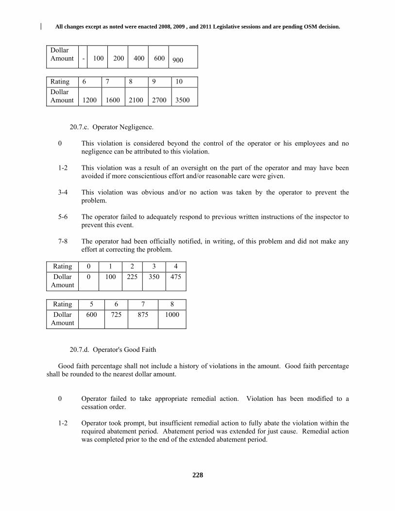
All changes except as noted were enacted 2008, 2009 , and 2011 Legislative sessions and are pending OSM decision.
228
Dollar Amount
-
100
200
400
600
900
Rating 6 7 8 9 10
Dollar Amount
1200
1600
2100
2700
3500
20.7.c. Operator Negligence.
0 This violation is considered beyond the control of the operator or his employees and no
negligence can be attributed to this violation.
1-2 This violation was a result of an oversight on the part of the operator and may have been avoided if more conscientious effort and/or reasonable care were given.
3-4 This violation was obvious and/or no action was taken by the operator to prevent the
problem.
5-6 The operator failed to adequately respond to previous written instructions of the inspector to prevent this event.
7-8 The operator had been officially notified, in writing, of this problem and did not make any
effort at correcting the problem.
Rating 0 1 2 3 4
Dollar Amount
0 100 225 350 475
Rating 5 6 7 8
Dollar Amount
600 725 875 1000
20.7.d. Operator's Good Faith
Good faith percentage shall not include a history of violations in the amount. Good faith percentage shall be rounded to the nearest dollar amount.
0 Operator failed to take appropriate remedial action. Violation has been modified to a cessation order.
1-2 Operator took prompt, but insufficient remedial action to fully abate the violation within the
required abatement period. Abatement period was extended for just cause. Remedial action was completed prior to the end of the extended abatement period.

All changes except as noted were enacted 2008, 2009 , and 2011 Legislative sessions and are pending OSM decision.
229
3-4 Operator took prompt remedial action and worked diligently to abate the violation. Conditions beyond the operator's control prevented full abatement and required that the abatement period be extended for just cause. Abatement of the violation was accomplished before the end of the extended abatement period.
5-6 Operator initiated remedial action immediately and expended all reasonable efforts to abate the violation. Violation was abated before the end of the original abatement period.
7-8 Operator was already taking remedial action at the time the violation was noted, and
expended exemplary effort in abating the violation before the end of the original abatement period.
Rating
0
1
2
3
4
%
0%
5%
10%
15%
20%
Rating
5
6
7
8
%
25%
30%
35%
40%
(e) Determination of Penalty Amount Seriousness of Violations $_________ Operator Negligence + $_________ Subtotal $_________ Less Good Faith % - $_________ Sub Total $_________ History of Violations + $_________ Total $_________
20.8. When an Individual Civil Penalty May be Assessed:
20.8.a. Except as provided in subdivision 20.8.b of this subsection, the Secretary may assess an individual civil penalty against any corporate director, officer or agent of a corporate permittee who knowingly and willfully authorized, ordered, or carried out a violation, failure or refusal.
20.8.b. The Secretary shall not assess an individual civil penalty in situations resulting from a
permit violation by a corporate permittee until a cessation order has been issued by the Secretary to the corporate permittee for the violation and the cessation order has remained unabated for thirty (30) days.

All changes except as noted were enacted 2008, 2009 , and 2011 Legislative sessions and are pending OSM decision.
230
20.9. Amount of Individual Civil Penalty.
20.9.a. In determining the amount of an individual civil penalty assessed under subsection 20.8
of this rule, the Secretary shall consider the criteria specified in subsection (c) of section 17 of the Act.
20.9.b. The penalty shall not exceed $5,000 for each violation. Each day of a continuing violation may be deemed a separate violation and the Secretary may assess a separate individual civil penalty for each day the violation, failure or refusal continues, from the date of service of the underlying notice of violation, cessation order or other order incorporated in a final decision issued by the Secretary until abatement or compliance is achieved.
20.10. Procedure for Assessment for Individual Civil Penalty.
20.10.a. The Secretary shall serve on each individual to be assessed an individual civil penalty a notice of proposed individual civil penalty assessment, including a narrative explanation of the reasons for the penalty, the amount to be assessed, and a copy of an underlying notice of violation and cessation order.
20.10.b. The notice of proposed individual civil penalty assessment shall become a final order of the Secretary thirty (30) days after service upon the individual unless:
20.10.b.1. The individual files within thirty (30) days of service of the notice of proposed individual civil penalty assessment a petition for review with the Surface Mine Board; or
20.10.b.2. The Secretary and the individual or responsible corporate permittee agree within thirty (30) days of service of the notice of proposed individual civil penalty assessment to a schedule or plan for the abatement or correction of the violation, failure, or refusal.
20.10.c. For purposes of this subsection, service is sufficient if it would satisfy state requirements for service of a summons and complaint.
20.11. Payment of Penalty.
20.11.a. If a notice of proposed individual civil penalty assessment becomes a final order in the absence of a petition for review or abatement agreement, the penalty shall be due upon issuance of the final order.
20.11.b. If an individual named in a notice of proposed individual civil penalty assessment files a petition for review in accordance with paragraph 20.10.b.1 of this section, the penalty shall be due upon issuance of a final administrative order affirming, increasing, or decreasing the proposed penalty.
20.11.c. Where the Secretary and the corporate permittee or individual have agreed in writing on a plan for the abatement of or compliance with the unabated order, an individual named in a notice of proposed individual civil penalty assessment may postpone payment until receiving either a final order from the Secretary stating that the penalty is due on the date of such final order, or written notice that abatement or compliance is satisfactory and the penalty has been withdrawn.
20.12. Fees and Costs of Administrative Proceedings.

All changes except as noted were enacted 2008, 2009 , and 2011 Legislative sessions and are pending OSM decision.
231
20.12.a. Request for Fees. Any person may on request be awarded by the appropriate board or court a sum equal to costs and expenses including attorneys' fees and expert witness fees as determined to have been reasonably incurred. Such request must be filed within forty-five (45) days of date of entry of judgment.
The request shall include an affidavit setting forth costs and expenses and an itemized statement of
attorneys' fees. The request shall be served upon all parties who shall have thirty (30) days to answer the request. Cost and expenses including attorneys' fees may be awarded to:
20.12.a.1. Any participating party against the violator upon a finding that there is a violation of the Act, the regulations or the permit has occurred, and there is a determination that the party made a significant contribution to the full and fair determination of the issues;
20.12.a.2. To any participating party other than the violator or his representative from the Department of Environmental Protection upon a determination that the party made a significant contribution to a full and fair determination of the issues;
20.12.a.3. To a violator from the Department of Environmental Protection when the violator
demonstrates that the Department of Environmental Protection issues cessation order, a show cause order or notice of violation in bad faith and for the purpose of harassing or embarrassing the violator, provided that no award shall be made under this subsection if the Department of Environmental Protection prevails upon the issue of a violation;
20.12.a.4. To a violator from any participating party other than the Department of Environmental Protection where such participating parties initiated or participated in the magistrate proceeding in bad faith and for the purpose of harassing or embarrassing the violator; and
20.12.a.5. To the Department of Environmental Protection from any participating party where the Department of Environmental Protection demonstrates that any such party participating in such proceeding in bad faith and for the purpose of harassing or embarrassing the Department of Environmental Protection. An award may also include attorneys' fees and expert witness fees expended in obtaining an award of costs, expenses and attorneys' fees. Decisions on such awards may be appealed as other cases under the Act. §38-2-21. Surface Mine Board.
21.1. Open Meetings.
21.1.a. General. All meetings of the Surface Mine Board, pursuant to the provisions of the Act shall be open to the public.
21.1.b. Public Notice. The time, and place of all regularly scheduled meetings and the time, place and purpose of all special meetings shall be made available to the public and the news media by publishing a notice containing at least the above information in a newspaper of general circulation in the county where the site or environmental concern exists, or if the matter under consideration is of general interest to the people of the State in a newspaper of general circulation in the State.
21.1.c. Emergency Meetings. In the event of any emergency requiring immediate official action such efforts to notify the public shall be taken as circumstances allow.

All changes except as noted were enacted 2008, 2009 , and 2011 Legislative sessions and are pending OSM decision.
232
21.2. Appeals to the Surface Mine Board.
21.2.a. Site Visits. The board may visit the site of the activity or proposed activity which is the subject of the hearing and take such additional evidence as it deems necessary provided that all parties and interveners be given notice of the visit and are given an opportunity to accompany the Board.
21.2.b. Final Orders. On all appeals to the Board, the Board shall issue a final decision thirty (30) days after the hearing or within thirty (30) days after the testimony presented at the hearing has been transcribed and checked for accuracy.
21.2.c. Burden of Proof. The burden of proof shall be on the party seeking to reverse the
decision of the Secretary.
21.3. Ex parte Communication.
21.3.a. Prohibition. Ex parte contacts between representatives of the parties appearing before the Board and members or representatives of the Board shall be prohibited. §38-2-22. Coal Refuse.
22.1. Applicability - Any surface coal mining operation which involves the construction, operation, enlargement, modification, removal and/or abandonment of a coal refuse site shall be subject to the special provisions of this section in addition to other applicable permitting requirements, performance standards, and enforcement provisions of this rule, the Act, and other State and Federal laws and regulations.
22.2. Certification - For purposes of permitting, the applicant shall submit a separate set of maps,
plans, design data, and specifications for the refuse disposal facility, in addition to those contained in the permit application.
The disposal facility shall be designed using current, prudent engineering practices. A qualified registered professional engineer, experienced in the design of similar earth and refuse structures, shall certify the design of the disposal facility. The disposal facility shall be designed to attain a minimum long-term static safety factor of 1.5 and a seismic factor of safety of 1.2. The stability of all foundations and abutments must be maintained during all phases of construction.
22.3. Permit Requirements - General - In addition to the other permitting requirements of the Act, this rule and the requirements of 30 CFR 77.214 and 30 CFR 77.215, each permit application which involves a coal refuse site shall contain the following materials:
22.3.a. Narrative. A general narrative and discussion of the project to include at a minimum a
discussion of existing site conditions, the design life of the facility, quantity and type of coal refuse to be placed on the site, subsidence potential method of operation to include clearing and grubbing, topsoil stockpiling, construction of surface and subsurface drainage facilities, phases of construction, method and location of coal refuse placement or removal, coal refuse placement during inclement weather, routine inspection and maintenance, procedure to be followed in the event the site is abandoned prior to the planned design life, and a sequence for construction of drainage facilities, critical construction phases, reclamation and final abandonment procedures. In addition, include a description of the duties, responsibilities and lines of communication of those persons responsible for the design and construction of the coal refuse disposal site. All data, graphs, curves, etc., which provide the basis for hydrologic and

All changes except as noted were enacted 2008, 2009 , and 2011 Legislative sessions and are pending OSM decision.
233
hydraulic design of coal refuse embankments and impoundments shall accompany other design data, plans, and specifications, submitted as part of the permit application.
22.3.b. Plan View. A plan view of the site showing detailed contours, limits of the coal refuse disposal site, all drainage facilities, location of springs, seeps, mine drainage and/or openings, location of the subdrain system, project stationing, location of cross sections, location of borings, test pits and instrumentation and other pertinent data required for project control.
22.3.c. Cross Sections. Cross sections of the coal refuse disposal site transversely and longitudinally showing original ground, finished elevations, final configuration of refuse material, subdrains, diversion details, spillways, and other pertinent features of the site. Cross section shall be of sufficient accuracy and detail so as to provide a basis for stability computations at critical locations.
22.3.d. Sediment Control Plan. A sediment control plan designed in accordance with subsection
5.4 of this rule. 22.3.e. Diversions. Each application shall contain plans and specifications for a diversion
channel above the coal refuse site to direct surface water runoff from the contributing watershed around the facility. Such diversion channel shall be designed in accordance with subsection 5.3 of this rule, except as follows:
22.3.e.1. Design storm. All diversion ditches and stream channel diversions shall be
designed to carry the peak runoff from a one-hundred (100) year frequency, twenty-four (24) hour duration rainfall.
22.3.e.2. A freeboard equal to or greater than 1+.025vd1/3 shall be added to the design flow depth to obtain the total depth of the diversion ditch.
22.3.e.3. Each diversion ditch must be designed to carry the peak flow with freeboard from the contributing watershed area.
22.3.e.4. Diversions shall be designed, constructed, and maintained in a manner which prevents additional contributions of suspended solids to stream flow and to runoff outside the permit area to the fullest extent possible.
22.3.e.5. Excess excavated material not required for construction or maintenance of the
diversion ditch must be properly disposed of in the permit area. 22.3.e.6. Topsoil removed from the channel excavation shall either be redistributed on
another part of the permit area or stockpiled for a later use.
22.3.e.7. All diversion systems shall exit safely beyond the toe of the embankment in a natural drainway capable of carrying the design flow without excessive erosion.
22.3.e.8. All stream channel diversions must be designed to carry the design flow around the disturbed area. The diversions must outlet into the original channel or a natural channel of equal cross section.
22.3.e.9. Diversions in refuse must be lined with soil or a suitable substitute unless other
All changes except as noted were enacted 2008, 2009 , and 2011 Legislative sessions and are pending OSM decision.
234
erosion protection is provided. 22.3.e.10. Permanent diversion systems designed to convey water under a coal refuse
embankment by means of a pipe or conduit are unacceptable. However, diversion by means of a pipe or conduit may be permitted during active operation, provided that (1) height or storage limits for impoundments are not exceeded, (2) the pipe or conduit is used in conjunction with surface ditches to meet applicable design storm requirements, and (3) the design of the pipe or conduit accounts for durability and design life, load limits, joint sealing, trash rack protection, and maintenance requirements throughout the operational life of the structure.
22.3.f. Design and Specifications for Hydraulic Structures. Such structures shall be designed to safely control excessive erosion by using energy dissipaters and/or channel protection, as necessary, based upon design flow velocity. Seepage control devices shall be used to prevent undercutting of nonflexible linings. The potential for landslides or slope failures shall be considered in the location of all hydraulic structures. Channels shall not be located on or near an existing landslide. No surface runoff or slurry may be diverted into underground mines unless approved by the Secretary in accordance with subdivision 14.5.e of this rule.
22.3.g. Computations. The application shall include all design data and calculation results. If a computer analysis is used, only the input data and results used specifically in the design need be submitted. If graphical flood routing techniques are used, all charts and graphs shall be included. Adequate cross sections and profiles shall be given for all hydraulic structures.
22.3.h. All coal refuse impoundments must be analyzed and/or designed in accordance with this
subsection. Non-impounding coal refuse embankments must be designed in accordance with this subsection unless any proposed modifications to the design standards of this subsection are justified through appropriate stability analysis. The following structural analysis and/or design data of coal refuse embankments and impoundments shall be presented in graphical or tabular form:
22.3.h.1. A sufficient subsurface investigation shall be performed by a registered professional engineer or engineering geologist. The number, location, and depth of borings, test pits, and/or trenches shall be reasonable for the size, purpose, soils present, and foundation type of the structure. The investigation shall consider depth of soil to bedrock, field classification of soils, character of bedrock, in situ testing, soil sampling, determination of groundwater flow and location of seeps and springs, and a soil profile for critical locations in the structure, hydraulic structures and other pertinent locations which may affect the safety of the structure. The number, depth, and location of boreholes shall be based on the quantity of material to be impounded and subsurface conditions. A geologic study shall also be conducted for impounding structures to evaluate landslides into the impoundment, bedrock discontinuities such as soft seams, joints, joint systems, bedding planes, and fault zones which may adversely affect the structure's performance. Past and future mining to include height of seam, depth and cover rock of the seam, and previous subsidence problems shall be considered where subsidence may affect the safety of the structure.
22.3.h.2. Laboratory tests shall be conducted on all foundation and embankment materials to include soil classification through hydrometer analysis, density, water content, compaction tests, shear strength, consolidation, and permeability unless the scope, characteristics, or design concept of the site make one or more of these requirements unnecessary.
22.3.i. Safety Factors. A description including plans, design data, specifications, and

All changes except as noted were enacted 2008, 2009 , and 2011 Legislative sessions and are pending OSM decision.
235
computations of how safety conditions will be achieved. The disposal facility shall be designed, constructed, and maintained to attain a minimum long-term safety factor of 1.5; provided further that a coal refuse site which has the capability to impound water shall also attain a seismic safety factor of at least 1.2.
22.3.j. Liquefaction. Describe the potential for liquefaction and provide safeguards against the development of this condition.
22.3.k. Instrumentation. A description of installation of instrumentation such as piezometers, settlement markers, slope indicators, and similar monitoring devices shall be included in the plan to monitor present hazardous conditions, construction conditions, and to verify design assumptions. A plan for monitoring these devices shall also be provided.
22.3.l. Stability Analysis. All stability analyses shall be done using standard engineering techniques. The submittal shall include cross sections at critical locations in the facility showing the materials profile, location of critical potential failure surfaces and their factors of safety, estimated or measured phreatic surfaces for construction and/or long term seepage conditions, and a tabulated listing of strength parameters used. If a computer analysis is used, only the input data and results used specifically in the design shall be submitted.
22.3.m. Underdrains. If the disposal area contains springs, natural or manmade water courses, or wet weather seeps, the application shall include diversions and underdrains as necessary to control erosion, prevent water infiltration into the disposal facility and ensure stability. Diversions and underdrains shall be designed as follows:
22.3.m.1. Runoff from the areas above the refuse pile and runoff from the surface of the
refuse pile shall be diverted into stabilized diversion channels designed in accordance with subdivision 22.3.e of this subsection and subsection 5.3 of this rule to safely pass the runoff from a one hundred (100) year, twenty-four (24) hour precipitation event. Runoff diverted from undisturbed areas need not be commingled with runoff from the surface of the refuse pile. Uncontrolled surface drainage may not be diverted over the outslope of the refuse piles.
22.3.m.2. Underdrains shall consist of durable rock or pipe, and be designed and constructed using current, prudent engineering practices. The underdrain system shall be designed to carry the anticipated seepage of water due to rainfall and from seeps and springs in the foundation of the disposal area away from the site, and shall be protected from piping and contamination by an adequate filter. Rock underdrains shall be constructed of durable, nonacid, nontoxic-forming rock (e.g., natural sand and gravel, sandstone, limestone, or other durable rock) that does not slake in water or degrade to soil material, and which is free of coal, clay or other nondurable material. Perforated pipe underdrains shall be corrosion resistant and shall have characteristics consistent with the long-term life of the fill.
22.3.n. Site Preparation. Procedures for clearing and grubbing.
22.3.o. Excess Material. Procedures for disposal of excess material resulting from clearing, grubbing, and other site preparation activities.
22.3.p. Compaction Requirements. Procedures for spreading and compaction of refuse material during placement. The material shall be compacted in layers not exceeding two (2) feet in thickness and shall not have any slope exceeding two horizontal to one vertical, except that the Secretary may approve construction of a refuse pile in compacted layers exceeding two (2) feet in thickness, where engineering data substantiates that both a minimum static safety factor of 1.5 and a minimum seismic safety factor of

All changes except as noted were enacted 2008, 2009 , and 2011 Legislative sessions and are pending OSM decision.
236
1.2 will be attained; provided, that the operator shall submit plans for the Secretary's approval, and shall also provide documentation showing prior approval by MSHA pursuant to Federal regulations at 30 CFR 77.215(h) for the alternate construction, without which documentation the plans will not be approved.
22.3.q. Sealing Abandoned Openings. Plans in accordance with 30 CFR 75.1711 for sealing
abandoned openings and covering the seal with four feet of an impermeable non-toxic material. Such plans shall consider prevention of water buildup behind the seals, toxicity of the refuse and mine strata, gradient of the opening, hydrologic balance and passage of any acid water to a treatment facility. If a mine seal is in the impoundment area of an impounding coal refuse disposal site, the seal shall be designed to safely withstand full hydrostatic head with a factor of safety of at least 1.5 against blowout. Higher factors of safety may be required where dictated by the consequences of failure. Calculations and cross sections used in the analyses shall be submitted.
22.3.r. Extinguishment of Burning Areas. Plans approved by MSHA for the extinguishment of burning areas which contain, at a minimum, method of extinguishment, safety measures for equipment operators and persons working or living in the vicinity of the site, and a provision that only those persons authorized by the operator, shall be involved in the extinguishing operation.
22.3.s. Underground Disposal. Plans for underground refuse disposal shall be submitted to and approved by the Secretary and the Mine Safety and Health Administration. All plans must include:
22.3.s.1. Method of disposal including a description of the source of the transport medium; 22.3.s.2. Maps of mines where coal refuse materials are to be disposed with a description of
the percent of mine void to be filled;
22.3.s.3. Description of location of active workings including plans, specifications, and methods of constructing underground retaining walls;
22.3.s.4. Potential areas of breakout in active mine workings and on the surface of the
ground;
22.3.s.5. Effects of subsidence on the plan;
22.3.s.6. The effects on the hydrologic regime including the location and description of permanent monitoring wells or monitoring stations;
22.3.s.7. Gradient of the mine from the backfill area;
22.3.s.8. Description of the stratum underlying the mined coal;
22.3.s.9. Source and quality of the refuse;
22.3.s.10. The method of treatment of water if released to surface streams;
22.3.s.11. A contingency plan formulated to alleviate or correct any hazardous conditions which may result from a blowout; and
22.3.s.12. A description of the surface area to be supported by the refuse backfill, the anticipated surface effects following backfilling, and the method for dewatering the backfill.

All changes except as noted were enacted 2008, 2009 , and 2011 Legislative sessions and are pending OSM decision.
237
22.3.t. Abandonment Plan. An abandonment plan which addresses the following requirements
and include a schedule for their implementation:
22.3.t.1. No refuse embankment or impoundment may be abandoned until approved by the Secretary.
22.3.t.2. The final top elevation of the refuse embankment must be higher than, and sloped into, the diversion ditch. Maximum slope of the top of the embankment to the diversion ditch shall be five (5) percent unless otherwise approved by the Secretary.
22.3.t.3. All pipes under refuse areas left as non-impounding fills shall be sealed with
concrete at the upstream end prior to abandonment.
22.3.t.4. At abandonment all fine refuse in the impoundment pool shall be covered with a minimum three foot layer of coarse refuse or other fill material prior to topsoiling unless otherwise approved by the Secretary.
22.3.t.5. At abandonment all coal refuse shall be covered with a minimum of four (4) feet of the best available non-toxic and non-combustible material in a manner that does not impede flow from sub-drainage systems. The Secretary may allow less than four (4) feet of cover material where it can be demonstrated on the basis of physical and chemical analyses of the growth medium that the vegetation requirements of section 9 of this rule will be met.
22.3.t.6. A certificate of approval for completion of construction shall be issued upon completion of the above requirements.
22.4. Permit Requirements - Impounding Structures. In addition to the requirements of the Act and
this rule coal refuse disposal sites which have the capability of impounding water shall be subject to the special requirements of this subsection and may be subject to other State and Federal laws and rules and regulations, depending on their embankment size and holding capacity.
22.4.a. Dam Control Act. A coal refuse site which is constructed in such a manner that it: (1) Rises twenty-five (25) feet or more above the natural bed of a stream or watercourse as measured from the downstream toe of the embankment and which does or can impound fifteen (15) acre-feet or more of water, or; (2) Rises six (6) feet or more above the natural bed of a stream or watercourse as measured from the downstream toe of the embankment and which does or can impound fifty (50) acre-feet or more of water is by definition a dam and is thereby subject to the provisions of the West Virginia Dam Control Act set forth in W.Va. Code §22-14 et seq.
22.4.b. Mine Safety and Health Administration (MSHA) Impoundments. A coal refuse site which is constructed in such a manner that it can impound water, sediment, or slurry to an elevation of: (1) Five (5) feet or more above the upstream toe of the structure and can have a storage volume of twenty (20) acres/feet or more, or; (2) Twenty (20) feet or more above the upstream toe of the structure, or; (3) Presents a hazard to coal miners as determined by the District Manager of the Federal Mine Safety and Health Administration, shall be subject to the requirements of 30 CFR 77.215 and 77.216 of the Federal Mine Safety and Health Administration Regulations.
22.4.c. Small Impoundments. Coal refuse sites which result in impoundments which are not subject to the Dam Control Act or the Federal Mine Health and Safety Act shall be designed, constructed,
All changes except as noted were enacted 2008, 2009 , and 2011 Legislative sessions and are pending OSM decision.
238
and maintained subject to the requirements of this subsection and subsections 5.4 and 22.5 j.6. of this rule.
22.4.d. Hazard Potential. The hazard potential of coal refuse sites which have the capability of impounding water shall be determined by the applicant based on the potential loss of life that would result due to a failure and the classification determined on the basis of the following criteria:
22.4.d.1. Class A. Impoundments located in rural or agricultural areas where failure may damage farm buildings, agricultural land, or secondary highways. Failure of the structure would cause only loss of the structure and loss of property use such as related roads, but with little additional damage to adjacent property. Any impoundment exceeding twenty-five (25) feet in height measured at the downstream toe or two-hundred (200) acre-feet storage volume or having a watershed exceeding five hundred (500) acres shall not be a Class A structure.
22.4.d.2. Class B. Impoundments located in predominantly rural agricultural areas where failure may damage isolated homes, primary highways or minor railroads or cause interruption of relatively important public utilities. Failure of the structure may cause great damage to property and project operations.
22.4.d.3. Class C. Impoundments located where failure may cause loss of life, serious damage to homes, industrial and commercial buildings, important public utilities, primary highways, or main railroads. This classification must be used if failure would cause possible loss of human life.
22.4.e. Emergency Planning. For a Class C structure or if a dangerous condition exists,
notification and action procedures shall be formulated by the operator or owner, for public protection and remedial action in the event of an emergency. All emergency procedures must be submitted and become part of the approved plan. If adequate emergency procedures cannot, for whatever reason, be formulated by the owner or operator, then he must so notify the Secretary in writing. The Secretary may then notify the Office of Emergency Services and request that emergency procedures be developed for the coal refuse site.
22.4.f. Design Storm Specifications. All refuse impoundments and dams shall be designed to meet the following design storm criteria based upon hazard classification.
22.4.f.1. Class A impoundments shall be designed for a minimum of P 100 + 0.12(PMP-P 100)
inches of rainfall in six (6) hours.
22.4.f.2. Class B impoundments shall be designed for a minimum of P 100 + 0.40(PMP-P 100) inches of rainfall in six (6) hours.
22.4.f.3. Class C impoundments shall be designed for a probable maximum precipitation (PMP) of a six (6) hour or greater event plus three feet of freeboard.
22.4.g. Primary and Emergency Spillway Design. All impoundments meeting the size or other
criteria of 30 CFR 77.216(a) must be designed and constructed to safely pass the probable maximum precipitation of a six (6) hour storm event. All impoundments of a lesser size must be capable of passing through a spillway or outlet works or a combination thereof, that portion of the design storm that cannot be safely stored in the impoundment and to draw down the stored portion of the design storm within the specified terms in accordance with the following:

All changes except as noted were enacted 2008, 2009 , and 2011 Legislative sessions and are pending OSM decision.
239
22.4.g.1. Class A impoundments must be designed with an open channel spillway unless otherwise approved by the Secretary, Ninety (90) percent of the stored portion of the design storm must be discharged or removed within ten (10) days after the storm event.
22.4.g.2. Class B impoundments shall be designed with either an open channel spillway only, or with an emergency spillway and a principal spillway together. Ninety (90) percent of the stored portion of the design storm shall be discharged or removed within ten days after the storm event.
22.4.g.3. Class C dams may be designed in one of three ways:
22.4.g.3.A. An impoundment designed without discharge structures shall be capable of storing a minimum of two (2) six (6) hour duration probable maximum storms. A system shall be designed to dewater the impoundment of the probable maximum storm in ten (10) days by pumping or by other means. The requirements of 38-4-25.14 shall also be met. . For existing structures exceeding the minimum 2PMP volume requirement, the dewatering system shall be installed when the containment volume is reduced to 2 PMPs.
22.4.g.3.B. An impoundment designed with a decant or principal spillway only shall be capable of storing at least one (1) six (6) hour duration probable maximum storm. Ninety (90) percent of the stored portion of the storm shall be discharged or removed within ten (10) days after the storm event.
22.4.g.3.C. An impoundment designed with either an open channel spillway only, or
with an emergency spillway and principal spillway together shall be capable of discharging that portion of the six (6) hour duration probable maximum storm that cannot be safely stored in the impoundment. Ninety (90) percent of the stored portion of the storm shall be discharged or removed within ten (10) days after the storm event.
22.4.g.4. A single open channel spillway may be used only if it is:
22.4.g.4.A. Of non-erodable construction and designed to carry sustained flows; or 22.4.g.4.B. Earth or grass-lined and designed to carry short term, infrequent flows at
non-erosive velocities where sustained flows are not expected.
22.4.h. Open Channel Spillways. All open channel spillways must comply with the design standards of this section and the following additional standards:
22.4.h.1. Any open channel spillway designed for less than one hundred (100) percent
probable maximum precipitation shall be provided with freeboard above the maximum water surface as determined by the equation 1+.025vd1/3.
22.4.h.2. All open channel spillways shall be constructed of non-erodable material where sustained flows are expected, or may be of earth or grass lined construction where short term infrequent flows at nonerosive velocities, are expected.
22.4.h.3. Excess excavated material not needed to construct and maintain the spillway
channel must be properly disposed of in the permit area.
22.4.h.4. Topsoil removed from channel excavation shall either be redistributed on another

All changes except as noted were enacted 2008, 2009 , and 2011 Legislative sessions and are pending OSM decision.
240
part of the permit area or stockpiled for future use.
22.4.i. Pipe Spillways. All pipe spillways must comply with the requirements of this section and the following additional requirements:
22.4.i.1. The pipe spillway inlet must be protected by a designed trash rack. 22.4.i.2. All riser-type spillways must be designed to prevent vortexing.
22.4.i.3. A skimming device is required where floating pollutants exist or are anticipated.
22.4.i.4. An adequate foundation and bedding shall be designed for all pipes and risers. 22.4.i.5. All pipe spillways shall be designed to provide seepage control along the conduit. 22.4.i.6. Use of Corrugated Metal Pipes -Corrugated metal pipes, whether coated or
uncoated, shall not be used in new or unconstructed refuse impoundments or slurry cells. If an existing corrugated metal pipe has developed leaks or otherwise deteriorated so as to cause the pipe to not function properly and such deterioration constitutes a hazard to the proper operation of the impoundment, the Secretary will require the corrugated metal pipe to be either repaired or replaced.
22.4.i.7. The pipe spillway shall be of sufficient strength to withstand the maximum load of
the fill above it.
22.4.i.8. All pipe spillways shall be constructed of suitable material to resist deterioration for the design life of the facility.
22.4.i.9. The outlet of all pipes, where blockage by animals can occur, must be protected by an animal guard.
22.5. Performance Standards. The following performance standards shall be met for all coal refuse disposal sites.
22.5.a. Controlled Placement. All coal refuse sites shall be placed in new or existing disposal areas within a permit area designated for this purpose. Coal mine refuse shall be hauled or conveyed and placed in a controlled manner to:
22.5.a.1. Minimize adverse effects of leachate and surface-water runoff on surface and ground water quality and quantity;
22.5.a.2. Ensure mass stability and prevent mass movement during and after all phases of
construction and be constructed and maintained in such a manner so as to attain a minimum long-term safety factor of 1.5 provided that structures which have the capacity to impound water shall also attain a seismic safety factor of 1.2;
22.5.a.3. Ensure that the final disposal facility is suitable for reclamation and revegetation compatible with the natural surroundings and the approved postmining land use;
22.5.a.4. Not create a public hazard; and
All changes except as noted were enacted 2008, 2009 , and 2011 Legislative sessions and are pending OSM decision.
241
22.5.a.5. Prevent combustion.
22.5.b. Extraneous Refuse. Coal mine refuse material from activities located outside a permit
area may be disposed of in the permit area only if approved by the Secretary. Approval shall be based upon a showing that such disposal will be in accordance with the standards of this section.
22.5.c. Slope Protection. Slope protection shall be provided to minimize surface erosion at the site. All disturbed areas, including diversion channels that are not riprapped or otherwise protected, shall be revegetated upon completion of construction.
22.5.d. Site Development. Clearing and grubbing shall be performed in the disposal area prior to placement of refuse material. Topsoil shall be removed, segregated, and stored or redistributed in accordance with subsection 14.3 of this rule. If approved by the Secretary, organic material may be used as mulch, or may be included in the topsoil to control erosion, promote growth of vegetation, or increase the moisture retention of the soil.
22.5.e. Final Configuration. The final configuration of the refuse pile shall be suitable for the
approved postmining land use. Terraces may be constructed on the outslope of the refuse pile if required for stability, control or erosion, conservation of soil moisture, or facilitation of the approved postmining land use. The grade of the outslope between terrace benches shall not be steeper than 2h:1v (50 percent).
22.5.f. Impoundment Within Fill Areas. No permanent impoundments shall be allowed on the
completed refuse pile. Small depressions may be allowed if they are needed to retain moisture, minimize erosion, create and enhance wildlife habitat, or assist revegetation, and if they are not incompatible with stability of the refuse pile.
22.5.g. Topsoiling. Following final grading of the refuse pile, the coal mine refuse shall be covered with a minimum of four (4) feet of the best available, nontoxic and noncombustible material, in a manner that does not impede drainage from the underdrains. The Secretary may allow less than four (4) feet of cover material based on physical and chemical analyses which show that the revegetation requirements of section 9 of this rule will be met.
22.5.h. Notification of Hazardous Conditions. If any examination or inspection discloses that a potential hazard exists, the Secretary shall be informed promptly of the finding and of the emergency procedures formulated for public protection and remedial action. If adequate procedures cannot be formulated or implemented, the Secretary shall be notified immediately. The Secretary shall then notify the appropriate agencies that other emergency procedures are required to protect the public.
22.5.i. Disposal in Underground Workings. Coal mine refuse may be disposed of in underground mine workings in accordance with the provisions of subdivision 22.3.s of this section.
22.5.j. Construction Specifications. New and existing impounding structures constructed of coal mine refuse or intended to impound coal mine refuse shall meet the following requirements:
22.5.j.1. Coal mine refuse shall not be used for construction of an embankment which impounds water unless it has been demonstrated to the Secretary that the stability of such a structure conforms to the requirements of this section and the use of coal mine refuse will not have a detrimental effect on downstream water quality or the environment due to acid seepage through the impounding structure. The stability of the structure and the potential impact of acid mine seepage through the

All changes except as noted were enacted 2008, 2009 , and 2011 Legislative sessions and are pending OSM decision.
242
impounding structure shall be discussed in detail in the design plan.
22.5.j.2. If an impounding structure constructed of coal mine refuse or intended to impound coal mine refuse meets the criteria of subdivision 22.4.c of this subsection, the combination of principal and emergency spillways shall be designed and constructed in accordance with subdivisions 22.4.g and 22.4.h of this subsection.
22.5.j.3. Spillways and outlet works shall be designed to provide adequate protection against
erosion and corrosion. Inlets shall be protected against blockage.
22.5.j.4. Runoff from areas above the disposal facility or runoff from surface of the facility that may cause instability or erosion of the impounding structure shall be diverted into stabilized diversion channels designed to safely pass the runoff from a one hundred (100) year, twenty-four (24) hour precipitation event.
22.5.j.5. Impounding structures constructed of or impounding coal mine refuse shall be designed so that at least ninety (90) percent of the water stored during the design precipitation event can be removed within a ten (10) day period.
22.5.j.6. No coal refuse impoundments shall remain as permanent impoundments. Upon completion of reclamation, such structures shall not be capable of storing or impounding water.
22.5.j.7. Slope protection shall be provided to protect against erosion and sudden drawdown. Embankment faces shall be vegetated or otherwise stabilized in accordance with approved procedures.
22.5.k. Drainage and Sediment Control. Drainage control measures shall meet the requirements
of section 5 of this rule. After grade release, discharges from the permit area shall not lower the water quality of receiving streams.
22.5.l. Removal of Abandoned Coal Refuse Piles. Where coal refuse is to be removed from an
abandoned coal refuse disposal area under a reclamation contract issued pursuant to subsection (d) section 28 of the Act and subsection 3.14 of this rule, the following standards shall be met:
22.5.l.1. Removal of refuse shall be complete when possible and shall be accomplished in successive horizontal lifts with a maximum elevation difference between working benches of twelve (12) feet or may be removed down a slope from the top to the toe provided that the slope is no steeper than 2H:1V. No refuse may be removed from the toe of the original embankment until the final removal process.
22.5.l.2. At all times during removal operations, care shall be exercised to protect the operating personnel, the public, and to insure long-term stability in accordance with the approved plan.
22.5.l.3. Where partial removal is approved, the final graded slopes of the remaining refuse shall be no steeper than 2H:1V and have at least one bench for every fifty (50) feet of change in elevation.
22.5.l.4. Should burning areas be encountered, the fires shall be extinguished in accordance with subdivision 22.5.m of this subsection, and removal of refuse shall be done in a safe manner. The final graded slopes of the coal refuse pile shall result in a stable configuration having a static safety factor of 1.5 as demonstrated by a stability analysis.

All changes except as noted were enacted 2008, 2009 , and 2011 Legislative sessions and are pending OSM decision.
243
22.5.l.5. The total disturbed area shall be regraded in such a manner as to be compatible with the natural surroundings and shall be revegetated in accordance with section 9 of this rule. Such regrading and revegetation shall occur as contemporaneously as practicable with removal operations as reflected in the reclamation plan.
22.5.l.6. All remaining refuse materials disturbed by the operation shall be covered with a minimum of four feet of cover of non-toxic and non-combustible material sufficient to establish adequate vegetation except that a lesser cover may be used based on chemical and physical analysis in accordance with subdivision 9.2.k of this rule.
22.5.l.7. Regrading drainage control shall be provided in accordance with the approved
reclamation plan.
22.5.m. Burning Refuse Piles. Where burning or burned refuse is encountered in the construction of a new structure or the reconstruction or removal of an existing structure, the following standards shall be met:
22.5.m.1. Coal mine refuse fires shall be extinguished by the person who conducts the surface mining activities, in accordance with a plan approved by the Mine Safety and Health Administration. The plan shall contain, at a minimum, provisions to ensure that only those persons authorized by the operator, and who have an understanding of the procedures to be used, shall be involved in the extinguishing operations.
22.5.m.2. No burning or burned coal mine refuse shall be removed from a permitted disposal area without a removal plan approved by the Secretary. Consideration shall be given to potential hazards to persons working or living in the vicinity of the structure.
22.6. Inspections. A qualified registered professional engineer, or other qualified professional specialist under the direction of the professional engineer, shall inspect the refuse pile during construction. The professional engineer or specialist shall be experienced in the construction of similar earth and refuse structures. Inspection reports shall be retained for review at or near the site.
22.6.a. Non-impounding Structures. Inspections of non-impounding refuse piles shall be made at
least quarterly throughout construction and during critical construction periods, which shall include at a minimum:
22.6.a.1. Foundation preparation including the removal of all organic material and topsoil;
22.6.a.2. Placement of underdrains and protective filter systems;
22.6.a.3. Installation of final surface drainage systems; and
22.6.a.4. The final graded and revegetated facility.
22.6.b. Unscheduled Inspections. Regular inspections by the engineer or specialist shall also be
conducted during placement and compaction of coal mine refuse materials. More frequent inspections shall be conducted if a potential danger or harm exists to the public health and safety or the environment. Inspections shall continue until the refuse pile has been finally graded and revegetated or until a later time if required by the Secretary.

All changes except as noted were enacted 2008, 2009 , and 2011 Legislative sessions and are pending OSM decision.
244
22.6.c. Reporting Requirements. The following reporting requirements shall be met:
22.6.c.1. The qualified registered professional engineer shall provide a certified report to the Secretary promptly after each inspection, that the refuse pile has been constructed and maintained as designed and in accordance with the approved plan, the Act, and this rule. The report shall include any appearances of instability, structural weakness, and other hazardous conditions; and
22.6.c.2. The certified report on the drainage system and protective filters shall include color
photographs taken during and after construction, but before underdrains are covered with coal mine refuse. If the underdrain system is constructed in phases, each phase shall be certified separately. The photographs accompanying each certified report shall be taken in adequate size and number with enough terrain or other physical features of the site shown to provide a relative scale to the photographs and to specifically and clearly identify the site.
22.7. Impounding Structures. Inspection of impounding refuse piles shall be made by a qualified registered engineer or other qualified professional specialist under the direction of the professional engineer. The professional engineer or specialist shall be experienced in the construction of impoundments.
22.7.a. Inspection Frequencies. Inspection shall be made regularly but not less than quarterly
during construction, upon completion of construction, and at least yearly until removal of the structure or release of the bond. Inspections will be made during placement and compaction of coal refuse material and during critical construction periods.
22.7.b. Reporting Requirements. The qualified professional registered engineer shall promptly, after each inspection, provide to the Secretary a certified report that the impoundment has been constructed and maintained as designed and in accordance with the approved plan and this rule. The report shall include discussions of any appearances of any instability, structural weakness, or other hazardous condition, depth and elevation of any impounded waters existing storage capacity, and existing or required monitoring procedures and instrumentation, and any aspects of the structure affecting stability.
22.7.c. Examinations. Examination of impoundments meeting or exceeding the size
specification or other criteria set forth in the Federal Mine Safety and Health Administration regulations at 30 CFR 77.216 shall, in addition to meeting the inspection requirements of subdivisions 22.7.a and 22.7.b of this subsection, comply with the MSHA requirements of 30 CFR 77.216-3.
Other impoundments shall be examined at least quarterly by a qualified person designated by the operator for appearances of structural weaknesses and other hazardous conditions.
22.7.d. Filing of Reports. A copy of each inspection and examination report shall be retained at or near the mine site. §38-23 Performance Standards Applicable Only to Remining Operations
23 .1. Backfilling, Remining, and Grading of Previously Mined Areas.
23 .1.a. Remining operations on previously mined areas that contain a pre-existing highwall shall comply with the applicable performance standards of the Act and this rule unless otherwise exempted in accordance with the provisions of this subsection.

All changes except as noted were enacted 2008, 2009 , and 2011 Legislative sessions and are pending OSM decision.
245
23 .1.b. The requirement of highwall elimination shall not apply to remining operations where the operator can demonstrate in writing that the volume of all reasonably available spoil located in the vicinity of the remining operation is insufficient to completely backfill the reaffected or enlarged highwall. The highwall shall be reduced to the maximum extent technically practical. All spoil generated by the remining operation and any other reasonably available spoil in the vicinity of the operation shall be included in the permit area. For purposes of this paragraph, the term reasonably available spoil means spoil and suitable coal mine waste material generated by the remining operation or other spoil or suitable coal mine waste material located in the permit area that is accessible and available for use and that when rehandled will not cause a hazard to public safety or significant damage to the environment.
23 .1.c. Achieve a postmining slope that does not exceed either the angle of repose or such lesser slope as is necessary to achieve a minimum long-term static safety factor of 1.3 and to prevent slides.
23.1.d. Minimize erosion and water pollution both on and off the site.
23.1.e. Support the approved postmining land use.
23.1.f. Spoil and waste materials shall be compacted where advisable to ensure stability or to prevent leaching of toxic materials.
23.1.g. Disposal of coal processing waste and underground development waste in the mined-out area shall be in accordance with section 22 of this, rule except that a long-term static safety factor of 1.3 shall be achieved.
23.1.h. Exposed coal seams, acid- and toxic-forming materials, and combustible materials exposed, used, or produced during mining shall be adequately covered with nontoxic and noncombustible material, or treated, to control the impact on surface and ground water in accordance with subsection 14.5 of this section, to prevent sustained combustion, and to minimize adverse effects on plant growth and the approved postmining land use.
23.1.i. Cut-and-fill terraces may be allowed where:
23.1.i.1. Needed to conserve soil moisture, ensure stability, and control erosion on final-graded slopes, if the terraces are compatible with the approved postmining land use; or
23.1.i.2. Specialized grading, foundation conditions, or roads are required for the approved postmining land use, in which case the final grading may include a terrace of adequate width to ensure the safety, stability, and erosion control necessary to implement the postmining land use plan.
23.1.j. Small depressions may be constructed if they are needed to retain moisture, minimize erosion, create and enhance wildlife habitat, or assist revegetation.
23.1.k. Spoil placed on the outslope during previous mining operations shall not be disturbed if such disturbance will cause instability of the remaining spoil or otherwise increase the hazard to the public health and safety or to the environment.
23.1.l. Any highwall remnant left after remining must be demonstrated by the operator to be stable and not pose a hazard to the public health and safety or the environment.
23.2. Revegetation.
23.2.a. All revegetation shall be carried out in a manner that encourages a prompt vegetative

All changes except as noted were enacted 2008, 2009 , and 2011 Legislative sessions and are pending OSM decision.
246
cover which, at a minimum, shall be adequate to control erosion and is consistent with the reclamation plan. The ground cover requirements for revegetation set forth in section 9 of this rule may be modified on a case-by-case basis, by the Secretary, except that at a minimum the vegetative ground cover shall be no less than that which existed before remining and shall be adequate to control erosion. Determination of premining ground cover success and productivity shall be made using sampling techniques described by the Secretary.
23.2.b. The responsibility for successful revegetation, as required by the Act, shall be for a period of not less than two growing seasons, as defined by the Secretary, after the last year of augmented seeding, fertilizing, irrigation or other work.
23.3. Water Quality. A coal remining operation which began after February 4, 1987, and on a site which was mined prior to August 3, 1977, may qualify for the water quality exemptions effluent limitations set forth in subsection (p), section 301 of the Federal Clean Water Act, as amended or a coal remining operation as defined in 40 CFR Part 434 as amended may qualify for the water quality exemptions set forth in 40 CFR Part 434 as amended.
23.4. Requirements to Release Bonds. Bond release for remining operations shall be in accordance with all of the requirements set forth in subsection 12.2 of this rule. and the terms and conditions set forth in the NPDES Permit in accordance with subsection (p), section 301 of the Federal Clean Water Act, as amended or 40 CFR Part 434 as amended . Provided that there is no evidence of a premature vegetation release.
§38-2-24. Exemption for Coal Extraction Incidental to Extraction of Other Minerals.
24.1. Exemption determination. The term other minerals as used in this section means any commercially valuable substance mined for its mineral value, excluding coal, topsoil, waste and fill material. No later than 90 days after filing of an administratively complete request for exemption, the Secretary shall make a written determination whether, and under what conditions, the persons claiming the exemption are exempt under this section, and shall notify the person making the request and persons submitting comments on the application of the determination and the basis for the determination. The determination of exemption shall be based upon information contained in the request and any other information available to the regulatory authority at that time. If the Secretary fails to provide a determination as specified in this section, an applicant who has not begun extraction may commence pending a determination Unless the Secretary issues an interim finding, together with reasons, therefore, that the applicant may not begin coal extraction. Any person adversely affected by a determination of the Secretary pursuant to this section may file an appeal only in accordance with the provisions of article one, chapter twenty-two-b of this code, within thirty days after receipt of the determination. The filing of an appeal does not suspend the effect of the determination.
24.2. Contents of request for exemption. An request for exemption shall be made part of a quarrying application and shall include at a minimum:
24.2.a. The names and business address of the requestor to include a street address or route number;
24.2.b. A list of the minerals to be extracted;
24.2.c. Estimates of annual production of coal and the other minerals over the anticipated life of the operation;
All changes except as noted were enacted 2008, 2009 , and 2011 Legislative sessions and are pending OSM decision.
247
24.2.d. A reasonable estimate of the number of acres of coal that will be extracted;
24.2.e. Evidence of publication of a public notice for an application for exemption. The notice that an application for exemption has been filed with the Secretary shall be published in a newspaper of general circulation in the county in which the operation is located and shall be published once and provide a thirty day comment period. The public notice must contain at a minimum:
24.2.e.1. The quarrying number identifying the operation;
24.2.e.2. A clear and accurate location map of a scale and detail found in the West Virginia General Highway Map. The map size will be at a minimum four inches (4") x four inches (4"). Longitude and latitude lines and north arrow will be indicated on the map and such lines will cross at or near the center of the quarrying operation;
24.2.e.3. The names and business address of the requestor to include a street address or route number;
24.2.e.4. A narrative description clearly describing the location of the quarrying operation;
24.2.e.5. The name and address of the Department of Environmental Protection Office where written comments on the request may be submitted;
24.2.f. Geologic cross sections, maps or plans of the quarrying operation determine the following information:
24.2.f.1. The locations (latitude and longitude) and elevations of all bore holes;
24.2.f.2. The nature and depth of the various strata or overburden including geologic formation names and/or geologic members;
24.2.f.3. The nature and thickness of any coal or other mineral to be extracted;
24.2.g. A map of appropriate scale which clearly identifies the coal extraction area versus quarrying area;
24.2.h. A general description of coal extraction and quarrying activities for the operation;
24.2.i. Estimated annual revenues to be derived from bona fide sales of coal and other minerals to be extracted;
24.2.j. If coal or the other minerals are to be used rather than sold, estimated annual fair market values at the time of projected use of the coal and other minerals to be extracted;
24.2.k. The basis for all annual production, revenue, and fair market value estimates;
24.2.l. A summary of sale commitments and agreements, if any, that the applicant has received for future delivery of other minerals to be extracted from the mining area, or a description of potential markets for the other minerals;
24.2.m. If the other minerals are to be commercially used by the applicant, a description specifying the use; and

All changes except as noted were enacted 2008, 2009 , and 2011 Legislative sessions and are pending OSM decision.
248
24.2.n. Any other information pertinent to the qualification of the operation as exempt.
24.3. Requirements for exemption.
24.3.a. Activities are exempt from the requirements of the Act if all of the following are satisfied:
24.3.a.1. The production of coal extracted from the mining area determined annually as described in this paragraph does not exceed 16 2/3 percent of the total annual production of coal and other minerals removed during such period for purposes of bona fide sale or reasonable commercial use.
24.3.a.2. Coal is extracted from a geological stratum lying above or immediately below the deepest stratum from which other minerals are extracted for purposes of bona fide sale or reasonable commercial use.
24.3.a.3. The revenue derived from the coal extracted from the mining area, determined annually does not exceed fifty (50) percent of the total revenue derived from the coal and other minerals removed for purposes of bona fide sale or reasonable commercial use. If the coal extracted or the minerals removed are used by the operator or transferred to a related entity for use instead of being sold in a bona fide sale, then the fair market value of the coal or other minerals shall be calculated at the time of use or transfer and shall be considered rather than revenue.
24.3.b. Persons seeking or that have obtained an exemption from the requirements of the Act shall comply with the following:
24.3.b.1. Each other mineral upon which an exemption under this section is based must be a commercially valuable mineral for which a market exists or which is quarried in bona fide anticipation that a market will exist for the mineral in the reasonably foreseeable future, not to exceed twelve months. A legally binding agreement for the future sale of other minerals is sufficient to demonstrate the above standard.
24.3.b.2. If either coal or other minerals are transferred or sold by the operator to a related entity for its use or sale, the transaction must be made for legitimate business purposes.
24.4. Conditions of exemption.
A person conducting activities covered by this part shall:
24.4.a. Maintain on-site the information necessary to verify the exemption including, but not limited to, commercial use and sales information, extraction tonnages, and a copy of the exemption application and the Department’s exemption approval;
24.4.b. Notify the Department of Environmental Protection upon the completion or permanent cessation of all coal extraction activities.
24.5. Stockpiling of minerals.
24.5.a. Coal extracted and stockpiled may be excluded from the calculation of annual production until the time of its sale, transfer to a related entity or use:
24.5.a.1. Up to an amount equaling a 12-month supply of the coal required for future sale, transfer or use as calculated based upon the average annual sales, transfer and use from the mining area over the two preceding years; or
All changes except as noted were enacted 2008, 2009 , and 2011 Legislative sessions and are pending OSM decision.
249
24.5.a.2. For a mining area where coal has been extracted for a period of less than two years, up to an amount that would represent a 12-month supply of the coal required for future sales, transfer or use as calculated based on the average amount of coal sold, transferred or used each month.
24.5.b. The Department of Environmental Protection shall disallow all or part of an operator's tonnages of stockpiled other minerals for purposes of meeting the requirements of this part if the operator fails to maintain adequate and verifiable records of the mining area of origin, the disposition of stockpiles or if the disposition of the stockpiles indicates the lack of commercial use or market for the minerals.
The Department of Environmental Protection may only allow an operator to utilize tonnages of stockpiled other minerals for purposes of meeting the requirements of this part if:
24.5.b.1. The stockpiling is necessary to meet market conditions or is consistent with generally accepted industry practices; and
24.5.b.2. Except as provided in. 24.5.b.3. of this section, the stockpiled other minerals do not exceed a 12-month supply of the mineral required for future sales as approved by the regulatory authority on the basis of the exemption application.
24.5.b.3. The Department of Environmental Protection may allow an operator to utilize tonnages of stockpiled other minerals beyond the 12-month limit established in 24.5. b.2. of this section if the operator can demonstrate to the Department of Environmental Protection’s satisfaction that the additional tonnage is required to meet future business obligations of the operator, such as may be demonstrated by a legally binding agreement for future delivery of the minerals.
24.5.b.4. The Department of Environmental Protection may periodically revise the other mineral stockpile tonnage limits in accordance with the criteria established by 24.5.b.2. and 3. of this section based on additional information available to the Department of Environmental Protection.
24.6. Revocation and enforcement.
24.6.a. The Department of Environmental Protection shall conduct an annual compliance review of the operation requesting exemption.
24.6.b. If the Department of Environmental Protection has reason to believe that a specific operation was not exempt at the end of the previous reporting period, is not exempt, or will be unable to satisfy the exemption criteria at the end of the current reporting period, the Department of Environmental Protection shall notify the operator that the exemption may be revoked and the reason(s) therefore. The exemption will be revoked unless the operator demonstrates to the Department of Environmental Protection within 30 days that the operation in question should continue to be exempt.
24.6.c. If the Department of Environmental Protection finds that an operator has not demonstrated that activities conducted in the operation area qualify for the exemption, the Department of Environmental Protection shall revoke the exemption and immediately notify the operator and commenter(s). If a decision is made not to revoke an exemption, the Secretary shall immediately notify the operator and commenter(s).
24.6.d. Any person adversely affected by a determination of the Secretary pursuant to this section may file an appeal only in accordance with the provisions of article one, chapter twenty-two-b of this

All changes except as noted were enacted 2008, 2009 , and 2011 Legislative sessions and are pending OSM decision.
250
code, within thirty days after receipt of the determination. The filing of an appeal does not suspend the effect of the determination.
24.6.e. Direct enforcement. 24. 6.e.1. An operator mining in accordance with the terms of an approved exemption shall not be cited for violations of WV §22-3 or §38-2 et seq. that occurred prior to the revocation of the exemption. Provided, however, an operator who does not conduct activities in accordance with the terms of an approved exemption and knows or should have known that the activities are not in accordance with the approved exemption shall be subject to direct enforcement action for violations of WV §22-3 or §38-2 et seq. that occur during the period of the activities.
24.6.e.2. Upon revocation of an exemption or denial of an exemption application, an operator shall stop conducting surface coal mining operations until a permit is obtained, and shall comply with the reclamation standards of WV §22-3 or §38-2 et seq. with regard to conditions, areas, and activities existing at the time of revocation or denial.
24.7. Reporting requirements.
24.7.a.1. Following approval by the Department of Environmental Protection of an exemption for an operation, the person receiving the exemption shall file a quarterly production report with the Department of Environmental Protection containing the information specified in 24.7.a.3. of this section.
24.7.a.2. The report shall be filed no later than 30 days after the end of each quarter.
24.7.a.3. The information in the report shall cover:
24.7.a.3.A. Quarterly production of coal and other minerals, and
24.7.a.3.B. The cumulative production of coal and other minerals.
24.7.a.3.C. The number of tons of coal stockpiled;
24.7.a.3.D. The number of tons of other minerals stockpiled by the operator.
24.7.b.1. Following approval by the Department of Environmental Protection of an exemption for an operation, the person receiving the exemption shall file an annual production report with the Department of Environmental Protection containing the information specified in. 24.7.b.3.of this section. 24.7.b.2. The report shall be filed no later than 30 days after the end of each calendar year. 24.7.b.3. The information in the report shall include:
24.7.b.3.a. The number of tons of extracted coal sold in bona fide sales and the total revenue derived from these sales;
24.7.b.3.b. The number of tons of coal extracted and used or transferred by the operator or related entity and the estimated total fair market value of this coal;

All changes except as noted were enacted 2008, 2009 , and 2011 Legislative sessions and are pending OSM decision.
251
24.7.b.3.c. The number of tons of coal stockpiled;
24.7.b.3.d. The number of tons of other commercially valuable minerals extracted and sold in bona fide sales and total revenue derived from these sales;
24.7.b.3.e. The number of tons of other commercially valuable minerals extracted and used or transferred by the operator or related entity and the estimated total fair market value of these minerals;
24.7.b.3 .f. The number of tons of other commercially valuable minerals removed and stockpiled by the operator;
24.7.b.3.g. The annual production of coal and other minerals and the annual revenue derived from coal and other minerals; and
24.7.b.3.h. The annual production of coal and other minerals and the annual revenue derived from coal and other minerals during the preceding year.
24.8. Public Availability of Information.
24.8.1. Except as provided in 24.8.2, all information submitted to the Secretary shall be made immediately available for public inspection and copying at the office with jurisdiction over coal mining in the locality of the subject exempt operation, until at least three (3) years after expiration of the period during which the subject mining area is active.
24.8.2 The Secretary may keep information submitted to the Secretary confidential if the person submitting it requests in writing, at the time of submission, that it be kept confidential and if the information concerns trade secrets or is privileged commercial or financial information of the persons intending to conduct operations under this rule.
24.8.3. Information requested to be held as confidential under subsection 24.8.2 shall not be made publicly available until after notice and opportunity to be heard is afforded persons both seeking and opposing disclosure of the information.
24.9. Right of Inspection and Entry.
24.9.1 Authorized representatives of the Secretary and the Secretary of the U.S. Department of the Interior shall have the right to conduct inspections of operations claiming exemption.
24.9.2. Each authorized representative of the Secretary and the Secretary of the U.S. Department of the Interior conducting an inspection under this rule shall:
24.9.2.a. Have a right of entry to, upon, and through any mining and reclamation operations without advance notice or a search warrant, upon presentation of appropriate credentials;
24.9.2.b. At reasonable times and without delay, have access to and copy any records relevant to the exemption; and

All changes except as noted were enacted 2008, 2009 , and 2011 Legislative sessions and are pending OSM decision.
252
24.9.2.c. Have a right to gather physical and photographic evidence to document conditions, practices, or violations at a site.
24.9.3. No search warrant shall be required with respect to any activity under 24.9.1 and 24.9.2., except that a search warrant may be required for entry into a building.


![The DMR Basics & No Frills - BRARA DMR Basics _ No Frills.pdf · The DMR Basics & No Frills •What is DMR? •Digital vs. Analog •Time Slots [TDMA] & Talk Groups •Zones •Color](https://static.fdocuments.in/doc/165x107/5ba1da1e09d3f2666b8d3885/the-dmr-basics-no-frills-dmr-basics-no-frillspdf-the-dmr-basics-no.jpg)