TITLE 18 TRANSPORTATION AND HIGHWAYS CHAPTER 31 ...
27
18.31.6 NMAC 1 TITLE 18 TRANSPORTATION AND HIGHWAYS CHAPTER 31 CLASSIFICATION AND DESIGN STANDARDS FOR HIGHWAYS PART 6 STATE HIGHWAY ACCESS MANAGEMENT REQUIREMENTS 18.31.6.1 ISSUING AGENCY: New Mexico Department of Transportation (NMDOT), 1120 Cerrillos Road, Post Office Box 1149, Santa Fe, New Mexico 87504-1149. [18.31.6.1 NMAC - Rp, 18.31.6.1 NMAC, 6/27/2017] 18.31.6.2 SCOPE: New Mexico department of transportation districts and divisions, all other state agencies, local governments, land owners, developers, and general public. [18.31.6.2 NMAC - Rp, 18.31.6.2 NMAC, 6/27/2017] 18.31.6.3 STATUTORY AUTHORITY: A. State highway commission (now state transportation commission): The basic enabling legislation for the management of access on state highways is Section 67-11-2 NMSA 1978, which states: “The state highway commission (now state transportation commission) is authorized and directed to do those things essential to plan, acquire by reasonable purchase or condemnation and construct a section or a part of a state or federally designated highway as a freeway or controlled-access highway or to make any existing state or federally designated highway a freeway or a controlled-access highway." B. New Mexico department of transportation: Pursuant to Section 67-3-6 NMSA 1978, the New Mexico department of transportation shall exercise the power, authority, and duty granted to the state transportation commission. Therefore, the department may prescribe rules and regulations for providing access to state highways pursuant to Sections 67-11-1 NMSA 1978 through Sections 67-11-10 NMSA 1978. In addition, the following state transportation commission policy and department administrative directive supplement New Mexico state statutes and shall be followed when determining the type and extent of access to be provided along state highways. (1) State transportation commission Policy CP 65, Interstate Access. (2) New Mexico department of transportation administrative directive AD 222, Highway Access Control. [18.31.6.3 NMAC - Rp, 18.31.6.3 NMAC, 6/27/2017] 18.31.6.4 DURATION: Permanent. [18.31.6.4 NMAC - Rp, 18.31.6.4 NMAC, 6/27/2017] 18.31.6.5 EFFECTIVE DATE: June 27, 2017 unless a later date is cited in the history note at the end of a section. [18.31.6.5 NMAC - Rp, 18.31.6.5 NMAC, 6/27/2017] 18.31.6.6 OBJECTIVE: A. By 18.31.6 NMAC, the department establishes access management requirements which will protect the functional integrity of the state highway system and the public and private investment in that system. Rule 18.31.6 NMAC, and its associated state access management manual which is attached to and filed concurrently with this rule, provides procedures and standards to preserve and protect the public health, safety and welfare, to maintain smooth traffic flow, and to protect the functional level of state highways while considering state, regional, local, and private transportation needs and interests. The access management requirements also consider other department regulations, policies and procedures related to highway rights-of-way such as drainage, archeology, hazardous materials and other environmental aspects. B. Through the administration of 18.31.6 NMAC, it is the intent of the department to work with property owners and local governments to provide reasonable access to the state highway system. However, the access rights of an owner of property abutting a state highway shall be held subordinate to the public's right and interest in a safe and efficient highway. C. All owners of property abutting a public road have a right of reasonable access to the general system of streets and highways in the state, but not to a particular means of access. The right of access is subject to regulation for the purpose of protecting the health, safety and welfare of the traveling public. D. Rule 18.31.6 NMAC addresses the design and location of driveways, medians, median openings, intersections, traffic signals, interchanges and other points of access to public highways under the jurisdiction of the state transportation commission. It is based upon the authority granted to the New Mexico department of
Transcript of TITLE 18 TRANSPORTATION AND HIGHWAYS CHAPTER 31 ...

18.31.6 NMAC 1
TITLE 18 TRANSPORTATION AND HIGHWAYS CHAPTER 31 CLASSIFICATION AND DESIGN STANDARDS FOR HIGHWAYS PART 6 STATE HIGHWAY ACCESS MANAGEMENT REQUIREMENTS 18.31.6.1 ISSUING AGENCY: New Mexico Department of Transportation (NMDOT), 1120 Cerrillos Road, Post Office Box 1149, Santa Fe, New Mexico 87504-1149. [18.31.6.1 NMAC - Rp, 18.31.6.1 NMAC, 6/27/2017] 18.31.6.2 SCOPE: New Mexico department of transportation districts and divisions, all other state agencies, local governments, land owners, developers, and general public. [18.31.6.2 NMAC - Rp, 18.31.6.2 NMAC, 6/27/2017] 18.31.6.3 STATUTORY AUTHORITY: A. State highway commission (now state transportation commission): The basic enabling legislation for the management of access on state highways is Section 67-11-2 NMSA 1978, which states: “The state highway commission (now state transportation commission) is authorized and directed to do those things essential to plan, acquire by reasonable purchase or condemnation and construct a section or a part of a state or federally designated highway as a freeway or controlled-access highway or to make any existing state or federally designated highway a freeway or a controlled-access highway." B. New Mexico department of transportation: Pursuant to Section 67-3-6 NMSA 1978, the New Mexico department of transportation shall exercise the power, authority, and duty granted to the state transportation commission. Therefore, the department may prescribe rules and regulations for providing access to state highways pursuant to Sections 67-11-1 NMSA 1978 through Sections 67-11-10 NMSA 1978. In addition, the following state transportation commission policy and department administrative directive supplement New Mexico state statutes and shall be followed when determining the type and extent of access to be provided along state highways. (1) State transportation commission Policy CP 65, Interstate Access. (2) New Mexico department of transportation administrative directive AD 222, Highway Access Control. [18.31.6.3 NMAC - Rp, 18.31.6.3 NMAC, 6/27/2017] 18.31.6.4 DURATION: Permanent. [18.31.6.4 NMAC - Rp, 18.31.6.4 NMAC, 6/27/2017] 18.31.6.5 EFFECTIVE DATE: June 27, 2017 unless a later date is cited in the history note at the end of a section. [18.31.6.5 NMAC - Rp, 18.31.6.5 NMAC, 6/27/2017] 18.31.6.6 OBJECTIVE: A. By 18.31.6 NMAC, the department establishes access management requirements which will protect the functional integrity of the state highway system and the public and private investment in that system. Rule 18.31.6 NMAC, and its associated state access management manual which is attached to and filed concurrently with this rule, provides procedures and standards to preserve and protect the public health, safety and welfare, to maintain smooth traffic flow, and to protect the functional level of state highways while considering state, regional, local, and private transportation needs and interests. The access management requirements also consider other department regulations, policies and procedures related to highway rights-of-way such as drainage, archeology, hazardous materials and other environmental aspects. B. Through the administration of 18.31.6 NMAC, it is the intent of the department to work with property owners and local governments to provide reasonable access to the state highway system. However, the access rights of an owner of property abutting a state highway shall be held subordinate to the public's right and interest in a safe and efficient highway. C. All owners of property abutting a public road have a right of reasonable access to the general system of streets and highways in the state, but not to a particular means of access. The right of access is subject to regulation for the purpose of protecting the health, safety and welfare of the traveling public. D. Rule 18.31.6 NMAC addresses the design and location of driveways, medians, median openings, intersections, traffic signals, interchanges and other points of access to public highways under the jurisdiction of the state transportation commission. It is based upon the authority granted to the New Mexico department of

18.31.6 NMAC 2
transportation. E. As of June 9, 1989, no person shall construct or modify any permanent or temporary access providing direct vehicular movement to or from any state highway from or to property in close proximity to or adjoining a state highway without an access permit issued by the New Mexico department of transportation. Within those jurisdictions where the local governments and authorities have returned issuing authority to the department, the department has sole authority to issue state highway access permits. However, the department will delegate the authority under 18.31.6 NMAC to other public agencies provided that these agencies minimally adopt the rule and as the department determines in its discretion as delegable. F. Access permits shall be issued only when the permit application is found to be in compliance with 18.31.6 NMAC. The department, or other issuing authority approved by the department, is authorized to impose terms and conditions as necessary and convenient to meet the requirements of 18.31.6 NMAC. G. Direct access from a subdivision to a state highway shall be permitted only if the proposed access meets the purposes and requirements of 18.31.6 NMAC. All new subdivision of property shall provide access consistent with the requirements of 18.31.6 NMAC. The provisions of 18.31.6 NMAC shall not be deemed to deny reasonable access to the general street system. The issuance of any permit, agreement, plat, subdivision, plan or correspondence shall not abrogate or limit the regulatory powers of the department or issuing authority in the protection of the public's health, safety and welfare. [18.31.6.6 NMAC - Rp, 18.31.6.6 NMAC, 6/27/2017] 18.31.6.7 DEFINITIONS: A. Acceleration lane-- A speed-change lane, including full-width auxiliary lane and tapered area, for the purpose of enabling a vehicle entering a roadway to increase its speed to a rate at which it can safely merge with through traffic. B. Access-- Any driveway or other point of access such as a street, road, or highway that connects to the general street system. Where two public roadways intersect, the secondary roadway shall be considered the access. C. Access category-- The definition by which access to a state highway is controlled according to the categories described in 18.31.6.10 NMAC. D. Access control-- The regulated limitation of access to and from a highway facility including full control of access, partial control of access, and driveway regulations. E. Applicant-- The owner of property or the representative of an owner applying for an access permit. F. Arterial roadway-- The primary function of an arterial roadway is to provide mobility for through traffic movements. Arterial roadways provide for land access as a secondary function. G. At-grade intersection-- A crossing of two or more highway facilities at the same elevation where through traffic movements on one or more of the highways cross and where turning movements between the highway facilities may be allowed. H. Auxiliary lane-- An additional lane adjoining the traveled way which may be used for parking, speed change, turning, storage for turning vehicles, weaving, truck climbing, and other purposes supplementary to through traffic movement. I. Average daily traffic (ADT)-- The average traffic volume per day, over a seven-day week, for a unique segment of roadway in both directions of travel on a two-way facility and in one direction of travel on a one-way facility. J. Average weekday traffic (AWDT)-- The average traffic volume for a unique segment of roadway on a typical weekday (Monday through Friday) in both directions of travel on a two-way facility and in one direction of travel on a one-way facility. K. Average weekend traffic (AWET)-- The average traffic volume for a unique segment of roadway over the weekend period (Saturday and Sunday) in both directions of travel on a two-way facility and in one direction of travel on a one-way facility. L. Developed area/business district-- A developed area/business district occurs along a highway when within 300 feet along such highway there are buildings in use for business or industrial purposes (including but not limited to hotels, banks or office buildings, railroad stations and public buildings) which occupy at least fifty percent of the frontage on one side or fifty percent of the frontage collectively on both sides of the highway. M. Capacity-- The maximum hourly rate at which persons or vehicles can reasonably be expected to traverse a point or uniform section of a lane or roadway under prevailing roadway, traffic, and control conditions. N. Change of use-- Occurs when a change in the use of the property including land, structures or

18.31.6 NMAC 3
facilities, or an expansion of the size of the structures or facilities, is expected to result in an increase in the trip generation of the property greater than twenty-five percent (either peak hour or daily) and greater than 100 vehicles per day more than the existing use. O. Channelized intersection-- An "at grade" intersection with painted islands, raised islands, or other devices for directing traffic along definite paths. P. Collector street-- Collector streets connect developed areas with the arterial street system, balancing the need to provide traffic movement with the need to provide property access. Q. Commission-- The New Mexico state transportation commission or its predecessor. R. Control of access-- The condition in which the right of owners or occupants of land abutting or adjacent to a roadway is controlled by public authority. S. Controlled-access highway-- Includes highways, streets or roadways to which owners or occupants of abutting lands, and other persons, have no legal right of access except as determined by the public authority having jurisdiction over the highway, street or roadway. T. Corner clearance-- At an intersecting street or highway, the dimension measured along the edge of the traveled way between the centerline of the intersecting street and the centerlines of the first adjacent access points on the approach and departure sides of the intersection. U. Cross street-- The lower function roadway that crosses a higher function facility, also referred to as minor street. V. Curb cut-- An opening along a state highway with raised curb or curb-and-gutter to provide for driveway access using drivepad construction. Also referred to as driveway cut. W. Curb return-- The access radius for an intersection or driveway opening, also referred to as radius return. X. Curb return construction-- As applied to a driveway opening, means that proper access radii are used in the design and construction of an access facility. Y. Deceleration lane-- A speed-change lane, including full-width auxiliary lane and tapered areas, for the purpose of enabling a vehicle to slow to a safe turning speed when exiting a roadway. Z. Department-- New Mexico department of transportation and all of its components, including but not limited to, the district engineers, and the department divisions. AA. Design vehicle-- A selected motor vehicle with the weight, dimensions, and operating characteristics used to establish highway design controls. AB. Developer-- A person or persons representing a proposed land development project. AC. Divided highway-- A highway with separated roadways for traffic traveling in opposite directions. Separation may be provided by depressed dividing strips, raised medians, traffic islands, other physical separations, standard pavement markings, or other traffic control devices. AD. Drivepad construction-- As applied to a driveway or curb cut, means that access radii are not used in the design and construction of an access facility. AE. Driveway-- For the purposes of department access management requirements, a driveway is a public or private access along a state highway serving a limited area where traffic signal control is not required. Excludes public streets, roads, highways, and other signalized intersections. AF. Driveway angle-- The angle of 90 degrees or less between the driveway centerline and the edge of the traveled way. AG. Driveway cut-- An opening along a state highway with raised curb or curb-and-gutter to provide for driveway access using drivepad construction. Also referred to as curb cut. AH. Driveway throat width-- The narrowest width of a driveway measured parallel with the edge of the traveled way exclusive of radii, ramps or tapers. AI. Edge clearance-- The distance measured along the edge of the traveled way between the frontage property line and the point of tangency of the nearest radius return for an access. AJ. Egress-- To exit an abutting property or intersecting roadway to gain access to a state highway. AK. Freeway-- A multi-lane divided highway having a minimum of two lanes in each travel direction, with access provided by grade-separated interchanges. AL. Frontage-- The distance along the highway right-of-way line of a single property tract or roadside development area between the limits of the property. AM. Frontage property line-- A line, perpendicular to the highway centerline, at each end of the frontage, extending from the right-of-way line to the edge of traveled way. AN. Full control of access-- That part of access control where preference is given to through traffic by providing access connections only with selected public roads, and by prohibiting at-grade crossings and direct

18.31.6 NMAC 4
private driveway connections. Access control is accomplished by legally obtaining right-of-way from the abutting property owners or by the use of frontage roads or other means to provide access to abutting properties. AO. Functional area of an intersection-- The areas of both upstream and downstream of an intersection where additional access points should not be allowed. The upstream area consists of length. The downstream area consists of stopping sight distance. Right-turn conflict overlap should also be considered when determining the downstream area. AP. Functional classification-- The grouping of highways by the character of service they provide to through traffic movements (mobility) versus access to abutting properties (land accessibility). AQ. General-purpose lanes-- The continuous through lanes on a highway, excluding auxiliary lanes. Sometimes referred to as mainline lanes. AR. General street system-- The interconnecting network of city streets, county roads, and state highways. AS. Grade separation-- A crossing of two transportation facilities, such as two roadways or a roadway and a railroad, at different elevations where access is not provided from either facility at their intersection. AT. Grade or gradient-- The rate (or percent) of change in slope. For highway facilities, it is measured along the centerline of the roadway or access facility. AU. Highway-- The entire width between the right-of-way lines of publicly maintained traveled way when any part thereof is open to the public for purposes of vehicular travel, or the entire width of any traveled way declared to be a public highway by law. It may include bridges, culverts, sluices, drains, ditches, waterways, embankments, walls, trees, shrubs and fences. AV. Highway improvement project-- Includes any project to improve a roadway segment or intersection facility to protect and maintain the general health, safety and welfare of the traveling public, typically conducted by the public entity having jurisdiction over the facility being improved. Highway improvement projects are generally included in the public entity's transportation improvement program, whether the program is local, regional or statewide. AW. Horizontal alignment-- The combination of curved and tangent sections of a highway in the horizontal plane. AX. Ingress-- To leave the highway and enter into an abutting property or intersecting roadway. AY. Intersection-- Public street or other access serving a large area or a major traffic generator(s) where traffic signal control may be provided. AZ. Interstate highway-- Represents the highest functional classification of a roadway in a highway network. Interstates are multi-lane divided highways having a minimum of two lanes in each travel direction, with access provided by grade-separated interchanges. BA. km/h-- A rate of speed measured in kilometers traveled per hour. BB. Land development project-- Includes any project to develop or redevelop private or public property adjacent or in close proximity to a state highway where direct or indirect access to the property is required from the state highway. Land development projects may be conducted by either private or public entities. BC. Lane-- The portion of a roadway for the movement of a single line of vehicles, not including the gutter or the shoulder of the roadway. BD. Level of service (LOS)-- A qualitative measure describing traffic operational conditions within a traffic stream based on factors such as speed, travel time, freedom to maneuver, traffic interruptions, comfort and convenience, and safety. Level of service designations range from A (best) to F (worse). BE. Local governments and authorities-- Every county, municipal, and other local board or body having authority to enact laws relating to traffic under the constitution and laws of the State of New Mexico. BF. Local road-- Local roads primarily provide direct access to abutting land and to roads of higher functional classification. Mobility is discouraged, especially in urban areas. BG. May-- A permissive condition where the condition is suggested but not mandatory. BH. MUTCD-- Manual on uniform traffic control devices for streets and highways, latest edition. BI. Median-- That portion of a divided highway separating traffic traveling in opposite directions. BJ. Minor street-- The lower function roadway that crosses a higher function facility, also referred to as cross street. BK. mph-- A rate of speed measured in miles traveled per hour. BL. NMDOT-- The New Mexico department of transportation. BM. Nominal control of access-- That part of access control that may be applied when full or partial control of access has not been obtained by a highway authority. A means of access control that is consistent with the functional classification of a state highway facility, and that is sufficient to maintain a safe and efficient

18.31.6 NMAC 5
transportation system. BN. Non-access controlled highway-- Includes state highways where roadside access is permitted and access control has not been established by legally obtaining right-of-way from the abutting property owners or by the use of frontage roads or other means to provide access to abutting properties. BO. Non-traversable median-- A median which, by its design, physically discourages or prevents vehicles from crossing it except at designated openings which are designed for turning or crossing movements. BP. Partial control of access-- That part of access control where preference is given to through traffic to a degree that some at-grade crossings may be permitted. Access control is accomplished by legally obtaining right-of-way from the abutting property owners or by the use of frontage roads or other means to provide access to abutting properties. BQ. Permittee-- The individual(s) responsible for fulfilling the terms and conditions of the access permit as imposed by the department. BR. Property owner-- The person or persons holding the recorded title to property abutting a state highway, and other persons holding a recorded interest in such property, that includes a right to reasonable access from the state highway system. BS. Radius return-- The access radius for an intersection or driveway opening, also referred to as curb return. BT. Recovery Area-- An unobstructed area provided beyond the edge of a traveled way for the recovery of errant vehicles. BU. Right-in/right-out driveway (RI/RO)-- A driveway located along a roadway prohibiting left-turn access into or out of the driveway. BV. Right-turn conflict overlap-- A conflict that occurs when a driver in a through travel lane must monitor more than one access connection at a time. BW. Setback-- The lateral distance between the highway right-of-way line and any development structure, obstacle or parking area along the highway roadside. BX. Shall-- A mandatory condition where the requirements must be met. BY. Should-- An advisory condition where the condition is recommended but not mandatory. BZ. Sight distance-- The length of roadway visible to the driver of a vehicle, as further defined in the AASHTO document, a policy on geometric design of highways and streets, latest edition. CA. Signal progression-- The timing of consecutive signalized intersections to provide for the progressive movement of traffic at a planned rate of speed. CB. Speed-change lane-- A separate lane for the purpose of enabling a vehicle entering or leaving a roadway to increase or decrease its speed to a rate at which it can more safely merge into or exit from through traffic. CC. State highway-- Any public highway that has been designated as a state highway by either the New Mexico state legislature or the state transportation commission. CD. Stopping sight distance-- The distance required by a driver of a vehicle to bring the vehicle to a stop after an object on the roadway becomes visible. CE. Storage lane length-- The length provided within a deceleration lane for the storage of queued vehicles, typically based on the vehicle queue expected during peak travel periods. CF. Subdivide-- To divide land into two or more smaller lots, tracts or parcels of land. CG. Subdivision-- A tract of land which has been subdivided in accordance with the laws of the state usually with appropriate streets, dedications and other facilities for the development or sale of industrial, commercial or residential land. CH. Traveled way-- That portion of a roadway containing the travel lanes and speed-change lanes, exclusive of pavement provided for shoulders. CI. Traversable median-- A median which, by its design, does not physically discourage or prevent vehicles from entering upon or crossing it. CJ. Trip-- A one way vehicle movement from one location to another. CK. Trip assignment-- Refers to the addition of trips generated by a proposed development to a transportation network. Involves the specific routing of traffic on the street system. CL. Trip distribution-- Refers to the geographic origin or destination of trips related to a project. Involves the general allocation of trips generated by a development over the transportation network. CM. Trip generation-- An estimate of the number of trips expected to be generated by specific type of land use. CN. Undivided roadway-- A highway without physical separation between traffic traveling in

18.31.6 NMAC 6
opposite directions. CO. Vertical alignment-- The vertical profile of a highway, intersection approach or driveway approach, typically measured along its centerline. [18.31.6.7 NMAC - Rp, 18.31.6.7 NMAC, 6/27/2017] 18.31.6.8 REFERENCES: The reference documents listed in 18.31.6.9 NMAC are supplementary and should be used when additional detail is required to address issues that arise during the access permitting and design process. The most recent edition of each technical reference shall be used. [18.31.6.8 NMAC - Rp, 18.31.6.8 NMAC, 6/27/2017] 18.31.6.9 REFERENCE LIST: A. New Mexico state statutes and traffic laws, as amended. B. The current editions, as amended, of the following NMDOT manuals, standards, and policies: (1) State access management manual. (2) Standard specifications for road and bridge construction. (3) State transportation commission policies. (4) Standard drawing serials and designated drawings. (5) Drainage manual, volume I - hydrology, volume II - sedimentation and erosion, and drainage design criteria (administrative memorandum 221), latest editions. (6) New Mexico state traffic monitoring standards. (7) Railroads and utilities manual. (8) Materials manual. (9) Construction manual. (10) Location study procedures, a guidebook for alignment and corridor studies. C. A policy on geometric design of highways and streets, American association of state highway and transportation officials, latest edition. D. Manual on uniform traffic control devices for streets and highways, U.S. department of transportation, federal highway administration, latest edition. E. Highway capacity manual, transportation research board, national research council, latest edition. F. Trip generation, institute of transportation engineers, latest edition. G. Roadside design guide, American association of state highway and transportation officials, latest edition. H. Manual of transportation engineering studies, institute of transportation engineers. I. A guide for erecting mailboxes on highways, American association of state highway and transportation officials. J. Americans with Disabilities Act, accessibility guidelines for buildings and facilities (PROWAG), architectural and transportation barriers compliance board, as amended; 36 CFR Part 1191. K. Traffic engineering handbook, current edition, institute of transportation engineers. L. Access management guidelines for activity centers, NCHRP 348. M. Manual of traffic signal design, second edition, institute of transportation engineers. N. Traffic access and impact studies for site development, institute of transportation engineers. O. Guide for the development of bicycle facilities, American association of state highway and transportation officials, 3rd edition. P. Transportation and land development, institute of transportation engineers. Q. An informational guide for roadway lighting, American association of state highway and transportation officials. R. Web sites (note: web addresses may change without notice): (1) New Mexico department of transportation: dot.state.nm.us. (2) Federal highway administration: www.fhwa.dot.gov. (3) Institute of transportation engineers: www.ite.org. (4) American association of state highway and transportation officials: www.transportation.org. (5) Transportation research board: www.nas.edu/trb. (6) National cooperative highway research program: www.trb.org/NCHRP/NCHRP.aspx. [18.31.6.9 NMAC - Rp, 18.31.6.9 NMAC, 6/27/2017]

18.31.6 NMAC 7
18.31.6.10 ACCESS CATEGORIZATION SYSTEM: The regulation and management of vehicular access to and from the New Mexico state highway system shall be defined by an access categorization system. The access categorization system for state highways is described in Section 10 of the state access management manual. The access categorization system shall be based on the functional classified system for New Mexico roadways, which consists of interstates and freeways (INTS), principal arterials (PRAR), minor arterials (MNAR), major collectors (MJCL), minor collectors (MNCL), collectors (COLL), local roads (LOC), and other special road types. The functional classified system shall be further defined as urban and rural routes based on the location of a highway with respect to population centers. The current classification of a highway shall be obtained from the department and shall be used to determine the access category applicable to the highway under consideration. Access requirements for each access category are described in the state access management manual. [18.31.6.10 NMAC - Rp, 18.31.6.10 NMAC, 6/27/2017] 18.31.6.11 ACCESS MANAGEMENT PLANS: The department may develop an access management plan for a designated portion of state highway. An access management plan provides the department, and local authority, with a comprehensive roadway access design plan for a designated state highway segment or corridor for the purpose of bringing that portion of highway into conformance with its access category and its functional needs to the extent feasible given existing conditions. Access management plans should be developed as described in Section 11 of the state access management manual. A. Access management plans for state highways are developed by the department in cooperation with the appropriate local authorities through a memorandum of understanding or a joint powers agreement. Access management plans shall be adopted by the department to become effective. The adoption of a plan shall be in the form of a formal written agreement prepared in accordance with 18.31.6.19 NMAC, access control review procedures. When applicable, concurrence of the local authority should also be obtained in written form. B. After an access management plan is adopted, modifications to the plan shall require department approval. Where an access management plan is in effect, all action taken in regard to access shall be in conformance with the plan and 18.31.6 NMAC unless the department approves exceptions to the plan in writing. [18.31.6.11 NMAC - Rp, 18.31.6.11 NMAC, 6/27/2017] 18.31.6.12 INTERCHANGE ACCESS MANAGEMENT PLANS: An interchange access management plan shall be required for any new interchange or significant modification to an existing interchange. The interchange access management plan shall satisfy the requirements of 18.31.6.19 NMAC, access control review procedures, and applicable state transportation commission policies and department administrative directives. The interchange and the management plan shall receive the approval of the deputy secretary for highway operations. If located on a national or interstate highway facility, approval shall also be obtained from the federal highway administration. Section 12 of the state access management manual should be used to guide the development of interchange access management plans. [18.31.6.12 NMAC - Rp, 18.31.6.12 NMAC, 6/27/2017] 18.31.6.13 ACCESS CATEGORY STANDARDS: A. Purpose: Whereas the requirements for access requests along state highways are described in multiple Sections of 18.31.6 NMAC, summary information for each access category is provided in Section 13 of the state access management manual to assist users in locating and determining the requirements for a proposed access along a state highway. Practitioners shall reference specific sections of 18.31.6 NMAC when determining applicable requirements for their access request. The summary information contained in Section 13 of the manual is provided solely to ease use of the access management manual, with the exception below regarding interstate highways. B. Interstate highways: The design of interstate highway facilities, requests for modifications to existing interstate access points, and new interstate access proposals shall satisfy the requirements of all pertinent sections of the code of federal regulations (CFR) and all interstate highway policies adopted by the federal highway administration. All decisions regarding interstate highway facilities shall require the approval of the federal highway administration and the New Mexico department of transportation. [18.31.6.13 NMAC - Rp, 18.31.6.13 NMAC, 6/27/2017] 18.31.6.14 PERMITTING PROCESS: A. Purpose: This section describes the application procedures for submitting an access permit request to the department, and the administrative procedures used by the department to approve or deny access

18.31.6 NMAC 8
permit requests on state highways. B. Types of access: Following is a list of the types of access that may occur along the state highway system. Refer to Section 14 of the state access management manual for a description of each access type. (1) Existing lawful access, modification or transfer. (2) New private access (individual use). (3) New subdivision access. (4) New public access. (5) New commercial access. (6) Temporary construction access. (7) Temporary access. (8) Emergency access. (9) Field access. (10) Access breaks in established access control lines. (11) Illegal access. C. Access permit applications: Applications for access permits shall be made by the property owner; the property owner's authorized representative; or, the local governmental agency requesting access from a state highway. Applications are required for all new access types, for modification or transfer of existing lawful access permits, and for upgrading an existing illegal access to a lawful access. (1) Changes in property use: Where additional traffic is projected due to expansion or redevelopment of a property, the property owner shall contact the department to determine if a new permit application and modifications to existing access points will be required. If the department determines that the increased traffic generated by the property does not require modifications to the existing permitted access, according to the procedures of 18.31.6.16 NMAC, a new permit application will not be required. Failure to contact the department to determine the need for access modifications or to apply for such modifications prior to initiation of property improvements, land use changes or traffic flow alterations actions, may result in notification to the property owner of intent to revoke or modify the existing permit and closure of the access to the property. (Also refer to Subsection O of 18.31.6.14 NMAC). (2) Permit application form: All applications shall be made on the approved department permit application form, "application for permit to construct an access or median opening on public right-of-way." (3) Department district offices: Persons wishing to submit an access permit application form should contact the appropriate department district office to obtain application forms. District offices are located in Deming, Roswell, Albuquerque, Las Vegas, Santa Fe, and Milan. The application form can also be found in the appendix of the state access management manual, and on the departments external web site, dot.state.nm.us/content/dam/nmdot/Infrastructure/Access_management_Manual.pdf. D. Application submittal requirements: (1) Completed access permit forms shall be submitted to the appropriate district office with proof of ownership of the property to which access is requested. A plan or sketch of the property shall be attached to the permit application showing the length of the property frontage, the distance from the edge of the traveled roadway to the property line, edge clearances, corner clearances, the distance from the referenced mile marker to the centerline of the proposed driveway(s), and the location of any access drives along the state highway across from the proposed site. A traffic engineering evaluation shall be conducted for all access permit requests according to the requirements of 18.31.6.15 NMAC and 18.31.6.16 NMAC, with an exception. The traffic engineering evaluation may be waived for individual use access requests (see Subsection E, Paragraph 1 of 18.31.6.14 NMAC). In such cases, the department may conduct the evaluation required to determine if an individual use access will be permitted or denied. A construction traffic control plan shall also be submitted with the application for review and approval by the district traffic engineer. The department may require additional information relative to the evaluation of a permit application as further described in Section 14 of the state access management manual. (2) A permit application may be deemed incomplete by the department when necessary and relevant information is missing, or when there is no written evidence of the ownership of the property surface rights provided in the application. If the application is deemed incomplete, the department shall notify the applicant within 15 working days of receipt of the application and shall indicate the reason or reasons for refusal. The department review period begins with the acceptance of an application. E. Access permit requests from private entities: (1) Individual use: Requests for a new private access shall be made on the department access permit application. Application requirements for individual use permits shall include a platted survey of the property, proof of ownership of the property, and details regarding the location of the proposed access and the

18.31.6 NMAC 9
proposed development. A traffic engineering evaluation typically shall not be required. The department may conduct the evaluation required to determine if an individual use access will be permitted or denied. (2) Subdivisions and commercial developments: Requests for new subdivision access, new commercial access or for modification to an existing lawful access for other than individual use shall be made on the access permit application. The applicant shall be required to satisfy all pertinent requirements of 18.31.6 NMAC. F. Access permit requests from governmental entities: (1) Local governments: Requests by local governmental agencies for new access or for the reconstruction of existing access to the state highway shall be administered by the department. The local governmental agency shall be considered the applicant. The department shall work with local governmental agencies realizing that the access will serve multiple property owners. Access to subdivisions and other developments shall not be considered public access until the access is constructed and accepted as a local public roadway. (a) Local governmental agencies shall provide notice of all developments that will directly or indirectly impact the state highway, and shall request department participation in the administration of an access permit if it is determined by the department that an access facility will directly or indirectly impact the operation and function of a state highway. The local governmental agencies may also require sub-dividers to provide additional notice of all proposed developments that will directly or indirectly impact the state highway. (b) Where a private development accessing the roadway of an appropriate local authority necessitates access improvements where the local roadway connects to a state highway, the permittee shall be the local jurisdiction. (c) Local governmental agencies may be required to submit a traffic engineering evaluation with a permit application. The traffic engineering evaluation requirement shall be determined according to the procedures described in 18.31.6.15 NMAC and 18.31.6.16 NMAC. Local governmental agencies may require developers to assist in preparing and providing this information for submission to the state. (2) Federal government: Requests for access from a state highway by the general services administration (GSA), United States postal service (USPS), department of defense (DOD), department of energy (DOE), or other divisions of the federal government shall be administered by the department in cooperation with the pertinent division of the federal government. The access location, spacing and design standards described in 18.31.6.18 NMAC and Section 18 of the state access management manual should be followed for such requests. (3) Sovereign Nations: Access requests on state highway segments that traverse sovereign nation lands shall be administered by the department in cooperation with the pertinent sovereign nation. The access location, spacing and design standards described in 18.31.6.18 NMAC and Section 18 of the state access management manual should be followed for such requests. G. Administrative review process: (1) An administrative review period begins with the acceptance of a permit application by the appropriate district engineer or the district engineer's designee. (2) Upon acceptance of the application permit and supplemental information, the department shall use 18.31.6 NMAC, the state access management manual and any other applicable state statutes for evaluating and acting on the application. Access requests that break existing access control lines or that are requested on a controlled-access facility shall be acted on by the access control review committee according to the procedures in 18.31.6.19 NMAC. The application will normally be processed within 45 days. The review period may be extended by the department when further action is required by the access control review committee or other government entities, the applicant will be notified. Transmittal of a completed permit, approved by the district engineer, or transmittal of a denied application constitutes action on the permit application. (3) If the department approves an application permit, the permit shall be prepared and transmitted to the applicant along with any additional terms and conditions established by the department. The owner noted on the permit, normally the surface right owner, will become the permittee. If the permittee does not agree to all terms and conditions of the permit, the permit shall not be issued. (4) In accepting the permit, the permittee agrees to all terms and conditions of the permit. Should the permittee or applicant choose to appeal a denied application, or the terms and conditions of a permit, the appeal shall be filed within 60 days of the date the denial notice or the approved permit is transmitted. (5) The issue date of the permit is the date the department representative signs the permit. (6) The granting of an access permit conveys no rights, title or interest in state highway rights-of-way to the permit holder or property served. A permit for direct access to a state highway does not entitle the permit holder to control or have any rights or interests in any portion of the design, specifications or operation of the highway or roadway, including those portions of the highway built pursuant to the terms and conditions of the

18.31.6 NMAC 10
permit. (7) If the department denies an application, the department shall provide the applicant a copy of the application marked "denied" along with any attachments and a written explanation for the decision. The applicant may request a hearing with the department district engineer or designee to discuss reasons for denial. (8) Denial of an application request for physical modifications to an existing lawful access does not constitute revoking access authorization for the existing access. (9) Requests for variance from the standards of 18.31.6 NMAC may be submitted to the district engineer and shall be considered an attachment to the permit application. The review of variance requests shall be in accordance with Subsection J of 18.31.6.14 NMAC. Variance procedures may be used when the standards established by 18.31.6 NMAC are not entirely applicable to the proposed request for access. (10) If, at the sole discretion of the department, it is determined that a permittee is in violation of 18.31.6 NMAC or any conditions of a permit, the department may revoke the permit. The revocations process shall be as described in Subsection O of 18.31.6.14 NMAC. H. Permit fees: The department may establish a reasonable schedule of fees for access permits issued pursuant to 18.31.6 NMAC. It is the responsibility of the applicant to determine if any local governmental fees are applicable. I. Appeals procedures: (1) If the permittee or applicant objects to the denial of a permit application by the Department or objects to any of the terms or conditions of the permit placed therein by the department, a written appeal shall be filed with the appropriate district engineer within 60 days of the transmittal of notice of denial or transmittal of the approved permit. The request shall include reasons for the appeal and may include recommendations by the permittee or applicant. (2) The district engineer, or the district engineer's designee, will submit a written request for review to the department traffic technical support engineer along with the permit application, the written appeal, and all supporting information. The traffic technical support engineer will review the request and the appeal and offer an opinion to the district engineer regarding the merits of the appeal. It is the intent of this process that an agreement is reached between the traffic technical support engineer and the district engineer. If, however, agreement cannot be reached, a formal meeting shall be scheduled with the deputy secretary for highway operations to hear the appeal. This meeting should involve the applicant, the traffic technical support engineer, and the district engineer or designee. The traffic technical support engineer shall provide a summary presentation of the facts and issues of dispute along with a discussion of the consequences, safety assessment, risks and value associated with the permit application. If applicable, the appeal should include a report from the applicant's engineer. The deputy secretary for highway operations shall make the final decision. Final decisions that are exceptions to existing standards and regulations may be sent to the federal highway administration for approval if their involvement is deemed appropriate by the deputy secretary for highway operations. At this final decision point, no other department employee will be authorized to approve the permit. J. Variance procedures: If an applicant wishes to seek a variance from the standards of 18.31.6 NMAC, a written request shall be submitted as an attachment to the permit application form. The request for variance should include specific and documented reasons. K. Construction of access by owner: (1) An approved access permit shall be deemed expired and null and void if the access is not under construction within six months from the date of issue unless otherwise noted and approved by the department in writing. When the permittee is unable to commence construction within six months after the permit issue date, a six-month extension may be requested from the district engineer. Any request for an extension shall be in writing and submitted to the district engineer before the permit expires. Denial of an extension may occur when the district engineer ascertains and documents that unforeseen and significant changes in highway traffic operations, proposed access operation, or statutes and regulations that were not considered in the issuance of the permit have occurred. Any person wishing to reestablish an access permit that has expired shall be required to submit a new permit application and comply with all related requirements, as specified by the district traffic engineer. (2) The permittee shall notify the district traffic engineer of pending access construction in state right-of-way at least 10 working days prior to any construction, unless other arrangements are made. Construction of the access shall not proceed until both the access permit and a construction traffic control plan are approved. The access shall be constructed and completed in an expeditious and safe manner and shall be finished within 45 days of initiation of construction within the highway right-of-way. Failure by the permittee to complete construction in the 45-day period shall be sufficient cause for the department to initiate action to suspend or revoke the permit or to close the access.

18.31.6 NMAC 11
(3) The construction of the access and its appurtenances as required by the terms and conditions of the permit shall be completed at the expense of the permittee, unless other arrangements are made with the district engineer. The permittee should arrange for access construction to be completed by qualified contractors. Construction shall meet all department specifications and shall be subject to inspection by the department. (4) Property required for highway access improvements shall be dedicated, without cost, to the department. All rights, titles and interests of dedicated property shall be conveyed to the department. All current title policies shall be disclosed and be acceptable to the department. The owner shall certify that the property is clean of contamination or indemnify the department from any remediation responsibilities prior to conveyance. The department may refuse to accept any property containing or suspected of containing hazardous substances, toxic wastes or other contaminants until such substances are either removed or the property is certified clean by the appropriate governmental entity. The access is not considered complete until property is conveyed. (5) All materials used in the construction of the access within the highway right-of-way or on permanent easements become public property. Any materials removed from the highway right-of-way shall be disposed of as directed by the department. All fencing, guard rail, traffic control devices and other equipment and materials removed in the course of access construction shall be given to the department unless otherwise instructed by the permit or the department inspector. (6) The department, at its discretion, may complete the installation of permanent traffic control devices. The permittee shall pay for direct costs and labor provided by the department for the installation and relocation of all traffic control devices within public right-of-way directly related to the use or construction of the permitted access. Failure of the permittee to pay within a reasonable period may be considered grounds for permit suspension, which may lead to revocation and access removal. (7) Where access construction requires the reconstruction of the existing state highway, the department may require the contractor or permittee to post a bond to ensure completion of the work. (8) The permittee shall provide adequate advance warning at all times during access construction according to the construction traffic control plan accompanying the approved access permit. The traffic control plan shall conform with the manual of uniform traffic control devices for streets and highways (MUTCD). Construction traffic control may include the use of signs, flashers, barricades, and flaggers. (9) The department may restrict work on or immediately adjacent to the highway, control lane closure periods, and require pre-approval of all aspects of construction phasing where access construction will affect traffic operations, roadway capacity or safety. Every effort shall be made to minimize the closure periods of any travel lanes. Work in the right-of-way may not be allowed on holidays, at night, during peak traffic hours, or during adverse weather conditions without written permission from the district. Work hours shall be approved by the district traffic engineer. (10) A utility permit shall be obtained for any utility work within highway right-of-way. Where necessary to remove, relocate, or repair a traffic control device or public or private utilities for access construction, the relocation, removal or repair shall be accomplished by the permittee without cost to the department and at the direction of the department or utility company. Any damage to the state highway or other public right-of-way beyond that which is allowed in the permit shall be repaired immediately. The permittee is responsible for the repair of any utility damaged in the course of access construction, reconstruction, or repair. (11) Prior to use of the access, the permittee is required to complete the construction according to the terms and conditions of the access permit. Failure by the permittee to abide by all permit terms and conditions shall be sufficient cause for the department to initiate action to suspend or revoke the permit or to close the access. If the permittee wishes to use the access prior to completion, arrangements shall be approved by the department and included in the permit. The department may order a halt to any unauthorized use of the access pursuant to statutory and regulatory powers. Reconstruction or improvement of the access may be required when the permittee has failed to meet required specifications of design or materials. (12) If any construction element fails within two years due to improper construction or material specifications, the permittee shall be responsible for all repairs. Failure to make such repairs may result in suspension of the permit and closure of the access. L. Inspection of access: (1) The permittee shall employ a qualified construction inspector to ensure that the conditions of the access permit are met unless otherwise determined necessary by the district engineer’s designee. The district engineer, or the district engineer's designee, may inspect the access during construction and upon completion of the access to ensure that all terms and conditions of the permit are met. Inspectors are authorized to enforce the conditions of the permit during construction and to halt any activities within state right-of-way that: (a) do not comply with the provisions of the permit;

18.31.6 NMAC 12
(b) conflict with concurrent highway construction or maintenance work; (c) endanger highway property, natural or cultural resources protected by law; or (d) endanger the health and safety of workers or the public. (2) The permittee shall ensure that a copy of the permit is available for review at the construction site at all times. The permit may require the contractor to notify the district representative noted on the permit at any specified phases in construction to allow a field inspector to inspect various aspects of construction such as concrete forms, subbase, base course compaction, and materials specifications. Minor changes and additions may be ordered by the department field inspector to meet unanticipated site conditions. The department may require the permittee to hire a New Mexico registered professional civil engineer to affirm to the best of the engineer's knowledge that the construction is in compliance with the permit and department specifications. The department may require testing of materials. When required, test results shall be provided to the department. (3) Each permittee understands and agrees as a condition of issuance of any permit, that if the department determines that any violation has or may result in the creation or existence of any safety or traffic hazard, the department may immediately take such action as the department deems necessary to correct, eliminate or mitigate such hazard, without the need for the completion of any review process. M. Maintenance of access: The permittee, his or her heirs, successors-in-interest, assigns, and occupants of the property serviced by the access shall be responsible for meeting the terms and conditions of the permit. This shall consist of, but not be limited to, the repair and maintenance of the access beyond the edge of the roadway including any cattle guard and gate, and the removal of snow or ice upon the access even though deposited on the access in the course of department snow removal operations. Any significant repairs, such as culvert replacement, resurfacing, or changes in design or specifications, require authorization from the department. The department shall maintain the roadway including auxiliary lanes and shoulders, except in those cases where the access installation has failed due to improper access construction or failure to follow permit requirements and specifications (see Subsection K, Paragraph 12 of 18.31.6.14 NMAC). In this case, the permittee shall be responsible for such repair. (1) Within unincorporated areas, the department shall keep access culverts clean as part of maintenance of the highway drainage system. However, the permittee shall be responsible for the repair and replacement of any access-related culverts within the right-of-way. (2) Within incorporated areas, drainage responsibilities for municipalities shall be determined by statute and local ordinance. N. Indemnification: The department and its duly appointed agents and employees shall be held harmless against any action for personal injury or property damage sustained by reason of the exercise of the permit. O. Revocations: (1) Where a change in property use occurs or a property's basic vehicular usage changes, so as to impact the highway, and the existing access points do not comply with 18.31.6 NMAC, the owner shall apply for a new access permit and reconstruct the driveways to comply with the rule. (2) If, at the sole discretion of the department, it is determined that a permittee is in violation of 18.31.6 NMAC or any conditions of the access permit, the department, acting through the district engineer, or the district engineer's designee, for the district where the driveways are located, shall inform the permittee in writing of the violations and allow the permittee 30 days to correct the violations. (3) If, after 30 days, the violations are not corrected, the district engineer, or the district engineer's designee, may issue a written notice of revocation of the permit. (4) The permittee may request a hearing on the revocation of the permit by giving written notice to the district office within 10 days of the written notice of the revocation. (5) The requested hearing shall be held no later than 30 days after receipt of the written notice of hearing. The department's representatives shall be the district engineer and the district traffic engineer, or their designees. After the hearing, the district engineer, or the district engineer's designee, shall issue a written decision. (6) The permittee may appeal that decision to the deputy secretary for highway operations or designee by giving written notice of a request for an appeal to the district office within 10 days of the date of the district's written decision. (7) The deputy secretary for highway operations, or the deputy's designee, shall hear the appeal within 30 days of receipt of the request for an appeal. (8) The decision of the deputy secretary, or the deputy's designee, shall be final and this decision completes the administrative review process. (9) After the review process, or at any stage if the conditions set out in Paragraph (10) of

18.31.6 NMAC 13
Subsection G of 18.31.6.14 NMAC occurs, the district engineer, or the district engineer's designee, may take whatever action is appropriate including, but not limited to, physically closing the driveway with barriers or signing, and the department may refuse to issue future permits to the permittee until the violations are corrected. The permittee shall be responsible for costs, labor and material provided by the department for such actions. (10) Each permittee understands and agrees as a condition of issuance of any permit, that if the department determines that any violation has or may result in the creation or existence of any safety or traffic hazard, the department may immediately take such action as the department deems necessary to correct, eliminate or mitigate such hazard, without the need for the completion of any review process. The permittee shall be responsible for costs, labor and material provided by the department for such actions. [18.31.6.14 NMAC - Rp, 18.31.6.14 NMAC, 6/27/2017] 18.31.6.15 TRAFFIC ENGINEERING EVALUATION: A. General: A traffic engineering evaluation shall be required for all proposed access points that are requested along the state highway system, to be submitted with the access permit application (see Paragraph (1) of Subsection D of 18.31.6.14 NMAC). The extent of the traffic engineering evaluation is directly related the scope of the highway improvement under consideration, or to the size and type of land use for which access is requested. In this section, operational performance standards, traffic data requirements and traffic signal considerations are described. Additional information regarding traffic engineering evaluation requisites are provided in Section 15 of the state access management manual. The specific traffic study process that shall be followed to address the traffic engineering evaluation requirement for a land development project are described in 18.31.6.16 NMAC. The criteria that shall be used to determine when speed-change lanes are required or should be considered at existing or proposed access points along the state highway system are defined in 18.31.6.17 NMAC. Design standards applicable to the traffic engineering evaluation are provided in 18.31.6.18 NMAC and are further described in section 18 of the state access management manual. B. Scope of evaluation: A traffic engineering evaluation shall be required when new or modified access facilities are proposed along a state highway to ensure that the operational characteristics of all state highways are maintained at acceptable levels. The evaluation may include, but is not limited to, roadway and intersection level of service calculations, driveway and intersection location and spacing assessments, traffic signal warrant and systems analyses, roadway and intersection design, and safety analysis. The department shall require a traffic engineering evaluation of access issues for land development projects that request access to a state highway, directly or indirectly, and for highway improvement projects (see Subsection AV of 18.31.6.7 NMAC). The traffic engineering evaluation shall be performed by a registered engineer, authorized under New Mexico Engineering and Surveying Practice Act (Sections 61-23-12 NMSA 1978 through 61-23-13 NMSA 1978). C. Traffic operational performance: The operational performance of a highway segment, intersection or access facility is described by level of service (LOS). Level of service is a quantitative measure of roadway or intersection operations and vehicle capacity. Level of service standards are defined by access category. level of service (LOS) F shall not be accepted for individual movements. D. Establishing existing traffic conditions: Engineering evaluations of traffic and roadway conditions on state highways should be based on current traffic count information. The traffic data will be considered current if it is or has been collected within one year of the date that a scoping meeting is held between the permittee and the district traffic engineer, or if otherwise approved for use by the district traffic engineer. (1) Defining the data collection period: The permittee should recommend the periods for traffic data collection at the traffic analysis scoping meeting held between the permittee and the department district traffic engineer. The periods for traffic data collection may include typical weekday conditions, special traffic conditions, or both. (2) Typical weekday traffic conditions: Traffic data representing typical weekday conditions should be obtained on Tuesday, Wednesday or Thursday, and may be obtained on Monday or Friday. (3) Special traffic conditions: Special traffic conditions typically occur from 1900 to 2400 hours and from 0000 to 0600 hours on weekdays, and throughout the day on Saturday and Sunday. The duration of special traffic counts should be based on the activity or event and be sufficient to capture the peak travel condition. (4) Traffic data for traffic signal warrant analysis: A minimum of 12 hours of traffic count data for a representative day shall be obtained when conducting a traffic signal warrant analysis. Manual intersection turn movement counts shall be conducted for at least eight of the 12 hours. The remaining four hours of data may be obtained using counting equipment on the intersection approaches, or by conducting a 12-hour intersection turn movement count. It is desirable to conduct an eight-hour manual turn movement count supplemented by 24-hour machine counts on each intersection approach when evaluating the need for traffic signal

18.31.6 NMAC 14
control on a state highway. E. Design hour volume: Design hour volumes (DHV) should be calculated for the AM peak hour and the PM peak hour of a typical weekday, or for the design hour associated with special traffic conditions. Design hour volume is synonymous with the term peak-hour volume that is used for traffic operations analysis. For land development projects, the DHV should be based on the traffic data collected to establish existing traffic conditions combined with background traffic growth and traffic generated by pertinent site-specific land development. For highway improvement projects, appropriate future year traffic forecasts should be developed to represent the DHV for the facility. F. Traffic signals: Traffic signals may be warranted at either public or private access locations due to new land development or the redevelopment of an existing property. The installation of traffic signal control shall be preceded by a traffic engineering evaluation that includes detailed analysis of the need for and an assessment of its impact upon the state highway. The engineering evaluation shall be conducted in accordance with the MUTCD, as clarified in sections of the state access management manual, and shall include a traffic signal warrant analysis. (1) Installation: If the warrant analysis and traffic engineering evaluation indicates that a signal is warranted, the permittee shall be required to provide all of or a portion of the funding for the installation (see Subsection K of 18.31.6.14 NMAC). The funding requirements will be determined by the department. (2) Traffic signal spacing: The number of traffic signals per mile has a significant influence on travel speed and vehicular delay along a roadway. Acceptable travel speeds and minimal delay occur when sufficient distance and relatively uniform spacing is provided between signals. Traffic signal spacing requirements shall be defined according to the highway functional classification where the intersection is located and shall be more restrictive for higher type roads. (3) Operations and Maintenance: The electric power supply and maintenance for a signal installation shall be the responsibility of the local governmental agency. A signalization and lighting agreement stating the operation and maintenance responsibilities shall be executed between the department and the local agency prior to installation of the signal. For land development projects, the signalization and lighting agreement shall be the responsibility of the permittee. For highway improvement projects, the signalization and lighting agreement shall be the responsibility of the departments project development engineer. [18.31.6.15 NMAC - Rp, 18.31.6.15 NMAC, 6/27/2017] 18.31.6.16 TRAFFIC STUDIES FOR LAND DEVELOPMENT: A. Purpose: As stated in 18.31.6.15 NMAC, a traffic engineering evaluation shall be required for all land development proposals that may directly or indirectly impact a state highway facility. This section describes the specific traffic study process that shall be followed to address the traffic engineering evaluation requirement for a land development project. The traffic engineering evaluation requirement may be waived by the department when considering a request for a new individual use access (see Paragraph (1) of Subsection E of 18.31.6.14 NMAC). B. Traffic study approach: A two-tiered approach shall be utilized to satisfy the department’s traffic study requirements for a proposed land development project. Traffic impact study requirements of local governments shall also be followed, where applicable. The departments two-tiered approach is as follows: First tier, site threshold analysis (STA); second tier, traffic impact analysis (TIA). C. Site threshold analysis: A STA shall be required of all developing or redeveloping properties that directly or indirectly access a state highway. The STA should examine existing roadway volumes and trip generation estimates to determine if additional traffic analysis is required. The department STA form should be completed and should be reviewed by the district traffic engineer. If the site characteristics and the trip generation estimate for a proposed development do not satisfy the requirements for a traffic impact analysis as determined by the district traffic engineer, the STA should be approved and the traffic study requirement for the proposed development will be complete. A description of the subject matter that should be included in the site traffic analysis is provided in Section 16 of the state access management manual. D. Traffic impact analysis: The purpose of a TIA is to conduct a comprehensive analysis of the transportation system that will provide access to a proposed development site, including proposed access points, to identify potential short-term and long-term impacts on the state highway system. The requirements for a TIA are described in the following subsections. All traffic impact analyses shall be sealed and signed by a registered New Mexico professional engineer prior to the issuance of an access permit by the department. (1) When is a TIA required? A TIA shall be conducted for each new development or property redevelopment impacting a state highway when: (a) The results of a STA indicate that the proposed development is expected to generate 100 or more peak-hour total trips; or,

18.31.6 NMAC 15
(b) The results of a STA indicate that expected levels of service (LOS) will be below the applicable LOS standards, and a mitigation plan cannot be resolved between the department and the permittee to address identified deficiencies; or, (c) There are safety concerns along the highway where the development is located that are verifiable by the district traffic engineer. (2) When is a TIA Complete? A TIA is considered complete when a final traffic study report, signed and sealed by a New Mexico registered professional engineer, is submitted to the district traffic engineer, and (a) The results of the TIA indicate that the levels of service for the proposed access points and the study area intersections satisfy or are better than the applicable LOS standards and the district traffic engineer concurs with those findings, or (b) The results of the TIA indicate that improvements are required at the proposed access points and at the study area intersections, and a mitigation plan has been developed and approved by the district engineer. (3) Requirements for conducting a TIA: A description of the subject matter that should be included in a traffic impact analyses is provided in Section 16 of the state access management manual. (4) Documentation: All required traffic impact analyses shall include documentation in the form of a bound report or an electronic submittal, as directed by the district traffic engineer. A sample outline for TIA documentation is provided in the appendix of the state access management manual. E. Fair share cost analysis: Based on the impact assessment completed for the STA or TIA, contributory costs of identified improvements should be identified. In addition to implementing the necessary improvements within the highway right-of-way at proposed site access points, the permittee shall be required to provide all or a portion of funding for mitigation of identified off-site impacts. The funding requirements shall be determined by the department through negotiations with the developer and the appropriate local government agency. Refer to Subsection J of 18.31.6.14 NMAC for the permittee's responsibilities when constructing the required improvements. F. Traffic study validity period: Approved traffic studies should remain valid for a period of one-year following approval of the driveway permit application, or as determined by the district traffic engineer. [18.31.6.16 NMAC - Rp, 18.31.6.16 NMAC, 6/27/2017] 18.31.6.17 SPEED-CHANGE LANE REQUIREMENTS: A. Purpose: This section defines the criteria for determining where speed-change lanes are required along non-access controlled and controlled-access state highways that provide access via at-grade intersections. Application guidelines for speed-change lanes on controlled-access interstate highways and freeways, which provide access exclusively by grade-separated interchanges, are also provided; however, specific criteria for speed-change lanes on grade-separated highway facilities are not explicitly defined (see Subsection C of 18.31.6.17 NMAC). B. State highways with at-grade intersections: At unsignalized at-grade intersections, four types of speed-change lanes are used including left-turn deceleration lanes, right-turn deceleration lanes, left-turn acceleration lanes, and right-turn acceleration lanes. At signalized at-grade intersections, three types of speed-change lanes are used including exclusive left-turn lanes, exclusive right-turn lanes, and right-turn acceleration lanes. (1) Schematic illustrations: Illustrations of left-turn and right-turn speed-change lanes can be found in the appendix of the state access management manual. (2) Design period: The need for speed-change lanes should be assessed using the hourly traffic volumes derived for the traffic study implementation year with the proposed development, or based on the future year traffic forecasts developed for a highway improvement project. (3) General criteria: (a) Speed-change lanes may be required by the department at unsignalized or signalized access points where specific public safety and traffic operation concerns are identified and documented. (b) Left-turn acceleration and deceleration lanes should not overlap. Preference should be given to the left-turn deceleration lane. Alternative treatments to providing a left-turn acceleration lane may be considered when this situation arises such as providing traffic signal control or restricting the left-turn movement from the cross street. Alternative treatments require approval by the district traffic engineer. (c) Where two access points have right-turn speed-change lanes that overlap, or are in close proximity but do not overlap, a continuous ingress/egress lane may be established between the access points to improve roadway consistency, safety, and to maintain roadway edge continuity.

18.31.6 NMAC 16
(d) If the design of an access facility crosses two different speed zones, the speed-change lane design should be based upon the applicable speed limit. The applicable speed for a deceleration lane is the posted speed limit at the beginning of the deceleration lane. The applicable speed for an acceleration lane is the posted speed limit at the end of the acceleration lane. (e) Acceleration lanes should only be used where sufficient acceleration length can be provided. (f) On multi-lane highways, the directional hourly traffic volume, or directional split, should be determined based on actual traffic count data. It may be assumed that traffic is equally divided among the mainline travel lanes when traffic count data are not available. (4) Unsignalized Intersections: In addition to the location of the roadway (urban or rural), the three primary factors used to determine the need for a speed-change lane at an unsignalized at-grade access are highway travel speed, directional traffic volume per lane, and turning traffic volume. Sight distance conditions, level of service, and roadway geometry should also be examined when determining the need for speed-change lanes. (a) Urban conditions: The need for left-turn and right-turn deceleration lanes on urban state highways should be determined based on the criteria in tables 17.B-1 and 17.B-2. right-turn acceleration lanes may be required on urban state highways with posted speed limits greater than 40 mph where an acceleration lane is necessary for public safety and traffic operations based upon site and roadway specific conditions. Left-turn acceleration lanes may be required on urban state highways with posted speed limits greater than 45 mph where an acceleration lane is necessary for public safety and traffic operations based upon site and roadway specific conditions. (b) Rural conditions: The need for left-turn and right-turn deceleration lanes on rural state highways should be determined based on the criteria in tables 17.B-3 through 17.B-6. right-turn acceleration lanes may be required on rural state highways with posted speed limits greater than 40 mph where an acceleration lane is necessary for public safety and traffic operations based upon site and roadway specific conditions. Left-turn acceleration lanes may be required on rural state highways with posted speed limits greater than 45 mph where an acceleration lane is necessary for public safety and traffic operations based upon site and roadway specific conditions. (5) Signalized intersections: The use of speed-change lanes at signalized intersections is generally consistent for all access categories, urban and rural. Guidelines for determining the need for speed-change lanes at signalized intersections can be found in Section 17 of the state access management manual. C. State and interstate highways with grade-separated interchanges: Speed-change lanes are used on controlled-access state and interstate highways at or between grade-separated interchanges. The need for speed-change lanes on grade-separated highway facilities should be determined based on design principles contained in the AASHTO publication a policy on geometric design of highways and streets, and based on detailed traffic operations analyses of the grade-separated facilities according to highway capacity manual methodologies. The need for and function of speed-change lanes should be documented in an interchange access management plan for the interchange (refer to 18.31.6.12 NMAC). Speed-change lanes on grade-separated highway facilities should enable a driver to make the necessary transition between the speed on a ramp and the speed of operation on the mainline highway in a safe and functional manner. Additional guidance is provided in Section 17 of the state access management manual.

18.31.6 NMAC 17
Table 17.B-1 Criteria for Deceleration Lanes On URBAN TWO-LANE HIGHWAYS Turning Volume (vph)
LEFT-TURN DECELERATION LANE RIGHT-TURN DECELERATION LANE Minimum Directional Volume in the Through Lane (vphpl) 2
Minimum Directional Volume in the Through Lane (vphpl) 2
30 mph 35 to 40 mph 45 to 55 mph 30 mph 35 to 40 mph 45 to 55 mph
5 Not R i d
Not R i d
Not R i d
Not R i d
Not R i d
Not R i d 5 510 450 330 1,080 610 360
10 390 330 210 700 400 240 15 320 250 150 500 280 170 20 270 200 120 380 210 140 25 230 160 100 300 180 120 30 200 130 Required 250 160 110 35 170 110 Required 220 150 100 40 150 Required Required 200 140 Required 45 130 Required Required 190 Required Required 46 Required Required Required Required Required Required Left-turn Deceleration Lanes are required
on Urban Two-lane Highways for the following Left-turn Volumes:
Right-turn Deceleration Lanes are required on Urban Two-lane Highways for the following Right-turn Volumes:
1. 30 mph : 46 vph or more 2. 35 to 40 mph : 36 vph or more 3. 45 to 55 mph : 26 vph or more
4. 30 mph : 46 vph or more 5. 35 to 40 mph : 41 vph or more 6. 45 to 55 mph : 36 vph or more
Notes:
1. Use linear interpolation for turning volumes between 5 and 45 vph. 2. The directional volume in the through lane includes through vehicles and turning vehicles.

18.31.6 NMAC 18
Table 17.B-2 Criteria for Deceleration Lanes on URBAN MULTI-LANE HIGHWAYS Turning Volume 1 (vph)
LEFT-TURN DECELERATION LANE RIGHT-TURN DECELERATION LANE Minimum Volume in the Adjacent Through Lane (vphpl) 2
Minimum Volume in the Adjacent Through Lane (vphpl) 2
30 mph 35 to 40 mph 45 to 55 mph 30 mph 35 to 40 mph 45 to 55 mph
5 Not R i d
Not R i d
Not R i d
Not R i d
Not R i d
Not R i d 5 Not
R i d 490 420 1,200 730 450
10 420 370 300 820 490 320 15 360 290 220 600 350 240 20 310 230 160 460 260 180 25 270 190 130 360 230 150 30 240 160 110 290 200 130 35 210 130 100 260 180 120 40 180 120 Required 240 170 110 45 160 110 Required 220 160 Required 50 140 Required Required 200 Required Required 55 120 Required Required 190 Required Required 56 Required Required Required Required Required Required Left-turn Deceleration Lanes are required
on Urban Multi-lane Highways for the following Left-turn Volumes:
Right-turn Deceleration Lanes are required on Urban Multi-lane Highways for the following Right-turn Volumes:
3. 30 mph : 56 vph or more 4. 35 to 40 mph : 46 vph or more 5. 45 to 55 mph : 36 vph or more
6. 30 mph : 56 vph or more 7. 35 to 40 mph : 46 vph or more 8. 45 to 55 mph : 41 vph or more
Notes:
1. Use linear interpolation for turning volumes between 5 and 55 vph. 2. The volume in the adjacent through lane includes through vehicles and turning vehicles.

18.31.6 NMAC 19
Table 17.B-3 Criteria for Left-Turn Deceleration Lanes on RURAL TWO-LANE HIGHWAYS
Left-Turn Volume 1 (vph)
LEFT-TURN DECELERATION LANE Minimum Directional Volume in Through Lane (vphpl) 2 30 mph 35 to 40 mph 45 to 55 mph 55 mph
5 Not Required Not Required Not Required Not Required 5 400 220 120 60 10 240 140 80 40 15 160 100 60 Required 20 120 80 Required Required 25 100 Required Required Required 26 Required Required Required Required Left-turn Deceleration Lanes are required on Rural Two-lane
Highways for the following Left-turn Volumes: 1. 30 mph : 26 vph or more
2. 35 to 40 mph : 21 vph or more 3. 45 to 55 mph : 16 vph or more 4. 55 mph : 11 vph or more
Notes:
Use linear interpolation for left-turn volumes between 5 and 25 vph. The directional volume in the through lane includes through vehicles and turning vehicles.
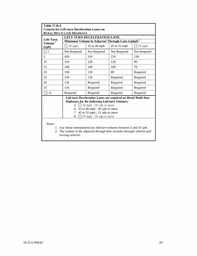
18.31.6 NMAC 20
Table 17.B-4 Criteria for Left-turn Deceleration Lanes on RURAL MULTI-LANE HIGHWAYS
Left-Turn Volume 1 (vph)
LEFT-TURN DECELERATION LANE Minimum Volume in Adjacent Through Lane (vphpl) 2 30 mph 35 to 40 mph 45 to 55 mph 55 mph
5 Not Required Not Required Not Required Not Required 5 450 310 210 130 10 310 220 130 90 15 240 160 100 70 20 190 130 80 Required 25 150 110 Required Required 30 130 Required Required Required 35 110 Required Required Required 36 Required Required Required Required Left-turn Deceleration Lanes are required on Rural Multi-lane
Highways for the following Left-turn Volumes: 5. 30 mph : 36 vph or more
6. 35 to 40 mph : 26 vph or more 7. 45 to 55 mph : 21 vph or more 8. 55 mph : 16 vph or more
Notes:
1. Use linear interpolation for left-turn volumes between 5 and 35 vph. 2. The volume in the adjacent through lane includes through vehicles and
turning vehicles.

18.31.6 NMAC 21
Table 17.B-5 Criteria for Right-Turn Deceleration Lanes on RURAL TWO-LANE HIGHWAYS Right-Turn Volume 1 (vph)
RIGHT-TURN DECELERATION LANE Minimum Directional Volume in Through Lane (vphpl) 2 30 mph 35 to 40 mph 45 to 55 mph 55 mph
5 Not Required Not Required Not Required Not Required 5 800 460 270 160 10 430 280 170 110 15 290 180 110 80 20 200 140 90 70 25 170 120 80 Required 30 160 110 Required Required 31 Required Required Required Required Right-turn Deceleration Lanes are required on Rural Two-lane
Highways for the following Right-turn Volumes: 3. 30 mph : 31 vph or more
4. 35 to 40 mph : 31 vph or more 5. 45 to 55 mph : 26 vph or more 6. 55 mph : 21 vph or more
Notes:
1. Use linear interpolation for left-turn volumes between 5 and 30 vph. 2. The directional volume in the through lane includes through vehicles
and turning vehicles.

18.31.6 NMAC 22
Table 17.B-6 Criteria for Right-Turn Deceleration Lanes on RURAL MULTI-LANE HIGHWAYS Right-Turn Volume 1 (vph)
RIGHT-TURN DECELERATION LANE Minimum Volume in Adjacent Through Lane (vphpl) 2 30 mph 35 to 40 mph 45 to 55 mph 55 mph
5 Not Required Not Required Not Required Not Required 5 910 520 310 180 10 520 330 200 130 15 370 220 140 100 20 270 170 110 90 25 220 140 100 Required 30 200 130 90 Required 35 180 120 Required Required 36 Required Required Required Required Right-turn Deceleration Lanes are required on Rural Multi-lane
Highways for the following Right-turn Volumes: 3. 30 mph : 36 vph or more
4. 35 to 40 mph : 36 vph or more 5. 45 to 55 mph : 31 vph or more 6. 55 mph : 21 vph or more
Notes:
1. Use linear interpolation for left-turn volumes between 5 and 35 vph. 2. The volume in the adjacent through lane includes through vehicles and
turning vehicles.
[18.31.6.17 NMAC - Rp, 18.31.6.17 NMAC, 6/27/2017] 18.31.6.18 ACCESS LOCATION AND DESIGN STANDARDS: The location and design of access points along state highway facilities shall be in accordance with standards established by the department. These standards are defined below and are expounded on in Section 18 of the state access management manual. Where specific design criteria are not provided in 18.31.6.18 NMAC, the design approach should be based on nationally accepted standards and shall be consistent with department specifications. A. General: The department has developed these standards to provide guidance for the location and design of access points along state highways, specifically for those highways in access categories (provided in Section 18.31.6.10 NMAC). These criteria are based upon established design standards meant to protect public safety, to maintain safe and smooth-flowing traffic operations, and to preserve the intended function of all state highway facilities. (1) Local standards: Where a local jurisdiction has established more stringent design standards than the department, the local standards should be applied with the concurrence of the department. (2) Material placed within state rights-of-way: Any materials used within state highway right-of-way shall be subject to approval by the department. Refer to 18.31.6.14 NMAC for additional requirements regarding construction within state highway right-of-way. B. Access location: Access points should be located along state highways to minimize turning movement conflicts between adjacent access facilities, and to provide adequate separation of conflicts for oncoming motorists. Stopping sight distance and intersection area of influence should be considered in determining access point locations. (1) Direct access: The number of access points should be limited to one per site unless frontage is adequate and design hour traffic volumes indicate that the operational level of service for a single access is expected to be below the minimum acceptable LOS standards. (2) Proximity to speed-change lanes: Any part of an access including radius returns shall not

18.31.6 NMAC 23
be permitted within a speed-change lane, or within 50 feet of either the leading or trailing limits of a speed-change lane. (3) Interchange proximity: Access shall not be permitted within the access control limits of an interchange, as established by the department's access control determination, or within 50 feet of the leading or trailing edge of the access control limits for the interchange. (4) Corner clearance: Driveway access should be controlled on both the approach and departure sides of an intersection to maintain adequate corner clearances. (5) Edge clearance: The location of access points relative to frontage property lines should be based on local requirements. When property frontage is not adequate to comply with local government's edge clearance requirements, shared access should be considered. C. Access spacing: (1) Non-developed and developing areas: The spacing of access points in non-developed and developing areas should be based on the access category, the posted speed limit, and the type of access requested (i.e., intersection or driveway). Desired access spacing standards are provided in Section 18 of the state access management manual. An applicant may request a variance to the spacing requirements when physical characteristics of a property preclude the desired spacing. (2) Developed areas/business districts: In developed or redeveloping areas where existing driveway locations preclude access spacing based on desired standards, new access points should be located to minimize conflicts with existing access points. Access points should be consolidated where possible to provide shared property access. D. Median openings: New median openings on state highways with non-traversable medians should not be allowed unless a traffic engineering evaluation analyzing all related traffic and safety issues is prepared and approved by the department. Median openings at intersections or full-access driveways should be spaced with a minimum frequency based upon the access category and posted speed of the highway. E. Selection of design vehicle: The design vehicle should be used to determine the geometric characteristics of a roadside access or median opening, and to define the required design components for the adjacent highway. This vehicle should be the largest vehicle that is expected to access the site on a daily basis. Selection of the design vehicle is subject to the approval of the district traffic engineer. F. Sight distance: Sight distance at all access locations shall be adequate to provide safe operating conditions for the motoring public. An access permit should not be issued unless adequate stopping sight distances are provided for motorists passing the access, and adequate entering and crossing sight distances are provided for motorists using the access. The permittee shall maintain adequate, unobstructed sight distance in both directions from the access. Any potentially obstructing objects such as but not limited to advertising signs, structures, trees and bushes, shall be designed, placed and maintained at a height not to interfere with the sight distances needed by any vehicle using the access. Roadway reconstruction may be required to provide adequate sight distance. G. Access horizontal alignment: The access centerline should be perpendicular to the state highway centerline and extend tangentially for a minimum distance of 40 feet beyond the near-side edge line. An acute angle between 75 degrees and 90 degrees may be permitted if significant physical constraints exist. Acute angles less than 75 degrees shall require special approval of the department. H. Access radius: The access radius should be designed to accommodate the design vehicle expected to use the access on a daily basis. Access radii apply to driveways that are not urban section driveway cuts. I. Driveway width: The width of a driveway should be measured exclusive of radii or tapers. Driveway widths should vary by design vehicle. All two-way driveways should accommodate a concurrent entering and exiting design vehicle, including the design vehicle's off-tracking. J. Access connection depth: The access connection depth should be designed to facilitate the movement of vehicles off the highway to prevent the queuing of vehicles on the traveled way. An access shall not be approved for parking areas that require backing maneuvers within state highway right-of-way. All off-street parking areas must include on-site maneuvering areas and aisles to permit vehicles to enter and exit the site in forward drive without hesitation. K. Speed change lanes: Design specifications for speed change lanes are provided in Section 18 of the state access management manual. Schematic illustrations of speed-change lanes are included in the appendix of the state access management manual. (1) Deceleration lanes: Deceleration lanes typically consist of three components: transition taper, deceleration distance, and queue storage. The length of the lane should allow a vehicle to come to a comfortable stop prior to reaching the end of the expected queue in the lane. (2) Acceleration lanes: Acceleration lanes should consist of a full-width lane and a transition

18.31.6 NMAC 24
taper. Acceleration lanes should be designed so that a turning vehicle will reach a speed between seventy-five and eighty percent of the highway posted speed at the point where the full-width lane ends and the transition taper begins. (3) Shoulders: Where shoulders are present along a roadway and speed change lanes are required, the shoulders should be continued along the speed change lanes. A minimum shoulder width of four feet should be provided adjacent to speed change lanes. (4) Bicycle lane width: When a right-turn deceleration lane or acceleration lane is required on a roadway with designated bicycle lanes, a five foot lane width (seven foot desirable) should be provided between the outside travel lane and the speed-change lane. (5) Grade adjustment: Adjustments should be made to the speed change lane lengths based on the roadway grade. (6) Truck design: If a speed-change lane is designed for a site with five or more large trucks during the design hour, a combination truck design vehicle should be used as the design vehicle. (7) Pavement: The speed change lane pavement section should be full depth and match the pavement section design of the adjacent roadway. All pavement designs require approval by the department. L. Median design for turn lane installation: Medians should be designed to accommodate the largest design vehicle anticipated to use the access, and may provide either partial or full access to a site. Where a single left-turn lane is necessary along a state highway, a minimum median width of 16 feet should be provided. Positive channelization should be provided for all median openings. Median paving should be full depth and match the pavement section design of the existing roadway. The installation of a median opening should not reduce the conveyance or storage capacity of the median, pertinent to its drainage function within the highway section. M. Setbacks: Improvements on public or private property adjacent to the right-of-way should be located so that parking, stopping, and maneuvering of vehicles within the highway right-of-way will not occur. N. Access vertical alignment: The vertical alignment of all access locations should be designed to minimize vehicle bounce and prevent high-centering of vehicles with a maximum clearance of four inches. The maximum grade for a driveway should be ten percent for a low volume residential driveway and eight percent for all other access locations. Steeper access drives require special department approval. A level area (maximum two percent grade) 20 feet in length should be provided at each access to ensure proper sight distance from the access. O. Roadside safety: Careful consideration shall be given to the roadside clear zone. The permittee shall provide adequate clear zones. The roadside clear zone should be designed per the AASHTO roadside design guide and applicable department standards. P. Non-motorized considerations: Access designs should provide for the safe movement of all right-of-way users, including but not limited to pedestrians, bicyclists, equestrian and the handicapped. Where non-motorized facilities cross an access point, such as bicycle trails, appropriate modifications should be made to maintain safe operations for both facilities. (1) Sidewalks: Sidewalks should be constructed along urban arterial and collector state highways. Sidewalks are required where they exist on adjacent properties to maintain consistency along the highway facility. Sidewalk widths should match existing adjacent sidewalk widths, but in any case shall conform to all federal, state, and local regulations and ordinances. (2) Bicycle facilities: Bicycle facilities along urban arterials and collectors should be constructed in accordance with the AASHTO guide for the development of bicycle facilities. Bicycle facilities should only be signed where designated by the state or local jurisdiction, with approval of the department. (3) ADA: Non-motorized facilities shall be designed in accordance with the Americans with Disabilities Act and applicable department standards. Curb ramps shall be provided on urban sections where sidewalk and curb returns exist. Q. Lighting: Where lighting is required at an access point, the lighting design shall comply with Department and AASHTO standards and the Night Sky Protection Act (Sections 74-12-1 NMSA 1978 through 74-12-11 NMSA 1978). The lighting design shall use full cut-off fixtures, and be consistent with AD 226, roadway lighting. (1) Signalized access: Illumination shall be provided at all signalized intersections in accordance with AASHTO's an informational guide to roadway lighting or as otherwise approved by the department. (2) Site illumination: Light beams from on-site lighting systems shall not be directed toward oncoming traffic along the adjacent roadway(s). All site illumination shall be constructed outside of the state highway right-of-way and outside of the roadside clear zone. R. Drainage: Adequate drainage within state highway right-of-way shall be maintained at all access

18.31.6 NMAC 25
locations. Drainage of roadside ditches shall not be altered or impeded, and the applicant shall provide suitable and approved drainage structures as required by the department. All site drainage shall be collected prior to entering state highway right-of-way. Site drainage shall not be permitted to drain into state right-of-way without written approval of the department. Drainage mitigation design shall be in accordance with administrative memorandum 221, drainage design criteria, and the department drainage manual. Access permit applicants shall submit drainage analysis documentation to the department prior to changing site drainage conditions. S. Right-of-way fencing: Driveways shall not be permitted through an existing right-of-way fence, the continuation of which is necessary for the safety of the traveling public, unless the applicant first agrees in writing to construct and maintain a gate or a cattle guard and additional fence in good repair and to keep the gate closed to livestock. The department shall determine whether a gate or cattle guard is required. All new fencing along a state highway shall be constructed so that clear sight triangles are provided for ingressing or egressing vehicles. This may require an offset from the right-of-way line to meet the minimum clear site triangles, on a case by case basis. T. Mailboxes: Mailboxes installed within the state highway right-of-way shall be constructed in conformance with the rules and regulations of the U.S. Postal service and the design standards of the department. AASHTO's a guide for erecting mailboxes on highways, should also be used for the location and design of mailbox installations. U. Utilities: All utilities located within the state highway right-of-way shall comply with the department’s utility accommodations Policy and 17.4.2. NMAC. V. Environmental review: As may be required by law. [18.31.6.18 NMAC - Rp, 18.31.6.18 NMAC, 6/27/2017] 18.31.6.19 ACCESS CONTROL REVIEW PROCEDURES: A. Purpose: The access control review procedures define the process that the department shall follow when considering requests for permanent breaks in existing access control lines, and for establishing or modifying access control limits on new or existing state, federal and interstate highways. Decisions regarding access control matters on state highways shall be addressed by the access control review committee of the department. Review and approval of an access break in established access control lines shall be required by the access control review committee. Refer to the state access management manual for further clarification of the access control review procedures. B. Access control review committee: (1) Purpose: The purpose of access control review committee is to review all access control requests by department staff members who have the expertise to identify issues that need to be resolved before access control limits are established or modified, or access breaks are recommended for approval. (2) Authority: The access control review committee has authority to deny requested access control breaks for existing access control facilities. Access control breaks denied by the committee may be appealed to the secretary of the New Mexico department of transportation or his/her designee. (3) Quorum definition: It shall be required that a simple majority of voting members of the committee, or their alternates, be in attendance for a quorum. C. Operating procedures: (1) The two basic functions of the access control review committee are: (a) To make recommendations to the secretary, or his/her designee, on requests for establishing access control on new or existing state, federal and interstate highways; and, (b) To make recommendations to the secretary, or his/her designee, regarding requests for permanent breaks in existing access control lines on state, federal and interstate highways. (2) The committee shall have the authority to deny access control breaks. A denial by the committee may be appealed to the secretary, or his/her designee. Any access control breaks permitted shall, as a minimum, be in conformance with criteria contained in the most current edition of this rule, the interstate access control policy (CP 65), and any other applicable statutes, policies or procedures. D. New or modified access control limits on state, federal or interstate highways: Operating procedures of the access control review committee for requests to establish access control on new highways or existing non-access controlled highways and procedures for modifying access control limits which shall include but not limited to shifting, extending or reducing on access-controlled highways shall be as follows. Refer to the state access management manual for further clarification. (1) A request for the establishment or modification of access control shall be received by the chairperson of the access control review committee from a department project development engineer or from other
18.31.6 NMAC 26
government agencies. It shall be the responsibility of the requestor, whether representing the department or other government agency, to provide a complete information/request package showing: Location, identified by stationing, distances and proposed right-of-way map; specific purpose, defined in a feasibility study or corridor study; and, source of funding, for all costs including engineering. (2) The chairperson shall request the right of way bureau chief to review the right-of-way map(s) and request lands engineering to prepare a draft administrative determination prior to review and consideration by the committee. The draft administrative determination should be reviewed by the project development engineer, or requestor, and the traffic technical support engineer prior to review and consideration by the committee. (3) The access control review committee shall either recommend approval of the draft administrative determination as presented or recommend approval based upon committee discussions and recommended modifications. The access control review committee may also recommend deferral of action on an administrative determination to a later meeting if additional information is required by the committee for evaluation. If the access control review committee votes to recommend disapproval of a draft administrative determination, they shall provide specific reasons to the requestor for their recommendation. (4) After the administrative determination has been recommended for approval by the committee, it shall be sent to the secretary or his/her designee, for review and approval or disapproval. The request shall be sent to FHWA for approval if on a federal or interstate highway. (5) If the request is disapproved by the secretary or FHWA, it shall be sent back to the chairperson of the committee to inform the requestor of the disapproval. (6) Once all approvals are obtained, the chairperson shall send all documents to the office of record, which is the right of way bureau chief's office. The right of way bureau chief, or his/her designee, shall send a copy of the approved resolution to the owners of record of all affected properties. E. Requests for interstate access control breaks: Requests for interstate access control breaks, which are requests for direct access to the interstate or requests that will have a major impact on the operation or function of the existing interchange, ramps, existing crossroad, etc., shall be handled as specified by applicable state and federal law, rules, regulations and procedures. F. Requests for access control breaks: Operating procedures of the access control review committee for requests for permanent access control breaks within the limits of existing access control rights-of-way on all federal or state highways (other than interstate) shall be as follows. (1) A request for an access control break shall be received by the chairperson of the access control review committee from a department district office, a project development engineer, an access control study team, another governmental agency or from an individual from the public or a private firm. For requests that create major impacts (i.e. requires a new interchange or major modifications), it shall be the responsibility of the requestor to provide a complete feasibility study similar to that required for interstate access. For requests that may create intermediate impacts (i.e. require traffic signals, require intermediate geometric improvements, etc.), the requestor shall furnish a traffic engineering evaluation or other reports to determine if the requested access is feasible. For access requests that appear to be minor, the request shall be submitted to the access control review committee for processing. (2) Once all pertinent information is received, the request shall be placed on the agenda for the next Access control review committee meeting. The access control review committee shall consider all pertinent data available concerning the request for a break in the existing access control line. (3) The Access control review committee shall recommend approval of the access control break as presented; or, recommend approval based upon committee discussions and recommended modifications; or, recommend deferral if additional information is required; or deny the request. The committee may request that a specific report or feasibility study be conducted if after reviewing the request the committee considers it to have major or intermediate impacts. If the access control review committee votes to deny an access control break, specific reasons for the denial shall be provided and a copy shall be sent to the secretary or his/her designee. A denial by the committee may be appealed to the secretary, or his/her designee. (4) After the access control break (administrative determination) has been recommended for approval by the committee, it shall be sent to the secretary or his/her designee, for review and approval or disapproval. The request shall be sent to FHWA for approval if on a federal or interstate highway. (5) Once all approvals are obtained, the chairperson shall send all documents to the office of record, which is the right of way bureau chief's office. The right of way bureau chief shall request the appropriate appraisal difference be paid back to the department. (6) Once all approvals have been obtained and the appraisal difference has been paid back to

18.31.6 NMAC 27
the department, the access-controlled right-of-way becomes non-access controlled right-of-way and the right of way bureau chief, or his/her designee, informs the requestor and the respective district that the requests for access may proceed contingent on all department requirements being met. The respective district shall be responsible for making sure all construction is completed in accordance with the department's regulations and any requirements that were made by the department regarding the approval of the access control break. G. Temporary construction access breaks: Any requests for temporary construction access breaks for department construction projects should be incorporated in roadway plans during their development. These requests should follow the format described in the access permit form C-196. H. Temporary access breaks: Any request for a temporary access break, which is not related to a construction project, shall be submitted to the access control review committee for their review and approval. The temporary access break does not require an administrative determination or approval of the secretary, but shall have FHWA approval if for a federal or interstate highway. If the committee denies a temporary access break, it can be appealed to the secretary, or his/her designee. If an appeal is approved by the secretary, or his/her designee, the request must be forwarded to FHWA for their review and approval if for a federal or interstate highway. I. Access control recommendations by other government agencies: (1) All access control recommendations by other government agencies for federal or state highways shall be submitted to the departments access control review committee in compliance with 18.31.6.19 NMAC. (2) Any and all access control actions/recommendations (made by other governmental agencies) on federal or state highways which have not been approved according to the access control review procedures shall not be effective until acted on as set forth herein. [18.31.6.19 NMAC - Rp, 18.31.6.19 NMAC, 6/27/2017] HISTORY OF 18.31.6 NMAC: Pre-NMAC History: Material in the part was derived from that previously filed with the State Records and Archives under: SHTD Rule No. 89-1(L), Regulations for Driveways and Median Openings on Non-Access Controlled Highways, 6/9/1989. History of Repealed Material: 18 NMAC 31.6, Requirements for Driveways and Median Openings on Non-Access Controlled Highways, 12/14/1998. 18.31.6 NMAC, State Highway Access Management Requirements, filed 10/1/2001 - Repealed effective 6/27/2017. Other History: Effective 10/15/2001, 18.31.6 NMAC, State Highway Access Management Requirements, replaced 18 NMAC 31.6, Requirements for Driveways and Median Openings on Non-Access Controlled Highways. 18.31.6 NMAC, State Highway Access Management Requirements (filed 10/1/2001) was replaced by 18.31.6 NMAC, State Highway Access Management Requirements, effective 6/27/2017.