
Title 14, Code of Federal Regulations, Part 77, “Safe ... · How to Submit F.A.R. Part 77...
12
1 How to Submit F.A.R. Part 77 Notification for On-Airport Proposals Using the Obstruction Evaluation/Airports Airspace Analysis Website (OE/AAA) Central Region Airports Division (IA, KS, NE & MO) “Notice of Proposed Construction or Alteration” (FAA Form 7460-1) Title 14, Code of Federal Regulations, Part 77, “Safe, Efficient Use, And Preservation of the Navigable Airspace” § 77.5 Applicability. (a) If you propose any construction or alteration described in § 77.9, you must provide adequate notice to the FAA of that construction or alteration. (b) If requested by the FAA, you must also file supplemental notice before the start date and upon completion of certain construction or alterations that are described in § 77.9. (c) Notice received by the FAA under this subpart is used to: (1) Evaluate the effect of the proposed construction or alteration on safety in air commerce and the efficient use and preservation of the navigable airspace and of airport traffic capacity at public use airports; (2) Determine whether the effect of proposed construction or alteration is a hazard to air navigation; (3) Determine appropriate marking and lighting recommendations, using FAA Advisory Circular 70/7460- 1, Obstruction Marking and Lighting; (4) Determine other appropriate measures to be applied for continued safety of air navigation; and (5) Notify the aviation community of the construction or alteration of objects that affect the navigable airspace, including the revision of charts, when necessary § 77.7 Form and time of notice. (a) If you are required to file notice under § 77.9, you must submit to the FAA a completed FAA Form 7460- 1, Notice of Proposed Construction or Alteration. FAA Form 7460-1 is available at FAA regional offices and on the Internet. (b) You must submit this form at least 45 days before the start date of the proposed construction or alteration or the date an application for a construction permit is filed, whichever is earliest. (c) If you propose construction or alteration that is also subject to the licensing requirements of the Federal Communications Commission (FCC), you must submit notice to the FAA on or before the date that the application is filed with the FCC. (d) If you propose construction or alteration to an existing structure that exceeds 2,000 ft. in height above ground level (AGL), the FAA presumes it to be a hazard to air navigation that results in an inefficient use of airspace. You must include details explaining both why the proposal would not constitute a hazard to air navigation and why it would not cause an inefficient use of airspace. (e) The 45-day advance notice requirement is waived if immediate construction or alteration is required because of an emergency involving essential public services, public health, or public safety. You may provide notice to the FAA by any available, expeditious means. You must file a completed FAA Form 7460-1 within 5 days of the initial notice to the FAA. Outside normal business hours, the nearest flight service station will accept emergency notices. § 77.9 Construction or alteration requiring notice. If requested by the FAA, or if you propose any of the following types of construction or alteration, you must file notice with the FAA of: (a) Any construction or alteration that is more than 200 ft. AGL at its site.
Transcript of Title 14, Code of Federal Regulations, Part 77, “Safe ... · How to Submit F.A.R. Part 77...

1
How to Submit F.A.R. Part 77 Notification for On-Airport Proposals
Using the Obstruction Evaluation/Airports Airspace Analysis Website (OE/AAA)
Central Region Airports Division (IA, KS, NE & MO)
“Notice of Proposed Construction or Alteration” (FAA Form 7460-1)
Title 14, Code of Federal Regulations, Part 77,
“Safe, Efficient Use, And Preservation of the Navigable Airspace”
§ 77.5 Applicability.
(a) If you propose any construction or alteration described in § 77.9, you must provide adequate notice to
the FAA of that construction or alteration.
(b) If requested by the FAA, you must also file supplemental notice before the start date and upon
completion of certain construction or alterations that are described in § 77.9.
(c) Notice received by the FAA under this subpart is used to:
(1) Evaluate the effect of the proposed construction or alteration on safety in air commerce and the
efficient use and preservation of the navigable airspace and of airport traffic capacity at public use
airports;
(2) Determine whether the effect of proposed construction or alteration is a hazard to air navigation;
(3) Determine appropriate marking and lighting recommendations, using FAA Advisory Circular 70/7460-
1, Obstruction Marking and Lighting;
(4) Determine other appropriate measures to be applied for continued safety of air navigation; and
(5) Notify the aviation community of the construction or alteration of objects that affect the navigable
airspace, including the revision of charts, when necessary
§ 77.7 Form and time of notice.
(a) If you are required to file notice under § 77.9, you must submit to the FAA a completed FAA Form 7460-
1, Notice of Proposed Construction or Alteration. FAA Form 7460-1 is available at FAA regional offices and
on the Internet.
(b) You must submit this form at least 45 days before the start date of the proposed construction or
alteration or the date an application for a construction permit is filed, whichever is earliest.
(c) If you propose construction or alteration that is also subject to the licensing requirements of the Federal
Communications Commission (FCC), you must submit notice to the FAA on or before the date that the
application is filed with the FCC.
(d) If you propose construction or alteration to an existing structure that exceeds 2,000 ft. in height above
ground level (AGL), the FAA presumes it to be a hazard to air navigation that results in an inefficient use of
airspace. You must include details explaining both why the proposal would not constitute a hazard to air
navigation and why it would not cause an inefficient use of airspace.
(e) The 45-day advance notice requirement is waived if immediate construction or alteration is required
because of an emergency involving essential public services, public health, or public safety. You may provide
notice to the FAA by any available, expeditious means. You must file a completed FAA Form 7460-1 within 5
days of the initial notice to the FAA. Outside normal business hours, the nearest flight service station will
accept emergency notices.
§ 77.9 Construction or alteration requiring notice.
If requested by the FAA, or if you propose any of the following types of construction or alteration, you must
file notice with the FAA of:
(a) Any construction or alteration that is more than 200 ft. AGL at its site.

2
(b) Any construction or alteration that exceeds an imaginary surface extending outward and upward at
any of the following slopes:
(1) 100 to 1 for a horizontal distance of 20,000 ft. from the nearest point of the nearest runway
of each airport described in paragraph (d) of this section with its longest runway more than
3,200 ft. in actual length, excluding heliports.
(2) 50 to 1 for a horizontal distance of 10,000 ft. from the nearest point of the nearest runway of
each airport described in paragraph (d) of this section with its longest runway no more than
3,200 ft. in actual length, excluding heliports.
(3) 25 to 1 for a horizontal distance of 5,000 ft. from the nearest point of the nearest landing
and takeoff area of each heliport described in paragraph (d) of this section.
(c) Any highway, railroad, or other traverse way for mobile objects, of a height which, if adjusted upward
17 feet for an Interstate Highway that is part of the National System of Military and Interstate Highways
where overcrossings are designed for a minimum of 17 feet vertical distance, 15 feet for any other
public roadway, 10 feet or the height of the highest mobile object that would normally traverse the
road, whichever is greater, for a private road, 23 feet for a railroad, and for a waterway or any other
traverse way not previously mentioned, an amount equal to the height of the highest mobile object that
would normally traverse it, would exceed a standard of paragraph (a) or (b) of this section.
(d) Any construction or alteration on any of the following airports and heliports:
(1) A public use airport listed in the Airport/Facility Directory, Alaska Supplement, or Pacific
Chart Supplement of the U.S. Government Flight Information Publications;
(2) A military airport under construction, or an airport under construction that will be available
for public use;
(3) An airport operated by a Federal agency or the DOD.
(4) An airport or heliport with at least one FAA-approved instrument approach procedure.
(e) You do not need to file notice for construction or alteration of:
(1) Any object that will be shielded by existing structures of a permanent and substantial nature
or by natural terrain or topographic features of equal or greater height, and will be located in
the congested area of a city, town, or settlement where the shielded structure will not adversely
affect safety in air navigation;
(2) Any air navigation facility, airport visual approach or landing aid, aircraft arresting device, or
meteorological device meeting FAA-approved siting criteria or an appropriate military service
siting criteria on military airports, the location and height of which are fixed by its functional
purpose;
(3) Any construction or alteration for which notice is required by any other FAA regulation.
(4) Any antenna structure of 20 feet or less in height, except one that would increase the height
of another antenna structure.
Notice MUST BE filed on-line at: https://oeaaa.faa.gov/

3
The following instructions apply to all on-airport construction (permanent, temporary, man-made or
natural) for FAA Central Region only.
BEFORE YOU CAN FILE ONLINE – You must register as a New User and obtain an ID and PASSWORD.
New users must complete “New User Registration” to file electronic Notice.

4
Once your user account has been created, you are required to create a “sponsor”. (All on-airport construction
(permanent, temporary, man-made or natural) shall file FAA Form 7460-1 as “On Airport Construction”.)
The FAA will address the official agency determination to the “Sponsor”.

5
Once you create the sponsor, return to the Portal Page using the links along the left-hand side of the screen.
From the Portal Page, you can now file your Notice of Proposed Construction or Alteration by selecting “Add
New Case (On Airport)”. (If your project includes more than one phase, it is highly recommended to submit
each phase as a “separate project” within OE/AAA).
Sponsor: Select appropriate Sponsor.
Notice of: Select the appropriate type:
• Construction – New construction of objects, structures, equipment, temporary
construction, new airports/heliports.
• Existing – Objects, structures, equipment, construction that has already started/in
progress, an airport/heliport not previously reported to the FAA.
• Alteration – Changes to existing objects, structures, equipment that has been
previously studied by the FAA and a determination issued.
Duration: Select appropriately.
Work Schedule: If applicable, enter a Start Date for construction and End Date for completion.
Latitude, Longitude: Enter the proposed location of the object. The coordinates must be in Degrees, Minutes,
and Seconds (DMS). The accuracy of the coordinates should be 0.1 second or better.
For temporary construction locations, see guidance in Appendix C of the Standard
Operating Procedure (SOP) for FAA Evaluation of Sponsor’s Construction Safety and Phasing
Plans Funded by the AIP or PFC Programs.
We will use the coordinates you provide, along with the drawings and/or imagery you
upload to confirm the location of the coordinate point(s). For temporary construction
submittals, your drawings must include a coordinate data table for the project/phase.
NOTE: The ASN will be TERMINATED if you provide a table or enter multiple
latitude/longitude points in the remarks section. This is not an acceptable means of
providing multiple latitude/longitude points for study. Our analyses require individual
6
latitude/longitude points receive an ASN so that all appropriate calculations and reports
are generated. Entering this information as “text” either in a document or description,
does not allow our system to process your proposal.
Horiz Datum: Select NAD83.
Site Elevation (SE): Enter ground elevation (above mean sea level) for the latitude/longitude point entered.
(Do not add the Site Elevation to the Structure Height; provide ONLY the height above
ground level.)
Structure Height (AGL): Enter the maximum height above ground of the object for the location (latitude/longitude)
provided above. (Do not add the Site Elevation to the Structure Height; provide ONLY the
height above ground level.)
1. For proposed pavement not shown on an approved airport layout plan (ALP): The
above ground level height should equal the tail-height of the most demanding
aircraft or the height of the most demanding ground vehicle, whichever is greater,
that will be located on the pavement.
2. For roads/streets: The height above ground shall be in accordance with 14 CFR Part
77 -- §77.17 (b) Obstruction Standards.
3. For temporary construction equipment, enter the anticipated height for the most-
demanding (tallest) temporary construction equipment.
4. Include all appurtenances in the structure height (i.e. lightning rods, antenna, etc.).
NOTE: Entering a 0 (zero) or 1 (one) will result in a delay processing your proposal. The
ASN(s) will be placed in “ADD” status awaiting additional information from you. (See
below for explanation of each status.)
Describe\Remarks: The information typed in this field auto-populates into the official agency determination
letter. Please be clear and concise. We recommend you use the following format:
1. Describe the object/temporary construction and purpose.
2. Provide a physical description (building materials), general footprint dimensions,
the type of roof (i.e., flat, sloped, gable, hip etc.) and if there are
any structures (antennas, flag pole, lights, air condition, etc.) on top of the building.
3. For temporary construction, identify runway and taxiway closures for the project or
phase of the project.
Example 1: Proposal for a new corporate hangar. The hangar’s construction is steel frame,
metal skin, and general footprint is 140’ x 80’. The roof is a gable with a 4:12 pitch. There
are no structures on the roof.
Example 2: Phase 1 temporary construction. Project will construct a portion of the parallel
taxiway associated with Runway 4/22 and extend Runway 30 end by 500’. The parallel
taxiway segment is between the terminal apron taxiway and the new Runway 30 end. The
terminal apron taxiway and Runway 12/30 will be closed for the duration of construction.
Runway 4-22 will be closed when remarking Runway 12/30.
If the current Airport Layout Drawing already has a defined development area illustrating
the airport’s plan to construct multiple buildings/hangars in a defined area, it may be

7
prudent (and efficient) to file notice for all the structures in the area under a single project.
When multiple structures are combined in a single project, the description needs to be
clear and sufficient points of interest must be provided. (See Additional Locations below.)
Example 3: Proposal for a new corporate hangar development eventually containing three
corporate hangars. The hangars will all be steel frame construction with metal skin. The
overall footprint is 150’ x 450’. The hangar roofs will be gables with a maximum 8:12 pitch.
Any future roof structures exceeding the limits of the coordinates provided or any
broadcast antennas will be proposed and filed under separate study. The coordinates
provided delineate the footprint of the hangars at the maximum roof height (gables).
Additional Locations: Required ONLY if you are filing notice for multiple building corners, ancillary structures,
additional helipads (if more than one pad at heliport), working limits of construction
equipment, etc., click “Add New Location(s)” and enter the latitude, longitude, and
elevation details for each of the corresponding points. Click on “Save” when all points are
entered.
For all structures, at a minimum, the coordinate points of the outside corners of the
structure are REQUIRED. Additionally, if appurtenances are located on the roof (i.e. AC
units, antenna, lightning rods, etc.) must be included also.
8
Component Type: Select appropriately. Do NOT select “Construction Safety Plan” for temporary
construction submittals. Construction Safety Plan is for a document review completed
under a different process internally.
Development Type: Select appropriately.
Other Desc: Enter as appropriate.
Prior Study: If your proposal has been studied in the past, please provide the study number (ASN), if
available.
Frequency: Enter all frequencies and associated power. Do NOT include this information in the
remarks section or on an attachment.
Save Click on “Save” AFTER everything has been completed.
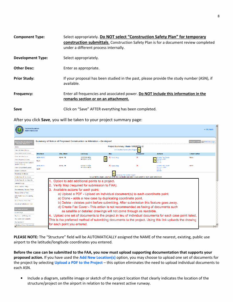
After you click Save, you will be taken to your project summary page:
PLEASE NOTE: The “Structure” field will be AUTOMATICALLY assigned the NAME of the nearest, existing, public use
airport to the latitude/longitude coordinates you entered.
Before the case can be submitted to the FAA, you now must upload supporting documentation that supports your
proposed action. If you have used the Add New Location(s) option, you may choose to upload one set of documents for
the project by selecting Upload a PDF to the Project – this option eliminates the need to upload individual documents to
each ASN.
• Include a diagram, satellite image or sketch of the project location that clearly indicates the location of the
structure/project on the airport in relation to the nearest active runway.
9
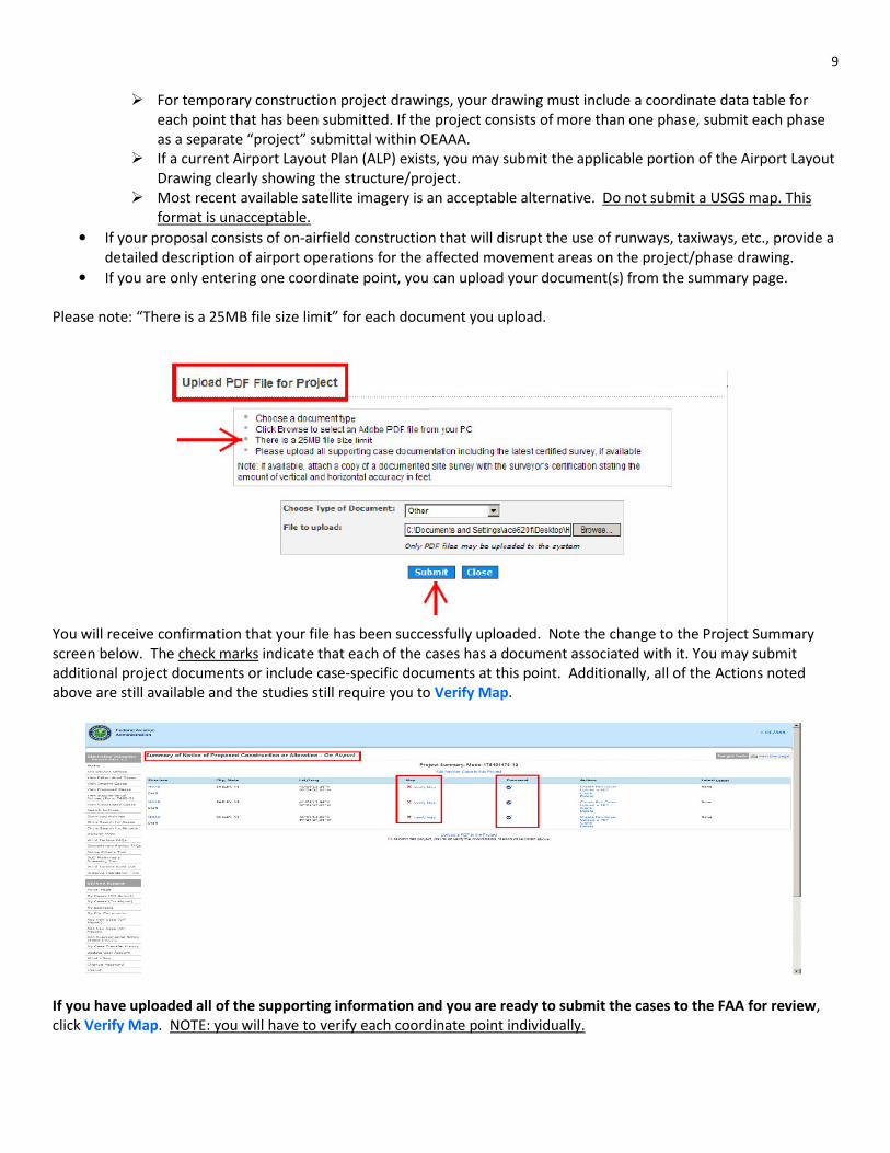
� For temporary construction project drawings, your drawing must include a coordinate data table for
each point that has been submitted. If the project consists of more than one phase, submit each phase
as a separate “project” submittal within OEAAA.
� If a current Airport Layout Plan (ALP) exists, you may submit the applicable portion of the Airport Layout
Drawing clearly showing the structure/project.
� Most recent available satellite imagery is an acceptable alternative. Do not submit a USGS map. This
format is unacceptable.
• If your proposal consists of on-airfield construction that will disrupt the use of runways, taxiways, etc., provide a
detailed description of airport operations for the affected movement areas on the project/phase drawing.
• If you are only entering one coordinate point, you can upload your document(s) from the summary page.
Please note: “There is a 25MB file size limit” for each document you upload.
You will receive confirmation that your file has been successfully uploaded. Note the change to the Project Summary
screen below. The check marks indicate that each of the cases has a document associated with it. You may submit
additional project documents or include case-specific documents at this point. Additionally, all of the Actions noted
above are still available and the studies still require you to Verify Map.
If you have uploaded all of the supporting information and you are ready to submit the cases to the FAA for review,
click Verify Map. NOTE: you will have to verify each coordinate point individually.

10
After all of the cases in your project have been verified and associated documents uploaded, you must submit your
cases to the FAA. NOTE: Before you submit the cases to the FAA you can still make changes, additions and deletions to
the cases.
After clicking “submit”, you will be asked to “confirm” the case/project submission to the FAA. At this point, you can
confirm or go back. If you click “Back”, all of the “Actions” listed above are still available. If you “Confirm”, the cases
have been submitted to FAA and you can no longer make changes to the data. However, you can still upload additional
documents to each case or the project.
You will receive a “Case Submission Success” screen listing the project name and the Aeronautical Study Number(s)
(ASNs) assigned to each latitude/longitude point you entered. Refer to the ASN(s) when communicating with the FAA
about the study. If you have not received an ASN(s), the case(s) have not been submitted to the FAA.

11
The Portal Page will provide a summary of the status of all of the cases you have entered into our database. Please note
the status of each case and check back periodically for status changes. Clicking the blue link will take you to the cases in
each category. If applicable, a .pdf link to a letter will be present on each case. The letter includes details or instructions.
Cases in either “Accepted” or “Work in Progress” have been submitted to the FAA and we are conducting the
aeronautical study. Other statuses may require further action on your part. See below for further explanation.
My Cases by Status:
DRAFT: Cases that have been saved by the user but have not been submitted to the FAA.
WAITING: Cases that have not been submitted to the FAA and are waiting for an action from the
user (you) to verify the map, attach a document or submit the case.
ACCEPTED: Cases have been submitted to the FAA.
ADD Letter: Cases that have been submitted to the FAA but require additional information from the
user (you). Cases in this status are not being evaluated and the timeframe for review has
not started.
WORK IN PROGRESS: Cases that are being evaluated by the FAA.
DETERMINED: Cases that are complete and a have received a final determination letter.
TERMINATED: Cases that are no longer valid. If refilling the case, follow any instructions provided or
include any required, missing, or requested information contained in the Termination
Letter.
After we complete the aeronautical study, the FAA issues a Final Determination letter to you with either a “No
Objection”, “No Objection with Conditions”, or an “Objection” determination. This letter includes the results of the FAA
aeronautical study. The letter will also contain an expiration date (unless the determination was objectionable).
12
It is imperative that you read ALL letters in full and follow ALL of the instructions provided. The following list of documents may help answer questions you may have about the process or information required
to complete the aeronautical study of your proposal.
Resource documents:
� FAA Advisory Circular (AC) 150/5300-13, “Airport Design”
� FAA AC 150/5390-2, “Heliport Design”
� FAA Joint Order 7400.2, “Procedures for Handling Airspace Matters”
� FAA Form 7460-1, “Notice of Proposed Construction or Alteration”
� ARP SOP 1.00, “FAA Evaluation of Sponsor’s Construction Safety and Phasing Plans Funded by the AIP or PFC
Programs”
Address of Regional Office Contact Information:
Central Region (IA, KS MO, NE) FAA Attn: Airports Division, ACE-620F 901 Locust, Room 364 Kansas City, MO 64106 816.329.2646 (office) 816.329.2610 (fax) (Revised May 2014)


![Thursday 2 July 2020 Order Paper No.77: Part 1 · 2 Thursday 2 July 2020 OP No.77: Part 1 CoNTENTS Notes: Item marked [R] indicates that a member has declared a relevant interest.](https://static.fdocuments.in/doc/165x107/5f22286d0fcf986fed575d11/thursday-2-july-2020-order-paper-no77-part-1-2-thursday-2-july-2020-op-no77.jpg)


