Tinker Lane 1 Exploratory Well, Retford Road, between ...
20
Tinker Lane 1 Exploratory Well, Retford Road, between Blyth and Barnby Moor, Nottinghamshire Appendix 11/2 - Botanical Survey Report 406.05251.00002 November 2015 Island Gas Energy Version: vf
Transcript of Tinker Lane 1 Exploratory Well, Retford Road, between ...

Tinker Lane 1 Exploratory Well, Retford Road, between Blyth and Barnby Moor, Nottinghamshire
Appendix 11/2 - Botanical Survey Report
406.05251.00002
November 2015
Island Gas Energy
Version: vf
IGas Energy i 406.05251.00002 Tinker Lane 1 Botanical Survey and Evaluation Report November 2015
SLR
CONTENTS
1.0 INTRODUCTION .......................................................................................................... 2
1.1 Background ....................................................................................................... 2
1.2 Location and Setting ........................................................................................ 2
1.3 Habitats ............................................................................................................. 2
1.4 Impacts on Notable Flora ................................................................................. 3
1.5 Study Aims and Objectives .............................................................................. 3
2.0 METHODOLOGY ......................................................................................................... 4
2.1 Desk-based Study ............................................................................................. 4
2.2 Field Survey ...................................................................................................... 4
2.3 Evaluation Methodology ................................................................................... 4
2.4 Survey Personnel.............................................................................................. 4
2.5 Limitations to Survey ....................................................................................... 4
3.0 RESULTS .................................................................................................................... 5
3.1 Contextual Information and Historical Records ............................................. 5
3.2 Field Survey Results 2015 ................................................................................ 5
4.0 EVALUATION ............................................................................................................ 10
5.0 SUMMARY AND CONCLUSIONS ............................................................................. 11
6.0 CLOSURE .................................................................................................................. 12
TABLES
Table 1 – DOMIN Scale ....................................................................................................... 5
Table 2 - Botanical Survey Results .................................................................................... 6
DRAWINGS
Drawing 1 Study Area
APPENDIX
Appendix A – Location of Tinker Lane, Barnby Moor LWS
Appendix B – Casual Invertebrate Records.

IGas Energy 2 406.05251.00002 Tinker Lane 1 Botanical Survey and Evaluation Report November 2015
SLR
1.0 INTRODUCTION
1.1 Background This report presents the results of a detailed botanical survey of field margins and roadside verges within or adjacent to a proposed exploratory drill site. The prospective applicant intends to apply to Nottinghamshire County Council (in its role as the mineral planning authority for the prospective application site), for permission to drill a single exploration well and three sets of monitoring boreholes, which would contain up to three boreholes in each set, to sample groundwater and ground gas. The proposals would require the following works:-
• Formation of new site access;
• Erection of gates, security fencing and CCTV;
• Stripping and storage of top and subsoils and formation of on-site bunds which
• would be put to grass and maintained for the life of the development;
• Creation of the wellsite platform using impermeable geotextile membrane layers
• covered by a layer of aggregate hardstanding and the installation of a wellhead
• cellar with associated steel conductors;
• Installation of bunded storage areas for chemicals and a surface water attenuation
• tank for surface water management; and
• staff welfare accommodation.
The survey and reporting has been undertaken by ecologists from SLR Consulting Limited (SLR) on behalf of IGas Energy Limited following the need for a botanical survey being identified following an initial habitat appraisal which was undertaken on the 21st August 2015.
1.2 Location and Setting The site is currently in agricultural use (arable cropping) and is surrounded by intensively farmed land to the north, west and south with the A634 forming the eastern boundary. It is located approximately 2.5km south-east of Blyth and 1.5km north-west of Barnby Moor. The village of Torworth is located approximately 1.6km to the north-east of the site. For identification purposes, the proposed site is centred in National Grid Reference (NGR) 465032 (easting) 385344 (northing).
1.3 Habitats
The site comprises of an arable field bordered by species-poor trimmed hedgerows. To the east the field is bordered by roadside verges bordering the A634 which are up to 20 metres wide and comprise of outer mown and inner un-mown grassland with developing bramble and also scattered broad-leaved tree planting (see Figure 1). Within the field itself there are un-cropped grass margins (c. 2-3m wide – see Figure 2) which it is understood form part of a Higher Level Stewardship Scheme.
The initial walkover survey undertaken by an ecologist from SLR on the 21st August 2015 recorded the presence of plant species indicative of more diverse swards which included Common Restharrow (Ononis repens) and Field Scabious (Knautia arvensis). The main area where these species were recorded was the roadside verge. It was considered that whilst the verges and field margins comprise of a relatively small and isolated habitat in an otherwise intensively farmed environment they had the potential to support a notable flora,

IGas Energy 3 406.05251.00002 Tinker Lane 1 Botanical Survey and Evaluation Report November 2015
SLR
particularly given the presence of a nearby Local Wildlife Site of interest for its roadside verge grassland (Tinker Lane, Barnby Moor LWS). A more detailed botanical survey was therefore recommended.
Figure 1 – Roadside Verges (C) along the A634
Figure 2 – Fieldside Margin (A and B)
1.4 Impacts on Notable Flora
If a notable flora is present, development of the site, more specifically the creation of a new site access and perimeter bunds could result in the loss of plant species.
1.5 Study Aims and Objectives
The aim of the surveys was to record the flora of the roadside verges and relevant field margins to provide a baseline against which to assess impacts from the proposed development.
IGas Energy 4 406.05251.00002 Tinker Lane 1 Botanical Survey and Evaluation Report November 2015
SLR
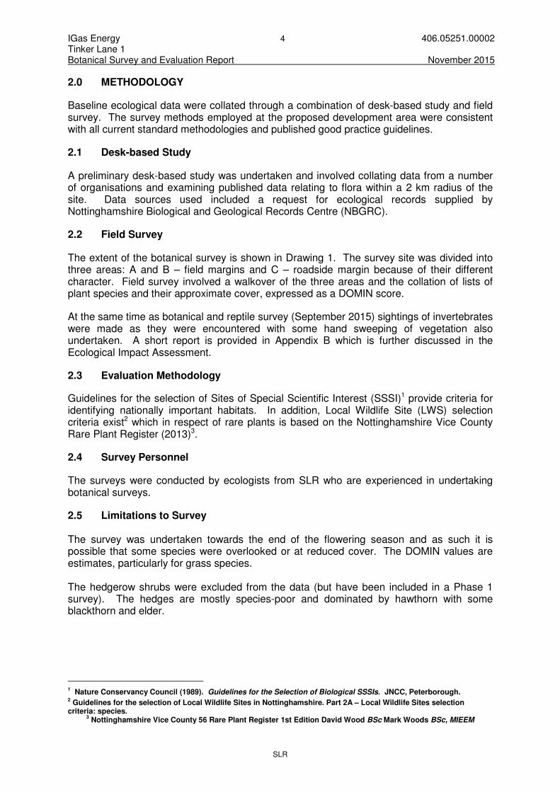
2.0 METHODOLOGY
Baseline ecological data were collated through a combination of desk-based study and field survey. The survey methods employed at the proposed development area were consistent with all current standard methodologies and published good practice guidelines.
2.1 Desk-based Study
A preliminary desk-based study was undertaken and involved collating data from a number of organisations and examining published data relating to flora within a 2 km radius of the site. Data sources used included a request for ecological records supplied by Nottinghamshire Biological and Geological Records Centre (NBGRC).
2.2 Field Survey
The extent of the botanical survey is shown in Drawing 1. The survey site was divided into three areas: A and B – field margins and C – roadside margin because of their different character. Field survey involved a walkover of the three areas and the collation of lists of plant species and their approximate cover, expressed as a DOMIN score.
At the same time as botanical and reptile survey (September 2015) sightings of invertebrates were made as they were encountered with some hand sweeping of vegetation also undertaken. A short report is provided in Appendix B which is further discussed in the Ecological Impact Assessment.
2.3 Evaluation Methodology
Guidelines for the selection of Sites of Special Scientific Interest (SSSI)1 provide criteria for identifying nationally important habitats. In addition, Local Wildlife Site (LWS) selection criteria exist2 which in respect of rare plants is based on the Nottinghamshire Vice County Rare Plant Register (2013)3.
2.4 Survey Personnel
The surveys were conducted by ecologists from SLR who are experienced in undertaking botanical surveys.
2.5 Limitations to Survey The survey was undertaken towards the end of the flowering season and as such it is possible that some species were overlooked or at reduced cover. The DOMIN values are estimates, particularly for grass species. The hedgerow shrubs were excluded from the data (but have been included in a Phase 1 survey). The hedges are mostly species-poor and dominated by hawthorn with some blackthorn and elder.
1 Nature Conservancy Council (1989). Guidelines for the Selection of Biological SSSIs. JNCC, Peterborough.
2 Guidelines for the selection of Local Wildlife Sites in Nottinghamshire. Part 2A – Local Wildlife Sites selection
criteria: species. 3 Nottinghamshire Vice County 56 Rare Plant Register 1st Edition David Wood BSc Mark Woods BSc, MIEEM

IGas Energy 5 406.05251.00002 Tinker Lane 1 Botanical Survey and Evaluation Report November 2015
SLR
3.0 RESULTS
3.1 Contextual Information and Historical Records
3.1.1 Historical Records for Notable Flora
NBGRC returned a single record for Japanese knotweed (Fallopia japonica), an invasive plant species from SK664867 which is within 2km but not near to the site.
3.1.2 Botanical Sites within 2km
The NBGRC search provided details of a Local Wildlife Site (LWS) Tinker Lane, Barnby Moor (Reference 2/414) which comprises of roadside verges (species-rich grassland). The LWS is situated to the north and south west of the application site (see Appendix A) within 500m and extends to a linear length of approximately 2km or 2.167ha in extent.
3.1.3 Previous Field Surveys There have been no botanical surveys undertaken at the site to SLR’s knowledge.
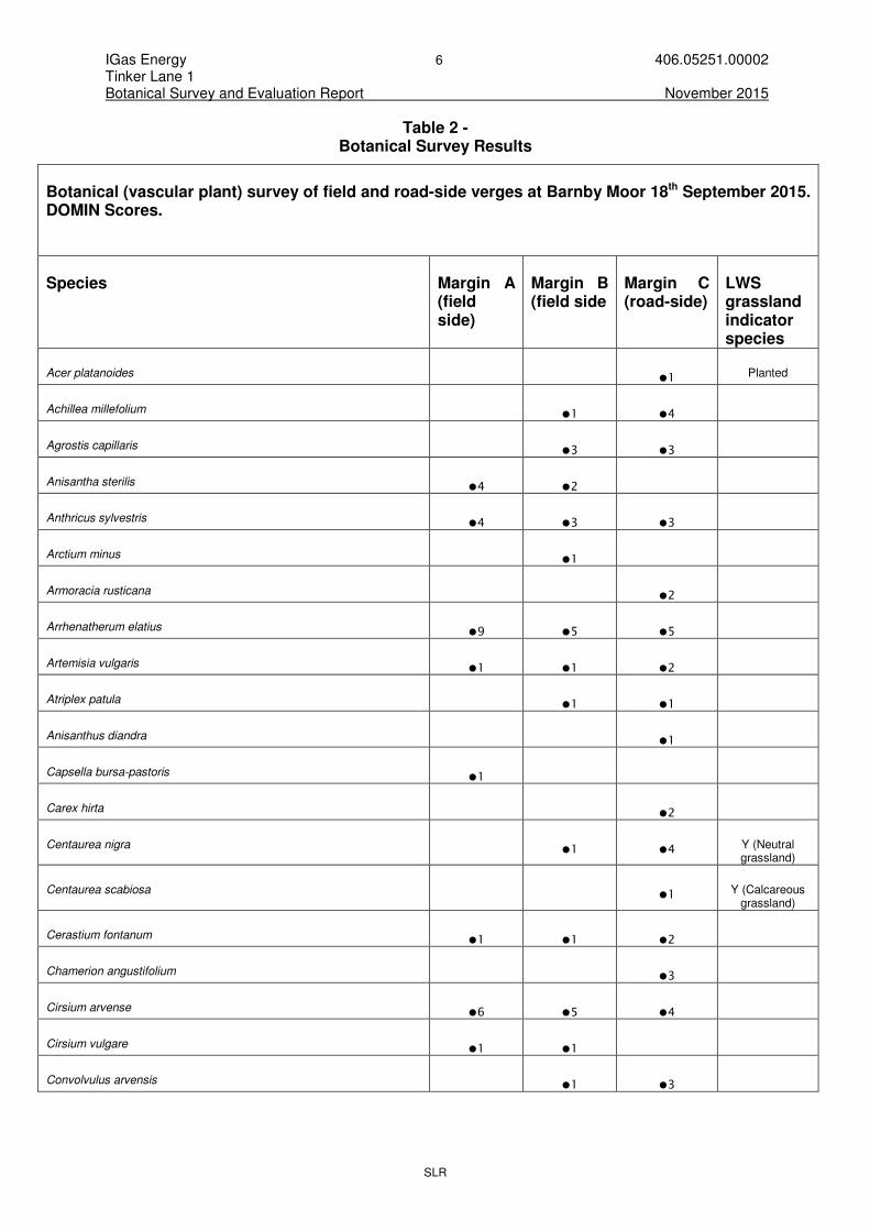
3.2 Field Survey Results 2015
A survey was undertaken on the 18th September 2015.
The 2015 botanical survey results are shown below in Table 2. The results show the plant species recorded and their DOMIN scores (see Table 1) which provide an indication of cover. Drawing 1 shows the location of the survey area and sub compartments.
Table 1 – DOMIN Scale
Cover Domin
91–100% 10
76–90% 9
51–75% 8
34–50% 7
26–33% 6
11–25% 5
4–10% 4
<4% (many individuals) 3
<4% (several individuals) 2
<4% (few individuals)
1
IGas Energy 6 406.05251.00002 Tinker Lane 1 Botanical Survey and Evaluation Report November 2015
SLR
Table 2 - Botanical Survey Results
Botanical (vascular plant) survey of field and road-side verges at Barnby Moor 18th September 2015. DOMIN Scores.
Species Margin A (field side)
Margin B (field side
Margin C (road-side)
LWS grassland indicator species
Acer platanoides �1
Planted
Achillea millefolium �1 �4
Agrostis capillaris �3 �3
Anisantha sterilis �4 �2
Anthricus sylvestris �4 �3 �3
Arctium minus �1
Armoracia rusticana �2
Arrhenatherum elatius �9 �5 �5
Artemisia vulgaris �1 �1 �2
Atriplex patula �1 �1
Anisanthus diandra �1
Capsella bursa-pastoris �1
Carex hirta
�2
Centaurea nigra �1 �4 Y (Neutral
grassland)
Centaurea scabiosa �1 Y (Calcareous
grassland)
Cerastium fontanum �1 �1 �2
Chamerion angustifolium
�3
Cirsium arvense �6 �5 �4
Cirsium vulgare �1 �1
Convolvulus arvensis �1 �3

IGas Energy 7 406.05251.00002 Tinker Lane 1 Botanical Survey and Evaluation Report November 2015
SLR
Conyza canadensis �1 �1
Cynosurus cristatus �1
Dactylis glomerata �9 �4 �6
Elytrigia repens
Erodium cicutarium �1 Y (Dry acid
grassland)
Fagus sylvatica �2 Planted
Fallopia convolvulus �1
Festuca arundinacea �1 �1
Festuca rubra �4 �4
Fraxinus excelsior �3 Planted
Galium aparine �4
�2
Galium verum
�1 Y (Neutral
grassland)
Geranium molle �1
Heracleum sphondylium �5 �1 �3
Holcus lanatus �5 �6 �5
Hypochaeris radicata �1 �1
Knautia arvensis �1 �3 Y (Neutral
grassland)
Lamium album �1 �2 �3
Lathyrus pratensis �1 Y (Neutral
grassland)
Leontodon autumnalis �1 �2
Lolium perenne �4
Matricaria discoidea �1 �2
Melilotus sp. �1
Ononis repens �2 Y (Calcareous
grassland)
Persicaria maculosa �1
Plantago lanceolata �1 �3 �4

IGas Energy 8 406.05251.00002 Tinker Lane 1 Botanical Survey and Evaluation Report November 2015
SLR
Plantago major �3 �3
Poa annua �4
�3
Poa pratensis �4
Poa trivialis �3
Polygonum aviculare �1
Potentilla reptans �4
Ranunculus repens �3
Raphanus raphinistrum raphinistrum �1
Rubus fruticosus agg. �2 �1 �4
Rumex acetosa �1 �3
Rumex crispus �1
�1
Rumex obtusifolius �1
Senecio jacobaea �2
�1
Senecio vulgaris �2 �1 �1
Silene dioica �1 �1 �1
Silene vulgaris �1 �1 �2 Y (Neutral
grassland)
Sisymbrium officinale �1
Sonchus oleraceus �2 �1 �1
Stellaria media �1
Taraxacum officinale agg �1 �1 �3
Tilia cordata
�1 Planted
Tragopogon pratensis �1 �1
Trifolium repens �1
Trifolium pratense �2
Y (Neutral grassland)
Trisetum flavescens �2 Y (Neutral
grassland)
Tripleurospermum inodorum �1 �2
Urtica dioica �5 �5 �4

IGas Energy 9 406.05251.00002 Tinker Lane 1 Botanical Survey and Evaluation Report November 2015
SLR
Veronica persica �1
Vicia cracca �1 �3
Vicia sativa �1
Vicia sp.
�1
Viola arvensis �1

IGas Energy 10 406.05251.00002 Tinker Lane 1 Botanical Survey and Evaluation Report November 2015
SLR
4.0 EVALUATION
Table 2 shows whether a given plant species is considered to be a good indicator of a particular habitat type for which Local Wildlife Sites are selected based on the guidance available. For each habitat type a certain number of indicator species needs to be present for selection to be considered.
The survey found that the roadside verge and field margins were dominated by coarse and competitive species that are indicative of disturbed, un-managed and enriched situations such as nettle, bramble, thistles and grasses. Within this context, the roadside verge grassland (C) held more of the grassland indicator species, however, the overall total number of indicator species and their cover was low. The flora of the field margins (A and B) was found to be impoverished and this was attributed to rotational disturbance, adjacent fertiliser use and shading.
The verges and margins which were surveyed by SLR would not qualify in isolation as a Local Wildlife Site. The flora of the roadside verge (Margin C) shares some floral similarities with that of the Tinker Lane LWS and forms a contiguous habitat but the grassland quality here is low. The presence of planted trees is preventing a more sympathetic mowing regime which would discourage bramble and domination by coarse grass species. The survey recorded the presence of great brome (Anisanthus diandra) which may have a localised distribution in Nottinghamshire. This is an introduced species that is naturalised in waste ground and waysides4. It is beginning to become more common in the Midlands and further north but is well established and locally common in East Anglia and is considered to be of low conservation importance.
4 Stace, C (2010) New Flora of the British Isles. 3
rd Edition. Cambridge Press.

IGas Energy 11 406.05251.00002 Tinker Lane 1 Botanical Survey and Evaluation Report November 2015
SLR
5.0 SUMMARY AND CONCLUSIONS
The botanical survey conducted in 2015 by SLR did not record the presence of a particularly notable flora within or adjacent to the site, however, due to the dominance of arable farming and the relative scarcity of the grassland resource in the area, measures to ensure that the minimum area of roadside verge is disturbed will be included within the Ecological Impact Assessment which accompanies the proposed development.

IGas Energy 12 406.05251.00002 Tinker Lane 1 Botanical Survey and Evaluation Report November 2015
SLR
6.0 CLOSURE
This report has been prepared by SLR Consulting Limited with all reasonable skill, care and diligence, and taking account of the manpower and resources devoted to it by agreement with the client. Information reported herein is based on the interpretation of data collected and has been accepted in good faith as being accurate and valid.
This report is for the exclusive use of IGas Energy; no warranties or guarantees are expressed or should be inferred by any third parties. This report may not be relied upon by other parties without written consent from SLR.
SLR disclaims any responsibility to the client and others in respect of any matters outside the agreed scope of the work.

DRAWINGS
SLR

26.7m
24.2m
L
a
y
-
b
y
28.7m
L
a
y
-
b
y
A
6
3
4
27.4m
A
A
C
C
A
B
N
© Crown copyright [and database rights] 0100031673 Expires
www.slrconsulting.com
Scale Date
2ND FLOOR
HERMES HOUSE
HOLSWORTH PARK
OXON BUSINESS PARK
SHREWSBURY, SY3 5HJ
T: 01743 239250
LEGEND05891.00001.27.001.0_B
OT
AN
IC
AL_S
UR
VE
Y_P
LA
N.dw
g
DRAWING 1
1:2000 @ A3 NOVEMBER 2015
BOTANICAL SURVEY PLAN
EXPLORATORY BOREHOLE
TORWORTH
[19/08/16]2015
0 20 40 60 80m 120 160 200
Metres 1:2000
© This drawing and its content are the copyright of SLR Consulting Ltd and may not be reproduced or amended except by prior written permission. SLR Consulting Ltd accepts no liability for any amendments made by other persons.
SITE BOUNDARY
BOTANICAL SURVEY AREA
FIELD SIDE MARGIN
FIELD SIDE MARGIN
ROADSIDE VERGE
C
A
B

__________________________________APPENDIX A

MATTERSEY HILL
MARSH SSSI
DANESHILL LWS / LNR
TINKER LANE, BARNBY MOOR LWS
1
k
m
2
k
m
3
k
m
N
© Crown copyright [and database rights] 0100031673 Expires
www.slrconsulting.com
Scale Date
TREENWOOD HOUSE
ROWDEN LANE
BRADFORD-ON-AVON
WILTS. BA15 2AU
T: 01225 309400
F: 01225 309401
05891.00001.27.11-2.0_E
CO
LO
GIC
AL_S
IT
ES
_P
LA
N.dw
g
DRAWING 11/2
1:50,000 @ A4 OCTOBER 2015
ECOLOGICAL SITES PLAN
EXPLORATORY BOREHOLE
TORWORTH
[19/08/16]2015
0 500 1000 1500 2000m 3000 4000 5000
Metres 1:50,000
© This drawing and its content are the copyright of SLR Consulting Ltd and may not be reproduced or amended except by prior written permission.
SLR Consulting Ltd accepts no liability for any amendments made by other persons.
APPLICATION SITE
LOCAL WILDLIFE SITES WITHIN 2km
PRIORITY HABITAT WITHIN 2km
LOWLAND FLOODPLAIN GRAZING MARSH
(LOW CONFIDENCE): SOURCE: MAGIC
SITES OF SPECIAL SCIENTIFIC INTEREST
WITHIN 3km
ANCIENT WOODLAND (ABSENT 2km RADIUS)
LEGEND
NO EUROPEAN SITES WITHIN 10km

__________________________________APPENDIX B

A brief summary of invertebrate interest recorded during the botanical and reptile surveys of Barnby Moor site on 18th & 19th September 2015
No rare or scarce species were recorded. However, there was some local interest present. This was found on road-side verge (Margin C) where sweeping of restharrow resulted in 2 Local species being recorded: the Rhopalid bug Corizus hyoscyami and the plantbug Dicyphus annulatus, the latter is confined to restharrow for all stages of lifecycle. C. hyoscyami is a species that was formely restricted to southern coastal areas but within the last several years has been documented as expanding its range inland and further north. Other species recorded from this area included 16-spot ladybird Tytthaspis sedempunctata, the green shieldbug Palomena prasina, bishop’s mitre shieldbug Aelia acuminata, tree damselbug Himacerus apterus, weevils from the genus Sitona (probably S. lineatus, a species that feds on Fabaceae) and a common snail-killing fly - Coremacera marginata.
Sweeping of grassland with field scabious and knapweed in margin C resulted in 2 spiked shieldbugs Picromerus bidens being found along with the common damselbug Nabis flavomarginatus and 22-spot ladybird (Harlequin ladybird Harmonia axyridis and 7-spot ladybird Coccinella septempunctata was also recorded elsewhere in Margin C).
From Margin A and B species associated with arable field margins were recorded such as the plantbug Lygus rugulipennis. The Cicadellid hopper Athysanus argentarius was also recorded (from Margin B). This is a species that in recent years has been moving north from a formerly very restricted south-eastern distribution on the coast.
ABERDEEN 214 Union Street, Aberdeen AB10 1TL, UK T: +44 (0)1224 517405 AYLESBURY 7 Wornal Park, Menmarsh Road, Worminghall, Aylesbury, Buckinghamshire HP18 9PH, UK T: +44 (0)1844 337380 BELFAST Suite 1 Potters Quay, 5 Ravenhill Road, Belfast BT6 8DN, Northern Ireland T: +44 (0)28 9073 2493 BRADFORD ON AVON Treenwood House, Rowden Lane, Bradford on Avon, Wiltshire BA15 2AU, UK T: +44 (0)1225 309400 BRISTOL Langford Lodge, 109 Pembroke Road, Clifton, Bristol BS8 3EU, UK T: +44 (0)117 9064280 CAMBRIDGE 8 Stow Court, Stow-cum-Quy, Cambridge CB25 9AS, UK T: + 44 (0)1223 813805 CARDIFF Fulmar House, Beignon Close, Ocean Way, Cardiff CF24 5PB, UK T: +44 (0)29 20491010 CHELMSFORD Unit 77, Waterhouse Business Centre, 2 Cromar Way, Chelmsford, Essex CM1 2QE, UK T: +44 (0)1245 392170
DUBLIN 7 Dundrum Business Park, Windy Arbour, Dublin 14 Ireland T: + 353 (0)1 2964667 EDINBURGH 4/5 Lochside View, Edinburgh Park, Edinburgh EH12 9DH, UK T: +44 (0)131 3356830 EXETER 69 Polsloe Road, Exeter EX1 2NF, UK T: + 44 (0)1392 490152 GLASGOW 4 Woodside Place, Charing Cross, Glasgow G3 7QF, UK T: +44 (0)141 3535037 GRENOBLE BuroClub, 157/155 Cours Berriat, 38028 Grenoble Cedex 1, France T: +33 (0)4 76 70 93 41 GUILDFORD 65 Woodbridge Road, Guildford Surrey GU1 4RD, UK T: +44 (0)1483 889 800 LEEDS Suite 1, Jason House, Kerry Hill, Horsforth, Leeds LS18 4JR, UK T: +44 (0)113 2580650 LONDON 83 Victoria Street, London, SW1H 0HW, UK T: +44 (0)203 691 5810 MAIDSTONE 19 Hollingworth Court, Turkey Mill, Maidstone, Kent ME14 5PP, UK T: +44 (0)1622 609242
MANCHESTER 8th Floor, Quay West, MediaCityUK, Trafford Wharf Road, Manchester M17 1HH, UK T: +44 (0)161 872 7564 NEWCASTLE UPON TYNE Sailors Bethel, Horatio Street, Newcastle upon Tyne NE1 2PE, UK T: +44 (0)191 2611966 NOTTINGHAM Aspect House, Aspect Business Park, Bennerley Road, Nottingham NG6 8WR, UK T: +44 (0)115 9647280 SHEFFIELD Unit 2 Newton Business Centre, Thorncliffe Park Estate, Newton Chambers Road, Chapeltown, Sheffield S35 2PW, UK T: +44 (0)114 2455153 SHREWSBURY 2nd Floor, Hermes House, Oxon Business Park, Shrewsbury, SY3 5HJ, UK T: +44 (0)1743 239250 STAFFORD 8 Parker Court, Staffordshire Technology Park, Beaconside, Stafford ST18 0WP, UK T: +44 (0)1785 241755 STIRLING No. 68 Stirling Business Centre, Wellgreen, Stirling FK8 2DZ, UK T: +44 (0)1786 239900 WORCESTER Suite 5, Brindley Court, Gresley Road, Shire Business Park, Worcester WR4 9FD, UK T: +44 (0)1905 751310