Timing of Cenozoic basin formation in northern … of Cenozoic basin formation in northern...
21
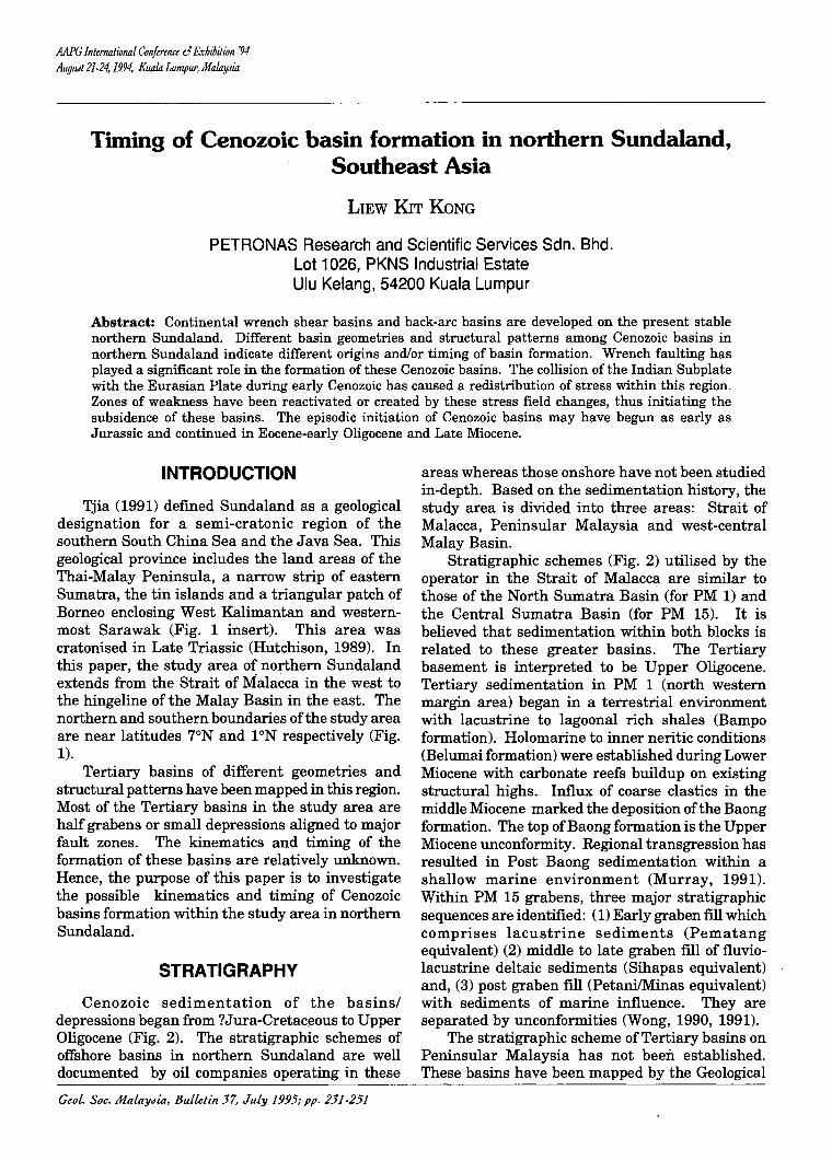
MPG InternatwlUll Conference d R"CbiDilwn '94 AI/gilA 21-24, 1994, Kuala Lumpur, MalaYJia Timing of Cenozoic basin formation in northern Sundaland, Southeast Asia LIEW KIT KONG PETRONAS Research and Scientific Services Sdn. Bhd. Lot 1026, PKNS Industrial Estate Ulu Kelang, 54200 Kuala Lumpur Abstract: Continental wrench shear basins and back-arc basins are developed on the present stable northern Sundaland. Different basin geometries and structural patterns among Cenozoic basins in northern Sundaland indicate different origins and/or timing of basin formation. Wrench faulting has played a significant role in the formation of these Cenozoic basins. The collision of the Indian Subplate with the Eurasian Plate during early Cenozoic has caused a redistribution of stress within this region. Zones of weakness have been reactivated or created by these stress field changes, thus initiating the subsidence of these basins. The episodic initiation of Cenozoic basins may have begun as early as Jurassic and continued in Eocene-early Oligocene and Late Miocene. INTRODUCTION Tjia (1991) defined Sundaland as a geological designation for a semi-cratonic region of the southern South China Sea and the Java Sea. This geological province includes the land areas of the Thai-Malay Peninsula, a narrow strip of eastern Sumatra, the tin islands and a triangular patch of Borneo enclosing West Kalimantan and western- most Sarawak (Fig. 1 insert). This area was cratonised in Late Triassic (Hutchison, 1989). In this paper, the study area of northern Sundaland extends from the Strait of Malacca in the west to the hingeline of the Malay Basin in the east. The northern and southern boundaries of the study area are near latitudes 7°N and 1°N respectively (Fig. 1). Tertiary basins of different geometries and structural patterns have been mapped in this region. Most of the Tertiary basins in the study area are half grabens or small depressions aligned to major fault zones. The kinematics and timing of the . formation of these basins are relatively unknown. Hence, the purpose of this paper is to investigate the possible kinematics and timing of Cenozoic basins formation within the study area in northern Sundaland. STRATIGRAPHY Cenozoic sedimentation of the basins/ depressions began from to Upper Oligocene (Fig. 2). The stratigraphic schemes of offshore basins in northern Sundaland are well documented by oil companies operating in these GeoL. Soc. MalaYJia, Bulletin 37, July 1995; pp. 231-251 areas whereas those onshore have not been studied in-depth. Based on the sedimentation history, the study area is divided into three areas: Strait of Malacca, Peninsular Malaysia and west-central Malay Basin. Stratigraphic schemes (Fig. 2) utilised by the operator in the Strait of Malacca are similar to those of the North Sumatra Basin (for PM 1) and the Central Sumatra Basin (for PM 15). It is believed that sedimentation within both blocks is related to these greater basins. The Tertiary basement is interpreted to be Upper Oligocene. Tertiary sedimentation in PM 1 (north western margin area) began in a terrestrial environment with lacustrine to lagoonal rich shales (Bampo formation). Holomarine to inner neritic conditions (Belumai formation) were established during Lower Miocene with carbonate reefs buildup on existing structural highs. Influx of coarse clastics in the middle Miocene marked the deposition of the Baong formation. The top of Baong formation is the Upper Miocene unconformity. Regional transgression has resulted in Post Baong sedimentation within a shallow marine environment (Murray, 1991). Within PM 15 grabens, three major stratigraphic sequences are identified: (1) Early graben fill which comprises lacustrine sediments (Pematang equivalent) (2) middle to late graben fill of fluvio- lacustrine deltaic sediments (Sihapas equivalent) and, (3) post graben fill (PetanilMinas equivalent) with sediments of marine influence. They are separated by unconformities (Wong, 1990, 1991). The stratigraphic scheme of Tertiary basins on Peninsular Malaysia has not been established. These basins have been mapped by the Geological
Transcript of Timing of Cenozoic basin formation in northern … of Cenozoic basin formation in northern...
MPG InternatwlUll Conference d R"CbiDilwn '94 AI/gilA 21-24, 1994, Kuala Lumpur, MalaYJia
Timing of Cenozoic basin formation in northern Sundaland, Southeast Asia
LIEW KIT KONG
PETRONAS Research and Scientific Services Sdn. Bhd. Lot 1026, PKNS Industrial Estate Ulu Kelang, 54200 Kuala Lumpur
Abstract: Continental wrench shear basins and back-arc basins are developed on the present stable northern Sundaland. Different basin geometries and structural patterns among Cenozoic basins in northern Sundaland indicate different origins and/or timing of basin formation. Wrench faulting has played a significant role in the formation of these Cenozoic basins. The collision of the Indian Subplate with the Eurasian Plate during early Cenozoic has caused a redistribution of stress within this region. Zones of weakness have been reactivated or created by these stress field changes, thus initiating the subsidence of these basins. The episodic initiation of Cenozoic basins may have begun as early as Jurassic and continued in Eocene-early Oligocene and Late Miocene.
INTRODUCTION
Tjia (1991) defined Sundaland as a geological designation for a semi-cratonic region of the southern South China Sea and the Java Sea. This geological province includes the land areas of the Thai-Malay Peninsula, a narrow strip of eastern Sumatra, the tin islands and a triangular patch of Borneo enclosing West Kalimantan and westernmost Sarawak (Fig. 1 insert). This area was cratonised in Late Triassic (Hutchison, 1989). In this paper, the study area of northern Sundaland extends from the Strait of Malacca in the west to the hingeline of the Malay Basin in the east. The northern and southern boundaries of the study area are near latitudes 7°N and 1°N respectively (Fig. 1).
Tertiary basins of different geometries and structural patterns have been mapped in this region. Most of the Tertiary basins in the study area are half grabens or small depressions aligned to major fault zones. The kinematics and timing of the . formation of these basins are relatively unknown. Hence, the purpose of this paper is to investigate the possible kinematics and timing of Cenozoic basins formation within the study area in northern Sundaland.
STRATIGRAPHY
Cenozoic sedimentation of the basins/ depressions began from ?Jura-Cretac~ous to Upper Oligocene (Fig. 2). The stratigraphic schemes of offshore basins in northern Sundaland are well documented by oil companies operating in these
GeoL. Soc. MalaYJia, Bulletin 37, July 1995; pp. 231-251
areas whereas those onshore have not been studied in-depth. Based on the sedimentation history, the study area is divided into three areas: Strait of Malacca, Peninsular Malaysia and west-central Malay Basin.
Stratigraphic schemes (Fig. 2) utilised by the operator in the Strait of Malacca are similar to those of the North Sumatra Basin (for PM 1) and the Central Sumatra Basin (for PM 15). It is believed that sedimentation within both blocks is related to these greater basins. The Tertiary basement is interpreted to be Upper Oligocene. Tertiary sedimentation in PM 1 (north western margin area) began in a terrestrial environment with lacustrine to lagoonal rich shales (Bampo formation). Holomarine to inner neritic conditions (Belumai formation) were established during Lower Miocene with carbonate reefs buildup on existing structural highs. Influx of coarse clastics in the middle Miocene marked the deposition of the Baong formation. The top of Baong formation is the Upper Miocene unconformity. Regional transgression has resulted in Post Baong sedimentation within a shallow marine environment (Murray, 1991). Within PM 15 grabens, three major stratigraphic sequences are identified: (1) Early graben fill which comprises lacustrine sediments (Pematang equivalent) (2) middle to late graben fill of fluviolacustrine deltaic sediments (Sihapas equivalent) and, (3) post graben fill (PetanilMinas equivalent) with sediments of marine influence. They are separated by unconformities (Wong, 1990, 1991).
The stratigraphic scheme of Tertiary basins on Peninsular Malaysia has not been established. These basins have been mapped by the Geological

232
TN
l' N
STUDY AREA
THAILAND
(INDONESIA)
lIEW KIT KONG
/ "-, ~-'---- JOINT DEVELOPMENT AREA
\
\
---~ .2!JGAPORE
Figure 1. Location of the study area. Inset is the area of Sundaland (Adapted from Tjia, 1991). PreCenozoic tectonics domains of Sundaland consists of Mergui Plate and Indosinia Block.
WEST STRAIT OF MALACCA EAST M.Y PENINSULAR
AGE MALAYSIA WEST-CENTRAL MALAY BASIN PM 1 PM 15
FormaUan Sedlmen!ary
Formalian Sedlmentary SedlmanIDry SeIsmic SedIment8ty
Envlrunmonts Environmento EnvIronman1a Sequence EnvIronmenta
Pleistocene Coastal to Inner neritic Minas Shallow marine
Pliocene Equivalent to Lower coastal plains
Middla naritic -Post Baong 4 Holomarina
Upper Petani -I 10
Innar-neritic Equivalent Lacustrine m to RED-
..•..• .. 't- .•.. •..•.. .., ..•..• Fluvio-Deltaic
Littoral CD c Coastal to
;C 3
8 Middle Baang Inner neritic Coastal Piain Sihapas
!-GREEN _Local .2 Equivalant ::E 2C Holomarine
20 ~ •..•..•.. '.1" ..•..• ;C r--YELLOW- Lower Coastal Halomarine
.. . 2B Lower Beiumai Innar neritic '--- ORANGE-
Plain
Pematang Lacustrina ..•. ";10 •. .m. ? . . .". e· .. . -............ . .......... Continantal at the baSE Equivalent 2A
Upper Bampo and marine towards
Upper Coastal CD ~ en - PURPLE- Plain c the top fa:
30 8 0
--I Alluvial .91 Lower 1A Plain 5 .. . . ··1······· .•. ";10 ..•..•. .. •.. •.. • '1' ..•..•..•. ?- ...
;C Pre-Oliogocene
riflinfill 40 Tampur - (possibly Cretaceous)
Eocene » r
50 Basement Uncertain Basement (Undifferentiated)
(Undifferentiated) ..... 'i .......... ~ ...... . ..... ~ .....•..... ·1··· ...
Paleocene Basement
60 (Undifferentiated)
Figure 2. Generalised stratigraphic schemes ofthe study area. Compiled from Murray (1991), Wong (1991), and Lasmo Oil (1990).

234 llEW KIT KONG
Survey of Malaysia. These Tertiary deposits appear to be fully continental; they show facies association oflacustrine, paludal and fluvial origin. Geological Survey of Malaysia (1985) interpreted these basins as isolated continental basin deposits of Late Tertiary age (?Late Miocene). Recent study on the Tertiary palynomorphs of Batu Arang suggested that the initiation of Batu Arang basin is probably Eocene to Oligocene (Ahmad Munif, 1993). Stauffer (1973) concluded that the nature of the continental deposits suggested that each basin has a discrete sedimentation history. The rapid lateral wedging of the deposits, e.g. Batu Arang, indicated that local downwarp controlled deposition.
A joint regional study by Petronas, Lasmo and Carigali on the northwest Malay Basin has proposed a new stratigraphic system for the area (Lasmo Oil, 1990). This system is based on seismic sequence stratigraphy (Fig. 2). Seismic sequence 1 (Purple to Basement isochron: ?Lower Oligocene to Middle Upper Oligocene) is divided into two parasequences separated by a local angular unconformity. Sediments of this sequence were laid down under alluvial to upper coastal plain conditions. Seismic sequence 2 (Green to Purple isochron: mid Upper Oligocene to lower Middle Miocene) is divided into three subsequences: Subsequence 2A was deposited under lower coastal plain conditions with alluvial plain dominated by braided and meandering channels. Subsequence 2B indicated the onset of coastal conditions and subsequence 2C recorded the onset of marine conditions. Seismic sequence 3 (Red to Green isochron: lower Middle Miocene to Upper Miocene) was deposited under predominantly lower coastal plain conditions (low energy estuarine conditions) with widespread coastal swamp dominated by mangrove and a network of low sinuosity distributary channel. Coastal conditions are prevalent at the base of Seismic sequence 4 (above Red horizon; ?Upper Miocene to present) with progressively more marine conditions up section. Localised channelling appeared in this sequence.
GRABENS IN THE STRAIT OF MALACCA
Within the basement of the Strait of Malacca, northerly trending grabens have been mapped at discrete locations. These grabens can be grouped into (1) Bengkalis Trough related grabens, (2) Pematang-Balam Trough related grabens, (3) Asahan Arch-Kepulauan Aruah Nose related grabens, and (4) Tamiang-Y ang Besar High related grabens. These northerly trending graben groupings are situated between regional highs (Fig. 3). The maximum depth of these grabens range from 2,700 ft to 13,000 ft (Table 1).
Bengkalis Trough related grabens include Johor Graben and Kukup Graben. These grabens are situated about 60 km east of the N-S trending Bengkalis Trough. Both grabens are aligned in the NNE direction. Tjia (1988,1989a) suggested that in late Cretaceous-early Tertiary time, the Bengkalis segment of the Bentong-Bengkalis suture experienced normal faulting that created the depression. Lateral faulting occurred in the Oligocene(?) and the Miocene. Pleistocene NW striking reverse faults have superimposed upon earlier trends. Wong (1990) believed that the Johor Graben is genetically related to the Bengkalis Trough in Central Sumatra. This graben could have developed as a side graben of Bengkalis Depression (Moulds, 1989).
Pematang-Balam Trough related grabens are Port Klang Graben, Angsa Graben and Sabak Graben. These grabens are situated north of the N-S trending Balam Trough and Pematang Trough and could be the northern ?extension of the Troughs. Kepulauan Aruah Nose is situated west of these grabens. These grabens are aligned in a NNW d.ITection. Port Klang Graben and Sabak Graben are northerly elongated grabens whilst Angsa Graben which is situated between these two grabens is oval in shape.
Grabens located between the Asahan Arch and the Kepulauan Aruah Nose are Central Grabens, Southern Graben, Eastern Graben, West Penang Graben, North Penang Graben and East Penang Graben. Collectively, these grabens are aligned in the NNE direction. Major bounding faults for these grabens are situated on the western margin of these grabens (except Central Graben).
Grabens that are situated north of the N-S Tamiang and Yang Besar High are Northern Graben, MSS-XA Graben, Thai Border East and Thai Border West. The Northern and MSS-XA Graben which are situated on the southern part of this graben grouping are aligned in NNE direction. Thai Border West and Thai Border East are aligned in N -S direction. There is no preferred sloping direction of these grabens.
The Asahan Arch is a northerly trending regional high that separates the North Sumatra Basin from the Central Sumatra Basin (Fig. 3). This arch probably extends to the west of Central Graben. Based on sediment fill within the grabens, Murray (1991) interpreted that grabens east ofthe Asahan Arch are associated with Central Sumatra Basin and those west of the arch are associated with North Sumatra Basin. In this paper, Northern Graben and Port Klang Graben are used as representative for North Central Basin and Central Sumatra Basin respectively.
Geot. Soc. MaLaytJia, BuLLetin 57
S' N
4' N
ga'E
· · · • · · I I :-:r •
'(9 • • '- . .. IX : ~ : 1<9 : ~ : • 'z . :r" :5 : II: I l .~ . .' .
,e::' • .' , .~: G":' .r-, ,. :
:-nf)' ,--' ( / : :: :~:,,: •• .~ I' / .. ...-..' : ~ .' · . . • • • ',: .-J '. : .. ~ .. · .' . .' . .' . .
'. ~\ . • . . . . . . . . 98' E ::>i.J . .-I."·1 Fr\ \
• . . , . , , , , • 0 o 0 o • , . . . , .
• • .~. 0 50 "\'1 km
• · . · . · . • • · . · . • • : : • • • • · . : . ; ; • • , .
• 0 , . • •
• 0 · , · , · , :r, ot) f t~ : .« • .. :~ : ~: !(I) •
:~ : · . · . · . • • · . · .
NAME OF GRABEN
a d
9
NORTHERN No name NORTH PENANG
b MSS-XA e = CENTRAL h EAST PENANG
SOUTHERN
c f
100' E
~ ~ .'"~ .~}~" ,,, \
(a) 100' E
No name WESTPENANG EASTERN
· · , • · · • ·
S' N
:UJ • (f) • :0 J .Z4.N ::.:: .« :0: .UJ :0.. • · • · ·
2· N
O' N
'00' E
SUfvll-\TRA
H)()· E
50 I
io'n
SABAK GRABEN
ANGSA
'OlE
N PENINSULA,H
rv'lA.LAYS Ij~
PORT KLANG EN
JOHOR GRABEN
,. N
Figure 3. (a) Location of graben groupings with regional elements. Note the orientation of graben groupings with regional elements. Modified from Sosromihardjo (1988) and Dyer et al. (1991). (b) Location of graben groupings with regional elements. Note the alignment ofthe Balam-Pematang Trough related grabens with both Troughs. Johor Graben and Kukup are east of the Bengkalis.
-l ~ z G)
o ., (") m Z
2 o ('5 OJ » (J)
Z ., o ::0 ;;: ~ 6 z Z z o ::0 -I :c m ::0 Z (f) C Z
§; s;: z _0
(f) o C -I :c m » ~ :t> (J)
:x;
I\) W (]l
236 LIEW KIT KONG
1--0 <2, ~
0 km 20
I I
CONTOUR INTERVAL = 02 SEC (1WT)
~ CARBONATE BUILDUP NW SE
INDONESIA MALAYSIA
NORTHERN GRABEN
POST ·IWlNG
BASEMENT
BASEMENT
NOT TO SCALE (b)
Geol. Soc. MaLaYJia, BuLLetin 37

NW
TIMING OF CENOZOIC BASIN FORMATION IN NORTHERN SUNDALAND, SOUTHEAST ASIA
( 1-\ , ,-;
" ... " 1 ,I, I ' I \,
High ,~' \ \,~ I I _ J I, J I
I"I'~" I I • I /, "
: : I', \ ~: I
I I \ \ I, t
I I I 1/'1 ' " / ", I ' ,t
, ",' I" , J t \, I I \ I
I \ \ \ \" \ , " • "Q I .. '" \ ,,\ \ '
"+ 1"'11 1 ,\ \ I \ "l' '" _ ... - \ " \ \ \ \ It
HI -... J \' \' \ \ - J " ... ... \ \ \\
I I" \ '- ,
I
'-
" ' \ ~ , I
~ - '-I
o I
, I
, , High I
\, \ I
"
'-
Low " .... - ... '
" ... ' ~
I ' , - ...... '" \
km
I
I
20
I
CONTOUR INTERVAL = FT
CONTOUR INTERVAL = TWT
H = High L= Low
\ \_,
PLEISTOCENE - RECENT
PETANII MINAS EQUIVALENT
" ( -'" \
(a)
, '"
'-
'-
\ ' , I , '
I '" I I I I
I I ~ I
SE
Figure 5. Location of Port Klang Graben and its schematic geosection. Adapted from Wong (1991).
JuLy 1995
237

238 lIEW KIT KONG
Table 1. Summary of the geometry of the grabens/depressions in the Strait of Malacca (Malaysian waters).
GRABEN DEPTH SIZE (approx.)
ORIENTATION Location of Major Boun~FaUit ELONGATION
(maximum) Le~ Breadth Relative of Graben (km) to Graben
TAMIANG-YANG BESAR HIGH RELATED GRABENS
Northern 8,100 ft 20 10 NNE-SSW ?Curvilinear West & East
MSS-XA 8,500 ft 40 15 NE-SW
No Name 1 2,700 ft 30 10 West Linear N-S
No Name 2 3,700 ft 30 10 East
ASAHAN ARCH-KEPULAUAN ARUAH NOSE RELATED GRABENS
Central 13,000 ft • 60 20 West & East
North Penang 9,400 ft 35 12 NE-SW
EastPenang 4,600 ft 55 16 Linear
Southern 7,600 ft 50 20 West
Eastern 3,200 ft 35 10 N-S
WestPenang 2,600 ft 20 8
PERMATANG-BALAM TROUGH RELATED GRABENS
Sabak 8,000 ft 35 15 N-S Curvilinear West
Angsa 12,000ft 25 25 NNE-SSW Oval
Port Klang 12,000 ft 80 15 NNW-SSE East Linear
BENG~STROUGHRELATEDGRABENS
Johor 11,000 ft 15 10
The NNE elongated Northern Graben is situated near the western margin of PM 1 Block and near the MalaysialIndonesia international boundary. Basement contour deepens towards SW. Faults mapped in this graben trend north and NE, and are interconnected. Most major faults are located on the eastern flank of this graben. The size of this graben is estimated to be 20 km x 10 km. The maximum depth of this graben is 8,100 ft (Fig. 4). Cross section shows that the basement of this graben generally tilts towards southeast. Structural overprint on the basement topography is evidenced by the presence of a number of fault blocks within the grabens. Carbonate buildups are found on local highs within the graben. Unconformity is above the Boang Sandstone. This shows that structural modification peaks at Upper Miocene:
The NNW-SSE elongated Port Klang Graben is situated southwest of Pulau Lumut. The axis of this graben extended across the MalaysialIndonesia international boundary, reaching a length of approximately 80 km. The average width of thi~ graben is 15 km. The NNW-SSE elongated depocentre is approximately 12,000 ft deep. N-S faults have transacted the depocentre of this graben. Normal faults have been mapped on the eastern and western flanks of the graben. The eastern
NNE-SSW East ?Curvilinear
flank of this graben is steeper than the western flank. Higher curvature is observed on contours of the western flank ofthe graben. The high linearity of the contour on the eastern flank suggest that a major fault has bounded the eastern margin of this graben and the graben deepens towards east (Fig. 5). Offshore gravity data suggest that the Port Klang Graben may extend in northeast direction into the islands offshore Kuala Selangor. Basement topography is altered by later structural events. Wrench faulting with flower structure is observed in this graben (Fig. 5). This structural modification of the basement terminated by Upper Miocene as indicated by the relatively undisturbed Petanil Minas sediment.
TERTIARY BASINS IN PENINSULAR MALAYSIA
Tjia and Zaiton Harun (1985) suggested that by the end of the Mesozoic or in early Tertiary time, Peninsular Malaysia has become tectonically stable. The main part of the country remained above sea level throughout the Cenozoic and small outcrops of continental Tertiary sediments mark minor basins. Stauffer (1973) has summarised the existence of Tertiary deposits in Peninsular Malaysia. The Tertiary deposits (Fig. 6) known at
GeoL. Soc. MaLaYJia, BuLLetin 57

TIMING OF CENOZOIC BASIN FORMATION IN NORTHERN SUNDALAND, SOUTHEAST ASIA 239 that time include BukitArang-Betong, Enggor, Batu Arang, Kepong and Kluang-Nyior. The other probable sites are Lawin, Tanjung Rambutan and Layang-Layang. Recently, Tertiary basins are identified in Pengkalan Hulu, Perak (Nenering Tertiary Basin; Ibrahim et al. (1991), Teh and Sia (1991), Teh (1992), Teh and Rushdan (1994) and Che Aziz Ali et al. (1994) ) and Lenggong, Perak (Lenggong Tertiary Basin; Teh and Rushdan, 1994.). Generally, these small Tertiary deposits are situated on the western side of the Peninsula, and most are less thaI). 50 km from the Strait of Malacca. Coincidentally, these basins (except LayangLayang) lie oil the west side of Peninsular drainage divide ('fjia, 1973). The Tertiary sediments have been interpreted to be more extensive than now as dipping beds are truncated at the surface or along an unconformity. Tertiary grabens in the Strait of Malacca have been mapped to extend onto the west
lDl·E
TERTIARY BASINS
1 Bukit Arang 3 Lawin 5 Enggor 7 Kepong 9 Layang Layang
2 Nenering 4 Lenggong 6 Batu Arang 8 Kluang-Nyior
lD3·E
o 8D I ,
Ion
MAJOR FAULTS
BB BokBak BP Batang Padang BT Bukit Tinggi KL Kuala Lumpur M Mersing/Endau L Lebir
6·
4·
2"
Figure 6. Location of Tertiary basins and major faults in Peninsular Malaysia. Major faults after Tjia (1972,1989b). Tertiary basins adapted from Geological map of Malaysia, 8th edition, 1985.
JuLy 1995
coast of Peninsular Malaysia by Sun Malaysia Petroleum Co.
The geological map of Peninsular Malaysia (Geological Survey of Malaysia, 1985) indicates six Tertiary basins. These mapped Tertiary basins are Bukit Arang, Lawin, Batu Arang, Kepong, KluangNyior and Layang-Layang. Tanjung Rambutan Tertiary basin which was postulated by Stauffer (1973) is not in this map. These mapped basins are ova1/elliptic in shape. The preferred elongated directions of these basins are north-south (Lawin, Batu Arang and Kluang-Nyior), east-west (?Bukit Arang, Enggor and Layang-Layang) and NW-SE (Kepong). They consist of shale, sandstone, conglomerate and minor coal seams. The larger Tertiary basins are Layang-Layang and Bukit Arang (Table 2). These basins are interpreted to be isolated continental basin deposits of Late Tertiary age (Geological Survey of Malaysia, 1985). Tertiary basins have undergone only mild structural deformation. It is postulated that the scattered Tertiary basins were produced by ?late Tertiary structural adjustments mainly involving faulting. Gobbett (1973) has postulated that some of the Tertiary basins are aligned with the major faults. Enggor, Batu Arang and Kepong are located on the trends of major structural lineaments (Stauffer, 1973).
Two Tertiary basins will be discussed in ~his paper, namely Batu Arang and Layang-Layang Tertiary basins. The age of these basins have been determined palynologically (Ahmad Munif, 1993; Ahmad Munif et al., 1994). Ages of other basins are still doubtful as paleontological evidence is lacking. Most of these basins are inferred as Tertiary based on their lithological similarity with the Batu Arang Basin (Foo, 1990).
As shown in the geological map of Peninsular Malaysia, the north-south elongated Batu Arang Tertiary basin is surrounded by Carboniferous rocks (southwest), Silurian-Ordovician rocks (east) and Devonian rocks (north). Stauffer (1973) indicated that the age of this deposit is Late Tertiary (?Upper Miocene). Recent palynological study by Ahmad Munif (1993) indicated that the age of this deposit is Eocene. The coal bearing sequence of this basin consists mainly of clay and shale, commonly carbonaceous, and fine-grained sandstone. There are also beds and lenses of coarse sandstone and conglomerate and lignite seams. Depositional environment is interpreted to be fluvio-Iacustrine (Mahendran et al., 1991).
Wong (1991) mapped Batu Arang basin as a NE-SW elongated basin with a major NW-trending normal fault delineating the SW boundary of the basin (Fig. 7). Basin deepens towards SW. Deposition in this basin began with fanglomerate

240
sw
feet
o
400
800
o 1200
3°20'N
\ ( I
\,""
km
I I
(
I
./ r'
/
t , / "
i I
101"26'E
lIEW KIT KONG
NE
Upper seam
1 ' ,t':':;';;,1 BOULDER BEDS
~ COAL MEASURES
_ FANGLOMERATE
o
km
\
Figure 7. Simplified geological map of Batu Arang Tertiary Basin and its cross section. Adapted from Wong (1991).

TIMING OF CENOZOIC BASIN FORMATION IN NORTHERN SUNDALAND, SOUTHEAST AsiA 241
Table 2. Geometry of Tertiary Basins in Peninsular Malaysia.
Size (approx.) Elevation Structural Tertiary Area Orientation (meter) Thickness
Basin Length* Breadth* above (meter) Domain Orin) (kIn) sea-level
Bukit Arang-Betong 20 7.5 40km2 East-West (?N-S) 60-120 > 180
Lawin 3.5 2.5 5km2 North-South -170 > 300 Northwest
Nenering ? ? ? ?NE-SW - 340 ?
Lenggong ? ? ? ? ? ?
Enggor 1 0.5 20ha East-West 46-76 > 62 West
Tanjung Rambutan Existence doubtful
BatuArang 5.5 3.5 15km2 North-South 21 > 265
Kepong 5 2.5 6,000ha NW-SE 15 > 194 Central
Kluang-Nyior 2.5 1.5 N/A North-South 30-75 > 60 East
Layang-Layang 25 10 N/A East-West ? ?
Banting Graben 20 10 N/A North-South subsurface > 2,000
Ext. of Sabak Graben 15 10 N/A NNE-SSW subsurface > 1,700 ?West
Ext. of Angsa Graben ?25 ?15 N/A ?NE-SW subsurface ?
Ext. of Port Klang ?15 ?10 N/A NE-SW subsurface ? Graben
Note: Information on area, elevation and thickness of sediments is extracted from Stauffer (1973). Information on size and orientation of basins is measured from geological map of Peninsular Malaysia (1985). * indicate maximum length and breadth. Structural domain is after Tjia and Zaiton Harun (1985). Information on extension of grabens is extracted from Wong (1991).
which consists of boulders/cobbles of quartzite in sandy siltstone matrix, grading to pebbly sandstone. Progressively up section, fanglomerate interfmgers with coal measures. These coal measures consist of shale and sandstone interbedded with coal seams. In the top section, fanglomerate interfingers with boulder beds. These beds consist of cobbleslboulders of sandstone and claystone in sandy clay matrix.
Lineaments in the vicinity of Batu Arang Basin are absent as surrounding areas are covered with alluvium. Granite in the east shows major lineaments that trended WNW (Geological Survey of Malaysia, 1985). 1]ia (1989b) showed that minor lineaments in this area trended north and northeast. The western extension of Kuala Lumpur fault is interpreted to extend to Pulau Jemur (1]ia, 1977). This basin lies within the western extension of Kuala Lumpur fault. The major NW fault bounding the basin could be part of this extension. Mahendran et al. (1991) found that this basin is bounded by NW-SE trending faults. They interpreted this basin as a fault-controlled basin. Rapidly deposited boulder beds and fault breccia were found in this basin.
Layang-Layang basin is among the larger Tertiary basins on Peninsular Malaysia. Ahmad Munif et al. (1994) determined the age of this pasin as Late Miocene. This basin is triangular in shape
JuLy 1995
and elongated in the east-west direction. It tapers towards west. This basin is surrounded by granite and bordered by Jura-Cretaceous sediments in the east (Fig. 8A). Sediments thicken eastward with major depocentre in the eastern area of the basin. Lineaments in this locality is lacking (Geological Survey of Malaysia, 1985). 1]ia (1989b) has mapped major WNW lineaments (Mersing trend) in the eastern area of this basin. The Geological Survey of Malaysia (1985) has mapped north to northwest lineaments in the eastern area of this basin. The Bouguer gravity anomaly (Vijayan, 1990) indicates that Layang-Layang basin is a half graben bounded by a near-linear fault to the south and a listric fault to the northeast with an estimated minimum vertical throw of 1 km.
Jengeli and Pengeli faults that trend northwesterly transect this basin. This northwesterly trend coincides with the trends of boundaries of older formations. A structural map (Fig. 8B) shows that the basin is surrounded by normal faults. Left stepping en echelon normal faults are mapped on the southwest part of the basin. These faults may indicate right lateral movement along the southern margin of the basin during its inception. Supported by high linearity of gravity contours on this margin, the east-west boundary between the granite and the basin may
242
0 8 I
km
Granite
Iill1 Renggam
1°S0'N
Gemas Fm (Tr)
N
• Rengam I
lIEW KIT KONG
103°30'E
40 . ~~ Gramte .... &~
... ,,.'</ ~ ,"1~,."". ,~~
A"lnU~E_il
Granite
............... ......
/i
! Bandar •
.... .i// Tenggara
............. is --
,
Layang- • Layang
............ if0U9n~ _-----....... ............ ------ -,~, -- ---
~~----' ", , '. , -- ~
-.;-----, '~ -~
o 8
km
\FaUlt '---------Major fault confining the basin
Deepest part of the basin 1 Major 2 Minor
,
Sedili J I J C·
~ , ~. c , "'1'\
~\ ~ C1 --~ \ ~ ~
"'1'\ ~ ~ \ ~ 'C \ ~ ~ \
Granite
A
B
.............................
Probable boundary of basin
Figure 8. (A) Simplified geological map of Layang-Layang Tertiary basin. Adapted from Geological map of Malaysia, 8th edition, 1985. (B) Structural map of Layang-Layang Tertary basin. After Vijayan (1990).
GeoL. Soc. MalaYdia, Bulletin 57

TIMING OF CENOZOIC BASIN FORMATION IN NORTHERN SUNDALAND, SOUTHEAST ASIA 243
represents a major controlling fault in the development of this basin. In short, northwesterly faults within this basin represent older fault trends within the basement (parallel to Mersing .Fault). This trend is responsible for the narrowing of the basin towards west. The basin maybe separated into several subbasins by these faults. The eastwest faults controlled the elongation of the basin. These faults may represent zones of weakness within ?pluton/pluton interfaces developed within the granite (Syed Sheikh Almashoor, 1989). Eastwest faults/fractures are activated during Tertiary and a transtensional stress regime is created within this area. This initiated the subsidence of Layang- . Layang Tertiary basin.
In Peninsular Malaysia, Tertiary basins are in proximity with the Baubak-Batang Kali-Kuala Lumpur-Endau fault zone. The Kuala LumpurEndau fault zone represents a prominent line of dislocation that extends from Kuala Lumpur to Ulu Endau in southeast Pahang. In this fault zone it appears that the east-southeast striking faults are discontinuous and the southeast striking faults are the major fractures (Gobbett and Tjia, 1973). The Kuala Lumpur fault zone is about 15 km wide and has several 280°-300° strike lineaments in the Kuala Lumpur region. Total left lateral displacement of this fault is estimated to be 20 km. This fault zone has been structurally mapped to extend to Pulau Jemur. Many parts of the Kuala Lumpur fault zone are· filled with quartz dykes (e.g. Klang Gates and Tekali quartz dykes). The Mersing or Endau fault zone is represented by a number of 290° striking shear zones of ?left lateral displacement in northwest Johore. This fault zone is 30 km wide and extends for a distance of about 100 km. The youngest known fault movement was of Cretaceous age. Left lateral displacement was in the order of 40 km (Tjia, 1972, 1977; Syed Sheikh Almashoor,1989). BatuArang, Kepong and KluangNyior Tertiary basins are located in proximity with the Kuala Lumpur-Endau Fault Zone. The size of these basins decreases as the distance from the fault zone increases. Batu Arang basin, being the largest, is within the fault zone. Kluang-Nyior basin is the smallest and is located the furthest from the fault zone. Could this relationship show that these three basins are genetically related to the Kuala Lumpur-Endau fault zone?
Gobbett and Tjia (1973) summarised that the Bok Bak Fault (or referred to as the Baubak Fault) is represented by two fault sets, one striking 143° and the other 32°. These sets represent a complementary system of shear faults. This fault zone maybe as wide as 10 km (Tjia, 1972). The Bok Bak fault, the largest fault striking NW, was traced for 75 km. The southern end of this fault can be
JuLy 1995
traced to Lasah (Syed Sheikh Almashoor, 1989). The northwest faults (325°) and the NNE faults (32°) were interpreted to have left and right lateral movements respectively. The recognisable lateral movements were probably during the upper Triassic-lower Jurassic. Vertical movement during Tertiary was indicated by the tilted Tertiary gravel deposits of Lawin (Tjia, 1972). Lawin, Nenering, Enggor and Lenggong lie in proximity with the Baubak fault zone. This fault zone could have initiated the formation of these Tertiary basins. Lawin basin is within the northwest fault set (325°) of the Baubak fault zone whereas Nenering is within the second set of faults (32°) of the Baubak fault zone.
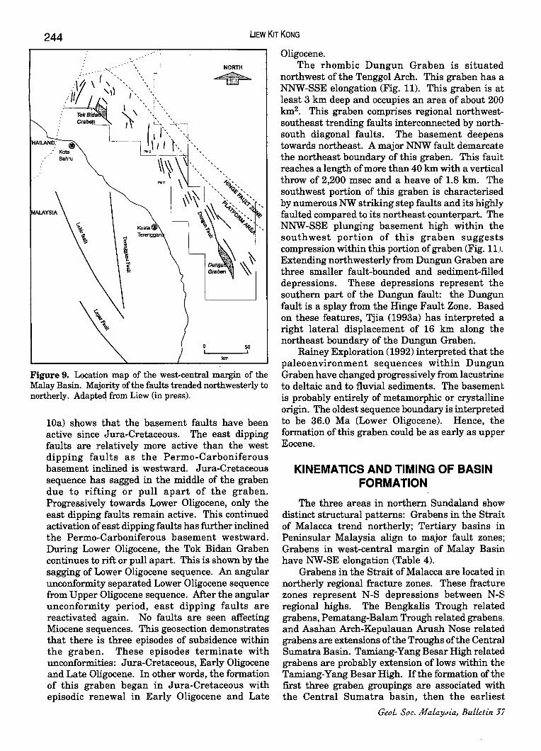
GRABENS IN WEST-CENTRAL MALAY BASIN
The west-central margin of the Malay Basin comprise a platform area and a hinge fault zone which runs parallel (NW-SE) to the basin margin (Fig. 9). Structurally, this area can be divided into three structural zones based on fault trends and basement contours (Liew, in press). Tok Bidan Graben and Dungun Graben are situated at the northern and southern portion of this margin respectively. Both grabens have rhombic shapes and are elongated in the NW -SE direction. Faults in the vicinity of Dungun Graben trended northwesterly. This trend progressively change to northerly northward. Tok Bidan Graben is surrounded by northeasterly faults on the west and northwesterly faults on the east. Major faults within this margin are parallel to major faults on Peninsular Malaysia such as Lebir Fault, Lepar Fault and Terengganu Faults. To illustrate the formation of basins/depressions in this margin, Tok Bidan Graben and Dungun Graben are discussed.
The NW elongated Tok Bidan Graben is located about 50 km north of Pulau Perhentian Besar. This graben is flanked by a NNE plunging basement high to the west and a NNW plunging basement high to the east (Fig. lOb). The basement of this graben has a rhombic shape. There is a large NW striking fault bounding the southwest margin of this graben with a length of 30 km and vertical throw reaching 800 msec. This fault is connected with the NNW faults on the western margin of the graben. These faults demarcate the length of the graben. The northeast margin of this graben is bounded by SE striking step faults downthrowing to SW. These faults are connected with SSE striking faults on the eastern margin of the graben. The basement deepens towards south-west. There are two NW-SE elongated depocentres in this graben.
The geosection of the Tok Bidan Graben (Fig.
244 lIEW KIT KONG
NORTH
~
o 50 I ,
kin
Figure 9. Location map of the west-central margin of the Malay Basin. Majority of the faults trended northwesterly to northerly. Adapteq from Liew (in press).
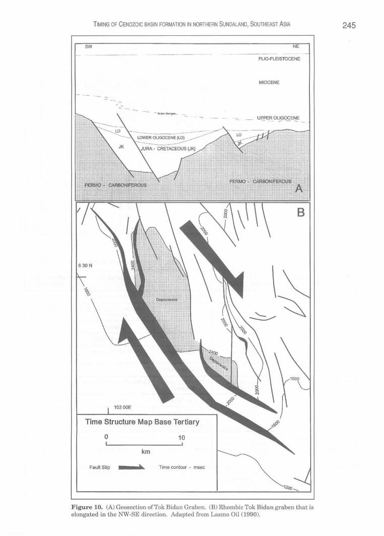
lOa) shows that the basement faults have been active since Jura-Cretaceous. The east dipping faults are relatively more active than the west dipping faults as the Permo-Carboniferous basement inclined is westward. Jura-Cretaceous sequence has sagged in the middle of the graben due to rifting or pull apart of the graben. Progressively towards Lower Oligocene, only the east dipping faults remain active. This continued activation of east dipping faults has further inclined the Permo-Carboniferous basement westward. During Lower Oligocene, the Tok Bidan Graben continues to rift or pull apart. This is shown by the sagging of Lower Oligocene sequence. An angular unconformity separated Lower Oligocene sequence from Upper Oligocene sequence. After the angular unconformity period, east dipping faults are reactivated again. No faults are seen affecting Miocene sequences. This geosection demonstrates that there is three episodes of subsidence within the graben. These episodes terminate with unconformities: Jura-Cretaceous, Early Oligocene and Late Oligocene. In other words, the formation of this graben began in Jura-Cretaceous with episodic renewal in Early Oligocene and Late
Oligocene. The rhombic Dungun Graben is situated
northwest of the Tenggol Arch. This graben has a NNW-SSE elongation (Fig. 11). This graben is at least 3 km deep and occupies an area of about 200 km2• This graben comprises regional northwestsoutheast trending faults interconnected by northsouth diagonal faults. The basement deepens towards northeast. A major NNW fault demarcate the northeast boundary of this graben. This fault reaches a length of more than 40 km with a vertical throw of 2,200 msec and a heave of 1.8 km. The southwest portion of this graben is characterised by numerous NW striking step faults and its highly faulted compared to its northeast counterpart. The NNW-SSE plunging basement high within the southwest portion of this graben suggests compression within this portion of graben (Fig. 11). Extending northwesterly from Dungun Graben are three smaller fault-bounded and sediment-filled depressions. These depressions represent the southern part of the Dungun fault: the Dungun fault is a splay from the Hinge Fault Zone. Based on these features, Tjia (1993a) has interpreted a right lateral displacement of 16 km along the northeast boundary of the Dungun Graben.
Rainey Exploration (1992) interpreted that the paleoenvironment sequences within Dungun Graben have changed progressively from lacustrine to deltaic and to fluvial sediments. The basement is probably entirely of metamorphic or crystalline origin. The oldest sequence boundary is interpreted to be 36.0 Ma (Lower Oligocene). Hence, the formation of this graben could be as early as upper Eocene.
KINEMATICS AND TIMING OF BASIN FORMATION
The three areas in northern Sundaland show distinct structural patterns: Grabens in the Strait of Malacca trend northerly; Tertiary basins in Peninsular Malaysia align to major fault zones; Grabens in west-central margin of Malay Basin have NW-SE elongation (Table 4).
Grabens in the Strait of Malacca are located in northerly regional fracture zones. These fracture zones represent N-S depressions between N-S regional highs. The Bengkalis Trough related grabens, Pematang-Balam Trough related grabens, and Asahan Arch-Kepulauan Aruah Nose related grabens are extensions of the Troughs of the Central Sumatra Basin. Tamiang-Yang Besar High related grabens are probably extension of lows within the Tamiang-Yang Besar High. If the formation of the first three graben groupings are associated with the Central Sumatra basin, then the earliest
Geol. Soc. MalaYdia, Bulletin 37
TIMING OF CENOZOIC BASIN FORMATION IN NORTHERN SUNDALAND, SOUTHEAST ASIA
PLIO-PLEISTOCENE
MIOCENE
- 'ui .. dl,f'9U- - _ UPPER OLIGOCENE ""-- ~- - -=--
630 N
10300E
Time Structure Map Base Tertiary
o 10
km
Fault Slip h Time contour - msec
Figure 10. (A) Geosection ofTok Bidan Graben. (B) Rhombic Tok Bidan graben that is elongated in the NW-SE direction. Adapted from Lasmo Oil (1990).
245

246
..........
.... .... ..•.
..•..
....... .....
.... ........
,.-"
•...... ~ ..... .
LlEW KIT KONG
l _
... "" • •••••• .r
. .......•...
..... -....... /
. ..... .....
..... /~
_ ........
.......
/,../ ,,/
z 8 in
.,f
."-----------... ......... " . ..--" .... " .... _ ...... _ ..... _ .. _._---_ ...... _-_ ...
Table 3. Major faults and Tertiary basins in Peninsular Malaysia. Major faults adapted from 'fjia (1972, 1989b) .
. ~
TERTIARY BASIN FAULT AGE BASEMENT STRUCTURAL BASIN ASSOCIA.TlON DOMAIN
Bukit Arang-Betong . ?Upper Miocene Carboniferous
Lawin ?Miocene Silurian-Ordovician! Northwest Granite
?Baubak Fault Nenering ? Silurian
Lenggong ? Ordovician-Devonian
Enggor ?Baubak Faultl Batang Padang Fault
?Upper Miocene Devonian-Permian
West Tanjung Rambutan Existence doubtful
BatuArang Kuala Lumpur- ?Upper Miocene CarboniferousnDevonian EndauFault Eocene*
Kepong ?Upper Miocene Triassic Central ?Faults parallel to
Kluang-Nyior Mersing Fault ?Upper Miocene Permian (WNW) East
Layang-Layang Upper Miocene* Granite
Ext. of Sabak Graben Related to northerly
Ext. of Angsa Graben faults of Central Upper Oligocene ** Pre-Tertiary ?West Sumatra Basin
Ext. of Port Klang Graben
Note: Age of Tertiary basin is from Stauffer (1973) and various district memoirs of Geological Survey Malaysia. * age by Ahmad MunH (1993, 1994). ** age by Wong (1991). Structural domain is after Tjia & Zaiton Harun (1985).
Geol. Soc. MaLaYJia, BuLLetin 57

TIMING OF CENOZOIC BASIN FORMATION IN NORTHERN SUNDALAND, SOUTHEAST ASIA 247
Table 4. Summary of the kinematics of Cenozoic basin formation in northern Sundaland.
REGION STRUCTURAL KINEMATICS OF COMMON PA'1TERNS FORMATION FEATURES
STRAIT Northerly grabens at E-W extension of northerly OF four northerly regional fracture initiated by
TERTIARY BASINS ARE MALACCA fractures zones right-lateral movement in FORMED WITHIN OR IN the NW -SE direction PROMIXITY WITH MAJOR
PENINSULAR Isolated basins aligned Transtensional bends FAULT ZONES
MALAYSIA to major faults within major fault zones REACTIVATION OF ZONE OF
WEST·CENTRAL NW rhombic grabens Pull apart depressions WEAKNESS
MARGIN OF parallel to prominent in the NW direction MALAY BASIN fault trends
Cenozoic structural development is the Eo-Oligocene rifting along old basement breaks ofN-NNE strike and reactivation of WNW trending regional basement arches (Heidrick and Aulia, 1993). If the Tamiang-Yang Besar High related grabens are related to North Sumatra Basin, then these depressions were developed during the Late Oligocene through Early Miocene as tensional horst and graben structures formed between reactivated dextral wrench faults (Davies, 1984).
The average horizontal spacing between these graben groupings is 150 km. If these graben groupings represent regional fracture zones, then they depict a left-stepping en echelon array. Rightlateral movement in the NW-SE direction could have caused the E-W transtension initiating these grabens. This right-lateral movement maybe caused by the relative movement between relatively stable Peninsular Malaysia and mobile Sumatra during Tertiary times. The possible dynamics is the northward progression of the Indian-Australian plate into the edge of Eurasian plate (Sundaland) during Tertiary.
Tertiary basins in Peninsular Malaysia can be linked together by the Baubak-Batang Kali-Kuala Lumpur-Endau fault zone that had experienced left lateral motion during Eocene ('fjia, 1972). If development of Tertiary basins could be used as a structural barometer during Tertiary, then this zone was the major zone of structural activity or weakness in Peninsular Malaysia during Tertiary. It is evidenced by the concentration of Tertiary basins along this zone. Though, this zone has the greatest structural activity, it only experienced minor structural adjustment along existing faults. Strata in these basins experienced mild deformation « 10°).
Sites of Tertiary basins are ?extensional bends of the Baubak-Batang Kali-Kuala Lumpur-Endau fault zones. These bends led to local subsidence.
JuLy 1995
.
Fractures within the granite could also playa role in the development of the Tertiary basins. If Kuala Lumpur-Endau fault zone and Baubak fault zone are ?active during Tertiary, then fractures in the vicinity of these fault zones could also be active. These ?active fractures would be parallel or subparallel to the fault zones. Syed Sheikh Almashoor (1989) suggested that structural accommodation within the granite after Late Triassic-Early Jurassic would be within the readymade weak linear zones. These zones are represented by pluton/pluton interfaces, the interpluton metasedimentary screens, and the batholith's interface with the metasedimentary terrain. Tertiary basins such as Layang-Layang, Enggor and Lawin are within these ready-made weak linear zones within the granite. Therefore, the orientation of the granite bodies indirectly influences the con1jguration of some Tertiary basins. Though the formation of these Tertiary basins have a common cause, each basin is discrete and requires its own stratigraphic and structural analysis. Older structures influence the configuration and development of these basins. They are developed as ?local phenomena (reactivation of major faults).
Structural elements in west-central margin of the Malay Basin trend NW to NNW. The orientation of the two grabens as well as major faults are parallel to this trend. The geometry of the two grabens is rhombic with elongation in the NW direction. This configuration suggests that these two grabens are formed as pull-apart basins. Their initiations were by right lateral wrenching in the NW-SE direction. The description ofthese grabens indicates that Cenozoic sedimentation ofTok Bidan Graben is through reactivation of old basement faults within Jura-Cretaceous sediments whereas Dungun graben is contemporaneous with the formation of Malay Basin during pre-Oligocene. 'fjia and Liew (1993) suggested that during Late

248 lIEW KIT KONG
Table 5. Alternative hypotheses for timing of Cenozoic basin formation in northern Sundaland.
SINGLE EPISODIC
AGE Strait Peninsular West-central Strait Peninsular West-centra l of Malaysia margin of of Malaysia margin of
Malacca Malay Basin Malacca Malay Basin
PLIO-PLEISTOCENE
Upper
MIOCENE Middle
Lower
Upper OLIGOCENE
Lower
EOCENE
PALEOCENE
JURA-CRETACEOUS
Oligocene, Dungun fault with Dungun graben and Ping-Teris faults with Tok Bidan Graben (Tjia, 1993b) acted as wrench-fault boundaries between tectonic domains in this part of the Malay Basin. In other words, basins/depressions in the westcentral margin ofthe Malay Basin are formed within major fractures zones.
The Cenozoic basins in this area are formed within or in proximity with major faults zones or regional fracture zones. The reactivation of major zones of weakness is the main cause of the initiation of the Cenozoic basins. The difference in geometry between basins/depressions in the Strait ofMalacca and west-central margin of the Malay Basin is attributed to the difference in pre-Tertiary basement of these two regions; the former is developed on Gondwana whereas the latter is on Cathaysia. Bentong Suture is the divider of these two preTertiary tectonic plates (Tjia, 1989a).
Peninsular Malaysia could be the buffer zone to the stresses from Malay Basin and Penyu Basin (in the east) and Sumatran Basins (in the west). Stresses from these two regions are released partially through Baubak-Batang Kali-Kuala Lumpur-Endau fault zone and Tertiary basins are formed in transtensional sites within this zone. In other words, Peninsular Malaysia can be divided into two major structural domains during Tertiary. These domains are delineated by Baubak-Batang Kali-Kuala Lumpur-Endau fault zone. Structural domain west of this zone experienced stress from Sumatran Basins whereas that east of this zone
Layang-Layang
TokBidan
Tok BidanlDungun
BatuArang ?Dungun
TokBidan
from the Malay Basin and Penyu Basin. The depth of Tertiary basins in the Strait of
Malacca (Malaysian waters) and west-central margin of the Malay Basin is of the order of 103
metres (Liew, 1993; Liew, 1994) whereas those in Peninsular Malaysia is of the order 102 metres. If subsidence rate of the Tertiary basins is a function of the movement of major fault zones, then the magnitude of fault movements in Peninsular Malaysia during Tertiary is lower than its adjacent areas. The main reason for the above inference is that regional subsidence is low, while local subsidence is mainly controlled by fault movement and basins are formed almost contemporary.
The timing of the basin formation is debatable as there is a lack of biostratigraphic markers within the oldest Tertiary sediments drilled and most of the wells did not penetrate the basement. Wells that penetrated the basements are on regional highs or basin margin and may not represent the oldest sediments in the basin. The oldest Tertiary sediments within these Cenozoic basins are believed to be ofterrestrial origin. Biostratigraphic markers recovery from these environment is very poor. As there is a lack of good biostratigraphic evidence, the author proposes two hypotheses for the timing of the Cenozoic basin formation in northern Sundaland (Table 5). The hypotheses are single event hypothesis and episodic events hypothesis.
The single event hypothesis proposes that during Cenozoic, basin formation in northern Sundaland concentrated in Eocene-early Oligocene
GeoL. Soc. MaLaYJia, BuLLetin 37

TIMING OF CENOZOIC BASIN FORMATION IN NORTHERN SUNDALAND, SOUTHEAST ASIA 249
(Table 5). The oldest Tertiary palynomorph recovered in the study area is dated as Eocene in Batu Arang basin in Peninsular Malaysia (Ahmad Munif,1993). In North Sumatra Basin, the oldest Tertiary sediment is the Tampur formation which is Eocene (Fig. 2). If the formation of Sumatran basins are genetically related to the grabens in the Strait of Malacca, then the oldest possible Tertiary sediment in the latter grabens could be Eocene. Ai?, for the Malay Basin, study by EPIC indicated the existence of older sediments than N (Lower Oligocene). The age of the reddish Jura-Cretaceous sediments in Tok Bidan Graben is based on its lithological similarity to the continental deposits in Peninsular Malaysia (Gagau Group; Rishworth, 1974). These Jura-Cretaceous sediments have not been determined biostratigraphically. They maybe Eocene terrestrial sediments. Ai?, for late Miocene palynomorph recovered from Layang-Layang, it can be argued that the older Tertiary sediment is situated deeper in the section and is not exposed. Vijayan (1990) interprets that Layang-Layang basin as a closed one comprising both Tertiary and PreTertiary sediments.
The episodic event hypothesis suggests that there are at least two major episodes of basin formation in northern Sundaland during Cenozoic; Eocene-early Oligocene and Late Miocene (Table 5). Some basins are formed during Eocene-early Oligocene (e.g. grabens in Strait of Malacca, Batu Arang Basin, Dungun Graben and Tok Bidan Graben). Most of the Tertiary basins in Peninsular Malaysia are formed during Late Miocene (Table 3). Some of these basins (e.g. Layang-Layang Basin and Tok Bidan Graben) are formed on JuraCretaceous sequences: reactivation of JuraCretaceous faults caused the initiation of these Cenozoic basins.
The author is inclined to favour the episodic events hypothesis as the model for the timing of the Cenozoic basin formation in the study area (Fig. 12). The pre-Tertiary basement in northern Sundaland experienced compression in Eocene-early Oligocene (Peninsular Malaysia, 'fjia, 1972; Malay Basin, 'fjia, 1993a; Strait of Malacca, Liew, 1994). This compression created tensional stress systems at some segments of major zones of weakness in this region. Basins/depressions in the Strait of Malacca, west-central Malay Basin, and some basins in Peninsular Malaysia are initiated by this stress system. At some places, this stress system reactivated Jura-Cretaceous faults. Thus, Cenozoic basins developed on Jura-Cretaceous sequences. Major stress reversal in Late Miocene is recorded in sediments of Malay Basin ('fjia, 1993a) and Strait ofMalacca (Wong, 1991). This Late Miocene stress system is responsible for majority of the Tertiary
JuLy 1995
basins developed in Peninsular Malaysia (e.g. Layang-Layang).
The model forwarded is only a proposal as more studies are required to determine the ages of the Cenozoic sediments and the kinematics of the formation of individual Cenozoic basin. The present biostratigraphic data as well as the known stress systems within this region supported the episodic events model for the timing of Cenozoic basin formation in northern Sundaland.
ACKNOWLEDGEMENT
The author expresses his gratitude to the managements of PETRONAS and PETRONAS Research and Scientific Services Sdn Bhd for their permission to publish this paper. This paper is part ofPRSS Project No. 123/92, "Tectonic Evolution and Hydrocarbon Prospectivity of the Malay and Penyu Basins", which is funded by Petroleum Research Fund. The unpublished information quoted in this paper is obtained from E&P Division, PETRONAS. Sincere appreciation is extended to Dr. H.D. Tjia for providing his constructive comments and advice.
REFERENCES
AHMAD MUNIF KORAINI, 1993. Tertiary palynomorphs from Batu Arang, Malaysia. Geological Society Malaysia, Annual Geological Conference 1993. Abstract of Papers.
AHMAD MUNIF KORAINI, AzMI MoHO. Y AI<ZAN AND UyOp SAID, 1994. Palynological study of outcrop samples from Layang-Layang Formation, Bandar Tenggara, Johor. Malaysia. Geological Society Malaysia, Annual Geological Conference 1994. Abstract of Papers.
CHE Azrz. ALI, AHMAd Jantan, Ibrahim Abdullah and Juhari Mat Akhir, 1994. Kehadiran paleosol di dalam jujukan sedimen kebenuaan di Nenering serta implikasi iklim kuno. Geological Society Malaysia, Annual Geological Conference 1994. Abstract of Papers.
DAVIES, P.R., 1984. Tertiary structural evolution and related hydrocarbon occurrences, North Sumatra Basin. Proceedings 13th Ann. Conv. Indonesian Petroleum Association, 19-49.
DYER, J., FINLAY, A., MoHO. GHAZALI AND WONG, D., 1991. Report on the geophysical and geolOgical re-evaluation of contract area PM I, Malacca Straits, Malaysia. Sun Malaysia Petroleum Co. (unpublished).
Foo,K.Y., 1990. Geology and mineral resources of the Taiping - Kuala Kangsar area, Perak Darul Ridzuan. Geological Survey Malaysia Map Report I, 145p.
GEOLOGICAL SURVEY OF MALAYSIA, 1985. Geological map of Peninsular Malaysia, 8th edition, 1:500,000. Kuala Lumpur, 2 sheets.
GaBBEIT, D.J. AND TJIA, H.D., 1973. Tectonic History. In: Gobbett, D.J. and Hutchison, C.S. (Eds.), Chapter 10, Geology of the Malay Peninsula West Malaysia and Singapore, New York, Wiley-Interscience, 305-334.
HEIDRICK, T.L. AND AULIA, K., 1993. A structural and tectonic

250
o km
L Mia - Latl MIHIII 01 - 011,_, LO - Lnar 011.-, ED - EDu •• JK - J.n-CntH'oat
1m,"" fIj\ ~y
East-West extension
Left lateral movement
Right lateral movement
58
LlEW KIT KONG
OJ m a z G')
Ul
~ c: ~
)., .'
6°
4·
Figure 12. Kinematics and timing of Cenozoic basin formation in northern Sundaland_ (a) Bengkalis Trough related grabens, (b) Pematang-Balam Trough related grabens (c) Asahan Arch-Kepulauan Aruah Nose related grabens and (d) Tamiang-Yang BesarHigh related grabens. Numeriall to 9 indicate locations of Tertiary basins in Peninsular Malaysia (refer to Fig. 6). Capital letters BB to L refers to major faults in Peninsular Malaysia (refer to Fig. 6).
GeoL. Soc. MaLaYJia, BuLLetin 57
TIMING OF CENOZOIC BASIN FORMATION IN NORTHERN SUNDALAND, SOUTHEAST ASIA 251 model of the coastal plains block, Central Sumatra Basin, Indonesia. Proceedings 22nd Ann. Conv. Indonesian Petroleum Association, 285-317.
HUTCHISON, C.S., 1989. Geological Evolution of South-East Asia. Oxford Monographs on Geology and Geophysics no. 13. Oxford Science Publications.
IBRAlllM ABDULLAH, JUHARI MAT AIanR, ABO. RAsID JAAPAR AND NOR AziAN HAMZAH, 1991. The Tertiary Basin in Felda Nenering, PengkalanHulu (Kerah), Perak. Warta Geologi, 17(4),181-186.
LASMO On. (MALAYSIA) LTD., 1990. North west Malay Basin Joint Study. PETRONAS-LASMO-CARIGALI Joint Study (unpublished).
LIEW, KK, 1993. Structural development of the west-central margin of the Malay Basin (basement of blocks PM2 and PM7). Geological Society Malaysia, Annual Geological Conference 1993. Abstract of Papers.
LIEW, KK, 1994. Structural patterns within the Tertiary basement of Strait of Malacca. PETRONAS Research and Scientific Services, Project 123/92, Report No. RPS-94-02. (unpublished).
LIEW, KK, in press. Structural development at the westcentral margin of the Malay Basin. Bull. Geol. Soc. Malaysia.
MAIiENoRAN, G., MUSTAFFA, KS. AND RAJ, J.K., 1991. The stratigraphy of the Batu Arang area. Geological Society Malaysia, Annual Geological Conference 1991. Abstract of Papers.
MOULDS, P.J., 1989. Development of the Bengkalis Depression, Central Sumatra and its subsequent deformation - A model for other Sumatran Grabens? Proceedings 18th Ann. Conv. Indonesian Petroleum Association, 217-245.
MURRAY, c., 1991. Review of the prospectivity of Block PM-1, Straits of Malacca, Malaysia. Sun Malaysia Petroleum Co. (unpublished).
RAINEy ExPWRATION, 1992. Seismic Stratigraphy of the Dungun Graben PM 7 (unpublished).
RisHWORlH, D.E.H., 1974. The Upper Mesozoic terrigenous Gagau Group of Peninsular Malaysia. Geol. Sur. Malaysia Special Paper 1.
SosROMDiARDJO, S.P.c., 1988. Structural analysis of the North Sumatra Basin - with emphasis on synthetic aperture radar data. Proceedings 17th Ann. Conv. Indonesian Petroleum Association, 187-209.
STAUFFER, P.H., 1973. Cenozoic. In: Gobbett, D.J. and Hutchison, C.S. (Eds.), Chapter 6, Geology of the Malay Peninsula West Malaysia and Singapore. New York. WileyInterscience, 143-176.
SYED SHEIKH ALMASHOOR, 1989. The role of Peninsular Malaysia's main range batholith in fault developments. Sains Malaysiana 18(1), 3-1i.
TEH, G.H. AND SIA, S.G., 1991. The Nenering Tertiary deposit,
Keroh, north Perak - A preliminary study. Warta Geologi, 17(20),49-58.
TEH, G.H., 1992. The Nenering Tertiary sedimentary basin, Keroh (Hulu Perak), Perak. Geological Society Malaysia, Annual Geological Conference 1992. Abstract of Papers.
TEH, G.H., 1992. Field Relationships of rock units along the Malaysia-Thai border, Nenering, Ulu Perak. Geological Society Malaysia, Annual Geological Conference 1992. Abstract of Papers.
TEH, G.H. AND RUSHDAN ABDUL LATIF, 1994. Occurrence of Tertiary deposit in the Lenggong area, Perak - its implication. Geological Society Malaysia, Annual Geological Conference 1994. Abstract of Papers.
TJIA, H.D., 1972. Strike-slip faults in West Malaysia. 24th Internatiollal Geological Congress, Montreal, Canada, Section 3 Tectonics, 255-262.
TJIA, H.D., 1973. Geomorphology. In: Gobbett, D.J. and Hutchison, C.S. (Eds.), Chapter 2, Geology of the Malay Peninsula, West Malaysia and Singapore. New York, WileyInterscience, 13-24.
TJIA, H.D., 1977. Western extension of the Kuala Lumpur fault zone. Bull. Geol. Soc. Malaysia, 8, 123-125.
TJIA, H.D., 1988. Tectonic history of the Bentong-Bengkalis Suture. Geological Society of Malaysia, Petroleum Geology Seminar 1988. Abstracts of Paper.
TJIA, H.D., 1989a. Tectonic history of the Bentong-Bengkalis Suture. Geol. Indon., 12(1), 89-111.
Tjia, H.D. 1989b. Major faults of Peninsular Malaysia on remotely sensed images. Sains Malaysiana 18(1),101-114.
TJIA, HD., 1991. Geological structures and tectonics workshop. PETRONAS PRI (unpublished).
TJIA, H.D., 1993a. Inversion tectonics in the Malay Basin: Evidence and timing of events. PETRONASResearchand Scientific Services, Project 123/92, Report No. RPS-93-04.
TJIA, H.D., 1993b. Northerly striking regional faults of Terengganu. PETRONAS Research and Scientific Services, Project 123/92, Report No. RPS-93-0S. (unpublished).
TJIA, H.D. AND ZAITON HARUN, 1985. Regional structures of Peninsular Malaysia. Sains Malaysiana, 14(1), 95-107.
TJIA, H.D. AND LIEw, KK, 1993. Changes in tectonic stress field in the northern Sunda Shelf basins. PETRONAS Research and Scientific Services, Project 123/92, Report No. RPS-93-06 (unpublished).
VIJAYAN, V.R., 1990. Gravity survey of the Layang-Layang Tertiary Basin in Johor, Peninsular Malaysia - A preliminary report. Bull. Geol. Soc. Malaysia, 26, 55-70.
WONG, D., 1990. Hydrocarbon potential of PM-IS grabens (overview). Sun Malaysia Petroleum Co. (unpublished).
WONG, D., 1991. Review of the prospectivity of PSC block PM-IS (Post Port Klang-I), Strait of Malacca. Sun Malaysia Petroleum Co. (unpublished).
---------.~.-~~.-.--------
Manuscript received 10 October 1994
JuLy 1995