,t,i I Envi,onm nt I Speci i,t,.lnc. - i,t,.lnc. 3-::2. plasi
18
PL./JSKA POf£R AlJ'T'l-m I1Y SUSITNA HYDROELEClRIC PROJ E CT ENVIR<N-£NTAL STUDIES WRiAL SlIBTASK 7 III WI LDLI FE ·E COLOGY- BIG 6N'£ I1'PACT ASSEsst-'ENT AND MITI GATI ON PING r II ,t,i I E nvi,onm nt I Speci i,t,.lnc. 3-::2.
Transcript of ,t,i I Envi,onm nt I Speci i,t,.lnc. - i,t,.lnc. 3-::2. plasi
PL./JSKA POf£R AlJ'T'l-m I1YSUSITNA HYDROELEClRIC PROJECT
ENVIR<N-£NTAL STUDIES~S WRiAL
SlIBTASK 7IIIWILDLIFE ·ECOLOGY-
BIG 6N'£ I1'PACT ASSEsst-'ENTAND MITIGATION PING
r II ,t,i IEnvi,onm nt I
Speci i,t,.lnc.
3-::2.
PLASI<A PQr£R AtmmITYSUSITNA HYI:ROELECTRIC PROJECT
eNIRCD£NfAL STUDIES~ES~LIAL
SlIBTASK 7.11WILDUFE .EOJU:X;Y-
BIG GNo£ Ir-PACT ASSESserrAND MITIGATI ON PLANNING
SUbmitted by
Terrestrial Env1rorlllEntal Spec1al1sts, Inc.
to
Acres AnErican, Inc.
~ /-, ~-...- <~ ,
Group Leader (TES)
July 1980
Copy No . [],---"--
.'
This procedures manual is a controlled document. Each copy fsnumbered and fssued fn trust to an fndfvfdual whose name fsrecorded on a dfstribution log mafntafned by TerrestrfalEnvfronmental Specfalists. Inc•• fn Phoenf x. Ne~ York. Amendmentsto this document , as they are fssued, wfll be sent to theauthorized holder of each copy. Upon completfon of the project(or by December 31, 1982) all copies of the manual are to bereturned to Terrestrfal Envfronmental Specfalfsts. Inc.
I.
Table of Contents
IMPM:T ASSESSMENT
MITIGATICN PLAN
II. TECHNICAL PR:x::EDURES
IMPACI' ASSESSMENl'
Upper susitna Basin
~ctsts •
Borrow AreasTransmission Line and Access EbadsHlI'lIall Activity
Wirect ~cts • •Den Site DlsturbanceAlteration of lttlose Habitat •Alteratioo of Caril:x:>u fobvement Patterns •
Ilt'paets on Comtunitr Dynanicslttlose-Hahitat Dynamics •••Predator-Prey Dynamics
tower susitna Basin
MITIGATIOO PLANGeneral ~ch • • . . • • • • • • • • • • .Identification and Classification of ImpactsAnalysis of Mitigation Alternatives
Avoidable ImpactsUnavoidable Impacts •Rea:mnendations
III. DI\TA PR:x::EOORES •
122555
6677
788
8
99
1010101010
11
IV.
v.VI.
QUALIT'! ccmroL •
PEES:HlEL •
11
11
13

Lis t of Figures
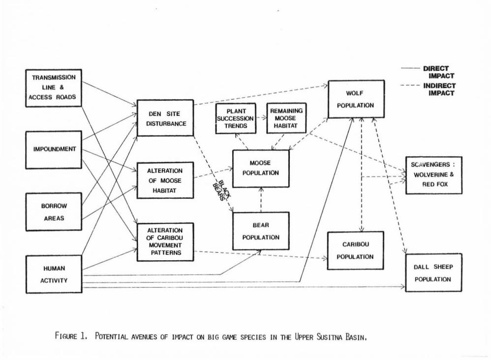
Figure 1. Potential avenues of inpaet ce big game soecfes in the tJP.:lerSusl tna Basin.
Figure 2. Big qarTe inpaet assessment om mitigation plan ~tiooschedule.
I . INl'lOJOCTICN
One of the rlDse inpxtant aspects of the Susitna HydroelectricStudies is the assessment of likely inpacts ce big game species thatcurrently use pxticns of the Susitna drainage. Big garre animals arevery iJrportant to the Alaskan lifestyle and economy. '!bey provide foodfor Ran}' state residents, supp:xt a aJrlSid.!rable srxxt tunting economy,am are an Inteqral Wllp:>()ellt in the ability of the state to attracttourists. These factors are maqni.fied 00. this proj"!!Ct dJe to thelocatioo of the Susitna. area between Fairbanks 1M Anchorage, thep:::IpU1ation centers of the atace ,
~ general cbjective of this assessment is to predict the natureard maqnitude of itrpacts that the pcCl£XlSed Susitna Project may have enseven big game species. 1he species to be mnsidered are; rroose(Alces atceej , caribou (Rangifer tarandus ), t.i.r.ber \oQlf (Cani s .!!:!2::!.),b~r toescs americanus). brOWI'V'qrizzly bear (Orsus ereece},..,lverine (GiiIO~). ana Dall sheep (Ovi s dalli).-e.iai of thesespecies will----si' considered in the analySI$of the ...,stream study area,wnic:h is defined as that PJrtioo of the Sus! tria Basin upstrean fran thepcop:JSed Devils Canycn dam. Inomstream fran the Devils canycn dam thetyp! of inpact will be considerably different . Here, oonsiderationswill focus Q1 p::ISSible irrpacts 00 noose wintering areas along the riverto awroxirnately the Delta Islands.
MITlGATICN PU\N
Following the preparation of an inp3.ct assessment, a detailedmitigatioo plan will be prepared. DJring Phase I (pre-licenseapplication) this plan will a>nsist pdmarily of an analysis and~riscn of feasible mitigatioo alternatives. Reo:Jnmendations willbe rtBde concerning the best approach to mitiaatioo includinq the typeof mitigatim to be lUldertaken, the lard area to be used , a.n:J the typeof research to be oonducted during Phase II (post-license application) .Phase II research will focus up:n informatioo needed prior to actualinplementation of the plan.
II • TIX:llNlCAL PID:E1XlRES
_ big garre ~ct assessment will be basel Ol data collecte:l bythe lUaska DepartJnent of Fish and Game (ADFtrG), Acres subcontractors,TES subcontractors, wildlife rteeeaeare, ard the experience of theauthor w other consultants. Details concerning the a:>llection of thedata to be used can be found in the specific plans of study arrl/orptcxedures manuals for ADF&G Bi g Game Studies, Plant Ecology smdtes ,Furbearer Ecology Studies, Hydrology, and Design Developnent .
l.'g?er Susi tna Basin
In oroer to determine the ~ct of the Susitna Project Ol biggame species in the tJwer Susitna Basin (at:ove Devils canyon), it willfirst be necessary to identify the habitat/species relationships thatare operative, predict ~cts 00 O::XifX)uents of the system, ard then
predict what changes impacts 00 system oorrponents will have 00 theentire system. Figure t was prepared to illustrate the rrajcrconponents o f the system am the ITOst likely pathways of impact thatcould occur throughout the system.
The following discussion is based on Figure 1 and i s elivided intosections concerning d irect irrpacts , indirect. impacts, arrl impacts 00
a:mnuni.~ dynamics. 'Ihe discussion of impacts en rornnuni ty dynamicss\J'lI1'Iarizes the flew of direct. arrl irXIirect impacts througoout thetX:IlUpOi ienes of the habi tat /big qame oormuniey,
Direct Inpaets
Direct inpacts nay originate from the following four WlI\XlClents ofthe project: the i.Irp:>urdnents, the bonow areas , the transnissioo lineand access roads , and increased hllMn activity assocdated with theconstruetioo and operatioo of the facility. As i llustrated in Figure 1,cee ce rrore of these four aspects of the project may directly tseecenoose habitat , den sites , bear popcretfons, wolf t:Opulation."" D311 sheepp:>pulations, and caribou novetent; patterns . This is rot to int>ly thatan illustrated iJrpaet will necessarily occur, rcr does it i nfer theextent (1[' ultimate inportanee of a specific line o f ~ct. Figuresimply identifies, foe consideration, potential ~~enues of impact .
~ts
The creation of a..o large iJrpoundments will result in theeliminatioo of a presently unkn:7wn quantity o f key wintering habitat forTRX:l5e . This is especially true in respect to the watana i.Jtp)undmentwhich will inundate a l arge area includirg a portfcn of the Watana Creekdrainage, an area which has already teen identified as a key winteringarea for moose,
'Itle elimination o f noose wintering habitat will probably be therrost i rrp:lrtant big gan-e ini'aet associated wi th the project. Figure 1,shows that many components of the system can be affected by dlanges inthe noose pop.llation. In turn, the factor rrost likely to affect thenoose p:>pJlation is an alteration of habitat. Fortunately this aspectof the project will be the easiest to quantify am thus theidentification of direct Irrpact; Q'l IIOOse habitat will be quitereliable.
The determination of i.ntlact en noose habitat will be based cn thefollowing information: 1) the locaticn of key winterirq areas for moose ,(data SUWlied by ADF&G) ; 2) the distribution, acreage, and condition ofkey plant conmmity types (data SUWliErl by Subtask 7 .12); and 3) theextent of inlJl"rlation (data supplied by Acres). The vegetationassessment (Subtask 7. 12), in a::njuncticn with a delineaticn of thei.mpourrlnent 2XXle , will enable the de termination of h::lw nudl ITOOsehabitat will be eliminated. Not all of the habitat out linErl by thevegetation assessment; may necessarily be available to noose , due tofactors such as SIlOoi dep th . Therefore, aerial survey data from ADFfrG ,as well as snc:KoI course data from R&M., ...,ill be factored in to define ....natl-Ortim o f eadl plant romrunity is actually available am used bynoose,
2
..." IL- ....
SC VENGEAS :
WOLVEAINE &
AED FOX
-- D RECTI ~CT
- - - - INDIRECTI PACT
...
DAL L SHEEP
POPU ATiON
I ...II \ .....
I ' _ =~\_ - -)\,
\\,,
\\,
\,CARIBOU ,
"..' -------,
WOL
POPULATION
POPU ATiON
---------------------- - - ~---'""II
DEN SITE PLANT A MAININGSUCCESSION -, MOOSE -
DISTUABANCE '"TAENDS HABITAT '"'"'"1\ / '" ..I
,'"\ , I
'"\ ' .\
\\ MOOSE
\ ..ALTEA ATION ) - - - POPULATION--- \OF MOOSE
~~HABITAT ~\!1
~t\
B AAALTEAATIONOF CAAIBOU PO U ATION
MOVEMENTPATTEANS - - - - -
1- - - - - - - - - - -- - - - - - - - - -- - ----
HUMAN
ACTIVITY
BO AOW
AAEAS
IMPOUN MENT
TRANS ISSION
LINE &
CCESS AOADS
FIG E 1. POTHlTlAL AVENUES OF IMPACT ~ BIG GJVw£ SPEC IES IN TI Upp R SuSITNA BASIN.
4
A secc:n:t type of i.q)act that could result fran the crea.tioo of thetwo iJrpoun:inents is the inundatioo of den sitesw This is especiallyi.Jrp::lrtant in regard to wolf dens, which are o f ten used year after yearand the loss of ...nich nay result in aban:Dllmeut of an establishedterritory by a pack . Since many wolf dens are created by enlarqingexisting red fox dens, it will be inportant to also CDClSider thee liminatim of exist.i.n3' fox dens, or suitable fox dennil'll areas, whichcould represent future s:>urces o f rew denning VRXJt"tuni t ies for WJlves.
'!he inpIet of i nurxlatiO"1 O'l 1001£ dens will be determined by ma~ing
the location of krown ''''I f dens. as determined I'f tadio telemetry (I'fADF&G), in relat100 to the projected i.Jrt:ourdnent zone. Likewise , mapsof existing red fo x dens, as well as suitable areas for denning, will bemawed to determine the relative loss of potential denningopportunities .
'l1lere is also the p>ssibility of ~cti"9' sui table bear denningareas . Altrough bears are oot as limited as wolves as to availabilityof suitable den sites, certain types of areas may be pr-eferred, 01::" required,and loss of sum areas could cause a subsequent ~c::t to occur. Since ITOStbrown,Igrizzly bears den at altitudes higher than the proposed iJrpoun:inent .i t is unl ikely their densities will be affected I'f this aspect. of theproject. Black bears, Q"l the other hand, may use areas within thei.Jrt:ourdnent zone fIX denning and therefore are more l ikely to be affected.Data fran tadio-=llared bears will be used I'f JlDF&G to establish locationsof dens durirq the winter of 1980-81 and 1981-82. 'nIis. in carbination wi thIiterature m blade bear deminq characteristics, veqetation naps an:!t::opogLaptic maps, will serve as the tool for predietin; ~c:t m thisi.Jrpxtant aspect of black tear erology.
Ore of the rost controversial questions associated with theSusitna Project concerns the p:>ssible distUPtioo of miqratioo p!ltternsof the Nelch.i.na cariOOu herd. 'l11e 1JR)er: reaches o f the WatanaiJrpoun:inent may intersect a route which is rep::7L'ted to be ~tlyused for rrovement to am fran a calvi.n; eree eouth of the SusitnaRiver in the vicinity of Kosi na Creek . Several qJestioos rrust beanswered before a pred ictim can be made concernin:] the impact m carib:::MJnovements.
The key problem concerns difficultles in predicting ceetecubehavior. It is anticipated that through aerial surveys and tadiotelemetry data, ACF&G "'ill d:xunE!'1t the current I'l'DVE!mer'l.t p!ltt erns of theNelc:hina herd and SUFPlement that data with historical information.fbwever, it will be very difficult to ~ict fublre novem:nt p:!tterns .caritxu behavior is a little understood pheruuen::X1 am ant predictionwill have to be t:erpered with 4¥Lopriate qJa1ifications.
Followin; the determinatim of current miqratim routes, thecritical aspect of the ca.r1t:ou pttblem is the cendition of thei.Jrt:ourdnent at the tiJre of the year when they _ at_ to cross i t .It is possible that the predicted winter drawd>wn _ create a>nditionssuch as i~lving' , II'U3 banks, or nu:3 banks covered ",ith extensiveblocks of ice of various th iclmesses. Factoring in SlJd\ variabl es asbank topography and timing o f migration. it will f irst be necessary todetetmine ..nat types of a>nditions the caribou will face if they a>ntinueto cross the Susitna in the i.Jrt:ourdnent zone. 'nIis information will be
5
provided by _es and R&M. 'ft1en the ""re speculative task o f predictingthe t::ehavioral respc:nse of caribou to those ccnditicns I!USt be dealtwith. Althc>ugh SOlI! researd> has been cXlne ooncernirq caribou responseto the Trans-Alaska Pipeline, it rray ro t apply to the oonditions in thiscase.
In surrnary of the caribou~lem, sufficient data will be avail ableto describe the current situation. Data should be avai l abl e fran theengineering and hydrology discipl ines to enabl e a prediction ofani! tions that caribou face i f they are still C'rOss~ the Sus! tee Riverin the 2O"Ie of the pcqosed iJrpJurdnents. A EX"f!dietion of c:arioouresp:>nse to these oonditions will be speculative but will be base:! on allavailable literature and scientific opinion.
'!be use of certain n:n-iJrpJurdnent lard for the acq.1is itioo of=tnletim materials (borrow areas ) will result in dlsbJrbance andel1Jll1nation of SOlI! big game habitat. 'nle two likely~ of tx>r=wareas are furthet' e11l:d.natim of rroose habitat, and p::$Sible disturbanceof den sites for ..,1vee and bears. 'nle same awroacll to identifyingthese bO areas of inpaet will be followed as previously dfscussed foriJrpJurdnent-related 1Jrpaets.
Transtdssion Line and Access !b3ds
I t is ontid pated that the II'OSt l1k'dy !Jrpaet o f the omstructionand operaticn of the transmissicn line and access roads will be m thedist.urbance of den sites a"ld alteratioo of CBrirou novement patterns.
In this case, i t is lOOn! likely that disturbance of den sites willresult fran the peeeeoce and use of the transnission line an1 road,rather than habitat rerroval as would 0CC\:r in the case of theiJrpJurdnents and tx>r=w areas. 'nle procedure to be used in predictingillpaet in this case will eeeetse of f irst CDIpllrirq the locatim of theline and road in relationship tD Jcrcwn \oOlf dens ad territories, aswell as areas determined to be suitable for bear denning. SCientificliterature and the experience of researchers in similiar situationswill then be used in order to generate a predictioo CXlr'lcernirg 11lcelyillpaets.
The prediction of inpaet 00 caribou rtDVement is aloo differentthan that discussed in regard to the iJrpJurdnents. Al thc>ugh the~lern of JXedicting caribJu tehavior remains the sane, thetransnissioo lire and access road represeee unnatural structures to thecaribou. 'l'herefexe, experience gained through research lJnd ~leproblems al ong the Trans-Alaska Pipeline may prove of use in this ease,Again, data provided by Hlf'&G concerning caribou misratioo routes an::icalving areas will be mapped in relatiat to the access road andtransmission line routes.
HlAm Activi tv
Predi cti rq the illpact o f inc:r1!ased Iunan activity on big gamespecies will prOO!b l y be the IlDSt Slbj eetive portion o f the bi g gameinpact assessment. Although Slfficient data will exist to E!'Iable
6
~ri~ areas of various deqrees of hunan activity to key behavioraland habitat parameters of the big game p:lpJlations, it will bediffie:ult ec project behavioral resp:lnSeS with the sane deqree ofaccuracy as with s:me other inpaets. Hunan activity will include bothconstructfm an1 operatl00 activities, includin} the presence of peoplearound ~, construction sites, traffic Q"I the access roads. and allair traffic associated with the project.
'!he iJopact analysis will CDIlSider the direct iIrpact of Iunanactivities Q"I den sites, carit:oJ rrovement. patterns, wolf ~p.l1ations.
bear p:JpJlatlons, and Dall sheep PJPUlations. 'l'his will bea~lished by maWi"'l loci of hunan act1vi ty anl ronki"'l then inorder of intensity and d1ration. '!'his will then illustrate thejuxtap)Sltim of various levels of activity to carll:nJ migrationroutes, \I\OU dens, key bear foraging areas, etc. As a result i t willbe p;JSSible to determine, ce a relative basis, where am in regard towhich species, the inpact of tunan activity is ITDSt likely to exxur ..As in sare othec areas of ccncern, informaticn gatherm durin;l theconstructioo and operation of the Trans-Alaska Pipeline will beCXlnSU1te:i ard may prove useful in predicting behavioral responses tothis aspect of the project.
'l1\e Susitna Project may result in an inc:reased utilization of thelJR>er Basin by sport hunters. n... extent of change will depenl to alarge extent Ql whether or rot the access road is opened to the p.1hlic.n... big gam! inpact assessnent will consider thh potential change anlproject ..nat effect it will have 00 big game p:lp.Ilations. Althoughthis aspect of the project ceuld have a significant effect. the iJItlactcan be ndtigated, if deemed necessary, by altering the game regulations.
Indirect Inpacts
Following the determination of direct p:ojeet iJTpacts 01 densites, rrcose habitat, caribou rrovement patterns, "'01£, bear am sheeppopJlations, the pc.......:ess will be carried me step further to determineindirect iJrpacts. As illustrated 00 Figure 1, there is sore overlapwhere roth direct and indirect inpacts may be operative. '!be followingdisc:ussl00 ccecerre the pri..Jre avenues of indirect iqJact including~ of den site disturbance at \1«)1£ aOO bear p::>pJlations, impact ofmoose habitat alterat!m 0'\ lTOOge \,Xlpllations, arrl f.rrt:Iaet of alterationof caribou lI'DVement patterns 0"1 cardbou IX'PUlations.
Den Site Disturbance
'l1'1e disturbance of den sites through either increased tumanactivity, inundation, Ol' I::orrcw areas, CXIU1d result in changes in thepop.Ilatioo of ""Olves and bears. Currently used df dens .n:I beardenning areas, particularly those of black bears, will be mapped andCXltpared to areas to be inundated and centers of tunan activity.
n... deqree to whidl wolf anl bear pop.1lations may change as aresult of den disturbance will be difficult to determine. It willdepend to a great dP.gree a1 the availability of alternative dem CIt'areas SJitable for deMing. It is anticipated that sufficient data.nll be gathered t1' AOF<G o:>ncerni"'l the physical characteristics ofden sites, asscciated territories, and foraging areas to ~iet therelative extent of irrpact a1 wolf packs ard blade. bears.
7
Alteratim of l'i:lOSe Habitat
1lle nost irrpxtant aspect of al tering I"OOSe habitat will be thereductiCl1 of key winterirg areas. '!his , in bJm, could cause adecrease in the rrcose ['op"lation in l'l'UCh of the Opper Susi tna. Basin.DJri.ng Phase I it will be pcsst bte to de termine the relative percentageof rroose winter habitat that will be lost. Phase II st udi es willi nclude a detai led analysis of b''''''''' quantity an'! qual i ty an'! >rillthus enable a refinement of the net loss of II"OOse winter habitat .
In a general manner, as previously described, i t will be p:>ssibl eto predict the extent of rmuctioo in the capacity o f the habitat toSlJR.X)rt IT'OOse pJpJ1ations in winter. '1b aca:xrplish this wi11 entaila:rrpari nq not cnly the area of habitat loss, but also i ts relative useto various subpopulations of nccse, PopJ.laticn data will be collectedby ltDF&G in the form of aerial surveys and radio telemetry studies .!he mapping an'! quantificatioo of populatioo an'! hab itat data >rillenable the identi f i ca t ion of those subpop.l1ations ""ich >rill be1rrpacted, am the degree of ~ct. ntis will be expressed as nlmtlerof II'OOse that can be supported, as wel l as the availabil ity ofalternative wintering areas.
Alteration of caerecu !'t:Nenent Patterns
'lhe iJrpact Ql p::lp1lations of alteri.n:J rrovenent patterns of caribouwill be rrore difficult to assess than the inpct. of habitat alterationa1 ecoee p:>p.J1ations because the fcmner W irect !Jrpaet can take therom of ei ther a dlange In caribou utilizatioo of the Upper 5usitnaBasi n, ce a change in the total. herd s ize , ()[' a CDl'binatim of both.!he assessment of the caribou Inpacts >rill be based 00 aerial surveysam radio telemetry data whim will identi fy current miqratl00 routes,the ti.m1ng o f trDVenents, and habitat needs . 'nlese data will be nB(4)edin CDtpariSQ"l to project aspects 9JCh as i.rrp:lunanent b:lun:!aries, accessroads , transmission lines, an:! centers of Iunan activity. A Ia!y factorin determining the extent of iJrpaet 00 caribJu EJ)ptJlationg will be thedescription of ice and water conditions at likely crossing potnes, Theultimate predictioo of iJlt>act 00 tl>e Nelchina herd >riil have eo besubjective, but will utilize all available data, literature , endscientific opinion.
Impacts on CCmnunity llyM1Iics
TIle bi g game CXlmIUI1i ty In the Upper 5usitna Basin is a dynamicsystem. Species are a>nStantly interacting with habitat CUlpo..'lef1ts andother species . As a result, any 1Dpact, either direct CX' indirect asi llustrat ed on Figure 1, rray affect 9:m! a: all e:tXJPOIlellts of the system.Therefore, the final irrpact analysis will attenpt , by using the peeviously described direct an'! in:Iirect iJlt>act predicticrs as tools. todescribo the lOtal dlange In the big game CXlmIUI1ity that >rill take ptaceas a resl1t of the Sus itna Project. '!!lis >riil require a thorough consideratien of Ia!y CXlmIUI1ity relationships. FigJte 1 _ that the relationshi pbetween lJ'OOSe p:>p.J1ations an:j rroose habitat is critical to the entiresystem. LUtewise the p:edator-prey dynamics invol vinq bears, dyes ,eccse, and carit:oJ are o f parmrount irtp:lrtance. '!he follo.linq is a generaldescript ion o f I"cw these factors will be analyzed. A detailed di scussionis rot included at this time since many specifics of the approach >rillrequire s::me baseline data before teetvUques can be selected.
8
/ltX)Se-f\a.b i tat Dynami.cs
Any .u ter a t i on of noose habitat will result in sane level of ~ct00 the Susitna eooee pop.l1ation. This , in turn. will alter thei nterrela tionship becween the noose fDP,latioo. and the remainingavailabl e habitat . As stated previously, sufficient data will begathered fran t."1e vegetatioo anal ysi s and eccse p:JpJlation studies todeteDl1i ne the arrount of winter habitat retoved an::! the aroount remaining .I t can be assuned that additi onal browsing pressure will then be ~lied
'oJ the ITClOSe 0'1 the re!Qaining habitat . It will therefore t:e necessary t>determine h:w I!IJch txowsing pcessure the remaining habi tat can 9.JPPOrt. .ntis will toe dare usi rg data Q'1 the ITIJOSe pop.l1aticn, the qeneral anounto f habitat remaining , the plant successional treros that are operative,and the current ccn :Utim of eecese in the rema i nirq area .
Predator-Prey Dynamics
The final analysis . based ~ ~1 [XeCeding ccestoeeactoes , willassess the p:lssible alter a tioo of predator -prey dynlmics in the t.lpperSus! tria Bas in. the key ~tor-prey relationship is be t 'oo'eeO eccse andsotves, with caerecc and eej vee bei.rJ1 a se<."l::lOOary rel ati onship. Bearptedation Q"l rn:::ose calves will arsc be consi dered in the analysis .
As illustrated in Figure 1, the relationship be tweEn rrost predatorand ~ species is a boO-way relati a'lShip. 'this is especially t:rue it.regard to \oQlves preyin;J 01 eccse, caribou, and sheep. 'nle abundance c fall ex arTY of these prey specfes will affect the r'l.JTber of Io01ves that.t.he area can StJRX)rt . Likewise t.he nUTt:er o f sctves in an a rea can,under certain clronstanees , affect the density o f Ole 0[' all of ~prey species . ~refore, arrt c:hanqe in e it.her IoOlf nLm'bers ()[' preyrurbers as a result o f the ~ject can result in a shift in ~ticn
pressure am subsequent changes in t.he nUTt:lers of o ther species . Byusing data an:erning dir ect Md indirect iJrpacts as {X'ev iousl ydiscussed , especially i..rrpacts Ol eccse, an analysis will be ccn:hJcted eedetermine p;JSSible ramifications to the big C}3lTle ~tor-prey system.
Lower Susi tna Basin
'l1le big game i.rrpact eesese-eoe oonceminq the area d>wnstream frcrnthe Devils Canycn darn to the Delta Islands will be di rected atdetermi ning what ef f ect an al terati on of flow regimes will have :nmoose habitat an::I subsequently Ol nccse pop..J.1ations that wi nter alongthe lower Susitna . The major avenue o f inpact that could occur in t!"!edownstrean area is a change o f moose habitat resultirq fran both annualand lonq- term chanqes in the flow regi.tre of the rivee , Data fran, avariety o f studies will be required to assess the iJrpaets m eccee,
I t is currently fel t that J'l[X)5e nove into the riparian x:ne alongthe lower Sus itna. duriBJ the winter an::J feed m browse species 00islards 5ld the flood plain imnediately ad jacent to the rtver , 'Ibdetermine the extent of USII!t by ecose, ,tl)fl.G wi ll conduct aerial surveysduring the winter tralths e also l'ICI"litor radio-collared lTD05e yearround. This will enable the identi ficatim of key wi nte rin:; areasalong the river , as well as determine the extent o f p::>ssible i.npct OllOOOSi@ eee a cc..uiderable d i s tance m roth sides of the river .
9
Both ADF5G and ns subcontra<:tms will assess the general statusof eecse trowse along the river during Phase I. A more detai led l:t:vo.sestudy, inclOOing data en quantity, quality, availability, andutilizatien will t:e porfot"el Wring Phase II . 'lhe Phase I data willenable a general assessnent of the quality of I'llCOSe habitat and, inCJ:XTt)ination with eccse J;XJPJlation data, allow fOr the identification ofcdtical winteri~ areas.
'Ib utilize this information in a I,redictive fashioo, Phase Istudies to be conducted by 'I'&S subcontractors will attempt to gain anunderstarding of plant succession trends along the river. Since it islikely that the key factor affecting the SUC'C'eSSl00 ptocess is periodicflooding, the validity of the mtire~ assessment will depend enpredicting chang'" in the hydrology of the lower Susitna. A descrtptien of likely changes in river hydrology an! resulting dlanges inriver lID"h,logy will t:e provided by R&Il. By understandirq both annualand long-tetlll hydrologic porameters i t will be !'JSSlble '" generate apredictlen of _ the riparian areas and tlus plant successien trendsmay t:e altered by the Susitna Project. 'lhese factors directlyinfluence rroose {X)p.J1ations over a very larr:Je area alan; the lowerSusitna Valley.
HITIGATIrn PLAN
General Approach
The mitigation plan will be based en the i.npact assessment aspreviously describP.d. An attent't will be rrade to develop a mitigationplan taking into oonsideratioo rot atly species-specific iJ'rpacts wta100 the iJrtlacts Q1 camunity relationships.
'Ib assure that all mit igation alternatives ace thoroughlyconsidered and developed, a mitigatien team wia t:e created. 'lhefollowing ,.,,; personnel or: subcontractors will ~se the """kingcere of tre mitigatioo team. Mr. Edward T. F.eed (T&S), WildlifeEcology Group Leader, will functioo as team CDOrdinator. Mr . Reedwill work closely with !'tr. JosePl H. McMullen (TES), Plant EcologyGroup Lea.c"er, Mr. William Collins, plant ECology Invp-stigator(University of Alaska), and ttl! big garre expert wOO will perform thei.rrpaet assessment. In ad::Ution, it is suggested that at least merepresentative fran ttl! followil'J1 organizations serve a1. the mitigationteam: Alaska Power Authority, Acres J''Il'lerican, Inc., Alaska ~rtmentof Pish and Game, United States Fish and Wildlife Service, UnitedStates Bureau of Land Management, ~ Cook Inlet Region IOCX)rpxated.
P'bSt of the plaMing ard develophent 'aOrX associated with thistask will be perfonned by the cere meftt)ers of the team. Prior to thecxxrmencenent of actual planning, i np.Jt will be solicited f'[(Jfl otherteam me!tbers in cxder to c:onpile specific a::ncerns, opinions,suggestions, am philosophies. It is anticipated that a series ofprogress meetings will be held througlx>ut the mltigatien planningprocess in order to brief tean men'bers Q'l the status of the effort andto peesent qp:xtunlties for discussion and gro~ decision makingconcernin:J key issues and problems .
10
Identification and Classification o f Impacts
'!be first step in the preparation of a miti .;ation plan will be athorough review- of the inpact analysis. DJrirJ; chis review, i.JTt:lactswill be grouped into oo catcpries: iJrpaets that nay be avoided orminimized by alteratioo of project design an::! operation, andunavoidable iJrpacts. In each case information identifying the natureof the irrpact, species, am land area involved will be analyzed. Thena list of feasible mitigaticn alternatives will be developed andanalyzed.
Analysis of Mitigation Alternatives
Avoidable Impacts
Detailed consideration will be given to means of avoiding inpacts.DependiD; a1 the natarre of the iJrpact, a va rie ty of actions can bereo:mnended. Aspects of the Susitna Project that will be CDnsideredinclude. but are oot limited to: extent of the imp:>Ul"dnent zone,alteration of cbwnstream flow regimes, location of access reeds andtransnissim line, am timing of certain co,"1Structicn and operatiooactivities. 'lhe analysis of sacn alternatives will require input franAcres engineers.
Una\lOidable Impacts
This IXX'tion of the effort will consider miti~tion alternativesthat could be inplemented to ~te for: unavoidable impacts Q"\ biggame p:Jp.1lations. Again the inpaet assessment will provide rrost of thedata necessary to aCOJlTPlish this analysis. The ultimate goal of thiseffort will be to develop a big game managanent proqram that willeither allcw for the maintenance o f existirg pop.liations or theenhancenent of other (XJpJlations to the extent necessary to of f setproject-related losses.
The analysis will consist of three eajor Piirts: management optionsthat can be irrplemented, availability of suitable land areas and thelegal feasibility o f executing management options , an::1 finally, theprojected cost of i rrpl ementiDl the mitigatioo plan.
One qJestion to be answered is whether or: rot there is sufficientland of a suitable nature available within the l1ppe:r Susitna Basin tomanage for increased big game iX>PUraEIons. If rot, it Wlll benecessary to identify al ternative areas where pop..1lations can beenhanced through management practices. This will require aninvestigatiQ'l of ooth present habi tat o:IOlHtions, game 1X'p.1lations,land cwne:rship, · and associated regulations 90verning the use of sumland.
Reo:mnerrlations
The end product o f the Phase I mi tigation plaMing will be area::mnended plan of mitigation. This will probably be a general
11
plan outlin1rg the rost pronislng managBnellt optlons, the best landarea to be used, and an estimate of mitigation CDSts. It is lnl ikely,due to the lalg-term stlXlies beil'¥3 conducted by ADF&G, that sufficientdata will be available prior to license ~lication to develop a planthat can be executed. '1be cecu:lIlended plan will require refinement asadditlonal data are recefved, '!his is especially true ccncerningdetailed m::JOSe habitat data, whim is a Phase II effort. Included i nthe Phase I effor:t will also be reo:::unendatioos identifying additionalreseardl that will have '" be CXX'ducted in order eo fine tune themitigation plan '" the point where the maxinun benefit will be realizedfrolI its 1Jlplernentation.
III. CA:rA PfO: El UR&S
'!here will not be arrt data collected d irectly by investi9atorswocldng on the bi9 ...... 1Jlpact assessnent and mitigation plan. Alldata USEd in this assessment will be provided by ADF&G, Acres, Acressubcontractors, an::! TES subcontractors.
IV. <;Ul\LI'lY cama.
T&S will depend on cpality contzol procedures "",lemented by theeetreeeces of data to be used in the big gartI! assessment. 'the actualorganization of data required to produce an iJrpact assessment will bebased to a great degree at the professional opinioo ard philosophy ofthe 1Jlpaet investigators. To assure that the 1Jlpact eseesereoe isthot'OU)h and has adequately addressed all i ssues and incorporated allfeasible oontingencies, several experts outside of the ~ject teamwill be contacted ani asked to review am oomnent ce the i.tTpactassessment and mitigation plan. This will allow for the review of allpractical aspects of the situation and will avoid the possible problenof oonfining the assessnent entirely to the expertise and ~inioo ofone ex eo Wividuals .
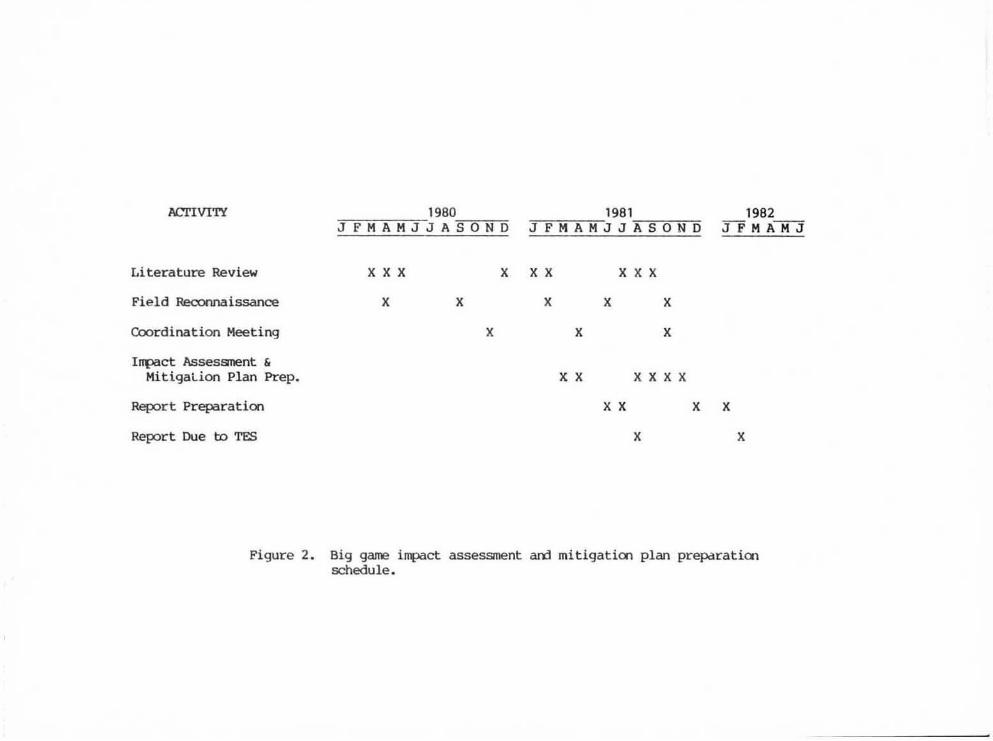
v, =_ bi9 .,."... 1Jlpaet assessment am miti9ation planning will be a
continual ptOCeSS through>ut Phase I. Since many aspects of theanalysis are dependent 00 receipt of data fran other sources, therewill be an uneven distributiat of time spent at these effort.s. sanefield time will be expended '" 9ain an in-depth familiarity with marrtaspects of the species and habitat CDili(XJllents. 'Ibis will be necessaryto place data i nto perspective with all project CXlIliponents. Figure 2is a schedule of activities as currently ewtsteoee,
1980 198 1 1982JF H A HJJ ASOND JFMA MJ J A SON D JF MAMJ
Lite~ature Review
Field Reconnaissance
Coordi nat ion Meeting
Inpec t; Assessment &Mi t igat ion Plan Prep.
x X X
X X
X
X X X
X
X
X X
X
X X X
X
X
x X X X
gepor t; Preperat ion
Report; Due to TES
X X
X
X X
X
Figure 2. Big gawe Inpect assessment a.n:j mitigatioo plan prepare t.Icnschedule .
Edward T. Ileed-
13
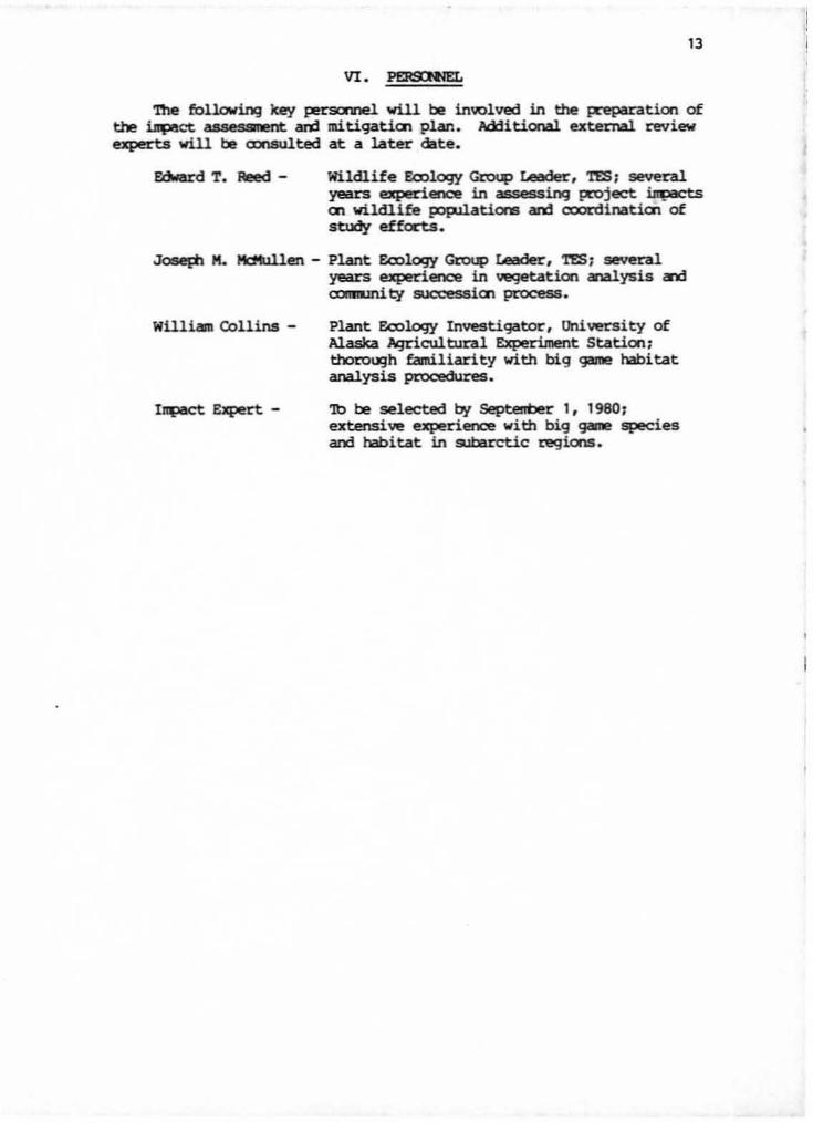
VI. l'EllSN<EL
'nle following key I"!rsonnel will be in"'lved in tlle ~tion ofthe !q>oce assessment ard mitigation plan. Additional external revi....experts will be aJnSU.1ted at a later date.
Wildlife Eoology Group Leader, 'res; severalyears experience in assessing IXOject~on wildlife popUations ard ooordination ofstudy efforts•
.JoseP1. M. Md1U1.1en - Plant EcDlogy G-roup Leader, '1'ES ~ severalyears experience in vegetation analysis a1d~ty succession process.
WUli... Collins -
IIl{)aCt: Expert -
Plant Ecology Investigator, University ofAlaska Iqrlcultural ExperiJnent Station,thoro",h familiarity with big gome habitatanalysis pcocedures.
'1b be selected I:7t Septenber 1, 1980;extensive experience with big~ speciesard habitat in sul:Brctic regions.