Thistleworth Richmond Old Deer Park FootbridgeRichmond...
1
13.3 13.2 13.4 3 3 3 3 4 1 2 4 2 4 2 1 8 0 4 0 1 4 6 0 2 0 4 0 4 0 3 0 8 0 9 0 3 1 5 0 7 0 6 0 8 1 0 1 0 9 0 9 4 6 4 4 0 2 0 8 0 9 0 4 2 9 0 6 0 7 1 1 4 5 1 5 0 7 0 4 0 7 0 8 0 9 2 1 0 3 3 6 0 3 1 1 0 9 3 0 6 1 0 7 1 6 0 6 4 1 0 2 0 2 2 4 1 0 6 5 1 6 1 0 1 4 2 0 9 0 3 0 6 0 4 0 1 0 4 0 8 0 6 1 2 4 1 0 5 0 6 4 7 0 6 1 4 6 1 4 7 0 8 0 6 2 4 4 2 2 1 0 5 2 4 5 0 5 3 0 4 0 5 9 2 4 1 4 6 0 5 6 2 7 8 0 3 6 2 0 8 6 1 3 3 5 1 4 1 0 2 0 1 2 1 0 3 0 8 0 3 6 1 1 1 0 4 0 4 0 3 1 1 9 0 9 0 5 1 0 6 0 3 0 8 4 2 1 1 0 6 0 4 0 8 4 1 0 7 1 1 Craft Craft Craft Craft Isleworth Barge Mooring No.1 P P P P P P P P P P P P P P P P P P P P P FS NB Dn P P P P P P P P Steps Steps Steps Steps Steps Steps Storm Outlet 111 112 112 Old Deer Park 3 3 3 3 4 1 2 4 2 4 2 2 1 4 0 9 3 0 0 2 0 9 0 1 4 5 0 8 0 1 0 4 0 6 0 3 1 2 0 4 0 9 4 1 6 1 4 7 0 6 0 7 1 2 0 3 1 1 0 8 0 6 4 6 4 2 0 4 4 1 0 8 4 1 0 9 5 1 2 1 0 4 0 7 1 1 6 1 2 1 0 6 0 2 0 1 0 5 0 7 0 3 1 5 0 5 6 1 6 2 0 5 6 2 4 1 2 1 1 1 0 8 9 2 0 5 5 1 7 8 4 1 1 9 6 1 3 3 4 0 9 4 5 0 3 0 4 0 9 4 2 0 3 3 0 0 1 0 6 0 3 0 2 1 0 8 4 6 0 4 0 4 0 8 0 5 4 1 0 3 1 1 0 8 0 3 0 6 0 2 0 7 0 4 0 9 1 8 0 4 4 4 0 1 0 8 0 8 0 6 0 2 4 6 2 9 0 3 0 4 0 7 2 4 1 4 7 0 8 0 3 3 6 1 5 4 2 0 9 1 6 0 6 0 5 0 6 0 7 0 9 0 6 0 6 1 1 LADDERS Permanent ladders, the exact position or condition of whi cannot be guaranteed, are shown thus . Tide Details, referred to levels at RICHMOND LOCK. Highest Recorded HAT Mean High Water Springs Mean High Water Mean High Water Neaps Ordnance Datum (Newlyn) Mean Low Water Neaps Mean Low Water Springs Chart Datum Issue:01 Date:18/10/13 Page 1 of 1 HYDROGRAPHIC SERVICE ISO FORM 425 For further information see the PLA hydrographic service website: http://www.pla.co.uk/Safety/PLA-Hydrographic-Service-Published-Surveys Charts: Petersham Ait to Richmond Lock to Church Ferry, Isleworth Port of London Authority Chart Correction Advice Date:29th December, 2017 CCA No: 2017/47 The accompanying block correction shows: New Depths & Contours in the channel and on the approaches to the lock & weir PLA Chart No. 304 HO Ref No. 113-304-087 Previous Chart Correction: New Edition PLA Chart No. 303 HO Ref No. 113-303-014 Previous Chart Correction: New Edition 3 3 3 3 4 4 2 4 2 5 2 4 5 0 5 3 0 4 0 5 9 2 4 1 4 6 0 5 6 2 7 8 0 3 6 2 0 8 6 1 3 3 5 1 4 1 0 2 0 1 2 1 3 P P P P P FS NB P 111 3 3 3 3 4 4 2 4 2 5 2 0 5 6 1 6 2 0 5 6 2 4 1 2 1 9 2 0 5 5 1 7 8 4 1 3 3 4 4 5 3 0 3 3 0 0 1 0 2 4 6 0 8 Chart 304 Chart 303
Transcript of Thistleworth Richmond Old Deer Park FootbridgeRichmond...
13.3
13.2
13.1
13.4
3333
4
37
312 22
364223 71
4252 52
32 8142
2222 81
0641
2281 1
204
42 081206
4261 12 112
08
22 613204 91
9152
05
18
04
01
4602
0404
03
08
090315
0706
08
101
090946
440208
09
042906
07
1145
150704
0708
09 210336
0311
0930 61 07
16064102
02205 41
0651610127
420209
030604
01
041208
06
122412
41 05
0647
06146147
12
1108
0614
24
420821
05
20722
06
1
15 610911
21
28 1116
28 3818
071
4406
06
112909
12 22
07
1408
31
41
1 23
41
3108
1
21
07
18 22
21
44
18 31
17
02
11
06 07
47
45
05
30 4059241
46
05627803
62086133
51 4102 01
21030803
61 1104
0403
1 190905
1
060308
4211
06
0408
41
07
46
14
11
Craft
Craft
Craft
Craft
Isleworth Barge Mooring No.1
P
P
P
P
P
P
P
P
P
Wk
P
Sea Scouts
P
stump
P
P
PP
P
P
P
P
P
P
NB
Dn
P
P
P
P
P
P
PP
PP
PP
PP
80
70
P
FSNB
Dn
P
70
80
60
60
70
PP
P
PP
P
P
He r
on P
l ace
Steps
Sluice
Steps
Slipway
Steps
Steps
Steps
Steps
Sluice
Steps
Steps
Steps
Steps
StormOutlet
West London Instituteof Higher Education
119-21
Lion Wharf Road
BowyersCourt
114
114aRiversideYard Grid
CharlevilleMews
River Crane
Boat House
Park House
116
115
Thistleworth Marine Ltd
-0.61m +1.72m
110
111
Richmond Lock& Weir
(See Note)16
117
WestMiddlesexSewageOutfalls
5 4
Richmond Footbridge
112112
-0.61m +1.72m
Old Deer Park
5 9
04 03
P
P
P
P
15
P
P
P
P
P
Ranelagh Drive
Steps
Steps
Old Deer Park
Steps
3333
4
37
322
123642
23 7142
525281
4232
228122
4106
22 181204
084212
0642
1112 26108
613222
9104
9152
055171
6242
44
28
28
22
18
06
1
07
11
24
11
12
1
1
08
11
27
11
1
09
22
12
21
16
12
02
12
18
22
05
2
14
29
23
38
14
09
30
39
02
09
01
45
08
01
04
06
03
12
04
09
4161
47
06
07
1
2
03
11
08
06
46
42
04
41
08
41
09
51
15
21
44
06
04
07
11
61
21
44
06
02
14
01
07
18
07
05
07
03
15
08
61
05
61
62
05
62
4121
11
08
92
05
51
78
41
19
61
33
4
09
45
03
04
09
42
03
30
01
06
03
02
1
08
46
04
04
08
05
41
03
11
08
03
06
02
07
04
09
18
04
44
01
08
0806
02
47
17
46
29
03
07
04
07
24
46
1
08
47
08
21
03
36
02
15
09
41
31
42
21
09
16
06
05
14
31
4107
06
07
11
06
09
06
06
31
06
11
27.9
28.1
27.8
27.7
PLA 304
0°19'W 0°19'W
51°28'N
0°19'W 0°19'W
51°28'N
18.919.119.219.3
DEPTHSDepths downstream of Richmond Lock & Weir are in metres and are reduced to Chart Datum being 0.61 m & 0.76 m below Ordnance Datum (Newlyn), which is approximately the level of Lowest Astronomical Tide. Depths upstream of Richmond Lock & Weir are in metres and are reduced to Chart Datum being 1.72 m above Ordnance Datum (Newlyn), which is Maintained Water Level. HEIGHTSHeights are in metres. Underlined figures are drying heightsabove Chart Datum; all other heights are above MHWS. SOUNDINGSAll sub-tidal areas are surveyed by MBES giving 100% coverage to IHO S44 order 1A
POSITIONSPositions are referred to WGS 84.
TOPOGRAPHYThe shore features on this chart are based largely on OrdnanceSurvey digital map data with the permission of the Controller of Her Majesty's Stationery Office. © Crown Copyright 2016.All rights reserved. Ordnance Survey Licence number 100022150.
LIGHTS ON JETTIESLight stars without legends represent two fixed lightsdisplayed vertically. They are seen as red to portand green to starboard when proceeding upriver. DISTANCESDistances from London Bridge are shown along the N channeledge in Sea Miles and tenths against this symbol .
LADDERSPermanent ladders, the exact position or condition of which cannot be guaranteed, are shown thus .
BRIDGES - Headway at the centre span above MHWS:Richmond Footbridge = 5.4 m.
MOORINGSMooring screws are shown in their true position thus andbuoys shown as symbols.Buoy numbers shown (20) are PLA references. PLA REFERENCESThe numbers shown on the shore and in parenthesis in theriver adjacent to moorings refer to PLA licences.
PLA PUBLICATIONSRefer to PLA Publications for further information:1. PLA River Byelaws2. General Directions for Navigation3. PLA Tide Tables & Port Information4. The River Thames Recreational Users Guide5. Rowing on the Tideway
RICHMOND LOCK & WEIRClosure of weir gates and prohibition of passage through weirarches is shown by three red discs below each arch during hoursof daylight and three red lights at night.Weir gate sill is 1.3m below ODNCrest of boat rollers is 2.1m above ODNLock upper sill is 1.4m below ODNLock lower sill is 2.0m below ODNLock Length 76m, width 7.9mHeadway within the lock above MHWS of 5.1m.
NOTE: The height of low water is greatly affected by fresh water flow over Teddington Weir. In drought conditions recorded levels as low as 0.49m BELOW chart datum have reduced the availabledepth downstream from Richmond Lock & weir during the period of low water.
PLA HYDROGRAPHIC SERVICE WEBSITEwww.pla.co.uk/hydrohomepage
Tide Details, referred to levels atRICHMOND LOCK.Highest RecordedHATMean High Water SpringsMean High WaterMean High Water NeapsOrdnance Datum (Newlyn)Mean Low Water NeapsMean Low Water SpringsChart Datum
Ordnance Datum
ChartDatum
5.47 6.08 (1978)4.89 5.50 4.17 4.78 3.67 4.28 3.16 3.77-------- 0.61-0.37 0.24 see note above-0.54 0.07 " " "-0.61 -------
Issue:01 Date:18/10/13Page 1 of 1
HYDROGRAPHIC SERVICEISO FORM 425
For further information see the PLA hydrographic service website:http://www.pla.co.uk/Safety/PLA-Hydrographic-Service-Published-Surveys
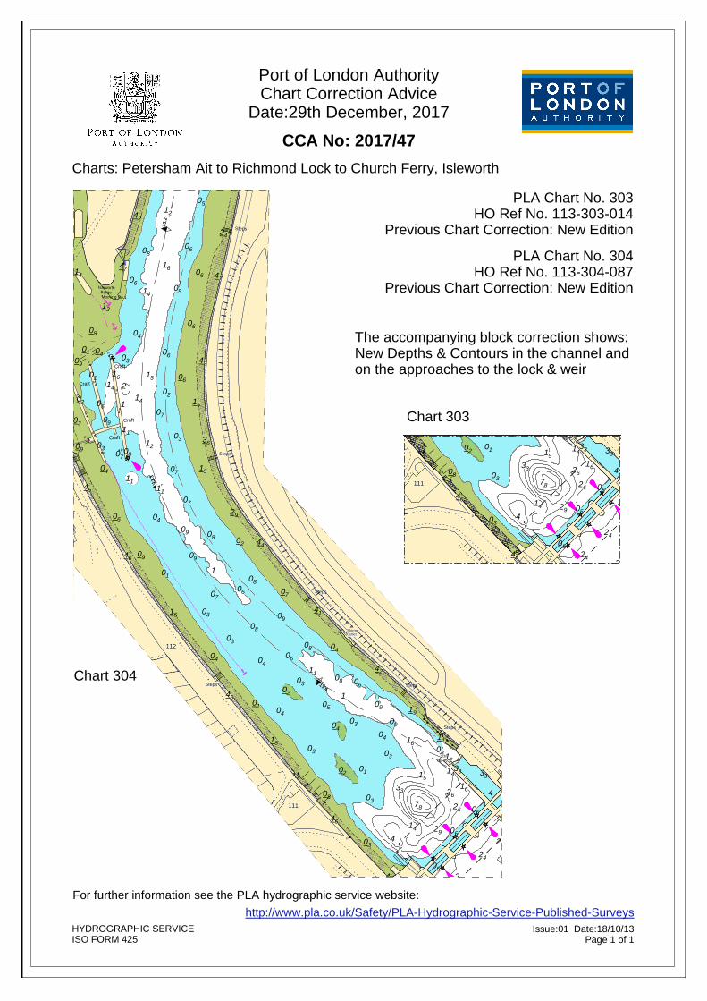
Charts: Petersham Ait to Richmond Lock to Church Ferry, Isleworth
Port of London AuthorityChart Correction Advice
Date:29th December, 2017
CCA No: 2017/47
The accompanying block correction shows: New Depths & Contours in the channel and on the approaches to the lock & weir
PLA Chart No. 304HO Ref No. 113-304-087
Previous Chart Correction: New Edition
PLA Chart No. 303HO Ref No. 113-303-014
Previous Chart Correction: New Edition
13.3
13.4
3333
4
37
312 22
364223
7142
52 5232 81
42
2222 81
0641
2281 1
204
42 081206
4261 12 2
08
22 3204
0571
0571
1
18
04
01
4602
0404
03
08
090315
0706
08
101
090946
440208
09
042906
07
1145
150704
0708
09 210336
0311
0930 61 07
16064102
02205 41
0651610127
420209
030604
01
041208
06
122412
41 05
0647
06146147
12
1108
0614
24
45
05
30 4059241
46
05627803
620861
3351 4102 01
21030803
61 1104
0403
1 190905
1
060308
4211
06
0408
41
07
11
Townsend
Townsend
13.5
13.6
Craft
Craft
Craft
Craft
Isleworth Barge Mooring No.1
04 03
109A
P
P
P
P
P
P
P
P
P
Outfall
St Peters Road
Ranelagh Drive
Steps
Old Deer Park
Steps
Talbot Road
Richmond Road
Sea Scouts
P
P
PP
P
P
P
P
P
NB
Dn
P
P
P
P
P
P
PP
PP
PP
PP
P
FSNB
Dn
P
PP
P
PP
P
P
Steps
Slipway
Steps
Steps
Steps
Steps
Steps
StormOutlet
West London Instituteof Higher Education
Sea Scout Hall
BowyersCourt
114
114aRiversideYard Grid
CharlevilleMews
River Crane
Boat House
Park House
116
115
Thistleworth Marine Ltd
-0.61m +1.72m
110
111
Richmond Lock& Weir
(See Note)16
5 4
Richmond Footbridge
112112
-0.61m +1.72m
Old Deer Park
3333
4
37
32212
364223
7142
525281
4232
228122
4106
22 181204
084212
0642
1261
08
322204
0571
05
24
11
27
12
12
02
12
05
14
14
09
30
02
09
01
45
08
01
04
06
03
12
04
09
4161
47
06
07
1
2
03
11
08
06
46
04
41
08
41
09
51
21
04
07
11
61
06
02
01
05
07
03
15
05
61
62
05
62
4121
11
08
92
05
51
78
41
19
61
33
4
09
45
03
04
09
42
03
30
01
06
03
02
1
08
46
04
04
08
05
41
03
11
08
03
06
02
07
04
09
18
04
44
01
08
0806
02
46
29
03
04
07
1
47
08
03
36
15
42
09
16
06
06
07
09
06
06
11
PLA 303
27.4
0°19'W
0°19'W
0°18'W
51°27'N 27.5'N
19.1
Chart 304
Chart 303