This page left intentionally blank. - Michigan · Provide photographs of all properties 50 years of...
49
Transcript of This page left intentionally blank. - Michigan · Provide photographs of all properties 50 years of...


This page left intentionally blank.

STATE HISTORIC PRESERVATION OFFICE Application for Section 106 Review
SHPO Use Only IN Received Date / / Log In Date / /
OUT Response Date / / Log Out Date / /
Sent Date / /
Submit one copy for each project for which review is requested. This application is required. Please type. Applications must be complete for review to begin. Incomplete applications will be sent back to the applicant without comment. Send only the information and attachments requested on this application. Materials submitted for review cannot be returned. Due to limited resources we are unable to accept this application electronically.
I. GENERAL INFORMATION THIS IS A NEW SUBMITTAL THIS IS MORE INFORMATION RELATING TO ER# 08-462
a. Project Name: Woodward Avenue Light Rail Transit Project - Phased Sec. 106 Submittal; see Attachment A. b. Project Address (if available): Generally Woodward Avenue from Downtown Detroit to Michigan State
Fairgrounds/8 Mile Road. c. Municipal Unit: Detroit and Highland Park County: Wayne d. Federal Agency, Contact Name and Mailing Address (If you do not know the federal agency involved in your
project please contact the party requiring you to apply for Section 106 review, not the SHPO, for this information.): Tricia Harr, AICP, Environmental Protection Specialist, Federal Transit Administration, 1200 New Jersey Avenue SE, E43-105, Washington, DC, 20590; 202-366-0486 or [email protected]
e. State Agency (if applicable), Contact Name and Mailing Address: Matt Webb, Senior Project Manager, Michigan Department of Transportation, Van Wagoner Building, 425 West Ottawa Street, Lansing, MI, 48909
f. Consultant or Applicant Contact Information (if applicable) including mailing address: Tim Roseboom, Project Manager, Detroit Department of Transportation, 1301 East Warren, Detroit, MI, 48207; 313-833-1196 or [email protected]
II. GROUND DISTURBING ACTIVITY (INCLUDING EXCAVATION, GRADING, TREE REMOVALS, UTILITY INSTALLATION, ETC.)
DOES THIS PROJECT INVOLVE GROUND-DISTURBING ACTIVITY? YES NO (If no, proceed to section III.) Exact project location must be submitted on a USGS Quad map (portions, photocopies of portions, and electronic USGS maps are acceptable as long as the location is clearly marked).
a. USGS Quad Map Name: Detroit and Highland Park, Attachment B. b. Township: T2S Range: R12E Section: N/A c. Description of width, length and depth of proposed ground disturbing activity: See Attachment A. d. Previous land use and disturbances: See Attachment A. e. Current land use and conditions: See Attachment A. f. Does the landowner know of any archaeological resources found on the property? YES NO
Please describe:
III. PROJECT WORK DESCRIPTION AND AREA OF POTENTIAL EFFECTS (APE)
Note: Every project has an APE.
a. Provide a detailed written description of the project (plans, specifications, Environmental Impact Statements (EIS), Environmental Assessments (EA), etc. cannot be substituted for the written description): See Attachments A, C, and D.
b. Provide a localized map indicating the location of the project; road names must be included and legible. c. On the above-mentioned map, identify the APE. d. Provide a written description of the APE (physical, visual, auditory, and sociocultural), the steps taken to
identify the APE, and the justification for the boundaries chosen. See Attachment A.

IV. IDENTIFICATION OF HISTORIC PROPERTIES
a. List and date all properties 50 years of age or older located in the APE. If the property is located within a National Register eligible, listed or local district it is only necessary to identify the district: See Attachments A, C, and D.
b. Describe the steps taken to identify whether or not any historic properties exist in the APE and include the level of effort made to carry out such steps: See Attachment A.
c. Based on the information contained in “b”, please choose one: Historic Properties Present in the APE No Historic Properties Present in the APE
d. Describe the condition, previous disturbance to, and history of any historic properties located in the APE: See Attachment A.
V. PHOTOGRAPHS Note: All photographs must be keyed to a localized map.
a. Provide photographs of the site itself. b. Provide photographs of all properties 50 years of age or older located in the APE (faxed or photocopied
photographs are not acceptable).
VI. DETERMINATION OF EFFECT
No historic properties affected based on [36 CFR § 800.4(d)(1)], please provide the basis for this determination.
No Adverse Effect [36 CFR § 800.5(b)] on historic properties, explain why the criteria of adverse effect, 36 CFR Part 800.5(a)(1), were found not applicable.
Adverse Effect [36 CFR § 800.5(d)(2)] on historic properties, explain why the criteria of adverse effect, [36 CFR Part 800.5(a)(1)], were found applicable.
Please print and mail completed form and required information to: State Historic Preservation Office, Environmental Review Office, Michigan Historical Center, 702
W. Kalamazoo Street, P.O. Box 30740, Lansing, MI 48909-8240

Attachment A Additional Information for
Application for Section 106 Review

This page left intentionally blank.

Woodward Avenue Light Rail Transit Project (ER# 08-462)Phased Section 106 Submittal – Assessment of Effects – Downtown Detroit to I-75/Fisher Freeway (October 2010)
Attachment A – Additional Information for Application for Section 106 Review
Section I. General Information
NOTE: A phased historic property identification and effects assessment was deemedappropriate for the Woodward Avenue Light Rail Transit (LRT) project and coordinated with theState Historic Preservation Office (SHPO); see response to Section IV, Part A. The encloseddocumentation assesses project effects to properties listed in or determined eligible for listing inthe National Register of Historic Places (NRHP) located within the portion of the project’s Areaof Potential Effects (APE) between Interstate 75 (I-75)/Fisher Freeway and Grand Boulevard.Therefore, information provided in this Application for Section 106 Review and in itsattachments describes both the general project and the specific portion of the project areabetween I-75/Fisher Freeway and Grand Boulevard, as relevant. Three reports were previouslysubmitted for SHPO review; these included eligibility determinations for properties located fromDowntown Detroit to I-75/Fisher Freeway; eligibility determinations for properties from I-75/Fisher Freeway to Grand Boulevard; and effects determinations for properties fromDowntown Detroit to I-75/Fisher Freeway. Forthcoming reports will contain determinations ofeligibility and effects for two remaining portions of the project, including between GrandBoulevard and Michigan Route 8 (M-8)/Davison Freeway and between M-8/Davison Freewayand M-102/8 Mile Road.
Section II. Ground Disturbing Activity
c. Describe the proposed dimensions of ground disturbing activity. Plans andspecifications should not be substituted here. Example: 4 feet wide, 20 feet long, 2 feetdeep.
The Woodward Avenue LRT project would extend approximately 8.5 miles from DowntownDetroit near the Detroit River north to 8 Mile Road along Woodward Avenue; total project length,including circulation in Downtown Detroit, would be 9.3 linear miles. The majority of the projectcorridor falls within the City of Detroit, with approximately two miles (from Webb Street toMcNichols Street) located within the City of Highland Park. All rail line construction, includingthe guideway, tracks, rails, overhead contact system (OCS) poles, and stations, would occurwithin existing roadway rights-of-way and within travel lanes and/or median areas/sidewalks.The width and depth of ground disturbance would vary from approximately 28 to 48 feet wideand from 0 to 3 feet deep.
Potential vehicle storage and maintenance facility (VSMF) sites have been identified. Theseareas, along with appropriate adjacent parcels, have been included in the APE. Two potentialVSMF sites are located within the project area between I-75/Fisher Freeway and GrandBoulevard, the area that this submittal addresses. This report addresses potential effects toaboveground historic properties; forthcoming archaeological reports will address potentialeffects to below-ground historic properties. VSMF design would be site specific and include ayard and various industrial buildings. Specific information regarding the width and depth ofdisturbance is not available at this time.
d. Describe the previous use of the land. Was it farm land, an industrial site, ahomestead, etc.? Was there a utility corridor placed on the property, were sewer andwaterlines placed there 10 years ago, etc.?

Attachment A – Additional Information for Application for Section 106 ReviewWoodward Avenue Light Rail Transit Project (ER# 08-462)Phased Section 106 Submittal – Assessment of Effects – Downtown Detroit to I-75/Fisher Freeway (October 2010)
2
Woodward AvenueOriginally a Native American trail, Woodward Avenue became the main thoroughfare for the Cityof Detroit and eventually stretched twenty-seven miles from the Detroit River in urbanDowntown Detroit through rural and later suburban areas northwest of the city to the City ofBloomfield Hills. In 1863, horse-drawn rail car lines were installed along four major DowntownDetroit roads, including Woodward Avenue from Jefferson Avenue to Alexandrine Street.Electric streetcar service replaced horse-drawn rail cars in late 1892.
In 1908, the world’s first mile of concrete roadway was built on Woodward Avenue between 6Mile and 7 Mile roads. The entire twenty-seven-mile length of Woodward Avenue was paved in1916, and the nation’s first three-color, four-way traffic light was installed in 1919 at theWoodward Avenue and Michigan Avenue intersection. After many legal disputes, WoodwardAvenue was widened from 66 feet to 120 feet in 1936. The widening resulted in the demolition,relocation, or renovation of numerous buildings along the road. Streetcar operations alongWoodward Avenue ended in April 1956. Today, the Detroit People Mover, a 2.9-mile elevatedlight rail system, provides local service between buildings and neighborhoods in DowntownDetroit.
Downtown Detroit and Midtown AreaThe historic core from which the rest of the city later developed was located from the DetroitRiver to what is now I-75/Fisher Freeway. Through the nineteenth and twentieth centuries, thecity steadily expanded northward with farmland giving way to residential neighborhoods,commercial buildings, factories, universities, and municipal and cultural institutions. This areacontains numerous office towers, churches, theaters, and smaller commercial buildingsconstructed in a variety of architectural styles, including Art Deco, Beaux Arts, Chicago Style,Gothic, Romanesque, and modern styles. The stretch of Woodward Avenue from Grand CircusPark to Mack Avenue was known as Piety Hill due to the numerous churches located in thatarea. In the early twentieth century, the construction of the Italian Renaissance-style DetroitPublic Library, the Beaux Arts-style Detroit Institute of Arts, and portions of the Wayne StateUniversity campus created Detroit’s Cultural Center in the Midtown area. Midtown is the arealocated approximately between the north end of Downtown Detroit and the New Center areanear the Woodward Avenue and Grand Boulevard intersection. The Cultural Center was laterexpanded in the mid-twentieth century with the construction of the Prairie-style Detroit HistoricalMuseum and other cultural institutions.
New Center AreaNew Center developed in the 1920s in response to the increase in automotive factories andindustries in the area. This development and the creation of a small commercial and businesscore led to extensive residential development of the surrounding areas that housed workersassociated with New Center’s factories and commercial enterprises. A three-block commercialdistrict developed on Woodward Avenue; it includes two- and three-story brick commercialbuildings in the Neoclassical and Art Deco styles. The General Motors Corporation and theFisher family, prominent local real estate developers, constructed Neoclassical-style and ArtDeco-style skyscrapers along Grand Boulevard to the west of Woodward Avenue and the NewCenter commercial district.
North of New Center, the neighborhoods of Virginia Park, Arden Park, and Boston-Edisondeveloped in the early twentieth century as enclaves for the middle class, upper middle class,and the wealthy. The neighborhoods feature a mix of homes and mansions including Prairie,Craftsman, and English Revival architectural styles.

Attachment A – Additional Information for Application for Section 106 ReviewWoodward Avenue Light Rail Transit Project (ER# 08-462)Phased Section 106 Submittal – Assessment of Effects – Downtown Detroit to I-75/Fisher Freeway (October 2010)
3
The portion of the APE considered in this application, between I-75/Fisher Freeway and GrandBoulevard, is in the middle, southern portion of the study area. The APE in this portionencompasses Detroit’s Midtown area and a portion of the New Center area.
Highland ParkAlong Woodward Avenue, the City of Highland Park stretches from Webb Street to McNicholsRoad. Highland Park incorporated as a village in 1889 and as a city in 1918. The location ofthe Highland Park Ford Plant along Woodward Avenue spurred the development of thecommunity from a small farming village to an urban industrial center. Commercial buildings,apartment buildings, and church buildings on Woodward Avenue were constructed in the GothicRevival, Beaux Arts, Renaissance Revival, and Craftsman architectural styles; they vary inheight from two to eight stories, depending on the building type. Residential neighborhoodslocated approximately one block east and west of Woodward Avenue commonly include theAmerican Foursquare and bungalow forms in the Craftsman, Prairie, and English Revival styles.In 1944, the world’s first limited-access urban expressway, the Davison Freeway, was openedthrough the city center. The closure of the Highland Park Ford Plant in the late 1950scontributed to population and economic declines in the city.
Palmer Park AreaThe City of Detroit jurisdiction resumes north of McNichols Road and includes Palmer Park andthe Palmer Woods neighborhood. Palmer Park is a large 270-acre public park and golf coursedeeded to the city in 1893. Constructed prior to World War II, the apartment buildings south ofPalmer Park include the Egyptian, Spanish, Mediterranean, Venetian, Tudor, and MoorishRevival styles, and the Art Moderne and International styles. North of Palmer Park is thePalmer Woods neighborhood developed from farmland in the 1920s as an upper-class classneighborhood of large Tudor Revival-style homes. North of Palmer Park and the Palmer Woodsneighborhood are the Evergreen and Woodlawn cemeteries, which date to 1905 and 1895,respectively. The sprawling Michigan State Fairgrounds are located on the east side ofWoodward Avenue between West State Fair Avenue and 8 Mile Road. Organized in Detroit in1849, the fairgrounds were moved to their present location in 1905. The main fairgroundbuildings were constructed in the Neoclassical style typical of fair architecture in the earlytwentieth century; various buildings within the complex also represent Greek Revival, Arts andCrafts, and modern styles.
e. Describe the current use and condition of the property.
The Woodward Avenue LRT project traverses a diverse area containing commercial,institutional, civic, recreational, industrial, and residential uses. Woodward Avenue remains amajor thoroughfare from the Detroit River and the Central Business District of Downtown Detroitnorth to 8 Mile Road. Throughout the proposed project corridor along Woodward Avenue,commercial, institutional, and industrial land use is most common, with sprawling residentialareas frequently located beyond development immediately fronting Woodward Avenue. Bothmodern redevelopment and vacant and cleared land is most common between I-75/FisherFreeway and I-94/Ford Freeway. Despite some modern development, older buildings andneighborhoods are located throughout the corridor. Many historic buildings and neighborhoodsalong Woodward Avenue have been listed in the NRHP and/or have been locally designated ashistoric by the appropriate local municipality or by the State of Michigan.
The portion of the APE considered in this application, between I-75/Fisher Freeway and GrandBoulevard, is in the middle, southern portion of the study area. The APE in this portionencompasses Detroit’s Midtown area and a portion of the New Center area. The Midtown area
Attachment A – Additional Information for Application for Section 106 ReviewWoodward Avenue Light Rail Transit Project (ER# 08-462)Phased Section 106 Submittal – Assessment of Effects – Downtown Detroit to I-75/Fisher Freeway (October 2010)
4
includes the Wayne State University campus, the Medical Center, and the Cultural Center andcontains many prominent historic sites, such as the Detroit Institute of Arts and the DetroitPublic Library, and commercial, residential, industrial, and civic buildings. The New Center areaincludes a mix of commercial and industrial buildings related to the growth of the automobileindustry in Detroit.
Section III. Project Work Description and APE
a. Provide a detailed written description of the project.
The Woodward Avenue LRT project would consist of a 9.3-mile fixed guideway LRT systemalong the Woodward Avenue corridor in Detroit and Highland Park, Michigan (see AttachmentC). The proposed system would use steel-wheel LRT vehicles with a typical train consisting oftwo cars. The system would be street running.
The guideway would typically be located in the center median area of Woodward Avenuebetween 6 Mile Road to north of State Fair Avenue. South of 6 Mile Road to north of GrandBoulevard, the tracks would be located primarily in the center of the roadway. From Downtownto Grand Boulevard, which contains the area from I-75/Fisher Freeway to Grand Boulevardaddressed in this submittal, there are two separate rail location alternatives being considered:median-running or curb-running.
Median-Running Alternative: This alternative would locate the LRT in the center median ofWoodward Avenue from Grand River Avenue to Grand Boulevard and would run separate fromvehicular traffic.
Curb-Running Alternative: This alternative would locate the LRT along the right-most travel laneof Woodward Avenue from State Street to Grand Boulevard.
Downtown Design OptionsThe three Downtown design options being considered are within the APE for the area beingevaluated within this submittal. All share a common point of beginning and ending near GrandRiver Avenue/State Street and Woodward Avenue. For each of the Downtown options, theguideway would be installed in the existing street with the light rail train sharing the roadwaywith existing traffic. In and between Downtown Detroit and I-75/Fisher Freeway, the designoptions follow separate routes and incorporate various station locations; however, between I-75/Fisher Freeway and Grand Boulevard, the area considered in this report, each design optionis located within Woodward Avenue only. Furthermore, in this area, Design Options 2 and 3 areidentical.
Downtown Design Option 1: Between I-75/Fisher Freeway and Grand Boulevard, this optionwould incorporate the Median-Running Alternative with stations located in the median of theroadway. Design Option 1 has four stations between I-75/Fisher Freeway and Grand Boulevard.See Attachment B and Map Attachment C.
Downtown Design Options 2 and 3: Between I-75/Fisher Freeway and Grand Boulevard, thisoption would incorporate the Curb-Running Alternative with stations located along the edges ofthe roadway. Design Option 1 has seven stations between I-75/Fisher Freeway and GrandBoulevard. See Attachment B and Map Attachment D.

Attachment A – Additional Information for Application for Section 106 ReviewWoodward Avenue Light Rail Transit Project (ER# 08-462)Phased Section 106 Submittal – Assessment of Effects – Downtown Detroit to I-75/Fisher Freeway (October 2010)
5
The proposed LRT system would require the construction of several supporting projectelements and facilities, including the guideway, a traction electrification system, transit powersubstations, a VSMF, and LRT stations. A brief description of each follows:
Guideway – The light rail system would run along a fixed guideway consisting of steeltracks at a standard gauge of 4 feet, 8.5 inches. The guideway would be locatedexclusively within existing road rights-of-way, except near the VSMF (site unconfirmed atthis time). The guideway would be exclusive to light rail operations, and no vehicletraffic would be allowed for much of the alignment; however, the system would operatein vehicle traffic in Downtown Detroit. The guideway would be embedded in thepavement.
Traction Electrification System – A simple catenary system would be used for thetraction power contact system. The OCS would consist of support poles and wiresproviding electrification to the light rail vehicles. These features would be located alongthe proposed route and situated in existing road rights-of-way.
Transit Power Substations – Spaced along the proposed route at approximately one-mile intervals, these substations would supply power to the LRT system. Thesubstation’s precise locations have not been determined at this time.
Vehicle Storage and Maintenance Facility – A facility would be required to store andmaintain the light rail vehicles. Typical functions at this location would include vehiclestorage, paint booth, lifts, pits, wheel truing, wash bays, and associated administrativefunctions. It is expected that the site selected would be: 1) no less than five acres insize; 2) close to the transit alignment; and 3) located in an area consistent in land useand zoning. Selection of a preferred site is ongoing. Three potential sites for this facilityhave been identified; two of these sites are located in the area that is the subject of thisapplication.
LRT Stations – Major features of the LRT stations would be the platforms and shelters.The platform length is derived from the length of the LRT vehicles, and with the two-cartrains proposed for the Woodward Avenue LRT project, a typical near-grade platformwould be from 140 to 200 feet depending on the design option. The platforms wouldhave access ramps (up to 24 feet long) and landing areas (up to 6 feet) to providepedestrian access to the platforms. Given the various site conditions at stations alongthe proposed route, total station length would vary from 180 to 260 feet. Typical widthwould be 18 to 24 feet for double-sided platforms, and approximately 10 feet, 6 inches to12 feet for single-sided platforms; typical platform height would be 14 inches toaccommodate the proposed low-floor LRT vehicles.
Station shelters may be designed with a signature look and/or be context-sensitive to therespective setting at each site. They protect waiting passengers from the elements andcan include special features such as passenger displays, sound systems, lighting, andheating elements. Shelters for Design Options 2 and 3 would also incorporate a roof-mounted billboard structure. Other facilities and station furniture would also include ticketvending and security equipment, schedule and area information cases, railings,benches, and litter receptacles.

Attachment A – Additional Information for Application for Section 106 ReviewWoodward Avenue Light Rail Transit Project (ER# 08-462)Phased Section 106 Submittal – Assessment of Effects – Downtown Detroit to I-75/Fisher Freeway (October 2010)
6
The station locations between I-75/Fisher Freeway and Grand Boulevard aresummarized in the table (Figure 1) below.
Figure 1: LRT Station Locations between I-75/Fisher Freeway and Grand Boulevard
Station DesignOption 1
DesignOptions 2, 3
Temple Street X
MLK Boulevard/MackAvenue X X
Canfield Street X
Warren Avenue X X
Ferry Street X
Piquette Street/AmtrakStation X X
Grand Boulevard X X
Total Stations 4 7
d. Provide a written description of the APE (physical, visual, auditory, and sociocultural),the steps taken to identify the APE, and the justification for the boundaries chosen.
The APE for the Woodward Avenue LRT project encompasses roadways within which the LRTwould be located, all properties flanking those roadways, and properties for which the LRT or itscomponents would be a prominent visual feature (see Map Attachments C, D, and E). Forvisual considerations, the APE encompasses properties that do not directly adjoin the projectcorridor, but are otherwise located proximate to it or to a project facility. For example, a buildingnot adjoining but directly facing a Woodward Avenue LRT roadway at an intersection, or abuilding separated from the proposed project corridor by a vacant lot or parking lot would beincluded in the APE. Properties surrounding or in proximity to three potential sites for theVSMFs and for which that facility would be a prominent visual feature have also been includedin the APE.
The APE was developed by utilizing preliminary project plans in conjunction with field surveys ofthe project corridor and consultation with project noise and vibration specialists. Because noauditory or vibratory impacts are anticipated, the APE was developed to encompass potentialvisual and physical effects related to facility construction near the project corridor. Toencompass effects in the immediate vicinity of the project alignment, all roadways within whichthe LRT would be located and flanking properties have been included in the APE. Additionalconsideration was given to viewshed impacts and effects to setting beyond these properties.Properties determined to be subject to a potential visual effect were identified and included inthe APE; the methodology employed is described below. No potential traditional culturalproperties or socio-cultural impacts have been identified. At this time, no changes to land use,traffic patterns, or public access are anticipated. Transit-oriented development (TOD) planningis in preliminary stages and will be evaluated for Section 106 purposes, if applicable andappropriate, when TOD projects are proposed.

Attachment A – Additional Information for Application for Section 106 ReviewWoodward Avenue Light Rail Transit Project (ER# 08-462)Phased Section 106 Submittal – Assessment of Effects – Downtown Detroit to I-75/Fisher Freeway (October 2010)
7
During the field survey, project architectural historians who meet the Secretary of the Interior’sProfessional Qualification Standards reviewed the visual setting of properties that do not adjointhe project corridor but for which the project corridor is a visual component because of the lackof an intervening physical feature (for example, a property separated from the project corridor bya vacant lot). In general, the architectural historians determined that for such properties locatedwithin 250 feet of the proposed LRT guideway and OCS and/or a station (for both the Median-Running and Curb-Running alternatives), proposed project features would become a prominentcomponent of the property’s visual setting, and, therefore, such properties would be visuallyaffected by project implementation. For such properties beyond 250 feet, the architecturalhistorians determined that the LRT would not become a significant component of the property’svisual setting, and, therefore, such properties would not be visually affected by the WoodwardAvenue LRT. Thus, properties that do not immediately adjoin the project corridor but for whichthe proposed Woodward Avenue LRT was determined to be a prominent visual componenthave been included in the APE. Following the selection of three potential sites for a proposedVMSF, the APE was expanded in these areas to accommodate surrounding and proximateproperties for which the facility would constitute a substantial visual change.
The APE for the Woodward Avenue LRT project was provided to the SHPO by letter from theDetroit Department of Transportation dated November 20, 2009; the SHPO concurred with theAPE by letter dated January 13, 2010. Because the project’s VSMF sites were only recentlyidentified, the APE has been expanded to accommodate these parcels, as well as adjacentparcels that would be potentially affected. Mapping showing this revised APE was submitted tothe SHPO on September 17, 2010, for concurrence.
Section IV. Identification of Historic Properties
a. List and date all properties 50 years of age or older located in the APE.
A historic property identification report, “Phased Section 106 Submittal: Interstate 75/FisherFreeway to Grand Boulevard” (September 2010), was submitted to the SHPO on September 24,2010. A phased historic property identification and effects assessment effort was deemedappropriate for the Woodward Avenue LRT project and coordinated with the SHPO to avoid asingle large submittal, as well as to provide project architectural historians with valuablefeedback from SHPO staff that can be incorporated into the future submittals. This reportidentified built resources more than forty years of age located within the project’s APE betweenI-75/Fisher Freeway and Grand Boulevard. Properties forty years of age or older (rather thanthe standard fifty-year age limit) were evaluated to accommodate the Woodward Avenue LRT’sconstruction schedule.
The historic property identification report contained documentation on sixty resources more thanforty years of age located within the APE between I-75/Fisher Freeway and Grand Boulevard.Of these, twenty-six were previously listed in the NRHP. Of the thirty-four resources that werepreviously not identified and/or evaluated for NRHP eligibility, five were determined to be eligiblefor listing. Therefore, the current submittal evaluates potential project effects to thirty-oneproperties listed in or determined eligible for the NRHP; these properties are listed in the table(Figure 2) below.

Attachment A – Additional Information for Application for Section 106 ReviewWoodward Avenue Light Rail Transit Project (ER# 08-462)Phased Section 106 Submittal – Assessment of Effects – Downtown Detroit to I-75/Fisher Freeway (October 2010)
8
Figure 2: NRHP-Listed and Eligible Properties in APE between I-75/Fisher Freeway andGrand Boulevard
Name NRHP Status DateFirst Unitarian Church of Detroit Listed 1982
First Presbyterian Church Listed 1982
Midtown Woodward Historic District Listed 2008
Peterboro-Charlotte Historic District Eligible* 2010
Clarence Burton School Nominated 2010
Temple Beth-El Listed 1982
Cass-Davenport Historic District Listed 1997
Hotel Stevenson Listed 1997
Orchestra HallListed 1971
Willis-Selden Historic DistrictListed 1997
Garden BowlListed 2008
Majestic TheaterListed 12008
Detroit Edison Company Willis Avenue StationListed 1972
David Whitney HouseListed 1999
Edwin S. George BuildingListed 1993
First Congregational ChurchListed 1979
Warren-Prentis Historic DistrictListed 1997
Cathedral Church of St. Paul Complex Listed 1982
Samuel L. Smith HouseListed 1986
Maccabees Building Listed 1983
Cultural Center Historic District Listed 1983
Detroit Historical Museum Eligible* 2010
The Wardell Listed 2007
Col. Frank L. Hecker House Listed 1973

Attachment A – Additional Information for Application for Section 106 ReviewWoodward Avenue Light Rail Transit Project (ER# 08-462)Phased Section 106 Submittal – Assessment of Effects – Downtown Detroit to I-75/Fisher Freeway (October 2010)
9
Name NRHP Status DateEast Ferry Avenue Historic District Listed 1980
Barlum Apartments Eligible** n.d.
St. Joseph’s Episcopal Church Listed 1982
New Amsterdam Historic District Listed 2001
Piquette Avenue Industrial Historic District Listed 2004
Conrail and Grand Trunk Western Railroad Bridges Eligible* 2010
New Center Commercial Historic District Eligible* 2010* Determinations of eligibility pending SHPO concurrence.
** Determined eligible as part of prior, unrelated Section 106 project review; no documentation on file. Updated determination ofeligibility provided in “Phased Section 106 Submittal: Interstate 75/Fisher Freeway to Grand Boulevard” (September 2010).
b. Describe the steps taken to identify whether or not any historic properties exist in theAPE and include the level of effort made to carry out such steps.
Project architectural historians conducted intensive-level surveys within the project area andutilized public property records to identify all properties within the APE older than forty years ofage. Properties forty years of age or older (rather than the standard fifty-year age limit) wereevaluated to accommodate the Woodward Avenue LRT’s construction schedule.
The status of NRHP-listed properties and districts located within the APE were reviewed usingprevious NRHP documentation to determine if any properties had changed to the extent thatthey were no longer eligible for the NRHP or that NRHP boundaries should be altered. Duringthe current survey, architectural historians observed no substantial changes to any propertybetween I-75/Fisher Freeway and Grand Boulevard that would alter its eligibility/listing status.Thus, no eligibility or boundary changes to NRHP-listed properties are recommended in thisportion of the project area.
Background research was conducted for each property not previously evaluated for listing in theNRHP. Sources consulted included public records, secondary published sources, and primarysources. Historians wrote detailed architectural descriptions and historic context statements.The NRHP criteria of eligibility were applied to each property and a determination of NRHPeligibility was made. This information was documented in survey data forms for each property.
All properties located in the APE between I-75/Fisher Freeway and Grand Boulevard weredocumented in the “Phased Section 106 Submittal: Interstate 75/Fisher Freeway to GrandBoulevard” (September 2010) that was submitted to the SHPO on September 24, 2010.
Section V. Photographs
See Attachments C and D.
Attachment A – Additional Information for Application for Section 106 ReviewWoodward Avenue Light Rail Transit Project (ER# 08-462)Phased Section 106 Submittal – Assessment of Effects – Downtown Detroit to I-75/Fisher Freeway (October 2010)
10
Section VI. Determination of Effect
Evaluations included in Attachments C and D assess potential project effects to the thirty-oneNRHP-listed and NRHP-eligible historic properties within the Woodward Avenue LRT’s APEbetween I-75/Fisher Freeway and Grand Boulevard. The effects determinations aresummarized in Attachment E.
MethodologyEffects assessments were based on the criteria of adverse effect as defined in 36 CFR 800.5“Assessment of adverse effects.” According to this portion of the regulations, the criteria ofadverse effect are defined as follows:
An adverse effect is found when an undertaking may alter, directly or indirectly, anyof the characteristics of a historic property that qualify the property for inclusion in theNational Register in a manner that would diminish the integrity of the property’slocation, design, setting, materials, workmanship, feeling, or association.Consideration shall be given to all qualifying characteristics of a historic property,including those that may have been identified subsequent to the original evaluationof the property’s eligibility for the National Register. Adverse effects may includereasonably foreseeable effects caused by the undertaking that may occur later intime, be farther removed in distance, or be cumulative.
Examples of adverse effects are identified in 36 CFR 800.5 and include, but are not limited to,the following:
Physical destruction of or damage to all or part of the property Alteration of a property, including restoration, rehabilitation, repair, maintenance,
stabilization, hazardous material remediation, and provision of handicappedaccess, that is not consistent with the Secretary’s Standards for the Treatment ofHistoric Properties (36 CFR 68) and applicable guidelines
Removal of the property from its historic location Change of the character of the property’s use or of physical features within the
property’s setting that contribute to its historic significance Introduction of visual, atmospheric, or audible elements that diminish the integrity
of the property’s significant historic features Neglect of a property which causes its deterioration, except where such neglect
and deterioration are recognized qualities of a property of religious and culturalsignificance to an Indian tribe or Native Hawaiian organization
Transfer, lease, or sale of property out of federal ownership or control withoutadequate and legally enforceable restrictions or conditions to ensure long-termpreservation of the property’s historic significance
National Register of Historic Places Bulletins do not address assessments of effects, as effectsevaluations are related to the Section 106 process and not the Section 110 process in which theNational Register guidance is more commonly used. However, crucial information on integrityassessments (used for eligibility determinations) provides information regarding what eachaspect of integrity entails and how each aspect relates to the select National Register criteria foreligibility. As described above, retention of relevant aspects of integrity is critical to a property’ssignificance under the NRHP Criteria for Evaluation. The National Register Bulletin How toApply the National Register Criteria for Evaluation (NPS 1997) identifies the aspects of integrity

Attachment A – Additional Information for Application for Section 106 ReviewWoodward Avenue Light Rail Transit Project (ER# 08-462)Phased Section 106 Submittal – Assessment of Effects – Downtown Detroit to I-75/Fisher Freeway (October 2010)
11
and describes their relevance to the NRHP Criteria for Evaluation. The seven aspects ofintegrity are described in the bulletin as follows:
Location is the place where the historic property was constructed or theplace where the historic event occurred. The relationship between theproperty and its location is often important to understanding why the propertywas created or why something happened. The actual location of a historicproperty, complemented by its setting, is particularly important in recapturing thesense of historic events and persons.
Design is the combination of elements that create the form, plan, space,structure, and style of a property. It results from conscious decisions madeduring the original conception and planning of a property (or its significantalteration) and applies to activities as diverse as community planning,engineering, architecture, and landscape architecture. Design includes suchelements as organization of space, proportion, scale, technology, ornamentation,and materials. A property’s design reflects historic functions and technologies aswell as aesthetics. It includes such considerations as the structural system;massing; arrangement of spaces; pattern of fenestration; textures and colors ofsurface materials; type, amount, and style of ornamental detailing; andarrangement and type of plantings in a designed landscape.
Design can also apply to districts, whether they are important primarily for historicassociation, architectural value, information potential, or a combination thereof.For districts significant primarily for historic association or architectural value,design concerns more than just the individual buildings or structures locatedwithin the boundaries. It also applies to the way in which buildings, sites, orstructures are related.
Setting is the physical environment of a historic property. Whereas locationrefers to the specific place where a property was built or an event occurred,setting refers to the character of the place in which the property played itshistorical role. It involves how, not just where, the property is situated and itsrelationship to surrounding features and open space. Setting often reflects thebasic physical conditions under which a property was built and the functions itwas intended to serve. In addition, the way in which a property is positioned inits environment can reflect the designer’s concept of nature and aestheticpreferences.
The physical features that constitute the setting of a historic property can beeither natural or manmade, including such elements as: topographic features (agorge or the crest of a hill); vegetation; simple manmade features (paths orfences); and relationships between buildings and other features or open space.These features and their relationships should be examined not only within theexact boundaries of the property, but also between the property and itssurroundings. This is particularly important for districts.
Materials are the physical elements that were combined or depositedduring a particular period of time and in a particular pattern orconfiguration to form a historic property. The choice and combination ofmaterials reveal the preferences of those who created the property and indicatethe availability of particular types of materials and technologies. Indigenousmaterials are often the focus of regional building traditions and thereby help

Attachment A – Additional Information for Application for Section 106 ReviewWoodward Avenue Light Rail Transit Project (ER# 08-462)Phased Section 106 Submittal – Assessment of Effects – Downtown Detroit to I-75/Fisher Freeway (October 2010)
12
define an area’s sense of time and place. A property must retain the key exteriormaterials dating from the period of its historic significance. If the property hasbeen rehabilitated, the historic materials and significant features must have beenpreserved.
Workmanship is the physical evidence of the crafts of a particular cultureor people during any given period in history or prehistory. It is the evidenceof artisans’ labor and skill in constructing or altering a building, structure, object,or site. Workmanship can apply to the property as a whole or to its individualcomponents. It can be expressed in vernacular methods of construction andplain finishes or in highly sophisticated configurations and ornamental detailing.It can be based on common traditions or innovative period techniques.Workmanship is important because it can furnish evidence of the technology of acraft, illustrate the aesthetic principles of a historic or prehistoric period, andreveal individual, local, regional, or national applications of both technologicalpractices and aesthetic principles.
Feeling is a property’s expression of the aesthetic or historic sense of aparticular period of time. It results from the presence of physical features that,taken together, convey the property’s historic character.
Association is the direct link between an important historic event or personand a historic property. A property retains association if it is the place wherethe event or activity occurred and is intact to convey that relationship to anobserver. Like feeling, association requires the presence of physical featuresthat convey a property’s historic character.
According to guidance found in How to Apply the National Register Criteria for Evaluation,different aspects of integrity may be more or less relevant dependent on why a specific historicproperty was listed in or determined eligible for listing in the NRHP. For example, a propertythat is significant for its historic association (Criteria A or B) is eligible if it retains the essentialphysical features that made up its character or appearance during the period of its associationwith the important event, historical pattern, or person(s). A property determined eligible underCriteria A or B ideally might retain some features of all aspects of integrity, although aspectssuch as design and workmanship might not be as important.
A property important for illustrating a particular architectural style or construction technique(Criterion C) must retain most of the physical features that constitute that style or technique. Aproperty that has lost some historic materials or details can be eligible if it retains the majority ofthe features that illustrate its style in terms of the massing, spatial relationships, proportion,pattern of windows and doors, texture of materials, and ornamentation. The property is noteligible, however, if it retains some basic features conveying massing but has lost the majority ofthe features that once characterized its style. A property significant under Criterion C mustretain those physical features that characterize the type, period, or method of construction thatthe property represents. Retention of design, workmanship, and materials will usually be moreimportant than location, setting, feeling, and association. Location and setting will be importantfor those properties whose design is a reflection of their immediate environment (such asdesigned landscapes).
For a historic district to retain integrity, the majority of the components that make up the district’shistoric character must possess integrity even if they are individually undistinguished. In

Attachment A – Additional Information for Application for Section 106 ReviewWoodward Avenue Light Rail Transit Project (ER# 08-462)Phased Section 106 Submittal – Assessment of Effects – Downtown Detroit to I-75/Fisher Freeway (October 2010)
13
addition, the relationships among the district’s components must be substantially unchangedsince the period of significance.
In some cases, select aspects of integrity are currently and substantially compromised by priorundertakings not related to the current project. These changes may have been made prior todeterminations of eligibility or since these determinations were made.
Because of common misunderstandings regarding the application of the criteria of adverseeffects to historic properties, it is necessary to clearly state that just because projectcomponents may be visible from a historic property, this does not necessarily constitute anadverse effect. Factors considered for resources that fall into this category include proximity ofthe guideway to the historic property; the significance of viewsheds as indicated in priordocumentation (including earlier documentation and more recent updates); and the overallimportance of integrity of setting to the historic property’s determination of eligibility. In mostcases, installing the LRT guideway and OCS proximate to a historic property is not consideredan adverse effect; in some cases, this finding is supported by the history of the area, wherestreetcars were previously present during the periods of significance of many historic properties.Conversely, adverse effect determinations tended to result when proposed stations are locatedproximate to historic properties or within historic districts where integrity of setting remainedintact. Generally, in these cases, the stations adversely affected integrity of setting or feelingand diminished the relationship among contributing resources within the district. Priordocumentation for historic properties was reviewed to determine under which Criteria forEvaluation a property was deemed eligible for the NRHP, which historic characteristics andfeatures of a property qualified it for eligibility, and which areas of integrity were most relevant tothe eligibility determination and to what degree the property retains them.
During the current assessment of effects, information available for each historic property wasreviewed to determine if the setting within and/or outside of the historic boundary, as well asviewsheds to and from each property, was historically significant and contributed to theproperty’s eligibility. Using the same information, a determination was made regarding whichaspects of integrity were most critical to a historic property’s NRHP eligibility. Of note, over thecourse of the evaluation, it was determined that many of the historic properties did not retainintegrity of setting as their historic urban surroundings have been altered over the course oftime.
Preliminary noise and vibration analyses were also conducted along the transit corridor. At thistime, no noise or vibration effects were identified. Results of any additional noise and vibrationanalyses will be reviewed to determine the potential for effects.
To determine project effects, architectural historians conducted site visits to each historicproperty, reviewed project plans and proposed station designs and additional documentation.Following guidelines set forth in 36 CFR 800 and supported by information on integrity set forthin the National Register Bulletin How to Apply the National Register Criteria for Evaluation, thefollowing findings were used to assess project effects to historic properties:
No Effect: Per 36 CFR 800.4(d)(1), an undertaking may have no effect to historicproperties present in the APE, and a finding of “No Effect” may be determined foran undertaking. This finding indicates that an undertaking would not alter anyaspects of integrity for any historic properties. This rationale has been used toassess effects to historic properties within the APE for the guideway alignment.
No Adverse Effect: Per 36 CFR 800.5(b), an undertaking may be determined tohave “No Adverse Effect” to historic properties if the undertaking’s effects do notmeet the criteria of adverse effect as described above. If project implementation

Attachment A – Additional Information for Application for Section 106 ReviewWoodward Avenue Light Rail Transit Project (ER# 08-462)Phased Section 106 Submittal – Assessment of Effects – Downtown Detroit to I-75/Fisher Freeway (October 2010)
14
would alter a specific aspect of integrity for a historic property but the effectwould not alter a characteristic that qualifies that resource for inclusion in theNRHP in a manner that diminishes the significant aspect of integrity, then thefinding for that aspect of integrity is “No Adverse Effect.”
Adverse Effect: An adverse effect is determined if the undertaking would alter acharacteristic that qualifies that contributing resource for inclusion in the NRHP ina manner that diminishes the significant aspect(s) of integrity.
Avoidance Alternatives, Planning To Minimize Effects, and MitigationPer 36 CFR 800.6, findings of adverse effect to historic properties require that efforts to resolvesuch effects by developing and evaluating alternatives or modifications to the undertaking thatcould avoid, minimize, or mitigate adverse effects must be undertaken. Throughout the courseof the project, planners and design staff were made aware of the historic and architecturalsignificance of the historic properties within the APE. Efforts have been successfully made toavoid physical impacts to historic properties. For environmental and functional considerations,the proposed guideway alignment would be located within the existing roadway alignments,avoiding direct physical impacts to historic properties.
Preliminary design and engineering drawings indicating station locations under the threeproposed design options and general station concepts were utilized to assess potential projecteffects. Based on the evaluations contained in this report, as well as project requirements andother planning and environmental constraints, project planners and designers will make allpossible efforts to avoid and/or minimize all identified adverse effects to historic properties. Asfeasible, such measures could include alignment shifts and/or station relocations.
To determine if any historic properties within the project’s APE between I-75/Fisher Freewayand Grand Boulevard would be affected by the Woodward Avenue LRT project, documentationwas reviewed for all NRHP-listed and eligible properties within this portion of the APE, projectplans for all three proposed design options were reviewed, and additional field visits were takento each historic property. Using the criteria of adverse effect established in 36 CFR 800.5(a)(1)and guidance found in How to Apply the National Register Criteria for Evaluation, each historicproperty was evaluated to determine if implementation of the Woodward Avenue LRT projectwould alter any historically significant characteristics or features of each historic property bydiminishing relevant aspects of that property’s historic integrity.
Indirect and cumulative effects to historic properties have also been considered; such effectsmay include reasonably foreseeable land use changes.
Future Project Refinement and/or ChangesFuture project refinements and/or changes that would affect determinations made in this report,including efforts to avoid and/or minimize identified adverse effects, will be coordinated with theSHPO through appropriate documentation (amendment reports and/or technical memoranda).All such documentation will be provided to consulting parties for comment.

Attachment B Project Location Map

This page left intentionally blank.

!.!.!.!.!.!.!. !.!.!.
WARR
EN AV
E (M
edian
- and
Cur
b-Ru
nning
)
MLK
BLVD
/MAC
K AV
E (M
edian
- and
Cur
b-Ru
nning
)
GRAN
D BL
VD (M
edian
- and
Cur
b-Ru
nning
)
HAZE
LWOO
D ST
/HOL
BROO
K ST
(Med
ian-R
unnin
g)
PIQUE
TTE S
T/AMT
RAK
STAT
ION
(Med
ian- a
nd C
urb-
Runn
ing)
CALV
ERT S
T (Me
dian-R
unnin
g)
GLEN
DALE
ST (M
edian
-Run
ning)
TEMP
LE ST
(Curb
-Run
ning)
CANF
IELD
ST (Cu
rb-R
unnin
g)
FERR
Y ST (
Curb
-Run
ning)
Seedesignoptionsin insetsbelow
F
1 INCH = 2,000 FEET
Sheet 1 of 2
Attachment B: Project Location MapUSGS Detroit, Highland Park, and Royal Oak 1:24,000 Quadrangle Maps
0 4,000 Feet
Alignment
!. Station
12
Sheet Index 1:150,000
!.
!. !. !.
!. !.
COBO CENTER (split platforms)
RANDOLPH ST (split platforms)
FOXT
OWN/
STAD
IUM
ROSA PARKSTRANSIT CENTER
(WASHINGTON BLVD)
!.!.!.
!.!.!.!.
!. !.!.
FOXT
OWN/
STAD
IUM
ADAM
S/GR
AND
CIRC
US PA
RK
STAT
E/GR
ATIO
TROSA PARKS
TRANSIT CENTER(WASHINGTON BLVD)
WOODWARD (split platforms)
COBO CENTER (split platforms)
RAND
OLPH
ST
!.!.!. !. !.CO
NGRE
SS/LA
RNED
MICH
IGAN
ADAM
S/GR
AND
CIRC
US PA
RK
FOXT
OWN/
STAD
IUM
Design Option 1 Design Option 2 Design Option 3

!.!.!.!.!.!.!.
GRAN
D BL
VD (M
edian
- and
Cur
b-Ru
nning
)
HAZE
LWOO
D ST
/HOL
BROO
K ST
(Med
ian-R
unnin
g)
PIQUE
TTE S
T/AMT
RAK
STAT
ION
(Med
ian- a
nd C
urb-
Runn
ing)
CALV
ERT S
T (Me
dian-R
unnin
g)
GLEN
DALE
ST (M
edian
-Run
ning)
MANC
HEST
ER ST
(Med
ian-R
unnin
g)
MCNI
CHOL
S RD
(Med
ian-R
unnin
g)
7 MILE
RD
(Med
ian-R
unnin
g)
STAT
E FA
IR (M
edian
-Run
ning)
F
1 INCH = 2,000 FEET
Sheet 2 of 2
Attachment B: Project Location MapUSGS Detroit, Highland Park, and Royal Oak 1:24,000 Quadrangle Maps
0 4,000 Feet
Alignment
!. Station
12
Sheet Index 1:150,000

Attachment C Determinations of Effect
Downtown Design Option 1

This page left intentionally blank.

11223333
"
"
Potential Location of Vehicle Storageand Maintenance Facility
F
1 INCH = 400 FEET
I-75/Fisher Freeway to Grand BoulevardDesign Option 1 - Sheet Index 1 (Map 1 of 8)
Map Attachment C: Area of Potential Effects and Historic Properties
0 530 Feet
Guideway Alignment - Design Option 1
Proposed Station
NRHP-Listed or Eligible Historic Property
National Historic Landmark
Area of Potential Effects
Sheet Index
KEY2-2 First Unitarian Church of Detroit NRHP-Listed2-3 First Presbyterian Church NRHP-Listed2-4 Midtown Woodward Historic District NRHP-Listed2-5 Peterboro-Charlotte Historic District NRHP-Eligible2-6 Clarence Burton School NRHP-Nominated2-7 Temple Beth-El NRHP-Listed2-16 Cass-Davenport Historic District NRHP-Listed2-17 Hotel Stevenson NRHP-Listed2-18 Orchestra Hall NRHP-Listed2-21 Willis-Selden Historic District NRHP-Listed2-23 Garden Bowl NRHP-Listed2-24 Majestic Theater NRHP-Listed2-26 Detroit Edison Company Willis Avenue Station NRHP-Listed2-29 David Whitney House NRHP-Listed2-31 Edwin S. George Building NRHP-Listed2-33 Warren-Prentis Historic District NRHP-Listed
!!1-1
Aerial Imagery: Bing Maps
881-1

22
33
3344
"
"
Potential Location of Vehicle Storageand Maintenance Facility
"
"
Potential Location of Vehicle Storageand Maintenance Facility
F
1 INCH = 400 FEET
I-75/Fisher Freeway to Grand BoulevardDesign Option 1 - Sheet Index 2 (Map 2 of 8)
Map Attachment C: Area of Potential Effects and Historic Properties
0 530 Feet
Guideway Alignment - Design Option 1
Proposed Station
NRHP-Listed or Eligible Historic Property
National Historic Landmark
Area of Potential Effects
Sheet Index!!1-1
Aerial Imagery: Bing Maps
881-1
KEY2-18 Orchestra Hall NRHP-Listed2-21 Willis-Selden Historic District NRHP-Listed2-23 Garden Bowl NRHP-Listed2-24 Majestic Theater NRHP-Listed2-26 Detroit Edison Company Willis Avenue Station NRHP-Listed2-29 David Whitney House NRHP-Listed2-31 Edwin S. George Building NRHP-Listed2-32 First Congregational Church NRHP-Listed2-33 Warren-Prentis Historic District NRHP-Listed2-34 Cathedral Church of St Paul Complex NRHP-Listed2-35 Samuel L. Smith House NRHP-Listed2-36 Maccabees Building NRHP-Listed2-37 Cultural Center Historic District NRHP-Listed2-38 Detroit Historical Museum NRHP-Eligible2-39 The Wardell NRHP-Listed2-42 Col. Frank J. Hecker House NRHP-Listed2-43 East Ferry Avenue Historic District NRHP-Listed2-44 Barlum Apartments Building NRHP-Eligible

2233334455
"
"
Potential Location of Vehicle Storageand Maintenance Facility
F
1 INCH = 400 FEET
I-75/Fisher Freeway to Grand BoulevardDesign Option 1 - Sheet Index 3 (Map 3 of 8)
Map Attachment C: Area of Potential Effects and Historic Properties
0 530 Feet
Guideway Alignment - Design Option 1
Proposed Station
NRHP-Listed or Eligible Historic Property
National Historic Landmark
Area of Potential Effects
Sheet Index!!1-1
Aerial Imagery: Bing Maps
881-1
KEY2-33 Warren-Prentis Historic District NRHP-Listed2-34 Cathedral Church of St Paul Complex NRHP-Listed2-35 Samuel L. Smith House NRHP-Listed2-36 Maccabees Building NRHP-Listed2-37 Cultural Center Historic District NRHP-Listed2-38 Detroit Historical Museum NRHP-Eligible2-39 The Wardell NRHP-Listed2-42 Col. Frank J. Hecker House NRHP-Listed2-43 East Ferry Avenue Historic District NRHP-Listed2-44 Barlum Apartments Building NRHP-Eligible2-51 St. Joseph's Episcopal Church NRHP-Listed2-54 New Amsterdam Historic District NRHP-Listed2-57 Piquette Avenue Industrial Historic District NRHP-Listed2-58 Conrail and Grand Trunk Western Railroad Bridges NRHP-Eligible2-60 New Center Commercial Historic District NRHP-Eligible

"
"
Potential Location of Vehicle Storageand Maintenance Facility
Mat
ch L
ine
(See
She
et 2
)
Potential Location ofVehicle Storage andMaintenance Facility
F
1 INCH = 200 FEET
I-75/Fisher Freeway to Grand BoulevardDesign Option 1 - Sheet 1 (Map 4 of 8)
Map Attachment C: Area of Potential Effectsand Historic Properties
0 225 Feet
Guideway Alignment - Design Option 1
Proposed Station
NRHP-Listed or Eligible Historic Property
National Historic Landmark
Area of Potential Effects
!!1-1
Aerial Imagery: Bing Maps
881-1
KEY2-2 First Unitarian Church of Detroit NRHP-Listed2-3 First Presbyterian Church NRHP-Listed2-4 Midtown Woodward Historic District NRHP-Listed2-5 Peterboro-Charlotte Historic District NRHP-Eligible2-6 Clarence Burton School NRHP-Nominated2-7 Temple Beth-El NRHP-Listed2-16 Cass-Davenport Historic District NRHP-Listed

"
"
Potential Location of Vehicle Storageand Maintenance Facility
Mat
ch L
ine
(See
She
et 3
)M
atch Line (See S
heet 1)
Potential Location ofVehicle Storage andMaintenance Facility
F
1 INCH = 200 FEET
I-75/Fisher Freeway to Grand BoulevardDesign Option 1 - Sheet 2 (Map 5 of 8)
Map Attachment C: Area of Potential Effectsand Historic Properties
0 225 Feet
Guideway Alignment - Design Option 1
Proposed Station
NRHP-Listed or Eligible Historic Property
National Historic Landmark
Area of Potential Effects
!!1-1
Aerial Imagery: Bing Maps
881-1
KEY2-4 Midtown Woodward Historic District NRHP-Listed2-6 Clarence Burton School NRHP-Nominated2-7 Temple Beth-El NRHP-Listed2-16 Cass-Davenport Historic District NRHP-Listed2-17 Hotel Stevenson NRHP-Listed2-18 Orchestra Hall NRHP-Listed2-21 Willis-Selden Historic District NRHP-Listed2-23 Garden Bowl NRHP-Listed2-24 Majestic Theater NRHP-Listed2-26 Detroit Edison Company Willis Avenue Station NRHP-Listed
Mat
ch L
ine
(See
She
et 4
)
Match Line (S
ee Sheet 2)
F
1 INCH = 200 FEET
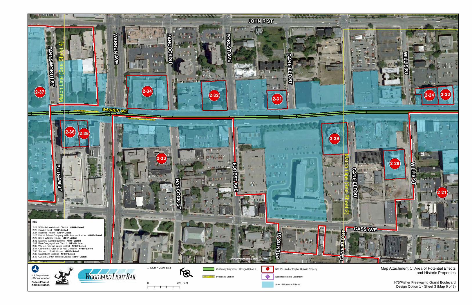
I-75/Fisher Freeway to Grand BoulevardDesign Option 1 - Sheet 3 (Map 6 of 8)
Map Attachment C: Area of Potential Effectsand Historic Properties
0 225 Feet
Guideway Alignment - Design Option 1
Proposed Station
NRHP-Listed or Eligible Historic Property
National Historic Landmark
Area of Potential Effects
!!1-1
Aerial Imagery: Bing Maps
881-1
KEY2-21 Willis-Selden Historic District NRHP-Listed2-23 Garden Bowl NRHP-Listed2-24 Majestic Theater NRHP-Listed2-26 Detroit Edison Company Willis Avenue Station NRHP-Listed2-29 David Whitney House NRHP-Listed2-31 Edwin S. George Building NRHP-Listed2-32 First Congregational Church NRHP-Listed2-33 Warren-Prentis Historic District NRHP-Listed2-34 Cathedral Church of St Paul Complex NRHP-Listed2-35 Samuel L. Smith House NRHP-Listed2-36 Maccabees Building NRHP-Listed2-37 Cultural Center Historic District NRHP-Listed

Mat
ch L
ine
(See
She
et 5
)
Match Line (S
ee Sheet 3)
F
1 INCH = 200 FEET
I-75/Fisher Freeway to Grand BoulevardDesign Option 1 - Sheet 4 (Map 7 of 8)
Map Attachment C: Area of Potential Effectsand Historic Properties
0 225 Feet
Guideway Alignment - Design Option 1
Proposed Station
NRHP-Listed or Eligible Historic Property
National Historic Landmark
Area of Potential Effects
!!1-1
Aerial Imagery: Bing Maps
881-1
KEY2-37 Cultural Center Historic District NRHP-Listed2-38 Detroit Historical Museum NRHP-Eligible2-39 The Wardell NRHP-Listed2-42 Col. Frank J. Hecker House NRHP-Listed2-43 East Ferry Avenue Historic District NRHP-Listed2-44 Barlum Apartments Building NRHP-Eligible2-51 St. Joseph's Episcopal Church NRHP-Listed2-54 New Amsterdam Historic District NRHP-Listed

Match Line (S
ee Sheet 4)
Potential Location ofVehicle Storage andMaintenance Facility
F
1 INCH = 200 FEET
I-75/Fisher Freeway to Grand BoulevardDesign Option 1 - Sheet 5 (Map 8 of 8)
Map Attachment C: Area of Potential Effectsand Historic Properties
0 225 Feet
Guideway Alignment - Design Option 1
Proposed Station
NRHP-Listed or Eligible Historic Property
National Historic Landmark
Area of Potential Effects
!!1-1
Aerial Imagery: Bing Maps
881-1
KEY2-51 St. Joseph's Episcopal Church NRHP-Listed2-54 New Amsterdam Historic District NRHP-Listed2-57 Piquette Avenue Industrial Historic District NRHP-Listed2-58 Conrail and Grand Trunk Western Railroad Bridges NRHP-Eligible2-60 New Center Commercial Historic District NRHP-Eligible
Woodward Avenue Light Rail Transit Project (ER# 08-462)Phased Section 106 Submittal – Assessment of Effects – I-75/Fisher Freeway to Grand Boulevard (October 2010)
Downtown Design Option 1See Map Attachment C
Between I-75/Fisher Freeway and Grand Boulevard, Design Option 1 includes a two-way,median-running guideway alignment located within Woodward Avenue. Stations in this areainclude LRT platforms at Martin Luther King Jr. Boulevard, Warren Avenue, PiquetteStreet/Amsterdam Street, and Grand Boulevard.
The Design Option 1 alignment would incorporate the overhead contact system (OCS),including electrification, support wires, and support poles. At this time, no traction powersubstations have been proposed between I-75/Fisher Freeway and Grand Boulevard.
LRT station design would be context sensitive, as applicable, and would be based onstakeholder input, adjacent land use, and/or building forms and materials. Between I-75/FisherFreeway and Grand Boulevard, all proposed Design Option 1 stations would be located withinthe median area of Woodward Avenue. These stations would include split-platform stations,incorporating separate, single-sided platforms each serving one direction of LRT traffic, or asingle-platform station, incorporating a single, double-sided platform serving LRT traffic in eachdirection.
Typical split-platform LRT stations would include individual, single-sided platforms up to 14inches high, 180 to 200 feet long, and from 10 feet, 6 inches to 12 feet wide. Platforms wouldrequire access ramps from 14 to 24 feet long, depending on site conditions. Station shelterswould be open or glass-enclosed and approximately 100 feet long and 10 to 14 feet tall.Additional station components would include railings, light fixtures, benches, ticket vendingequipment, information cases, and litter receptacles. Typical single-platform LRT stations wouldcomprise the same features, but the double-sided platforms would be 18 to 24 feet wide.
Final LRT station design would be approached on a specific, case-by-case basis based onstation location, physical context, public involvement, and any applicable local ordinances,including historic preservation ordinances mandating design review for structures in localhistoric districts.
Although only one Vehicle Storage and Maintenance Facility (VSMF) is proposed for the LRTproject, two potential sites have been identified between I-75/Fisher Freeway and GrandBoulevard. The potential VSMF sites are identical for each design option. Proposed sitesinclude an area west of Woodward Avenue between Martin Luther King Jr. Boulevard andStimson and Peterboro streets, and a separate, second proposed area west of WoodwardAvenue between the Conrail and Grand Trunk Western railroads and Amsterdam Street. Thefacility would be required to store and maintain the light rail vehicles. Typical functions at thislocation would include vehicle storage, paint booth, lifts, pits, wheel truing, wash bays, andassociated administrative functions. VSMF design would be site specific; however, each sitewould include the yard and industrial-style buildings.
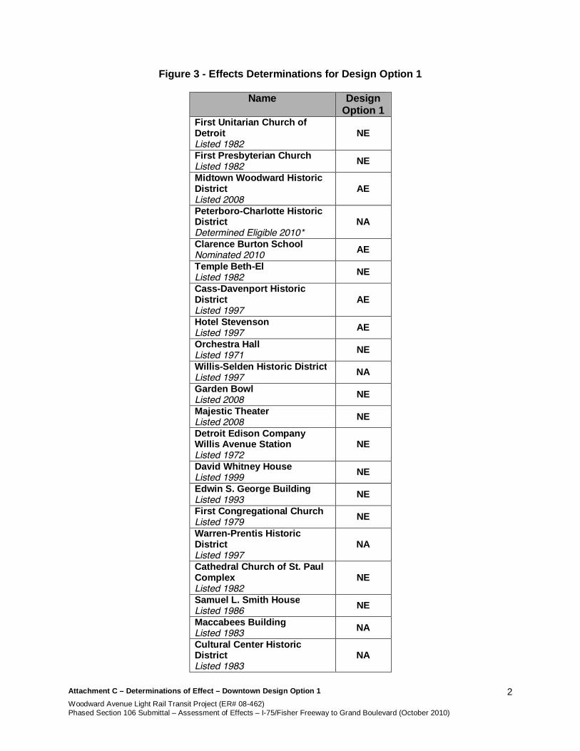
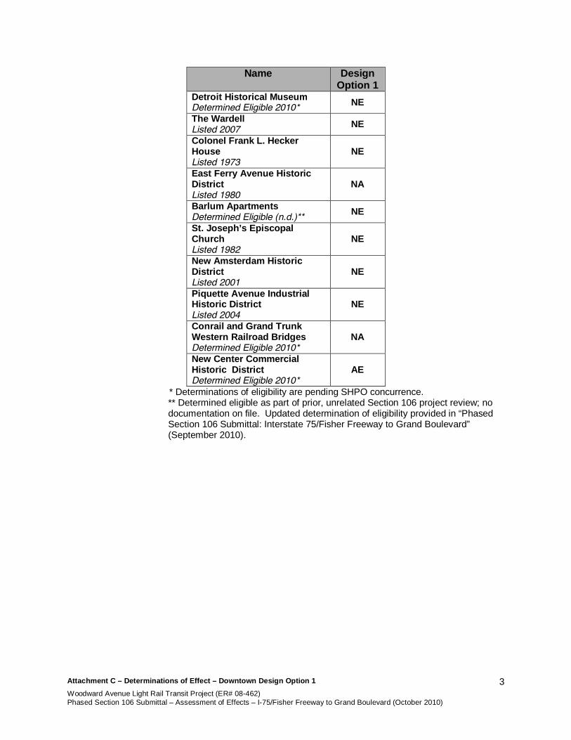
The following table (Figure 3) summarizes effects determinations for Design Option 1. Detailedassessments and viewshed photographs of each historic property follow. In cases where nocomponent of the project would be visible from the historic property and a determination of noeffect has been made, no viewshed photographs are included.
Attachment C – Determinations of Effect – Downtown Design Option 1Woodward Avenue Light Rail Transit Project (ER# 08-462)Phased Section 106 Submittal – Assessment of Effects – I-75/Fisher Freeway to Grand Boulevard (October 2010)
2
Figure 3 - Effects Determinations for Design Option 1
Name DesignOption 1
First Unitarian Church ofDetroitListed 1982
NE
First Presbyterian ChurchListed 1982 NE
Midtown Woodward HistoricDistrictListed 2008
AE
Peterboro-Charlotte HistoricDistrictDetermined Eligible 2010*
NA
Clarence Burton SchoolNominated 2010 AE
Temple Beth-ElListed 1982 NE
Cass-Davenport HistoricDistrictListed 1997
AE
Hotel StevensonListed 1997 AE
Orchestra HallListed 1971 NE
Willis-Selden Historic DistrictListed 1997 NA
Garden BowlListed 2008 NE
Majestic TheaterListed 2008 NE
Detroit Edison CompanyWillis Avenue StationListed 1972
NE
David Whitney HouseListed 1999 NE
Edwin S. George BuildingListed 1993 NE
First Congregational ChurchListed 1979 NE
Warren-Prentis HistoricDistrictListed 1997
NA
Cathedral Church of St. PaulComplexListed 1982
NE
Samuel L. Smith HouseListed 1986 NE
Maccabees BuildingListed 1983 NA
Cultural Center HistoricDistrictListed 1983
NA
Attachment C – Determinations of Effect – Downtown Design Option 1Woodward Avenue Light Rail Transit Project (ER# 08-462)Phased Section 106 Submittal – Assessment of Effects – I-75/Fisher Freeway to Grand Boulevard (October 2010)
3
Name DesignOption 1
Detroit Historical MuseumDetermined Eligible 2010* NE
The WardellListed 2007 NE
Colonel Frank L. HeckerHouseListed 1973
NE
East Ferry Avenue HistoricDistrictListed 1980
NA
Barlum ApartmentsDetermined Eligible (n.d.)** NE
St. Joseph’s EpiscopalChurchListed 1982
NE
New Amsterdam HistoricDistrictListed 2001
NE
Piquette Avenue IndustrialHistoric DistrictListed 2004
NE
Conrail and Grand TrunkWestern Railroad BridgesDetermined Eligible 2010*
NA
New Center CommercialHistoric DistrictDetermined Eligible 2010*
AE
* Determinations of eligibility are pending SHPO concurrence.** Determined eligible as part of prior, unrelated Section 106 project review; nodocumentation on file. Updated determination of eligibility provided in “PhasedSection 106 Submittal: Interstate 75/Fisher Freeway to Grand Boulevard”(September 2010).

Attachment C – Determinations of Effect – Downtown Design Option 1Woodward Avenue Light Rail Transit Project (ER# 08-462)Phased Section 106 Submittal – Assessment of Effects – I-75/Fisher Freeway to Grand Boulevard (October 2010)
4
First Unitarian Church of Detroit(See Map Attachment C; see Figures 4-5)The First Unitarian Church of Detroit is a red-sandstone-clad, late nineteenth-century,Romanesque Revival-style church with a cruciform plan and a steeply pitched slate roof withcopper trim. The property was listed in the NRHP under Criterion C and Criteria ConsiderationA as an excellent and distinctive example of a Romanesque Revival-style church and animportant work of the local architectural firm of Donaldson and Meier.
Near the First Unitarian Church of Detroit, project implementation under Design Option 1 wouldbe limited to construction of the guideway alignment and corresponding OCS along WoodwardAvenue’s central lanes, approximately 65 feet from the property’s western NRHP boundary.The OCS, consisting of support poles and wires, would be installed in roadway rights-of-wayalong the alignment. No planned stations are proximate to the First Unitarian Church.
No physical impacts to the First Unitarian Church of Detroit would occur; no project activity isproposed within the property’s NRHP boundary. Therefore, no effects to the property’s integrityof location, design, materials, and workmanship would occur.
The First Unitarian Church of Detroit no longer retains integrity of setting due to land clearanceand twentieth-century commercial development in its vicinity. In addition, the church’s formerlyopen front porch was enclosed during the City of Detroit’s widening of Woodward Avenue in1936; this exterior alteration diminished the significance of the property’s setting by limitingviews from the main entrance. Although the proposed embedded guideway and OCS would bevisible from some portions of the First Unitarian Church of Detroit, these facilities represent aminor alteration to the property’s already altered visual setting; no significant views to or fromthe building would be obscured. Because no views would be obscured, no visual effects to theproperty were identified. In addition, based on current information, no auditory, vibratory, oratmospheric impacts were identified for the property. Therefore, project implementation wouldhave no effect to the property’s integrity of setting.
Furthermore, no project activity would alter the property’s feeling as an excellent example of aRomanesque Revival-style church or its association with that architectural style and the work ofDonaldson and Meier. Therefore, project implementation would have no effect to the property’sintegrity of feeling and association under Design Option 1.
Based on this evaluation, the Woodward Avenue LRT would have no effect to the FirstUnitarian Church of Detroit under Design Option 1.

Attachment C – Determinations of Effect – Downtown Design Option 1Woodward Avenue Light Rail Transit Project (ER# 08-462)Phased Section 106 Submittal – Assessment of Effects – I-75/Fisher Freeway to Grand Boulevard (October 2010)
5
Figure 4Facing southwest along Woodward Avenue from northwest corner of First Unitarian Church of
Detroit at Edmund Place
Figure 5Facing northwest along Woodward Avenue to Midtown Woodward Historic District (at left, center)
from northwest corner of First Unitarian Church of Detroit

Attachment C – Determinations of Effect – Downtown Design Option 1Woodward Avenue Light Rail Transit Project (ER# 08-462)Phased Section 106 Submittal – Assessment of Effects – I-75/Fisher Freeway to Grand Boulevard (October 2010)
6
First Presbyterian Church of Detroit(See Map Attachment C; see Figures 6-7)The First Presbyterian Church of Detroit is a red-sandstone-clad, late nineteenth-century,Richardsonian Romanesque-style church with a Greek cross plan and a steeply pitched,hipped, slate roof. The property was listed in the NRHP under Criterion A for its associationwith the oldest Protestant congregation in Detroit and under Criterion C and CriteriaConsideration A as an excellent and distinctive example of a Romanesque Revival-style churchand an important work of the local architect George D. Mason.
Near the First Presbyterian Church of Detroit, project implementation under Design Option 1would be limited to construction of the guideway alignment and the corresponding OCS alongWoodward Avenue’s central lanes, approximately 65 feet from the property’s western NRHPboundary. The OCS, consisting of support poles and wires, would be installed in roadwayrights-of-way along the alignment. No planned stations are proximate to the First PresbyterianChurch of Detroit.
No physical impacts to the First Presbyterian Church of Detroit would occur; no project activity isproposed within the property’s NRHP boundary. Therefore, no effects to the property’s integrityof location, design, materials, and workmanship would occur.
The First Presbyterian Church of Detroit no longer retains integrity of setting. The property wasoriginally set back from Woodward Avenue in a tree-shaded residential neighborhood, but isnow adjacent to Woodward Avenue and surrounded largely by multi-story commercialproperties and vacant parcels. In addition, the City of Detroit’s widening of Woodward Avenuein 1936 resulted in the re-orientation of the main entrance from the west facade to the south,side elevation; this exterior alteration diminished the significance of the property’s setting bylimiting views from the main entrance. Although the proposed guideway alignment and OCSwould be visible from some portions of the First Presbyterian Church of Detroit, these facilitiesrepresent a minor alteration to the property’s visual setting. Therefore, no significant views to orfrom the building would be obscured and no components of the setting would be impacted; novisual effects to the property were identified. In addition, based on current information, noauditory, vibratory, or atmospheric impacts were identified for the property. Therefore, projectimplementation would have no effect to the property’s integrity of setting.
Furthermore, no project activity would alter the property’s feeling as an excellent example of aRomanesque Revival-style church or its association with that architectural style, the work ofDonaldson and Meier, or the oldest Protestant congregation in Detroit. Therefore, projectimplementation would have no effect to the property’s integrity of feeling and association underDesign Option 1.
Based on this evaluation, the Woodward Avenue LRT would have no effect to the FirstPresbyterian Church of Detroit under Design Option 1.

Attachment C – Determinations of Effect – Downtown Design Option 1Woodward Avenue Light Rail Transit Project (ER# 08-462)Phased Section 106 Submittal – Assessment of Effects – I-75/Fisher Freeway to Grand Boulevard (October 2010)
7
Figure 6Facing southwest along Woodward Avenue from southwest corner of First Presbyterian Church of
Detroit at Edmund Place
Figure 7Facing northwest along Woodward Avenue to Midtown Woodward Historic District (at left, center)
from northwest corner of First Presbyterian Church of Detroit

Attachment C – Determinations of Effect – Downtown Design Option 1Woodward Avenue Light Rail Transit Project (ER# 08-462)Phased Section 106 Submittal – Assessment of Effects – I-75/Fisher Freeway to Grand Boulevard (October 2010)
8
Midtown Woodward Historic District(See Map Attachment C; see Figures 8-11)The Midtown Woodward Historic District consists of thirteen commercial and residentialbuildings along Woodward Avenue between Peterboro and Erskine streets on the south andCharlotte and Watson streets on the north. Constructed between 1900 and 1920, the buildingsrepresent Renaissance Revival, Neoclassical, Chicago Style, and Art Deco architectural styles.The district was listed in the NRHP under Criterion A for its significance in the commercialdevelopment of Woodward Avenue and under Criterion C as a significant collection of earlytwentieth-century commercial buildings.
Near the Midtown Woodward Historic District, project implementation under Design Option 1would include construction of the guideway alignment and the corresponding OCS alongWoodward Avenue’s central lanes. The project would also include the potential construction ofthe VSMF west of the district. The guideway would be embedded at-grade along WoodwardAvenue. The OCS, consisting of support poles and wires, would be installed in roadway rights-of-way along the alignment. The proposed VSMF, consisting of a rail yard and industrial-stylebuildings, would be constructed northwest of Woodward Avenue, south of Martin Luther King Jr.Boulevard, and along Stimson Street, abutting portions of the district’s northwestern NRHPboundary. No planned stations are proximate to the Midtown Woodward Historic District.
No physical impacts to contributing properties within the Midtown Woodward Historic Districtwould occur. All construction activity would take place within existing rights-of-way; no projectactivity is proposed within the legal parcels of any contributing property. Rights-of-way withinthe district that would be affected by guideway and OCS construction contain non-historicroadway materials; these features do not contribute to the historic district’s significance. Theproposed VSMF is not located within the district’s boundaries and would have no physical effectto the district or its contributing properties. Therefore, no effects to the district’s integrity oflocation, design, materials, and workmanship would occur.
Although the proposed guideway and OCS, which would run through the district’s boundariesalong Woodward Avenue, would be visible from some portions of contributing properties withinthe district, these facilities would represent a minor alteration to the district’s urban visualsetting. No significant views to or from the contributing properties would be obscured and nosignificant elements of the district’s setting would be affected by the guideway and OCS. Theproposed VSMF, which may abut portions of the district’s northwestern NRHP boundary oncurrently vacant parcels south of Martin Luther King Jr. Boulevard and along Stimson Street,would not obscure or obstruct views to or from the district as a whole. However, the proposedindustrial facility would obscure views north and west from the apartment building at 26Peterboro Street, which is a contributing building within the Midtown Woodward Historic District.Although the historic commercial and residential fabric of the proposed VSMF site has beenpreviously cleared, the area maintains its character as a residential neighborhood withcommercial activity along Woodward Avenue. Potential construction of the VSMF wouldintroduce an incompatible, industrial facility into this contributing property’s historicallycommercial and residential setting. Therefore, implementation of the Woodward Avenue LRTunder Design Option 1 would result in an adverse effect to the district’s integrity of setting.Based on current information, no auditory, vibratory, or atmospheric impacts were identified forthis property.
Project activity related to the VSMF would alter the district’s feeling as a collection ofcommercial and residential buildings by introducing an industrial facility near a historicallyresidential contributing building, resulting in an adverse effect to the integrity of feeling.

Attachment C – Determinations of Effect – Downtown Design Option 1Woodward Avenue Light Rail Transit Project (ER# 08-462)Phased Section 106 Submittal – Assessment of Effects – I-75/Fisher Freeway to Grand Boulevard (October 2010)
9
However, the district’s association with the commercial development of Woodward Avenuewould remain intact; despite the introduction of the VSMF, the district would continue to conveyits commercial origins. Therefore, project implementation under Design Option 1 would have noadverse effect to the district’s integrity of association.
Based on this evaluation, the Woodward Avenue LRT Design Option 1 would have an adverseeffect to the Midtown Woodward Historic District.

Attachment C – Determinations of Effect – Downtown Design Option 1Woodward Avenue Light Rail Transit Project (ER# 08-462)Phased Section 106 Submittal – Assessment of Effects – I-75/Fisher Freeway to Grand Boulevard (October 2010)
10
Figure 8Facing northwest along Woodward Avenue from southeast corner of Watson Street
Figure 9Facing southwest along Woodward Avenue to Midtown Woodward Historic District (at right,
center) from south of Erskine Street
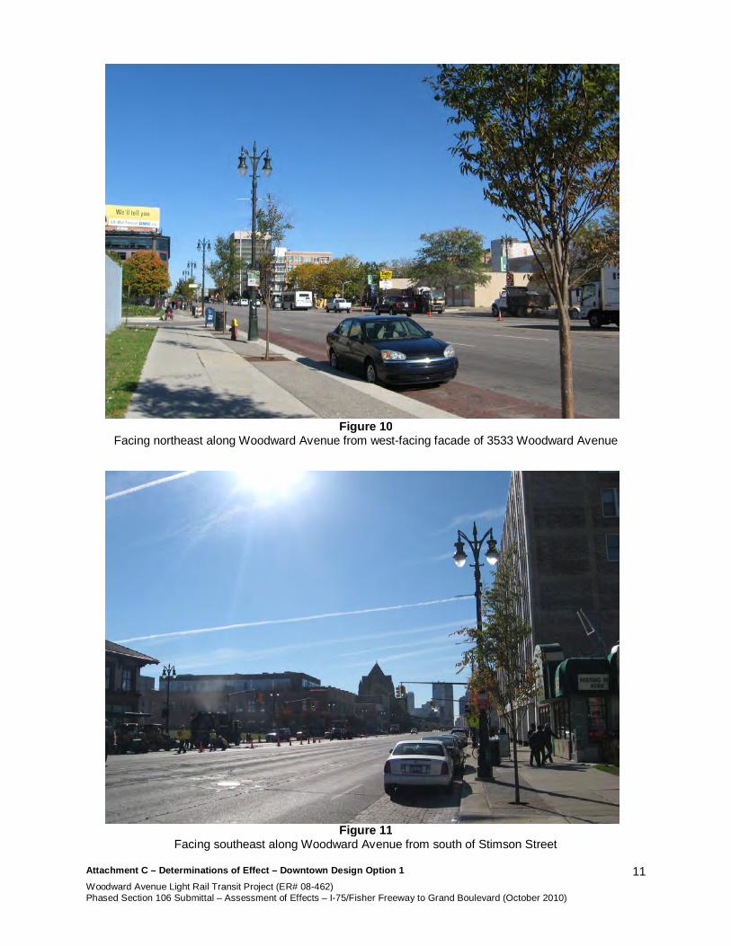
Attachment C – Determinations of Effect – Downtown Design Option 1Woodward Avenue Light Rail Transit Project (ER# 08-462)Phased Section 106 Submittal – Assessment of Effects – I-75/Fisher Freeway to Grand Boulevard (October 2010)
11
Figure 10Facing northeast along Woodward Avenue from west-facing facade of 3533 Woodward Avenue
Figure 11Facing southeast along Woodward Avenue from south of Stimson Street
Attachment C – Determinations of Effect – Downtown Design Option 1Woodward Avenue Light Rail Transit Project (ER# 08-462)Phased Section 106 Submittal – Assessment of Effects – I-75/Fisher Freeway to Grand Boulevard (October 2010)
12
Peterboro-Charlotte Historic District(See Map Attachment C; see Figures 12-14)The Peterboro-Charlotte Historic District consists of nine, late nineteenth-century residences onPeterboro Street, Charlotte Street, and Park Boulevard. The buildings represent a variety ofstyles including Queen Anne, Second Empire, Italian Renaissance Revival, and RichardsonianRomanesque. The district was determined eligible for listing in the NRHP under Criterion C asan exemplary collection of residences representing the eclectic styles found in middle-class,streetcar developments of the era.
Near the Peterboro-Charlotte Historic District, project implementation under Design Option 1would include construction of the guideway alignment and the corresponding OCS alongWoodward Avenue’s central lanes. The project may also include construction of the potentialVSMF north of the district. The guideway would be embedded at-grade within WoodwardAvenue and approximately 300 feet from the district’s eastern NRHP boundary. The OCS,consisting of support poles and wires, would be installed in roadway rights-of-way along theguideway alignment. The VSMF, consisting of a rail yard and industrial-style buildings, may beconstructed west of Woodward Avenue along Martin Luther King Jr. Boulevard and StimsonStreet, approximately 250 feet from the district’s northern NRHP boundary. No planned stationsare proximate to the Peterboro-Charlotte Historic District.
No physical impacts to the Peterboro-Charlotte Historic District would occur; no project activityis proposed within the district’s NRHP boundaries, or within the individual parcels of anycontributing properties. Therefore, no effects to the district’s integrity of location, design,materials, and workmanship would occur.
Although the proposed guideway alignment and OCS would be visible from portions of thePeterboro-Charlotte Historic District along Peterboro and Charlotte streets, no historicallysignificant views to or from the district would be obstructed or obscured and no character-defining features of the district’s setting would be impacted. The district’s integrity of setting inthe eastern area along Woodward Avenue is diminished by recent land clearance and twentieth-century commercial development. In addition, views to the proposed guideway and OCS wouldalready be limited by existing structures along the west side of Woodward Avenue and by heavytraffic along that street. The guideway alignment and OCS would be located along WoodwardAvenue and would represent minor alterations to the district’s already diminished easternsetting. The proposed VSMF would be located north of the district along Stimson Street,approximately 250 feet from the district’s northern NRHP boundary, and separated from thedistrict by a large parking lot along the north side of Peterboro Street. This parking lot, which isenclosed by a tall chain-link and iron fence, is the result of land clearance on this block andalready compromises the district’s historically residential setting along the northern boundary.The presence of this parking lot as an intervening parcel between the VSMF and contributingresources would diminish the visual effects of the VSMF to the district’s setting. Therefore, theproposed VSMF would not further obscure or obstruct historic views to or from the district.Based on current information, no auditory, vibratory, or atmospheric impacts were identified forthis property. Therefore, implementation of the Woodward Avenue LRT under Design Option 1would result in no adverse effect to the district’s integrity of setting.
Project components would not alter the district’s feeling as a collection of eclectic nineteenth-century residences or its association with those styles and that building type because nocontributing properties would be physically altered. Therefore, project implementation wouldhave no adverse effect to the district’s integrity of feeling or association.
Attachment C – Determinations of Effect – Downtown Design Option 1Woodward Avenue Light Rail Transit Project (ER# 08-462)Phased Section 106 Submittal – Assessment of Effects – I-75/Fisher Freeway to Grand Boulevard (October 2010)
13
Based on this evaluation, the Woodward Avenue LRT Design Option 1 would have no adverseeffect to the Peterboro-Charlotte Historic District.

Attachment C – Determinations of Effect – Downtown Design Option 1Woodward Avenue Light Rail Transit Project (ER# 08-462)Phased Section 106 Submittal – Assessment of Effects – I-75/Fisher Freeway to Grand Boulevard (October 2010)
14
Figure 12Facing northwest along Peterboro Street to Woodward Avenue
Figure 13Facing northwest along Charlotte Street to contributing buildings (at left) and Woodward Avenue

Attachment C – Determinations of Effect – Downtown Design Option 1Woodward Avenue Light Rail Transit Project (ER# 08-462)Phased Section 106 Submittal – Assessment of Effects – I-75/Fisher Freeway to Grand Boulevard (October 2010)
15
Figure 14Facing north to proposed VSMF site from Peterboro Street