This Accepted Author Manuscript is copyrighted and...
37
This Accepted Author Manuscript is copyrighted and published by Elsevier. It is posted here by agreement between Elsevier and University of Brasilia. Changes resulting from the publishing process - such as editing, corrections, structural formatting, and other quality control mechanisms - may not be reflected in this version of the text. The definitive version of the text was subsequently published in [Journal of South American Earth Sciences, Volume 17, Issue 2, October 2004, Pages 153–169, http://dx.doi.org/10.1016/j.jsames.2004.03.001]. You may download, copy and otherwise use the AAM for non-commercial purposes provided that your license is limited by the following restrictions: (1) You may use this AAM for non-commercial purposes only under the terms of the CC-BY-NC-ND license. (2) The integrity of the work and identification of the author, copyright owner, and publisher must be preserved in any copy. (3) You must attribute this AAM in the following format: [agreed attribution language, including link to CC BY-NC-ND license + Digital Object Identifier link to the published journal article on Elsevier’s ScienceDirect® platform]. Este Manuscrito do Autor Aceito para Publicação (AAM) é protegido por direitos autorais e publicado pela Elsevier. Ele esta disponível neste Repositório, por acordo entre a Elsevier e a Universidade de Brasília. As alterações decorrentes do processo de publicação - como a edição, correção, formatação estrutural, e outros mecanismos de controle de qualidade - não estão refletidas nesta versão do texto. A versão definitiva do texto foi posteriormente publicado em [Journal of South American Earth Sciences, Volume 17, Número 2, Outubro 2004, Pages 153-169, http://dx.doi.org/10.1016/j.jsames.2004.03.001]. Você pode baixar, copiar e utilizar de outra forma o AAM para fins não comerciais , desde que sua licença seja limitada pelas seguintes restrições: (1) Você pode usar este AAM para fins não comerciais apenas sob os termos da licença CC- BY- NC-ND. (2) A integridade do trabalho e identificação do autor, detentor dos direitos autorais e editor deve ser preservado em qualquer cópia. (3) Tem de atribuir este AAM no seguinte formato: [acordo na linguagem atribuída, incluindo o link para CC BY-NC-ND licença Digital + DOI do artigo publicado na revista Elsevier ScienceDirect ® da plataforma].
Transcript of This Accepted Author Manuscript is copyrighted and...

This Accepted Author Manuscript is copyrighted and published by Elsevier. It is posted here by agreement between Elsevier and University of Brasilia. Changes resulting from the publishing process - such as editing, corrections, structural formatting, and other quality control mechanisms - may not be reflected in this version of the text. The definitive version of the text was subsequently published in [Journal of South American Earth Sciences, Volume 17, Issue 2, October 2004, Pages 153–169, http://dx.doi.org/10.1016/j.jsames.2004.03.001]. You may download, copy and otherwise use the AAM for non-commercial purposes provided that your license is limited by the following restrictions:
(1) You may use this AAM for non-commercial purposes only under the terms of the CC-BY-NC-ND license.
(2) The integrity of the work and identification of the author, copyright owner, and publisher must be preserved in any copy.
(3) You must attribute this AAM in the following format: [agreed attribution language, including link to CC BY-NC-ND license + Digital Object Identifier link to the published journal article on Elsevier’s ScienceDirect® platform].
Este Manuscrito do Autor Aceito para Publicação (AAM) é protegido por direitos autorais e publicado pela Elsevier. Ele esta disponível neste Repositório, por acordo entre a Elsevier e a Universidade de Brasília. As alterações decorrentes do processo de publicação - como a edição, correção, formatação estrutural, e outros mecanismos de controle de qualidade - não estão refletidas nesta versão do texto. A versão definitiva do texto foi posteriormente publicado em [Journal of South American Earth Sciences, Volume 17, Número 2, Outubro 2004, Pages 153-169, http://dx.doi.org/10.1016/j.jsames.2004.03.001]. Você pode baixar, copiar e utilizar de outra forma o AAM para fins não comerciais , desde que sua licença seja limitada pelas seguintes restrições:
(1) Você pode usar este AAM para fins não comerciais apenas sob os termos da licença CC- BY- NC-ND.
(2) A integridade do trabalho e identificação do autor, detentor dos direitos autorais e editor deve ser preservado em qualquer cópia.
(3) Tem de atribuir este AAM no seguinte formato: [acordo na linguagem atribuída, incluindo o link para CC BY-NC-ND licença Digital + DOI do artigo publicado na revista Elsevier ScienceDirect ® da plataforma].

The Caldas Novas dome, central Brazil: structural evolution and implications for the evolution of the Neoproterozoic
Brasilia belt
Luiz Jose Homem D’el-Rey Silva1
Percy Boris Wolf Klein
Detlef Hans-Gert Walde
Abstract
The Caldas Novas dome (Goiaas state, central Brazil) lies in the southern segment of the Neoproterozoic Brasilia belt (center of the Tocantins Province) between the Goias magmatic arc and the margin of the ancient Sao Francisco plate. The core of the dome comprises rocks of the Meso-Neoproterozoic Paranoa group (passive margin psamitic-pelitic sediments and subgreenschist facies) covered by a nappe of the Neoproterozoic Araxa group (backarc basin pelitic-psamitic sediments and volcanics of greenschist facies, bitotite zone). Hot underground waters that emerge along fractures in the Paranoa quartzite and wells in the Araxa schist have made the Caldas Novas dome an international tourist attraction. A recent detailed structural analysis
demonstrates that the dome area was affected by a D₁D₃ Brasiliano cycle progressive deformation in the — 750-600 Ma interval (published U-Pb and
Sm-Nd data). During event D₁, a pervasive layer- parallel foliation developed coeval the regional metamorphism. Event D₂ (intense F₂ isoclinal folding) was responsible for the emplacement of the nappe. D₁ and D₂ record a regime of simple shear (top-to-SE relative regional movement) due to a WNW-ESE
subhorizontal compression (a 1). Event D₃ records a WSW-ENE compression, during which the dome rose as a large-scale F₃ fold, possibly associated with a duplex structure at depth. During the dome’s uplift, the layers slid back and down in all directions, giving way to gravity-slide folds and an extensional crenulation cleavage. A set of brittle fractures and quartz veins constitutes the
record of a late-stage D₄ event important for understanding the thermal water reservoir.
Keywords: Caldas novas dome; Brasilia belt; Brasiliano cycle; Neoproterozoic; Structural analysis; Thermal water; Tocantins province
1 Instituto de Geociências/Universidade de Brasilia (IG/UnB), Campus Universitário
Darcy Ribeiro, Asa Norte, CEP 70,910-900 Brasilia-DF, Brazil
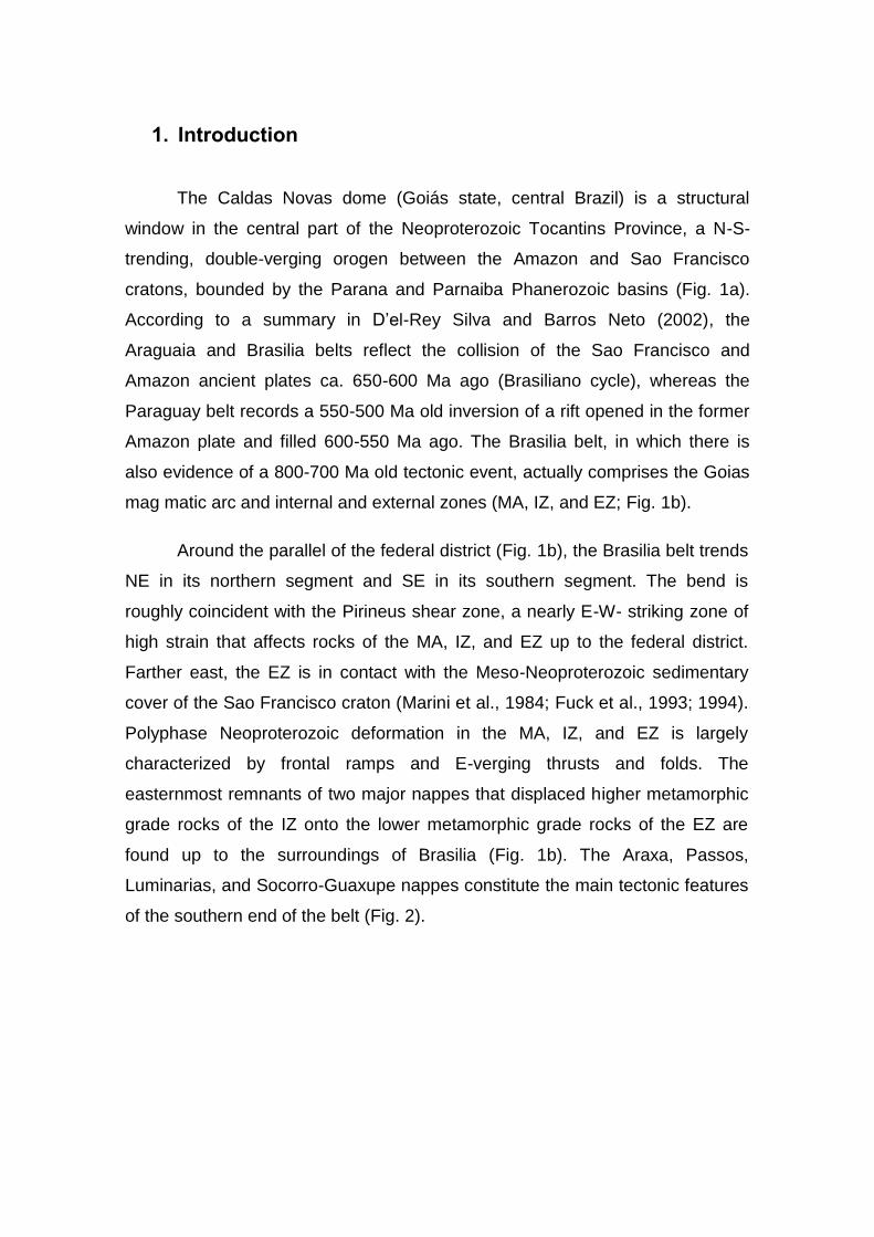
1. Introduction
The Caldas Novas dome (Goiás state, central Brazil) is a structural
window in the central part of the Neoproterozoic Tocantins Province, a N-S-
trending, double-verging orogen between the Amazon and Sao Francisco
cratons, bounded by the Parana and Parnaiba Phanerozoic basins (Fig. 1a).
According to a summary in D’el-Rey Silva and Barros Neto (2002), the
Araguaia and Brasilia belts reflect the collision of the Sao Francisco and
Amazon ancient plates ca. 650-600 Ma ago (Brasiliano cycle), whereas the
Paraguay belt records a 550-500 Ma old inversion of a rift opened in the former
Amazon plate and filled 600-550 Ma ago. The Brasilia belt, in which there is
also evidence of a 800-700 Ma old tectonic event, actually comprises the Goias
mag matic arc and internal and external zones (MA, IZ, and EZ; Fig. 1b).
Around the parallel of the federal district (Fig. 1b), the Brasilia belt trends
NE in its northern segment and SE in its southern segment. The bend is
roughly coincident with the Pirineus shear zone, a nearly E-W- striking zone of
high strain that affects rocks of the MA, IZ, and EZ up to the federal district.
Farther east, the EZ is in contact with the Meso-Neoproterozoic sedimentary
cover of the Sao Francisco craton (Marini et al., 1984; Fuck et al., 1993; 1994).
Polyphase Neoproterozoic deformation in the MA, IZ, and EZ is largely
characterized by frontal ramps and E-verging thrusts and folds. The
easternmost remnants of two major nappes that displaced higher metamorphic
grade rocks of the IZ onto the lower metamorphic grade rocks of the EZ are
found up to the surroundings of Brasilia (Fig. 1b). The Araxa, Passos,
Luminarias, and Socorro-Guaxupe nappes constitute the main tectonic features
of the southern end of the belt (Fig. 2).
Fig. 1. (a) Simplified map displaying the major lithotectonic units of Brazil and highlighting the Tocantins Province
between the Sao Francisco and Amazon cratons. (b) Simplified geological map of the central part of the Province,
based on Marini et al. Marini et al. (1984), Fuck et al. (1993, 1994), and Pimentel et al. (1999, 2000). Vectors for
maximum horizontal compression (o1) are according to a vast inventory of lithostructural data (D’el-Rey Silva and
Barros Neto, 2002). Direction for D₃ shortening is based on this paper and Seer and Dardenne (2000).
Although the Caldas Novas dome is well known for its thermal waters,
few international publications (e.g. Drake, 1980; Troger et al., 1999) discuss its
geology, and the most comprehensive general and recent study of the dome,
which remains unpublished, does not address a structural analysis (Campos et
al., 2000). Since 1999, a Brasilia University-Technical University of Berlin
research program has provided additional information on the regional
hydrology. Further data on the geology and water chemistry appear in technical
reports sponsored by DNPM (a federal office) and local companies (e.g. UHE-
Corumba, Geocaldas, Geocenter).
In this article, we summarize the results of a structural analysis carried
out in the Caldas Novas dome area in October-December 2000. We provide a
structural database relevant for understanding the regional geology and
underground reservoirs of hot water. All data are integrated into a model that
accounts for the tectonic evolution of the dome and the physical-chemical
characteristics of the hot water reservoirs. Our results, combined with the
results of previous and independent structural analyses, geological mapping,
and age determination shed light on the critical difference between the two
segments of the Brasilia belt, a challenge for any interpretation of the tectonic
evolution of Tocantins Province.
2. Tectonic setting
2.1 The magmatic arc (MA), internal zone (IZ,) and external zone (EZ)
The MA, originally characterized by Pimentel and Fuck (1992), consists
of tonalitic orthogneiss, granites, and volcanic-sedimentary sequences
(Lacerda Filho et al., 1999), but it remains poorly known in the north (Pimentel
et al., 2000). The IZ includes, in its northern segment, an Archean-
Paleoproterozoic continental block of gneiss, tonalite, and greenstone-type
volcanic-sedimentary sequences affected by polycyclic tectonism (Queiroz,
2000); three mafic-ultramafic layered intrusions metamorphosed to the
granulite facies (plus metavolcano- sedimentary sequences to the west, not
distinguished in Fig. 1b) and narrow tectonic slices of Paleoproterozoic
basement rocks to the east; and a strip of metasediments that comprises, from
S to N, rocks of the Araxa, Paranoa, and Serra da Mesa groups (Fig. 1b; D’el-
Rey Silva and Barros Neto, 2002). In the south, the IZ includes the backarc
basin-like Araxa group, which mainly comprises amphibolite-greenschist facies
metasediments and basic metavolcanics (e.g. Brod et al., 1991) and a
longitudinal belt of Neoproterozoic granulites. The eastern boundary of the IZ is
a contractional frontal ramp that dips less than 30° to the west and places high-
P rocks in sharp contact with the Araxa nappe, as well as with low greenschist
facies and strongly shortened passive margin-like metasediments of the EZ
(Fig. 1b).
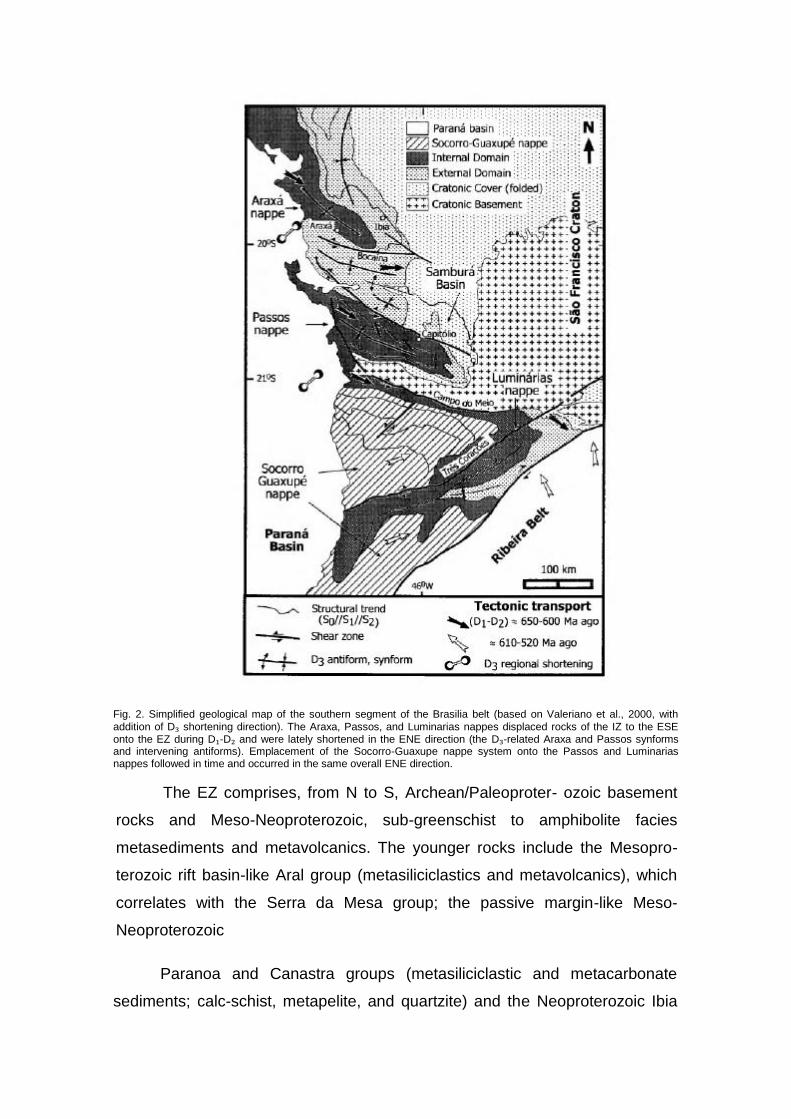
Fig. 2. Simplified geological map of the southern segment of the Brasilia belt (based on Valeriano et al., 2000, with
addition of D₃ shortening direction). The Araxa, Passos, and Luminarias nappes displaced rocks of the IZ to the ESE onto the EZ during D₁-D₂ and were lately shortened in the ENE direction (the D₃-related Araxa and Passos synforms and intervening antiforms). Emplacement of the Socorro-Guaxupe nappe system onto the Passos and Luminarias nappes followed in time and occurred in the same overall ENE direction.
The EZ comprises, from N to S, Archean/Paleoproter- ozoic basement
rocks and Meso-Neoproterozoic, sub-greenschist to amphibolite facies
metasediments and metavolcanics. The younger rocks include the Mesopro-
terozoic rift basin-like Aral group (metasiliciclastics and metavolcanics), which
correlates with the Serra da Mesa group; the passive margin-like Meso-
Neoproterozoic
Paranoa and Canastra groups (metasiliciclastic and metacarbonate
sediments; calc-schist, metapelite, and quartzite) and the Neoproterozoic Ibia
and Vazante groups (respectively, siliciclastics and fine-grained silici- clastics
and metacarbonates); and the Bambui group (siliciclastic and carbonate
metasediments), which rests on the Paranoa group along the eastern margin of
the EZ and stretches over the Sao Francisco craton.
2.2 Surrounding the Caldas Novas dome
The area surrounding the Caldas Novas dome displays north-trending
tectonic slices of a frame of Brasiliano cycle frontal ramps and intervening
lateral ramps (Fig. 3). Data in Lacerda Filho et al. (1999), Fischel et al. (1998,
1999a-c) and Pimentel et al. (1999, 2000) indicate a general lithostratigraphy
consisting of a Paleoprotreozoic crystalline basement (gneiss, orthogneiss, and
the Silvania metavolcano-sedimentary sequence); a Meso-Neoproterozoic
cover that includes the Paranoa, Canastra, and Ibia groups; and a large set of
Neoproterozoic rocks that includes metasediments of the Araxa and Ibia
groups, metavolcano-sedimentary sequences termed Rio Veríssimo and
Marata, orthogneiss of the Goias MA, granulitic rocks akin to the Anapolis-
Itaucu complex that occurs outside the area to the north of Leopoldo de
Bulhoes, and the Ipameri, Aragoiania, and Rio Piracanjuba granite suites.
The area also includes elongated bodies of (mylonitic) granitic intrusions
syntectonically emplaced in the Araxa supracrustals (Pimentel et al., 2000; not
individualized in Fig. 3). They comprise the subvolcanic Marata granites (, 794
Ma old, U-Pb data) derived from the Paleopro- terozoic continental crust, as
well as 700-780 Ma old (Rb-Sr data) granites, which display strongly and
slightly peraluminous signatures, respectively. The former also occurs in the
Marata area, east of Pires do Rio (Fig. 9 in Pimentel et al., 1999), and has an
Sm-Nd composition with tdm model ages in the 1.73-2.5 Ga interval, similar to
that of the Araxa metasediments. The latter are Sesmaria- and Tambu-type
granites, with main outcrop areas east of Ipameri along the Araxa-Ibia contact
(Fig. 10 in Pimentel et al., 1999). These granites derive from Neoproterozoic
juvenile material with Sm- Nd model ages of 1.1-1.0 Ga, equivalent to that
found in the adjacent Goias MA (Pimentel et al., 2000).

The Caldas Novas dome area is particularly important because it lies in
the southern part of a granulite belt that includes (Fig. 1b), three M-Um
intrusions (granulitized ca. 780 Ma ago) and the Anapolis-Itaucu complex
extending south of Ipameri (east of Caldas Novas). Granulites of this complex
derive from supracrustals and granites, are aged ca. 603 ± 31 and 633 ± 28 Ma,
according to U-Pb data in garnets and zircons (Fig. 1b; Fischel et al., 1999a,b;
Fischel, 2002) and occur tectonically intercalated within lower metamorphic
grade rocks of the ca. 750 Ma old Araxa nappe. According to these authors,
both high- and low-grade rocks display similar Sm-Nd isotopic signatures. To
provide a mechanism to explain the uplift of the granulites of the IZ and their
field relationship with the lower-grade metasediments of the nappe and the EZ,
D’el-Rey Silva et al. (1996, 1997) and D’el-Rey Silva (2002a) have shown that
the contraction of the EZ post-nappe emplacement must have occurred through
the mechanism of underthrusting, with the upper crust accompanying the
wetward ductile flow of the ancient Sao Francisco plate.

Fig. 3. Simplified geological map of the southern segment of the Brasilia belt in the surroundings of the Caldas Novas
dome (inside the study area, Fig. 4) based on Lacerda Filho et al. (1999), Fischel et al. (1998, 1999a-c) and Pimentel et
al. (2000). The subdivision and the vertical succession of the Neoproterozoic rocks are informal and do not imply any
relative age relationship.

3. Summary geology of the Caldas Novas dome area
3.1 Summary lithostratigraphy
The Caldas Novas dome is a — 20 X 12 km elliptic structure, with its
longer axis trending NNW (Fig. 4). The study area includes Proterozoic
tectonites of the Paranoa and Araxa groups. The former occupies the core of
the dome, whereas the latter surrounds it and spreads in all directions.
Undeformed conglomerates of a local body (Fig. 4) have been assigned to the
Cretaceous Areado group (Campos et al., 2000).
In the study area, the Paranoa group is a psamo-pelitic sequence
comprising four lithostratigraphic units found in normal contact (Campos et al.,
2000). The basal unit consists of commonly white, wavy rippled, cross-stratified
orthoquartzite that is silicified and crops out along the internal border of the
dome but is partially covered by younger laterite (omitted in Fig. 4) in the central
part.
Five drill holes along an E-W cross-section prove the continuity of the
quartzite, at least at depths of up to 100 m. Moreover, gravity data indicate a
negative anomaly (Haraly, 1978, 1980) that indicates that the Paranoa group
(lighter material) extends to 1000 m deep underneath the dome. Above, the
basal orthoquartzite passes to a unit of brown to red, argillaceous, immature,
and commonly laminated quartzite; then to intercalated layers of quartzite and
metasiltstone (a metarhythmite unit); and finally to an upper unit of
metasiltstone, metamudstone, and argillous metasiltstone.
The Araxa group consists mainly of schists or layered sequences of mica
schist, quartzite, siltic schist, metapelite, pelitic metasiltstone, or metasiltstone.
The thicknesses of these layers may vary within dm- to m- or even dam-scales.
Slightly or unweathered schist commonly exhibits a greyish green color, and the
schist layers display a basic mineralogy of chlorite, biotite, muscovite, and
quartz combined in variable percentages across the area. Feldspars may occur
in the matrix, but no feldspar grain was found in the field, even with the aid of a
hand lens. Nevertheless, cm-size flakes of white mica are relatively common

(e.g. outcrops 2, 68, 72). In several outcrops closer to the contact with the
Paranoa rocks around the dome (e.g. 33, 37, 38, 39, 50, 57, 66, 67, 70), the
bottom of the group consists of biotite-quartz schist, biotite-quartzite, and
chlorite-biotite-schist that forms a continuous layer resistant to erosion. Small
bodies of ultramafic rocks also have been identified regionally within the Araxa
group (Drake, 1980), as well as in the SW corner of the study area (omitted in
Fig. 4 Campos et al., 2000).
Fig. 4. (a) Simplified geological map of the studied area displaying some of the main D₁-D₂ foliation and lineation data.
All overburden has been omitted. Main towns are Caldas Novas, Esplanada, and Rio Quente. The approximate limits of
a major tourist park (Pousada) are also shown. Location of the roads is approximate between two successive outcrops,
particularly those far from one another. Line AB stands for the cross section in Fig. 12. Lower hemisphere stereograms
(Schmidt-Lambert net) of structural data are in b-e.
3.2 Underground Waters
Thermal waters have been noted in the region of Caldas Novas since the
beginning of the eighteenth century (Oriente, 1982). The first site was found
along a stream that started in a fracture zone and cross-cut quartzites of the
western flank of the dome and passed into Pousada park. From here, the
stream turns into the Rio Quente, which flows through Esplanada (Fig. 4) with a
rate of 1.4 m3/s of water as hot as 38 °C but becomes colder to the west.
According to Zschocke (2000), there are three kinds of underground water
reservoirs surrounding Caldas Novas: (1) the Paranoa aquifer whose thermal
waters (> 51 °C) flow from open fractures in the low greenschist metamorphic
facies quartzites, (2) the Araxa aquifer whose thermal waters (> 41 °C) have
been explored from the Araxa schists; and (3) a porous aquifer consisting of
cold waters (24 °C) in the lateritic cover.
Since the early 1970s, Caldas Novas has been a tourist site, benefiting
from the activities of the numerous hotels and private clubs established in the
city with pools of thermal waters from more than 400 boreholes made in the
Araxa schist. Tourism currently also spreads into localities to the west of the
dome and has caused a new wave of civil construction and tourism jobs. The
intensive exploration of the thermal waters has driven DNPM toward more
restrictive control in an attempt to avoid misuse of the underground resources.
3.3 Summary of deformation events and associated structures
The area displays clear evidence of a progressive (Brasiliano cycle)
evolution during three ductile to ductile-brittle deformation events (D₁-D₃) that
affect the primary layering (S₀), defined by the intercalation of beds of different
composition and easily recognizable at different scales in Paranoa and Araxa
metasediments. The inventory of structures includes folds, such as F₂ and F₃,
three axial-plane foliations (S₁-S₃), fold axes (B2 and B3), and lineations such as
the intersections of S₂ with S₀ and S₁ and stretching and striae lineation (L2, Lx,
and Le). The Araxa schists also display two extensional crenulation cleavages
(c0 and d0). Approximately five sets of brittle fractures (S4) have been
recognized, some of which may host cm- to dm-thick quartz veins.
Events D₁ and D₂ record a progressive simple shear along frontal ramps
and imply a relative top-to-ESE displacement along surfaces subparallel to S₀
that gently dip to the NW. The D₁ event developed the pervasive layering-
parallel S₁ foliation, but metamorphism is more intense in the Araxa rocks
(biotite zone, greenschist facies) than in the Paranoa rocks (subgreenschist
facies). The D₂ event is responsible for the placement of higher metamorphic
grade Araxa rocks as a nappe on the lower-grade Paranoa group. The Araxa
group displays many isoclinal to tight F₂ folds of cm- to dm-scale, whereas
Paranoa rocks exhibit F₂ folds that are dm- to m-scale and commonly isoclinal
to tight. Further slip resulted in the development of the c0 extensional
crenulation cleavage, which records progressive displacement within Araxa
schists with systematic top-down to various directions between NE and SE. The
D₃ event developed a major, NNW-SSE-trending, double-plunging F₃ antiform
(i.e. the dome itself) that also affected the nappe.
4. Main tectonic structures
4.1 D₁ event of deformation
Event D₁ mostly developed the S₁ foliation and probably the F₁ folds as
well. Drake (1980) assumes that such folds occur, though they are hard to find
and impossible to measure because they were so severely flattened that no
hinge can be recognized. In areas where deformation records a progressive
inter- and intralayer flow, as in Caldas Novas, F₁ folds may not develop;
therefore, F₁ should be recognized as just those folds that are actually refolded
by F₂ folds or cross cut by S₂ foliation.
Foliation S₁ is penetrative and subparallel to the primary bedding. In the
Araxa rocks, S₁ is commonly a mylonitic structure that consists of a cm-scale S
-C pair in the schists or a mineral foliation in relatively coarser-grained silici-

clastic layers. The S-C mylonitic structure also may be identified in some
intercalated quartzite layers. Almost everywhere, the S-C asymmetry indicates
a top-to-ESE relative movement. The intersection lineation may be safely
measured only locally, due to the S and C planes in S₁ (LiS-C); therefore, it has
not been treated statistically. The Araxa schist commonly displays cm-thick and
dm-long plate-like quartz veins subparallel to the S or C foliations of the pair S-
C = S₁. Such plates are useful for identification of F₂ folds, foliations c! and d0,
and Le striae lineation. In the Paranoa rocks, S₁ is more commonly a mineral
foliation defined by fine-grained white mica and flattened quartz in quartz-rich
layers or very fine-grained mica (sericite) in phyllites or layers with greater
clayey components. The stereogram for S₁/S₀ (Fig. 4b) shows not only a clear
dispersion along the center of the diagram, but also a girdle that reflects the
influence of the F₂ and F₃ folds. Despite all this deformation, the maximum
concentration of poles still records gentle dips to the W or WNW.
4.2 D₂ event of deformation
Event D₂ developed the F₂ folds, the axial plane S₂ foliation, the
penetrative L2 lineation, and the B2 fold axis. The stretching lineation (Lx) and
extensional crenulation cleavage (c0) relate to both D₁ and D₂ events. Foliation
S₂ (commonly a mineral foliation or, more locally, a slaty cleavage) is less
prominent than S₁ but is also penetrative. Fine-grained flakes of sericite and
chlorite (less muscovite) and flattened crystals of quartz define S₂ in Araxa
rocks, whereas sericite and flattened quartz do so in Paranoa rocks. The slaty
cleavage consists of closely spaced planes of partition and is more common in
fine-grained Paranoa rocks, even quartzites. The mineralogy and small grain
size of micas along S₂ indicate that D₂ is associated with a low greenschist
facies metamorphism.
The F₂ folds are cm- to dm-scale in outcrops of Araxa schists and up to
10 m scale in the Paranoa rocks. They are commonly tight to isoclinal, gently to
moderately inclined, or even recumbent, and often evolve into sheath folds (Fig.
5a and b). The latter are key features to decipher the tectonics in the area, in
that they keep a constant orientation and clearly define a generally down-dip
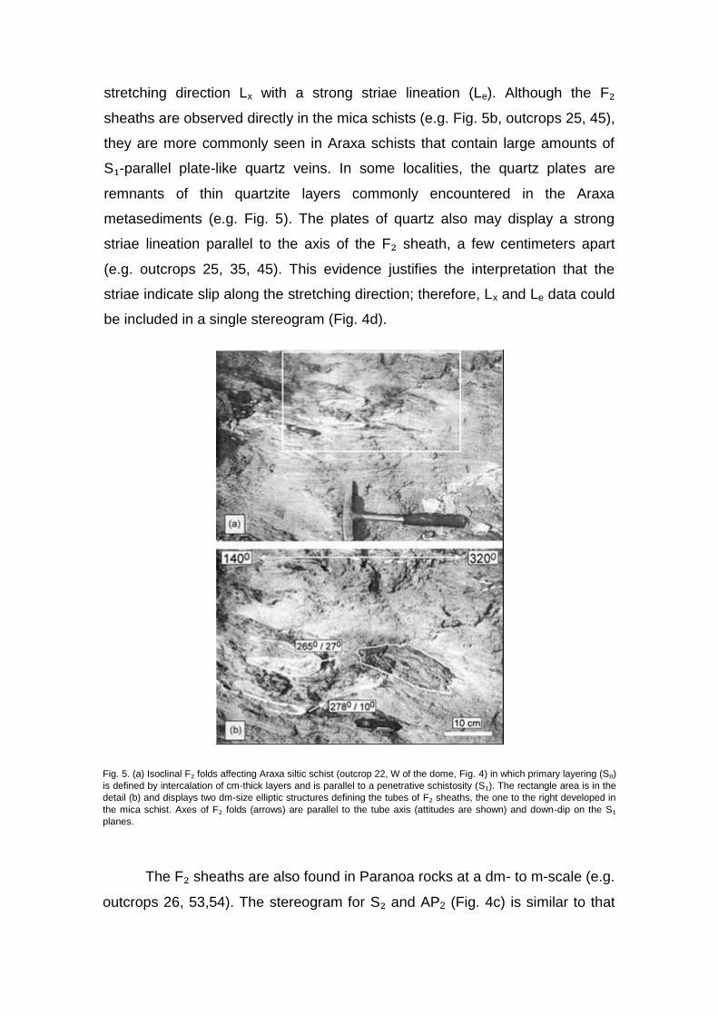
stretching direction Lx with a strong striae lineation (Le). Although the F₂
sheaths are observed directly in the mica schists (e.g. Fig. 5b, outcrops 25, 45),
they are more commonly seen in Araxa schists that contain large amounts of
S₁-parallel plate-like quartz veins. In some localities, the quartz plates are
remnants of thin quartzite layers commonly encountered in the Araxa
metasediments (e.g. Fig. 5). The plates of quartz also may display a strong
striae lineation parallel to the axis of the F₂ sheath, a few centimeters apart
(e.g. outcrops 25, 35, 45). This evidence justifies the interpretation that the
striae indicate slip along the stretching direction; therefore, Lx and Le data could
be included in a single stereogram (Fig. 4d).
Fig. 5. (a) Isoclinal F₂ folds affecting Araxa siltic schist (outcrop 22, W of the dome, Fig. 4) in which primary layering (S₀) is defined by intercalation of cm-thick layers and is parallel to a penetrative schistosity (S₁). The rectangle area is in the
detail (b) and displays two dm-size elliptic structures defining the tubes of F₂ sheaths, the one to the right developed in
the mica schist. Axes of F₂ folds (arrows) are parallel to the tube axis (attitudes are shown) and down-dip on the S₁ planes.
The F₂ sheaths are also found in Paranoa rocks at a dm- to m-scale (e.g.
outcrops 26, 53,54). The stereogram for S₂ and AP2 (Fig. 4c) is similar to that

for S₁//S₀, which indicates that such planes are nearly parallel in the field
because the F₂ folds are frequently isoclinal. In areas where this situation is
common, the term Lx applies because it is impossible to distinguish whether
tectonic slip took place during D₁, D₂, or both events. The distinction is clear
where actual F₂ sheath folds are observed, but the striae observed on a plate of
quartz likely developed progressively and probably record the net slip from both
events.
Both B2 and L2 both plunge to a fan of directions that includes three main
populations (Fig. 4e). The first is the same for Lx (Fig. 4d) because of the F₂
sheathing process. The second (and smallest) population indicates axes that
plunge shallowly to the SW, according to the few F₂ folds preserved in their
original trend. The third and largest population indicates plunges of B2 and L2 to
the N-NNW or S-SSE, which result from the incomplete rotation of B2 from the
SW (original trend) to the direction of maximum stretching (WNW). Thus, the
mean lineation vector (326°/ 13°; Fig. 4e) differs slightly from the average Lx
(296°/12°; Fig. 4d).
Fig. 6. (a) Same map as in of Fig. 4 displaying the main foliation (S₁/S₀) and the two extensional
crenulation cleavages (c0, d0) that affect S₀//S₁ in the study area. Lower hemisphere stereograms
(Schmidt-Lambert net) of structural data are in b-g.

The S₁ data from Fig. 4a are plotted on a map (Fig. 6a) with the other
main foliation in the area (c0, d0), whereas other data for brittle fracturing and
quartz veining are plotted in Fig. 6b-g. The extensional crenulation cleavage c0
is common in the Araxa mylonitic schists, both inside and outside the study
area, such as in outcrops along the road to Ipameri and to the east of the
Corumba River (Fig. 3). Foliation c0 consists of subparallel, discontinuous,
slightly curved surfaces (not rarely anastomosed) that strike at a high angle with
the direction of Lx and dip gently to moderately to the east (Fig. 6b). The c0
planes affect the S-C foliation and make it a sigmoidal-shaped feature, which
suggests top- down to easterly directions (Fig. 7). The discontinuous nature of
c0 is a key feature that distinguishes it from d0 planes. Discontinuity occurs
because c0 surfaces start and die along planes (foliation c) close to one
another, which resembles the c0 structure described by Lister and Snoke (1984)
for progressive extension during the evolution of SC mylonites in general.
Planes of c0 formed during D₁ and D₂; they are observed displacing F₂ folds in
the Araxa schists (Fig. 7).
Fig. 7. The syn-Dx/D₂ extensional crenulation cleavage (c0) affects the Araxa mylonitic schist and is observed
everywhere in the area. It affects a typical S-C pair ( = S₁ foliation) or even F₂ folds in several dam- to hm- scale outcrops W and E of the dome. Photograph taken in outcrop 35. Arrows 1 and 2 indicate foliation c
0 displacing quartz
veins that had been affected by F₂ folds.
4.3 D₃ event of deformation
The structures described in this section (S₃, F₃, and d0) relate to the uplift
of the Caldas Novas dome. This event not only modified the dip of D₁-D₂
structures around the NNW-SSE-trending axis of the dome, but also moved the

layers down, mainly to the E and W directions, but also to the NE, NW, SW, and
SE.
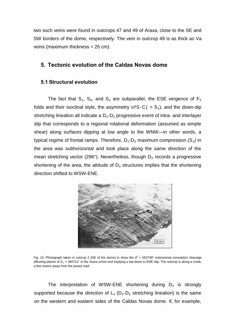
Foliation S₃ is a spaced or crenulation cleavage, generally marked by
very fine-grained sericite, that commonly occurs as the axial planar cleavage of
F₃ folds. These folds are open to tight, steeply inclined to upright, and
subhorizontal to gently plunging and indicate a WSW-ENE shortening during
D₃. This interpretation, justified by the constant and consistent orientation of
both S₃//AP3 and the fold axis B3 (Fig. 6d and e) is positively tested against
other data from the regional geology. The F₃ folds display varied style, scale,
and vergence due to two basic processes that may be attributed to their
formation: a late-D₂ progressive slip along S₀ -S₁ and S₂ planes (continuation of
the D₁ -D₂ inter- and intralayer shearing) and gravity sliding.
The F₃ folds formed by inter- and intralayer shearing include (1) open to
tight folds of 10 cm scale, upright or steeply inclined, east-verging, with
crenulation-style that refold F₂ isoclinal folds (e.g. outcrop 02 for Araxa, 54 for
Paranoa rocks); (2) gentle folds of 10 m- or greater scales found far from the
dome, such as east of Caldas Novas, along the road leading to Ipameri; and (3)
tight, 10 m scale folds that occur in outcrops 68 and 73 (Figs. 4a and 6a) and
indicate a km-scale F₃ fold affecting the Araxa schist to the east of the dome,
with a fold axis nearly N-S (to the east of PESCAN, Fig. 6). The western limb of
the major F₃ fold east of PESCAN is affected by upright, 10 cm scale F₃
crenulations oriented similar to the larger fold, as seen in outcrops 68, 73, and
74. Farther south, between the road to Marzagao and the dome (Fig. 6a), the
Araxa layers that dip toward one another (see outcrops 62, 63, and 65 and their
relationship to surrounding outcrops) suggest the existence of other km-scale F₃
folds. The same finding is valid south of the dome (outcrops 48 and 52). For all
these folds (measured or deduced), the fold axis B3 plunges to the NNW or SSE
(Fig. 6e). The F₃ folds, due to gravity sliding, appear on the western and
eastern sides of the dome. Those on the western side include 10-100 m scale,
WNW-verging folds (Figs. 8 and 9) that affect D₁ and D₂ structures and display
vergence compatible with a top-to-the-WNW shear, in contrast to the sense
implied by D₁ -D₃ structures in general. The fold shown in Fig. 8 lies closer to

the dome and displays layers that underwent intense brecciation during folding.
Those on the eastern side include, among others, m-scale folds found in the
Paredao outcrop.
Foliation d0 is an extensional crenulation cleavage that extended D₁ -D₂
structures, according to mm- to cm-scale displacements, top-down to the south,
east, or north (Fig. 6a). Foliation d0 does not occur to the west or northwest of
the Caldas Novas dome (Fig. 6c), other than the specimen that dips to the S in
outcrop 10 (Fig. 6a). As will be discussed subsequently, this is a key feature for
understanding the origin of d0 and the dome. Foliations d0 and c0 look very
similar, which suggests compatibility in the conditions of ductility and
metamorphism that prevailed during their evolution. Nevertheless, there are key
and subtle differences that distinguish extensional crenulation cleavages as d0
or c0 in outcrops. Whereas c0 surfaces are typically sigmoidal shaped and their
trace is only visible for few centimeters, foliation d0 is defined by more discrete
and planar surfaces that are continuous for nearly 1 m or more (Fig. 10). In flat-
lying or 3D outcrops where both foliations occur (e.g. 36, 37, 38, 41, 47, 62, 75),
their distinctive characteristics are evident, and d0 is always steeper than c0.
Fig. 8. Sketch displaying information collected during a detailed observation along a nearly 80 m-long, 10 m-high, man-made wall situated behind the tennis courts in Pousada park (outcrop 15). Basal metasiltstone layers topped by white
phyllite dip gently to NW and display foliation S₁ (not shown) subparallel to S₀. A steeper mineral foliation S₂ (not shown) cross-cuts S₁//S₀ at low angle and dips westward. These rocks and structures are affected by a 10 m-scale and NW-verging F₃ fold in the SE part of the outcrop. The metasandstone layers were disrupted around the hinge of the fold, and the fragments underwent chaotic rotation to form a breccia. This fold indicates a top-to-the-WNW down-dip
movement compatible with a m-scale, kink-style F₃ fold seen in the phyllite in the leftmost part of the outcrop.

Fig. 9. Sketch of a hm-scale, W-verging F₃ fold observed in outcrop 7, NW of the dome, in the paved road to Morrinhos (Fig. 4). The limits of the road cut are drawn in the center of the figure. A succession of layers of metasiltstone, pelitic
metasiltstone, and metapelite define the primary layering (S₀) that is affected by a layer-parallel foliation Si commonly marked by fine-grained white mica (biotite also occurs in the lowermost layer to the left), all affected by the S₂ foliation (mostly fine-grained white mica). The L2-1 intersection lineation is down-dip along the planes of S₁/S₀ and subparallel to the axis of several 10 cm-scale F₂ folds. Such planar and linear structures change dip or plunge either E or W along the respective limbs of the major folds, demonstrating that the larger structure is an F₃ fold. Fractures and quartz veins (omitted for simplicity) also occur but are less important. The entire structure indicates a top-to-W shear and, as in the fold in Fig. 8, fits the interpretation for a gravity slide during the Caldas Novas dome’s uplift. The metapelite layer is more intensively folded to accommodate more intense shortening in the core of the major synform.
4.4 Brittle deformation: fractures and quartz veins
Fractures/joints and quartz veins that occur throughout the area and
cross-cut D₁-D₃ structures in all rock types have been labelled S4 (Fig. 6f and g)
and interpreted as the record of a late event of brittle deformation (D₄). They are
commonly sharp and well defined in outcrops of the Paranoa rocks but are
more rare in outcrops of the Araxa rocks. The fractures are generally subvertical
and statistically distributed in five main sets, v to w. Fractures v (the largest) and
fractures z ~ y (the second largest) strike WNW and NNE, respectively,
corresponding to directions subparallel and subperpendicular to the direction of
Lx. Fractures x and w strike along intermediary directions between these two
extremes and are nearly perpendicular to each other. Data in Fig. 6g define
three main populations of quartz veins: Va, Vb, and Vc. The Va veins, which are
subperpendicular to Lx, are generally thicker than Vbs, which are subparallel to
the direction of Lx, and both are found everywhere. Veins Vc are parallel to the
main population of S₃ and AP3 (Fig. 6d) and more common in Paranoa
quartzites of the eastern limb of the dome (outcrops 70 and 71, Fig. 6a). Only
two such veins were found in outcrops 47 and 49 of Araxa, close to the SE and
SW borders of the dome, respectively. The vein in outcrop 49 is as thick as Va
veins (maximum thickness = 25 cm).
5. Tectonic evolution of the Caldas Novas dome
5.1 Structural evolution
The fact that S₁, S₀, and S₂ are subparallel, the ESE vergence of F₂
folds and their isoclinal style, the asymmetry ofS-C( = S₁), and the down-dip
stretching lineation all indicate a D₁-D₂ progressive event of intra- and interlayer
slip that corresponds to a regional rotational deformation (assumed as simple
shear) along surfaces dipping at low angle to the WNW—in other words, a
typical regime of frontal ramps. Therefore, D₁-D₂ maximum compression (S₁) in
the area was subhorizontal and took place along the same direction of the
mean stretching vector (296°). Nevertheless, though D₃ records a progressive
shortening of the area, the attitude of D₃ structures implies that the shortening
direction shifted to WSW-ENE.
Fig. 10. Photograph taken in outcrop 2 (NE of the dome) to show the d0 = 053748° extensional crenulation cleavage
affecting planes of S₁ = 340712° in the Araxa schist and implying a top-down to ENE slip. The outcrop is along a creek,
a few meters away from the paved road.
The interpretation of WSW-ENE shortening during D₃ is strongly
supported because the direction of Lx (D₁-D₂ stretching lineation) is the same
on the western and eastern sides of the Caldas Novas dome. If, for example,

the dome was formed initially as a consequence of WNW-ESE regional ductile
flow and underwent rotation to its present NNW-SSE position (whether due to
different intensities of the flow itself or the slip along WNW-ESE-striking lateral
ramps north of the dome, as in Fig. 3), these processes would also affect Lx
and the trace of S₀/1 and S₂, so the dome would appear as a rotated
porphyroblast-like structure in regional maps (similar to the Itabaiana dome in
the Sergipano belt, NE Brazil; D’el-Rey Silva, 1992; 1995a,b; D’el-Rey Silva
and McClay, 1995). The complete lack of evidence of such rotation indicates
that the final position of the Caldas Novas dome is the same as that in which it
was formed.
Relative to D₄, it is notable that veins Vc display orientation and
distribution compatible with the uplift of the dome. However, fracture planes
labelled v are usually open, subvertical, strike parallel to the subhorizontal
regional compression (S₁), dip parallel to the subvertical internal compression
(S₁i), and host veins (Vb) that are subparallel to Lx. In addition, Va veins are
hosted along fractures that are subperpendicular to Lx and, by playing the role
of T fractures, are expected to develop in the same shearing regime. As shown
in Fig. 6g, Va veins are concentrated in two populations of planes with similar
strike but different dips (subvertically or steeply) to the ESE, which may be the
result of the progressive emplacement and rotation of veins along T fractures.
Finally, the parallel relationship between Vc veins and S₃//AP3 match the
direction of extension expected for the limbs of the dome during gravity-induced
slides.
5.2 The Caldas Novas dome as a D₃ structure
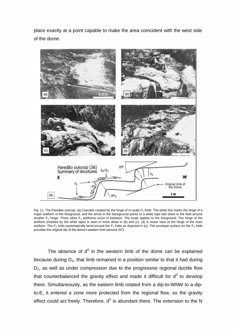
On the basis of the unequivocal evidence found in the Paredao outcrop,
it can be safely stated that the Caldas Novas dome formed during a D₃
deformation. The outcrop is continuous along a 3 m wide stream that flows
down to the east in a cascade created by the rounded hinges of east-verging,
steeply inclined, < 5 m scale F₃ asymmetric antiforms (Fig. 11a-d). These
hinges affect Paranoa quartzite layers that display the S₁//S₀ foliation, as well
as several ~ 1m scale F₂ isoclinal folds that refold around the F₃ hinges (Fig.
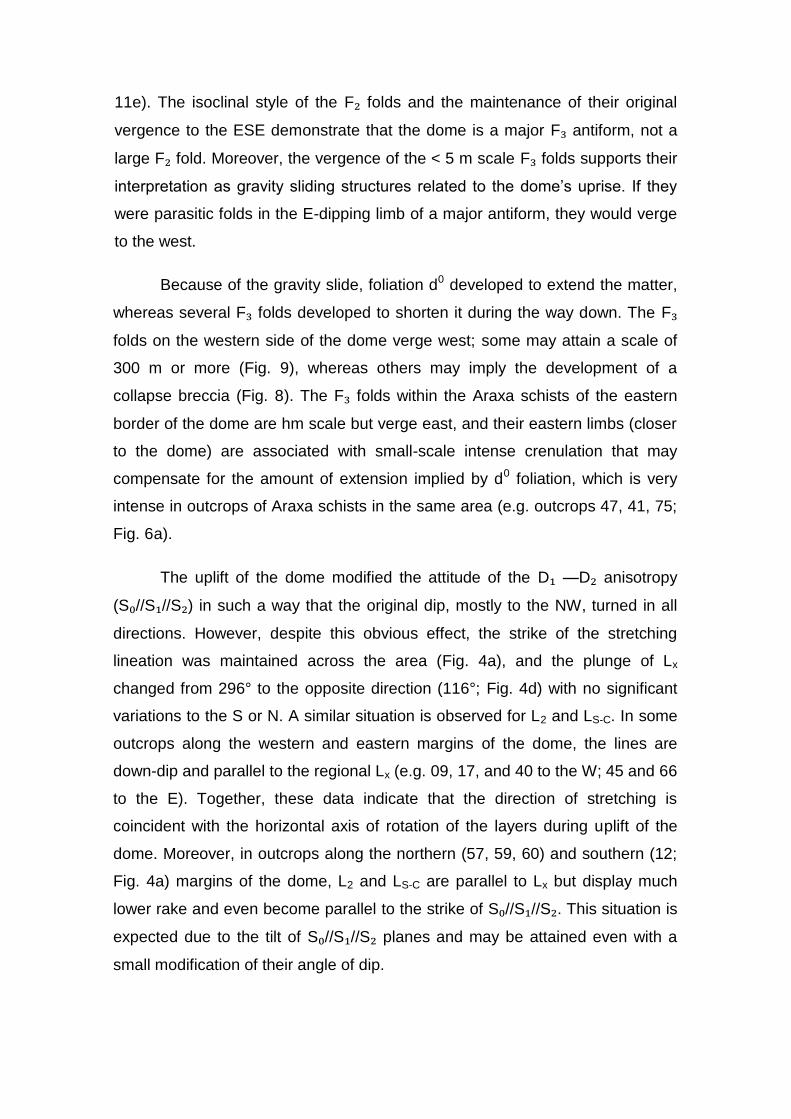
11e). The isoclinal style of the F₂ folds and the maintenance of their original
vergence to the ESE demonstrate that the dome is a major F₃ antiform, not a
large F₂ fold. Moreover, the vergence of the < 5 m scale F₃ folds supports their
interpretation as gravity sliding structures related to the dome’s uprise. If they
were parasitic folds in the E-dipping limb of a major antiform, they would verge
to the west.
Because of the gravity slide, foliation d0 developed to extend the matter,
whereas several F₃ folds developed to shorten it during the way down. The F₃
folds on the western side of the dome verge west; some may attain a scale of
300 m or more (Fig. 9), whereas others may imply the development of a
collapse breccia (Fig. 8). The F₃ folds within the Araxa schists of the eastern
border of the dome are hm scale but verge east, and their eastern limbs (closer
to the dome) are associated with small-scale intense crenulation that may
compensate for the amount of extension implied by d0 foliation, which is very
intense in outcrops of Araxa schists in the same area (e.g. outcrops 47, 41, 75;
Fig. 6a).
The uplift of the dome modified the attitude of the D₁ —D₂ anisotropy
(S₀//S₁//S₂) in such a way that the original dip, mostly to the NW, turned in all
directions. However, despite this obvious effect, the strike of the stretching
lineation was maintained across the area (Fig. 4a), and the plunge of Lx
changed from 296° to the opposite direction (116°; Fig. 4d) with no significant
variations to the S or N. A similar situation is observed for L2 and LS-C. In some
outcrops along the western and eastern margins of the dome, the lines are
down-dip and parallel to the regional Lx (e.g. 09, 17, and 40 to the W; 45 and 66
to the E). Together, these data indicate that the direction of stretching is
coincident with the horizontal axis of rotation of the layers during uplift of the
dome. Moreover, in outcrops along the northern (57, 59, 60) and southern (12;
Fig. 4a) margins of the dome, L2 and LS-C are parallel to Lx but display much
lower rake and even become parallel to the strike of S₀//S₁//S₂. This situation is
expected due to the tilt of S₀//S₁//S₂ planes and may be attained even with a
small modification of their angle of dip.

5.3 Is the Caldas Novas dome a D₃ structure?
Together with the F₃ folds and foliation S₃, plus the similar conditions of
ductility for d0 and c0 (which reflects great D₂-D₃ metamorphic compatibility), the
heterogeneous distribution of d0 in the area demonstrates that the dome is a D₃
structure formed in a progressive event following D₂. The fact that d0 is
characteristically absent on the western side of the dome works strongly
against other possible interpretations.
Foliation d0 might be interpreted as a D₂ structure that affected c0 planes
during progressive deformation. However, if this was the case, d0 would be
found everywhere in the area, and the uplift of the dome would affect d0 in all of
its quadrants (as happened with c0). The dome also might be interpreted as a
much younger structure (e.g. Cretaceous) due to a magma intrusion. In this
case, the lack of a reasonable argument for d0 as a syn-D₂ structure would lead
to the interpretation that d0 is a Cretaceous structure. Again, there is no reason
for d0 be absent along the west side of the dome; in addition, the similar
conditions of ductility for c0 and d0 would require a warming up of the dome
area in the Cretaceous. An igneous intrusion beneath the site of the dome
could provide heat for such event, but it remains hard to accept that the Araxa
rocks could be heated more intensively than the Paranoa rocks that lie closer to
the hypothetical intrusion. Even accepting this, we also would have to accept
that heat propagated heterogeneously upward and did not affect the Araxa
rocks west of the dome. In addition to this negative coincidence, two other
points work against the idea that the dome is due to a younger igneous
intrusion: (1) Why would such a dome have to be elliptical? (2) Why would its
longer axis have to trend exactly NNW, not in any other position? The elliptical
shape and the trend of the Caldas Novas dome’s longer axis both support D₃
evolution in the Brasiliano cycle and fit within the characteristics of a D₃ regional
event existing in the southern segment of the Brasilia fold belt. The last
possibility against the Brasiliano cycle D₃ evolution of the dome is even harder
to accept, in that it considers d0 as a Brasiliano D₂ structure and the uplift of the
dome as due to a Cretaceous intrusion. If this happened, during event D₂
foliation d0 did not form in a particular area, and the younger intrusion took
place exactly at a point capable to make the area coincident with the west side
of the dome.
Fig. 11. The Paredao outcrop. (a) Cascade created by the hinge of m-scale F₃ folds. The white line marks the hinge of a
major antiform in the foreground, and the arrow in the background points to a white tape laid down in the field around
another F₃ hinge. Three other F₃ antiforms occur in between. The scale applies to the foreground. The hinge of the
antiform (marked by the white tape) is seen in more detail in (b) and (c). (d) A closer view of the hinge of the main
antiform. The F₂ folds systematically bend around the F₃ folds as depicted in (e). The envelope surface for the F₃ folds
provides the original dip of the dome’s eastern limb (around 20°).
The absence of d0 in the western limb of the dome can be explained
because during D₃, that limb remained in a position similar to that it had during
D₂, as well as under compression due to the progressive regional ductile flow
that counterbalanced the gravity effect and made it difficult for d0 to develop
there. Simultaneously, as the eastern limb rotated from a dip-to-WNW to a dip-
to-E, it entered a zone more protected from the regional flow, so the gravity
effect could act freely. Therefore, d0 is abundant there. The extension to the N

and S implied by d0 fits in and reinforces this interpretation. The isolated
occurrence of foliation d0 in outcrop 10 (NW of the dome, Fig. 6a), which implies
it extended to the S, may be attributed to the growth of the rolling hinge of the
large F₃ folds seen in outcrop 7 (Fig. 9) located to the N. If this possibility is
proven, it lends additional support to the interpretation that the gravity-induced
folds are D₃ structures.
5.4 A model for D₃ evolution and underground thermal waters
Any model about the evolution of the Caldas Novas dome should take
into account the possibility that the Paranoa quartzite actually extends down
nearly 1000 m and should provide an explanation for this abnormal thickness.
The 1000 m of quartzites could be due to deposition of voluminous siliciclastics
in a particularly deeper depocenter, the site of the future Caldas Novas dome,
as is the case for the Itabaiana gneiss dome of the Sergipano belt, where the
basal quartzite formation is less than 50 m thick regionally but attains a
thickness of 700 m around the dome as a consequence of a kind of half-graben
associated with the hanging wall of a system of extensional listric faults (D’el-
Rey Silva, 1992, 1995a; D’el-Rey Silva and McClay, 1995). The evolution of
such a fault system led to the initial uprise of the dome during the sedimentation
and volcanism of the precursor basin, and the incipient Itabaiana dome thus
received a crown of carbonates covering the quartzites.
Fig. 12. Photograph taken in outcrop 2 (NE of the dome) to show the d0 = 053748° extensional crenulation cleavage
affecting planes of S₁ = 340712° in the Araxa schist and implying a top-down to ENE slip. The outcrop is along a creek,
a few meters away from the paved road.
In contrast, the Caldas Novas dome area displays no lithostratigraphic
information that might detail the possible tectonic evolution of the sedimentation
in that part of the Brasilia belt; therefore, sedimentary control over the abnormal
thickness cannot be demonstrated or ruled out. Nevertheless, a tectonic
explanation for the abnormal thickness may be easily envisaged with the aid of
out-of-sequence thrusts (Butler, 1987; McClay, 1992) and a D₃ duplex structure
or antiformal stack (Boyer and Elliott, 1982) hidden in the core of the F₃ fold
that corresponds to the dome (Fig. 12). However, because the study area lacks
even a simple control over the regional thickness of the Paranoa group, this
model is just one of several plausible ideas that vary according to the regional
thickness.
The structural model for the Caldas Novas dome (Fig. 12c) agrees with
the physical parameters required for the 50 °C hot springs, such as those
shown near Pousada park (Fig. 6). A model for the evolution of the
underground reservoir considers that meteoric waters would infiltrate regionally
into the Paranoa group and percolate until they reached the bottom of the
quartzite layers in the core of the dome, where they would attain the highest
temperatures and then migrate quickly upward through a net of brittle structures
that could combine planes of S₃ spaced cleavage and D₄ fractures. The model
accounts for the nature and inventory of the D₃ and D₄ structures mapped at
surface but cannot attain a higher degree of complexity until a very detailed
geophysical survey combining, for example, seismic reflection, induced
polarization, and hydrologic modelling provides additional information.
Researchers working recently in Caldas Novas (e.g. Troger et al., 1999;
Campos et al., 2000; Zschocke, 2000) agree that the uprise of thermal waters
through different geological units in a complex hydraulic manner, controlled by
the structural features observed in the area, leads to reservoirs with different
chemical characteristics and temperatures.
It is possible that a younger magmatic rock (e.g. Cretaceous) was placed
in the core of the D₃ dome (Fig. 12c), which enhanced the mechanical porosity
by reopening at least part of the Brasiliano cycle D₃-D₄ brittle structures and
facilitating the underground flow of waters. This hypothetical intrusion also

could be the source of at least part of the heat required to warm up the waters.
Again, only a very detailed geophysical study could provide reliable information
about whether such an intrusion exists or not. The results of recent
geochemical and isotope studies (Zschocke, 2000; U. Trogger, pers. comm.)
indicate no contribution from a magmatic intrusion for the composition of
thermal waters in the Caldas Novas area.
6. Implications for understanding the Brasilia belt and Tocantins province
The structural and tectonic analyses of the Caldas Novas area suggest
the following:
1. The D₁-D₃ (D₄) evolution described may be bracketed in the ~
750-600 Ma interval, according to the age of syntectonic granitic intrusions
located to the NW and E of Ipameri, as well as of granulite facies
metamorphism near the study area;
2. The D₁ -D₂ tectonics of frontal ramps with S₁ oriented to the
WNW-ESE in the Caldas Novas area is the same that has been
demonstrated in Ipameri, as well as in other parts of both the southern and
northern segments of the belt along the magmatic arc-continental plate
margin or closer to the Sao Francisco craton (Fig. 1b; D’el-Rey Silva and
Barros Neto, 2002). Thus, despite the bend of the Brasilia belt, there is a
strong coincidence in the WNW-ESE direction of the regional stretching
lineation and maximum horizontal compression (S₁) for D₁-D₂ in both the
northern and southern segments of the belt;
The Caldas Novas dome is a D₃ antiformal structure, implying a WSW-
ENE-trending shortening, remarkably coincident with the direction of shortening
in the F₃ folds that affect the D₁-D₂ Araxa, Passos and Luminarias nappes in
the southern segment of the belt (Fig. 2; Seer, 1999; Seer et al., 1999; Seer
and Dardenne, 2000; Valeriano et al., 2000);
3. Such a D₃ event is regionally absent in the northern segment of

the belt. The single well-documented example of WSW-ENE D₃ shortening in
the northern segment of the belt is a local phenomena and related to the
escape of the rocks to the SSE during formation of D₂ sheath folds that
control emerald ore shoots in the mining district of Campos Verdes in the MA
(Fig. 1b; Barros Neto, 2000; D’el-Rey Silva and Barros Neto, 2002; D’el-Rey
Silva, 2002b);
4. The age of D₃ deformation in the southern segment of the belt
must be close to 600 Ma (Pimentel et al., 1999 for the Ipameri area; Seer,
1999; Valeriano et al., 2000 for the southernmost part of the belt; Seer
(1999) for the structural analysis), which fits the age of opening of the rift-like
basin precursor of the Paraguay belt (Alvarenga and Trompette, 1992;
Pimentel et al., 1996; Alvarenga et al., 2000); and
5. The direction of D₃ shortening fits with the movement of the
Socorro-Guaxupe nappe that evolved in the 620-510 Ma interval and
displaced high-P basement rocks onto the F₃ regional folds that affect the
Araxa, Passos and Luminárias nappes (Fig. 2; Valeriano et al., 2000).
We have avoided correlating the WSW-ENE direction of shortening (D₃)
with a particular stress field because the likelihood that the NNW-SSE trend of
the Caldas Novas dome (the F₃ antiform) records the same position in which it
formed originally does not suggest a straightforward similarity between the
direction of shortening and the direction of maximum compressive stress. In
addition, the Caldas Novas dome F₃ antiform did not form in the same NE-SW
trend of the nonrotated F₂ folds in the study area, which does not authorize a
denial that the WSW-ENE D₃ shortening could be due to the same WNW-ESE
subhorizontal stress field (sj) active since the Dj-D₂ events. However, to
correlate the WSW-ENE shortening with the WNW-ESE-trending S₁, the three
following hypotheses should be considered: (1) D₃ shortening is due to different
velocities of the WNW-ESE flow along the planes of S₀/Si/S₂, (2) D₃ shortening
was due to S₂, and (3) The rocks in the study area (and in the Araxa, Passos,
and Luminarias nappes) underwent D₃ shortening due to WNW-ESE flow that
took place in the basement.
Hypothesis 1 seems quite unlikely because the basement crops out as a
dorsal between the F₃ synforms that affect the Passos and Luminarias D₁ -D₂
nappes (Fig. 2), which indicates that nappe emplacement involved the
crystalline basement of the Sao Francisco craton, at least south of the Caldas
Novas dome, and the whole vertical column of the DJ -D₂ nappes underwent
D₃ shortening. If not involved in the nappes, then the basement marks the hinge
of an intervening antiform between two F₃ synforms, or it crops out because of
erosion. The first case requires a D₃ detachment within the basement, which is
most reasonable because D₃ is a regional event. In the second case, the D₃
detachment lies along the basement-cover interface, and it would have had to
jump exactly the narrow site of the basement between two F₃ synforms.
Hypothesis 2 also is hard to accept because S₂ alone would have to shorten a
thicker pile of rocks after D₁ -D₂. Folds due to S₂ must form simultaneously with
folds due to S₁, not afterwards. Hypothesis 3 implies that the D₁-D₂ regional
flow continued solely in the basement during D₃, without a detachment between
two crustal levels. In addition, the WNW -ESE flow in the crystalline basement
would have to be contemporaneous with D₃ in the upper level. To date, ductile
flow in the basement during D₁-D₂ does not indicate that the basement was part
of the D₁-D₂ nappes. Furthermore, if Hypotheses 1-3 are true, why is a regional
WSW-ENE D₃ shortening regionally absent in the northern segment of the belt?
Therefore, most likely D₃ event involved the basement, and the
maximum compression responsible for the D₃ structures was not the same as
that responsible for D₁-D₂ events. It sounds interesting to interpret another
maximum compression (e.g. σ₁ _3) as parallel to the direction of D₃ shortening.
Nevertheless, despite its existence, the younger field σ ₁_3 does not require that
the older one became inactive in the late stage of the evolution of the southern
part of the belt. If so, which tectonic scenario could account for coexisting stress
fields, and why should the effects of the WSW-ENE field overcome the effects
of the WNW-ESE one? Instead of competing with S₁, the younger maximum
compression σ₁ _3 may have added to the effect of S₂ during D₃ and facilitated
the WSW-ENE shortening. Of great relevance is that the southern segment of
the Brasilia belt displays clear evidence for a regional event of WSW-ENE
shortening that affected both basement and cover and was active for
approximately 100 Ma, progressively overprinting D₁-D₂ structures that formed
across the belt as a consequence of a WNW-ESE-driven tectonic transport
during ~ 750-600 Ma. These two distinct events, their characteristics, and the
preceding questions all demand a comprehensive tectonic analysis of the
Tocantins Province that is beyond the scope of this paper.
7. Conclusions
The Caldas Novas dome is an elliptic structural window with a ~ 20 km
long maximum axis trending NNW, cored by subgreenschist facies rocks of the
Meso-Neoproterozoic Paranoa group and mantled by a nappe of greenschist
facies (biotite zone) rocks of the Neoproterozoic Araxa group. These rocks
underwent three (D₁-D₃) events of mainly ductile progressive deformation in the
ca.750-600 Ma interval and indicate typical tectonics of frontal ramps. A set of
brittle fractures and veins characterizes the youngest event recorded in the
area. Both D₁ and D₂ record an event of regional simple shear along surfaces
that dip gently to the NW, with a top-to-SE relative displacement and a
maximum subhorizontal compression (S₁) oriented 290-300°/110-120°. The
Araxa rocks experienced more severe metamorphism than did the Paranoa
rocks during D₁ and were emplaced as a nappe during D₂. Event D₃ implies
additional shortening and records a WSW-ENE-driven compression, during
which the dome started to rise as a large- scale F₃ fold, possibly associated
with a duplex structure at depth. Continuous with the uplift of the dome, the
layers slid down, giving way to gravity-slide D₃ structures, such as extensional
crenulation cleavage, folds, and tectonic breccia heterogeneously distributed
across the area. The underground reservoir likely is fed by meteoric waters that
percolate through the Paranoa group, attain temperatures of more than 50 °C at
a depth of 1000 m, and travel quickly upward through a mechanical porosity
consisting of a net of D₃ and D₄ planar brittle structures. Detailed geophysical
work could provide additional information. The D₁-D₂ structural and tectonic
evolution of the Caldas Novas dome area is similar to several other areas of the
whole Brasilia belt and took place in the ~ 750-620 Ma interval. Moreover, the
dome itself demonstrates the importance of the 620-510 Ma old D₃ event of
WSW-ENE shortening that is evident across the southern segment of the
Brasilia belt and virtually absent in the northern one.
Acknowledgements
Luiz D’el-Rey Silva acknowledges CNPq-Brazil for scholarship and
research funds (1987-2001) and CAPES-Brazil for postdoctoral research Grant
BEX-1922/99-8 throughout 2001. He also thanks Prof. K.R. McClay’s Fault
Dynamics Group (Geology Department, RHUL) and the Geological Survey of
Finland (in particular Prof. Gabor Gaal, Research Director) for support during
his stay in Egham, UK, and Helsinki, respectively. Two anonymous referees for
the Journal of South American Earth Sciences are thanked for their valuable
comments on previous versions. Detlef G. Walde and Percy B.W. Klein both
thank UnB-IG, and Percy thanks UFG-Campus Catalao for support received
during their careers. The authors thank geologists Fabio F. Haesbeart and
Fernando Gabier for important information and assistance in Caldas Novas.
This paper is part of Project FAPESP 96/1566-0, coordinated by Prof. A.J.
Berrocal Gomes (USP-Sao Paulo).
References
Alvarenga, C.J.S., de Trompette, R., 1992. Glacially-influenced sedimentation in the Later Proterozoic of the Paraguay Belt (Mato Grosso, Brazil). Palaeogeography, Palaeoclimatology, Palaeoecology 92, 85-105.
Alvarenga, C.J.D.de, Moura, C.A.V., Gorayeb, P.S.de.S., Abreu, F.A.M.de, 2000. Paraguay and Araguaia belts. In: Cordani, U.G., Milani, E.J., Thomaz Filho, A., Campos, D.A. (Eds.), Tectonic Evolution of South America. 31 International Geological Congress, Rio, pp. 183-193.
Barros Neto, L.de S., 2000. Evolução Estrutural do Distrito Esmeraldifero de Campos Verdes, GO. MSc Dissertation 149. Universidade de Brasilia, Enclosure with a 1:25,000 scale map and cross sections 111 pp.
Boyer, S.E., Elliott, D., 1982. Thrust systems. American Association of Petroleum Geologists Bulletin 66(9), 1196-1230.
Brod, J.A., Leonardos, O.H., Menezes, P.R., Albuquerque, M.A.C., Almeida, R., Araujo, R.N.G., Blanco, S.B., Cardoso, F.B.F., Carvalho, O.A. Jr., Junqueira, F.F., Riedl, W. Jr., Romao, P.A., Souza, J.C.F., Tallarico, F.H.B., Thomsen, F.P.R., Berbert, M.L.C., Cerqueira, M.R.S., Chagas, M.A., Dias, R.R., Lima, C.V.,
Nakamura, E.T., Porto, S.G., Santos, P.C.V., 1991. Tectonoestratigrafia da Faixa Brasilia na regiao do Alto Paranaiba. Simpósio de Geologia do Centro-Oeste 3, 155-168.
Butler, R., 1987. Thrust sequences. Journal of the Geological Society 144, 619-634.
Campos J.E.G., Fortes P.F., Santos R.V., 2000, Geologia do Domo de Caldas Novas. Internal report, UnB-IG, 80 pp.
Drake, A.A., Jr., 1980. The Serra de Caldas window, Goiais. Tectonic Studies in the Brazilian Shield. Geological Survey of America Professional Paper 1119-A, 13 pp.
D’el-Rey Silva, L.J.H., 1992. Tectonic evolution of the southern part of the Sergipano fold belt, northeastern Brazil. PhD Thesis. Royal Holloway, London University, 258 pp.
D’el-Rey Silva, L.J.H., 1995a. The evolution of basement gneiss domes of the Sergipano fold belt (NE Brazil) and its importance for the analysis of Proterozoic basins. Journal of South American Earth Sciences 8(3/4), 325-340.
D’el-Rey Silva, L.J.H., 1995b. Tectonic evolution of the Sergipano belt, northeastern Brazil. Revista Brasileira de Geociencias 25(4), 315-332.
D’el-Rey Silva, L.J.H., 2002a. The belt of Neoproterozoic granulites in the inner part of the Brasilia belt: Implications for collision tectonics and exhumation processes. XLI Congresso Brasileiro de Geologia, Joao Pessoa. Anais SBG, 341.
D’el-Rey Silva, L.J.H., 2002b. The Caldas Novas and Santa Cruz domes: Structural evolution and implication for tectonics in the Brasilia belt, central Brazil. XLI Congresso Brasileiro de Geologia, Joao Pessoa. Anais SBG, 341.
D’el-Rey Silva, L.J.H., Barros Neto, L.de.S., 2002. The Santa Terezinha- Campos Verdes emerald district, central Brazil: Structural and Sm-Nd data to constrain the tectonic evolution of the Neoproterozoic Brasilia Belt. Journal of South American Earth Sciences 15(6), 697 -708.
D’el-Rey Silva, L.J.H., McClay, K.R., 1995. Stratigraphy of the southern part of the Sergipano belt, NE Brazil: Tectonic implications. Revista Brasileira de Geociencias 25(3), 185-202.
D’el-Rey Silva, L.J.H., Fuck, R.A., Ferreira Filho, C.F., Nilson, A.A., 1996, The Niquelandia layered intrusion and underthrutsting in the Brasilia fold belt. XXXIX Congresso Brasileiro de Geologia, Salvador, Anais SBG 6, Simpoisios, pp. 87-91.
D’el-Rey Silva, L.J.H., Ferreira Filho, C.F., Nilson, A.A., Oliveira, A.C. de, Silva Jr., C.G., Silva, C.B., Medeiros, E.S., Campos, G.S., Cruz, H.P., Zoby, J.L.G., Almeida, J.C.M., Pinelli, M.P., Mongim, R.M., Algarte, R.D., Bispo, R.S., Souza, R.S., Silva, V.V., 1997. Uplift of the Barro Alto mafic-ultramafic intrusion by underthrusting in the northern segment of the Brasilia belt, Brazil. VI Simpoisio Nacional de Estudos Tectonicos, Pirenopolis-Go, Anais SBG, pp. 53-56.
Fischel, D.P., 2002, Geologia isotopica U-Pb e Sm-Nd da Seqüencia Silvania, Complexo Anapolis-Itaucu e Grupo Araxa na regiao de Leopoldo de Bulhões, Goias: Contribuicao ao estudo da evoluçao da Faixa Brasilia. PhD Thesis 55. Universidade de Brasilia, 162 pp.

Fischel, D.P., Pimentel, M.M., Fuck, R.A., 1998. Idade do metamor- fismo de alto grau no Complexo Anaipolis-Itaucçu. Goiais, determinada pelo metodo Sm-Nd. Revista Brasileira de Geociencias 28(4), 543-544.
Fischel, D.P., Pimentel, M.M., Fuck, R.A., 1999a. Preliminary Sm-Nd isotopic study of the Araxa Group, central Goias. VII Simposio de Geologia do Centro-Oeste e X Simpoisio de Geologia de Minas Gerais, Brasilia, Boletim de Resumos, SBG-DF/MG/CO, 87pp.
Fischel, D.P., Fuck, R.A., Pimentel, M.M., 1999b. Sm-Nd mineral isochrons and model ages of the Anaipolis-Itaucçu complex and associated granites, Goias: New insights into the geological evolution of the Brasilia Belt. VII Simpoisio de Geologia do Centro-Oeste e X Simpoisio de Geologia de Minas Gerais, Brasilia, Boletim de Resumos, SBG-DF/MG/CO, p. 88.
Fischel, D.P., Pimentel, M.M., Fuck, R.A., 1999c. Dados Sm-Nd Preliminares dos Anfibolitos entre Silvania e Bonfinopolis. Goias. VII Simposio de Geologia do Centro-Oeste e X Simposio de Geologia de Minas Gerais, Brasilia, Boletim de Resumos, SBG-DF/ MG/CO, p. 89.
Fuck, R.A., Jardim de Sa, E.F., Pimentel, M.M., Dardenne, M.A., Pedrosa- Soares, A.C., 1993. In: Domingues, J.M.L., Misi, A. (Eds.), As faixas de dobramentos marginais do Craton do Sao Francisco: Sintese dos conhecimentos. O Craton do Sao Francisco, SBG/SGM/CNPq, pp. 161 -185.
Fuck, R.A., Pimentel, M.M., D’el-Rey Silva, L.J.H., 1994. Compartimen- tacao Tectonica na Porçao Oriental da Província Tocantins. XXXVIII Congresso Brasileiro de Geologia, Camboriui, SBG. Boletim Resumos Expandidos 1, 215 -217.
Haraly, N.L.E., 1978. Carta gravimetrica Bouguer do oeste e sul de Minas Gerais, nordeste de Sao Paulo e do sul de Goias. PhD Thesis. University of Sao Paulo (USP), 288 pp.
Haraly, N.L.E., 1980. Carta gravimeitrica do Oeste de Minas Gerais, Sudeste de Goias e Norte de Sao Paulo. XXXI Congresso Brasileiro de Geologia, Camboriui, Anais SBG, 2639-2643.
Lacerda Filho, J.W., Rezende, A., da Silva, A., 1999. Programa de Levantamentos Geoloigicos Baisicos do Brasil. Geologia e Recursos Minerais do Estado de Goias e Distrito Federal, Escala 1:500.000, CPRM Goiania.
Lister, Snoke, 1984. S-C mylonites. Journal of Structural Geology 6, 617-638.
Marini, O.J., Fuck, R.A., Dardenne, M.A., Danni, J.C.M., 1984, Provincia Tocantins, Setores Central e Sudeste. In: Almeida de, F.F.M., Hasui, Y, (Coord.), O Precambriano do Brasil, (Ed. Edgard Blucher), pp. 205-264.
McClay, K.R., 1992. Glossary of thrust tectonics terms. In: McClay, K.R., (Ed.), Thrust Tectonics. Chapman & Hall, xxx, pp. 409-433.
Oriente, T., 1982. In: Oriente, T., (Ed.), As fabulosas aguas quentes de Caldas Novas, pp. 147, Goiania.
Pimentel, M.M., Fuck, R.A., 1992. Neoproterozoic crustal accretion in central Brazil. Geology 20, 375-379.
Pimentel, M.M., Fuck, R.A., Alvarenga, C.J.S., 1996. Post-Brasiliano (Pan-African) high-K granitic magmatism in central Brazil: the role of Late Precambrian-Early Paleozoic extension. Precambrian Research 80, 217-238.
Pimentel, M.M., Fuck, R.A., Botelho, N.F., 1999. Granites and the geodynamic history of the neoproterozoic Brasilia belt, central Brazil: a review. Lithos 46, 463-483.
Pimentel, M.M., Fuck, R.A., Gioia, S.M.C.L., 2000. The Neoproterozoic Goiais maamatic Arc, central Brazil: a review and new Sm-Nd isotopic data. Revista Brasileira de Geociencias 30(1), 35-39.
Queiroz, C.L., 2000, Evolucao Tectono-Estrutural dos Terrenos Granito- Greenstone Belt de Crixais, Brasil Central. PhD Thesis. Universidade de Brasilia, 208pp.
Seer, H.J., 1999, Evolucao tectonica dos Grupos Araxa, Ibia e Canastra na sinforma de Araxai, Araxai, Minas Gerais. PhD Thesis. Universidade de Brasilia, 268 pp.
Seer, H.J., Dardenne, M.A., 2000. Tectonostratigraphic terrane analysis on Neoproterozoic times: the case study of Araxai synform, Minas Gerais state, Brazil: Implications to the final collage of the Gondwanaland. Revista Brasileira de Geociencias 30(1), 78-81.
Seer, H.J., Dardenne, M.A., Fonseca, M.A., 1999. O Grupo Ibiai na Sinforma de Araxa: Um terreno tectonoestratigrafico ligado a evolucao de arcos magmaticos. VII Simposio de Geologia do Centro-Oeste e X Simpósio de Geologia de Minas Gerais, Brasília, Boletim de Resumos, SBG-DF/MG/CO, p. 19.
Troger, U., Costa, J.F.G., Haesbaert, F.F., Zschocke, A., 1999. Novas contribuições aos aquíferos termais de Caldas Novas. VII Simposio de Geologia do Centro-Oeste e X Simposio de Geologia de Minas Gerais, Brasília, Boletim de Resumos, SBG-DF/MG/CO, p. 131.
Valeriano, C.de M., Teixeira, W., Heilbron, M., Simoes, L.S.de A., 2000. Southern Brasilia belt (SE Brazil): tectonic discontinuities, K-Ar data and evolution during the Neoproterozoic Brasiliano orogeny. Revista Brasileira de Geociencias 30(1), 195-199.
Zschocke, A., 2000, Zur Hydrochemie der Grundwasser von Caldas Novas- Zentralbrasilien-Implikationen für das Thermalgrundwasser. MSc dissertation. Technical University of Berlin, Germany, 67 pp.