Thirston Neighbourhood Development Plan Strategic ...
73
Thirston Neighbourhood Development Plan Strategic Environmental Assessment (SEA) Environmental Report Prepared by the Neighbourhood Planning Team, Northumberland County Council for Thirston Parish Council 15 January 2021
Transcript of Thirston Neighbourhood Development Plan Strategic ...

Thirston Neighbourhood
Development Plan
Strategic Environmental
Assessment (SEA)
Environmental Report
Prepared by the Neighbourhood Planning Team, Northumberland County
Council for Thirston Parish Council
15 January 2021

Quality Control
Document
name
Ref Prepared
for
Prepared by Date Reviewed
By
SEA Environmental Report for the Thirston Neighbourhood Plan (July 2020)
v.1.0 Thirston Parish Council
Sarah Brannigan Neighbourhood Planning & Infrastructure Team, Northumberland County Council
17.8.20 David English, Planning Manager
SEA Environmental Report for the Thirston Neighbourhood Plan (August 2020)
v.2.0 Thirston Parish Council
Sarah Brannigan Neighbourhood Planning & Infrastructure Team, Northumberland County Council
08.9.20 David English, Planning Manager
SEA Environmental Report for the Thirston Neighbourhood Plan (Jan 2021)
v.3.0 Thirston Parish Council
Sarah Brannigan Neighbourhood Planning Team Northumberland County Council
15.01.21 David English, Planning Manager
Revision history
Version Revision
date
Details Name
Position
v.0.1 12.08.20 Preparation of
first draft
Sarah Brannigan Planning Officer
v.0.2 14.08.20 Revisions to first draft
(March 2020 Plan)
David English Planning Manager
v.0.3 16.08.20 Revisions to first draft
(July 2020 Plan)
David English Planning Manager
v.1.0 17.08.20 Final SEA ER (July 2020
Plan)
Sarah Brannigan Planning Officer
v.1.1 26.08.20 Revisions to SEA ER (Aug
2020 Plan)
Sarah Brannigan Planning Officer
v.2.0 08.09.20 Final SEA ER (Aug 2020
Plan)
Sarah Brannigan Planning Officer
v.2.1 15.01.21 Updated SEA ER (Jan 2021
Plan)
Sarah Brannigan Planning Officer

Contents
Non-Technical Summary Section 1: Introduction 9 Overview 9 Structure of the report 10 Scope and limitations 11 Section 2: The Strategic Environmental Assessment Approach 12 What is Strategic Environmental Assessment? 12 Determining the need for Strategic Environmental Assessment 12 SEA of the Thirston Neighbourhood Development Plan 13 Strategic Environmental Assessment Stages 13 Section 3: The Thirston Neighbourhood Plan and Policy Context 18 Neighbourhood Plans 18 Thirston Neighbourhood Development Plan 19 The strategic planning policy context 21 Section 4: Environmental Baseline Position 23 Plans, programmes, policies and strategies 23 The baseline – environmental issues 23 Section 5: The SEA Framework used to Appraise the Thirston Neighbourhood Plan
32
The SEA Framework 32 Methodology 35 Section 6: Appraisal of the Likely Effects of the Thirston Neighbourhood Plan and Reasonable Alternatives on the Environment
37
Appraising the Plan objectives 37 Appraising the reasonable alternatives 37 Appraising the Plan policies 43 Strategic Environmental Assessment conclusions 56 Section 7: Monitoring and Next Steps 58 Monitoring 58 Next steps 58 Appendix A: Thirston Neighbourhood Development Plan Policies 59
Appendix B: Statutory Consultees’ Responses to the SEA Scoping Report 64
Appendix C: Environment Agency’s Response to the SEA Environmental Report
69
Appendix D: Review of Plans and Programmes 70

Non-Technical Summary
Introduction
1. Thirston Parish Council is currently preparing a neighbourhood plan for the Thirston
Parish area. Once in force, the Thirston Neighbourhood Development Plan (the Plan)
will form part of the statutory development plan for Northumberland, which is the
background against which planning decisions are made.
What is the purpose of Strategic Environmental Assessment?
2. This document is the Environmental Report for a Strategic Environmental
Assessment (SEA) of the Thirston Neighbourhood Development Plan. This report has
been prepared in order to meet the obligations set out in The Environmental
Assessment of Plans and Programmes Regulations 2004 (the SEA Regulations) which
implements European Directive 2001/42/EC (the SEA Directive) into UK law.
3. The aim of undertaking a SEA is to identify and assess the potentially significant
environmental effects of a plan; and to suggest measures to avoid, reduce or
manage damaging environmental impacts, and enhance positive effects. The SEA
process enables engagement with stakeholders and certain specified consultees to
allow them to comment on and shape the approach taken to assessment and to
comment on the outcomes.
5. The need for SEA was triggered by the need for ‘appropriate assessment’ of the
Thirston Neighbourhood Plan under the Conservation of Habitats and Species
Regulations 2017 (as amended) (HRA). The HRA screening process, undertaken by
the County Council, determined that appropriate assessment was necessary because
the Plan would be likely to have significant effects on European sites. This
conclusion automatically triggered the need for SEA. An environmental assessment
must therefore be undertaken, and an environmental report prepared for
submission with the Neighbourhood Plan to meet the requirements of Regulation
15(1)(e) of the Neighbourhood Planning (General) Regulations 2012 (as amended).
6. This Environmental Report describes the assessed impact on the environment of the
Draft Submission version of the Thirston Neighbourhood Development Plan (January
2021). That version of the Plan will be made available alongside the Environmental
Report for the purposes of consultation required under the SEA Regulations.

5
What has the Strategic Environmental Assessment involved so far?
7. The first step is to decide whether or not an SEA is required. This is referred to as
‘screening’. The need for a SEA for the Plan was triggered by a separate assessment
(the HRA). Accordingly, no further consideration was required about whether the
Plan should be subject to SEA. Once ‘screened in’ there are five stages in
undertaking an SEA:
Stage A: Scoping
The scoping stage of the SEA process seeks to ensure that the ‘scope’ of the
assessment covers the likely significant environmental effects of the Plan. It
describes the approach proposed for undertaking an environmental assessment of
the Neighbourhood Plan and for preparing the environmental report. A scoping
report was produced and consultation took place with the ‘consultation bodies’ in
accordance with the SEA Regulations, specifically: Natural England, Historic England
and the Environment Agency. The Scoping Report is available at: https://www.northumberland.gov.uk/Planning/Planning-policy/Neighbourhood.aspx
Stage B: Testing
This stage is about assessing the Neighbourhood Plan. This involves:
• Testing the Neighbourhood Plan objectives and policies;
• Examining and assessing any reasonable alternatives;
• Predicting the effects;
• Evaluating and scoring the effects;
• Identifying measures to mitigate adverse effects and maximise positive impacts;
and
• Proposing measures for monitoring the environmental effects of the
Neighbourhood Plan.
Stage C: Reporting
This Environmental Report presents the outcome of the assessment carried out at
stage 3 of the process at this point in time. This may be modified in future should
further significant changes be made to the Plan prior to it being brought into force.
Stage D: Consulting
This report will be subject to consultation with prescribed consultation bodies and
others who have an interest in the Plan and in the area.
Stage E: Monitoring
This stage will not take place until the Neighbourhood Plan is ‘made’ (brought into
force) and the effects of implementing the Plan can be monitored.

6
SEA Scope and Limitations
8. Taking a proportionate approach is a key principle in undertaking SEA. The process
should only focus on what is needed to assess the likely significant effects of a plan.
The scope of the SEA of the Thirston Neighbourhood Development Plan has been
influenced by the relatively small geographic area covered by the Plan and the
overall strategy, vision and objectives. It has also been informed by a higher level
‘Sustainability Appraisal’ of the emerging Northumberland Local Plan. That process
includes an assessment of the environmental impacts of introducing the Local Plan.
9. SEA is not an exact science and there are certain difficulties commonly encountered
in undertaking any SEA. For example, the baseline analysis which describes the
current situation of various factors is dependent upon the availability of information.
Projecting what might happen with or without the Plan or in light of alternatives is
also inherently difficult and requires a degree of judgement.
What does the Strategic Environmental Assessment tell us?
10. The area covered by the Thirston Neighbourhood Development Plan is
environmentally sensitive, hosting a number of important nature conservation
sites. Some of the key environmental issues based on the current state of the
environment and how it is likely to evolve without the Neighbourhood Plan
include:
• The area is rich in biodiversity. There may be opportunities for enhancement but
there are also potential pressures which could lead to disturbance or depletion
of habitats and species. The SSSI water course (Swarland Burn to Coquet
Mouth) is in an ‘unfavourable – recovering’ condition and is at ‘high’ threat risk.
• Reliance upon private vehicles is high reflecting the rural nature of the area. This
is the main cause of rising carbon emissions in the County. There are significant
barriers to reducing carbon emissions. The changing climate variables
(temperature / rainfall) have the potential to affect the area.
• The health and well-being of those in the Neighbourhood Area is generally good.
However, this could change relatively over time as a result of there being an
increasingly ageing population. The quality and availability of existing
community facilities is limited which could affect health and wellbeing.
• There are barriers to housing and services and the quality of the living
environment.
• The ‘moderate’ condition of Longdike Burn water quality.
• The area contains a range of heritage assets which could be sensitive to new
development. There is a lack of information about these heritage assets – West
Thirston Conservation Area does not have a Character Appraisal and there is
limited information available on the condition of listed heritage assets – which

7
will make it difficult to determine the effect of development on these assets and
their settings.
• The erosion of landscape character in LCA 39a.
11. The assessment demonstrates that the Neighbourhood Plan objectives are in
accordance with the SEA environmental objectives, having a largely neutral or
slightly positive effect.
12. The assessment demonstrates that individually and collectively the policies of the
Thirston Neighbourhood Development Plan serve to support development that has
limited environmental impact and the Plan provides appropriate tools to ensure
mitigation of any potential negative environmental effects. The Plan encourages the
protection and enhancement of the environment as a whole, and provides an
appropriate framework, working alongside other plans and programmes, to protect
and enhance the environment. Implementation of the Plan overall is assessed as
having positive or neutral effects on the environment.
13. An assessment was carried out on the July 2020 version of the Plan. This resulted in
recommendations for changes; the revised Plan was assessed with the conclusion
that no further changes were needed.
In autumn 2020, the Parish Council consulted on the SEA Environmental Report (in
line with Regulation 13 of the 2004 SEA Regulations) alongside the Regulation 14
publicity and consultation on their pre-submission draft plan. Comments received
during this consultation have led to changes being made to the draft plan and the
Environmental Report. This report is the latest version and is based on the
submission draft of the Thirston Neighbourhood Plan (January 2021).
14. The ‘reasonable alternatives’ considered in the plan making process related to:
• the approach to settlement boundaries; and
• locally important green spaces.
15. The SEA demonstrates the alternative approaches to meeting the objectives of the
Plan which were considered by the Parish Council do not represent more favourable
outcomes in respect of environmental impacts. For settlement boundaries, having
regard to progress made in establishing housing requirements for the Parish over the
Plan period to 2036, and the objectives of the Plan (which does not propose to
allocate land for a greater quantum of development that that apportioned to the
parish by the Local Planning Authority strategy for the area), there were no genuine
reasonable alternative options other than the preferred policy approaches defined in
the draft Plan.

8
16. For locally important green spaces, these may only be designated where they serve
particular purposes and they are demonstrably special to the local community. The
Plan designates all green spaces identified by the community that achieve the
recognised status in terms of their function and the value attributed to them by the
community. Accordingly, there are no further spaces that could be considered
reasonable alternatives.
Next Steps
17. The Environmental Report was subject to consultation in accordance with the SEA
Regulations. The assessment and the Environmental Report has been reviewed and,
where necessary, revised to take account of representations made by the
consultation bodies and to take account of the subsequent changes made to the Plan
by the Parish Council. The final draft Neighbourhood Plan will now be submitted by
the Parish Council to Northumberland County Council, along with the Environmental
Report and other supporting documents required by legislation. The County Council
will then consider whether the Plan and the various submission documents meet
certain legal requirements. Provided these requirements are met the Plan will then
progress to Independent Examination.

9
1. Introduction
Overview
1.1 Thirston Parish Council is currently preparing a neighbourhood development plan,
often referred to simply as a ‘neighbourhood plan’, for the Thirston Parish area.
1.2 The Localism Act 2011 introduced neighbourhood planning powers. These various
powers are contained in modifications to the Planning Acts and allow parish councils
and, where parishes don’t exist, groups of people from the community, called
neighbourhood forums, to formulate neighbourhood development plans and
neighbourhood development orders. These documents are intended to guide and
shape development in a particular area. Neighbourhood planning powers are
discretionary and there is no particular obligation on parish councils or local
communities to prepare plans. However, where neighbourhood plans are prepared
they must have regard to national policies and must be in general conformity with
local strategic planning policies.
1.3 To be brought into legal force, which is known as being ‘made’, a neighbourhood
development plan must pass an independent examination and meet certain ‘basic
conditions’ defined in the Town and Country Planning Act 1990. These include that
the making of the plan does not breach and is otherwise compatible with EU
obligations.
1.4 One of these EU obligations is European Directive 2001/42/EC on the assessment of
the effects of certain plans and programmes on the environment. This is often
referred to as the Strategic Environmental Assessment Directive (the SEA Directive).
The need for Strategic Environmental Assessment (SEA) must be determined and,
where necessary, an assessment of the effects a plan may have on the environment
must be completed prior to a plan being brought into legal force.
1.5 The SEA Directive ‘seeks to provide a high level of protection of the environment by
integrating environmental considerations into the process of preparing plans and
programmes’. The SEA Directive is transposed into UK legislation through the
Environmental Assessment of Plans and Programmes Regulations 2004 (the SEA
Regulations). It is these regulations with which a neighbourhood plan must comply.
1.6 It is the responsibility of the Local Planning Authority (LPA) to decide whether a
neighbourhood plan complies with relevant legislative obligations. The Local
Planning Authority for Thirston Parish is Northumberland County Council. The
County Council has confirmed that SEA is required for the Thirston Neighbourhood
Development Plan (the Plan). This requirement was triggered by an assessment
under the Habitats Regulations which concluded that the introduction of certain

10
policies in the Plan would be likely to have significant effects on sites protected for
their ecological importance at a European level. This automatically means that a SEA
must be completed before a plan can be brought into force.
1.7 Beyond its duty to advise and assist Thirston Parish Council with neighbourhood
planning1, Northumberland County Council offered additional assistance by
undertaking the SEA process and preparing this report. This additional support is
akin to the role of an independent consultancy and was offered to assist in light of
the limited resources available to the Parish Council and the lack of support available
from any other sources, including the government’s national support programme for
neighbourhood planning.
1.8 The outcome of the SEA process is the preparation of an ‘Environmental Report’.
This Environmental Report has been prepared in line with the procedures prescribed
in the SEA Regulations.
Structure of the Report
1.9 Regulation 12 of the SEA Regulations specifically sets out the requirements of an
Environmental Report. It must identify, describe and evaluate the likely significant
effects on the environment of implementing a plan, and of the reasonable
alternatives, taking into account the objectives and geographical scope of the plan.
The Environmental Report must clearly show how these requirements have been
met.
1.10 In order to meet requirements described in the SEA Regulations, and to produce a
user-friendly document, the remainder of this report has been structured to include
the following chapters:
Chapter 2: The Strategic Environmental Assessment Approach
Chapter 3: Thirston Neighbourhood Development Plan and policy context
Chapter 4: Environmental baseline position
Chapter 5: The Strategic Environmental Assessment Framework used to appraise the
Thirston Neighbourhood Development Plan
Chapter 6: Appraisal of the effects of the Thirston Neighbourhood Development Plan,
and reasonable alternatives, on the environment
Chapter 7: Monitoring and Next steps
1 as required by paragraph 3 of Schedule 4B to the Town and Country Planning Act 1990 (as amended).

11
Scope and Limitations
1.11 In accordance with national Planning Practice Guidance (PPG)2, Strategic
Environmental Assessment should only focus on what is needed to assess the likely
significant effects of a neighbourhood plan. It should focus on the environmental
impacts which are likely to be significant. To this end, the SEA does not need to be
done in any more detail, or using more resources, than is considered to be
appropriate for the content and level of detail in the Thirston Neighbourhood
Development Plan.
1.12 Furthermore, in undertaking the assessment, it is necessary to be mindful of the
extent to which certain matters are more appropriately assessed at different levels
in the plan making process in order to avoid duplication of assessment. Accordingly,
the SEA process has been informed by the Sustainability Appraisal of the emerging
Northumberland Local Plan, which includes an SEA of that Plan.
1.13 It should be noted that in undertaking any SEA, there are certain limitations which
are referred to throughout this Environmental Report. For example, the assessment
is based on the information found to be available at the time of undertaking the SEA.
There may be additional information, which has not been identified or in some
instances the available information may be dated, such as data derived from the
census. In addition, projecting or forecasting the future situation, with or without the
plan is not a precise science. It involves a level of judgement to be applied, including
considering the wide range of external factors which could have an indirect influence
on the environment over time.
2 Paragraph: 030 Reference ID: 11-030-20150209

12
2. The Strategic Environmental Assessment Approach
What is Strategic Environmental Assessment?
2.1 Strategic Environmental Assessment is a mechanism for considering and
communicating the likely significant effects on the environment of an emerging plan,
and reasonable alternative approaches to achieve the objectives of that plan. The
aim of SEA is to inform and influence the plan-making process with a view to
avoiding or mitigating negative environmental effects and maximising positive
effects. Through this approach, the Strategic Environmental Assessment of the
Thirston Neighbourhood Development Plan seeks to maximise the emerging Plan’s
contribution to achieving sustainable development.
2.2 In some circumstances a Strategic Environmental Assessment may be undertaken as
a part of a ‘Sustainability Appraisal’. The Sustainability Appraisal process has a
broader remit than SEA. In addition to assessing the likely effects of a plan or
programme on the environment, a Sustainability Appraisal involves examining the
likely effects of a plan in social and economic terms.
2.3 Neighbourhood development plans are ‘development plan documents’ for the
purposes of the Planning Acts. Accordingly, ‘Sustainability Appraisal’ is not required.
The SEA of the Thirston Parish Neighbourhood Plan therefore addresses only the
requirements of the SEA Directive and the SEA Regulations. Whilst it does not
constitute a Sustainability Appraisal, it has informed wider considerations by the
Parish Council in respect of ensuring the Neighbourhood Plan contributes to the
achievement of sustainable development which is one of the ‘basic conditions’
required of neighbourhood plans.
Determining the need for Strategic Environmental Assessment
2.4 Not every neighbourhood plan requires SEA. The need for SEA is influenced by the
objectives and policies proposed in the plan and the nature of the area to which the
plan applies and any likely significant environmental effects. In order to determine if
a neighbourhood plan requires SEA, a screening process is necessary. Screening the
need for SEA includes consideration of requirements set out in The Conservation of
Habitats and Species Regulations 2017 (the ‘Habitats Regulations’). Where a
Habitats Regulations Assessment (HRA) concludes that significant environmental
effects are likely as a result of the objectives or policies contained in a plan the SEA
Regulations indicate that this automatically triggers the need for SEA.
2.5 The Habitats Regulations require that competent authorities assess the potential
impacts of land use plans on the Natura 2000 network of European protected sites.
For the purposes of the Regulations, Northumberland County Council is the

13
competent authority. The purpose of assessment is to determine whether there will
be any ‘likely significant effects’ on any European site as a result of the plan’s
implementation, either alone or ‘in combination’ with other plans or projects; and, if
so, whether these effects will result in any adverse effects on that site’s integrity
with reference to the site’s conservation objectives. The process by which the effects
of a plan or programme on European sites are assessed is known as ‘Habitats
Regulations Assessment’ (HRA).
2.6 In accordance with the Habitats Regulations, an HRA screening exercise was
undertaken to identify the likely impacts of the Thirston Parish Neighbourhood Plan
upon European sites, either alone or ‘in combination’ with other projects or plans,
and to consider whether these effects are likely to be significant.
2.7 The screening exercise found that the possibility of significant effects could not be
excluded, therefore it was deemed necessary to undertake a more detailed
assessment, known as ‘Appropriate Assessment’ (AA). This conclusion automatically
triggered the need for SEA. The AA is reported separately from the SEA of the Plan,
but importantly has helped to inform the appraisal process, particularly in respect of
the potential impact the introduction of some policies may have on biodiversity and
habitats.
SEA of the Thirston Neighbourhood Development Plan
2.8 The point in the plan-making process when it was determined that SEA should be
undertaken, and the time at which this assessment was completed, has had some
impact on the evaluation of reasonable alternatives through the SEA process. The
extent to which genuine reasonable alternatives were available to assess through
the SEA process at the time this assessment was undertaken is, to some extent, a
reflection of progress at the strategic planning level made by the County Council in
the preparation of the Northumberland Local Plan. More particularly, the need for
indicative local housing requirements for neighbourhood areas was introduced
through paragraphs 65 and 66 of the National Planning Policy Framework (February
2019). Those requirements, including for Thirston Parish, have now been included in
the draft Northumberland Local Plan which is at an advanced stage in the plan-
making process.
Strategic Environmental Assessment Stages
2.9 The SEA Regulations prescribe a process for undertaking SEA and specific guidance
on what must be addressed at each stage. The stages for the SEA of the
Neighbourhood Plan are included in Planning Practice Guidance3 and are described
in Figure 1.
3 Paragraph: 033 Reference ID: 11-033-20150209

14
Figure 1: Stages in the SEA Process
Stage Tasks
Stage A: Setting the
context and
objectives,
establishing the
baseline and deciding
on the scope
1. Identify other relevant plans, programmes and
environmental protection objectives.
2. Collect baseline information.
3. Identify environmental problems.
4. Develop SEA objectives.
5. Consult on the scope of SEA.
Stage B: Developing
and refining
alternatives and
assessing effects
1. Test the Plan objectives against the SEA objectives.
2. Develop the Plan options including reasonable
alternatives.
3. Predict the likely effects of the Plan, including
alternatives.
4. Evaluate the likely effects of the Plan, including
alternatives.
5. Consider ways of mitigating adverse effects and
maximising beneficial effects.
6. Propose measures to monitor the significant effects of
implementing the Plan.
Stage C: Preparing
the Environmental
Report
1. Present the predicted environmental effects of the
Plan, including alternatives, in an Environmental Report.
Stage D: Consultation
and decision-making
1. Consult the public and Consultation Bodies on the draft
Plan and the Environmental Report.
2. Assess significant changes to the Plan to ensure that the
environmental implications are assessed and taken into
account.
3. Make decisions on how the Environmental Report and
consultees’ opinions have been taken into account in
deciding the final form of the Plan.
Stage E: Monitoring
implementation of
the plan
1. Develop methods for monitoring implementation of the
Plan and publish these in a ‘post adoption statement’.
2. Monitor significant effects of implementing the Plan.
3. Respond to adverse effects.
Stage A
2.10 The SEA Regulations require that “When deciding on the scope and level of detail of
the information that must be included in the report, the responsible authority shall
consult the consultation bodies”. In England, these consultation bodies are Natural
England (NE), Historic England (HE) and the Environment Agency (EA). The

15
consultation bodies were consulted on the scope of the SEA for the Thirston
Neighbourhood Development Plan in April 2020.
2.11 The Scoping Report included:
• A review of the key environmental and sustainability objectives of European,
national, regional and local plans, policies and programmes relevant to the
Neighbourhood Plan – this work has been kept under review, but has not
required updating since the scoping stage and is presented in Appendix A.
• A baseline against which the Neighbourhood Plan could be assessed – based on
the anticipated scope of the neighbourhood plan’s effects, the baseline position
was presented in respect of the following environmental topics:
a. Air
b. Biodiversity, flora and fauna
c. Climatic factors
d. Population and human health
e. Soil
f. Water
g. Historic environment
h. Landscape
• Key environmental issues or problems for the Neighbourhood Area – based on
the above topics, the key issues and problems were identified. Where the issues
were of little or no relevance to the Plan they would not be addressed or
afforded more limited weight.
• An SEA Framework – the SEA framework is a set of objectives and guiding
questions used to determine and assess the likely significant effects on the
environment of the objectives and policies in the Plan. It is a recognised method
by which the likely effects of the plan and alternative options can be described,
analysed and compared. The SEA framework is set out in Section 5.
2.12 Consultation responses to the SEA Scoping document are provided in Appendix B to
this Report and were taken into account and informed the subsequent stage of
assessment. Responses are summarised as follows:
Historic England: They agree that historic environment issues should be scoped into
the SEA. They advise enlarging the context with the inclusion of the principal duties of
the Planning (Listed Buildings and Conservation Areas (Act 1990 and the Ancient
Monuments and Archaeological Areas Act 1979. Under ‘summary of current baseline,
HE advise expanding on the significance and sensitivity to change of the assets
identified (and non-designated heritage assets) and give advice on how to address
the lack of a conservation area character appraisal for West Thirston. Under

16
‘triggers’, HE wonder if the Plan should include policies to manage the impact of the
A1 proposals on the historic environment. [It should be noted that, unless the Plan
would fail to meet the ‘basic conditions’ by omitting a particular policy or theme, only
the Parish Council may decide the scope of their Neighbourhood Plan.] In addition,
they suggest including any likely positive impacts on the historic environment. Under
‘Objectives’, HE advise considering if additional questions are needed and suggest
consideration of indicators and monitoring to clearly demonstrate the effects of the
Plan in operation.
Natural England: They welcome the comprehensive approach to the scoping and
note specific reference to the Coastal Mitigation Service which is welcomed in
addressing potential impacts on the designated sites at the cost. They also welcome
the reference to likely national strategic infrastructure projects and mitigation
requirements as appropriate and the inclusion of reference to biodiversity net gain.
Environment Agency: They support the inclusion of SEA objectives which support a
net gain in biodiversity and multifunctional green space. To ensure the Plan does not
cause deterioration in the Water Framework Directive (WFD) status of the River
Coquet, they advise including an objective in relation to this. They welcome the
inclusion of an objective to support resilience to the potential effects of climate
change and advise taking account of relevant policies and strategies. The EA
welcome consideration of water quality and water availability and advise having
regard to the objectives of the WFD. Regarding Policy 8, they recommend making
reference to the cemetery section of the ‘Environment Agency’s Approach to
Groundwater Protection’ and information on the Natural Death Centre website. They
advise that a hydrogeological risk assessment should be undertaken and refer to the
EA documents ‘Assessing the Groundwater Pollution Potential of Cemetery
Developments’.
Stage B
2.13 Following consultation on the SEA Scoping Report, testing of the objectives and
policies in the Neighbourhood Plan was progressed. This involved each of the five
actions identified in the defined SEA stages, that is:
• Testing the Plan objectives and policies against the strategic environmental
assessment framework;
• Developing the Plan options including reasonable alternatives;
• Evaluating the likely effects of the Neighbourhood Plan and alternatives;
• Considering ways of mitigating adverse effects and maximising beneficial effects;
and
• Proposing measures to monitor the significant effects of implementing the
Neighbourhood Plan

17
Stage C
2.14 The Environmental Report is prepared. It seeks to present information on the draft
Thirston Neighbourhood Development Plan and the reasonable alternative options
considered. The Environmental Report explains the process that was undertaken and
provides an assessment setting out how the policies chosen in the draft Plan, and
any reasonable alternatives, perform against a range of environmental objectives.
2.15 In accordance with Stage D, this report was subject to consultation. No comments
were received from Historic England or Natural England. The Environment Agency
made the following comments:
• There is a known Great Crested Newt population at Burgham golf course and
around Longfield Cottage / Park Wood just north of the river Coquet. This should
be considered within the SEA.4
• With respect to ‘Figure 3: SEA Framework, we welcome the inclusion of the
guide question in relation to WFD.
• Much of the focus of the SEA is on designated sites and local wildlife sites.
Consideration should be given to priority habitats and species. For example,
Longdike Burn is a priority river habitat which has a moderate WFD status. We
would encourage opportunities through community projects to enhance this
priority river habitat in order to improve biodiversity.
Their response is included in Appendix C to this report. The environmental
assessment has been reviewed and modified and this report has been updated to
reflect these comments.
2.16 Stage E will not take place until the Neighbourhood Plan is made and the effects of
implementing the Plan can be monitored.
4 Longfield Cottage and Park Wood lie beyond the boundary of the Neighbourhood Area and are therefore not assessed in this report.

18
3. The Thirston Neighbourhood Plan and Policy Context
Neighbourhood Plans
3.1 Communities have a right to use discretionary powers introduced into the Planning
Acts in 2011 to produce a neighbourhood development plan, often just known as a
‘neighbourhood plan’. Communities are not required by legislation to produce such a
plan but they may choose to do so in order to shape development in their area. Local
Planning Authorities have a duty to support those groups which choose to pursue a
neighbourhood plan and are required to bring plans into force provided they meet
all statutory obligations. Once neighbourhood plans are ‘made’ (brought into legal
force) they become part of the statutory development plan and must be used in
making decisions on planning applications in the area to which they apply.
3.2 There are various regulations governing neighbourhood planning. Neighbourhood
plans may only be prepared by a ‘qualifying body’ defined under the Town and
Country Planning Act 1990. Where parish councils exist these are, by default, the
‘qualifying body’ for the purposes of neighbourhood planning. The preparation of
plans is subject to The Neighbourhood Planning (General) Regulations 2012; The
Neighbourhood Planning (Referendums) Regulations 2012 (and subsequent
amendments); and the Neighbourhood Planning Act 2017. Neighbourhood plans
may only be prepared for areas specifically defined as ‘neighbourhood areas’. For
areas where parishes exist it is normally the whole of a parish that is defined as a
neighbourhood area.
3.3 Neighbourhood plans must meet several statutory requirements to ensure they are
legally compliant. This includes meeting what are known as the ‘basic conditions’. It
must be demonstrated that the basic conditions have been met before a
neighbourhood plan can proceed to a referendum and then be formally ‘made’ by
the Local Planning Authority. These are set out in the Town and Country Planning
Act 1990 and Planning Practice Guidance5. Independent examination of
neighbourhood plans comprises an assessment of the extent to which a plan meets
the basic conditions and other legal obligations. The basic conditions applying to
neighbourhood plans are that:
• having regard to national policies and advice contained in guidance issued by the
Secretary of State it is appropriate to make the neighbourhood plan;
• the making of the neighbourhood plan contributes to the achievement of
sustainable development;
• the making of the neighbourhood plan is in general conformity with the strategic
policies contained in the development plan for the area of the authority (or any
part of that area);
5 Paragraph: 065 Reference ID: 41-065-20140306

19
• the making of the neighbourhood plan does not breach, and is otherwise
compatible with, EU obligations; and
• all prescribed conditions are met in relation to the plan and prescribed matters
have been complied with in connection with the proposal for the neighbourhood
plan.
Thirston Neighbourhood Development Plan
3.4 The Thirston Neighbourhood Development Plan is being prepared by Thirston Parish
Council, as the qualifying body. If the Plan passes independent examination and is
supported in a local referendum it will be ‘made’ by Northumberland County Council
as the Local Planning Authority. The Neighbourhood Plan will cover the Thirston
Neighbourhood Area which comprises the whole of the administrative area of
Thirston Civil Parish (figure 2).
Figure 2: Thirston Neighbourhood Area

20
3.5 Thirston Parish is in a rural area situated north of Morpeth. Initial work on a
Neighbourhood Plan for Thirston began in late 2017. The Thirston Parish
Neighbourhood Plan Steering Group was created to help guide the preparation of a
plan and comprises volunteers from the community and Parish Councillors. In July
2018, the Parish Council carried out an initial consultation on a draft vision and
objectives, giving the opportunity also to raise other concerns to be addressed within
the Parish. This was followed in May 2019 by a survey of all businesses in the Parish.
Consideration of feedback received from both consultations helped to further shape
the draft vision and objectives and inform draft policy areas.
3.6 A Submission Draft Thirston Neighbourhood Development Plan has been prepared
which seeks to address the key issues of:
• supporting local businesses and home-working whilst minimising the impact of
some businesses on residential amenity;
• protecting the value of tranquillity, wildlife and the rural nature of the area;
• conserving the character and rural setting of the villages of West Thirston and
Eshott;
• protecting the natural environment in the Neighbourhood Area with the River
Coquet corridor and other green spaces being highly valued for recreation and
biodiversity;
• supporting the needs of the local community by maintaining community
facilities, whilst recognising that many of the community facilities are in nearby
Felton;
• ensuring that new development is of high-quality design and sympathetic to the
local environment and of a scale that results in incremental growth;
• the potential impact on local facilities of the large number of caravan and chalet
parks that now have consent in the Parish;
• concerns about additional pressure for development within the Parish following
the future dualling of the A1.
3.7 The Submission Draft Neighbourhood Plan sets out the following vision:
“Our vision for Thirston Parish is that we maintain the tranquil, rural nature of
our diverse small rural communities, recognising the historic and natural
environmental heritage that we enjoy, whilst embracing change that will enhance
the lives of all parishioners.”
3.8 To deliver the vision, the following objectives are set out in the draft Plan:
Objective 1: The built and natural environment
To value the peaceful, beautiful nature and the rural setting of the parish, our
objective is to ensure that:

21
• new development conserves and respects the special character of
buildings and places and enhances wildlife across the parish;
• settlement boundaries are defined to ensure the intrinsic character and
beauty of the countryside in the Parish is recognised in decision-making;
• Local Green Spaces are identified and protected;
• the natural environment is preserved and where possible enhanced.
Objective 2: The economy, employment and the community
To build on the strong sense of community across the Parish our objective is to:
• retain and support our facilities, local services and employment
generating businesses providing they respect the special rural and tranquil
character of the area and the amenity of residents;
• support tourism in the Parish but ensure that new development is at an
appropriate scale;
• support the provision of a new crematorium and protect the Woodland
Burial site.
3.9 To deliver the vision and objectives, the draft Plan included the following policies:
• Policy 1: Design and Development Principles
• Policy 2: New Housing Development
• Policy 3: Wildlife Corridors and Site of Special Scientific Interest
• Policy 4: Coastal Mitigation Service
• Policy 5: Local Green Spaces
• Policy 6: Businesses and Community Facilities
• Policy 7: Tourism Accommodation
• Policy 8: Woodland Burial Site and Crematorium
The policies in full are set out in Appendix A of this report.
The Strategic Planning Policy Context
3.10 Neighbourhood Plans must be in general conformity with the strategic policies in the
development plan. In Northumberland, the development plan consists of the
adopted Core Strategies and saved policies of the Local Plans of the former local
planning authorities that made up Northumberland, prior to Local Government
Reorganisation in 2009.
3.11 Specifically, Thirston lies within the former Castle Morpeth District Council
administrative area. The Castle Morpeth District Local Plan was adopted in 2003. A
number of policies from the Castle Morpeth Local Plan were ‘saved’ beyond
September 2007 and continue to form part of the statutory development plan for
the former Castle Morpeth District Council area.
22
3.12 A new Northumberland Local Plan is set to supersede all existing Core Strategy and
Local Plan documents currently extant in Northumberland. Northumberland County
Council submitted the Northumberland Local Plan, to the Secretary of State for
Housing, Communities and Local Government on 29 May 2019 for examination. The
Local Plan is, at the time of preparing this Report, subject to independent
examination by the Planning Inspectorate. Phase 1 hearings took place in autumn /
winter of 2019 and spring 2020 and phase 2 hearings are expected to take place in
autumn 2020 with a view to adoption thereafter in 2021.
3.13 The Neighbourhood Plan has been prepared having regard to the need to meet the
‘basic condition’ requiring policies and the Plan as a whole to be in general
conformity with the strategic policies in the development plan. It is recognised by
the Parish Council that the existing Castle Morpeth District Local Plan (2003) is
somewhat dated; however, for the purposes of neighbourhood planning they
contain the strategic policies against which the Neighbourhood Plan must be
assessed. The Parish Council has also taken into account the emerging strategic
planning policy context set out in the draft Northumberland Local Plan when
formulating the Neighbourhood Plan. This approach has regard to advice provided in
national Planning Practice Guidance concerning the relationship between emerging
local plans and neighbourhood plans.
3.14 The Thirston Neighbourhood Development Plan will be submitted to
Northumberland County Council, alongside this Environmental Report. The County
Council will consider whether the Plan may progress to Independent Examination in
terms of meeting legal requirements.
3.15 If the Plan is successful at Independent Examination and meets the basic conditions,
the Plan will progress to Referendum. If more than 50% of the local electorate vote
in favour of the Plan, it will then be for Northumberland County Council to seek to
‘make’ the Plan. Once made, the Plan will become part of the statutory development
plan for the Parish of Thirston.
3.16 The SEA has been undertaken to support the Neighbourhood Plan in meeting the
basic conditions, and particularly the need to ensure that the Plan is compatible with
and does not otherwise breach EU obligations. The Environmental Report provides
an assessment of the impact policies presented in the Draft Pre-Submission (August
2020) version of the Plan may have on the environment.
23
4. Environmental baseline position
Plans, programmes, policies and strategies
4.1 In order to establish a clear scope, and in accordance with the requirements of the
SEA Regulations, it was necessary to review and develop an understanding of a wide
range of relevant plans, programmes, policies and strategies. The Thirston
Neighbourhood Development Plan first needed to be framed in the context of
international, European, national, regional and local objectives and take account of
strategic planning and environmental policies. The purpose of this review was to
highlight the key elements of these plans and strategies that will influence the
preparation of the SEA to ensure that their requirements are taken into account.
4.2 Recognising national Planning Practice Guidance in respect of taking a proportionate
approach to SEA of Neighbourhood Plans and avoiding duplication of work, the
review of such plans and programmes, policies and strategies was derived from the
Sustainability Appraisal of the Northumberland Local Plan (produced by Wood
Environment & Infrastructure Solutions UK Ltd). It was considered that the same
plans, programmes, policies and strategies would be relevant to the Plan but
additional consideration would be given to any more locally specific context.
Appendix C provides the full schedule and outlines brief details of their potential
relevance to the Neighbourhood Plan.
4.3 The plans and programmes identified do not act in isolation and links between their
scale and objectives can be made. International and national plans and strategies
often provide high level guidance, with their objectives being reflected in plans at a
regional, sub-regional or local level. The schedule of plans and programmes
identifies the diversity of documents that are considered to have a bearing on the
preparation of the Neighbourhood Plan.
The Baseline – Environmental issues
4.4 The selected environmental themes for the assessment, set out below, incorporated
the ‘SEA topics’ suggested by Annex I(f) of the SEA Directive6. These were refined to
reflect a broad understanding of the anticipated scope of Neighbourhood Plan
effects. These topics are:
a. Air
b. Biodiversity, flora and fauna
c. Climatic factors
6 The SEA Directive does not set out to prescribe particular issues that should and should not be a focus, beyond requiring a focus on “the environment, including on issues such as biodiversity, population, human health, fauna, flora, soil, water, air, climatic factors, material assets, cultural heritage including architectural and archaeological heritage, landscape and the interrelationship between the above factors”.

24
d. Population and human health
e. Soil
f. Water
g. Historic environment
h. Landscape
The interrelationships between the above topics were also taken into account.
4.5 The following provides a brief overview of the baseline environmental characteristics
in the Thirston Parish area and the likely evolution thereof without the
implementation of the Neighbourhood Plan as required in Planning Practice
Guidance7. As described, some of the issues are of little or no relevance i.e. do not
represent environmental problems or opportunities and therefore have not been
addressed in the SEA or have been afforded a more limited focus. The baseline
provides the broad basis against which to assess the likely effects of the draft plan
and any reasonable alternatives.
Air
4.6 Due to the absence of significant and tangible air quality issues in the Thirston
Neighbourhood Area, air has been scoped OUT of the SEA process.
Biodiversity, flora and fauna
Nature conservation designations
4.7 The River Coquet and Woodlands SSSI runs along the northern boundary of the
Neighbourhood Area. As a relatively unmodified fast-flowing upland river supporting
characteristic fauna and flora the Coquet is of key significance in the national
resource for nature conservation. The Coquet valley has several long-established
woodlands which, being relatively unmodified by planting, retain semi-natural plant
communities. There are few such woodlands now remaining in Northumberland.8
The condition of the river course within the Parish (Swarland Burn to Coquet
Mouth), is recorded as ‘unfavourable – recovering’ and the condition threat risk is
high (25/08/2010). An earlier survey (10/12/2002) recorded the condition as
‘unfavourable – no change’. Therefore, the data would suggest a marginal
improvement in the outlook for this stretch of the SSSI though the threat risk
remains high.
7 Paragraph: 036 Reference ID: 11-036-20140306 8 https://designatedsites.naturalengland.org.uk/PDFsForWeb/Citation/2000052.pdf Views about Management
25
4.8 Within the SSSI are two areas of ancient and semi-natural woodland: Hedley Wood;
and Duke’s Bank Wood. In recent surveys, their condition was classed as ‘favourable’
with no loss evident.
Habitats
4.9 There are two other ancient woodlands in the Parish: Catheugh Woods in the north
west corner of the area; and Windy Banks, an ancient replanted woodland along its
western edge. There is no data to indicate the condition of these woodlands,
however, ancient woodland is acknowledged as being a rich and complex habitat,
home to more threatened species than any other.9
4.10 The Coquet River Moldshaugh Local Wildlife Site (LWS) lies within the north eastern
corner of the Parish. This is an area of ancient grassland on the south bank of the
River Coquet which holds rare plants of regional and national importance. The site
record, which dates from 2008, makes no reference to the condition of this LWS.
Species
4.11 Several important bird species are found in the Parish. These are listed under section
41 of the Natural Environment and Rural Communities Act 2006 (NERC), and include
corn bunting, northern lapwing and curlew. In addition, the Coquet provides an
undisturbed habitat for otters. The rich insect life creates feeding grounds for bat
colonies which roost and rear their young within the valley. The river is frequented
by water voles along much of its length. The fish fauna of the Coquet is diverse with
salmon and trout being particularly significant. There is a known Great Crested Newt
population at Burgham golf course.
Key environmental problems or issues
4.12 There are two issues relating to biodiversity, flora and fauna:
• The ‘unfavourable – recovering’ condition of the SSSI water course (Swarland
Burn to Coquet Mouth) and ‘high’ threat risk;
• The presence of rare and threatened bird species in the Parish.
Climatic factors
Greenhouse gas emissions by source
4.13 No emissions data is available for the Neighbourhood Area. At the local authority
level, detailed information is available for Carbon Dioxide (CO²). Total emissions in
9 https://www.woodlandtrust.org.uk/trees-woods-and-wildlife/habitats/ancient-woodland/

26
Northumberland decreased by 40% between 2005 and 2017 mainly because of
reductions from industrial and commercial sources. The main source of CO²
emissions in Northumberland is now transport, which has shown only a very
marginal reduction since 2005, not surprisingly in a large and largely rural county
where more people rely on private transport.
Greenhouse gas emissions trends
4.14 Per capita emissions of CO² in Northumberland are higher than both the regional and
national averages; however, levels in the County decreased more quickly than in the
Country as a whole between 2005 and 2017.
Effects of climate change
4.15 In Northumberland, compared to the period 1981-2000, winters are projected to be
slightly wetter, but summers may be slightly drier. Average year-round temperature
is expected to be higher with a slightly greater increase in the daily maximum
temperature in the summer. Changes in rainfall patterns, including more frequent
and more intense storm events, are predicted.
4.16 It is anticipated that climate change will create a number of issues in the area,
including: changes in arable cultivation that could have a negative effects on soils
and water and cause the loss of landscape features; increased soil erosion; more
river flooding; reduced river flows in summer months, which could reduce water
quality affecting the River Coquet’s habitats and wildlife. Northumbrian Water
expect water supply to remain in surplus over the Plan period because water
demand is expected to fall in response to water efficiency and leakage strategies.
Flood risk
4.17 Lying inland, the Neighbourhood Area is not at risk of coastal flooding as a result of
climate change. However, the chance of flooding is high in areas immediately
adjacent to the River Coquet and Thirston Burn. This means that each year these
areas have a chance of flooding greater than 3.3%. Significant areas of agricultural
land could experience increased risk of flooding and threats to livestock and crops.
Surface water flooding is also a risk for some parts of the Neighbourhood Area. Areas
of agricultural land could experience increased risk of flooding.
Key environmental problems or issues
4.18 There are two issues relating to climatic factors:
• The rising carbon emissions from transport in the County;
• The changing climate variables (temperature / rainfall) and their potential
impact on the area.

27
Population and human health
Population characteristics
4.19 Between 2001 and 2011, the number of households in the Parish increased
significantly (by 22.5%) while average household size reduced. Overall, in
percentage terms, there was a very slight increase in the population of Thirston
between 2001 and 2011 though significantly lower than for the county as a whole.
4.20 The population in Thirston Parish is ageing: between 2001 and 2011 there was a 60%
increase in the number of residents aged 65+ years; at the same time, the number of
children fell by 40%. In 2001, the average age of residents was 38.5 years; in 2011 it
was 44.8 years. However, the Parish still has a greater percentage of people of
working age and a smaller proportion of older residents compared to the County
overall.
Education and skills
4.21 The Parish has a well-qualified population: for level 4 qualifications or above, the
percentage in Thirston is almost twice that of the North East. In line with the County,
Region and England, the percentage of residents with lower level qualifications fell
between 2001 and 2011. At the same time, the proportion with level 3 or level 4
qualifications increased, often at a greater rate than elsewhere.
Health indicators and deprivation
4.22 Data from the Index of Multiple Deprivation (IMD) show that Thirston is in the 30%
least deprived neighbourhoods in the country. Figures for income, employment,
education and crime are particularly positive though it is noticeable that for crime,
the risk of personal and material victimisation at a local level has increased. In terms
of barriers to housing and services, the Parish scores poorly, a reflection of limited
geographical accessibility to local services and not having the right housing mix. The
figure for living environment is middling reflecting average quality of the indoor and
outdoor local environment.
4.23 Health appears to be good and significantly better in Thirston than in
Northumberland or the North East or the country as a whole. The trend is upwards
too. However, the number of residents providing unpaid care to family members,
friends, neighbours or others because of long-term physical or mental ill health or
disability, or problems related to old age, is increasing: the number of residents
providing more than 20 hours of unpaid care per week doubled between 2001 and
2011.
4.24 Overall, the baseline for Population and Human Health is very positive for Thirston
Parish, with almost all indicators being at or above comparison figures. The trends

28
for the indicators described are, generally, stable or improving. The exception would
be that its population is ageing in line with the rest of the County, and at a higher
rate than elsewhere. No vulnerable social groups have been identified in the Parish.
Key environmental problems or issues
4.25 There are several issues relating to population and human health:
• Barriers to housing and services and the quality of the living environment (indoors
and outdoors);
• The population is ageing which puts extra pressure on healthcare and other
services;
• The quality and availability of existing community facilities is limited which could
affect health and wellbeing.
Soil
Soil resource
4.26 Generally, soils in the Neighbourhood Area are slowly permeable seasonally wet
slightly acid but base-rich loamy and clayey soils with moderate fertility. Such soils
are most suited to grass production for dairying or beef with some cereal production
often for feed. To the north and east of the Neighbourhood Area, the soils are
predominantly freely draining slightly acid loamy soils with low fertility. Such soils
are suitable for a range of spring and autumn sown crops; under grass the soils have
a long grazing season. As a result, land use in the Parish comprises mainly arable and
horticulture and improved grassland with broadleaved woodland particularly
associated with water courses, and small pockets of coniferous woodland.
Soil quality
4.27 A significant portion of the Neighbourhood Area is defined as grade 3 Agricultural
land, i.e. good to moderate quality agricultural land. In terms of land pollution, there
are no ‘Special Sites’ within the Neighbourhood Area, as defined under Part 2A of
the Environmental Protection Act. The Neighbourhood Area does not have a history
of heavy industrial land use, which may cause soil pollution. The risk of water erosion
to soils caused by rainfall running off the soil in sloping terrain is generally low to
moderate in the Parish. Generally, soils in the area are not prone to wind erosion
though the risk is slightly higher along the northern and eastern edges of the Parish.
Key environmental problems or issues
4.28 None were identified at the scoping stage.

29
Water
Water availability
4.29 Water supply in the area is provided by Northumbrian Water Ltd. The Kielder Water
Resource Zone (WRZ) serves the Neighbourhood Area. There is a large surplus of
supply over demand in the Kielder WRZ and the area is not classed as seriously water
stressed.
Water quality
4.30 Groundwater Source Protection Zones (SPZs) show the risk of contamination from
activities that might cause groundwater pollution in the area. The Neighbourhood
Area contains no SPZs.
4.31 The River Coquet flows along the northern edge of the Parish. Water quality along
this stretch of the river (from Forest Burn to the tidal limit) is classed as ‘good’. With
the exception of 2014, water quality has remained stable at ‘good’ for the period
2013-2016. The River Coquet has been identified as a Drinking Water Protected Area
(DrWPA) within the Water Framework Directive. The River is a raw water source
that is at risk of deterioration from the effects of pesticides (Metaldehyde) which
would result in the need for additional treatment. A ‘Safeguard Zone’ has been
designated in which the use of pesticides must be carefully manged to prevent the
pollution of the River.
4.32 Longdike Burn flows through the Parish. It is a tributary of Thirston Burn which joins
the River Coquet just beyond the north east corner of the parish boundary. It is a
priority river habitat and its overall classification for 2016 is ‘Moderate’. Water
quality has remained stable at ‘moderate’ for the period 2013-2016. The main issue
preventing this river reaching ‘good’ status is pollution from agriculture, specifically:
diffuse and point phosphate pollution caused by poor nutrient management.
Key environmental problems or issues
4.33 There is one issue relating to water:
• the ‘moderate’ condition of Longdike Burn water quality.
Historic environment
Landscape and townscape character and quality
4.34 The Historic Landscape Character of the Parish is quite complex but in the main
comprises enclosed fields of varying ages: to the south of the Parish, west of the A1
30
lies mainly piecemeal enclosure dating from the 17th to 18th centuries; above this is
largely surveyed enclosure of the mid 18th to 19th centuries; the north of the Parish
is dominated by 20th century fields, mainly the result of post World War II
improvements; and to the east of the A1 is mainly surveyed enclosure of the
mid18th to 19th centuries.
4.35 To the east of the A1 is the Airfield which was built as a training school for pilots in
World War II and is still in use today; to the west is the golf course and ornamental
parkland at Burgham. There are small areas of woodland; most notably around the
village of Eshott (late 19th century), south of the river Coquet (Ancient Semi-Natural
close to the village of West Thirston, and Ancient Replanted woodland further west),
and Forest Wood on the southern boundary of the Parish (Ancient Semi-Natural).
Designated and non-designated heritage assets
4.36 West Thirston village is of special architectural and historic interest, with many listed
buildings. The older core of the village is situated adjacent to the medieval bridge
crossing the river and was designated as a Conservation Area in 1987. However,
there is a gap in the evidence base: there is no conservation area appraisal for West
Thirston.
4.37 There are 25 listed structures in the Parish and two scheduled monuments. Of those
structures considered by Historic England in 2019, none are said to be at risk. In
addition, there are several locally important non-designated heritage assets. There is
limited information about the condition of these assets and therefore their
sensitivity to change.
Key environmental problems or issues
4.38 There are two issues relating to the historic environment:
• The lack of a Character Appraisal for the Thirston Conservation Area;
• The lack of information about the condition of listed heritage assets in the
Neighbourhood Area.
Landscape
Landscape character and quality
4.39 The Parish is divided between two National Character Areas (NCA): the east falls into
the South East Northumberland Coastal Plain; the western portion is in Mid
Northumberland.

31
4.40 Key characteristics of the Mid-Northumberland NCA (NCA12) are: it is an
intermediate plateau of rolling farmland between the Pennine uplands to the west
and the low-lying coastal plain to the east. In the northern part are ridges and
enclosed river valleys. Within this predominantly farmed landscape there are many
small woodlands and shelterbelts, and a few areas of open water.
4.41 Key characteristics of the South East Northumberland Coastal Plain NCA (NCA13) are:
a generally flat, low-lying strip along the coast, extending from north Tyneside in the
south to the Coquet Estuary in the north. It is more rural to the north, with large
fields supporting mixed farming, with fields divided by low, often guppy hedgerows
and few trees.
4.42 The Northumberland Landscape Character Assessment (2010) identified three
distinct Landscape Character Areas (LCA) within the NCAs covering the
Neighbourhood Area.
• LCA 35a Coquet Valley is varied but lacks complexity. The Coquet forms a gently
v-shaped valley with incised gorge sections, which create a sense of enclosure.
Land use here is a mix of farmland, woodland and estates with medium-scale
woodland and field pattern.
• LCA 38b Longhorsley has some variety. It is generally open with occasional
enclosure formed by undulations. This is an intensively farmed landscape with
large-scale farmland and some woodland plantations.
• LCA 39a Coastal Coalfields is a simple, gently rolling or flat landscape with
limited variety in land cover, mainly arable, much resulting from reclamation. It
is an open, exposed landscape.
4.43 LCAs 35a and 38b have experienced change over the last 30 years but the overall
trend is one of maintaining the landscape with some enhancements to woodland
habitats. LCA 39a has experienced mark changes inconsistent with character.
Changes in agriculture and increasing development have eroded the character of the
landscape. More recently, woodland character has weakened and overall, landscape
character appears be eroding slowly.
Key environmental problems or issues
4.44 There is one issue relating to landscape:
• the erosion of landscape character in LCA 39a.

32
5. The SEA Framework used to Appraise the Thirston
Neighbourhood Plan
The SEA Framework
5.1 An SEA Framework is a recognised method by which the likely effects of a Plan, and
any reasonable alternative options, can be described, analysed and compared. It
comprises objectives, which are statements of what is intended should be achieved
through the implementation of the Plan, specifying a desired direction of
environmental change, and these are evaluated having regard to various guiding
questions. It is not the intention of the assessment to answer all of the guiding
questions. The questions will act as prompts to help focus the assessment as an
informed evaluation of likely significant environmental effects arising from the
implementation of the Plan or any reasonable alternative options.
5.2 The SEA Framework for the Thirston Neighbourhood Development Plan (figure 3)
was informed by the review of relevant plans and programmes and the analysis of
the baseline position to identify environmental issues. The framework was
subject to consultation with the consultation bodies as part of the SEA Scoping stage.
Figure 3: SEA Framework for the Thirston Neighbourhood Development Plan
SEA Objective Guiding questions
Biodiversity, flora and fauna
1. Protect and enhance biodiversity features.
Will the option/proposal help to:
• Support continued improvements to the status of the European designated sites of significance within the neighbourhood area?
• Support the status of SSSIs located wholly or partly within the neighbourhood area?
• Protect and enhance semi-natural habitats?
• Protect and enhance priority habitats, and the habitat of priority species?
• Achieve a net gain in biodiversity?
• Support enhancements to multifunctional green infrastructure networks?
• Support access to, interpretation and understanding of biodiversity and geodiversity?
Climatic factors
2. Reduce the level of contribution to climate change made by activities within
Will the option/proposal help to:
• Reduce the number of journeys made and reduce the need to travel?
• Promote the use of sustainable modes of transport, including walking, cycling and public transport?

33
SEA Objective Guiding questions
the Neighbourhood Area
• Increase the number of new developments meeting or exceeding sustainable design criteria?
• Generate energy from low or zero carbon sources?
• Reduce energy consumption from non-renewable sources?
Climatic factors
3. Support the resilience of the Neighbourhood Area to the potential effects of climate change, including flooding
Will the option/proposal help to:
• Ensure that inappropriate development does not take place in areas at higher risk of flooding, taking into account the likely future effects of climate change?
• Improve and extend green infrastructure networks in the plan area to support adaptation to the potential effects of climate change?
• Sustainably manage water run-off, reducing surface water runoff (either within the neighbourhood area or downstream)?
• Ensure the potential risks associated with climate change are considered through new development in the neighbourhood area?
• Increase the resilience of biodiversity to the effects of climate change, including through enhancements to ecological networks?
Population and Human Health
4. Provide everyone with the opportunity to live in good quality housing which people can afford, and ensure an appropriate mix of dwelling sizes, types and tenures.
Will the option/proposal help to:
• Support the provision of a range of house types and sizes?
• Support enhancements to the current housing stock?
• Meet the needs of all sectors of the community?
• Provide quality and flexible homes that meet people’s needs?
• Promote the use of sustainable building techniques, including use of sustainable building materials in construction?
• Provide housing in sustainable locations that allow easy access to a range of local services and facilities?
Population and Human Health
5. Support a vibrant, mixed economy which enables residents of the neighbourhood area to work locally
Will the option/proposal help to:
• Support and enhance the viability of small local businesses?
• Support the diversity of local businesses and the economy?
• Support employment opportunities which enable residents to work from home?

34
SEA Objective Guiding questions
Population and Human Health
6. Improve the health and wellbeing of residents within the neighbourhood area
Will the option/proposal help to:
• Promote accessibility to a range of leisure, health and community facilities, for all age groups?
• Promote the use of healthier modes of travel?
• Improve access to the countryside for recreational use?
Population and Human Health
7. Promote sustainable transport use and reduce the need to travel.
Will the option/proposal help to:
• Reduce the need to travel through sustainable patterns of land use and development?
• Encourage modal shift to more sustainable forms of travel?
• Enable sustainable transport infrastructure enhancements?
• Facilitate working from home and remote working?
• Improve road safety?
• Reduce the impact on residents from the road network?
Population and Human Health
8. Cater for existing and future residents’ needs as well as the needs of different groups in the community, and improve access to local, high-quality community services and facilities
Will the option/proposal help to:
• Promote the development of a range of high-quality, accessible community facilities?
• Encourage and promote social cohesion and encourage active involvement of local people in community activities?
• Minimise fuel poverty?
• Maintain or enhance the quality of life of existing local residents?
• Improve the availability and accessibility of key local facilities, including specialist services for disabled and older people?
• Support the provision of land for allotments and cemeteries?
Soil
9. Manage soil and land resources in a sustainable manner.
Will the option/proposal help to:
• Promote the use of previously developed land?
• Avoid the development of the best and most versatile agricultural land?
Water
10. Use and manage water resources in a sustainable manner.
Will the option/proposal help to:
• Support improvements to water quality?
• Minimise water consumption?
• Ensure the Plan does not cause deterioration in the Water Framework Directive status of the River Coquet and Longdike Burn?

35
SEA Objective Guiding questions
Historic Environment
11. Protect and enhance the character and quality of the historic environment
Will the option/proposal help to:
• Support the significance of the historic environment?
• Conserve and/or enhance heritage assets, their setting and the wider historic environment?
• Respect, maintain and strengthen local character and distinctiveness?
• Ensure that development within or affecting conservation areas is sympathetic to its surroundings?
Landscape
12. Protect and enhance the character and quality of landscapes
Will the option/proposal help to:
• Support the integrity of the landscape in the neighbourhood area?
• Conserve and enhance landscape features?
Methodology
5.3 Based on the contents of the current Pre-Submission Draft Thirston
Neighbourhood Development Plan (August 2020), the SEA Framework has been used
to appraise:
• the Neighbourhood Plan objectives;
• the proposed policies; and
• reasonable alternatives where they exist.
5.4 Along with identifying effects, consideration was given to the likely level of
significance of the effects. This includes an assessment of whether the effects are
positive or negative and whether the degree of significance is major or minor. The
SEA Regulations specify the criteria which should be taken into account. These
criteria essentially relate to the nature of the effects arising from the Plan and the
value and vulnerability of the receptors as follows:
• How valuable and vulnerable is the receptor that is being affected?
• How probable, frequent, long lasting and reversible are the effects?
• What is the magnitude and spatial scale of the effect?
• Are the effects positive or negative?
5.5 The assessment involved judgement in respect of the likely effects of the
Neighbourhood Plan, the significance of any effects and the nature of those effects.
5.6 Evaluating effects is inherently challenging. There are inevitably many limitations.
There is uncertainty about predicting the implications of implementing planning
policies. The ability to evaluate effects is also limited by the understanding of the

36
baseline. Accordingly, the SEA can only be assumed to identify the broad
implications for the SEA topics. In this regard the assessment takes a proportionate
approach, as required by the guidance.
5.7 Figure 4 illustrates the scoring system applied to assist in the assessment.
Given the assessment must be informed by judgement, a small group of suitably
qualified and experienced practitioners was engaged to undertake the assessment.
This collective approach helped to ensure a degree of consensus and sought to
ensure objectivity which may not necessarily come from those familiar with or
directly engaged in the preparation of the Neighbourhood Plan.
Figure 4: Matrix for the SEA of the Thirston Neighbourhood Plan
Score Description Key
Major positive
effect
The objective/policy/alternative addresses all the elements
that are required to protect the environment and address the
relevant sustainability issues in the neighbourhood area and
would help achieve the applicable SEA objective. The
objective/policy/alternative also sets out how, where and
when the policy will be implemented. It will have a positive
impact in relation to characteristics of the effect and the
sensitivity of the receptors.
✓✓
Minor positive
effect
The objective/policy/alternative addresses all the elements
that are required to protect the environment and address the
sustainability issues in the neighbourhood area and would
help achieve the applicable SEA objective.
✓
Minor negative
effect
The objective/policy/alternative conflicts with the SEA
objective. X
Major negative
effect
The objective/policy/alternative conflicts with the SEA
objective. It also sets out how, where and when the policy
will be implemented and this will have a negative effect in
relation to characteristics of the effect and the sensitivity of
the receptors.
XX
Neutral effect The objective/policy/alternative does not have an effect or
has a neutral effect on the achievement of the SEA objective. 0
Not Applicable The objective/policy/alternative does not apply to the SEA
objective NA

37
6. Appraisal of the Likely Effects of the Thirston Neighbourhood
Plan and Reasonable Alternatives on the Environment
6.1 The key purpose of this Environmental Report is to present information and an
assessment of the effects the implementation of the Thirston Neighbourhood
Development Plan, and any reasonable alternative options considered, may have on
the environment. This chapter presents the findings of the assessment in relation to
the Draft Submission version (August 2020) of the Neighbourhood Plan. An earlier
draft version of the Plan (July 2020) was assessed using the defined SEA
methodology. This concluded that some minor modification to policies would be
required to limit or avoid adverse environmental effects. The recommended
changes were subsequently made to the Plan prior to this assessment being
undertaken.
Appraising the Thirston Parish Neighbourhood Plan Objectives
6.2 It is important that the objectives of the Neighbourhood Plan are aligned and
compatible with the SEA objectives. The Plan objectives have therefore been
assessed using the SEA Framework which is presented in figure 5. The assessment
finds that Objectives of the Plan are generally compatible with all of the SEA
objectives and are assessed as having a largely neutral or slightly positive effect on
the environment. No modification is required to Objectives of the Plan.
Appraising the Thirston Neighbourhood Development Plan Reasonable Alternatives
6.3 The SEA needs to consider and compare any reasonable alternatives that could
deliver the Plan’s objectives as the Plan evolves, including the preferred approach,
and assess these against the baseline environmental characteristics of the area.
6.4 Reasonable alternatives are defined in Planning Practice Guidance (PPG) as ‘the
different realistic options considered in developing the policies in the plan’. They
need to be sufficiently distinct so that meaningful comparisons can be made.
However, PPG acknowledges that there may be limited alternatives that can
realistically be considered in the context of the strategic policies for the
neighbourhood area.10 In some instances the only reasonable alternative would be a
‘no policy’ alternative, which is appraised in the baseline analysis. This is provided in
detail in the Scoping Report and in summary in Chapter 4 of this Report.
6.5 Progress made on the preparation of the Northumberland Local Plan, and the
introduction through paragraphs 65 and 66 of NPPF more specifically of the
obligation placed on the Local Planning Authority to identify at least an indicative
10 Paragraph: 038 Reference ID: 11-038-20190722

38
housing requirement figure for neighbourhood areas, have further limited the extent
of reasonable alternatives available to meet the objectives set for the Thirston Parish
Neighbourhood Plan. Nevertheless, it is helpful, as part of this assessment, to
describe the outcomes of the plan-making process as they emerged and changed
over time in the context of considering what may have been reasonable alternatives.
This is particularly relevant to the intention to create settlement boundaries.
Figure 5: Assessment of the Thirston Neighbourhood Plan Objectives against the SEA
Objectives
NEIGHBOURHOOD PLAN OBJECTIVES
Objective 1: The Built and natural environment
Objective 2: The economy, employment and the community
SEA OBJECTIVES
1. Protect and enhance biodiversity features ✓ 0
2. Reduce the contribution to climate change 0 0
3. Support resilience to the potential effects of climate change
0 0
4. Provide an appropriate mix of good quality affordable housing
✓ 0
5. Support a vibrant, mixed economy which enables residents to work locally
✓ ✓
6. Improve the health and wellbeing of residents ✓ ✓
7. Promote sustainable transport use and reduce the need to travel.
0 0
8. Cater for residents’ needs, and improve access to local, high-quality community facilities
0 ✓
9. Manage soil and land resources in a sustainable manner ✓ 0
10. Use and manage water resources in a sustainable manner 0 0
11. Protect and enhance the character and quality of the historic environment
0 0
12. Protect and enhance the character and quality of landscapes
✓ ✓

39
Settlement Boundaries
6.6 The Plan defines settlement boundaries for West Thirston and Eshott. This is an
appropriate approach to the management of development provided it recognises
the need to contribute to the achievement of sustainable development, which is the
main purpose of the planning system in England. The definition of settlement
boundaries must be associated with meeting at least the recognised needs for new
housing, and other development, in an area. The definition of settlement
boundaries must therefore reflect the expectation that development is likely to
happen in any given area in order to comply with the Local Planning Authority
strategy and strategic policies for that area, unless there are particular reasons for
significantly greater control. This expectation must be recognised in undertaking the
assessment of environmental effects through the SEA process and must be reflected
in the outcome of that process.
6.7 The generic alternative to the definition of settlement boundaries allied with
planning to accommodate sufficient development is the use of criteria-based
policies. These set out in general terms the criteria to be applied in considering
whether development can be considered sustainable and appropriate. This is often
regarded as a less prescriptive approach to managing development but creates
greater uncertainty since the application of such policies relies largely on planning
judgement rather than reference to described and discernible features defined on
policy maps.
6.8 The County Council has advised the Parish Council that an adequate supply of land
for housing is available to meet the needs of the Parish and to contribute towards
the delivery of housing requirements in Northumberland. This advice has been given
having regard to current housing development commitments in the Parish, both
from extant planning permissions and from development that has been either
completed or commenced since April 2016 (the commencement date for monitoring
purposes for the emerging Northumberland Local Plan). The County Council advise
that there is currently no requirement to provide land for additional housing in the
Parish before the end of the proposed plan period (April 2036). This advice is further
reflected in Policy HOU 3 of the emerging Local Plan which defines the housing
requirements for all designated neighbourhood areas in Northumberland. This
shows no requirement to provide additional housing in Thirston Neighbourhood
Area during the plan period.
Assessment of Alternative Options
Option 1: No settlement boundaries
6.9 The Vision and Objectives proposed for the Neighbourhood Plan, particularly
Objective 1, clearly envisage the Plan providing some general protection of the

40
countryside and valued landscapes within the Parish. Objective 1 specifically sets
out that settlement boundaries will be defined through the Plan. The alternative of
preparing criteria-based policies would fail to accord with the stated intentions of
the Objectives for the Plan. Not having settlement boundaries is therefore not a
reasonable alternative within the context of the Plan’s Objectives.
Option 2: Settlement boundaries
6.10 The creation of settlement boundaries is a stated intention of the Objectives of the
Plan. The way in which these are defined must have regard to the Local Planning
Authority strategy for the management of development in the Neighbourhood Area,
and to the aspirations of the local community in preparing the Neighbourhood Plan,
given that the final outcome on support for the Plan is determined through a local
referendum. The Parish Council’s justification for the use of settlement boundaries
and their methodology for the definition of the boundaries are discussed and
described in detail in the ‘Settlement Boundary Methodology and Background
Report available on the Parish Council website:
https://northumberlandparishes.uk/thirston/documents/neighbourhood-plan.
6.11 It is evident from the advice provided by the Local Planning Authority that there is no
expectation that further new housing need be accommodated in the Parish. It is also
evident from community engagement undertaken by the Parish Council, and from
the outcome of community consultation and involvement in recent housing
development proposals, that there is no particular appetite from the local
community to plan for additional housing growth, although such an approach would
accord generally with the intentions of neighbourhood planning powers. This is,
quite properly, a matter for the local community to decide and for the Parish Council
to give expression to through the Neighbourhood Plan.
6.12 There is an existing settlement boundary for West Thirston. This was defined under
(saved) Policy WTC1 in the Castle Morpeth District Local Plan, 2003. The emerging
Northumberland Local Plan under Policy STP1 proposes to retain this settlement
boundary, albeit with slight adjustments to reflect more recent development or
other changes that have taken place. This approach recognises the particular
development pressure along the A1 corridor: the boundary is defined to apply a
policy of constraint, to protect the countryside and character of the settlement.
6.13 The Parish Council agreed with strategic approach proposed by Northumberland
County Council to retain the existing boundary for West Thirston. This was backed up
by public support following a planning application submitted in 2017 for the building
of 30 properties just outside West Thirston to which 55 objections were received
from residents whose concerns included the impact on wildlife and landscape and
visual impact on the character of the settlement.
41
6.14 A planning appeal against the refusal of that application was subsequently
dismissed. This included consideration of the merit of settlement boundary policies
which, in general terms, was supported through the appeal outcome. However, it
was noted in the appeal decision that the approach in the Castle Morpeth District
Local Plan was in part in conflict with current national policy due to the age of that
plan. Therefore, the Parish Council considered that, for West Thirston, the definition
of an updated policy defining an appropriate settlement boundary would meet the
Objectives for the Plan and that this is a reasonable approach to the proper
management of development in the Parish.
6.15 Similarly, a proposed settlement boundary for Eshott Village proved overwhelmingly
popular with residents when they were consulted in February 2019. Burgham
residents were consulted in June 2019: a substantial majority of residents opted for
a settlement boundary. However, as Burgham lies within the extension to the Tyne &
Wear Green Belt to the north of Morpeth, the detail of which is defined in the
emerging Northumberland Local Plan, the Parish Council decided there was no need
for a settlement boundary since the settlement and surrounding land would be
washed over by the Green Belt. Any development proposed in that area should be
managed according to national Green Belt policy. The Parish Council considered that
East Thirston is too small a settlement to warrant a settlement boundary and that
development management should be consistent with national policy for the
countryside.
6.16 The Parish Council decided, in consultation with the local community, to define
settlement boundaries to give precision, clarity and context to the Objectives of the
Plan. Specifically, the Parish Council considers the benefits of establishing
settlement boundaries to be to:
• ensure development is directed to the most suitable locations in the village,
both in terms of accessibility to and support of existing services and transport,
and in terms of landscape and the historic environment;
• protect the special character of the villages in the parish and the landscape
around them and maintain the character and distinctiveness of West Thirston
and Eshott; and
• provide greater certainty to communities, landowners and developers over
where certain types of development could be acceptable in principle, and
where.
6.17 In considering where to draw the settlement boundaries for West Thirston and
Eshott, the Parish Council took into account:
• the emerging Northumberland Local Plan housing requirements for the Parish;
• Strategic Housing Land Availability Assessment (SHLAA) data (there are
currently no suitable, available or achievable sites around West Thirston or
Eshott);

42
• the recent refusal of planning permission for a proposed development on the
edge of West Thirston (the Inspector cited the importance of the landscape
context as a significant reason for refusal);
• the current settlement boundary (and proposed settlement boundary in the
emerging Northumberland Local Plan) for West Thirston;
• local features (where possible, the boundary has been drawn along defined
features such as walls, garden curtilages and existing development); and
• further comments given in consultation responses from the local community.
6.18 The Parish Council determined it would not be necessary to draw more extensive
settlement boundaries or to allocate any sites for housing development through the
Neighbourhood Plan because no such requirement had been provided by the Local
Planning Authority. The result is settlement boundaries for West Thirston and Eshott
that are relatively tightly drawn around existing built development, while allowing
for infill development, or redevelopment where appropriate, within those
settlements.
6.19 Having regard to there being no strategic need to plan to accommodate additional
housing development in the Parish during the plan period beyond that already
committed; the intentions of the Vision and Objectives established in the
Neighbourhood Plan; and the availability of land through windfall sites within
settlements, it is evident that there are no genuine reasonable alternatives in
relation to establishing settlement boundaries other than those defined in the
Neighbourhood Plan. Accordingly, no further detailed assessment is required on this
matter.
Locally Important Green Spaces
6.20 In developing the Neighbourhood Plan there were a number of green spaces
identified for consideration for protection through community engagement.
Qualities like their recreational use, environmental use and wildlife value and their
significance and value to the local community were discussed through the
community engagement process. By using criteria defined in the National Planning
Policy Framework (NPPF) the Steering Group assessed the suitability of the locally
important sites and decided to designate two Local Green Spaces which met the
criteria defined in national policy. No other sites were considered to be of sufficient
value to merit this level of protection.
6.21 The approach employed by the Parish Council has resulted in protection being
afforded through proposed planning policies to the only areas identified by the
community as having sufficient value and importance to them. Accordingly, there
are no reasonable alternatives to assess through the SEA process.

43
Appraising the Thirston Neighbourhood Plan Policies
6.22 The appraisal has been structured using the SEA Framework. For each SEA Objective,
the likely significant effects of each of the planning policies in the Neighbourhood
Plan have been predicted and evaluated where possible. Account has been taken of
the criteria presented within Schedule 2 of the SEA Regulations, including the
probability, duration, frequency and reversibility of effects, as far as this is possible.
Biodiversity, flora and fauna
SEA Objective 1: Protect and enhance biodiversity features
6.23 The Thirston Neighbourhood Development Plan sets out a number of provisions to
limit the impact of development on features and areas of biodiversity interest, and
to support enhancements to ecological networks within the Neighbourhood Area.
6.24 Key designations in the Neighbourhood Area and their attributes are described in the
Scoping Report and in section 4 of this Report which outlines the environmental
baseline characteristics. Designations which demonstrate the value and potential
vulnerability of the area to environmental effects include the River Coquet and
Woodlands SSSI, Catheugh Woods and Windy Banks ancient woodlands and the
Coquet River Moldshaugh Local Wildlife Site.
6.25 Policy 1 relates to design in new development. Criterion d) of the policy requires
appropriate landscaping to be incorporated into any scheme including the retention
of trees and hedgerows, where possible. Criterion h) requires development to take
opportunities to realise at least a 10% net gain for biodiversity, including by
incorporating native species in landscaping schemes. Overall, it is recognised that
these measures could be delivered through development to protect existing
vegetation and associated habitats and to achieve net gains for biodiversity.
6.26 Policy 2 identifies settlement boundaries for West Thirston and Eshott. Settlement
boundaries help to ensure development is directed to the most suitable locations in
each village and protects the special character of the villages and the landscape
around them. Settlement boundaries support the intention expressed in paragraph
170 of the NPPF that planning policies should recognise the intrinsic character and
beauty of the countryside.
6.27 Policy 3 is supportive of proposals that would promote the conservation, restoration
and enhancement of the biodiversity value of the River Coquet and Longdike Burn
Wildlife Corridors. By seeking to prevent development that would have an adverse
effect on the SSSI, unless the benefits of the development clearly outweigh the
impact on the SSSI, this policy supports the status of the SSI and would help to
protect it. The policy also supports proposals to improve public access along the river

44
where they do not have an adverse effect on the SSSI thereby supporting access to,
interpretation and understanding of biodiversity.
6.28 Policy 4 sets out the requirement for new residential and tourist accommodation
within 10km of the coast to contribute to the Coastal Mitigation Service. This is a
developer-funded warden service which seeks to ensure that effective mitigation can
be provided to address the impacts of new residential development and recreational
activity within coastal European sites. Advice provided by the County Ecologist
during the HRA pre-screening of the Plan, confirmed mitigation would need to be
required through a policy in the Plan to address likely significant impacts on coastal
European sites. It was recommended that this should comprise a requirement for
contributions to be made to the Northumberland Coastal Mitigation Service from
development that results in a net increase in the number of dwellings or additional
tourist accommodation. In the current version of the Plan (August 2020) the
necessary mitigation requirements have been set out in Policy 4.
6.29 Policy 5 designates two Local Green Spaces. Each space serves a number of purposes
including in respect of biodiversity. Specifically, The Peth in West Thirston is valued
for biodiversity interest. It is a Priority Habitat (under the Wildlife Acts) and
comprises 0.62 hectares of Deciduous Broadleaved Woodland. Its location directly
adjacent to a SSSI means that it has an important function as a link and buffer to the
SSSI. In this way, the policy helps to protect and enhance semi-natural habitats.
6.30 Policy 6 supports business development that accord with policies elsewhere in the
Development Plan. It sets out a list of criteria which should be met by all new and/or
expansions to existing businesses. The policy provides support to tourism and leisure
development that provides net gains for biodiversity.
6.31 Policy 7 supports proposals for bunkhouses, chalets, touring caravans and camping
accommodation where they are of a scale that can be sensitively accommodated
into the landscape. The policy does not support the expansion, or creation of new
large-scale holiday parks. These controls would be a positive factor in protecting
biodiversity by limiting land-take and limiting further significant tourist activities on
sensitive sites.
6.32 Policy 8 allocates a site for woodland burials and a crematorium. It seeks to restrict
proposals that would have a significant adverse effect on the site.
Assessment Conclusions
6.33 Whilst it is recognised that Thirston Parish has important biodiversity features, the
Neighbourhood Plan is likely to have positive effects on biodiversity through the
implementation of preservation and habitat enhancement policies. The Plan seeks to
ensure that development in the area is limited to a relatively small scale and

45
therefore any negative effects are likely to be minor. However, residential
development and tourist accommodation of any scale could have a negative effect
on European sites because development will increase recreational pressure. Policies
in the Plan ensure that those negative impacts will be minimised through the scale of
development supported and mitigated through the requirement for contributions
from residential and tourist accommodation development to be made to the
Northumberland Coastal Mitigation Service. The Neighbourhood Plan policies are
assessed as having a positive, minor positive or neutral effect on the achievement of
SEA Objective 1. No changes are required to meet SEA Objective 1.
Climatic Factors
SEA Objective 2: Reduce the level of contribution to climate change made by activities within
the Neighbourhood Area
SEA Objective 3: Support the resilience of the Neighbourhood Area to the potential effects of
climate change, including flooding
6.34 Policy 1 requires new development, including extensions and conversions to
incorporate, where possible, measures to reduce the carbon footprint and energy
efficiency of the building. Criterion c) which requires new development, where
relevant, to incorporate sustainable drainage, helps to manage water run-off in a
sustainable way to mitigate the increased flood risk associated with climate change.
Other criteria support the resilience of biodiversity to the effects of climate change,
including through enhancements to ecological networks through landscaping,
including the retention of trees and hedgerows wherever possible, taking
opportunities to realise a net gain for biodiversity. These approaches would support
SEA Objectives 2 and 3.
6.35 Policy 2 supports development within the settlement boundaries of West Thirston
and Eshott where they comply with policies elsewhere in the development plan. This
permissive approach within the settlement boundaries would help to reduce the
number of journeys made and also reduce the need to travel to access any new
business. Overall, this approach would support SEA Objective 2. In addition, these
settlements are not in areas at higher risk of flooding, fluvial or surface, associated
with climate change. Development is supported only by exception outside the
settlement boundaries, in accordance with national planning policies. The scale of
development supported through the Plan would be such that major negative
impacts on flood risk should not occur. In this way, this Policy would support SEA
Objective 3.
6.36 Policy 3 supports proposals that promote the conservation, restoration and
enhancement of the biodiversity value of the River Coquet Wildlife Corridor. In this
way, the Policy would support SEA Objective 3 by increasing the resilience of
46
biodiversity to the effects of climate change, through enhancements to ecological
networks.
6.37 Policy 4 supports SEA Objective 3 because it seeks to ensure that the impacts arising
from increasing levels of recreational disturbance on coastal Sites of Special Scientific
Interest and European Sites can be addressed. In this way, it would help to increase
the resilience of biodiversity to the effects of climate change.
6.38 Each of the two local green spaces designated in Policy 5 is located within a
settlement. The LGS Evidence Paper describes how each area is used by the
community for social and recreational activities. This would reduce the need to
travel as each space is easily accessible by walking and cycling and the Policy would
secure their retention in the long term. As such, this Policy would support SEA
objective 2.
6.39 Policy 6 supports proposals for new and/or expansions to existing businesses within
and beyond settlement boundaries where they accord with policies elsewhere in the
development plan. As such, this approach could reduce the number of journeys
made and reduce the need to travel long distances to work or to access services and
facilities. Criterion d) requires consideration to be given to whether access to the
new or extended business can be accommodated without significant impacts on the
local and national road network. This criterion may help to promote the use of
sustainable modes of transport; however, given that a key issue is the rising level of
CO² emissions associated with private transport, it is likely that the proposed
dualling of the A1 would simply allow more cars to easily access this part of
Northumberland. Criterion e) (sic) has regard to national policy in that it requires
a development proposal to demonstrate the extent to which it could be made
accessible by sustainable modes of transport including cycling and walking.
Therefore, overall, this policy is neutral in terms of its contribution towards
achieving SEA Objective 2.
6.40 Policy 7 supports proposals for bunkhouses, chalets, touring caravans and camping
accommodation where they are of a scale that can be sensitively accommodated
into the landscape. The policy does not support the expansion, or creation of new
large-scale holiday parks. These controls would be a positive factor in limiting the
impact of development on climate change and flooding.
6.41 Policy 8 allocates a site for a woodland burial site and crematorium on a site
adjacent to the airfield. The site is operational as a burial site and comprises
Clarefield Meadow which provides a resting place for traditional burials, Merlin
Wood which is a dedicated woodland for ashes burials and Griffon Wood which is a
pet burial woodland area. The site also has planning permission for the construction
of a crematorium. In terms of SEA Objective 2, this policy supports development
whose activities contribute to climate change: the site would be mostly accessed

47
by private transport, the approved crematorium application, for example, has
parking for 40 cars. This would likely increase the number of journeys made within
and into the Parish. In addition, gas cremation releases significant amounts of CO²
into the atmosphere. However, the Plan cannot respond to development that has
planning permission and therefore the assessment in this respect is neutral.
Assessment Conclusions
6.42 Overall, the strategic approach set out in the Neighbourhood Plan does not
specifically seek to reduce the need to travel. However, in terms of business
development, it does directly support sustainable transport. The Plan does, however,
include policy provisions to ensure climate change is considered and mitigated in
new development and it has some measures to support the resilience of the
Neighbourhood Area to the potential effects of climate change. Overall, the policies
are assessed as not making a significant contribution towards the achievement of
SEA Objectives 2 and 3; where they do, this effect is slightly positive. No changes are
required to meet SEA Objectives 2 and 3.
Population and Human Health
SEA Objective 4: Provide everyone with the opportunity to live in good quality housing which
people can afford, and ensure an appropriate mix of dwelling sizes, types and tenures
6.43 The Neighbourhood Plan does not directly address the issue of housing provision;
indirectly, it is addressed through policies for design and settlement boundaries.
6.44 Policy 1 requires new development, where relevant to demonstrate how: local
context and character are reflected in scale, density, height, massing, layout, use of
materials, hard and soft landscaping and means of enclosure; and features including
windows, doors, roof lights, chimneys, flues, roofs, and boundary treatments have
regard to surrounding character and materials used locally. In this way, the policy
may support provision of high-quality homes and enhancements to the current
housing stock. However, the emphasis on reflecting local character and materials
could come at the expense of adopting more sustainable building techniques
including the use of sustainable building materials in construction. This may conflict
with criterion g) which requires proposals to demonstrate the incorporation of
measures to reduce the carbon footprint and promote energy efficiency in new
building. This criterion supports the use of sustainable building techniques. Overall,
this policy is neutral in terms of its contribution towards achieving SEA Objective 4.
6.45 Policy 2 supports new residential development within the settlement boundaries of
West Thirston and Eshott, and in the countryside beyond by exceptions which reflect
national planning policy. In this way, it supports the provision of housing in

48
sustainable locations, including affordable housing to meet local needs that allow
easy access to a range of local services and facilities. The Policy supports the
achievement of SEA Objective 4 in that it supports housing to meet the needs of
different people in the community.
6.46 None of the remaining policies in the Plan are associated with achieving SEA
Objective 4.
Assessment Conclusions
6.47 Overall, the relevant Neighbourhood Plan policies support the provision of good
quality and affordable homes and are assessed as having a minor positive effect on
the achievement of SEA Objective 4. No changes are required to meet SEA Objective
4.
Population and Human Health
SEA Objective 5: Support a vibrant, mixed economy which enables residents of the
neighbourhood area to work locally
6.48 Policy 6 supports proposals for new and/or expansions to existing businesses where
they accord with policies elsewhere in the development plan. This supports the
achievement of SEA Objective 5.
6.49 Policy 7 supports proposals for tourism accommodation of a scale that can be
sensitively accommodated into the landscape and for visitor accommodation
associated with farm diversification schemes. This Policy supports and enhances the
viability and diversity of local businesses and the economy. In this way, it supports
the achievement of SEA Objective 5.
6.50 Policy 8 allocates a site as a Woodland Burial Site and Crematorium. Within the site,
planning proposals directly related to the use of the site as a burial site and
crematorium will be supported. In this way, the Policy supports the diversity of the
local economy and supports the achievement of SEA Objective 5.
Assessment Conclusions
6.51 The Neighbourhood Plan policies are assessed as having a minor positive or neutral
effect on the achievement of SEA Objective 5. No changes are required to meet SEA
Objective 5.
49
Population and Human Health
SEA Objective 6: Improve the health and wellbeing of residents within the neighbourhood
area
6.52 Policy 1 seeks to secure high quality and sustainable design. Good design can
improve the character and quality of the area, indirectly improving people’s
wellbeing and enjoyment of the area in which they live or visit.
6.53 Policy 2 directs new small-scale development to locations within the settlements and
close to services thereby promoting walking and cycling to nearby facilities and
services.
6.54 Policy 3 supports proposals to improve public access along the River Coquet. In this
way, it improves access to the countryside which may indirectly promote
recreational activity.
6.55 Policy 5 designates two sites as Local Green Spaces. Each site has recreational value
and the village green in Eshott is a demonstrable community facility hosting village
events which may indirectly improve the wellbeing of residents.
6.56 Policy 7 supports the limited development of tourism accommodation in the Parish,
including bunkhouses and campsites, which could help to promote access to the
countryside and leisure activities, though this effect is likely to be negligible given its
limited applicability to local residents.
Assessment Conclusions
6.57 The Neighbourhood Plan policies are assessed as having a minor positive or neutral
effect on the achievement of SEA Objective 6. No changes are required to meet SEA
Objective 6.
Population and Human Health
SEA Objective 7: Promote sustainable transport use and reduce the need to travel
6.58 The approach adopted in the Neighbourhood Plan is to support housing
development within settlement boundaries and beyond those boundaries only by
exception in accordance with national planning policy. Business development and
other community facilities are supported within settlements and beyond, in
accordance with national planning policy.
6.59 This approach reinforces the role of these settlements as centres providing the focus
for new homes and other development being close to local services. This supports
SEA Objective 7 in that it can reduce the need to travel. However, it must be
50
recognised that the area is rural in nature and there will be continued reliance on
services, facilities and employment outside the Neighbourhood Area and many of
the journeys taken to access those will be by private car. There is scope for limited
modal shift to sustainable transport due to the presence of a local bus service to
Alnwick and Berwick in the north and Morpeth and Newcastle upon Tyne in the
south.
6.60 Policy 1 sets out design principles including a requirement that new development,
including extensions and conversions, must, where relevant, demonstrate how safe
access can be achieved to the development site for all users to and from the
highway.
6.61 Policy 2 directs new housing development to locations within the settlements and
close to services thereby reducing the need to travel through sustainable patterns of
land use and development. The Policy also supports housing for rural workers near
their place of work which could reduce their need to commute longer distances.
6.62 Under Policy 6 proposals for new and/or expansions to existing businesses would be
assessed against criteria including whether access can be accommodated without
significant impacts on the local road network. This may also help to improve road
safety. Criterion d) supports the sustainable growth and expansion of home-based
businesses where planning permission is required. Criterion e) (sic) requires a
development proposal to demonstrate the extent to which it could be made
accessible by sustainable modes of transport including cycling and walking.
6.63 Policy 7 supports proposals for tourism accommodation that is of a scale that can be
sensitively accommodated into the landscape and where it does not have a
significant impact on the local highway network. It does not support the creation or
expansion of large-scale holiday parks. This should help in limiting the amount of
holiday accommodation in the Parish and thereby limiting any growth in the need to
travel.
6.64 Policy 8 allocates land for a woodland burial site and crematorium within the
Neighbourhood Area. The burial site is already operational and the site has planning
permission for the construction of a crematorium. Once built and operating, the
crematorium, along with the burial site, is likely to generate a significant number of
additional journeys into and within the Neighbourhood Area. These will almost
entirely be made by private transport. The Plan cannot respond to development that
has planning permission and therefore the assessment in this respect is neutral.

51
Assessment Conclusions
6.65 Overall, the Neighbourhood Plan is assessed as having a minor positive or neutral
effect on the on the achievement of SEA Objective 7. No changes are required to
meet SEA Objective 7.
Population and Human Health
SEA Objective 8: Cater for existing and future residents’ needs as well as the needs of
different groups in the community, and improve access to local, high-quality community
services and facilities
6.66 Policy 5 designates two sites as Local Green Spaces. These sites, in particular the
village green in Eshott which hosts village events, will help to maintain or enhance
the quality of life of existing residents by encouraging involvement in community
activities.
6.67 Policy 6 supports proposals for new business or expansion to exiting businesses and
the creation of accessible services and facilities. These would help in meeting the
community’s needs for accessible employment opportunities and for services and
facilities.
6.68 Policy 8 supports SEA objective 8 because it allocates a site as a woodland burial site
and crematorium which will be able to cater for the future needs of residents.
6.69 Fuel poverty is not expressly addressed in the Neighbourhood Plan. However, Policy
1 requires new development to demonstrate that opportunities have been taken
where possible, to incorporate measures to reduce the carbon footprint and
improve energy efficiency of the building. This criterion could indirectly have positive
impacts addressing fuel poverty in the longer term.
Assessment Conclusions
6.70 The Neighbourhood Plan policies are assessed as having a minor positive or neutral
effect on the achievement of SEA Objective 8. No changes are required to meet SEA
Objective 8.
Soil
SEA Objective 9: Manage soil and land resources in a sustainable manner
6.71 A significant portion of the Neighbourhood Area is defined as grade 3 Agricultural
land, i.e. good to moderate quality agricultural land.
52
6.72 The Plan does not allocate land for development and therefore does not actively
promote development on previously developed land, a matter implied in SEA
Objective 9 as promoting the use of land resources in a sustainable manner. Policy 2
directs residential development to existing settlements and gives support to
residential development outside settlements in accordance with exceptions
established in national planning policy. In this way, the Policy may indirectly promote
the use of previously developed land, and it limits the types and scale of
development in the countryside.
6.73 Policy 2 defines settlements boundaries for West Thirston and Eshott. These
boundaries have been drawn tightly in recognition of the scale of proposed housing
required to meet needs in the Parish as set out in the emerging Northumberland
Local Plan and the need to recognise the intrinsic character and beauty of the
countryside. Settlement boundaries should have a positive effect on the efficient use
of land by avoiding sprawl into the countryside. They should also contribute
positively to the avoidance of the development of the best and most versatile
agricultural land in the Neighbourhood Area which is a specific requirement of
national planning policy. This is assessed as having an overall positive environmental
effect since it encourages the management of land resources in a sustainable
manner.
6.74 Policy 6 supports proposals for new business or expansion to exiting businesses and
the creation of accessible services and facilities. These would help in meeting the
community’s needs for accessible employment opportunities and for services and
facilities in accordance with national planning policy. Whilst this may have minor
negative impacts, the scale of such development is likely to be limited and consistent
with the recognised national approach to the management of sustainable
development. Overall, the impact of implementing Policy 6 on this SEA Objective is
assessed as being neutral.
6.75 Policy 7 seeks to promote the development of tourism accommodation including
that associated with farm diversification schemes, where they are of a scale that can
be sensitively accommodated into the landscape. Given the suggested ‘small-scale’
nature of such development, and the intention not to support large-scale holiday
parks, this should help in limiting the amount of holiday accommodation in the
Parish and therefore any effect is likely to be negligible.
Assessment Conclusions
6.76 The Neighbourhood Plan policies are assessed as having a minor positive or neutral
effect on the achievement of SEA Objective 9. No changes are required to meet SEA
Objective 9.

53
Water
SEA Objective 10: Use and manage water resources in a sustainable manner.
6.77 Water quality is not addressed in the Neighbourhood Plan. The requirements of the
Water Framework Directive are likely to lead to continued improvements to water
quality in watercourses in the wider area. Water quality could also be affected by
pollution incidents in the area, the presence of non-native species and physical
modifications to water bodies. It is not expected that climate change would affect
the ability to supply water in the Kielder Water Resource zone.
6.78 Policy 1 requires new development to demonstrate how opportunities to
incorporate sustainable drainage have been taken. Sustainable Drainage Systems
(SuDS) can include elements of water harvesting thereby reusing water with positive
effects in respect of water consumption.
6.79 Policy 8 requires that proposed development adheres to the Environment Agency’s
advice on burial grounds and groundwater pollution. This secures alignment of the
Plan with SEA Objective 10 by seeking to support controls over burials in the interest
of managing water resources in a sustainable manner.
Assessment Conclusions
6.80 The Neighbourhood Plan policies are assessed as having a minor positive or neutral
effect on the achievement of SEA Objective 10. No changes are required to meet
SEA Objective 10.
Historic Environment
SEA Objective 11: Protect and enhance the character and quality of the historic environment
6.81 Policy 1 seeks to support the significance of the historic environment and ensure the
protection of designated and non-designated heritage assets and their settings by
requiring proposals to demonstrate, where relevant, how heritage assets and their
settings are conserved in a manner consistent with their significance. This should be
identified in any planning application through the submission of a Heritage
Statement. The policy also seeks to ensure that development within or affecting the
West Thirston Conservation Areas is sympathetic to its surroundings by requiring
applicants to submit a Heritage Statement that details how the proposal will
preserve or enhance the character of the Conservation Area and its setting.
6.82 Historic England point out that the lack of an appraisal makes it difficult to judge the
likely environmental impacts of the Plan’s policies on the Conservation Area. They
offer advice to the qualifying body on how to fill this gap in their publication

54
‘Neighbourhood Planning and the Historic Environment’.11 Given that Policy 1
provides less detail than the existing development plan, a Character Appraisal would
provide greater protection in terms of conserving and / or enhancing heritage assets
(including their setting) and strengthening local character and distinctiveness.
6.83 The Plan does not propose any specific allocations, with the exception of two areas
of Local Green Space which would have no adverse impact on heritage assets; and
the woodland burial ground which similarly is not expected to impact any heritage
assets. However, it is noted that the Plan includes some ‘Community Projects’ in
addition to its land use planning policies. Community Project CP1 supports joint
working between the Parish Council and Northumberland County Council to secure
preparation of a conservation area character appraisal. The Parish Council cannot be
obliged to secure a conservation area character appraisal since this may only be
approved by the County Council and it is not a pre-requisite for the preparation of
planning policies which are tested only against the neighbourhood plan ‘basic
conditions’. Any development proposals which arise in future will be capable of
assessment against the policy requirements for development in or affecting
conservation areas, other designated heritage assets and any non-designated
heritage assets. No modification is required to the Plan in this respect to meet SEA
Objectives.
6.84 Policy 2 supports proposals for development within the settlement boundary of
West Thirston, and elsewhere by exception. Policy 6 supports business
development. In all cases it is a requirement that the development plan be read as a
whole in applying relevant planning policies. Policy 1 supports the proper
management of sustainable development in the context of heritage impacts, thereby
helping to conserve heritage assets (including the Conservation Area), their setting
and the wider historic environment. In addition, Policy 2 supports proposals for
residential development outside settlement boundaries where the development
would present the optimal viable use of a heritage asset or would be appropriate
enabling development to secure the future of heritage assets.
Assessment Conclusions
6.85 Overall, the Neighbourhood Plan policies are assessed as having a minor positive or
neutral effect on the achievement of SEA Objective 11. No changes are required to
meet SEA Objective 11.
11 https://historicengland.org.uk/images-books/publications/neighbourhood-planning-and-the-historic-environment/neighbourhood-planning-and-the-historic-environment-historic-england-advice-note-11/

55
Landscape
SEA Objective 12: Protect and enhance the character and quality of landscapes
6.86 Apart from the Coquet Valley along the northern edge of the Parish, landscape in the
area is largely open, gently rolling farmland. Though the landscape has experienced
change over the last 30 years the overall trend is one of maintaining the landscape
with some enhancements to woodland habitats. The eastern part of the Parish has
experienced the greatest changes: here, agricultural intensification and increasing
development have eroded the character of the landscape, including weakening
woodland character.
6.87 Policy 1 requires new development to, where relevant, demonstrate how: local
context and character are reflected in scale, density, height, massing, layout, use of
materials, hard and soft landscaping and means of enclosure; and landscaping has
been incorporated into the scheme including the retention of trees and hedgerows
wherever possible. This would help to achieve SEA Objective 12 because it supports
the integrity of the landscape in the neighbourhood area and helps to conserve and
enhance landscape features.
6.88 Policy 2 defines settlement boundaries for West Thirston and Eshott. Paragraph 5.11
of the Plan explains that the settlement boundaries have been created having
particular regard to the need to ensure recognition of the intrinsic character and
beauty of the countryside in the Neighbourhood Area. Outside of these settlement
boundaries, proposals would be supported that re-use a redundant or disused
building and enhance its immediate setting; or the design is of exceptional quality,
in that it significantly enhances its immediate setting, and is sensitive to the defining
characteristics of the local area. In this way, the Policy would help to protect or
enhance landscape features.
6.89 Policy 6 supports proposals for new business or expansion to exiting businesses and
the creation of accessible services and facilities. These would help in meeting the
community’s needs for accessible employment opportunities and for services and
facilities in accordance with national planning policy. Whilst this may have minor
negative impacts on the character and quality of landscapes, the scale of such
development is likely to be limited and consistent with the recognised national
approach to the management of sustainable development. Overall, the impact of
implementing Policy 6 on this SEA Objective is assessed as being neutral.
6.90 Policy 7 supports the development of tourism accommodation where they are of a
scale that can be sensitively accommodated into the landscape. It does not support
the creation or expansion of large-scale holiday parks. This should help in limiting

56
the amount of holiday accommodation in the Parish. This approach would help to
support the integrity of the landscape in the Neighbourhood Area.
Assessment Conclusions
6.91 Overall, the Neighbourhood Plan policies are assessed as having a minor positive or
neutral effect on the achievement of SEA Objective 12, particularly with regard to
preventing further erosion of the landscape character of the coastal coalfields in the
eastern part of the Parish. Whilst no changes are required to meet SEA Objective 12,
the Parish Council could refer to the specific Landscape Character Areas in their
policies to help in drawing attention to the particularly valued or threatened aspects
of those landscapes to aid in better protecting and enhancing the character and
quality of the landscapes in the Neighbourhood Area.
Strategic Environmental Assessment Conclusions
6.92 The summary of the assessment of the Neighbourhood Plan Policies against SEA
Objectives is set out in figure 6. The assessment concludes that overall, the
Thirston Neighbourhood Development Plan is likely to lead to slightly positive or
neutral environmental effects. Whilst the area hosts a number of environmental
designations reflecting its environmental value and sensitivity, the
Neighbourhood Plan’s vision, objectives and policies should, on the whole help to
avoid significant environmental impacts arising from development in the future, and
the policies will, to a limited degree, serve to mitigate some of the potential
adverse effects.

57
Figure 6: Assessment of the Neighbourhood Plan Policies against the SEA Objectives
PO
LIC
IES
Po
licy
1:
De
sign
Pri
nci
ple
s
Po
licy
2:
Sett
lem
en
t B
ou
nd
arie
s fo
r
We
st T
hir
sto
n a
nd
Esh
ott
Po
licy
3:
Riv
er
Co
qu
et
Wild
life
Co
rrid
or
and
SSS
I
Po
licy
4:
Co
asta
l Mit
igat
ion
Fu
nd
Po
licy
5:
Loca
l Gre
en
Sp
ace
s
Po
licy
6:
Ne
w B
usi
ne
sse
s an
d
Exp
ansi
on
s to
Exi
stin
g B
usi
ne
sse
s
Po
licy
7:
Tou
rism
Acc
om
mo
dat
ion
Po
licy
8:
Wo
od
lan
d B
uri
al S
ite
an
d
Cre
mat
ori
um
SEA OBJECTIVES
1. Protect and enhance biodiversity features
✓ ✓ ✓✓ ✓✓ ✓ ✓ 0 0
2. Reduce the contribution to climate change
✓ ✓ NA NA ✓ 0 ✓ 0
3. Support resilience to the potential effects of climate change
✓ ✓ ✓ ✓ ✓ 0 0 0
4. Provide an appropriate mix of good quality affordable housing
0 ✓ NA NA NA NA NA NA
5. Support a vibrant, mixed economy which enables residents to work locally
NA ✓ NA NA NA ✓ ✓ ✓
6. Improve the health and wellbeing of residents
✓ ✓ ✓ 0 ✓ 0 0 0
7. Promote sustainable transport use and reduce the need to travel.
0 ✓ NA NA NA ✓ 0 0
8. Cater for residents’ needs, and improve access to local, high-quality community facilities
0 0 0 0 ✓ ✓ 0 ✓
9. Manage soil and land resources in a sustainable manner
0 ✓ ✓ ✓ ✓ 0 0 0
10. Use and manage water resources in a sustainable manner
✓ 0 NA NA NA 0 0 ✓
11. Protect and enhance the character and quality of the historic environment
✓ ✓ NA 0 0 0 0 NA
12. Protect and enhance the character and quality of landscapes
✓ ✓ 0 0 0 0 ✓ ✓

58
7. Monitoring and Next Steps
Monitoring
7.1 Monitoring the significant effects of the implementation of a neighbourhood plan
that was subject to a Strategic Environmental Assessment will enable unforeseen
adverse effects to be identified and enable appropriate remedial actions to be taken.
For identified significant effects consideration should be given to identifying:
• the criteria or thresholds for remedial action;
• the type of remedial actions that could be taken, for example reviewing the
relevant policy or implementing additional mitigation measures; and
• the responsibility for taking the action.
Monitoring will be led by the Parish Council but will be informed by monitoring data
captured by Northumberland County Council in respect of the Northumberland Local
Plan.
Next Steps
7.2 This Environmental Report will be subject to consultation. Subject to any necessary
amendments the report will be finalised.
7.3 There are a number of subsequent stages before the Thirston Neighbourhood
Development Plan can come into force, as described in the relevant legislation. In
summary, the Neighbourhood Plan will be finalised and submitted to
Northumberland County Council, alongside the SEA Environmental Report. The
County Council will consider whether the Plan may progress to Independent
Examination in terms of meeting legal requirements.
7.4 If the Plan passes Independent Examination, it will progress to Referendum. If more
than 50% of the local electorate vote in favour of the Plan Northumberland County
Council must ‘make’ the Plan, unless doing so would breach EU obligations. Once
made, the Plan will become part of the statutory development plan for the Parish of
Thirston and will be used to make decisions on planning applications in that area.

Appendix A: Thirston Neighbourhood Plan Policies
POLICY 1: DESIGN AND DEVELOPMENT PRINCIPLES
Proposals for new development, including extensions and conversions, must, where
relevant, demonstrate how:
a) local context and character are reflected in scale, density, height, massing, layout,
use of materials, hard and soft landscaping and means of enclosure; and
b) features including windows, doors, roof lights, chimneys, flues, roofs, and boundary
treatments have regard to surrounding character and materials used locally; and
c) opportunities to incorporate sustainable drainage have been taken; and
d) landscaping has been incorporated into the scheme including the retention of trees
and hedgerows wherever possible; and
e) external lighting is minimised to reduce light pollution; and
f) in terms of the massing, height, scale and proximity, the proposed development
does not result in an unacceptable loss of light, overshadowing, significant adverse
noise impacts or other significant adverse amenity impacts on existing or future
residents and businesses; and
g) opportunities have been taken where possible to incorporate measures to reduce
the carbon footprint and energy efficiency of the building; and
h) how a minimum of 10% biodiversity net gain will be achieved including by
incorporating native species in landscaping schemes to enhance biodiversity; and
i) safe access can be achieved for all users to and from the highway; and
j) heritage assets and their settings are conserved in a manner consistent with their
significance which should be identified in any planning application through the
submission of a Heritage Statement; and
k) within the West Thirston Conservation Area, development demonstrates, through
the submission of a Heritage Statement, how it will preserve or enhance the
character and appearance of the Conservation Area and its setting; and
l) within the village of Eshott, the development will reflect the special character of the
village in terms of materials, design, density and boundary treatments consistent
with neighbouring properties.

60
POLICY 2: NEW HOUSING DEVELOPMENT
Settlement boundaries for West Thirston and Eshott are defined on the Policies Maps.
Residential development within the settlement boundaries will be supported subject to
compliance with relevant policies elsewhere in the Neighbourhood Plan and the
Development Plan.
Land outside the defined settlement boundaries will be treated as countryside whose
intrinsic character and beauty must be recognised in all decision making on development
proposals. Outside defined settlement boundaries, residential development will be limited
to affordable housing delivered as ‘rural exception sites’ as defined in national planning
policy. Rural exception sites will be supported on the edge of the settlements where they
are well related to existing development and comply with policies elsewhere in the
development plan.
Isolated homes in the countryside will not be supported unless one or more of the following
circumstances apply:
a) housing where there is an essential need for a rural worker, including those taking
majority control of a farm business, to live permanently at or near their place of
work in the countryside;
b) housing that represents the optimal viable use of a heritage asset or that which
would be appropriate enabling development to secure the future of heritage assets;
c) additional housing created through the sub-division of an existing residential
dwelling;
d) housing whose design is of exceptional quality in that it is truly outstanding or
innovative, reflecting the highest standards in architecture, and would help to raise
standards of design more generally in rural areas; and would significantly enhance its
immediate setting, and be sensitive to the defining characteristics of the local area;
e) the re-use of redundant and disused buildings to provide new housing where this
would enhance their immediate setting.
Residential development within the Green Belt will be considered in accordance with
national planning policy on Green Belts set out in the National Planning Policy Framework.
POLICY 3: WILDLIFE CORRIDORS AND SITE OF SPECIAL SCIENTIFIC INTEREST (SSSI)
Proposals that promote the conservation, restoration and enhancement of the biodiversity
value of the River Coquet Wildlife Corridor, comprising the River Coquet and Coquet Valley
Woodlands SSSI and the areas of broadleaved woodland, ancient and semi-natural
woodland identified on the Policies Map will be supported.

61
Proposals that promote the conservation, restoration and enhancement of the biodiversity
value of the Longdike Burn Wildlife Corridor will be supported.
Development on land within or outside the River Coquet and Coquet Valley Woodlands SSSI
which is likely to have an adverse effect on it (either individually or in combination with
other developments) will not normally be permitted unless the benefits of the development
in the location proposed clearly outweigh both its likely impact on the features of the site
that make it of special scientific interest and any broader impacts on the national network
of SSSIs.
Proposals to improve public access along the river will be supported where they do not have
an adverse effect on the SSSI.
POLICY 4: COASTAL MITIGATION SERVICE
To ensure that the impacts arising from increasing levels of recreational disturbance on
coastal Sites of Special Scientific Interest and European Sites can be addressed, all
development within 7km of the coast that will result in a net increase in the number of
residential units or tourist accommodation will be required to contribute to the Coastal
Mitigation Service, or provide alternative mitigation of demonstrable effectiveness. Within a
zone, as shown on the policies map, extending between 7km and 10km from the coast, only
major development will be required to make a contribution to the Coastal Mitigation
Service, or provide alternative mitigation of demonstrable effectiveness.
All financial contributions required in accordance with this policy will be secured by way of a
planning obligation under section 106 of the Town and Country Planning Act 1990, or any
subsequent amending legislation.
POLICY 5: LOCAL GREEN SPACES
The following sites are designated as Local Green Spaces and are shown on the Policies
Map:
LGS1: Eshott Village Green
LGS2: The Peth, West Thirston
These Local Green Spaces will be protected in a manner consistent with the protection of
land within the Green Belt.

62
POLICY 6: BUSINESSES AND COMMUNITY FACILITIES
The sustainable growth and expansion of the following types of development will be
supported subject to compliance with relevant policies elsewhere in the Development Plan:
a) the development and diversification of agricultural and other land based rural
business including the provision of well-designed buildings to support that business;
b) new sustainable rural tourism and leisure developments which respect the character
of the countryside and deliver net gains for biodiversity;
c) the development of local services and community facilities;
d) the expansion of home-based businesses where planning permission is required.
Any planning applications for new and/or expansions to existing businesses will be assessed
in accordance with policies elsewhere in the Neighbourhood Plan and Development Plan in
relation to the following:
a) impacts on the amenity of residents, holiday makers and other businesses and
tourist attractions in the Neighbourhood Area;
b) impacts of noise generating businesses and in particular, their impact on residents
and other businesses in the Neighbourhood Area;
c) hours of operation and impacts on neighbouring businesses and residents;
d) whether access to the new or extended business can be accommodated without
significant impacts on the highway network. This may be assessed through a
submitted Transport Statement or Transport Assessment; and
e) the extent to which the new or extended business development can be made
accessible by cycle, walking and/or other sustainable modes of transport.
Proposals that have a significant adverse effect on the peaceful nature of the Woodland
Burial Site and Crematorium will not be supported.
POLICY 7: TOURISM ACCOMMODATION
Expansion of existing large-scale holiday parks and the creation of new large-scale holiday
parks will not be supported.
Proposals for bunkhouses, chalets, touring caravans and camping accommodation will be
supported where they are of a scale that can be sensitively accommodated into the
landscape and where they do not have a significant impact on the highway network or the
amenity of neighbouring residential properties.
Visitor accommodation associated with farm diversification schemes will be supported
where they comply with policies elsewhere in the Development Plan.

63
POLICY 8: WOODLAND BURIAL SITE AND CREMATORIUM
This site is allocated on the Policies map as a Woodland Burial Site and Crematorium.
Within the site, development proposals directly related to the use of the site as a burial site
and crematorium will be supported where they meet requirements for groundwater
protection set out in the most recent Environment Agency guidance documents.
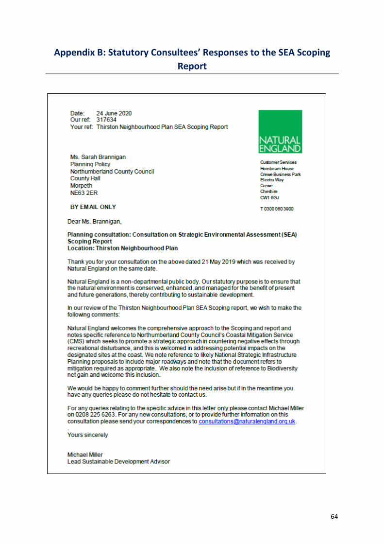
64
Appendix B: Statutory Consultees’ Responses to the SEA Scoping
Report

65

66

67

68

69
Appendix C: Environment Agency’s Response to the SEA
Environmental Report
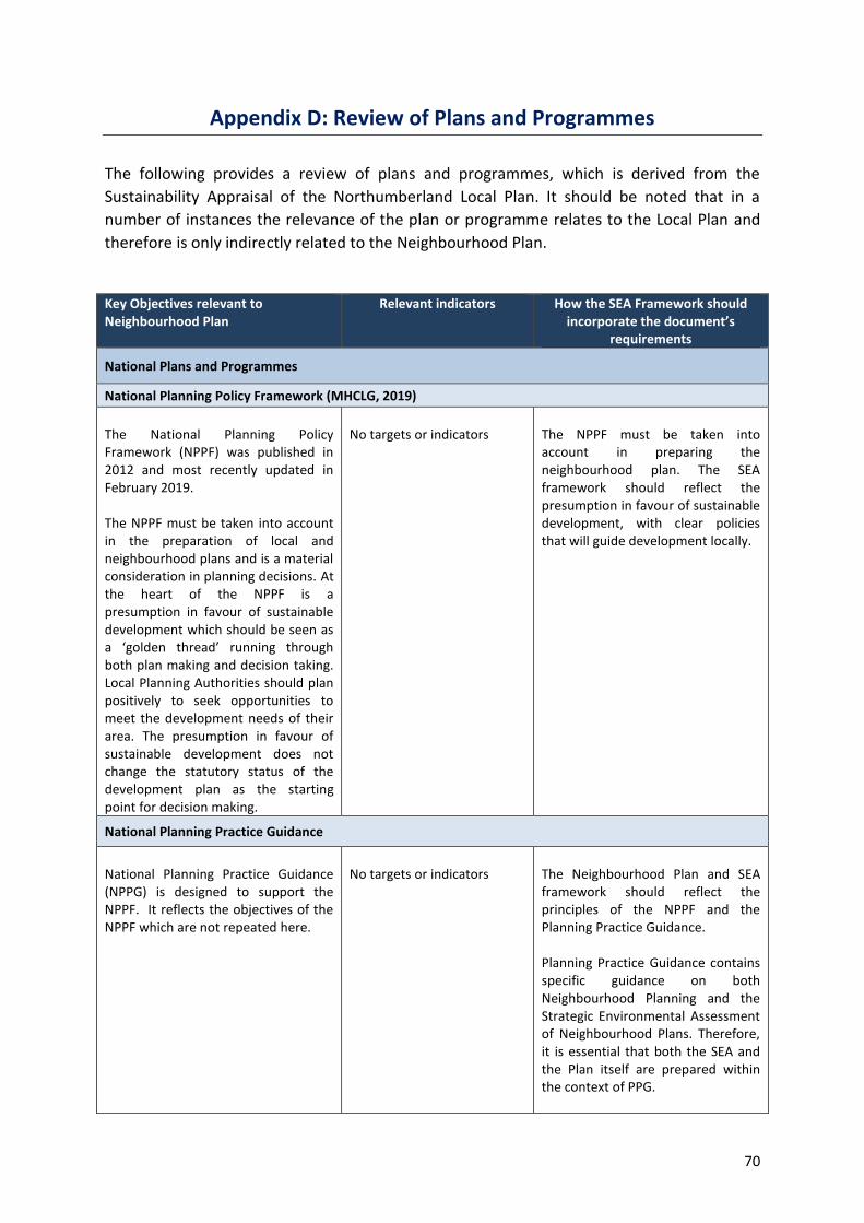
70
Appendix D: Review of Plans and Programmes
The following provides a review of plans and programmes, which is derived from the
Sustainability Appraisal of the Northumberland Local Plan. It should be noted that in a
number of instances the relevance of the plan or programme relates to the Local Plan and
therefore is only indirectly related to the Neighbourhood Plan.
Key Objectives relevant to Neighbourhood Plan
Relevant indicators How the SEA Framework should incorporate the document’s
requirements
National Plans and Programmes
National Planning Policy Framework (MHCLG, 2019)
The National Planning Policy Framework (NPPF) was published in 2012 and most recently updated in February 2019. The NPPF must be taken into account in the preparation of local and neighbourhood plans and is a material consideration in planning decisions. At the heart of the NPPF is a presumption in favour of sustainable development which should be seen as a ‘golden thread’ running through both plan making and decision taking. Local Planning Authorities should plan positively to seek opportunities to meet the development needs of their area. The presumption in favour of sustainable development does not change the statutory status of the development plan as the starting point for decision making.
No targets or indicators
The NPPF must be taken into account in preparing the neighbourhood plan. The SEA framework should reflect the presumption in favour of sustainable development, with clear policies that will guide development locally.
National Planning Practice Guidance
National Planning Practice Guidance (NPPG) is designed to support the NPPF. It reflects the objectives of the NPPF which are not repeated here.
No targets or indicators
The Neighbourhood Plan and SEA framework should reflect the principles of the NPPF and the Planning Practice Guidance. Planning Practice Guidance contains specific guidance on both Neighbourhood Planning and the Strategic Environmental Assessment of Neighbourhood Plans. Therefore, it is essential that both the SEA and the Plan itself are prepared within the context of PPG.

71
Sustainability Appraisal and Strategic Environmental Assessment (Historic England Advice Note 8)
The purpose of this advice note is to support those involved in assessing the effects of certain plans on the historic environment. It offers advice on heritage considerations during the SEA process.
Identifying unforeseen adverse effects of implementing the plan and enabling appropriate remedial action to be taken. Testing the accuracy of predictions made in the appraisal and improving future practice. Determining if the plan is contributing to the achievement of the desired objectives and targets for the historic environment. Checking the delivery and performance of mitigation measures.
The SEA framework should include objectives relating to conservation and enhancement of the historic environment.
Local Plans and Programmes
ADOPTED DEVELOPMENT PLAN DOCUMENTS
Castle Morpeth District Local Plan (Castle Morpeth District Council, 2003)
A considerable number of the policies contained within the Castle Morpeth District Local Plan are saved policies and are therefore still relevant. These policies broadly aim to:
• Provide enough employment and housing land for new, high quality developments to take place that service the needs of the district’s residents;
• Protect the existing, built, historical, ecological and landscape character and assets of the district;
• Ensure the district’s limited resources are used appropriately and for pollution and waste to be kept to a minimum – sustainable development is key;
• Improve the connectivity of the district through infrastructure improvements that make it easier to traverse the district and make it easier to travel to; and
• Encourage the creation and strengthening of communities and ensuring that communities have the services and facilities required for a good quality of life.
The Neighbourhood Plan must be in general conformity with the strategic policies in the development plan.
The SEA framework should consider the policies outlined within the Castle Morpeth Local Plan and ensure that it contains measures that seek to meet its key objectives where appropriate. It should also include objectives/guiding questions which relate to sustainable development, protecting the historic and natural environment, infrastructure, the creation of new housing and employment land and protecting and enhancing local communities.

72
EMERGING DEVELOPMENT PLAN DOCUMENTS
Northumberland Local Plan Publication Draft Plan (Regulation 19) (January 2019)
The Northumberland Local Plan is currently undergoing examination. The Plan will be a single new Local Plan, covering the whole of Northumberland and will replace all of the previous District and County Council Local Plan and Core Strategy documents. When adopted, the Plan will:
• Set the strategic planning policies of the Council, taking account of key factors like population trends, economic growth, climate change, resources and environmental character;
• Set the general scale and distribution of new development which is required to meet Northumberland’s needs to 2036;
• Provide the planning principles, including detailed ‘development management’ policies to guide decisions on planning applications;
• Show in detail where new homes, workplaces and facilities will be located through allocations of land; and
• Show key environmental designations and include site specific proposals for the conservation and enhancement of historic and natural assets.
The Neighbourhood Plan must be in general conformity with the strategic policies in the development plan.
Planning law states that planning applications should be determined in accordance with the Development Plan unless material considerations indicate otherwise. Therefore, the policies within the Northumberland Local Plan, together with those in neighbourhood plans, will be the starting point for the assessment of all planning applications. While the Local Plan is not yet adopted, it is a relevant consideration and its evidence base should be used to help inform the preparation of Neighbourhood Plans.
Climate Commitment Action Plan 2020-21 (December 2019)
The Action Plan sets out targets for reducing carbon emissions: net zero emissions for the County by 2030; the Council’s own operational emissions will be halved by 2025. Progress will be assessed against 35 measures within: agriculture and land use, energy, industry and commercial, transport, domestic and waste with 4 levels of ambition for each indicator. The measures encompass Scope 1 (all direct emissions owned or controlled by the Council), Scope 2 (all indirect emissions), and Scope 3 (other indirect omissions from business travel).
The Neighbourhood Plan should incorporate policies to support sustainable development and the reduction in carbon omissions in the County.
The SEA framework should include objectives / guiding questions that relate to a reduction in carbon emissions.

73
Northumberland Biodiversity Action Plan (Northumberland County Council, 2008)
The Biodiversity Action Plan outlines numerous challenges facing the natural environment of Northumberland including recreational pressure; development; habitat fragmentation; and climate change. The Biodiversity Action Plan also enforces the need to protect Northumberland’s important designated natural assets.
Maintain and even enhance the County’s natural assets to ensure they can be enjoyed by residents and tourists.
The SEA framework should include objectives/guiding questions that relate to protecting the natural environment and which relate back to the SEA Regulations.
Northumberland Coastal Mitigation Service Strategy Document (Northumberland County Council, 2018)
This strategy document aims to mitigate the effects of development, and pressure resulting from development, on the Northumberland Coast. It requires mitigation measures to be implemented within designated sites as well as covering monitoring, reporting and governance arrangements.
Policies should include sufficient requirements which include mitigation measures and references to the Coastal Mitigation Service to enable a positive planning policy context.
The SEA framework should include objectives/guiding questions that relate to the protection of important natural and ecological areas and habitats.
Northumberland Landscape Character Assessment (Northumberland County Council, 2010)
The Landscape Character Assessment looks at the character of the landscape, how nature has influenced it, what it has looked like historically and what things make it distinctive. The study is divided into two parts. Part A - Landscape Classification Part A provides an understanding of the 44 different character types and the 108 landscape character areas. The map and associated descriptions provide a background to understanding landscape and its local distinctiveness and provide a baseline against which change can be assessed. Part B - The Changing Landscape Part B sets out principles for each landscape character type. The principles seek to maintain and enhance the properties most valued in the landscape.
Maintain and enhance the properties most valued in the landscape.
The SEA framework should include objectives/guiding questions that relate to landscape and local distinctiveness. The SEA baseline should include information on landscape character and how landscapes in each neighbourhood area should be managed in order to ascertain the likely effects on these.