Thesis+revision+2_220812_lite
195
Towards a multifunctional rurality: Agricultural change and the development of England’s smaller rural settlements. THOMAS POWELL
Transcript of Thesis+revision+2_220812_lite

8/9/2019 Thesis+revision+2_220812_lite
http://slidepdf.com/reader/full/thesisrevision2220812lite 1/195
Towards a multifunctional rurality:Agricultural change and the development of England’s smallerrural settlements.
THOMAS POWELL

8/9/2019 Thesis+revision+2_220812_lite
http://slidepdf.com/reader/full/thesisrevision2220812lite 2/195
4

8/9/2019 Thesis+revision+2_220812_lite
http://slidepdf.com/reader/full/thesisrevision2220812lite 3/195
5
‘Everyone knows more than half of mankind lives in cities and everybody
is moving to the city so at some point I became interested in simply thequestion what did they leave behind… I’ve been working on this thing,and I call it countryside. And I am discovering that the countryside now isa totally undescribed eld. Nobody thinks about it. And that in spite of thatit’s changing incredibly fast and the countryside is no longer a kind of idyllicenvironment. It is where genetic engineering happens, where immigrationhappens, where religious warfare happens. It is much more agitated andchanging than people typically recognize.’
(Transcript of Rem Koolhaas in conversation with Charlie Rose at OMA
Progress, The Barbican Centre 2012)

8/9/2019 Thesis+revision+2_220812_lite
http://slidepdf.com/reader/full/thesisrevision2220812lite 4/195
6
CONTENTS
ABSTRACT
INTRODUCTION
METHODOLOGY; THE CASE STUDY AREA & BURROUGH GREEN
PART 1 - WHY DO WE NEED TO RETHINK RURAL HINTERLANDS?
I. THE STATE OF RURAL SOCIETY
II. RURAL SPATIAL DEVELOPMENT STRATEGY & CHANGING PLANNING POLICY
III. AGRICULTURAL & LANDSCAPE CHANGE
PART 2 - PROPOSING A NEW RURAL STRATEGY: THE PROJECT OF A MULTIFUNCTIONAL RURALITY
PREFACE; DEFINING MULTIFUNCTIONAL AGRICULTURE
I. A NEED’S BASED AND LOCALLY SPECIFIC DEVELOPMENT STRATEGY IN WHICH MULTIFUNCTIONAL
FARMSTEADS PROVIDE A KEY ROLE
II. ASSESSING THE EVIDENCE; WHAT RURAL DEVELOPMENT IS NEEDED?
III. HOW COULD WE ENABLE SUCH A STRATEGY?

8/9/2019 Thesis+revision+2_220812_lite
http://slidepdf.com/reader/full/thesisrevision2220812lite 5/195
7
PART 3 - HOW COULD A MULTIFUNCTIONAL FARMSTEAD DELIVER A SUSTAINABLE FUTURE FOR
VILLAGE, LANDSCAPE AND FARM?
I. SUSTAINABLE AGRICULTURE & THE MULTIFUNCTIONAL LANDSCAPE
II. DEVELOPING THE VILLAGE; AN AGRICULTURALLY INTEGRATED MASTERPLAN FOR BURROUGH
GREEN
III. THE FARMSTEAD; A GATEWAY TO THE LANDSCAPE
IV. THE FARM HUB; MULTIFUNCTIONAL SPACE FOR FARM AND COMMUNITY
V. LIVING & WORKING, RURAL EMPLOYMENT & BUSINESS
VI. ADDING VALUE; ON FARM FOOD PROCESSING
VII. LOW ENERGY FARM BUILDINGS; PASSIVE STORAGE AND DRYING.
CONCLUSION & FURTHER RESEARCH

8/9/2019 Thesis+revision+2_220812_lite
http://slidepdf.com/reader/full/thesisrevision2220812lite 6/195
8
Acknowledgements
I would like to express my thanks and gratitude to my supervisors and tutors for their hugecommitment to the programme and their invaluable advice, critiscism and support for my project;
Professor Alan Short
Joris Fach
Kevin Fellingham
Ingrid Schroder
This dissertation is the result of my own work and includes nothing which is the outcome ofwork done in collaboration except where speci cally indicated in the text.

8/9/2019 Thesis+revision+2_220812_lite
http://slidepdf.com/reader/full/thesisrevision2220812lite 7/195
9

8/9/2019 Thesis+revision+2_220812_lite
http://slidepdf.com/reader/full/thesisrevision2220812lite 8/195
10
Abstract
Towards a multifunctional rurality:
Agricultural change and ruraldevelopment in England’s smallervillages.Danny Boyle’s 2012 Olympic opening ceremony chose to present to the world a romantic caricatureof pre-industrial Britain, af rming the great cultural importance of the British pastoral tradition.Industrialisation and post-war agricultural modernisation transformed Britain into an urban nation, butthe territory urbanisation left behind is signi cant and complex. What is happening in the contemporary
countryside? The foot and mouth crisis of 2001 saw tourism’s loss to the economy greater thanagriculture’s, signifying a shift in the countryside’s role from the productivist to the post-productivist. Inthe decade or so since, the countryside has changed dramatically.Examination reveals a countryside of expensive barn conversions, priced-out locals, NIMBYism,nostalgia and constrictive planning policy, alongside failing services and car-centric lifestyles. This‘commodi ed countryside’ sits in con ict with an industrial scale agriculture of huge subsidy, ecologicaldegradation and signi cant greenhouse gas emissions. This thesis takes a pragmatic and holistic lookat rural development, examining how a small village could be planned to develop sustainably towards anew multifunctional rural paradigm where agriculture, ecology and low density inhabitation of landscapeform an integrated and complimentary symbiosis.

8/9/2019 Thesis+revision+2_220812_lite
http://slidepdf.com/reader/full/thesisrevision2220812lite 9/195
11
gure 1; London 2012 Olympic Opening Ceremony

8/9/2019 Thesis+revision+2_220812_lite
http://slidepdf.com/reader/full/thesisrevision2220812lite 10/195
12
Visual Abstract

8/9/2019 Thesis+revision+2_220812_lite
http://slidepdf.com/reader/full/thesisrevision2220812lite 11/195
13
Figure 2; Proposal overview

8/9/2019 Thesis+revision+2_220812_lite
http://slidepdf.com/reader/full/thesisrevision2220812lite 12/195
14

8/9/2019 Thesis+revision+2_220812_lite
http://slidepdf.com/reader/full/thesisrevision2220812lite 13/195

8/9/2019 Thesis+revision+2_220812_lite
http://slidepdf.com/reader/full/thesisrevision2220812lite 14/195
16
INTRODUCTIONEighty-three percent of the UK is rural landscape; (Foresight 2010, p53) farmland and woodland
interspersed with thousands of villages and hamlets. Although a minority of the population inhabit this
space, its political, social, economic and cultural impact is far-reaching. It has been largely ignored by
architectural thinkers, yet today this territory is complex, signi cant and undergoing rapid change. It
presents pragmatic challenges; to nd new modes of sustainable rural living and to deliver an increased
yet sustainable agricultural output. However its positioning within a late capitalist society so dominated
by urban considerations also presents theoretical problems. Whilst urban space entertains complexity
and contradiction, affording architects freedom to invent in the city’s multiplicity, this cannot be said of
rural areas where politicians, geographers and anthropologists wrestle with traditionalism, restrictive
planning policy and massive public subisidy.
Huge change over the past decades has seen the countryside rede ned within rural studies, from a
place of monolithic agro-industrial production to a post-productivist ‘consumption countryside,’(Mather et
al, 2006, p452) (Halfacre, 2007, p130) where its environmental and aesthetic value equals or outweighs
its productive function. As policy shifted to post-productivist aims, the concept of multifunctionalism
emerged in academic and political discourse, as spatial theorists and geographers sought to integrate
rural development, ecological conservation and the management of landscapes with agricultural
production. (Marsden & Sonnino, 2008, p422) However, following timid government intervention
coupled with a slow change in attitudes, the last decade has left a ‘differentiated countryside’ (Halfacre,
2007, p130) where the old paradigm of agro-industrial productivism is held in tension with remnants of
a post productivist consumption countryside, which acheives only a partial and weak multifunctionalism.
(Wilson 2007, p113)Today rural Britain is outwardly successful, with strong communities, thriving economies and a high
quality of life drawing more people to the countryside than the city, with a net migration into rural
areas. (CRC, 2010, p17) However, many smaller villages have been developmentally frozen to the
detriment of equity, economy and sustainability, a condition which promulgates pastiche, self-parody
and conservatism. This has resulted in buildings and spaces which stymy authentic rural living and
settlements which are disconnected from the landscape. Recent changes to planning policy and the
pressing need to rethink agriculture along sustainable lines provides the impetus to look again at rural
space, to capitalise on its assets and address its problems, both pragmatic and theoretical.The thesis proposes an engagement with a fresh conceptualisation of rural multifuctionality which
ties agricultural, ecological and social development together in a new sustainable rural development
paradigm, with the aim of creating authentic, living, working settlements and landscapes that
accommodate human habitation, ecosytem services and sustainable agricultural production. It is
posited that this multifunctional paradigm could be realised through a re-imagining of the village
farmstead as a hub for farm business pluri-activity, landscape management and leisure and tourism;
providing spaces for social functions, services and rural economic activity. Through this proposition the
thesis explores the achitectural implications of building in the rural context, examining the commodifed
vernacular, the aesthetic of agricultural landcape, and the implications of modifying historic low density
settlement structures.

8/9/2019 Thesis+revision+2_220812_lite
http://slidepdf.com/reader/full/thesisrevision2220812lite 15/195
17
Figure 4; UK land cover

8/9/2019 Thesis+revision+2_220812_lite
http://slidepdf.com/reader/full/thesisrevision2220812lite 16/195
18
Why is now a pertinent time to re-examine the rural?
1. THE STATE OF RURAL SOCIETY
There is much evidence to suggest that rural communities are facing signi cant social and economic
challenges. The Taylor Review (2009) and the Commision for Rural Communites’ 2010 State of the
countryside report identify serious barriers to sustainability in local services, housing, social equity and
the rural economy. If the carbon reduction targets set in law are to be met, then every settlement type in
the UK, even the smallest will have to signi cantly reduce their energy use.
2. CHANGING PLANNING POLICY AND SPATIAL DEVELOPMENT STRATEGY
The growth limiting policies of the last decade are reported to have exacerbated social and economic
problems whilst failing to reduce transport distances and energy use. With the recent shake-up of the
planning system there is the opportunity to orchestrate a new approach to rural development and spatial
strategies, particularly for smaller rural settlements.
3. AGRICULTURE & LANDSCAPE CHANGE
There is a broad consensus that UK agriculture faces massive change as it needs to produce more in a
sustainable manner. Several key reports including Foresight’s The Future of Food and Farming (2011)
and The Royal Society’s Reaping the bene ts; Science and the sustainable intensi cation of global
agriculture (2009) have recently called for a renewed focus on domestic production with a ‘sustainable
intensi cation’ of UK agriculture.
These three drivers for change suggest the countryside is at a turning point, and to consolidate these
complex and competing issues there is now a strong case for intervention by designers in a space
traditionally ignored. To understand how this could happen this thesis examines the small villages which
inhabit sparsely populated farmland regions and which local authorities have deliberately excluded from
local development plans as these places are the most acute representation of rural issues.
(CRC, 2010, p2)

8/9/2019 Thesis+revision+2_220812_lite
http://slidepdf.com/reader/full/thesisrevision2220812lite 17/195
19
Figure 5; Land at the back of Wyck Farm, Burrough Green

8/9/2019 Thesis+revision+2_220812_lite
http://slidepdf.com/reader/full/thesisrevision2220812lite 18/195
20
CAMBRIDGE
Highlights the location of the village & study area through the document
METHODOLOGY; THE CASE STUDYAREA & BURROUGH GREENThe role of design as a mode of research is the subject of considerable debate. However there is
much that designers can contribute to knowledge and understanding, through the invention that comes
in design, through spatialising and integrating the research contributions of different disciplines and
by addressing issues at a range of scales. This research project explores how to use architectural
thinking and design to conduct research which can contribute new ways of solving issues and
improving human environments through a propositional research methodology. Over the duration of
the research project, ve papers have been submitted which build an understanding of the topic, from
design studies to papers on policy. This thesis summarises this supporting work and a nal design
exploration as a comprehensive research report. The proposition of this thesis is to promote a new
multifunctional agricultural paradigm through the re-alignment of agricultural practice along sustainable
lines, fostering a re-activation of rural settlements through the re-imagination of the farmstead as a hub
of multifunctional social, agricultural and touristic activity. This argument is made through a broad and
multi-disciplinary understanding of current research, policy and reportage alongside original analysis
of geospatial data. In the construction of this proposal it becomes apparent that although the concept
8/9/2019 Thesis+revision+2_220812_lite
http://slidepdf.com/reader/full/thesisrevision2220812lite 19/195
21
NEWMARKET
Figure 6; Case study area
of multifunctionality is widely discussed in research and that multifunctional traits have become
established in contemporary agriculture, where agricultural pluri-activity is found it is typically partial
and piecemeal, with multifunctional activity often divorced from productive objectives. (Marsden &
Sonnino, 2008, p422) This thesis explores the full potential of rural multifunctionality and its conciliation
with sustainable intensi cation by examining what could be realised through an architectural and spatial
intervention. This is achieved through a propositional research where a case study design explores the
symbiotic development of a farm, settlement and its locale. The process of designing within a context
and giving physical form to research concepts gives rise to new insights and possibilities. It is intended
that this view will present a unique contribution to the wider debate in rural studies, planning policy,
agricultural development, economics and sociology. The vehicle for an exploration of these issues is
the small village of Burrough Green in East Cambridgeshire, the farm and farmstead which adjoin it,
and its spatial context, the rural hinterland between Cambridge, Newmarket and Haverhill.

8/9/2019 Thesis+revision+2_220812_lite
http://slidepdf.com/reader/full/thesisrevision2220812lite 20/195
22
Burrough Green and the Dullingham villages ward sit in ‘the accessible countryside’, where
the commodi cation of rural space, commuting culture and problems of inequality are high. It
falls within the area of East Anglian arable production where the most monolithic and industrial
UK farming occurs. To understand how the proposed development of farm and village might
work, rst considered are the overarching in uences on the rural environment; the challenges
facing rural society, the relationship of the countryside to urban centres and the impetus for
agricultural change. Through a description of the broader issues for rurality and how they relate
to what is happening in the study area, this part of the thesis sets out the evidence for why it is
important to rethink rural hinterlands.

8/9/2019 Thesis+revision+2_220812_lite
http://slidepdf.com/reader/full/thesisrevision2220812lite 21/195
23
LBTCB
WrT
TCB
FB
FB
LB
LB
TCB
LB
R a d i o M a s t
Tank
LB
WrT
Shelter
FootBridge
TCB
FB
FootBridge
S h e l t e r
TCB
Pump
h e lt e r
Pumps
r's ri
Stone
Stone
Stone
Stone
LB
a r e l
FB
Figure 8; Aerial photo of Burrough Green
Figure 7; Burrough Green in relation to neighbouring villages

8/9/2019 Thesis+revision+2_220812_lite
http://slidepdf.com/reader/full/thesisrevision2220812lite 22/195

8/9/2019 Thesis+revision+2_220812_lite
http://slidepdf.com/reader/full/thesisrevision2220812lite 23/195
25Figure 9; Panorama across green, Burrough Green

8/9/2019 Thesis+revision+2_220812_lite
http://slidepdf.com/reader/full/thesisrevision2220812lite 24/195
26
I. THE STATE OF RURAL SOCIETY
The state of the countryside report (SOTC 2010) is published periodically by the Commission for
Rural Communities. The latest report published in 2010 gives us a comprehensive and up to date
summary of statistical data on UK rural communities. Along with the major 2008 report to government;
Living Working Countryside: The Taylor Review of Rural Economy and Affordable Housing , there is a
substantial contemporary evidence base to help understand the shape of rural communities and the
challenges for rural development. Drawing heavily from these reports and other key papers in the eld
of rural studies, this chapter aims to summarise the key issues for rural communities.
Figure 10; Traditional agricultural workers cottages demolished in Burrough Green, 1960

8/9/2019 Thesis+revision+2_220812_lite
http://slidepdf.com/reader/full/thesisrevision2220812lite 25/195
27
The Dear Old Village
….In the bad times of old feudality,
The villagers were ruled by masters three –
Squire, Parson, schoolmaster. Of these, the last
Knew best the village present and it’s past.
Now, I am glad to say, the man is dead,
The children have a motor bus instead,
And in town eleven miles away,
We train them to be ‘Citizens of Today’.
And many a cultivated hour they pass
In a ne school with walls of vita-glass.
Civics, eurythmics, economics, Marx,
How–to-respect-wild-life-in-national-parks;
Plastics, Gymnastics – thus they learn to scorn
The old thatch’d cottages where they were born.
The girls, ambitious to begin their lives
Serving in WOOLWORTH’s rather than as wives;The boys, who cannot yet escape the land,
At driving tractors lend a clumsy hand.
An eight-hour day for all, and more than three,
Of these are occupied in making tea…..
Betjeman, J, 1970
Figure 11; Cosy Cottage, Burrough Green, 1925

8/9/2019 Thesis+revision+2_220812_lite
http://slidepdf.com/reader/full/thesisrevision2220812lite 26/195
28
The gentri cation of the countryside
The change Betjeman described in The Dear Old Village aptly captures the sense of a rural way of life
being left behind by post-war Britain, as traditional agricultural communities disappeared in a period of
radical change, driven by the industrialisation of agriculture. This saw the traditional employment base
destroyed, whilst the immigration of wealthier urban incomers began in earnest following Government
expansion of the road network, which opened up rural backwaters as desirable commuting elds.
(Howkins, 2003 143 -159) Throughout the late twentieth and early twenty- rst century the trend of in-
migration and falling agricultural employment and services continued, leaving a modern countryside far
removed from the close knit and wholly agricultural communities which existed pre-war.Today there are some bastions of traditional working community in remote areas, but the majority of
the ‘post-productivist’ countryside is socially and demographically similar to urban society, a small
minority working directly in agriculture. (Taylor, 2007, p123) However it differs in some key aspects. It
is now predominantly a middle-class territory, as rural gentri cation has brought in a majority ‘petite
bourgeoisie’ of small employers and own account workers, predominantly traditional in their cultural
values. (Philips, 2007, p293) A mix of the new service class and professionals make up the remainder of
the middle class, with higher proportions in the ‘accessible countryside,’ where they can easily commute
to urban conurbations. (Philips, 2007, p293) Much of the class con ict which once troubled ruralcommunities in the early days of in-migration has now disappeared.
The Place Survey (2009) found rural areas to report higher satisfaction with community integration than
urban and suburban areas, possibly as the incomers essentially ‘won out.’ Rural areas are reported
to have greater wellbeing, community spirit and volunteerism than urban areas. (CRC, 2010, p76)
However there still exists large disparities in mean wages. Those who work in rural areas typically earn
£4,655 less than the national average, creating an economic divide between those who live in rural
communities and work in small businesses, which are predominantly land based, property or business
services, and those who live in rural areas and commute to cities to work in higher paying, larger rms,
consequently able to price out those working in rural areas. (CRC, 2010, p135)

8/9/2019 Thesis+revision+2_220812_lite
http://slidepdf.com/reader/full/thesisrevision2220812lite 27/195
29
THE AGRARIAN COUNTRYSIDE
Figure 12; Burrough Green. Families
outside their homes at Town Yard
situated near Walnut Tree Row, 1920
THE AGRARIAN COUNTRYSIDE
Figure 13; Brinkley - Chalk Pit Farm.
A stack on raised hobbles. The farm
worker is thatching the top to prevent
rain getting in. 1932 to 1934

8/9/2019 Thesis+revision+2_220812_lite
http://slidepdf.com/reader/full/thesisrevision2220812lite 28/195
30
THE PRODUCTIVIST COUNTRYSIDE
gure 14; Burrough Green, new car, 1964
THE PRODUCTIVIST COUNTRYSIDE
gure 15; Burrough Green, combine harvester, 1960’s

8/9/2019 Thesis+revision+2_220812_lite
http://slidepdf.com/reader/full/thesisrevision2220812lite 29/195
31
THE POST PRODUCTIVIST ORCOMMODIFIED COUNTRYSIDE
gure 16; Burrough Green, the restored Hart
Farm and Barn conversion, 2012
The hedge still has labels on.
THE POST PRODUCTIVIST ORCOMMODIFIED COUNTRYSIDE
gure 17; Burrough Green, chemical
agriculture; spraying crops with pesticides, 2012
.

8/9/2019 Thesis+revision+2_220812_lite
http://slidepdf.com/reader/full/thesisrevision2220812lite 30/195
32
Housing A lack of government support for affordable housing in smaller rural settlements has led to a severe
shortage, with the right to buy policies of the 1980s eradicating much available housing. Only 13%
of housing in rural areas is affordable, compared with 21 percent in urban areas, and provision in the
smallest settlements is far lower. (CRC, 2010, p48)
The Affordable Rural Housing Commission and the Commission for Rural Communities have
independently estimated the need to more than double the current rate of affordable home provision,
with 10,000-15,000 new homes required in rural settlements of less than 3000 people in the next ve
years. (Taylor, 2008, p87) Such exclusion of the poorest undermines the sustainability of rural places,
socially and environmentally, and con icts with the principles of social cohesion and equity set out in
the aims of national planning policy. The lack of affordable housing is partly to do with spatial planning
strategy, which is examined in the subsequent section. Yet it also has roots in the societal attitudes of
the post-productivist countryside, where dominant middle class values put great value on the small
scale and traditional environment which they have invested in and wish to protect. Furthermore the
low quality, sprawling development of the 1970s has created a negative view of new development and
resistance to new building. (Howkins, 2003, p170) Dubbed NIMBYism by contemporary commentators,
this opposition to development has derailed many housing projects and deterred landownersfrom developing land. (Taylor 2008, p108) (IPPR, 2006, p122) Designing new pieces of rural built
environment in a manner which appeases the desire of the community to preserve the character and
form of rural space is essential to seeing projects accepted. (DCLG, 2011, P16)
This suggests the need for the careful editing of village settlements rather than the introduction of
comprehensive new forms. However an engagement by designers with the commodi cation of rural
vernaculars and romantic societal ideals promises to have interesting implications, with opportunities to
revive a vernacular tradition which has been lost in pastiche and historicism.

8/9/2019 Thesis+revision+2_220812_lite
http://slidepdf.com/reader/full/thesisrevision2220812lite 31/195
33
gure 19; Barriers to housing & services, 2010, Cambridgeshire
93,363.6 - 162,603.7
162,603.8 - 208,235.6
208,235.6 - 258,052.5
258,052.6 - 337, 304.1
337, 304.2 - 566,352.7
Average price (£)
99.3 - 123.0
75.5 - 99.2
49.7 - 74.4
24.9 - 49.6
1.0 -24.8
Ranking of wards 1 (highest) - 23 (lowest)
gure 18; Average house prices 2012, Cambridgeshire

8/9/2019 Thesis+revision+2_220812_lite
http://slidepdf.com/reader/full/thesisrevision2220812lite 32/195

8/9/2019 Thesis+revision+2_220812_lite
http://slidepdf.com/reader/full/thesisrevision2220812lite 33/195
35
Rural & farmstead employment hubs
Primary school
Village hall
Pub
Church
Post of ce
gure 20; Existing services in Burrough Green and surrounding villages

8/9/2019 Thesis+revision+2_220812_lite
http://slidepdf.com/reader/full/thesisrevision2220812lite 34/195
36
Economy, Premises & Employment.
The rural economy is signi cant, contributing 14% to the national economy. It is diverse, stable and
growing faster than urban economies, although it is now compositionally very similar. Once largely
agrarian, now only 7.5% of people are employed in agriculture, with the most rural areas seeing levels
of entrepreneurial activity rivalled only by inner London.
(Taylor, 2008, p123)
More micro businesses employing less than 10 people are registered in rural than urban areas and
since 2005 rms employing 1-10 people in villages and hamlets saw the largest growth of any area.
(CRC, 2010, p135) A positive trend is in growing knowledge-intensive ICT businesses, which increased
46% in rural areas between 1998 and 2005, compared to 21% in urban areas, as the perceived quality
of rural life attracts those businesses which are geographically mobile. (Taylor 2008, 123) ICT may also
account for the increase in home working in hamlets and isolated dwellings, currently practiced by 17%
of rural workers. (Lowe & Ward, 2009, p1332) Competition with more pro table residential development
for rural sites and protectionist planning policies limit the availability of working premises. In a survey for
The Taylor Review 74% of home-based businesses cited a shortage of premises as a barrier to growth.
(Taylor 2008, p120) The Taylor Review calls for the development of live/work units and for planning
policy to prioritise business usage in conversions, with exibility towards green- eld and farmstead
development. With the barrier of limited premises removed, the potential of the strong rural economy
to make more sustainable communities, with people both working and living locally could be realized,
whilst allowing businesses to grow and provide higher levels of income. Farmsteads offer an ideal base
for small businesses to cluster, providing a hub for business activity, sharing resources and services. In
the study area there are already several examples of redundant agricultural buildings let as business
premises, though these are usually outside of settlement boundaries. Bringing a working population into
the village could reinforce local services and businesses, making thriving village environments.

8/9/2019 Thesis+revision+2_220812_lite
http://slidepdf.com/reader/full/thesisrevision2220812lite 35/195

8/9/2019 Thesis+revision+2_220812_lite
http://slidepdf.com/reader/full/thesisrevision2220812lite 36/195
38
Conclusions on the State of Rural SocietyLooking at the countryside nationally alongside snapshots of Burrough Green, it appears the
countryside is a good place to live for many. It has thriving communities, with high levels of volunteerism
and good social cohesion. Furthermore there is a strong economy of entrepeneurial small businesses.
However limited development in the post-productive countryside also equates to inequality for the
communities of smaller settlements, with high desirability and little intervention from government
leaving them as increasingly the preserve of a wealthy middle class, as populations are ageing and
becoming more gentri ed. This undermines social diversity whilst putting further strain on services,
as well as keeping businesses small and wages low. There is a growing separation between this
commuting middle class, and an underclass composed of those with small rural businesses who often
can’t afford to live in the same area they work. This situation is undesirable in social and economic
terms, but it is also contributing to higher transport distances. So what are the problems with planning
and development policy which have contributed to this situation, and what needs to change? The next
section looks at changing spatial development strategy and the opportunities for farmstead and village
development which this presents.

8/9/2019 Thesis+revision+2_220812_lite
http://slidepdf.com/reader/full/thesisrevision2220812lite 37/195
39
gure 22; Burrough Green, An old phone box has become a makeshift lending library for the residents

8/9/2019 Thesis+revision+2_220812_lite
http://slidepdf.com/reader/full/thesisrevision2220812lite 38/195
40
II. RURAL SPATIAL DEVELOPMENTSTRATEGY & CHANGINGPLANNING POLICY
Previous to the new National Planning Policy Framework published in March 2012, (DCLG, 2012) rural
development policy was designed to reinforce a hierarchial settlement strategy, where larger village
settlements with a good level of services are allowed some small scale development. However within
those smaller villages with limited services, development was largely prohibited.
The hierarchial strategy stemmed from an understanding that development in small settlements
fundamentally contradicted the aims set out in previous planning policy guidance to reduce dependence
on cars and reduce the need to travel. In its report Planning for Sustainable Rural Communities: A New
Agenda , the Commision for Rural Communities challenged the presumption that small settlements are
fundamentally unsustainable, arguing instead that, ‘ the key settlement approach is based on a mythical
hierarchy of villages and towns...which fails to recognize the complexity and diversity of functions and
networks that have developed in recent decades in rural England’ CRC, 2007, p6
This view is supported by a now well-developed body of research into commuting and travel patternsbased on census data. As the commute is largely combined with use of other services such as
shopping, (Findlay et al, 2001) it gives an accurate indicator of people’s movement in rural space.
Concurrently the new National Planning Policy Framework has abolished the hierarchial settlement
strategy and freed up local authorities to determine their own polcies on rural spatial development,
allowing rural spatial strategy to be re-adressed. (DCLG, 2012) With counter-urbanisation increasing,
rural commuting needs to be tackled to ensure a sustainable future. Prominent reports such as The
Taylor Review (Taylor 2008) have called for a place speci c response to rural issues based on evidence
and public consultation. Examining rural commuting through 2001 census data in an analysis of the
case study area, we attempt to understand commuting in a speci c place, and how this might inform
strategies for reducing travel.

8/9/2019 Thesis+revision+2_220812_lite
http://slidepdf.com/reader/full/thesisrevision2220812lite 39/195
41gure 23; Figure ground demonstrates the dispersed pattern of small settlements on the Cambridgeshire Suffolk Border.

8/9/2019 Thesis+revision+2_220812_lite
http://slidepdf.com/reader/full/thesisrevision2220812lite 40/195
42
The car-centric countrysideTravel to work in rural areas has been instrumental in the changing nature of rural settlements over
the last 40 years. Growing numbers of people live in the countryside attracted by the perceived higher
quality of life alongside increased accessibility to commute to work in cities. In many places this in ux of
newcomers into rural communities led to tensions, loss of social cohesion, and a steady decline in rural
services. (Howkins, 2003)
Rural inhabitants seem to travel further than those in urban areas, and as low density habitation makes
cost-effective public transport dif cult to implement, they travel more by car. Unsustainable in terms of
emissions, this is also problematic for non-drivers. There is little to suggest that rural travel distances
have been reduced by the hierarchial settlement model, with travel distances to services and work
having remained the same over the past 10 years. (CRC 2010 p123) There is evidence to suggest
that spatial development strategy is anyway unlikely to impact directly on travel behaviour. Findlay et
al describe a ‘culture of mobility,’ identifying rural ‘hypermobility’ as an embedded cultural trait likely
unaffected by spatial planning.
The dispersed nature of jobs in rural areas coupled with cheap car-based transport and uncongested
rural roads has led in many areas to an increasingly dispersed and far-reaching spatial economy, with
little friction of distance; rural dwellers choosing to live and work with little consideration for how far
they travel. This is coupled with a growing ‘two way’ pattern of commuting, the traditional model of
rural residents commuting into towns and cities being replaced by ‘commuting elds’ in which people
are increasingly mobile, with increasingly powerful labour market connections which cut across simple
categorisations of settlement type and urban/rural status. (Findlay et al 2001, p13)
This suggests more place speci c study is required, speci cally of strategies for transport and
commuting, towards targeted interventions that reduce excessive travel behaviour This sectionsummarises a supporting study on rural travel which examines the commuting patterns of Burrough
Green and the surrounding area. It identi es three distinct rural commuting traits; long distance urban/
peri-urban commuting, rural containment and reverse commuting; before proposing some ways
that negative traits could be changed, and positive traits capitalised on. This informs us as to how a
multifunctional agriculture might combine with new rural development strategies.

8/9/2019 Thesis+revision+2_220812_lite
http://slidepdf.com/reader/full/thesisrevision2220812lite 41/195
43
gure 24; Burrough Green, Cars parked two deep outside elderly residents homes

8/9/2019 Thesis+revision+2_220812_lite
http://slidepdf.com/reader/full/thesisrevision2220812lite 42/195
44
COMMUTING IN THE EAST CAMBRIDGESHIRERURAL HINTERLAND.
Long distance urban & peri-urban commuting.Long distance commuting to urban conurbations is one of the most entrenched traits of rural travel. The
national average commute in these rural areas is 14.6km, nearly 50% further than a large urban area.
(Champion, 2009, p175) gs. 25-28 shows output area mapping of census origin destination data which
illustrates the commuting habits of several villages, including Burrough Green, within the Dullingham
villages ward. The average commute within the ward is higher than the national average, at 18.9km.
(ONS 2001) The mapping shows extensive long distance commuting to Cambridge and Newmarket,
as well as to further employment centres such as Ely. This describes an extremely far-reaching and
emission-heavy commuting eld. It also shows little commuting between these villages and nearby
adjacent settlements or service centre villages. This is problematic for local services, as there is much
evidence to suggest the commute is often combined with use of services, so it is likely local shops, post
of ces and leisure facilities are often bypassed for those in nearby towns.
How could long distance commuting be reduced?
Addressing the regional housing balance
A shortage of housing near Cambridge is likely the cause of much long distance commuting in the
rural regions. Although the study wards are expensive, the scarcity and high cost of spacious detached
housing in the city make them attractive to city workers. (CCC, 2009) The provision of spacious new
housing closer to Cambridge could lower the desirability of these wards to long distance commuters and
return them to more localised economic activity. However there is a great inertia to the spatial economy.
As demonstrated by The Martin Centre’s Solutions scenario modelling, new development has limited
and only very long term in uence on the shape of regional spatial economies. (Echenique et al, 2009)

8/9/2019 Thesis+revision+2_220812_lite
http://slidepdf.com/reader/full/thesisrevision2220812lite 43/195
45
A 12UCFZ007 (SAXON ST/DITTON GREEN)
OA 12UCFZ004 (STRETCHWORTH)
Figure 18.
Figure 19.
gure 25; Mapping of commuting pattern from Burrough Green
gure 26; Mapping of commuting pattern from Brinkley

8/9/2019 Thesis+revision+2_220812_lite
http://slidepdf.com/reader/full/thesisrevision2220812lite 44/195
46
Electric cars
The introduction of electric cars could reduce the emissions produced by rural hyper-commuting.They
are ve times as energy ef cient as fossil fuel cars (Mackay, 2008, p127) and the extra space afforded
rural settlements provides opportunities for the renewable self-generation of power to charge them.
However this wouldn’t address problems of providing transport for non-drivers, or the social implications
of a hyper-commuting countryside, such as reduced patronage of local facilities and services.
Despite this electric vehicles could prove to be a signi cant part of the solution. However with
optimistic estimates predicting no more than a 30% electric eet by 2030, (COCC, 2010, p217) ruralcar eets being typically older, (CRC, 2010, p38) and with electric cars set to be more expensive
than conventional vehicles, there is a danger of rural areas being left behind. There does seem to be
considerable opportunity for car sharing and car pool schemes, which could be particularly effective
when used alongside part-time homeworking.
Home-working.
Encouraging more self-employed to work from home or within their community rather than rent
premises in faraway urban areas could reduce long distance commuting. Additionally, with thewidespread adoption and continuing advancement of ICT, large employers could introduce exitime
schemes, where rural employees could work from home some days of the week. The provision of
dedicated space to work is a potential function of the proposed multifunctional farmstead with a call
for new rural live-work development, (CRC 2007b) whilst rural business hubs have been proven as
effectual means to provide space and resources for effective homeworking, (Taylor, 2008)

8/9/2019 Thesis+revision+2_220812_lite
http://slidepdf.com/reader/full/thesisrevision2220812lite 45/195
47
12UCFZ001 (DULLINGHAM VILLAGES)
12UCFU002 (LODE) Figure 16.
Figure 17.
gure 27; Mapping of commuting pattern from Stretchworth
gure 28; Mapping of commuting pattern from Dullingham

8/9/2019 Thesis+revision+2_220812_lite
http://slidepdf.com/reader/full/thesisrevision2220812lite 46/195
48
Containment Although the proportion of jobs to residence is lower in rural areas, there are high levels of self-
containment in rural settlements, with people both living and working in the same place. This is a
positive rural trait, reducing emissions from transport and building stronger communities. Rural areas
see more homeworking nationally, (CRC 2007b) and this trend is evident in the study area, which
shows higher percentages of homeworking than nearby town/urban wards. ( g. 29)
How can this potentially sustainable characteristic of rural working be capitalised on?
The Taylor Review suggests that development restrictions limit the extent of the rural economy, and
proposes that premises should be permitted to be expanded and businesses allowed to ourish. (Taylor
2008) The high containment found suggests if rural businesses and premises were allowed to expand
and the number of jobs located in rural areas increase, people would continue to live near their work,
particularly if the expansion was modest.
A 2009 public consultation carried out by East Cambridgeshire ACRE and East Cambridgeshire’s
strategic partnership Rural Cambridgeshire: Ensuring a Vibrant Future, Consultation on a new Rural
Strategy for Cambridgeshire 2009 , identi ed a need for affordable business space and opportunities
for homeworking, with a recent consultation speci cally identifying a lack of small premises as a
barrier. (CCRG, 2006, p10) In response to high levels of out-commuting, East Cambridgeshire Council
developed ‘E spaces’ for small businesses in Ely and Newmarket, with low rents and exible leases.
These units increased regional containment, with 30% of respondents saying they would have located
outside East Cambridgeshire without the E spaces. It seems a similar strategy could work in the more
rural areas.
.

8/9/2019 Thesis+revision+2_220812_lite
http://slidepdf.com/reader/full/thesisrevision2220812lite 47/195
49
70% and over
50% to 69%
35% to 49%
20% to 34%
less than 20%
% of people working in the area who also live there
gure 29; Workplace containment

8/9/2019 Thesis+revision+2_220812_lite
http://slidepdf.com/reader/full/thesisrevision2220812lite 48/195
50
Reverse commutingReverse commuting is the phenomenon of incomers moving into rural settlements, causing house
prices to soar, leaving lower paid local workers unable to afford local houses. Instead they live on the
cheaper peripheries of nearby market towns or urban areas and commute back into the countryside to
work.
Around 13.5% of the workforce in the Dullingham Villages ward reverse commute, with the majority of
ows from Newmarket. ( g. 31 & 32) Commuting ows by industry show that it is employees in lower
income industries such as farming, forestry and shing who commute from the town wards back into the
rural wards. ( g. 33) Examining average houses prices across the wards demonstrates a considerable
gap in affordability. ( g. 30)
Reducing reverse commuting
The obvious solution is to provide more affordable local housing. This raises signi cant problems. How
can policy ensure that those who buy or let the new housing are working locally? Indeed a 2009 study
by Champion found new arrivals to smaller rural settlements were more likely to exhibit long distance
commuting behaviour. (Champion et al, 2009)
The development of market housing would do little to reduce the problem. The desirability of these
areas would demand large volumes of housing before prices dropped enough to make it affordable for
local workers. Such development would be detrimental to the pastoral quality of these settlements, and
would not guarantee less travel.
Another solution would be to allow the development of housing with special conditions, such as on
evidence of being a local worker with an income below a set threshold. This could be either developed
by the local authority through non-subsidised models, such as community land trusts where land or
property is held in perpetuity for the bene t of the community, or through the encouragement of private
affordable homes by developers or through social landlord models. Under such schemes landowners
are permitted to develop land for affordable local housing, under condition that the rents are set at
an agreed amount below market value. (Taylor 2008, p111) The right to buy policies of the 1980s
dramatically decreased the stock of social housing in rural areas, and waiting lists for affordable housing
are growing. (Taylor 2008) Low cost rented housing kept in perpuity for local workers could reduce
reverse commuting, however where and how this new housing would be provided is of interest to the
wider proposition of farmstead development to aid in rural development.

8/9/2019 Thesis+revision+2_220812_lite
http://slidepdf.com/reader/full/thesisrevision2220812lite 49/195
51
Workers Origns, Dullingham viillages SOA Workers Origins, Bottisham SOA
99.3 - 123.0
75.5 - 99.2
49.7 - 74.4
24.9 - 49.6
1.0 -24.8
Ranking of wards 1 (highest) - 23 (lowest)
gure 30; Barriers to housing & services, 2010, Cambridgeshire
gures 31-33; Reverse commuting
Number of commutes
6-9
10-1415 -19
20-29
30+
Travel to work in Agriculture, Forestry and Fishing,

8/9/2019 Thesis+revision+2_220812_lite
http://slidepdf.com/reader/full/thesisrevision2220812lite 50/195
52
Conclusions on the car-centric countrysideThe generic policies of servicing and developing smaller rural settlements have for a long time been
based on an outdated hierarchial model, which has been applied to large geographical areas and
across broad area classi cations. The resultant frozen development has caused housing pressures,
social inequality, a constrained economy and weakened rural services. A contemporary understanding
of rural commuting shows us a diverse, complex and locally speci c spatial economy. Rather than
writing off small settlements as inherently unsustainable and freezing development, by understanding
the economic pressures and development needs of individual rural settlements, speci c interventions
could be made to reduce unsustainable travel behaviour. This analysis has speculated on how the
unsustainable commuting practices identi ed might be altered and how more sustainable trends could
be encouraged. Through an evidence-based understanding of peoples’ commuting habits and needs,
both through analysis of census datasets such as those examined here and through public surveys and
consultation, positive strategies which lessen the negative impacts of rural commuting habits could be
applied on a case by case basis, through changing working behaviour, addressing housing pressures
and easing premises restraints on rural business. In doing so there is the opportunity to reduce
transport related emissions and tackle the issues surrounding wider socio-economic sustainability. This
raises the question of how the farmstead and the development of a multifunctional agriculture could be
integrated with these aims.

8/9/2019 Thesis+revision+2_220812_lite
http://slidepdf.com/reader/full/thesisrevision2220812lite 51/195
53

8/9/2019 Thesis+revision+2_220812_lite
http://slidepdf.com/reader/full/thesisrevision2220812lite 52/195
54
III. AGRICULTURAL &
LANDSCAPE CHANGESmall villages such as Burrough Green are dominated by the agricultural landscape they inhabit.This
chapter examines how agriculture needs to change, in the ambition to construct a more accessible and
diverse natural environment, and in the need to secure a sustainable low energy future for agriculture,
through ‘sustainable intensi cation.’ This chapter describes the scale of the challenge, and the strate -
gies available to secure a positive transformation.

8/9/2019 Thesis+revision+2_220812_lite
http://slidepdf.com/reader/full/thesisrevision2220812lite 53/195
55gure 34; Burrough Green, looking towards Wyck Farm

8/9/2019 Thesis+revision+2_220812_lite
http://slidepdf.com/reader/full/thesisrevision2220812lite 54/195
56
Introduction After the wholesale commitment to the modernization of agriculture post war, production soared
and ef ciencies increased. By the late 20th century the ‘green revolution’ became a victim of its own
success, with ‘set aside’ schemes introduced by the government, effectively paying farmers to reduce
production as a means to stabilise saturated markets. Concurrently a growing public outcry at the huge
cost to the environment and animal welfare of monolithic agricultural modernisation was becoming
steadily more vocal. (Howkins 2003 220 -225) In 2001 the aftermath of the foot and mouth crisis
showed greater loss to the economy in tourism than in agriculture (Howkins 2003 231 -232) The CAP
reform of 2001 for the rst time seriously recognised environmental concerns, regarding subsidy as
linked to environmental stewardship; encouraging the reinstatement of hedgerows, eld boundaries
and other important habitats. This re ected a paradigm shift from a productivist to a post-productivist
role for the countryside. (Marsden & Sonnino, 2008, p422) The reform of the CAP demonstrated
that Government had acknowledged the countryside was no longer solely for the production of food
and bre, and that its worth as an environmental asset was equal to its productive value. (Foresight,
2010, p71-72) Additionally diversi cation from agricultural activities was promoted, helping to make
agri-businesses more resilient by providing alternative incomes. (DEFRA, 2009) These changes have
had positive impacts, yet signify a reduced commitment to out and out food production. Successive
governments have stressed that food security should be seen as a global issue, with policy directed at
securing and protecting international trade routes rather than through supporting self suf ciency. (Soil
Association, 2008, p3) This has reduced domestic share of food production from 71% in 1988 to 60%
in 2008 (Barling et al, 2008 p14) However food price spikes in 2008 brought home the UK’s exposure
to uctuating global markets, and has refocused attention on national suf ciency. (Barling et al, 2008,
p5) The second decade of the 21st century has seen a re-evaluation of food systems and food security.
Foresight ‘s report to government on food and farming futures is a major research report drawing on
over a hundred commissioned peer reviewed papers. It concludes that a sustainable intensi cation ofagriculture is now urgently needed. (Foresight 2012) Sustainable agricultural intensi cation is de ned
as ‘ producing more output from the same area of land while reducing the negative environmental
8/9/2019 Thesis+revision+2_220812_lite
http://slidepdf.com/reader/full/thesisrevision2220812lite 55/195
57
impacts and at the same time increasing contributions to natural capital and the ow of environmental
services’ (Pretty, 2012) With a reported 70% increase in food production needed to 2050, and with the
worlds biggest food producing countries likely to be worse affected by climate change, the impetus for
Northern European countries to increase their own output is great. (FAO, 2011, p3) In light of this the
current position of the countryside as a post productivist space needs to be challenged and a new way
of thinking about rurality will need to be found.
This chapter looks at how agriculture will have to change to achieve sustainable intensi cation and
what this will mean for the relationship between agriculture and rural development.
8/9/2019 Thesis+revision+2_220812_lite
http://slidepdf.com/reader/full/thesisrevision2220812lite 56/195
58
Producing more foodThe UK will need to increase domestic food production. To do so sustainably, where will increases come
from?
Biological improvements.
Agriculture has managed an average of 2% increase in yield each year since WWII in improved crops,
whilst livestock has advanced at a similar pace. (Pollock 2011, p4) This could continue with investment
in research and development of new breeds and varieties, however it seems likely that some productive
advantages will be redirected into making crops resilient to a water depleted future and in coping
with greater climate instability. (Pollock 2011, p9) Furthermore the necessity to reduce inputs such as
fertilizer and pesticides in crops and to reduce outputs in livestock, such as methane, will see scienti c
advancement pre-occupied with more than just increasing yields. (Royal Society, 2009, p4) (Sassenrath
et al, 2008, p291))
Changing what is produced.
Production could be increased by a structural shift towards more ef cient produce, for instance using
more land for arable and horticultural production rather than livestock. Beef cattle, for example, are
extremely inef cient, with large areas of productive land used for growing animal feed which could be
producing human food. (Barling et al, 2008, p40) Climate change could open up opportunities for land
traditionally only viable for grazing to arable and horticultural use (Pollock 2011, p17) whilst novel foods
such as the protein rich warm water sh Talapia boast extremely ef cient conversion rates. (Little et
al, 2008) How consumer demand and societal attitudes will change is hard to predict, and unless the
market leads shifts in what is produced, it seems likely that demand for less productive outputs such as
beef would simply be offset abroad.
Improving farm ef ciency
There are signi cant opportunities to increase national production by improving the performance of
the agricultural sector. (Pollock 2011, p17) The industry needs training and investment to optimise
underperforming farms, with latest practice in management and technology needing to be disseminated
across the industry. For example precision farming, involving the precise placement of inputs such
as water and nutrients, aided by technologies such as infrared imaging ensure best possible yields.
(Foresight 2010 p13)

8/9/2019 Thesis+revision+2_220812_lite
http://slidepdf.com/reader/full/thesisrevision2220812lite 57/195

8/9/2019 Thesis+revision+2_220812_lite
http://slidepdf.com/reader/full/thesisrevision2220812lite 58/195
60
Reducing energy use and emmissionsThe biggest challenge is to implement these ef ciencies whilst reducing emissions. Agriculture will
have a major role in the UK meeting its emissions targets under the Climate Change Act 2008, with a
required GHG reduction of 80% by 2050. (Warwick HRI, 2007, p4)
Livestock
Agriculture currently emits 8% of UK GHG, largely in Methane and Nitrous Oxide through ruminant
livestock. (Foresight, 2011b, p8) There are strong health and environmental arguments to reduce meat
production. However unless public attitudes lead such a shift, then it is likely that a policy of structural
reduction of meat and dairy production would just offset demand to other countries where emissions
may be entirely unregulated. (Audsley et al, 2009, p68) Another option is to capture these emissions at
source. There is much potential in slurry management and processing manure on farm. With livestock
kept for large parts of the year in large sheds where slurry is easily captured, the opportunity to process
this through anaerobic digestion is a viable way to reduce emissions and create energy. (Defra 2007,
p8&9)
External inputs.
External inputs such as chemical fertilizers and pesticides account for a large amount of agriculture’s
energy consumption and C02 production. There is potential to breed livestock and crops which need
less inputs, (Sassenrath et al, 2008) but there is more potential to mitigate external inputs through agro-
ecological and closed loop farming systems, where nutrients are cycled on farm. This includes using
manures from livestock as fertilizer and novel crop rotations such as cover crops and nitrogen xing
legumes. (Pretty, 2001) Ef ciencies gained through no till farming methods, creating eld barriers to
reduce nutrient runoff and targeted application through precision farming could further reduce farming
inputs. (UN, 2009, p16)

8/9/2019 Thesis+revision+2_220812_lite
http://slidepdf.com/reader/full/thesisrevision2220812lite 59/195
61
gure 36; On farm anaerobic digestors produce energy from waste such as manure
and crop residue, and is combinable with domestic wastes.

8/9/2019 Thesis+revision+2_220812_lite
http://slidepdf.com/reader/full/thesisrevision2220812lite 60/195

8/9/2019 Thesis+revision+2_220812_lite
http://slidepdf.com/reader/full/thesisrevision2220812lite 61/195

8/9/2019 Thesis+revision+2_220812_lite
http://slidepdf.com/reader/full/thesisrevision2220812lite 62/195
64
Fostering ecology and providingenvironmental services
The race to increase production in the post-war period had huge environmental consequences.
Hedgerows were removed destroying important habitats to make way for larger mechanised cereal
production. Widespread use of chemical pesticides and monucultures decreased biodiversity
dramatically, with key indicators such as farmland bird populations halved between 1977 and 1993
(Foresight 2010, p124) Increased awareness of environmental issues and growing public concern has
seen ecology prioritised in the post productivist countryside, as agri-environmental schemes linked
to subsidy payments have encouraged farmers to persue ecologically sound practice. This includes
reducing the use of pesticides and chemical fertilizers, replanting hedgerows and leaving unmown eld
margins as wild areas. With 66% of land now under agri-environmental schemes, the last decade has
seen marked improvements. (Natural England, 2009) However, continued decline of key landscape
features such as hedgerows and falling bird populations indicate biodiversity and wildlife is still in net
decline. (CRC 2010 p164) If a sustainable balance between agricultural production and maintainingbiodiversity is to be found, ubiquitous & holistic landscape management will be essential. How this is
accommodated in the structure of the farmscape is an interesting challenge.
Natural landscape has a huge value as a human environment, which is translated into nancial worth
via tourism and leisure activities. Green space has been found to be extremely important to wellbeing,
with several studies nding ‘green exercise’ and engaging with rural environments greatly bene cial
to physiological and psychological health. (Barton & Pretty, 2010) The cultural and aesthetic value
of the countryside as historic artefact comprises key landscape features, traditional boundaries such
as hedgerows and stone walls, juxtaposed with openness and enclosure derived from mixed farmingmethods and contrasted with more natural features such as woodland, streams and rivers. (Natural
England, 2009b, p72) Preserving traditional features and making efforts to cultivate the aesthetic of
the countryside as a manmade landscape and human environment will be an important calling for any
future agricultural model.
Further to this the farming landscape will need to accommodate new functions, such as the provision of
ooding buffers as climate change delivers more extreme weather events. Foresight, (2010, p162) As
this affects water supply, provision of reservoirs and water storage on the land for irrigation will become
essential, particularly for horticulture in the eastern counties. (Environment Agency, 2010, p5) There will
also be pressure to accommodate renewables, particularly wind turbines on farmland.
(Foresight, 2010, p173)
A sustainable intensive farming will have to integrate aesthetic and cultural consideration of landscape,
biodiversity and wildlife habitats with access and spaces for human interaction, green infrastructure and
renewables. There is currently a lack of investigation into how these multiple functions would be brought
together in practice.

8/9/2019 Thesis+revision+2_220812_lite
http://slidepdf.com/reader/full/thesisrevision2220812lite 63/195
65
gure 38; Polite notice, outside conservation area East of Burrough Green

8/9/2019 Thesis+revision+2_220812_lite
http://slidepdf.com/reader/full/thesisrevision2220812lite 64/195
66
1945
gures 39 & 40; Loss of hedges as elds get larger from 1945 - 2008

8/9/2019 Thesis+revision+2_220812_lite
http://slidepdf.com/reader/full/thesisrevision2220812lite 65/195
67
2008

8/9/2019 Thesis+revision+2_220812_lite
http://slidepdf.com/reader/full/thesisrevision2220812lite 66/195
68gure 41; Mapping of agricultural land use shows extent of monocultural grain production on arable land, shown in yellow

8/9/2019 Thesis+revision+2_220812_lite
http://slidepdf.com/reader/full/thesisrevision2220812lite 67/195
69

8/9/2019 Thesis+revision+2_220812_lite
http://slidepdf.com/reader/full/thesisrevision2220812lite 68/195
70
Creating a robust and sustainable economic
model of agricultureFor Common Agricultural Policy (CAP) reform in 2013, the European Parliament is tabling three options;
a business as usual light reforming of the cap, with the fundamental strategy remaining the same,
a reform of the CAP which focuses on sustainable reform of agriculture through public subsidy and
support, or a reform of the CAP which focuses on sustainable reform of agriculture through freeing
up to the market and reduced income from subsidy. (EC, 2011, p41-45) With pressured european
governments looking to further their programmes of austerity, it does seem likely there will be a move to
increasingly free european agriculture up to global markets. (DEFRA 2011. p6-10)With more exposure to world markets and uctuating prices, farming businesses will continue to
experience increasing risk to market volatility and spikes in price or demand. (EC, 2011, p17) Growing
several crops or a mixture of livestock and arable and horticulture outputs could reduce exposure
to sudden price crashes. Another means to attain economic robustness is through secondary
income streams through diversi cation from agricultural production. Rural agencies have promoted
diversi cation since the Pillar I & II CAP was introduced, with over 3000 grants awarded between 2000-
06. (DEFRA, 2009) If the trend toward market led agriculture continues, and with a potentially volatile
transition to low carbon farming, other incomes alongside traditional production will become increasingly
important. Currently half of farmers have an income from diversi cation; principally property letting,
equine services and on-farm food processing. However planning restrictions and lack of knowledge
amongst farmers are signi cant barriers to further diversi cation, which is a largely positive trend with
strong community bene ts in employment and wealth. (DEFRA 2007b, p3) With better information,
support and funding it could continue to expand. (Turner et al, 2006) Inputs such as chemical fertilizer
and fuel for eld operations are major overheads for farmers, and with volatile world energy markets
leaving prices unstable, self suf ciency in energy and fuel can make farming business more robust. On-
farm energy production and closed loop farming systems can reduce the need for expensive external
inputs, with potential to make farm business more resilient. (Wilkins, 2007)

8/9/2019 Thesis+revision+2_220812_lite
http://slidepdf.com/reader/full/thesisrevision2220812lite 69/195
71
gure 42; British farmers protest at low milk prices, July 2012

8/9/2019 Thesis+revision+2_220812_lite
http://slidepdf.com/reader/full/thesisrevision2220812lite 70/195
72gure 43; Land ownership showing the size of contemporary farms around Cambridge

8/9/2019 Thesis+revision+2_220812_lite
http://slidepdf.com/reader/full/thesisrevision2220812lite 71/195
73

8/9/2019 Thesis+revision+2_220812_lite
http://slidepdf.com/reader/full/thesisrevision2220812lite 72/195
74
Conclusions to Agriculture and the Post Productivist
Countryside
Government has been advised to pursue the sustainable intensi cation of farming. To produce more
sustainably agriculture will have to accommodate a range of competing pressures, whilst establishing
a means to remain economically robust and viable. This will make the farmer of the future a landscape
manager as well as a food producer and businessman. To achieve the complex aims of sustainable
intensive farming, it seems there is acute need to actively design land use strategies which achieve anef cient and integrated consolidation of the multiple landscape functions required.

8/9/2019 Thesis+revision+2_220812_lite
http://slidepdf.com/reader/full/thesisrevision2220812lite 73/195
75
gure 44; Beef cattle in stocking sheds, Wyck Farm, Burrough Green

8/9/2019 Thesis+revision+2_220812_lite
http://slidepdf.com/reader/full/thesisrevision2220812lite 74/195
76
PART 2PROPOSING A NEW RURALSTRATEGY; the project of amultifunctional rurality.In part 1 a description of Burrough Green exposes the manifold problems facing the countryside.
The evidence suggests there is a strong case for a strategy of needs-based and locally speci c
development to rebalance smaller rural communities.
Meanwhile farming faces huge change as it stands to undergo sustainable intensi cation. This thesis
proposes that rather than deal with these issues separately, the rethinking of our agricultural systems
and the development of rural settlements could be united in a strongly multifunctional agricultural model.
This section describes broadly how such a strategy could work, outlining a theoretical positioning
of multifunctional agriculture allied with the aims of sustainable intensi cation. It then examinesthe process of how we can build a bottom up understanding of development need for a settlement,
before speculating on how we could use the mechanisms of the new planning policy to enable such
development.

8/9/2019 Thesis+revision+2_220812_lite
http://slidepdf.com/reader/full/thesisrevision2220812lite 75/195
77gure 45; Burrough Green awaits change.

8/9/2019 Thesis+revision+2_220812_lite
http://slidepdf.com/reader/full/thesisrevision2220812lite 76/195
78
De ning multifunctional agricultureWhilst the conceptualization of agriculture as multifunctional has been a part of political and academic
discourse for decades, the de nition of multifunctional agriculture has remained contested. (Wilson,
2007, 185-212) Since the term was adopted by policy makers in Europe to describe the changing
objectives of agriculture as its productivist aims faltered, the term has been appropriated by spatial
theorists and rural scholars to describe several aspects of contemporary rurality, mainly but not wholly
related to agriculture. (Wilson, 2007 182-184) Perhaps the clearest summation is Marsden & Sonnino’s
2008 description of three main competing interpretations. First they describe ‘multifunctional agriculture
as a palliative to the productivist ‘cost-price’ squeeze’, (Marsden & Sonnino, 2008, p423) wherein
multifunctionality describes farm-based pluri-activity - alternative income streams and diversi cation
as a response to dif cult market conditions. Second, they suggest ‘Multifunctional agriculture as a
spatial regulation of the consumption countryside’ (ibid) wherein multifunctional describes the multiple
objectives of agricultural land use in the post productivist rural paradigm - the diversi cation of land
use away from solely producing food and bre. This conception would neatly describe government
agri-environmental schemes, under which land is divided into ‘speci c and functional parcels’ (ibid) for
amenity, conservation and production.
With 66% of UK agricultural land under agri-environmental schemes and with half of all farms
diversi ed, it would seem currently UK agriculture is largely multifunctional to some degree under these
rst two de nitions. However Marsden and Sonnino propose a new third and more comprehensive
conceptualisation of ‘Multifunctional agriculture as sustainable rural development,’ (ibid) which positions
multifunctional agriculture within a new sustainable development paradigm wherein agriculture
‘rede nes nature by re-emphasizing food production and agro-ecology whilst it re-asserts the socio-
environmental role of agriculture as a major agent in sustaining rural economies and cultures’. (ibid) In
such a de nition they posit a multifunctionality of both land and farm, interconnected with wider rural
space.What makes this de nition of ‘multifunctional agriculture as rural development’ particularly interesting is
its re-emphasis of food production. This allies it with the productive aims of sustainable intensi cation.
In more conventional theorizations of multifunctional agriculture, it has been held largely as something

8/9/2019 Thesis+revision+2_220812_lite
http://slidepdf.com/reader/full/thesisrevision2220812lite 77/195
79
opposite to and con icting with productivist values. Wilson’s scale of weak and strong multifunctionality
for example, identi es productivist goals as synonymous with ‘weak multifunctionality.’ (Wilson, 2007,
p231) This thesis proposes that as agriculture is called to sustainably intensify, we should embrace
a new multifunctional paradigm, wherein productivist action is a signi cant and complimentary
function amongst other multiple functions. There is huge potential in ‘multifunctional farming as part of
sustainable rural development’, and as a ‘development tool to promote more sustainable economies
of scope and synergy’ (Marsden, 2003: cited in Wilson, 2007 p 185), yet we also need to promote
an agriculture which retains the goal of production, albeit recognising that ‘current approaches to
maximizing production within agricultural systems are unsustainable,’ instead ensuring that ‘yields
are increased without adverse environmental impact and without the cultivation of more land.’ (Royal
Society, 2009, p9) To achieve a consolidation of productive objectives and multifunctional objectives,
we need to further re ne our de nition of multifunctional agriculture to mean multifunctional through
synergy, that rather than acting independently of each other, there is a true integration of these multiple
objectives where the ful lment of one objective is aided or improved by the full ment of others. In the
post-productivist paradigm, a farm can be farming most of its land in a conventional industrial high input
manner, yet fence off an area for conservation and wildlife. Outwardly this is engaging in multifunctional
action, yet its multiple functions are competing, i.e. the land given over to wildlife reduces its
productive function. To meet the challenges of sustainable intensi cation, we need to theorise a true
multifunctional agriculture whose objectives are not solely multiple, but also synergic.
In such a recon guration of multifunctional agriculture through synergy and its conciliation
with sustainable intensi cation we can conceptualise a new paradigm for the countryside as a
multifunctional, sustainable and productive, though not ‘productivist,’ space. In doing so we can take
the countryside’s theorisation beyond the productivist/post productivist dichotomy. It is such a radical
new de nition of multifunctional agriculture which this thesis explores.

8/9/2019 Thesis+revision+2_220812_lite
http://slidepdf.com/reader/full/thesisrevision2220812lite 78/195
80
I. A needs based & locally evidenceddevelopment strategy, in which
multifunctional farmsteads play a keyrole.
To achieve this new rural paradigm, it is proposed that village farmsteads would form the backbone of
a broader drive towards rural multifunctionality. By focusing on the development of those farmsteads
within or adjacent to small villlages, there is a greater opportunity for synergy between community and
farming. The provision of access and transport networks connected to settlements allow for possibilities
of reconnection between the landscape and wider society, with the village and farmstead acting as
a gateway to the landscape. Nationally areas of predominantly dispersed farmstead settlement are
apparent in areas of western and some parts of eastern and south-eastern england, whilst the rest
of the UK sees a pattern of nucleated and dispersed settlement to varying degrees. However even
in areas where farmstead settlement is largely dispersed and isolated, the small villages that have
developed in these areas usually have some sort of historic farmstead in adjacency. (English Heritage,
2006, p6) The wider region of the study area is strongly characterized by nucleated settlement where
historically most small villages evolved out of a cluster of farmsteads, a pattern surviving from periods
of common cultivation within open eld systems of early agriculture. (Brunskill 1987, p147). Whilsthistorically composed almost entirely of nucleated farms and supporting accommodation for workers,
today within these villages many farmsteads have disappeared or no longer function as working farms,
having been converted long since to private houses or demolished to make way for new housing.
However a mapping of working farmsteads or farms still pursuing some kind of agricultural and
land based activity is shown in g. 46. This shows most villages in the study area have at least one
remaining farmstead working in some capacity. As historically these small settlements emerged out of
a symbiosis with agriculture, the legacy of that past in a remnant proximity to contemporary functioning
farmsteads gives us the device for a re-engagement with agricultural and settlement symbiosis.

8/9/2019 Thesis+revision+2_220812_lite
http://slidepdf.com/reader/full/thesisrevision2220812lite 79/195
81
FootBridge
Stetchworth Ley
FB
LB
TCB
WrT
FB
FB
LB
TCB
Tank
Tank
Stones
WrT
Tank
S h e l t e r
TCB
FB
FB
LB
Westley Waterless
FB
LB
LB
FB
Bason Bridge
TCB
LB BurroughGreenTCB
LB
R a d i o M a s t
Brinkley Stud
Burrough End
FB
Dullingham
LB
FB
FB
Tank
T CB
Tank
BrinkleyL B
WrT
Shelter
FootBridge
TCB
FB
FootBridge
Deereld Farm
S h e l t e
r
Mast
TempleEnd
Sipsey Bridge
TempleEnd
Pump
LB
GBr
FB
TCB
Pump
S h e l te r
FB
FB
West Wickham
Nursery
LB
Silos
TCB
Weston ColvilleLB
FB
LB
FB
TCB
GreenFB
Tank FB
Weston
Water
Pumps
LB
Tanks
Raynor's Bridge
Stone
Stone
Stone
Stone
Willingham Green
LBCarltonGreen
LB
Carlton Hill
Carlton
W ar M e m l
Foot Bridge
FB
FB
FB
FB
FB
LB
ElSub Sta
MemlWar
Hopper
Wooton/Ditton Green
Dullingham Ley
gure 46; Sites of farmsteads in adjacency to settlements

8/9/2019 Thesis+revision+2_220812_lite
http://slidepdf.com/reader/full/thesisrevision2220812lite 80/195
82
II. ASSESSING THE EVIDENCE; WHAT RURAL
DEVELOPMENT IS NEEDED?
Evidenced rural need and bottom up rural development.The rst section of this thesis describes the socio-economic issues the countryside faces and a
changing understanding of the rural spatial economy through commuting behaviour. This suggests
a new spatial development strategy of needs based and locally speci c development to rebalance
communities. Before we can understand the potential to combine this development within and
alongside a multifunctional agriculture, we need to understand what settlements such as Burrough
Green need, and what constitutes evidence for rural development. There are two means to understand
these rural settlements; through statistical evidence, and through community led consultation and
surveys. The ONS Census creates datasets at Super Output Area, which allows us to roughly isolate
the characteristics of individual small settlements. (ONS, 2001) These allow us to understand quite
accurately how aspects of demography such as age, social group, deprivation and as previously
shown, commuting behaviour, vary between these settlements. A neat summarisation of these statistics
has been developed by the Rural Community Action Network (RCAN), whose Rural Place Pro les
compile data from the census and other ONS datasets. (ACRE, 2011, p3) However it is community
consultation and surveys which give us the best means to understand what is happening in these
places. A movement towards localism and community led planning in small settlements has been
growing over the last decade with many adopting a parish plan, which sets out issues and goals for
communities. These have been found to be highly successful as an inclusive means to gauge need
in terms of housing, amenity and services, with RCAN reporting a 70% community respondency in
some communities where surveys come out of community engagement, led by parish councils or other
community groups. ACRE (2009, p1) In contrast top down and local authority based survey is often
unsuccessful, as highlighted by the 2010 village visions survey conducted by East Cambridgeshire
District council, covering Burrough Green and the study area. (ECDC, 2011) A respondency of less
than 3% in some villages, with only ve villages seeing respondency over 20% demonstrates the
ineffectiveness of the top down approach. (ECDC, 2011, p9)
These two means of understanding rural settlements give us the basis to suggest what sort of allocation
of development is needed. Through a review of existing housing need surveys, RCAN rural place
pro les and Parrish Plan documents, g. 47 begins to suggest what this new distribution of needs
based rebalancing development might look like across the study area.
It is partly the success of community led planning in these rural areas which has culminated in the new
localism and the introduction of the new neighbourhood planning tier, Neighbourhood Development
plans. (NDP’s) (Gallent et al, 2008, p7) This thesis argues that if engaged with in the right manner, thisnew planning mechanism could be a highly succesful means to enable the sort of development pattern
shown opposite.

8/9/2019 Thesis+revision+2_220812_lite
http://slidepdf.com/reader/full/thesisrevision2220812lite 81/195
83
FootBridge
Stetchworth Ley
FB
LB
TCB
WrT
FB
Little Ditton
FB
LBTCB
Tank
Tank
Tank
Stones
WrT
FS
Tank
Sh e lt er
LB
Tank
TCB
FB
FB
LB
Westley Waterless
FB
LB
LB
FB
Bason Bri dge
TCB
LBBurrough
GreenTCB
LB
R a d i o M a s t
Brinkley Stud
Burrough End
FB
Dullingham
LB
FB
FB
Tank
StetchworthLB
T C B
Tank
BrinkleyLB
WrT
Shelter
FootBridge
TCB
FB
FootBridge
Deereld Farm
S h e l t e r
Mast
TempleEnd
Sipsey Bridge
TempleEnd
Pump
FB
TCB
Pump
Sh e l t e r
FB
FB
LB
West Wickham
West Wratting
Nursery
Shelter
LB
TCB
Pp
Stone
Stone
LB
Silos
TCB
Weston ColvilleLB
FB
LB
FB
TCB
GreenFB
Tank FB
Weston
Water
Pumps
LB
Tanks
Raynor's Bri dge
Stone
Stone
Stone
Stone
Willingham Green
LBCarltonGreen
LB
Carlton Hill
Carlton
W a rM em l
FootBridge
FB
FB
FB
FB
FB
LB
ElSub Sta
MemlWar
Hopper
Wooton/Ditton Green
Dullingham Ley
gure 47; new development proposed across the villages
F ri
T
um
S
F
'
n
n
n
n
L
r l
F t r i
F
u
S
F
n r ' r i
t n
t n
t n
t n
L
r m l
Live work unit
housing unit
F t r i
F
u
S
F
n r ' r i
t n
t n
t n
t n
L
r m l
business unit

8/9/2019 Thesis+revision+2_220812_lite
http://slidepdf.com/reader/full/thesisrevision2220812lite 82/195
84
III. HOW COULD WE ENABLE SUCH A STRATEGY?One of the key components of the new planning regime introduced by government in 2012, NDPs
aim to target resistance to housing and economic development from communities by handing them
new powers. The hope is that more involvement from communities about the design and location of
development will reduce public resistance to new building. (DCLG, 2011, p16) The NDP will form a new
local tier to the planning system, and though it must adhere to the strategic policies of the LDF and
accord with the NPPF, it delivers a statutory planning tier which can express the aspirations and needs
of local communities at the level of parish or village councils. (CPRE, 2011, p8) Furthermore NDP’s are
intended to be based on a rigorous community consultation, alongside statistical evidence and local
housing needs surveys. (EHDC, 2011) An outline of the way NDPs are proposed to work is given
in g. 48.
As such the neighbourhood development plan is a promising new planning tool which could allow us
to build a thorough understanding of local issues, towards making carefully planned interventions to
rural settlements, whilst ensuring greater community support through consultation and involvement.
The editing of settlement form and environment, such as roads, paths, green space, the planning of
new housing, work premises and the integration of settlement with farmstead and landscape could all
be achieved through a long term masterplan for a settlement, set in statutory planning law through the
NDP. However to realize the potential of NDPs to improve rural environments, there are several aspects
which ask to be addressed. Summarizing the key points of the supporting essay;
Changing planning policy and rural development: Towards a design-led community planning?
This chapter brie y outlines these aspects and proposes that the NDP becomes a design led process.
Proposing a design-led Neighbourhood Planning
Whilst Parish plans have been a succesful form of community planning, they rarely if ever dealtwith design decisions on allocating land use and scale of development as proposed for NDP’s.
(Bishop, 2010, p620) There is concern that communities will deliver spatial plans that show inexpert
understanding of planning issues, and communities may choose sites that are impractical, an issue
the government recognizes itself: ‘Where neighbourhood plans have directed development to less
favourable sites but the developer’s incentive nevertheless remains high, the normal business model
operated by developers may not apply, leading to narrower pro t margins.’ (EHDC, 2011, p20)
Furthermore, typically community plans have historically been made reactively, against a perceived
threat such as imminent development. (CPRE, 2011, p8) Looking at another form of communityplanning, Village Design Statements, where community planning did begin to re ect spatial and design

8/9/2019 Thesis+revision+2_220812_lite
http://slidepdf.com/reader/full/thesisrevision2220812lite 83/195
85
PARISH COUNCIL initiates plan and informs Local Authority either on own initiative, or on behestof residents or other interested parties. Meeting is called to determine whether there is communitysupport for a plan.
If yes, PC Appoints the NEIGHBOURHOOD FORUM
A steering group drawing from;
Residents, Elected representatives, Community groups, Businesses, Landowners& Developers
The forum then;
• De nes the ‘neighbourhood area’• Produces a programme for developing the plan• Develops a communications strategy
NEIGHBOURHOOD FORUM Gathers together or commisions relevant evidence such as community& housing needs surveys, sustainability appraisal etc.
• appoints relevant consultants where necessary• Identi es the area’s strengths and weaknesses• Drafts the visions & objectives• Checking of draft vision and objectives with the community and for conformity with the strategic
policies in the LDF
NEIGHBOURHOOD FORUM Develops policies; including drawn location maps of scale &types of development.
• Develops an implementation plan• Finalises draft of the Neighbourhood Plan• Checks for conformity with the strategic policies in the development plan• Checks draft neighbourhood plan with community and other stakeholders
INITIATION
VISIONS &OBJECTIVES
MAKING THEPLAN
VALIDATIONINDEPENDENT EXAMINATION (validation by external examiner if planand plan making process is considered approproate and legal)
REFERENDUM (50% Community suport needed to pass)
ADOPTION (Plan becomes statutory planning policy)
gure 48; How the Neighbourhood Planning system is proposed to work

8/9/2019 Thesis+revision+2_220812_lite
http://slidepdf.com/reader/full/thesisrevision2220812lite 84/195
86
issues, the result is largely defensive and overwhelmingly conservative with emphasis on continuity and
maintaining the status quo, with preference for protecting the historic core and moving development
as far to the peripheries of settlements as possible, even if this might not be the best design option.
(ibid) This was a view broadly supported by local authority planners in CPRE’s 2011 consultation study
who felt that many plans wouldn’t show a suf ciently rigorous or evidenced methodology to be robust
against legal challenge: ‘The general feeling is that any successful NDP can only be produced through
a genuinely collaborative process between a community and planning professionals.’ (ibid) However
as Galent et al suggest, the involvement of local authority planners in this process could undermine
the independence and community feeling behind NDPs. (Galent et al, 2008, p12) Architects and urbandesigners, as planning professionals adept in liasing with local authorities, but independent of the
formal planning system, could translate the ideas of the community into realistic and practicable land
use proposals, put forward new possibilities and challenge preconceptions. As the RIBA proposes
in its paper on neighbourhood planning: ‘Exploring the history of a place, its topography and identity
(visual, social, environmental and economic); what works about it and why; what needs to be changed
or improved – these are all issues that architects seek to understand when they commence design
strategies. They are also issues on which local people have strong views and vital perspectives to
contribute. This is the basic starting point for neighbourhood planning.’ (RIBA, 2011, p9) A descriptionof this new best practice is outlined in g. 49.
As well as design concerns there are also issues with how the proposed NDP will make wider
connection between plans. Having an independent community planning professional employed directly
by the neighbourhood forum could ensure there is an expert coordinator versed in dealing with a range
of consultants, service providers and infrastructural issues, capable of embedding any plan within a
wider development context. The aim of the needs based rebalancing strategy which this thesis argues
for, is that although development comes from what each settlement needs individually, there is still
a process of co-ordination between settlements, in which a certain distribution of development and
services is brokered between adjacent communities. Since its conception the government’s open
source planning was based on an ambition that planning authorities would still be co-ordinating the
bottom up planning approach, ‘brokering a rational and coherent plan for the area as a whole, on
the basis of negotiation with each of the neighbourhoods and with all the relevant public agencies’
(Conservative Party, 2010, p8)
However there is no proposed extra funding for this role. In consequence there is concern that there will
not be necessary support available to guide communities in formulating a plan of the necessary quality

8/9/2019 Thesis+revision+2_220812_lite
http://slidepdf.com/reader/full/thesisrevision2220812lite 85/195
87
NEIGHBOURHOOD FORUM Gathers together or commisions relevant evidence such as community& housing need surveys, sustainability appraisals etc.
• Appoints INDEPENDENT COMMUNITY LED DESIGN PLANNER (Planner, urban designer orarchitect)
• CLD PLANNER conducts analysis of settlement, architectural qualities, movement and usethrough studies and through community workshop sessions
• CLD PLANNER explores visions for village development through design workshops.
• Draft of the visions & objectives developed by neighbourhood forum from communitysurveys, Housing Needs Surveys & design workshops. Summary draft document includingall evidencing and research compiled by CLD PLANNER
• Checking of draft vision and objectives with the community and for conformity with the strategicpolicies in the LDF
ICP DEVELOPS A LONG TERM MASTERPLAN DOCUMENT FOR VILLAGE includingdrawn location maps of scale & types of development, MODELS, DRAWINGS AND VISU-ALISATIONS, WORKING CLOSELY WITH NEIGHBOURHOOD FORUM & COMMUNITYWORKSHOPS.
• DRAWN MASTERPLAN FORMS THE BASIS OF WRITTEN POLICIES.
• Neighbourhood forum develops an implementation plan
• Finalised draft of the Neighbourhood Plan compiled by CLD PLANNER
• Check for conformity with the strategic policies in the development plan
• Check draft neighbourhood plan with community and other stakeholders
INITIATION
VISIONS &OBJECTIVES
MAKING THEPLAN
VALIDATION
PARISH COUNCIL initiates plan and informs Local Authority either on own initiative, or on behestof residents or other interested parties. Meeting is called to determine whether there is communitysupport for a plan.
If yes, PC Appoints the NEIGHBOURHOOD FORUM
A steering group drawing from;
Residents, Elected representatives, Community groups, Businesses, Landowners
& Developers
The forum then;
• De nes the ‘neighbourhood area’• Produces a programme for developing the plan• Develops a communications strategy
INDEPENDENT EXAMINATION (validation by external examiner if planand plan making process is considered approproate and legal)
REFERENDUM (50% Community suport needed to pass)
ADOPTION (Plan becomes statutory planning policy)
gure 49; A proposal for a design led ciommunity planning

8/9/2019 Thesis+revision+2_220812_lite
http://slidepdf.com/reader/full/thesisrevision2220812lite 86/195
88
with regard to wider connectivity to pass into statutory guidance. (CPRE, 2011, p23) Slow uptake could
further hinder hopes of a joined up localism. With an estimated cost of £17,000 it is likely uptake of
NDP’s could be slow and unevenly distributed. (DCLG, 2011) If plans have no neighbours to work with,
there is little opportunity for interconnection. The experience of parish plans shows community planning
to be largely inward looking, with little understanding of wider regional issues. (Bishop, 2010, p617) If
developed in isolation and with the low levels of uptake expected, the relationships between adjacent
communities could be under-represented in NDPs. Whilst the uptake of plans is more an issue for
policy and funding, It does seem that putting a professional actor such as an architect or urbanist in the
centre of the process who could help the community understand wider issues would be prudent. Withpotentially broader challenges of engaging with sustainable infrastructure, agricultural and landscape
planning, there is a strong case for ensuring professional, holistic and strategic thinking behind NDPs,
whilst keeping the process fundamentally community led.
To properly simulate the extensive process of making such a design led neighbourhood plan for
Burrough Green is beyond the scope of this study, and would have no validity without real community
engagement. However the following design proposal aims to demonstrate what could be achieved
through a neighbourhood development plan. It imagines a scenario where a designer and co-ordinatorhas been appointed by the parish council and neighbourhood forum, on which sit representatives of the
village including various landowners, the farmer and the regional housing association or social landlord.
This proposal aims to demonstrate the kind of proposition for Burrough Green which a designer could
make within a community plan. Such a plan would re ect the interests represented by the forum
members, and spell out a sustainable future for the settlement, within an understanding of it’s wider
context and how it interacts with neighbouring communities. Without the extensive detail and evidence
of community consultation, the evidence used for this case study is partial. However it is based on
some key evidence already prepared for the village, such as a recent housing needs survey, notes
from recent parish council meetings, RCAN’s Rural Place Pro le for Burrough Green, alongside an
understanding of the use and function of existing services. Beyond this it introduces new ideas about
rural living and rural development, alongside urban analysis and a critique of the existing conditions
of the village. In practice the process would become a dialogue between designer and community,
however this proposal attempts to demonstrate the principals of this approach as far as is possible in a
desk based study.

8/9/2019 Thesis+revision+2_220812_lite
http://slidepdf.com/reader/full/thesisrevision2220812lite 87/195
89
gure 50; Burrough Green village sign

8/9/2019 Thesis+revision+2_220812_lite
http://slidepdf.com/reader/full/thesisrevision2220812lite 88/195
90
PART 3
HOW COULD A MULTIFUNCTIONALFARMSTEAD DELIVER A SUSTAINABLEMULTIFUNCTIONAL RURALITY FORVILLAGE, LANDSCAPE AND FARM?

8/9/2019 Thesis+revision+2_220812_lite
http://slidepdf.com/reader/full/thesisrevision2220812lite 89/195
91
With a broad understanding of the wider issues for the countryside and of how the new
neighbourhood planning tier could be used to deliver rural development, this section
sets out how a farmstead in Burrough Green could deliver a new multifunctional rural
development paradigm. It rstly describes change to landscape and agricultural practice
and how this relates to the settlement, before moving into the village structure and how it
could accommodate new development. Finally the thesis looks at how the farmstead and
its individual buildings function as a mediator between landscape and village.
gure 51; A new con guration of the village

8/9/2019 Thesis+revision+2_220812_lite
http://slidepdf.com/reader/full/thesisrevision2220812lite 90/195
92
I. Sustainable agriculture and amultifunctional landscape
The design study supposes a scenario where planning policy, rural development funding and CAP
subsidy are mobilized to support the concept of multifunctional farming as part of the sustainable
intensi cation of UK agriculture. With nancial incentives such as the end of all direct payments
and the transfer of more CAP funding to agro-ecological aims, the farmer at Wyck farm in Burrough
Green begins the transition to agro-ecological and multifunctional farming. This chapter explores howthis could be realised, looking at how farming practice would change and how the landscape would
accommodate this, before the thesis goes on to describe how the farm and farmsteads development
could catalyse rural development for the village.
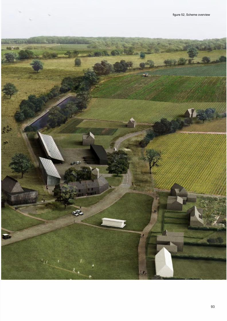
8/9/2019 Thesis+revision+2_220812_lite
http://slidepdf.com/reader/full/thesisrevision2220812lite 91/195
93
gure 52, Scheme overview

8/9/2019 Thesis+revision+2_220812_lite
http://slidepdf.com/reader/full/thesisrevision2220812lite 92/195
94
Wyck Farm
gure 53, The extent of Wyck Farm
gure 54; View across the farmland

8/9/2019 Thesis+revision+2_220812_lite
http://slidepdf.com/reader/full/thesisrevision2220812lite 93/195
95
The existing farm covers approximately 400 hectares, predominantly wheat arable land, with
some pasture. ( g. 60) The farm is currently a livestock operation which raises beef stock for
slaughter. From the top of the hill on which farmstead and village sit, the land fans out to the
south and east, falling away to a gentle gradient. ( g. 58) The land is suitable for a range of
agricultural produce. Historically the land has been used for livestock, cereals and horticul-
ture, at one time a fruit farm. ( g. 55) It has good quality, highly fertile soil, classi ed as slight -
ly acidic clay, although it has some drainage issues. ( g. 59) It is typical of the wider character
of clay and chalk downland in which it sits, with a rolling landscape of large arable elds and
small woods or coppices, some of them ancient woodland. To the north it is bordered by the
small cellular elds of stud farms which become more frequent towards Newmarket. To the
south there is more of the same large scale cereal production on rolling downland.
gure 55; Orchards in Burrough green, 1960

8/9/2019 Thesis+revision+2_220812_lite
http://slidepdf.com/reader/full/thesisrevision2220812lite 94/195
96
gure 56; View of the farmstead, Wyck Farm
gure 57; View of the farmyard, Wyck Farm

8/9/2019 Thesis+revision+2_220812_lite
http://slidepdf.com/reader/full/thesisrevision2220812lite 95/195
97gure 58; Existing topography of the farmland

8/9/2019 Thesis+revision+2_220812_lite
http://slidepdf.com/reader/full/thesisrevision2220812lite 96/195
98
gure 59; Soils on the farm.
Slightly acid loamy and clayey soils with impeded
drainage
Lime-rich loamy and clayey soils with impeded
drainage
Slowly permeable seasonally wet slightly acid but
base-rich loamy and clayey soils
Freely draining lime-rich loamy soils
gure 60; Exis

8/9/2019 Thesis+revision+2_220812_lite
http://slidepdf.com/reader/full/thesisrevision2220812lite 97/195
99
gure 60; Existing land use
Arable wheat production
Temporary pasture
Woodland
and use

8/9/2019 Thesis+revision+2_220812_lite
http://slidepdf.com/reader/full/thesisrevision2220812lite 98/195
100
A new agro-ecological farm atBurrough Green.The current livestock enterprise would be replaced with a mixed agro-ecological farm, which uses
the nutrient cycling between a dairy herd and a rotation of cereals, legumes and eld vegetables to
create a closed loop farming system, with little or no external inputs. Around 80 hectares are converted
to permanent pasture to support a dairy herd of 100 cows. The remaining land remains arable, with
the exact crops grown depending on season and pro tabillity. A secondary horticultural enterprise
of around 20 hectares is also established near the village, producing soft and top fruit such as
rasberries, strawberries and pears as a diversi cation activity. Concurrently the farm enters higher level
stewardship management, securing subsidy for maintaining the landscape for ecology and as a human
environment, whilst delivering green infrastructure in water management and carbon sinks, becoming a
node for the provision of landscape services, supporting neighbouring farms.
Landscape organisiation
To accommodate this new agriculture a recon guration of the farming landscape is proposed which
amalgamates the demands of a productive agriculture with ecology and human inhabitation. In current
agro-environmental schemes and agro-ecological practice, hedgerows and unmanaged wild eld
margins are encouraged to foster ecology. (Natural England, 2009) However this practice reduces
the area of farmed land, whilst re-establishing traditional hedgerows limits the exibility of the farmer
to alter growing practices and eld areas dynamically from year to year. Furthermore, whilst thesemanagements might improve the aesthetic value of the countryside it doesn’t inherently make it more
accesible to the public or encourage human interaction with the landscape.
The thesis proposes a new structure to the landscape based on multifunctional corridors, establishing
a new ordering principal, which provides for ecology and biodiversity, agricultural function, public
access and green infrastructures. ( g. 62) Whilst organising the land at the farm level, the placement
of corridors would also be orchestrated to join up with the wider geographical context, crossing farm
borders and linking pieces of woodland, established footpaths and river courses. ( g. 63) Particularly
suited to the Eastern arable areas where few ancient hegerow boundaries are left, multifunctional
corridors can be threaded through the countryside, adapting to existing eld patterns and geographical
features. The corridors provide access and service spines to the landscape, dividing the land into
exible bands within which the farmer can easily adapt the size of elds and type of crop grown to suit
climatic and economic conditions. Establishing permanent bands of hedgerow, meadow and woodland
along the corridors prevents soil erosion and runoff from the elds, whilst allowing ecosystems to join
up across large areas. Their geometry is driven by research which demonstrates meandering, organic
ecology corridors to be more successful at fostering ecological spread and wildlife distribution. (Holland
& Hastings, 2008) The corridors are formed around a track, which provides public walking and riding

8/9/2019 Thesis+revision+2_220812_lite
http://slidepdf.com/reader/full/thesisrevision2220812lite 99/195
101
gure 61; Proposed landscape plan NTS

8/9/2019 Thesis+revision+2_220812_lite
http://slidepdf.com/reader/full/thesisrevision2220812lite 100/195
102
Landscape Overview
rasberry orchard
pear orchards Strawberries and soffruit
Stands of hazel coppice forbiomass harvesting
Magenn oating wind turbines harness highaltitude wind
root vegetables and legumesgrown in rotation.
tourist camping lodges seasonallyinhabit the corridors.
hedges create wind breaks,protecting crops and pre-venting soil erosion.
wild ower habitatencourages pollinatinginsects.
managed permanentpasture of perennialgrassland, using mob
grazing practices
gure 62; Proposed landscape overview

8/9/2019 Thesis+revision+2_220812_lite
http://slidepdf.com/reader/full/thesisrevision2220812lite 101/195
103
reed bed sewage and waste waterprocessing wetland habitat
swathes of unmanaged land run alongtracks creating ecology corridors
trees in pasture provideshade for cows
reservoirs store water on farm andfeed drip irrigation systems
gure 63; Wider corridor connections

8/9/2019 Thesis+revision+2_220812_lite
http://slidepdf.com/reader/full/thesisrevision2220812lite 102/195
104
routes as well as access for farm machinery and moving cattle. A band of land each side of the track is
removed from agricultural production and provides multiple functions. Drainage ditches run alongside
the track way, draining the clay soil and managing nutrient and fertiliser runoff from the land. With the
likelihood of increasingly unsettled weather patterns through the 21st century, irrigation will become
an increasing aspect of British farming. (Environment Agency, 2010, p5) Long narrow reservoirs along
the corridors are shaded by trees to prevent evaporation. These feed arteries of drip irrigation which
run alongside the track before fanning out into the elds. The corridors might also act as spines for
renewable energy infrastructure such as Magenn turbines. (Magenn, 2012) These high altitude helium
balloons harvest the reliable winds at high level and are less visually intrusive than conventional
turbines. They could provide energy for the farm, whilst feeding energy to the grid. Hedges and trees
along the corridors become habitats but also substanital carbon sinks, along with sustainable stands
of hazel coppice which provide biomass. The unmanaged land along the corridors provides a range of
habitats, from wild grassland to scrub and woodland, allowing species of aura and fauna to uorish.
gure 64; Landscape plan detail NTS

8/9/2019 Thesis+revision+2_220812_lite
http://slidepdf.com/reader/full/thesisrevision2220812lite 103/195
105
HORTICULTURALZONE
FIELD VEGETABLES(ROTATIONAL CROPPING)
WOODLAND
ZERO TILL CEREALS/LEGUMES
gure 65; Mixed farming crop zoning

8/9/2019 Thesis+revision+2_220812_lite
http://slidepdf.com/reader/full/thesisrevision2220812lite 104/195

8/9/2019 Thesis+revision+2_220812_lite
http://slidepdf.com/reader/full/thesisrevision2220812lite 105/195
107
gure 66; Multifunctional corridors

8/9/2019 Thesis+revision+2_220812_lite
http://slidepdf.com/reader/full/thesisrevision2220812lite 106/195

8/9/2019 Thesis+revision+2_220812_lite
http://slidepdf.com/reader/full/thesisrevision2220812lite 107/195
109gure 74; Proposed design of landscape meeting settlement NTS

8/9/2019 Thesis+revision+2_220812_lite
http://slidepdf.com/reader/full/thesisrevision2220812lite 108/195
110
SHOWING IRRIGATION
SHOWING CROP PROPORTIONSSHOWING CONNECTIONS TOFOOTPATHS AND WIDER ECOLOGYROUTES
SHOWING HOW DEALS WITH NEXT VIL-LAGE
II. .DEVELOPING THE VILLAGE;AN AGRICULTURALLYINTEGRATED MASTERPLANFOR BURROUGH GREEN.
As the landscape is recon gured through changing farming practice, the village form and structure is
recon gured to make way for new development which rebalances the community and sustains it for
the future. As well as these new developments the village environment is carefully edited following an
analysis of the village structure.

8/9/2019 Thesis+revision+2_220812_lite
http://slidepdf.com/reader/full/thesisrevision2220812lite 109/195
111gure 75; proposed village overview

8/9/2019 Thesis+revision+2_220812_lite
http://slidepdf.com/reader/full/thesisrevision2220812lite 110/195
112
Primary School
Village Hall
Sheltered Elderly housing
Burrough Green Parish Church
Cricket Clubhouse
Hall Farm Stud
Burrough Green

8/9/2019 Thesis+revision+2_220812_lite
http://slidepdf.com/reader/full/thesisrevision2220812lite 111/195
113
WYCK FARM
The Bull, Village Pub
Wyck Farm farmhouse
gure 76; Existing village overview

8/9/2019 Thesis+revision+2_220812_lite
http://slidepdf.com/reader/full/thesisrevision2220812lite 112/195
114
What does Burrough Green need and want?
Housing
The most signi cant issue for Burrough Green is housing. A recent housing needs survey identi ed
there was currently housing need for eight new affordable homes in Burrough Green. (ACRE, 2009b,
p22) Beyond this immediate requirement however, there is a broader need to rebalance the village’s
variety of tenures and housing stock with Burrough Green having a shortage of smaller homes and
terraced properties. (ACRE, 2011) The housing need survey found demand for subsidised market
housing models. (ACRE, 2009b, p20) This study aims to make a longer term design which provides a
masterplan for how more housing could be provided in the future.
Recreational space.
The existing community hall, whilst well used, is small, costly to run and isn’t designed for modern
community activities, originally a library or reading room. ( g.78) A new sustainable community space
is proposed which could serve Burrough Green and the adjacent villages, given their proximity and
good pedestrian links. It has been an issue with the parish council for some while that with the school
expanded in the village a children’s play area should be provided (Burough Green Parish Council, 2012)
Business Space
Without consultation it is impossible to understand the exact demand for business premises and space,
but the number of small businesses located in the area, alongside a lack of premises in the village
itself supposes there would be some demand for premises in the area. With the wider strategy of
encouraging workplace containment discussed in Part 1 of the thesis, and a walkable relationship to
neighbouring villages, ( g. 77) several small business units and live work units are proposed.
Bearing in mind these considerations and the wider objectives of creating sustainable village
communites, the thesis identi es the major urbanistic issues for the settlement’s structure.

8/9/2019 Thesis+revision+2_220812_lite
http://slidepdf.com/reader/full/thesisrevision2220812lite 113/195
115
LB
TCB
TCB
FB
LB
LB
TCB
LB
R a d i o M a s t
Tank
L B
WrT
Shelter
FootBridge
TCB
FB
FootBridge
S h e
l t e r
TCh e l t e r
s
n r's ri
Sto e
Sto e
Sto e
Sto e
L
r e l
F
gure 77; Pedestrian connections to neighbouring villages
gure 78; The Reading Room, current village hall for Burrough Green

8/9/2019 Thesis+revision+2_220812_lite
http://slidepdf.com/reader/full/thesisrevision2220812lite 114/195
116
gure 79; Study model showing overview of existing village
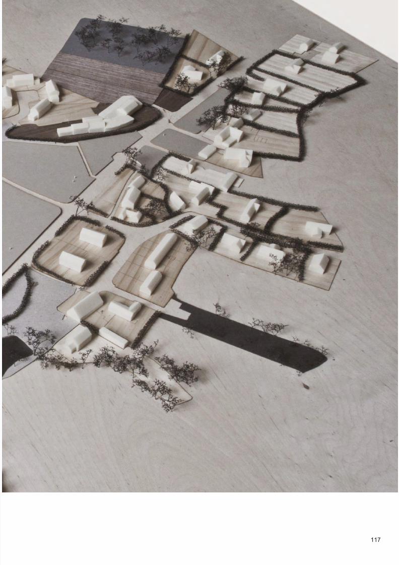
8/9/2019 Thesis+revision+2_220812_lite
http://slidepdf.com/reader/full/thesisrevision2220812lite 115/195
117

8/9/2019 Thesis+revision+2_220812_lite
http://slidepdf.com/reader/full/thesisrevision2220812lite 116/195
118
The lost north greenHaving grown up around the road that runs through its centre, the road has become a major issue for
the village, with heavier modern traf c making it a signi cant intrusion and hazard on the otherwise
peaceful village. The speed limit on the main road is regularly brought up at Parish council meetings.
(Burrough Green Parish Council, 2012) This is a typical condition for such small villages. The reaction
to this issue is naturally defensive as the community turns away from its centre, growing tall hedges and
erecting fences against noise and intrusion. ( g. 80 & 81) However the issue isn’t aided by the poorly
placed development of the 1960s, where council houses were built over what was once a north side
to the green. Historic maps and photos suggest how the green used to provide a buffer zone between
road and settlement. ( g. 83)
The nearby Village of Barrington which has a similar structure has retained its historic form, with the low
hedges and open frontages of the cottages a testament to the success of this separation in relation to
modern traf c. ( g 87 & 88)
gure 80; Hedges built up against road

8/9/2019 Thesis+revision+2_220812_lite
http://slidepdf.com/reader/full/thesisrevision2220812lite 117/195
119gure 81; The lost north green

8/9/2019 Thesis+revision+2_220812_lite
http://slidepdf.com/reader/full/thesisrevision2220812lite 118/195
120
gure 82; Historic map showing building line set well back from the road
gure 83; View across the green in 1910

8/9/2019 Thesis+revision+2_220812_lite
http://slidepdf.com/reader/full/thesisrevision2220812lite 119/195
121
gures 84 & 85; Poorly placed 20th century development destroys the historic set back of the building line to the road

8/9/2019 Thesis+revision+2_220812_lite
http://slidepdf.com/reader/full/thesisrevision2220812lite 120/195
122
gure 86; Boundary conditions along the road show even a slight set back
encourages people to keep hedges lower.

8/9/2019 Thesis+revision+2_220812_lite
http://slidepdf.com/reader/full/thesisrevision2220812lite 121/195
123
gure 87 & 88; Nearby Barrington in South West Cambridgeshire has a very similar structure to Burrough Green but the original line of
the green has been retained, with green space either side of the road. The pleasant frontages of the cottages and the low hedges testify
to its sucess

8/9/2019 Thesis+revision+2_220812_lite
http://slidepdf.com/reader/full/thesisrevision2220812lite 122/195
124
The Leaky Green
Another issue for the village again typical for rural settlements is the loss of terraced forms andhigher density pieces of built environment. Although typically low density and detached, these
places historically had very dense moments of more urban grain. ( g. 91) Their disappearance
partly explains the issues of housing affordability which plague these places. With a move to large
gardens and larger detached bungalow homes, today there is a lack of the different house types
such as ats and terraced houses which are cheaper, smaller and more suitable to younger and
older people. Burrough Green has signi cantly less of these housing forms than other areas.
(ACRE, 2011) Urbanistically, the green is currently ill de ned, with sporadic detached houses set
in hedged gardens doing little to hold the space. ( g. 88, 89 & 90) In developing the design a key
strategy has been to prioritize a reintroduction of denser forms to rede ne the green.
gure 88 & 89; Panoramas of the green show how the settlement fails to ‘hold’ the space.

8/9/2019 Thesis+revision+2_220812_lite
http://slidepdf.com/reader/full/thesisrevision2220812lite 123/195
125
LB
Tank
ri
ri
S h e l t e r
gure 90; gure ground shows the ill-de ned edge of the green

8/9/2019 Thesis+revision+2_220812_lite
http://slidepdf.com/reader/full/thesisrevision2220812lite 124/195
126

8/9/2019 Thesis+revision+2_220812_lite
http://slidepdf.com/reader/full/thesisrevision2220812lite 125/195
127
gure 91; Location and images of lost terrace forms within the village

8/9/2019 Thesis+revision+2_220812_lite
http://slidepdf.com/reader/full/thesisrevision2220812lite 126/195
128
A recon guration of the village
Bearing in mind the broad needs of the settlement and problems with its existing structure,
this chapter demonstrates how the requirements for new development could be integrated
as part of a holistic vision for the settlement, exploring issues of housing, recreation space
and village environment.
farmstead provides community hallspace, shop, cafe and hosted servicesupport
8 new market houses
4 affordable houses and 6 intermediate housesare built on the farm’s land
land brought by communityas play area
allotments forresidents of newhousing on oldsewage works
road markings, pavements and signageremoved as part of shared surfacestrategy

8/9/2019 Thesis+revision+2_220812_lite
http://slidepdf.com/reader/full/thesisrevision2220812lite 127/195
129
A reed bed managed by the farmstead and on thefarm’s land processes waste from farm and villagesewage
cattle grids and gates give psychological impetus fordriers to slow down, marking formal start of settlement
wasteland brought by communityto make allotments for residents
affordable houses built on existing plotof cricket pavilion
new sheltered elderly housing development replacesexisting with 50% more capacity and improvedcommunal facilities
new lightweight pavilion provides changingfacilities for village sports
parking and charging point for electriccarshare scheme
on-farm anaerobic digestion plant processes organicwaste from the village and surrounding villages, aswell as farm waste
gure 92; overview of village masterplan

8/9/2019 Thesis+revision+2_220812_lite
http://slidepdf.com/reader/full/thesisrevision2220812lite 128/195
130
The main move driving the recon guration of the village is a rede nition of the north side of the green,
with the new development completing and reinforcing the historic set-back building line. The farmstead
is brought into the settlement, with new buildings completing the north east corner of the village’s
encirclement of the green. ( g. 93) Setting back the buildings from the road and creating a buffering green
space gives the new buildings respite from the highway. This works in tandem with a new treatment of
road surface and traf c calming to reduce the dominance and disruption of the road within the village.
Firstly cattle grids and gateposts de ne the end of the main road and the start of the residential area,
which is marked as a twenty zone. Within the village, the road becomes a shared surface, with a change
of surface material, and with no road markings or pavements, slowing drivers speed and increasing
awareness. Cars can park on the wider areas of road, giving easy access to the farm centre and activities
on the green, and creating further obstacles to slow traf c. New housing reintroduces denser pieces of
terraced form into the grain of the village, with two terraces, one of affordable and one of market housing
facing directly onto the green and further de ning the space. ( g. 94) Locals only affordable housing is
positioned right in the centre of the village, putting the nancially less well off, or younger less established
residents at the heart of the community rather than the peripheries. As this housing displaces the existing
pavilion, a new lightweight pavilion is proposed to sit in the centre of the green, which can be removed
out of season or for events. A third terrace of housing is proposed on green eld farmland adjacent to the
old sewage works site, along the beginning of one of the landscape corridors. This mix of affordable and
intermediate housing overlooks a new community space, with a children’s play area, and allotments on the
old sewage works. If the land could be obtained, further allotments are proposed for land in the south east
corner of the village, which was historically village allotments. To the east of the village the land alongside
the road is converted into a new sustainable sewage works, with reed beds to treat runoff. This is run by
the farm business which uses it to process waste water from anaerobic digestion and dairy operations.
The farm hub, live work units and business units of the farmstead form a new corner to the green, with
activity from the farm and cafe spilling onto the green itself. With a new community hall within the farm
hub, the existing reading room building could be converted to a community homeworking centre, allowing
commuters to larger rms in Cambridge to remote work several days a week.
A masterplan for Burrough Green

8/9/2019 Thesis+revision+2_220812_lite
http://slidepdf.com/reader/full/thesisrevision2220812lite 129/195
131
gure 94; New forms in the village and their relationship to the re-established setback settlement line
gure 93; view of village with new development
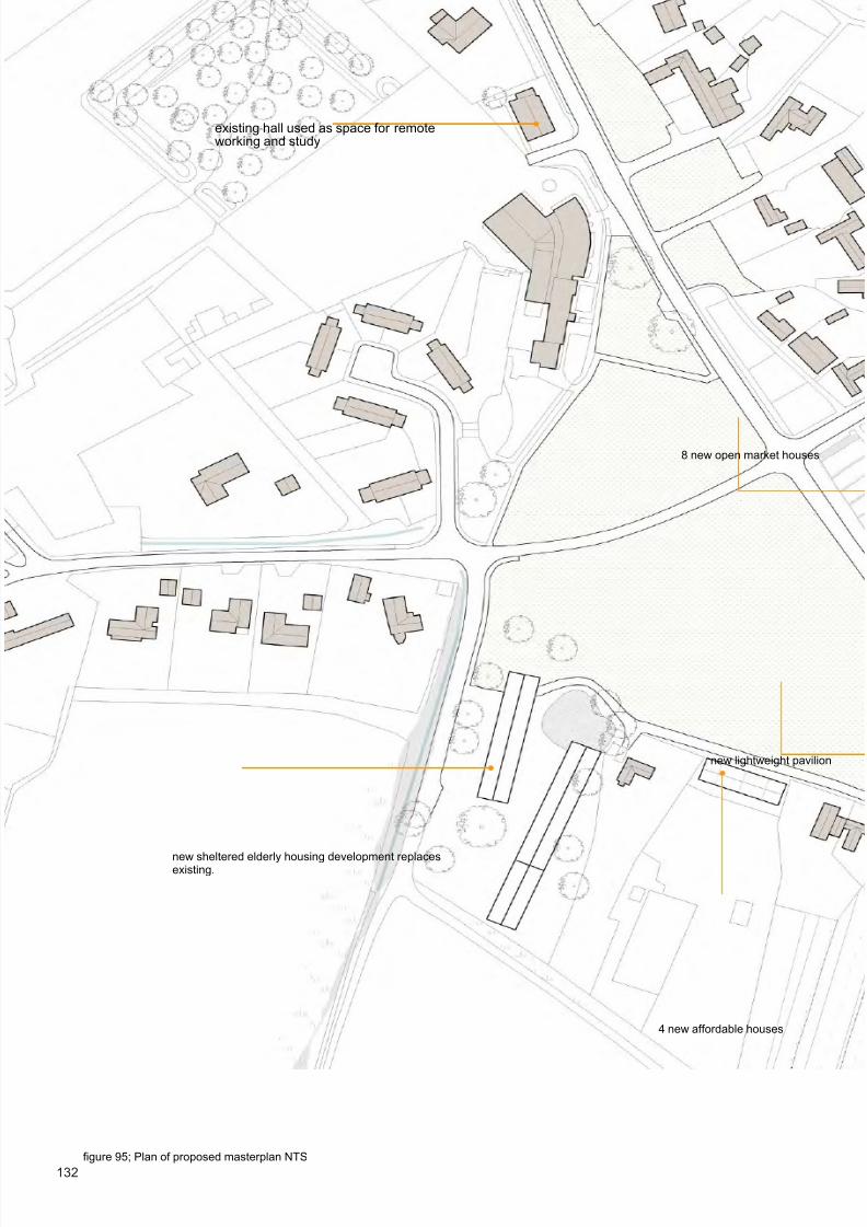
8/9/2019 Thesis+revision+2_220812_lite
http://slidepdf.com/reader/full/thesisrevision2220812lite 130/195
132
new sheltered elderly housing development replacesexisting.
new lightweight pavilion
existing hall used as space for remoteworking and study
8 new open market houses
4 new affordable houses
gure 95; Plan of proposed masterplan NTS
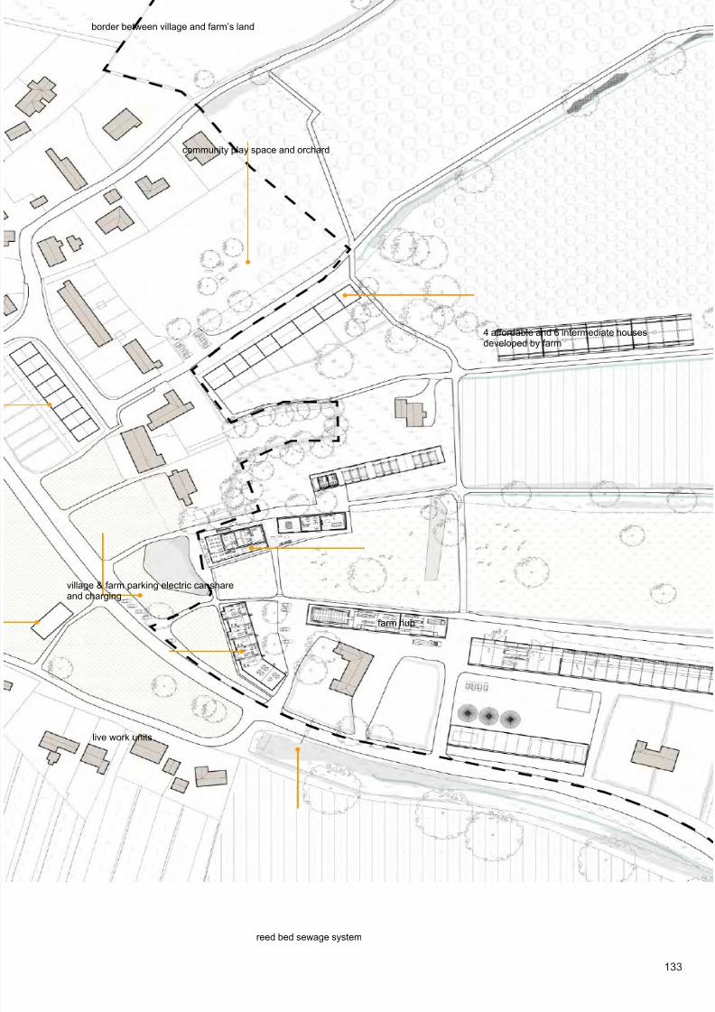
8/9/2019 Thesis+revision+2_220812_lite
http://slidepdf.com/reader/full/thesisrevision2220812lite 131/195
133
reed bed sewage system
community play space and orchard
4 affordable and 6 intermediate housesdeveloped by farm
village & farm parking electric car shareand charging
border between village and farm’s land
farm hub
live work units

8/9/2019 Thesis+revision+2_220812_lite
http://slidepdf.com/reader/full/thesisrevision2220812lite 132/195
134
Housing Development
PHASE 1 - Affordable housing
PHASE 2 - Affordable & intermediate housing
PHASE 3 - Market housing
PHASE 4 - Sheltered housing for the elderly
Dealing with the initial needs of the village, 4 affordable houses are proposed on the site of the existing cricket pavilion.
( g.96) A compact terrace of 1 x 1 bedroom 2 x 2 bedroom and 1x 3 bedroom cottages are built, and a new lightweight
pavilion is erected on the green itself. As the land on which the housing is built already belongs to the council, it can
quickly be enabled, either through the local housing association, or perhaps through a community land trust, where the
community nance and build the houses themselves. In either case the houses would be affordable rental properties, kept
in perpetuity for local people, with rents xed below market rates.
Built on Wyck farm’s land a terrace of 4 affordable houses and 6 intermediate houses meet the affordable requirement found in
the Housing Need Survey, (ACRE, 2009b, p22) but also provide intermediate housing as a means to bridge the gap between
subsidised rental properties and the expensive open market housing in the village. Intermediate houses are like market houses
and can be brought and sold freehold, but they have a planning covenant on them which xes their price at a set amount below
market value, for example 70-80%. (Taylor, 2008, p111) As the farm owns the land, which outside of such an agreement has little
value, there is potentially substantial nancial incentive for the farm developing the land, even with the reduced market rate. The
farm could either develop the housing itself to sell in collaboration with developers and housing associations, or it could just sell
the land with the planning permission. using associations, or sell the land with the permission for a substantiallygreater value. This capital could be used to enable the development of the farmstead itself.
With an ageing population nationally and particularly in rural areas. Elderly housing for rural communities is a key issue.
It is proposed that in negotiation with the current affordable housing provider Sanctuary Hareward, the current buildings
would be replaced with a larger scheme with a 50% larger capacity. The current sheltered housing dates from the 1960’s
and is of poor quality design and construction. As demand in the future increases and the buildings come to the end of
their life, a more engaging scheme is proposed which addresses the pond and green, and acts as a gateway to a green
corridor which runs from the green through the development and out along the footpath to neighbouring Brinkley.
Although it is not desirable for the village to grow substantially, permitting some market development in carefully planned
ways could improve the village structure and encourage redevelopment of substandard and insensitive buildings.
Furthermore it could broaden the types and tenures of housing on the market, such as providing more small terraced
starter homes and ats. If demolished the four ex-council houses at the centre of the green could provide a terrace of eight
to ten new homes, restoring the historic line of development to the north of the green. Whilst the land is currently in private
and separate ownerships, by speculatively including such a proposition within the long term plan there is incentive for
developers to try and acquire the land.

8/9/2019 Thesis+revision+2_220812_lite
http://slidepdf.com/reader/full/thesisrevision2220812lite 133/195
135
gure 96; Position of initial housing development on green
gure 97; housing development

8/9/2019 Thesis+revision+2_220812_lite
http://slidepdf.com/reader/full/thesisrevision2220812lite 134/195
136
model photos
gures 98 - 101; Study model images of proposal for village

8/9/2019 Thesis+revision+2_220812_lite
http://slidepdf.com/reader/full/thesisrevision2220812lite 135/195
137

8/9/2019 Thesis+revision+2_220812_lite
http://slidepdf.com/reader/full/thesisrevision2220812lite 136/195
138
III. THE MULTIFUNCTIONALFARMSTEAD;
A gateway to the landscape
Within the wider plan for the village, the farmstead plays an integral role in the sustainable future of Burrough
Green. It creates a valve between the village and farmland, assimilating the grain of the landscape and the
fabric of the village. The buildings of the farmstead provide multiple functions, supporting the farm business,
providing a base for agricultural activity, managing the farm and hosting diversi ed activities such as tourism,
care farming and on-farm food processing. Beyond this it ful ls a wider social role, providing community
functions, services and premises for economic development. This chapter explains the organisation of the
farmstead and how the design mediates between village and landscape

8/9/2019 Thesis+revision+2_220812_lite
http://slidepdf.com/reader/full/thesisrevision2220812lite 137/195
139gure 102; Farmstead overview in context

8/9/2019 Thesis+revision+2_220812_lite
http://slidepdf.com/reader/full/thesisrevision2220812lite 138/195
140
Architectural language and the farmstead.
In designing the farmstead the issue of rural architectural language and form is closely examined. To realisethe proposal made in this thesis, design and aesthetic becomes a crucial component, as conservative
attitudes and the great value given to the historic environment often result in opposition to development
and change. (Taylor, 2008, 88-89) Engaging with this issue, the design of the farmstead has tried to nd
an architecture which resonates with the values of the commodi ed countryside, whilst avoiding pastiche.
Careful massing and consideration of scale in the form and placement of buildings and their relation to the
historic fabric drive the planning of the scheme. In the articulation and materiality of the buildings, a irtation
with nostalgic forms and vernacular materials determines an architectural treatment which aims to satisfy the
tastes of rural society whilst making buildings which are contemporary, pragmatic and spatially innovative.
In such a strategy the architecture hopes to sidestep theoretical discourses surrounding regionalism with
an irreverent approach, which treats the vernacular as an eclectic source of inspiration and reference. In
this aim the architecture draws in uence form Tonobu fujimori’s rustic Japanese buildings which playfully
appropriate and exaggerate historic forms and the early Swiss works of Peter Zumthor, which demonstrate a
pared down vernacular-modern tradition of simple and elegant buildings.
gure 105; Thatched roof; Cosy Cottage, Burrough Green, 1929

8/9/2019 Thesis+revision+2_220812_lite
http://slidepdf.com/reader/full/thesisrevision2220812lite 139/195
141
https://www.japlusu.com
gure 103; House near Chur, Peter Zumthor
gure 104; Private House, Teronobu Fujimori, Japan

8/9/2019 Thesis+revision+2_220812_lite
http://slidepdf.com/reader/full/thesisrevision2220812lite 140/195
142
business cluster naerobic digestor plant
dairy processing and cheesemakingbuildingfarm workersaccommodationor b&baccommodation
farm centremachinery & storage barn
Overview
The buildings of the farmstead are organised along the radial landscape corridors which fan out from the
south east of the green. ( g.107) This organisation serves all the buildings with pedestrian and vehicular
access, but also ensures permeability between settlement and landscape. As the more public andmultifunctional buildings, the farm centre and business cluster are pulled into the village, completing the
settlement’s encirclement of the green. The positioning of the farmstead on the corner of the green puts it in
conversation with the other public nodes of the village; the school, pub and elderly housing centre, integrating
it as a key institution of the settlement. ( g. 106) The larger agricultural buildings are positioned further out
from the village, with a notion of functionally and guratively moving produce inwards from the landscape,
from milking and drying, to storage and processing, to packaging and selling as the farmstead meets
settlement. ( g. 108)

8/9/2019 Thesis+revision+2_220812_lite
http://slidepdf.com/reader/full/thesisrevision2220812lite 141/195
143
passive grain dryersvegetable and grain storage barndairy & cowhouse
PUB
SCHOOL
FARMSTEAD
ELDERLY SHELTERED HOUSING
gure 107; Massing of buildings along landscapecorridors
gure 106; Farmstead as node around green
gure 108; Farmstead layout and overview
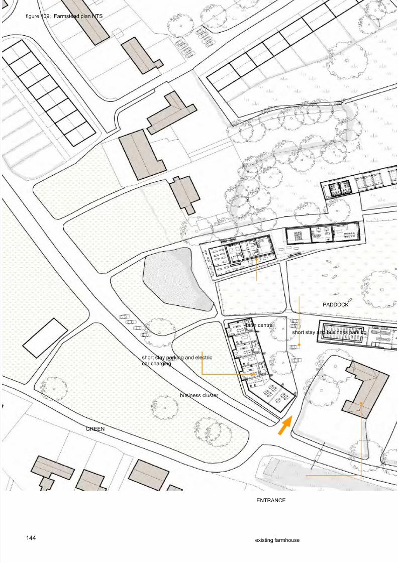
8/9/2019 Thesis+revision+2_220812_lite
http://slidepdf.com/reader/full/thesisrevision2220812lite 142/195
144
III. general overview and diagrams
farm centre
business cluster
existing farmhouse
short stay parking and electriccar charging
short stay and business parking
ENTRANCE
PADDOCK
gure 109; Farmstead plan NTS
GREEN

8/9/2019 Thesis+revision+2_220812_lite
http://slidepdf.com/reader/full/thesisrevision2220812lite 143/195
145
production building
cow house & milking parlour
machinery and storage barn
anaerobic digestor
staff and over ow parking
GOODS ENTRANCE
grain & vegetable store

8/9/2019 Thesis+revision+2_220812_lite
http://slidepdf.com/reader/full/thesisrevision2220812lite 144/195
146
A valve to the landscape
Approaching the farmstead from the village green the farm centre and business cluster form a gateway to thelandscape, de ning the wedge of pasture which sweeps out into the farmland.
gure 110; Aspect of farmstead from village green.

8/9/2019 Thesis+revision+2_220812_lite
http://slidepdf.com/reader/full/thesisrevision2220812lite 145/195
147

8/9/2019 Thesis+revision+2_220812_lite
http://slidepdf.com/reader/full/thesisrevision2220812lite 146/195
148
A valve to the village
gure 111; Aspect of village from farmstead

8/9/2019 Thesis+revision+2_220812_lite
http://slidepdf.com/reader/full/thesisrevision2220812lite 147/195
149

8/9/2019 Thesis+revision+2_220812_lite
http://slidepdf.com/reader/full/thesisrevision2220812lite 148/195
150
IV. THE FARM CENTRE,DIVERSIFICATION AND
COMMUNITY SERVICES
The farm centre is the core of multifunctional activity within the farmstead, a loose- t series of spaces
which can accommodate everything from the everyday running of the farm, to the farm’s diversi cation
and tourism activities, to community events and community services.

8/9/2019 Thesis+revision+2_220812_lite
http://slidepdf.com/reader/full/thesisrevision2220812lite 149/195
151gure 112; Farmstead overview in context
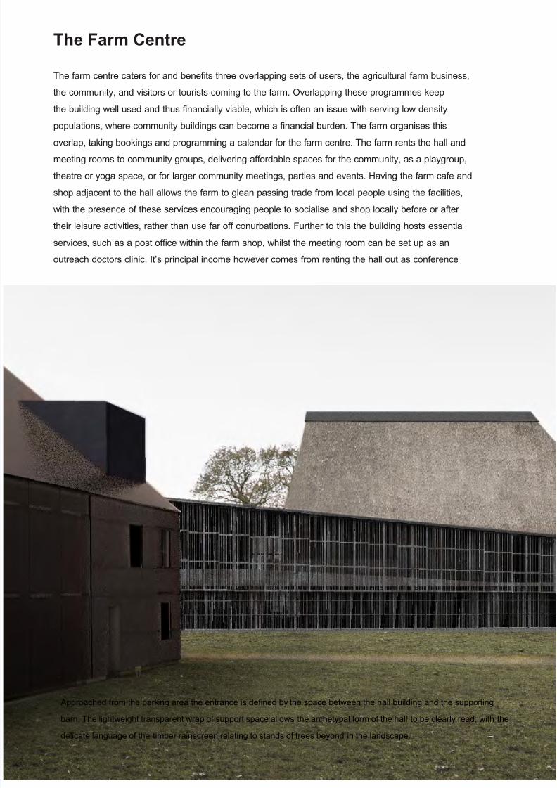
8/9/2019 Thesis+revision+2_220812_lite
http://slidepdf.com/reader/full/thesisrevision2220812lite 150/195
152
Approached from the parking area the entrance is de ned by the space between the hall building and the supporting
barn. The lightweight transparent wrap of support space allows the archetypal form of the hall to be clearly read, with the
delicate language of the timber rainscreen relating to stands of trees beyond in the landscape.
The Farm Centre
The farm centre caters for and bene ts three overlapping sets of users, the agricultural farm business,
the community, and visitors or tourists coming to the farm. Overlapping these programmes keep
the building well used and thus nancially viable, which is often an issue with serving low density
populations, where community buildings can become a nancial burden. The farm organises this
overlap, taking bookings and programming a calendar for the farm centre. The farm rents the hall and
meeting rooms to community groups, delivering affordable spaces for the community, as a playgroup,
theatre or yoga space, or for larger community meetings, parties and events. Having the farm cafe and
shop adjacent to the hall allows the farm to glean passing trade from local people using the facilities,
with the presence of these services encouraging people to socialise and shop locally before or after
their leisure activities, rather than use far off conurbations. Further to this the building hosts essential
services, such as a post of ce within the farm shop, whilst the meeting room can be set up as an
outreach doctors clinic. It’s principal income however comes from renting the hall out as conference

8/9/2019 Thesis+revision+2_220812_lite
http://slidepdf.com/reader/full/thesisrevision2220812lite 151/195
153
or events space, making it viable and subsidising its community use. It might for example be used
for business conferences, walking or outdoor activity groups, weddings or academic retreats from
Cambridge. The possibility of accommodation and catering on the farm as well as the attractions of the
landscape would make it an appealing destination.
Alongside this the farm runs a care farming programme which would use the facilities of the centre
for orientation and brie ngs. Care farming is a growing phenomenon where disadvantaged groups
or those with disabilities are brought to farms to engage with basic farming activities such as habitat
maintenance or fruit picking, and is an increasingly common form of farm diversi cation. (Care farming
UK, 2012) With recent research evidencing the signi cant health bene ts of green exercise and green
environments, the building serves as a node for landscape activity, bringing people from further a eld
out to engage with the countryside.
gure 113; Approaching the farm centre

8/9/2019 Thesis+revision+2_220812_lite
http://slidepdf.com/reader/full/thesisrevision2220812lite 152/195
154
The buiding is composed of four elements. This articulation addresses the issue of massing a larger
building with a loose t and freely planned relationship of spaces in a sensitive rural context. Borrowing
from the agglomerative language of vernacular farmsteads the form of the building breaks down the
scale and depth of oor plan whilst maintaining programmatic adjacency and exibility. Firstly the hall,
which takes a vernacular barn like pitched form, is raised up to the rst oor to look over the green, a
gestural archetypal village hall. The plinth on which the hall sits contains service spaces such as toilets,
changing and kitchen facilities. The hall is then wrapped in a lightweight lean-to of supporting spaces,
which accommodates a shop and cafe on the ground oor, breakout space, kitchen/bar and stage/
meeting room on the upper oor.
The main hall
supporting barn
accommodationblock
lean-to
meeting room/stage hall space
activity space farm of ce
gure 114; Massing & articulation
gure 116; Long section A- A’ NTS

8/9/2019 Thesis+revision+2_220812_lite
http://slidepdf.com/reader/full/thesisrevision2220812lite 153/195
155
Kitchen diner for seasonal workers Accommodation units
gure 115; Perspective section B - B’ NTS

8/9/2019 Thesis+revision+2_220812_lite
http://slidepdf.com/reader/full/thesisrevision2220812lite 154/195
156
Section B-B’
Section B-B’
FIRST FLOOR PLAN
GROUND FLOOR PLAN

8/9/2019 Thesis+revision+2_220812_lite
http://slidepdf.com/reader/full/thesisrevision2220812lite 155/195
157
Section A-A’
Section A-A
gures 117, 118; Farm centre plans, NTS

8/9/2019 Thesis+revision+2_220812_lite
http://slidepdf.com/reader/full/thesisrevision2220812lite 156/195
158
gure 121; A deep covered space allows the activities of the farm centre to inhabit the outdoors, with vegetable stalls spilling out of theshop, or orientation brie ngs for care farming.
The supporting barn sits slightly apart from the hall, with the lean-to element forming a covered walkway
between the buildings.This building contains a secondary multifunctional space for meetings, activities
and hosted services. The central bays of the building contains the farm of ce for everyday running ofthe farm, whilst the east end of the barn contains a large kitchen dining and living area for seasonal
farm workers in season and tourists at other times of year, who sleep in the adjacent accommodation
block. The long overhanging porch of the supporting barn makes an exterior space for outdoor
activities, events and orientations.
gure 119; Elevational render

8/9/2019 Thesis+revision+2_220812_lite
http://slidepdf.com/reader/full/thesisrevision2220812lite 157/195
159
Figure 122; The space between the two buildings de nes a small courtyard which acts as a lobby to the various spaces of thefarm centre.
gure 120; sketch model explores oating hall concept
Figure 123; Faceted contemporary thatching give the hall a playfulvernacular expression

8/9/2019 Thesis+revision+2_220812_lite
http://slidepdf.com/reader/full/thesisrevision2220812lite 158/195
160
On entering this courtyard, to the right large double doors open into a multi-purpose space, which the
farm could use for care farming orientation and seminars, or where the community might run a youth
club, or outreach clinics. ( g. 125) To the left the shop and cafe stretch along the side of the hall.
( g. 124) An external circulation between the glass facade and the rain screen widens at the front of the
building to provide shaded outdoor seating overlooking the green. The cafe has a larger separate dining
room which can be shut down in winter when there is less activity, divided off for functions or as a dining
room for farm workers. ( g. 126)
Figure 124; View of the shop & cafe

8/9/2019 Thesis+revision+2_220812_lite
http://slidepdf.com/reader/full/thesisrevision2220812lite 159/195
161
Figure 125; The activity room hosts an outreach clinic
Figure 126; Hall plan detail, NTSexpandable secondary dining space
ENTRANCE

8/9/2019 Thesis+revision+2_220812_lite
http://slidepdf.com/reader/full/thesisrevision2220812lite 160/195
162
Entering the hall itself, doors open into the lower level where a foyer opens onto changing spaces and
toilets. ( g. 126) From the foyer a stair dog legs up into the hall. A playful appropriation of the vernacular
half hipped roof form illuminates the space with a large asymetrical north facing roof-light. ( g. 127)
Open at one end, the hall has a panoramic view out over the green across the stage. Sliding timber
screens divide the hall itself from the meeting room and kitchen, allowing for numerous con gurations.
( g. 128)
sliding partitions
Figure 126; Section of hall
Figure 127; View of hall

8/9/2019 Thesis+revision+2_220812_lite
http://slidepdf.com/reader/full/thesisrevision2220812lite 161/195
163
Separate spaces
The hall is divided into three separate
spaces with sliding acoustic insulating partitions
between. This allows for simultaneous activities,
such as a playgroup in the stage/meeting room whilst
a coffee morning for parents is held in the main hall.
Alternatively some spaces can be shut down completely,
saving heating the whole building when only lightly used,
for example for a parish coucil meeting.
performance
For lectures, performances or conferences the hall
recon gures as a small auditorium, with a curtain
de ning a runaround and making a small back of house
area. The kitchen area forms a foyer space and bar for
refreshments and drinks.
open plan
For activites and events the hall can be opened up as an
open plan series of spaces.
Figure 128; Different con gurations of the hall

8/9/2019 Thesis+revision+2_220812_lite
http://slidepdf.com/reader/full/thesisrevision2220812lite 162/195
164
The accommodation block provides on farm accommodation for seasonal farm workers. Fruit pickingand harvesting eld vegetable crops is labour intensive and requires extra workers to be brought in for
several weeks at a time. Portable accommodation pods slot into an open fronted timber framed building,
providing a simple room with a small stove. A permanent laundry, shower and W.C block is provided at
one end of the building. Opposite the shower block there is a communal kitchen and dining area within
the farm centre. Out of season the accommodation can be run as bed and breakfast stays and can be
moved by tractor to other parts of the farm, inhabiting the landscape as tourist camping lodges.
( g. 129)
Figure 128; Plan of accommodation block and communal areas
Figure 130; The accommodation block

8/9/2019 Thesis+revision+2_220812_lite
http://slidepdf.com/reader/full/thesisrevision2220812lite 163/195
165
Figure 129; Accomodation pod demounted in landscape

8/9/2019 Thesis+revision+2_220812_lite
http://slidepdf.com/reader/full/thesisrevision2220812lite 164/195

8/9/2019 Thesis+revision+2_220812_lite
http://slidepdf.com/reader/full/thesisrevision2220812lite 165/195
167Figure 131; Business cluster overview in context

8/9/2019 Thesis+revision+2_220812_lite
http://slidepdf.com/reader/full/thesisrevision2220812lite 166/195
168
Cottage Industry.
Three live work cottages suggest a new mode of rural living, where small ICT based, land based and
rural service businesses can be run from rural residential premises. The units proposed are generous
three bedroom family houses with a exible split level work space, which would accommodate several
employees alongside its residents. The elevation to the green takes on a domestic language, with an
entrance and porch directly to the kitchen. The rear elevation faces onto the farmyard, with shop fronts,
parking and access for delivery. A shared stair core and W.C saves on circulation and ties the function
of living and working together, discouraging the partition or separate rental of the workshop space,
ensuring the cottage remains in a genuine live work use. However there is potential to adapt how the
space is shared between residential and business functions, with options to expand and contract as
businesses grow and shrink, or to accommodate very different types of business. ( g. 135) Developed
by the farmstead, the cottages would provide a rental income for the farm, whilst providing rural
entrepreneurs an affordable means to start a business.
A higher ceiling height for machinery and ducting in the workshop creates a stepped section betweenthe house and workshop, with the mezzanine workshop level accessed off the intermediate landing of
the stair. The ground oor of the house has a kitchen, utility and W.C. Above on the rst oor, a large
living room faces south across the green, with a small bedroom to the rear. Two further bedrooms
and a bathroom inhabit the roof space, with a large top lit dormer making headroom for the bathroom.
The exterior is wrapped in a corten mesh rain-screen which disguises the large openings in the roof,
maintaining the integrity of the vernacular pitched roof form, and shading the roof-lights. To the rear
large polycarbonate facades allow light to spill into the workshop, with rain-screen mesh shutters folding
across for security. Adjoining the cottages there is a further business unit and larger of ce space, whichprovides spaces for a larger local business to expand, or space for one of the live work enterprises to
grow.
Whilst a small economic intervention in urban terms, with perhaps ten people employed in the cluster,
if such a strategy of small farmstead based live work and business clusters was spread through the
villages, it could signi cantly increase workplace containment and thus reduce the transport emissions
of rural populations, whilst the bene ts of increasing day time population of the village, with support to
services and a more dynamic environment would be signi cant.
Figure 132; Business cluster rear elevation and shop fronts

8/9/2019 Thesis+revision+2_220812_lite
http://slidepdf.com/reader/full/thesisrevision2220812lite 167/195
169
family kitchen diner
living room
bedrooms in roof
of ce on mezzanine
carpentry workshop
A central circulation core servesboth residential and businesslevels
Figure 133; Split level circulation
Figure 134; Interior layout

8/9/2019 Thesis+revision+2_220812_lite
http://slidepdf.com/reader/full/thesisrevision2220812lite 168/195
170
Small business
Workshop/of ce on ground oor, of ce above.Carpenter, bakery, small shop etc. Employing several peoplewith accounts and of ce above.
Sole practitioner
To suit sole practitioner or couple, accountant, editor etc.Ground oor becomes sitting room, mezzanine of ce above
Large family with workshop
Workshop on ground oor, mezzanine converted to master bedroomsuits small machine shop, mechanic etc.
Figure 135; Adaptability and recon guration
Figure 136; The elevation to the green is more domestic

8/9/2019 Thesis+revision+2_220812_lite
http://slidepdf.com/reader/full/thesisrevision2220812lite 169/195
171
w a s h e r/ d r y e r
FIRST FLOOR NTS SECOND FLOOR NTS
GROUND FLOOR NTS
Figure 137; Plans of the business centre NTS

8/9/2019 Thesis+revision+2_220812_lite
http://slidepdf.com/reader/full/thesisrevision2220812lite 170/195
172
VI. ADDING VALUE; ON FARMFOOD PROCESSING
The production building demonstrates how a farm business can diversify into food processing and
packaging on farm, adding value and pro t to the outputs of the farm.

8/9/2019 Thesis+revision+2_220812_lite
http://slidepdf.com/reader/full/thesisrevision2220812lite 171/195
173Figure 138; Production building overview in context

8/9/2019 Thesis+revision+2_220812_lite
http://slidepdf.com/reader/full/thesisrevision2220812lite 172/195
174
Adding Value
The production building creates an adaptable space for diversi ed activities on the farm. Small scale
diversi cation enterprises supplement the income of the farm and turn unpro table outputs such as farm
gate milk into higher value items, whilst also generating rural employment. (DEFRA 2007b, p3) This
scheme proposes a cheesemaking enterprise and a farm box packing and delivery scheme, both of
which are established diversi cation activities. The cheesemaking enterprise produces artisan cheeses
made and matured on farm from the milk the dairy produces, which buys in milk from other local farms
when needed. The cheeses can be sold locally in the farm shop or further a eld in Cambridge or
Newmarket, reinforcing local networks and connections.
Description
A simple portal frame in small diameter timber built off a clay block wall forms a basic structural and
weather-tight envelope which can then be inhabited in a number of ways and remain readily adaptable
to future needs. A rain-screen of glass pantiles forms a large north facing facade which brightly
Figure 139; Production building, interior of cheesemaking space

8/9/2019 Thesis+revision+2_220812_lite
http://slidepdf.com/reader/full/thesisrevision2220812lite 173/195
175
cheese maturation ‘cheese cave’
cheese making space
farm box packing andwashing
illuminates the oors, creating a functional working environment and allowing visitors to the farm centre
and the farm to see and sense activity. The eastern ve bays of the shed remain an uninsulated shell,
creating a packing and washing space for running a vegetables farm box scheme, with a loading bay
for deliveries. The central ve bays are internally insulated and tted out to make a large conditioned
space for cheesemaking processing and machinery. A double glazed curtain wall set back from the
facade leaves a semi external circulation zone. The four westernmost bays are uninsuated, with a
passive cheese maturing room or cheesecave built freestanding within the building. Gabion walls give
thermal inertia and stability, whilst a bath of cool water at the base of the wall humidi es air as it is
brought in to the space. ( g. 140)
Figure 140; Production building schematic overview

8/9/2019 Thesis+revision+2_220812_lite
http://slidepdf.com/reader/full/thesisrevision2220812lite 174/195
176
cheese maturation ‘cheese cave’
cargo lift
cheese maturation ‘cheese cave’
cheese packaging area
FIRST FLOOR PLAN
GROUND FLOOR PLAN

8/9/2019 Thesis+revision+2_220812_lite
http://slidepdf.com/reader/full/thesisrevision2220812lite 175/195
177
cargo lift
delivery site of ce
vegetable washing
top swing doors
vegetable washing
milk storage tank and pasteuriser
further farm box packing and administration space
Figure 141; Production building plans NTS
section A - A’
section A - A’

8/9/2019 Thesis+revision+2_220812_lite
http://slidepdf.com/reader/full/thesisrevision2220812lite 176/195
178
unheated circulation space
service and storage zone conditioned production space
Formally the building aims to reveal the process of food production and the symbolic ow of produce
from the eld to the village. The transparent facade allows visitors to the farm and those moving
through the landscape to read the activity of the processes inside. However the introduction of typical
transparent facade treatments such as curtain walling to the rural context is inappropriate at this scale.Borrowing from the vernacular, a unitised rain-screen of glass pantiles disrupts the homogeneity of the
glass facade and add an impression of tactility and nostalgia for vernacular form.
glass pantilerainscreen facade
double glazed curtain walling
Figure 142; Production building section NTS

8/9/2019 Thesis+revision+2_220812_lite
http://slidepdf.com/reader/full/thesisrevision2220812lite 177/195
179
Figure 144; Glass pantilesFigure 143; Pantiles on an outbuilding roof, Burrough Green 1965
Figure 145; View of facade

8/9/2019 Thesis+revision+2_220812_lite
http://slidepdf.com/reader/full/thesisrevision2220812lite 178/195
180
VII. LOW ENERGY FARMING; PASSIVEBUILDINGS FOR PRODUCTION ANDSTORAGE

8/9/2019 Thesis+revision+2_220812_lite
http://slidepdf.com/reader/full/thesisrevision2220812lite 179/195
181Figure 146; Overview in context of passive farm buildings
A summary of the pilot study to this thesis, these design explorations add a further facet to our understanding
of the multifunctional farmstead, as we touch on how the agricultural buildings of the farmstead might work in a
sustainable intensive agriculture.
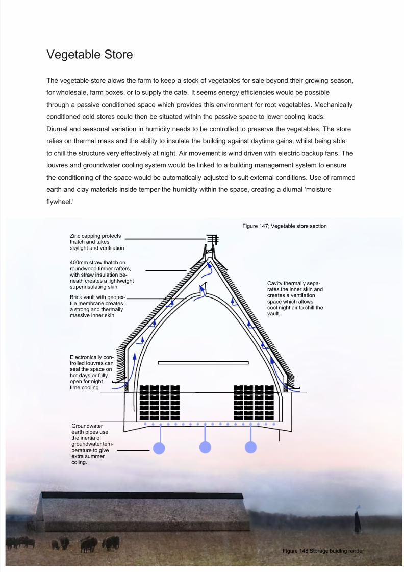
8/9/2019 Thesis+revision+2_220812_lite
http://slidepdf.com/reader/full/thesisrevision2220812lite 180/195
182
Figure 147; Vegetable store section
Figure 148 Storage buidlng render
Vegetable Store
The vegetable store alows the farm to keep a stock of vegetables for sale beyond their growing season,
for wholesale, farm boxes, or to supply the cafe. It seems energy ef ciencies would be possible
through a passive conditioned space which provides this environment for root vegetables. Mechanically
conditioned cold stores could then be situated within the passive space to lower cooling loads.
Diurnal and seasonal variation in humidity needs to be controlled to preserve the vegetables. The store
relies on thermal mass and the ability to insulate the building against daytime gains, whilst being able
to chill the structure very effectively at night. Air movement is wind driven with electric backup fans. The
louvres and groundwater cooling system would be linked to a building management system to ensure
the conditioning of the space would be automatically adjusted to suit external conditions. Use of rammed
earth and clay materials inside temper the humidity within the space, creating a diurnal ‘moisture
ywheel.’
Brick vault with geotex-tile membrane createsa strong and thermallymassive inner skin
Zinc capping protectsthatch and takesskylight and ventilation
Electronically con-trolled louvres canseal the space onhot days or fullyopen for nighttime cooling
400mm straw thatch onroundwood timber rafters,with straw insulation be-neath creates a lightweightsuperinsulating skin
Cavity thermally sepa-rates the inner skin andcreates a ventilationspace which allowscool night air to chill thevault.
Groundwaterearth pipes usethe inertia ofgroundwater tem-perature to giveextra summercoling.

8/9/2019 Thesis+revision+2_220812_lite
http://slidepdf.com/reader/full/thesisrevision2220812lite 181/195
183
Figure 149; Storage buidlng plan
Figure 150; Storage buildlng, formin the landscape

8/9/2019 Thesis+revision+2_220812_lite
http://slidepdf.com/reader/full/thesisrevision2220812lite 182/195
184
Figure 151; Passive grain dryer Passive Grain Dryer
The conceptual low energy grain dryer (Fig.152) works on a passive
wind driven stack principle. Grain is top loaded by a combine
escalator feeder and stored in vertical mesh cylinders of 0.8m
diameter by 15m height. Nozzle forms in a brick plinth accelerate
air into the dryer, where it is pulled up its height by the pressure
difference of the wind cowl. There would be a small solar fan to
create air ow on windless days.
Each cylinder contains 7.5 cubic metres of grain, and has a surface
area of 38m2. This gives a large area to allow air passing the
surface to evaporate off, pulling more moisture to the edges with a
wicking effect. Once the grain is suf ciently dry, the cylinders open
at the bottom and the grain can ow into a trailer for transport to
storage.

8/9/2019 Thesis+revision+2_220812_lite
http://slidepdf.com/reader/full/thesisrevision2220812lite 183/195
185
Figure 152; Passive grain dryer plan & sectiondiagram
Figure 153; Grain dryer in context

8/9/2019 Thesis+revision+2_220812_lite
http://slidepdf.com/reader/full/thesisrevision2220812lite 184/195
186
This piece of research begins by setting out to broadly de ne and describe the major issues facing
the societies of england’s smaller villages and the practice of agriculture with which these places are
intrinsically linked. It reports on three drivers of change which will likely determine the future of rural
England; the lack of equity and unsustainable lifestyles of contemporary rural society, the changing
planning context and the failure of recent rural spatial planning, and the pressing need to sustainably
intensify agriculture.
From this brie ng the thesis argues that the current problems the countryside faces stem from the
underlying productivist/post productivist dichotomy of contemporary rural space, and that a new
conceptualization of the countryside as a multifunctional and synergic territory is needed to achieve asustainable future for rurality; as a place of sustainable habitation and as a space of productive and
sustainable agricultural practice.
Through this understanding the thesis proposes that the farm itself is, as it has been historically, the key
to establishing any new paradigm for the countryside, proposing a rural strategy where multifunctional
village farmsteads are promoted as a means to recon gure farming practice, landscape management
and its integration with rural settlement.
To understand how this proposition might be realized, a design case study of Burrough green
attempts to spatialize this theoretical concept through a design scheme which explores the realitiesof how the integration of agriculture and sustainable rural development might work. The design
marshalls an understanding of established and emerging research concepts, precedents and novel
inventions made in the process of designing into a holistic vision for a multifunctional rurality, bringing
together ideas about the countryside across multiple disciplines and scales in a physical and spatial
proposition. The study is intended as a scoping exercise, the limitations of a desk based study and the
broadness of investigation mean it is not feasible to test or attempt to prove in detail all the concepts
put forward, beyond the evidence of the drawn design and its supporting evidence. As such it stands
as an elucidation of what could be achieved in an ideal scenario. Without extensive engagement
with community, landowners and other stakeholders we can only speculate on how the complex
social dynamics and behaviors which the scheme aims to alter would be affected. However there is
great worth in making bold suggestions and asking what could be achieved within carefully de ned
arguments and well considered research frameworks. By asking ‘what if we did this’ within a research
context we can re-orientate the debate surrounding an issue through the novel lens of a propositional
research, offering up a conceptual vision to the wider scholarly community for critique and dissection.
As a construct for understanding the potential, limitation and issues surrounding the argument for
a multifunctional farmstead, the process of designing proves a useful means of testing the general
concept and nding out its practical and spatial implications. The design demonstrates that there are
many opportunities for multifunctionality within the farmstead, nding several possibilities for how
CONCLUSION

8/9/2019 Thesis+revision+2_220812_lite
http://slidepdf.com/reader/full/thesisrevision2220812lite 185/195
187
reciprocal relationships between farm and village could be established. The success of the design
as a demonstration of multifunctional ideas suggests there is great potential in farmsteads to play a
vital role in rural development, with the exercise producing promising new concepts worthy of further
investigation. The act of proposition brings to light some interesting new opportunities and highlights
some issues to consider.
Land dynamics
Firstly the design highlighted the opportunities of land swaps and relationships between farm and
village. The farm owns much of the land close to the village and as such potential plotsfor new development. Currently with little worth, planning has the potential to give this land massively
increased value, stimulating development of affordable housing and providing the capital to catalyze
the development of the farmstead. As a piece of land near to the centre of the village, the potential of
the farmstead itself as a site for developing is shown to have great potential as a means to signi cantly
expand settlements without sprawl. The potential of planning to instantly create capital by encouraging
development on agricultural and farmstead land in these areas of constricted development has huge
potential, and understanding the dynamics and economics of these issues is of great interest.
Landscape and leisure
One of the dif culties of ensuring sustainable land management is how to link economic value to things
like ecology, landscape aesthetic and maintaining soil quality. Currently the only means to encourage
good landscape management is subsidy. Whilst this will undoubtedly continue to play a part, the
design demonstrates how a vital reciprocity between sustainable land management and rural economy
could be established. By encouraging a human interaction with the landscape, the management
of environment is directly linked to tourism and leisure activities which bring income to the farm.
Demonstrating how the farm could foster this relationship is a key nding of the proposal.
Low density overlap and increasing use.
A second important reciprocity is in the potential role that the farm could play in providing community
and social spaces. In low density environments maintaining viable and sustainable services such
as village halls, shops and post of ces is problematic, however through the integration of a farms
diversi ed touristic activity and village functions, village communities could bene t from access to
sustained services. This principal has great potential in an integration of community with agricultural
practice and as a robust economic means to provide community functions in the village.

8/9/2019 Thesis+revision+2_220812_lite
http://slidepdf.com/reader/full/thesisrevision2220812lite 186/195
188
Outstanding issues
In consultation over the early concept with research manager Ben Lang at Cambridge Universities’ Department
of Land Economy, it was raised that the sort of diversi cation proposed would be a challenge to manage for farm
business. His experience in authoring The Farm Business Survey suggested that farmers don’t have the skills or
resources to run complex and multi-stranded businesses. This suggests that if a farmstead was to take on the scale
and range of activities proposed in this thesis then signi cant help in education, advice and guidance will need to be
made available to farmers. Another option discussed was the franchising of some aspects of the farm’s diversi cation.
i.e the farm shop for instance might be managed by a small local chain rather than the farm itself. Further investigation
and consultation is needed to understand the pragmatics and realities of how the farm might operate as a businessentity. Only super cially addressed in this thesis, how the precise economics of such an operation would be made to
work would be essential to proving the concept. Whilst precedent suggests farms do manage to nance diversi cation,
and grants have been made available in the past, exactly how the economics of development investment and income
might work for the multifunctional farmstead demands consideration.
This thesis has shown one vision of what a sustainable future for agriculture and small scale rural society could
become. It stands as a collection of concepts and ideas established through an extensive, holistic and interdisciplinaryunderstanding of current thinking on rurality, alongside the discoveries made in the application of this understanding in
designing. Whilst a case study of one site and condition, the structuring of the research delivers generic implications,
with the strategies and principals of the design applicable to many small villages and farms across the country. As
a prototype model the design proposal demonstrates a strong argument for the broad concept of the multifunctional
village farmstead becoming a keystone to future sustainable rural development. However as a scoping study its main
worth is as a stepping off point for further research. Each aspect covered in this study, from architectural language,
passive farm building design to landscape design only offers schematic concepts and all aspects demands closer
examination, testing and consultation. Furthermore the proposition raises new questions, such as how policy, planning
practice and rural agencies could be directed to support such a multifunctional model. Perhaps the most important
lesson of the thesis is the exciting potential for designers to re-engage with rural space, which is currently largely
outside the remit of urbanists and masterplanners. It is evident from this investigation that the complex needs of the
countryside demand joined up and holistic thinking. The countryside as an environment is a man made artifact as
much as the city, with the same complex interrelation of economic social and physical features. As such the potential
of design in optimizing and improving this environment is shown to be great.

8/9/2019 Thesis+revision+2_220812_lite
http://slidepdf.com/reader/full/thesisrevision2220812lite 187/195

8/9/2019 Thesis+revision+2_220812_lite
http://slidepdf.com/reader/full/thesisrevision2220812lite 188/195
190
REFERENCES
ACRE, 2009, Community Led Planning Position Paper, Gloucestershire
ACRE, 2009b, Housing needs survey results report for Burrough Green Parish, ACRE
ACRE, 2011, Parish pro le for Burrough Green (Parish) Final report v1.1,
Audsley et al, 2009, How low can we go? An assessment of greenhouse gas emissions from
Banister, D, 2005, What are sustainable rural communities, Thinkpiece for the Commission for Rural Communities,The Bartlett School of Planning, University College London
Barling, D et al, 2008 Rethinking Britain’s Food Security, Centre for Food Policy, London
Barton M & Pretty J, 2010, What is the Best Dose of Nature and Green Exercise for Improving Mental Health? A Multi-Study Analysis, Environ. Sci. Technol. 2010, 44, 3947–3955
Bishop, J, 2010, Parish Plans to Localism in England: Straight Track or Long and Winding Road?, Planning Practice
and Research, 25:5Brunskill, R, 1987, Illustrated handbook of vernacular architecture, Faber & Faber, London
Burough Green Parish Council, 2012, www.burroughgreen.com
Burrough Green & District community archive www.ccan.co.uk
Cambrideshire Country Council. 2009, Cambridge Strategic Housing Market Assessment: CONSULTATION DRAFT
Cambridgeshire County Council Research Group, 2006, Economic Development Strategy 2006-2011, Cambridge, p10
Cambridgeshire Together, 2009, Rural Cambridgeshire: Ensuring a Vibrant FutureCare farming UK, 2012, www.carefarminguk.org
CCRG,(Cambridgeshire County Council Research Group), 2006, Economic Development Strategy 2006-2011, Cam-bridge
Champion, T et al. 2009 , Migration and Longer-Distance Commuting in Rural England’, Regional Studies, 43: 10,1245 — 1259
Champion, T, 2009 ‘Urban-Rural Differences in Commuting in England: A Challenge to the Rural
COCC, 2010,The Fourth Carbon Budget 2010, (2010) Committee on Climate Change, London,p217
Consultation on a new Rural Strategy for Cambridgeshire, Cambridgeshire county council.CPRE, 2011, How to shape where you live: a guide to neighbourhood planning, Gloucestershire.
CRC, 2007 Planning for Sustainable Rural Communities: A New Agenda, Cheltenham CRC, 2007b, Under the Radar; tracking and supporting home based businesses, Cheltenham
CRC, 2010, State of the countryside, 2010, Commission for Rural Communities, Cheltenham
DCLG (Department of Communities & Local government) 2011, Localism Bill: neighbourhood plans and communityright to build: Impact assessment, London
Defra 2007, SID 5 research Project, Final report, Institute of grassland and environmental research.
DEFRA, 2007b, Barriers to Farm Diversi cation; Report of the Joint Industry-Government
DEFRA, 2009, The Rural enterprise scheme
DEFRA, 2011, CAP Reform post 2013; Defra discussion paper on the impact in England of

8/9/2019 Thesis+revision+2_220812_lite
http://slidepdf.com/reader/full/thesisrevision2220812lite 189/195
191
EU Commission regulatory proposals for Common Agricultural Policy reform, post 2013, DEFRA
Department of Communities & Local Government, 2012, National Planning Policy Framework, London
Department of Communities & Local Government, 2012, National Planning Policy Framework, London
East of England Region, University of Gloucestershire in association with English Heritageand the Countryside Agency. Gloucestershire
EC (European Commision) 2011, Impact Assesmsnt; Common Agricultural Policy towards2020, European Commision, Brussel
ECDC (East Cambs District Council), 2011, Village Visions – consultation responses (available online 2012 http://www.eastcambs.gov.uk/local-development-framework/consultation-villagetown-visions)
Echenique, M et al, 2009, London and the Wider South East Regions Case Study, Sustainability of land use and trans-port in outer neighbourhoods, Solutions, CambridgeEHDC, (East Herts District Council), 2011, Interim Neighbourhood Planning Guidance Note, (online 2012 at www.eastherts.gov.uk)
English Heritage, 2006, Historic Farmsteads. Preliminary Character Statement:FAO, 2011, Energy-smart food for people and climate Issue paper, FAO
Findlay et Al, 2001, Mobility as a Driver of Change in Rural Britain: An Analysis of the Links between Migration, Com-muting and Travel to Shop Patterns, International Journal of Population Geography Int. J. Popul. Geogr. 7, P 1-15,
Foresight, 2010, Land Use Futures Final Project Report, The Government Of ce for Science, London.
Foresight, 2011 ,The Future of Food and Farming Final Project Report. The Government Of ce for Science, London.
Foresight, 2011b, Synthesis Report C12: Meeting the challenges of a low-emissions world; The Future of Food andFarming, The Government Of ce for Science, London.Gallent, N et al, 2008, Parish plans and the spatial planning approach in England, Town Planning Review, 79 (1) P 7
Halfacre, K, 2007, Trial by space for a ‘radical rural’ : Introducing alternative localities, representations and lives, Jour-nal of Rural Studies (23) 125-141
Holland M, & Hastings, A, 2008, Strong effect of dispersal network structure on ecological dynamics, Nature 456, 792-794 (11 December 2008
Howkins, A, 2003, The Death of Rural England; A Social history of the Countryside since 1900, Routledge, Londonhttp://www.defra.gov.uk/rural/rdpe/erdp/schemes/project-based
Little, D et al, 2008, Warm water Fish Production as a Niche Production and Market Diversi cation Strategy for Or -
ganic Arable Farmers: Full Research Report, ESRC, Swindon
Lowe, P, & N Ward, 2009, England’s Rural Futures: A Socio-Geographical Approach to Scenarios Analysis, RegionalStudies, Vol. 43.10, Centre for Rural Economy, Newcastle upon Tyne University.
M Taylor, Living working, countryside, 2008, Department for Communities and Local Government, London 2008,
MacKay, D, 2008, Sustainable Energy – without the hot air. UIT Cambridge, online www.withouthotair.com.127
Magenn, 2012, www.magenn.com
Marsden T, Sonnino S, 2008, Rural development and the regional state: Denying multifunctional agriculture in the UK,Journal of rural studies (24) 422-431
Mather, A et al, 2006, Post productivism and rural land use: cul de sac or challenge for theorization? Journal of ruralstudies (22) 441-455
Natural England, 2008, Research report NERR026, Carbon Management by Land and Marine Management, Natural

8/9/2019 Thesis+revision+2_220812_lite
http://slidepdf.com/reader/full/thesisrevision2220812lite 190/195
192
England, Cheltenham
Natural England, 2009, Agri-environment schemes in England 2009, a review of results and effectiveness,Natural England, Cheltenham.
Natural England, 2009b, Experiencing Landscapes: capturing the cultural services and experiential qualitiesof landscape, Natural England, Cheltenham.
NHS Sustainable development unit, 2009, Fit for the Future; Scenarios for low-carbon healthcare 2030,
online as of 2010 at (http://www.sdu.nhs.uk/publications-resources)
ONS 2001, super output area travel to work dataset, Of ce for national statistics, London.Oxford Consultants for Social Inclusion (OCSI), Brighton
Pollock C, 2011, Food for thought, Options for sustainable increases in agricultural
Pretty J & Ball A, 2001, Agricultural In uences on Carbon Emissions and Sequestration: A Review of Evi -dence and the Emerging Trading Options, Centre for Environment and Society, Department of BiologicalSciences University of Essex, UK.
Pretty, J, 2012, http://www.julespretty.com/Sustainable_Ecological_Agri.html
production, Government of ce for science, London.RIBA 2011, Guide to Localism Opportunities for Architects Part One: Neighbourhood Planning, London
Royal Society 2009, Reaping the bene ts; Science and the sustainable intensi cation of global agriculture,London
Sassenrath et al, 2008, Technology, complexity and change in agricultural production systems, Journal ofrenewable agriculutre and food systems, 23(4) 285-295)Soil association, 2008, An inconvenient truth about food, Soil Association, BristolSustainability Agenda?’, Planning Practice and Research, 24: 2, P 161 — 183
The Post Of ce, 2012, outreach services, available online as of 2012 at (www.postof ce.co.uk)
the UK food system and the scope to reduce them by 2050. FCRN-WWF-UK.
Turner M et al, 2006,The effects of Funding on Farmer’s Attitudes to Farm Diversi cation, Centre for RuralResearch Exeter University (for DEFRA) Exeter.
UN(Uniterd Nations), 2009, Low Greenhouse Gas Agriculture; Mitigation and adaptation potential of sustain-able farming systems, Food and Agriculture Organizations of the United Nations, Rome,
Warwick HRI, 2007, Direct energy use in agriculture: opportunities for reducing fossil fuel inputs, Universityof Warwick,
Wilkins, R, 2008, Eco-ef cient approaches to land management: a case for increased integration of cropand animal production systems, Philosophical transactions of the royal society, (363) 517–525
Wilson, G, 2007, multifunctional agriculture, a transition theory perspective, CABI, OxfordWorking Group, DEFRA, London, p3.

8/9/2019 Thesis+revision+2_220812_lite
http://slidepdf.com/reader/full/thesisrevision2220812lite 191/195
193

8/9/2019 Thesis+revision+2_220812_lite
http://slidepdf.com/reader/full/thesisrevision2220812lite 192/195
194
LIST OF FIGURES
gure 1; London 2012 Olypmic opening Ceromony
Figure 2; Proposal overview, illustration by author
Figure 3; view of farmstead proposal. illustration by author
Figure 4; UK land use, DEFRA 2007
Figure 5; Land at the back of Wyck Farm, Burrough Green (photograph by author)
Figure 6; Case study area (illustration by author)
Figure 7; Burrough Green in relation to neighbouring villages (illustration by author)
Figure 8; Aerial photo of Burrough Green (www.bingmaps.com
Figure 9; Panorama of the Green, Burrough Green (photograph by author)
Figure 10, Traditional agricultural workers cottages demolished in Burrough Green, 1960. Burrough Green & district community archive
(www.ccan.co.uk)
Figure 11; Cosy Cottage, Burrough Green, 1925, Burrough Green & district community archive ( www.ccan.co.uk)
Figure 12; Burrough Green. Families outside their homes at Town Yard situated near Walnut Tree Row, 1920, Burrough Green &
district community archive ( www.ccan.co.uk)
FIgure 13; Brinkley - Chalk Pit Farm. A stack on raised hobbles. The farm worker is thatching the top to prevent rain getting in. 1932 to
1934
Burrough Green & district community archive ( www.ccan.co.uk)
gure 14; Burrough Green, new car, 1964, Burrough Green & district community archive ( www.ccan.co.uk)
gure 15; Burrough Green, combine harvester, 1960’s, Burrough Green & district community archive ( www.ccan.co.uk)
gure 16; Burrough Green, the restored Hart Farm and Barn conversion, 2012
The hedge still has labels on. (photograph by author)
gure 17; Burrough Green, chemical agriculture; spraying crops with pesticides, 2012
(photograph by author)
gure 18; average house prices 2012, Cambridgeshire (http://atlas.cambridgeshire.gov.uk/Pro les/WardPro les/atlas.html)
gure 19; Barriers to housing & services, 2010, Cambridgeshire (http://atlas.cambridgeshire.gov.uk/Pro les/WardPro les/atlas.html)
gure 20; Existing services in Burrough Green and surrounding villages (original mapping by author)
gure 21; Mapping of Businesses in Burrough Green and surrounding villages, showing the great range and number of small busi -
nesses in the area. (original mapping by author)
gure 22; Burrough Green, An old phone box has become a makeshift lending library for the residents (photograph by author)
gure 23; Figure ground demonstrates the dispersed pattern of small settlements on the Cambridgeshire Suffolk Border. (illustration by
author)
gure 24; Burrough Green, Cars parked two deep outside elderly residents homes (photograph by author)
gure 25; Mapping of commuting patterns from Burrough Green (original mapping by author derived from 2001 Super ouput area travel
to work datasets, ONS 2001)
gure 26; Mapping of commuting pattern from Brinkley (original mapping by author derived from 2001 Super ouput area travel to work
datasets, ONS 2001)
gure 27; Mapping of commuting patterns from Stretchworth (original mapping by author derived from 2001 Super ouput area travel to
work datasets, ONS 2001)
igure 28; Mapping of commuting pattern from Dullingham (original mapping by author derived from 2001 Super ouput area travel to
work datasets, ONS 2001)
8/9/2019 Thesis+revision+2_220812_lite
http://slidepdf.com/reader/full/thesisrevision2220812lite 193/195

8/9/2019 Thesis+revision+2_220812_lite
http://slidepdf.com/reader/full/thesisrevision2220812lite 194/195
196
gure 65; Mixed farming crop zoning (illustration by author)
gure 64; Landscape plan detail NTS (illustration by author)
gure 66; Multifunctional corridors (illustration by author, images, google images)
gure 67; crop spraying (photograph by author)
gures 68-73; Settlement boundaries and corresponding views out towards the landscape (photographs by author)
gure 74; Proposed design of landscape meeting settlement NTS (illustration by author)
gure 75; proposed village overview (illustration by author)
gure 76; existing village overview (google maps)
gure 77; pedestrian connections to neighbouring villages (illustration by author)
gure 78; The Reading Room, current village hall for Burrough Green (photograph by author)
gure 79; Study model showing overview of existing village (model and photograph by author)
gure 80; Hedges built up against road (photograph by author)
gure 81; The lost north green (model and p hotograph by author)
gure 82; Historic map showing building line set well back from the road (1880 ordanance survey, historic digimaps)
gure 83; View across the green in 1910 ( Burrough Green & district community archive ( www.ccan.co.uk)
gures 84 & 85; poorly placed 20th century development destroys the historic set back of the building
line to the road (model and photograph by author)
gure 86; Boundary conditions along the road show even a slight set back
encourages people to keep hedges lower. (model and photographs by author)
gure 87 & 88; Nearby Barrington in South West Cambridgeshire has a very similar structure to Burrough Green but the original line
of the green has been retained, with green space either side of the road. The pleasant frontages of the cottages and the low hedges
testify to its sucess (google maps)
gure 88 & 89; Panoramas of the green show how the settlement fails to ‘hold’ the space. (photograph by author)
gure 90; gure ground shows the ill-de ned edge of the green (illustration by author)
gure 91; Location and images of lost terrace forms within the village (photos from Burrough Green & district community archive (www.
ccan.co.uk) map from 1880 ordanance survey, historic digimaps)
gure 92; overview of village masterplan (illustration by author)
gure 94; New forms in the village and their relationship to the re-established set back settlement line. (illustration by author)
gure 93; view of village with new development (illustration by author)
gure 95; Plan of proposed masterplan NTS( illustration by author)
gure 96; Position of initial housing development on green ( illustration by author)
gure 97; housing development (illustration by author)gures 98 - 101; Study model images of proposal for village, photographs and models by author
gure 102; Farmstead overview in context (illustration by author)
gure 103; House near Chur, Peter Zumthor (google images)
gure 104; Private House, Teronobu Fujimori, Japan, (google images)
gure 106; Farmstead as node around green (illustration by author)
gure 107; Massing of buildings along landscape coridors (illustration by author)
gure 108; Farmstead layout and overview (illustration by author)
gure 109; Farmstead plan NTS (illustration by author)
gure 110; Aspect of farmstead from village green. (illustration by author)
gure 111; Aspect of village from farmstead (illustration by author)
gure 112; Farmstead overview in context (illustration by author)

8/9/2019 Thesis+revision+2_220812_lite
http://slidepdf.com/reader/full/thesisrevision2220812lite 195/195


![Master Thesis [final revision 2] - Divalnu.diva-portal.org/smash/get/diva2:938394/FULLTEXT01.pdf · In this thesis, the relationships between green consumerism, green washing and](https://static.fdocuments.in/doc/165x107/5fcfff82cb35b3786f756970/master-thesis-final-revision-2-938394fulltext01pdf-in-this-thesis-the-relationships.jpg)