Thermal Profiling of Long River Reaches to Characterize ... · Thermal Regimes: Abiotic Driver of...
25
Thermal Profiling of Long River Reaches to Characterize Ground-Water Discharge and Preferred Salmonid Habitat by John J. Vaccaro Washington Water Science Center April 14, 2005
Transcript of Thermal Profiling of Long River Reaches to Characterize ... · Thermal Regimes: Abiotic Driver of...

Thermal Profiling of Long River Reaches to Characterize Ground-Water Discharge and Preferred Salmonid Habitat
by John J. Vaccaro
Washington Water Science Center
April 14, 2005

Purpose
Identify ground-water discharge locations
Assess salmon habitat in relation to temperature

Overview
•Ecological role of thermal regimes and ground-water discharge
•Method for thermal profiling
•Application to Yakima River Basin

Thermal Regimes: Abiotic Driver of Aquatic Ecosystems
• Dissolved oxygen concentrations, metabolic and decomposition rates
• Algal and invertebrate communities • Fish assemblages (summer and winter)• Controls bioenergetics of the riverine system• Increased biodiversity due to
thermal diversity (long spatial/temporal variability)thermal structure (short spatial/temporal variability)

Ground-Water Discharge is Basicto Ecological Function
• Provides preferred thermal structure and thus habitat for fish at different life-cycle stages
• Provides nutrients to the aquatic ecosystem
• Provides unique ecotone at interface where it interacts with surface-water (similar ecotones are some of the most productive of all habitats)

Typical Methods for Measuring:
Streamflow Temperature
• In situ, fixed stations• Remote sensing techniques
‘snapshots’ in space and time
Ground-water Discharge
• Discharge Measurements• Mini-piezometers

Need:
Method for Measuring Temperature and Ground-Water
Discharge in situ in Large, Modified River Systems.
Yakima River: 1,600 mi network with mean annual discharge of at least 5 cfs

Developed Thermal Profiling Method
• Longitudinal profile of the near-bottom water temperature, conductivity, and depth
• Measure continuously while drifting in a Lagrangian framework
• Long reaches: 8 ~ 25 km(typical study reach : 1 ~ 500 m)

Self-Contained Data Logger & VehicleStainless steel in PVC container No wires to towSampling rate is adjustable
(second to hours)‘Generally’ safe method

Method Details
TOW
• Tow data logger(s) set to GPS time
• GPS data collected at 1-sec intervals
• CTD data collected at 1- to 3-sec intervals

YAKIMA RIVER BASIN
1
32

Parker Reach: Reproducibility of Results
Start of cooling stretch
17.5
18.5
19.5
20.5
21.5
22.5
23.5
0 1 2 3 4 5 6 7 8 9 10 11 12 13 14
DISTANCE, in miles
TEM
PER
ATU
RE,
in d
egre
es C
elsi
us
August
September
In next slide

Parker Reach: : 4-mile Cooling Stretch
DEPTH
TEMPERATURE

Parker Reach: Conductivity (30-sec moving average)August 2001
SHALLOW
DEEP
Cooling stretch
Temperature, CExplanation

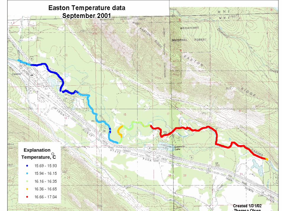
Easton Reach: Temperature and Depth
TEMPERATUREDEPTH

Easton Reach: Profile vs. Fixed-Station Data
DOWNSTREAM,fixed station
3-SEC PROFILE DATA
UPSTREAM,fixed station

CLE ELUM RIVER:
REDD STUDY AREA
Cooling area in summer,warming area in winter

Cle Elum River, Redd Study Area, Feb. 2002
TEMPERATURE
DEPTH
Warming area (winter)
UPSTREAM DOWNSTREAM UPSTREAM

Redds in Relation to Temperature deviations from Trends
TEMPERATUREREDD
DEPTH

Temperature, C


Stehekin River
Methow River

Conclusions• Thermal profiles provide a new perspective
on the temperature regimes of rivers• Aquatic habitat templet for lotic community
patterns– different life stages/life-history patterns of
salmonids– logical progression of the longitudinal gradient
of fish assemblages• Ground-water discharge occurs over broad
areas and very locally– localized discharge associated with dry
tributaries, side channels, geomorphic controls, springs