Thematic Programme: Environment and Sustainable Development · 2013. 7. 15. · Gheorghe Univ....
97
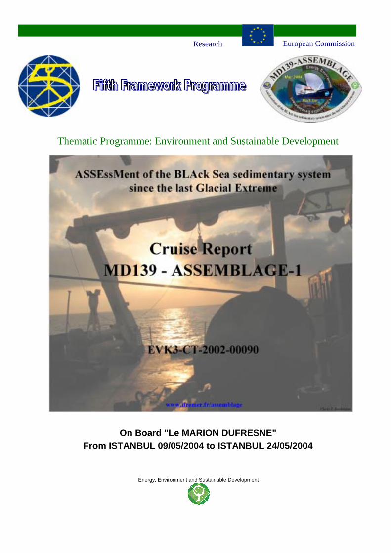
Thematic Programme: Environment and Sustainable Development On Board "Le MARION DUFRESNE" From ISTANBUL 09/05/2004 to ISTANBUL 24/05/2004 Energy, Environment and Sustainable Development Research European Commission
Transcript of Thematic Programme: Environment and Sustainable Development · 2013. 7. 15. · Gheorghe Univ....
Thematic Programme: Environment and Sustainable Development
On Board "Le MARION DUFRESNE"From ISTANBUL 09/05/2004 to ISTANBUL 24/05/2004
Energy, Environment and Sustainable Development
Research European Commission
MD139 – ASSEMBLAGE 1 ISTANBUL 09/05/2004, ISTANBUL 24/05/2004
Energy, Environment and Sustainable Development
2
INTRODUCTION
ASSEMBLAGE is a European collaborative project focused on the assessment of the BlackSea sedimentary system from its North-western part, including the continental shelf and slope,down to the deep-sea zone.
The first scientific cruise dedicated to the project was undertaken on board the French ResearchVessel "Le MARION DUFRESNE" from ISTANBUL, 9th of May 2004 to ISTANBUL, 24th ofMay 2004. The ship and scientific technology for the cruise ASSEMBLAGE 1 were provided byIPEV (Institut Paul Emile Victor) and the project was under the direction of Gilles Lericolais,co-ordinator of the European ASSEMBLAGE project. The project proposes a new, extensiveand complex marine research programme in the Black Sea using modern scientific equipmentand technology and high expertise. Within this project there is a clear will to unify the efforts ofscientists from Western Europe and Central-Eastern Europe.
The scientific party was composed by the project partners: Partner 1, 2 and 3 from France,Partner 4 from Germany, Partner 5 and 6 from Romania, Partner 7 from Bulgaria, Partner 10from Spain and Partner 11 from Italy. The team was completed by guest scientists from theUnited Kingdom, Turkey and the United States of America.
The western Black Sea is a unique feature characterised by a particularly wide shelf of 100-150 km, which is under the jurisdiction of Ukraine, Romania and Bulgaria. The north-westernBlack Sea receives water and sediment discharge from some major European rivers (Danube,Dniepr, Dniestr) and is characterised by high sedimentation rates which present favourableconditions for paleoclimatic studies of this region. Its geographical position and that of itsdrainage basin makes it sensitive to changes in the ice-cap during the last Glacial period which isalso recorded in the sedimentary record.
The knowledge of past climatic and environmental changes provides important scientificsupport to facilitate the access and sustainable use of the Black Sea floor resources, primarily forthe benefit of the riparian East European countries. The project aims to quantify the impacts ofclimate change and the sensitivity of the Black Sea system to external forcing, with respect tonatural processes and human activity. Progress in resolving these major issues will be achievedthrough the examination of:
(1) the geomorphology and stratigraphy of the north-western shelf of the Black Sea to its deep-sea,
(2) a series of long cores retrieved from the Bosphorus outlet, the north-western shelf and thedeep-sea fans using the Marion Dufresne technology,
(3) the determination of the consequences of a reduction of the river input,(4) the use of a computationally efficient ecological model and(5) the reconstruction of the depositional history of the sequences laid down during the out-
building of the Danube delta.

MD139 – ASSEMBLAGE 1 ISTANBUL 09/05/2004, ISTANBUL 24/05/2004
Energy, Environment and Sustainable Development
3
The BlaSON 1 and BlaSON 2 cruises have already provided detailed images of the seafloor byswath mapping, side-scan sonar and very-high-resolution seismic profiling. These cruises haveincreased our understanding of the timing of and the processes controlling Holocene sea-levelrise on the shelf and to reconstruct the outbuilding of the Danube delta and deep-sea fan. Tocharacterise the last transgression (invasion of saltwater into a giant low salinity lake?),sediments need to sampled from the coast to the deep basin to cover the Late Pleistocenelacustrine phase to the Holocene marine phase of the Black Sea. Core samples retrieved by theMarion Dufresne will allow detailed age determinations. By studying the stable isotopes, pollen,molluscs, ostracods, foraminifers, diatoms and clay mineralogy of these cores and using proxiesdelivered by rivers that drain the interior of Asia and Europe, it will be possible to understandthe history of climate change at a cm core-resolution. Because the abrupt Holocene re-connection of the Black Sea to the Mediterranean is perhaps one of the most dramatic climaticevents of the last 18,000 years in Europe, this research can be used as a proxy for the future. Thisproject can be linked to previous and recent researches carried out in the Marmara Sea in orderto decipher the timing and processes of the re-connection.
MD139 – ASSEMBLAGE 1 ISTANBUL 09/05/2004, ISTANBUL 24/05/2004
Energy, Environment and Sustainable Development
4
CONTENTS
INTRODUCTION ......................................................................................................................................................... 2
CONTENTS ................................................................................................................................................................... 4
1. CORE LOCALITIES AND ROUTES OF THE SURVEY .............................................................................. 8
2. SCIENTIFIC TEAM PARTICIPATING IN THE CRUISE ......................................................................... 12
2.1. ASSEMBLAGE PARTNERS............................................................................................................................. 122.1.1. Partner 1 : Ifremer................................................................................................................................. 122.1.2. Partner 2 & 12: UCBL / CNRS.............................................................................................................. 122.1.3. Partner 3 & 13: LSCE /CEA.................................................................................................................. 122.1.4. Partner 4: Uni HH (Hamburg University) ............................................................................................ 122.1.5. Partner 5: GeoEcoMar .......................................................................................................................... 122.1.6. Partner 6: University of Bucharest ........................................................................................................ 132.1.7. Partner 7: IOBAS................................................................................................................................... 132.1.8. Partner 10: CSIC- IACT ........................................................................................................................ 132.1.9. Partner 11: University of Ancona.......................................................................................................... 13
2.2. OTHER PARTICIPANTS TO THE CRUISE .............................................................................................................. 13
3. SCIENTIFIC OBJECTIVES ............................................................................................................................ 18
3.1. BACKGROUND: THE BLACK SEA SEDIMENTARY SYSTEM ...................................................................................... 183.2. PREVIOUS CAMPAIGNS AND BRIEF REFERENCES ON THE SUBJECT ..................................................................... 203.3. REFERENCES FOR CHAPTER 3............................................................................................................................ 23
4. TOOLS AND METHODS ................................................................................................................................. 28
4.1. MULTIBEAM ECHO-SOUNDER AND SUB-BOTTOM PROFILER.............................................................................. 284.1.1. Multibeam echo-sounder (by Xavier Morin).......................................................................................... 284.1.2. Sub-Bottom profiler ............................................................................................................................... 284.1.3. Post-processing...................................................................................................................................... 304.1.4. Site Survey.............................................................................................................................................. 30
4.2. CORING AND CORES STUDY ON BOARD ............................................................................................................. 314.2.1. General presentation of the corer.......................................................................................................... 314.2.2. Core packing.......................................................................................................................................... 324.2.3. Lithostratigraphic description ............................................................................................................... 334.2.4. Digital photography............................................................................................................................... 354.2.5. Colour spectrophotometry ..................................................................................................................... 364.2.6. GEOTEK Multi Sensor Core Logger (MSCL) ....................................................................................... 364.2.7. Pore Water extraction............................................................................................................................ 374.2.8. Gas Chromatograph (Partner 4) ........................................................................................................... 394.2.9. Sampling Ostracods (Ian Boomer University of Newcastle)................................................................. 404.2.10. Sampling for geochemical and mineralogical analyses (Partner 10: IACT-CSIC)............................... 414.2.11. Sampling methodology used during the cruise MD139 by Partner 11 – (University of Ancona;Caterina Morigi) .................................................................................................................................................. 42
4.3. CTD, HYDROLOGY AND PLANKTON NETS........................................................................................................ 434.3.1. Water sampling. ..................................................................................................................................... 434.3.2. Water-sediment interface and surface sediment. ................................................................................... 434.3.3. Living microplankton. ............................................................................................................................ 44
5. DESCRIPTION OF CORE MD04-2761 .......................................................................................................... 68
5.1. SITE PRESENTATION ......................................................................................................................................... 685.2. LOCATION MAP FOR CORE MD04-2761............................................................................................................ 695.3. MD04-2761 SITE SURVEY ............................................................................................................................... 705.4. MD04-2761 CORING FORM.............................................................................................................................. 715.5. MD04-2761 PHOTOGRAPH TABLES ................................................................................................................. 72

MD139 – ASSEMBLAGE 1 ISTANBUL 09/05/2004, ISTANBUL 24/05/2004
Energy, Environment and Sustainable Development
5
5.6. MD04-2761 LOG DESCRIPTION ....................................................................................................................... 74
6. DESCRIPTION OF CORE MD04-2754 .......................................................................................................... 93
6.1. SITE PRESENTATION ......................................................................................................................................... 936.2. LOCATION MAP FOR CORE MD04-2754............................................................................................................ 936.3. MD04-2754 PRECISE SITE SURVEY.................................................................................................................. 94
6.3.1. Profile acquired during BlaSON2.......................................................................................................... 946.3.2. MD04-2761 Site Survey ......................................................................................................................... 94
6.4. MD04-2754 CORING FORM ............................................................................................................................. 956.5. MD04-2754 PHOTOGRAPHY TABLE ................................................................................................................. 96
MD139 – ASSEMBLAGE 1 ISTANBUL 09/05/2004, ISTANBUL 24/05/2004
Energy, Environment and Sustainable Development
6
MD04-139 ASSEMBLAGE 1
Core location and routes of the survey

MD139 – ASSEMBLAGE 1 ISTANBUL 09/05/2004, ISTANBUL 24/05/2004
Energy, Environment and Sustainable Development
7
MD139 – ASSEMBLAGE 1 ISTANBUL 09/05/2004, ISTANBUL 24/05/2004
Energy, Environment and Sustainable Development
8
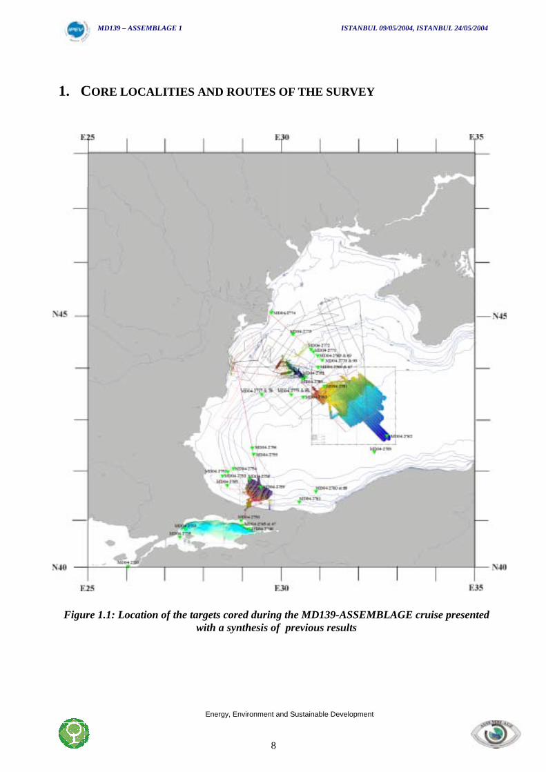
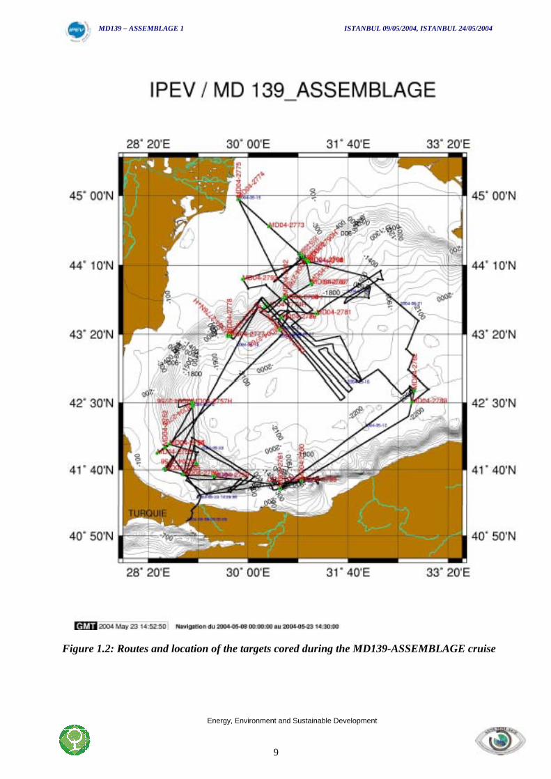
1. CORE LOCALITIES AND ROUTES OF THE SURVEY
Figure 1.1: Location of the targets cored during the MD139-ASSEMBLAGE cruise presentedwith a synthesis of previous results
MD139 – ASSEMBLAGE 1 ISTANBUL 09/05/2004, ISTANBUL 24/05/2004
Energy, Environment and Sustainable Development
9
Figure 1.2: Routes and location of the targets cored during the MD139-ASSEMBLAGE cruise
MD139 – ASSEMBLAGE 1 ISTANBUL 09/05/2004, ISTANBUL 24/05/2004
Energy, Environment and Sustainable Development
10
MD04-139 ASSEMBLAGE 1
Scientific Team

MD139 – ASSEMBLAGE 1 ISTANBUL 09/05/2004, ISTANBUL 24/05/2004
Energy, Environment and Sustainable Development
11
MD139 – ASSEMBLAGE 1 ISTANBUL 09/05/2004, ISTANBUL 24/05/2004
Energy, Environment and Sustainable Development
12
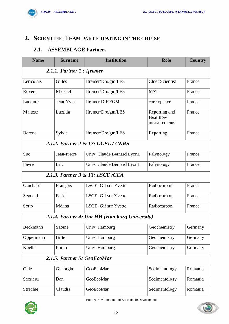
2. SCIENTIFIC TEAM PARTICIPATING IN THE CRUISE
2.1. ASSEMBLAGE Partners
Name Surname Institution Role Country
2.1.1. Partner 1 : Ifremer
Lericolais Gilles Ifremer/Dro/gm/LES Chief Scientist France
Rovere Mickael Ifremer/Dro/gm/LES MST France
Landure Jean-Yves Ifremer DRO/GM core opener France
Maltese Laetitia Ifremer/Dro/gm/LES Reporting andHeat flowmeasurements
France
Barone Sylvia Ifremer/Dro/gm/LES Reporting France
2.1.2. Partner 2 & 12: UCBL / CNRS
Suc Jean-Pierre Univ. Claude Bernard Lyon1 Palynology France
Favre Eric Univ. Claude Bernard Lyon1 Palynology France
2.1.3. Partner 3 & 13: LSCE /CEA
Guichard François LSCE- Gif sur Yvette Radiocarbon France
Segueni Farid LSCE- Gif sur Yvette Radiocarbon France
Sotto Mélina LSCE- Gif sur Yvette Radiocarbon France
2.1.4. Partner 4: Uni HH (Hamburg University)
Beckmann Sabine Univ. Hamburg Geochemistry Germany
Oppermann Birte Univ. Hamburg Geochemistry Germany
Koelle Philip Univ. Hamburg Geochemistry Germany
2.1.5. Partner 5: GeoEcoMar
Oaie Gheorghe GeoEcoMar Sedimentology Romania
Secrieru Dan GeoEcoMar Sedimentology Romania
Strechie Claudia GeoEcoMar Sedimentology Romania
MD139 – ASSEMBLAGE 1 ISTANBUL 09/05/2004, ISTANBUL 24/05/2004
Energy, Environment and Sustainable Development
13
Furtuna Corina GeoEcoMar Sedimentology Romania
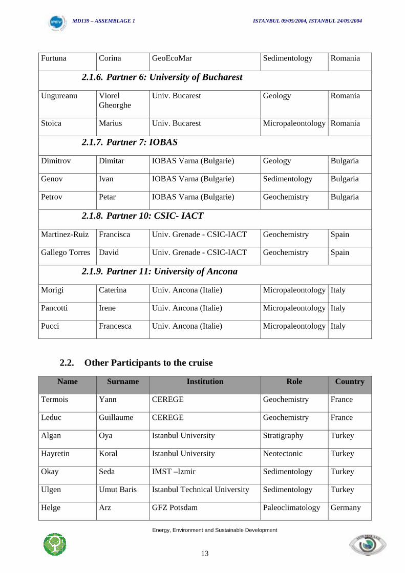
2.1.6. Partner 6: University of Bucharest
Ungureanu ViorelGheorghe
Univ. Bucarest Geology Romania
Stoica Marius Univ. Bucarest Micropaleontology Romania
2.1.7. Partner 7: IOBAS
Dimitrov Dimitar IOBAS Varna (Bulgarie) Geology Bulgaria
Genov Ivan IOBAS Varna (Bulgarie) Sedimentology Bulgaria
Petrov Petar IOBAS Varna (Bulgarie) Geochemistry Bulgaria
2.1.8. Partner 10: CSIC- IACT
Martinez-Ruiz Francisca Univ. Grenade - CSIC-IACT Geochemistry Spain
Gallego Torres David Univ. Grenade - CSIC-IACT Geochemistry Spain
2.1.9. Partner 11: University of Ancona
Morigi Caterina Univ. Ancona (Italie) Micropaleontology Italy
Pancotti Irene Univ. Ancona (Italie) Micropaleontology Italy
Pucci Francesca Univ. Ancona (Italie) Micropaleontology Italy
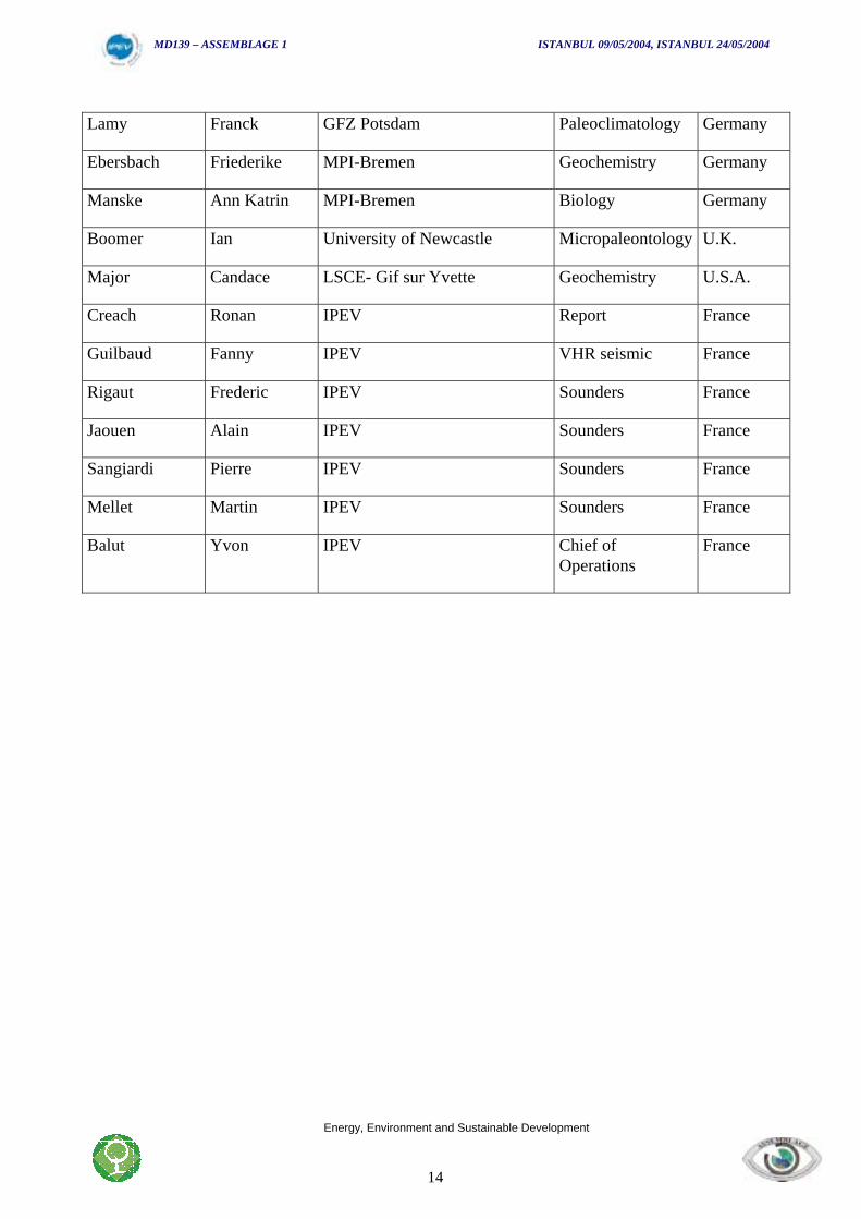
2.2. Other Participants to the cruise
Name Surname Institution Role Country
Termois Yann CEREGE Geochemistry France
Leduc Guillaume CEREGE Geochemistry France
Algan Oya Istanbul University Stratigraphy Turkey
Hayretin Koral Istanbul University Neotectonic Turkey
Okay Seda IMST –Izmir Sedimentology Turkey
Ulgen Umut Baris Istanbul Technical University Sedimentology Turkey
Helge Arz GFZ Potsdam Paleoclimatology Germany
MD139 – ASSEMBLAGE 1 ISTANBUL 09/05/2004, ISTANBUL 24/05/2004
Energy, Environment and Sustainable Development
14
Lamy Franck GFZ Potsdam Paleoclimatology Germany
Ebersbach Friederike MPI-Bremen Geochemistry Germany
Manske Ann Katrin MPI-Bremen Biology Germany
Boomer Ian University of Newcastle Micropaleontology U.K.
Major Candace LSCE- Gif sur Yvette Geochemistry U.S.A.
Creach Ronan IPEV Report France
Guilbaud Fanny IPEV VHR seismic France
Rigaut Frederic IPEV Sounders France
Jaouen Alain IPEV Sounders France
Sangiardi Pierre IPEV Sounders France
Mellet Martin IPEV Sounders France
Balut Yvon IPEV Chief ofOperations
France

MD139 – ASSEMBLAGE 1 ISTANBUL 09/05/2004, ISTANBUL 24/05/2004
Energy, Environment and Sustainable Development
15
MD139 – ASSEMBLAGE 1 ISTANBUL 09/05/2004, ISTANBUL 24/05/2004
Energy, Environment and Sustainable Development
16
MD04-139 ASSEMBLAGE 1
Scientific Objectives

MD139 – ASSEMBLAGE 1 ISTANBUL 09/05/2004, ISTANBUL 24/05/2004
Energy, Environment and Sustainable Development
17
MD139 – ASSEMBLAGE 1 ISTANBUL 09/05/2004, ISTANBUL 24/05/2004
Energy, Environment and Sustainable Development
18
3. SCIENTIFIC OBJECTIVES
3.1. Background: the Black Sea sedimentary system
To date, we have a very limited and mostly classical knowledge about the recentsedimentology of the Black Sea although this is the largest semi-enclosed Basin at the easternborder of Europe.
• The North-western Black Sea receives the water and sediment discharge of thelargest European rivers (Danube, Dniepr, Dniestr). For example, the drainage basin of theriver Danube is of 817,000 km2. The Danube mean-annual water discharge into the Black Seais estimated at 6,047 m3 s-1 (almost 190 km3 yr-1), while its mean-annual sediment discharge atthe mouth zone was about 51,7 million tons per year (t yr-1) before the river damming (Bondar,1998). After the damming in 1970 and 1983, one can estimate that the Danube’s total averagesediment discharge could not be larger than 30-35 million t yr-1, out of which only 4-6 milliont yr-1 was sandy material (Panin, 1997). During the glacial lowstands and especially at thebeginning of interglacials, the sediment discharge of these rivers were probably much higher.The examination at an appropriate scale of sediment path-way transportation, deposition,compaction and/or possible sliding across the continental shelf towards the slope and thedeep-sea zone represents a case study for a better understanding of the processes affectingsedimentation in inland basins during the Quaternary period.• Beyond the continental shelf a complex system of canyons, channels, accumulating
sedimentary bodies as deep-sea fans are developed. The Danube deep-sea fan which can beconsidered as a potential hydrocarbon field, developed in the North-western part of theBlack Sea from sediments fed by the Danube but also by the northern rivers: the Dniepr, theDniestr and the Bug. It extends for about 150 km downslope of the shelf-break, and the distalend of the fan reaches the abyssal plain at 2200 m water depth. Depositional processes arelocated essentially on the middle and lower slope. The surface of the fan is covered by anetwork of meandering channels. The southern system is controlled by the Danube sedimentsupply through the Viteaz canyon (Popescu et al., 2004), whereas the Dniepr, the Dniestr andthe Bug probably built up the northern system (Wong et al., 1997). The Black Sea was a lowsalinity lake during most sea-level lowstands when fan deposition was active. Turbiditesedimentation in the deep North-western Black Sea was not well investigated before the 1990s(Popescu et al., 2001; Winguth et al., 2000). Recent and further contributions will improveconsiderably our understanding of the architecture and growth pattern of the Danube andDniepr deep-sea fans.• The Black Sea is linked to the Mediterranean Sea only through the Bosphorus-
Dardanelles system of straits. The Bosphorus sill was responsible for a particular behaviourof the Black Sea during the global glaciations and deglaciations. Thus the Black Sea levelfollowed the World Ocean level changes while it was higher than the sill. When global sealevel was lower than the Bosphorus sill the variations of the Black Sea level reflected specificregional climate conditions without being coupled to the ocean changes. The Bosphorus is arather narrow (0,76–3,6 km large) and shallow strait (32–34 m at the sill) restricting the two-way water exchange between the brackish Black Sea (the salinity of the Black Sea water isabout 17‰ at the surface and 22 ‰ at the bottom) and the very saline Mediterranean Sea (38–39 ‰). The surface outflow of the less saline Black Sea water is estimated at about 600 km3
yr-1, while the under-current of saline Mediterranean water flows towards the Black Sea andsupplies it with almost 300 km3 yr-1 (Oguz et al., 2000; Ozsoy and Unluata, 1997).
MD139 – ASSEMBLAGE 1 ISTANBUL 09/05/2004, ISTANBUL 24/05/2004
Energy, Environment and Sustainable Development
19
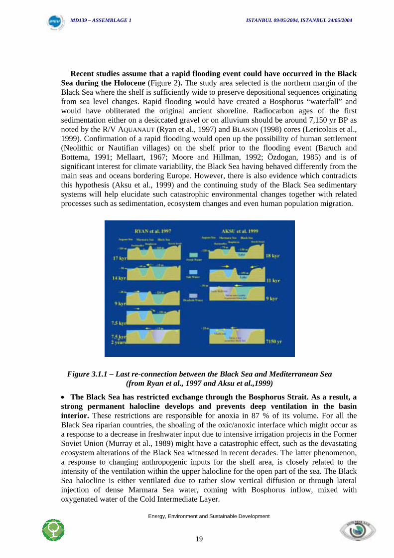
Recent studies assume that a rapid flooding event could have occurred in the BlackSea during the Holocene (Figure 2). The study area selected is the northern margin of theBlack Sea where the shelf is sufficiently wide to preserve depositional sequences originatingfrom sea level changes. Rapid flooding would have created a Bosphorus “waterfall” andwould have obliterated the original ancient shoreline. Radiocarbon ages of the firstsedimentation either on a desiccated gravel or on alluvium should be around 7,150 yr BP asnoted by the R/V AQUANAUT (Ryan et al., 1997) and BLASON (1998) cores (Lericolais et al.,1999). Confirmation of a rapid flooding would open up the possibility of human settlement(Neolithic or Nautifian villages) on the shelf prior to the flooding event (Baruch andBottema, 1991; Mellaart, 1967; Moore and Hillman, 1992; Özdogan, 1985) and is ofsignificant interest for climate variability, the Black Sea having behaved differently from themain seas and oceans bordering Europe. However, there is also evidence which contradictsthis hypothesis (Aksu et al., 1999) and the continuing study of the Black Sea sedimentarysystems will help elucidate such catastrophic environmental changes together with relatedprocesses such as sedimentation, ecosystem changes and even human population migration.
Figure 3.1.1 – Last re-connection between the Black Sea and Mediterranean Sea(from Ryan et al., 1997 and Aksu et al.,1999)
• The Black Sea has restricted exchange through the Bosphorus Strait. As a result, astrong permanent halocline develops and prevents deep ventilation in the basininterior. These restrictions are responsible for anoxia in 87 % of its volume. For all theBlack Sea riparian countries, the shoaling of the oxic/anoxic interface which might occur asa response to a decrease in freshwater input due to intensive irrigation projects in the FormerSoviet Union (Murray et al., 1989) might have a catastrophic effect, such as the devastatingecosystem alterations of the Black Sea witnessed in recent decades. The latter phenomenon,a response to changing anthropogenic inputs for the shelf area, is closely related to theintensity of the ventilation within the upper halocline for the open part of the sea. The BlackSea halocline is either ventilated due to rather slow vertical diffusion or through lateralinjection of dense Marmara Sea water, coming with Bosphorus inflow, mixed withoxygenated water of the Cold Intermediate Layer.
MD139 – ASSEMBLAGE 1 ISTANBUL 09/05/2004, ISTANBUL 24/05/2004
Energy, Environment and Sustainable Development
20
• This particular anoxic dominated environment is responsible for a widespread ofsapropels everywhere from the continental slope to the deep sea. The formation ofsapropels can be related either to an increase of precipitation and freshwater run-off duringglacial intervals or to changes in stratification and/or the chemistry of the water column,which are thought to lead to increased anoxia in the bottom water, increased primaryproductivity, and more complete preservation of organic matter (Calvert and Karlin, 1998;Rohling, 1994; Rossignol-Strick et al., 1982; Sancetta, 1999). Others (e.g. (Bosch et al.,1997) consider that sapropels are formed by anoxia in the photic zone. A number of sapropellayers have been observed in marine sedimentary sequences that extend over severalglacial-interglacial cycles, which suggests that the conditions under which sapropels formare linked, directly or indirectly, to Quaternary climate forcing mechanisms.• Preliminary estimation of hydrate potential in this region is still required. The BlackSea is one of the largest basins on the Earth with anoxic environment below 150 m waterdepth. In such conditions, with a large supply of organic matter from the tributary rivers andfrom the oxygenated surface layer, sulphate reduction, methanogenesis and methaneoxidation are the dominant terminal processes of carbon flux in the sediments. The biogasesare present in large quantities in the Black Sea sediments in different bathymetrical zonesstarting with the continental shelf. Within the deeper zones (more than 600 m) gas hydrateoccurrence is reported. Nevertheless no reliable estimation of deep hydrate potential isavailable for the Black Sea. Combined expertise from relevant scientific fields i.e.,geophysics, sedimentology, microbiology, geochemistry will allow the identification andinvestigation of gas occurrence in the sediments (vents, seeps, mud volcanoes) andassociated structures (carbonates, bacterial mats), as well as the inventory of gas hydrateoccurrence and potential estimation. The Black Sea represents a key region forunderstanding the significance of this greenhouse gas production and emission for globalclimatic changes.
These details emphasise the fact that the Black Sea is a unique natural laboratory. Thus,validation of the results from previous stratigraphic surveys and investigations must beundertaken. The opportunity to use a marine facility with the ability to core to a sediment depthof 50 meters presented a unique opening for the ASSEMBLAGE project.
3.2. Previous campaigns and brief references on the subject
Most of the previous work in the Black Sea was undertaken by scientific teams from the formerUSSR. The first bathymetric charts were published by Androsov (1893) and the first importantcompilation was published in the seventies by (Goncharov et al., 1972). Most of the publicationsconcerning the Black Sea are written in Russian and we have access to it only through ourRomanian, Bulgarian and Ukrainian colleagues. Specific surveys have been carried out by theBulgarian Academy of Sciences on their own continental shelf (Kuprin, 1980; Kuprin et al.,1974). On the Romanian coast; it is principally the evolution of the recent part of the Danubedelta which has been studied (Panin, 1972; Panin, 1974; Panin, 1983; Panin, 1989; Panin, 1995).In 1969, on board the Atlantis 2 Research vessel, American teams began their investigation inthe area (Degens and Ross, 1974) and continued in 1988 on board the R/V Knorr (Murray,1991). Some French scientists worked on samples collected during these surveys (Calvert andFontugne, 1987; Guichard et al., 1993).
In 1975, DSDP leg 42B from the Glomar Challenger sampled the sedimentary deposits of theBlack Sea Basin from the Upper Miocene through to the present (Ross and Neprochnov, 1978).Our group is associated to an ODP proposal presented by Roger Flood following the letter of
MD139 – ASSEMBLAGE 1 ISTANBUL 09/05/2004, ISTANBUL 24/05/2004
Energy, Environment and Sustainable Development
21
intent prepared in 1996 in Malanas (Romania). The deep structure of the Black Sea basin hasbeen studied within the Odyssée IV du CNEXO/CEPM (Letouzey et al., 1977) and also by aseismic survey using the R/V Nadir (campaign BLACKSIS 1997, C. Rangin chief scientist).Recent surveys have been carried out in the Black Sea with the Russian R/V Geledzhnikstudying principally mud volcanoes and gas hydrates (Training Through Research UNESCOprogram 1992). The German expedition to study the Dnieper and Danube fans (Wong et al.,1994) as well as an American campaign in 1993 on the Ukrainian margin (Ryan et al., 1997) andthe EROS 2000/EROS 21 (J.M. Martin, ENS, N. Panin et al.) European project sought tounderstand the origin of pollutants offshore of the Danube.
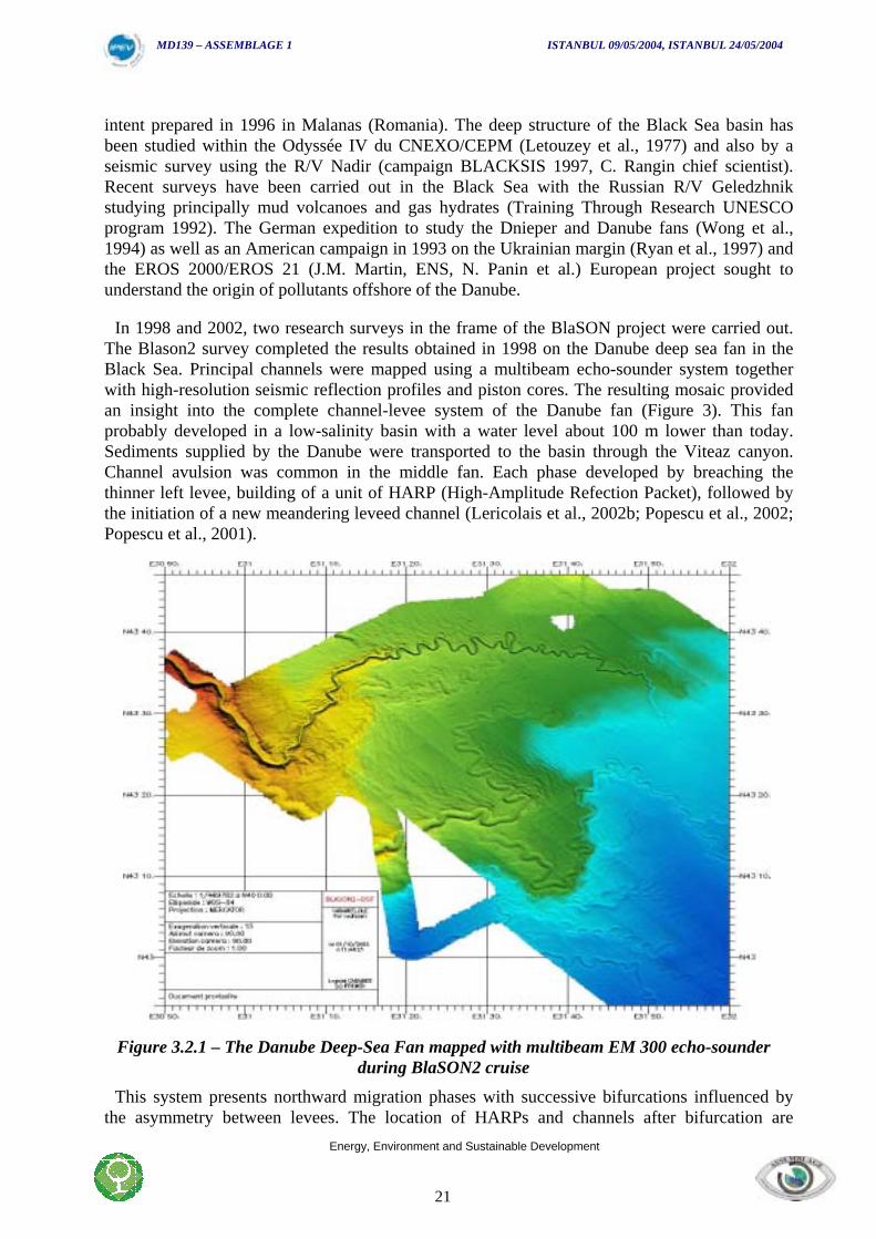
In 1998 and 2002, two research surveys in the frame of the BlaSON project were carried out.The Blason2 survey completed the results obtained in 1998 on the Danube deep sea fan in theBlack Sea. Principal channels were mapped using a multibeam echo-sounder system togetherwith high-resolution seismic reflection profiles and piston cores. The resulting mosaic providedan insight into the complete channel-levee system of the Danube fan (Figure 3). This fanprobably developed in a low-salinity basin with a water level about 100 m lower than today.Sediments supplied by the Danube were transported to the basin through the Viteaz canyon.Channel avulsion was common in the middle fan. Each phase developed by breaching thethinner left levee, building of a unit of HARP (High-Amplitude Refection Packet), followed bythe initiation of a new meandering leveed channel (Lericolais et al., 2002b; Popescu et al., 2002;Popescu et al., 2001).
Figure 3.2.1 – The Danube Deep-Sea Fan mapped with multibeam EM 300 echo-sounderduring BlaSON2 cruise
This system presents northward migration phases with successive bifurcations influenced bythe asymmetry between levees. The location of HARPs and channels after bifurcation are
MD139 – ASSEMBLAGE 1 ISTANBUL 09/05/2004, ISTANBUL 24/05/2004
Energy, Environment and Sustainable Development
22
controlled by the pre-existing bathymetry, confined between the high of the youngest channel-levee system to the south, and the steep relief of the Dniepr fan to the north. The HARP depositsconsist of fine to very-fine sand with mud clasts. Sparse occurrences of reworked benthicforaminifers indicate a much shallower sediment source while the rare ostracod specimenscharacterize a low salinity to brackish water basin. It seems clear that sea level fluctuation is atthe origin of the control of the Danube fan activity but the evolution of the last channel-leveesystem suggests that the primary control of channel avulsion and sand delivery is probablyautocyclic and in that case (a large lake) only hyperpicnality operates.
During the BlaSON expedition in May 1998, the French Research Vessel Le Suroit mapped thenorthwest continental shelf of the Black Sea and revealed a seabed populated by sand ridges andsmall depressions overlying and sculpted into the eroded remains of a former terrestrialfloodplain. The ridges are located at the crest and landward of a shoreface recognized at depthsof –85 to –100 m. They have stronger correspondence to aspect ratios of modern linear beachridges than to those of underwater sand waves. The depressions are similar in size and shape topans formed through wind deflation. The ridges and depressions sit on a surface exposed by alow stand of the Black Sea's glacial and post-glacial lake. Submergence without destruction andinfilling suggests a rapid rise in the lake's surface (Lericolais et al., 2001; Lericolais et al., 2000a;Lericolais et al., 2000b).
In August 2002, the French research vessel “Le Suroit” equipped with a EM 300 multibeamecho-sounder and a TritonElics Chirp Sonar mapped the Bosphorus outlet at the shelf edge. Theresults show the existence of an important retrogressive canyon incised on the platform and twomore recent canyon heads, the incision of which can be followed landward on the shelf in frontof the Bosphorus outlet. The direction of these canyon heads being West-East is puzzling. Onesuggestion is that they may follow a tectonic direction. Coring should be undertaken on theplatform and then in the canyon itself where some megaripples made of shell debris have beenfound witnessing a very recent activity (Lericolais et al., 2002a).
MD139 – ASSEMBLAGE 1 ISTANBUL 09/05/2004, ISTANBUL 24/05/2004
Energy, Environment and Sustainable Development
23
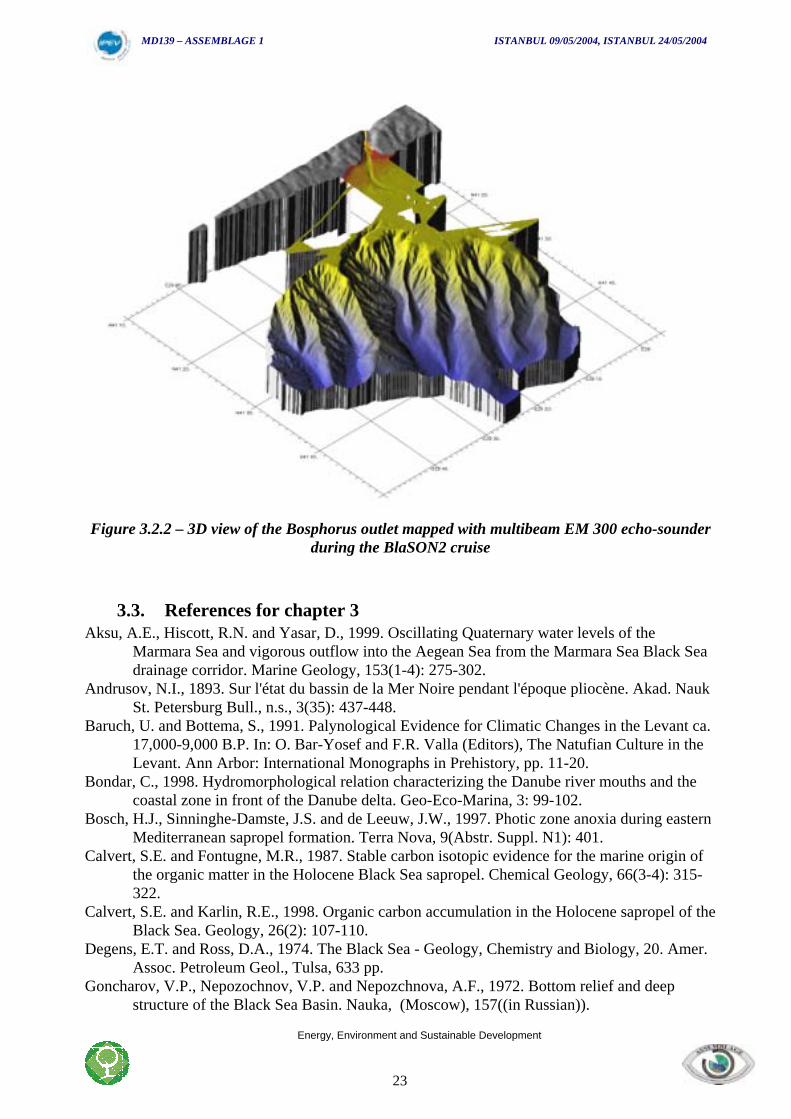
Figure 3.2.2 – 3D view of the Bosphorus outlet mapped with multibeam EM 300 echo-sounderduring the BlaSON2 cruise
3.3. References for chapter 3Aksu, A.E., Hiscott, R.N. and Yasar, D., 1999. Oscillating Quaternary water levels of the
Marmara Sea and vigorous outflow into the Aegean Sea from the Marmara Sea Black Seadrainage corridor. Marine Geology, 153(1-4): 275-302.
Andrusov, N.I., 1893. Sur l'état du bassin de la Mer Noire pendant l'époque pliocène. Akad. NaukSt. Petersburg Bull., n.s., 3(35): 437-448.
Baruch, U. and Bottema, S., 1991. Palynological Evidence for Climatic Changes in the Levant ca.17,000-9,000 B.P. In: O. Bar-Yosef and F.R. Valla (Editors), The Natufian Culture in theLevant. Ann Arbor: International Monographs in Prehistory, pp. 11-20.
Bondar, C., 1998. Hydromorphological relation characterizing the Danube river mouths and thecoastal zone in front of the Danube delta. Geo-Eco-Marina, 3: 99-102.
Bosch, H.J., Sinninghe-Damste, J.S. and de Leeuw, J.W., 1997. Photic zone anoxia during easternMediterranean sapropel formation. Terra Nova, 9(Abstr. Suppl. N1): 401.
Calvert, S.E. and Fontugne, M.R., 1987. Stable carbon isotopic evidence for the marine origin ofthe organic matter in the Holocene Black Sea sapropel. Chemical Geology, 66(3-4): 315-322.
Calvert, S.E. and Karlin, R.E., 1998. Organic carbon accumulation in the Holocene sapropel of theBlack Sea. Geology, 26(2): 107-110.
Degens, E.T. and Ross, D.A., 1974. The Black Sea - Geology, Chemistry and Biology, 20. Amer.Assoc. Petroleum Geol., Tulsa, 633 pp.
Goncharov, V.P., Nepozochnov, V.P. and Nepozchnova, A.F., 1972. Bottom relief and deepstructure of the Black Sea Basin. Nauka, (Moscow), 157((in Russian)).
MD139 – ASSEMBLAGE 1 ISTANBUL 09/05/2004, ISTANBUL 24/05/2004
Energy, Environment and Sustainable Development
24
Guichard, F., Carey, S., Arthur, M.A., Sigurdsson, H. and Arnold, M., 1993. Tephra from theMinoan eruption of Santorini in sediments of the Black Sea. Nature, 363(17): 610-612.
Kuprin, P.N., 1980. Geological-geophysical investigations of the Bulgarian Black Sea sector.BAN (Sofia), 318((in russian)).
Kuprin, P.N., Scherbakov, F.A. and Morgunov, I.I., 1974. Correlation, age, and distribution of thepostglacial continental terrace sediments of the Black Sea. Baltica, 5: 241-249.
Lericolais, G. et al., 2002a. Recent canyon heads evidenced at the Bosphorus outlet. EOStransactions.
Lericolais, G., Panin, N., Guichard, F., Popescu, I. and Ryan, W.B.F., 2001. Un évènementgéologique majeur est-il à l'origine de la reconnection entre la Méditerranée et la merNoire, il y a 7 500 ans ?, 8ème Congrès Français de Sédimentologie. Association desSédimentologues de France, Orléans, pp. 219.
Lericolais, G. et al., 1999. Quaternary sea-level fluctuations in the Black-Sea, new discoveriesduring Blason survey on the North Western Black Sea Shelf. In: A. The Institute ofOceanography NCMR, Greece (Editor), Oceanography of the Eastern Mediterranean andBlack Sea : Similarities and differences of two interconnected basins - EU, IO/NCMR,IOC/UNESCO. European Commission, Athens (Greece).
Lericolais, G. et al., 2000a. An abrupt transition 7500 years ago in the Black Sea results of theBlaSON survey (Romanian shelf). In: I.U.o.G.S. IUG (Editor), IGCP 396 - 31stInternational Geological Congress. IUGS and UNESCO, Rio de Janeiro (Brazil).
Lericolais, G. et al., 2000b. A major erosional surface recognized on Black Sea seismic dataduring Blason survey. In: N. Panin and C. Dinu (Editors), International GeophysicalConference & Exposition. SEG - EAEG - RSG, Bucharest (Ro).
Lericolais, G. et al., 2002b. Viteaz Canyon, The only sediment pathway of the Black Sea Shelf ?CIESM Workshop series, 17: 77-80.
Letouzey, J., Khristchev, K., Gonnard, R., Montadert, L. and Dorkel, A., 1977. Black Sea :Geological setting and recent deposits distribution from seismic reflection data. In: DSDP(Editor), Initial report of DSDP. U.S. Government Printing Office, Washington.
Mellaart, J., 1967. Çatal Hüyük - A Neolithic Town. McGraw Hill, New York, 232 pp.Moore, A.M.T. and Hillman, G.C., 1992. The Pleistocene to Holocene transition and human
economy in soutwest Asia: the impact of the Younger Dryas. American Antiquity, 57(3):482-494.
Murray, J.W., 1991. The 1988 Black Sea oceanographic expedition: introduction and summary.Deep-Sea Research, 38(Supplement 2): S655-S661.
Murray, J.W. et al., 1989. Unexpected changes in the oxic/ anoxic interface in the Black Sea.Nature (London), 338(6214): Pages 411-413.
Oguz, T., Ducklow Hugh, W. and Malanotte Rizzoli, P., 2000. Modeling distinct verticalbiogeochemical structure of the Black Sea; dynamical coupling of the oxic, suboxic, andanoxic layers. Global Biogeochemical Cycles, 14(4): Pages 1331-1352.
Özdogan, M., 1985. A surface survey for prehistoric and early historic sites in northwesternTurkey, National Geographic Research Reports for 1979, pp. 517-541.
Ozsoy, E. and Unluata, U., 1997. Oceanography of the Black Sea; a review of some recent results.Earth-Science Reviews, 42(4): Pages 231-272.
Panin, N., 1972. Quaternary history of the Danube delta. Cercetari marine, 4: 5-15.Panin, N., 1974. Evolution of the Danube delta during the Holocene. Geologia Cuaternarului,
H(5): 107-121.Panin, N., 1983. Black Sea coastline changes in the last 10,000 years: a new attempt at identifying
the Danube mouths as described by the ancients. Dacia N.S., 27: 175-184.
MD139 – ASSEMBLAGE 1 ISTANBUL 09/05/2004, ISTANBUL 24/05/2004
Energy, Environment and Sustainable Development
25
Panin, N., 1989. Danube delta: Genesis, evolution sedimentology. Rev. Roum. Géol. Géophys.Géogr., 33: 25-36.
Panin, N., 1995. Impact of global changes on geo-environmental and coastal zone state of theBlack Sea, Geological and Geoecological Study of the danube Delta and the Black SeaWestern Shelf Margin International Workshop, Tulcia, pp. 1-8.
Panin, N., 1997. On the geomorphologic and geologic evolution of the river Danube: Black Seainteraction zone. Geo-Eco-Marina, 2: 31-40.
Popescu, I. et al., 2002. Architecture and recent sedimentary evolution of the Danube deep-sea fan(Black Sea). CIESM Workshop series, 17: 81-84.
Popescu, I. et al., 2004. The Danube Submarine Canyon (Black Sea): morphology andsedimentary processes. Marine Geol., (Accepted).
Popescu, I., Lericolais, G., Panin, N., Wong, H.K. and Droz, L., 2001. Late Quaternary channelavulsions on the Danube deep-sea fan. Marine Geology, 179(1-2): 25-37.
Rohling, E.J., 1994. Review and new aspects concerning the formation of eastern Mediterraneansapropels. Marine Geology, 122(1-2): 1-28.
Ross, D.A. and Neprochnov, Y.P. (Editors), 1978. Initial Reports of the Deep Sea Drilling Project.Initial Rep. Deep Sea Drill. Proj., 42, part 2. US Govt. Print. Office, Washington, DC,1178 pp.
Rossignol-Strick, M., Nesteroff, W., Olive, P. and Vergnaud-Grazzini, C., 1982. After the deluge;Mediterranean stagnation and sapropel formation. Nature, 295(5845): 105-110.
Ryan, W.B.F. et al., 1997. An abrupt drowning of the Black Sea shelf. Marine Geology, 138(1-2):119-126.
Sancetta, C., 1999. The Mystery of Sapropels. Nature, 398(6722): 27-29.Winguth, C. et al., 2000. Upper Quaternary water level history and sedimentation in the
northwestern Black Sea. Marine Geology, 167(1-2): 127–146.Wong, H.K., Panin, N., Dinu, C., Georgescu, P. and Rahn, C., 1994. Morphology and post-
Chaudian (Late Pleistocene) evolution of the submarine Danube fan complex. Terra Nova,6: 502-511.
Wong, H.K. et al., 1997. The Danube and Dniepr fans, morphostructure and evolution.GeoEcoMarina, 2: 77-102.
MD139 – ASSEMBLAGE 1 ISTANBUL 09/05/2004, ISTANBUL 24/05/2004
Energy, Environment and Sustainable Development
26
MD04-139 ASSEMBLAGE 1
Tools and Methods:Multibeam echo-sounder and Sub-bottom profiler
Coring and core description on board. General Presentation of the Calypso Corer. Description of the Ronanberg. Core packaging. Lithostratigraphic logs. Digital Photography. Color Spectrophotometry. Multi-parameter measurements GEOTEK (MSCL). Pore water extraction. Gas Chromatograph. Sampling
CTD, Hydrology and Plankton nets

MD139 – ASSEMBLAGE 1 ISTANBUL 09/05/2004, ISTANBUL 24/05/2004
Energy, Environment and Sustainable Development
27
MD139 – ASSEMBLAGE 1 ISTANBUL 09/05/2004, ISTANBUL 24/05/2004
Energy, Environment and Sustainable Development
28
4. TOOLS AND METHODS
4.1. Multibeam echo-sounder and Sub-bottom profiler
4.1.1. Multibeam echo-sounder (by Xavier Morin)
The deep water echo-sounder Thomson Seafalcon 11 was installed on board the oceanographicresearch vessel Marion-Dufresne in 1995. It has since then become an essential instrument,which is intensively used for cartography (bathymetry and imagery) and sediment profiling. Themultibeam echo-sounder (MBES) Thomson Seafalcon 11 runs two modes of operation: the“bathymetry and imaging” mode and the “sub-bottom profiler” mode. Both modes can be runsimultaneously.
Bathymetry and imagery are simultaneous information derived by the echo-sounder.Bathymetry provides the depth, travel time and propagation direction of a huge number ofcreated soundings, regarding the ship’s attitude and sound velocity profile. Imagery is thereflectivity derived from the soundings signals and is related to backscattered energy. A seabedimage is produced from this information, where grey levels are dependent of the sea floor nature.In this operating mode (bathymetry and imagery), the echo-sounder uses transmitted frequenciesaround a 12 kHz carrier. The range of depths on which this mode can operate is 50 to 11000metres. Five spatially separated cross-track swaths are simultaneously created in order togenerate a data redundancy (as if five multibeam echo-sounders were simultaneously used).These swaths are separated in the frequency domain by the use of digital active filters. Thus,measurement gaps are avoided. These five swaths are separated (along the boat-track axis) fromeach other by a 1.4-degree angle. The central swath is vertical. The large antenna 3 dBattenuation level (at transmission) and beam forming at reception allow images to be built andmeasure bathymetry at 120 degrees from the track axis of the boat (60 degrees to starboard and60 degrees to portside). Actually, the swath angle depends on the depth and on the signal-to-noise ratio. It is always comprised between 120° and 140°. Concerning bathymetry, the across-track resolution depends upon the measured depth H. The across-track length of a resolution cellis typically equal to H/100. The number of created soundings for one measurement is typicallyequal to 2000 (400 per swath).
The imaging system uses the reflectivity extracted from the five separated frequency swaths.This representation is useful for the study of the seafloor texture and composition. In order tobuild images, a mosaic is created, geographically representing sea bottom level in the studiedarea. This mosaic is fed by the five sets of backscattered signal. The huge number of data foreach swath (around 20.000 for a complete cycle of 5 emitted frequencies) and their redundancyallow a large geographic coverage and the relative increase of the signal-to-noise ratio.
4.1.2. Sub-Bottom profiler
The Seafalcon 11 echo-sounder also includes a sub-bottom profiler. This system is able tocreate reflectivity slices of the sub-bottom sea floor as a function of the geographical position ofthe boat. As described in the preceding paragraph, beam forming from many signals received oneach sensor provides a very narrow antenna diagram (high directivity), during transmission (7.4degrees) and reception (5.6 degrees). This beam formation also achieves a high acoustic signallevel. Indeed, one of the main features of this profiler is the use of a large dedicated transmission
MD139 – ASSEMBLAGE 1 ISTANBUL 09/05/2004, ISTANBUL 24/05/2004
Energy, Environment and Sustainable Development
29
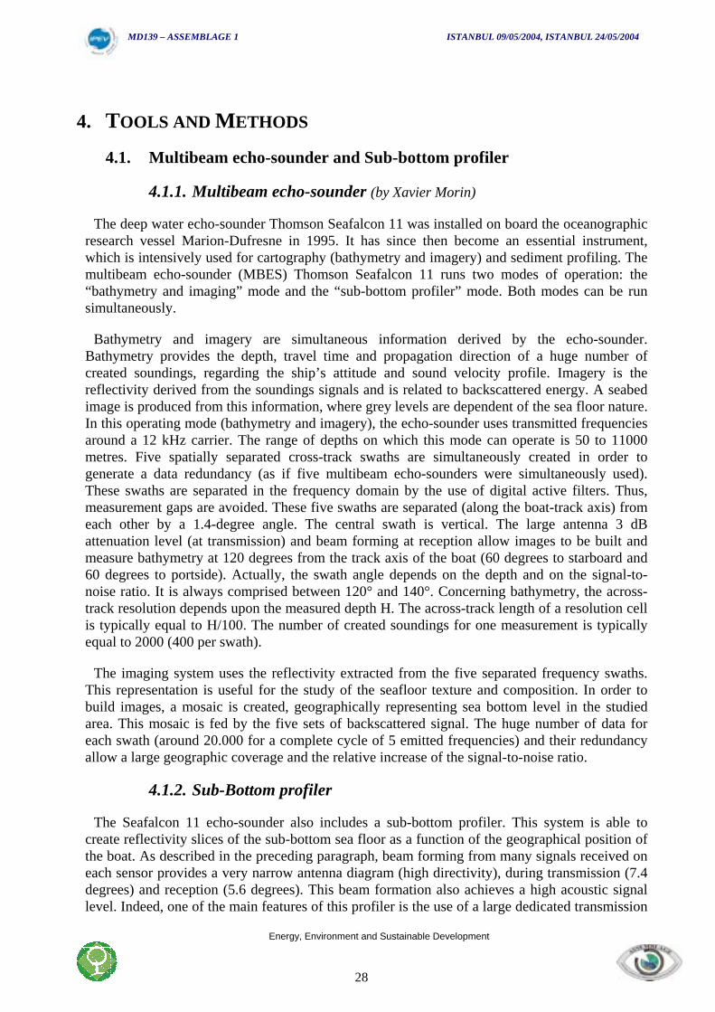
array, and the use of the large bandwidth and long size multibeam reception array in order tocreate a high acoustic level signal and a very narrow beamwidth. While classical profilersbeamwidths are usually wide (20° to 30°), the seafalcon 11 echo-sounder produces a 7.4° widthbeam. This feature prevents from interferences between different objects located in theilluminated scene, and achieves a very good along-track resolution. The central frequency usedfor this system is equal to 3.75 kHz. As for the “bathymetry and imaging” mode, the transmittedwave is linearly frequency modulated. The corresponding correlation gain is equal to 23 dB. Thelarge transmitted bandwidth (1.6 kHz) achieves a small vertical resolution (0.45 metres). Fivebeams are created on reception (the central beam is vertical), separated from each other by 5degrees. This diversity provides an opportunity to record good quality profiles when the across-track slope is steep. Typically, 100 metres penetrations are achieved for a 4000 metres depth.The maximal observed penetrations are around 200 metres. In any case, the ship’s attitudes areused in order to determine the exact location of each sounding. Two high performance Headingand Vertical Reference Unit (HVRU) are installed on the Marion-Dufresne to measure the ship’sattitudes.
Figure 4.1.2.1: Example of Sub-bottom Profiler (SBP) profile acquired surveying a Lowstandprograding wedge on the Turkish coast.
MD139 – ASSEMBLAGE 1 ISTANBUL 09/05/2004, ISTANBUL 24/05/2004
Energy, Environment and Sustainable Development
30
4.1.3. Post-processing
The post-processing of bathymetry and imaging data is carried out with the “Caraibes”software, which has been developed by I.F.R.E.M.E.R. This image processing software enablesthe creation of geographical digital data grids for bathymetry. Contour extraction, “spline”curves filtering and bi-dimensional digital filtering are examples of tools that can be used toremove any possible artefact. 3-D representations are possible. The resolution cell size of thedigital terrain Model can be chosen, as well as the vertical depth resolution. A version for realtime display is also installed aboard the Marion Dufresne vessel. This tool is very useful, since itclearly shows the multibeam coverage during surveys. The ship’s routes can be adapted in realtime in order to achieve the goals of the survey. In order to a posteriori view the sub-bottomprofiles, the French Polar Institute has developed a unix-based software. This software usesGMT and is freely available to any scientist team who would ask for it.
4.1.4. Site Survey
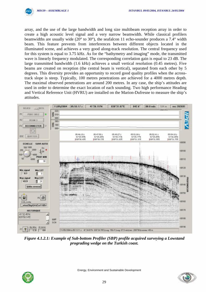
Every coring site has been determined from previous geophysical surveys; essentiallyBlaSON1 and BlaSON2 surveys. Nevertheless a new site survey was carried out during thecruise using Marion Dufresne equipment; multibeam echo-sounder and Sub-bottom profiler. Anaccurate survey of the chosen site is essential to reach the core target. Due to the importantmorphology and thickness variations, the position and the nature of the sedimentary layer, it isimportant to know precisely the nature of the sedimentary cover on site to select the appropriatetube length and set the corer parameters.
Figure 4.1.1 Site survey routes
Echo-sounder data are linked to a D-GPS positioning system. The data are recorded andvisualised with Caraïbes, (real-time cartography software – Ifremer)
MD139 – ASSEMBLAGE 1 ISTANBUL 09/05/2004, ISTANBUL 24/05/2004
Energy, Environment and Sustainable Development
31
Besides real time acquisition, a quality control is done using printed profiles. The chirp profilesare visualised on the SBP-visu interface and plotted on Dowty plotter.
4.2. Coring and cores study on board
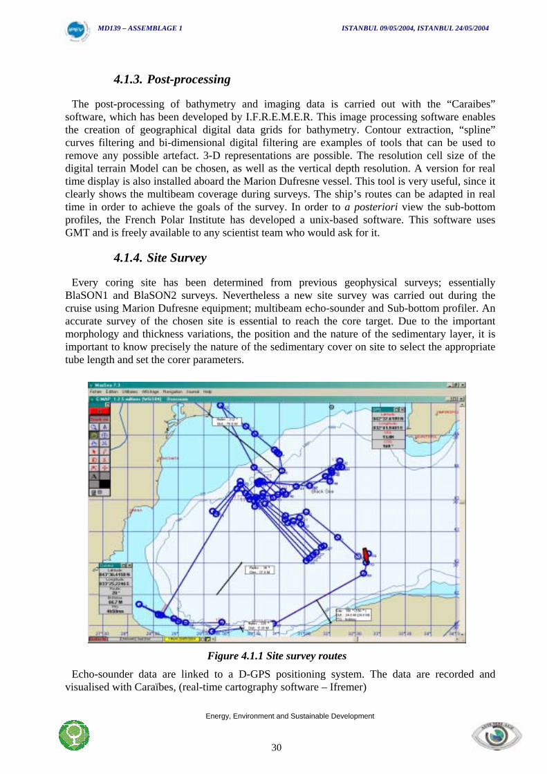
4.2.1. General presentation of the corer
The corer used during the mission is the Calypso piston-coring system, developed by IPEV anddedicated to the “Marion Dufresne”.
This corer can be equipped with a tube up to 75 m long (limitation due to the length of thegangway where the corer is installed). The corer is deployed using a cable made of kevlar,virtually weightless in water. This significantly enhances the traction security margin and weightlifting capacity of the winch. During the cruise, the longest tube used was 55meters.
Figure 4.2.1 Giant corer Calypso
MD139 – ASSEMBLAGE 1 ISTANBUL 09/05/2004, ISTANBUL 24/05/2004
Energy, Environment and Sustainable Development
32
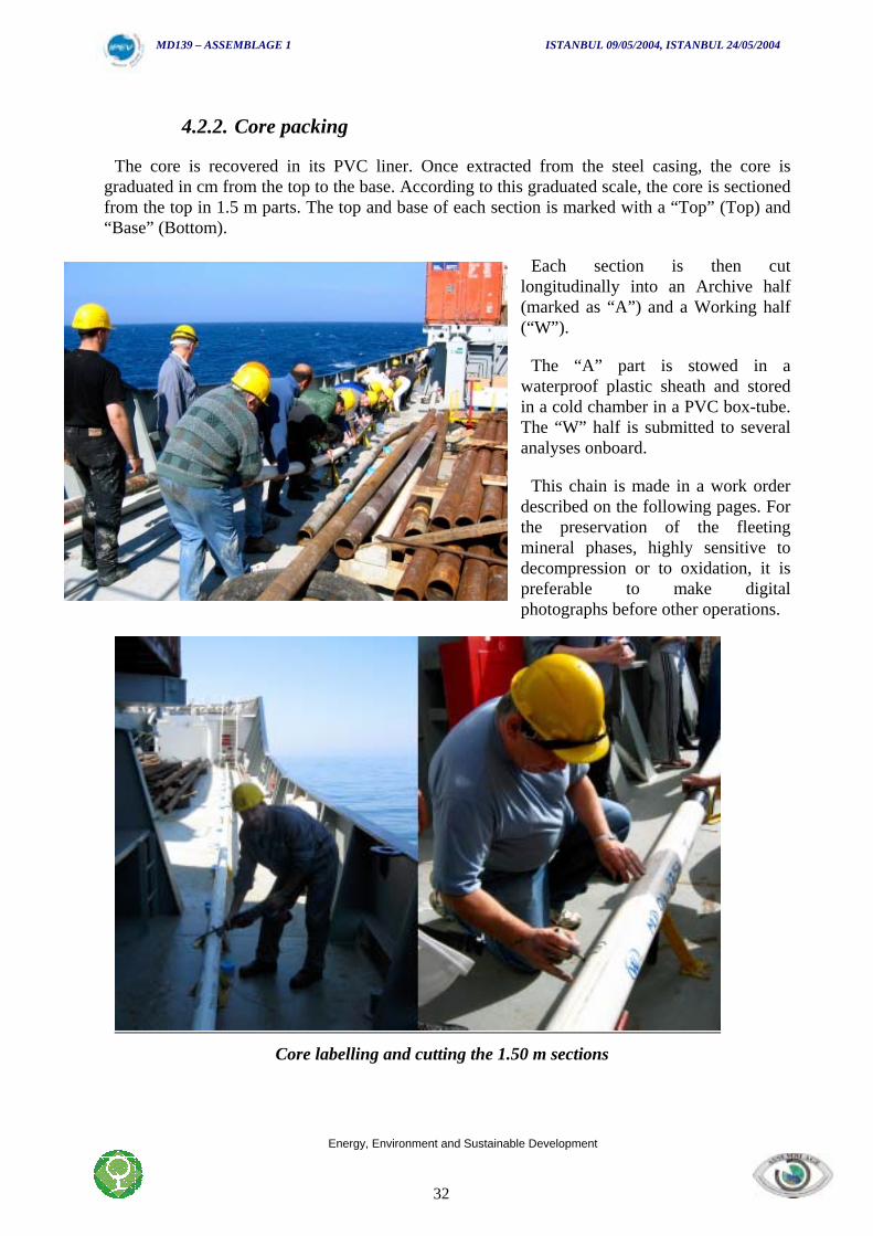
4.2.2. Core packing
The core is recovered in its PVC liner. Once extracted from the steel casing, the core isgraduated in cm from the top to the base. According to this graduated scale, the core is sectionedfrom the top in 1.5 m parts. The top and base of each section is marked with a “Top” (Top) and“Base” (Bottom).
Each section is then cutlongitudinally into an Archive half(marked as “A”) and a Working half(“W”).
The “A” part is stowed in awaterproof plastic sheath and storedin a cold chamber in a PVC box-tube.The “W” half is submitted to severalanalyses onboard.
This chain is made in a work orderdescribed on the following pages. Forthe preservation of the fleetingmineral phases, highly sensitive todecompression or to oxidation, it ispreferable to make digitalphotographs before other operations.
Core labelling and cutting the 1.50 m sections
MD139 – ASSEMBLAGE 1 ISTANBUL 09/05/2004, ISTANBUL 24/05/2004
Energy, Environment and Sustainable Development
33
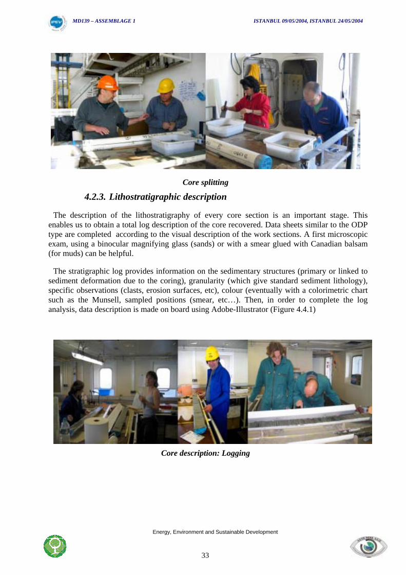
Core splitting
4.2.3. Lithostratigraphic description
The description of the lithostratigraphy of every core section is an important stage. Thisenables us to obtain a total log description of the core recovered. Data sheets similar to the ODPtype are completed according to the visual description of the work sections. A first microscopicexam, using a binocular magnifying glass (sands) or with a smear glued with Canadian balsam(for muds) can be helpful.
The stratigraphic log provides information on the sedimentary structures (primary or linked tosediment deformation due to the coring), granularity (which give standard sediment lithology),specific observations (clasts, erosion surfaces, etc), colour (eventually with a colorimetric chartsuch as the Munsell, sampled positions (smear, etc…). Then, in order to complete the loganalysis, data description is made on board using Adobe-Illustrator (Figure 4.4.1)
Core description: Logging
MD139 – ASSEMBLAGE 1 ISTANBUL 09/05/2004, ISTANBUL 24/05/2004
Energy, Environment and Sustainable Development
34
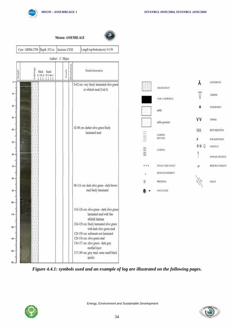
Figure 4.4.1: symbols used and an example of log are illustrated on the following pages.
MD139 – ASSEMBLAGE 1 ISTANBUL 09/05/2004, ISTANBUL 24/05/2004
Energy, Environment and Sustainable Development
35
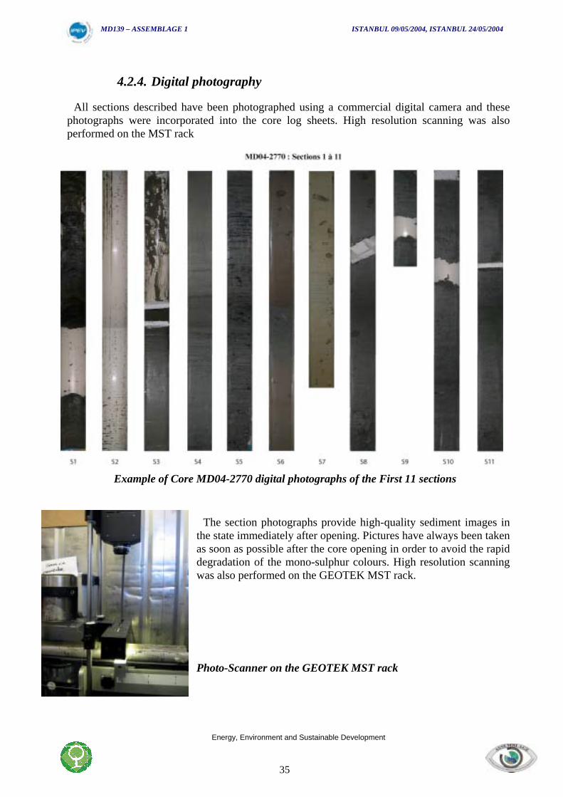
4.2.4. Digital photography
All sections described have been photographed using a commercial digital camera and thesephotographs were incorporated into the core log sheets. High resolution scanning was alsoperformed on the MST rack
Example of Core MD04-2770 digital photographs of the First 11 sections
The section photographs provide high-quality sediment images inthe state immediately after opening. Pictures have always been takenas soon as possible after the core opening in order to avoid the rapiddegradation of the mono-sulphur colours. High resolution scanningwas also performed on the GEOTEK MST rack.
Photo-Scanner on the GEOTEK MST rack
MD139 – ASSEMBLAGE 1 ISTANBUL 09/05/2004, ISTANBUL 24/05/2004
Energy, Environment and Sustainable Development
36
4.2.5. Colour spectrophotometry
The spectrophotometer enables us, in some case, to obtain a preliminary stratigraphic log basedon sediment colour variation along the sections.
The light-coloured tints could correspond in some cases to a more carbonate-rich sedimentsformed during relatively warmer periods, while dark ones may correspond to periods of a colderclimatic environment. The measure is undertaken when the work sections are covered by atransparent plastic film (to avoid pollution of the sensor in contact with the sediment). Since theequipment was not set up properly at the beginning of the cruise, only a few of last cores werestudied on board using the Spectro-colorimeter.
The spectrophotometer used is a Minolta CM-508i, using an 8 mm diameter disk sensor.Measurements are made continuously every 5cm. A colour spectrum (400-700 nm divided intosixteen 20 nm classes) is recorded.
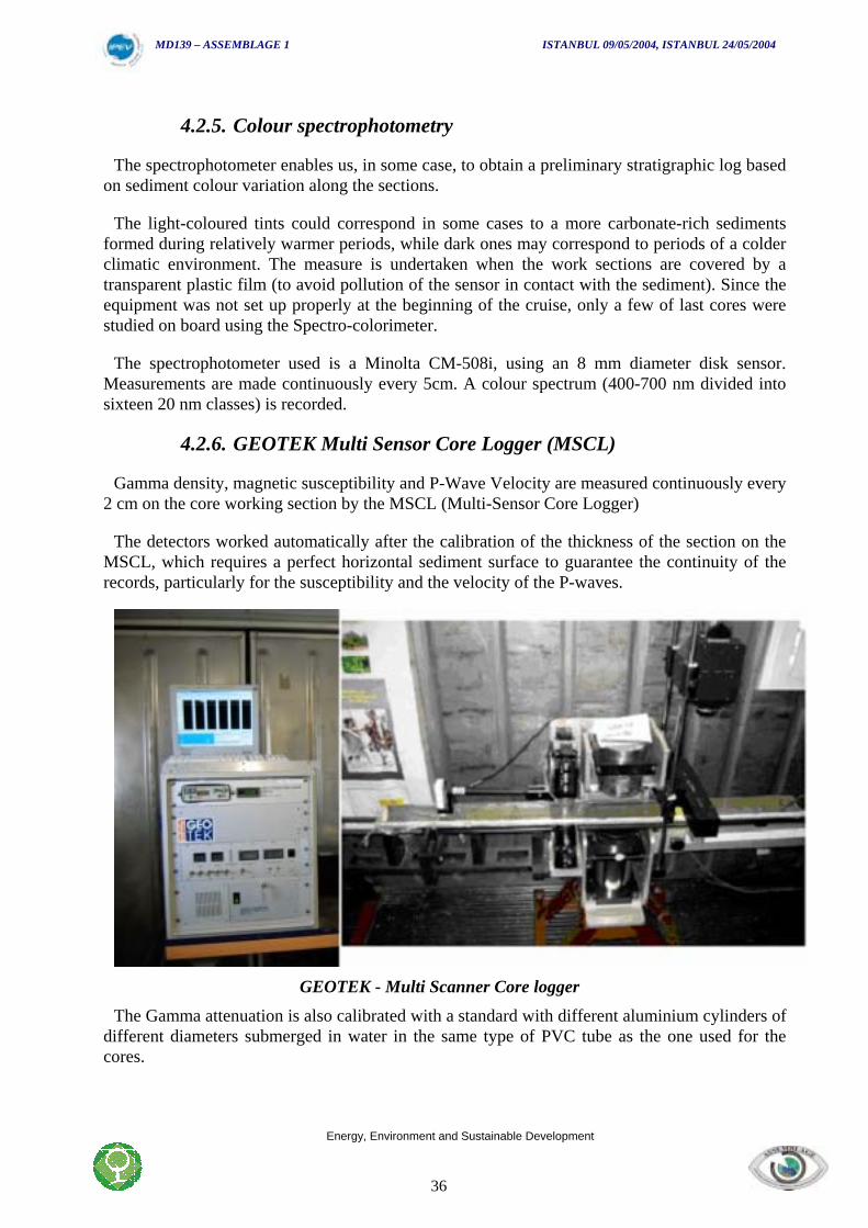
4.2.6. GEOTEK Multi Sensor Core Logger (MSCL)
Gamma density, magnetic susceptibility and P-Wave Velocity are measured continuously every2 cm on the core working section by the MSCL (Multi-Sensor Core Logger)
The detectors worked automatically after the calibration of the thickness of the section on theMSCL, which requires a perfect horizontal sediment surface to guarantee the continuity of therecords, particularly for the susceptibility and the velocity of the P-waves.
GEOTEK - Multi Scanner Core logger
The Gamma attenuation is also calibrated with a standard with different aluminium cylinders ofdifferent diameters submerged in water in the same type of PVC tube as the one used for thecores.
MD139 – ASSEMBLAGE 1 ISTANBUL 09/05/2004, ISTANBUL 24/05/2004
Energy, Environment and Sustainable Development
37
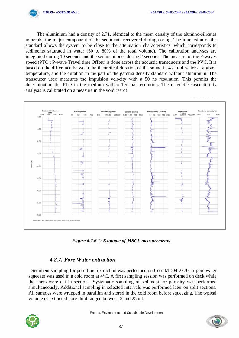
The aluminium had a density of 2.71, identical to the mean density of the alumino-silicatesminerals, the major component of the sediments recovered during coring. The immersion of thestandard allows the system to be close to the attenuation characteristics, which corresponds tosediments saturated in water (60 to 80% of the total volume). The calibration analyses areintegrated during 10 seconds and the sediment ones during 2 seconds. The measure of the P-wavesspeed (PTO : P-wave Travel time Offset) is done across the acoustic transducers and the PVC. It isbased on the difference between the theoretical duration of the sound in 4 cm of water at a giventemperature, and the duration in the part of the gamma density standard without aluminium. Thetransducer used measures the impulsion velocity with a 50 ns resolution. This permits thedetermination the PTO in the medium with a 1.5 m/s resolution. The magnetic susceptibilityanalysis is calibrated on a measure in the void (zero).
Figure 4.2.6.1: Example of MSCL measurements
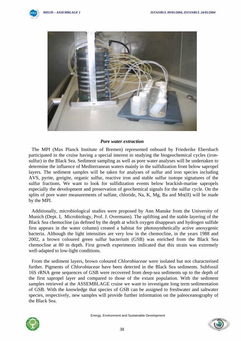
4.2.7. Pore Water extraction
Sediment sampling for pore fluid extraction was performed on Core MD04-2770. A pore watersqueezer was used in a cold room at 4°C. A first sampling session was performed on deck whilethe cores were cut in sections. Systematic sampling of sediment for porosity was performedsimultaneously. Additional sampling in selected intervals was performed later on split sections.All samples were wrapped in parafilm and stored in the cold room before squeezing. The typicalvolume of extracted pore fluid ranged between 5 and 25 ml.
MD139 – ASSEMBLAGE 1 ISTANBUL 09/05/2004, ISTANBUL 24/05/2004
Energy, Environment and Sustainable Development
38
Pore water extraction
The MPI (Max Planck Institute of Bremen) represented onboard by Friederike Ebersbachparticipated in the cruise having a special interest in studying the biogeochemical cycles (iron-sulfur) in the Black Sea. Sediment sampling as well as pore water analyses will be undertaken todetermine the influence of Mediterranean waters mainly in the sulfidization front below sapropellayers. The sediment samples will be taken for analyses of sulfur and iron species includingAVS, pyrite, greigite, organic sulfur, reactive iron and stable sulfur isotope signatures of thesulfur fractions. We want to look for sulfidization events below brackish-marine sapropelsespecially the development and preservation of geochemical signals for the sulfur cycle. On thesplits of pore water measurements of sulfate, chloride, Na, K, Mg, Ba and Mn(II) will be madeby the MPI.
Additionally, microbiological studies were proposed by Ann Manske from the University ofMunich (Dept. I, Microbiology, Prof. J. Overmann). The uplifting and the stable layering of theBlack Sea chemocline (as defined by the depth at which oxygen disappears and hydrogen sulfidefirst appears in the water column) created a habitat for photosynthetically active anoxygenicbacteria. Although the light intensities are very low in the chemocline, in the years 1988 and2002, a brown coloured green sulfur bacterium (GSB) was enriched from the Black Seachemocline at 80 m depth. First growth experiments indicated that this strain was extremelywell-adapted to low-light conditions.
From the sediment layers, brown coloured Chlorobiaceae were isolated but not characterisedfurther. Pigments of Chlorobiaceae have been detected in the Black Sea sediments. Subfossil16S rRNA gene sequences of GSB were recovered from deep-sea sediments up to the depth ofthe first sapropel layer and compared to those of the extant population. With the sedimentsamples retrieved at the ASSEMBLAGE cruise we want to investigate long term sedimentationof GSB. With the knowledge that species of GSB can be assigned to freshwater and saltwaterspecies, respectively, new samples will provide further information on the paleoceanography ofthe Black Sea.
MD139 – ASSEMBLAGE 1 ISTANBUL 09/05/2004, ISTANBUL 24/05/2004
Energy, Environment and Sustainable Development
39
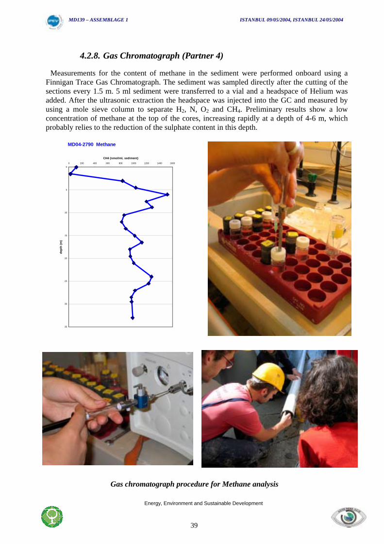
4.2.8. Gas Chromatograph (Partner 4)
Measurements for the content of methane in the sediment were performed onboard using aFinnigan Trace Gas Chromatograph. The sediment was sampled directly after the cutting of thesections every 1.5 m. 5 ml sediment were transferred to a vial and a headspace of Helium wasadded. After the ultrasonic extraction the headspace was injected into the GC and measured byusing a mole sieve column to separate H2, N, O2 and CH4. Preliminary results show a lowconcentration of methane at the top of the cores, increasing rapidly at a depth of 4-6 m, whichprobably relies to the reduction of the sulphate content in this depth.
MD04-2790 Methane
0
5
10
15
20
25
30
35
0 200 400 600 800 1000 1200 1400 1600
CH4 (nmol/mL sediment)
dept
h (m
)
Gas chromatograph procedure for Methane analysis
MD139 – ASSEMBLAGE 1 ISTANBUL 09/05/2004, ISTANBUL 24/05/2004
Energy, Environment and Sustainable Development
40
4.2.9. Sampling Ostracods (Ian Boomer University of Newcastle)
This contribution focuses on the potential application of Ostracoda (calcareous microfossils) toreconstruct past environmental conditions in the Black Sea as well as providing material thatmay be utilised for radiocarbon dating.
The Ostracoda (or ostracods) are an abundant and diverse group of small, aquatic crustaceans(0.3-3.0mm long as adults) which live in the oxic zone of the Black Sea today but are alsoknown as fossils in many of the pre-Holocene sediments. Each individual provides an importantsource of biogenic, low-magnesium, carbonate, which can be used, for stable-isotope analysis,trace-element geochemistry and carbon-14 studies.
Following reconnaissance studies of previous cruises (BLASON 1 and 2) it is known thatostracods are the only significant carbonate microfossil group present in many sedimentarysequences of the Black Sea and it is therefore important to understand the ecology of individualspecies (salinity, temperature and depth range) and establish the relationship between theircarbonate shell chemistry and environmental parameters.
To achieve this, ostracod subsamples have been recovered from the core-top interface atshallow sites and from one box-core. A number of living specimens have already been identifiedimmediately after sample collection and further studies of the samples will take place post-cruise. Three cores have initially been targeted for detailed stratigraphic analysis (MD04-2760,2761, 2783) while ogive (core-catcher) subsamples have been taken at each site.
This work is complimentary to that of Partner 11 (Univ. of Ancona, Italy) who are studyingbenthic foraminifera. Whereas the benthic foraminifera have a lower salinity limit at about 12psuthe ostracods range from fresh to marine waters and even into hypersaline conditions (withchanging species composition). Thus a combined micropalaeontological approach permitspalaeoenvironmental reconstruction across the full salinity range.
The ostracod work will be developed with the assistance of partners 5 (GeoEcoMar) and 6(University of Bucharest) with whom it is planned to undertake detailed modern sampling of arange of environments around the Black Sea coastline and in shallow water offshore settings.
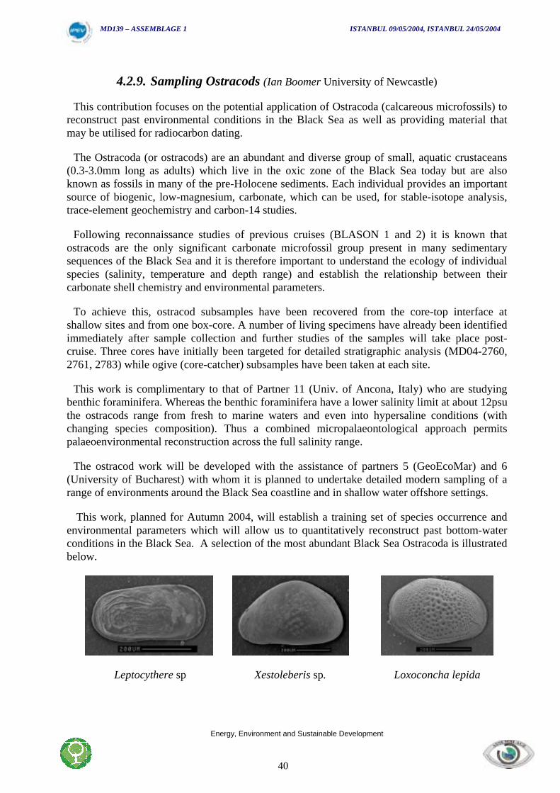
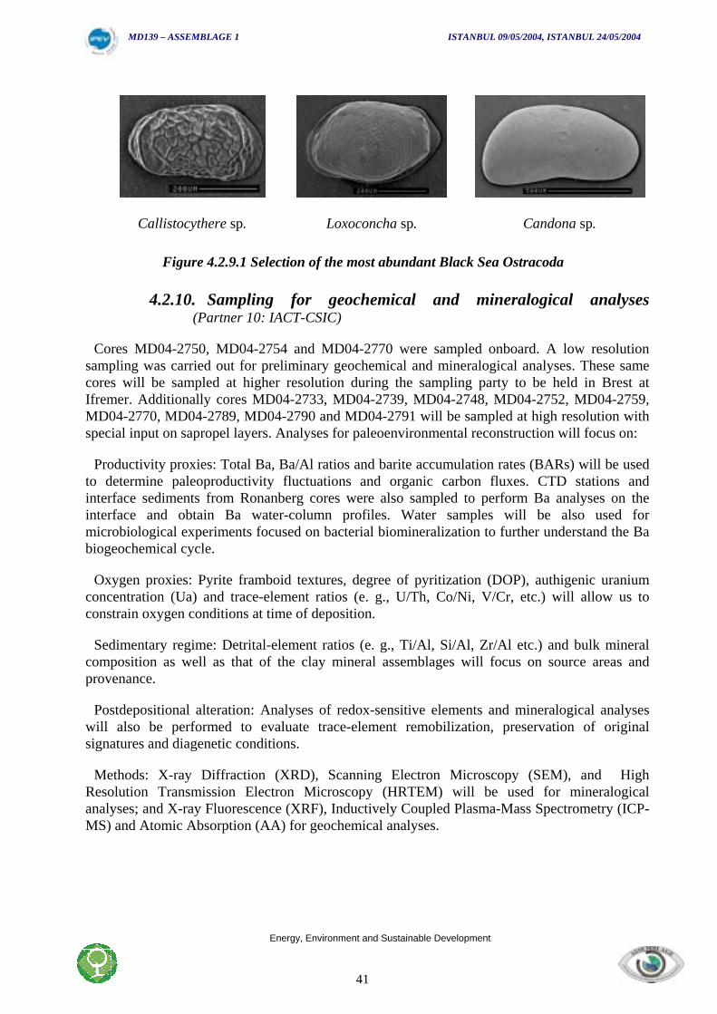
This work, planned for Autumn 2004, will establish a training set of species occurrence andenvironmental parameters which will allow us to quantitatively reconstruct past bottom-waterconditions in the Black Sea. A selection of the most abundant Black Sea Ostracoda is illustratedbelow.
Leptocythere sp Xestoleberis sp. Loxoconcha lepida
MD139 – ASSEMBLAGE 1 ISTANBUL 09/05/2004, ISTANBUL 24/05/2004
Energy, Environment and Sustainable Development
41
Callistocythere sp. Loxoconcha sp. Candona sp.
Figure 4.2.9.1 Selection of the most abundant Black Sea Ostracoda
4.2.10. Sampling for geochemical and mineralogical analyses(Partner 10: IACT-CSIC)
Cores MD04-2750, MD04-2754 and MD04-2770 were sampled onboard. A low resolutionsampling was carried out for preliminary geochemical and mineralogical analyses. These samecores will be sampled at higher resolution during the sampling party to be held in Brest atIfremer. Additionally cores MD04-2733, MD04-2739, MD04-2748, MD04-2752, MD04-2759,MD04-2770, MD04-2789, MD04-2790 and MD04-2791 will be sampled at high resolution withspecial input on sapropel layers. Analyses for paleoenvironmental reconstruction will focus on:
Productivity proxies: Total Ba, Ba/Al ratios and barite accumulation rates (BARs) will be usedto determine paleoproductivity fluctuations and organic carbon fluxes. CTD stations andinterface sediments from Ronanberg cores were also sampled to perform Ba analyses on theinterface and obtain Ba water-column profiles. Water samples will be also used formicrobiological experiments focused on bacterial biomineralization to further understand the Babiogeochemical cycle.
Oxygen proxies: Pyrite framboid textures, degree of pyritization (DOP), authigenic uraniumconcentration (Ua) and trace-element ratios (e. g., U/Th, Co/Ni, V/Cr, etc.) will allow us toconstrain oxygen conditions at time of deposition.
Sedimentary regime: Detrital-element ratios (e. g., Ti/Al, Si/Al, Zr/Al etc.) and bulk mineralcomposition as well as that of the clay mineral assemblages will focus on source areas andprovenance.
Postdepositional alteration: Analyses of redox-sensitive elements and mineralogical analyseswill also be performed to evaluate trace-element remobilization, preservation of originalsignatures and diagenetic conditions.
Methods: X-ray Diffraction (XRD), Scanning Electron Microscopy (SEM), and HighResolution Transmission Electron Microscopy (HRTEM) will be used for mineralogicalanalyses; and X-ray Fluorescence (XRF), Inductively Coupled Plasma-Mass Spectrometry (ICP-MS) and Atomic Absorption (AA) for geochemical analyses.
MD139 – ASSEMBLAGE 1 ISTANBUL 09/05/2004, ISTANBUL 24/05/2004
Energy, Environment and Sustainable Development
42
4.2.11. Sampling methodology used during the cruise MD139 byPartner 11 – (University of Ancona; Caterina Morigi)
Partner 11 collected different type of samples during the cruise to attain the different objectivesof our working unit.
4.2.11.1. Water samplesWater samples were collected to analyse the presence and to identified the different species of
phytoplankton (coccoliths and diatoms) living at present in the Black Sea. Different water depthfrom the surface to the sea bottom was selected to determine the presence of the livingcommunity and to determinate carbonate dissolution along the water column. To analyse thecoccolith assemblage 1 –3 litres of seawater are collected by Niskin bottle and stored in plasticbottle added to formaline 4% buffered by sodium borate. The water will be filtered through a0.45 micron Millipore filters (polycarbonate membranes, 50 mm diameter) at 200 mbar, dried at20°C and stored in petri dishes. Analyses will be performed with a light microscope at 1250U bycounting at least 300 specimens/sample. For diatoms assemblages 250 ml of seawater arecollected, stored in plastic bottle and fixed with formaline 4% buffered by sodium borate.
4.2.11.2. Recent sediment samplesWe collected recent sediment samples using Ronenberg core and box-corer to investigate the
living benthic community. In detail we study benthic foraminiferal community and theassociated meiofaunal assemblage. For each Ronenberg core we sampled a short core.Immediately this core was sub sampled each 1 centimetre form the top of the core until the 5centimetres. About 10 cc of sediment for each sample was stored in centrifuge vials and fixedwith formaline 4% buffered with sodium borate. We will evaluate surface sediment foraminiferalcontent using standard meiofaunal techniques. Rose Bengal stained fauna was differentiatedfrom the death assemblage. Analyses expected: Standing stock (n/cm2), taxonomic composition,species diversity, vertical distribution in the sediment.
4.2.11.3. Sediment coresCalcareous nannofossils are largely used to obtain biostratigraphy for the Holocene sediments
of the Black Sea, where as the analysis of the benthic foraminifera assemblage could beimproved our knowledge of the paleoenvironment in the shallower part (delta, prodelta area ofthe Danube delta) of the Black Sea.
On board we sampled 3 cores MD04-2750, MD04-2754, MD04-2770. The 3 cores of differentsedimentary setting are chosen to have a first insight of the biostratigraphy andpaleoenvironment conditions.
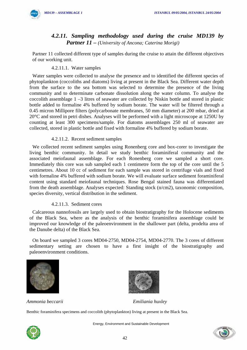
Ammonia beccarii Emiliania huxley
Benthic foraminifera specimens and coccolith (phytoplankton) living at present in the Black Sea.
MD139 – ASSEMBLAGE 1 ISTANBUL 09/05/2004, ISTANBUL 24/05/2004
Energy, Environment and Sustainable Development
43
4.3. CTD, Hydrology and Plankton nets
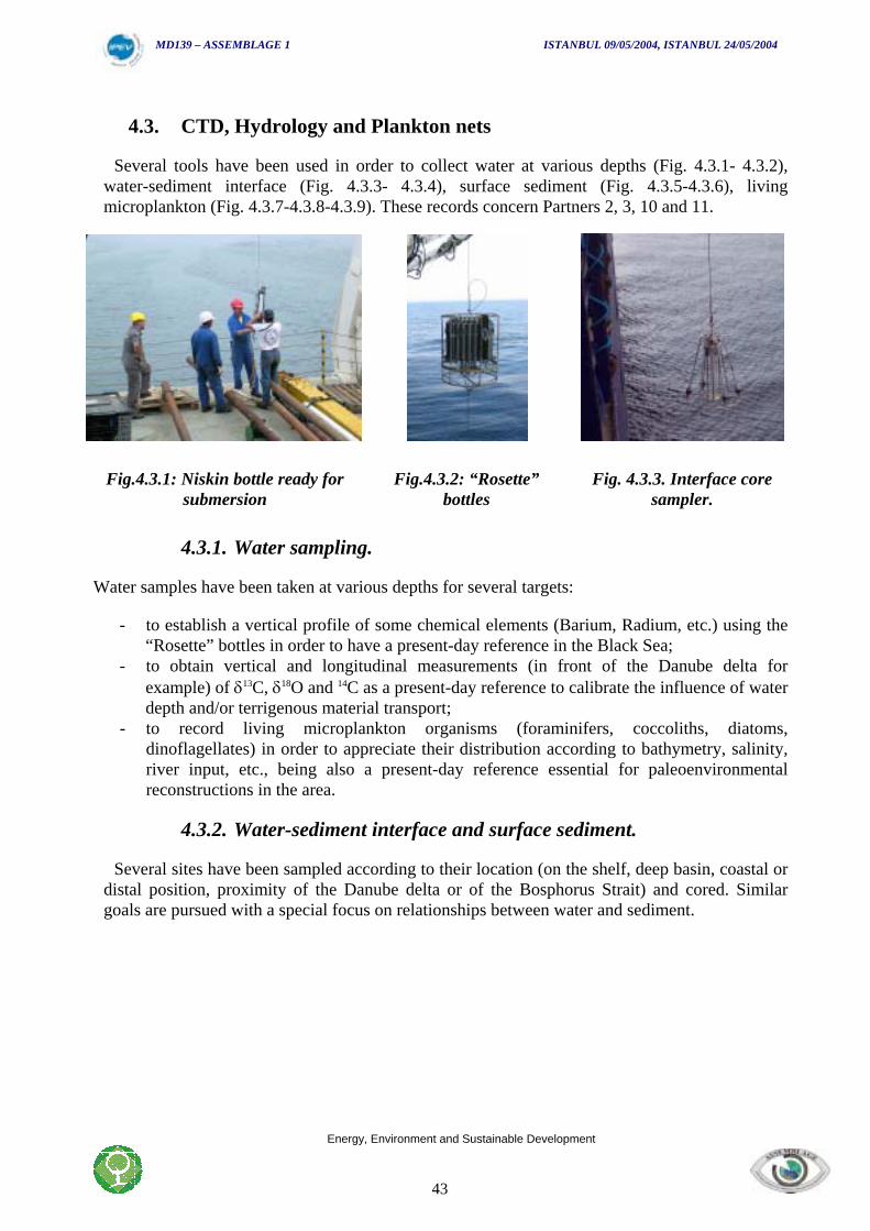
Several tools have been used in order to collect water at various depths (Fig. 4.3.1- 4.3.2),water-sediment interface (Fig. 4.3.3- 4.3.4), surface sediment (Fig. 4.3.5-4.3.6), livingmicroplankton (Fig. 4.3.7-4.3.8-4.3.9). These records concern Partners 2, 3, 10 and 11.
Fig.4.3.1: Niskin bottle ready forsubmersion
Fig.4.3.2: “Rosette”bottles
Fig. 4.3.3. Interface coresampler.
4.3.1. Water sampling.
Water samples have been taken at various depths for several targets:
- to establish a vertical profile of some chemical elements (Barium, Radium, etc.) using the“Rosette” bottles in order to have a present-day reference in the Black Sea;
- to obtain vertical and longitudinal measurements (in front of the Danube delta forexample) of δ13C, δ18O and 14C as a present-day reference to calibrate the influence of waterdepth and/or terrigenous material transport;
- to record living microplankton organisms (foraminifers, coccoliths, diatoms,dinoflagellates) in order to appreciate their distribution according to bathymetry, salinity,river input, etc., being also a present-day reference essential for paleoenvironmentalreconstructions in the area.
4.3.2. Water-sediment interface and surface sediment.
Several sites have been sampled according to their location (on the shelf, deep basin, coastal ordistal position, proximity of the Danube delta or of the Bosphorus Strait) and cored. Similargoals are pursued with a special focus on relationships between water and sediment.
MD139 – ASSEMBLAGE 1 ISTANBUL 09/05/2004, ISTANBUL 24/05/2004
Energy, Environment and Sustainable Development
44
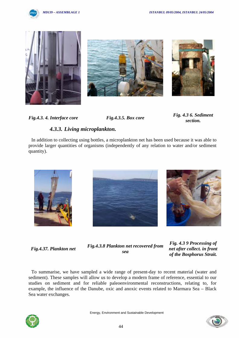
Fig.4.3. 4. Interface core Fig.4.3.5. Box core Fig. 4.3 6. Sedimentsection.
4.3.3. Living microplankton.
In addition to collecting using bottles, a microplankton net has been used because it was able toprovide larger quantities of organisms (independently of any relation to water and/or sedimentquantity).
Fig.4.37. Plankton net Fig.4.3.8 Plankton net recovered fromsea
Fig. 4.3 9 Processing ofnet after collect. in frontof the Bosphorus Strait.
To summarise, we have sampled a wide range of present-day to recent material (water andsediment). These samples will allow us to develop a modern frame of reference, essential to ourstudies on sediment and for reliable paleoenvironmental reconstructions, relating to, forexample, the influence of the Danube, oxic and anoxic events related to Marmara Sea – BlackSea water exchanges.

MD139 – ASSEMBLAGE 1 ISTANBUL 09/05/2004, ISTANBUL 24/05/2004
Energy, Environment and Sustainable Development
45

MD139 – ASSEMBLAGE 1 ISTANBUL 09/05/2004, ISTANBUL 24/05/2004
Energy, Environment and Sustainable Development
46
MD04-139 ASSEMBLAGE 1
Time Log

MD139 – ASSEMBLAGE 1 ISTANBUL 09/05/2004, ISTANBUL 24/05/2004
Energy, Environment and Sustainable Development
47
MD139 – ASSEMBLAGE 1 ISTANBUL 09/05/2004, ISTANBUL 24/05/2004
Energy, Environment and Sustainable Development
48
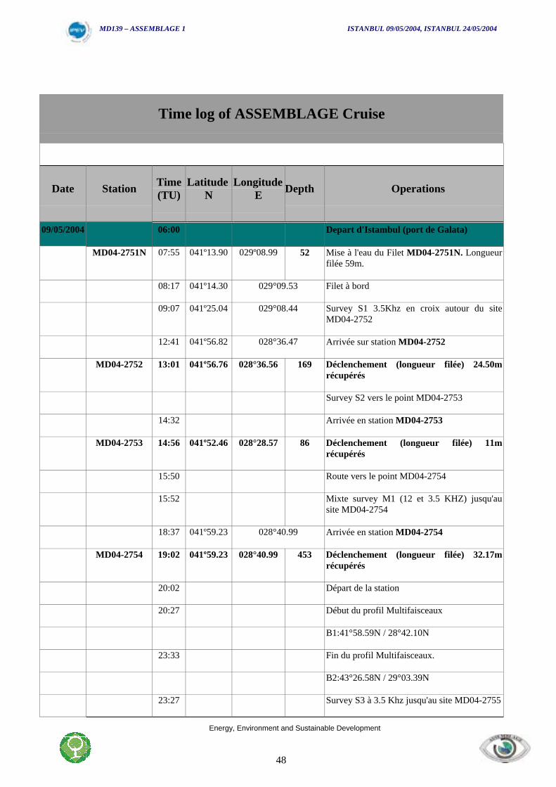
Time log of ASSEMBLAGE Cruise
Date Station Time(TU)
LatitudeN
LongitudeE Depth Operations
09/05/2004 06:00 Depart d'Istambul (port de Galata)
MD04-2751N 07:55 041º13.90 029º08.99 52 Mise à l'eau du Filet MD04-2751N. Longueurfilée 59m.
08:17 041º14.30 029°09.53 Filet à bord
09:07 041º25.04 029°08.44 Survey S1 3.5Khz en croix autour du siteMD04-2752
12:41 041º56.82 028°36.47 Arrivée sur station MD04-2752
MD04-2752 13:01 041º56.76 028°36.56 169 Déclenchement (longueur filée) 24.50mrécupérés
Survey S2 vers le point MD04-2753
14:32 Arrivée en station MD04-2753
MD04-2753 14:56 041º52.46 028°28.57 86 Déclenchement (longueur filée) 11mrécupérés
15:50 Route vers le point MD04-2754
15:52 Mixte survey M1 (12 et 3.5 KHZ) jusqu'ausite MD04-2754
18:37 041º59.23 028°40.99 Arrivée en station MD04-2754
MD04-2754 19:02 041º59.23 028°40.99 453 Déclenchement (longueur filée) 32.17mrécupérés
20:02 Départ de la station
20:27 Début du profil Multifaisceaux
B1:41°58.59N / 28°42.10N
23:33 Fin du profil Multifaisceaux.
B2:43°26.58N / 29°03.39N
23:27 Survey S3 à 3.5 Khz jusqu'au site MD04-2755
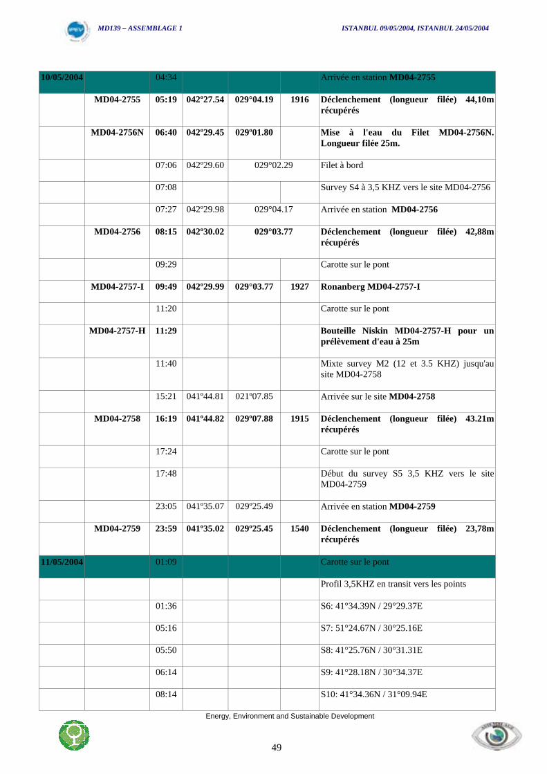
MD139 – ASSEMBLAGE 1 ISTANBUL 09/05/2004, ISTANBUL 24/05/2004
Energy, Environment and Sustainable Development
49
10/05/2004 04:34 Arrivée en station MD04-2755
MD04-2755 05:19 042º27.54 029°04.19 1916 Déclenchement (longueur filée) 44,10mrécupérés
MD04-2756N 06:40 042º29.45 029º01.80 Mise à l'eau du Filet MD04-2756N.Longueur filée 25m.
07:06 042º29.60 029°02.29 Filet à bord
07:08 Survey S4 à 3,5 KHZ vers le site MD04-2756
07:27 042º29.98 029°04.17 Arrivée en station MD04-2756
MD04-2756 08:15 042º30.02 029°03.77 Déclenchement (longueur filée) 42,88mrécupérés
09:29 Carotte sur le pont
MD04-2757-I 09:49 042º29.99 029°03.77 1927 Ronanberg MD04-2757-I
11:20 Carotte sur le pont
MD04-2757-H 11:29 Bouteille Niskin MD04-2757-H pour unprélèvement d'eau à 25m
11:40 Mixte survey M2 (12 et 3.5 KHZ) jusqu'ausite MD04-2758
15:21 041º44.81 021º07.85 Arrivée sur le site MD04-2758
MD04-2758 16:19 041º44.82 029º07.88 1915 Déclenchement (longueur filée) 43.21mrécupérés
17:24 Carotte sur le pont
17:48 Début du survey S5 3,5 KHZ vers le siteMD04-2759
23:05 041º35.07 029º25.49 Arrivée en station MD04-2759
MD04-2759 23:59 041º35.02 029º25.45 1540 Déclenchement (longueur filée) 23,78mrécupérés
11/05/2004 01:09 Carotte sur le pont
Profil 3,5KHZ en transit vers les points
01:36 S6: 41°34.39N / 29°29.37E
05:16 S7: 51°24.67N / 30°25.16E
05:50 S8: 41°25.76N / 30°31.31E
06:14 S9: 41°28.18N / 30°34.37E
08:14 S10: 41°34.36N / 31°09.94E
MD139 – ASSEMBLAGE 1 ISTANBUL 09/05/2004, ISTANBUL 24/05/2004
Energy, Environment and Sustainable Development
50
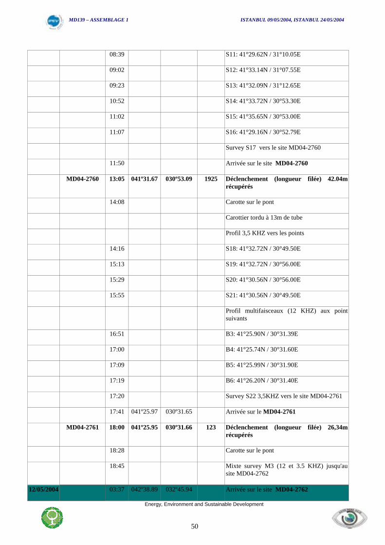
08:39 S11: 41°29.62N / 31°10.05E
09:02 S12: 41°33.14N / 31°07.55E
09:23 S13: 41°32.09N / 31°12.65E
10:52 S14: 41°33.72N / 30°53.30E
11:02 S15: 41°35.65N / 30°53.00E
11:07 S16: 41°29.16N / 30°52.79E
Survey S17 vers le site MD04-2760
11:50 Arrivée sur le site MD04-2760
MD04-2760 13:05 041º31.67 030º53.09 1925 Déclenchement (longueur filée) 42.04mrécupérés
14:08 Carotte sur le pont
Carottier tordu à 13m de tube
Profil 3,5 KHZ vers les points
14:16 S18: 41°32.72N / 30°49.50E
15:13 S19: 41°32.72N / 30°56.00E
15:29 S20: 41°30.56N / 30°56.00E
15:55 S21: 41°30.56N / 30°49.50E
Profil multifaisceaux (12 KHZ) aux pointsuivants
16:51 B3: 41°25.90N / 30°31.39E
17:00 B4: 41°25.74N / 30°31.60E
17:09 B5: 41°25.99N / 30°31.90E
17:19 B6: 41°26.20N / 30°31.40E
17:20 Survey S22 3,5KHZ vers le site MD04-2761
17:41 041º25.97 030º31.65 Arrivée sur le MD04-2761
MD04-2761 18:00 041º25.95 030º31.66 123 Déclenchement (longueur filée) 26,34mrécupérés
18:28 Carotte sur le pont
18:45 Mixte survey M3 (12 et 3.5 KHZ) jusqu'ausite MD04-2762
12/05/2004 03:37 042º38.89 032º45.94 Arrivée sur le site MD04-2762
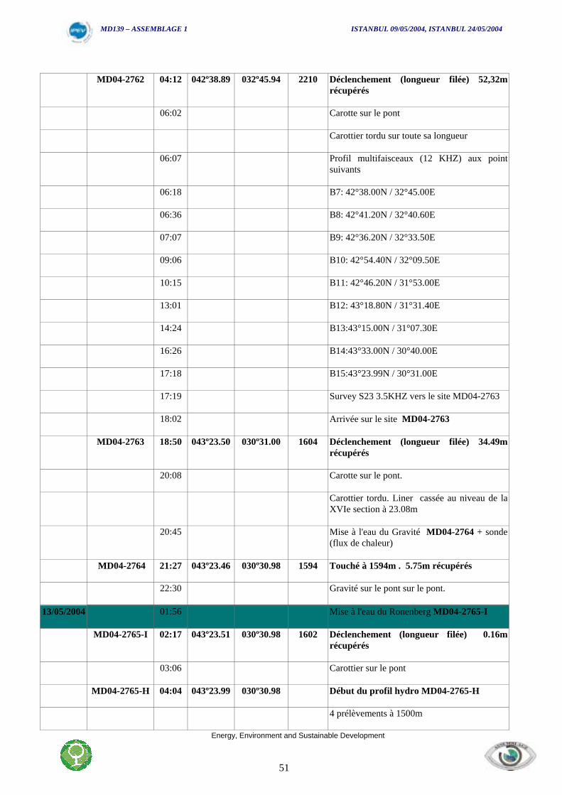
MD139 – ASSEMBLAGE 1 ISTANBUL 09/05/2004, ISTANBUL 24/05/2004
Energy, Environment and Sustainable Development
51
MD04-2762 04:12 042º38.89 032º45.94 2210 Déclenchement (longueur filée) 52,32mrécupérés
06:02 Carotte sur le pont
Carottier tordu sur toute sa longueur
06:07 Profil multifaisceaux (12 KHZ) aux pointsuivants
06:18 B7: 42°38.00N / 32°45.00E
06:36 B8: 42°41.20N / 32°40.60E
07:07 B9: 42°36.20N / 32°33.50E
09:06 B10: 42°54.40N / 32°09.50E
10:15 B11: 42°46.20N / 31°53.00E
13:01 B12: 43°18.80N / 31°31.40E
14:24 B13:43°15.00N / 31°07.30E
16:26 B14:43°33.00N / 30°40.00E
17:18 B15:43°23.99N / 30°31.00E
17:19 Survey S23 3.5KHZ vers le site MD04-2763
18:02 Arrivée sur le site MD04-2763
MD04-2763 18:50 043º23.50 030º31.00 1604 Déclenchement (longueur filée) 34.49mrécupérés
20:08 Carotte sur le pont.
Carottier tordu. Liner cassée au niveau de laXVIe section à 23.08m
20:45 Mise à l'eau du Gravité MD04-2764 + sonde(flux de chaleur)
MD04-2764 21:27 043º23.46 030º30.98 1594 Touché à 1594m . 5.75m récupérés
22:30 Gravité sur le pont sur le pont.
13/05/2004 01:56 Mise à l'eau du Ronenberg MD04-2765-I
MD04-2765-I 02:17 043º23.51 030º30.98 1602 Déclenchement (longueur filée) 0.16mrécupérés
03:06 Carottier sur le pont
MD04-2765-H 04:04 043º23.99 030º30.98 Début du profil hydro MD04-2765-H
4 prélèvements à 1500m
MD139 – ASSEMBLAGE 1 ISTANBUL 09/05/2004, ISTANBUL 24/05/2004
Energy, Environment and Sustainable Development
52
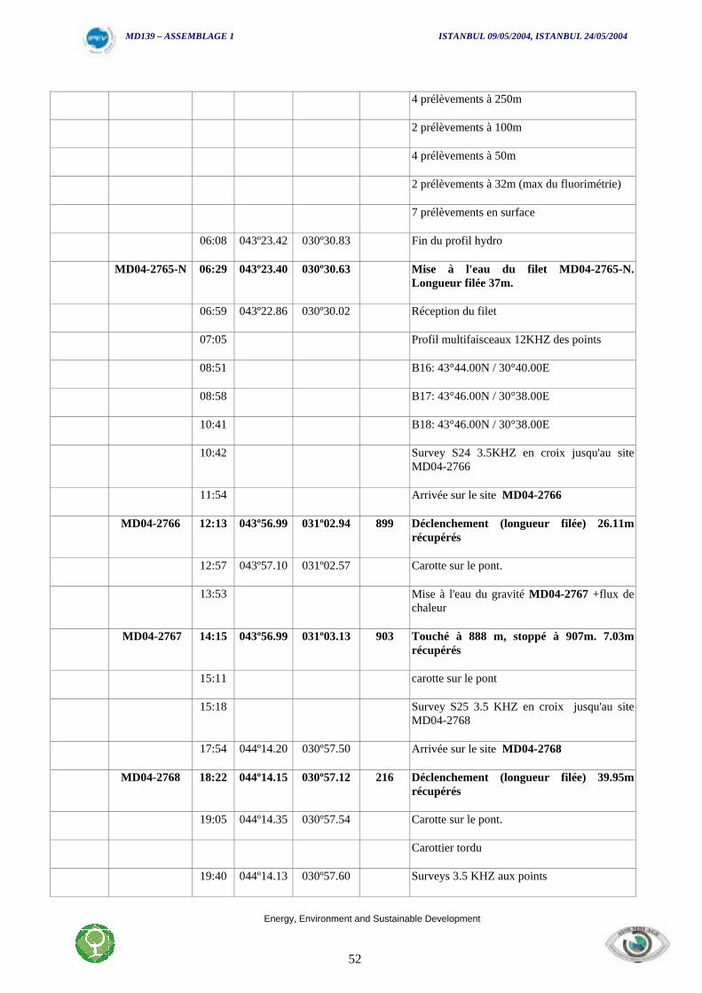
4 prélèvements à 250m
2 prélèvements à 100m
4 prélèvements à 50m
2 prélèvements à 32m (max du fluorimétrie)
7 prélèvements en surface
06:08 043º23.42 030º30.83 Fin du profil hydro
MD04-2765-N 06:29 043º23.40 030º30.63 Mise à l'eau du filet MD04-2765-N.Longueur filée 37m.
06:59 043º22.86 030º30.02 Réception du filet
07:05 Profil multifaisceaux 12KHZ des points
08:51 B16: 43°44.00N / 30°40.00E
08:58 B17: 43°46.00N / 30°38.00E
10:41 B18: 43°46.00N / 30°38.00E
10:42 Survey S24 3.5KHZ en croix jusqu'au siteMD04-2766
11:54 Arrivée sur le site MD04-2766
MD04-2766 12:13 043º56.99 031º02.94 899 Déclenchement (longueur filée) 26.11mrécupérés
12:57 043º57.10 031º02.57 Carotte sur le pont.
13:53 Mise à l'eau du gravité MD04-2767 +flux dechaleur
MD04-2767 14:15 043º56.99 031º03.13 903 Touché à 888 m, stoppé à 907m. 7.03mrécupérés
15:11 carotte sur le pont
15:18 Survey S25 3.5 KHZ en croix jusqu'au siteMD04-2768
17:54 044º14.20 030º57.50 Arrivée sur le site MD04-2768
MD04-2768 18:22 044º14.15 030º57.12 216 Déclenchement (longueur filée) 39.95mrécupérés
19:05 044º14.35 030º57.54 Carotte sur le pont.
Carottier tordu
19:40 044º14.13 030º57.60 Surveys 3.5 KHZ aux points
MD139 – ASSEMBLAGE 1 ISTANBUL 09/05/2004, ISTANBUL 24/05/2004
Energy, Environment and Sustainable Development
53
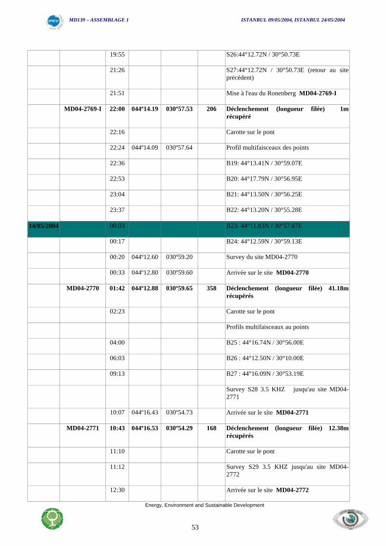
19:55 S26:44°12.72N / 30°50.73E
21:26 S27:44°12.72N / 30°50.73E (retour au siteprécédent)
21:51 Mise à l'eau du Ronenberg MD04-2769-I
MD04-2769-I 22:00 044º14.19 030º57.53 206 Déclenchement (longueur filée) 1mrécupéré
22:16 Carotte sur le pont
22:24 044º14.09 030º57.64 Profil multifaisceaux des points
22:36 B19: 44°13.41N / 30°59.07E
22:53 B20: 44°17.79N / 30°56.95E
23:04 B21: 44°13.50N / 30°56.25E
23:37 B22: 44°13.20N / 30°55.28E
14/05/2004 00:03 B23: 44°11.83N / 30°57.67E
00:17 B24: 44°12.59N / 30°59.13E
00:20 044º12.60 030º59.20 Survey du site MD04-2770
00:33 044º12.80 030º59.60 Arrivée sur le site MD04-2770
MD04-2770 01:42 044º12.88 030º59.65 358 Déclenchement (longueur filée) 41.18mrécupérés
02:23 Carotte sur le pont
Profils multifaisceaux au points
04:00 B25 : 44°16.74N / 30°56.00E
06:03 B26 : 44°12.50N / 30°10.00E
09:13 B27 : 44°16.09N / 30°53.19E
Survey S28 3.5 KHZ jusqu'au site MD04-2771
10:07 044º16.43 030º54.73 Arrivée sur le site MD04-2771
MD04-2771 10:43 044º16.53 030º54.29 168 Déclenchement (longueur filée) 12.38mrécupérés
11:10 Carotte sur le pont
11:12 Survey S29 3.5 KHZ jusqu'au site MD04-2772
12:30 Arrivée sur le site MD04-2772

MD139 – ASSEMBLAGE 1 ISTANBUL 09/05/2004, ISTANBUL 24/05/2004
Energy, Environment and Sustainable Development
54
MD04-2772 13:08 044º18.07 030º51.56 120 Déclenchement (longueur filée) 7.51mrécupérés
13:27 Carotte sur le pont
13:34 Survey S30 3.5 KHZ jusqu'au site MD04-2773 + survey en croix
17:07 044º37.82 030º20.37 Arrivée sur le site MD04-2773
MD04-2773 17:54 044º37.96 030º20.57 68 Déclenchement (longueur filée) 3.63mrécupérés
18:04 Carotte sur le pont
18:15 Survey S31 3.5 KHZ jusqu'au site MD04-2774 + survey en croix
21:39 Arrivée sur le site MD04-2774
MD04-2774-H 21:48 044º57.47 029º50.12 Début du profil hydro MD04-2774-H
21:59 4 prélèvements à 30m
22:03 4 prélèvements à 15m
22:05 4 prélèvements en surface
22:10 044º57.46 029º50.13 Fin du profil hydro
22:27 044º57.45 029º50.11 Mise à l'eau du Calypso MD04-2774
MD04-2774 22:38 044º57.45 029º50.11 30 Déclenchement (longueur filée) 7.30mrécupérés
23:16 Mise à l'eau du Ronenberg MD04-2775-I
MD04-2775-I 23:20 044º57.45 029º50.11 30 Déclenchement (longueur filée) 7.30mrécupérés
MD04-2775-N 23:47 044º57.46 029º50.21 Mise à l'eau du filet MD04-2775-N.Longueur filée 18m pour 15m
15/05/2004 00:07 044º57.50 029º50.21 Réception du filet
Profils multifaisceaux au points
05:31 B28 : 43°59.50N / 30°30.72E
08:13 B29 : 43°37.85N / 31°04.60E
09:55 B30 : 43°34.82N / 30°57.56E
10:00 B31 : 43°46.90N / 30°39.92E
10:18 B32 : 43°44.59N / 30°35.45E
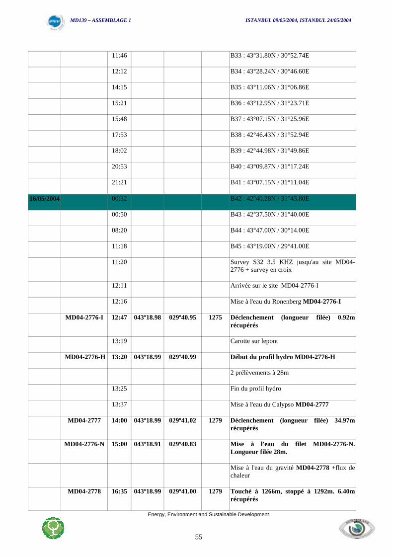
MD139 – ASSEMBLAGE 1 ISTANBUL 09/05/2004, ISTANBUL 24/05/2004
Energy, Environment and Sustainable Development
55
11:46 B33 : 43°31.80N / 30°52.74E
12:12 B34 : 43°28.24N / 30°46.60E
14:15 B35 : 43°11.06N / 31°06.86E
15:21 B36 : 43°12.95N / 31°23.71E
15:48 B37 : 43°07.15N / 31°25.96E
17:53 B38 : 42°46.43N / 31°52.94E
18:02 B39 : 42°44.98N / 31°49.86E
20:53 B40 : 43°09.87N / 31°17.24E
21:21 B41 : 43°07.15N / 31°11.04E
16/05/2004 00:32 B42 : 42°40.28N / 31°43.80E
00:50 B43 : 42°37.50N / 31°40.00E
08:20 B44 : 43°47.00N / 30°14.00E
11:18 B45 : 43°19.00N / 29°41.00E
11:20 Survey S32 3.5 KHZ jusqu'au site MD04-2776 + survey en croix
12:11 Arrivée sur le site MD04-2776-I
12:16 Mise à l'eau du Ronenberg MD04-2776-I
MD04-2776-I 12:47 043º18.98 029º40.95 1275 Déclenchement (longueur filée) 0.92mrécupérés
13:19 Carotte sur lepont
MD04-2776-H 13:20 043º18.99 029º40.99 Début du profil hydro MD04-2776-H
2 prélèvements à 28m
13:25 Fin du profil hydro
13:37 Mise à l'eau du Calypso MD04-2777
MD04-2777 14:00 043º18.99 029º41.02 1279 Déclenchement (longueur filée) 34.97mrécupérés
MD04-2776-N 15:00 043º18.91 029º40.83 Mise à l'eau du filet MD04-2776-N.Longueur filée 28m.
Mise à l'eau du gravité MD04-2778 +flux dechaleur
MD04-2778 16:35 043º18.99 029º41.00 1279 Touché à 1266m, stoppé à 1292m. 6.40mrécupérés
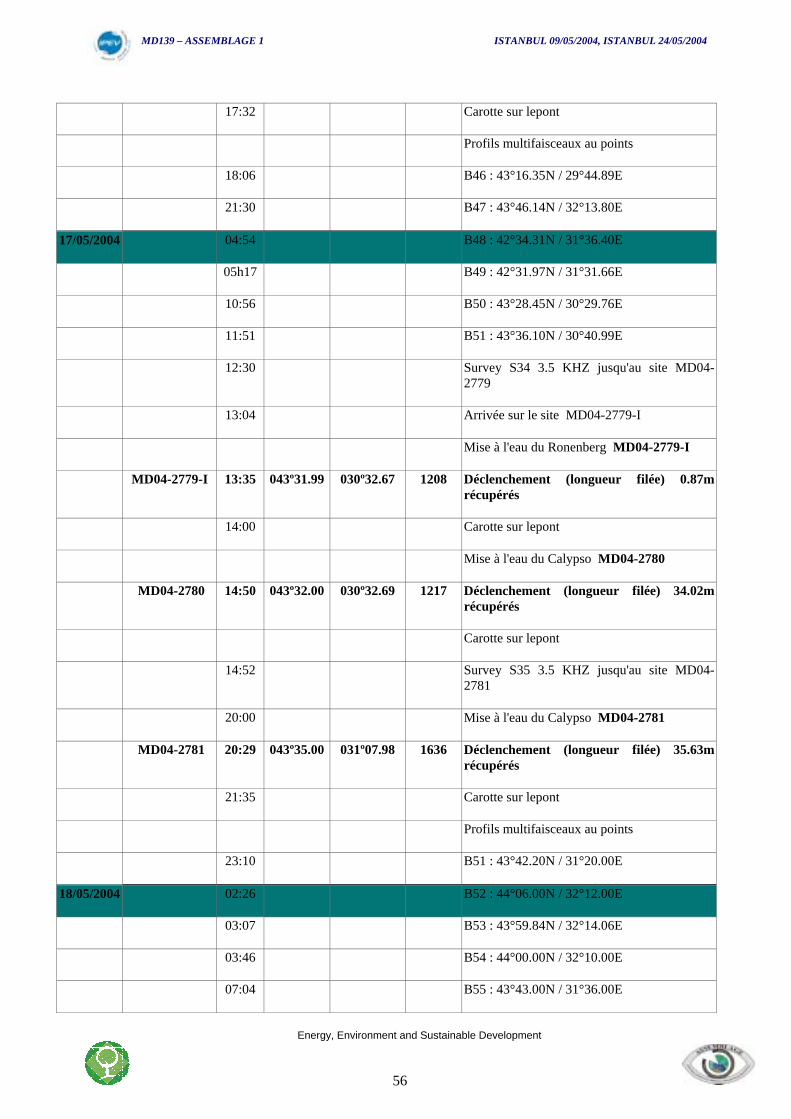
MD139 – ASSEMBLAGE 1 ISTANBUL 09/05/2004, ISTANBUL 24/05/2004
Energy, Environment and Sustainable Development
56
17:32 Carotte sur lepont
Profils multifaisceaux au points
18:06 B46 : 43°16.35N / 29°44.89E
21:30 B47 : 43°46.14N / 32°13.80E
17/05/2004 04:54 B48 : 42°34.31N / 31°36.40E
05h17 B49 : 42°31.97N / 31°31.66E
10:56 B50 : 43°28.45N / 30°29.76E
11:51 B51 : 43°36.10N / 30°40.99E
12:30 Survey S34 3.5 KHZ jusqu'au site MD04-2779
13:04 Arrivée sur le site MD04-2779-I
Mise à l'eau du Ronenberg MD04-2779-I
MD04-2779-I 13:35 043º31.99 030º32.67 1208 Déclenchement (longueur filée) 0.87mrécupérés
14:00 Carotte sur lepont
Mise à l'eau du Calypso MD04-2780
MD04-2780 14:50 043º32.00 030º32.69 1217 Déclenchement (longueur filée) 34.02mrécupérés
Carotte sur lepont
14:52 Survey S35 3.5 KHZ jusqu'au site MD04-2781
20:00 Mise à l'eau du Calypso MD04-2781
MD04-2781 20:29 043º35.00 031º07.98 1636 Déclenchement (longueur filée) 35.63mrécupérés
21:35 Carotte sur lepont
Profils multifaisceaux au points
23:10 B51 : 43°42.20N / 31°20.00E
18/05/2004 02:26 B52 : 44°06.00N / 32°12.00E
03:07 B53 : 43°59.84N / 32°14.06E
03:46 B54 : 44°00.00N / 32°10.00E
07:04 B55 : 43°43.00N / 31°36.00E
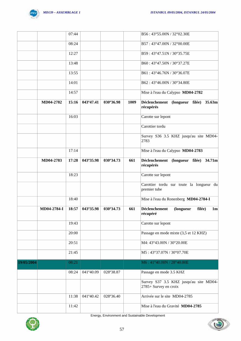
MD139 – ASSEMBLAGE 1 ISTANBUL 09/05/2004, ISTANBUL 24/05/2004
Energy, Environment and Sustainable Development
57
07:44 B56 : 43°55.00N / 32°02.30E
08:24 B57 : 43°47.00N / 32°00.00E
12:27 B59 : 43°47.51N / 30°35.75E
13:48 B60 : 43°47.50N / 30°37.27E
13:55 B61 : 43°46.76N / 30°36.07E
14:01 B62 : 43°46.00N / 30°34.80E
14:57 Mise à l'eau du Calypso MD04-2782
MD04-2782 15:16 043º47.41 030º36.98 1009 Déclenchement (longueur filée) 35.63mrécupérés
16:03 Carotte sur lepont
Carottier tordu
Survey S36 3.5 KHZ jusqu'au site MD04-2783
17:14 Mise à l'eau du Calypso MD04-2783
MD04-2783 17:28 043º35.98 030º34.73 661 Déclenchement (longueur filée) 34.71mrécupérés
18:23 Carotte sur lepont
Carottier tordu sur toute la longueur dupremier tube
18:40 Mise à l'eau du Ronenberg MD04-2784-I
MD04-2784-I 18:57 043º35.98 030º34.73 661 Déclenchement (longueur filée) 1mrécupéré
19:43 Carotte sur lepont
20:00 Passage en mode mixte (3,5 et 12 KHZ)
20:51 M4: 43°43.00N / 30°20.00E
21:45 M5 : 43°37.07N / 30°07.70E
19/05/2004 08:21 M6 : 41°40.00N / 28°40.00E
08:24 041º40.09 028º38.87 Passage en mode 3.5 KHZ
Survey S37 3.5 KHZ jusqu'au site MD04-2785+ Survey en croix
11:38 041º40.42 028º36.40 Arrivée sur le site MD04-2785
11:42 Mise à l'eau du Gravité MD04-2785
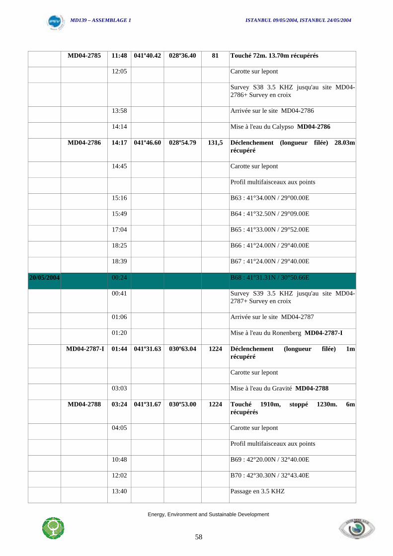
MD139 – ASSEMBLAGE 1 ISTANBUL 09/05/2004, ISTANBUL 24/05/2004
Energy, Environment and Sustainable Development
58
MD04-2785 11:48 041º40.42 028º36.40 81 Touché 72m. 13.70m récupérés
12:05 Carotte sur lepont
Survey S38 3.5 KHZ jusqu'au site MD04-2786+ Survey en croix
13:58 Arrivée sur le site MD04-2786
14:14 Mise à l'eau du Calypso MD04-2786
MD04-2786 14:17 041º46.60 028º54.79 131,5 Déclenchement (longueur filée) 28.03mrécupéré
14:45 Carotte sur lepont
Profil multifaisceaux aux points
15:16 B63 : 41°34.00N / 29°00.00E
15:49 B64 : 41°32.50N / 29°09.00E
17:04 B65 : 41°33.00N / 29°52.00E
18:25 B66 : 41°24.00N / 29°40.00E
18:39 B67 : 41°24.00N / 29°40.00E
20/05/2004 00:24 B68 : 41°31.31N / 30°50.66E
00:41 Survey S39 3.5 KHZ jusqu'au site MD04-2787+ Survey en croix
01:06 Arrivée sur le site MD04-2787
01:20 Mise à l'eau du Ronenberg MD04-2787-I
MD04-2787-I 01:44 041º31.63 030º63.04 1224 Déclenchement (longueur filée) 1mrécupéré
Carotte sur lepont
03:03 Mise à l'eau du Gravité MD04-2788
MD04-2788 03:24 041º31.67 030º53.00 1224 Touché 1910m, stoppé 1230m. 6mrécupérés
04:05 Carotte sur lepont
Profil multifaisceaux aux points
10:48 B69 : 42°20.00N / 32°40.00E
12:02 B70 : 42°30.30N / 32°43.40E
13:40 Passage en 3.5 KHZ
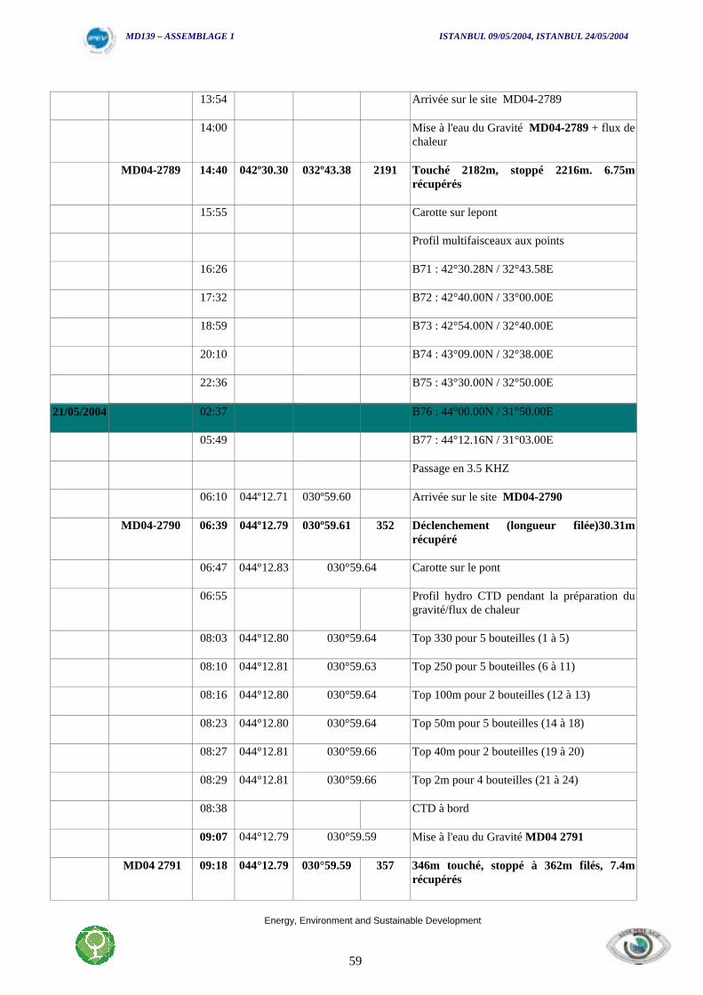
MD139 – ASSEMBLAGE 1 ISTANBUL 09/05/2004, ISTANBUL 24/05/2004
Energy, Environment and Sustainable Development
59
13:54 Arrivée sur le site MD04-2789
14:00 Mise à l'eau du Gravité MD04-2789 + flux dechaleur
MD04-2789 14:40 042º30.30 032º43.38 2191 Touché 2182m, stoppé 2216m. 6.75mrécupérés
15:55 Carotte sur lepont
Profil multifaisceaux aux points
16:26 B71 : 42°30.28N / 32°43.58E
17:32 B72 : 42°40.00N / 33°00.00E
18:59 B73 : 42°54.00N / 32°40.00E
20:10 B74 : 43°09.00N / 32°38.00E
22:36 B75 : 43°30.00N / 32°50.00E
21/05/2004 02:37 B76 : 44°00.00N / 31°50.00E
05:49 B77 : 44°12.16N / 31°03.00E
Passage en 3.5 KHZ
06:10 044º12.71 030º59.60 Arrivée sur le site MD04-2790
MD04-2790 06:39 044º12.79 030º59.61 352 Déclenchement (longueur filée)30.31mrécupéré
06:47 044°12.83 030°59.64 Carotte sur le pont
06:55 Profil hydro CTD pendant la préparation dugravité/flux de chaleur
08:03 044°12.80 030°59.64 Top 330 pour 5 bouteilles (1 à 5)
08:10 044°12.81 030°59.63 Top 250 pour 5 bouteilles (6 à 11)
08:16 044°12.80 030°59.64 Top 100m pour 2 bouteilles (12 à 13)
08:23 044°12.80 030°59.64 Top 50m pour 5 bouteilles (14 à 18)
08:27 044°12.81 030°59.66 Top 40m pour 2 bouteilles (19 à 20)
08:29 044°12.81 030°59.66 Top 2m pour 4 bouteilles (21 à 24)
08:38 CTD à bord
09:07 044°12.79 030°59.59 Mise à l'eau du Gravité MD04 2791
MD04 2791 09:18 044°12.79 030°59.59 357 346m touché, stoppé à 362m filés, 7.4mrécupérés
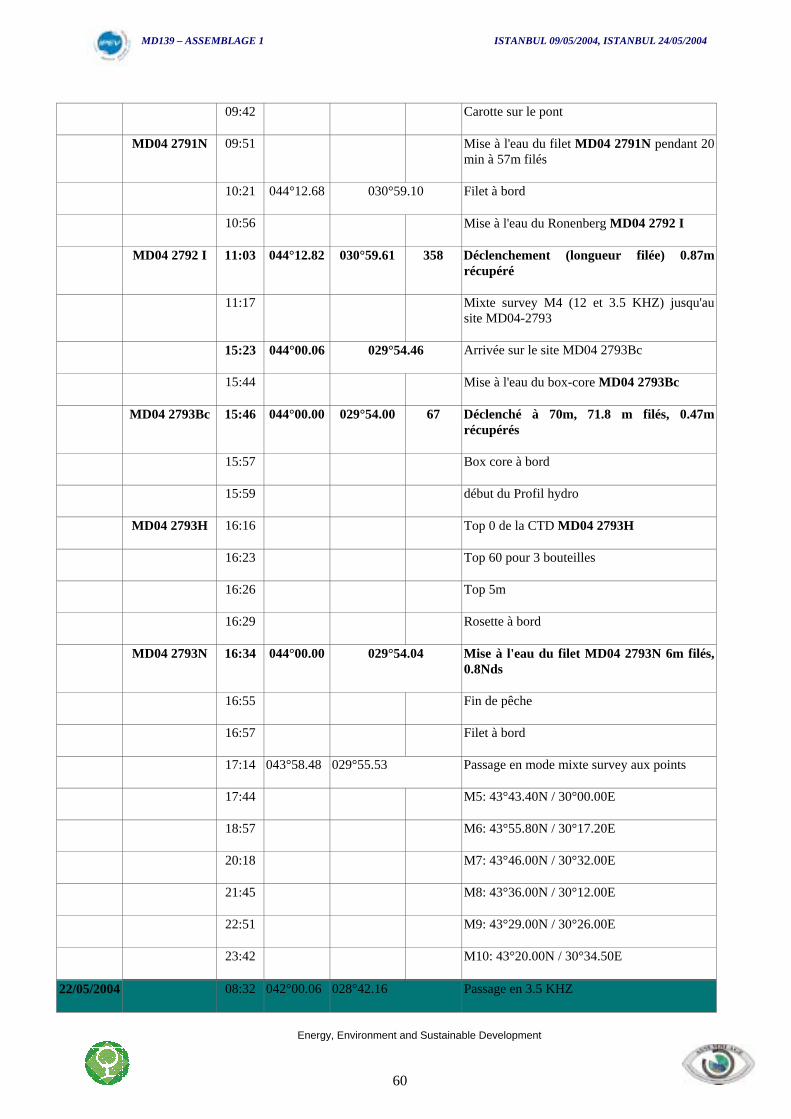
MD139 – ASSEMBLAGE 1 ISTANBUL 09/05/2004, ISTANBUL 24/05/2004
Energy, Environment and Sustainable Development
60
09:42 Carotte sur le pont
MD04 2791N 09:51 Mise à l'eau du filet MD04 2791N pendant 20min à 57m filés
10:21 044°12.68 030°59.10 Filet à bord
10:56 Mise à l'eau du Ronenberg MD04 2792 I
MD04 2792 I 11:03 044°12.82 030°59.61 358 Déclenchement (longueur filée) 0.87mrécupéré
11:17 Mixte survey M4 (12 et 3.5 KHZ) jusqu'ausite MD04-2793
15:23 044°00.06 029°54.46 Arrivée sur le site MD04 2793Bc
15:44 Mise à l'eau du box-core MD04 2793Bc
MD04 2793Bc 15:46 044°00.00 029°54.00 67 Déclenché à 70m, 71.8 m filés, 0.47mrécupérés
15:57 Box core à bord
15:59 début du Profil hydro
MD04 2793H 16:16 Top 0 de la CTD MD04 2793H
16:23 Top 60 pour 3 bouteilles
16:26 Top 5m
16:29 Rosette à bord
MD04 2793N 16:34 044°00.00 029°54.04 Mise à l'eau du filet MD04 2793N 6m filés,0.8Nds
16:55 Fin de pêche
16:57 Filet à bord
17:14 043°58.48 029°55.53 Passage en mode mixte survey aux points
17:44 M5: 43°43.40N / 30°00.00E
18:57 M6: 43°55.80N / 30°17.20E
20:18 M7: 43°46.00N / 30°32.00E
21:45 M8: 43°36.00N / 30°12.00E
22:51 M9: 43°29.00N / 30°26.00E
23:42 M10: 43°20.00N / 30°34.50E
22/05/2004 08:32 042°00.06 028°42.16 Passage en 3.5 KHZ

MD139 – ASSEMBLAGE 1 ISTANBUL 09/05/2004, ISTANBUL 24/05/2004
Energy, Environment and Sustainable Development
61
08:46 041°52.32 028°41.04 Arrivée sur le site MD04 2794
09:18 Mise à l'eau du Calypso MD04 2794
MD04 2794 09:32 041°59.12 028°41.03 456 Déclenchement (longueur filée) 31.52mrécupéré
09:52 Carotte sur le pont
10:36 041°59.22 028°40.99 Mise à l'eau du Ronenberg MD04 2795-I
MD04 2795-I 10:44 041°59.22 028°40.99 454 Déclenchement (longueur filée)1m récupéré
10:54 Carotte sur le pont
11:01 Mise à l'eau du Gravité MD04 2796
MD04 2796 11:16 041°59.23 028°40.99 454 439m touché, stoppé à 450m. 7.70mrécupérés
Carotte sur le pont
Profil multifaisceaux aux points
13:54 B78 : 41°52.90N / 29°09.00E
15:58 B79 :41°32.00N / 28°60.00E
17:27 B80 :41°21.50N / 29°18.00E
19:08 B81 :41°24.00N / 29°42.00E
20:50 B82 :41°34.00N / 29°59.00E
21:43 B83 :41°40.75N / 29°46.16E
23/05/2004 00:37 B84 :41°50.13N / 29°23.90E
02:26 B85 :41°38.00N / 28°58.00E
02:49 B86 :41°38.00N / 28°55.00E
05:13 B87 :42°04.00N / 29°03.80E
17.00 Survey complément mosaique BlaSON sortiedu Bosphore
19.00 Fin des Opérations ASSEMBLAGE ISTANBUL
MD139 – ASSEMBLAGE 1 ISTANBUL 09/05/2004, ISTANBUL 24/05/2004
Energy, Environment and Sustainable Development
62
MD04-139 ASSEMBLAGE 1
Core List

MD139 – ASSEMBLAGE 1 ISTANBUL 09/05/2004, ISTANBUL 24/05/2004
Energy, Environment and Sustainable Development
63
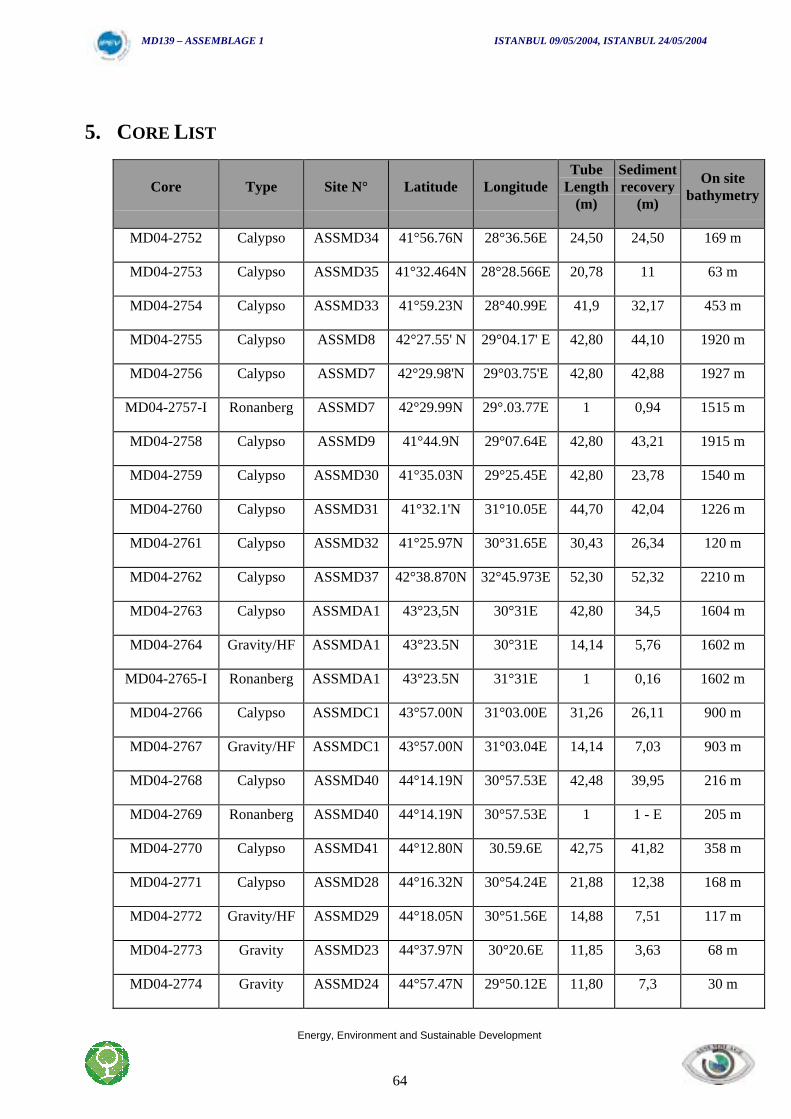
MD139 – ASSEMBLAGE 1 ISTANBUL 09/05/2004, ISTANBUL 24/05/2004
Energy, Environment and Sustainable Development
64
5. CORE LIST
Core Type Site N° Latitude LongitudeTube
Length(m)
Sedimentrecovery
(m)
On sitebathymetry
MD04-2752 Calypso ASSMD34 41°56.76N 28°36.56E 24,50 24,50 169 m
MD04-2753 Calypso ASSMD35 41°32.464N 28°28.566E 20,78 11 63 m
MD04-2754 Calypso ASSMD33 41°59.23N 28°40.99E 41,9 32,17 453 m
MD04-2755 Calypso ASSMD8 42°27.55' N 29°04.17' E 42,80 44,10 1920 m
MD04-2756 Calypso ASSMD7 42°29.98'N 29°03.75'E 42,80 42,88 1927 m
MD04-2757-I Ronanberg ASSMD7 42°29.99N 29°.03.77E 1 0,94 1515 m
MD04-2758 Calypso ASSMD9 41°44.9N 29°07.64E 42,80 43,21 1915 m
MD04-2759 Calypso ASSMD30 41°35.03N 29°25.45E 42,80 23,78 1540 m
MD04-2760 Calypso ASSMD31 41°32.1'N 31°10.05E 44,70 42,04 1226 m
MD04-2761 Calypso ASSMD32 41°25.97N 30°31.65E 30,43 26,34 120 m
MD04-2762 Calypso ASSMD37 42°38.870N 32°45.973E 52,30 52,32 2210 m
MD04-2763 Calypso ASSMDA1 43°23,5N 30°31E 42,80 34,5 1604 m
MD04-2764 Gravity/HF ASSMDA1 43°23.5N 30°31E 14,14 5,76 1602 m
MD04-2765-I Ronanberg ASSMDA1 43°23.5N 31°31E 1 0,16 1602 m
MD04-2766 Calypso ASSMDC1 43°57.00N 31°03.00E 31,26 26,11 900 m
MD04-2767 Gravity/HF ASSMDC1 43°57.00N 31°03.04E 14,14 7,03 903 m
MD04-2768 Calypso ASSMD40 44°14.19N 30°57.53E 42,48 39,95 216 m
MD04-2769 Ronanberg ASSMD40 44°14.19N 30°57.53E 1 1 - E 205 m
MD04-2770 Calypso ASSMD41 44°12.80N 30.59.6E 42,75 41,82 358 m
MD04-2771 Calypso ASSMD28 44°16.32N 30°54.24E 21,88 12,38 168 m
MD04-2772 Gravity/HF ASSMD29 44°18.05N 30°51.56E 14,88 7,51 117 m
MD04-2773 Gravity ASSMD23 44°37.97N 30°20.6E 11,85 3,63 68 m
MD04-2774 Gravity ASSMD24 44°57.47N 29°50.12E 11,80 7,3 30 m

MD139 – ASSEMBLAGE 1 ISTANBUL 09/05/2004, ISTANBUL 24/05/2004
Energy, Environment and Sustainable Development
65
MD04-2775-I Ronanberg ASSMD24 44°57.45N 29°50.11E 1 0,12 30 m
MD04-2776-I Ronanberg ASSMDB1 43°18.98N 29°40.95E 1 0,92 1275 m
MD04-2777 Calypso ASSMDB1 43°18.98N 29°40.93E 34,97 34,97 1279 m
MD04-2778 Gravity/HF ASSMDB1 43°18.99N 29°41.00E 14,14 6,5 1279 m
MD04-2779-I Ronanberg ASSMD42 43°31.99N 30°32.71E 1 0,86 1208 m
MD04-2780 Calypso ASSMD42 43°32.00N 30°32.69E 42 34,02 1217 m
MD04-2781 Calypso ASSMDE 43°35.00N 31°07.98E 35,6 35,63 1642 m
MD04-2782 Calypso ASSMDF2 43°47.41N 30°36.98E 35,6 35,63 1009 m
MD04-2783 Calypso ASSMDF4 43°46.00N 30°34.00E 41,2 34,71 661 m
MD04-2784-I Ronanberg ASSMDF4 43°45.99N 30°34.75E 1 1,01 661 m
MD04-2785 Gravity ASSMD15 41°40.42N 28°36.40E 13,7 4,75 72 m
MD04-2786 Calypso ASSMD16 41°36.60N 28°54.79E 29,32 28,03 131,5 m
MD04-2787-I Ronanberg ASSMD31 41°31.63N 30°53.04E 1 1 1224 m
MD04-2788 Gravity ASSMD31 41°31.67N 30°53.00E 14,14 6 1224 m
MD04-2789 Gravity/HF ASSMD38 40°30.30N 32°43.38E 14,14 6,75 2191 m
MD04-2790 Calypso ASSMD41 44°12.79N 30°59.61E 35,15 30,31 352 m
MD04-2791 Gravity ASSMD41 44°00.00N 30°59.61E 14,14 7,4 358 m
MD04-2792 I Ronanberg ASSMD41 44°12.82N 30°59.61E 1 0,87 67 m
MD04-2793-I Ronanberg 44°00.00N 29°54.00E 1 0,47 456 m
MD04-2794 Calypso ASSMD33 41°59.12N 28°41.03E 35,15 31,52 452 m
MD04-2795 I Ronanberg ASSMD33 41°59.22N 28°40.99E 1 1 453 m
MD04-2796 Gravity ASSMD33 41°59.23N 28°40.99E 14,14 7,7 453 m
MD139 – ASSEMBLAGE 1 ISTANBUL 09/05/2004, ISTANBUL 24/05/2004
Energy, Environment and Sustainable Development
66
MD04-139 ASSEMBLAGE 1
Core Description

MD139 – ASSEMBLAGE 1 ISTANBUL 09/05/2004, ISTANBUL 24/05/2004
Energy, Environment and Sustainable Development
67
MD139 – ASSEMBLAGE 1 ISTANBUL 09/05/2004, ISTANBUL 24/05/2004
Energy, Environment and Sustainable Development
68
6. DESCRIPTION OF CORE MD04-2761
6.1. Site Presentation
In collaboration with the University of Istanbul, one core was recovered from the shelf edge inthe vicinity of the Sakarya Delta. The core MD04-2761 with a length of 26 m was collected. Onthe basis of previous data and subbottom profiling during the cruise, the location of the corereflects a lowstand sediment wedge formed during lowstands of the Black Sea. The mainpurpose of obtaining a core in such a location is to investigate the deposition during the last 20ky BP. For determining the changing sea levels and paleoenvironment of the Black Sea thefollowing analyses are planned:
Major and minor element distribution: Bulk sediment subsamples in various depth intervalswill be analyzed l for their major and minor element concentrations (ICP) by the University oIstanbu, in order to provide some information about the influence of terrigenic inputs andchemical properties and conditions of the deposition conditions.
Foraminiferal assemblage: Identification and counting of foraminifera along the core willprovide the changing conditions throughout the time span of 26 m long sedimentary column.
Mollusk assemblage: mollusks will be identified in various depth intervals
Ostracoda assemblage: Ostracoda will be identified in various depth intervals. This part of thestudy will be carried out by Ian Boomer from New Castle University.
Palynology : Pollen and dinoflagellat analysis will be performed by J. P. Suc and S. Popescu;Partner 2 of the ASSEMBLAGE project
Oxygen isotopes and radiocarbon age determination: These analysis will be carried out byFrancoise Guichard, partner 3 of the Assemblage project
In addition to core MD04-2761, core MD04-2752 will be planned to investigate in the samecontext. However in this core, Istanbul University, Institute of Marine Sciences and Managementwill carry out only Foraminiferal analysis under the supervision of partner 11.
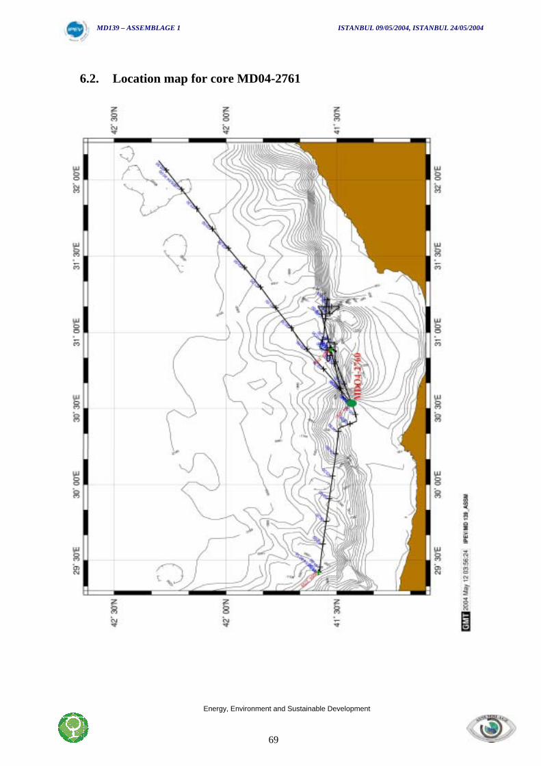
MD139 – ASSEMBLAGE 1 ISTANBUL 09/05/2004, ISTANBUL 24/05/2004
Energy, Environment and Sustainable Development
69
6.2. Location map for core MD04-2761
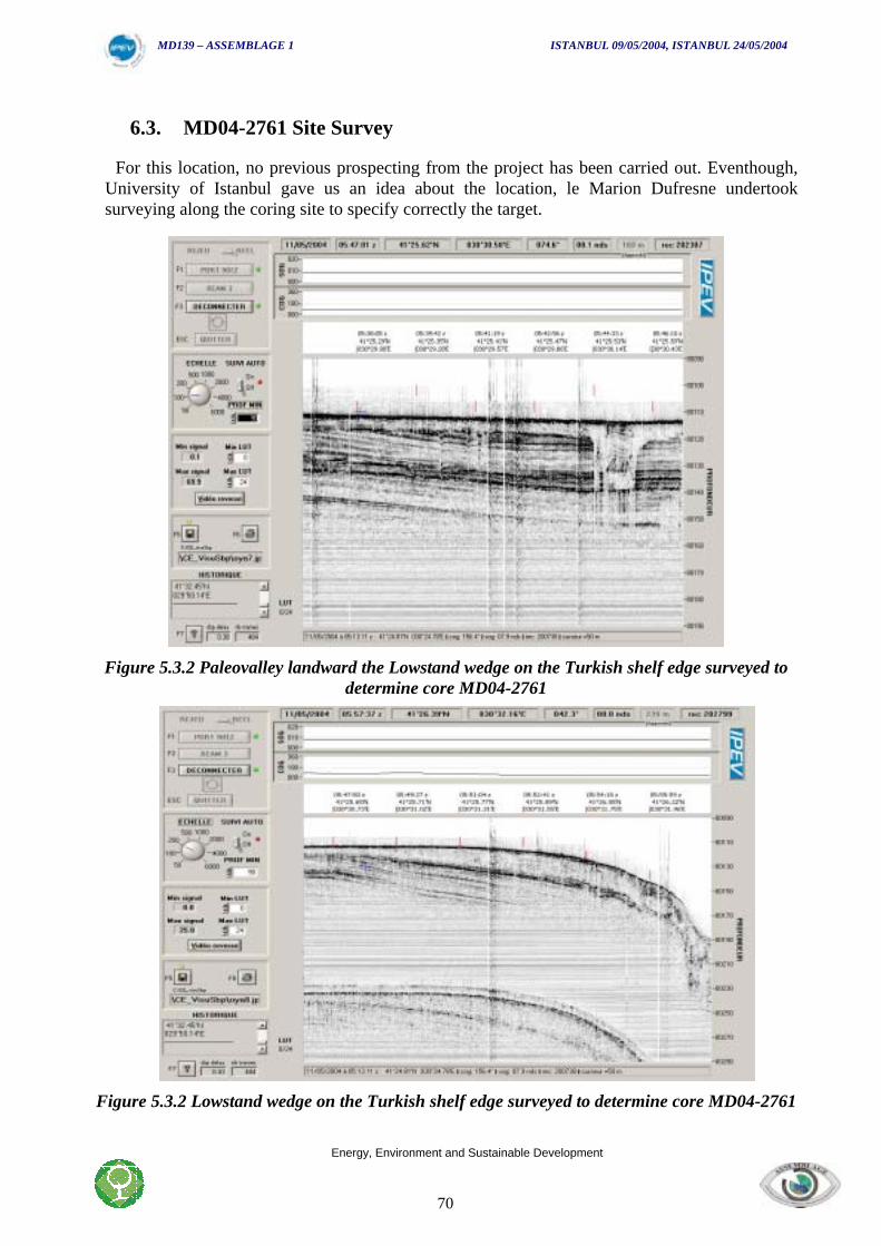
MD139 – ASSEMBLAGE 1 ISTANBUL 09/05/2004, ISTANBUL 24/05/2004
Energy, Environment and Sustainable Development
70
6.3. MD04-2761 Site Survey
For this location, no previous prospecting from the project has been carried out. Eventhough,University of Istanbul gave us an idea about the location, le Marion Dufresne undertooksurveying along the coring site to specify correctly the target.
Figure 5.3.2 Paleovalley landward the Lowstand wedge on the Turkish shelf edge surveyed todetermine core MD04-2761
Figure 5.3.2 Lowstand wedge on the Turkish shelf edge surveyed to determine core MD04-2761
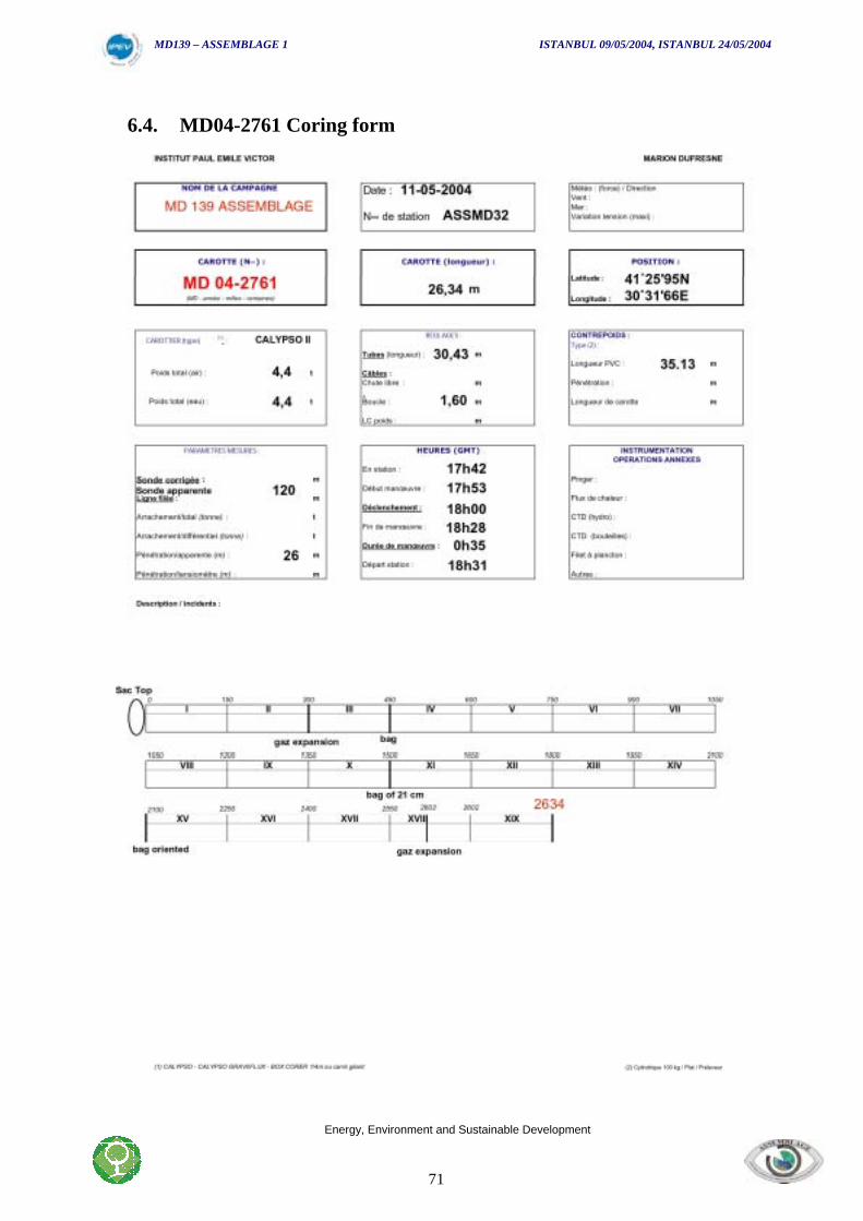
MD139 – ASSEMBLAGE 1 ISTANBUL 09/05/2004, ISTANBUL 24/05/2004
Energy, Environment and Sustainable Development
71
6.4. MD04-2761 Coring form
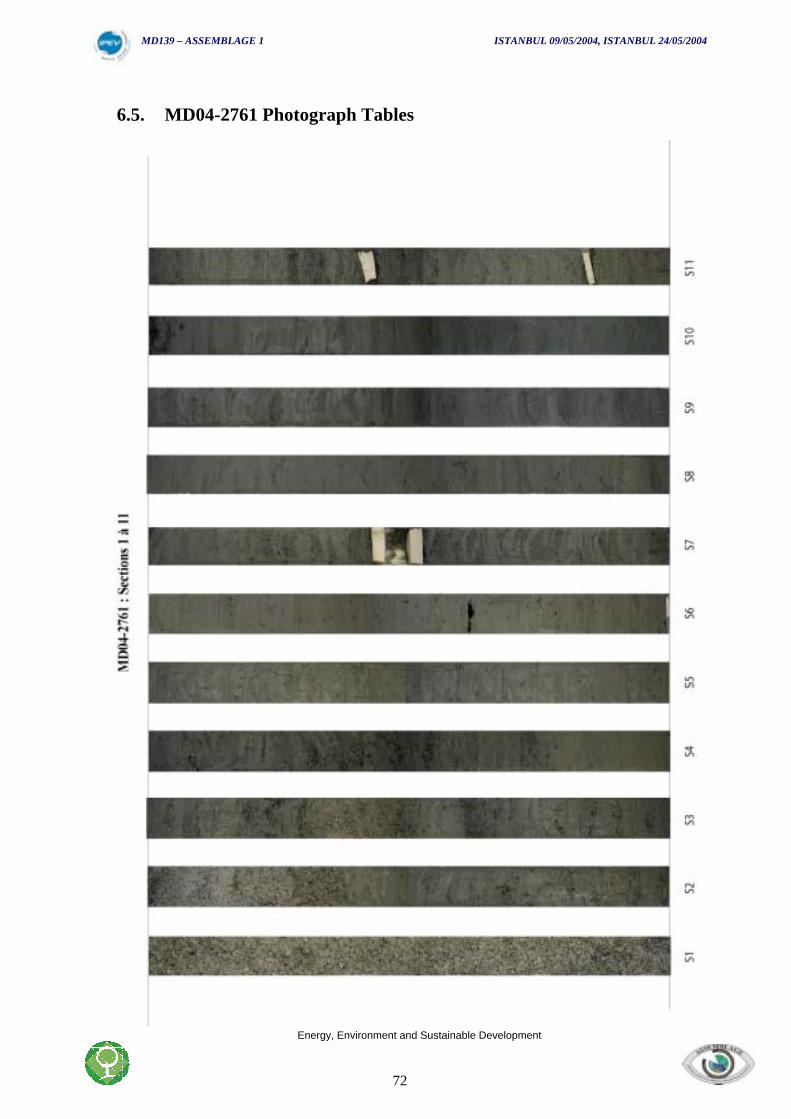
MD139 – ASSEMBLAGE 1 ISTANBUL 09/05/2004, ISTANBUL 24/05/2004
Energy, Environment and Sustainable Development
72
6.5. MD04-2761 Photograph Tables
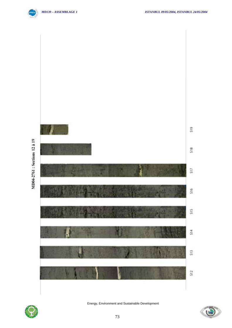
MD139 – ASSEMBLAGE 1 ISTANBUL 09/05/2004, ISTANBUL 24/05/2004
Energy, Environment and Sustainable Development
73
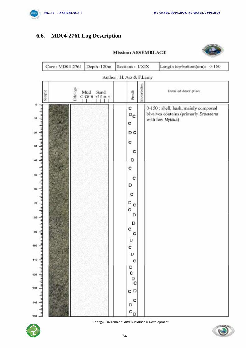
MD139 – ASSEMBLAGE 1 ISTANBUL 09/05/2004, ISTANBUL 24/05/2004
Energy, Environment and Sustainable Development
74
6.6. MD04-2761 Log Description
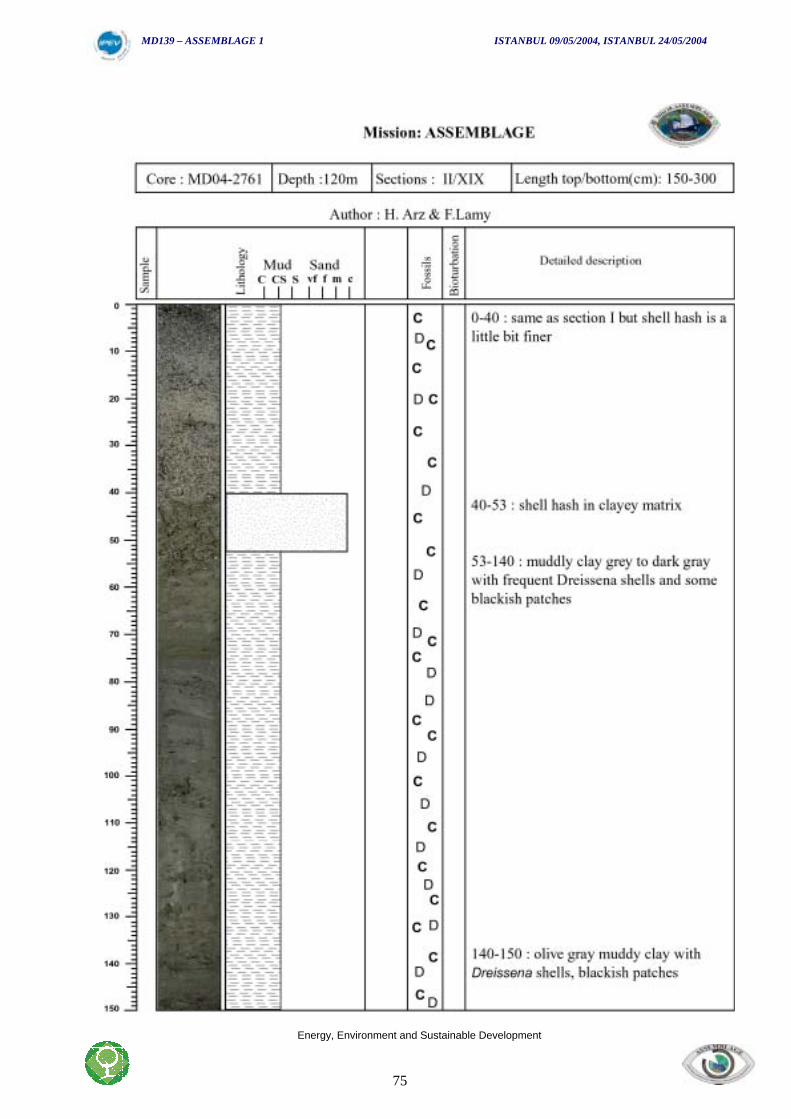
MD139 – ASSEMBLAGE 1 ISTANBUL 09/05/2004, ISTANBUL 24/05/2004
Energy, Environment and Sustainable Development
75
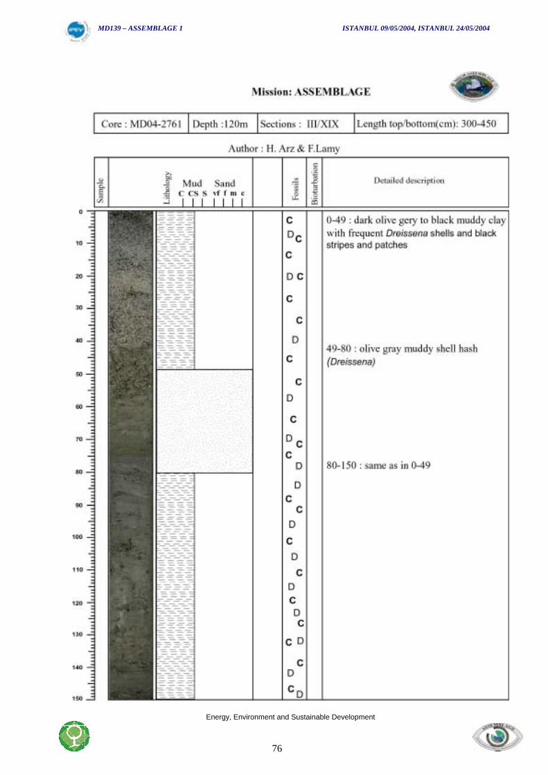
MD139 – ASSEMBLAGE 1 ISTANBUL 09/05/2004, ISTANBUL 24/05/2004
Energy, Environment and Sustainable Development
76
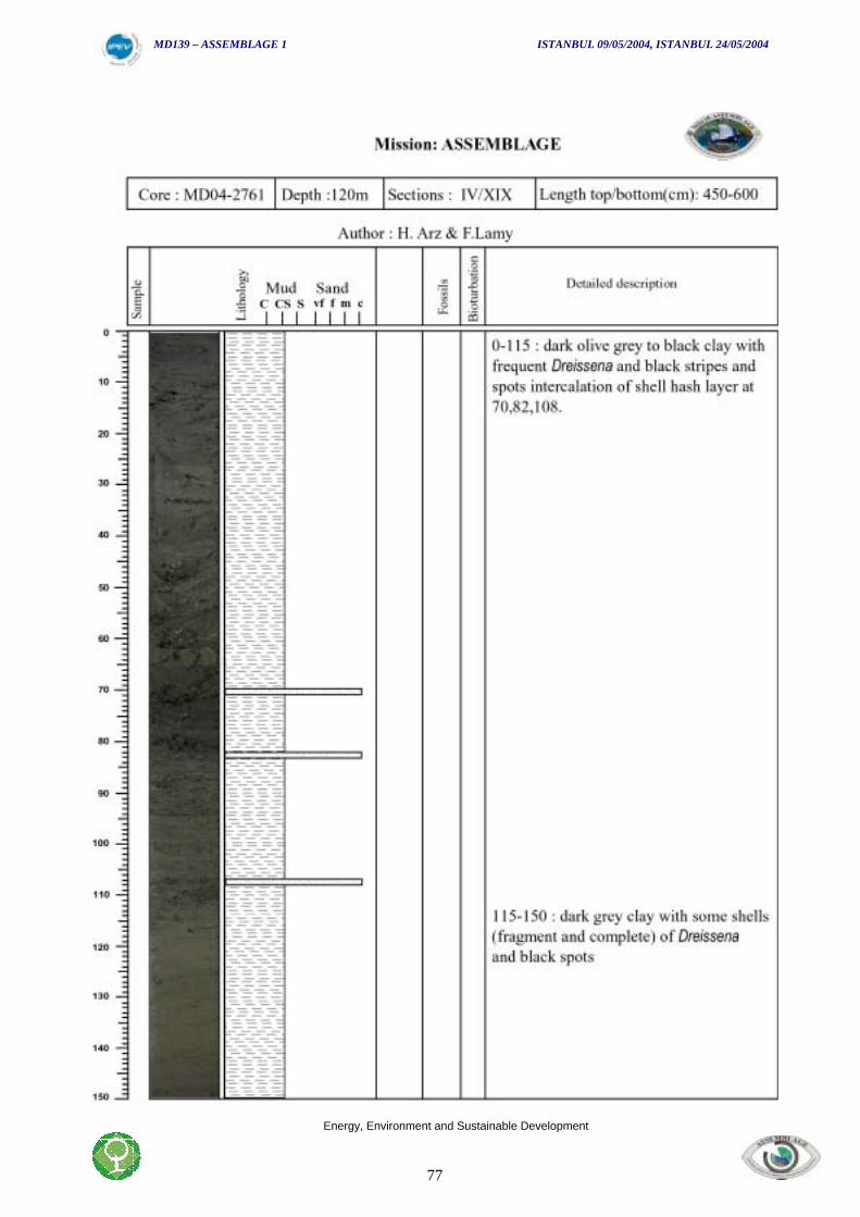
MD139 – ASSEMBLAGE 1 ISTANBUL 09/05/2004, ISTANBUL 24/05/2004
Energy, Environment and Sustainable Development
77
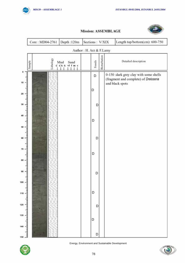
MD139 – ASSEMBLAGE 1 ISTANBUL 09/05/2004, ISTANBUL 24/05/2004
Energy, Environment and Sustainable Development
78
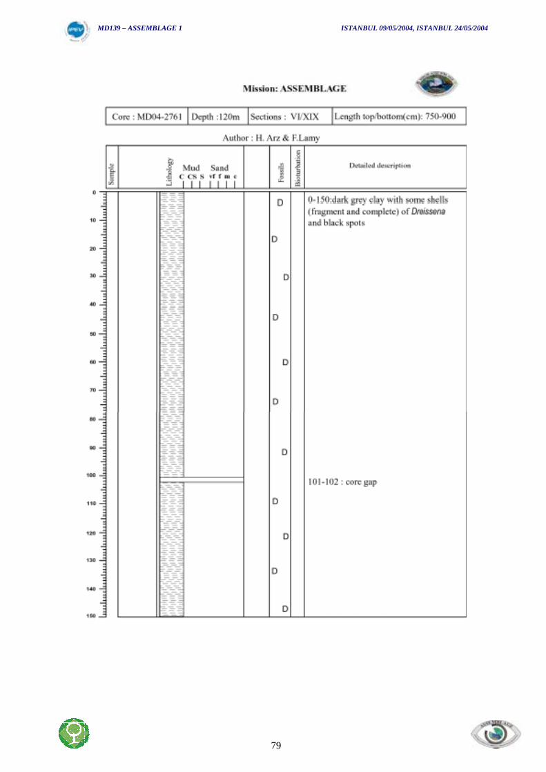
MD139 – ASSEMBLAGE 1 ISTANBUL 09/05/2004, ISTANBUL 24/05/2004
Energy, Environment and Sustainable Development
79
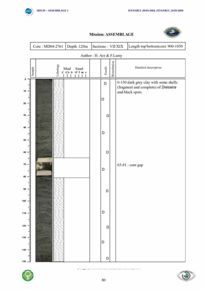
MD139 – ASSEMBLAGE 1 ISTANBUL 09/05/2004, ISTANBUL 24/05/2004
Energy, Environment and Sustainable Development
80
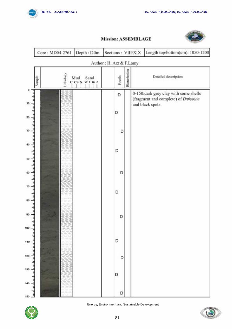
MD139 – ASSEMBLAGE 1 ISTANBUL 09/05/2004, ISTANBUL 24/05/2004
Energy, Environment and Sustainable Development
81
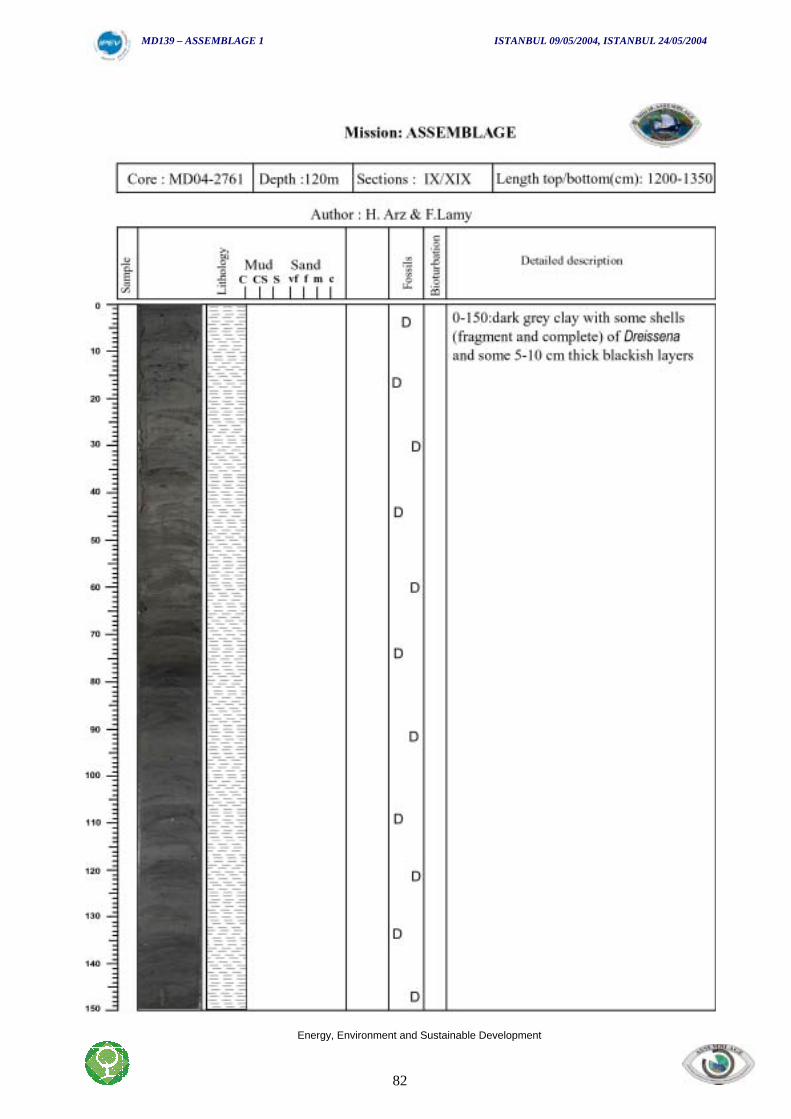
MD139 – ASSEMBLAGE 1 ISTANBUL 09/05/2004, ISTANBUL 24/05/2004
Energy, Environment and Sustainable Development
82
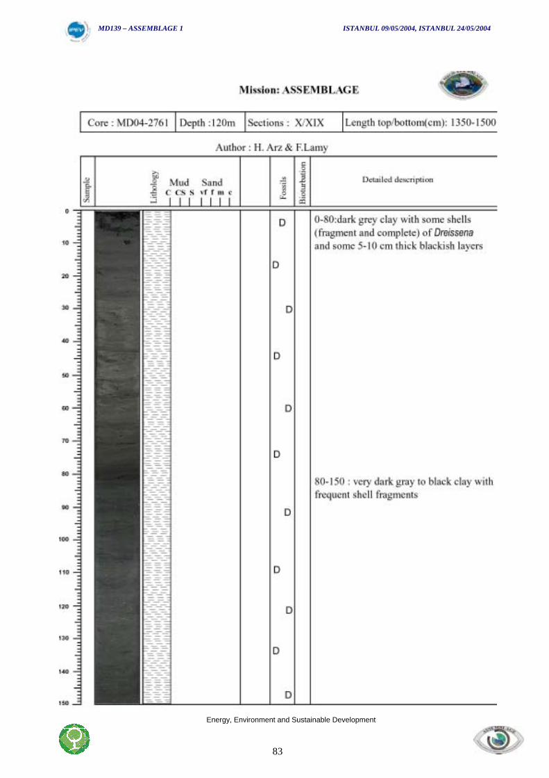
MD139 – ASSEMBLAGE 1 ISTANBUL 09/05/2004, ISTANBUL 24/05/2004
Energy, Environment and Sustainable Development
83
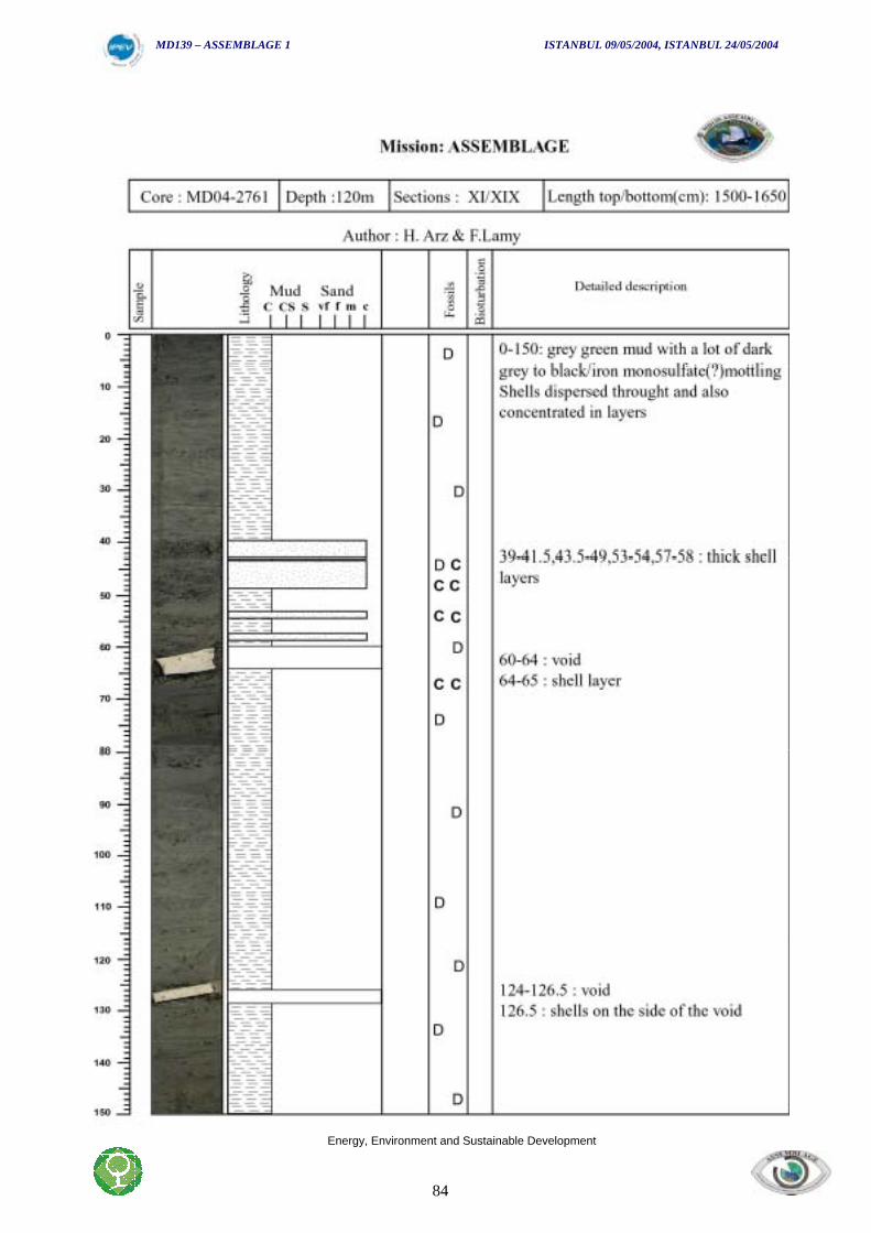
MD139 – ASSEMBLAGE 1 ISTANBUL 09/05/2004, ISTANBUL 24/05/2004
Energy, Environment and Sustainable Development
84
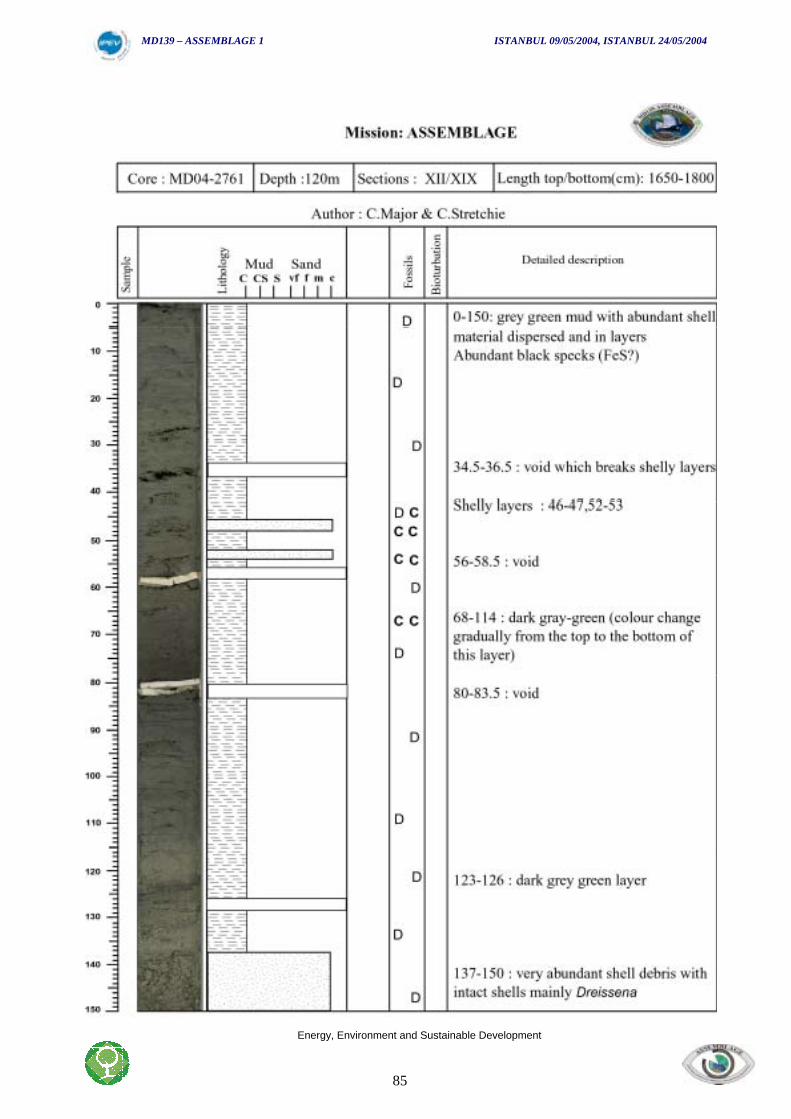
MD139 – ASSEMBLAGE 1 ISTANBUL 09/05/2004, ISTANBUL 24/05/2004
Energy, Environment and Sustainable Development
85
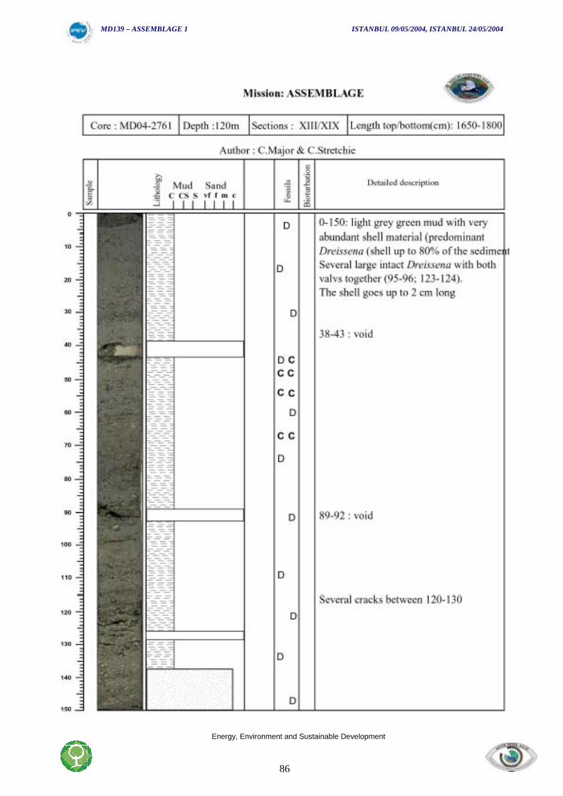
MD139 – ASSEMBLAGE 1 ISTANBUL 09/05/2004, ISTANBUL 24/05/2004
Energy, Environment and Sustainable Development
86
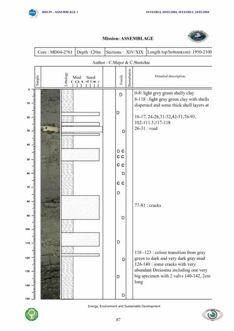
MD139 – ASSEMBLAGE 1 ISTANBUL 09/05/2004, ISTANBUL 24/05/2004
Energy, Environment and Sustainable Development
87
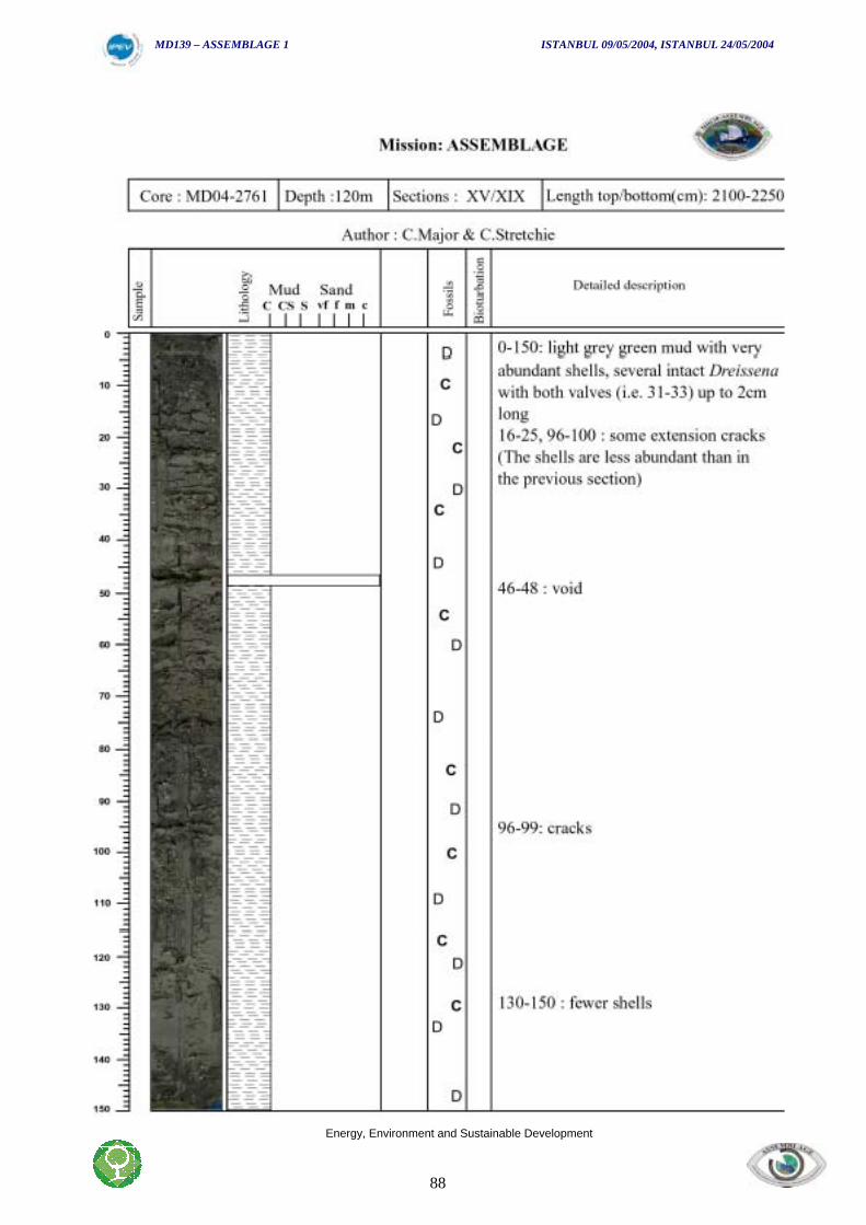
MD139 – ASSEMBLAGE 1 ISTANBUL 09/05/2004, ISTANBUL 24/05/2004
Energy, Environment and Sustainable Development
88
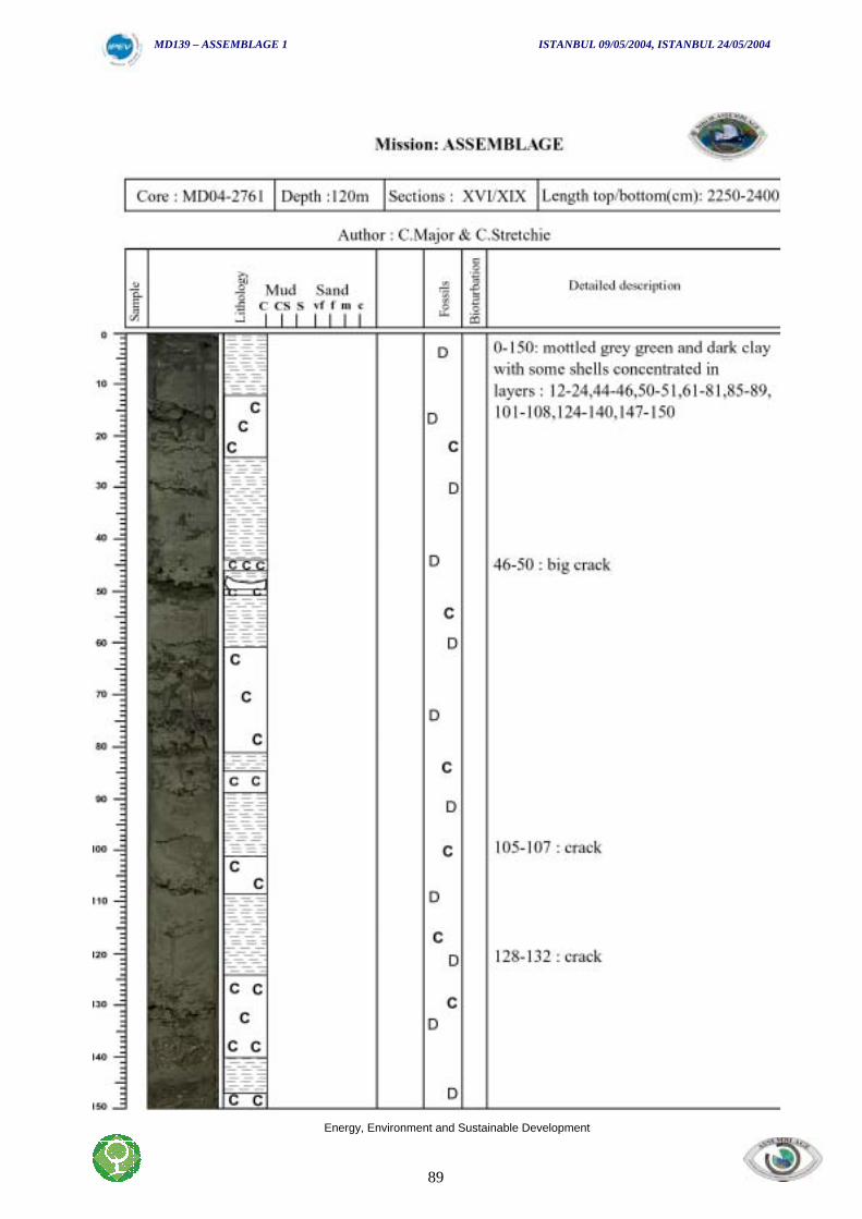
MD139 – ASSEMBLAGE 1 ISTANBUL 09/05/2004, ISTANBUL 24/05/2004
Energy, Environment and Sustainable Development
89
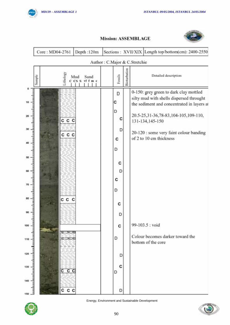
MD139 – ASSEMBLAGE 1 ISTANBUL 09/05/2004, ISTANBUL 24/05/2004
Energy, Environment and Sustainable Development
90
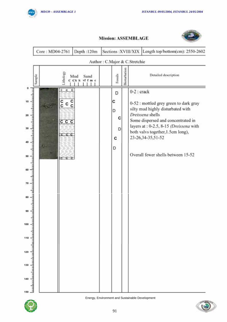
MD139 – ASSEMBLAGE 1 ISTANBUL 09/05/2004, ISTANBUL 24/05/2004
Energy, Environment and Sustainable Development
91
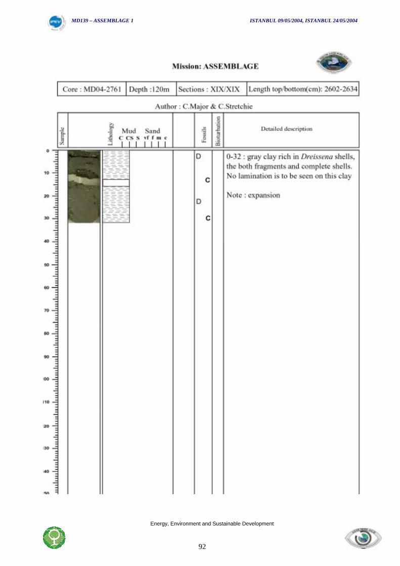
MD139 – ASSEMBLAGE 1 ISTANBUL 09/05/2004, ISTANBUL 24/05/2004
Energy, Environment and Sustainable Development
92
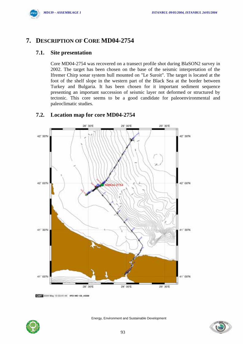
MD139 – ASSEMBLAGE 1 ISTANBUL 09/05/2004, ISTANBUL 24/05/2004
Energy, Environment and Sustainable Development
93
7. DESCRIPTION OF CORE MD04-2754
7.1. Site presentation
Core MD04-2754 was recovered on a transect profile shot during BlaSON2 survey in2002. The target has been chosen on the base of the seismic interpretation of theIfremer Chirp sonar system hull mounted on "Le Suroit". The target is located at thefoot of the shelf slope in the western part of the Black Sea at the border betweenTurkey and Bulgaria. It has been chosen for it important sediment sequencepresenting an important succession of seismic layer not deformed or structured bytectonic. This core seems to be a good candidate for paleoenvironmental andpaleoclimatic studies.
7.2. Location map for core MD04-2754
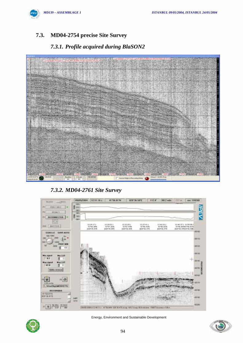
MD139 – ASSEMBLAGE 1 ISTANBUL 09/05/2004, ISTANBUL 24/05/2004
Energy, Environment and Sustainable Development
94
7.3. MD04-2754 precise Site Survey
7.3.1. Profile acquired during BlaSON2
7.3.2. MD04-2761 Site Survey
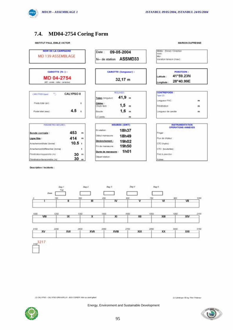
MD139 – ASSEMBLAGE 1 ISTANBUL 09/05/2004, ISTANBUL 24/05/2004
Energy, Environment and Sustainable Development
95
7.4. MD04-2754 Coring Form
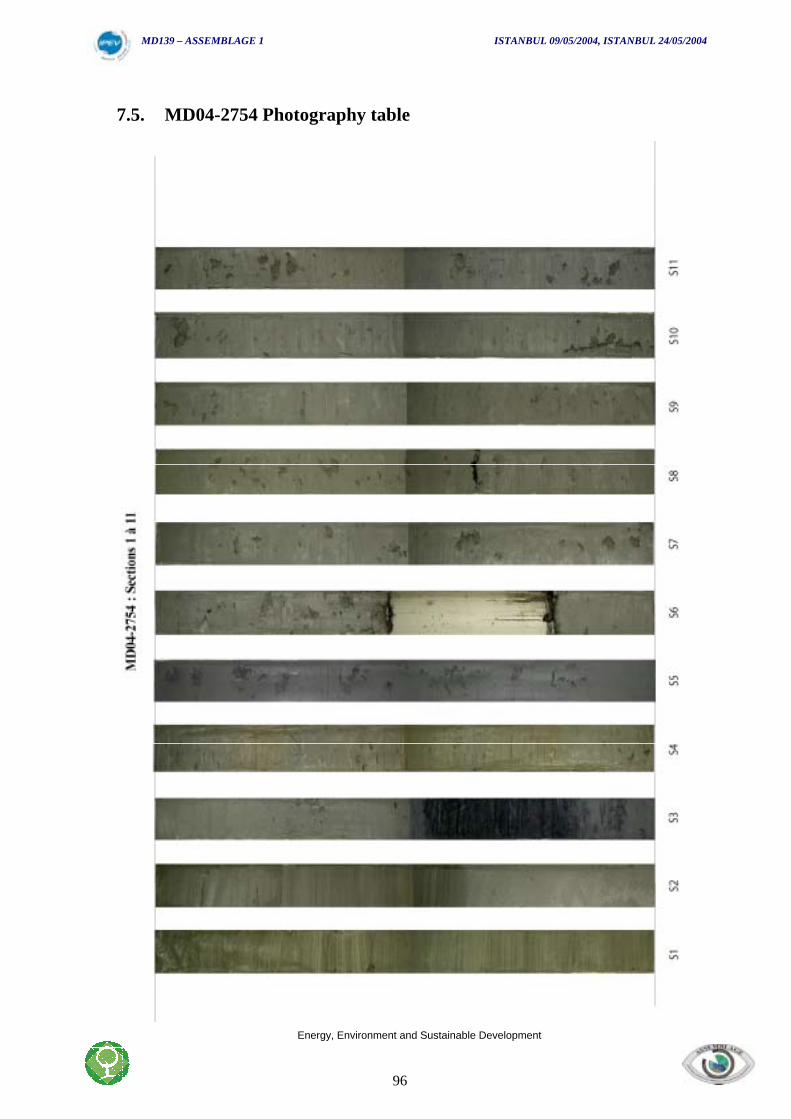
MD139 – ASSEMBLAGE 1 ISTANBUL 09/05/2004, ISTANBUL 24/05/2004
Energy, Environment and Sustainable Development
96
7.5. MD04-2754 Photography table
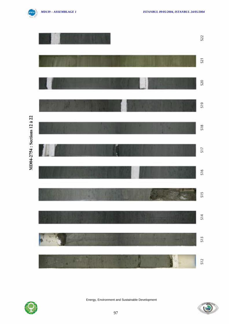
MD139 – ASSEMBLAGE 1 ISTANBUL 09/05/2004, ISTANBUL 24/05/2004
Energy, Environment and Sustainable Development
97