Thematic Mapper studies of Andean volcanoes Six … Mapper studies of Andean volcanoes Six monthly...
13
> ' ,- Page (1) Thematic Mapper studies of Andean volcanoes Six monthly report P.W. Francis ..„.»•.•.£ Lunar and Planetary Institute. 3303 NASA Road 1 Houston Texas 77058 Phone: (713) 486 2174 Contract Number NAS5-28759 1. STATUS OF DATA AQUISITION A total of 51 quads of day time TM data were included in the original proposal. Three full night scenes were also requested on an experimental basis, with others to be acquired if the experimental scenes were successful. 18 of the day time scenes requested have been received to date, mostly covering the southern part of the area under investigation. 2. QUALITY OF THE DATA For the most part, the quality of the data received has been outstandingly good, and its enormous potential for advancing knowledge of Andean volcanoes is already obvious. Some scenes have much more snow than is desirable. The original plan had been to inspect photographic products of each scene for snow and cloud cover before obtaining the CCT, but because of YNASA-CR-176807) THE HAT 1C MAPPER STUDIES 0-F N86-25666 ANDEAN VOLCANOES Monthly Bepcrt (Lunar and iPlanetary Inst.) 13 p HC A02/MF A01 CSCL 08K Dnclas G3/43 43578 https://ntrs.nasa.gov/search.jsp?R=19860016394 2018-05-26T05:30:24+00:00Z
Transcript of Thematic Mapper studies of Andean volcanoes Six … Mapper studies of Andean volcanoes Six monthly...
> ' ,- Page (1)
Thematic Mapper studies of Andean volcanoes
Six monthly report
P.W. Francis ..„.»•.•.£
Lunar and Planetary Institute.
3303 NASA Road 1
Houston
Texas 77058 Phone: (713) 486 2174
Contract Number NAS5-28759
1. STATUS OF DATA AQUISITION
A total of 51 quads of day time TM data were included in the original
proposal. Three full night scenes were also requested on an experimental basis,
with others to be acquired if the experimental scenes were successful. 18 of
the day time scenes requested have been received to date, mostly covering the
southern part of the area under investigation.
2. QUALITY OF THE DATA
For the most part, the quality of the data received has been
outstandingly good, and its enormous potential for advancing knowledge of
Andean volcanoes is already obvious. Some scenes have much more snow than is
desirable. The original plan had been to inspect photographic products of each
scene for snow and cloud cover before obta in ing the CCT, but because ofYNASA-CR-176807) THE HAT 1C M A P P E R STUDIES 0-F N86-25666A N D E A N V O L C A N O E S Monthly Bepcrt (Lunar and
iPlanetary Inst.) 13 p HC A 0 2 / M F A01CSCL 08K Dnclas
G3/43 43578
https://ntrs.nasa.gov/search.jsp?R=19860016394 2018-05-26T05:30:24+00:00Z
page (2)
pressures arising from Landsat commercialization, we were encouraged to accept
whatever data was available. The problems raised by commercialization are
addressed in a later section.
Technically, the only serious defect found in the TM data is the well
known coarse striping thought to be due to sensor memory effects. This has
prooved to be a problem in one band (7) in one scene, and has particularly
unfortunate consequences when carrying out band ratioing and other processes.
In other scenes, band 7 shows no striping effects, although there are similar
variations between very bright playa lake surfaces and lavas closely
juxtaposed. There are also a few defective lines and pixels in the data, but
these are relatively trivial.
3. RESULTS TO DATE
Only rather general comments are possible here because the research is
still in its early stages. Only a small part of the data has been received and
only a small proportion of the data received has been analysed in detail.
3.1 Identifying active volcanoes
^The primary objective of the research project is to identify all the
"active" volcanoes in the region, and publish a catalog with image data, maps
and structural data. According to the IAVCEI compilation of post-Miocene
volcanoes of the world, there are approximately 300 named volcanoes in the
region between 16° and 29° S. (For some reason this compilation did not include
north-west Argentina). Most of these are large, easily recognisable
structures, but little is known about them other than their names, approximate

page (3)
heights and locations. There are innumerable other smaller and more obscure
structures unlisted. Deciding which of these hundreds of volcanoes should be
regarded as "active" is not easy. An "active" volcano is conventionally
accepted as being one that has been active within historic time, although many
of the most lethal eruptions in history have taken place on volcanoes thought
to be extinct. A better definition includes volcanoes that have been active in
post-glacial times, roughly the last 10-12,000 years. This is a relatively
straightforward criterion to apply to the many large, ~ 6,000m high cones in
the Central Andes, because although the region is extremely arid at present,
during glacial times ice sheets extended down to about 4,000m and left moraine
deposits that are easily recognisable on TM (Thematic Mapper) imagery.
Problems arise with the smaller volcanoes, however, particularly those on the
western flanks of the principal cordillera. Here, precipitation rates are so
small that erosion is extremely slow, and volcanic features which appear very
fresh may have ages measured in the range of hundreds of thousands of years.
Our preliminary studies suggest, however that there may be 50-60 major
volcanoes that should be regarded as active.
In this part of the research, it is the TM's excellent spatial
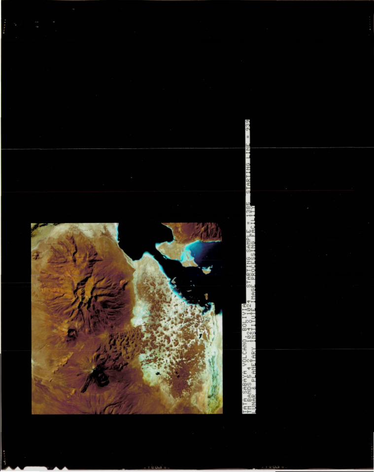
resolution that is most valuable so far. In the case of Tata Sabaya volcano,*•?
Bolivia, for example, MSS data suggested the possible presence of a major
debris avalanche deposit extending into the Salar de Coipasa, whereas in the TM
imagery not only is the distinctive hummocky topography of the debris avalanche
unequivocally recognizable, but the 'tide mark' left by the flow on the flanks
of a neighbouring older cone is also clear. Other morphological features that
the TM data have made accessible to study include details of marginal levees on
lava and pyroclastic flows, and summit crater structure. Valley glacier moraine
page (4)
deposits, not easily identifiable on MSS data, are also unambiguous, and
provide useful 'marker horizons' on large volcanic edifices which were built up
in pre-glacial times but which have been active subsequently. With such high
resolution imagery, it is not only possible to identify potentially "active"
volcanoes, but also to use standard photo-geological interpretation to outline
the history of individual volcanos.
3.2 Large volcanic debris avalanche deposits
The 1980 eruption of Mt St Helens focussed attention on volcanic
eruptions in which large scale collapse of part of the volcanic edifice is a
key factor. Many other examples have come to light in different parts of the
world since 1980, and we have made a special search for examples in the Central
Andes. In temperate regions, the hummocky terrain that characterises the
surface of an avalanche deposit quickly becomes masked by soil and vegetation,
and all surface expression of it may be lost in only a few thousand years. The
high, arid conditions in the Andes are particularly favorable for the
preservation of such fragile surface features. There are also some grounds for
thinking that major collapse events may be more common in the Central Andes
than elsewhere, because lavas of dacitic composition are so common. Effusion of*-̂
viscous dacite from vents high on the volcano produces cones with extremely
steep profiles, (over 45°); ideal candidates for collapse. We have been able to
identify about a dozen debris avalanche deposits on the TM imagery to date, and
expect to find many more. Some of these were known previously or are quite
unambiguous on the imagery -such as the Tata Sabaya deposit- but others are
more equivocal, and require field checking.
page (5)
One of the most impressive debris avalanches, which has not been
described before, is on the eastern slopes of the LLullaillaco volcano,
straddling the Chile/Argentina border. This volcano, 6723 m high, is one of the
highest in the world, but has been little studied. TM data shows that a great
pre-historic debris avalanche cascaded down the eastern flanks of the volcano
into Argentina; swept hundreds of metres up and passed around both sides of, an
older, 1,000m high cone, leaving a distinct "tide mark", and travelled 25 km
before coming to rest in a small playa lake. This deposit has the hummocky
terrain characteristic of debris avalanche deposits. It was subsequently
partially covered by two other younger debris deposits. These were probably
more like volcanic mudflows (lahars) than the first, since they are thinner and
their surface textures are much finer. There is no evidence of a major collapse
amphitheater left by the emplacement of the large debris avalanche; this has
presumably been 'healed' by younger volcanic activity. Interestingly, the small
cone partially buried by the avalanche itself has a well defined collapse
amphitheater on its eastern flank, and an eroded debris avalanche deposit.
3.3 Spectral characteristics
Extracting the compositions of lava and pyroclastic flows from TM dataa-*
depends more on variations in albedo than spectral signature. Experiments both
with radiometers in the field and with the image data show that the chief
difference between flows of basaltic through rhyolitic composition is an
increase in reflectivity in all bands. Young basaltic or basaltic andesite
flows are almost completely black; albedo increases with increasing silica
content, so that young rhyolitic ashes have albedos approaching those of snow.
Superimposed on this simple relationship are two other factors: age and the
page (6)
effects of iron oxidation.
As a lava flow ages, it is subject to both weathering and to cover by
wind blown dust. Both of these lead to an increase in albedo, sometimes
dramatic when the flow is downwind of a source of bright dust, such as a
gypsum-covered playa lake. Thus, the albedos of flows tend to converge with
increasing age towards the albedo of the surrounding terrain. Vegetation cover
can also cause progressive changes in lava albedo, but this is not an important
factor in much of the Atacama desert region. Lavas of all compositions may
exhibit the effects of iron oxidation, though this is most striking in flows of
basaltic to intermediate composition. This may take place on weathering, or
when fumarolic or magmatic steam exhaled from the magma converts iron bearing
minerals in lavas to hydrous iron oxides such as limonite or goethite. Basaltic
or andesitic lavas which have been affected can be distinguished by eye in the
field through their rusty reddish color, but in TM images they are
umistakeable, since the reflectivity of the oxide minerals is much higher in
the mid- infra red than the visible.
This characteristic has proved invaluable in a detailed study of the
debris avalanche deposits of the Socompa volocano, north Chile. These deposits•*>•?
were emplaced as the result of a catastrophic collapse of the north-western2
flank of the volcano, and now cover some 500 km. As in the case of Mt. St.
Helens, the volcano did not fail in a single, simple collapse, but a number of
events followed in rapid succession. The presence of a number of debris streams
characterised by sharply different degrees of iron oxidation has proved
critical to tracing the trajectories of materials derived from different parts
of the original volcanic structure An unusual feature of the Socompa debris
page (7)
avalanche is that the collapse event involved the sub-volcanic basement, as
well as the volcanic edifice itself. Underlying the volcano is a dacitic
ignimbrite, which has a relatively flat spectral signature (bright in all
bands), and this gave rise to other unmistakeable debris streams. Individual
debris streams with distinct spectral signatures can be traced for many
kilometres, tracking the course of the avalanche as it rode over underlying
hills, and sliding off again in a different direction.
3.4 Volcanic alteration products
A characteristic feature of an active volcano is persistent fumarolic
activity, which may continue for hundreds or thousands of years after the last
magmatic eruption. A few volcanoes, such as Guallatiri, exhibit fumaroles
strong enough to form steam plumes which are visible on TM imagery, but for the
most part it is the effects of long continued fumarolic activity on the
surrounding rocks that are most conspicuous. Prolonged exposure of rocks to
high temperature steam causes the breakdown of silicate minerals such as
feldspars and the deposition of native sulphur, chert, alunite and kindred
minerals. Related kinds of hydrothermal alteration, leading to the formation of
clay minerals are associated with several major types of ore deposit, so the»•?
ability to detect such deposits was built in to the TM. This ability depends on
the fact that clay minerals exhibit a distinctive absorption in the mid -infra
red. On active volcanoes, areas of fumarolic activity tend to be quite small,
and to be bright in all spectral bands. These deposits consist mostly of
sulphur and other sublimate materials. Older, more deeply eroded volcanoes show
evidence of extensive alteration, such that their entire cores appear to have
been replaced by high albedo alteration products. The drainages around the
page (8)
volcano carry this bright material long distances downstream, so an old
volcanic center is easy to spot. For the most part, such dissected volcanoes
have experienced only low grade alteration (quartz-alunite-native sulphur), but
some large, eroded calderas show more advanced clay mineral alteration, and
these are potentially good prospects for economic epithermal mineral deposits.
One such site, identified initially solely from TM data, proved on subsequent
enquiry to be an active gold mine.
3.5 Ignimbrites
Ignimbrites (pumiceous pyroclastic flows) are extremely widespread in
the Central Andes, and form an essential part of the study on Andean volcanism.
They present quite different problems from ordinary lava flows. Individual3
flows may have volumes far exceeding 1,000 km , and may travel over 100 km from
their source caldera. Because an individual ignimbrite may be exposed over
thousands of square kilometers of high altitude terrain, and cross two or three
national frontiers, mapping them by conventional means presents formidable
difficulties. Fortunately, the generally high albedos and distinctive erosional
morphology of ignimbrites ensure that it is easy to identify them as a rock
type on Landsat imagery, even on a monochrome MSS product. Problems arise,
however, in attempting to distinguish between individual ignimbrite units.
Andean ignimbrites are mostly dacites (-68 % SiCL) and show only small
variations in major and trace element chemistry. Not suprisingly, many units
appear very similar both in the field and on TM imagery. Fortunately, some show
significant differences in texture and spectral signature. These differences
arise mostly from the most-emplacement history of the flow, which may lead to
welding of the pumice clasts or to different degrees of vapor phase alteration.
page (9)
Fresh ignimbrite surfaces are highly reflective, and appear white to
the eye, but on weathering they acquire a reddish surface coating of iron
oxides which increases their reflectivity in the mid-infrared. The extent to
which their spectral properties are modified depends on the physical
characteristics of the ignimbrite, such as degree of welding and grain size.
These physical features also give rise to different erosional morphologies and
spectral characteristics. Densely welded ignimbrites are dark, glassy
resistant rocks, whereas unwelded units are lighter, friable and easily eroded
by wind or water. Thus, the combination of spectral and textural
characteristics offers a possible means of distinguishing some ignimbrite units
from one another. This is a problem that will require considerable further
work,
6. CONSEQUENCES OF LANDSAT COMMERCIALIZATION
The full implications of Landsat commercialization to the project are
not yet clear, but they do not seem good. At worst, it has been suggested that
no more TM data will be supplied than we have already received. It has also
been suggested that scenes already acquired by Goddard may be made available at*"f
low cost by EOSAT. This is unlikely to be a solution for the Andean work, since
new acquisitions are essential to provide coverage.
The essential element of the original proposal was that it would be a
comprehensive study, covering the complete Central Andean volcanic province.
Anything less than complete coverage, therefore precludes the possibility of a
systematic study, and of compiling a catalog that would be of lasting value for
page (10)
all Earth scientists. The quality of the TM data already received is so good
that there is no question that one can do valuable science with it, but it is
essential if at all possible to continue with the original research objectives.
An integrated study of Andean volcanism is a real and important scientific
goal, and one that can only be achieved using TM data.
A more specific problem concerns night-time thermal IR data. Apart
from the commercialization issue, there are also apparently technical and
scheduling problems that have made this unavaible to date, and the future
prospects are also apparently not good. Because no data are available for the
region, it is not certain what the full value of night time thermal IR data may
be. Thus, it would be highly desirable if at least one scene could be acquired
on an experimental basis, so that the full potential can be assessed.
7. APPENDICES
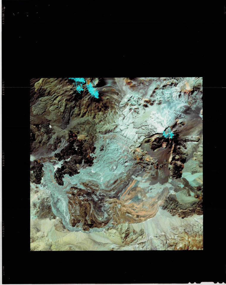
i. False color composite TM image of Socompa volcano, north Chile and
catastrophic debris avalanche deposit. Bands 7 (red), 4 (green) and 2 (blue),«--
linear stretched, 1536 x 1536 pixels. Image reveals plainly the trajectories of
different debris streams in the avalanche deposit.
ii. False color composite TM image of Tata Sabaya volcano, Bolivia. Bands 4
(red), 2 (green) and 1 (blue), linear stretched; 1024 x 1024 pixels. Major
debris avalanche which enters Salar de Coipasa was ambiguous on MSS data; is
unequivocal on TM image.
page (11)
iii. Abstract of invited paper presented at IGCP Project 120 meeting on
Volcanic Evolution of the Andes, Santiago, Chile November 1985.