THEMATIC HISTORY AND MATRIX 2017 - Town of … · The Bassendean Hotel ... Figure 25 The Bassendean...
54
THEMATIC HISTORY AND MATRIX 2017
Transcript of THEMATIC HISTORY AND MATRIX 2017 - Town of … · The Bassendean Hotel ... Figure 25 The Bassendean...

THEMATIC HISTORY AND MATRIX
2017
Town of Bassendean
Thematic History and Matrix - 2017 ii
Cover Illustration: Unveiling of plaque to celebrate the Bassendean Road Board Jubilee 1901-1951, on 3 May 1951. State Library of WA b2297364_1, call number 8292B/25672-1
Town of Bassendean
Thematic History and Matrix - 2017 iii
TABLE OF CONTENTS Table of Contents ........................................................................................................................................... iii List of Figures ..................................................................................................................................................... v
1.0 Introduction ........................................................................................................................................... 2
1.1 Background ................................................................................................................................... 2 1.2 Methodology ................................................................................................................................. 2 1.3 Study Team..................................................................................................................................... 2 1.4 Acknowledgments ........................................................................................................................ 2
2.0 Thematic History .................................................................................................................................... 1
2.1. Geography .................................................................................................................................... 1 2.2. Aboriginal Histories (Pre & post European History Period) ....................................................... 3 2.3. Discovery and Early exploration pre 1829 ............................................................................... 10 2.4. Settlement 1829-1850 .................................................................................................................. 12
Peter Broun (1797-1846) ................................................................................................................................. 12 Cleikum Inn and Ferry Service ....................................................................................................................... 16
2.5. The Convict Era 1850-1880 ......................................................................................................... 18 The Enrolled Pensioner Guards ..................................................................................................................... 18 Convicts, Pensioner Guards and West Guildford ...................................................................................... 19 Convicts - The Last Arrivals ......................................................................................................................... 20
2.6. Increased Development 1880-1900 ......................................................................................... 21 The First Traffic Bridge .................................................................................................................................... 22 The Gold Rush and the Building Boom ........................................................................................................ 22 The Midland Workshops ................................................................................................................................. 25
2.7. Consolidation 1900-1920 ............................................................................................................ 26 Industry in Bassendean ................................................................................................................................... 28 Establishing a community .............................................................................................................................. 30 Creating a Social Life in West Guildford ..................................................................................................... 31 World War One and its Impact on West Guildford ................................................................................... 32
2.8. A new Identity -Town of Bassendean Between the Wars 1920-1939 ................................... 33 The Great Depression ..................................................................................................................................... 34 BIC Reserve ....................................................................................................................................................... 35 The Bassendean Hotel .................................................................................................................................. 37
2.9. Post-World War II Expansion 1939-1970s ................................................................................... 39 State Housing in Bassendean .................................................................................................................... 39 Post-War Migration and Bassendean ....................................................................................................... 40
2.10. Decline and Renewal 1970s - Present ...................................................................................... 42
3.0 Thematic Matrix .................................................................................................................................. 44
Bibliography.................................................................................................................................................... 46

Town of Bassendean
Thematic History and Matrix - 2017 iv

Town of Bassendean
Thematic History and Matrix - 2017 v
LIST OF FIGURES Figure 1 Map of the Town of Bassendean ......................................................................................... 2 Figure 2 Plan Showing Approximate Boundary of The Whadjuk Dialectical Group .................... 3 Figure 3 Place names and territories as told to Robert Lyon by Yagan in 1832. .......................... 4 Figure 4 Group at Success Hill Aboriginal Reserve, 1901. ................................................................. 5 Figure 5 Camp near Guildford, assumed to be Success Hill, 1911. ................................................ 6 Figure 6 Mrs Worrall and family 1951 in Bassendean ........................................................................ 7 Figure 7 First home built for Aboriginal family in Eden Hill, 1954 ...................................................... 8 Figure 8 Chart of Swan River from a survey by Captain Stirling, 1827 .......................................... 11 Figure 9 Peter Nicholas Broun (1797-1846), ...................................................................................... 12 Figure 10 Survey of Swan River by R. Clint, with P. Broun property ‘Bassindean’, 1831 ............... 13 Figure 11 Portion of Survey by R. Clint, showing P.Broun property ‘Bassindean’, 1831 ................ 13 Figure 12 Bassendean Homestead, c1920 ......................................................................................... 14 Figure 13 Land allocation Guildford, 1836, ........................................................................................ 15 Figure 14 Townsite of Guildford, 1842 .................................................................................................. 16 Figure 15 Portion of plan showing the location of the Cleikum Inn and ferry service, 1841. ...... 17 Figure 16 Pensioner Guard cottage, 1920. ........................................................................................ 20 Figure 17 Design of the Lockeridge Hotel, later Success Hill Lodge ............................................... 24 Figure 18 Plan of lots for sale in Guildford and West Guildford, n.d. .............................................. 25 Figure 19 Sir Cyril Jackson, foundation Chairman of the West Guildford Road Board. ............... 26 Figure 20 Cyril Jackson’s house, Daylesford, c1920, ......................................................................... 27 Figure 21 Cuming Smith, Bassendean, c1925, ................................................................................... 29 Figure 22 Santa Rosa Wines, Bassendean, 1910-1920, ..................................................................... 30 Figure 23 Sale of lots in Bassendean, c1915. ...................................................................................... 32 Figure 24 Bassendean Post Office, constructed in 1923. ................................................................. 33 Figure 25 The Bassendean Road Board Building constructed in 1936. .......................................... 36 Figure 26 Bassendean Service Station c1932 ..................................................................................... 37 Figure 27 The Bassendean Hotel, c1930. ............................................................................................ 38 Figure 28 The Bassendean Hotel, c1935 ............................................................................................. 38 Figure 29 Members of the Bassendean Road Board, 1950 .............................................................. 40 Figure 30 Bassendean Public Library 27 April 1973 ............................................................................ 41

Town of Bassendean
Thematic History and Matrix - 2017 1
Town of Bassendean
Thematic History and Matrix - 2017 2
1.0 INTRODUCTION 1.1 Background
In 2014, the Town of Bassendean determined to undertake a Thematic History as part of the Municipal Heritage Inventory Review. The aim of the Thematic History is to provide an historical context for the Town’s Local Government Inventory. The history will focus on the growth of the area for the purposes of creating an overview of the main periods of development as well as identifying any key factors, stories, themes and characteristics. This is crucial to understanding and appreciating the Town of Bassendean’s distinct heritage, and, it is hoped, will produce a framework by which the cultural heritage significance of places in the Town of Bassendean can be recognised and, as a result, be represented on the Local Government Inventory.
1.2 Methodology
This report has been prepared based on The State Heritage Office’s ‘Basic Principles for Local Government Inventories’ and themes, and comparable projects.
1.3 Study Team
• Gemma Smith, BSc Hons, MSc Hist Cons, M.ICOMOS, IHBC, APIA • Prue Griffin, BA, Post Grad Dip. Public Hist, M App Cult Heritage Studies M.ICOMOS • Alex Myszka, BA Hons. • Amy Rhodes, BSc, M. Arch
1.4 Acknowledgments
The following members of the Municipal Heritage Inventory Review Committee are thanked for their time and commitment to this project in addition to their wealth of knowledge about Bassendean, its history and its community.
• Cr Gerry Pule, Council Member • Cr Bob Brown, Council Member • Cr Paul Bridges, Council Member • Cr Anne Brinkworth, Council Member (fmr) • Cr Renee McLennan, Council Member • Mr Michael Grogan Community Member • Dr Sally Cawley Community Member • Ms Jennie Collins Community Member • Mr Peter Wittwer, Community Member • Brian Reed, Manager Development Services, Town of Bassendean • Timothy Roberts, Planning Officer, Town of Bassendean
Special thanks to Janet Megarrity, Local Studies Librarian, Bassendean Memorial Library for her research of the Bassendean archives and her enthusiasm for the project.
Thanks also to the people of the Bassendean community for sharing their knowledge about the heritage places in their community and participating in this project.

Town of Bassendean
Thematic History and Matrix - 2017 1
2.0 THEMATIC HISTORY The aim of this thematic history is to provide a context for the review of the Town’s Local Government Inventory. This framework is essential to understanding and recognising the cultural heritage significance of places within the Town of Bassendean and ensuring the Local Government Inventory reflects this and is as representative as possible.
This document therefore looks specifically at the establishment and growth of the Town of Bassendean and its suburbs over time; dating from pre-European history up to the present day (2016).
Its purpose is not to provide a social or local history of the area; these can be found elsewhere. Rather, it is to write a broad overview of the evolution of Subiaco in order to identify turning points in its history, the main periods of its development, and key stories, themes and influential factors that have all shaped the Town’s distinctive character.
This document is an extension of the 1991 history of the Town of Bassendean prepared by Tanya Suba and Naomi Lawrence for the Department of Planning and Urban Development. It has been modified in accordance with current practice through the inclusion of themes and examples of places representing those themes. A full list of references used in that document and any additional references has been reproduced in the bibliography.
Particular acknowledgment is extended to Jennie Carter for the excellent social history of the Town of Bassendean prepared in 1986.
2.1. Geography
The Town of Bassendean is located in Perth's north-eastern suburbs, about 10 kilometres from the Perth GPO bounded by the City of Swan in the north and east, the Swan River and the City of Belmont in the south and the City of Bayswater in the west.1
The Swan River provides a natural boundary to the suburb. Its banks range from grassy to sheer cliffs. The river has had a profound impact on the settlement and development of Bassendean and remains an integral entity. The fertile alluvial flats and flood plains along both sides of the river have provided much nutriment for the local agriculture. The flood plains present varying degrees of hazard and are subject to a variety of ownership and landuse, including recreation, residential development and rural pursuits.
The Town of Bassendean is virtually totally developed, either with buildings, industry or recreation grounds. The built environment consists predominantly of housing. Bassendean's main shopping and commercial district is the centre and core of the Town's residential area which has developed outwards from the railway line. The eastern portion of Bassendean is virtually fully built out except for isolated areas where topographic features have limited such development. Areas in the western half of the town have remained vacant land owing to the swampy and low lying nature of the land.
As a continuation from early settlement and subdivision a small number of rural holdings continue to carry on agricultural pursuits in small pockets along the river.
A large industrial estate adjoining the northern side of the railway reserve contains most of Bassendean's industry.
1 Town of Bassendean Community Profile in Profile ID website, http://profile.id.com.au/emrc/about?WebID=150
accessed June 2016.
Town of Bassendean
Thematic History and Matrix - 2017 2
Figure 1 Map of the Town of Bassendean Courtesy Town of Bassendean

Town of Bassendean
Thematic History and Matrix - 2017 3
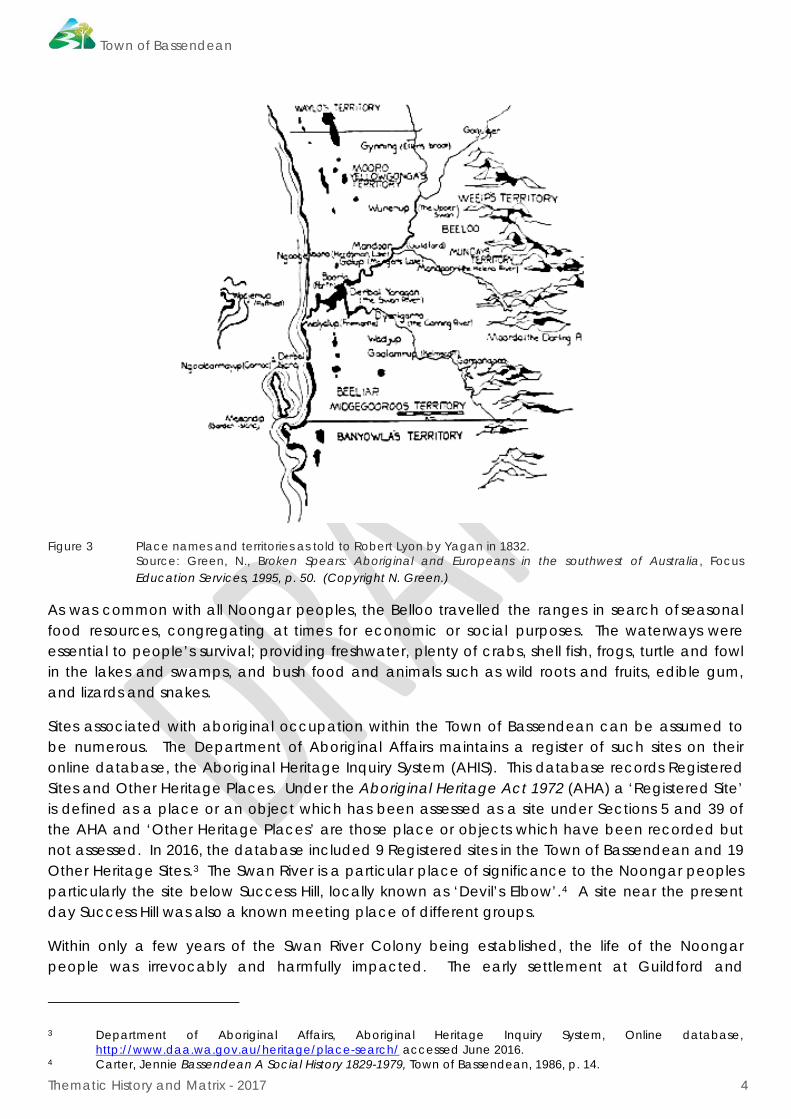
2.2. Aboriginal Histories (Pre & post European History Period)
The histories of Aboriginal people in what is now the local government area of the Town of Bassendan cannot be defined as neatly and easily as boundaries and streets. Instead local Aboriginal people’s histories relate to social organisation, land relationships, events and experiences in the area.
The aboriginal peoples who occupied the lands in the south west corner of Western Australia are collectively known as the Noongar peoples.2 Whadjuk is the name of the dialectal group from the Perth area.
Figure 2 Plan Showing Approximate Boundary of The Whadjuk Dialectical Group Courtesy http://www.noongarculture.org.au/whadjuk/
At the time of European settlement at the Swan River Colony in 1829 the Whadjuk peoples were divided by the Swan River into four principle groups. The group who inhabited the region from the Canning to the Helena Rivers was known as the Belloo and led by Munday.
2 There are many versions of the spelling of this name; Nyungar, Nyoongar, etc. The spelling ‘Noongar’ has been
chosen for this document as it is the spelling chosen in the website developed by the South West Aboriginal Land and Sea Council, Kaartdijin Noongar – Noongar Knowledge. http://www.noongarculture.org.au/
Town of Bassendean
Thematic History and Matrix - 2017 4
Figure 3 Place names and territories as told to Robert Lyon by Yagan in 1832. Source: Green, N., Broken Spears: Aboriginal and Europeans in the southwest of Australia, Focus
Education Services, 1995, p. 50. (Copyright N. Green.)
As was common with all Noongar peoples, the Belloo travelled the ranges in search of seasonal food resources, congregating at times for economic or social purposes. The waterways were essential to people’s survival; providing freshwater, plenty of crabs, shell fish, frogs, turtle and fowl in the lakes and swamps, and bush food and animals such as wild roots and fruits, edible gum, and lizards and snakes.
Sites associated with aboriginal occupation within the Town of Bassendean can be assumed to be numerous. The Department of Aboriginal Affairs maintains a register of such sites on their online database, the Aboriginal Heritage Inquiry System (AHIS). This database records Registered Sites and Other Heritage Places. Under the Aboriginal Heritage Act 1972 (AHA) a ‘Registered Site’ is defined as a place or an object which has been assessed as a site under Sections 5 and 39 of the AHA and ‘Other Heritage Places’ are those place or objects which have been recorded but not assessed. In 2016, the database included 9 Registered sites in the Town of Bassendean and 19 Other Heritage Sites.3 The Swan River is a particular place of significance to the Noongar peoples particularly the site below Success Hill, locally known as ‘Devil’s Elbow’.4 A site near the present day Success Hill was also a known meeting place of different groups.
Within only a few years of the Swan River Colony being established, the life of the Noongar people was irrevocably and harmfully impacted. The early settlement at Guildford and
3 Department of Aboriginal Affairs, Aboriginal Heritage Inquiry System, Online database,
http://www.daa.wa.gov.au/heritage/place-search/ accessed June 2016. 4 Carter, Jennie Bassendean A Social History 1829-1979, Town of Bassendean, 1986, p. 14.

Town of Bassendean
Thematic History and Matrix - 2017 5
surrounding areas, such as the future Town of Bassendean, meant interactions with the Noongar were frequent in this locality. In such areas, government policies of control were implemented. In the 1830s, policing and rationing were in place and the program of ‘assimilation’ of Aboriginal children dates from the 1840s. Throughout the 19th century the creeping suburbanisation of the land as a result of the clearing of land and drainage and building over traditional trackways, all had devastating results on the Noongar. Relationships with land were all but destroyed when family groups left their homelands either by force or by encroaching settlement.
In 1901, to celebrate the visit to Western Australia by the Duke and Duchess of Cornwall and York, 110 Aborigines were brought together from all parts of the south west and housed in specially erected iron-roofed shelters at Success Hill.
Figure 4 Group at Success Hill Aboriginal Reserve, 1901. Courtesy SLWA image 100011PD.
The Noongar who remained on the fringes of settlements are believed to have been able to do so by building relationships with European settlers. They often worked for these families as servants and manual labourers whilst being ‘permitted’ to live on what remained of earlier camping
Town of Bassendean
Thematic History and Matrix - 2017 6
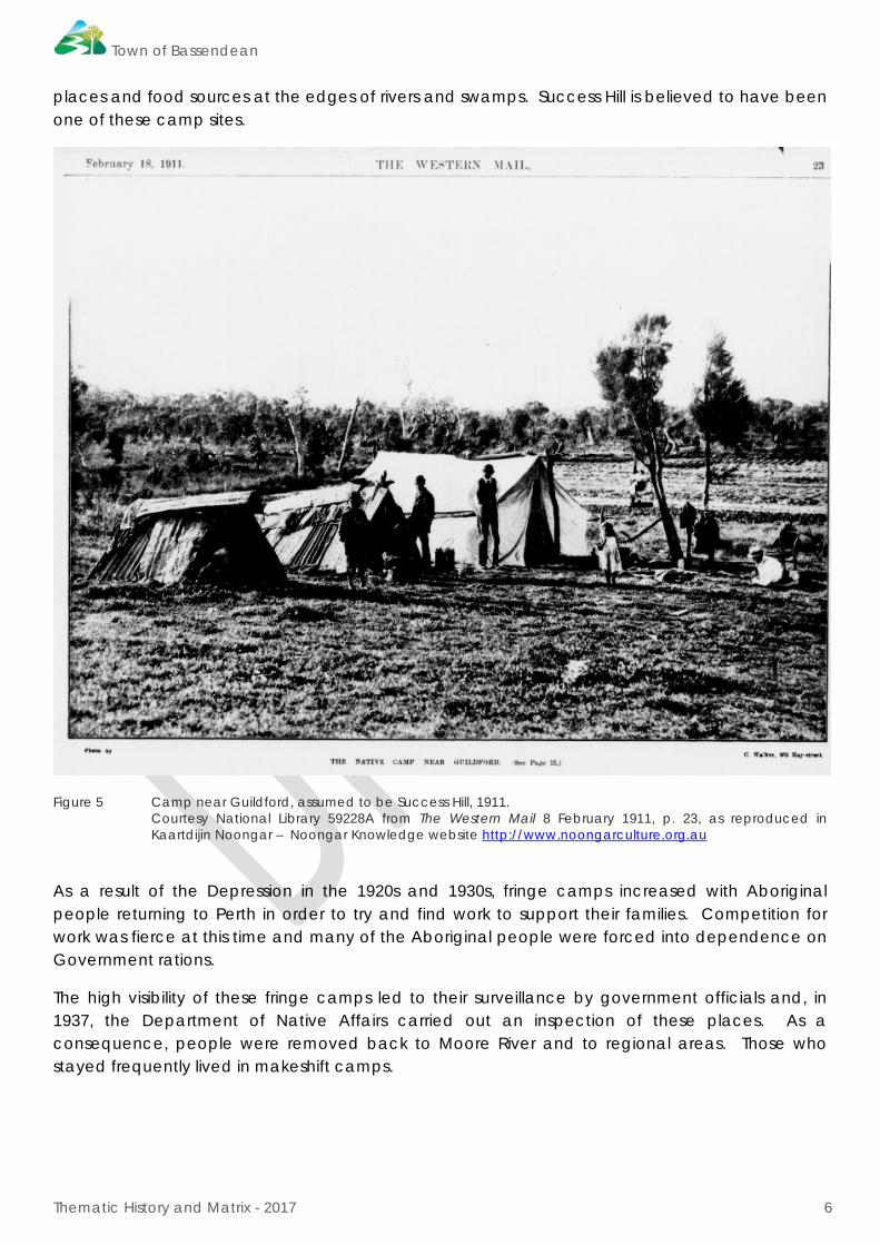
places and food sources at the edges of rivers and swamps. Success Hill is believed to have been one of these camp sites.
Figure 5 Camp near Guildford, assumed to be Success Hill, 1911. Courtesy National Library 59228A from The Western Mail 8 February 1911, p. 23, as reproduced in
Kaartdijin Noongar – Noongar Knowledge website http://www.noongarculture.org.au
As a result of the Depression in the 1920s and 1930s, fringe camps increased with Aboriginal people returning to Perth in order to try and find work to support their families. Competition for work was fierce at this time and many of the Aboriginal people were forced into dependence on Government rations.
The high visibility of these fringe camps led to their surveillance by government officials and, in 1937, the Department of Native Affairs carried out an inspection of these places. As a consequence, people were removed back to Moore River and to regional areas. Those who stayed frequently lived in makeshift camps.
Town of Bassendean
Thematic History and Matrix - 2017 7
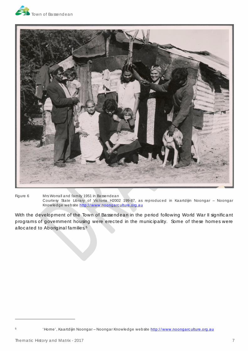
Figure 6 Mrs Worrall and family 1951 in Bassendean Courtesy State Library of Victoria H2002 199-87, as reproduced in Kaartdijin Noongar – Noongar
Knowledge website http://www.noongarculture.org.au With the development of the Town of Bassendean in the period following World War II significant programs of government housing were erected in the municipality. Some of these homes were allocated to Aboriginal families.5
5 ‘Home’, Kaartdijin Noongar – Noongar Knowledge website http://www.noongarculture.org.au
Town of Bassendean
Thematic History and Matrix - 2017 8
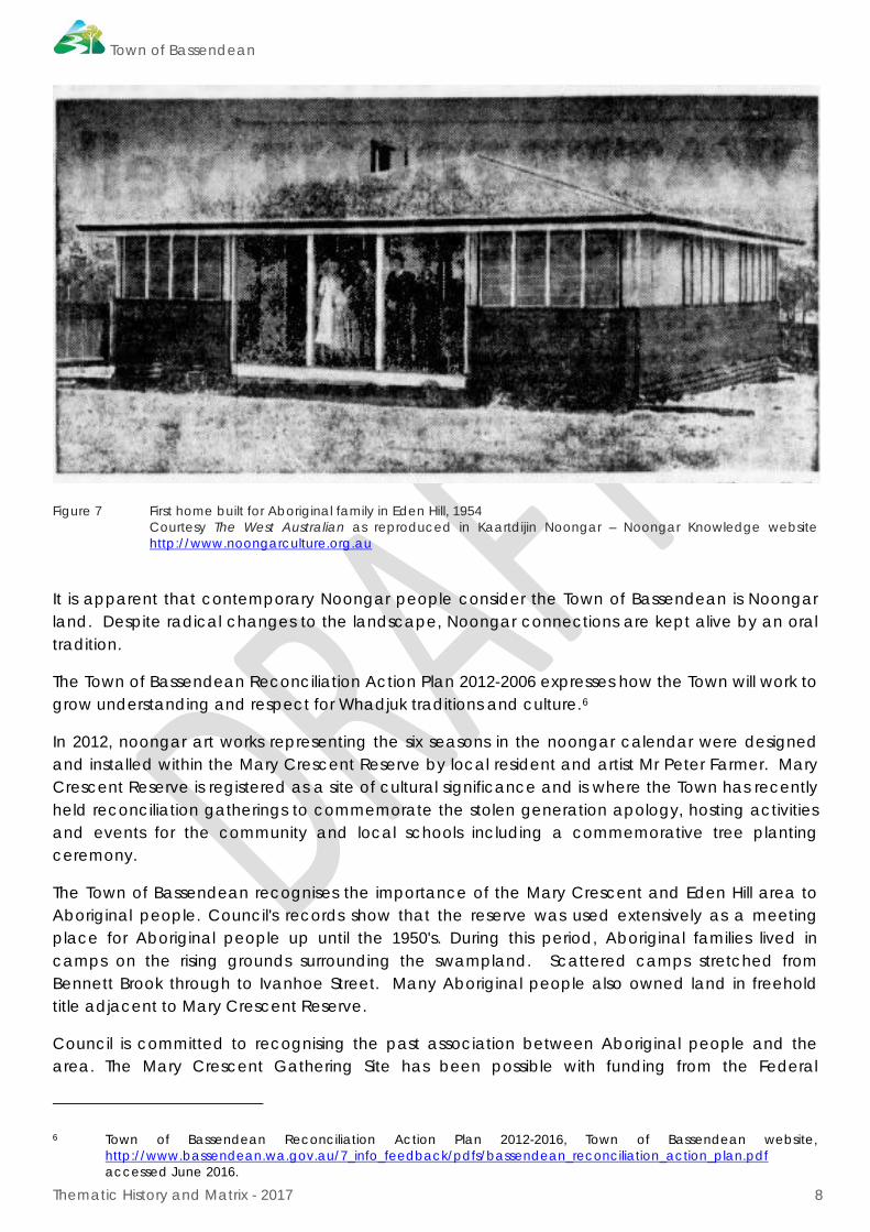
Figure 7 First home built for Aboriginal family in Eden Hill, 1954 Courtesy The West Australian as reproduced in Kaartdijin Noongar – Noongar Knowledge website
http://www.noongarculture.org.au
It is apparent that contemporary Noongar people consider the Town of Bassendean is Noongar land. Despite radical changes to the landscape, Noongar connections are kept alive by an oral tradition.
The Town of Bassendean Reconciliation Action Plan 2012-2006 expresses how the Town will work to grow understanding and respect for Whadjuk traditions and culture.6
In 2012, noongar art works representing the six seasons in the noongar calendar were designed and installed within the Mary Crescent Reserve by local resident and artist Mr Peter Farmer. Mary Crescent Reserve is registered as a site of cultural significance and is where the Town has recently held reconciliation gatherings to commemorate the stolen generation apology, hosting activities and events for the community and local schools including a commemorative tree planting ceremony.
The Town of Bassendean recognises the importance of the Mary Crescent and Eden Hill area to Aboriginal people. Council's records show that the reserve was used extensively as a meeting place for Aboriginal people up until the 1950's. During this period, Aboriginal families lived in camps on the rising grounds surrounding the swampland. Scattered camps stretched from Bennett Brook through to Ivanhoe Street. Many Aboriginal people also owned land in freehold title adjacent to Mary Crescent Reserve.
Council is committed to recognising the past association between Aboriginal people and the area. The Mary Crescent Gathering Site has been possible with funding from the Federal
6 Town of Bassendean Reconciliation Action Plan 2012-2016, Town of Bassendean website,
http://www.bassendean.wa.gov.au/7_info_feedback/pdfs/bassendean_reconciliation_action_plan.pdf accessed June 2016.
Town of Bassendean
Thematic History and Matrix - 2017 9
Government’s Regional and Local Community Infrastructure Program and represents the first step in the Mary Crescent Master Plan that has previously been adopted by Council. The project is near completion, with the construction of the limestone walls and installation and planting of the garden beds representing the six seasons in the Noongar calendar.
A guide to Aboriginal Histories (Pre & Post European History Period):
Historic themes Aboriginal people; Aboriginal occupation; Nyungar stories and knowledge; government policies
Major influences Pre-history; European colonisation, settlement & suburbanisation; government policies; changing landscapes, dispossession & removal; assimilation & institutionalisation
Development characteristics
Waterway systems (lakes, swamps & freshwater springs); tracks; bush huts & camps; fringe camps
Significant & representative places
Alice’s Corner, Registered Site, Artefacts/Scatter DAA Site ID 3133
Bennett Brook: Eden Hill Reserve, Camp Meeting Place, Water Source DAA Site ID 3487
Bennett Brook: Rosher Park, Camp Meeting Place DAA Site ID 3488
Bennett Brook: Lord Street , Ceremonial, Skeletal Material, Burial DAA Site ID 3489
Swan River, Mythological DAA Site ID 3536
Bennett Brook: in total, Mythological DAA 3692
Success Hill: Artefacts/Scatter, Ceremonial, Fish Trap, Man-Made Structure, Mythological, Quarry, Repository/Cache, Birth Place, Camp, Meeting Place, Water Source.
Mary Crescent Gathering Site, Eden Hill (Lockridge Camp)
Town of Bassendean
Thematic History and Matrix - 2017 10
2.3. Discovery and Early exploration pre 1829
Although the Western coast of Australia was discovered by the Dutch as early as 1616 and the lower reaches of the Swan River estuary were both discovered and explored by Dutch navigators in 1697 it was not until 1801 that the fertile alluvial flats along the upper reaches of the river, in the area known today as the Swan Valley were first seen by Europeans.
The Dutch expedition of 1697, which was led by Commander Willem de Vlamingh, was sent to search for possible survivors of the wreck of a missing Dutch ship, the 'Ridderschap van Hollandt', which had been lost between the Cape of Good Hope and Batavia. Consequently, little attention was afforded to environmental considerations along the western coast of 'New Holland'.
On arriving in the vicinity of what later became known as Fremantle, members of the crew explored the river estuary which they named 'Swaarte Swanne River' or 'Black Swan River'. When the explorers reached the mud-flats near the site of the present Causeway the presumption was made that this was the furthest reaches of the river and no attempt was made to haul the boats over the shallows.
Just over a century later a French expedition was commissioned on the orders of Napoleon Bonaparte to complete the French surveys of the coast line of Australia as well as to make collections of specimens of flora and fauna.
While the crew of the 'Naturaliste' awaited the arrival of the 'Geographe' at the prearranged rendezvous point off Rottnest Island, Captain Hamelin decided to use the time in exploring the mainland. Thus, on 17th June 1801 one of the ship's boats under the command of Ensign Heirisson was sent to explore the Swan River as far upstream as possible. The account of their expedition was the first written description of the landscape.
Owing to increased fears at the possible annexation of the western half of the Australian continent by the French, the Governor of New South Wales, General Darling called for the establishment of a temporary outpost at King George Sound.
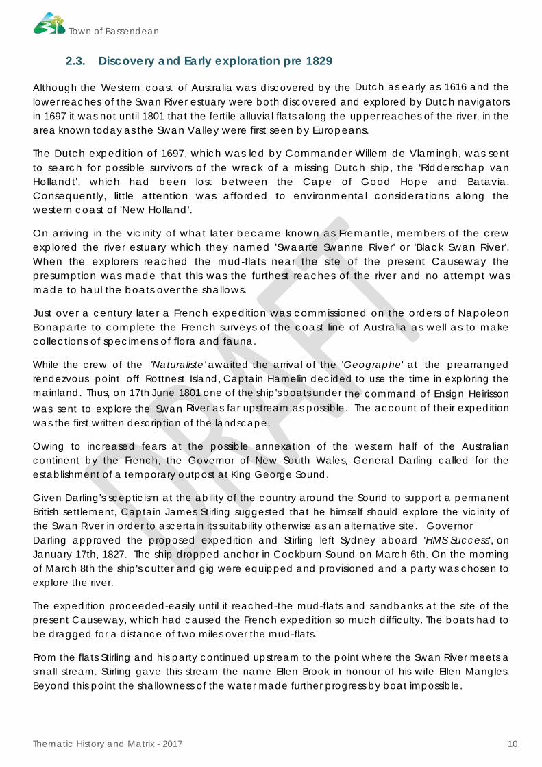
Given Darling's scepticism at the ability of the country around the Sound to support a permanent British settlement, Captain James Stirling suggested that he himself should explore the vicinity of the Swan River in order to ascertain its suitability otherwise as an alternative site. Governor Darling approved the proposed expedition and Stirling left Sydney aboard 'HMS Success', on January 17th, 1827. The ship dropped anchor in Cockburn Sound on March 6th. On the morning of March 8th the ship's cutter and gig were equipped and provisioned and a party was chosen to explore the river.
The expedition proceeded-easily until it reached-the mud-flats and sandbanks at the site of the present Causeway, which had caused the French expedition so much difficulty. The boats had to be dragged for a distance of two miles over the mud-flats.
From the flats Stirling and his party continued upstream to the point where the Swan River meets a small stream. Stirling gave this stream the name Ellen Brook in honour of his wife Ellen Mangles. Beyond this point the shallowness of the water made further progress by boat impossible.
Town of Bassendean
Thematic History and Matrix - 2017 11
Figure 8 Chart of Swan River from a survey by Captain Stirling, 1827 SROWA item 408 cons 3844.
It is widely asserted that during the course of this exploration the party found a spring of beautiful fresh water at the base of a hill from which they filled their water-casks. Recent studies of Bassendean, such as Carter's Bassendean A Social History 1829-1979 and Bevan Carter’s extensive research in relation to the interpretation at Success Hill have revealed this story to be a myth. Nevertheless, the hill and spring both carry the name 'Success' and perpetuate the story.
The glowing report by Stirling and a conjunction of other factors led the British government to the decision to establish a colony at the Swan River in 1829.

Town of Bassendean
Thematic History and Matrix - 2017 12
2.4. Settlement 1829-1850
Stirling's initial expedition and resulting report of 1827 was far too narrow in its scope, concentrating on the extremely rich alluvial soil along the Swan River and the fertile pockets of land extending from the Darling Scarp to below the confluence of the Swan and Helena Rivers. This, combined with the short period of time spent on exploring the mainland, resulted in an inaccurate report of the area as a whole.
It soon became apparent that birth, breeding and influence were not by themselves enough to secure and maintain the various land grants. Capital became the essential ingredient for prosperity and success. When the land on either side of the river failed to yield its expected harvests many of the settlers who had equated property with wealth realised their mistake. One such settler was Peter Broun.
Peter Broun (1797-1846) Broun, the first Colonial Secretary and first banker of Western Australia, was a descendant from an ancient French family and a member of Scotland's minor gentry. Broun, his wife Caroline, and their young family achieved a high standing in the small colony.
Figure 9 Peter Nicholas Broun (1797-1846), SLWA, online image 003117D, call number 1905B/1
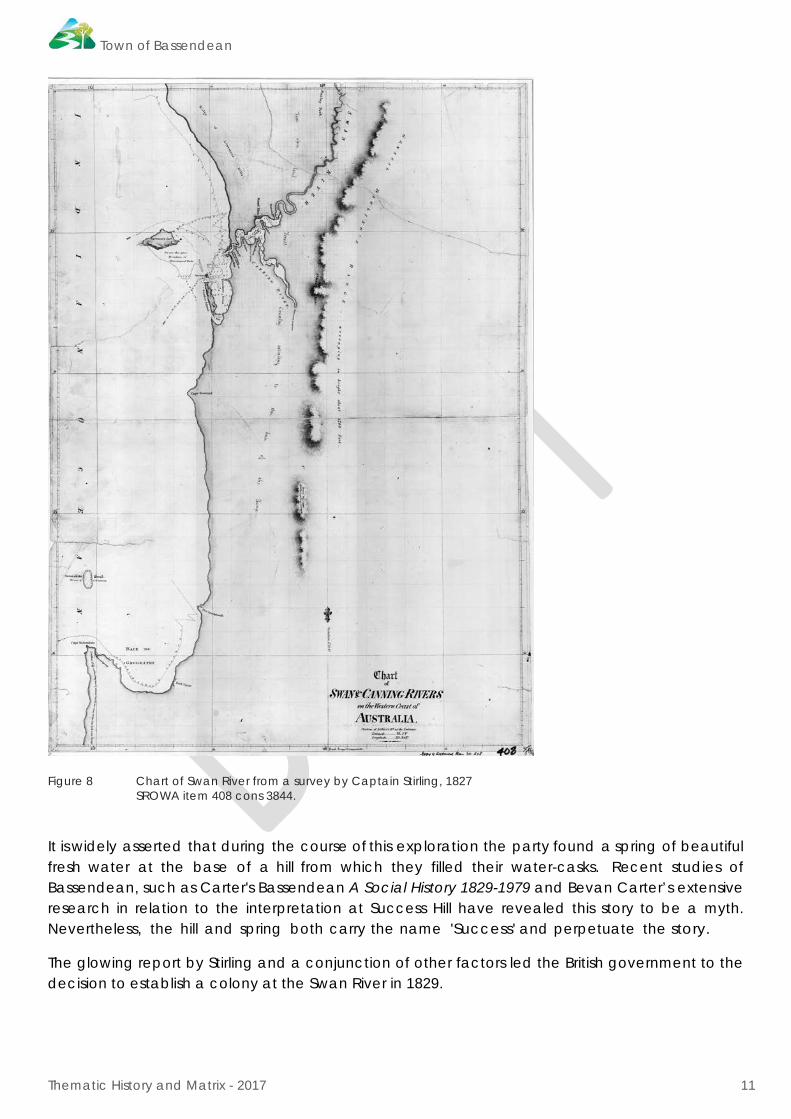
By 1832, Broun had acquired two substantial parcels of land, a large grant comprising 5000 acres on the Upper Swan, in addition to land totalling 1455 acres on the western side of the river at Guildford. The latter of the two grants, a triangular piece of land with a long river frontage stretching from the area now known as Ashfield nearly up to James Dodd's land, was named 'Bassendean' after Broun's family seat in Scotland. This property originally known as 'Stoke Farm', was previously owned by brothers James and Stephen Henty.
Town of Bassendean
Thematic History and Matrix - 2017 13
Figure 10 Survey of Swan River by R. Clint, with P. Broun property ‘Bassindean’, 1831 SROWA item 014 cons 3844 Sheet 10.
Figure 11 Portion of Survey by R. Clint, showing P.Broun property ‘Bassindean’, 1831 SROWA item 014 cons 3844.
Town of Bassendean
Thematic History and Matrix - 2017 14
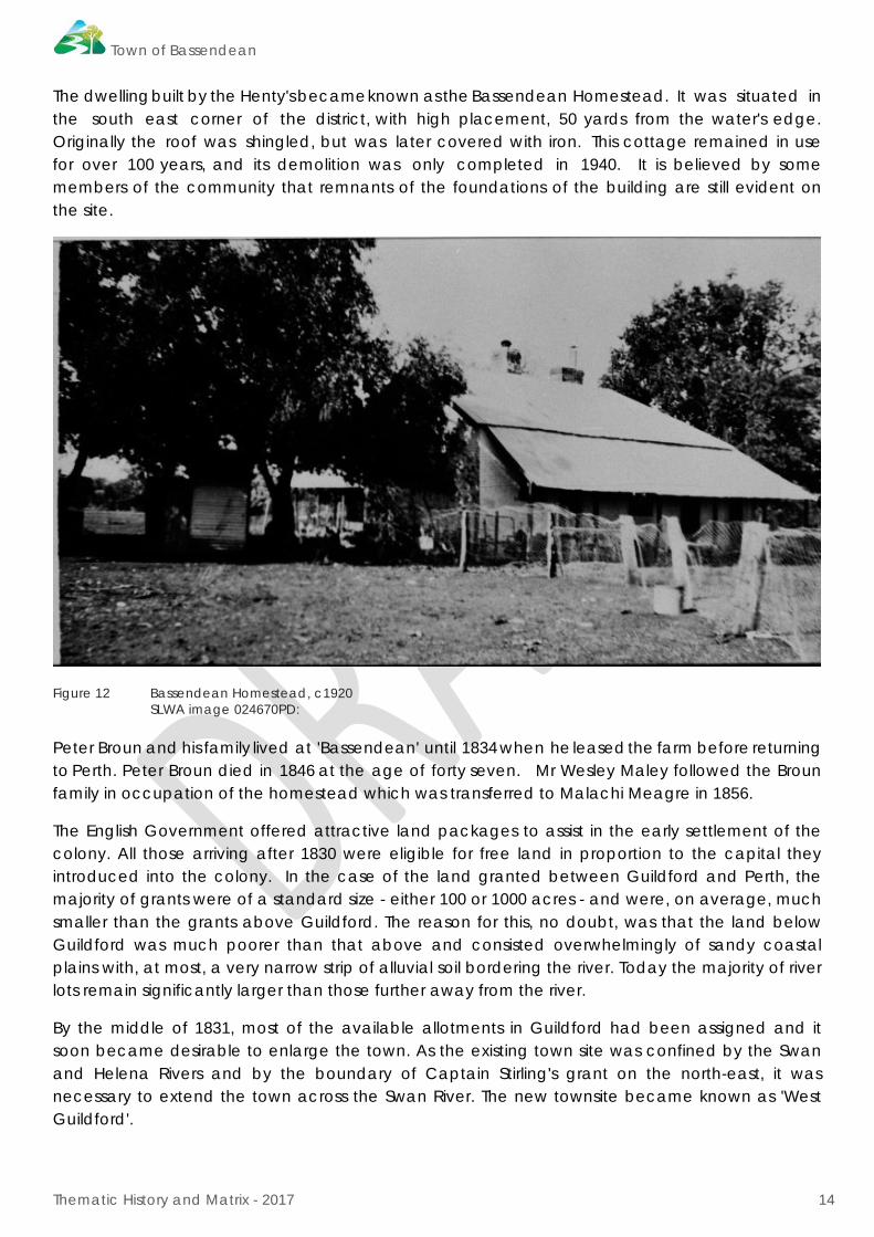
The dwelling built by the Henty's became known as the Bassendean Homestead. It was situated in the south east corner of the district, with high placement, 50 yards from the water's edge. Originally the roof was shingled, but was later covered with iron. This cottage remained in use for over 100 years, and its demolition was only completed in 1940. It is believed by some members of the community that remnants of the foundations of the building are still evident on the site.
Figure 12 Bassendean Homestead, c1920 SLWA image 024670PD: Peter Broun and his family lived at 'Bassendean' until 1834 when he leased the farm before returning to Perth. Peter Broun died in 1846 at the age of forty seven. Mr Wesley Maley followed the Broun family in occupation of the homestead which was transferred to Malachi Meagre in 1856.
The English Government offered attractive land packages to assist in the early settlement of the colony. All those arriving after 1830 were eligible for free land in proportion to the capital they introduced into the colony. In the case of the land granted between Guildford and Perth, the majority of grants were of a standard size - either 100 or 1000 acres - and were, on average, much smaller than the grants above Guildford. The reason for this, no doubt, was that the land below Guildford was much poorer than that above and consisted overwhelmingly of sandy coastal plains with, at most, a very narrow strip of alluvial soil bordering the river. Today the majority of river lots remain significantly larger than those further away from the river.
By the middle of 1831, most of the available allotments in Guildford had been assigned and it soon became desirable to enlarge the town. As the existing town site was confined by the Swan and Helena Rivers and by the boundary of Captain Stirling's grant on the north-east, it was necessary to extend the town across the Swan River. The new townsite became known as 'West Guildford'.

Town of Bassendean
Thematic History and Matrix - 2017 15
Although the young colony experienced difficult years there remained a strong desire to recreate the privileged British gentry social order. The English hierarchical social system soon became the philosophy of the influential first white settlers, whereby birth, breeding and capital were the guide-lines for the establishment of the colony's ruling elite.
Even though there were many stories of debt, disillusionment and despair, such as that of Peter Broun, there were also a number of settlers who succeeded in their quest for position and prosperity in the new colony. One of the most notable was William Tanner, who arrived in the Swan River Colony in 1831 and eventually came to own the greater part of land which was to become the Town of Bassendean.
Figure 13 Land allocation Guildford, 1836, SROWA Guildford 17F series 235 cons 3868 item175
It was not long before the adopted social order of the Mother Country was found to be out of place in the Swan River Colony. The opportunity to own land was within the reach of all settlers regardless of their station. For those workers who were able to capitalise on the colony's need for their services, land ownership provided a measure of independence and a base from which they could redefine inherited ·power relations. The high rate of wages in the colony heightened the aspirations of the independent labourers and enabled some of them to buy their own land and livestock.
The acquisition of land by the 'working class' occurred to a greater extent in the Swan district than elsewhere in the colony. Surviving records show that several of the West Guildford Town Lots were originally taken up by labourers, former servants, artisans and small farmers previously employed by members of the investing class.

Town of Bassendean
Thematic History and Matrix - 2017 16
Consequently the labourers were forming in independence of outlook which they had not been able to afford in their home country.
Figure 14 Townsite of Guildford, 1842 SROWA: Guildford 17B, series 235 cons3868 item172
For the settlers in the district the absence of bridges and properly made roads in the Swan district made it necessary to rely almost completely on riverboats for communication and the transport of goods between Guildford, Perth and Fremantle.
In 1831, the government proposed to establish a public ferry service over the Swan River at Guildford. A boat large enough to carry horses, cattle and other livestock was built in the colony for that purpose.
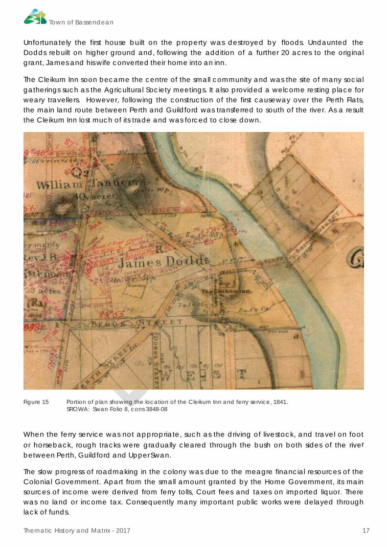
Cleikum Inn and Ferry Service The ferry was put into operation at the end of June 1831 and remained in use for fifty years until the first bridge was built. It travelled between a landing on the river bank at the end of Bridge St, Guildford, to the opposite bank below James Dodd's house. From there the beginnings of a road led to the Town of Perth and another led northwards on the west side of the river to 'Henley Park' and Ellen's Brook.
The franchise to operate the ferry was auctioned annually at a meeting of townspeople. It is recorded that James Dodd leased the newly built horse ferry in 1834 for five pounds.
The Dodd family arrived in the Swan River Colony aboard the 'Rockingham' in May 1830. In September of that year James Dodd selected an allotment of 20 acres in West Guildford.
Town of Bassendean
Thematic History and Matrix - 2017 17
Unfortunately the first house built on the property was destroyed by floods. Undaunted the Dodds rebuilt on higher ground and, following the addition of a further 20 acres to the original grant, James and his wife converted their home into an inn.
The Cleikum Inn soon became the centre of the small community and was the site of many social gatherings such as the Agricultural Society meetings. It also provided a welcome resting place for weary travellers. However, following the construction of the first causeway over the Perth Flats, the main land route between Perth and Guildford was transferred to south of the river. As a result the Cleikum Inn lost much of its trade and was forced to close down.
Figure 15 Portion of plan showing the location of the Cleikum Inn and ferry service, 1841. SROWA: Swan Folio 8, cons 3848-08
When the ferry service was not appropriate, such as the driving of livestock, and travel on foot or horseback, rough tracks were gradually cleared through the bush on both sides of the river between Perth, Guildford and Upper Swan.
The slow progress of roadmaking in the colony was due to the meagre financial resources of the Colonial Government. Apart from the small amount granted by the Home Government, its main sources of income were derived from ferry tolls, Court fees and taxes on imported liquor. There was no land or income tax. Consequently many important public works were delayed through lack of funds.

Town of Bassendean
Thematic History and Matrix - 2017 18
The severe economic depression which hit the Swan River Colony in the 1840s resulted from a combination of factors: too much money leaving the colony in the form of imports, and not enough exports to replace this loss, the small and relatively poor population with its absence of a sizable pool of labourers, the settlement's extreme isolation from most of the world's markets, large areas of unproductive land and the lack of managerial expertise and enterprise. Thus, the poor living and working conditions which characterised the early years of settlement were further heightened. It was only after the sandalwood export boom, which took off in 1847, that the economic depression started to lift.
During the 1840s West Guildford remained largely an undeveloped satellite to Guildford with few roads, no businesses and a dwindling population. The small town appeared to be increasingly isolated, both in relation to activities and logistics.
This difficult economic situation was to remain until the introduction of the convict system in 1850.
2.5. The Convict Era 1850-1880
The ever-present push for the transportation of convicts to the Swan River Colony gained momentum as the need for cheap labour agricultural expansion but also to carry out much needed public increased. The convicts were required not only to further works which had, to this point, been sadly neglected.
There was a certain degree of opposition to the scheme by individuals who believed that the benefits to be derived from cheap labour would be far outweighed by the 'moral taint' that being a penal settlement would bring to the Swan River Colony.
In spite of this, on June 1 1850 the 'Scindian' landed at Fremantle with 75 prisoners of the Crown who were accompanied by 55 guards and their families.
For the next 18 years regular shipments of convicts from Britain brought over 9000 men to the colony [women convicts were not accepted] whose presence did much to change the shape of the colony - both physically and socially.
The Enrolled Pensioner Guards Between 1850 and 1868 nearly 1200 Enrolled Pensioner Guards along with their wives and families were brought out to the Swan River Colony in order to oversee the convicts and to act as a reserve force in the young settlement. In March 1870, Enrolled Pensioner Guards constituted 543 of the 2511 free [non-convict] adult males in the colony.
Their place in the strict social hierarchy of the colony is difficult to define, situated as they were on the scale, somewhere between the convicts and the 'free emigrants', a position which encouraged them to form a closed society of their own.
Western Australia was not the first, nor the only British Colony where Pensioner Guards were used as a cheap substitute for regular soldiers for the purpose of garrison or police duties. In the aftermath of the Napoleonic Wars many undertook such duties in preference to civilian life in the British Isles.
Each convict ship was normally staffed by a platoon of about thirty men, including 4 non-commissioned officers. Successful recruits were assured of free passages for themselves and their

Town of Bassendean
Thematic History and Matrix - 2017 19
families. On arrival in the settlement the Pensioner Guards were guaranteed six months employment on regular duty at pay ranging from one and threepence to one and tenpence per day, depending on their army rank.
Initially the Pensioner Guards were not allowed to obtain a land grant; the aim being to encourage them to supply the demand for labour rather than to aspire to becoming settlers.
It being considered more advantageous for the Pensioners and their families that they should supply the demand for labour, than attempt settling on land of their own, no grant of land has been promised them: but if they acquire money to purchase it in the interior, there will be no objection to their settling there, even though the distance should prevent them from serving as enrolled Pensioners.7
However, owing to the great difficulties in obtaining outside work and the resulting hardships due to lack of capital, Governor Charles Fitzgerald altered the ruling. Thus, deserving Pensioners were granted land, but only obtained freehold if they remained on the property for seven years. Unfortunately, only a minority benefited from this scheme.
Whether they took government positions or went on the land, the Pensioner Guards were usually regarded as a powerful force for respectability in the colony. "The Pensioner Force under Lt. Colonel Bruce form an important element in the population of this colony," wrote Governor Kennedy in 1856, "and is calculated to exercise a lasting influence on the popular character of the colony."8
Governor Kennedy was probably right in suggesting that the Pensioners' legacy to Western Australia would mainly be their moral influence. They provided an example of conformity and loyalty which evoked official approval and served as a model for other members of the working class who aspired to respectability, including some of the ex-convicts.
When the Pensioner Guards were disbanded in 1887 they were encouraged to settle permanently in the colony and, therefore, both increase and influence the population.
Convicts, Pensioner Guards and West Guildford Almost immediately following the arrival of the first shipment of convicts, depots for hiring convicts were set up in a number of settled areas, one of the most important being that constructed at Guildford in 1851. Unfortunately it was demolished in 1882 to make way or the re-routed railway line. On the surface, West Guildford remained relatively unaffected by the increased activity produced by transportation. Despite the establishment of the convict depot in Guildford and the flurry of construction, road making, drainage works and bridge building that followed from the ready supply of forced labour, very little was done to improve the facilities of, or access to, the town lots on the west bank. No roads were made, the anticipated bridge was not built and business continued to be concentrated on the east side of the river. Yet in one respect West Guildford did benefit from the presence of the convict depot in that from the 1860s onwards a number of the Enrolled Pensioner Guards settled permanently on their grants in the area. They
7 The Perth Gazette, 22 March 1830, as quoted in Bolton, 1981. 8 Bolton, G.C. “Who were the Pensioners” in ‘Studies in Western Australian History, IV, December 1981, p. 88.

Town of Bassendean
Thematic History and Matrix - 2017 20
and their children were involved in shaping the character of the township which was to become the nucleus of the suburb of Bassendean.
The Pensioner Guards who were stationed in Guildford and employed to guard the depot there did not take up residence in the area prior to 1854. By 1859 three of the Pensioners had been granted land in West Guildford and had settled there with their families. Initially the Guard population was quite fluid, with few completing the required seven years residence. Those who did stay to swell the tiny population of West Guildford had a significant impact on the development and character of the township.
As well as the land grants given to individual Pensioners and their families, the convict authorities had to provide quarters for the guards employed at the Guildford depot. It was originally planned to build twelve Pensioners' Cottages at West Guildford, but in the end only four were built. They took several years to complete owing to the shortage of skilled labour, and were not finally occupied until the 1860s.
Figure 16 Pensioner Guard cottage, 1920. SLWA, online image 024673PD, call number b2987220_2
Only one of these cottages, which were all grouped in the vicinity of Surrey Street, has survived and has been included on the State Register of Heritage Places as the ‘Pensioner Guard Cottage’.
Convicts - The Last Arrivals In 1865, it was announced that the transportation of convicts to Western Australia would cease in 1867. This coincided with a building boom as the authorities made the fullest use of the remaining time, with the construction of roadworks and public buildings.
Town of Bassendean
Thematic History and Matrix - 2017 21
l l 1
The last convict ship to be sent to the colony arrived in Fremantle on 10 January 1868 carrying 279 convicts, most of whom were Irish Fenians. Many of the Fenians were sent to work surfacing the road to Guildford on the west side of the river; hence it became known as 'Fenian Road'.
Even after the arrival of the convicts at Guildford, progress and development on the west bank was painfully slow. There were few good roads, no railway and still no bridge to link West Guildford to the main township.
The most notable sign of progress in the late 1850's was the introduction of steam communication between Perth and Guildford. On the 15th January 1857 the 'Pioneer' steamboat, with twenty passengers aboard, made its maiden voyage to Guildford. The boat was actually a barge, of the type known as a 'flat:, built with shallow draught for negotiating the shallow waters near the Perth Causeway. With a paddle-wheel and steam engine fitted to the stern, the boat reached Guildford in two hours and five minutes. A regular service between Perth and Guildford was soon in operation. [Bourke,1987]
By the late 1860s the convict element was far from obvious, with large numbers of former convicts having merged into the general population. Guildford was no longer primarily a convict town and its inhabitants depended less and less on the Convict Depot for their livelihood.
Labourers continued to acquire land and tillage leases throughout the 1860s and were the chief growers of wheat and other crops. They formed a distinct class, usually referred to as 'yeomen' or more popularly as 'cockatoo farmers', and proved to be a source of considerable competition to the gentlemen farmers ('agriculturalists') and the pastoral leaseholders ('squatters'). In the Swan district the yeomen farmers were in a majority in terms of numbers, but the gentlemen farmers continued to act as leaders of society.
However, much of the progress and posterity experienced within the colony can be attributed to the presence of convicts. Although there was a fear of an overwhelming increase in serious crime this did not eventuate. In fact, many former prisoners were accepted into the community as successful farmers, storekeepers and tradesmen
2.6. Increased Development 1880-1900
The ever increasing population of Western Australia had repercussions on the growth and diversity of industry, particularly primary industry, in the state. Consequently, the need for efficient transport and communication became essential. Thus, the spate of railway construction that had begun in the 1870s, increased dramatically.
An initial proposal for the construction of a railway connecting Fremantle, Perth and Guildford was put forward in 1875. Preliminary surveys for the proposed railway line indicate three possible routes. The first or 'Northern' route ran on the north side of the Swan River, passing through Perth and West Guildford into James Street, Guildford. The second or 'Southern' route crossed the Canning and Helena Rivers and terminated near Helena Street, Guildford. The third or 'alternative' route ran on the south side as far as the Perth Causeway, where it crossed the river and continued to Guildford on the north side.
Town of Bassendean
Thematic History and Matrix - 2017 22
Following much deliberation, the Northern route was chosen by the Legislative Council and approved by the Governor. On 3rd June 1879, a date which also commemorated the fiftieth anniversary of the colony's foundation, construction of the Fremantle to Guildford Railway began. The last spike was driven in less than two years later in December 1880. The line was officially opened by the Governor on 1st March 1881, and further extended to York by 1885.
The decision to construct the railway line along the northern route was crucial to the development of West Guildford. If the line had followed the southern side of the Swan River, the small township would probably have had a fundamentally different history from that which eventuated.
The opening of the railway proved to be a very significant event leading to the promotion of West Guildford as an increasingly fashionable place of residence. Traffic on the new railway surpassed all expectations, both in the amount of goods carried and in the number of passenger tickets issued. One immediate effect of the railway was a decline in river traffic because most farmers and sandalwood carters now brought their goods to the Guildford railway yard for transport to Fremantle by rail.
It was not until 1910 and the growth of industry in the area that the West Guildford Railway Station was constructed.
The First Traffic Bridge Due to the unfortunate demise of the ferry service in 1880 owing to lack of funds, West Guildford was effectively cut off from the Guildford Township until the completion of the first traffic bridge five years later.
In 1875, the Government had promised the people of Guildford it would build a road bridge across the Swan River at West Guildford. However, it was not until 1881 that the proposal was given serious consideration. The construction of a bridge was opposed by members of the Legislative Council on the grounds that it would only benefit the 25 people living in West Guildford.
However, it was pointed out that if the bridge was built more people would be likely to go there to live; a prediction which was later borne out. Money was voted for the purpose and construction began in 1883. It was built at the end of Bridge Street under contract with the Guildford Municipal Council by Mr Ben Mason, who was also responsible for the Fremantle Bridge. His Guildford contract cost £600 pounds and was completed in 1885.
A second bridge in the same position, built by Engineer Parry, was later replaced by a third built under contract with the Main Roads Department, by Mr R.A. Ordham, in November 1937. This bridge is still in use today.
As a residential area, West Guildford continued to grow, essentially due to the influence of the railway and the bridge construction. The town was now within easy commuting distance to Perth and, thus, it was now possible to commute daily to the city while living in a pleasant, rural environment.
The Gold Rush and the Building Boom In 1885 gold was discovered in the Kimberleys and heralded a rush of people to the West which peaked in the 1890s following discoveries at Coolgardie and Kalgoorlie. In less than a decade

Town of Bassendean
Thematic History and Matrix - 2017 23
Western Australia's population increased from 48,502 in 1890 to 131, 465. The sharp rise was also due to the severe economic depression which had hit the Eastern States in the 1890s. Caused by a series of complex factors, including a drought, heavy overseas borrowing, falling export prices and the resulting bank failures and industrial strikes, the depression forced people to abandon their 'home' state in order to seek work or dig for their fortunes on the gold fields. So while Eastern states sank further into depression, the West was riding a wave of prosperity and optimism.
The increased population was accompanied by land speculation, subdivision and a building boom. The nature of the development which followed was reflected in the construction of roads, bridges, railways and public buildings, the architectural distinctiveness of which became synonymous with the extravagance of the era.
Such was the demand for housing and land that by 1899 virtually all the large tracts of land in West Guildford had been subdivided. Initially a small but steady trickle of families came to swell the infant suburb. Areas of bush were cleared so that houses, both small and makeshift or large and comfortable, depending on the owner's circumstances, could be constructed. Although roads were surveyed, at this stage few were made apart from those in the older, more established sections of West Guildford
As the landscape was gradually tamed and transformed, West Guildford began to take on the appearance of an English outer suburb. Tidiness and order, which was a distinct characteristic of the district, became an outward sign of its respectability. Several grand homes along and near the river still exist today and are evidence of the wealth and social standing of West Guildford's small population. For example the two large residences built by Charles Wicks.9 The quality of the materials and the ornate craftsmanship distinguish these and other such residences from the very plain and simple cottages set further back from the river.
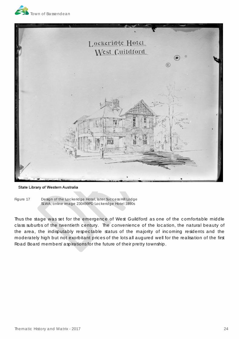
The vision of West Guildford as a potentially exclusive residential area was further reinforced by contemporary land advertisements which dwelt upon the picturesque surroundings and it reputed salubrious climate. Land prices were indicative of the perceived value of the area and compared favourably to those in the new district of Peppermint Grove, a similar riverside development situated approximately the same distance from Perth as West Guildford. In 1895, the three blocks on which the Lockeridge Hotel was later built sold for £150 and £250 was the asking price for one of the two acre lots fronting the river.
9 Holmehouse, 16 Anstery Road and Hazeldean, 8 Carnegie Road.
Town of Bassendean
Thematic History and Matrix - 2017 24
Figure 17 Design of the Lockeridge Hotel, later Success Hill Lodge SLWA, online image 230499PD Lockeridge Hotel 1890s
Thus the stage was set for the emergence of West Guildford as one of the comfortable middle class suburbs of the twentieth century. The convenience of the location, the natural beauty of the area, the indisputably respectable status of the majority of incoming residents and the moderately high but not exorbitant prices of the lots all augured well for the realisation of the first Road Board members' aspirations for the future of their pretty township.

Town of Bassendean
Thematic History and Matrix - 2017 25
Figure 18 Plan of lots for sale in Guildford and West Guildford, n.d. SROWA, series 235 cons 3868 item178 Guildford 17-7B.
The Midland Workshops The Government continued to expand its commitment to railway construction but soon found that the existing railway workshops situated at Fremantle to be inadequate for the purpose. The decision to relocate the workshops to Midland Junction, at a spot four miles from Guildford, was to have profound repercussion on the surrounding areas. Although the proposal was recommended in 1891 it was not until 1900 that work commenced at the Midland site, to be finally completed in 1905.
Initially, there was a huge influx of 'transient' workers who lived in Fremantle and commuted daily to the workshops. However, it was not long before the workers decided to make their homes closer to Midland Junction. Many railway workers chose to live in West Guildford as land and housing there was reasonably inexpensive.
Consequently the social milieu of West Guildford took on a more complex appearance. The substantial brick dwellings surrounded by established, manicured gardens in the near vicinity of the Swan River no longer stood out as a distinguishing feature of West Guildford. They were now outnumbered by the hastily erected wooden, hessian and sheet metal workers' cottages generally located along the railway line. The surviving examples of these workers cottages reflect a way of life, a social class and a building type but also represent an intrinsic part of Bassendean's character and history.
Town of Bassendean
Thematic History and Matrix - 2017 26
2.7. Consolidation 1900-1920
The rise in Western Australia’s population, which increased dramatically following the gold-rushes of the 1880s, was reflected in the formation of numerous country and suburban road boards. Included among these was the Bayswater Road Board. Formed in 1897 it petitioned the Government to include West Guildford within its jurisdiction. However, the Guildford Municipal Council strongly objected to this move and the request was subsequently denied.
Until the close of the nineteenth century the administration of West Guildford was under the control of the Guildford Municipal Council. However, there was a history of indifference by the Guildford authorities concerning the development of its neighbour. Very little was done in regards to lighting, road construction and general development as the Council was primarily concerned with rate collections and the adjustment of land titles and settlement. Naturally, such a situation resulted in great dissatisfaction among the residents of West Guildford. Concerted moves were made to secede from the Guildford Council and hence establish a West Guildford Council.
Thus, the West Guildford Road Board came into being. The action was principally motivated by an influential group of residents including senior civil servants and prosperous businessmen.
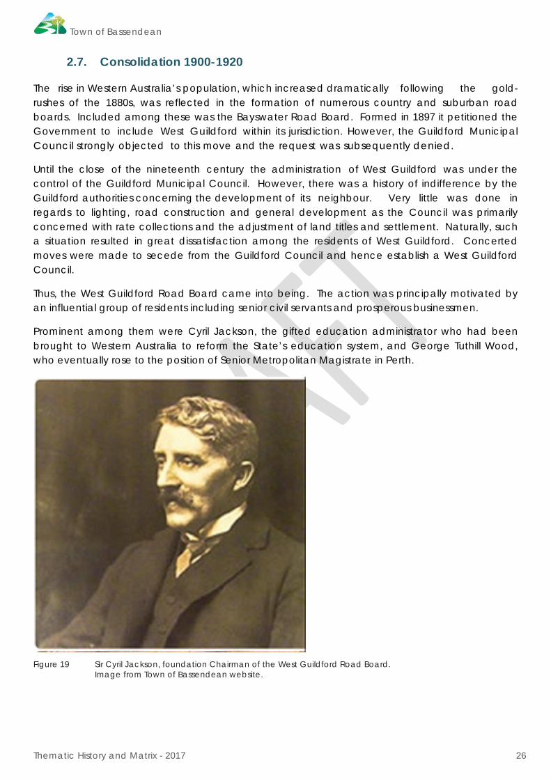
Prominent among them were Cyril Jackson, the gifted education administrator who had been brought to Western Australia to reform the State’s education system, and George Tuthill Wood, who eventually rose to the position of Senior Metropolitan Magistrate in Perth.
Figure 19 Sir Cyril Jackson, foundation Chairman of the West Guildford Road Board. Image from Town of Bassendean website.
Town of Bassendean
Thematic History and Matrix - 2017 27
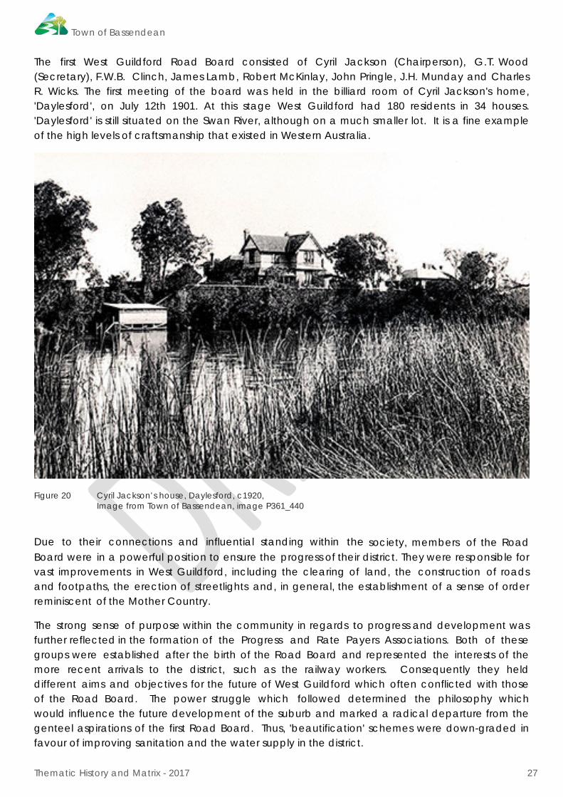
The first West Guildford Road Board consisted of Cyril Jackson (Chairperson), G.T. Wood (Secretary), F.W.B. Clinch, James Lamb, Robert McKinlay, John Pringle, J.H. Munday and Charles R. Wicks. The first meeting of the board was held in the billiard room of Cyril Jackson's home, 'Daylesford', on July 12th 1901. At this stage West Guildford had 180 residents in 34 houses. 'Daylesford' is still situated on the Swan River, although on a much smaller lot. It is a fine example of the high levels of craftsmanship that existed in Western Australia.
Figure 20 Cyril Jackson’s house, Daylesford, c1920, Image from Town of Bassendean, image P361_440
Due to their connections and influential standing within the society, members of the Road Board were in a powerful position to ensure the progress of their district. They were responsible for vast improvements in West Guildford, including the clearing of land, the construction of roads and footpaths, the erection of streetlights and, in general, the establishment of a sense of order reminiscent of the Mother Country.
The strong sense of purpose within the community in regards to progress and development was further reflected in the formation of the Progress and Rate Payers Associations. Both of these groups were established after the birth of the Road Board and represented the interests of the more recent arrivals to the district, such as the railway workers. Consequently they held different aims and objectives for the future of West Guildford which often conflicted with those of the Road Board. The power struggle which followed determined the philosophy which would influence the future development of the suburb and marked a radical departure from the genteel aspirations of the first Road Board. Thus, 'beautification' schemes were down-graded in favour of improving sanitation and the water supply in the district.
Town of Bassendean
Thematic History and Matrix - 2017 28
Industry in Bassendean It was not until the beginning of the Twentieth Century that Bassendean began to show any enterprise of an industrial nature. Prior to 1900, Bassendean was not only noted for its brickmaking but also for the several backyard boat-building operations in the area. However, the most common business to be established during these and later years were market gardens; the major commercial market gardens belonging to Chinese syndicates. Due to the essentially rural nature of Bassendean, poultry breeding became a popular occupation in the district.
Although Midland was a significant centre of industrial growth it was soon realised that Bassendean was ideally situated for an industrial area. Not only was it located on the Swan River it was also easily accessible by road and rail. This, combined with an abundance of unoccupied, flat, cheap land, a readily-available labour force, and the close proximity to the capital, were advantages taken into consideration in the placement of the industrial area.
The factories and industries that were to emerge henceforth in Bassendean all contributed to moulding and defining the character of the district.
In August 1909, Cuming Smith and Company approached the West Guildford Road Board with a proposal to erect a Superphosphate factory on nearly forty acres of Tanner's Ql Estate north of the railway line. The proposal was eagerly and enthusiastically received by the Board members who envisaged employment possibilities and the future development that the construction of the superphosphate works would bring.
By July 1910, the factory was fully operational and functioning efficiently. Over 120 men were employed to staff the works, with much of the unskilled labour force being drawn from the surrounding district. The employment advantages related to having a factory located in the district attracted an increased inflow of workers, and heralded a new importance and prosperity for the suburb.

Town of Bassendean
Thematic History and Matrix - 2017 29
Figure 21 Cuming Smith, Bassendean, c1925, SLWA online image b1924324_2
In January 1919, the Sydney firm Australian Electric Steel Ltd, which later changed its name to Hadfields Ltd, purchased land in Bassendean. When the company in the Eastern States was forced into liquidation the Bassendean company was bought by a Western Australian based syndicate, and hence became Hadfields (WA) Ltd in 1934.
At the time Hadfields was considered one of the most modern and mechanically equipped electric steel works in Australia. Having undergone considerable extensions and renovations, the factory was involved in the manufacturing of munitions, in particular, mortar bombs during the Second World War. Thus, not only did the Hadfield Steel Works have a considerable impact on Bassendean, employing up to 300 men, it also made a significant contribution to the development of the State.
Town of Bassendean
Thematic History and Matrix - 2017 30
Establishing a community In 1912, the Road Board opened its new offices which also doubled as the Town Hall. The original structure was demolished and replaced by the current Council building in the 1960s.
The population increase brought on by the gold rushes of the 1880s and 1890s resulted in closer settlement patterns in the Swan Valley. By 1919 more than half of the State's population was living in and around the Perth Metropolitan area. Some of the increase was due to the immigration program implemented between 1903 and 1913, but a significant proportion was due to the decay of the Eastern Goldfields mining towns and the resulting exodus to the coastal districts.
In the decade between 1904 and 1914, the population of West Guildford had multiplied fivefold from 485 residents to well over two thousand, the majority of them less than eighteen years of age.
The sudden increase in the population lead to a flurry of building construction, and the establishment of a number of small businesses in the district. Small farmlets were also established because of the demand for produce from the growing population.
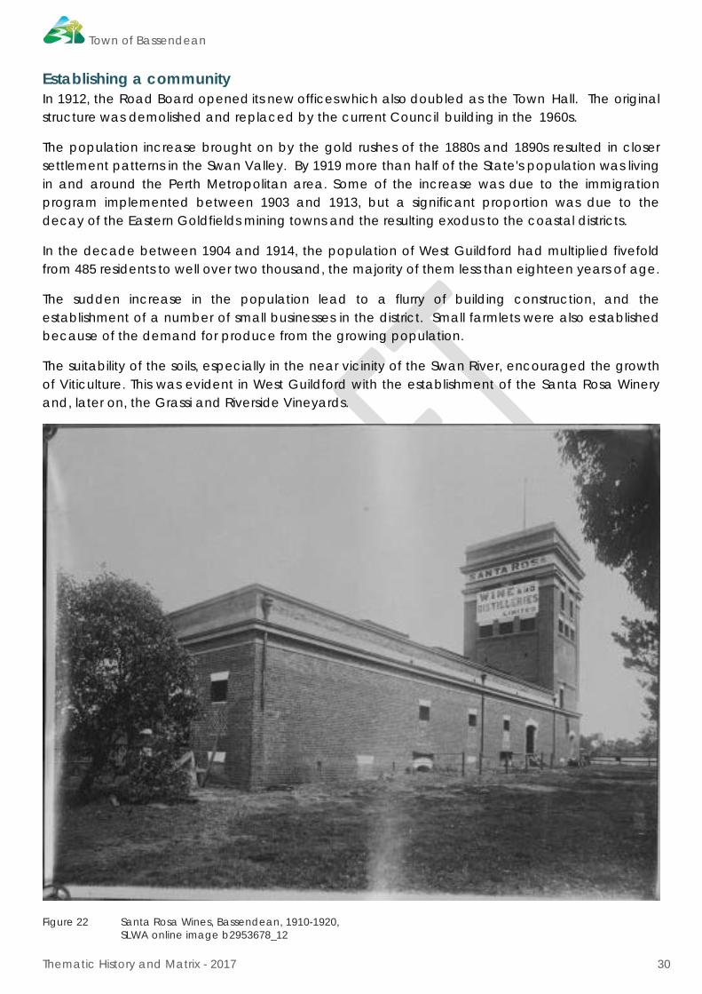
The suitability of the soils, especially in the near vicinity of the Swan River, encouraged the growth of Viticulture. This was evident in West Guildford with the establishment of the Santa Rosa Winery and, later on, the Grassi and Riverside Vineyards.
Figure 22 Santa Rosa Wines, Bassendean, 1910-1920, SLWA online image b2953678_12

Town of Bassendean
Thematic History and Matrix - 2017 31
Creating a Social Life in West Guildford As the population grew and communities were established the various church bodies and their followers built churches to serve the spiritual need of the congregations.
The construction of the Methodist Church by voluntary labour in 1904 was a significant step in the development of West Guildford. Not only did it provide for a growing congregation, which until this point had held their meetings under a tree, but it was also the first building in the district suitable for a public meeting.
Hence this weatherboard and stamped metal structure was in great demand by the residents of West Guildford.
Prior to 1909 Church of England Services were occasionally held at the Girls High School (the old Lockeridge Hotel). However, in April of that year a weatherboard church was built to cater for the increased population information.
In 1913, members of the Church of Christ erected a church hall and vestry during the daylight hours of a single day; holding a service there the next day.
St Joseph's Catholic Church was built in 1913 for the Roman Catholic Church, prior to which worshippers had to travel to Guildford to attend Sunday Mass. Not long after this a school was established in the church building by a group of nuns of the order of Sisters of Mercy.
Each of the above churches established social clubs and organised community events and, played a significant role in the social life of Bassendean residents.
Further evidence of the continued growth in West Guildford came with the establishment of a volunteer Fire Brigade in January 1911. Not only did the Brigade provide an essential service to the district but it also became an important part of the suburb's social life and one of its most influential and powerful organisations.
Electric power arrived in West Guildford in 1916 following which a number of houses in the suburb were electrically lit as well as a few street lamps and bridge lights.
The first school established in the area was the Guildford Girls High School, located in the old Lockeridge Hotel. It was a genteel institution which catered for the daughters of the more wealthy and prominent residents. Unfortunately it was forced to close in 1910 due to a decline in enrolments.
October 15th 1906 witnessed the opening of the West Guildford State School, prior to which students had to travel across the river to the Guildford School.
Other schools opened in the following years including the convent school in July 1914 and the Ivanhoe Street School or North Guildford School, later Eden Hill Primary, in 1915.
This period also witnessed the formation of a number of clubs such as the Cricket Club, the West Guildford Orchestral Society (1913), the Rifle Club (1915), as well as the local branch of the RSL (1919). Apart from this there was also more organised entertainment in the form of dances and, after 1913, silent movies.

Town of Bassendean
Thematic History and Matrix - 2017 32
World War One and its Impact on West Guildford There was very little growth during the war years, with a general slowing down of industry and the departure of numerous members of the male population for the battlefields.
The rate of subdivision of properties increased substantially during and immediately following the First World War. There were numerous schemes to settle returned soldiers on small farms in outer-Perth suburbs.
Figure 23 Sale of lots in Bassendean, c1915. SLWA online image b4211489_2.
The era was also characterised by widespread social dislocation and a sense of bewilderment as to what the future held in West Guildford and Western Australia in general. This was further intensified by the outbreak of a deadly nation-wide influenza epidemic and, what appeared to be the breakdown of traditional values, which was especially manifest in the prevalence of the 'demon drink'. The residents of West Guildford were particularly enthusiastic in their support of prohibition; outlawing the sale and consumption of alcohol.

Town of Bassendean
Thematic History and Matrix - 2017 33
2.8. A new Identity -Town of Bassendean Between the Wars 1920-1939
In May 1922, the Road Board voted to change its name from West Guildford to 'Bassendean' after Peter Broun's estate.
The change of name heralded a renewed burst of activity in the district. The Bassendean Magnet newspaper commenced circulation, the Post Office was finally erected, the Road Board Hall had extensive renovations and additions and the swampland known as Hay's Swamp was transformed into the BIC Reserve.
Figure 24 Bassendean Post Office, constructed in 1923. SLWA online image 007822d
The progress evident in Bassendean, including the BIC Reserve was greatly encouraged by Richard Alexander McDonald, a prominent member of the community.
McDonald purchased two blocks of land on Kenny Street, Bassendean where he later built a house. Almost immediately after settling in the district McDonald became involved in the community affairs and politics. He became a Road Board Member for the first time in April 1915. McDonald encouraged the formation of numerous clubs and societies and was himself a founding member of the West Guildford Masonic Lodge.
Town of Bassendean
Thematic History and Matrix - 2017 34
One of McDonald's most longstanding contributions to the Town of Bassendean was his central role in gaining acceptance for the Swan District Football team to join the Western Australian Football league in 1934. McDonald's efforts and long-term involvement with the club were acknowledged by naming the grandstand after him.
Football and sport of any kind was not only a popular pastime for many of the residents of Bassendean, it was a passion. Sporting activities not only provided a source of entertainment, they also encouraged community involvement and identification which, in turn, helped to strengthen and enhance social relationships between the residents.
These developments of the 1920s were tragically offset by a number of hardships including an outbreak of what was believed to be Rinderpest. This often fatal cattle disease hit the Metropolitan region of Perth and resulted in the slaughter of many animals. This had a great impact on Bassendean and especially the local dairy owners which never really recovered from the tragedy.
The increasing size and diversity of the Town of Bassendean resulted in the emergence of a substantial number of businesses and associated concerns. Apart from the existence of grocery and mixed business shops, there also emerged several professional establishments such as a doctor's surgery and an accountant's office.
Coinciding with these developments was an increase in small manufacturing outlets such as Smallman's Furniture. Most of these businesses were stimulated by the presence of heavy industry including the large factory complex built by Cuming Smith in 1909.
The Great Depression Following the First World War there were very slow improvements in economic conditions. However, 1929 witnessed the onset of the disastrous worldwide depression in the wake of the Wall Street Crash. The impact on Perth and its surrounding suburbs was profound, this being most evident in the drastic rise in the rate of unemployment and the ever-increasing prices of food and goods in the State.
The Depression was particularly severe in the Swan District. Among the industries most affected were building, agriculture and the railways, all of which were important to the district's economy. Government financial cutbacks forced the retrenchment of a large proportion of the employees at the Midland Junction Railway Workshops. This had a direct and extreme impact on Bassendean, whose residents included many railway workers. Consequently, unemployment figures were especially acute in the Bassendean/Midland districts.
By May 1931 the Bassendean Unemployment Relief Committee reported that there were 240 families in the district officially registered as unemployed. This represented over 40% of the town's population, but was still a conservative estimate of the total problem. Some relief was provided when the Bassendean Road Board was offered a share in the Government Grant of 32 000 pounds.
This meant that the Board was able to offer work to a significant number of men who worked on various projects within the district. Unfortunately the Road Board and its 'Unemployed Sustenance Workers Scheme' could not generate enough work for the majority of applicants, and in fact, teetered on the brink of bankruptcy itself.
Town of Bassendean
Thematic History and Matrix - 2017 35
The Depression had a profound impact on the social cohesion of the Bassendean population. It was a very traumatic time for families, especially women and children. The fragmentation of the society was evident in the ever-widening gap between those with employment and those without.
While the situation for Bassendean's unemployed improved somewhat by the close of the 1930s, it was not until the outbreak of the Second World War that the Depression could be considered over.
BIC Reserve One of the projects begun during the Depression and carried out mainly by relief workers was the filling and draining of Hay's Swamp and its transformation into the BIC Reserve. Hay's Swamp was owned by an eccentric old journalist, Jose Hay, who built an odd looking wooden 'castle' in the middle of the area. This notorious landmark was considered to be somewhat of an eyesore by the residents of Bassendean, but a favourite meeting spot for local boys. Following Hay's death in 1925 ownership of the land was transferred to the Road Board at the suggestion of the Bassendean Improvement Committee (BIC).
BIC came into being on November 28, 1923, at a meeting convened by the Road Board. It included members of the Traders' Association, the Ugly Men's Association, the Parents' and Citizens' Association, and others. The Committee enthusiastically set about improving the site which soon boasted playing fields, clubhouses, bowling greens, croquet and tennis courts, a children's playground and a pavilion,
The BIC grounds, which were to become the centre-piece of the suburb, were officially opened in 1936. Although 'Temple Park' was chosen as the name it has always been referred to as the BIC Reserve - a fitting acknowledgement to the work done by the committee.
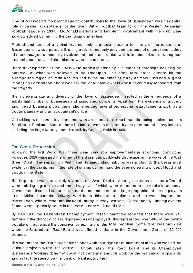
In contrast to the general economic gloom, the 1930s in Bassendean did produce a significant number of building projects in the town. Besides grandstands and clubhouses erected on the Recreation Reserve and the BIC, a trades hall was built on Broadway, a new fire station was erected in Wilson Street and the old town hall was demolished in order to make way for the new Road Board premises, the building being completed in 1936.
Town of Bassendean
Thematic History and Matrix - 2017 36
Figure 25 The Bassendean Road Board Building constructed in 1936. SLWA online image of ceremony in 1951,
In addition, the Bassendean Masonic Lodge dedicated their recently constructed temple in May 1934, new shops opened up along the Perth Road and a bus and taxi service was put into operation. This latter evidence of the growing importance of private car travel in contrast to the former dependence on train travel.
Town of Bassendean
Thematic History and Matrix - 2017 37
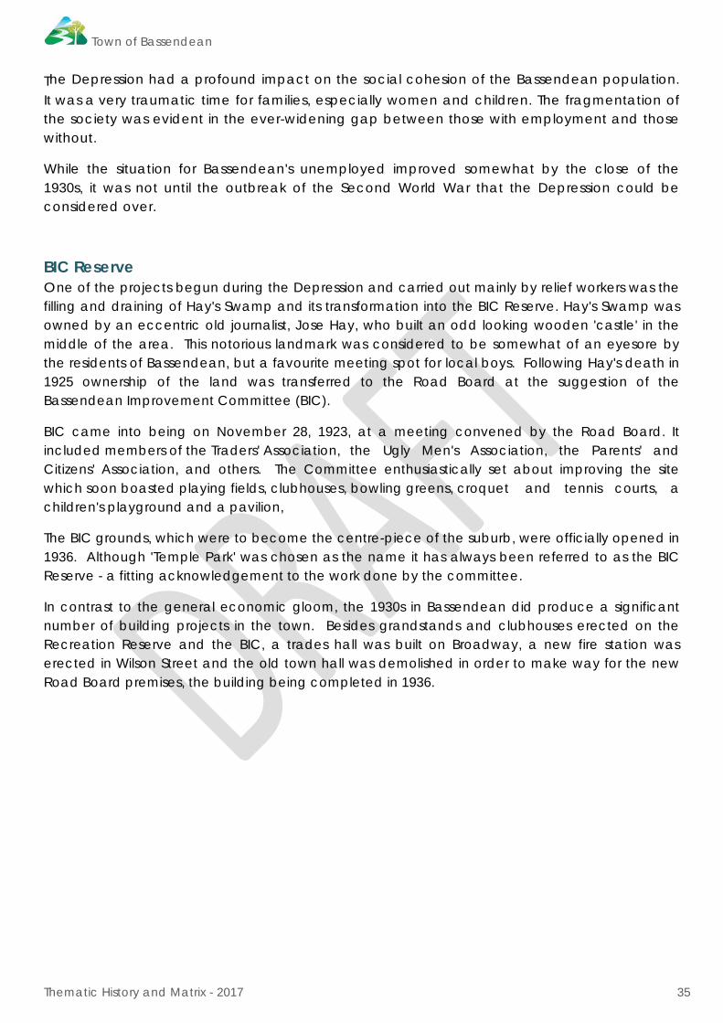
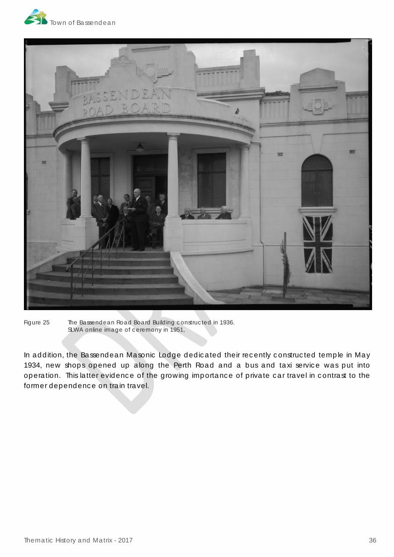
Figure 26 Bassendean Service Station c1932 SLWA online image 101818PD.
The Bassendean Hotel Also built during this period was the very controversial Bassendean Hotel. Bassendean locally known as, 'The Holy City’ was renowned as a teetotal suburb. Although a predominantly working class population, the residents were proud of the respectable and traditionalist character of their town. Consequently there was an outraged reaction when the construction of a hotel became known. Despite a well-orchestrated campaign the hotel was opened in 1930. For many the establishment of the hotel in Bassendean symbolised the lowering of the high moral stance that had so characterised the suburb.

Town of Bassendean
Thematic History and Matrix - 2017 38
Figure 27 The Bassendean Hotel, c1930. Courtesy, Carter p.184.
Figure 28 The Bassendean Hotel, c1935 Courtesy, Carter p.185.
Town of Bassendean
Thematic History and Matrix - 2017 39
2.9. Post-World War II Expansion 1939-1970s
The outbreak of World War Two eased the employment situation in the district as not only were men recruited into the fighting force, they were also absorbed into the new munitions industry.
A section of the railway workshops at Midland was converted into a munitions factory as was Hadfields foundry in Bassendean. There was also a critical shortage of skilled factory workers throughout the war years and wages returned to their pre-depression levels.
Although the war brought a number of hardships, such as rationing and shortages of essential materials, the residents of Bassendean rallied behind the war effort. Fund-raising events were commonplace, usually organised and run by the women of the community.
State Housing in Bassendean The period immediately following the Second World War was marked by a sudden increase in the demand for urban housing, accompanied by very limited supplies of available materials. This was the so-called 'austerity period' for the building industry. Government action was found to be necessary, and the State Housing Commission commenced construction of large blocks of publicly financed housing.
This intense building activity carried out by the Government continued until the early 1970s and expanded to include private builders and developers.
Accommodation was urgently required for not only the returned servicemen, but also the large influx of immigrants coming to Australia under the Commonwealth Government's new migration policy. Consequently, in 1950 the Bassendean Road Board with a proposal to set up a public housing estate at Ashfield. Bassendean was selected primarily because of the important industrial development within its boundaries and its proximity to other large centres of employment.
The initial plan called for the construction of 230 houses within the first twelve months of the scheme. Although the Board enthusiastically embraced the proposal as a step forward in terms of future development and population, they became somewhat perturbed when they learnt of the size and prefabricated nature of the housing to be constructed. The Board's apprehension increased when they were notified that not only would none of the houses be built in brick but there also was to be no assurance that only British migrants or Australian residents would be allowed to occupy dwellings on the estate.
As a result the Board voted unanimously to reject the scheme unless an alternative proposal which would provide for a better type of dwelling was adopted. Regardless of this decision the State Housing Commission began the resumption of properties in Ashfield and notified the Board of its intention to proceed with the erection of pre-cut timber dwellings in the area. The prefabricated homes were known locally as ‘Austrian PreFabs’.
As a consequence of the growing population the Ashfield Primary School was built in 1955 and the Cyril Jackson High school in 1963.
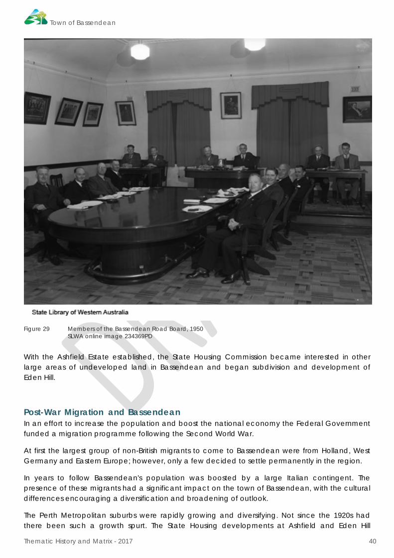
Town of Bassendean
Thematic History and Matrix - 2017 40
Figure 29 Members of the Bassendean Road Board, 1950 SLWA online image 234369PD
With the Ashfield Estate established, the State Housing Commission became interested in other large areas of undeveloped land in Bassendean and began subdivision and development of Eden Hill.
Post-War Migration and Bassendean In an effort to increase the population and boost the national economy the Federal Government funded a migration programme following the Second World War.
At first the largest group of non-British migrants to come to Bassendean were from Holland, West Germany and Eastern Europe; however, only a few decided to settle permanently in the region.
In years to follow Bassendean's population was boosted by a large Italian contingent. The presence of these migrants had a significant impact on the town of Bassendean, with the cultural differences encouraging a diversification and broadening of outlook.
The Perth Metropolitan suburbs were rapidly growing and diversifying. Not since the 1920s had there been such a growth spurt. The State Housing developments at Ashfield and Eden Hill

Town of Bassendean
Thematic History and Matrix - 2017 41
attracted many young families to the suburb and the post-war 'baby boom' placed an unforeseen demand on the available facilities for children.
However, by the late 1960s and early 1970s Bassendean's population was becoming older and older as young families were moving to the outer suburbs and fewer people were moving into the district to balance the losses. The Senior Citizen's Centre was built in 1966 to cater to the needs of the more elderly residents.
In 1971 the new council offices and Community Centre were officially opened, followed by the Bassendean Memorial Library in 1972.
Figure 30 Bassendean Public Library 27 April 1973 SLWA online image 231872PD One explanation for the exodus of young people from the suburb was the gradual rise in unemployment and the concurrent decline in heavy industry in Bassendean and surrounding areas.
By the late 1960s Cuming Smith had begun to wind down their Bassendean operations; the last despatches of superphosphate from the old depot were made in 1971, leaving the factory buildings to be demolished some years later.
The steady decline of heavy industry also affected the Hadfields steel foundry operations; however it remained in business until 1983. As a direct result, employment opportunities for semi and unskilled workers were much more competitive.

Town of Bassendean
Thematic History and Matrix - 2017 42
2.10. Decline and Renewal 1970s - Present
The Town of Bassendean went through a period of quiet stability from the 1970s to the 1990s. While new developments did occur, the general trend in the established areas was an aging population as many of the new suburbs in the metropolitan area were established.
The rerouting of Guildford Road from the centre of the main townsite to alongside the railway line in the late 1970s made a significant change in the dynamic of the townsite. The main shopping precinct was bypassed and the construction of a new shopping complex, east of the old town centre on the site bound by West Road, Old Perth road, Whitfield Street and Extension Road added to the decline in the original commercial precinct. The more recent expansion of this shopping complex and the construction of multi storey apartments adjacent have increased the focus on this section of the town centre.
The decline in heavy industry and the closure of the Midland Workshops in 1993 was especially hard felt in Bassendean where many of the workforce lived. The large tracts of land occupied by the former Cuming Smith factory were eventually cleared and new developments took their place.
The first stage of Tonkin Industrial Park was released in 1990 followed by stage two in the late 1990s. Alongside the new industrial development, new residential subdivisions have progressed which are noted for their higher density.
In recent decades many older homes on large adjacent lots have been amalgamated, the original homes demolished and large unit developments been constructed. As these new developments have occurred new families have moved into the older established parts of Bassendean in many instances restoring and adding to the existing residences. A ‘gentrification’ of the suburb is a trend seen in many other suburbs in metropolitan Perth, particularly along the railway line.
The Town of Bassendean officers and council have continued to work toward addressing the needs of their community. In recent decades significant efforts have been made to work with the indigenous community of Bassendean and its surrounds with the adoption of the Reconciliation Action Plan in 2012-2016. The 2012 development of the Mary Crescent Gathering site in Eden Hill is an acknowledgement of the significance of that site to the local Whadjuk people.

Town of Bassendean
Thematic History and Matrix - 2017 43
Town of Bassendean
Thematic History and Matrix - 2016 44
3.0 THEMATIC MATRIX THEMES*
*As determined by the State Heritage Office of WA
ABORIGINAL HISTORIES (pre and post European
Settlement)
DISCOVERY AND EARLY EXPLORATION Pre 1829 SETTLEMENT 1829-1850 THE CONVICT ERA
1850-1880
INCREASED DEVELOPMENT
1880-1900
CONSOLIDATION 1900-1920
A NEW IDENTITY BETWEEN THE WARS
POST WORLD WAR II EXPANSION 1945-
1970S
DECLINE AND RENEWAL 1970S-PRESENT
DEMOGRAPHIC SETTLEMENT AND MOBILITY • Aboriginal occupation • Land allocation and subdivision • Exploration and surveying • Workers • Settlements • Government Policy • Environmental Change • Resource Exploitation and depletion • Depression and boom • Technology and technological
change • Natural disasters
Aboriginal occupation Camps and gathering places Success Hill Eden Hill Lockridge Traditional seasonal camps Occupation estimated to be 450 people Light and temporary shelters (Potential archaeological sites)
Arrival of first European explorers. Early mapping of the Swan River
Arrival of first European settlers. (1829) Establishment of Guildford (1829) as the administrative centre for the region. Survey of lots for West Guildford (1842) establishes form of the future town. Land grants to wealthy settlers. Conditions of grants lead to abandonment of several grants. Small number of landowners living in simple structures Disruption of traditional indigenous lifestyle Racial contact and interaction, dispossession
Arrival of convicts and pensioner guards. Convict Depot in Guildford (1851) Establishment of pensioner guard cottages Conditional land grants to Pensioner Guards Indigenous settlements at Success Hill Land clearing
Large properties established for wealthy professionals often on large lots on the river. Absentee wealthy landowners responsible for large residential subdivisions for working families. Population increase because of gold discoveries
Modest steady growth of the economy. Indigenous peoples confined to reserves Last major subdivisions. Relocation of Railway Workshops to Midland (1901) Land drainage and beautification Intense development of village Provision of electricity. Large properties established for wealthy professionals often on large lots on the river.
European migration leads to diversity of population. Community activation Pressure to relocate Indigenous community. Take up of residential lots for workers homes. Adoption of the name ‘Bassendean’ (1922)
Post war migration Large undeveloped areas of Ashfield, Eden Hill subdivided for public housing by State Housing Commission. New Road Board Offices (1951) Introduction of town planning Subdivision leads to decline in farming practices. Recovery of sand from Success Hill for Bassendean Oval and other civil works. Population growth
Aging population through the 1970s and 1980s. New migrants in the 2000s Decline in population then steady increase. Mary Crescent Gathering Site (2012) I
TRANSPORT AND COMMUNICATIONS • River and sea transport • Rail and light rail transport • Road transport • Droving • Air transport • Mail Services • Newspapers • Technology and technological
change • Telecommunications
Aboriginal track ways
Waterways used for transport. Rough bush tracks from Perth to Guildford
Ferry service to Guildford near the Cleikum Inn (1831) Rough bush tracks from Perth to Guildford
Improvements in public works including roads. Ferry operated by convicts
First Bridge over the Swan River (1881) Closure of the ferry service Completion of Perth to Guildford railway (1881 Opening of the Second Road Bridge over the Swan River (1905) Opening of the West Guildford Railway Station (1910)
Private cars in the district
Growth in use of private cars. Service station in the district. New Guildford road Bridge (1937) New Post Office (1923) Telephones and Bassendean Newspaper
Decline in rail travel and growth in use of private cars.
Realignment of Guildford Road (1970s) Railway Station redeveloped.
OCCUPATIONS • Grazing, pastoralism and dairying • Rural industry and market gardening • Mining • Timber industry • Fishing and other maritime industry • Domestic activities • Intellectual activities, arts & crafts • Commercial services and industries • Technology and technological
change • Manufacturing and processing • Hospitality industry and tourism
Living off the land to grazing and settlement Fire Stick farming and use of natural resources
Living off the land to grazing and settlement Fire Stick farming and use of natural resource
Dairy farming, market gardening, orchards, Vineyards Clay pits and brickmaking Milling Land clearing Subsistence farming Grazing and droving Early recognition of the inappropriate European methods of farming
Dairy farming, market gardening, orchards, Vineyards Clay pits and brickmaking Milling Land clearing and Subsistence farming Grazing and droving Adaption of inappropriate European methods of farming Sale of produce from farms or taken to Guildford or Perth.
Farmers, market gardeners, boat builders Decline in employment prior to World War One.
Market gardening and dairying although declining. Manufacturers, trades people Commuting to other places to work. Brickworks and clay recovery Fertiliser and farm machinery manufacture
Factory workers Brickworks and clay recovery Manufacturers, trades people Market gardening and dairying declining. Widespread unemployment because of the depression. Rinderpest disease.
Munitions factories established in Bassendean and Midland provide work for men and women at higher wages. Closure of heavy industry in the 1960s. Pollution from industry increases unchecked.
Internet communication enables decentralising of work places Fly in/fly out workers Closure of the Midland Workshops (1993)
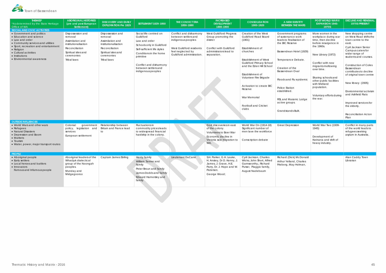
Town of Bassendean
Thematic History and Matrix - 2016 45
THEMES* *As determined by the State Heritage Office of WA
ABORIGINAL HISTORIES (pre and post European
Settlement)
DISCOVERY AND EARLY EXPLORATION Pre 1829 SETTLEMENT 1829-1850 THE CONVICT ERA
1850-1880
INCREASED DEVELOPMENT
1880-1900
CONSOLIDATION 1900-1920
A NEW IDENTITY BETWEEN THE WARS
POST WORLD WAR II EXPANSION 1945-
1970S
DECLINE AND RENEWAL 1970S-PRESENT
SOCIAL AND CIVIC ACTIVITIES • Government and politics • Education and science • Law and order • Community services and utilities • Sport, recreation and entertainment • Religion • Cultural activities • Institutions • Environmental awareness
Dispossession and removal Assimilation and institutionalisation Reconciliation Spiritual sites and ceremonies Tribal laws
Dispossession and removal Assimilation and institutionalisation Reconciliation Spiritual sites and ceremonies Tribal laws
Social life centred on Guildford Law and order Schools only in Guildford Self-sufficient life styles Conditions in the home primitive Conflict and disharmony between settlers and indigenous peoples
Conflict and disharmony between settlers and indigenous peoples West Guildford residents feel neglected by Guildford administration.
West Guildford Progress Group promoting the district Conflict with Guildford administrators lead to separation.
Creation of the West Guildford Road Board (1901) Establishment of churches Establishment of West Guildford Primary School and the Eden Hill School Establishment of Volunteer Fire Brigade Activation to create BIC Reserve War Memorial Football and Cricket clubs
Government programs of sustenance work leads to finalisation of the BIC Reserve Bassendean Hotel (1929) Temperance Debate. Creation of the Bassendean Oval Floods and Flu epidemic Police Station established. RSL and Masonic Lodge active groups. Grandstands Built.
More women in the workplace during war time, then decline before resurgence in the 1960s. New Library (1972) Conflict with new migrants mellowing over time. Sharing schools and other public facilities with Midland population. Voluntary efforts during the war.
New shopping centre on West Road shifts the town centre to the east. Cyril Jackson Senior Campus caters for wider range of students and courses. Construction of Coles Bassendean contributes to decline of original town centre New library (2005) Environmental activism and Ashfield Flats Improved services for the elderly. Reconciliation Acton Plan
OUTSIDE INFLUENCES • World Wars and other wars • Refugees • Natural Disasters • Depression and Boom • Markets • Tourism • Water, power, major transport routes
Colonial government policy, legislation and services European settlement
Relationship between Britain and France lead to
Fluctuations in commodity prices leads to widespread financial hardship in the colony.
God discoveries in east of the colony. Volunteers to Boer War Economic decline in Victoria saw migration to WA.
World War On (1914-18) Significant number of men lave the workforce Conscription debate
Great Depression
World War Two (1939-1945) Development of Kwinana and shift of heavy industry.
Conflict in many parts of the world leads to refugees seeking asylum in Australia.
PEOPLE • Aboriginal people • Early settlers • Local heroes and battlers • Innovators
Famous and Infamous people
Aboriginal leaders of the Whadjuk dialectical group of the Noongah peoples. Munday and Midgegooroo
Captain James Stirling Henty family William Tanner and family Peter Broun and family James Dodds and family Edward Hamersley and family
Lieutenant DuCane S.H. Parker, G.H. Leake, H. Anstey, Dr D. Kenny, J. James, J. Grave, H.E. Parry, Dr. J. Hope and W. Paterson. George Wood;
Cyril Jackson, Charles Wicks, John Short, Alfred Garnsworthy,; Richard Purser, Piaggio family, August Nadebaum
Richard (Dick) McDonald Arthur Yelland, Charles Frieberg, May Holman,
Alan Caddy Town Librarian

Town of Bassendean
Thematic History and Matrix - 2016 46
BIBLIOGRAPHY Apperley, R., Irving, R., Reynolds, P. A Pictorial Guide to Identifying Australian Architecture. Styles
and Terms from 1788 to the Present. North Ryde: Angus and Robertson, 1989.
Appleyard, R.T., and T. Manford. The Beginning. Perth: University of Western Australia Press, 1979.
Bassendean Preservation Group. A Regional park Plan for the Ashfield Flats. Bassendean: Self published, 1985.
Bassendean Town Council. Bassendean Town News, 1973.
Bolton, G.C. “Who Were the Pensioners.” Studies in Western Australian History IV (December 1981).
Bourke, M.J. On the Swan: A History of the Swan District. Perth : University of Western Australian Press, 1987.
Bourke, M.J., and M. Conner. Old Buildings at Guildford, W.A. Thesis, Perth: School of Architecture at the University of Western Australia, 1971.
Bryan, C., and F.I. Bray. “Peter Nicholas Broun (1797-1846) First Colonial Secretary of Western Australia (1829-1846).” The Western Australian Historical Society II (1935).
Cammilleri, C. “Walter padbury 1820-1907: Pioneer, Pastoralist, Merchant and Philanthropist.” Thesis, Perth, n.d.
Carter, Jennie. Bassendean A Social History 1829-1979. Perth, Western Australia: Town of Bassendean, 1986.
Cogan, M. Bassendean and Guildford Sketchbook. Perth: Rigby Limited, 1976.
Feilman Planning Consultants. “Town of Bassendean - Town Planning Scheme Number Three, District Zoning Scheme.” Report, Perth, 1983.
H. Wise & Co. The Western Australian Post Office Directory, 1895-1949.
Hall, C. An Industrial History of Bassendean. Thesis, Perth: Graylands Teachers College, 1964.
Hasluck, A. Unwiling Emigrants. London: Oxford University Press, 1959.
Hunt, I. [ed]. Westalian Portraits. Perth: University of Western Australia Press, 1979.
Ian Molyneux and Associates. Survey of the National Estate in Subiaco. Perth : Self published, 1985.
ICOMOS Australia. “The Burra Charter: The Australia ICOMOS Charter for Places of Cultural Significance.” 2013.
Igglesden, D. “Town of Bassendean: Population and Housing Study.” 1988.
Lawrance, Naomi, and Tanya Suba. Town of Bassendean Heritage Study Vol 1 - Draft. Department of Planning and Urban Development, 1991.
Marquis-Kyle, Peter, and Meredith Walker. The Illustrated Burra Charter: Making Good Decisions About the Care of Important Places,. Sydney: ICOMOS, 1994.
Moore, R., S. Burke, and R. Joyce. Australian Cottages. Melbourne: Hamlyn, 1989.
Peron, F. Voyage of Discovery to the Southern Hemisphere. London, 1809.
Pitt Morison, M., and J. [eds] White. Western Towns and Buildings. Perth: University of Western Australia Press, 1979.
Royal Australian Institute of Architects. The Architect 22, no. 4 (1982).
State Planning Commission. “Metropolitan Region Scheme: Proposed Amendment No. 704/33A Ashfield Flats - Town of Bassendean.” Perth, 1988.
Taylor, G. Management of Flood Prone land: Bassendean, W.A. Thesis, Bentley: Curtin University, 1987.
Town of Bassendean
Thematic History and Matrix - 2016 47
Thomas, A.T. A History of Bassendean. Perth: Bassendean Road Board, 1947.
Town of Bassendean. “Reconciliation Action Plan 2012-2016.” Town of Bassendean. 2012. http://www.bassendean.wa.gov.au/7_info_feedback/pdfs/bassendean_reconciliation_action_plan.pdf (accessed June 10, 2016).
Uren, M. Land Looking West. London : Oxford University Press, 1948.
W.A. Heritage Committee. “The Swan River Heritage Trail.” 1988.
—. “The Swan Valley Heritage Trail.” 1988.