THE WORK OF FAO TO ENHANCE NATIONAL CAPACITIES TO REPORT ... · THE WORK OF FAO TO ENHANCE NATIONAL...
20
THE WORK OF FAO TO ENHANCE NATIONAL CAPACITIES TO REPORT ON CLIMATE CHANGE AGRICULTURE, FORESTRY AND OTHER LAND USE
Transcript of THE WORK OF FAO TO ENHANCE NATIONAL CAPACITIES TO REPORT ... · THE WORK OF FAO TO ENHANCE NATIONAL...
THE WORK OF FAO TOENHANCE NATIONALCAPACITIES TO REPORTON CLIMATE CHANGEAGRICULTURE, FORESTRY AND OTHER LAND USE
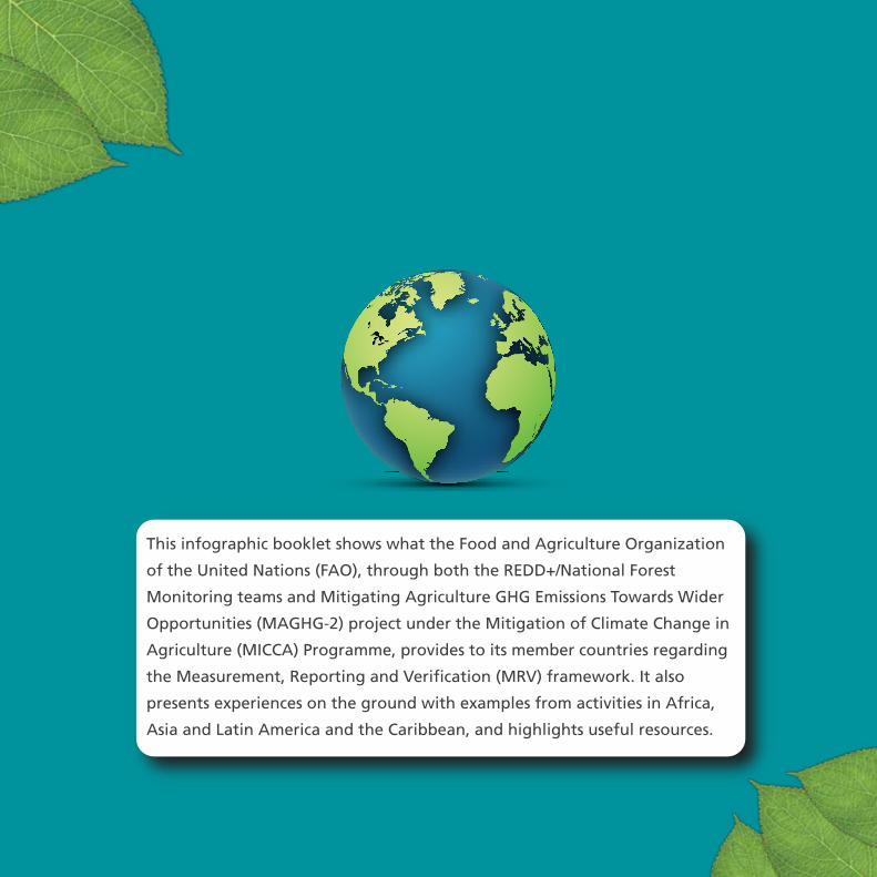
This infographic booklet shows what the Food and Agriculture Organization
of the United Nations (FAO), through both the REDD+/National Forest
Monitoring teams and Mitigating Agriculture GHG Emissions Towards Wider
Opportunities (MAGHG-2) project under the Mitigation of Climate Change in
Agriculture (MICCA) Programme, provides to its member countries regarding
the Measurement, Reporting and Verification (MRV) framework. It also
presents experiences on the ground with examples from activities in Africa,
Asia and Latin America and the Caribbean, and highlights useful resources.

In 2015, two significant global efforts were undertakento combat climate change and boost sustainable development
The Paris Agreement. Adopted in December 2015, the Paris Agreement represents a commitment by the international community to limit the rise of the global average temperature to well below 2 degrees Celsius. To reach this goal, each country has formulated individual climate commitments, referred to as Nationally Determined Contributions (NDCs).
The 2030 Sustainable Development Agenda and its 17 Sustainable Development Goals (SDGs). The SDGs are a set of global objectives that will shape national development plans over the next 15 years, from ending poverty and hunger to sustaining our natural resources and responding to climate change.
Under the Paris Agreement, countries are required to provide national inventory reports of their greenhouse gas (GHG) emissions and information on the progress in implementing their NDCs. The reporting procedures of the Paris Agreement will probably build upon the already existing Measurement, Reporting and Verification (MRV) framework. This framework requires developing countries to submit National Communications (NC) every four years and Biennial Update Reports (BUR) every two years.
The BUR should also go through the United Nations Framework Convention on Climate Change (UNFCCC) International Consultation and Analysis (ICA). Countries are also requiredto set up domestic MRV for their Nationally Appropriate Mitigation Actions (NAMAs) and voluntarily undertake MRV of their activities to reduce emissions from deforestation and forest degradation and the role of conservation, sustainable management of forests and enhancement of forest carbon stocks in developing countries (REDD+). MRV represents a particular challenge, as countries can experience difficulties in collecting information and regularly updating their national statistics.

DATACOLLECTION& ANALYSISNFI National Forest Inventory
Census of Agriculture/Agricultural surveys
NFMS National Forest Monitoring System
GHG ESTIMATES& REPORTING,
INCLUDING QUALITYASSURANCE/
QUALITY CONTROL:NC National Communication
BUR Biennial Update Report, including REDD+ results
FREL/FRL Forest Reference Emission Level/Forest Reference Level
NDC Nationally Determined Contributions
FAOCountrySupportIN
STITUTIONAL ARRANGEM
ENTS
FAO resources
NFMSfor REDD+
MRV
AFOLU
OpenForis
FAOSTAT
GFOI
LCCS
WCAE-learning
GlobAllomeTree
Map AccuracyAssessment &
Area Estimation
Voluntaryguidelines
on nationalforest monitoring
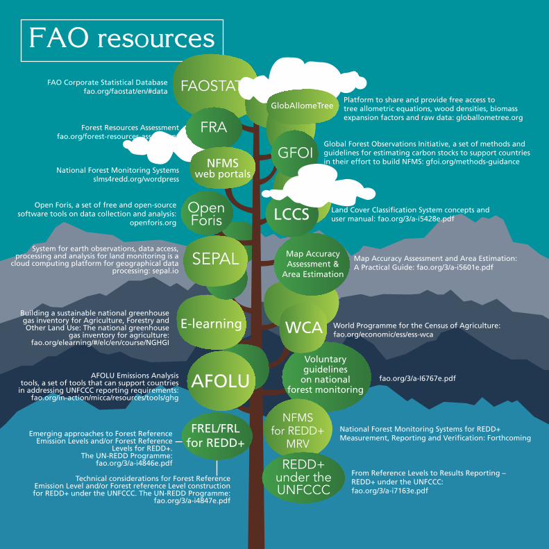
FAO Corporate Statistical Databasefao.org/faostat/en/#data
Forest Resources Assessmentfao.org/forest-resources-assessment
Platform to share and provide free access totree allometric equations, wood densities, biomassexpansion factors and raw data: globallometree.org
Global Forest Observations Initiative, a set of methods andguidelines for estimating carbon stocks to support countriesin their effort to build NFMS: gfoi.org/methods-guidance
Land Cover Classification System concepts anduser manual: fao.org/3/a-i5428e.pdf
Map Accuracy Assessment and Area Estimation: A Practical Guide: fao.org/3/a-i5601e.pdf
fao.org/3/a-I6767e.pdf
World Programme for the Census of Agriculture: fao.org/economic/ess/ess-wca
National Forest Monitoring Systemsslms4redd.org/wordpress
Open Foris, a set of free and open-sourcesoftware tools on data collection and analysis:
openforis.org
From Reference Levels to Results Reporting – REDD+ under the UNFCCC: fao.org/3/a-i7163e.pdf
System for earth observations, data access, processing and analysis for land monitoring is a
cloud computing platform for geographical data processing: sepal.io
Building a sustainable national greenhousegas inventory for Agriculture, Forestry andOther Land Use: The national greenhouse
gas inventory for agriculture:fao.org/elearning/#/elc/en/course/NGHGI
AFOLU Emissions Analysistools, a set of tools that can support countries
in addressing UNFCCC reporting requirements:fao.org/in-action/micca/resources/tools/ghg
National Forest Monitoring Systems for REDD+Measurement, Reporting and Verification: Forthcoming
FREL/FRLfor REDD+
Emerging approaches to Forest ReferenceEmission Levels and/or Forest Reference
Levels for REDD+.The UN-REDD Programme:
fao.org/3/a-i4846e.pdf
Technical considerations for Forest ReferenceEmission Level and/or Forest reference Level constructionfor REDD+ under the UNFCCC. The UN-REDD Programme:
fao.org/3/a-i4847e.pdf
SEPAL
FRA
REDD+under theUNFCCC
NFMSweb portals

FAO-supported activities on the ground
SATELLITE LAND MONITORING SYSTEMThe Democratic Republic of the Congo (DRC) has developed a Satellite Land Monitoring System (SLMS) called TerraCongo to keep track of forest cover changes in the country. FAO provided continuous capacity development activities for technical staff and established a remote sensing laboratory for generating activity data. FAO supported and empowered DRC in developing and implementing the National Forest Monitoring System (NFMS) web portal.
NATIONAL FOREST INVENTORYThe DRC implemented a pilot national forest inventory (NFI) to estimate country-specific emission factors and assess the feasibility of implementing the first forest inventory at the national scale. FAO provided technical support in designing the methodology and is now managing the upcoming complete NFI with the support of the Central African Forest Initiative (CAFI).
WORKSHOPSDRC together with FAO has organized several hands-on workshops on the national GHG inventory for the Land Use, Land Use Change and Forestry (LULUCF) sector.
KICK-OFFDRC and FAO held a national kick-off meeting in 2016 to define how to obtain data for the preparation of the first BUR for the Agriculture, Forestry and Other Land Use (AFOLU) sector.
EXCHANGING KNOWLEDGEDRC and Côte d’Ivoire worked together to adopt methods and tools for national GHG inventories. The two countries also compiled a list of data gaps in the compilation of their national GHG inventory for the LULUCF sector.
DEMOCRATICREPUBLIC OF THE CONGO

NFMSweb
portals
OpenForis
Collect
SEPAL
The way forward
Data collection to enable the preparation ofthe national GHG Inventory for the AFOLU sector.
The construction of the forest reference emission level.
Submission of the first BUR in collaboration withthe United Nations Environment Programme.
Development of the technical annex on REDD+ results.
Assessment of changes in land use, land coverand forest cover using TerraCongo.
Implementation of the first complete National Forest Inventory.
FAO resources
DRC and FAO continue to collaborate withfunding from Central African Forest Initiative on:

NATIONAL FOREST INVENTORYEthiopia carried out a NFI between 2013 and 2016. Data was collected from all regions and all strata, including forest and non-forest land use classes. FAO has assisted in the collection and elaboration of the forest inventory data and in the development of country-specific emissions factors for the LULUCF sector from the NFI. These country-specific emission factors were essential for constructing the national forest reference level (FRL).
INSTITUTIONAL ARRANGEMENTSEthiopia has worked on the establishment of a Measurement, Reporting and Verification (MRV) Unit to support REDD+ activities in the country. This Unit will put in place a self-sustaining and consistent process for estimating national-scale forest emissions and removals and reporting them internationally. FAO has supported the implementation of this national MRV unit.
FOREST REFERENCE LEVELEthiopia constructed and submitted an FRL in 2016. FREL/FRL are benchmarks for assessing each country’s performance in implementing REDD+ activities. FAO has supported the generation of forest change data that were essential for constructing the national FRL.
FAO-supported activities on the ground
ETHIOPIA
The way forward
NFMSweb
portals
OpenForis
Collect OpenForisCalc
OpenForis
Geospatialkit
OpenForis
CollectEarth
Map AccuracyAssessment &
Area Estimation:A Practical Guide
SEPAL
FAO resources
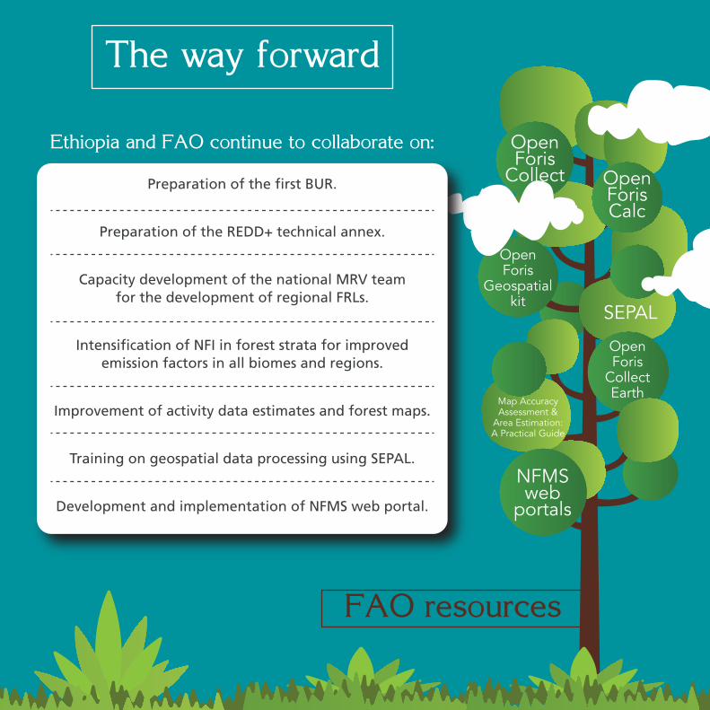
Ethiopia and FAO continue to collaborate on:
Preparation of the first BUR.
Preparation of the REDD+ technical annex.
Capacity development of the national MRV teamfor the development of regional FRLs.
Intensification of NFI in forest strata for improvedemission factors in all biomes and regions.
Improvement of activity data estimates and forest maps.
Training on geospatial data processing using SEPAL.
Development and implementation of NFMS web portal.
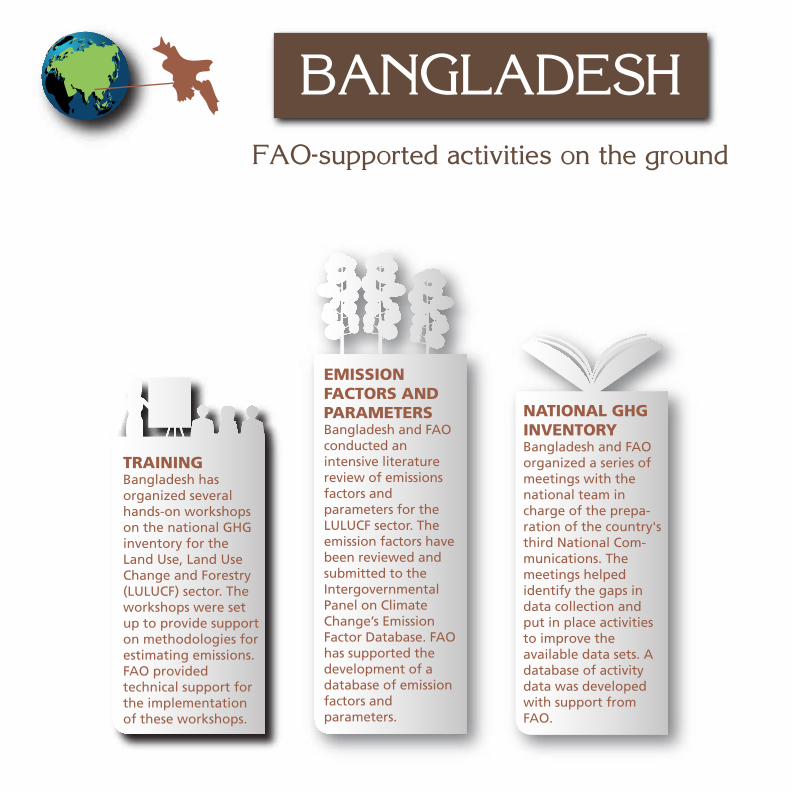
TRAININGBangladesh has organized several hands-on workshops on the national GHG inventory for the Land Use, Land Use Change and Forestry (LULUCF) sector. The workshops were set up to provide support on methodologies for estimating emissions. FAO provided technical support for the implementation of these workshops.
FAO-supported activities on the ground
BANGLADESH
EMISSION FACTORS AND PARAMETERSBangladesh and FAO conducted an intensive literature review of emissions factors and parameters for the LULUCF sector. The emission factors have been reviewed and submitted to the Intergovernmental Panel on Climate Change’s Emission Factor Database. FAO has supported the development of a database of emission factors and parameters.
NATIONAL GHG INVENTORYBangladesh and FAO organized a series of meetings with the national team in charge of the prepa-ration of the country's third National Com-munications. The meetings helped identify the gaps in data collection and put in place activities to improve the available data sets. A database of activity data was developed with support from FAO.
The way forward
OpenForis
Collect
OpenForisCalc
GlobAllomeTree
LCCS
FAO resources
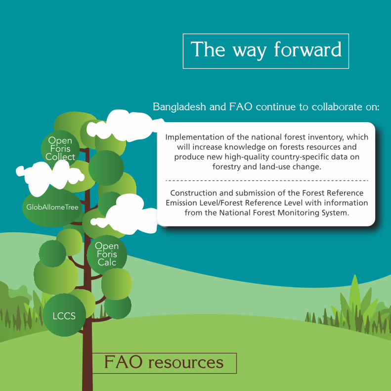
Bangladesh and FAO continue to collaborate on:
Implementation of the national forest inventory, which will increase knowledge on forests resources and
produce new high-quality country-specific data on forestry and land-use change.
Construction and submission of the Forest Reference Emission Level/Forest Reference Level with information
from the National Forest Monitoring System.
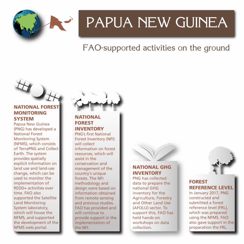
NATIONAL FOREST MONITORING SYSTEMPapua New Guinea (PNG) has developed a National Forest Monitoring System (NFMS), which consists of TerraPNG and Collect Earth. The system provides spatially explicit information on land use and land-use change, which can be used to monitor the implementation of REDD+ activities over time. FAO also supported the Satellite Land Monitoring System laboratory, which will house the NFMS, and supported the development of the NFMS web portal.
NATIONAL FOREST INVENTORYPNG’s first National Forest Inventory (NFI) will collect information on forest resources, which will assist in the conservation and management of the country's unique forests. The NFI methodology and design were based on information obtained from remote sensing and previous studies. FAO has provided and will continue to provide support in the implementation of the NFI.
FOREST REFERENCE LEVELIn January 2017, PNG constructed and submitted a forest reference level (FRL), which was prepared using the NFMS. FAO also gave support in the preparation the FRL.
FAO-supported activities on the ground
PAPUA NEW GUINEA
NATIONAL GHG INVENTORYPNG has collected data to prepare the national GHG inventory for the Agriculture, Forestry and Other Land Use (AFOLU) sector. To support this, FAO has held hands-on workshops on data collection.

The way forward
OpenForis
Collect
NFMSweb
portals
OpenForis
Collect Earth
FAO resources
Papua New Guinea and FAO continue to collaborate on:
Preparation of the national GHG inventory forthe AFOLU sector for the first BUR.
Technical support to REDD+, NFMS and FRL.
Implementation of the NFI.
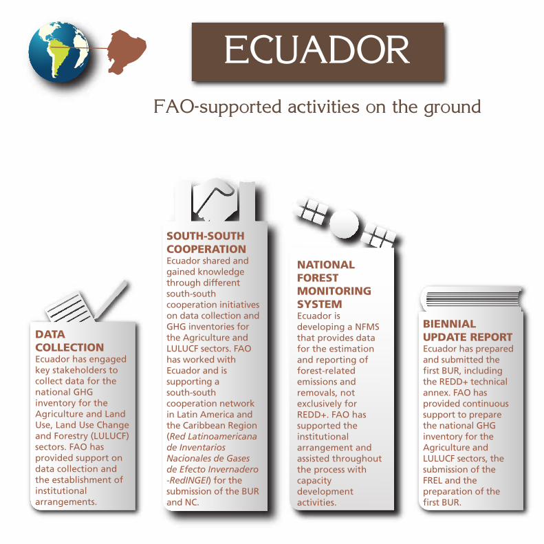
NATIONAL FOREST MONITORING SYSTEMEcuador is developing a NFMS that provides data for the estimation and reporting of forest-related emissions and removals, not exclusively for REDD+. FAO has supported the institutional arrangement and assisted throughout the process with capacity development activities.
DATA COLLECTIONEcuador has engaged key stakeholders to collect data for the national GHG inventory for the Agriculture and Land Use, Land Use Change and Forestry (LULUCF) sectors. FAO has provided support on data collection and the establishment of institutional arrangements.
FAO-supported activities on the ground
ECUADOR
BIENNIAL UPDATE REPORTEcuador has prepared and submitted the first BUR, including the REDD+ technical annex. FAO has provided continuous support to prepare the national GHG inventory for the Agriculture and LULUCF sectors, the submission of the FREL and the preparation of the first BUR.
SOUTH-SOUTH COOPERATIONEcuador shared and gained knowledge through different south-south cooperation initiatives on data collection and GHG inventories for the Agriculture and LULUCF sectors. FAO has worked with Ecuador and is supporting a south-south cooperation network in Latin America and the Caribbean Region (Red Latinoamericana de Inventarios Nacionales de Gases de Efecto Invernadero -RedINGEI) for the submission of the BUR and NC.

The way forward
AFOLUEmissions
Analysis Tools
FAO resources
Ecuador and FAO continue to collaborate on:
Development of the NDC for the Agriculture and Land Use, Land Use Change and Forestry sectors.
Technical analysis process under the International Consultation and Analysis.
Preparation of the third National Communications.

FAO-supported activities on the ground
FOREST REFERENCE EMISSION LEVELParaguay has constructed and submitted in January 2016 its national Forest Reference Emission Level (FREL). The preparation of the FREL has benefited from data collected through the NFMS. FAO has supported Paraguay in the preparation of the FREL.
NATIONAL FOREST MONITORING SYSTEMParaguay has developed a National Forest Monitoring System (NFMS), which includes a Satellite Land Monitoring System that has generated the first official national maps of forest cover and forest-cover change and the National Forest Inventory (NFI), which includes a country-wide assessment of Paraguay’s forests. Geoportal, an online portal open to the public, provides access to key information from the maps and the NFI. FAO provided support with the implementation of the methodology, data collection and processing, and the assessment of the NFI.
PARAGUAY
NATIONAL GHG INVENTORYParaguay has collected data to prepare the national GHG inventory for the Agriculture and Land Use, Land Use Change and Forestry (LULUCF) sectors. In December 2015, Paraguay submitted its first BUR, which has gone through the International Consultation and Analysis process. The preparation of the national GHG inventory has benefited from data obtained from the NFMS. FAO has provided technical support for the preparation of the GHG inventory.

The way forward
FAO resources
SEPAL
OpenForis
Collect
NFMSweb
portals
Paraguay and FAO continue to collaborate on:
Updating and improving the national GHG inventory for the second BUR implementing the 2006 IPCC guidelines for the Agriculture,
Forestry and Other Land Use sector.
Preparing, in cooperation with the World Bank, a new project proposal Pobreza,
Reforestación, Energía y Cambio Climático (PROEZA) for submission to
the Green Climate Fund.

THE WAY FORWARD
NATIONAL FOREST MONITORING SYSTEMParaguay has developed a National Forest Monitoring System (NFMS), which includes a Satellite Land Monitoring System that has generated the first official national maps of forest cover and forest-cover change and the National Forest Inventory (NFI), which includes a country-wide assessment of Paraguay’s forests. Geoportal, an online portal open to the public, provides access to key information from the maps and the NFI. FAO provided support with the implementation of the methodology, data collection and processing, and the assessment of the NFI.
Moving from the MRV framework to the Transparency Framework of the Paris Agreement
and building capacities to support member countries in this area.
Moving from FREL/FRL to REDD+results and REDD+ implementation.
FAO is able to help countries to access different funds that can support capacity building, such as the Capacity Building Initiative
for Transparency, and the implementation of mitigation and adaptation activities, such as the Global Environment Facility and
the Green Climate Fund.

COUNTRY SUPPORT
FAO REDD+/NFM team
FAO MICCABenin, Chad, Costa Rica, Mexico, Morocco, Mozambique, Uruguay
REDD+/NFM team & FAO MICCAColombia, Côte d’Ivoire, Democratic Republic of the Congo, Dominican Republic,
Ecuador, Myanmar, Papua New Guinea, Paraguay

www.fao.org/climate-change© FAO 2017
I721
0EN
/1/0
5.17