The Wilmington Wave - Weather
13
INSIDE THIS ISSUE: A Look Back on Hurricane Matthew 1-2 Wireless Emergency Alerts (WEA) 3 Weather-Ready Nation: Fall Hazards 4 Clearing the Air on Weather & Air Quality 5-6 Become A Weather Ready Nation Ambassador 7 Be Prepared for Winter Weather 8-9 NWS On Your Mobile Phone 10-11 ILM Office History 12 The Wilmington Wave FALL/WINTER 2017 VOLUME VII, ISSUE I National Weather Service, Wilmington, NC Hurricane Matthew: Carolina Impacts -Tim Armstrong Hurricane Mahew was the most powerful storm of the 2016 Atlanc Hurricane Season, and made its fourth and final landfall near McClel- lanville, South Carolina as a category 1 hurricane late in the morning of Octo- ber 8th. Although gusts above hurri- cane force were reported along the Carolina coast, Mahew will be re- membered for its extreme rainfall and deadly flooding. According to the Na- onal Hurricane Center, Mahew was directly responsible for 25 deaths in North Carolina and four in South Caro- lina, all but one due to flooding. Dam- age in the United States was esmat- ed by the Naonal Center for Environ- mental Informaon (NCEI) at $10.3 billion. The name "Mahew" was officially rered from the list of Atlan- c hurricane names due to the im- mense destrucon it caused during its trek across the Caribbean islands and the Southeastern United States. The 2016 Atlanc Hurricane Season featured 15 named storms, 7 hurri- canes, and 4 major hurricanes. The Carolinas were affected by four tropi- cal cyclones in 2016 prior to Mahew: Bonnie, Colin, Hermine, and Julia. COASTAL IMPACTS ACROSS SOUTH CAROLINA AND NORTH CAROLINA A combinaon of wind and storm surge caused extensive damage along the South Carolina coast- line. In most locaons water levels were three to five feet above the normal astronomical des. In Beaufort County, SC damage was parcularly severe on the sea islands south and east of Beaufort in- cluding Hilton Head Island, Fripp Island, Dataw Island, and at Hunng Island State Park. Observed damage to trees and homes implies winds reached at least 100 mph in these communies. Storm surge flooding moved boats inland, including four boats deposited on the runway of the Beaufort County airport. One lane of the Harbor Island Bridge over to Hunng Island was scoured out by the storm surge. ...Continued on Page 2
Transcript of The Wilmington Wave - Weather

I N S I D E T H I S
I S S U E :
A Look Back on
Hurricane
Matthew
1-2
Wireless
Emergency
Alerts (WEA)
3
Weather-Ready
Nation:
Fall Hazards
4
Clearing the Air
on Weather &
Air Quality
5-6
Become A
Weather Ready
Nation
Ambassador
7
Be Prepared for
Winter Weather 8-9
NWS On Your
Mobile Phone 10-11
ILM Office
History 12
The Wilmington Wave
F A L L / W I N T E R 2 0 1 7 V O L U M E V I I , I S S U E I
National Weather Service, Wilmington, NC
Hurricane Matthew: Carolina Impacts -Tim Armstrong
Hurricane Matthew was the most powerful storm of the 2016 Atlantic Hurricane Season, and made its fourth and final landfall near McClel-lanville, South Carolina as a category 1 hurricane late in the morning of Octo-ber 8th. Although gusts above hurri-cane force were reported along the Carolina coast, Matthew will be re-membered for its extreme rainfall and deadly flooding. According to the Na-tional Hurricane Center, Matthew was directly responsible for 25 deaths in North Carolina and four in South Caro-lina, all but one due to flooding. Dam-age in the United States was estimat-ed by the National Center for Environ-mental Information (NCEI) at $10.3 billion. The name "Matthew" was officially retired from the list of Atlan-tic hurricane names due to the im-mense destruction it caused during its trek across the Caribbean islands and the Southeastern United States. The 2016 Atlantic Hurricane Season featured 15 named storms, 7 hurri-canes, and 4 major hurricanes. The Carolinas were affected by four tropi-cal cyclones in 2016 prior to Matthew: Bonnie, Colin, Hermine, and Julia.
COASTAL IMPACTS ACROSS SOUTH CAROLINA AND NORTH CAROLINA
A combination of wind and storm surge caused extensive damage along the South Carolina coast-line. In most locations water levels were three to five feet above the normal astronomical tides. In Beaufort County, SC damage was particularly severe on the sea islands south and east of Beaufort in-cluding Hilton Head Island, Fripp Island, Dataw Island, and at Hunting Island State Park. Observed
damage to trees and homes implies winds reached at least 100 mph in these communities. Storm
surge flooding moved boats inland, including four boats deposited on the runway of the Beaufort County airport. One lane of the Harbor Island Bridge over to Hunting Island was scoured out by the storm surge.
...Continued on Page 2
P A G E 2
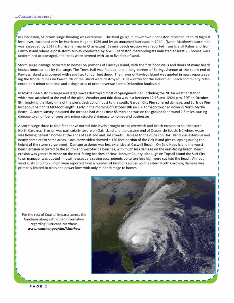
...Continued from Page 1
In Charleston, SC storm surge flooding was extensive. The tidal gauge in downtown Charleston recorded its third highest level ever, exceeded only by Hurricane Hugo in 1989 and by an unnamed hurricane in 1940. (Note: Matthew's storm tide was exceeded by 2017's Hurricane Irma in Charleston) Severe beach erosion was reported from Isle of Palms and from Edisto Island where a post-storm survey conducted by NWS Charleston meteorologists indicated at least 70 homes were undermined or damaged, and roads were covered with up to five feet of sand. Storm surge damage occurred to homes on portions of Pawleys Island, with the first floor walls and doors of many beach houses knocked out by the surge. The Town Hall was flooded, and a long portion of Springs Avenue at the south end of Pawleys Island was covered with sand two to four feet deep. The mayor of Pawleys Island was quoted in news reports say-ing the frontal dunes on two-thirds of the island were destroyed. A newsletter for the DeBordieu Beach community refer-enced only minor sand loss and a single area of ocean overwash onto DeBordieu Boulevard. In Myrtle Beach storm surge and large waves destroyed most of Springmaid Pier, including the NOAA weather station which was attached to the end of the pier. Weather and tide data was lost between 12:18 and 12:24 p.m. EDT on October 8th, implying the likely time of the pier's destruction. Just to the south, Garden City Pier suffered damage, and Surfside Pier lost about half of its 689-foot length. Early in the morning of October 8th an EF0 tornado touched down in North Myrtle Beach. A storm survey indicated the tornado had winds near 85 mph and was on the ground for around 1.5 miles causing damage to a number of trees and minor structural damage to homes and businesses. A storm surge three to four feet above normal tide levels brought ocean overwash and beach erosion to Southeastern North Carolina. Erosion was particularly severe on Oak Island and the eastern end of Ocean Isle Beach, NC where water was flowing beneath homes at the ends of East 2nd and 3rd streets. Damage to the dunes on Oak Island was extensive and nearly complete in some areas. Local news video showed a 150 foot portion of the Oak Island pier collapsing during the height of the storm surge event. Damage to dunes was less extensive at Caswell Beach. On Bald Head Island the worst beach erosion occurred to the south- and west-facing beaches, with much less damage on the east-facing beach. Beach erosion was generally minor on the east-facing beaches of New Hanover County, although on Topsail Island the Surf City town manager was quoted in local newspapers saying escarpments up to ten feet high were cut into the beach. Although wind gusts of 60 to 75 mph were reported from a number of locations across Southeastern North Carolina, damage was primarily limited to trees and power lines with only minor damage to homes.
For the rest of Coastal Impacts across the Carolinas along with other information
regarding Hurricane Matthew, www.weather.gov/ilm/Matthew

P A G E 3
Wireless
Emergency
Alerts

P A G E 4 V O L U M E V I I , I S S U E I
From NOAA’s Weather-Ready Nation
(https://www.weather.gov/wrn/fall-safety)
As the days get shorter and temperatures fall, a new round of weather hazards are on the rise. This transitional season often features weather hazards seen during both warm and cold months, including hurricanes, wildfires, intense winds, flooding, droughts, early season snow and more.
Get ready for fall weather with preparedness tips from the National Weather Service. Stay safe this fall!
Fall Hazards: Weather-Ready Nation
Know your Risk, Take Action, Be a Force of Nature!

P A G E 5
Clearing the Air on Weather and Air Quality From NWS Weather Ready Nation—Safety Campaign
Air quality affects the air we breathe. There are many factors that can lead to poor air quality, but the two most common are related to elevated concentrations of ground-level ozone or particulate matter. Ground level ozone forms when nitrogen oxides from sources like vehicle exhaust and industrial emissions re-act with organic compounds in the presence of heat and sunlight. Per EPA, ozone can cause a number of health problems, including coughing, breathing difficulty, and lung damage. Exposure to ozone can make the lungs more susceptible to infection, aggravate lung diseases, increase the frequency of asthma attacks, and in-crease the risk of early death from heart or lung disease (see https://airnow.gov/index.cfm?action=pubs.aqiguideozone). Particulate matter in the air consists of solid and liquid particles including smoke, dust and other aerosols, some of which are directly emitted and others are resulting from chemical transformations., The sources of these particles are numerous- including vehicles, factories, power plants, fires, other natural phenomena and human activities. Particle pollution is linked to a number of health problems, including coughing, wheezing, reduced lung function, asthma attacks, heart attacks, strokes and even early death (see https://airnow.gov/index.cfm?action=pubs.aqguidepart).
The weather can have a significant impact on air quality since different aspects of the weather affect the amounts of ozone and particulates that are present in a specific area. Sunshine, rain, higher temperatures, wind speed, air turbulence, and mixing depths all affect pollutant concentrations. Sunshine can cause some pollutants to undergo chemical reactions, resulting in the development of smog Higher air temperatures can speed up chemical reactions in the air Rain typically results in less pollution since it washes away particulate matter and can also wash out pollu-
tants that are dissolvable Wind speed, air turbulence, and mixing depth all affect how pollutants disperse, or spread out from an area
...Continued on Page 6

P A G E 6
...Continued from Page 5
National Weather Service provides model forecast guidance for ozone, dust and fine particulate matter twice daily and smoke predictions once daily for next 48 hours. State and local agencies use NWS model guidance to issue air quality forecasts that weather forecast offices (WFOs) help disseminate. Air quality forecasts of unhealthy (code orange) or worse air quality that are shared with WFOs get displayed on NWS warning maps as air quality alerts. When Air Quality Alerts are in effect, there are many actions you can take to stay safe and protect your health.
If you would like to help reduce air pollution, you can take the following measures: Eliminate tobacco smoke Reduce your use of wood stoves and fireplaces Don’t burn candles, leaves, garbage, plastic or rubber Use HEPA air filters and air cleaners designed to reduce particles Drive less: carpool, use public transportation, bike or walk Keep car, boat and other engines tuned Inflate tires to the recommended pressure When refueling: stop when the pump shuts off, avoid spilling fuel, and tighten your gas cap Use low-VOC paint and cleaning products, and seal and store them so they can’t evaporate Choose energy saving appliances Set thermostats higher in summer and lower in winter Turn off lights you are not using
For more information: (https://airnow.gov/index.cfm?action=pubs.aqiguideozone)
(https://airnow.gov/index.cfm?action=pubs.aqguidepart)
EPA compiles the official air quality forecasts at https://www.airnow.gov/ and NWS provides hour-by-hour predictions of air quality at https://airquality.weather.gov/
Stay informed about air quality conditions in your area. Infor-mation is provided by EPA, NWS and the media
Choose a less-strenuous activity Shorten and take more breaks
during outdoor activity Reschedule activities to the
morning or to another day Move your activity inside where
ozone levels are usually lower Spend less time near busy roads

P A G E 7
Want to Become a Weather-Ready Nation Ambassador? - Steve Pfaff
It’s no surprise for many that live in southeast NC and northeast SC that we are susceptible to a wide variety of
weather impacts. In fact, our part of the country is like no other when it comes to the different hazards we have
to prepare for including wind driven wildfires, hurricanes, ice storms, flooding, tornado outbreaks, severe thun-
derstorms, drought, etc. Although many of these events do not occur routinely, if we fail to plan for them then
many will become caught off guard by their impacts. The National Weather Service (NWS) is responsible for do-
ing storm survey assessments of areas hit hard by severe weather, and a common theme we hear from those
who were hit hardest is – “I can’t believe this happened to me”. While most people agree that we have an expo-
sure to hazardous weather, only a small segment of the population is ideally prepared to deal with extreme
weather events.
During a typical year the United States has 100,000 severe thunderstorms, 5,000 floods and flash floods, 1,000
tornadoes, and 2 land-falling hurricanes. It’s no wonder why our Nation needs to be Weather-Ready. While
there have been advancements in weather related technology and research that have led to the increased accu-
racy and warning lead time over the last decade, people are still being killed in great numbers. For instance, dur-
ing 2011 there were 549 fatalities from tornadoes – almost 300 people during the Alabama outbreak on a single
day! As a result, the NWS has started a new program called Weather-Ready Nation to enhance community resili-
ence in the face of extreme weather events across the Nation.
The Weather-Ready Nation Ambassador program is the initiative that recognizes a wide variety of partners in
their efforts to advocate weather safety and planning. The Ambassadors help to unify weather safety efforts, are
action-oriented, inclusive, and help lead to new partnership opportunities with the NWS. The Ambassador pro-
gram is open to any club, organization, company, civic group, or government agency (Local/State/Federal) and is
free to join. There are no formal guidelines or requirements to become an Ambassador other than to sign-up and
become integrated into the pipeline of weather safety information through the Weather-Ready Nation program.
Consider the following - does weather potentially impact your family, friends, club members, staff or co-
workers? If you answered yes then consider joining to become a Weather-Ready Nation Ambassador. Help the
NWS to better serve our local communities by signing up!
For more information visit: http://www.weather.gov/ilm/wrn

Be Prepared for Winter Weather
Exposure to extreme cold, fires and poisoning due to the improper use of heaters, and vehicle acci-dents are just a few reasons as to why dozens of fatalities are reported each year due to winter weather, an overlooked significant threat. Now you may be thinking that the winter season across the Coastal Carolinas is nothing compared to, for example, the New England region. Well, we have our share of winter weather across the Carolinas, thus you should always be prepared. In preparation for a winter weather event, keep in mind that the primary concern will be the loss of heat, power outages, and shortage of supplies if storm or proceeding conditions persist for more than one day. Before winter weather strikes, be sure to take necessary precautions such as maintaining, cleaning, and annually inspecting chimneys and other heating equipment, and making sure your vehicle is pre-pared by having a full gas tank and inspecting the antifreeze levels, brakes, battery, and more!
For additional information, visit www.ready.gov
Disaster Kit: Home/Work
· Flashlight and extra batteries
Battery-powered NOAA Weather Radio
Extra food and water (one gallon of water per person, per day)
Prescription medicines
Special items for infant, elderly or disabled family members
Emergency tools
Cash and a credit card, emergency phone numbers
Important documents
Blankets and change of clothing per person
First aid supplies
Fire extinguisher/smoke alarm/carbon monoxide detector
Heating fuel
Emergency heat source (fireplace, space heater, etc)
- Sandy LaCorte
P A G E 8
Safety Tips: Animals/Pets
Move animals to sheltered locations
Have extra feed on hand or near feeding areas
Have water available (animals may die from dehydration)
Make sure pets have plenty of food, water and shelter
...Continued on Page 9

P A G E 9
Disaster Kit: Vehicle
Mobile phone, charger, batteries
windshield scraper and small broom
flashlight with extra batteries
battery powered radio
compass and road maps
water and snack food
matches
extra hats, socks, mittens, and clothing
first aid kit with pocket knife
necessary medications
blanket(s)/sleeping bags
tow chain and/or rope
road salt and sand, booster cables
emergency flares/fluorescent distress flag
Safety Tips: Vehicle
Drive only if it is absolutely necessary. If you must
drive: travel during the day; don’t travel alone;
keep others informed of your schedule; stay on
main roads and avoid back road shortcuts.
If driving on snow or ice-covered roadways, re-
duce your speed. Driving at the regular speed limit
will reduce your ability to control the car if you
begin to slide. Leave plenty of room between you
and other vehicles.
If conditions worsen and you can no longer drive
safely, pull off the highway. Stay calm and remain
in your vehicle. Do not set out on foot unless you
can see a building close by where you know you
can take shelter.
Let someone know your destination, your route,
and when you expect to arrive. If your car gets
stuck along the way, help can be sent along your
predetermined route.
Carbon Monoxide: The Invisible Killer
Carbon monoxide (CO) is a deadly odorless, colorless, and poisonous gas that is the cause of fatalities each
year, especially during the winter weather season. It is a result of the incomplete burning of various fuels (ie
coal, wood, kerosene, propane) from equipment such as generators and cars.
Symptoms
Dizziness, nausea, fatigue, headache, shortness of breath
High level of CO poisoning: vomiting, mental confusion, loss of consciousness
Prevent CO poisoning:
Never operate equipment in enclosed spaces, such as a garage or locations within a home.
Never leave car running in an attached garage (even with garage door open)
Never burn charcoal inside home, vehicle, garage
Never use gas appliances to heat your home (ovens, clothes dryers, etc)
Never operate equipment where people are sleeping
Install carbon monoxide alarms in central locations on every level of your home
If carbon monoxide alarm sounds, move quickly to fresh air

P A G E 1 0
From: Weather-Ready Nation
Take the weather with you on your mobile phone! Wherever you are, you can get the local weather forecast from the National Weather Service with one click on your home screen. Book-mark mobile.weather.gov to make sure that you have the latest weather news and information on the go.
How can you add mobile.weather.gov to your mobile phone’s Home Screen? It’s easy! Learn how to add the mobile version of weather.gov to your iPhone or Android phone.
Follow these three steps for one-click access to your local forecast.
If you have an iPhone...
Visit mobile.weather.gov using Safari on your iPhone. 1. Click the Send button at the bottom of the screen.
2. Choose “Add to Home Screen” and tap “Add.”
Weather.gov on Your Mobile Phone
...Continued on Page 12

P A G E 1 1
From: Weather-Ready Nation
If you have an Android mobile device… There are a number of browsers that will allow you to add mobile.weather.gov to your home screen. For example, on Chrome for Android:
Visit mobile.weather.gov using Chrome on your Android phone 1. Click the menu button
Choose “Add to Home Screen.”
That’s it! That’s all it takes to get local weather information from the National Weather Service on your iPhone or other device. For other mobile platforms, if you do not know how to bookmark a page on your phone, open your browser and search “how to bookmark a page on _____” with the blank being filled in with your model of phone.
Interested in other sources for weather alerts? Go www.weather.gov/subscribe for alternative options for weather alerting services or visit your mobile phone’s app store for commercial app options.
Weather.gov on Your Mobile Phone
...Continued from Page 11

P A G E 1 2 T H E W I L M I N G T O N W A V E
NWS Wilmington Office History
They say everyone has a story, and for the National Weather Service office in Wilmington, NC, that
story begins with December of 1870. It was then that the U.S. Signal Corps began taking sporadic
snowfall measurements. Jump ahead a few years to 1874, when in April, the first complete and con-
tinuous set of weather observations began in a building located in downtown Wilmington, which no
longer exists. From historic weather events to multiple moves for the office location, a lot has hap-
pened since 1870.
Take a ride down memory lane through our office history timeline:
http://www.weather.gov/ilm/TimelineNWSILM

to
refer
your
read-
This story can fit 175-225 words.
If your newsletter is folded and
mailed, this story will appear on the
back. So, it’s a good idea to make it
easy to read at a glance.
A question and answer session is a
good way to quickly capture the at-
tention of readers. You can either
compile questions that you’ve re-
ceived since the last edition or you
can summarize some generic ques-
tions that are frequently asked about
your organization.
A listing of names and titles of manag-
ers in your organization is a good way
to give your newsletter a personal
touch. If your organization is small,
you may want to list the names of all
employees.
If you have any prices of standard
products or services, you can include
a listing of those here. You may want
We need your Storm Reports!!
Events of tornadoes, hail, damaging winds,
and flooding are very important to us.
Please call: 1-800-697-3901 *Storm reports ONLY*
Email: [email protected]
National Weather Service
Weather Forecast Office
Wilmington, North Carolina
2015 Gardner Drive
Wilmington, NC 28405
Phone: (910) 762-4289
www.weather.gov/ilm
Webmaster’s Email: [email protected]
The Wilmington Wave
Volume IV, Issue I
Contributors:
Timothy Armstrong
Sandy LaCorte
Editor-in-Chief:
Sandy LaCorte
Meteorologist-in-Charge:
Michael Caropolo
Follow Us on Social Media
@NWSWilmingtonNC www.facebook.com/
NWSWilmingtonNC
Where we share adverse weather information and historical weather events,
and you share storm reports and any weather questions you might have!