The use of LADA - United Nations · The use of LADA (Land degradation ... Manual /toolkit for local...
12
1 The use of LADA (Land degradation assessment in drylands) for sustainable land management, reducing vulnerability and adapting to change - LADA Partnership by Sally Bunning, FAO - LADA Senegal by Déthié Soumare Ndiaye - LADA South Africa and Landcare by Lehman Lindeque - Linking Local Monitoring and Management by Constance Neely, Heifer/HM - FFS and landscape Approaches by FAO/Landcare - Partnership on LD in Dryland ecosystem of China Facilitated Discussion by Constance Neely Closing Comments on SLM/Terrafrica by NEPAD /UNCCD New Website (Information, technical reports, LADA manuals http://lprlada.fao.org/lada or contact [email protected] Case studies and discussion
Transcript of The use of LADA - United Nations · The use of LADA (Land degradation ... Manual /toolkit for local...

1
The use of LADA (Land degradation assessment in drylands)
for sustainable land management, reducing vulnerability and adapting to
change
- LADA Partnership by Sally Bunning, FAO
- LADA Senegal by Déthié Soumare Ndiaye
- LADA South Africa and Landcare by Lehman Lindeque
- Linking Local Monitoring and Management by Constance Neely, Heifer/HM- FFS and landscape Approaches by FAO/Landcare- Partnership on LD in Dryland ecosystem of ChinaFacilitated Discussion by Constance Neely
Closing Comments on SLM/Terrafrica by NEPAD /UNCCD
New Website (Information, technical reports, LADA manuals http://lprlada.fao.org/lada
or contact [email protected]
Case studies and discussion
2
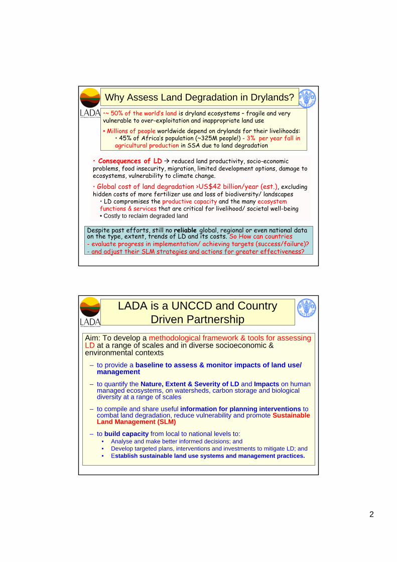
Why Assess Land Degradation in Drylands?
Despite past efforts, still no reliable global, regional or even national data on the type, extent, trends of LD and its costs. So How can countries - evaluate progress in implementation/ achieving targets (success/failure)? - and adjust their SLM strategies and actions for greater effectiveness?
•~ 50% of the world’s land is dryland ecosystems – fragile and very vulnerable to over-exploitation and inappropriate land use• Millions of people worldwide depend on drylands for their livelihoods:
• 45% of Africa’s population (~325M people!) - 3% per year fall in agricultural production in SSA due to land degradation
• Consequences of LD reduced land productivity, socio-economic problems, food insecurity, migration, limited development options, damage to ecosystems, vulnerability to climate change.
• Global cost of land degradation >US$42 billion/year (est.), excluding hidden costs of more fertilizer use and loss of biodiversity/ landscapes
• LD compromises the productive capacity and the many ecosystem functions & services that are critical for livelihood/ societal well-being• Costly to reclaim degraded land
LADA is a UNCCD and Country Driven Partnership
Aim: To develop a methodological framework & tools for assessing LD at a range of scales and in diverse socioeconomic & environmental contexts
– to provide a baseline to assess & monitor impacts of land use/ management
– to quantify the Nature, Extent & Severity of LD and Impacts on human managed ecosystems, on watersheds, carbon storage and biologicaldiversity at a range of scales
– to compile and share useful information for planning interventions to combat land degradation, reduce vulnerability and promote Sustainable Land Management (SLM)
– to build capacity from local to national levels to: • Analyse and make better informed decisions; and• Develop targeted plans, interventions and investments to mitigate LD; and• Establish sustainable land use systems and management practices.
3
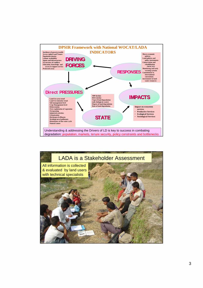
DPSIR Framework with National WOCAT/LADA INDICATORS
DRIVING DRIVING FORCESFORCES
Direct PRESSURES
STATESTATE
IMPACTSIMPACTS
RESPONSES
Land Use area trendLand Use intensity trendSoil management levelCrop Management levelDeforestationOver-exploitation of vegetationOvergrazingIndustrial activitiesUrbanizationDischarge of effluentsWashing out of pollutantsDisturbance of the water cycleNatural causes
NPP declineRUE declineType of land degradation(soil, biological, water)Degree of land degradationRate of land degradation
Incidence of poverty/wealthAccess rights/Land TenurePopulation densityLabour availabilityInputs and infrastructureOccurrence of conflicts Education, knowledge and
access to support serviceProtected areas
Impact on ecosystem services
• Productive Services• Ecological Services• Sociological Services
Macro economic policies
Land policies and policy instruments
Conservation and rehabilitation
(WOCAT)Monitoring and early
warning systemsCommitment to
international conventions
Investments in land water resources
Understanding & addressing the Drivers of LD is key to success in combating degradation: population, markets, tenure security, policy constraints and bottlenecks
Foto: H.P. Liniger
All information is collected & evaluated by land users with technical specialists
LADA is a Stakeholder Assessment
4
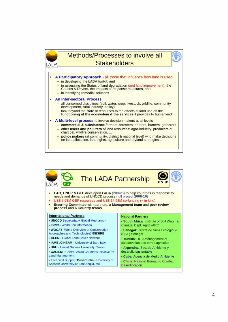
Methods/Processes to involve all Stakeholders
• A Participatory Approach - all those that influence how land is used– in developing the LADA toolkit; and– in assessing the Status of land degradation (and land improvement), the
Causes & Drivers, the Impacts of response measures, and– in identifying remedial solutions
• An Inter-sectoral Process– all concerned disciplines (soil, water, crop, livestock, wildlife, community
development, rural industry, policy);– look beyond the state of resources to the effects of land use on the
functioning of the ecosystem & the services it provides to humankind
• A Multi-level process to involve decision makers at all levels – commercial & subsistence farmers, foresters, herders, hunters, gatherers – other users and polluters of land resources: agro-industry, producers of
charcoal, wildlife conservation, ...– policy makers (at community, district & national level) who make decisions
on land allocation, land rights, agriculture and dryland strategies...
The LADA Partnership
• FAO, UNEP & GEF developed LADA (2004/5) to help countries in response to needs and demands of UNCCD process (full project 2006-10)
• US$ 7.98M GEF resources and US$ 14.98M co-funding (+ in kind)• Steering Committee with partners, a Management team and peer review
process and 6 Country teams
International Partners• UNCCD Secretariat + Global Mechanism• ISRIC - World Soil Information• WOCAT- World Overview of Conservation Approaches and Technologies) /DESIRE• GLCN - Global Land Cover Network• IAMB /CIHEAM - University of Bari, Italy• UNU - United Nations University, Tokyo• CACILM - Central Asian Countries Initiative for Land Management• Technical Support: Desertlinks - University of Sassari; University of East Anglia, etc.
National Partners• South Africa: Institute of Soil Water & Climate, Dept. Agric /ARC• Senegal: Centre de Suivi Ecologique(CSE) Sénégal• Tunisia: DG Aménagement et conservation des terres agricoles• Argentina: Sec. de Ambiente y desarollo sustentable• Cuba: Agencia de Medio Ambiente• China: National Bureau to Combat Desertification
5
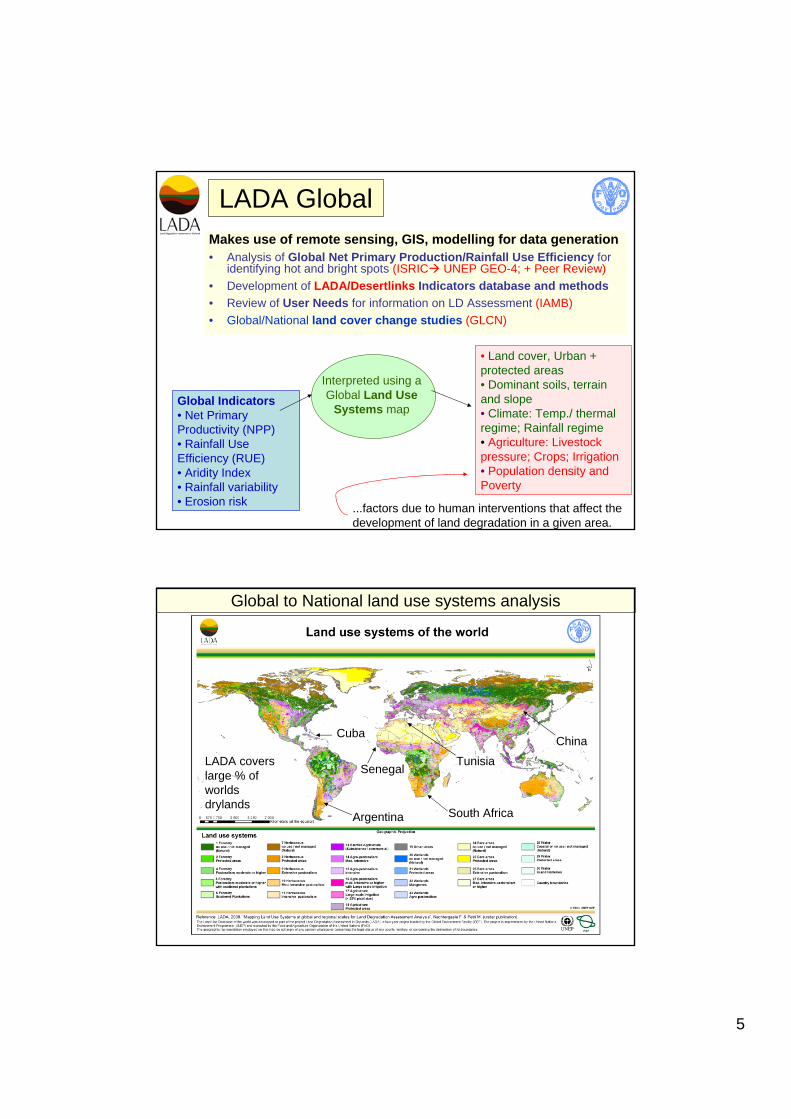
LADA GlobalMakes use of remote sensing, GIS, modelling for data generation • Analysis of Global Net Primary Production/Rainfall Use Efficiency for
identifying hot and bright spots (ISRIC UNEP GEO-4; + Peer Review)• Development of LADA/Desertlinks Indicators database and methods• Review of User Needs for information on LD Assessment (IAMB)• Global/National land cover change studies (GLCN)
Global Indicators • Net Primary Productivity (NPP) • Rainfall Use Efficiency (RUE) • Aridity Index • Rainfall variability • Erosion risk
• Land cover, Urban + protected areas • Dominant soils, terrain and slope • Climate: Temp./ thermal regime; Rainfall regime• Agriculture: Livestock pressure; Crops; Irrigation• Population density and Poverty
Interpreted using a Global Land Use
Systems map
...factors due to human interventions that affect the development of land degradation in a given area.
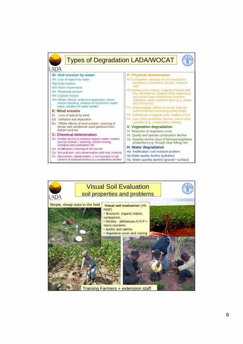
Argentina
CubaChina
Global to National land use systems analysis
TunisiaSenegal
South Africa
LADA covers large % of worlds drylands

6
LADA National
Makes use of national data sets, RS/GIS tools + qualitative assessmentGuidelines and tools for national level assessment of LD and land improvementwere developed and validated with partners
– National mapping system (on line questionnaire and guidelines (30 arcsec ~900m) (WOCAT/LADA/DESIRE)
– Participatory workshop technical guidance on national mapping and adaptation of WOCAT tools (South Africa -ARC)
All LADA countries developing national database and information sets and national land use system map
– natural resources (temperature, climate, growing period, soil slope) – land use (crops, livestock, irrigation) – socio-economic data (population density, poverty)
National Land use systems are assessed using guided expert opinion
Sustainable land management (SLM) options are assessed at regional/ provincial level using LADA/WOCAT manual and questionnaire (using LUS map)
Case studies from LADA South Africa and Senegal
LADA LocalUse of participatory rural appraisals, expert assessment + field measurement and set of local indicatorsManual /toolkit for local level field assessment of LD / Sustainable Land management (LADA/University of East Anglia)developed and validated in LADA pilot countries for use in drylands and wider
Hands-on Workshops (UK, Tunisia) for Training of trainers in 6 LADA countries practical step by step guide in 9 sections:
1. Introduction 2. Planning the assessment3. Identifying Local Assessment
Areas within priority areas ( national assessment)
4. Characterisation of Local Assessment Areas (transects, community mapping)
5. Identifying sites and households for detailed assessments (SL interviews)
(Observation and measurements)
6. Assessment of the type, extent and severity of Land Degradation /Improvement
7. Assessment of the Biophysical Impacts of LD
8. Assessment of soil properties, erosion and productivity (VS-Fast)
9. Assessment of water

7
LADA Local (2)Ten Annexes - essential part of the Toolkit - optional tools for specific contexts and additional explanations for example:
– LD within Ecosystem Services and Sustainable Livelihoods frameworks
– Soil and water salinity assessment– Economics of soil erosion and conservation
Local area assessments (selected areas) - integrated understanding:
– of biophysical and socio-economic causes and impacts of LD – effectiveness of land management practices/approaches – identification of drivers and policy responses and needs in regard
to institutional, economic + policy environment for sustainable land management (SLM)
Good practices manual at local level prepared with national-provincial institutes practical and successful SLM technologies that deserve investment and scaling up
Erosion by wind and water
Quantifying the nature, extent, severity and impacts of land degradation
Soil chemical degradationSoil physical degradation
Biological degradation
8
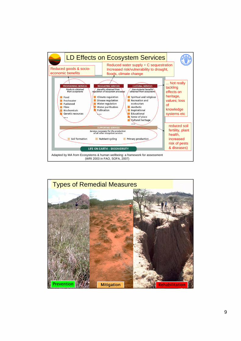
W: Soil erosion by waterWt Loss of topsoil by waterWg Gully erosionWm Mass movementsWr Riverbank erosionWc Coastal erosionWo Offsite effects: sediment deposition, down-
stream flooding, siltation of reservoirs/ water-ways, siltation of water bodies
E: Wind erosionEt Loss of topsoil by windEd Deflation and depositionEo Offsite effects of wind erosion: covering of
terrain with windborne sand particles from distant sources
C: Chemical deteriorationCn Fertility decline & reduced organic matter content
(not by erosion) - leaching, nutrient mining, oxidation and volatisation (N)
Ca Acidification: lowering of the soil pHCp Soil pollution: soil contamination with toxic materialCs Salinisation / alkalinisation: a net increase of salt
content of (top)soil leading to a productivity decline
P: Physical deteriorationPc Compaction: damage of soil structure by
trampling or machinery (weight; frequent use)
Pk Sealing and crusting: clogging of pores with fine soil material; creation of an impervious soil surface layer obstructing rainwater infiltration; water-repellent layer (e.g. ashes after forest fire)
Pw Waterlogging: effects of human induced hydromorphism (excluding paddy fields)
Ps Subsidence of organic soils, settling of soilPu Loss of bio-productive function due to other
activities (e.g. construction, mining)V: Vegetation degradationVr Reduction of vegetation coverVs Quality and species composition declineVq Quantity decline (loss of biomass/vegetative
production) e.g. through clear felling, fireH: Water degradationHa Aridification / soil moisture problemHp Water quality decline (pollution)Hq Water quantity decline (ground + surface)
Types of Degradation LADA/WOCAT
Visual Soil Evaluationsoil properties and problems
Simple, cheap tests in the field Visual soil evaluation (VS-FAST)• Structure- organic matter, compaction,• Fertility - deficiences K N P + micro-nutrients• Acidity and salinity• Vegetative cover and rooting
Training Farmers + extension staff
9
LD Effects on Ecosystem Services
Adapted by MA from Ecosystems & human wellbeing: a framework for assessment (WRI 2003 in FAO, SOFA, 2007)
Reduced goods & socio-economic benefits
Reduced water supply + C sequestrationIncreased risk/vulnerability to drought, floods, climate change
reduced soil fertility, plant health, increased risk of pests & diseases)
... Not really tackling effects onheritage, values; loss of knowledge systems etc
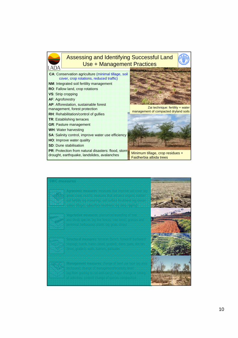
MitigationPrevention Rehabilitation
Types of Remedial Measures
10
CA: Conservation agriculture (minimal tillage, soil cover, crop rotations, reduced traffic)
NM: Integrated soil fertility managementRO: Fallow land, crop rotationsVS: Strip croppingAF: Agroforestry AP: Afforestation, sustainable forest management, forest protectionRH: Rehabilitation/control of gulliesTR: Establishing terraces GR: Pasture managementWH: Water harvestingSA: Salinity control, improve water use efficiencyHO: Improve water qualitySD: Dune stabilisationPR: Protection from natural disasters: flood, storm drought, earthquake, landslides, avalanches
Assessing and Identifying Successful Land Use + Management Practices
Minimum tillage, crop residues + Faidherbia albida trees
Zai technique: fertility + water management of compacted dryland soils
11
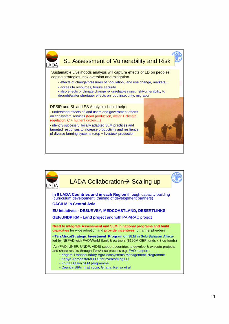
SL Assessment of Vulnerability and Risk
DPSIR and SL and ES Analysis should help :- understand effects of land users and government efforts on ecosystem services (food production, water + climate regulation, C + nutrient cycles....)- identify successful locally adapted SLM practices and targeted responses to increase productivity and resilience of diverse farming systems (crop + livestock production
Sustainable Livelihoods analysis will capture effects of LD on peoples’coping strategies, risk aversion and mitigation
• effects of change/pressures of population, land use change, markets,... • access to resources, tenure security• also effects of climate change unreliable rains, risk/vulnerability to drought/water shortage, effects on food insecurity, migration
LADA Collaboration Scaling up
In 6 LADA Countries and in each Region through capacity building (curriculum development, training of development partners) CACILM in Central Asia
EU Initiatives - DESURVEY, MEDCOASTLAND, DESERTLINKSGEF/UNDP KM - Land project and with PAP/RAC project
Need to integrate Assessment and SLM in national programs and build capacities for wide adoption and provide incentives for farmers/herders
• TerrAfrica/Strategic Investment Program on SLM in Sub-Saharan Africa-led by NEPAD with FAO/World Bank & partners ($150M GEF funds x 3 co-funds)
IAs (FAO, UNEP, UNDP, AfDB) support countries to develop & execute projects and share results through TerrAfrica process e.g. FAO support :
• Kagera Transboundary Agro-ecosystems Management Programme• Kenya Agropastoral FFS for overcoming LD• Fouta Djallon SLM programme• Country SIPs in Ethiopia, Ghana, Kenya et al

12
Study plot Observation
Adaptive Management through Farmer Field School Approaches
Analysis
Synthesis discussion decisions
Farmers Practice
Water Harvesting