“The use of Dynamic maps and Volunteered Geographic Information in Greece” Sofia Basiouka...
26
“The use of Dynamic maps and Volunteered Geographic Information in Greece” Sofia Basiouka National Technical University of Athens PhD student [email protected]
-
Upload
paula-barrett -
Category
Documents
-
view
216 -
download
2
Transcript of “The use of Dynamic maps and Volunteered Geographic Information in Greece” Sofia Basiouka...
“The use of Dynamic maps and Volunteered Geographic Information
in Greece”
Sofia Basiouka
National Technical University of Athens
PhD student [email protected]

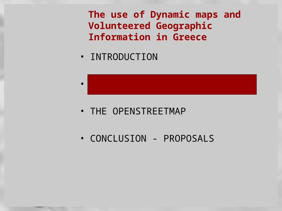
The use of Dynamic maps and Volunteered Geographic Information in Greece
• INTRODUCTION
• WEB MAPPING AND DYNAMIC MAPS
• THE OPENSTREETMAP
• CONCLUSION - PROPOSALS
INTRODUCTION
Land management and land administration constitute a set of processes where spatial information has a fundamental role. The transition from land information to land resources can only be successful if spatial data is incorporated properly.
The distribution of spatial information has dramatically changed due to:
• Web Mapping • User Generated Content

INTRODUCTION
New terms such as:• Neogeography (Turner 2006, Sui 2008)• Ubiquitous Cartography (Gartner et al, 2007)• Web Mapping (Plewe 2007) • Volunteered Geographic Information
(Goodchild, 2007). • Neogeography is only a neologism which
introduces the era of geospatial democratization including new technologies, standards, new practices and new users – creators. (Roche 2010)
have been adopted to identify citizens’ contribution in mapping
The use of Dynamic maps and Volunteered Geographic Information in Greece
• INTRODUCTION
• WEB MAPPING AND DYNAMIC MAPS
• THE OPENSTREETMAP
• CONCLUSION - PROPOSALS

DYNAMIC MAPS
The online dynamic maps orient users in a modern way when they seek for geospatial information (Cartwright 2003)
A special category of dynamic maps are the mashup maps which provide special interest because the can aggregate spatial information from different sources.
“mashup is a web page or application that uses and combines data, presentation or functionality from two or more sources to create new services.” Wikipedia (2010)
DYNAMIC MAPS
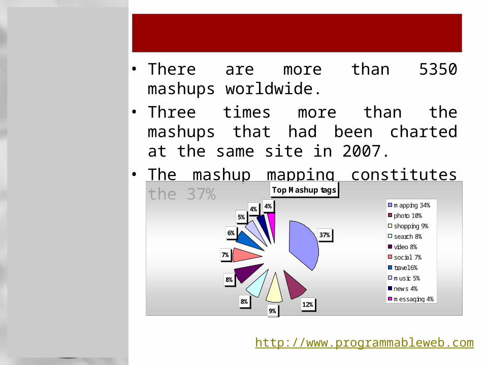
• There are more than 5350 mashups
worldwide. • Three times more than the mashups that
had been charted at the same site in 2007. • The mashup mapping constitutes the 37%
Top Mashup tags
37%
12%9%
8%
8%
7%
6%
5%4% 4% mapping 34%
photo 10%
shopping 9%
search 8%
video 8%
social 7%
travel 6%
music 5%
news 4%
messaging 4%
http://www.programmableweb.com
DYNAMIC MAPS
Why mashup maps are so special and essential part of web mapping?
• Combine separate stand alone applications• Source code can be used without
modification • Most applications can function through an
API • Google or Yahoo maps are used as base
maps offering a simplicity to designers.
• Mashup maps can be divided in two main categories; their content can be enhanced by the citizens or not.
DYNAMIC MAPS IN GREECE
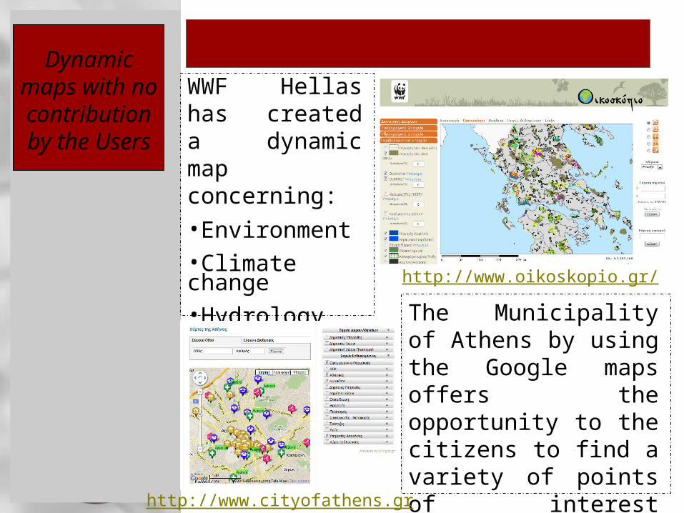
WWF Hellas has created a dynamic map concerning:
•Environment•Climate change•Hydrology•Topography
The Municipality of Athens by using the Google maps offers the opportunity to the citizens to find a variety of points of interest concerning the city.
Dynamic maps with no contribution by the Users
http://www.oikoskopio.gr/
http://www.cityofathens.gr
DYNAMIC MAPS IN GREECE
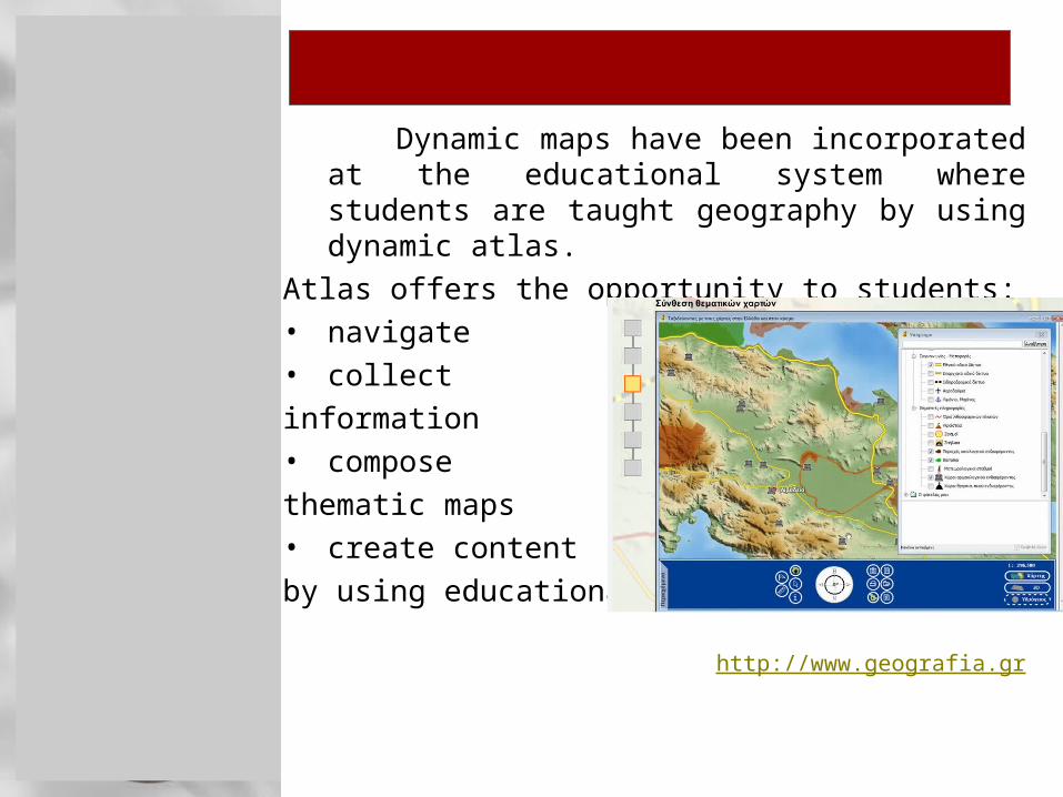
Dynamic maps have been incorporated at the educational system where students are taught geography by using dynamic atlas.
Atlas offers the opportunity to students:• navigate • collect
information• compose
thematic maps• create content
by using educational software.
http://www.geografia.gr

DYNAMIC MAPS IN GREECE
The aim of the initiative
supported by the Ministry of Transportation is focused on the removal of the illegal advertising signs which are responsible for drivers’ distraction and accidents.
The application requires citizens’ participation. Volunteers are free to tag their point of interest and upload a photo on the map.
875 verified accusations have been declared and 175 have been removed until now. http://www.illegalsigns.gov.gr
Dynamic maps based
on volunteers contribution

DYNAMIC MAPS IN GREECE
Pin Project has similar philosophy to the “illegal sign” effort.
It is supported by the Road Safety Institute (P.M.)
Its aim is to remark spatially the potholes on the map.
The volunteers can tag the point of interest spatially, rate its importance and add descriptive information additionally.
The project is limited at the city of Athens until now. http://www.msfree.gr/pin/
DYNAMIC MAPS IN GREECE
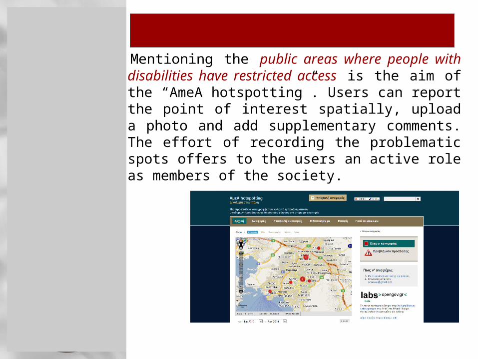
Mentioning the public areas where people with disabilities have restricted access is the aim of the “AmeA hotspotting”. Users can report the point of interest spatially, upload a photo and add supplementary comments. The effort of recording the problematic spots offers to the users an active role as members of the society.
http://www.amea.eu

The use of Dynamic maps and Volunteered Geographic Information in Greece
• INTRODUCTION
• WEB MAPPING AND DYNAMIC MAPS
• THE OPENSTREETMAP
• CONCLUSION - PROPOSALS

THE OPENSTREETMAP - GENERAL
• As the welcome message says in the main home page of OSM:“The OpenStreetMap is a free, editable map of the whole world. It is made by people like you.”
• OSM was launched by Steve Coast in 2004 and was spread in many countries in relatively short time.
• Guardian introduced OSΜ in its top 5 list among 100 mapping related websites in 2009.

THE OPENSTREETMAP – QUALITY
Numerous case studies have been carried out in different European countries investigating on the quality of the Openstreetmap. • United Kingdom (Haklay, 2008) (Ather, 2009)
(Basiouka, 2009)
• Switzerland (Ueberschlag, 2009)
• Greece (Kounadi, 2009)
United Kingdom is one of the best-mapped areas. • OSM was assessed to official datasets
Meridian 2 and ITN. • The percentage of positional accuracy was
more than 80%. • Length completeness indicated that OSM
road length is 95% of ITN road length.
THE OPENSTREETMAP - QUALITY
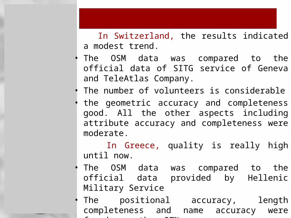
In Switzerland, the results indicated a modest trend.
• The OSM data was compared to the official data of SITG service of Geneva and TeleAtlas Company.
• The number of volunteers is considerable• the geometric accuracy and completeness
good. All the other aspects including attribute accuracy and completeness were moderate.
In Greece, quality is really high until now. • The OSM data was compared to the official
data provided by Hellenic Military Service• The positional accuracy, length completeness
and name accuracy were found more than 87%.

THE OPENSTREETMAP IN GREECE
• A strict correlation of mapping in relation to population
• Among the 61 most populated Greek towns the 31% of them is totally unmapped.
• 62% of them are modesty mapped.• Only the four main cities are really well
mapped.Mapping in relation to population
100
0 00
57,1
72,2
0
27,8
42,9
010
2030
4050
6070
8090
100
[main cities= 3.800.000- 160.000]
[modestcities =
159.999 -30.000]
[small cities= 29.999 -
10.000]
well - mapped
moderate - mapped
non-mapped
THE OPENSTREETMAP IN GREECE
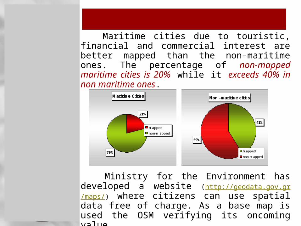
Maritime cities due to touristic, financial and
commercial interest are better mapped than the non-maritime ones. The percentage of non-mapped maritime cities is 20% while it exceeds 40% in non maritime ones.
Maritime Cities
21%
79%
mapped
non-mapped
Non - maritime cities
41%
59%
mapped
non-mapped
Ministry for the Environment has developed a website (http://geodata.gov.gr/maps/) where citizens can use spatial data free of charge. As a base map is used the OSM verifying its oncoming value.
THE OPENSTREETMAP IN GREECE
• Volunteers in Greece have created their own OSM forum.
• They exchange opinions and share ideas.• There are not any teams of mapping so
everyone collects and edits tracks individually. • They contribute in mapping by collecting
tracks with GPS, by copying Yahoo imagery, or by editing maps which have been created for the Olympic Games 2004 and are not restricted of copyrights.
• Their main concerns are focused on naming (latin or greek characters) and categorizing different points of interest or which technique is considered more accurate for data collection between GPS and Yahoo maps.

THE OPENSTREETMAP IN HAITI
• Most quality studies were focused on
navigation aspects testing the accuracy of spatial data for routing.
• However Haiti example changed the way that OpenStreetMap can be used.
• Haiti was dramatically affected after the earthquake hit in January 12 the capital city of Port-au-Prince.
• 48 hours spent to get first imagery loaded on the OSM platform available for tracing. (Maron, 2010)
• 60 persons were trained and more that 700 contributed in mapping, among them people from UN agencies, NGOs, National Haitian Mapping Agency, National Center of Spatial Information and Haitian civil society. (Waters, 2010)
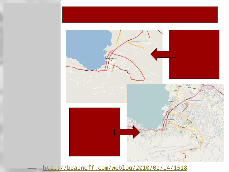
THE OPENSTREETMAP IN HAITI
Day 0
Day 2
http://brainoff.com/weblog/2010/01/14/1518

The use of Dynamic maps and Volunteered Geographic Information in Greece
• INTRODUCTION
• WEB MAPPING AND DYNAMIC MAPS
• THE OPENSTREETMAP
• CONCLUSION - PROPOSALS

CONCLUSION
Why volunteered mapping in relation to dynamic maps is so important?
• Highly informative and quick way of sharing spatial data in a pluralism of maps.
• Society is putting in the center of land management through data manipulation.
• Dynamic GIS is an ideal tool for storing, analyzing and visualizing natural disasters such as hurricanes, wildfires, and earthquakes. (Pultar, 2009)
• Volunteered contribution eliminates time of mapping especially in crucial situations. (“would have taken tens of thousands of pounds and years to do what OpenStretMap did in 3 weeks.” UN, 2010)

CONCLUSION - PROPOSALS
• Haiti earthquake and Hurricane Katrina
constitute two representative examples. (“What OpenStreetMap did in Haiti changed disaster response forever.” Johnson, 2010)
• Commercial maps do not offer the magnitude of quantitative information which is essential in similar cases. In Haiti, maps contained all camps meaning distribution of supplies.
Knowledge acquired by the disaster can be used for future crucial cases especially in Greece: Floods (Evros 2005 – 2010)
Earthquakes (Aigio 1994, Grevena, 1995)
Wildfires (Peloponnese, 2007) In two stages; while crisis breaks out and as
a post-event.

Thank you for your attention.