The Unexpected Morphometry in Digital Terrain Model
6
Section Photogrammetry and Remote Sensing THE UNEXPECTED MORPHOMETRY IN DIGITAL TERRAIN MODEL DERIVED FROM UNMANNED AERIAL VEHICLE IMAGES Assist. Prof. Dr. Dubravko Gajski 1 Dubravka Maurer 1 Dr. Sanja Šamanović 1 1 Faculty of Geodesy, University of Zagreb, Croatia ABSTRACT The wide availability of unmanned aerial vehicles (UAVs) equipped with GPS, inertial system and a digital camera makes them very affordable for many geospatial applications. Just about a decade, such applications were reserved exclusively for aerial photogrammetry. With the development and popularization of UAVs, the software was developed, that allows a very high degree of automation in the preparation of standard photogrammetric products, such as digital orthophoto (DOF) and digital terrain model (DTM). However, during imaging especially in large scales, for which the UAVs mostly are used, errors occur in the modeling of DTMs using the software, based only on use of the Structure from Motion (SFM) algorithm. This paper will explore and show unexpected (incorrect) morphometry, which appears by use of the SfM-algorithm to produce the DTM, and consequently to produce orthophotos. The images obtained by digital photogrammetric camera Vexcel UltracamD will be measured subjectively at a digital photogrammetric workstation using stereoscopy, to get the reference set of data. The second dataset will be obtained by eBee RTK UAV using the procedure and software, as proposed by producer. These two datasets will be compared, and the overall discrepancies will be calculated and presented. Keywords: photogrammetry, DTM, morphometry, SfM-algorithm INTRODUCTION Unmanned Aerial Vehicles (UAVs) find their use in many fields of human activities. During the last decade, the market of UAVs is growing very fast [1], with a tendency to continue its growth at even higher speed. First applications of UAV technology were supporting of military tasks, but soon the advantages of using the UAVs in mapping application has been recognized and such system enter into the focus of broad spectrum of non-military applications. In geodetic applications, the imaging geometry, as well as the processing of images taken by UAVs, were following the standard photogrammetric approaches, extended by new algorithms to achieve a high grade of automation. The first results were really promising [2] especially after the implementation of Structure from Motion algorithm [3]. After the SfM algorithm reaches its maturity, the processing of images and other data gathered by UAVs with the goal to produce orthophoto or even 3D-model of imaged terrain became very simple, provocating even bigger popularity of use the UAVs for mapping needs. The archaeologists [4] and the geologists [5] use this technology for their mapping needs with success. This paper presents the imperfections https://doi.org/10.5593/sgem2017/23 303 17th International Scientific Conference on EARTH and GEOSCIENCES, SGEM 2017 www.sgem.org
Transcript of The Unexpected Morphometry in Digital Terrain Model
Section Photogrammetry and Remote Sensing
THE UNEXPECTED MORPHOMETRY IN DIGITAL TERRAIN MODEL
DERIVED FROM UNMANNED AERIAL VEHICLE IMAGES
Assist. Prof. Dr. Dubravko Gajski1
Dubravka Maurer1
Dr. Sanja Šamanović1
1Faculty of Geodesy, University of Zagreb, Croatia
ABSTRACT
The wide availability of unmanned aerial vehicles (UAVs) equipped with GPS, inertial
system and a digital camera makes them very affordable for many geospatial
applications. Just about a decade, such applications were reserved exclusively for aerial
photogrammetry. With the development and popularization of UAVs, the software was
developed, that allows a very high degree of automation in the preparation of standard
photogrammetric products, such as digital orthophoto (DOF) and digital terrain model
(DTM). However, during imaging especially in large scales, for which the UAVs
mostly are used, errors occur in the modeling of DTMs using the software, based only
on use of the Structure from Motion (SFM) algorithm. This paper will explore and show
unexpected (incorrect) morphometry, which appears by use of the SfM-algorithm to
produce the DTM, and consequently to produce orthophotos. The images obtained by
digital photogrammetric camera Vexcel UltracamD will be measured subjectively at a
digital photogrammetric workstation using stereoscopy, to get the reference set of data.
The second dataset will be obtained by eBee RTK UAV using the procedure and
software, as proposed by producer. These two datasets will be compared, and the overall
discrepancies will be calculated and presented.
Keywords: photogrammetry, DTM, morphometry, SfM-algorithm
INTRODUCTION
Unmanned Aerial Vehicles (UAVs) find their use in many fields of human activities.
During the last decade, the market of UAVs is growing very fast [1], with a tendency to
continue its growth at even higher speed. First applications of UAV technology were
supporting of military tasks, but soon the advantages of using the UAVs in mapping
application has been recognized and such system enter into the focus of broad spectrum
of non-military applications. In geodetic applications, the imaging geometry, as well as
the processing of images taken by UAVs, were following the standard photogrammetric
approaches, extended by new algorithms to achieve a high grade of automation. The
first results were really promising [2] especially after the implementation of Structure
from Motion algorithm [3]. After the SfM algorithm reaches its maturity, the processing
of images and other data gathered by UAVs with the goal to produce orthophoto or even
3D-model of imaged terrain became very simple, provocating even bigger popularity of
use the UAVs for mapping needs. The archaeologists [4] and the geologists [5] use this
technology for their mapping needs with success. This paper presents the imperfections
https://doi.org/10.5593/sgem2017/23 303
17th
Intern
ation
al Scie
ntific
Con
feren
ce on
EARTH and G
EOSCIENCES, SGEM 20
17
www.sgem
.org
17thInternational Multidisciplinary Scientific GeoConference SGEM 2017
in 3D model, and consequently in orthophoto, using fully automatic approaches. To
explore the quality of orthophoto and digital terrain model (DTM) obtained by the
UAVs at the present technology, we made a small project of mapping a portion of the
settlement with buildings, trees, streets, and other objects, by the eBee RTK UAV.
DATA COLLECTION
The photogrammetric platform eBee RTK is an unmanned aerial vehicle, dedicated to
produce orthophotos and digital terrain model as well as a digital surface model with
spatial resolution as high as 4cm. Built-in RTK GPS measures the position of projection
centers of the camera at the time of shooting with an accuracy of a few centimeters. The
camera is spatially calibrated and fully integrated with flight controller. Maximal
duration of flight without landing is about 40 minutes, and during this time it can cover
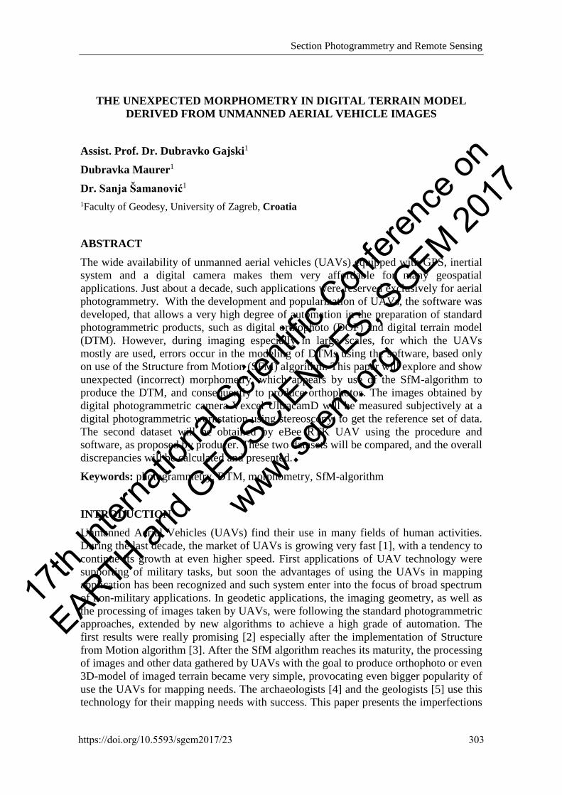
by images the area of about 8km2. [6]. The flight was prepared by mission planner
eMotion. Ground sampling distance (GSD) was planned to be 4.5 cm/pix. The side
overlap between each of 34 strips had to be equal 85% with an along-flight overlap of
70%. The flight route is 18km long with mean height above ground of 136m (Image 2).
During flight 242 photos were taken, with 12Mpix spatial resolution and geolocation of
projection centers at the shooting moment, saved in EXIF format [7]
Image 1: The mission plan overlapped on Google map [7]
DATA PROCESSING
The processing of images taken during the flight was done by software PIX4D, and
finally, the digital orthophoto and digital surface model (DSM) were obtained.
However, first of all, was needed to determine the elements of interior and exterior
orientation for every photogrammetric bundle (every image). Thus, the
photogrammetric triangulation with self-calibration was calculated. The seven ground
control points (GCPs) were marked in the field and measured by GNSS-RTK receivers,
to reach the reliable determination of all parameters of inner orientation and exterior
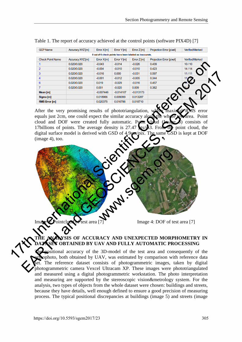
orientation. The result of accuracy achieved at control points is shown in Table 1.
304
17th
Intern
ation
al Scie
ntific
Con
feren
ce on
EARTH and G
EOSCIENCES, SGEM 20
17
www.sgem
.org
Section Photogrammetry and Remote Sensing
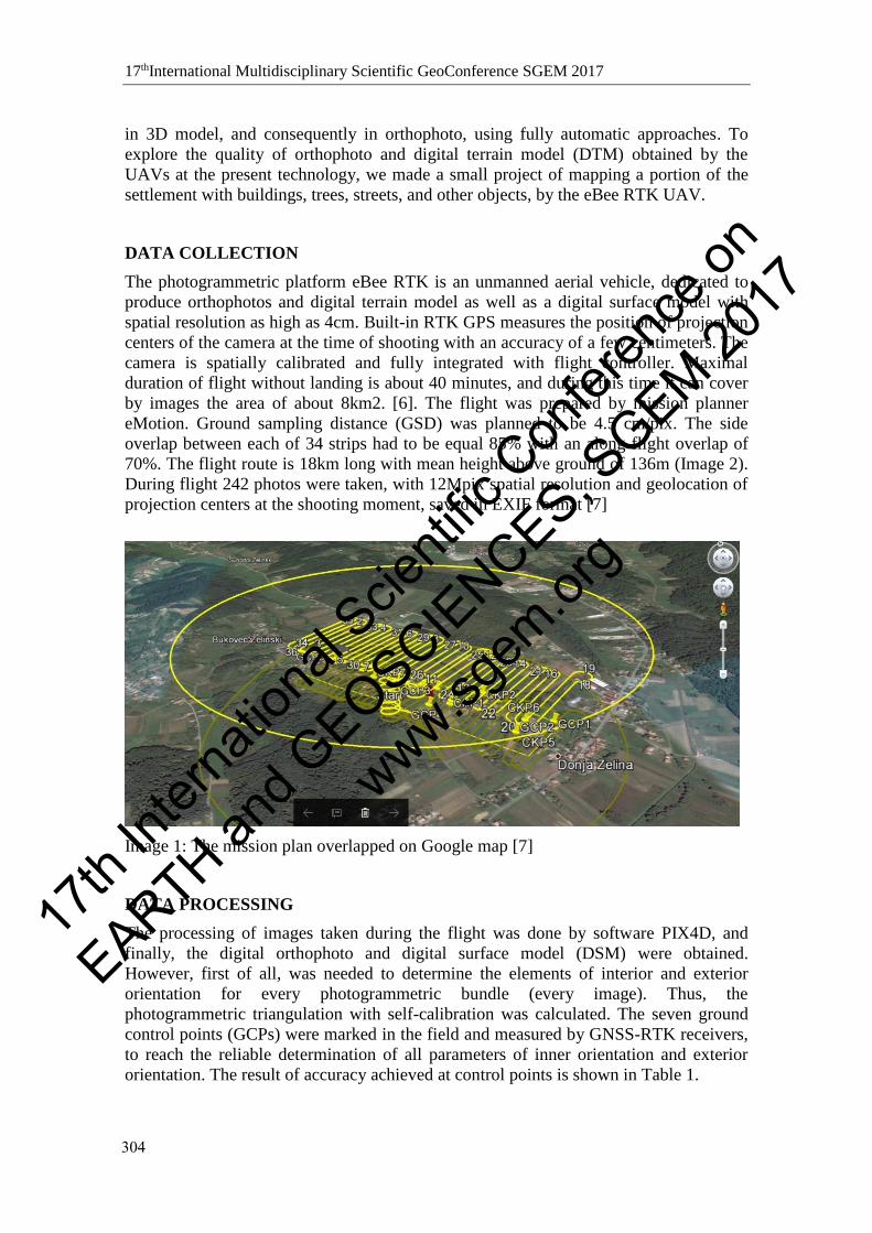
Table 1. The report of accuracy achieved at the control points (software PIX4D) [7]
After the very promising results of phototriangulation, where maximal RMS error
equals just 2cm, one could expect the similar accuracy along the whole test area. Point
cloud and DOF were created fully automatic. Point cloud (Image 3) consists of
17billions of points. The average density is 27.47 pts/m3. From the point cloud, the
digital surface model is derived with GSD of 4.9cm/pix. The same GSD is kept at DOF
(image 4), too.
Image 3: Pointcloud of test area [7] Image 4: DOF of test area [7]
THE ANALYSIS OF ACCURACY AND UNEXPECTED MORPHOMETRY IN
DATASET OBTAINED BY UAV AND FULLY AUTOMATIC PROCESSING
The positional accuracy of the 3D-model of the test area and consequently of the
orthophoto, both obtained by UAV, was estimated by comparison with reference data
set. The reference dataset consists of photogrammetric images, taken by digital
photogrammetric camera Vexcel Ultracam XP. These images were phototriangulated
and measured using a digital photogrammetric workstation. The photo interpretation
and measuring are supported by the stereoscopic vision&metrology system. For the
analysis, two types of objects from the whole dataset were chosen: buildings and streets,
because they have details, well enough defined to ensure a good precision of measuring
process. The typical positional discrepancies at buildings (image 5) and streets (image
https://doi.org/10.5593/sgem2017/23 305
17th
Intern
ation
al Scie
ntific
Con
feren
ce on
EARTH and G
EOSCIENCES, SGEM 20
17
www.sgem
.org
17thInternational Multidisciplinary Scientific GeoConference SGEM 2017
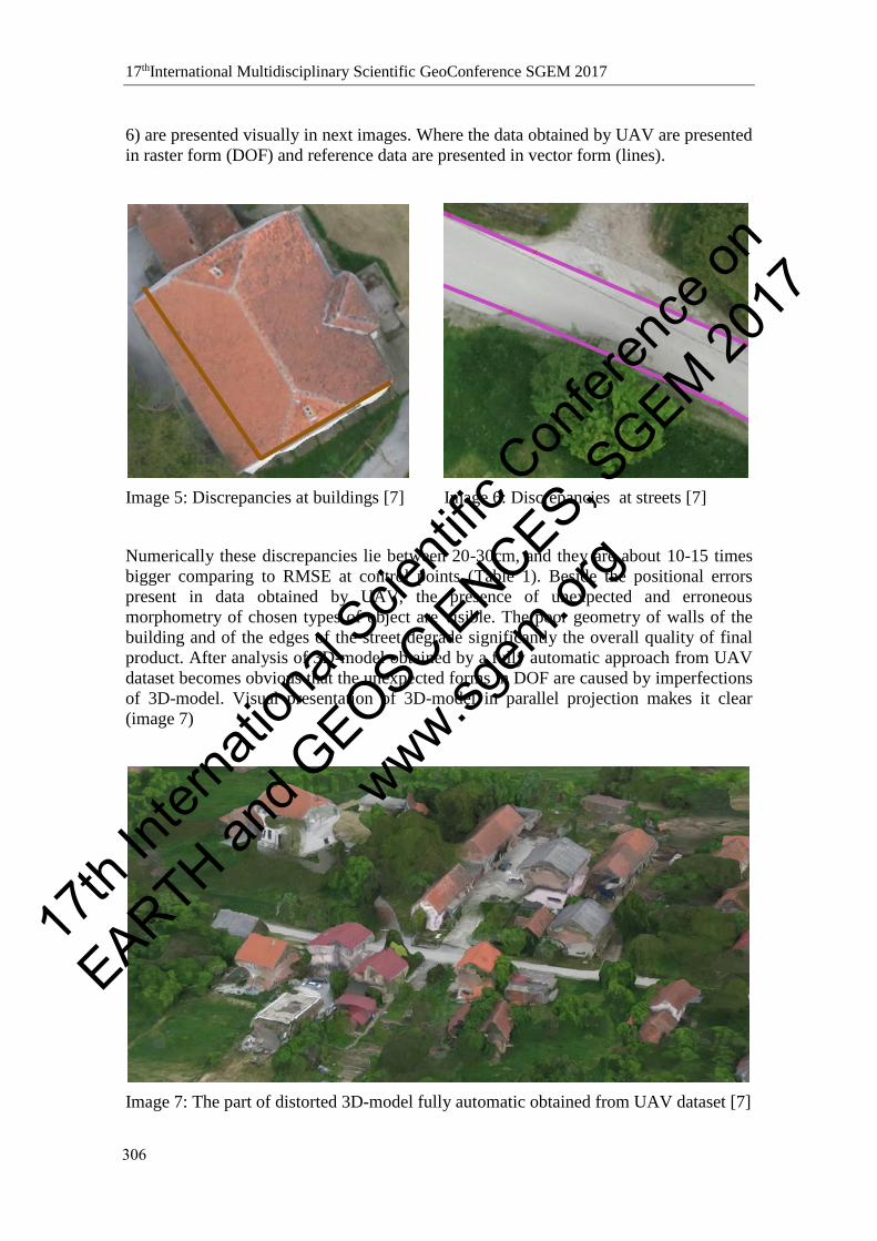
6) are presented visually in next images. Where the data obtained by UAV are presented
in raster form (DOF) and reference data are presented in vector form (lines).
Image 5: Discrepancies at buildings [7] Image 6: Discrepancies at streets [7]
Numerically these discrepancies lie between 20-30cm, and they are about 10-15 times
bigger comparing to RMSE at control points (Table 1). Beside the positional errors
present in data obtained by UAV, the presence of unexpected and erroneous
morphometry of chosen types of object are visible. The poor geometry of walls of the
building and of the edges of the street degrade significantly the overall quality of final
product. After analysis of 3D-model obtained by a fully automatic approach from UAV
dataset becomes obvious that the unexpected forms in DOF are caused by imperfections
of 3D-model. Visual presentation of 3D-model in parallel projection makes it clear
(image 7)
Image 7: The part of distorted 3D-model fully automatic obtained from UAV dataset [7]
306
17th
Intern
ation
al Scie
ntific
Con
feren
ce on
EARTH and G
EOSCIENCES, SGEM 20
17
www.sgem
.org
Section Photogrammetry and Remote Sensing
CONCLUSION
The fully automatic algorithms of photogrammetric processing, to obtain the standard
photogrammetric product (i.e. DTM, DOF, photorealistic 3D-model) are used widely in
many photogrammetric applications, especially those where images were taken by
UAVs. Outside geodesy the fully automatic processing approaches are appreciated even
more because the user does not need to learn specific photogrammetric knowledge and
can keep his attention and effort focused at the problematic inside the area of his
profession. The very promising results of accuracy analysis at control points, taken as-is
and without necessary criticism can make a wrong impression about the overall
accuracy of the whole dataset. This paper draws attention to mapping situation where
the up-to-date algorithms often fail, heavily degrading the overall quality of the
photogrammetric product. This investigation clearly shows the biggest discrepancies at
man-made objects, especially buildings. It is worth noting that the degradation of
positional accuracy is mostly influenced by imperfections in 3D models produced by
fully automatic processing algorithms. In such case, the strategy of choice could be to
turn back to standard photogrammetric procedures and perform some critical
measurements subjectively using digital photogrammetric workstation supported by
stereovision system.
REFERENCES
[1] Haarbrink R.B., UAS FOR GEO-INFORMATION: CURRENT STATUS AND
PERSPECTIVES, International Archives of the Photogrammetry, Remote Sensing and
Spatial Information Sciences, Vol. XXXVIII-1/C22, UAV-g 2011, Conference on
Unmanned Aerial Vehicle in Geomatics, Zurich, Switzerland
[2] Kungl O., Strecha C., Beyeler A., Zufferey J-C., Floreano D., Fua P., Gervaix F.,
The accuracy of automatic photogrammetric techniques on ultra-light UAV imagery,
International Archives of the Photogrammetry, Remote Sensing and Spatial Information
Sciences, Vol. XXXVIII-1/C22, UAV-g 2011, Conference on Unmanned Aerial
Vehicle in Geomatics, Zurich, Switzerland
[3] Wefelscheid C., Hansch R., Hellwich O., Three-dimensional building reconstruction
using images obtained by unmanned aerial wechiles, International Archives of the
Photogrammetry, Remote Sensing and Spatial Information Sciences, Vol. XXXVIII-
1/C22, UAV-g 2011, Conference on Unmanned Aerial Vehicle in Geomatics, Zurich,
Switzerland
[4] Seitz C., Altenbach H., Project Archeye – the quadrocopter as archaeologist’s eye,
International Archives of the Photogrammetry, Remote Sensing and Spatial Information
Sciences, Vol. XXXVIII-1/C22, UAV-g 2011, Conference on Unmanned Aerial
Vehicle in Geomatics, Zurich, Switzerland
[5] Niethammer U., Rothmund S., Schwaderer U., Zeman J., Joswig M., Open source
image-processing tools for low-cost UAV-based landslide investigations, International
Archives of the Photogrammetry, Remote Sensing and Spatial Information Sciences,
Vol. XXXVIII-1/C22, UAV-g 2011, Conference on Unmanned Aerial Vehicle in
Geomatics, Zurich, Switzerland
https://doi.org/10.5593/sgem2017/23 307
17th
Intern
ation
al Scie
ntific
Con
feren
ce on
EARTH and G
EOSCIENCES, SGEM 20
17
www.sgem
.org

17thInternational Multidisciplinary Scientific GeoConference SGEM 2017
[6] SenseFly, eBee RTK - The survey-grade mapping drone URL:
https://www.sensefly.com/fileadmin/user_upload/sensefly/documents/brochures/eBee_
RTK_en.pdf
[7] Gashi F., Upotreba fotogrametrijskih snimki za potrebe katastra nekretnina, završni
rad, Geodetski fakultet Sveučilišta u Zagrebu, Croatia, 2017.,
308
17th
Intern
ation
al Scie
ntific
Con
feren
ce on
EARTH and G
EOSCIENCES, SGEM 20
17
www.sgem
.org