The Surveyor’s - c.ymcdn.com · and matters of survey, ... recording thereof or for the...
44
0 The Surveyor’s Judicial Role ~ ~ ~ ~ ~ New York State Association of Professional Land Surveyors Presented by Gary R. Kent, PS The Schneider Corporation September 10-14, 2015 New York State © 2015 Gary R. Kent The Schneider Corporation Indianapolis, Indiana
Transcript of The Surveyor’s - c.ymcdn.com · and matters of survey, ... recording thereof or for the...

0
The Surveyor’s
Judicial Role
~ ~ ~ ~ ~
New York State Association of
Professional Land Surveyors
Presented by
Gary R. Kent, PS
The Schneider Corporation
September 10-14, 2015
New York State © 2015 Gary R. Kent The Schneider Corporation Indianapolis, Indiana

1
Synopsis
Only two persons can truly resolve a disputed boundary or title problem. Those persons do not
include attorneys, title companies or surveyors. And, in a sense, they do not even include judges
and juries - at least not of their own volition. This program explores the role that the
professional surveyor can, and arguably should, take in helping property owners establish or
maintain their common boundary in the location that they were perfectly satisfied with - at least
until the surveyor showed up! We will look at the role of the surveyor as related to boundaries,
not only from a statutory standpoint, but also as eloquently expressed by renowned Michigan
Supreme Court Chief Justice Thomas Cooley in his seminal 1881 treatise "The Judicial Function
of Surveyors." As a part of this, we will review the dynamic that exists between matters of title
and matters of survey, including a close look at title insurance. We will also review several
examples that demonstrate the problem, and offer an alternative to what is often the standard
approach by surveyors. We will outline a new approach that has the surveyor helping property
owners avoid the expense and angst of unnecessarily litigating boundaries when there has been
acquiescence to an accepted line by both owners.
Program
The Definition of Surveying – New York Statute
Rules of Professional Conduct – New York Administrative Law, NSPS, ASPLS
Boundaries and the Status Quo
Matters of Title vs. Matters of Survey
o Boundary Law
Unwritten Rights and the Surveyor’s Role
o Marketable Title
o The Role of Title Insurance
o Recordation Acts
o Junior/Senior Rights
The Judicial Function of Surveyors, Justice Thomas M. Cooley, 1881
A Proposal
o A Statute of Limitation on Boundaries, Jeffery N. Lucas, PLS, Esq.
o The Surveyor’s Roles and Responsibilities, Gary R. Kent, PS, 2014
Examples and scenarios
Mediation and the Role of the Mediator – New York statutes and rules
NOTE- The author of this paper and presentation is not an attorney. It is the author’s intent that neither
this paper nor the presentation should be considered legal advice or a substitute for consultation with
an attorney.

2
The Role of the Land Surveyor in Boundary Determinations
The Regulation of Land Surveying
The definition of surveying in all states allows the registered surveyor to rely upon the work of
unlicensed subordinates working under his or her direct supervision. There are relatively few
registered surveyors in the United States (probably on the order of 40,000).
The practice of Land Surveying is, in all states, regulated by a state board. Some states, like
West Virginia, Maine, New Hampshire and Indiana, have boards that regulate only Land
Surveyors. Many other states, however, have “joint” boards that regulate more than one
profession – typically engineering and surveying.
Surveying is part Science, part Law and part Art
The science aspect is generally the science of measurement – using angle measuring devices
(theodolites, total stations), distance measuring devices (electronic distance measuring
instruments, steel tapes) and GPS (global positioning system which uses satellites).
The law aspects relate to the interpretation and resolution of legal descriptions and boundaries.
There are no statutes or legislated laws that tell surveyors how to determine boundaries; the rules
for that are from a body of common law derived from hundreds of years of court cases related to
boundary disputes and legal descriptions. Surveyors cannot make proper boundary
determinations without studying and understanding what the “weight of authority” has been in
case law.
The art aspect could be said to apply to the judgments and decisions in the field related to where,
and to what extent, to look for evidence, and how that information is all presented. For example,
having a gut feeling on where to dig to try and find a stone marker set in 1840, or how to most
effectively run a survey line from one location across a ravine and river and through the trees to
another location.
Surveying can also be seen as part “doing” and part “thinking.” It’s one thing to make a
measurement; with today’s technologies, virtually anyone can make very precise survey-grade
measurements. But it’s an entirely different thing to understand where to make the
measurements from, and to what, and how to apply those measurements to the facts and evidence
at hand so a defensible boundary opinion can be made.
The retracement of a boundary is the professional opinion of the surveyor. That opinion is based
on the evidence available to the surveyor; and if that evidence changes, the opinion may well
change. Evidence comes in many forms – from the writings, from what is found in the field,
from verbal and written statements, from measurements and from historical information.
Two competent surveyors faced with the same evidence will generally come to the same opinion,
although there are occasions when the surveyors will simply have differing opinions as to how to
interpret or weigh certain pieces of evidence. This can result in the two surveyors arriving at
different conclusions as to a boundary location. If the surveyors cannot resolve the differences
satisfactorily, and if the affected owners are inclined to litigate, a final determination will be
made by a court.

3
New York Definition of Land Surveying1
The practice of the profession of land surveying is defined as practicing that branch of the
engineering profession and applied mathematics which includes the measuring and plotting of
the dimensions and areas of any portion of the earth, including all naturally placed and man- or
machine-made structures and objects thereon, the lengths and directions of boundary lines, the
contour of the surface and the application of rules and regulations in accordance with local
requirements incidental to subdivisions for the correct determination, description, conveying and
recording thereof or for the establishment or reestablishment thereof.
Rules of Professional Conduct2
§29.1 General provisions.
a. Unprofessional conduct shall be the conduct prohibited by this section. The provisions of
these rules applicable to a particular profession may define additional acts or omissions
as unprofessional conduct and may establish exceptions to these general prohibitions.
b. Unprofessional conduct in the practice of any profession licensed, certified or registered
pursuant to title VIII of the Education Law, except for cases involving those professions
licensed, certified or registered pursuant to the provisions of Article 131 or 131-B of such
law in which a statement of charges of professional misconduct was not served on or
before July 26, 1991, the effective date of Chapter 606 of the Laws of 1991, shall
include:
1. willful or grossly negligent failure to comply with substantial provisions of
Federal, State or local laws, rules or regulations governing the practice of the
profession;
2. exercising undue influence on the patient or client, including the promotion of the
sale of services, goods, appliances or drugs in such manner as to exploit the
patient or client for the financial gain of the practitioner or of a third party;
3. directly or indirectly offering, giving, soliciting, or receiving or agreeing to
receive, any fee or other consideration to or from a third party for the referral of a
patient or client or in connection with the performance of professional services;
4. permitting any person to share in the fees for professional services, other than: a
partner, employee, associate in a professional firm or corporation, professional
subcontractor or consultant authorized to practice the same profession, or a legally
authorized trainee practicing under the supervision of a licensed practitioner. This
prohibition shall include any arrangement or agreement whereby the amount
received in payment for furnishing space, facilities, equipment or personnel
services used by a professional licensee constitutes a percentage of, or is
otherwise dependent upon, the income or receipts of the licensee from such
practice, except as otherwise provided by law with respect to a facility licensed
pursuant to Article 28 of the Public Health Law or Article 13 of the Mental
Hygiene Law;
1 State of New York Education Law, Title VIII, Article 145, Section 7203 2 Rules of the Board of Regents Part 29

4
5. conduct in the practice of a profession which evidences moral unfitness to
practice the profession;
6. willfully making or filing a false report, or failing to file a report required by law
or by the Education Department, or willfully impeding or obstructing such filing,
or inducing another person to do so;
7. failing to make available to a patient or client, upon request, copies of documents
in the possession or under the control of the licensee which have been prepared
for and paid for by the patient or client;
8. revealing of personally identifiable facts, data or information obtained in a
professional capacity without the prior consent of the patient or client, except as
authorized or required by law;
9. practicing or offering to practice beyond the scope permitted by law, or accepting
and performing professional responsibilities which the licensee knows or has
reason to know that he or she is not competent to perform, or performing without
adequate supervision professional services which the licensee is authorized to
perform only under the supervision of a licensed professional, except in an
emergency situation where a person's life or health is in danger;
10. delegating professional responsibilities to a person when the licensee delegating
such responsibilities knows or has reason to know that such person is not
qualified, by training, by experience or by licensure, to perform them;
11. performing professional services which have not been duly authorized by the
patient or client or his or her legal representative;
12. advertising or soliciting for patronage that is not in the public interest:
i. Advertising or soliciting not in the public interest shall include, but not be
limited to, advertising or soliciting that:
a. is false, fraudulent, deceptive or misleading;
b. guarantees any service;
c. makes any claim relating to professional services or products or the
cost or price therefore which cannot be substantiated by the
licensee, who shall have the burden of proof;
d. makes claims of professional superiority which cannot be
substantiated by the licensee, who shall have the burden of proof;
or
e. offers bonuses or inducements in any form other than a discount or
reduction in an established fee or price for a professional service or
product.
ii. The following shall be deemed appropriate means of informing the public
of the availability of professional services:
a. informational advertising not contrary to the foregoing
prohibitions; and
b. the advertising in a newspaper, periodical or professional directory
or on radio or television of fixed prices, or a stated range of prices,
for specified routine professional services, provided that if there is
an additional charge for related services which are an integral part
of the overall service being provided by the licensee, the
advertisement shall so state, and provided further that the

5
advertisement indicates the period of time for which the advertised
prices shall be in effect.
iii.
a. all licensees placing advertisements shall maintain, or cause to be
maintained, an exact copy of each advertisement, transcript, tape or
videotape thereof as appropriate for the medium used, for a period
of one year after its last appearance. This copy shall be made
available for inspection upon demand of the Education
Department;
b. a licensee shall not compensate or give anything of value to
representatives of the press, radio, television or other
communications media in anticipation of or in return for
professional publicity in a news item;
iv. Testimonials, demonstrations, dramatizations, or other portrayals of
professional practice are permissible provided that they otherwise comply
with the rules of professional conduct and further provided that the
following conditions are satisfied:
a. the patient or client expressly authorizes the portrayal in writing;
b. appropriate disclosure is included to prevent any misleading
information or imagery as to the identity of the patient or client;
c. reasonable disclaimers are included as to any statements made or
results achieved in a particular matter;
d. the use of fictional situations or characters may be used if no
testimonials are included; and
e. fictional client testimonials are not permitted;
13. failing to respond within 30 days to written communications from the Education
Department or the Department of Health and to make available any relevant
records with respect to an inquiry or complaint about the licensee's unprofessional
conduct. The period of 30 days shall commence on the date when such
communication was delivered personally to the licensee. If the communication is
sent from either department by registered or certified mail, with return receipt
requested, to the address appearing in the last registration, the period of 30 days
shall commence on the date of delivery to the licensee, as indicated by the return
receipt;
14. violating any term of probation or condition or limitation imposed on the licensee
by the Board of Regents pursuant to Education Law, Section 6511.
§ 29.3 General provisions for design professions.
a. Unprofessional conduct shall also include, in the professions of architecture and
landscape architecture, engineering and land surveying:
1. being associated in a professional capacity with any project or practice known to
the licensee to be fraudulent or dishonest in character, or not reporting knowledge
of such fraudulence or dishonesty to the Education Department;
2. failing to report in writing to the owner or to the owner's designated agent any
unauthorized or improperly authorized substantial disregard by any contractor of
plans or specifications for construction or fabrication, when professional
observation or supervision of the work is provided for in the agreement between
6
the owner and the design professional or when supervision of the work is under
the control of the design professional;
3. certifying by affixing the licensee's signature and seal to documents for which the
professional services have not been performed by, or thoroughly reviewed by, the
licensee; or failing to prepare and retain a written evaluation of the professional
services represented by such documents in accordance with the following
requirements:
i. a licensee who signs and seals documents not prepared by the licensee or
by an employee under the licensee's direct supervision shall prepare, and
retain for a period of not less than six years, a thorough written evaluation
of the professional services represented by the documents, including but
not limited to drawings, specifications, reports, design calculations and
references to applicable codes and standards. Such written evaluation shall
clearly identify the project and the documents to which it relates, the
source of the documents and the name of the person or organization for
which the written evaluation was conducted, and the date of the
evaluation, and the seal and signature of the licensee shall also be affixed
thereto; and
ii. nothing in this paragraph shall be construed as authorizing the practice of
a design profession in this State by persons other than those authorized to
practice pursuant to the provisions of Article 145, 147 or 148 of the
Education Law;
4. failure by a licensee to maintain for at least six years all preliminary and final
plans, documents, computations, records and professional evaluations prepared by
the licensee, or the licensee's employees, relating to work to which the licensee
has affixed his seal and signature;
5. having a substantial financial interest, without the knowledge and approval of the
client or employer, in any products or in the bids or earnings of any contractor,
manufacturer or supplier on work for which the professional has responsibility;
6. permitting any person to share in the fees for professional services, other than: a
partner, employee, associate in a professional firm or corporation, subcontractor
or consultant. This prohibition shall include any arrangement or agreement
whereby the amount received in payment for furnishing space, facilities,
equipment, or personnel services used by a professional licensee constitutes a
percentage of or is otherwise dependent upon the income or receipts of the
licensee from such practice. This provision shall apply in lieu of Section
29.1(b)(4) of this Part;
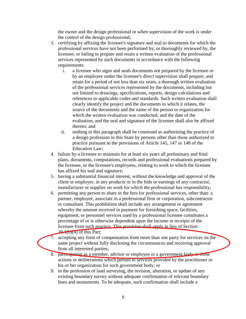
7. accepting any form of compensation from more than one party for services on the
same project without fully disclosing the circumstances and receiving approval
from all interested parties;
8. participating as a member, advisor or employee or a government body in those
actions or deliberations which pertain to services provided by the practitioner or
his or her organization for such government body; or
9. in the profession of land surveying, the revision, alteration, or update of any
existing boundary survey without adequate confirmation of relevant boundary
lines and monuments. To be adequate, such confirmation shall include a

7
reasonable field verification and shall be sufficiently extensive to reasonably
ensure the accuracy of the revision, alteration, or update, as appropriate to the
circumstances of the revision, alteration, or update.
b. Unprofessional conduct shall not be construed to include:
1. the employment, with the knowledge of the client, of qualified consultants to
perform work in which the consultant has special expertise. This provision shall
apply in conjunction with Section 29.1(b)(9) of this Part; and
2. participation as a delegator, or delegatee in delegating or accepting delegation,
through an intermediate entity not authorized to provide professional design
services, of specifically defined work involving the performance of a design
function requiring a professional license, under the following terms, conditions
and limitations:
i. such specifically defined design work shall be limited to project
components ancillary to the main components of the project;
ii. the delegator shall specify in writing to the delegatee all parameters which
the design must satisfy;
iii. the design function shall be required to be performed in accordance with
performance specifications established by the delegator;
iv. the delegatee shall be required to be licensed or otherwise legally
authorized to perform the design work involved and shall be required to
sign and certify any design prepared;
v. the delegator shall be required to review and approve the design submitted
by the delegatee for conformance with the established specifications and
parameters and such determination shall be in writing; and
vi. the delegator shall be required to determine that the design prepared by the
delegatee conforms to the overall project design and can be integrated into
such design and such determination shall be in writing.
3. As used in paragraph (2) of this subdivision:
i. Delegator means a primary design team or team of design professionals
which may be composed of professional engineers, land surveyors,
architects and landscape architects acting either alone or in combination,
licensed and registered in accordance with Articles 145, 147 or 148 of the
Education Law, and authorized to provide the services being delegated.
ii. Intermediate entity means a person or entity, typically a contractor or
subcontractor, responsible for performing the work under the contract for
construction.
iii. Delegatee means a design professional, licensed and registered in
accordance with Articles 145, 147 or 148 of the Education Law, who is
employed or retained by the intermediate entity to produce design work in
compliance with the performance requirements and parameters specified
by a delegator.
iv. Certify means a written statement by a licensee confirming responsibility
for the work and attesting that the work prepared meets the specifications
(as well as conforming to governing codes applicable at the time the work
was prepared), and conforms to prevailing standards of practice.

8
Boundaries, “the Status Quo” and the Surveyor
What constitutes the line, is a matter of law; where it is, is a matter of fact. Smothers v.
Schlosser, 163 SE 2d 127 - NC: Court of Appeals 1968. [internal citations omitted]
The vocation of a surveyor is limited to the ascertainment of definite lines. He may
ascertain where the lines and corners specified in the description of the given tract of real
estate actually are. He does not have the power to determine what the terms of such
description ought to be. Where the line lies, and where its corners are, is a question, and
on which the surveyor, on account of his superior facilities for doing so, may be called
upon to officially determine. What the lines and corners are is a matter of law, which
courts can alone declare. Wilson v. Powell, (1905) 37 Ind.App. 44, 70 N.E. 611.
With respect to boundaries, the surveyor deals with matters of survey, primarily location – the
“where” of a boundary. Sometimes the boundary location is not in question – the deed
description is unambiguous and there are no issues with the adjoiners. Many times, however, the
description(s) require interpretation and/or extrinsic evidence to eliminate or resolve the
ambiguities. Either way, we are in the realm of “where” - which falls in the authority of the
surveyor on which to give an opinion based on his or her survey.
Alternatively, the law deals with “what” that boundary line is – in essence, what the boundary
represents with respect to title (ownership). These concepts of “where” and “what” are often,
however, not mutually exclusive. The best example of that is with unwritten rights.
Unwritten Rights – Title Doctrine or Evidence of Intent?
There are a number of means by which boundaries can be established by unwritten means. Yet
each of these doctrines would seem to be contrary to the otherwise inviolate Statute of Frauds,
which requires that conveyances of real property must be in writing. The courts have found a way
around this conundrum; however, by determining that in some cases these doctrines do not
necessarily transfer title, but rather merely fix what were otherwise uncertain lines.
In other cases, particularly when the intent of the words in the conveyance is exceptionally
ambiguous, they may point to acquiescence, estoppel, parol agreement or practical location as the
best evidence of that intent.
When applied in the former manner, these are simply title doctrines, the evidence of which
surveyors normally locate, note and show as evidence contrary to the written title.
However, surveyors often neglect to recognize that when considered in the latter manner, this
evidence can provide proper guidance when “trying” to resolve a particularly intractable boundary
property. Rather, they will harken back to their comfort with mathematics and concoct a solution
that - relative to the long-standing lines of possession is entirely irrational - but provides a clear
means by which they can justify their opinion: Math!
Adverse Possession
Everyone can agree that the doctrine of adverse possession falls in the realm of title, not survey.
The necessary elements typically include all, most, or some version of, the following: adverse or
hostile, open and notorious, visible, actual, exclusive and with a claim of right or color of title.

9
Some states also require payment of the property taxes due on the area being claimed. The
statutory period varies from 3 to 21 years depending on the state, with some states providing for
shorter periods if the claimant can show color of title, that the taxes had been paid, and/or if the
nature of the possession was especially open.
Courts do not look kindly on the doctrine of adverse possession which is why every single
element most be proven - typically by “clear and convincing” evidence. Failure to prove only
one of the elements is enough to defeat the entire claim. However, when a claim of unwritten
rights is perfected in a court of law, it (1) confirms that the boundary of the ownership has
changed from the original written title line, and (2) creates marketable title to the ownership line.
Adverse Possession – New York
The elements of common law adverse possession in New York have been spelled out in
hundreds of cases, e.g.,
Adverse possession must be proven by clear and convincing evidence (Ray v Beacon
Hudson Mtn. Corp., 88 NY2d 154, 159 [1996]). "Where there has been an actual
continued occupation of premises under a claim of title, exclusive of any other right, but
not founded upon a written instrument or a judgment or decree, the premises so actually
occupied, and no others, are deemed to have been held adversely" (RPAPL 521).
To establish a claim of adverse possession, the following five elements must be proved:
Possession must be (1) hostile and under claim of right; (2) actual; (3) open and
notorious; (4) exclusive; and (5) continuous for the required period (Belotti v Bickhardt,
228 NY 296, 302 [1920]; see also Van Valkenburgh v Lutz, 304 NY 95, 99 [1952];
Spiegel v Ferraro, 73 NY2d 622, 624 [1989]; Ray v Beacon Hudson Mtn. Corp., 88
NY2d at 159). Here the required period is at least 10 years (see Ray at 159).]
"Adverse possession, although not a favored method of procuring title, is a recognized
one. It is a necessary means of clearing disputed titles and the courts adopt it and enforce
it, because, when adverse possession is carefully and fully proven, it is a means of
settling disputed titles and this is desirable" (Belotti v Bickhardt, 228 NY at 308; see
generally Hindley v Manhattan Ry. Co., 185 NY 335, 355-356 [1906]).
Walling v. Przybylo, 851 NE 2d 1167 - NY: Court of Appeals 2006
New York Statute also addresses adverse possession3, viz.,
1. Section 501 of the real property actions and proceedings law, as added by chapter 312
of the laws of 1962, is amended to read as follows:
S 501. {Action after entry. An entry upon real property is not sufficient or valid as a
claim unless an action is commenced thereupon within one year after the making thereof
and http://co.cook.mn.us/index.php/viagra-canada-generic within ten years after the time
3 As amended in July 2008 by S.7915-C/A.11574-A. All caps indicate new text by virtue of the 2008 law; {brackets}
indicate text removed by the same law. Tompkins County Bar Association webpage: http://www.tcbaweb.com/index.php?option=com_content&view=article&catid=902:law-in-the-news&id=61:real-property-law-update&Itemid=53
10
when the right to make it descended or accrued.} ADVERSE POSSESSION;
DEFINED. FOR THE PURPOSES OF THIS ARTICLE:
1. ADVERSE POSSESSOR. A PERSON OR ENTITY IS AN "ADVERSE POSSESSOR"
OF REAL PROPERTY WHEN THE PERSON OR ENTITY OCCUPIES REAL
PROPERTY OF ANOTHER PERSON OR ENTITY WITH OR WITHOUT KNOWLEDGE
OF THE OTHER`S SUPERIOR OWNERSHIP RIGHTS, IN A MANNER THAT WOULD
GIVE THE OWNER A CAUSE OF ACTION FOR EJECTMENT.
2. ACQUISITION OF TITLE. AN ADVERSE POSSESSOR GAINS TITLE TO THE
OCCUPIED REAL PROPERTY UPON THE EXPIRATION OF THE STATUTE OF
LIMITATIONS FOR AN ACTION TO RECOVER REAL PROPERTY PURSUANT TO
SUBDIVISION (A) OF SECTION TWO HUNDRED TWELVE OF THE CIVIL
PRACTICE LAW AND RULES, PROVIDED THAT THE OCCUPANCY, AS
DESCRIBED IN SECTIONS FIVE HUNDRED TWELVE AND FIVE HUNDRED
TWENTY-TWO OF THIS ARTICLE, HAS BEEN ADVERSE, UNDER CLAIM OF
RIGHT, OPEN AND NOTORIOUS, CONTINUOUS, EXCLUSIVE, AND ACTUAL.
3. CLAIM OF RIGHT. A CLAIM OF RIGHT MEANS A REASONABLE BASIS FOR
THE BELIEF THAT THE PROPERTY BELONGS TO THE ADVERSE POSSESSOR OR
PROPERTY OWNER, AS THE CASE MAY BE. NOTWITHSTANDING ANY OTHER
PROVISION OF THIS ARTICLE, CLAIM OF RIGHT SHALL NOT BE REQUIRED IF
THE OWNER OR OWNERS OF THE REAL PROPERTY THROUGHOUT THE
STATUTORY PERIOD CANNOT BE ASCERTAINED IN THE RECORDS OF THE
COUNTY CLERK, OR THE REGISTER OF THE COUNTY, OF THE COUNTY WHERE
SUCH REAL PROPERTY IS SITUATED, AND LOCATED BY REASONABLE MEANS.
2. Section 511 of the real property actions and proceedings law, as added by chapter 312
of the laws of 1962, is amended to read as follows:
S 511. Adverse possession under written instrument or judgment. Where the occupant or
those under whom {he} THE OCCUPANT claims entered into the possession of the
premises under claim of {title} RIGHT, exclusive of any other right, founding the claim
upon a written instrument, as being a conveyance of the premises in question, or upon the
decree or judgment of a competent court, and there has been a continued occupation and
possession of the premises included in the instrument, decree or judgment, or of some
part thereof, for ten years, under the same claim, the premises so included are deemed to
have been held adversely; except that when they consist of a tract divided into lots, the
possession of one lot is not deemed a possession of any other lot.
3. Section 512 of the real property actions and proceedings law, as added by chapter 312
of the laws of 1962, is amended to read as follows:S 512. Essentials of adverse
possession under written instrument or judgment. For the purpose of constituting an
adverse possession {by a person claiming a title}, founded upon a written instrument or a
judgment or decree, land is deemed to have been possessed and occupied in {either}
ANY of the following cases:
1. Where {it has been usually cultivated or improved} THERE HAS BEEN ACTS
SUFFICIENTLY OPEN TO PUT A REASONABLY DILIGENT OWNER ON NOTICE.

11
2. Where it has been protected by a substantial {inclosure} ENCLOSURE, EXCEPT AS
PROVIDED IN SUBDIVISION ONE OF SECTION FIVE HUNDRED FORTY-THREE
OF THIS ARTICLE.
3. Where, although not {inclosed} ENCLOSED, it has been used for the supply of fuel or
of fencing timber, either for the purposes of husbandry or for the ordinary use of the
occupant. Where a known farm or a single lot has been partly improved, the portion of
the farm or lot that has been left not cleared or not {inclosed} ENCLOSED, according to
the usual course and custom of the adjoining country, is deemed to have been occupied
for the same length of time as the part improved and cultivated.
4. Section 521 of the real property actions and proceedings law, as amended by chapter
116 of the laws of 1965, is amended to read as follows:
S 521. Adverse possession {under claim of title not written} NOT UNDER WRITTEN
INSTRUMENT OR JUDGMENT. Where there has been an actual continued occupation
of premises under a claim of {title} RIGHT, exclusive of any other right, but not founded
upon a written instrument or a judgment or decree, the premises so actually occupied, and
no others, are deemed to have been held adversely.
5. Section 522 of the real property actions and proceedings law, as added by chapter 312
of the laws of 1962, is amended to read as follows:
S 522. Essentials of adverse possession {under claim of title not 52 written} NOT
UNDER WRITTEN INSTRUMENT OR JUDGMENT. For the purpose of constituting
an adverse possession {by a person claiming title} not founded upon a written instrument
or a judgment or decree, land is deemed to have been possessed and occupied in either of
the following cases, and no others:
1. Where {it has been usually cultivated or improved} THERE HAVE BEEN ACTS
SUFFICIENTLY OPEN TO PUT A REASONABLY DILIGENT OWNER ON NOTICE.
2. Where it has been protected by a substantial {inclosure} ENCLOSURE, EXCEPT AS
PROVIDED IN SUBDIVISION ONE OF SECTION FIVE HUNDRED FORTY-THREE
OF THIS ARTICLE.
6. Section 531 of the real property actions and proceedings law, as amended by chapter
375 of the laws of 1975, is amended to read as follows:
S 531. Adverse possession, how affected by relation of landlord and tenant. Where the
relation of landlord and tenant has existed {between any persons}, the possession of the
tenant is deemed the possession of the landlord until the expiration of ten years after the
termination of the tenancy; or, where there has been no written lease, until the expiration
of ten years after the last payment of rent; notwithstanding that the tenant has acquired
another title or has claimed to hold adversely to his landlord. But this presumption shall
cease after the periods prescribed in this section and such tenant may then commence to
hold adversely to his landlord.

12
7. Section 541 of the real property actions and proceedings law, as amended by chapter
375 of the laws of 1975, is amended to read as follows:
S 541. Adverse possession, how affected by relation of tenants in common. Where the
relation of tenants in common has existed {between any persons}, the occupancy of one
tenant, personally or by his servant or by his tenant, is deemed to have been the
possession of the other, notwithstanding that the tenant so occupying the premises has
acquired another title or has claimed to hold adversely to the other. But this presumption
shall cease after the expiration of ten years of continuous exclusive occupancy by such
tenant, personally or by his servant or by his tenant, or immediately upon an ouster by
one tenant of the other and http://www.odontiatrika.gr/pfizer-levitra-canada such
occupying tenant may then commence to hold adversely to his cotenant.
8. The real property actions and proceedings law is amended by adding a new section
543 to read as follows:S 543. ADVERSE POSSESSION; HOW AFFECTED BY ACTS
ACROSS A BOUNDARY LINE.
1. NOTWITHSTANDING ANY OTHER PROVISION OF THIS ARTICLE, THE
EXISTENCE OF DE MINIMUS NON-STRUCTURAL
ENCROACHMENTS INCLUDING, BUT NOT LIMITED TO, FENCES, HEDGES,
SHRUBBERY, PLANTINGS, SHEDS AND NON-STRUCTURAL WALLS, SHALL
BE DEEMED TO BE PERMISSIVE AND NON-ADVERSE.
2. NOTWITHSTANDING ANY OTHER PROVISION OF THIS ARTICLE, THE ACTS OF
LAWN MOWING OR SIMILAR MAINTENANCE ACROSS THE BOUNDARY LINE OF
AN ADJOINING LANDOWNER`S PROPERTY SHALL BE DEEMED PERMISSIVE
AND NON-ADVERSE.
9. This act shall take effect immediately, and shall apply to claims filed on or after such
effective date.
Acquiescence, Parol Agreement, Practical Location, Estoppel and Repose
As suggested above, with a few exceptions, the courts view other unwritten boundary doctrines -
acquiescence, practical location and parol agreement - as being either manifestations of prior
boundary line agreements or the best evidence of an otherwise ambiguous intent. This is contrary
to adverse possession which arises out of contentious situations. Even the doctrines of estoppel
and repose could be seen as representing boundary line agreements – in essence, inverse
agreements, whereby the inaction of one party can be taken as an implied acceptance of a claim
by an adjoiner.
Each of the various unwritten boundary doctrines has its own set of specific requirements that
must be met in order for a court to perfect a claim of title. Some requirements are problematic in
that they require a look inside the mind of the claimant; and some requirements are
counterintuitive. As an example of the former, in some states a claim of adverse possession is
defeated if it can be shown that the claimant did not intend to possess someone else’s land (i.e., it
was ‘by mistake”). With regard to the latter, in some states, a parol agreement between two
parties to set a common line is not valid if there is no conflict in the written title or if a survey
would have otherwise resolved the uncertainty.

13
Acquiescence
Acquiescence is also sometimes looked at as a form of estoppel or the manifestation of an old
parol agreement. It is also closely related to and, in some states, a form of the doctrine of
practical location. In some states, the simple long-standing acquiescence in an apparently
agreed-upon line is good enough evidence in and of itself to define a line by acquiescence.
Acquiescence in the boundary line for the statutory period required for adverse
possession is sufficient to establish ownership marked by that line (see, Fisher v Mac
Vean, 25 AD2d 575). Where the statutory period has not been established, acquiescence
for "a considerable period of time provides conclusive evidence as to the true location of
the boundary" (Sarfaty v Evangelist, supra, at 996; see, Allen v Cross, supra, at 292).
Markowski v. Ferrari, 174 AD 2d 793 - NY: Appellate Div., 3rd Dept. 1991.
The doctrine holds that "the practical location of a boundary line and an acquiescence of
the parties therein for a period of more than [the statutory period governing adverse
possession] is conclusive of the location of the boundary line" (Kaneb v. Lamay, 58
A.D.3d 1097, 1098 [3rd Dept., 2009]). "[A]pplication of the doctrine requires a clear
demarcation of a boundary line and proof that there is mutual acquiescence to the
boundary by the parties such that it is definitely and equally known, understood and
settled" (Jakubowicz v. Solomon, 107 A.D.3d 852, 853 [2nd Dept., 2013] [internal
quotation marks and citations omitted]). The doctrines of adverse possession (or "title by
prescription") and practical location, while distinct, are closely related. It has been noted
that, with respect to the doctrine of practical location, the "evidence of the agreement or
acquiescence under which such location is established seems to be only another mode of
proof of the adverse possession necessary to a title by prescription" (Eldridge v. Kenning,
59 Hun 615, 12 N.Y.S. 693 [Sup. Ct., Monroe, Co., January 23, 1891]). Owens v.
ANDRUSCHAT, 2015 NY Slip Op 30087 - NY: Supreme Court, Wyoming 2015.
A practical location of a boundary line and an acquiescence therein for more than the
statutory period is conclusive of the location of such boundary (Wentworth v. Braun, 78
App. Div. 634, affd. 175 N.Y. 515; Van Dusen v. Lomonaco, 24 Misc 2d 878). It is
conclusive although such line may not in fact be the true line according to the calls of the
deeds of the adjoining owners (Fallone v. Gochee, 9 A D 2d 569, mot. for lv. to app. den.
7 N Y 2d 708; Quigg v. Treadway, 222 App. Div. 164, affd. 249 N.Y. 543; Katz v.
Kaiser, 154 N.Y. 294; 6 N. Y. Jur., Boundaries, § 82). "And a boundary once located and
openly adhered to by contiguous owners cannot be disturbed and relaid by a subsequent
owner." (Smith v. Stacey, 68 App. Div. 521, 527.). Fisher v. MacVean, 25 AD 2d 575 -
NY: Appellate Div., 3rd Dept. 1966.
More than 70 years ago, we articulated the requirements of the doctrine of practical
location as well as its derivation. "[It] was originally derived from a long acquiescence by
the parties in a line known and understood between them * * *. [T]o be effectual, [it]
`must be an act of the parties, either express or implied; and it must be mutual, so that
both parties are equally affected by it. It must be definitely and equally known,
understood and settled.' * * * Where land is unimproved and uncultivated, the mere
running of a line through the woods, ex parte, by one of the owners, so long as such line
is not settled upon and mutually adopted by the adjoining owners as a division line, is an
immaterial fact. In such a case, until the adjoining owner shows his assent to it, it would

14
amount to a mere expression of the individual opinion of the owner who ran the line"
(Adams v Warner, 209 App Div 394, 397, quoting Hubbell v McCulloch, 47 Barb 287,
299). Riggs v. Benning, 290 AD 2d 716 - NY: Appellate Div., 3rd Dept. 2002.
Acquiescence does not appear to be an independent unwritten title doctrine in some states like
North Carolina, but the concept is mentioned in the context of parol agreements and it is also
allowed as evidence of a an otherwise ambiguous boundary.
[I]n American Law Reports in an annotation entitled "Fence as Factor in Fixing Location
of Boundary Line—Modern Cases," it is stated:
"[W]here the fence was built by both the party opposing, and the party claiming the
fence, as the boundary, by the predecessors of both parties, or by a common predecessor
of both parties, the courts have generally held that the fence had become the boundary by
acquiescence or agreement." Annot., 7 A.L.R. 4th 53, § 2[a] at 61 (1981) (emphasis
added). Lilly v. Palmer, 495 So. 2d 522 - Ala: Supreme Court 1986.
Parol Agreement
In general, parol agreements to set boundaries between adjoining landowners have effect only
when there is an uncertainty or dispute as to the true location of the line; however, the exact
requirements vary state-to-state and the doctrine is more stringently viewed in some states. In
other states, the doctrine, on its own, is seen as violating the statute of frauds and it exists only in
concert with other doctrines like acquiescence or practical location.
Estoppel
Estoppel is rooted in the courts’ propensity to prevent unjust enrichment and boundaries can be
established based on this doctrine.
The doctrine of equitable estoppel is designed "to prevent the infliction of unconscionable
injury and loss upon one who has relied on the promise of another" (supra, at 718). Plaintiff
has failed to demonstrate that its predecessors in title … detrimentally relied on any oral
representations by Greenberg. Jokay, Inc. v. Lagarenne, 138 AD 2d 778 - NY: Appellate
Div., 3rd Dept. 1988.
Practical Location
Boundary by practical location does not appear as an independent unwritten title doctrine in most
states, but it is addressed in other states. In those states, it seems to be a doctrine that relates to
other unwritten boundaries such as those by acquiescence, parol agreement and estoppel.
"Practical location of a boundary line, to be effectual, `must be an act of the parties, either
express or implied; and it must be mutual, so that both parties are equally affected by it. It
must be definitely and equally known, understood and settled. If unknown, uncertain, or
disputed, it cannot be a line practically located.' (Hubbell v. McCulloch, 47 Barb. 287,
299.) Where land is unimproved and uncultivated, the mere running of a line through the
woods, ex parte, by one of the owners, so long as such line is not settled upon and
mutually adopted by the adjoining owners as a division line, is an immaterial fact. In such
a case, until the adjoining owner 240*240 shows his assent to it, it would amount to a
mere expression of the individual opinion of the owner who ran the line" (Adams v

15
Warner, 209 App Div 394, 397; see also, 1 NY Jur 2d, Adjoining Landowners, § 142).
Hadix v. Schmelzer, 186 AD 2d 239 - NY: Appellate Div., 2nd Dept. 1992
"A party can establish a boundary by practical location in three ways: (1) by acquiescing
in the boundary for a sufficient period of time to bar a right of entry under the statute of
limitations; (2) by expressly agreeing with the other party on the boundary and then by
acquiescing to that agreement; or (3) by estoppel." Slindee, 760 N.W.2d at 907 (citing
Theros v. Phillips, 256 N.W.2d 852, 858 (Minn. 1977)).
To establish a boundary by practical location through acquiescence, "a person must show
by evidence that is clear, positive, and unequivocal that the alleged property line was
acquiesced in for a sufficient length of time to bar a right of entry under the statute of
limitations," which is 15 years in Minnesota. "The acquiescence required is not merely
passive consent but conduct from which assent may be reasonably inferred." Id. Besides
arguing that respondents acquiesced in the gravel road as the boundary line because they
knew about the garage, concrete slab, and shrubs on the land in dispute and did not
object, appellants did not present any evidence of conduct on the part of respondents
from which to infer that they acquiesced in the new boundary line. Accordingly, the
district court did not err in determining that appellants failed to provide evidence of direct
conduct, as opposed to mere passive consent, from which assent could be reasonably
inferred.
To establish a boundary by practical location through express agreement, a person must
prove that "an express agreement between the landowners set an `exact, precise line'
between [their properties] and that the agreement had been acquiesced to `for a
considerable time.'" "Without a specific discussion identifying the boundary line or a
specific boundary-related action clearly proving that the parties or their predecessors in
interest had agreed to a specific boundary, a boundary is not established by practical
location based on express agreement." "[A]n express agreement requires more than
unilaterally assumed, unspoken and unwritten mutual agreements corroborated by neither
word nor act." Appellants argue that the district court "failed to recognize the specific
boundary-related actions of the parties, including [their] maintenance of the yard up to
the road, the construction of a garage, and the placement of a cement slab up to the road,
all with no objection by [r]espondents." But again, appellants failed to present evidence
that respondents agreed to the new boundary line beyond their passive failure to object to
appellants' use of the disputed land.
Finally, to establish a boundary by practical location through estoppel, a person must
show that "the parties whose rights are to be barred . . . silently looked on, with
knowledge of the true line, while the other party encroached upon it or subjected himself
to expense in regard to the land which he would not have had the line been in dispute."
"[E]stoppel requires knowing silence on the part of the party to be charged and
unknowing detriment by the other." Because neither party claims to have had knowledge
of the true boundary line between their properties prior to the 2001 survey, the district
court correctly determined that appellants' estoppel claim fails as a matter of law.
Watkins v. Patch, Minn: Court of Appeals 2013 (Memorandum Decision, not for
publication) [internal citations and quotation marks omitted]

16
Unwritten Rights and the Surveyor’s Role
All of the doctrines that alter ownership by unwritten means represent matters of title, not
survey. And title by unwritten means can only be perfected by a court. If a surveyor decides to
act on his or her ‘opinion’ that unwritten rights have operated and move a written boundary line
to conform to that opinion, he or she has stepped over the line - out of survey and into title.
However, no less than Thomas Cooley, Chief Justice of the Michigan Supreme Court in 1881,
wrote:
“Surveyors are not and cannot be judicial officers, but in a great many cases they act in
a quasi-judicial capacity with the acquiescence of parties concerned…”4
Thus, if the surveyor can bring the affected parties together and convince them to acquiesce to a
long-established, and ostensibly a long-agreed upon line, then the surveyor might have ‘cover’ to
survey to the agreed-upon line.
In such cases, however, it is virtually a given that the surveyor, after preparing such a survey,
should also prepare descriptions and an exhibit showing and describing to the agreed upon line,
and then go no further until the owners engage an attorney or attorneys to see that the proper
written documents are prepared and recorded memorializing and providing notice of the agreed-
upon line. Otherwise, what may have been an agreement in the moment could easily devolve
into a dispute later and into which the surveyor will most assuredly be dragged into.
Additionally, there are very important, but not always obvious issues such as the treatment of
mortgages, setback requirements, and jurisdictional regulations such as “lot line adjustments”
that might affect - or be affected by - the new line and which must be properly vetted by an
attorney.
Also, if the elements of whatever doctrine the surveyor relied on as the basis for his or her
opinion were actually not met (including those elements that impossibly require one to climb
inside the head of one or both of the parties), the surveyor is at great risk if the written title line
was disregarded and there was actually no acquiescence by the parties to the surveyed line.
But the surveyor may be uncomfortable or concerned about violating standards, practicing law or
determining a matter of title. Or perhaps, despite an attempt, the neighbor and client simply
could not be convinced to agree to the line that represents the surveyor’s opinion. Either way,
the surveyor will be left with surveying to the written title line and showing any conflicts with
adjoiners’ deeds or with occupation/possession. Except in a few states, this is actually what is
expected of surveyors, and/or required by state statutes or administrative code/rule (standards).
Either way, no matter what line the surveyor decides to go with, there must be clear
communication of the necessary information so the client does not act ill-advisedly and cause a
problem with an adjoiner. For example, perhaps there is a five foot overlap with an adjoiner and
the client’s written title line falls five feet over the neighbor’s fence. If the surveyor deems it
necessary to monument that location (or if the parties could not otherwise be brought to
agreement), he or she had better clearly understand what is going on and advise the client
accordingly. Why? Because the client will most assuredly assume that she owns to the rebar
4 The Judicial Function of Surveyors, Thomas M. Cooley, 1881 (included later in this handout)

17
and take steps to exercise domain over to that line (5 feet over the fence) to the detriment of the
adjoiner’s rights.
Surveyors also need to be familiar with what their state courts have said about the nature of
boundary line agreements.
Marketable Record Title Acts
Marketable Title Acts exist in about 20 states under a variety of names. The purpose of these acts
is to allow for the removal of potential title defects of ‘ancient’ origin by essentially enacting
statutes of limitation that act to clear away obscure property rights that might otherwise cloud
title.
Under a Marketable Title Act, it is possible to extinguish ancient interests, whether they are
revealed in the present day or in the future, unless the holders of such interests act to protect their
interests by recent recordation.
Marketable Title Acts vary substantively in the states that have them. Differences include the
property interests that are subject to the act, the statutory period of limitation, the period of time
allowed for recording of notices preserving rights, and exceptions contained therein.
According to one source, states that have some form of Marketable Title Act include Colorado,
Connecticut, Florida, Kansas, Illinois, Indiana, Iowa, Michigan, Minnesota, Nebraska, North
Carolina, North Dakota, Ohio, Oklahoma, Rhode Island, South Dakota, Utah, Vermont, and
Wyoming.
Example of a Marketable Title Act – Connecticut5
Sec. 47-33b. Marketable record title. Definitions. As used in sections 47-33b to 47-
33l, inclusive:
(a) "Marketable record title" means a title of record which operates to extinguish such
interests and claims, existing prior to the effective date of the root of title, as are stated in
section 47-33e;
…
(e) "Root of title" means that conveyance or other title transaction in the chain of
title of a person, purporting to create or containing language sufficient to transfer the
interest claimed by such person, upon which he relies as a basis for the marketability of
his title, and which was the most recent to be recorded as of a date forty years prior to the
time when marketability is being determined. The effective date of the root of title is the
date on which it is recorded;…
Sec. 47-33c. Chain of title for not less than forty years creates marketable
record title. Any person having the legal capacity to own land in this state, who has an
unbroken chain of title to any interest in land for forty years or more, shall be deemed to
have a marketable record title to that interest, subject only to the matters stated in section
47-33d. A person has such an unbroken chain of title when the land records of the town
5 Connecticut General Statutes, Title 47 “Land and Land Titles” Chapter 821 “Land Titles”

18
in which the land is located disclose a conveyance or other title transaction, of record not
less than forty years at the time the marketability is to be determined, which conveyance
or other title transaction purports to create such interest in land, or which contains
language sufficient to transfer the interest, either in (1) the person claiming that interest,
or (2) some other person from whom, by one or more conveyances or other title
transactions of record, the purported interest has become vested in the person claiming
the interest; with nothing appearing of record, in either case, purporting to divest the
claimant of the purported interest.
Title Insurance
In the United States, the system of land tenure does not, in and of itself, provide for a definitive
guarantee or even assurance of ownership, except in the half dozen states where title registration
is available (and even in those states it is not required and is seldom used).
Thus we rely on title insurance companies to provide for the continuity, confidence and
permanence in title that is necessary for a functioning society. Because the system does not
inherently provide the necessary assurances, title companies conduct searches and risk analyses
and then provide insurance, so conveyances, mortgages, and other actions and transactions
involving real estate can take place generally without the concern or liability associated with
finding that someone else owns the property that you paid for and thought was yours.
Because of its importance and ubiquity in real estate conveyancing title insurance is relatively
heavily regulated in most states.
Title Insurance – New York6 (selected sections of New York Statutes)
§6401. Definitions. In this article, the following definitions apply except as otherwise
specified:
(a) "Title insurance corporation" means a corporation exercising any of the powers
described in paragraph one or two of subsection (b) of section six thousand four hundred
three of this article.
(b) "Title insurance policy" means any policy or contract insuring or guaranteeing the
owners of real property and chattels real and other persons interested therein, or having
liens thereon, against loss by reason of encumbrances thereon and defective titles.
§ 6402. Organization; financial requirements. A title insurance corporation may be
organized and licensed in the manner prescribed in subsection (e) of section one
thousand one hundred two and section one thousand two hundred one of this chapter,
except as hereinafter prescribed, to do the kind of insurance business, and with the
incidental powers, specified in section six thousand four hundred three of this article,
with a paid-in capital of at least five hundred thousand dollars and a paid-in initial
surplus at least equal to fifty percent of its paid-in capital, and it shall at all times
thereafter maintain a capital at least equal to five hundred thousand dollars, except
that any such corporation organized before July first, nineteen hundred eighty-two, shall
at all times maintain a minimum capital of two hundred fifty thousand dollars.
6 Articles 64 and 23 of the New York State Consolidated Laws - Insurance Code
19
§6403. Management and powers of title insurance corporation. (a) The business and
affairs of every title insurance corporation shall be managed under the direction of its
board of directors.
(b) Every title insurance corporation shall, subject to the exceptions and restrictions
contained in this chapter, have power to do, in addition to the powers granted by the
business corporation law, only the following kinds or any of the kinds of business, of
which those specified in paragraphs one and two hereof shall be deemed doing an
insurance business:
(1) To make and to guarantee the correctness of searches for all instruments affecting
titles to real property, chattels real, and cooperative units and proprietary leases, and
for all liens or charges affecting the same.
(2) To issue title insurance policies.
(3) To examine titles to real property and chattels real and to procure and furnish
information in relation thereto and to personal property used in connection therewith.
* * *
§6405. Reserves. (a) Every title insurance corporation organized and
doing an insurance business under this article shall establish, segregate and
maintain a reinsurance reserve during the period and for the uses and purposes hereinafter
provided which shall at all times and for all purposes be deemed and shall constitute
unearned portions of the original premiums and shall be charged as a reserve liability of
such corporation in determining its financial condition.
§6409. Filing of policy forms; rates; classification of risks; commissions and
rebates prohibited. (a) No title insurance policy shall be issued or delivered in this
state, unless it has been filed with the superintendent in accordance with article twenty-
three of this chapter.
(b) Title insurance rates and rate filings shall be subject to article twenty-three of this
chapter.
(c) Notwithstanding any other provision of this article, every title insurance
corporation shall offer, at or prior to title closing, an optional policy form that insures
the title of owner-occupied real property used predominantly for residential
purposes that consists of not more than four dwelling units for an amount equal to the
market value of the property at the time a loss is discovered. Such policy form shall be
filed with, and approved by, the superintendent in accordance with article twenty-three of
this chapter. Rates for such coverage shall be filed and approved pursuant to article
twenty-three of this chapter.
§ 2303. Standards for rates. Rates shall not be excessive, inadequate, unfairly
discriminatory, destructive of competition or detrimental to the solvency of insurers. In
determining whether rates comply with the foregoing standards, the superintendent
shall include all income earned by such insurer and any insurer controlling or
controlled by such insurer or under common control by or with such insurer on all
its investments of any kind and wherever located. The superintendent shall further
determine whether any component of such rates represent an effort on the part of the
insurer to recover losses incurred in another state due to any referendum, law or
regulation which requires a general reduction in rates for the kinds of insurance described

20
in section two thousand three hundred two of this article. Such a finding shall be
deemed unfairly discriminatory for the purposes of this article.
§ 2305. Rates or rating plans; no prior approval; prior approval.
* (a) Except as otherwise provided in subsection (b) hereof or section two thousand
three hundred eight of this article, prior approval of rates, rating plans, rating rules and
rate manuals by the superintendent shall not be required.
* NB Expires July 1, 2017
(b) rate filings for:
…
(7) title insurance;
…
shall be filed with the superintendent and shall not become effective unless either the
filing has been approved or thirty days, which the superintendent may with cause
extend an additional thirty days and with further cause extend an additional fifteen days,
have elapsed and the filing has not been disapproved as failing to meet the
requirements of this article, including the standard that rates be not otherwise
unreasonable. After a rate filing becomes effective, the filing and supporting information
shall be open to public inspection.
Title Registration (“Torrens”)
Torrens Title Registration is a system of registering land titles whereby the state essentially
guarantees an indefeasible title to those included in the register. Once title to real estate is
registered, it is transferred not by the traditional deed, but rather through the written registration.
In short, in an “abstract system” of title, the abstract is evidence of title. In the Torrens system,
the Certificate of Title is the title.
The primary advantage of title registration is that it simplifies conveyances of real property and
provides for a state guarantee as to the ownership of absolute title. It is very common in many
parts of the world; however, in the United States the only states that provide for some form of
title registration are Colorado, Georgia, Hawaii, Massachusetts, Minnesota, New York, North
Carolina, Ohio, Pennsylvania, Virginia and Washington. It is not widely used in any state and
Illinois repealed its registration of title law a few years ago. At one time, twenty states had
statutes authorizing title registration.7
Disadvantages of title registration include the time and costs involved in the preparation and
review of a complete abstract of title and survey, and the remedying of any deficiencies.
Recordation Statutes
Where there is a gap or overlap between properties – representing some sort of conflicting
junior/senior rights - some surveyors will (and in some states, like New England and Texas,
must) research the chain of title to attempt to determine which deed is senior. Surveyors need to
recognize that this is an exercise in title, and not a matter of survey. In doing so, the surveyor is
essentially deciding who “owns” written title to the area in question. However, the answer is not
always clear by simply examining the written record. This is because the effect and order of
7 Reference is made to http://www.inversecondemnation.com/inversecondemnation/2010/04/land-court-schmand-court-state-disregards-torrens-title-claiming-unstated-preexisting-rights.html

21
recordation and the date of execution of conflicting deeds can differ from state to state and may
be dependent on whether there was notice to subsequent purchasers of prior conveyances.8
Another very simply way of saying this is that the first deed recorded is not necessarily the
senior deed.
Race statute
Also known as the "Race to the courthouse." The rule that the document recorded first wins and
will have priority over any later recordings.
• States that follow the Race statute: Delaware, Louisiana, and North Carolina. [One
source found also included Maryland]
Notice statute
A later buyer who pays fair value for the property and does not have notice that there were any
other earlier conflicting interests, wins and will have priority over any later recordings. If a prior
interest records first, but not until after a subsequent purchaser paid fair value, that recordation
has no effect.
• States that follow the Notice statute: Alabama, Arizona, Connecticut, Florida, Illinois,
Iowa, Kansas, Kentucky, Maine, Massachusetts, Missouri, New Hampshire, New
Mexico, Oklahoma, Rhode Island, South Carolina, Tennessee, Vermont, and West
Virginia.
Race-Notice statute
A later buyer who pays fair value, does not have notice of any other earlier conflicting interests,
and records first, wins and will have priority over any later recordings.
• States that follow the Race-Notice statute: Alaska, Arkansas, California, Colorado,
District of Columbia, Georgia, Hawaii, Idaho, Indiana, Maryland, Michigan,
Minnesota, Mississippi, Montana, Nebraska, Nevada, New Jersey, New York, North
Dakota, Ohio (regarding mortgages, Ohio follows the Race statute), Oregon,
Pennsylvania (regarding mortgages, PN follows Race), South Dakota, Texas, Utah,
Washington, Wisconsin, and Wyoming. [Note one source found stated that Maryland is
a race state]
Recordation Act – New York9 (Race-Notice statute)
§ 291. Recording of conveyances. A conveyance of real property, within the state,
on being duly acknowledged by the person executing the same, or proved as required by
this chapter, and such acknowledgment or proof duly certified when required by this
chapter, may be recorded in the office of the clerk of the county where such real
property is situated, and such county clerk shall, upon the request of any party, on tender
of the lawful fees therefor, record the same in his said office.
8 See http://www.legalmatch.com/law-library/article/recording-acts.html 9 Article 9 of the New York State Consolidated Laws – Real Property
22
Every such conveyance not so recorded is void as against any person who subsequently
purchases … the same real property or any portion thereof … in good faith and for a
valuable consideration, from the same vendor or assignor, his distributees or devisees,
and whose conveyance, contract or assignment is first duly recorded, and is void as
against the lien upon the same real property or any portion thereof arising from payments
made upon the execution of or pursuant to the terms of a contract with the same vendor,
his distributees or devisees, if such contract is made in good faith and is first duly
recorded. [emphasis added]
There is a simple yet excellent diagram from The National Paralegal College
(http://nationalparalegal.edu/) viz,
http://nationalparalegal.edu/public_documents/courseware_asp_files/realProperty/RecordingSyst
em/NoticeandRace.asp that graphically depicts the effect of the three types of recording statutes.
Junior/Senior Rights
In most public land survey states and in many of the colonial states, surveyors do not routinely
attempt to resolve junior/senior conflicts. Rather they simply report the potential conflict, which
is what the ALTA/ACSM Standards require.
In some states like in New England and Texas; however, surveyors must attempt to ‘resolve’
junior/senior relationships in order to comply with their respective states’ laws.
Some surveyors around the country, outside New England or Texas, would suggest that there is
only one boundary; and in order to properly determine its location, the surveyor must resolve the
junior senior relationship. This argument creates an interesting dichotomy in attitudes towards
title. No knowledgeable surveyor would suggest that title should or could be resolved by a
surveyor when it is potentially affected by unwritten rights (e.g., adverse possession,
acquiescence) because they know it is the purview of the courts to ascertain whether or not such
rights have been successfully achieved, and to perfect written title if they have.
Yet, most real estate attorneys would assert that resolving junior/senior rights is also a title issue,
not a survey issue. The ALTA/ACSM Survey Standards ever since 1962 and in the 2011
version, in particular, also take this stance. When preparing an ALTA/ACSM Land Title Survey,
the surveyor is to disclose the gap or overlap to the title company and client prior to delivering
the final survey “for determination of a course of action concerning junior/senior rights.” 10
Aside from boundaries per se, surveyors do get indirectly involved in title when performing an
ALTA/ACSM Land Title Survey. The primary purpose of the ALTA/ACSM Survey Standards
is for the surveyor to locate and show those conditions observed that could adversely affect title
to the property being surveyed. Such conditions would include potential prescriptive easements
and adverse claims by others. By virtue of a proper and complete Land Title Survey, the title
company is appropriately informed of such conditions and can, by virtue of listing them in the
title commitment, likewise inform the interested parties, and help facilitate responses or solutions
that will eventually aid in a successful real estate transaction.
10 2011 Minimum Standard Details Requirements for ALTA/ACSM Land Title Surveys, Section 6.B.vii.
23
Junior/Senior Rights – New York11
Section 5
A. Research
The surveyor should develop, determine, and substantiate with reasonable certainty a
professional opinion and provide a product that adequately addresses and reflects the historical
development of the subject property or project. For the purposes of this section, a record is any
documentary material filed in public repositories that maintain information about the location of
real property.
1. For Boundary, Title or Similar Surveys:
Research of records and record sources should be performed with sufficient scope and
depth to identify with reasonable certainty:
a. The location of the clients record boundaries;
b. Conflicting record and ownership boundary locations within, abutting or affecting
the client's property or access to the same; and,
c. Exceptions, easements, encumbrances, rights of way, privileges, restrictions and
reversions affecting the client property or access to the same in so far as they
affect he professional determinations to be made be the surveyor.
Note: None of the above is intended to require the surveyor to perform the title search. It
is common practice for the surveyor to rely on title search information prepared by others
qualified to do so.
[emphasis added]
It is noted, however, notwithstanding the research guideline above, that the Practice Guidelines
do not specifically state that gaps or overlaps with adjoiners should be indicated on the survey
map.
As an aside, (1) the allowance that the client can opt out of the setting of monuments, and (2) the
fact that there is no apparent requirement that a survey map shall be prepared is, in this writer’s
opinion, irresponsible given that all surveyors know the primary responsibility of the surveyor in
retracing boundaries is to follow in the footsteps of the original surveyor. If the surveyor leaves
no monuments and no survey map, how is that critical charge achievable?
11 Land Surveying Practice Guidelines – February 2000 http://www.op.nysed.gov/prof/pels/lsurvguide.htm#s5

24
THE [QUASI-]JUDICIAL FUNCTIONS OF SURVEYORS Thomas M. Cooley, Chief Justice Michigan Supreme Court - January, 1881
[italicized and underlined highlights added]
When a man has had a training in one of the exact sciences, where every problem within its
purview is supposed to be susceptible of accurate solution, he is likely to be not a little impatient
when he is told that, under some circumstances, he must recognize inaccuracies, and govern his
action by facts which lead him away from the results which theoretically he ought to reach.
Observation warrants us in saying that this remark may frequently be made of surveyors.
In the State of Michigan all our lands are supposed to have been surveyed once or more, and
permanent monuments fixed to determine the boundaries of those who should become
proprietors. The United States, as original owner, caused them all to be surveyed once by sworn
officers, and as the plan was simple, and was uniform over a large extent of territory, there
should have been, with due care, few or no mistakes; and long rows of monuments should have
been perfect guides to the place of any one that chanced to be missing. The truth unfortunately is
that the lines were very carelessly run, the monuments inaccurately placed; and, as the recorded
witnesses to these were many times wanting in permanency, it is often the case that when the
monument was not correctly placed, it is impossible to determine by the record with the aid of
anything on the ground, where it was located. The incorrect record of course becomes worse than
useless when the witnesses it refers to have disappeared.
It is, perhaps, generally supposed that our town plats were more accurately surveyed, as indeed
they should have been, for in general there can have been no difficulty in making them
sufficiently perfect for all practical purposes. Many of them, however, were laid out in the
woods; some of them by proprietors themselves, without either chain or compass, and some by
imperfectly trained surveyors, who, when land was cheap, did not appreciate the importance of
having correct lines to determine boundaries when land should have become dear. The fact
probably is that town surveys are quite as inaccurate as those made under the authority of the
general government.
Recovering Lost Corners
It is now upwards of fifty years since a major part of the public surveys in what is now the State
of Michigan were made under authority of the United States. Of the lands south of Lansing, it is
now forty years since the major part were sold, and the work of improvement begun. A
generation has passed away since they were converted into cultivated farms, and few if any of
the original corners and quarter stakes now remain.
The corner and quarter stakes were often nothing but green sticks driven into the ground. Stones
might be put around or over these if they were handy, but often they were not, and the witness
trees must be relied upon after the stake was gone. Too often the first settlers were careless in
fixing their lines with accuracy while monuments remained, and an irregular brush fence, or
something equally untrustworthy, may have been relied upon to keep in mind where the blazed
line once was. A fire running through this might sweep it away, and if nothing was substituted in
its place, the adjoining proprietors might in a few years be found disputing over their lines, and

25
perhaps rushing into litigation, as soon as they had occasion to cultivate the land along the
boundary.
If now the disputing parties call in a surveyor, it is not likely that any one summoned would
doubt or question that his duty was to find, if possible, the place of the original stakes which
determined the boundary line between the proprietors. However erroneous may have been the
original survey, the monuments that were set must nevertheless govern, even though the effect be
to make one half-quarter section ninety acres and the adjoining seventy; for parties buy or are
supposed to buy in reference to these monuments, and are entitled to what is within their lines
and no more, be it more or less. While the witness trees remain, there can generally be no
difficulty in determining the locality of the stakes. When the witness trees are gone, so that there
is no longer record evidence of the monuments, it is remarkable how many there are who
mistake altogether the duty that now devolves upon the surveyor.
It is by no means uncommon that we find men, whose theoretical education is thought to make
them experts, who think that when the monuments are gone, the only thing to be done is to place
new monuments where the old ones should have been, and would have been if placed correctly.
This is a serious mistake. The problem is now the same that it was before: To ascertain by the
best lights of which the case admits, where the original lines were. The mistake above alluded to,
is supposed to have found expression in our legislation; though it is possible that the real intent
of the act to which we will refer is not what is commonly supposed.
An act passed in 1869, Compiled Laws 593, amending the laws respecting the duties and powers
of county surveyors, after providing for the case of corners which can be identified by the
original field notes or other unquestionable testimony, directs as follows: Second. Extinct
interior section corners must be reestablished at the intersection of two right lines joining the
nearest known points on the original section lines east and west and north and south of it.
Third. Any extinct quarter-section corner, except on fractional lines, must be established
equidistant and in a right line between the section corners; in all other cases at its proportionate
distance between the nearest original corners on the same line. The corners thus determined the
surveyors are required to perpetuate by noting bearing trees when timber is near."
To estimate properly this legislation, we must start with the admitted and unquestionable fact
that each purchaser from the government bought such land as was within the original boundaries,
and unquestionably owned it up to the time when the monuments became extinct. If the
monument was set for an interior section corner, but did not happen to be at the intersection of
two right lines joining the nearest known points east and west and north and south of it it
nevertheless determined the extent of his possessions, and he gained or lost according as the
mistake did or did not favor him.
Extinct Corners
It will probably be admitted that no man loses title to his land or any part thereof merely because
the evidences become lost or uncertain. It may become more difficult for him to establish it as
against an adverse claimant, but theoretically the right remains; and it remains a potential fact

26
so long as he can present better evidence than any other person. And it may often happen that
notwithstanding the loss of all trace of a section corner or quarter stake, there will still be
evidence from which any surveyor will be able to determine with almost absolute certainty where
the original boundary was between the government subdivisions.
There are two senses in which the word extinct may be used in this connection: one is the sense
of physical disappearance: The other the sense of loss of all reliable evidence. If the statute
speaks of extinct corners in the former sense, it is plain that a serious mistake was made in
supposing that surveyors could be clothed with authority to establish new corners by an arbitrary
rule in such cases. As well might the statute declare that if a man loses his deed, he shall lose his
land altogether.
But if by extinct corner is meant one in respect to the actual location of which all reliable
evidence is lost, then the following remarks are pertinent.
1. There would undoubtedly be a presumption in such a case that the corner was correctly fixed
by the government surveyor where the field notes indicated it to be.
2. But this is only a presumption, and may be overcome by any satisfactory evidence showing
that in fact it was placed elsewhere.
3. No statute can confer upon a county surveyor the power to establish corners, and thereby bind
the parties concerned. Nor is this a question merely of conflict between State and federal law; it
is a question of property right. The original surveys must govern, and the laws under which they
were made must govern, because the land was bought in reference to them; and any legislation,
whether state or federal, that should have the effect to change these, would be inoperative,
because it would disturb vested rights.
4. In any case of disputed lines, unless the parties concerned settle the controversy by agreement,
the determination of it is necessarily a judicial act, and it must proceed upon evidence, and give
full opportunity for a hearing. No arbitrary rules of survey or evidence can be laid down
whereby it can be adjudged.
The Facts of Possession
The general duty of a surveyor in such a case is plain enough. He is not to assume that a
monument is lost until after he has thoroughly sifted the evidence and found himself unable to
trace it. Even then he should hesitate long before doing anything to the disturbance of settled
possessions. Occupation, especially if long continued, often affords very satisfactory evidence of
the original boundary when no other is attainable; and the surveyor should inquire when it
originated, how, and why the lines were then located as they were, and whether a claim of title
has always accompanied the possession, and give all the facts due force as evidence.
Unfortunately, it is known that surveyors sometimes, in supposed obedience to the state statute,
disregard all evidences of occupation and claim of title, and plunge whole neighborhoods into
quarrels and litigation by assuming to establish corners at points with which the previous
occupation cannot harmonize.

27
It is often the case when one or more corners are found to be extinct, all parties concerned have
acquiesced in lines which were traced by the guidance of some other corner or landmark, which
may or may not have been trustworthy; but to bring these lines into discredit when the people
concerned do not question them not only breeds trouble in the neighborhood, but it must often
subject the surveyor himself to annoyance and perhaps discredit, since in a legal controversy the
law as well as common sense must declare that a supposed boundary long acquiesced in is better
evidence of where the real line should be than any survey made after the original monuments
have disappeared. Stewart vs Carleton, 31 Mich. Reports, 270; Diehl vs. Zanger, 39 Mich.
Reports, 601. And county surveyors, no more than any others, can conclude parties by their
surveys.
The mischiefs of overlooking the facts of possession most often appear in cities and villages. In
towns the block and lot stakes soon disappear; there are no witness trees, and no monuments to
govern except such as have been put in their places, or where their places were supposed to be.
The streets are likely to be soon marked off by fences, and the lots in a block will be measured off
from these, without looking farther. Now it may perhaps be known in a particular case that a
certain monument still remaining was the starting point in the original survey of the town plat;
or a surveyor settling in the town may take some central point of departure in his surveys, and
assuming the original plat to be accurate, he will then undertake to find all streets and all lots by
course and distance according to the plat, measuring and estimating from his point of departure.
This procedure might unsettle every line and every monument existing by acquiescence in the
town; it would be very likely to change the lines of streets, and raise controversies everywhere.
Yet this is what is sometimes done; the surveyor himself being the first person to raise the
disturbing questions.
Suppose, for example, a particular village street has been located by acquiescence and used for
many years, and the proprietors in a certain block have laid off their lots in reference to this
practical location. Two lot owners quarrel, and one of them calls in a surveyor that he may make
sure his neighbor shall not get an inch of land from him. This surveyor undertakes to make his
survey accurate, whether the original was so or not, and the first result is, he notifies the lot
owners that there is an error in the street line, and that all fences should be moved, say one foot
to the east. Perhaps he goes on to drive stakes through the block according to this conclusion. Of
course, if he is right in doing this, all the lines in the village will be unsettled; but we will limit
our attention to the single block. It is not likely that the owners generally will allow the new
survey to unsettle their possessions, but there is always a probability of finding someone to do
so. We shall have a lawsuit; and with what result?
Fixing Lines by Acquiescence
It is a common error that lines do not become fixed by acquiescence in less time than twenty
years. In fact, by statute, road lines may become conclusively fixed in ten years; and there is no
particular time that shall be required to conclude private owners, where it appears that they
have accepted a particular line as their boundary, and all concerned have cultivated and
claimed up to it. Public policy requires that such lines be not lightly disturbed, or disturbed at all
after the lapse of considerable time. The litigant, therefore, who in such a case pins his faith on

28
the surveyor is likely to suffer for his reliance, and the surveyor himself to be mortified by a
result that seems to impeach his judgment.
Of course nothing in what has been said can require a surveyor to conceal his own judgment, or
to report the facts one way when he believes them to be another. He has no right to mislead, and
he may rightfully express his opinion that an original monument was at one place, when at the
same time he is satisfied that acquiescence has fixed the rights of the parties as if it were at
another. But he would do mischief if he were to attempt to establish monuments which he knew
would tend to disturb settled rights; the farthest he has a right to go, as an officer of the law, is
to express his opinion where the monument should be, at the same time that he imparts the
information to those who employ him, and who might otherwise be misled, that the same
authority that makes him an officer and entrusts him to make surveys, also allows parties to
settle their own boundary lines, and considers acquiescence in a particular line or monument,
for any considerable period, as strong if not conclusive evidence of such settlement. The peace of
the community absolutely requires this rule. It is not long since, that in one of the leading cities
of the State an attempt was made to move houses two or three rods into a street, on the ground
that a survey under which the street had been located for many years, had been found in a more
recent survey to be erroneous.
The Duty of the Surveyor
From the foregoing it will appear that the duty of a surveyor where boundaries are in dispute
must be varied by the circumstances.
1. He is to search for original monuments, or for the places where they were originally located,
and allow these to control if he finds them, unless he has reason to believe that agreements of the
parties, express or implied, have rendered them unimportant. By monuments in the case of
government surveys we mean of course the corner and quarter stakes: blazed lines or marked
trees on the lines are not monuments: they are merely guides or finger posts, if we may use the
expression, to inform us with more or less accuracy where the monuments may be found.
2. If the original monuments are no longer discoverable, the question of location becomes one of
evidence merely. It is merely idle for any State statute to direct a surveyor to locate or establish
a corner, as the place of the original monument, according to some inflexible rule. The surveyor,
on the other hand, must inquire into all the facts; giving due prominence to the acts of parties
concerned, and always keeping in mind, first, that neither is opinion nor his survey can be
conclusive upon the parties concerned; and, second, that courts and juries may be required to
follow after the surveyor over the same ground, and that it is exceedingly desirable that he
govern his action by the same lights and the same rules that will govern theirs.
It is always possible when corners are extinct that the surveyor may usefully act as a mediator
between parties, and assist in preventing legal controversies by settling doubtful lines. Unless he
is made for this purpose an arbitrator by legal submission, the parties, of course, even if they
consent to follow his judgment, cannot on the basis of mere consent, be compelled to do so; but if
he brings about an agreement, and they carry it into effect by actually conforming their
occupation to his lines, the action will conclude them. Of course, it is desirable that all such
29
agreements be reduced to writing; but this is not absolutely indispensable if they are carried into
effect without.
. . .
I have thus indicated a few of the questions with which surveyors may now and then have
occasion to deal, and to which they should bring good sense and sound judgment. Surveyors are
not and cannot be judicial officers, but in a great many cases they act in a quasi-judicial
capacity with the acquiescence of parties concerned; and it is important for them to know by
what rules they are to be guided in the discharge of their judicial functions. What I have said
cannot contribute much to their enlightenment, but I trust will not be wholly without value.

30
A Statute of Limitation on Boundaries12
By Jeffery N. Lucas, PLS, Esq.
June 16, 2014
One of the things that has often fascinated me about the law as I continue to read and write about
it is the concept of a statute of limitations. That after a certain amount of time something that was
once a wrong, while it may not ever become a right, will eventually be forgiven and we can
move on and not worry about it anymore. Limitations on negligence is a good example. To
clarify, I am talking in the civil context and not the criminal.
I have often told surveyors that property law, especially boundary law, has built-in limitations
periods. These are not statutorily enacted limitations, but court-made limitations. The most
common in the boundary context are the so-called location doctrines; the common grantor
doctrine, the doctrine of monuments, boundary by oral agreement, boundary by acquiescence,
boundary by practical location, estoppel and the all-encompassing rule of repose. Most rules of
repose are in the 20 to 30 year range.
Since McArthur v. Carrie's Admr., 32 Ala. 75 (1858), this State has followed a rule of repose, or
rule of prescription, of 20 years. This principle of repose or prescription is similar to a statute of
limitations, but not dependent upon one, and broader in scope. It is a doctrine that operates in
addition to laches. Unlike laches, however, the only element of the rule of repose is time. It is not
affected by the circumstances of the situation, by personal disabilities, or by whether prejudice
has resulted or evidence obscured. It operates as an absolute bar to claims that are unasserted for
20 years.[1]
Adverse possession is also a boundary establishment doctrine, but it is more than that. It will also
settle the title question along with the location question. More than this, however, since it is
always statutorily enacted it also serves as a statute of limitations.
Falling right on the heels of these doctrines are the fundamental principles of land surveying.
You are either an original surveyor laying out original lines for the first time or you are a
following surveyor whose only function is to retrace where these lines were originally laid out,
not to correct them. As we all know, there is a lot more that goes into that discussion and I’m not
going there with this column because I have other ground to cover.
The point to be made is that unlike a statute of limitations where a wrong may never become a
right, in the boundary context a mistake in location will eventually be the correct location in due
course because of the fundamental principles of land surveying and the built-in court-made
limitations—if surveyors would allow this to happen.
12 Reprinted by permission from the author and POB Magazine.

31
But many surveyors simply can’t or won’t allow this to happen and this is the point of this
column and has been the point of several of my most recent columns—how can we work towards
a practice model that maintains the status quo as opposed to constantly upsetting the applecart?
Good Public Policy
The reason we have statutes of limitation is that they fulfill valuable public policy needs. Life is
too short, after a certain amount of time we need to be able to move on. Adverse possession says,
in essence, if you aren’t going to take care of your property we will give to somebody who is
already doing that job. This goes back to the ancient idea that we do not want to see property go
unused, especially if someone else is willing to use it and make it productive for society as a
whole.
As a matter of public policy and for the repose of society, it has long been the settled
policy of this state, as of others, that antiquated demands will not be considered by the
courts, and that, without regard to any statute of limitations, there must be a time beyond
which human transactions will not be inquired into.[2]
I recently covered a statute of limitations case, guised as an easement case, for my monthly
newsletter. It is a case I have covered in this column in the past, H&F Land, Inc. v. Panama City-
Bay County Airport and Industrial District,[3] but this time around I had a totally different take-
away given my somewhat recent interest in exploring ideas that could fundamentally change the
way land surveying is practiced—hopefully for the better—and keep traditional land surveying
relevant well into the 21st century.
The Marketable Record Title Act
The reason I first covered the case was because it dealt with the Marketable Record Title Act
(MRTA) as it has been enacted in Florida. My most recent reason for revisiting the case was
MRTA’s impact on a common law way of necessity—an implied easement servicing a
landlocked piece of property. As the Florida Supreme Court noted, MRTA is both a recording
statute and a statute of limitations on old stale claims. The court gave us a basic explanation of
MRTA:
In landmark legislation fundamentally revamping Florida property law, the Florida
Legislature adopted MRTA in 1963 for the purpose of simplifying and facilitating land
title transactions. MRTA was designed to simplify conveyances of real property, stabilize
titles, and give certainty to land ownership. MRTA is based on the Model Marketable
Title Act, which was proposed in 1960 with multiple objectives: (1) to limit title searches
to recently recorded instruments only; (2) to clear old defects of record; (3) to establish
perimeters within which marketability can be determined; (4) to reduce the number of
quiet title actions; and (5) to reduce the costs of abstracts and closings.[4]
Do you see what I see? The title attorneys and title companies got together and decided that they
wanted a model law that would simplify the task of searching and insuring title. A process that
would eliminate old problems, ensure marketability, reduce litigation and associated liability,

32
and reduce costs. Another thing that it does is it levels the playing field so that all of the title
companies and title attorneys are working from the same basic parameters. It also establishes a
correct answer. Couldn’t the land surveying profession—the guys and gals in charge of the
location question—use something akin to MRTA?
MRTA sets up something called the “root of title,” which refers to the last title transaction
creating the estate in question and which was recorded at least thirty years ago. Once there is a
root of title it extinguishes all earlier claims in the record to the same property. In essence, this is
now the superior conveyance. The public policy issue here are clear. Society hates ancient
controversies and MRTA extinguishes them after 30 years.
Here’s The Rub
I am almost loath to say what I’m about to say next because I know I am going to get the
flaming-arrow e-mails, I can already hear the cries of heresy, the wailing and gnashing of teeth,
and the inevitable lynch mobs gathering at the next conference I attend. This actually happened
once. The only reason I was spared is that my wife was there and they took pity on her because
they did not want her to see me dangling by the neck from a second-story balcony. But I digress.
Folks … after thirty years the location question should be a settled matter. I don’t care if you find
an original monument set by George Washington. If it doesn’t match the status quo as has been
established for the last thirty years, pull it up, take it home and put it on the mantel. Everybody
else wants to move on save the land surveying profession. Life is too short and our standing in
society is too precarious for us to continue to be the source of ancient controversies when it
comes to boundaries. We need to be problem solvers not trouble makers.
One of the built-in rubs that we have within the land surveying profession, which is actually part
of the land surveyor’s DNA, is our never-ending search for ancient controversies. We are taught
at the very beginning of our career that we must find the original monuments set by the original
surveyor, no matter how long that takes or how long these monuments have come up missing.
Even if the rest of the world has moved on, it seems the surveyor’s duty is to remain focused on
the past.
Another problem that we have, that is fairly wide-spread, is surveyors of the past did not do this
work diligently. They didn’t exhaust all measures to find missing original monuments. Shortcuts
were taken, evidence ignored, math applied and new corners set. These new corners get accepted
by the local landowners, improvements get built to them, new subdivisions hang off of them,
reliance sets in, and then some county surveyor decides to dig up the intersection and finds the
original sandstone monument six feet down and 8.25 feet away from the spike that was in the
middle of the intersection and used by everyone for the last 60 years. To what end?
There Needs to be an End
We could use a model code similar to MRTA, except with a focus on settling the location
question as MRTA settles the title question. Notwithstanding many of the obvious problems with
accomplishing such a task (lawyers, guns and money, to name a few), the Model Marketable
33
Title Act was first promulgated in 1960. Last time I wrote about this I did an internet search to
try and find out how many states had adopted the model act. At that time I read an article that
said about 22 out of 50 states had adopted some form of the act. It only took 50 years to get that
many jurisdictions onboard. I don’ think we have that kind of time on our hands, at least I know I
don’t.
That does not mean that we could not use a MRTA type code as a model for what should be
acceptable practice. A survey on the record that goes unchallenged for over thirty years should
become the “root of location” and settle the question of location, extinguishing all previous
surveys and boundary evidence to the contrary. Once it has reached this status, it should also
settle all future location questions.
I certainly can’t predict the future, but one thing I am fairly confident of is that our current
practice model, which is let the chips fall where they may, will eventually bring an end to
traditional surveying as we currently know it (that part of surveying that requires licensure). If
that’s all we have to offer there will be faster and easier ways to do it and the land surveyor’s
services will no longer be needed—after all—there will be an app for that.
Footnotes
[1] McDurmont v. Crenshaw, 489 So.2d 550, 552 (Ala.1986).
[2] Id. at 552.
[3] Panama City-Bay County Airport and Industrial District, 736 So.2d 1167 (Fla.1999).
[4] Id. at 1171.

34
The following three columns are reprinted with permission of American Surveyor Magazine and the author.

35

36
37

38
Mediation in the State of New York13
Mediation: a neutral person called a "mediator" helps the parties try to reach a mutually
acceptable resolution of the dispute. The mediator does not decide the case, but helps the parties
communicate so they can try to settle the dispute themselves. Mediation may be particularly
useful when family members, neighbors, or business partners have a dispute. Mediation may be
inappropriate if a party has a significant advantage in power or control over the other.
What are the qualifications for mediators under Part 146?14
To apply to serve on court rosters, mediators must have successfully completed at least 40 hours
of approved training as follows: (Note: The 40 hours may be offered together as one complete
program, e.g. 40 hour divorce mediation training.)
At least 24 hours of training in basic mediation skills and techniques; and
At least 16 hours of additional training in the specific mediation techniques pertaining to the
subject area of the types of cases referred to them
* Mediators must also have recent experience mediating actual cases in the subject area of the
types of cases referred to them.
Interested in Becoming a Mediator?15
One of the best ways to get training and experience is to volunteer as a community
mediator. Community mediation programs offer both quality training and the opportunity for a
supervised apprenticeship. Contact your local Community Dispute Resolution Center to find out
about requirements and application procedures. Visit the Training/Events section of our website
to view upcoming training opportunities.
There are other alternative dispute resolution (ADR) organizations that provide training in
mediation and other ADR processes. You can find out more about these organizations from our
links page. Another particularly helpful resource is the Tips for Becoming a Mediator in New
York City site administered by John Jay College of Criminal Justice.
Court-based mediation rosters generally require a combination of mediation training and
experience. Find out how to join a particular court roster.16 Please review the Guidelines for
ADR Neutrals Serving on Court Rosters before you apply.
Please note that New York State does not "certify" mediators. Mediators who volunteer for
CDRCs or belong to ADR member organizations may be certified to mediate only through the
particular CDRC or member organization.
13 http://www.nycourts.gov/ip/adr/ 14 http://www.nycourts.gov/ip/adr/Part146_FAQs.shtml 15 http://www.nycourts.gov/ip/adr/Info_for_prospective_neutrals.shtml 16 http://www.nycourts.gov/ip/adr/CourtAnnexedADRPrograms.pdf

39
40
41
42
Tips for Becoming a Mediator in New York City17
The following information is provided to assist those who are interested in becoming mediators,
particularly in New York City. While much of the information is generic and applicable most
anywhere, the tips offered here feature information that is specifically relevant to NYC.
But first, a caveat: Since the 1980s, the number of mediators has grown exponentially, far
outstripping the demand for services. This has created a very challenging landscape for those
who are interested in earning a living as a mediator. The chances of a new mediator making
money in a private practice continue to be extremely low; the chances of actually earning a living
as a mediator can be daunting even for highly trained mediators.
1. MEDIATOR EDUCATION
Basic mediator training: There is widespread agreement in the ADR field that those
interested in becoming mediators need extensive training. The length of basic mediator
training is usually about 30 hours to start. Some contexts or areas of specialization
require more; consult with appropriate professional organizations or providers for
specific information.
Community dispute resolution centers that receive funding from the Office of Alternative
Dispute Resolution and Court Improvement Programs (ADRCIP) provide a
comprehensive training and apprenticeship program in accordance with minimum
guidelines promulgated by the ADRCIP. Mediators who complete this training are
certified to work in this program only; there is currently no general state certification in
place to practice mediation in New York State.
Training sessions in the NYC metropolitan area are announced on the NYC DR listserv.
Increasingly, institutions of higher education offer a variety of degrees and certificates in
conflict resolution. In the NYC area, a wide range of coursework is available at area
colleges, universities and law schools.
Some training programs are oriented around a particular approach to mediation, such as
facilitative mediation, or specific context in which it is used such as divorce mediation or
workplace mediation.
In addition to skills training, one needs to become knowledgeable about mediator ethics
and relevant legal provisions, such as the unauthorized practice of law.
Experience for new mediators: As in any other professional field of practice, training is
not enough to qualify one as a practitioner.
Mentoring and apprenticeship are essential elements of developing mediator competency.
Seek opportunities to co-mediate with experienced mediators.
Mediating as a volunteer is a source of experience and skill development. Volunteer
mediations also provide additional credentials to add to one’s resume. For information
on volunteer mediation opportunities, see CUNY DRC’s List of Pro Bono and
Compensated Mediation Opportunities in NYC.
17 http://johnjayresearch.org/cdrc/tips-for-becoming-a-mediator-in-new-york-city/

43
Ongoing learning: Mediators should participate in continuing education, which is
available from a variety of providers.
The Model Standards of Conduct for Mediators states that mediators should participate in
continuing education. [Standard IV. Competence. A. 2.] Some rosters require that their
members take continuing education.
Participate in peer consultation groups to discuss cases with other mediators. Contact
local professional organizations, programs, or practitioners for existing groups in your
area of interest. If none exist, consider starting one to meet your needs.
Subscribe to dispute resolution listservs. For national listservs, go to CRinfo. In NYC,
the local listserv for dispute resolvers is NYC-DR hosted by the CUNY DRC. Follow
Dispute Resolution blogs. Adrblogs.com is an international list of blogs organized by
country and special interest.