Island County SMP Shoreline Residential Development Workshop December 5, 2011.
SummaryJanuary 2010
prepared by Suffolk Coastal District Council
Suffolk Coastal... where quality of life counts
The Suffolk SMP
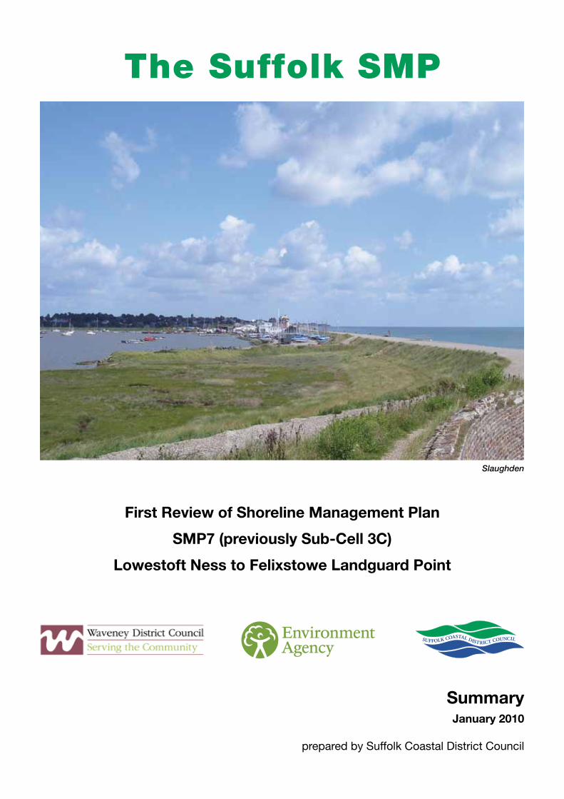
Slaughden
First Review of Shoreline Management Plan
SMP7 (previously Sub-Cell 3C)
Lowestoft Ness to Felixstowe Landguard Point

The Suffolk SMP Area
This map and all other maps in this report are based upon Ordnance Survey material with the permission of Ordnance Survey on behalf of the controller of HMSO’s © Crown copyright. Unauthorised reproduction infringes Crown copyright and may lead to prosecution or civil proceedings.
Suffolk Coastal District Council 100019684, 2009

Contents
Page
Section 1
Introduction 2
What Is A Shoreline Management Plan? 3
Developing The Plan 4The Plan and the Policies 4Dividing the Coast 4The Starting Point 4
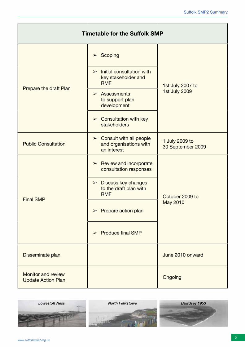
Timetable for the SMP 5
The Area Covered By The SMP – A Brief Description 6
How The Suffolk Coast Works 6
What Is At Risk? What Are We Managing? 7
Finding The Right Balance, The Final SMP 8
Section 2
Policy Development Zone 1 - Lowestoft Ness to Benacre Ness 18
Policy Development Zone 2 - Benacre Ness to Easton Broad 21
Policy Development Zone 3 - Easton Broad to Dunwich Cliffs 24
Policy Development Zone 4 - Dunwich Cliffs to Thorpeness 27
Policy Development Zone 5 - Thorpeness to Orford Ness 29
Policy Development Zone 6 - Orford Ness to Cobbold’s Point 32
Policy Development Zone 7 - Cobbold’s Point to Landguard Point 35
THE PARTNERS Inside back cover
Section 1
2 Shoreline Management Plan
Section 1 Introduction
This summary gives an overview of the Shoreline Management Plan (SMP) for the coast between Lowestoft Ness and Felixstowe Landguard Point. This plan is known as the Suffolk SMP.
Shoreline Management Plans are developed around the whole of the coast of England and Wales. To the north of the Suffolk SMP area is the Kelling to Lowestoft Ness SMP and to the south the Essex and South Suffolk SMP.
The SMP focuses on managing the risk of flooding and erosion. However, the plan has significant implications for many other important aspects of the coast and the coastal communities. This summary offers an overview of the management plan, identifying how these other interests are affected.
The initial SMP (SMP1) was completed in 1998. Since then considerable work has been undertaken both in managing defences around the coast and in building a better understanding of the issues and behaviour of the coast through studies and monitoring. The present study began in 2007 and the plan and documentation were finalised in the early part of 2010.
The final report is one of the second generation Shoreline Management Plans, or SMP2.
This summary aims to:
• highlightthemainthinkingbehindtheSMPprocess• setouttheprincipalfindingsandtherecommendationscontainedwithintheSMP.
The summary is set out in two sections. The first section considers the whole SMP frontage. The second section provides more detailed information on individual areas.
The objectives of the SMP are:
• toprovideanunderstandingofthecoast
• to indentify the risks,over thenextcentury, tocoastalcommunitiesand others who have an interest on the coast.
• to identify the likely consequence of different managementapproaches.
• toidentifythepreferredpoliciesformanagingtherisk.
• toexaminetheconsequencesofimplementingthepreferredpolicies.
• tosetoutactions formonitoringhoweffective theSMPpoliciesareand to address issues arising from the SMP.
• tocomplywithinternationalandnationalnatureconservationlegislationand biodiversity obligations.
Further information, together with the latest edition of the SMP,is provided on the Suffolk SMP2 website:
www.suffolksmp2.org.uk.

Suffolk SMP2 Summary
3www.suffolksmp2.org.uk
What is a Shoreline Management Plan?
A Shoreline Management Plan (SMP) is a strategy for managing flood and erosion risk for a particular stretch of coastline, over short, medium and long-term time periods. SMPs identify the best ways to manage coastal flood and erosion risk to people and the developed, historic and natural environment. They also identify opportunities where shoreline management can work with others to make improvements.
The Suffolk coast is constantly changing, with changes in one area resulting in changes elsewhere. This is why the SMP has to consider the full 72 kilometres of the Suffolk coast and why it needs to co-ordinate policy with neighbouring SMPs. It is also why the SMP needs to look to the long-term, as the way we manage the coast today can establish the pattern of how we will be managing the coast into the future.
The SMP has been developed using a set of principles agreed by all the organisations involved in the process, aimed at capturing the overall values and issues identified during the public consultation. One of the main challenges facing shoreline management is that it is unlikely, if not impossible, to fully achieve everybody’s objectives. However, this set of principles represents the balance of values to which the SMP aspires for the Suffolk coast. The SMP aims to provide the best achievable balance between the objectives in the short, medium and long term.
About 10 years ago the first round of SMPs was completed for the entire length of the coastline of England and Wales. These first round SMPs are now being reviewed to take account of updated information.
The Plan describes how the shoreline will be managed in the short term (up to 2025), the medium term (2026 – 2055) and the long term (up to 2105). The plan for the medium and long term sets a vision for the future, but is based on our current knowledge and understanding. That is why SMPs are reviewed every five to 10 years.
Suffolk Coastal and Waveney District Councils are the coast protection authorities, with powers to undertake coast protection works (protection against coastal erosion and the encroachment by the sea). They are the bodies, under the Coast Protection Act 1949, who have a duty to regulate coast protection works undertaken by other organisations and individuals.
The Environment Agency is the authority responsible for sea defence (management of coastal flood risk). It also has an overview, or supervisory, role with respect to both sea defence and coast protection. These three organisations work in partnership with each other and with all those that have an interest and responsibility along the Suffolk coast. These include Natural England, with their advisory role on nature conservation, Suffolk County Council, English Heritage and the Suffolk Coast and Heaths Area of Outstanding Natural Beauty Unit.
• Toavoidthelossoflifethroughflooding;• To protect people’s homes from flooding and
erosion;• Toprotectthelocaleconomy;• To contribute to a sustainable and integrated
approachtolanduseplanning;• To support adaptation by the local coastal
communities;
• To avoiddamage to and enhance thenaturalheritage;
• Tosupportthehistoricenvironmentandculturalheritage;
• Tomaintainorimprovelandscapedesignationsandfeatures;and
• Toreducerelianceondefence.

4 Shoreline Management Plan
Section 1
SMP2 is a review based on where we are now. It has taken as its starting point two baseline scenarios for the future:
➢ No Active Intervention (NAI). How would the coast evolve if no one manages it?
➢ With Present Management (WPM). If we continue to manage the coast in the way in which we have been managing it, what might happen in the future?
Looking at these scenarios gives an understanding of the issues being faced. What is at risk? What are the problems and how might we manage the coast better? The plan was developed to address these issues taking account of the way in which the coast behaves and taking account of what is the best way to manage flood and erosion risks in a manner that can be achieved in the future.
DevelopingthePlan
The Plan and the Policies
The SMP2 defines a long-term sustainable plan. This plan represents the long-term vision, considering the interactions of proposals for individual areas and their implications across the whole SMP area. This plan is achieved through the development of policies for individual areas over the three timescales.
These policy definitions by themselves can only tell part of the story. As it is the way in which these policies will be implemented that is important; this is discussed in the main document.
Dividing the Coast
While developing the SMP, it was found that the plan area could be sensibly divided into seven zones. Within each zone the detailed plan is described in Management Areas. Each Management Area (MA) contains of a group of Policy Units (PU). It is within each Management Area that the plan for managing the coast is set out and the policies defined.
The Starting Point
Management of the shoreline is a continuous process. SMP2 has built upon previous work taken from the first SMP and from the subsequent strategies and studies that have been completed since then.
Physical behaviour of the coast
Issues and objectives
Policy Appraisal The SMP2
The shoreline management policy options applicable to the Suffolk coast as defined by Defra (the Government’s Department for the Environment, Food and Rural Affairs) are:
➢ No active intervention (NAI): a decision not to invest in providing or maintaining defences or natural coastline.
➢ Hold the line (HTL): maintain or upgrade the level of protection provided by defences or natural coastline.
➢ Managed realignment (MR): manage the coastal processes to realign the ‘natural’ coastline configuration, either seaward or landward of its present position.
Suffolk SMP2 Summary
5www.suffolksmp2.org.uk
Timetable for the Suffolk SMP
Prepare the draft Plan
➢ Scoping
1st July 2007 to 1st July 2009
➢ Initial consultation with key stakeholder and RMF
➢ Assessments to support plan development
➢ Consultation with key stakeholders
Public Consultation➢ Consult with all people
and organisations with an interest
1 July 2009 to 30 September 2009
Final SMP
➢ Review and incorporate consultation responses
October 2009 to May 2010
➢ Discuss key changes to the draft plan with RMF
➢ Prepare action plan
➢ Produce final SMP
Disseminate plan June 2010 onward
Monitor and review Update Action Plan
Ongoing
Lowestoft Ness Bawdsey 1953North Felixstowe

6 Shoreline Management Plan
Section 1
TheareacoveredbytheSMP–abriefdescription
The SMP area is from Ness Point in Lowestoft to the mouth of the Stour and Orwell Estuaries at Landguard Point, Felixstowe. This is an area that contains both soft eroding cliffs and lower-lying areas extending inland that are at potential risk from coastal flooding. Three major river estuaries, the Blyth, the Alde/Ore and the Deben, cut the coast and there are several smaller broads or low lying areas, which are closed off by the shingle ridges and beaches which extend over much of the length of the shoreline.
There are four major towns - Lowestoft, Southwold, Aldeburgh and Felixstowe - and many smaller towns and villages, all within the coastal strip.
The shoreline area is essential for the local, regional and national economy. This relies heavily on shoreline-related tourism, agriculture, two major ports and several smaller harbours. The coastal zone also provides an attractive place to live. This vitality comes from the way in which the coast is used, as well as from its outstanding natural beauty, its largely unspoilt character and the diverse range of wildlife and natural habitats. It has long been an area of human settlement and its cultural and heritage value adds to its overall landscape quality. A historic and central part of that landscape is the changing nature of the coast and this natural change will continue in the future.
How the Suffolk coast works
The coastal processes in the area are complex and operate at different scales. The coast is generally made up of soft geology. Waves are the main cause of change. The energy of the waves work on the coast causing erosion and moving sediment along the shore. In some areas the tides are also important, particularly where there are headlands and where the shoreline and estuaries interact with each other.
Much of the sediment that makes up the present shoreline has come from erosion of the coast and nearshore area over the last 10,000 years as sea level rose and the East Anglian coast eroded after the last ice age. This large-scale erosion created features such as the shingle bank of Orford Ness. It also provided most of the sediment now retained as shingle and sand beaches. Now there is a much smaller supply being delivered to the coast by erosion of the cliffs. The most significant supply at present comes from erosion of the cliffs between Kessingland and Southwold.
Sediment was also deposited close to the shoreline as banks. These are moved by waves and currents changing how they interact with the shoreline. This process can also be seen at the mouths of the Alde/Ore and the Deben with sediment being recycled, banks developing and breaking down and sediment being retained and then fed to neighbouring sections of the coast.
Sediment generally moves from north to south along the shoreline. This can, however, vary locally and in some areas the overall movement of sediment is quite low. Examples of such areas are the Pakefield and Kessingland cliffs, along the Minsmere and Thorpeness cliff frontages and in areas such as Hollesley and Felixstowe bays. In other areas, such as at Easton Bavents and Covehithe or at Orford Ness, erosion and sediment drift is persistent and, particularly at Covehithe, rapid. In some places the shape of the coast would be very different if there were no defences and structures there. Lowestoft Ness and Landguard Point are examples of this, as well as at the entrance to the Blyth estuary and at East Lane, Bawdsey.
The whole of the coast does, however, suffer some degree of erosion. As sea level has risen in the past the coast has tended to retreat. This process has been limited in places by man-made defences and, along more undisturbed areas where sediment is limited, has exposed areas to increased flood risk. This risk will increase with sea level rise.

Suffolk SMP2 Summary
7www.suffolksmp2.org.uk
No Active Intervention: Without defence the main areas of loss would be the major towns. Around 1,200 properties (both homes and businesses), would be lost over the next 100 years under the No Active Intervention scenario, to erosion. More property would be at increased risk of flooding. The largest area of erosion loss would be at Southwold and Walberswick. Lowestoft, Aldeburgh and Felixstowe would lose significant areas of their seafronts.
There would also be losses in the villages of Kessingland, Covehithe, Dunwich, Thorpeness, Shingle Street and Felixstowe Ferry. Around 400 ha of agricultural land is at risk from erosion. There are also important heritage sites at risk including the Martello towers in the south of the area, the Greyfriars Priory and the hospital of the Holy Trinity at Dunwich and the village of Covehithe, as well as many buildings and features in the towns. This would have a significant impact on the overall historical landscape.
Other areas would be at risk from increased flooding as coastal defences fail due to pressure from erosion or lack of maintenance, most obviously within the estuaries. On the open coast the most significant areas affected by flooding are:
At Lowestoft, the area around the Ness, large areas of the harbour and within Lake Lothing.
At Felixstowe, the main southern part of the town and the area of the port. These areas would be lost.
Kessingland Levels, affecting agricultural land, properties behind Kessingland and the main A12 road.
The agricultural land behind Hollesley Bay.
There would also be loss of freshwater habitat.
Areas of flood risk shown in blue, and the 100 year erosion line in red.
What is at risk? What are we managing?
Without defences the coast would continue to retreat over its whole length. In some areas this might only be a retreat of tens of metres. In other areas erosion could be over several hundreds of metres over the next hundred years. The risk of erosion threatens homes, businesses and other assets in all the major towns and several of the smaller villages. It also threatens important historic assets and puts pressure on many of the coastal flood defences. However, erosion in one area also provides sediment that maintains the beaches, provides defence to other areas of the coast, as well as sustaining many of the important nature conservation habitats.
There are also many areas of flood risk within SMP area. This flood risk is most significant within the estuaries but also affects large areas of Lowestoft and Felixstowe.
Even if we continue to manage the coast as we have been managing it up to now, significant areas would continue to erode and large areas of land would still be at risk from flooding. Even where there are defences now, during severe storms, there is still a risk that land and property would be flooded. Where we do continue to defend, we have to consider whether, with sea level rise and continuing erosion, we are not storing up problems for the future. We also have to be aware of how defending some areas may affect others and how by defending we may be destroying the important natural landscape of the coast.
8 Shoreline Management Plan
Section 1
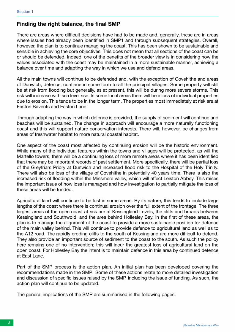
Findingtherightbalance,thefinalSMP
There are areas where difficult decisions have had to be made and, generally, these are in areas where issues had already been identified in SMP1 and through subsequent strategies. Overall, however, the plan is to continue managing the coast. This has been shown to be sustainable and sensible in achieving the core objectives. This does not mean that all sections of the coast can be or should be defended. Indeed, one of the benefits of the broader view is in considering how the values associated with the coast may be maintained in a more sustainable manner, achieving a balance over time and adapting the way in which we use and defend areas.
All the main towns will continue to be defended and, with the exception of Covehithe and areas of Dunwich, defence, continue in some form to all the principal villages. Some property will still be at risk from flooding but generally, as at present, this will be during more severe storms. This risk will increase with sea level rise. In some local areas there will be a loss of individual properties due to erosion. This tends to be in the longer term. The properties most immediately at risk are at Easton Bavents and Easton Lane
Through adapting the way in which defence is provided, the supply of sediment will continue and beaches will be sustained. The change in approach will encourage a more naturally functioning coast and this will support nature conservation interests. There will, however, be changes from areas of freshwater habitat to more natural coastal habitat.
One aspect of the coast most affected by continuing erosion will be the historic environment. While many of the individual features within the towns and villages will be protected, as will the Martello towers, there will be a continuing loss of more remote areas where it has been identified that there may be important records of past settlement. More specifically, there will be partial loss of the Greyfriars Priory at Dunwich and increased flood risk to the Hospital of the Holy Trinity. There will also be loss of the village of Covehithe in potentially 40 years time. There is also the increased risk of flooding within the Minsmere valley, which will affect Leiston Abbey. This raises the important issue of how loss is managed and how investigation to partially mitigate the loss of these areas will be funded.
Agricultural land will continue to be lost in some areas. By its nature, this tends to include large lengths of the coast where there is continual erosion over the full extent of the frontage. The three largest areas of the open coast at risk are at Kessingland Levels, the cliffs and broads between Kessingland and Southwold, and the area behind Hollesley Bay. In the first of these areas, the plan is to manage the alignment of the coast to provide a more sustainable position for defence of the main valley behind. This will continue to provide defence to agricultural land as well as to the A12 road. The rapidly eroding cliffs to the south of Kessingland are more difficult to defend. They also provide an important source of sediment to the coast to the south. As such the policy here remains one of no intervention; this will incur the greatest loss of agricultural land on the open coast. For Hollesley Bay the intent is to maintain defence in this area by continued defence at East Lane.
Part of the SMP process is the action plan. An initial plan has been developed covering the recommendations made in the SMP. Some of these actions relate to more detailed investigation and discussion of specific issues raised by the SMP, including the issue of funding. As such, the action plan will continue to be updated.
The general implications of the SMP are summarised in the following pages.

Suffolk SMP2 Summary
9www.suffolksmp2.org.uk
The Plan: Property.Over the 100 year period of the SMP2, the plan continues to provide protection to the main centres of residential and commercial development. Along the coast between Lowestoft Ness and Kessingland village there are some 250 properties at risk from erosion. The aim is to continue to protect. How this risk is managed would very much depend on how the beach behaves in the future. There would continue to be the risk of flooding to the centre of Lowestoft. How this is managed needs to be considered alongside the regeneration plan for the area. The SMP identifies the need for integrated planning.
Further south, the aim is to manage the erosion immediately south of Kessingland, protecting the village and part of the Kessingland Levels. South of Kessingland Levels there would be no defences put in place; this continues the policy defined in the first SMP. There would, therefore, be properties lost in Covehithe village, probably in 40 years time. Just north of Southwold there are seven properties in the area of Easton Bavents and Easton Lane that could be lost under the plan. The plan does recommend discussion as to how this might be managed to some degree through private works, if this could work with the intent of the plan to provide continued sustainable protection to Southwold and Walberswick. Discussion of this is included in the action plan. The SMP for the area of Southwold and Walberswick is to continue to protect the 640 properties at risk within these communities. The plan also continues to support the operation of Southwold and Walberswick Harbour, although there needs to be a long-term plan to address the on-going flood risk. This again is identified in the action plan. The flood risk around Southwold and Walberswick will continue to be managed. To the north of Southwold a secondary line of defence would be needed to allow the shoreline to respond more naturally.
At Dunwich, although existing measures to slow erosion to the village would not be ruled out, it is likely that some five properties would be lost in the medium term (20 to 50 years). Flood defence to properties to the back of the village would need to be improved. The erosion of the coast at Dunwich helps maintain the natural shoreline protection to the south. Even so, the cliffs will continue to erode and the shoreline will roll back. As such, it is anticipated that nine
Sizewell Beach
Lowestoft

10 Shoreline Management Plan
Section 1
properties may be lost along the Dunwich and Sizewell cliffs, two of these possibly over the next 50 years. The further seven properties, at Thorpeness, might only be at risk in 50 to 100 years time. This will need to be monitored. There is some provision in the plan for minor works to be allowed, if this can be shown not to threaten the natural of protection to properties to the south of Thorpeness and not to impact adversely on nature conservation interests. The plan continues the intent to protect Sizewell power station and would provide natural protection to the village of Sizewell. The aim of the plan is to continue to provide flood defence to the centre of Thorpeness and Aldeburgh. The 75 properties that are also at risk from erosion along the Aldeburgh frontage will be protected.
The plan is to continue to provide protection to the village of Shingle Street and property at East Lane. There is uncertainty about how the coast will develop in this area and this needs to be monitored. There are estimated
to be about 20 properties at risk from erosion in this area. Potentially three properties could be lost towards the 100 year period covered by the plan, but this would depend on local management. Flood defence to Hollesley Bay and Shingle Street would be maintained but there will be an increasing risk of flooding affecting access to Shingle Street.
Over the southern area of the coast, from Felixstowe Ferry through to Landguard Point, there are around 200 properties at risk from erosion and, particularly in the area of Felixstowe where there are in excess of 1,300 properties, at risk from flooding. The aim of the plan is to continue to protect these properties and to maintain flood defence to the town and the port.
Infrastructure.The main risk to the road system is from flooding. Only locally at Lowestoft and along the sea front at Felixstowe are main roads at risk from erosion; these would be protected under the plan. The A12 is at flood risk to the back of Kessingland Levels and at Blythburgh. In both these places the plan envisages continued defence of the road. Access to Southwold is at risk from flooding and this access would continue to be defended. At Potters Bridge
The Plan (continued):
Southwold
Central Felixstowe

Suffolk SMP2 Summary
11www.suffolksmp2.org.uk
The Plan (continued):
the risk is mainly from river flooding. This is a continuing risk and the plan acknowledges the need for discussion between the Environment and Highways Authority. Other critical service infrastructure has been identified in developing the plan. The flood risk to this infrastructure would be managed. There is no critical service infrastructure at risk from erosion.
AgricultureThe main risk to agriculture in the area is from tidal flooding, principally within the estuaries. (The approach taken to management of the estuaries by the SMP is discussed below). On the open coast the main areas of risk from flooding are Hollesley Bay, Minsmere valley and the Kessingland Levels. In Hollesley Bay, this area will continue to be defended (around 600 hectares). The flood risk to the Minsmere valley (around 240 hectares) would be managed, with defence being provided by sustaining the natural defence and maintaining the sluice. The standard of defence would reduce and there would be increased risk of coastal flooding over the next 50 to 100 years. At Kessingland Levels there would be loss from more regular flooding of part of the site that is defended at present, with a loss of defence to around 50 hectares, compared to the area at risk of around 350 hectares. Possibly the most significant loss of agricultural land would be between Kessingland and Southwold. Here, the loss due to erosion over the next 100 years could amount to about 400 hectares. Loss would be to Grade 3 and 4 agricultural land.
Historic Environment.There are important aspects of cultural and heritage value associated with the main towns and villages. These are generally protected. The main features at risk under the plan are the Greyfriars Priory at Dunwich and the Hospital of the Holy Trinity. Potentially most significant is the loss of Covehithe. There are also important areas of historic landscape that will be affected, such as that present at Orford Ness. The plan is to protect other features such as all the Martello towers.
Nature Conservation.With a naturally eroding dynamic coastline, one of the main issues for nature conservation is achieving the right balance between protecting or preserving features at risk and maintaining the natural processes that sustain other important coastal habitats. In particular, this introduces a challenge of balancing the freshwater coastal habitat and the open coast habitat. In discussion with Natural England, a balance has been agreed. Key areas affected directly by erosion are features such as at Dunwich Heath and Orford Ness. In both areas there is gradual erosion with loss of overall area. In either case, to protect will be to create a
Hollesley Bay
Section 1
12 Shoreline Management Plan
situation where there would be greater damage. One of the important features of the coast are the saline lagoons. These are recognised to be short-lived features that require the natural movement of sediment. Opportunity is created for such habitats to develop at Kessingland and in Hollesley Bay.
In other areas, there is the risk of coastal flooding, or the roll-back of the coastline onto valuable areas of freshwater interest. Management has been used in the past to try to re-shape natural shingle defences in places such as Walberswick Marshes and Easton Broad. This has led to a situation were the habitat behind has been maintained through intervention and has become increasingly vulnerable to sudden loss of the bank. The plan puts in place a more natural approach allowing the shoreline to adapt naturally. At Minsmere the pressure from erosion is less. Here it is anticipated that the natural main line of defence will be sustained by natural processes over the next 50 to 100 years but there will be increasing risk of overtopping and flooding.
There are areas where new habitat will need to be created to compensate for losses. This is being identified through the Environment Agency’s habitat creation programme. In other areas monitoring is in place to understand better the risk to nature conservation values. Both actions are identified in the action plan. Overall the SMP aims to deliver a more naturally functioning coastline to support the important geomorphological, nature conservation and natural landscape interests.
Landscape.The important natural Suffolk landscape is maintained under the plan. There will be loss to the historic landscape, as identified above, and there will be change in nature conservation interest, but this is balanced in the plan by maintaining the essential ability of the coast to adapt and in maintaining the quality of the shingle and sand shoreline. The Plan supports the aims of the AONB designation.
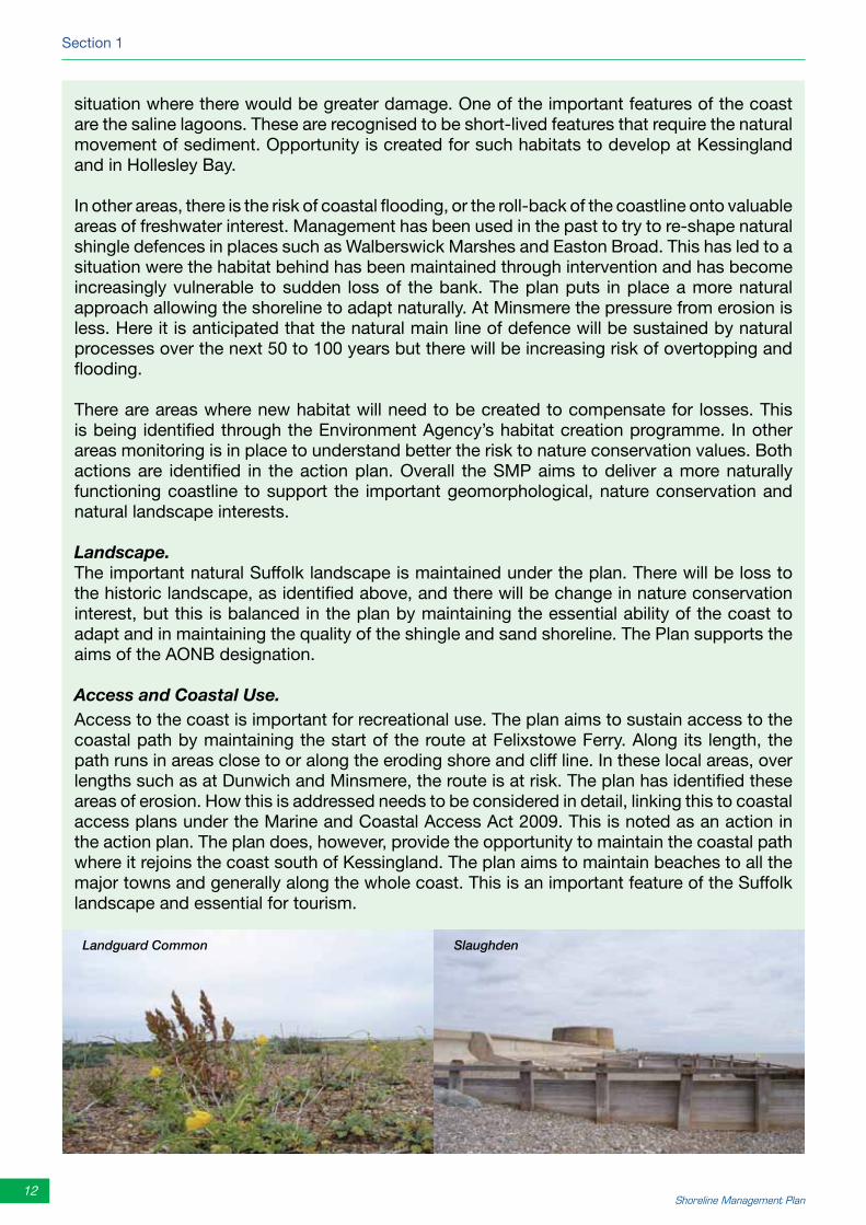
Access and Coastal Use.Access to the coast is important for recreational use. The plan aims to sustain access to the coastal path by maintaining the start of the route at Felixstowe Ferry. Along its length, the path runs in areas close to or along the eroding shore and cliff line. In these local areas, over lengths such as at Dunwich and Minsmere, the route is at risk. The plan has identified these areas of erosion. How this is addressed needs to be considered in detail, linking this to coastal access plans under the Marine and Coastal Access Act 2009. This is noted as an action in the action plan. The plan does, however, provide the opportunity to maintain the coastal path where it rejoins the coast south of Kessingland. The plan aims to maintain beaches to all the major towns and generally along the whole coast. This is an important feature of the Suffolk landscape and essential for tourism.
Landguard Common Slaughden

Suffolk SMP2 Summary
13www.suffolksmp2.org.uk
FundingIn the more populated areas it is economically justified, using current government criteria, to continue to defend. Even in these areas, however, at the local level, maintaining the existing line of defence relies on understanding the broader benefits these frontages provide in terms of recreational, tourism and other economic values associated with the shoreline.
In other areas, the policy to continue to provide defence cannot be so easily justified economically. The SMP, however, recognises that continued defence is important at a regional and local level and has put in place policies for continued management. In several areas this would only be possible through joint funding with local and individual contributions. Establishing management groups looking in more detail at how this funding can be put in place will be an important aspect of how the SMP policies are taken forward.
Nature ConservationThere are areas where of existing habitats will be lost as the coast retreats or where there is increased flooding. Some of these freshwater areas are designated under international law. Habitat to replace this will be needed in more sustainable areas and it is recognised that developing suitable habitat will take time. Where this is critical, the SMP policies have allowed time for this to happen.
The EstuariesRunning in parallel with developing the SMP has been the development of management plans for the estuaries.
The Blyth. The SMP has worked closely with the emerging flood risk management strategy for the Blyth, providing important consideration of interaction with coastal management.
The Alde/Ore. The SMP recognises that there are complex issues associated with a potential breach through the estuary south of the Slaughden Martello Tower in the medium to long term. The SMP policy informs and is subject to the conclusions of the both the Aldeburgh Coast and Estuaries Strategy (ACES), which is specifically looking at flood and erosion risk management for the relevant stretch of coast and the estuary, as well as the Alde and Ore Futures project, which is looking at a more holistic, integrated coastal zone management (ICZM) approach to maintain sustainable communities in the long term around the estuary.
The Deben. The strategy for the Deben has not yet been developed. The SMP has taken account of existing findings and recommends a policy for holding the entrance to the estuary. This limits the way in which the estuary would be managed. These will be considered as the strategy is developed in a way similar to that developed for the Alde/Ore.
Some of the Issues in Taking the Plan Forward
The Deben Estuary

Section 1
14 Shoreline Management Plan
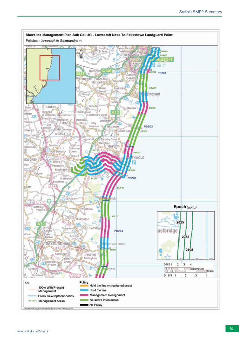
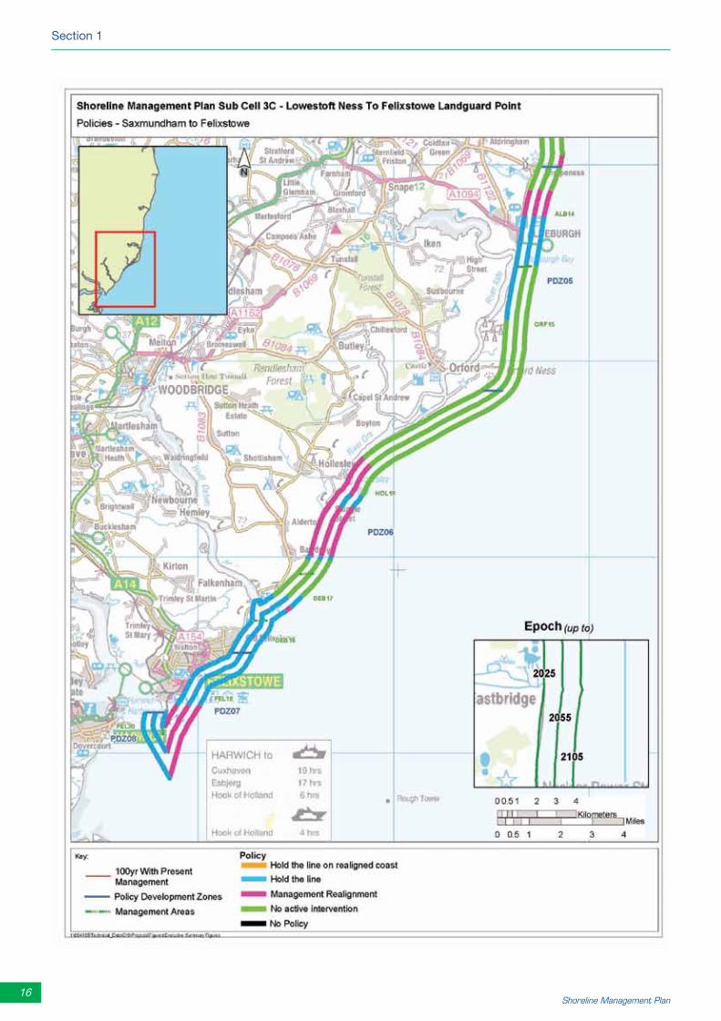
The following two pages summarise the policies along the shoreline.
Integrated Coastal Zone ManagementThe SMP only sets policies for managing flood and coastal erosion risk. However, how the shoreline is managed has a major effect on the future use of the coast, including development of its settlements, management of its natural and historic environment and the opportunity to deliver a sustainable future for the whole area.
The Alde/Ore Futures Initiative has been an important step forward in establishing a framework for managing the coast and the Suffolk estuaries. It is anticipated that this approach will be rolled forward in looking at how other areas of the coast may be managed from a broader perspective. This SMP has aimed throughout its development to link closely with this initiative and has made recommendations where taking this broader approach may be valuable in the future. This is seen as being as important in establishing the broader values of the coast as other aspects, such as monitoring, might be to the next review of the SMP in some 10 years time.
It has been identified in relation to Aldeburgh and the issue of managing the narrow neck of land between the coast and the estuary at Slaughden, that the SMP2 policy should be reviewed when the estuary strategy is completed and as the Futures project develops its initial findings. This review would happen in about two years time.
Southwold Seafront Dunwich HeathLandguard Common
Alde/Ore Estuary
Felixstowe Pier
Suffolk SMP2 Summary
15www.suffolksmp2.org.uk
16 Shoreline Management Plan
Section 1

Suffolk SMP2 Summary
17www.suffolksmp2.org.uk
Section 2
Individual sections of the coast
Key
The shoreline management policy options applied to Suffolk coast are:
➢ No active intervention (NAI): a decision not to invest in providing or maintaining defences or natural coastline.
➢ Hold the line (HTL): maintain or upgrade the level of protection provided by defences or natural coastline.
➢ Managed realignment (MR): manage the coastal processes to realign the ‘natural’ coastline configuration, either seaward or landward of its present position.
Those areas where there is a change in policy from SMP1 are highlighted in bold.
Section 2
18 Shoreline Management Plan
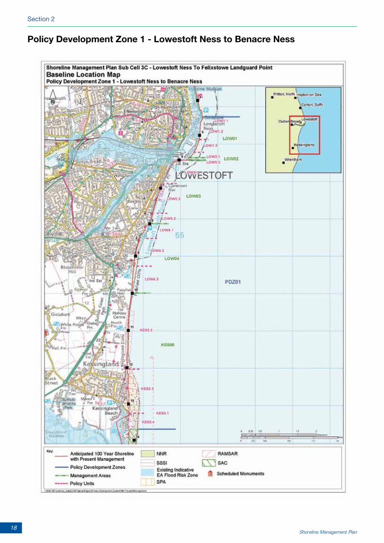
PolicyDevelopmentZone1-LowestoftNesstoBenacreNess

Suffolk SMP2 Summary
19www.suffolksmp2.org.uk
PolicyDevelopmentZone1
This policy development zone runs from just north of Lowestoft Ness to the southern end of the concrete wall south of Kessingland. It includes Lowestoft harbour and Lake Lothing.
The frontage is made up of:• theheavily-defendedheadlandoftheNessandHamiltondock,withthelow-lyingareaofthe
inner harbour area • theshallowbayofSouthbeachthroughtothelessobviousheadlandatPakefieldRoad• themorenaturalcoastandcliffsofPakefieldandnorthofKessingland.
The zone has been divided into five management areas, each made up of a series of policy units. The policies for each unit are defined below.
LOW01-LowestoftNessandouterharbour
Policy unitPolicy
2025 2055 2105
LOW 1.1 Lowestoft Ness HTL HTL HTL
LOW 1.2 Hamilton docks HTL HTL HTL
LOW 1.3 South pier HTL HTL HTL
LOW02-Innerharbour
Policy unitPolicy
2025 2055 2105
LOW 2.1 Northern side HTL HTL HTL
LOW 2.2 Southern side HTL HTL HTL
LOW03-Southbeach
Policy unitPolicy
2025 2055 2105
LOW 3.1 North HTL HTL HTL
LOW 3.2 South HTL HTL HTL
LOW 3.3 Pakefield Road HTL HTL HTL
LOW04–Pakefield
Policy unitPolicy
2025 2055 2105
LOW 4.1 Southern Promenade HTL HTL HTL
LOW 4.2 Pakefield HTL HTL MR
LOW 4.3 Pakefield Cliffs NAI NAI NAI
KES05-Kessingland
Policy unitPolicy
2025 2055 2105
KES 5.1 Benacre Ness NAI NAI NAI
KES 5.2 Kessingland cliff NAI NAI NAI
KES 5.3 Kessingland village HTL HTL HTL
KES 5.4 Kessingland south HTL HTL HTL
Section 2
20 Shoreline Management Plan
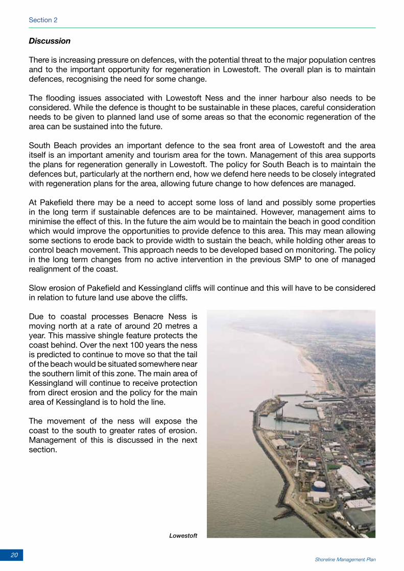
Discussion
There is increasing pressure on defences, with the potential threat to the major population centres and to the important opportunity for regeneration in Lowestoft. The overall plan is to maintain defences, recognising the need for some change.
The flooding issues associated with Lowestoft Ness and the inner harbour also needs to be considered. While the defence is thought to be sustainable in these places, careful consideration needs to be given to planned land use of some areas so that the economic regeneration of the area can be sustained into the future.
South Beach provides an important defence to the sea front area of Lowestoft and the area itself is an important amenity and tourism area for the town. Management of this area supports the plans for regeneration generally in Lowestoft. The policy for South Beach is to maintain the defences but, particularly at the northern end, how we defend here needs to be closely integrated with regeneration plans for the area, allowing future change to how defences are managed.
At Pakefield there may be a need to accept some loss of land and possibly some properties in the long term if sustainable defences are to be maintained. However, management aims to minimise the effect of this. In the future the aim would be to maintain the beach in good condition which would improve the opportunities to provide defence to this area. This may mean allowing some sections to erode back to provide width to sustain the beach, while holding other areas to control beach movement. This approach needs to be developed based on monitoring. The policy in the long term changes from no active intervention in the previous SMP to one of managed realignment of the coast.
Slow erosion of Pakefield and Kessingland cliffs will continue and this will have to be considered in relation to future land use above the cliffs.
Due to coastal processes Benacre Ness is moving north at a rate of around 20 metres a year. This massive shingle feature protects the coast behind. Over the next 100 years the ness is predicted to continue to move so that the tail of the beach would be situated somewhere near the southern limit of this zone. The main area of Kessingland will continue to receive protection from direct erosion and the policy for the main area of Kessingland is to hold the line.
The movement of the ness will expose the coast to the south to greater rates of erosion. Management of this is discussed in the next section.
Lowestoft

Suffolk SMP2 Summary
21www.suffolksmp2.org.uk
PolicyDevelopmentZone2-BenacreNesstoEastonBroad

Section 2
22 Shoreline Management Plan
PolicyDevelopmentZone2
The zone runs from just south of Kessingland to Easton Lane and has two distinct sections.
To the north is the Kessingland Levels, extending as a low-lying valley about 3.5 kilometres inland. This area is defended by flood embankments with a pumping station that manages water levels behind. South of Kessingland Levels is an undefended section of cliffs interspersed with low-lying broads. The cliffs and shoreline are rapidly eroding.
The zone has been divided into two management areas, each made up of a series of policy units. The policies for each unit are defined below.
Discussion
This is an area where there is greatest pressure for erosion on the coast and most rapid erosion rates.
The significant changes, brought about by the movement of Benacre Ness, would have a big influence on the southern section of Kessingland village and how land is used within Kessingland Levels. This is a significant change from the policy previously proposed for the medium and long term (20 to 100 years hence). This change is managed to allow a more sustainable defence system to develop. The approach allows the natural appearance of the coast to be maintained, separating the flood risk management issue from management of the shoreline itself. The shoreline will remain in a similar position to where it is now, set back to allow natural adjustment but still maintaining that important Suffolk landscape of shingle and sand. Retaining this shoreline would allow flood defences to be re-established further back within the existing area of Kessingland Levels. The village of Kessingland would therefore be sustained, the A12 defended and the use of Kessingland Levels placed on a more secure footing.
This approach would increase the probability of flooding in the valley behind Kessingland Beach Road. Local improvement to flood defences would need to be considered to protect assets and properties.
The approach is unlikely to be funded completely by the national flood risk management budget, although the current strategy for the short is to continue maintenance of the existing defence. There is a period of somewhere around 15 to 20 years before action would be needed. This period of time needs to be used to develop a joint funding approach to managing flood risk.
BEN06-KessinglandLevels
Policy unitPolicy
2025 2055 2105
BEN 6.1 Kessingland south HTL
MR MRBEN 6.2 Kessingland Levels HTL
BEN 6.3 Beach Farm MR
COV07-BenacreBroadtoEastonBroad
Policy unitPolicy
2025 2055 2105
COV 7.1 Benacre Broad to
Easton Broad
NAI NAI NAI
COV 7.2 Easton Broad MR NAI NAI

Suffolk SMP2 Summary
23www.suffolksmp2.org.uk
While the policy for managing the coast further south has not changed a lot since the first SMP, this is one of two areas in the SMP area where the plan indicates the need to accept the most significant change in the future shape of the coast. The erosion of the cliffs provides a major supply of sediment to the coastal system and this is essential for maintaining defence to other parts of the coast.
There are, however, important land use issues. The historically important village of Covehithe and areas of internationally designated habitat would be lost. Despite this, it is not considered sustainable to attempt to manage the erosion. The village may be lost during the medium term of the SMP and agricultural land will continue to be lost over the next 100 years. The role of the SMP is to identify that these losses will occur. It is recognised that there is little potential for adaptation in terms of loss of the village so significant value will be lost. (The main document discusses the issues in this area in detail). Alternative sites for nature conservation will need to be identified away from the pressures of the coast. In terms of the heritage value the main issue highlighted by the SMP is the need to invest in further research into the area to record valuable information before it is lost.
Further south in this section is the road at Potters Bridge. This road would not be lost due to erosion but there would be more flooding in the area. This area is being considered as part of a strategy and consideration will be given as to how the important transport link to Southwold might be maintained and how drainage of the river Wren can be managed. There will, however, need to be some adaptation of use of this area.
Benacre Ness Covehithe village
Covehithe Broad
Section 2
24 Shoreline Management Plan
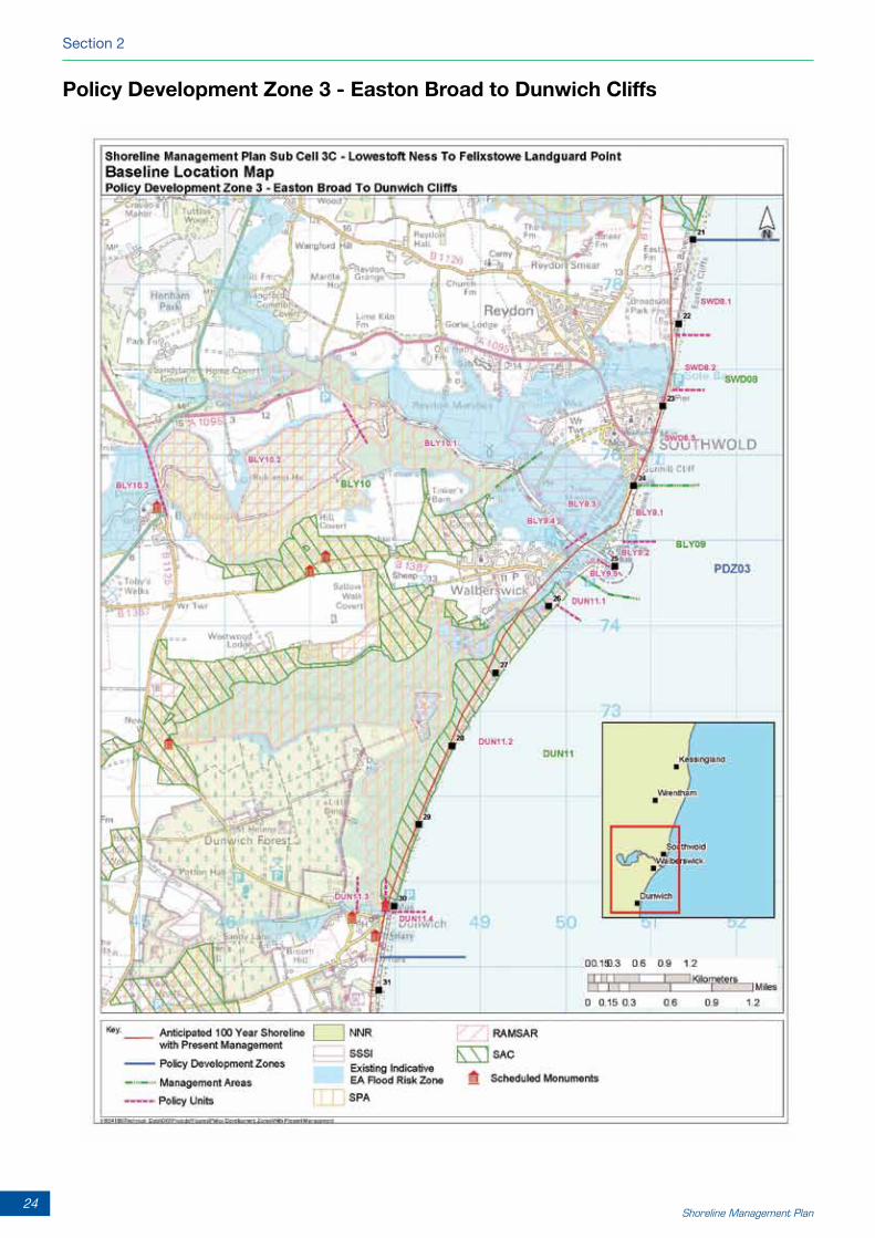
PolicyDevelopmentZone3-EastonBroadtoDunwichCliffs

Suffolk SMP2 Summary
25www.suffolksmp2.org.uk
PolicyDevelopmentZone3
The zone runs southwards from the northern limit of the Easton Bavents cliffs down to and including the northern section of cliffs at Dunwich. The zone includes:
• TheundefendedcliffsofEastonBaventsthroughtothedefencesatSouthwold.• TheBlythestuaryanditsmanagedentrance.• NaturalshinglebankinfrontoftheWalberswickmarshes• ThevillageofDunwich
The zone has been divided in to three management areas, each made up of a series of policy units. The policies for each unit are defined below.
SWD08-SouthwoldandSouthwoldnorth
Policy unitPolicy
2025 2055 2105
SWD 8.1 Easton Bavents MR MR MR
SWD 8.2 Easton Marsh HTL MR HTL
SWD 8.3 Southwold town HTL HTL HTL
BLY09-TheDenestoWalberswickincludingthemouth of the estuary
Policy unitPolicy
2025 2055 2105
BLY 9.1 The Denes HTL HTL HTL
BLY 9.2 Harbour entrance (north and south)
HTL HTL HTL
BLY 9.3 Harbour reach north HTL HTL HTL
BLY 9.4 Harbour reach south side
HTL MR MR
BLY 9.5 Walberswick dunes MR MR MR
BLY10-Blythinnerestuary
Policy unitPolicy
2025 2055 2105
BLY 10.1 Lower inner estuary MR MR MR
BLY 10.2 A12 HTL HTL HTL
BLY 10.3 Upper estuary NAI NAI NAI
DUN11-WalberswickmarshesandDunwich
Policy unitPolicy
2025 2055 2105
DUN 11.1 Walberswick HTL HTL HTL
DUN 11.2 Walberswick Marshes MR MR MR
DUN 11.3 Dunwich near defences HTL HTL HTL
DUN 11.4 Dunwich cliff MR MR MR

Section 2
26 Shoreline Management Plan
Discussion
While the estuary strategy is about to be published, there is still on-going discussion about the detailed management of the Blyth estuary. The SMP highlights the important issues relating to this. In particular the SMP confirms the important use of the estuary and the continued use of the harbour. It also highlights the important role the harbour entrance has in managing the coast. The SMP puts forward a plan that allows adaptation of defences within the estuary in line with the intent to maintain use of the harbour and the coast. In developing the policies, the SMP recognises the clear need to make decisions about the future use of the harbour.
The SMP plans to maintain defence to Southwold. Defence of this area relies very much on sediment entering the local system from the north. The plan sets out an approach to managing the area to the north of the town by allowing a transition from the policies of no active intervention further north through to the hold the line in front of the town. As seen at Kessingland Levels, one of the key parts of this approach is to separate out the need for flood defence to important assets in the town and the need to develop a frontage that works well with the alignment of the coast at Southwold. This separation of flood and erosion management provides the opportunity to maintain a naturally sustainable beach in front of the town. This change in approach, as identified by the strategy for the area, is likely to be needed in the medium term. Meanwhile it is important that local management, which would not be ruled out under the plan, needs to be undertaken in a way that supports the long term intent.
This approach will not result in Southwold becoming an island. The aim is to maintain, through management, a beach along a line similar to where it is now. The main difference is that the beach would be allowed to function as a beach and shingle ridge without the constraint of maintaining a hard line. Without such an adaptive approach there would be a real risk that Southwold would lose its northern beach.
The SMP similarly recognises the need to maintain a shoreline between Walberswick and Dunwich. This area has been actively managed in the past and the shingle bank has become increasingly vulnerable to major breaches. The plan recommends that the shingle bank is allowed to act more naturally. This would maintain the overall landscape of the frontage but accepts that it will increase the risk of flooding behind. This is taken into account in the SMP. While the existing trial defences at Dunwich seem to provide some slowing of the erosion in this area, the long term plan is to allow erosion here. This is important to managing sediment to the coast to the south. Although this means that some properties will be lost, there is still scope within this to maintain the village and adapt use of areas such as the car park and associated visitor area. There are important heritage assets in the village that will be at risk. Investigation and recording of these features would be needed. As at Covehithe, there would be a need for investment in research of areas at risk.
The main changes from the first SMP are in identifying the need to manage change throughout the zone in a way that sustains the important features, use and character of the area. Significant changes are therefore made from no active intervention to a policy of managed realignment.
Dingle MarshesSouthwold Harbour entrance

Suffolk SMP2 Summary
27www.suffolksmp2.org.uk
PolicyDevelopmentZone4-DunwichCliffstoThorpeness

Section 2
28 Shoreline Management Plan
PolicyDevelopmentZone4
The zone runs from just south of Dunwich village to the access at the centre of Thorpeness village.
The whole frontage is dominated by the two areas of high ground, the Dunwich and Minsmere cliffs to the north and the Sizewell cliffs and Thorpeness headland to the south. The coast between is a natural shingle bank, with flood defences to the rear, protecting the extensive valley of the Minsmere River.
The zone has been divided into two management areas. However, because of the interaction between the management of the power station and the management at Minsmere, these have been combined. The combined management area is subdivided into policy units. The policies for each unit are defined below.
Discussion
The plan for this area is to allow the coast to function naturally as far as possible.
The long-term result of this will be increased flooding to the Minsmere valley. The coast is eroding to the north and this would continue, providing valuable sediment to the system. Erosion across the valley and around Sizewell is a lot less. The plan allows for local management of the main Minsmere frontage but with the long term aim of managed realignment. The power station would continue to be defended and this is not seen as having a significant effect on the frontage to the north over the period of the plan. However, joint planning needs to be developed to ensure a compatible defence approach over the whole area.
Some properties along the Sizewell cliffs and at Thorpeness may be lost in the longer term. The intent of the plan is not to rule out management of this erosion. However, this would need to be considered on a case by case basis, within the constraints identified with respect to the natural functioning of the whole coast and the potential effect on nature conservation interests.
MIN12&13-DunwichtoThorpeness
Policy unitPolicy
2025 2055 2105
MIN 12.1 Dunwich and Minsmere Cliffs NAI NAI NAI
MIN 12.2 Minsmere north MR MR NAI
MIN 12.3 Minsmere central MR MR MR
MIN 12.4 Minsmere south MR MR MR
MIN 13.1 Power station and village HTL HTL HTL
MIN 13.2 Sizewell cliffs NAI NAI NAI
MIN 13.3 Thorpeness NAI NAI MR
Sizewell Power StationMinsmere Reserve

Suffolk SMP2 Summary
29www.suffolksmp2.org.uk
PolicyDevelopmentZone5-ThorpenesstoOrfordNess

Section 2
30 Shoreline Management Plan
PolicyDevelopmentZone5
The zone includes the main part of Thorpeness village and extends to the main ness feature of Orfordness to the south of the lighthouse.
The zone covers two distinct areas. To the north is the headland of Thorpeness and the defences in front of Aldeburgh to just south of the Martello tower, with the valley of the Hundred River and low-lying area behind the shingle bank at the back of the foreshore. The second part of the zone comprises Orfordness, extending about 7.5 kilometres south of Aldeburgh. The point of the ness is marked by the lighthouse.
The zone has been divided into two management areas, each made up of a series of policy units. The policies for each unit are defined below.
ORF15-MartellotowertoOrfordNess
Policy unitPolicy
2025 2055 2105
ORF 15.1 Sudbourne beach (south of the Martello tower)
HTL* NAI* NAI*
ORF 15.2 Orford Ness NAI NAI NAI
ALB14-ThorpenessHaventoAldeburgh
Policy unitPolicy
2025 2055 2105
ALB 14.1 Thorpeness Haven properties NAI NAI NAI
ALB 14.2 Thorpeness Haven beach
MR MR MR
ALB 14.3 Aldeburgh HTL HTL HTL
ALB 14.4 Slaughden HTL HTL HTL
AldeburghThorpeness
Note: * An interim policy pending an agreed Management
and Investment Plan for the Alde and Ore area.

Suffolk SMP2 Summary
31www.suffolksmp2.org.uk
Thorpeness village Aldeburgh Shingle Street
Discussion
To the north of Aldeburgh and in front of the town the aim is to maintain a healthy shingle beach and ridge. Over the northern section this may result in more overtopping and the aim would be to examine in detail (through a specific strategy) where flood defences may be needed to provide extra protection to the Mere and to properties in Thorpeness and Aldeburgh. The policy over the northern section of the frontage changes from hold the line in front of the properties at the Haven to one of managed realignment. This reflects more the approach being taken rather than suggesting greater risk to the properties along the Haven. In the review of policy it is more appropriate to maintain the defence provided by the naturally-functioning shingle bank rather than trying to hold this feature through man-made works.
An essential aspect of maintaining protection to the town of Aldeburgh is the control of shingle over the frontage. The SMP highlights this and the policies in the area provide the opportunity to maintain a beach in front of Aldeburgh.
The section of coast south of the town has the potential to breach between the shore and the estuary. This is recognised to be a very complex issue, with potentially far-reaching effects on the estuary and the agricultural, recreational and nature conservation interests of the estuary.
The SMP has taken a pragmatic approach to this, recognising that some of the issues need much closer examination. The SMP aims to provide guidance to these further studies in setting out the consequences of different approaches solely from the perspective of managing the shoreline. The main pressure for a breach arises from the persistent erosion of the coast. If this were to be managed to prevent a breach into the estuary considerable effort would be needed over time to prevent this. In effect, protection would be needed against increasing pressure over about four kilometres of coast. Purely from the coastal management perspective, maintaining the barrier between the sea and the estuary would be counter to the basic principle of minimising reliance on man made defences. It is likely that this would also result in unacceptable damage to the coastal habitat.
However, this does not take account of the impact within the estuary. It is recognised that such impacts could significantly affect many values within the estuary affecting agricultural values, the important navigational and water use, landscape and nature conservation.
In taking these impacts on the estuaries into consideration, the significant potential negative impacts on the coast identified above would need to be considered as consequences of management of the estuary.
There will be a policy of Hold the Line at the coast for the first 15 years whilst conclusions are drawn from the broader scale integrated approach being developed through the Alde and Ore Futures initiative and the Aldeburgh Coast and Estuary Strategy.

Section 2
32 Shoreline Management Plan
PolicyDevelopmentZone6-OrfordNesstoCobbold’sPoint

Suffolk SMP2 Summary
33www.suffolksmp2.org.uk
PolicyDevelopmentZone6
The zone runs from just south of Orford Ness through to Cobbold’s Point on the Felixstowe frontage.
The Alde/Ore estuary runs behind the massive shingle ridge of Orford spit to emerge at the coast at North Weir Point. Over the main section of Hollesley Bay the shore is backed by a wide shingle sand beach with a secondary flood defence behind. At East Lane this line of defence runs forward, forming a more heavily-defended headland, which then links through to the defences over the rising ground to the south. The ridge of higher ground running back from Bawdsey cliffs separates the coast from the low-lying land of the lower Deben estuary. At the entrance to the Deben are the banks of the Knolls with the defended village of Felixstowe Ferry to the south of the estuary. The land rises from the low-lying northern end to the higher land of Brackenbury cliffs and Cobbold’s Point.
The zone has been divided in to three management areas, each made up of a series of policy units. The policies for each unit are defined below.
DEB17-BawdseyHilltomouthofDeben
Policy unitPolicy
2025 2055 2105
DEB 17.1 Bawdsey cliffs NAI NAI NAI
DEB 17.2 Bawdsey Manor HTL HTL HTL
DEB 17.3 Lower estuary HTL HTL MR
DEB 17.4 Felixstowe Ferry HTL HTL HTL
HOL16-OrfordNesstoBawdseyHill
Policy unitPolicy
2025 2055 2105
HOL 16.1 Orford beach NAI NAI NAI
HOL 16.2 North Weir Point MR MR NAI
HOL 16.3 Shingle Street MR HTL HTL
HOL 16.4 Hollesley Bay MR MR MR
HOL 16.6 East Lane HTL HTL HTL
HOL 16.6 Bawdsey Hill NAI NAI NAI
DEB18-NorthFelixstowe
Policy unitPolicy
2025 2055 2105
DEB 18.1 Golf course HTL HTL HTL
DEB 18.2 North Felixstowe HTL HTL HTL
East Lane, BawdseyFelixstowe Ferry

Section 2
34 Shoreline Management Plan
Discussion
The SMP has identified and considered two basic approaches to Hollesley Bay and to the Deben. In each area the intent of the plan is to manage the way in which the coast behaves, rather than abandoning defences.
In Hollesley Bay this maintains the opportunity for both current land use and maintaining the village of Shingle Street. Managing the bay in this way relies on maintaining defences at East Lane. It is recognised in the plan that there are significant uncertainties, particularly with respect to sediment movement within the bay. There is therefore a need for monitoring to find out how this would affect the integrity of the nature conservation interests and any potential increased pressure on the defence at the southern end. There would still be significant risk to the village of Shingle Street, even under this policy for management. The approach, however, aims to deliver a balanced approach to managing the various land use, heritage and environmental issues in the area. This is discussed in more detail in the main document.
At the Deben, the critical decision is whether the mouth of the estuary continues to be managed or not. Considering the important issues identified for the area, the intent of the plan is to continue to manage this area of the coast. This will sustain the important recreational uses and assets of the area, while maintaining the coastal processes associated with the Knolls. Managing the entrance would rely on managing the tidal volume of the estuary. This would require the long-term management of the large flood compartments in the lower estuary. This needs to be considered further by the estuary strategy, considering ways in which future flood risk can be managed. This would not rule out increased frequency of flooding to these areas but the effect on any increase in the volume of water into the Deben on each tide would need to be managed. It is therefore envisaged that the lower estuary defences would need to be maintained.
Any effect on the habitats in the estuary would need to be addressed, possibly through habitat recreation elsewhere within the estuary.
The defence of North Felixstowe would be maintained.
The approach to both areas clarifies policy left in abeyance by the first SMP. This SMP policy draws on the various strategies and studies that have been undertaken since the first SMP.
The Deben estuary
Suffolk SMP2 Summary
35www.suffolksmp2.org.uk
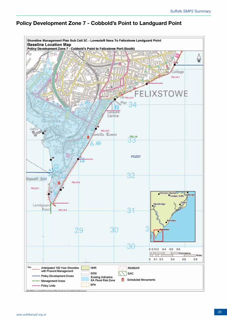
PolicyDevelopmentZone7-Cobbold’sPointtoLandguardPoint
Section 2
36 Shoreline Management Plan
PolicyDevelopmentZone7
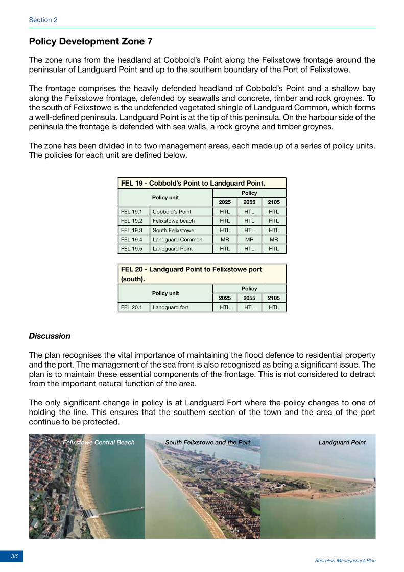
The zone runs from the headland at Cobbold’s Point along the Felixstowe frontage around the peninsular of Landguard Point and up to the southern boundary of the Port of Felixstowe.
The frontage comprises the heavily defended headland of Cobbold’s Point and a shallow bay along the Felixstowe frontage, defended by seawalls and concrete, timber and rock groynes. To the south of Felixstowe is the undefended vegetated shingle of Landguard Common, which forms a well-defined peninsula. Landguard Point is at the tip of this peninsula. On the harbour side of the peninsula the frontage is defended with sea walls, a rock groyne and timber groynes.
The zone has been divided in to two management areas, each made up of a series of policy units. The policies for each unit are defined below.
Discussion
The plan recognises the vital importance of maintaining the flood defence to residential property and the port. The management of the sea front is also recognised as being a significant issue. The plan is to maintain these essential components of the frontage. This is not considered to detract from the important natural function of the area.
The only significant change in policy is at Landguard Fort where the policy changes to one of holding the line. This ensures that the southern section of the town and the area of the port continue to be protected.
FEL20-LandguardPointtoFelixstoweport(south).
Policy unitPolicy
2025 2055 2105
FEL 20.1 Landguard fort HTL HTL HTL
FEL19-Cobbold’sPointtoLandguardPoint.
Policy unitPolicy
2025 2055 2105
FEL 19.1 Cobbold’s Point HTL HTL HTL
FEL 19.2 Felixstowe beach HTL HTL HTL
FEL 19.3 South Felixstowe HTL HTL HTL
FEL 19.4 Landguard Common MR MR MR
FEL 19.5 Landguard Point HTL HTL HTL
Felixstowe Central Beach South Felixstowe and the Port Landguard Point

The SMP has been led by Suffolk Coastal District Council. The main partners in developing the SMP are: Suffolk Coastal District Council (SCDC), Waveney District Council (WDC), the Environment Agency (EA), British Energy, Suffolk County Council (SCC), English Heritage (EH) and Natural England (NE). These authorities and organisations have formed the Client Steering Group (CSG) for the SMP.
The various stages and output from the work have been reviewed and discussed with the Representative Members Forum (RMF), made up of members and representatives from the following organisations:
• SuffolkCoastalDistrictCouncil
• WaveneyDistrictCouncil
• The Environment Agency Anglian (Eastern) Regional Flood DefenceCommittee
• NaturalEngland
• SuffolkCountyCouncil
An initial consultation was undertaken with key stakeholders, who were also asked to comment on an early version of the plan, before preparing the full draft plan for the three month public consultation. Full details of the consultation process are in appendix B of the main document. www.suffolksmp2.org.uk
The production of the SMP has been managed on behalf of SCDC by Terry Oakes Associates Ltd and the technical study has been carried out by Royal Haskoning, supported by ABPmer.

Shingle Street and the Mouth of Alde/Ore Estuary at North Weir Point